Etosha National Park
12
8/28/14 7:55 PM Etosha National Park - Wikipedia, the free encyclopedia Page 1 of 12 http://en.wikipedia.org/wiki/Etosha_National_Park Etosha National Park IUCN category II (national park) Animals at the Nebrownii waterhole Map of show location in Namibia Location Namibia Coordinates 18°56!43"S 15°53!52"E Area 22,270 square kilometres (8,600 sq mi) Established March 22, 1907 Visitors 200000 (in 2010) Governing body Ministry of Environment and Tourism, Namibia Etosha National Park From Wikipedia, the free encyclopedia Etosha National Park is a national park in northwestern Namibia. The park was proclaimed a game reserve on March 22, 1907 in Ordinance 88 by the Governor of German South West Africa, Dr. Friedrich von Lindequist. It was designated as Wildschutzgebiet Nr. 2 which means Game Reserve Number 2, in numerical order after West Caprivi (Game Reserve No. 1) and preceding Namib Game Reserve (No. 3). In 1958, Game Reserve No. 2 became Etosha Game Park and was elevated to status of National Park in 1967 by an act of parliament of the Republic of South Africa which administered South-West Africa during that time. [1] Etosha National Park spans an area of 22,270 square kilometres (8,600 sq mi) and gets its name from the large Etosha pan which is almost entirely within the park. The Etosha pan (4,760 square kilometres (1,840 sq mi)) covers 23% of the area of the total area of the Etosha National Park. [2] The park is home to hundreds of species of mammals, birds and reptiles, including several threatened and endangered species such as the black rhinoceros. The park is located in the Kunene region and shares boundaries with the regions of Oshana, Oshikoto and Otjozondjupa. Contents 1 History 1.1 Discovery by Europeans 1.2 Origins of Name 1.3 People 1.4 European settlers 1.5 German South-West Africa 1.6 Boundary 1.7 Etosha Ecological Institute 2 Geography 2.1 Etosha Pan 2.2 Dolomite Hills Coordinates: 18°56!43"S 15°53!52"E
-
Upload
catalinatorre -
Category
Documents
-
view
99 -
download
3
description
Etosha National Park
Transcript of Etosha National Park

8/28/14 7:55 PMEtosha National Park - Wikipedia, the free encyclopedia
Page 1 of 12http://en.wikipedia.org/wiki/Etosha_National_Park
Etosha National ParkIUCN category II (national park)
Animals at the Nebrownii waterhole
Map of show location in Namibia
Location Namibia
Coordinates 18°56!43"S 15°53!52"E
Area 22,270 square kilometres(8,600 sq mi)
Established March 22, 1907
Visitors 200000 (in 2010)
Governing body Ministry of Environment andTourism, Namibia
Etosha National ParkFrom Wikipedia, the free encyclopedia
Etosha National Park is a national park in northwesternNamibia. The park was proclaimed a game reserve onMarch 22, 1907 in Ordinance 88 by the Governor ofGerman South West Africa, Dr. Friedrich von Lindequist. Itwas designated as Wildschutzgebiet Nr. 2 which meansGame Reserve Number 2, in numerical order after WestCaprivi (Game Reserve No. 1) and preceding Namib GameReserve (No. 3). In 1958, Game Reserve No. 2 becameEtosha Game Park and was elevated to status of NationalPark in 1967 by an act of parliament of the Republic ofSouth Africa which administered South-West Africa duringthat time.[1]
Etosha National Park spans an area of 22,270 squarekilometres (8,600 sq mi) and gets its name from the largeEtosha pan which is almost entirely within the park. TheEtosha pan (4,760 square kilometres (1,840 sq mi)) covers23% of the area of the total area of the Etosha NationalPark.[2] The park is home to hundreds of species ofmammals, birds and reptiles, including several threatenedand endangered species such as the black rhinoceros.
The park is located in the Kunene region and sharesboundaries with the regions of Oshana, Oshikoto andOtjozondjupa.
Contents
1 History1.1 Discovery by Europeans1.2 Origins of Name1.3 People1.4 European settlers1.5 German South-West Africa1.6 Boundary1.7 Etosha Ecological Institute
2 Geography2.1 Etosha Pan2.2 Dolomite Hills
Coordinates: 18°56!43"S 15°53!52"E

8/28/14 7:55 PMEtosha National Park - Wikipedia, the free encyclopedia
Page 2 of 12http://en.wikipedia.org/wiki/Etosha_National_Park
Satellite picture of the park
Charles John (Karl Johan) Andersson
3 Vegetation types3.1 Saline desert3.2 Woodlands3.3 Other types of vegetation
3.3.1 Savanna3.3.2 Grasslands
4 Fauna4.1 History4.2 Mammals4.3 Birds
5 Tourism5.1 Okaukuejo5.2 Namutoni5.3 Halali5.4 Onkoshi5.5 Dolomite Camp
6 References7 External links
History
Discovery by Europeans
Explorers Charles John Andersson and Francis Galton were the firstEuropeans to record the existence of the Etosha pan on 29 May1851.[1] The explorers were traveling with Ovambo copper oretraders when they arrived at Omutjamatunda (now known asNamutoni). The Etosha pan was discovered when they traveled northupon leaving Namutoni.
Origins of Name
The name Etosha (spelled Etotha in early literature) comes fromOshindonga word meaning Great White Place referring to the Etoshapan. The Hai//om called the pan Khubus which means "totally bare,white place with lots of dust". The pan is also known as Chumswhich refers to the noise made by a person's feet when walking on the clay of the pan.
People

8/28/14 7:55 PMEtosha National Park - Wikipedia, the free encyclopedia
Page 3 of 12http://en.wikipedia.org/wiki/Etosha_National_Park
Changing park boundaries 1907-1970
Areas north of the Etosha pan were inhabited by Ovambo people, while various Otjiherero-speaking groupslived immediately outside the current park boundaries. The areas inside the park close to the Etosha pan hadKhoisan-speaking Hai//om people.
When the Etosha pan was first discovered, the Hai//om people recognized the Ovambo chief at Ondongwa(formerly Ondonga) but the Hereros did not.[3] The Hai||om were forcibly removed from the park in the1954, ending their hunter-gatherer lifestyle to become landless farm laborers.[4] The Hai||om have had arecognized Traditional Authority since 2004 which helps facilitate communications between the communityand the government. The government of Namibia acknowledges the park to be the home of Hai||om peopleand has plans to resettle displaced families on farms adjacent to the national park. Since 2007 theGovernment has acquired six farms directly south of the Gobaub depression in Etosha National Park. Anumber of families have settled on these farms under the leadership of Chief David Khamuxab, ParamountChief of the Hai||om.
European settlers
In 1885, entrepreneur William Worthington Jordan bought a huge tract of land from Ovambo chiefKambonde. The land spanned nearly 170 kilometres (110 mi) from Okaukuejo in the west to Fischer's Pan inthe east. The price for the land was £300 sterling, paid for by 25 firearms, one salted horse and a cask ofbrandy.[3] Dorstland Trekkers first traveled through the park between 1876 and 1879 on their way to Angola.The trekkers returned in 1885 and settled on 2,500-hectare (6,200-acre) farms given to them at no charge byJordan. The trekkers named the area Upingtonia after the Prime Minister of the Cape Colony. The settlementhad to be abandoned in 1886 after clashes with the Hai||om[3] and defeat by Chief Nehale Mpingana.[5]
German South-West Africa
The German Reich ordered troops to occupy the Okaukuejo, Namutoni and Sesfontein in 1886 in order tokill migrating wildlife to stop spread of rinderpest to cattle. A fort was built by the German cavalry in 1889at the site of the Namutoni spring. On 28 January 1904, 500 men under Nehale Mpingana attacked ImperialGermany's Schutztruppe at Fort Namutoni and completely destroyed it, driving out the colonial forces andtaking over their horses and cattle.[5] The fort was rebuilt and troops stationed once again when the area wasdeclared a game reserve in 1907; Lieutenant Adolf Fischer of Fort Namutoni then became its first "gamewarden".
Boundary
The present-day Etosha National Park has had many major and minorboundary changes since its inception in 1907. The major boundarychanges since 1907 were because of Ordinance 18 of 1958 andOrdinance 21 of 1970.[1]
When the Etosha area was proclaimed as Game Reserve 2 by Ordinance88 of 1907, the park stretched from the mouths of the Kunene river andHoarusib river on the Skeleton Coast to Namutoni in the east. Theoriginal area was estimated to be 99,526 square kilometres(38,427 sq mi), an estimate that has been corrected to about 80,000
8/28/14 7:55 PMEtosha National Park - Wikipedia, the free encyclopedia
Page 4 of 12http://en.wikipedia.org/wiki/Etosha_National_Park
Etosha Pan lookout near Salvadora
square kilometres (31,000 sq mi).[1] Ordinance 18 of 1958 changed thewestern park boundaries to exclude the area between the Kunene river and the Hoarusib river and insteadinclude the area between Hoanib river and Uchab river, thus reducing the park's area to 55,000 squarekilometres (21,000 sq mi). The Odendaal Commission's (1963) decision resulted in the demarcation of thepresent-day park boundary in 1970.
Etosha Ecological Institute
The Etosha Ecological Institute (EEI) was formally opened on 1 April 1974 by Adolf Brinkmann of theSouth-West African Administration.[1] The institute is responsible for all management-related research in thepark. Classification of vegetation, population and ecological studies on wildebeest, elephants and lions, andstudies on anthrax were among the first major topics to be investigated.[1] The EEI has collaborations withresearchers from universities in Namibia, United States, United Kingdom, Germany, South Africa, Australia,Norway and Israel.
Geography
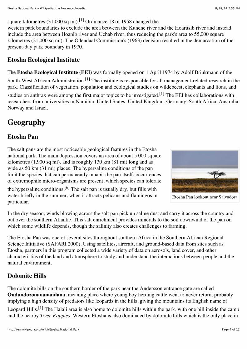
Etosha Pan
The salt pans are the most noticeable geological features in the Etoshanational park. The main depression covers an area of about 5,000 squarekilometres (1,900 sq mi), and is roughly 130 km (81 mi) long and aswide as 50 km (31 mi) places. The hypersaline conditions of the panlimit the species that can permanently inhabit the pan itself; occurrencesof extremophile micro-organisms are present, which species can toleratethe hypersaline conditions.[6] The salt pan is usually dry, but fills withwater briefly in the summer, when it attracts pelicans and flamingos inparticular.
In the dry season, winds blowing across the salt pan pick up saline dust and carry it across the country andout over the southern Atlantic. This salt enrichment provides minerals to the soil downwind of the pan onwhich some wildlife depends, though the salinity also creates challenges to farming.
The Etosha Pan was one of several sites throughout southern Africa in the Southern African RegionalScience Initiative (SAFARI 2000). Using satellites, aircraft, and ground-based data from sites such asEtosha, partners in this program collected a wide variety of data on aerosols, land cover, and othercharacteristics of the land and atmosphere to study and understand the interactions between people and thenatural environment.
Dolomite Hills
The dolomite hills on the southern border of the park near the Andersson entrance gate are calledOndundozonananandana, meaning place where young boy herding cattle went to never return, probablyimplying a high density of predators like leopards in the hills, giving the mountains its English name ofLeopard Hills.[1] The Halali area is also home to dolomite hills within the park, with one hill inside the campand the nearby Twee Koppies. Western Etosha is also dominated by dolomite hills which is the only place in

8/28/14 7:55 PMEtosha National Park - Wikipedia, the free encyclopedia
Page 5 of 12http://en.wikipedia.org/wiki/Etosha_National_Park
the park that has Mountain zebra.
Vegetation types
Saline desert
The pans in the park are mostly devoid of vegetation with the exception of the halophytic Sporobolus salsus,a protein-rich grass that is used by grazers such as blue wildebeest and springbok. The areas around theEtosha pan also have other halophytic vegetation including grasses such as Sporobolus spicatus and Odysseapaucinervis and shrubs such as Suaeda articulata.[7]
Woodlands
Most of the park is savanna woodlands except for areas close to the pan. Mopane is the most common tree,estimated to be around 80% of all trees in the park.[7] The sandveld of north-eastern corner of Etosha isdominated by Acacia and Terminalia trees. Tamboti trees characterize the woodlands south of the sandveld.
Other types of vegetation
Savanna
Dwarf shrub savanna occurs areas close to the pan and is home to several small shrubs including ahalophytic succulent Salsola etoshensis. Thorn bush savanna occurs close to the pan on limestone andalkaline soils and is dominated by Acacia species such as Acacia nebrownii, Acacia luederitzii, Acaciamelliferra, Acacia hebeclada and Acacia tortilis.
Grasslands
Grasslands in the park are mainly around the Etosha pan where the soil is sandy. Depending on the soil andthe effects of the pan, grasslands could be dominated by one of Eragrostis, Sporobolus, Monelytrum,Odyssea or Enneapogon species.[7]
FaunaThe park has about 114 mammal species, 340 bird species, 110 reptile species, 16 amphibian species and 1species of fish (up to 49 species of fish during floods).[8][9]
History
By 1881, large game mammals like elephants, rhinoceroses and lions had been nearly exterminated in theregion.[1] The proclamation of the game reserve helped some of the animals recover, but some species likebuffalo and wild dogs have been extinct since the middle of the 20th century.
Prof. P. Schoemann, a writer from Otjiwarango, was appointed game warden in 1951 and he considered thegrasslands to be severely overgrazed. A bone meal plant was constructed near Rietfontein and culling of

8/28/14 7:55 PMEtosha National Park - Wikipedia, the free encyclopedia
Page 6 of 12http://en.wikipedia.org/wiki/Etosha_National_Park
Plains zebra, Etosha NationalPark.
Elephant
Black rhinoceros with a Giraffe
zebras and wildebeests began in 1952. Official records indicate 293 zebras and 122 wildebeest wereprocessed at the plant, but conservationists claimed thousands had been culled and successfully forced theplant's closure during the same year.
The drought that began in the year 1980 resulted in the largest capture and culling operation in the history ofthe park.[1] 2235 mountain zebras and 450 plains zebras were captured, culled or sold. 525 elephants wereculled and processed at a temporary abattoir near Olifantsrus.
Mammals
Commonly seen mammals in the park, past and present, are listed in thetable below
Mammal Status Additional Information
Africanelephant common
Etosha's elephants belong to the group ofelephants in northwestern Namibia andsouthern Angola. They are the tallestelephants in Africa, but mineral deficienciesmean that they have very short tusks.[10]
Whiterhinoceros rare
Reintroduced recently after a longabsence[11]
Blackrhinoceros
notdisclosedpublicly
Odendaal Commission's plan in 1963severely reduced the habitat of the rhinocerosas most of their preferred habitat fell outsidethe park.[12] Relocation programs haveexisted since then to increase the populationof rhinos within the protected boundaries ofthe park.
Africanbuffalo extinct
The last known record of buffalo in the parkis from an observation of a young bull killedby lions on the Andoni plains in the 1950s.
Giraffe G. c.angolensis common
A 2009 genetic study on this subspeciessuggests that the northern Namib Desert andEtosha National Park populations form aseparate subspecies.[13]
African lion commonAfricanleopard common
Cheetah uncommonServal rareCaracal commonAfricanwildcat common
Black-

8/28/14 7:55 PMEtosha National Park - Wikipedia, the free encyclopedia
Page 7 of 12http://en.wikipedia.org/wiki/Etosha_National_Park
Plains zebra
Lion at Gemsbokvlakte
Spotted hyena
Springbok
footed cat very rareBlack-backedjackal
verycommon
Bat-earedfox common
Cape fox commonAfricanwild dog extinct
Brownhyena common
Spottedhyena common
Aardwolf commonMeerkat commonBandedmongoose common
Yellowmongoose common
Slendermongoose common
Dwarfmongoose uncommon
Commongenet common
Warthog commonScrub hare commonSpringhare commonAfricangroundsquirrel
verycommon
Honeybadger common
Aardvark commonCrestedporcupine common
Groundpangolin(Manistemminckii)
uncommon
Plains zebra verycommon

8/28/14 7:55 PMEtosha National Park - Wikipedia, the free encyclopedia
Page 8 of 12http://en.wikipedia.org/wiki/Etosha_National_Park
Lesser Flamingos
White Pelican
Mountainzebra
locallycommon Seen only in western Etosha
Springbok verycommon
Black-facedImpala common
Gemsbok commonCommonduiker uncommon
Damara dik-dik common
Steenbok commonRedHartebeest common
Bluewildebeest common
Commoneland uncommon
Greaterkudu common
Birds
This overview is only one indication of the diversity of birds in the parkand is not a complete list.
Ostrich
Vultures
Lappet-facedvultureWhite-backedvulture
Eagles
Martial EagleTawny EagleBateleurBooted EagleCircaetus
Storks
Abdim's StorkMarabou Stork
Blue Crane
White Pelican
Flamingos
LesserFlamingoGreaterFlamingo
Waterfowl
Hornbills
Monteiro's HornbillSouthern Yellow-billed HornbillAfrican GreyHornbill
Crows
Pied CrowCape Crow
Sandgrouse
Namaqua

8/28/14 7:55 PMEtosha National Park - Wikipedia, the free encyclopedia
Page 9 of 12http://en.wikipedia.org/wiki/Etosha_National_Park
Ostrich
Blue crane
eaglesVerreaux'sEagle
Secretarybird
Other Hawks
AfricanHarrier-HawkPale ChantingGoshawkShikra
Kites
Yellow-billedKiteBlack-shoulderedKite
Falcons
Lanner FalconGreaterKestrelLesser KestrelPygmy FalconRed-neckedFalcon
Owls
Giant EagleOwlBarn OwlAfrican ScopsOwl
Herons
Red-billed TealEgyptianGooseKnob-billedDuckCape Teal
Galliformes
HelmetedGuineafowlRed-billedSpurfowl
Coursers andPratincoles
Temminck'sCourserDouble-bandedCourserThree-bandedCourserBlack-wingedPratincole
Waders
Spotted Thick-kneeThree-bandedPloverCrownedLapwingBlacksmithLapwing
Rollers
Lilac-breasted
SandgrouseDouble-bandedSandgrouse
Pigeons and Doves
Namaqua DoveEmerald-spottedWood DoveAfrican CollaredDoveLaughing Dove
Other Passerines
Red-billed QueleaSouthern MaskedWeaverLesser MaskedWeaverSociable WeaverCape SparrowCape StarlingHerero Chat
Bustards
Kori BustardNorthern BlackKorhaanRüppell's KorhaanRed-crested Korhaan

8/28/14 7:55 PMEtosha National Park - Wikipedia, the free encyclopedia
Page 10 of 12http://en.wikipedia.org/wiki/Etosha_National_Park
Andersson Gate park entrance
Tourists photographing anelephant at the Okaukuejowaterhole.
Regulations in the park
Grey HeronCattle Egret
RollerPurple Roller
Hoopoe
TourismAll lodging and camping accommodation inside the park is managed byNamibia Wildlife Resorts (NWR). There five sites inside the park withlodges and three of the sites have facilities for camping. All sites havegame-proof fences.[14]
Okaukuejo
Okaukuejo was founded as a German South-West Africa militaryoutpost in 1897 in an effort to control spread of foot-and-mouth disease.It later served as a police station and it was formally opened as a restcamp in 1955. The Okaukuejo tower was built in 1963 modeled after theold police station tower in the area. Okaukuejo has a restaurant, a postoffice, souvenir shops, two swimming pools and a tourist informationcenter where visitors can record their daily observations. There is anobservation deck at the Okaukuejo waterhole, which is floodlit at nightfor the benefit of tourists staying overnight, to observe nocturnal wildlifeat the waterhole.
Namutoni
Namutoni is also a former police and military station in the eastern partof the park, 123 kilometres (76 mi) from Okaukuejo. Fort Namutoni wasrebuilt in 1957 when it served as a rest camp for winter visitors to thepark.
Halali
The Halali rest camp was opened in 1967 and is located about midwaybetween Okaukuejo and Namutoni.
Onkoshi
Onkoshi is an exclusive property inside the park and is located near Stinkwater
Dolomite Camp
Tourists are not allowed to go west of Ozonjuitji m'bari and the only exception to that rule are registeredNamibian tour operators and guests staying at Dolomite Camp. It was built in 2010 and can be accessedfrom the Galton gate or through the park along the 19S latitude road (19e Breëdtegaard).

8/28/14 7:55 PMEtosha National Park - Wikipedia, the free encyclopedia
Page 11 of 12http://en.wikipedia.org/wiki/Etosha_National_Park
Wikimedia Commons hasmedia related to EtoshaNational Park.
References
1. ^ a b c d e f g h i Historical Review of the Etosha Region and its subsequent administration as a National Park, H.H.Berry; Madoqua 1997, 20(1): 3-12
2. ^ Lindeque, M. and Archibald, T.J. 1991. Seasonal wetlands in Owambo and the Etosha National Park. Madoqua17(2): 129-133
3. ^ a b c Trümpelmann, G.P.J. 1948. Die Boer in Suid-wes Afrika.4. ^ Born in Etosha. Ute Dieckmann (2009)
5. ^ a b "Namibia Heroes and Heroines" (http://www.namibia-1on1.com/a-central/namibiaheroes.html). Namibia 1-on-1. Retrieved 28 January 2012.
6. ^ C. Michael Hogan. 2010
7. ^ a b c Trees and shrubs of the Etosha National Park and in northern and central Namibia; Cornelia Berry and BlytheLoutit
8. ^ Etosha Fact Sheet 2 (http://www.met.gov.na/Documents/Etosha%20Fact%20sheet2.pdf)9. ^ A Review of Fauna and Flora Associated with Coastal and Inland Saline Flats from Namibia with Special
Reference to the Etosha Pan. Peter L. Cunningham and Willem Jankowitz10. ^ Etosha Ecological Institute, Okaukuejo.11. ^ Etosha Park Profile (http://www.met.gov.na/Documents/Etosha%20Park%20Profile.pdf)12. ^ On the clover trail. Eugène Joubert. 199613. ^ Brenneman, R. A.; Louis, E. E. Jr; Fennessy, J. (2009). "Genetic structure of two populations of the Namibian
giraffe, Giraffa camelopardalis angolensis". African Journal of Ecology 47 (4): 720–28. doi:10.1111/j.1365-2028.2009.01078.x (http://dx.doi.org/10.1111%2Fj.1365-2028.2009.01078.x).
14. ^ Etosha National Park: Guidebook to the Waterholes and Animals. Timothy Osborne, Wilferd Versveld, Paul vanSchalkwyk. 2003
"Etosha National Park, Namibia"(http://earthobservatory.nasa.gov/Newsroom/NewImages/images.php3?img_id=16355). NASA EarthObservatory.C.Michael Hogan. 2010. Extremophile (http://www.eoearth.org/article/Extremophile?topic=49540).eds. E.Monosson and C.Cleveland. Encyclopedia of Earth. National Council for Science and theEnvironment, Washington DC.
External links
Namibia Park Brochures(http://www.met.gov.na/Pages/ParkBrochures.aspx)Ministry of Environment and Tourism page(http://www.met.gov.na/nwr.htm)Etosha on PBS (http://www.pbs.org/edens/etosha/)

8/28/14 7:55 PMEtosha National Park - Wikipedia, the free encyclopedia
Page 12 of 12http://en.wikipedia.org/wiki/Etosha_National_Park
Etosha Travel Guide (http://www.etoshanationalpark.org)
Retrieved from "http://en.wikipedia.org/w/index.php?title=Etosha_National_Park&oldid=605229702"Categories: IUCN Category II Etosha National Park National parks of Namibia
This page was last modified on 22 April 2014 at 00:56.Text is available under the Creative Commons Attribution-ShareAlike License; additional terms mayapply. By using this site, you agree to the Terms of Use and Privacy Policy. Wikipedia® is aregistered trademark of the Wikimedia Foundation, Inc., a non-profit organization.