
ETM 58A - C26
16
THE KOKEMÄENJOKI RIVER BASIN FLOOD RISK MANAGEMENT PLAN Mete Çağan Işık - Bahadır Akın
Transcript of ETM 58A - C26

THE KOKEMÄENJOKI RIVER BASIN FLOOD RISK MANAGEMENT PLAN
Mete Çağan Işık - Bahadır Akın

Introduction
● The Kokemäenjoki River Basin is the 4th largest in Finland
● It has been predicted that climate change will alter the flood dynamics of the Kokemäenjoki River○ The highest flow peaks will shift from spring to late autumn and
winter○ Risk of ice jam floods will increase
● The city of Pori at the delta of the river is the most significant flood risk area in Finland
● The preparation of a Flood Risk Management Plan (FRMP) for the river basin as a national pilot.
RIVER BASIN AND DELTA
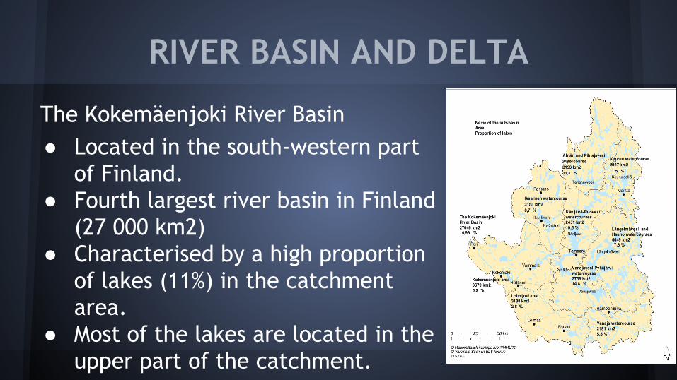
The Kokemäenjoki River Basin● Located in the south-western part
of Finland.● Fourth largest river basin in Finland
(27 000 km2)● Characterised by a high proportion
of lakes (11%) in the catchment area.
● Most of the lakes are located in the upper part of the catchment.

RIVER BASIN AND DELTA
● The length of the main river is about 110 km● The Kokemäenjoki River is heavily modified.
○ Ecological state of most lakes in the river basin is good○ The main river it is mainly satisfactory
● The largest lakes of the river basin as well as the main river flows were originally regulated to serve flood prevention and hydropower generation.○ 11 significant (over 1 MW) hydropower plants in the river
● Pori is the second largest city, with 80 000 inhabitants, in the catchment.

COLLABORATION & PLANNING
● In 2007 the South-west Finland Regional Environment Centre began preparing FRMP
● Extensive collaboration with other authorities, municipalities and actors of the river basin
● The steering group of the FRMP comprises 25 people.
● Several experts have also participated in the preparation of the FRMP.
● The FRMP will be finalised during 2011.

CLIMATE CHANGE
● It has been predicted that climate change will alter the flood dynamics of the Kokemäenjoki River.○ For example: The annual 1% probability of an open water flood is
predicted to increase by approximately 15% in the period 2040–2069 as compared to 1971–2000
● Snow cover duration and the amount of water stored in the snowpack will decrease.○ This will also mitigate the traditional spring flood caused by
snowmelt.
● Rainfall in late autumn and early winter is predicted to increase.

CLIMATE CHANGE
The increasingly high flows and warmer winters, when cold and warm periods alternate, will increase the probability of;
● Frazil ice○ ice crystals accumulating in supercooled water, blocking the flow.
● Ice jam floods
These are the most harmful types of flood in the Kokemäenjoki River.

PRELIMINARY FLOOD RISK ASSESSMENT
● Historic data on previous floods○ Water-level data has been gathered since the nineteenth century.○ There have been several harmful floods in the past○ Although data on water levels and flows of the floods are
comprehensive, data on the damage and economic impacts of the floods are deficient.
● GIS-based preliminary flood risk assessment has been carried out in addition to the historic data○ GIS: Geographic Information Systems
● According to preliminary flood risk assessment there are at least two significant flood risk areas in the Kokemäenjoki

PRELIMINARY FLOOD RISK ASSESSMENT
1. The city of Pori● At the delta of the river● 80 000 inhabitants in the city ● Up to 20 000 are in danger of being exposed to floods in terms of
damage being caused to their homes.
2. The city of Huittinen● On the central part of the main river.● Flood risk area is large due to the flatness of the area ● Up to 500 inhabitants exposed to floods in terms of damage being
caused to their homes.● Large-scale piggeries, henhouses and cowhouses

Flood Hazard And Damage Assessment
The Figure illustrates the flood hazard map for the city of Pori in the case of a serious ice jam flood. It is estimated to be approximately 0.5–1%
● The overall direct damage would be at least EUR 300 million
● On the other hand, direct damage of an open water flood with 1% probability would be approximately EUR 5 million.
The possible flood damage in the city of Huittinen is also rise to millions of euros.
These estimates only include direct damage to agriculture, buildings and industry.

FLOOD RISK MANAGEMENT PLAN
The flood risk management measures are categorised in the FRMP into;
● flood risk prevention● flood prevention● flood protection ● preparedness
Geographically, the measures can be grouped into;
● measures at the river-basin scale● measures in the city of Pori ● measures in the city of Huittinen

Flood Risk Prevention
The most important flood risk prevention measure is linked to;● Land use planning● Building regulations
○ The recommendations for lowest building elevation are set for the entire catchment area.

Flood Prevention
● Adaptive lake regulations○ It is the most important measure for
preventing floods
● Frazil and ice-jam prevention● Water retention and controlled
flooding

Flood Protection
● Dredging and Embankment○ Large-scale local flood protection
measures
● New Channels○ increases the possibility of managing
the flood risks by enlarging the flow capacity of the river.
● Individual property protection

Preparedness
● Runoff forecast and warning systems
● Flood prevention and protection rehearsals
● Public guidance● Rescue plans● Temporary flood protection
structures

CONCLUSIONS
● According to climate change estimations, the flood risks of the Kokemäenjoki River will increase in future.
● Effective flood risk management will require for both flood prevention measures and substantial flood protection structures
● Collaboration among authorities remains the key element of successful flood risk management in the Kokemäenjoki River Basin.