Estimating the Economic Cost of Sea Level Rise on Low ... threat to coastline properties. ... of...
14
1 Estimating the Economic Cost of Sea Level Rise on Low-Lying Coastal Properties in Accra, Ghana Ibrahim Amidu Yale University, 195 Prospect Street, New Haven, CT 06511 ABSTRACT Sea level rise – one of the consequences of global climate change – is predicted to adversely affect low-lying coastal settlements. Coastal settlements of Accra, the capital city of Ghana, could potentially experience the brunt of sea level rise. Examining three sea level rise scenarios evolved by the Intergovernmental Panel on Climate Change, this study estimates the potential economic cost of sea level rise on a market land along the coast of Accra. The objective is to identify the least cost adaptation option for coastal management in Ghana. The study established that protection of the coastline is the best adaptation strategy and that constructing a sea wall every 10 years to protect the land is the cheapest protection approach to pursue. INTRODUCTION: Global mean sea level rise (GMSLR) – one of the consequences of climate change – poses an epic threat to coastline properties. With nearly 41% of the population of the planet living within 100km of the coast (McGranahan et al., 2007), and the surge in coastline settlement (Martínez et al., 2013), inundation of properties – as a result of GMSLR – could be catastrophic (Nicholls & Cazenave, 2010; Ranasinghe et al., 2012; McGowan & Baker, 2014). Nicholls et al., (2008) observes that the asset of major coastal cities around the world was nearly 3,000 billion (2005 US$); they posit that the pivot to coastline settlement, particularly in developing countries, would surge in response to the interplay of population growth and economic significance of coastal cities. Accordingly, sea level rise is of global concern because of the threats the rise poses to coastline properties (Bosello and De Cian, 2014). Various studies concur that global mean sea level will continue to rise in the 21st century. Essentially, the rate of the rise is more likely to be precipitated by a surge in ocean warming, loss of mass from glaciers and ice sheets due to global warming, and changes in the mass balance of Greenland and Antarctica ice sheets (Dasgupta et al., 2007; Church et al., 2014; Nicholls et al. 2014). Analysis of satellite altimeter and tide-gauge records indicate a global mean sea level rise rate of over 3mmy -1 (Church et al., 2008). According to Marcos et al.
Transcript of Estimating the Economic Cost of Sea Level Rise on Low ... threat to coastline properties. ... of...

1
Estimating the Economic Cost of Sea Level Rise on Low-Lying Coastal
Properties in Accra, Ghana
Ibrahim Amidu
Yale University, 195 Prospect Street, New Haven, CT 06511
ABSTRACT
Sea level rise – one of the consequences of global climate change – is predicted to adversely
affect low-lying coastal settlements. Coastal settlements of Accra, the capital city of Ghana,
could potentially experience the brunt of sea level rise. Examining three sea level rise
scenarios evolved by the Intergovernmental Panel on Climate Change, this study estimates
the potential economic cost of sea level rise on a market land along the coast of Accra. The
objective is to identify the least cost adaptation option for coastal management in Ghana. The
study established that protection of the coastline is the best adaptation strategy and that
constructing a sea wall every 10 years to protect the land is the cheapest protection approach
to pursue.
INTRODUCTION:
Global mean sea level rise (GMSLR) – one of the consequences of climate change – poses an
epic threat to coastline properties. With nearly 41% of the population of the planet living
within 100km of the coast (McGranahan et al., 2007), and the surge in coastline settlement
(Martínez et al., 2013), inundation of properties – as a result of GMSLR – could be
catastrophic (Nicholls & Cazenave, 2010; Ranasinghe et al., 2012; McGowan & Baker, 2014).
Nicholls et al., (2008) observes that the asset of major coastal cities around the world was
nearly 3,000 billion (2005 US$); they posit that the pivot to coastline settlement, particularly
in developing countries, would surge in response to the interplay of population growth and
economic significance of coastal cities. Accordingly, sea level rise is of global concern because
of the threats the rise poses to coastline properties (Bosello and De Cian, 2014).
Various studies concur that global mean sea level will continue to rise in the 21st century.
Essentially, the rate of the rise is more likely to be precipitated by a surge in ocean warming,
loss of mass from glaciers and ice sheets due to global warming, and changes in the mass
balance of Greenland and Antarctica ice sheets (Dasgupta et al., 2007; Church et al., 2014;
Nicholls et al. 2014). Analysis of satellite altimeter and tide-gauge records indicate a global
mean sea level rise rate of over 3mmy-1 (Church et al., 2008). According to Marcos et al.

2
(2012), in the Bizkaian coast of northern Spain, mean sea level might increase by up to 0.4m
by the end of the 21st century with respect to current values. Studies by Johansson et al.
(2012) established a 0.26-1.55m range for global mean sea level rise up to 2100, with the
Finnish coast expected to range from 0.24-1.26m. Recent climate change Assessment Report
of the Intergovernmental Panel on Climate Change (IPCC AR5) predicts that it is very likely
global mean sea level rise rate in the 21st century would exceed that during the period 1971-
2010. Under the Representative Concentration Pathways (RCP) scenarios, global mean sea
level rise is likely to range between 0.26 to 0.55m for RCP2.6 (minimum scenario) and 0.45
to 0.82 m for RCP8.5 (maximum scenario) during 2081-2100, compared to 1986–2005
(Church et al. 2014).
The prospect of an accelerating rise in global sea level has attracted global concern because
of the catastrophic impact of inundation of natural coastline environments, and coastal
settlements (Haer et al., 2013; McGowan and Baker, 2014; Mani Murali and Dinesh Kumar,
2015; Sudha Rani et al., 2015). Inundation analysis on the Moroccan coast by Snoussi et al.
(2008) projects 50% and 70% land loss in 2050 and 2100 respectively, with residential, and
farmlands expected to be severely impacted. Using a minimum scenario of 0.2m global sea
level rise, Ng and Mendelsohn (2005) estimated the annual value of Singapore land that
could potentially to be lost through inundation to run about 104 million (2000 US$) by 2050
and 376 million (2000 US$) by 2100. In the United States, Ayyub et al. (2012) forecasted the
potential damage to properties in Washington D.C. – under a modest global sea level rise
scenario of 0.1m – to cost about 2.1 billion (2012 US $).
According to the IPCC AR5, global sea level rise would cause shoreline erosion on several
coastlines in Africa (Niang et al., 2014). Given the astronomical economic cost of coastline
inundation, potential impact of global sea level rise on sub-Saharan Africa, where adaptation
capacity is limited, would be highly devastating (Dasgupta et al., 2008). Studies by
Appeaning Addo et al. (2011) established that the Dansoman coastline in Accra, Ghana, could
be inundated up to 202m by 2100, with 1970-1990 as the baseline; 31% of tourism facilities
situated along the coastline of Ghana cannot withstand the adverse impact of sea level rise
(Sagoe-Addy and Appeaning Addo, 2012). Given the foregoing, economic assessment of the
impact of sea level rise on the coastline of Ghana is crucial in guiding the design of policy
framework on coastline management in the country. Economic analysis of the impact of sea
level rise would inform policy makers on whether protection of the coastline (or allowing
the coastline to be inundated) is the best option. Yet, as far as I know, there is currently no
published paper on the economic impact of sea level rise on Ghana.
This study therefore examined the potential economic cost of sea level rise on low-lying
coastal land in Accra, Ghana. Using IPCC’s three sea level rise scenarios – dynamic sea level
rise scenarios that reflect the range of sea level rise predictions for the next century from
global warming – I investigated the potential economic loss of four market lands along the
coast of Accra as sea level rises. In the scenarios, sea level rise is expected to increase
gradually each decade. For each scenario, I calculated both the protection costs and the value
of potentially inundated land. I then evaluated the least cost strategy for coping with sea level
3
rise for each decade. The objective is to identify the least cost adaptation option that will
guide the design of policy framework on coastal management. This method of calculating the
economic impact of sea level rise on coastal land was evolved by Yohe et al. (1995). The
method was employed by Ng and Mendelsohn (2005) to examine the economic impact of sea
level rise on Singapore; they demonstrated through their work in Singapore that this cost–
benefit approach could be employed to examine the impact of sea level rise on coastlines
outside the United States.
METHOD:
a) Study Area:
Ghana (Figure 1 below) is a West African country located on latitude 8°00'N and longitude
2°00'W. The country is situated just above the equator in the northern hemisphere; it could
be located between the eastern and western hemispheres. The coastline of Ghana – generally
low-lying with sandy beaches – spans about 550 km (341.75 mi). This study was conducted
along the coast of Accra, the capital city of Ghana. Accra (Figures 1 and 2 below) is located in
the south of Ghana along latitude 5°33'N and longitude 0°15'W. The southern part of Accra
is bounded by the Gulf of Guinea. The city of Accra – which is about 67 sq. mi (173 km2) – is
the most commercialized city in the country. Major economic installations such as the Bank
of Ghana and the headquarters of Barclays Ghana are located about 0.5km from the coast.
The main commercial area of Accra as well as the Supreme Court buildings of Ghana are also
located about 0.5km from the coast. Since Accra is the most commercialized city in Ghana, it
is fitting to advance that the major economic installations of Ghana are situated within 0.5km
of the coast of the country.
The study area (Figure 3 below) could be located between latitude 5°56'N and longitude
-0°15'W and latitude 5°56'N and longitude -0°13'W; the area spans about 1.01 mi (1.63 km)
along the Gulf of Guinea in the Atlantic Ocean. Two five-star hotels (one of them housed
President Bush when he visited Ghana in February 2008) are located in the study area. The
two hotels are sited in the areas around the two red stars in Figure 3. In addition to these
facilities, an 18-storey apartment which is at an advanced stage of construction is also
located in the area. Also in the study area is Ghana’s major recreational beach, the La Pleasure
beach. At the extreme end of the study area (marked with a red arrow) is a river that flows
into the sea. It is important to point out that on some occasions, the sea flows into the river
and causes the area to flood. Appeaning (2009) has observed that Accra has an open coast
that enables strong unimpeded swell waves to reach the shores. As sea level rises, this
phenomenon of sea water flowing into the river will play a crucial role in the inundation of
the study area.
One of the reasons why I selected this area for the study is because of the massive economic
installation (as far as Ghana is concerned) in the area.

4
Figure 1: Satellite map of West Africa. Accra, Ghana is shown with a red star. Source: Google Earth
Figure 2: Satellite image of Accra with study area marked with red oval. Source: Google Earth.
Figure 3: Satellite image of the study area (marked with red oval). Source: Google Earth
5
b) Data Collection:
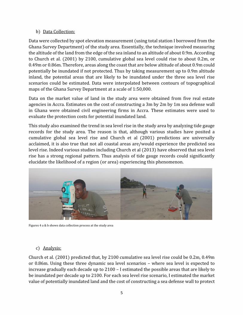
Data were collected by spot elevation measurement (using total station I borrowed from the
Ghana Survey Department) of the study area. Essentially, the technique involved measuring
the altitude of the land from the edge of the sea inland to an altitude of about 0.9m. According
to Church et al. (2001) by 2100, cumulative global sea level could rise to about 0.2m, or
0.49m or 0.86m. Therefore, areas along the coast that are below altitude of about 0.9m could
potentially be inundated if not protected. Thus by taking measurement up to 0.9m altitude
inland, the potential areas that are likely to be inundated under the three sea level rise
scenarios could be estimated. Data were interpolated between contours of topographical
maps of the Ghana Survey Department at a scale of 1:50,000.
Data on the market value of land in the study area were obtained from five real estate
agencies in Accra. Estimates on the cost of constructing a 3m by 2m by 1m sea defense wall
in Ghana were obtained civil engineering firms in Accra. These estimates were used to
evaluate the protection costs for potential inundated land.
This study also examined the trend in sea level rise in the study area by analyzing tide gauge
records for the study area. The reason is that, although various studies have posited a
cumulative global sea level rise and Church et al (2001) predictions are universally
acclaimed, it is also true that not all coastal areas are/would experience the predicted sea
level rise. Indeed various studies including Church et al (2013) have observed that sea level
rise has a strong regional pattern. Thus analysis of tide gauge records could significantly
elucidate the likelihood of a region (or area) experiencing this phenomenon.
Figures 4 a & b shows data collection process at the study area
c) Analysis:
Church et al. (2001) predicted that, by 2100 cumulative sea level rise could be 0.2m, 0.49m
or 0.86m. Using these three dynamic sea level scenarios – where sea level is expected to
increase gradually each decade up to 2100 – I estimated the possible areas that are likely to
be inundated per decade up to 2100. For each sea level rise scenario, I estimated the market
value of potentially inundated land and the cost of constructing a sea defense wall to protect
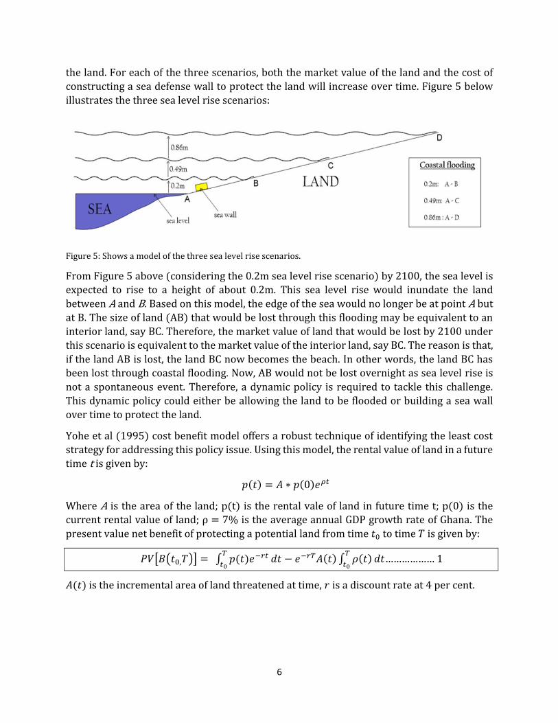
6
the land. For each of the three scenarios, both the market value of the land and the cost of
constructing a sea defense wall to protect the land will increase over time. Figure 5 below
illustrates the three sea level rise scenarios:
Figure 5: Shows a model of the three sea level rise scenarios.
From Figure 5 above (considering the 0.2m sea level rise scenario) by 2100, the sea level is
expected to rise to a height of about 0.2m. This sea level rise would inundate the land
between A and B. Based on this model, the edge of the sea would no longer be at point A but
at B. The size of land (AB) that would be lost through this flooding may be equivalent to an
interior land, say BC. Therefore, the market value of land that would be lost by 2100 under
this scenario is equivalent to the market value of the interior land, say BC. The reason is that,
if the land AB is lost, the land BC now becomes the beach. In other words, the land BC has
been lost through coastal flooding. Now, AB would not be lost overnight as sea level rise is
not a spontaneous event. Therefore, a dynamic policy is required to tackle this challenge.
This dynamic policy could either be allowing the land to be flooded or building a sea wall
over time to protect the land.
Yohe et al (1995) cost benefit model offers a robust technique of identifying the least cost
strategy for addressing this policy issue. Using this model, the rental value of land in a future
time t is given by:
𝑝(𝑡) = 𝐴 ∗ 𝑝(0)𝑒𝜌𝑡
Where A is the area of the land; p(t) is the rental vale of land in future time t; p(0) is the
current rental value of land; ρ = 7% is the average annual GDP growth rate of Ghana. The
present value net benefit of protecting a potential land from time 𝑡0 to time 𝑇 is given by:
𝑃𝑉[𝐵(𝑡0,𝑇)] = ∫ 𝑝(𝑡)𝑒−𝑟𝑡𝑇
𝑡0𝑑𝑡 − 𝑒−𝑟𝑇𝐴(𝑡) ∫ 𝜌(𝑡)
𝑇
𝑡0𝑑𝑡……………… 1
𝐴(𝑡) is the incremental area of land threatened at time, 𝑟 is a discount rate at 4 per cent.
7
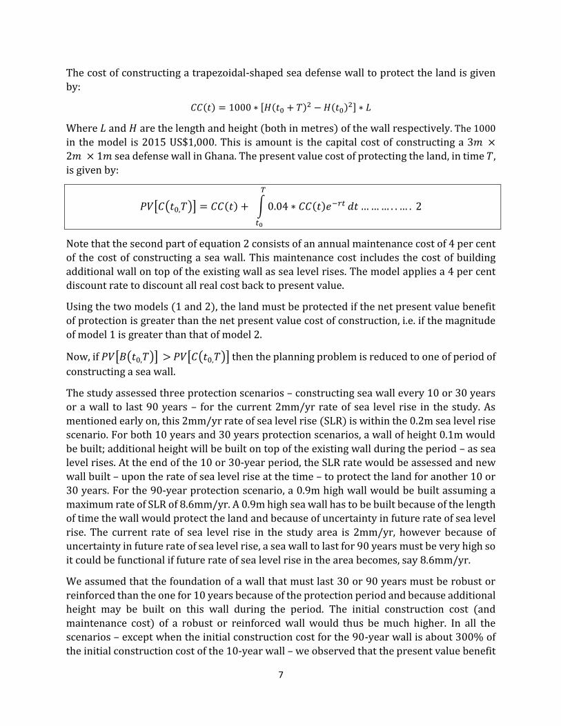
The cost of constructing a trapezoidal-shaped sea defense wall to protect the land is given
by:
𝐶𝐶(𝑡) = 1000 ∗ [𝐻(𝑡0 + 𝑇)2 − 𝐻(𝑡0)2] ∗ 𝐿
Where 𝐿 and 𝐻 are the length and height (both in metres) of the wall respectively. The 1000
in the model is 2015 US$1,000. This is amount is the capital cost of constructing a 3𝑚 ×
2𝑚 × 1𝑚 sea defense wall in Ghana. The present value cost of protecting the land, in time 𝑇,
is given by:
𝑃𝑉[𝐶(𝑡0,𝑇)] = 𝐶𝐶(𝑡) + ∫ 0.04 ∗ 𝐶𝐶(𝑡)𝑒−𝑟𝑡
𝑇
𝑡0
𝑑𝑡 … … … . . … . 2
Note that the second part of equation 2 consists of an annual maintenance cost of 4 per cent
of the cost of constructing a sea wall. This maintenance cost includes the cost of building
additional wall on top of the existing wall as sea level rises. The model applies a 4 per cent
discount rate to discount all real cost back to present value.
Using the two models (1 and 2), the land must be protected if the net present value benefit
of protection is greater than the net present value cost of construction, i.e. if the magnitude
of model 1 is greater than that of model 2.
Now, if 𝑃𝑉[𝐵(𝑡0,𝑇)] > 𝑃𝑉[𝐶(𝑡0,𝑇)] then the planning problem is reduced to one of period of
constructing a sea wall.
The study assessed three protection scenarios – constructing sea wall every 10 or 30 years
or a wall to last 90 years – for the current 2mm/yr rate of sea level rise in the study. As
mentioned early on, this 2mm/yr rate of sea level rise (SLR) is within the 0.2m sea level rise
scenario. For both 10 years and 30 years protection scenarios, a wall of height 0.1m would
be built; additional height will be built on top of the existing wall during the period – as sea
level rises. At the end of the 10 or 30-year period, the SLR rate would be assessed and new
wall built – upon the rate of sea level rise at the time – to protect the land for another 10 or
30 years. For the 90-year protection scenario, a 0.9m high wall would be built assuming a
maximum rate of SLR of 8.6mm/yr. A 0.9m high sea wall has to be built because of the length
of time the wall would protect the land and because of uncertainty in future rate of sea level
rise. The current rate of sea level rise in the study area is 2mm/yr, however because of
uncertainty in future rate of sea level rise, a sea wall to last for 90 years must be very high so
it could be functional if future rate of sea level rise in the area becomes, say 8.6mm/yr.
We assumed that the foundation of a wall that must last 30 or 90 years must be robust or
reinforced than the one for 10 years because of the protection period and because additional
height may be built on this wall during the period. The initial construction cost (and
maintenance cost) of a robust or reinforced wall would thus be much higher. In all the
scenarios – except when the initial construction cost for the 90-year wall is about 300% of
the initial construction cost of the 10-year wall – we observed that the present value benefit

8
of protection is higher than the present value cost of protection. For the 90-year with an
initial construction cost of about 300% of the initial construction cost of the 10-year wall,
the present value benefit of protection is higher than the present value cost of protection if
a 0.5m wall is built instead of a 0.9m wall. We anticipate that some planners may opt for this
strategy since the analysis accounts for a maintenance cost which comprises the cost of
maintaining the wall and the cost of building additional wall on top of the existing wall during
the 90-year period. Therefore, if the foundation of the 90-year sea wall of height 0.5m is
robust, additional height could be built on the existing wall if the rate of SLR surpasses
4.9mm/yr which this planner has anticipated.
Now, since – for all three protection scenarios – the present value benefit of protection is
higher than the present value cost of protection i.e. 𝑉[𝐵(𝑡0,𝑇)] > 𝑃𝑉[𝐶(𝑡0,𝑇)], protection is
the best adaptation strategy to pursue. Next, we analyzed which of the three protection
strategies is cheaper to pursue. Our analysis shows that building a sea wall every 10 years is
the best adaptation strategy because that scenario gives the lowest present value cost of
protection – even if the initial construction cost of all three protection scenarios are the same.
In the next section, we present – in addition to results of market values of potential inundated
land – the results of the three protection scenarios. Notice that the initial construction cost
of the 30-year and 90-year scenarios is about 300% of the initial construction cost of the 10-
year scenario.
RESULTS:
Table 1 below shows the potential land in the study area that – per the three sea level rise
scenarios – are likely to be inundated if the land is not protected. The amount of potential
inundated land increases in proportion to the rate of sea level rise. Currently, the rate of sea
level rise in the study area (La Beach Zone, Accra) is about 2mm/yr. This 2mm/yr rate of sea
level rise falls under the trajectory of 0.2m sea level rise by 2100. Therefore, as of the end of
2015, about 0.0008 sq. km area of land may have been flooded if the land is not protected.

9
POTENTIAL INUNDATED LAND (sq. km)
Year 0.2mm/yr 0.49mm/yr 0.86mm/yr
2015 0.0008 0.0028 0.0069 2020 0.0013 0.0044 0.0105 2030 0.0017 0.0058 0.0137 2040 0.0025 0.0087 0.0208 2050 0.0041 0.0150 0.0276 2060 0.0049 0.0178 0.0345 2070 0.0058 0.0210 0.0414 2080 0.0066 0.0235 0.0483 2090 0.0075 0.0265 0.0552 2100 0.0093 0.0293 0.0621
Table 1: Potential dryland likely to be flooded if the study area is not protected. Amount increases in proportion to the rate of sea level rise
Table 2 shows the market value of potential inundated land. These estimated values are in
millions of 2015 United States dollars. The values do not include market values of properties
on the land and therefore likely to be underestimated. It was challenging to obtain the
market values of structures on the land, given the limited time for the study and the
reluctance of property owners to give out the estimates of their properties, for the study.
Nevertheless, given the high values of land in the study area, the study established that
protecting the land is the best policy strategy to pursue.
Estimated Market Value of Potential Inundated Land (in millions of 2015 US$)
Year 2mm/yr 4.9mm/yr 8.6mm/yr
2015 0.09 0.32 0.78
2020 0.15 0.50 1.19
2030 0.20 1.04 1.55
2040 0.29 1.56 2.35
2050 0.48 2.69 3.12
2060 0.57 3.19 3.90
2070 0.67 3.76 4.68
2080 0.76 4.21 5.46
2090 0.86 4.75 6.24
2100 1.07 5.25 7.02
Table 2: Market value of potential inundated land (in millions of 2015 US$). Estimates include projected increase in land values.
Table 3 shows the decadal cost of constructing a sea wall to protect the land. The total cost
of protection is comprised of the cost of constructing a sea wall and the maintenance cost
during the decade. All values have been discounted to the present value within each decade
at 4 per cent discount rate. Like the size of potential inundated land and the market value of

10
land, the total cost of protection is lower for the minimum sea level rise scenario of 0.2m and
higher for the maximum sea level rise scenario. Notice also that the total cost of construction
increases with years. This increase in total construction cost corresponds to the increase in
potential inundated land if the land is not protected in earlier periods.
Decadal cost of constructing a sea wall to defend the study area (values are in millions of 2015 US$)
2mm/yr 4.9mm/yr 8.6mm/yr
Year CC MC TC CC MC TC CC MC TC
2015 0.010 0.005 0.015 0.035 0.017 0.052 0.086 0.041 0.127
2020 0.016 0.008 0.024 0.055 0.026 0.081 0.131 0.063 0.194
2030 0.021 0.010 0.031 0.073 0.035 0.108 0.171 0.082 0.253
2040 0.031 0.015 0.046 0.110 0.053 0.163 0.260 0.125 0.385
2050 0.051 0.024 0.075 0.190 0.091 0.281 0.345 0.166 0.511
2060 0.061 0.029 0.090 0.225 0.108 0.333 0.431 0.207 0.638
2070 0.072 0.035 0.107 0.265 0.127 0.392 0.517 0.248 0.765
2080 0.082 0.040 0.122 0.297 0.143 0.440 0.603 0.290 0.893
2090 0.093 0.045 0.138 0.335 0.161 0.496 0.689 0.331 1.020
2100 0.115 0.055 0.170 0.370 0.178 0.548 0.775 0.372 1.147
Table 3: Total cost of construction (TC) is composed of Construction Cost (CC) and Maintenance Cost (MC). Values have been discounted to the present value within each decade at 4 per cent discount rate
Tables 4 and 5 show the cost of protection for the 30 and 90 years scenarios. We assume that
protection started in 2010 so that new walls would be built in 2040, 2070, and 2100 for the
30-year scenario; the 90-year wall lasts from 2010 to 2100. For both walls, we assume that
the initial construction cost is about 300% of the initial construction cost of the 10-year wall.
Cost of constructing a sea wall (in millions of 2015 US$) every 30 years to protect the study area
2mm/yr 4.9mm/yr 8.6mm/yr
YEAR CC MC TC CC MC TC CC MC TC
2010 0.030 0.067 0.097 0.105 0.236 0.341 0.258 0.579 0.837
2040 0.094 0.211 0.305 0.326 0.731 1.057 0.778 1.745 2.523
2070 0.218 0.489 0.707 0.787 1.766 2.553 1.549 3.475 5.024
2100 0.350 0.785 1.135 1.098 2.463 3.561 2.324 5.214 7.538
Table 4: Total Construction Cost (TC) is comprised of Construction Cost (CC) and Maintenance Cost (MC). Values have been discounted to the present value at 4 percent per each 30-year period.
Notice that the total protection cost for each of protection scenarios increases as the rate of
sea level rise increases. For all three protection scenarios, the total protection cost is higher
for the 90-year protection scenario.
11
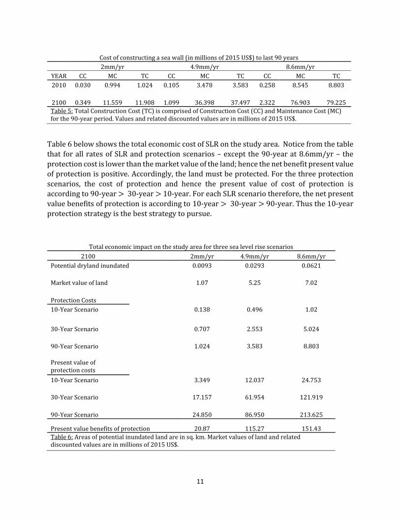
Cost of constructing a sea wall (in millions of 2015 US$) to last 90 years
2mm/yr 4.9mm/yr 8.6mm/yr
YEAR CC MC TC CC MC TC CC MC TC
2010 0.030 0.994 1.024 0.105 3.478 3.583 0.258 8.545 8.803
2100 0.349 11.559 11.908 1.099 36.398 37.497 2.322 76.903 79.225
Table 5: Total Construction Cost (TC) is comprised of Construction Cost (CC) and Maintenance Cost (MC) for the 90-year period. Values and related discounted values are in millions of 2015 US$.
Table 6 below shows the total economic cost of SLR on the study area. Notice from the table
that for all rates of SLR and protection scenarios – except the 90-year at 8.6mm/yr – the
protection cost is lower than the market value of the land; hence the net benefit present value
of protection is positive. Accordingly, the land must be protected. For the three protection
scenarios, the cost of protection and hence the present value of cost of protection is
according to 90-year > 30-year > 10-year. For each SLR scenario therefore, the net present
value benefits of protection is according to 10-year > 30-year > 90-year. Thus the 10-year
protection strategy is the best strategy to pursue.
Total economic impact on the study area for three sea level rise scenarios
2100 2mm/yr 4.9mm/yr 8.6mm/yr
Potential dryland inundated 0.0093 0.0293 0.0621
Market value of land 1.07 5.25 7.02
Protection Costs
10-Year Scenario 0.138 0.496 1.02
30-Year Scenario 0.707 2.553 5.024
90-Year Scenario 1.024 3.583 8.803
Present value of protection costs
10-Year Scenario 3.349 12.037 24.753
30-Year Scenario 17.157 61.954 121.919
90-Year Scenario 24.850 86.950 213.625
Present value benefits of protection 20.87 115.27 151.43
Table 6: Areas of potential inundated land are in sq. km. Market values of land and related discounted values are in millions of 2015 US$.
12
DISCUSSION:
The foregoing analysis shows that the potential economic cost of sea level rise on the study
area far outweighs the cost of constructing a defense wall to protect the land. The current
rate of sea level rise in the study area is about 2mm/yr. From the analysis, about 0.0008 sq.
km of land may have been inundated as of the end of 2015 if the land is not protected. The
market value of this land is about 0.09 million 2015 US$. If the rate of sea level rise in the
study area remains the same and the land is not protected, about would have been inundated
by 0.0093 sq. km by 2100. The market value of this land is 1.07 million 2015 US$. The study
also established that the total cost of protecting the land during this period is 0.17 million
2015 US$. This value is far lower than the market value of the land. The most effective
adaptation strategy therefore is to defend the coastline instead of allowing it to be inundated.
The study estimated the market of land as if there were no structures on the land. This
approach has the potential of underestimating the market value of properties in the study
area. Nevertheless, the price of land in the study area is very high that protection is the best
adaptation strategy to pursue. Consequently, the study assessed three protection scenarios,
and estimated that the cost of protection ranges from 0.170 to 8.803 million 2015 US$
depending on the protection approach. For the three protection scenarios, the study
established that the 10-year approach is the cheapest to pursue.
CONCLUSION:
This study examined the economic cost of sea level rise on low-lying coastal properties in
Accra, Ghana and established that protection of the coastline is the best adaptation strategy
for the area.
References:
A. Bigano, F. Bosello, R. Roson and R. S. J. Tol (2008), 'Economy-wide impacts of climate change: a joint analysis for sea level rise and tourism', Mitigation and Adaptation Strategies for Global Change 13(8): 765-791.
F. Bosello, R. Roson and R. S. J. Tol (2007), 'Economy-wide Estimates of the Implications of Climate Change: Sea Level Rise', Environmental and Resource Economics 37(3): 549-571.
K. Appeaning Addo, L. Larbi, B. Amisigo and P. K. Ofori-Danson (2011), 'Impacts of Coastal Inundation
Due to Climate Change in a CLUSTER of Urban Coastal Communities in Ghana, West Africa',
Remote Sensing 3(12): 2029-2050.

13
B. M. Ayyub, H. G. Braileanu and N. Qureshi (2012), 'Prediction and impact of sea level rise on
properties and infrastructure of Washington, DC', Risk Anal 32(11): 1901-1918.
F. Bosello and E. De Cian (2014), 'Climate change, sea level rise, and coastal disasters. A review of
modeling practices', Energy Economics 46: 593-605.
J. A. Church, N. J. White, T. Aarup, W. S. Wilson, P. L. Woodworth, C. M. Domingues, J. R. Hunter and K.
Lambeck (2008), 'Understanding global sea levels: past, present and future', Sustainability
Science 3(1): 9-22.
J.A., Church et al. (2013), ‘Sea Level Change’, in T.F. Stocker et al. (eds), Climate Change 2013 The
Physical Science Basis. Contribution of Working Group I to the Fifth Assessment Report of the
Intergovernmental Panel on Climate Change, Cambridge University Press, Cambridge, pp. 1137-
1216.
I., Niang et al. (2014), ‘Africa’, in V.R., Barros et al. (eds), Climate Change 2014 Impacts, Adaptation,
and Vulnerability. Part B: Regional Aspects. Contribution of Working Group II to the Fifth
Assessment Report of the Intergovernmental Panel on Climate Change, Cambridge University
Press, pp. 1199-1265.
S. Dasgupta, B. Laplante, C. Meisner, D. Wheeler and J. Yan (2008), 'The impact of sea level rise on
developing countries: a comparative analysis', Climatic Change 93(3-4): 379-388.
T. Haer, E. Kalnay, M. Kearney and H. Moll (2013), 'Relative sea-level rise and the conterminous
United States: Consequences of potential land inundation in terms of population at risk and GDP
loss', Global Environmental Change 23(6): 1627-1636. M. Marcos, G. Chust, G. Jordà and A. Caballero, ‘Effect of sea level extremes on the western Basque
coast during the 21st century’.Climate Research 51, 237-248.
M.L., Martınez et al. (2013), ‘Coastal dunes: human impact and need for restoration’, Environmental
Management, (Chapter 1), pp. 1–14.
M. M. Johansson, H. Pellikka, K. K. Kahma and K. Ruosteenoja (2014), 'Global sea level rise scenarios
adapted to the Finnish coast', Journal of Marine Systems 129: 35-46.
R. Mani Murali and P. K. Dinesh Kumar (2015), 'Implications of sea level rise scenarios on land use
/land cover classes of the coastal zones of Cochin, India', J Environ Manage 148: 124-133.
S. A. McGowan and R. G. Baker (2014), 'How past sea-level changes can inform future planning: A
case study from the Macleay River estuary, New South Wales, Australia', The Holocene 24(11):
1591-1601.
G. McGranahan, D. Balk and B. Anderson (2007), 'The rising tide: assessing the risks of climate change
and human settlements in low elevation coastal zones', Environment and Urbanization 19(1): 17-
37.
G., Yohe, J., Neumann, P., Marshall and H., Ameden. (1995), ‘Assessing the economic cost of
greenhouse-induced sea level rise: Methods and application in support of a national survey’,
Journal of Environmental Economics and Management 29: S-78–S-97.
W.-S. Ng and R. Mendelsohn (2005), 'The impact of sea level rise on Singapore', Environment and
Development Economics 10(2): 201-215.
R. J. Nicholls, S. E. Hanson, J. A. Lowe, R. A. Warrick, X. Lu and A. J. Long (2014), 'Sea-level scenarios
for evaluating coastal impacts', Wiley Interdisciplinary Reviews: Climate Change 5(1): 129-150.
R.J. Nicholls and A. Cazenave (2010), ‘Sea-level rise and its impact on coastal zones’, Science 328
(5985), pp. 1517–1520.
R. Ranasinghe, D. Callaghan and M. J. F. Stive (2012), 'Estimating coastal recession due to sea level
rise: beyond the Bruun rule', Climatic Change 110(3-4): 561-574.

14
K. Sagoe-Addy and K. Appeaning Addo (2012), 'Effect of predicted sea level rise on tourism facilities
along Ghana’s Accra coast', Journal of Coastal Conservation 17(1): 155-166.
M. Snoussi, T. Ouchani and S. Niazi (2008), 'Vulnerability assessment of the impact of sea-level rise
and flooding on the Moroccan coast: The case of the Mediterranean eastern zone', Estuarine,
Coastal and Shelf Science 77(2): 206-213.
N. N. V. Sudha Rani, A. N. V. Satyanarayana and P. K. Bhaskaran (2015), 'Coastal vulnerability
assessment studies over India: a review', Natural Hazards 77(1): 405-428.