Estimating Debris · PDF fileRiver channel morphology is the study of the form and ......
6
01‐DN‐101‐PM 36.06 Smith River (Dr. Ernest Fine) Bridge Replacement 01‐43640 EFIS 0100000193 March 3 rd 2016 James Philipp Debris Analysis at Smith River (Dr. Ernest Fine), Bridge Replacement Estimating Debris Quantities This report documents an initial assessment and evaluation of debris loading in preparation for the Dr. Fine bridge replacement. The goal of this document is to come up with some estimate of the volume and extent of debris loading that may be expected during the construction of the new bridge. This also explores some options to provide countermeasures to any debris that will encounter the construction elements placed in the river during construction. Upstream River Morphology River channel morphology is the study of the form and function of rivers. The Smith River as it approaches the Dr. Fine Memorial Bridge would be classified as a low gradient, braided/meandering riffle/pool stream with low width/depth ratio, high meander width ratio, classified as Stream Type DA/E in Figure 1. Smith River is one of six rivers that drain the Six Rivers National Forest which is a one million acres area. At the convergence of the north and middle fork it changes from a steep entrenched channel similar to Type B in Figure 1 at the town of Douglas Park. This located is 10 river miles upstream of Smith River Bridge, with an average slope of 0.4 %. This river system has been altered in the last 150 years due to tree harvesting, off stream aggregate mining, and in‐stream extraction of aggregate. Figure 1 Typical River Types, key to diagram below (Rosgen, 1996, reprinted with permission from Wildland Hydrology, UK)
Transcript of Estimating Debris · PDF fileRiver channel morphology is the study of the form and ......

01‐DN‐101‐PM 36.06 Smith River (Dr. Ernest Fine) Bridge Replacement 01‐43640 EFIS 0100000193 March 3rd 2016 James Philipp
Debris Analysis at Smith River
(Dr. Ernest Fine), Bridge Replacement
Estimating Debris Quantities
This report documents an initial assessment and evaluation of debris loading in preparation for
the Dr. Fine bridge replacement. The goal of this document is to come up with some estimate
of the volume and extent of debris loading that may be expected during the construction of the
new bridge. This also explores some options to provide countermeasures to any debris that will
encounter the construction elements placed in the river during construction.
Upstream River Morphology
River channel morphology is the study of the form and function of rivers. The Smith River as it
approaches the Dr. Fine Memorial Bridge would be classified as a low gradient,
braided/meandering riffle/pool stream with low width/depth ratio, high meander width ratio,
classified as Stream Type DA/E in Figure 1. Smith River is one of six rivers that drain the Six
Rivers National Forest which is a one million acres area. At the convergence of the north and
middle fork it changes from a steep entrenched channel similar to Type B in Figure 1 at the
town of Douglas Park. This located is 10 river miles upstream of Smith River Bridge, with an
average slope of 0.4 %. This river system has been altered in the last 150 years due to tree
harvesting, off stream aggregate mining, and in‐stream extraction of aggregate.
Figure 1 Typical River Types, key to diagram below
(Rosgen, 1996, reprinted with permission from Wildland Hydrology, UK)
01‐DN‐101‐PM 36.06 Smith River (Dr. Ernest Fine) Bridge Replacement 01‐43640 EFIS 0100000193 March 3rd 2016 James Philipp
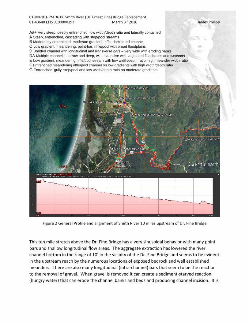
Aa+ Very steep, deeply entrenched, low width/depth ratio and laterally contained A Steep, entrenched, cascading with step/pool streams B Moderately entrenched, moderate gradient, riffle-dominated channel C Low gradient, meandering, point-bar, riffle/pool with broad floodplains D Braided channel with longitudinal and transverse bars – very wide with eroding banks DA Multiple channels, narrow and deep, with extensive well-vegetated floodplains and wetlands E Low gradient, meandering riffle/pool stream with low width/depth ratio, high meander width ratio F Entrenched meandering riffle/pool channel on low gradients with high width/depth ratio G Entrenched 'gully' step/pool and low width/depth ratio on moderate gradients
Figure 2 General Profile and alignment of Smith River 10 miles upstream of Dr. Fine Bridge
This ten mile stretch above the Dr. Fine Bridge has a very sinusoidal behavior with many point
bars and shallow longitudinal flow areas. The aggregate extraction has lowered the river
channel bottom in the range of 10’ in the vicinity of the Dr. Fine Bridge and seems to be evident
in the upstream reach by the numerous locations of exposed bedrock and well established
meanders. There are also many longitudinal (intra‐channel) bars that seem to be the reaction
to the removal of gravel. When gravel is removed it can create a sediment‐starved reaction
(hungry water) that can erode the channel banks and beds and producing channel incision. It is

01‐DN‐101‐PM 36.06 Smith River (Dr. Ernest Fine) Bridge Replacement 01‐43640 EFIS 0100000193 March 3rd 2016 James Philipp
also evident at many locations that as the river bottom lowered bedrock material has been
exposed and now acts to prevent further degradation, or head cutting.
Aerial Photograph Comparisons
Aerial photos of river reach from 1988 to 2015 on Google Earth Pro were compared to review
degradation of the channel because of in‐stream mining. Most photos were taken in June of
the given years. Differing years produce flow rates that vary however it appears overall that
the river has widened and exposed bedrock seem to be more pronounced. The widening could
be a response to the removal of aggregate and the river system equilibrium response to replace
that material from other locations within the reach
Discussion: Based on review of aerial photos there is a scant amount of debris evident along
the Ordinary High Water (OHW) mark of the river of this 10‐mile stretch. OHW is defined by
the Army Corps of Engineers as the natural line impressed on the bank where the vegetation
line begins. There is evidence of some debris above the OHW especially along the upstream
sides of the point bars and downstream sides of point bar areas. This material could be
transported further downstream if the watershed experiences a large flow event. It is apparent
that though change has occurred in the 10 mile reach upstream of the Dr. Fine Bridge the river
has reached an equilibrium. It would be expected that material entering this 10‐mile stretch
would be substantially screened as it makes its way to the Dr. Fine Bridge. Within the 10‐mile
stretch just above the bridge the amount or organic loading would be expected to be small,
since it appears stable.
Historic Debris Quantities from our two Bridges
There are two Caltrans bridges along this stretch of 10 river miles that can provide some
historic data regarding debris loading. They are the Hiouchi Bridge on SR‐199 and the Dr. Fine
Bridge on SR‐101. Archived records for both bridges were reviewed and any reports of debris
documented in the reports were noted.
DN‐199‐PM 4.22 Smith River (Hiouchi Bridge) Br No. 01‐0006, replaced in 1990, previous bridge
was a steel truss bridge built in 1928. There is no record of debris removal at this structure that
has two pile at the edges of river since its construction in 1990. The Supplemental Bridge
Reports from old bridge are not available on BIRIS for review.
DN‐101‐PM 36.06 Smith River (Dr. Ernest Fine) Br No 01‐0020
1956 – High water reached to 5.7’ below the bottom of the strut in Bent 3, “some drift
accumulated on the piers I the channel”, later removed.
1958 – Minor drift on some piers, not removed.
1960 – Light drift on main channel piers.

01‐DN‐101‐PM 36.06 Smith River (Dr. Ernest Fine) Bridge Replacement 01‐43640 EFIS 0100000193 March 3rd 2016 James Philipp
1962 – “A few drift logs have lodged on one of the piers…to remove then at an early date.”
1966 – “Debris has piled up on upstream face of piers”.
1967 – “Some drift trees have accumulated on one of the piers in the channel.
1968 – Drift removed from previous inspection, new drift on two piers.
1969 – Drift removed.
1970 – Remove drift from 3 piers.
1971 – Remove large amount of drift at Pier 16.
1972 – Large pile of drift at Pier 15.
1973 –Large mound of drift on the upstream side of Span 14 has been removed.
1974 – Drift removed from Span 14.
1974 – Remove the logs and drift caught on Pier 15.
1975 – Remove trees and drift hung up on Pier 15.
1983 – Remove large log at Pier 13.
1986 – Remove the accumulated timber drift from the upstream nose of the piers.
1992 – Remove debris located at the upstream face of Piers 14 and 15.
2001 – Drift debris has piled up at the upstream nose of Piers 12 & 13.
2003 – A minor amount of drift debris has piled up at the upstream nose of Pier 16.
2005 – A minor amount of drift debris has piled up at the upstream nose of Pier 13.
Dr. Fine Pier 13 in 2005

01‐DN‐101‐PM 36.06 Smith River (Dr. Ernest Fine) Bridge Replacement 01‐43640 EFIS 0100000193 March 3rd 2016 James Philipp
2007 – Drift debris has piled up the upstream nose of Pier 15
Dr. Fine Pier 15 in 2007
Discussion: There is a consistent record of debris snagging on the existing structure although it
does not appear to be in large quantities. There is also a consistent decrease in the occurrence
of floating debris from the 1980’s to present. This is probably due to changes in timber harvest
practices and more stringent controls on in‐stream gravel removal. Monitoring of scour at the
Dr. Fine Bridge was starting in 1971 with profiles across the channel to document scour depths.
The profile diagrams below shows the lowering of the channel bottom between the years of
1939‐2008. A scoured channel would typically increase debris initially due to bank erosion but
would stabilized within a few years and return to normal levels of debris loading.
Channel Profile at Dr. Fine Bridge between years of 1939‐2006

01‐DN‐101‐PM 36.06 Smith River (Dr. Ernest Fine) Bridge Replacement 01‐43640 EFIS 0100000193 March 3rd 2016 James Philipp
Channel Profile at Dr. Fine Bridge between years of 1972‐2008
Possible Future Debris Loading and Mitigation
Fires Within the watershed
Fires within any watershed can have one of two effects in regard to debris loading. If there is
intense rainfall enough to cause mud slides, then large amounts of fire debris would be
delivered into the river. Conversely if there are milder rainfall that does not cause erosion then
the debris would remain where it is and decompose in place without contributing to debris
loading of the river.
Debris Snagging Reduction During Construction
There are two basic techniques that will limit the accumulation of debris on any engineered
structure placed in the river channel, they are element spacing and element shape. As the
distance between elements increase the potential for snagging between these elements
decrease. The shape of the leading edge shape of the element can also have an effect on the
snag potential of the debris. The more uniform and parallel to the flow the temporary piles can
be placed, the larger the opening will be for floating or submerged debris to pass between
them.


![From Atmospheric Rivers to Rivers Of Debris: Coupling Extreme Precipitation Events, Glacial Retreat, Debris Flows, And Channel Changes On Mount Rainier, Washington [Gordon Grant]](https://static.fdocuments.net/doc/165x107/54b8c9714a7959f0388b4610/from-atmospheric-rivers-to-rivers-of-debris-coupling-extreme-precipitation-events-glacial-retreat-debris-flows-and-channel-changes-on-mount-rainier-washington-gordon-grant.jpg)