Establishment Record for Sturgeon River Gorge Research ...
49
a. TITLE PAGE Establishment Record for Sturgeon River Gorge Research Natural Area (RNA) Within the Ottawa National Forest, Kenton Ranger District, Houghton and Baraga Counties, Michigan
Transcript of Establishment Record for Sturgeon River Gorge Research ...
a. TITLE PAGE
Establishment Record for Sturgeon River Gorge
Research Natural Area (RNA)
Within the Ottawa National Forest,
Kenton Ranger District,
Houghton and Baraga Counties, Michigan
Sturgeon River Gorge Research Natural Area Establishment Record Page 2
TABLE OF CONTENTS 1. IDENTIFICATION SECTION ........................................................................................................................ 4 b. Location Map .......................................................................................................................................... 4 c. Boundary Map ......................................................................................................................................... 5 d. Legal Description ..................................................................................................................................... 6 2. ADMINISTRATIVE SECTION ...................................................................................................................... 6 3. a. INTRODUCTION ................................................................................................................................... 6 b. JUSTIFICATION ........................................................................................................................................ 7 (1) Justification Statement ...................................................................................................................................... 7 (2) Principal Distinguishing Features....................................................................................................................... 8 (3) Objectives .......................................................................................................................................................... 8 c. LAND MANAGEMENT PLANNING ............................................................................................................. 9 d. MANAGEMENT PRESCRIPTION ................................................................................................................ 9 e. USE OR CONTROL OF FIRE AND GRAZING ............................................................................................... 10 f. APPENDICES .......................................................................................................................................... 11 4. APPENDIX A. ECOLOGICAL EVALUATION ............................................................................................... 11 a. PHYSICAL SITE DESCRIPTION AND CLIMATIC CONDITIONS ...................................................................... 11 (1) Location ........................................................................................................................................................... 11 (2) Size ................................................................................................................................................................... 11 (3) Elevation Range ............................................................................................................................................... 11 (4) Access to the site ............................................................................................................................................. 11 (5) Climatic data .................................................................................................................................................... 11 b. ECOLOGICAL DESCRIPTION .................................................................................................................... 12 (1) Eco-Region ....................................................................................................................................................... 12 (2) Plant Communities .......................................................................................................................................... 14 (3) Values of the Sturgeon River Gorge RNA ........................................................................................................ 16 (a) Flora ................................................................................................................................................................. 16 (b) Fauna ............................................................................................................................................................... 19 (c) Geology ............................................................................................................................................................ 24 (d) Soils .................................................................................................................................................................. 24 (e) Topography ...................................................................................................................................................... 24 (f) Aquatic/riparian ............................................................................................................................................... 26 (g) Rare, threatened, endangered, or sensitive species ....................................................................................... 26 (h) List of rare elements and rare plant communities .......................................................................................... 26 c. RESOURCE INFORMATION ..................................................................................................................... 26 (1) Minerals ........................................................................................................................................................... 26 (2) Grazing ............................................................................................................................................................. 27 (3) Plants (including timber and special forest products) ..................................................................................... 27 (4) Watershed Values ............................................................................................................................................ 27 (5) Recreation Use................................................................................................................................................. 27 (6) Wildlife ............................................................................................................................................................. 27 (7) Transportation/Road System........................................................................................................................... 27 d. HISTORICAL INFORMATION ................................................................................................................... 27 (1) Research/education use and interest: history of establishment ................................................................... 27 (2) Cultural/heritage ............................................................................................................................................. 28 (3) Disturbance history ......................................................................................................................................... 29 (4) Occurrence of exotic species ........................................................................................................................... 29 e. OTHER INFORMATION ........................................................................................................................... 29
Sturgeon River Gorge Research Natural Area Establishment Record Page 3
(1) Any permanent research plots and/or photo points ...................................................................................... 29 (2) Bibliography ..................................................................................................................................................... 29 (3) Potential research topics ................................................................................................................................. 29 (4) Administrative records and protection ........................................................................................................... 29 f. EVALUATION OF SPECIFIC MANAGEMENT RECOMMENDATIONS ON RESEARCH NATURAL AREA .............. 30 (1) Potential or existing conflicts; principal management issues ......................................................................... 30 (2) Special management area if the Research Natural Area is within one ........................................................... 30 g. PHOTOGRAPHS ..................................................................................................................................... 30 APPENDIX B. MANAGEMENT PRESCRIPTIONS ........................................................................................... 33 Management Prescription 5.2 within the Ottawa National Forest. ..................................................................... 33 Management Prescription 8.1 (excerpts for Sturgeon River) ............................................................................... 38 Management Direction: Fire in Wilderness .......................................................................................................... 44 APPENDIX C. LITERATURE CITED and REFERENCES FOR RNA ...................................................................... 48
LIST OF TABLES AND FIGURES Figure 1. General location map of the Sturgeon River Gorge RNA. ............................................................. 4 Figure 2. Specific boundary map of the Sturgeon River Gorge RNA. ........................................................... 5 Table 1. Ecological landtype phase units, soil series, habitat types, soil and site characteristics, and acreages for Sturgeon River Gorge RNA. .................................................................................................... 12 Figure 3. Ecological landtype phases mapped for the Sturgeon River Gorge RNA. ................................... 13 Figure 4. Existing vegetation cover mapped for the Sturgeon River Gorge RNA....................................... 14 Table 2. Plant communities in the Sturgeon River Gorge RNA. ................................................................. 15 Table 3. Flora of the RNA showing scientific and common names. .......................................................... 16 Table 4. Bird species identified in the Sturgeon River Wilderness Study Area. ......................................... 20 Table 5. Mammals identified in the Sturgeon River Wilderness Study Area. ............................................. 23 Table 6. Reptiles and amphibians identified in the Sturgeon River Wilderness Study Area. ..................... 23 Figure 5. Topographic map for the Sturgeon River Gorge RNA, excerpted from Sidnaw Quadrangle. .... 25 Figure 6. Natural color, leaf-on aerial photography for the Sturgeon River Gorge RNA ........................... 31 Figure 7. False color infra-red aerial photography for the Sturgeon River Gorge RNA ............................. 32
Sturgeon River Gorge Research Natural Area Establishment Record Page 4
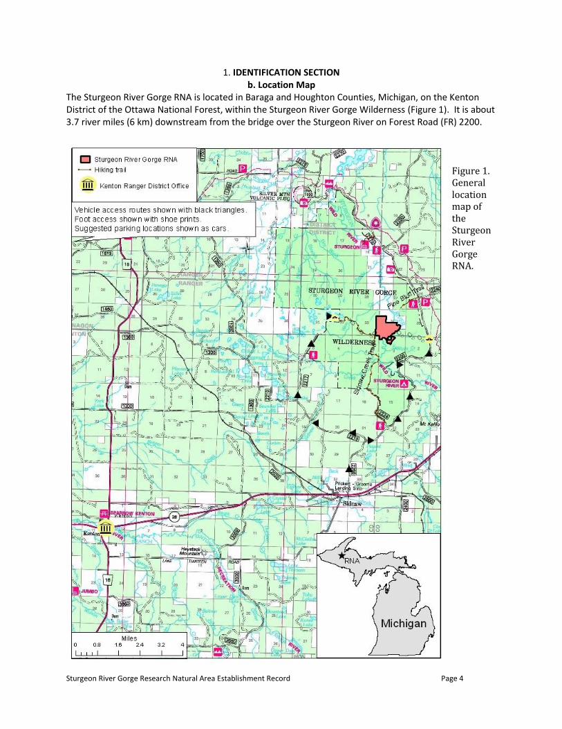
1. IDENTIFICATION SECTION b. Location Map
The Sturgeon River Gorge RNA is located in Baraga and Houghton Counties, Michigan, on the Kenton District of the Ottawa National Forest, within the Sturgeon River Gorge Wilderness (Figure 1). It is about 3.7 river miles (6 km) downstream from the bridge over the Sturgeon River on Forest Road (FR) 2200.
Figure 1. General location map of the Sturgeon River Gorge RNA.
Sturgeon River Gorge Research Natural Area Establishment Record Page 5
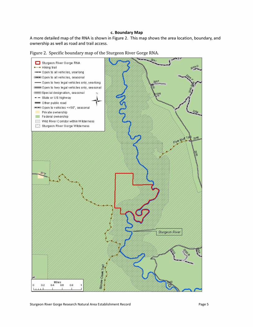
c. Boundary Map
Figure 2. Specific boundary map of the Sturgeon River Gorge RNA.

Sturgeon River Gorge Research Natural Area Establishment Record Page 6
d. Legal Description A parcel of land within the confines of the Ottawa National Forest in Section 33, Township 49 North, Range 35 West, more particularly described as the East 660 feet of the Southeast Quarter of the Northeast Quarter and the East 660 feet of the Southeast Quarter. And A parcel of land in Section 34, Township 49 North, Range 35 West, more particularly described as the Southwest Quarter of the Northwest Quarter, that part of the Southwest Quarter lying westerly of the present day main channel of the Sturgeon River, and that part of the Southeast Quarter lying westerly of the main channel of the Sturgeon River. And A parcel of land in Section 3, Township 48 North, Range 35 West more particularly described as beginning at the Northwest Corner of Section 3, then southerly along the Section Line common to Sections 3 and 4 a distance of 660 feet, then easterly perpendicular to said line to the left bank of the Sturgeon River, then following along the left bank of said river to the North Line of Section 3, then westerly along said line to the point of beginning.
The above three descriptions contain an estimated 351 acres.
2. ADMINISTRATIVE SECTION
The administrator of the RNA is the Kenton District Ranger, Kenton Ranger District, Ottawa National Forest, Kenton, Michigan, 49923. The Regional Forester approves and coordinates plans for research activities with the Northern Research Station Director.
3. a. INTRODUCTION Research Natural Areas (RNAs) are part of a national network of ecological areas designated in perpetuity for research and education and/or to maintain biological diversity on National Forest System lands (FSM 4063). RNAs represent “…examples of important forest, shrubland, grassland, alpine, aquatic, and geologic types that have special or unique characteristics of scientific interest and importance and are needed to complete the national network of RNAs” (36 CFR 219.25 1998).
The rugged and scenic Sturgeon River Gorge was designated as a wilderness area in 1987, and the Sturgeon River was designated as a Wild River in 1991. The gorge is a deep, V-shaped valley that is immature in geologic terms, developing over the past 10,000 years. During this period, the river rapidly cut down through the unconsolidated tills left during advances of the Keweenaw glacial lobes. Terraces, oxbow lakes and other topographic features formed as a result of the river’s erosion and were left perched above the river. Most of the landscape of the RNA lies well above the river’s flood stages and is more subject to the erosional forces of steep gradient tributaries and unstable slopes than the river itself. The RNA is entirely on federally owned lands. Forests of the area were originally dominated by northern hardwoods, eastern hemlock (Tsuga canadensis) and white pine (Pinus strobus). About the turn of the 20th century, the gorge was first

Sturgeon River Gorge Research Natural Area Establishment Record Page 7
logged, primarily for its pines. The river probably played an important role in the transport of logs from local woods to sawmills. Logging continued until the gorge was congressionally designated for wilderness study in 1975. Old logging roads penetrate into most reaches of the gorge, including the RNA. The RNA’s featured 85 acre (34 ha) eastern hemlock stand escaped the logging and remains one of few unharvested stands in Michigan’s Upper Peninsula. The balance of the RNA was logged at various times and in different manners. The maturing aspen types alongside the eastern hemlock are likely the result of clearcutting and/or fire. A good representation of sawtimber-size trees in the northern hardwood and mixed hemlock-hardwood stands suggests that single-tree selection was used to formerly manage these stands. Previous private ownerships north and east of the eastern hemlock stand (acquired by the Forest Service in 2008 from Wisconsin Electric Company via the Trust for Public Land) have logged-over, second-growth, northern-hardwood stands. There has been interest in establishing an RNA, featuring the eastern hemlock stand, since 1976. An establishment record was drafted in 1983, but was not submitted because of the commencement of forest planning, the inclusion of the gorge in the second Roadless Area Review and Evaluation (RARE II), and the desire to include a greater representation of the gorge slope, biologic communities and the oxbow lake in a larger proposed RNA. Appendix E of the 1986 Ottawa Forest Plan Environmental Impact Statement (EIS) included a draft establishment record for an area of about 120 acres (USDA Forest Service 1986). This appendix also notes the potential to expand the candidate area, to add geologic features not included in the smaller tract. In the RNA Program files, a candidate area of 281 acres (113 ha) is delineated and cover types are mapped. Based on the intent of the 1986 Forest Plan to expand the area, and the detailed map prepared for the 1993 draft establishment record, the file’s paper map was digitized, modified slightly to facilitate preparation of a boundary description, and used for the candidate RNA boundary. This area is approximately 314 acres (127 ha). Due to the subsequent acquisition of the electric company lands, it was possible to slightly expand the RNA, by about 37 acres (15 ha), for this final establishment record, capturing all of the oxbow and adjacent land. The RNA was carried as a candidate through the 1986 Ottawa National Forest Land and Resource Management Plan (Forest Plan) and re-evaluated as part of Forest Plan revision in 2006 (see Forest Plan EIS Appendix I). The 2006 Forest Plan EIS included environmental analysis for establishment of the candidate RNA and updating was begun for the 1993 draft establishment record. However, Eastern Regional Office concerns over a large pulse of candidate RNAs generated during Forest plan revisions at this time further delayed establishment. A region-wide assessment of all candidate RNAS ensued, resulting in the recommendation of 64 (of 110) candidates for establishment. In a July 2010 letter, the Regional Forester directed that Sturgeon River Gorge cRNA be moved forward to establishment. The Sturgeon River Gorge RNA includes approximately 166 acres (67 ha) of designated wilderness and approximately 185 acres (75 ha) of wild river corridor, for a total of about 351 acres (142 ha). It is about 2.4% of the Sturgeon River Gorge Wilderness total acreage.
b. JUSTIFICATION (1) Justification Statement The eastern hemlock type, Society of American Foresters (SAF) type 23 (Eyre 1980), is found in Forest Service RNAs throughout the Upper Great Lakes and New England. The “Great Cutover” and affiliated forest fires in the late 1800s and early 1900s greatly reduced this formerly abundant forest type

Sturgeon River Gorge Research Natural Area Establishment Record Page 8
throughout its range (Mladenoff and Stearns 1993; White and Mladenoff 1994; Bollinger et al. 2004). The current RNAs in the Upper Great Lakes contain small stands of the type and the total acreage is low. At two existing RNAs in the Upper Peninsula of Michigan, the Dukes and McCormick RNAs, three stands comprise a total of only 5 acres (2 ha) of the type in each RNA. In contrast, the gorge stand includes 85 acres (34 ha) in a single stand, 31 acres (13 ha) in an adjoining stand and 6 acres (2 ha) in a third stand. The largest stand is also larger than hemlock stands reported in the literature. Rogers (1978) and Willis and Coffman (1975) encountered hemlock stands of 0.1 to 6 acres (0.04-2.4 ha), but more commonly they were between 0.5 and 2 acres (0.2-0.8 ha). The gorge stand’s larger size is a positive attribute for research, as it allows for buffer zones, multi-plot sampling and replicated studies under relatively uniform conditions. The eastern hemlock type also occurs in two USDI administered RNAs in Upper Michigan at the Seney National Wildlife Refuge. The two areas have a total of 150 acres (61 ha) of the type. Details on their composition stand size and site conditions are not disclosed. Other protected examples of the hemlock type in Upper Michigan are on the Huron Mountain Club and the Porcupine Mountain State Park. In Wisconsin, there may be five or six state scientific areas with the type present (based upon generalized descriptions of the areas and not on specific data). According to Faber-Langendoen et al. (2000), the eastern hemlock matrix alliance is not represented in an RNA or RNA-equivalent on Subsection 212Jn (i.e. 212Sn), thus the Sturgeon River Gorge RNA would fill that representation need. As noted in Faber-Langendoen et al. (2000), the candidate RNA includes representation of at least six vegetation alliances: five matrix alliances and one large patch alliance. Three of these are represented elsewhere in the ecological subsection, two as low quality sites (Faber-Langendoen et al. 2000). The RNA may also include some large or small patch wetland or aquatic alliances. The RNA also includes geologic features that are not common in the Forest Service RNA system, including a five acre (2 ha) oxbow lake. Other geologic features represented within the RNA include an abandoned oxbow basin, terraces, escarpment terrace, associated drainages and a rim-to-river section of a major Midwestern gorge. (2) Principal Distinguishing Features The primary features of the Sturgeon River Gorge RNA are the large virgin stand of mature eastern hemlock and the oxbow lake. The RNA includes a cross-section of the gorge from river to rim, and includes transverse ridges, terraces and an abandoned oxbow basin. There are a variety of plant communities present that represent seral to mature types, including the following mapped cover types (see Ecological Evaluation for more information): balsam fir-aspen/paper birch; hemlock; paper birch; quaking aspen; sugar maple-beech/yellow birch; and open (oxbow lake). No rare species have been documented in the RNA, but there is potential for Regional Forester’s Sensitive plants and animals. More specific information regarding the biophysical characteristics of the area is presented in the Ecological Evaluation section (Appendix A) of this Establishment Record. (3) Objectives The objectives of establishing Research Natural Areas listed in FSM 4063.02 that apply to Sturgeon River Gorge RNA are:
1. Maintain a wide spectrum of high quality representative areas that represent the major forms of variability found in forest, shrubland, grassland, alpine, and natural situations that have
Sturgeon River Gorge Research Natural Area Establishment Record Page 9
scientific interest and importance that, in combination, form a national network of ecological areas for research, education, and maintenance of biological diversity.
2. Preserve and maintain genetic diversity, including threatened, endangered, and sensitive species.
3. Serve as reference areas for the study of natural ecological processes including disturbance. 4. Serve as baseline areas for measuring long-term ecological changes. 5. Serve as control areas for comparing results from manipulative research.
Specifically, the RNA contains an excellent example of eastern hemlock forest, once much more common in northern Great Lakes forests (Bollinger et al. 2004), and an oxbow lake, as well as a number of other biologic communities and a variety of unusual landscape settings. Interest in the dynamics of eastern hemlock and climax northern hardwood stands and their reproduction processes is high. Eastern hemlock is a major component of the northern hardwood forest, contributing to its diversity and wildlife needs. Concern is raised because the species reproduces poorly under silvicultural systems typically used in northern hardwoods, especially where there are high deer densities. This stand would be desirable in studies of succession, as a baseline community, and as a control for research on eastern hemlock ecology and factors affecting it in manipulated environments. Establishing the RNA also would increase alliance representation in this ecological subsection.
c. LAND MANAGEMENT PLANNING The RNA was included as a candidate in the analysis and recommendations of the Ottawa National Forest Land and Resource Management Plan approved in October 1986. It was carried as a candidate through the plan period and re-analyzed using new ecological information in 2004. Analysis for establishment was completed as part of Forest Plan revision in 2006. Establishment was expected concurrent with signing of the record of decision for the Forest Plan in 2006, but regional review and candidate RNA ranking delayed this process. Establishment is expected in 2012 following prioritization of Eastern Region candidate RNAs and direction to Forests and Stations to proceed with establishment of the selected candidates, including Sturgeon River Gorge RNA.
d. MANAGEMENT PRESCRIPTION Management goals, objectives, standards and guidelines for the RNA are specified in the Ottawa National Forest Land and Resource Management Plan (2006). The primary objective of management is to protect and maintain the natural character of the RNA and to preserve the area from unnatural disturbance. Management direction for the RNA is shown below:
Goal (#38)
Provide quality examples of dominant vegetation types and special features that occur on National Forest System lands through the reference area network for the Ottawa to furnish valuable ecological information to the Forest Service and society. Reference areas include established research natural areas (RNAs), candidate RNAs, as well as RNA-equivalents.
Objective(s):
Maintain these areas in their natural states, including natural disturbance processes, to continue to be representative of the ecosystems they were established to represent.
Carry the Sturgeon River Gorge forward as a candidate RNA.
Sturgeon River Gorge Research Natural Area Establishment Record Page 10
Standards
In candidate Research Natural Areas (cRNA), ecological processes prevail with minimum human intervention. Management emphasizes conserving or enhancing the resources and ecosystem features for which the cRNA was selected, and activities which detract from these values and features are prohibited.
Prohibit the use of horses in cRNAs. Guidelines
Avoid activities which diminish the eligibility of the area for designation. Activities that would enhance a candidate’s eligibility for designation, such as a land ownership adjustment, may be undertaken after careful review of project design and probable impacts.
Avoid recreational use that threatens or interferes with the purposes for which the cRNA may be established. These areas may be closed to public use when needed to protect botanical or other attributes from disturbances.
Allow control actions for non-native invasive species to protect adjacent resources or the features for which the cRNA was selected.
For all significant data collections, the locations, collectors, methods, and dates are known and the unanalyzed data are available. Copies of all data, reports, and publications resulting from studies in the area, including theses, dissertations, articles, monographs, etc., are provided to the Ottawa.
Utilize the Eastern Region RNA user permit process for all research activity proposals. Management direction for Wild Rivers and Sturgeon River Gorge Wilderness also apply; these prescriptions are detailed in Appendix B.
e. USE OR CONTROL OF FIRE AND GRAZING
The RNA is not suitable for grazing because the area is largely forested. Grazing is not needed to achieve RNA objectives. The RNA lies within a landscape that historically experienced very infrequent stand-replacing fires (Cleland et al. 2003). This fire-regime 4 area had average fire return intervals of 400 to 700 years. Prescribed fire is not expected to be used as a tool in the RNA. If a wildfire began in the area, guidelines for the wilderness within which the RNA lies would be followed. These include options to let the fire burn in its entirety; or suppress portions or all of such a fire, using minimal impact suppression techniques. See full management direction for handling fire in the wilderness in Appendix B.

Sturgeon River Gorge Research Natural Area Establishment Record Page 11
f. APPENDICES 4. APPENDIX A. ECOLOGICAL EVALUATION
a. PHYSICAL SITE DESCRIPTION AND CLIMATIC CONDITIONS (1) Location The RNA is located in the northeast corner of the Ottawa National Forest, on the Kenton Ranger District and within the Sturgeon River Gorge Wilderness. It lies within Baraga and Houghton Counties, Michigan.
The area lies at latitude 46° 35-36’N and longitude 88 40’W (NAD83). The area lies on the west slope of the Sturgeon River Gorge, about 3.7 river miles (6 km) downstream from the bridge over the Sturgeon River on Forest Road 2200. The RNA is within Sections 33 and 34 of Township 49 North, Range 35 West, and Section 3 of T48N R35W, Michigan Meridian. (2) Size The RNA includes approximately 351 acres (142 ha) entirely on national forest system lands (federal ownership). (3) Elevation Range Elevations range from 981 feet (299 m) on the Sturgeon River to 1270 feet (387 m) MSL at the highest point, in the northwest corner of the RNA. The oxbow lake is at 984 feet (300 m). The USGS topographic map for the Sidnaw 7.5’ quadrangle covers the area. (4) Access to the site Starting from Michigan State Highway 28, east of Sidnaw, Michigan, the RNA can be reached by highway vehicle going north on Forest Road (FR) 2200, about 8.7 miles (14 km) to a point due east of the RNA. This is about where Forest Road 2236 heads east from FR 2200. From this location, head by foot travel due west about 1.3 mile (2 km) to the east bank of the Sturgeon River. Cross the river to enter the RNA on the opposite side. To avoid the river crossing, one can take the Sidnaw Creek hiking trail from the west side of the Sturgeon River Gorge Wilderness, as follows. From Highway 28, east of Sidnaw, travel by highway vehicle about 2.3 miles (3.7 km) north on FR 2200 to the intersection with FR 2210. Travel westerly on FR 2210 about 3.3 miles (5.3 km) to the intersection with FR 2217. Travel north on 2217 for about 4 miles (6.4 km) to its terminus at the Sidnaw Creek trailhead. Follow the hiking trail about 1.9 miles (3 km) to where it takes a right angle bend to the south. Head due east from the bend about 0.06 mile (0.10 km) to enter the west side of the RNA. Alternatively, the southern terminus of the Sidnaw Creek trail may be accessed from FR 2224, off FR 2200 about 1 mile (1.6 km) north of the intersection of FR 2200 and FR 2210. Drive 0.2 miles (0.3 km) north on FR 2224 to the hiking trailhead. Proceed north by foot about 4.3 miles (6.9 km) to the same right angle bend as noted above. Travel due east into the RNA as described above. Under appropriate river conditions, it is also possible to canoe or kayak to the RNA from the Forest Service Sturgeon River Campground near the FR 2200 bridge over the river. Access to the area in winter would be difficult, with snow covered, rough terrain and unknown ice conditions on the river. (5) Climatic data A continental climate prevails at the Sturgeon River Gorge. Lake Superior’s influence is mostly limited to increasing cloudiness and snowfall in the fall and winter. At its closest, Lake Superior is only 30 miles (48
Sturgeon River Gorge Research Natural Area Establishment Record Page 12
km) northwest of the RNA, but the intervening ridge along the Keweenaw Fault intercepts lake-moderated weather. Undoubtedly, the gorge influences its microclimate, but its local effects are not documented. The nearest NOAA weather stations are at Alberta, 9 miles (15 km) east and at Kenton, 13 miles (21 km) southwest of the RNA. Alberta and Kenton have records from 1971 through 2000. Climatic summaries for Kenton are available online at http://climate.geo.msu.edu/stations/4328/ and for Alberta at http://climate.geo.msu.edu/stations/0089/ , provided by the Michigan State Climatologist’s Office associated with Michigan State University.
Mean annual temperature at Alberta is 40 °F (4 C), the January mean is 12 °F (-11 C) and the July mean
is 66° F (19 C). Precipitation averages 34 inches (864 mm) annually. Snowfall at the Alberta Station averages 155 inches (394 cm) annually.
Mean annual temperature at Kenton is 40 °F (4 C), the January mean is 12 °F (-11 C) and the July mean
is 65 °F (18 C). Precipitation averages 30 inches (762 mm) annually. Snowfall at the Kenton Station averages 123 inches (312 cm) annually.
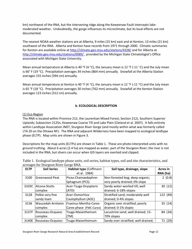
b. ECOLOGICAL DESCRIPTION (1) Eco-Region The RNA is located within Province 212, the Laurentian Mixed Forest; Section 212J, Southern Superior Uplands; Subsection 212Sn, Keweenaw Coarse Till and Lake Plain (Cleland et al. 2007). It falls entirely within Landtype Association JN07, Sturgeon River Gorge (and mostly within what was formerly called LTA 20 on the Ottawa NF). The RNA and adjacent Wilderness have been mapped to ecological landtype phase (ELTP). Map units are shown in Figure 3. Descriptions for the map units (ELTPs) are shown in Table 1. These are photo-interpreted units with no ground truthing. About 6 acres (2.4 ha) are mapped as water, part of the Sturgeon River; the river is not included in the RNA, but slivers can occur when GIS layers are overlaid and clipped. Table 1. Ecological landtype phase units, soil series, habitat types, soil and site characteristics, and acreages for Sturgeon River Gorge RNA.
ELTP Soil Series Habitat type (Coffmann et al. 1984)
Soil type, drainage, slope Acres in RNA (ha)
3100 Greenwood Peat Picea-Chamaedaphne-Sphagnum (PCS)
Non-forested bog; deep organic; very poorly drained; 0% slope
2 (0.8)
3103C Alcona-Stutts complex
Acer-Tsuga-Dryopteris (ATD)
Sandy water-worked till; well drained; 6-18% slopes
30 (12)
3128 Pelkie very fine sandy loam
Acer-Osmorhiza-Caulophyllum (AOC)
Stratified sand; moderately well drained; 0-4% slopes
122 (49)
3136 Waucedah-Arnheim complex
Fraxinus-Mentha-Carex-Carex phase (FMC-Carex)
Organic over stratified; poorly drained; 0-1% slopes
35 (14)
3137F Rousseau-Ocqueoc complex
Tsuga-Maianthemum (TM)
Lacustrine sand; well drained; 15-70% slopes
84 (34)
3140E Rousseau-Ocqueoc- Tsuga-Maianthemum- Sandy over stratified; well drained; 71 (29)
Sturgeon River Gorge Research Natural Area Establishment Record Page 13
Rubicon complex Vaccinium (TMV) 15-70% slopes
Total 344 (139)
Figure 3. Ecological landtype phases mapped for the Sturgeon River Gorge RNA.
Sturgeon River Gorge Research Natural Area Establishment Record Page 14
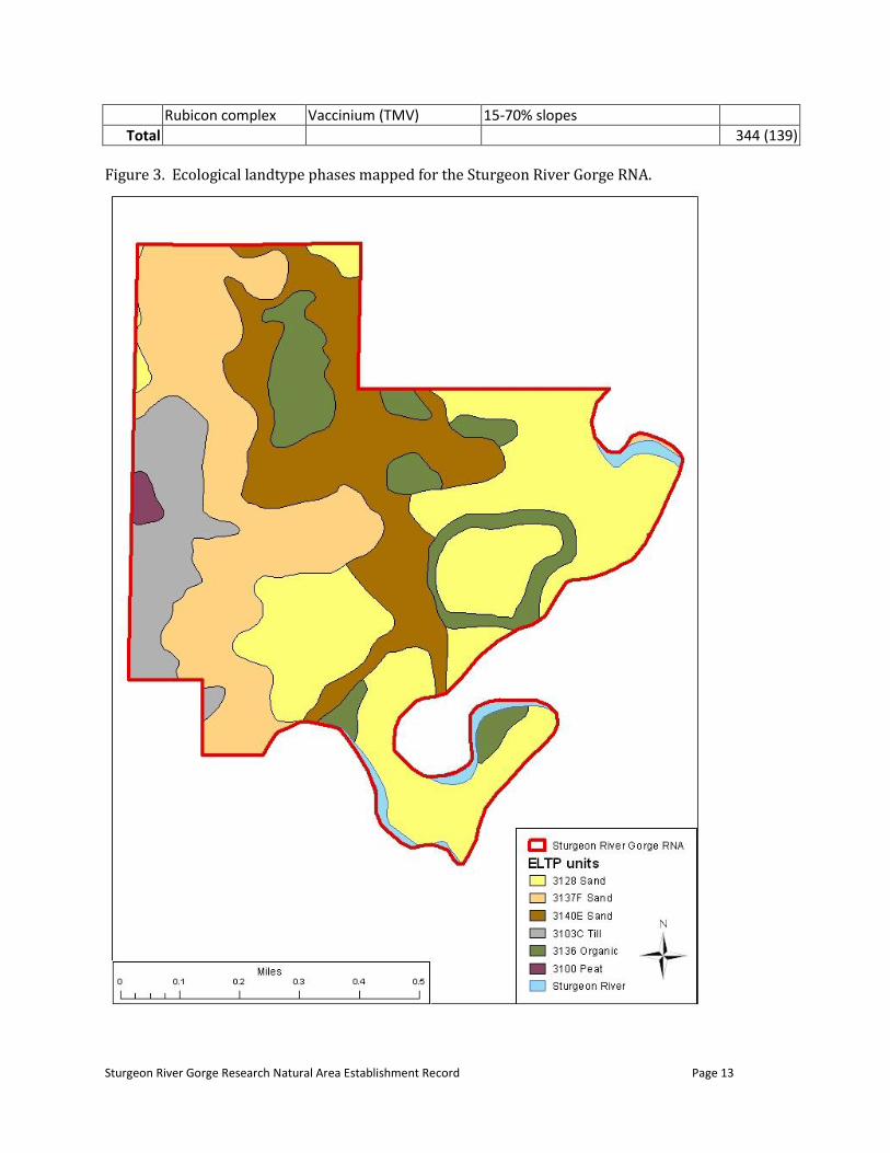
(2) Plant Communities The Ottawa National Forest has mapped the RNA using the standardized Forest Service national cover type codes for existing vegetation. This mapping divides the RNA into 14 stands (Figure 4; some of these stands extend past the RNA but have been clipped to the RNA boundary for this document). The cover types and areal extent are listed in Table 2.
Figure 4. Existing vegetation cover mapped for the Sturgeon River Gorge RNA.
Sturgeon River Gorge Research Natural Area Establishment Record Page 15
Relative to the National Vegetation Classification (NVC), the cover types fit within the system as follows: Forest and Woodland class
Temperate Forest subclass Cool Temperate Forest formation
Eastern North American Cool Temperate Forest division Northern Mesic Hardwood and Conifer Forest macrogroup
Northern Hardwood-Hemlock-White Pine Forest group OR Eastern North American Ruderal Forest & Plantation macrogroup
Northern and Central Hardwood and Conifer Ruderal Forest Group (birch-aspen woodland)
OR Boreal Forest subclass Lowland & Montane Boreal Forest formation
North American Boreal Forest division E. & Central N. American Boreal Conifer and Hardwood Forest macrogroup
White Spruce - Balsam Fir Forest Group (balsam fir) Associations within the groups are shown in Table 2. See http://usnvc.org/explore-classification/ for more information on the NVC and links to NatureServe for group descriptions (see http://www.natureserve.org/explorer/ ) Table 2. Plant communities in the Sturgeon River Gorge RNA. Cover Type (successional status)
Approx. Acres
Approx. Hectares
Approximate National Vegetation Classification Association*
Balsam fir-aspen/paper birch (likely succeeding to sugar maple type, mixed hardwoods, or hardwoods-hemlock)
4 2 CEGL002475 Picea glauca-Abies balsamea-Populus tremuloides/Mixed Herbs Forest or CEGL002446 Picea glauca-Abies balsamea/Acer spicatum/Rubus pubescens Forest or CEGL002474 Abies balsamea-Betula papyrifera/Diervilla lonicera Forest
Hemlock (late successional type)
122 49 CEGL002598 Tsuga canadensis-(Betula alleghaniensis) Forest or CEGL005044 Tsuga canadensis-Acer saccharum-Betula alleghaniensis Forest
Paper birch (likely succeeding to sugar maple type, mixed hardwoods, or hardwoods-hemlock)
107 43 CEGL002467 Populus tremuloides-Betula papyrifera-(Acer rubrum, Populus grandidentata) Forest or CEGL002468 Populus tremuloides-Betula papyrifera/Acer saccharum- Mixed Hardwoods Forest or CEGL006303 Populus (tremuloides, grandidentata)-Betula (populifolia, papyrifera) Woodland
Quaking aspen (likely succeeding to sugar maple type, mixed hardwoods, or hardwoods-hemlock)
17 7 CEGL002467 Populus tremuloides-Betula papyrifera-(Acer rubrum, Populus grandidentata) Forest or CEGL002468 Populus tremuloides-Betula papyrifera/Acer saccharum-Mixed Hardwoods Forest or CEGL006303 Populus (tremuloides, grandidentata)-Betula (populifolia, papyrifera) Woodland
Sugar maple-beech/yellow birch (late successional type)
94 38 CEGL002457 Acer saccharum-Betula alleghaniensis-(Tilia americana) Forest or CEGL002458 Acer saccharum-Tilia americana/Ostrya virginiana/Lonicera canadensis Forest
Open (oxbow lake) 5 2 NA: plant communities within the lake have not been mapped
Total 351 142
*Without further field work, exact association cannot be assigned.
Sturgeon River Gorge Research Natural Area Establishment Record Page 16
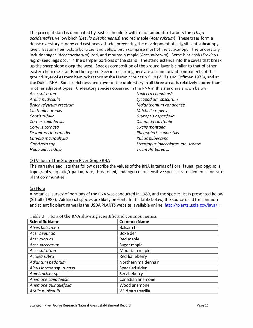
The principal stand is dominated by eastern hemlock with minor amounts of arborvitae (Thuja occidentalis), yellow birch (Betula alleghaniensis) and red maple (Acer rubrum). These trees form a dense overstory canopy and cast heavy shade, preventing the development of a significant subcanopy layer. Eastern hemlock, arborvitae, and yellow birch comprise most of the subcanopy. The understory includes sugar (Acer saccharum), red, and mountain maple (Acer spicatum). Some black ash (Fraxinus nigra) seedlings occur in the damper portions of the stand. The stand extends into the coves that break up the sharp slope along the west. Species composition of the ground layer is similar to that of other eastern hemlock stands in the region. Species occurring here are also important components of the ground layer of eastern hemlock stands at the Huron Mountain Club (Willis and Coffman 1975), and at the Dukes RNA. Species richness and cover of the understory in all three areas is relatively poorer than in other adjacent types. Understory species observed in the RNA in this stand are shown below: Acer spicatum Lonicera canadensis Aralia nudicaulis Lycopodium obscurum Brachyelytrum erectrum Maianthemum canadense Clintonia borealis Mitchella repens Coptis trifolia Oryzopsis asperifolia Cornus canadensis Osmunda claytonia Corylus cornuta Oxalis montana Dryopteris intermedia Phegopteris connectilis Eurybia macrophylla Rubus pubescens Goodyera spp. Streptopus lanceolatus var. roseus Huperzia lucidula Trientalis borealis (3) Values of the Sturgeon River Gorge RNA The narrative and lists that follow describe the values of the RNA in terms of flora; fauna; geology; soils; topography; aquatic/riparian; rare, threatened, endangered, or sensitive species; rare elements and rare plant communities. (a) Flora A botanical survey of portions of the RNA was conducted in 1989, and the species list is presented below (Schultz 1989). Additional species are likely present. In the table below, the source used for common and scientific plant names is the USDA PLANTS website, available online: http://plants.usda.gov/java/ . Table 3. Flora of the RNA showing scientific and common names. Scientific Name Common Name
Abies balsamea Balsam fir
Acer negundo Boxelder
Acer rubrum Red maple
Acer saccharum Sugar maple
Acer spicatum Mountain maple
Actaea rubra Red baneberry
Adiantum pedatum Northern maidenhair
Alnus incana ssp. rugosa Speckled alder
Amelanchier sp. Serviceberry
Anemone canadensis Canadian anemone
Anemone quinquefolia Wood anemone
Aralia nudicaulis Wild sarsaparilla
Sturgeon River Gorge Research Natural Area Establishment Record Page 17
Scientific Name Common Name
Aralia racemosa American spikenard
Arisaema triphyllum Jack in the pulpit
Asarum canadense Canadian wildginger
Athyrium filix-femina Common ladyfern
Betula alleghaniensis Yellow birch
Betula papyrifera Paper birch
Brachyelytrum erectum Bearded shorthusk
Cardamine diphylla Crinkleroot
Carex arctata Drooping woodland sedge
Carex communis Fibrousroot sedge
Carex crinita Fringed sedge
Carex deweyana Dewey sedge
Carex disperma Softleaf sedge
Carex intumescens Greater bladder sedge
Carex lupulina Hop sedge
Carex pedunculata Longstalk sedge
Carex retrorsa Knotsheath sedge
Carex trisperma Threeseeded sedge
Carex tuckermanii Tuckerman’s sedge
Caulophyllum thalictroides Blue cohosh
Chelone glabra White turtlehead
Chrysosplenium americanum American golden saxifrage
Cicuta bulbifera Bulblet-bearing water hemlock
Circaea alpina Small enchanter’s nightshade
Clematis occidentalis var. occidentalis Western blue virginsbower
Clintonia borealis Bluebead
Coptis trifolia Threeleaf goldthread
Cornus alternifolia Alternateleaf dogwood
Cornus canadensis Bunchberry dogwood
Cornus sericea ssp. sericea Redosier dogwood
Corylus cornuta Beaked hazelnut
Cypripedium acaule Moccasin flower
Decodon verticillatus Swamp loosestrife
Deparia acrostichoides Silver false spleenwort
Dicentra cucullaria Dutchman’s breeches
Diervilla lonicera Northern bush honeysuckle
Dirca palustris Eastern leatherwood
Dryopteris intermedia Intermediate woodfern
Elymus hystrix Eastern bottlebrush grass
Epilobium coloratum Purpleleaf willowherb
Epipactis helleborine Broadleaf helleborine
Equisetum hyemale Scouringrush horsetail
Equisetum scirpoides Dwarf scouringrush
Equisetum sylvaticum Woodland horsetail
Erythronium americanum Dogtooth violet
Sturgeon River Gorge Research Natural Area Establishment Record Page 18
Scientific Name Common Name
Eurybia macrophylla Bigleaf aster
Fraxinus nigra Black ash
Galeopsis tetrahit Brittlestem hempnettle
Galium asprellum Rough bedstraw
Galium triflorum Fragrant bedstraw
Gaultheria procumbens Eastern teaberry
Geum macrophyllum Largeleaf avens
Goodyera repens Lesser rattlesnake plantain
Goodyera tesselata Checkered rattlesnake plantain
Gymnocarpium dryopteris Western oakfern
Huperzia lucidula Shining clubmoss
Impatiens capensis Jewelweed
Iris versicolor Harlequin blueflag
Laportea canadensis Canadian woodnettle
Lathyrus ochroleucus Cream pea
Lemna sp. Duckweed
Lonicera canadensis American fly honeysuckle
Lonicera hirsuta Hairy honeysuckle
Luzula acuminata Hairy woodrush
Lycopodium annotinum Stiff clubmoss
Lycopodium clavatum Running clubmoss
Lycopodium obscurum Obscure (rare) clubmoss
Lycopus americanus American water horehound
Lysimachia quadrifolia Whorled yellow loosestrife
Maianthemum canadense Canada mayflower
Matteuccia struthiopteris Ostrich fern
Milium effusum American milletgrass
Mimulus ringens Allegheny monkeyflower
Mitchella repens Partridgeberry
Mitella nuda Naked miterwort
Onoclea sensibilis Sensitive fern
Oryzopsis asperifolia Roughleaf ricegrass
Osmorhiza sp. Sweetroot
Osmunda cinnamomea Cinnamon fern
Osmunda claytoniana Interrupted Fern
Osmunda regalis Royal fern
Oxalis montana Mountain woodsorrel
Parthenocissus vitacea Woodbine
Petasites frigidus var. palmatus Arrowleaf Sweet coltsfoot
Phegopteris connectilis Long beechfern
Picea glauca White spruce
Pinus resinosa Red pine
Pinus strobus Eastern white pine
Platanthera orbiculata Lesser roundleaved orchid
Polygala paucifolia Gaywings
Sturgeon River Gorge Research Natural Area Establishment Record Page 19
Scientific Name Common Name
Polygonatum pubescens Hairy solomon’s seal
Polygonum cilinode Fringed black bindweed
Populus tremuloides Quaking aspen
Potamogeton sp. Pondweed
Potentilla norvegica Norwegian cinquefoil
Prunella vulgaris Common selfheal
Prunus virginiana Chokecherry
Pteridium aquilinum Western brackenfern
Pyrola elliptica Waxflower shinleaf
Quercus rubra Northern red oak
Ribes glandulosum Skunk currant
Ribes triste Red currant
Rubus parviflorus Thimbleberry
Rubus pubescens Dwarf red blackberry
Sambucus racemosa var. racemosa Red elderberry
Sanguinaria canadensis Bloodroot
Scirpus microcarpus Panicled bulrush
Scutellaria galericulata Marsh skullcap
Solanum dulcamara Climbing nightshade
Sorbus sp. Mountain ash
Streptopus lanceolatus var. roseus Twistedstalk
Symphyotrichum lateriflorum Calico aster
Thelypteris palustris var. pubescens Eastern marsh fern
Thuja occidentalis Arborvitae
Tilia americana American basswood
Toxicodendron radicans Eastern poison ivy
Trientalis borealis Starflower
Trillium cernum Whip-poor-will flower
Tsuga canadensis Eastern hemlock
Ulmus americana American elm
Uvularia grandiflora Largeflower bellwort
Viola labradorica Alpine violet
Viola pubescens Downy yellow violet
Viola renifolia White violet
Viola sororia Common blue violet
Waldsteinia fragarioides Appalachian barren strawberry
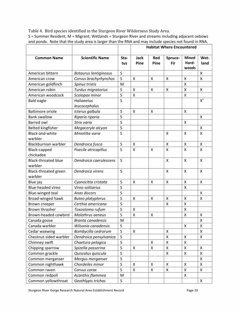
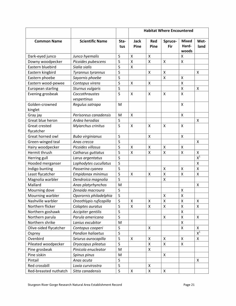
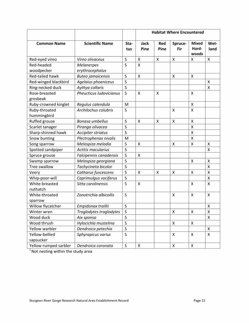
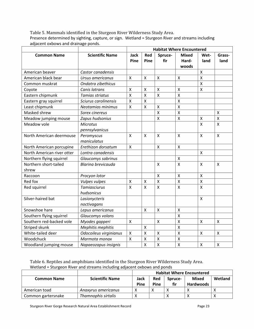
(b) Fauna Fauna typical of mesic northern forest and riverine communities is expected in the RNA. Crider (1979) conducted a survey of fauna of the larger gorge area that includes mammals, birds, amphibians and reptiles. These species lists are shown below and should approximate species expected in the RNA. The source for scientific and common names of animals is NatureServe, available online at http://www.natureserve.org/explorer/ .
Sturgeon River Gorge Research Natural Area Establishment Record Page 20
Table 4. Bird species identified in the Sturgeon River Wilderness Study Area. S = Summer Resident, M = Migrant; Wetlands = Sturgeon River and streams including adjacent oxbows and ponds. Note that the study area is larger than the RNA and may include species not found in RNA.
Habitat Where Encountered
Common Name Scientific Name Sta-tus
Jack Pine
Red Pine
Spruce-Fir
Mixed Hard-woods
Wet-land
American bittern Botaurus lentiginosus S X
American crow Corvus brachyrhynchos S X X X X X
American goldfinch Spinus tristis M X
American robin Turdus migratorius S X X X X X
American woodcock Scolopax minor S X X
Bald eagle Haliaeetus leucocephalus
S X1
Baltimore oriole Icterus galbula S X X X
Bank swallow Riparia riparia S X
Barred owl Strix varia S X
Belted kingfisher Megaceryle alcyon S X
Black-and-white warbler
Mniotilta varia S X X X
Blackburnian warbler Dendroica fusca S X X X X
Black-capped chickadee
Poecile atricapillus S X X X X X
Black-throated blue warbler
Dendroica caerulescens S X X X
Black-throated green warbler
Dendroica virens S X X X
Blue jay Cyanocitta cristata S X X X X X
Blue-headed vireo Vireo solitarius S X
Blue-winged teal Anas discors S X
Broad-winged hawk Buteo platypterus S X X X X X
Brown creeper Certhia americana S X X
Brown thrasher Toxostoma rufum S X X
Brown-headed cowbird Molothrus aeneus S X X X X
Canada goose Branta canadensis M X
Canada warbler Wilsonia canadensis S X X
Cedar waxwing Bombycilla cedrorum S X X X
Chestnut-sided warbler Dendroica pensylvanica S X X X
Chimney swift Chaetura pelagica S X X X
Chipping sparrow Spizella passerina S X X X X X
Common grackle Quiscalus quiscula S X X X
Common merganser Mergus merganser S X
Common nighthawk Chordeiles minor S X X X X X
Common raven Corvus corax S X X X X X
Common redpoll Acanthis flammea M X
Common yellowthroat Geothlypis trichas S X
Sturgeon River Gorge Research Natural Area Establishment Record Page 21
Habitat Where Encountered
Common Name Scientific Name Sta-tus
Jack Pine
Red Pine
Spruce-Fir
Mixed Hard-woods
Wet-land
Dark-eyed junco Junco hyemalis S X X X
Downy woodpecker Picoides pubescens S X X X X
Eastern bluebird Sialia sialis S X
Eastern kingbird Tyrannus tyrannus S X X X
Eastern phoebe Sayornis phoebe S X X
Eastern wood-pewee Contopus virens S X X X
European starling Sturnus vulgaris S X X
Evening grosbeak Coccothraustes vespertinus
S X X X X
Golden-crowned kinglet
Regulus satrapa M X
Gray jay Perisoreus canadensis M X X
Great blue heron Ardea herodias S X
Great crested flycatcher
Myiarchus crinitus S X X X X
Great horned owl Bubo virginianus S X X
Green-winged teal Anas crecca S X
Hairy woodpecker Picoides villosus S X X X X
Hermit thrush Catharus guttatus S X X X X X
Herring gull Larus argentatus S X1
Hooded merganser Lophodytes cucullatus S X
Indigo bunting Passerina cyanea S X X X
Least flycatcher Empidonax minimus S X X X X X
Magnolia warbler Dendroica magnolia S X
Mallard Anas platyrhynchos M X
Mourning dove Zenaida macroura S X
Mourning warbler Oporornis philadelphia S X X
Nashville warbler Oreothlypis ruficapilla S X X X X X
Northern flicker Colaptes auratus S X X X X X
Northern goshawk Accipiter gentilis S X
Northern parula Parula americana S X X X
Northern shrike Lanius excubitor M X
Olive-sided flycatcher Contopus cooperi S X X X
Osprey Pandion haliaetus S X1
Ovenbird Seiurus aurocapilla S X X X X X
Pileated woodpecker Dryocopus pileatus S X X X
Pine grosbeak Pinicola enucleator M X
Pine siskin Spinus pinus M X
Pintail Anas acuta S X
Red crossbill Loxia curvirostra S X
Red-breasted nuthatch Sitta canadensis S X X X
Sturgeon River Gorge Research Natural Area Establishment Record Page 22
Habitat Where Encountered
Common Name Scientific Name Sta-tus
Jack Pine
Red Pine
Spruce-Fir
Mixed Hard-woods
Wet-land
Red-eyed vireo Vireo olivaceus S X X X X X
Red-headed woodpecker
Melanerpes erythrocephalus
S X
Red-tailed hawk Buteo jamaicensis S X X X
Red-winged blackbird Agelaius phoeniceus S X
Ring-necked duck Aythya collaris S X
Rose-breasted grosbeak
Pheucticus ludovicianus S X X X
Ruby-crowned kinglet Regulus calendula M X
Ruby-throated hummingbird
Archilochus colubris S X X
Ruffed grouse Bonasa umbellus S X X X X
Scarlet tanager Piranga olivacea S X
Sharp-shinned hawk Accipiter striatus S X
Snow bunting Plectrophenax nivalis M X
Song sparrow Melospiza melodia S X X X X
Spotted sandpiper Actitis macularius S X
Spruce grouse Falcipennis canadensis S X
Swamp sparrow Melospiza georgiana S X X
Tree swallow Tachycineta bicolor S X
Veery Catharus fuscescens S X X X X X
Whip-poor-will Caprimulgus vociferus S X
White-breasted nuthatch
Sitta carolinensis S X X X
White-throated sparrow
Zonotrichia albicollis S X X X
Willow flycatcher Empidonax traillii S X
Winter wren Troglodytes troglodytes S X X X
Wood duck Aix sponsa S X
Wood thrush Hylocichla mustelina S X X
Yellow warbler Dendroica petechia S X
Yellow-bellied sapsucker
Sphyrapicus varius S X X X
Yellow-rumped sarbler Dendroica coronata S X X X 1 Not nesting within the study area
Sturgeon River Gorge Research Natural Area Establishment Record Page 23
Table 5. Mammals identified in the Sturgeon River Wilderness Study Area. Presence determined by sighting, capture, or sign. Wetland = Sturgeon River and streams including adjacent oxbows and drainage ponds.
Habitat Where Encountered
Common Name Scientific Name Jack Pine
Red Pine
Spruce-fir
Mixed Hard-woods
Wet-land
Grass-land
American beaver Castor canadensis X
American black bear Ursus americanus X X X X X
Common muskrat Ondatra zibethicus X
Coyote Canis latrans X X X X X
Eastern chipmunk Tamias striatus X X X X
Eastern gray squirrel Sciurus carolinensis X X X
Least chipmunk Neotamias minimus X X X X
Masked shrew Sorex cinereus X X X
Meadow jumping mouse Zapus hudsonius X X X X
Meadow vole Microtus pennsylvanicus
X X
North American deermouse Peromyscus maniculatus
X X X X X X
North American porcupine Erethizon dorsatum X X X
North American river otter Lontra canadensis X
Northern flying squirrel Glaucomys sabrinus X
Northern short-tailed shrew
Blarina brevicauda X X X X
Raccoon Procyon lotor X X X
Red fox Vulpes vulpes X X X X X
Red squirrel Tamiasciurus hudsonicus
X X X X X
Silver-haired bat Lasionycteris noctivagans
X
Snowshoe hare Lepus americanus X X X
Southern flying squirrel Glaucomys volans X
Southern red-backed vole Myodes gapperi X X X X X
Striped skunk Mephitis mephitis X X
White-tailed deer Odocoileus virginianus X X X X X X
Woodchuck Marmota monax X X X X
Woodland jumping mouse Napaeozapus insignis X X X X X
Table 6. Reptiles and amphibians identified in the Sturgeon River Wilderness Study Area. Wetland = Sturgeon River and streams including adjacent oxbows and ponds
Habitat Where Encountered
Common Name Scientific Name Jack Pine
Red Pine
Spruce-fir
Mixed Hardwoods
Wetland
American toad Anaxyrus americanus X X X X X
Common gartersnake Thamnophis sirtalis X X X X
Sturgeon River Gorge Research Natural Area Establishment Record Page 24
Common snapping turtle Chelydra serpentina X X
Eastern newt Notophthalmus viridescens X
Mink frog Lithobates septentrionalis X
Northern leopard frog Lithobates pipiens X
Northern painted turtle Chrysemys picta X X
Red-bellied snake Storeria occipitomaculata X X
Ring-necked snake Diadophis punctatus X
Smooth greensnake Opheodrys vernalis X X
Spring peeper Pseudacris crucifer X X
Wood frog Lithobates sylvaticus X X X
Wood turtle Glyptemys insculpta X X
(c) Geology A detailed study of the gorge’s geology and mineral resources was prepared by Cannon et al. (1980) for the Sturgeon River Wilderness Study Area. Bedrock is not exposed in the immediate vicinity of the RNA, being buried by glacial till. On the basis of aeromagnetic surveys it is presumed to be the Michigamme Formation. This formation consists of middle Precambrian greywacke and slate in a monotonous sequence and is highly folded. The aeromagnetic surveys also indicate an east-west trending diabase dike that intruded into the Michigamme Formation, passing directly beneath the RNA. The present Sturgeon River course follows an ancient pre-Pleistocene course that was influenced by a through in the bedrock. The area was highly modified during Pleistocene glaciations. Tills of considerable depth, at least to the depth of the gorge, were deposited in this area, as it is on the axis of the Keweenaw lobe. The Portage Lake Moraine crosses the gorge at about the RNA. The moraine became a shoreline of proglacial Lake Duluth, which formerly inundated the RNA. The gorge was formed when the lake breached the moraine and drained through the gorge with the water flowing southward toward Lake Algonquin. The subsequent northward retreat of the shoreline toward the Lake Superior basin and the isostatic rebound of the area caused the drainage to reverse and flow northward. Several landforms in the RNA were shaped in these later stages. The terrace appears to have been an oxbow that drained and filled after continuous downcutting left it perched above the river level. The small ridge appears to be a terrace escarpment that formed at an earlier, higher river stage also. (d) Soils Soils information is shown above under Eco-Regions. (e) Topography The Sturgeon River bisects a generally upland plain of a variety of glacially influenced landscapes, creating a gorge of 200 to 300 feet (61-91 m) deep. The river is in the Lake Superior watershed and the gorge is in about the center of the watershed. The gorge averages 0.5 to 1 mile (0.8-1.6 km) wide and is about 8 miles (13 km) long. Geologically, it is relatively young and has a narrow V-shaped valley with steep side slopes that, in locations, are bare and actively eroding. Most tributaries extend westward from the river, and are actively cutting into the uplands.
Sturgeon River Gorge Research Natural Area Establishment Record Page 25
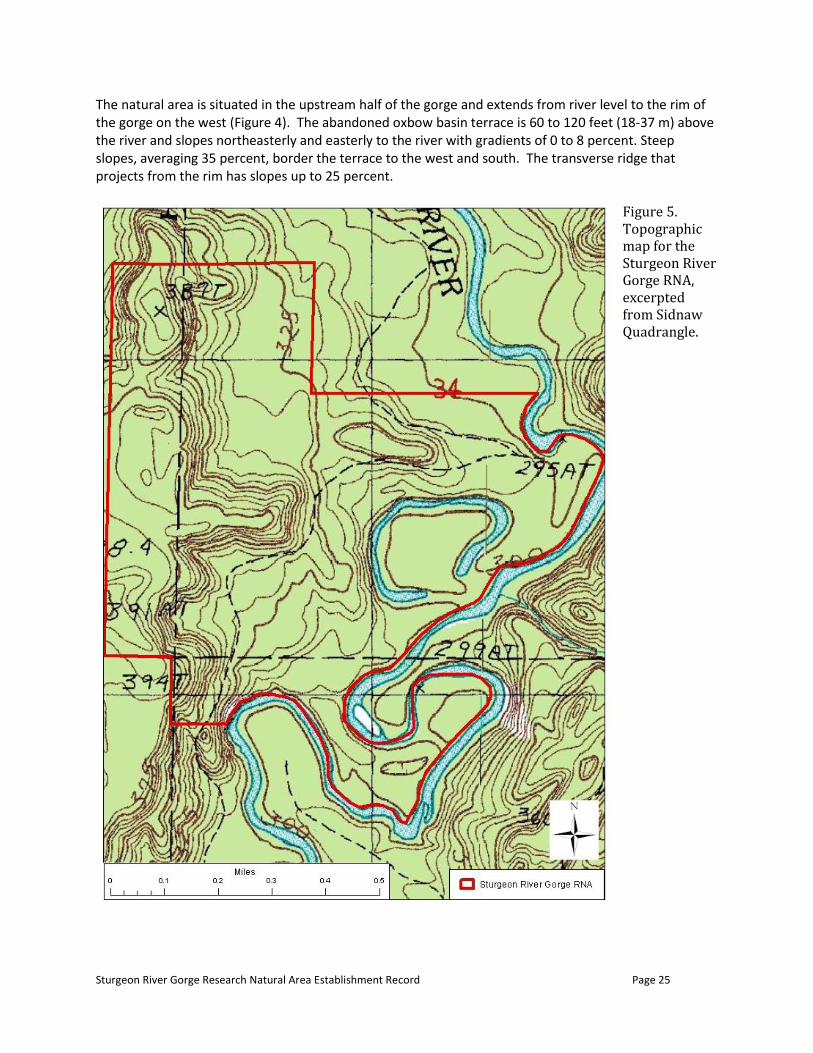
The natural area is situated in the upstream half of the gorge and extends from river level to the rim of the gorge on the west (Figure 4). The abandoned oxbow basin terrace is 60 to 120 feet (18-37 m) above the river and slopes northeasterly and easterly to the river with gradients of 0 to 8 percent. Steep slopes, averaging 35 percent, border the terrace to the west and south. The transverse ridge that projects from the rim has slopes up to 25 percent.
Figure 5. Topographic map for the Sturgeon River Gorge RNA, excerpted from Sidnaw Quadrangle.
Sturgeon River Gorge Research Natural Area Establishment Record Page 26
(f) Aquatic/riparian No mapped rivers or streams are within the RNA; the Sturgeon River forms part of the south and the east boundary of the RNA. The only lake in the RNA is the unnamed 5 acre (2 ha) oxbow lake. The oxbow lake is situated near the level of the present river course at about 984 feet (300 m) above MSL. It forms an almost complete loop of about 1,000 feet (305 m) in diameter, falling short by an arc of about 300 feet (91 m) at its southeast point. It averages 70 feet (21 m) wide and is shallow, not over 10 feet (3 m) deep in most places. The banks on the north and west are steep and high, as this was the river’s cutting edge when it flowed through this channel. The other banks are low and the area inside the loop is relatively flat. Biological surveys specifically of the lake have not been conducted. Species on Crider’s (1979) list of fauna that are associated with wet habitats would likely be found in this habitat, such as muskrats or common snapping turtles. (g) Rare, threatened, endangered, or sensitive species There are no records for Regional Forester’s Sensitive Plants or State of Michigan listed plants in the RNA, based on the Ottawa NF database and the Michigan Natural Features Inventory database. The Regional Forester’s Sensitive Species bald eagle and wood turtle have been observed near the RNA and could occur there. There may be potential habitat for other RFSS species in the area. (h) List of rare elements and rare plant communities There are no known (recorded) rare elements or rare plant communities other than the eastern hemlock stand described above.
c. RESOURCE INFORMATION (1) Minerals The mineral potential of the area was investigated by the U.S. Geological Survey (Cannon et al. 1980). This report concludes: “The study disclosed no metallic deposits that can be mined economically”. Minor resources of stone, sand, gravel, clay and peat exist in the RNA, but because they lie so far from major demand centers, they are of little economic interest. The Forest Plan includes standards for the wilderness that “no permit, lease, or other authorization will be issued for the exploration or mining of minerals owned by the United States” and “Recommend against US Department of Agriculture consent to mineral extraction plans”. The Forest Plan also includes a guideline to “acquire subsurface mineral rights through exchange with the State of Michigan where feasible. Establish federal claims based on the State Dormant Minerals Act where the law can be applied to free leasable minerals. Acquire subsurface mineral rights in other cases on a willing seller, willing buyer basis”. All lands within the RNA are federally owned. Lands in T48N R35W Section 3, and T49N R35W Section 34, were acquired from the Wisconsin-Michigan Power Company in 1936. The power company reserved the right to utilize right of ways for roads and power transmission whenever necessary to develop and operate power sites. The government holds the mineral rights to lands in Section 34, except for the parcel obtained in 2008 (adjacent to river) and the Michigan Iron and Land Company retains the mineral rights in Section 3. The lands in T49N R35W Section 33 were acquired in 1977 from the Nature Conservancy. The Ford Motor Company retains the mineral, oil and gas rights on these lands.

Sturgeon River Gorge Research Natural Area Establishment Record Page 27
(2) Grazing The primarily forested RNA is unsuitable for grazing. The Ottawa NF does not have a range program. Moreover, allowing grazing would be incompatible with the management prescription for the Wilderness including the RNA. (3) Plants (including timber and special forest products) Timber harvest is not allowed in the wilderness encompassing the RNA. The Forest Plan includes a guideline that forest product removal is generally not permitted in Wilderness; this guideline would also apply to the RNA. The RNA receives little public use due to its remoteness. (4) Watershed Values No watershed management activities are proposed or anticipated within the RNA. The terrain of the gorge lends itself to natural erosion on a larger scale than is typical of much of the Ottawa National Forest. Maintenance of forest cover, reduced foot traffic, and the lack of any road or trail construction should mitigate the need for watershed protective measures. (5) Recreation Use District personnel have observed light use, perhaps 15 to 20 people per year in this general area of the gorge (T. Strietzel, personal communication, February 2012). Much of the use is associated with the river or the rim. The typical recreationists would be backpackers, river users, fishermen or hunters. Light visitor use of the RNA is expected to continue, and that use is not expected to conflict with research or the protection and maintenance of natural values. The potential for human caused impacts due to more than occasional recreational use within the RNA is minimal given the somewhat difficult access, absence of improved trails, and rugged terrain. (6) Wildlife
-
-
(7) Transportation/Road System The current transportation system surrounding the Sturgeon River Gorge Wilderness should not conflict with the RNA. No changes are expected to the collector roads used to access the RNA.
d. HISTORICAL INFORMATION
(1) Research/education use and interest: history of establishment There has been interest in establishing an RNA, featuring the eastern hemlock stand, since 1976. An establishment record was drafted in 1983, but was not submitted because of the commencement of forest planning, the inclusion of the gorge in the second Roadless Area Review and Evaluation (RARE II), and the desire to include a greater representation of the gorge slope, biologic communities and the

Sturgeon River Gorge Research Natural Area Establishment Record Page 28
oxbow lake in a larger proposed RNA. Appendix E of the 1986 Ottawa Forest Plan Environmental Impact Statement (EIS) included a draft establishment record for an area of about 120 acres (USDA Forest Service 1986). This appendix also notes the potential to expand the candidate area, to add geologic features not included in the smaller tract. In the RNA Program files, a candidate area of 281 acres (113 ha) is delineated and cover types are mapped. Based on the intent of the 1986 Forest Plan to expand the area, and the detailed map prepared for the 1993 draft establishment record, the file’s paper map was digitized, modified slightly to facilitate preparation of a boundary description, and used for the candidate RNA boundary. This area is approximately 314 acres (127 ha). Due to the subsequent acquisition of the electric company lands, it was possible to slightly expand the RNA, by about 37 acres (15 ha), for this final establishment record, capturing all of the oxbow and adjacent land. The RNA was carried as a candidate through the 1986 Ottawa National Forest Land and Resource Management Plan (Forest Plan) and re-evaluated as part of Forest Plan revision in 2006 (see Forest Plan EIS Appendix I). The 2006 Forest Plan EIS included environmental analysis for establishment of the candidate RNA and updating was begun for the 1993 draft establishment record. However, the Eastern Region generated a large pulse of candidate RNAs during Forest plan revisions at this time, which became a concern. A region-wide assessment of all candidate RNAS ensued, and resulted in the recommendation of 64 (of 110) candidates for establishment. In a July 2010 letter, the Regional Forester directed that Sturgeon River Gorge cRNA be moved forward to establishment. There is no active research and/or educational use of the RNA taking place at this time. No research has occurred to date in the RNA. (2) Cultural/heritage Native American tribes have used the lands that make up the Ottawa National Forest for thousands of years and treaties ensure their continued use. Treaty rights are exercised by Native American tribes and tribal members in various ways, such as hunting, fishing, cultural practices and gathering of forest plants. The Forest Service recognizes treaty rights as a matter of national policy and more locally on the Ottawa through a “Memorandum of Understanding” with sovereign and federally recognized tribes of Lake Superior Chippewa Indians. The Forest Plan includes an objective (USDA FS Eastern Region 2006 p. 2-3) that “nothing in this Forest Plan or its implementation [i.e. establishing the RNA] is intended to modify, abrogate, or otherwise adversely affect tribal reserved or treaty guaranteed rights applicable within the Ottawa”. The Sturgeon River Gorge Wilderness containing the RNA has been designated as a Tribal wilderness (GLIFWC 1998), meaning federal restrictions on wheeled and motorized uses are adopted. The new RNA has not been designated as a Tribal RNA, which would add a restriction that “gathering of wild plants [is] prohibited within designated research natural areas except for religious or ceremonial use with permission from Tribe.” Designation of the new RNA as a Tribal RNA could be explored with GLIFWC and the local Tribes; however, such designation may be unnecessary since current gathering uses are light. None of the RNA has been surveyed for archaeological or historic sites (C. Ver Planck , personal communication, February 2012). Overstreet and Wackman (1978) suggest, based on surveys nearby, that this area has a moderate to high potential for having archaeological sites. Establishment of the RNA should have no adverse effect on any existing, but as yet unobserved, cultural or heritage resources in the area. RNA establishment will be beneficial in facilitating protection of such cultural/heritage values.

Sturgeon River Gorge Research Natural Area Establishment Record Page 29
(3) Disturbance history Forests of the area were originally dominated by northern hardwoods, eastern hemlock and white pine. About the turn of the 20th century, the gorge was first logged, primarily for its pines. The river probably played an important role in log transport from the woods to local sawmills. Since then, logging continued until the gorge was congressionally designated for wilderness study in 1975. Old logging roads penetrate into most reaches of the gorge, including the RNA. The RNA’s featured eastern hemlock escaped the logging and remains one of few unharvested areas in Michigan’s Upper Peninsula. The balance of the RNA was logged at various times and in different manners. The maturing aspen types alongside the eastern hemlock are likely the result of clearcutting and/or fire. The frequent occurrence of sawtimber-size trees in the northern hardwood and mixed hemlock-hardwood stands suggest that single-tree selection system of silviculture was used to manage these stands. The formerly private lands north and east of the eastern hemlock stand (acquired by the Forest Service in 2008 from Wisconsin Electric Company via the Trust for Public Land) have second-growth, northern-hardwood stands resulting from harvesting. (4) Occurrence of exotic species Native plant species dominate the RNA. Three species of naturalized European flora were observed in the RNA during the botanical survey: Epipactis helleborine, Galeopsis tetrahit and Solanum dulcamara. They are not considered invasive species of concern on the Ottawa. They are minor constituents of their communities and, at present, control is not warranted.
e. OTHER INFORMATION
(1) Any permanent research plots and/or photo points No permanent research plots or photo points have been established in the RNA. (2) Bibliography References cited in this Establishment Record are listed in Appendix C. No publications have resulted from studies in the RNA. (3) Potential research topics Possible research topics include the following:
dendrochronology to reconstruct historical climate records
biomass accumulation (carbon sequestration) rates and sequestration trajectories as the stands reach maturity
Role of regeneration and small scale disturbances in natural succession
Role of deer in plant community structure and composition. The hemlock stands could be used as controls for manipulative hemlock research outside the RNA. (4) Administrative records and protection The Station Director, Northern Research Station, in consultation with the Forest Supervisor, Ottawa National Forest; District Ranger, Kenton Ranger District; and NRS RNA Coordinator(s) will coordinate research conducted in the RNA. Research approval must be granted by the Regional Forester, since the RNA is within designated wilderness.
Sturgeon River Gorge Research Natural Area Establishment Record Page 30
Requests to conduct research are referred to the Station Director, Northern Research Station, who will coordinate a review of the application. Prior to the initiation of any projects, the Director or NRS RNA Designate will coordinate the project or activity with the District Ranger. Any plant, animal, vegetation, or soil specimen(s) collected in the course of research conducted in the RNA are to be housed at a location designated by the Forest or approved by the Station Director. Hard copies of research data files will be maintained in the following offices:
RNA Coordinator Supervisor’s Office Ottawa NF E6248 US Highway 2 Ironwood, MI 49938 And Michigan National Forest RNA Liaison Northern Research Station Michigan State University Stephen S. Nisbet Building, Room 220 1407 S. Harrison Road, East Lansing, MI 48823-5239
The Station Director will determine archiving methods for the RNA in order to facilitate the exchange and transfer of information among Research Stations, scientists and Forest resource managers.
f. EVALUATION OF SPECIFIC MANAGEMENT RECOMMENDATIONS ON RESEARCH NATURAL AREA
(1) Potential or existing conflicts; principal management issues The RNA is within the Sturgeon River Gorge Wilderness and the Sturgeon Wild River Corridor. Management conflicts that could arise under the three designations should be minor, and the most restrictive designation would likely prevail where there is overlap. The overall management direction of all three designations is very similar. The primary emphasis on research in the RNA is not in conflict with permissible uses allowed in the two other designations. Destructive or manipulative research would not be allowed in the RNA. Any sampling or other activities that may result in changes to the ecosystem structure or function are to be avoided in order to maintain the undisturbed character of the RNA. (2) Special management area if the Research Natural Area is within one The RNA is within the Sturgeon River Gorge Wilderness and the Sturgeon Wild River Corridor.
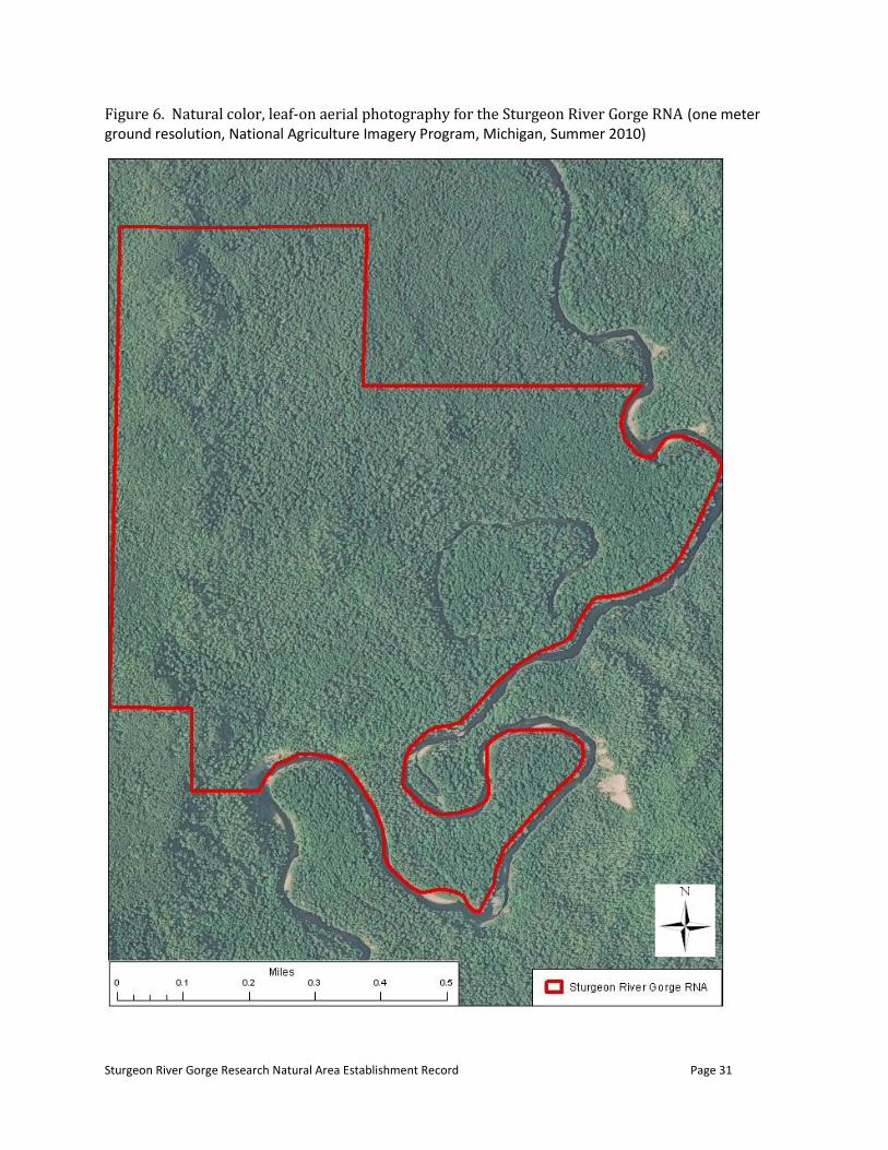
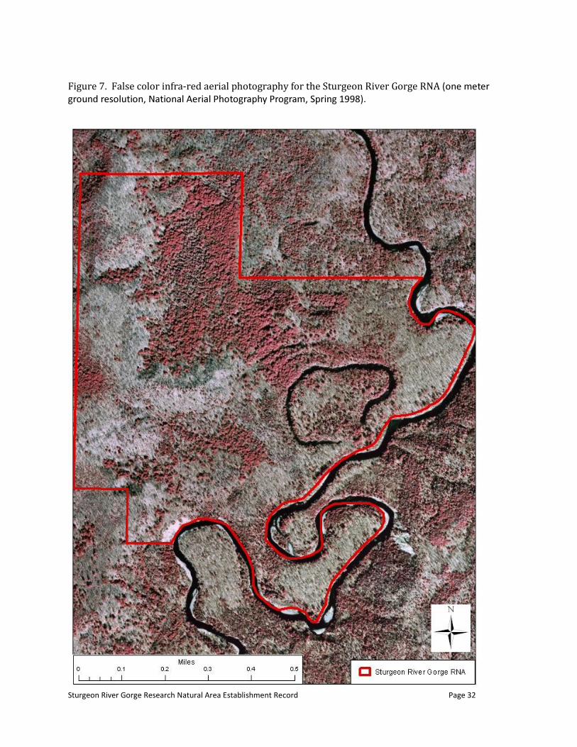
g. PHOTOGRAPHS
No digital photographs are available showing the RNA. Aerial photography is available in both true color and false color infra-red, through the Ottawa National Forest geographic information system, as shown in Figures 5 and 6.
Sturgeon River Gorge Research Natural Area Establishment Record Page 31
Figure 6. Natural color, leaf-on aerial photography for the Sturgeon River Gorge RNA (one meter ground resolution, National Agriculture Imagery Program, Michigan, Summer 2010)
Sturgeon River Gorge Research Natural Area Establishment Record Page 32
Figure 7. False color infra-red aerial photography for the Sturgeon River Gorge RNA
Sturgeon River Gorge Research Natural Area Establishment Record Page 33
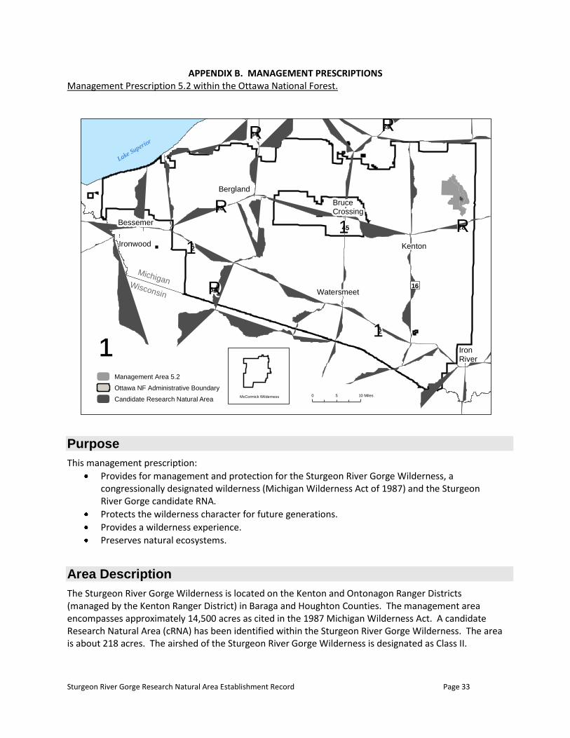
APPENDIX B. MANAGEMENT PRESCRIPTIONS Management Prescription 5.2 within the Ottawa National Forest.
Purpose
This management prescription:
Provides for management and protection for the Sturgeon River Gorge Wilderness, a congressionally designated wilderness (Michigan Wilderness Act of 1987) and the Sturgeon River Gorge candidate RNA.
Protects the wilderness character for future generations.
Provides a wilderness experience.
Preserves natural ecosystems.
Area Description
The Sturgeon River Gorge Wilderness is located on the Kenton and Ontonagon Ranger Districts (managed by the Kenton Ranger District) in Baraga and Houghton Counties. The management area encompasses approximately 14,500 acres as cited in the 1987 Michigan Wilderness Act. A candidate Research Natural Area (cRNA) has been identified within the Sturgeon River Gorge Wilderness. The area is about 218 acres. The airshed of the Sturgeon River Gorge Wilderness is designated as Class II.
!.
!.
!.
!.
!.
!.
!.
Kenton
Bergland
Ironwood
Bessemer
Watersmeet
Iron River
BruceCrossing
Lake Superior
MichiganWisconsin
012
012
QR64
QR28
QR64QR26
0145 QR28
16
McCormick Wilderness 0 105 Miles
¹Management Area 5.2
Ottawa NF Administrative Boundary
Candidate Research Natural Area
Sturgeon River Gorge Research Natural Area Establishment Record Page 34
The most common Landtype Association (LTA) is 212Sn07, Sturgeon River Gorge (about 65%), which consists of very steep, unstable, river valley walls and floodplains with variable acid soils. Numerous smaller streams have incised the valley walls, creating a complex, dissected, ridge and ravine landscape. Seepages (springs), landslides, soil creep, and mass wasting are quite common. Colluvial soils common. Soil permeability is variable. The remainder is LTA 212Sn12, Watton-Six Mile moraines. This is a rolling, dissected, terminal moraine complex with loamy soils over calcareous, clay loam till. There are some stony areas, and soil permeability is commonly moderately slow.
Desired Condition of the Land
Remote, undisturbed areas offer a secluded setting. Visitors to the Sturgeon River Gorge Wilderness will find rocky outcrops and steep terrain along the gorge, rivers, marshes, bogs, wetlands, and quiet secluded forests. Down, dead or dying trees remain within the forest, offering habitat for a wide variety of animals and birds. A diversity of tree species, age and size are found in this natural appearing forest. The experience is that of quiet, secluded, wild woodland.
1900 Land and Resource Management Planning
Vegetative Management Guidelines Vegetative composition will generally evolve through natural succession and disturbance. Manage vegetation to protect wilderness values. Considerations may include protection of adjacent property from fire or pests, or removal of non-indigenous species. Allow areas to revegetate naturally. Consider means to revegetate only those areas that are heavily impacted and do not have a chance to revegetate naturally, using local native plant species and hand tool scarification.
2300 Recreation Management
Recreation Management Standards Use hand tools for construction and maintenance activities. Prohibit use of wheeled vehicles such as portage wheels or bicycles, except non-motorized wheelchairs as provided for in the Americans with Disabilities Act. Guidelines Feature semi-primitive non-motorized recreation opportunities. Allow recreational use consistent with protecting wilderness values.
Sturgeon River Gorge Research Natural Area Establishment Record Page 35
Manage for low interaction between users. Provide only minimum facilities, when they are necessary, to prevent the deterioration of wilderness values. Construct facilities primarily with natural materials. Limit signing to major trail intersections and trailhead facilities. Trailhead facilities and wilderness information will normally be located outside wilderness boundaries. Trail Use and Operation Guidelines In general, do not build new trails. Design, construct, and maintain trails to minimize impacts to vegetation, soils, and water. Reroute, rehabilitate, or close existing trails as necessary for resource protection and to minimize user impact. Watercraft Standard Storage of boats or equipment is not allowed, except for those items used in conjunction with a current visit. Visual Quality Standard The overall desired Visual Quality Objective (VQO) of wilderness is preservation, which allows for ecological changes only. Since some management practices are allowed in wilderness, these practices must meet, at the minimum, a VQO of retention. Human Waste Guideline Facilities for human waste may be provided at designated sites and trailheads or specified sites outside wilderness.
2400 Timber Management
Standard Silvicultural systems are not applicable to this management area. Timber is not harvested in wilderness.
2500 Soil, Water and Air
Guidelines Mitigate erosion with control measures commensurate with the soil characteristics, expected use, and management objectives of the area. Limit watershed improvement projects to correcting human-caused problems and natural disasters that threaten health and safety.
Sturgeon River Gorge Research Natural Area Establishment Record Page 36
Rehabilitate areas using local native materials.
2700 Special Use Management
Utility Transmission Corridors Standards Prohibit corridors for reservoirs, water conservation works, power projects, transmission lines, and other facilities, except as authorized by the act establishing the wilderness. No new utility transmission corridors will be permitted. Other Special Uses Standard Competitive events are not permitted. Guideline Special uses, such as outfitter/guiding activities, which do not require fixed improvements or modification of natural conditions, may be considered on a case-by-case basis.
2800 Minerals and Geology
Federal Minerals Standards No permit, lease, or other authorization will be issued for the exploration or mining of minerals owned by the United States. Recommend against U.S. Department of Agriculture consent to mineral extraction plans.
3400 Forest Pest Management
Standards Obtain Regional Forester approval for all pesticide applications in wilderness. Do not control insect or disease outbreaks unless necessary to prevent unacceptable damage to resources on lands outside the wilderness, or an unnatural loss to wilderness resources due to exotic pests.
4000 Research
Standards Research activities shall be authorized by permit. Research and monitoring may be allowed in wilderness when the desired information cannot be obtained from a location outside the wilderness. Guidelines Allow research activities that comply with wilderness standards.

Sturgeon River Gorge Research Natural Area Establishment Record Page 37
Locate research activities away from trails, facilities, and other areas where people may be concentrated. Research Natural Areas Standards In candidate Research Natural Areas (cRNA), ecological processes prevail with minimum human intervention. Management emphasizes conserving or enhancing the resources and ecosystem features for which the cRNA was selected, and activities which detract from these values and features are prohibited. Prohibit the use of horses in cRNAs. Guidelines Avoid activities which diminish the eligibility of the area for designation. Activities that would enhance a candidate’s eligibility for designation, such as a land ownership adjustment, may be undertaken after careful review of project design and probable impacts. Avoid recreational use that threatens or interferes with the purposes for which the cRNA may be established. These areas may be closed to public use when needed to protect botanical or other attributes from disturbances. Allow control actions for non-native invasive species to protect adjacent resources or the features for which the cRNA was selected. For all significant data collections, the locations, collectors, methods, and dates are known and the unanalyzed data are available. Copies of all data, reports, and publications resulting from studies in the area, including theses, dissertations, articles, monographs, etc., are provided to the Ottawa. Utilize the Eastern Region RNA user permit process for all research activity proposals.
5100 Fire Management
Guideline If suppression is appropriate, use tactics and equipment that minimize potential damage to wilderness values, visual quality objectives, federally threatened and endangered species, and cultural sites unique to the area.
5400 Landownership
Surface Ownership Guidelines Work with private landowners to protect wilderness values. On a case by case basis, acquire in holdings within the Sturgeon River Gorge Wilderness boundaries where necessary to protect the wilderness character.
Sturgeon River Gorge Research Natural Area Establishment Record Page 38
Subsurface Ownership Guideline Acquire subsurface mineral rights through exchange with the State of Michigan where feasible. Establish federal claims based on the State Dormant Minerals Act where the law can be applied to free leasable minerals. Acquire subsurface mineral rights in other cases on a willing seller, willing buyer basis.
Management Prescription 8.1 (excerpts for Sturgeon River)
Purpose
The following desired conditions (goals), management standards, and guidelines apply to the corridors of Congressionally designated Wild and Scenic River segments of the Black, Ontonagon, Paint, Presque Isle, Sturgeon, and Yellow Dog Rivers within the Ottawa National Forest. The intent of this management direction is to protect and enhance water quality, free-flowing characteristics, and outstandingly remarkable values of each of these river segments. In the case of conflicting management direction between MA 8.1 and overlapping MAs (such as MAs 5.1 and 5.2, McCormick and Sturgeon River Gorge Wildernesses, or MA 8.3 Special Interest Areas) or forestwide direction, the more restrictive shall apply. See Figure 1 for delineation of designated Wild and Scenic River corridors.
Area Description
The management area encompasses approximately 95,500 acres, of which about 71,400 acres are NFS lands. The Michigan Scenic Rivers Act of 1991 established classifications for the designated portions of the Black, Ontonagon, Presque Isle, Paint, Sturgeon, and Yellow Dog Rivers based upon the levels of development present in 1991. Congressionally designated river segments and their classifications are described as follows:
The 28-mile segment from its entry into the Ottawa National Forest to the northern boundary of the Ottawa National Forest in the following classifications:
(A) The 20-mile segment from its entry into the Ottawa National Forest to Prickett Lake, as a Wild River (portions of this segment are within the Sturgeon River Gorge Wilderness and will be managed consistent with those wilderness values); and
(B) The 8-mile segment from the outlet of Prickett Lake Dam to the northern boundary of the Ottawa National Forest, as a Scenic river.
Desired Condition of the Land
Desired Conditions Common to All River Segments In river corridors where existing resource conditions differ from desired resource conditions, management actions shall be designed to move resources toward the desired conditions described below. Where existing resource conditions are the same as the desired conditions, management actions shall be designed to maintain those conditions.

Sturgeon River Gorge Research Natural Area Establishment Record Page 39
Water Quality/Free-flow The designated river has excellent water quality that supports diverse aquatic communities. The river segment exists in a free-flowing condition with a range of flows that provide optimum conditions for fish, wildlife, natural processes, and channel integrity.
Recreation Designated river corridors provide opportunities for a variety of river-related recreation experiences. Motorized recreational vehicle access is allowed only on roads and trails designated for such uses. Developed recreation facilities are managed to protect and enhance the rivers’ resources. Dispersed recreation sites are compatible with river values.
Designated river corridors provide outstanding opportunities for visitor education regarding cultural and historic resources, geology, hydrologic conditions, wildlife, fish, ecological resources, and natural processes that attract visitors from outside this geographic region. Interpretive efforts are designed to enhance recreational experiences, influence proper stewardship behaviors, and protect river resources.
Geology Relatively natural and undisturbed ecological conditions, such as stable rainfall and runoff patterns, and natural succession of vegetation in the designated river corridors, help maintain the rivers in a state of dynamic equilibrium with natural erosional and depositional processes occurring at local scales. Changes in stream channel characteristics and valley walls occur at normal rates and extent. Riparian habitat management and stabilization of human caused or accelerated erosion are designed to allow natural processes to continue and to blend with the natural landscape. All geological features are natural in appearance, free from human defacement, damage, and destruction.
Fish and Wildlife Habitat Designated rivers, their corridors, and associated ecological communities are diverse in composition and structure. They support native and desired non-native fish and wildlife species appropriate to ecological site and hydrologic characteristics. Habitat conditions contribute to the viability of gray wolves, bald eagles, and other threatened, endangered and Regional Forester Sensitive Species populations. Herbivory does not impact ecosystem functions.
Habitat features necessary to enable wildlife species to use the river corridors as migration and dispersal routes across the landscape of the Ottawa National Forest are abundant. Large standing dead and live cavity trees are common and readily available to primary and secondary cavity nesters, bark gleaners, and decomposers. Similarly, optimal amounts of large downed woody debris lies on the forest floor within the river corridors, providing habitat for species that need them, including amphibians, small mammals, decomposers, and predatory insects. Decomposing woody material is abundant to provide nursery sites for seedling establishment, moisture retention, and soil-building processes.
Aquatic habitat condition for fish supports a diverse, productive, and stable aquatic community typical of that found in these rivers. Sediments are predominately cobble or gravel in rivers with moderate to high gradients. Rivers have a complex morphology including a near equal number of riffles and pools, numerous pieces of large woody debris, and abundant shade from large, long-lived riparian trees.
Vegetation River corridors are composed of diverse, dynamic, and complex native vegetation types. Vegetative communities vary by ecotonal zones ranging from terrestrial to aquatic. Native vegetation occurs in various successional stages, including forest openings, but climax communities are common and are tied to the site potential of the ecological units where they occur. Native trees, shrubs, herbaceous and emergent vegetation functions in a variety of ways, such as providing shade to moderate river water temperature, a source of fine litter and large woody debris to streams and riparian areas, bank
Sturgeon River Gorge Research Natural Area Establishment Record Page 40
stabilization, sediment filtration and nutrients, modified microclimate, and wildlife habitat and connectivity. Forest health is maintained to minimize threats to those outstandingly remarkable river values that are dependent upon forest vegetation.
Non-native Invasive Plants Non-native, invasive plants (identified on the ONF priority non-native plant list) rarely occur in the Wild and Scenic River corridors. Infestations are addressed using integrated pest management principles. Invasive plant treatment promotes native plant community recovery and enhances river related resources. Revegetation of disturbed soils is timely and features locally native plant species.
Land Ownership Lands held in private ownership are managed in accordance with County and Township land use ordinances and other appropriate jurisdictions, so that the rivers’ free-flowing character and high water quality are maintained. The Ottawa National Forest assists, advises, and cooperates with the State of Michigan and its political subdivisions, landowners, private organizations, and individuals to plan, protect, and manage river resources.
Mining Mining activities, within the authority of the Ottawa National Forest, do not interfere with the protection and enhancement of river values, water quality, or free-flowing conditions.
Desired Conditions for Specific River Segments Desired resource conditions that apply only to specific river segments follow. Resources with no river-specific conditions are not included. Management actions shall be designed to achieve or maintain the following resource conditions in the specified river corridors, in addition to those desired conditions applying to all river corridors described earlier. Sturgeon River – Wild Segment Scenery This segment is distinguished by having exemplary characteristics that define high quality scenery and visual attractions that are highly diverse over the majority of the river and deep valley gorge. Special characteristics of deeply shadowed walls, moss covered boulders, multicolored cliffs, and numerous falls including the notable Sturgeon Falls are show cased in the deepest valley in the State. The hardwood mix offers highly colored seasonal vistas. Developed facilities at the rim of the escarpment, outside the Wilderness boundary and along Forest Roads and trails, are moderately developed, and embody a rustic appearance. All facilities are appropriate in scale and development. Recreation The Wild segment of the Sturgeon River provides opportunities for semi-primitive non-motorized recreation experiences. Scenery viewing opportunities are available at numerous points along Forest System Roads and provide visitors with a chance to observe unique geological features. Fish Cold-water river communities, including macro invertebrates, brook trout and brown trout, are self-sustaining and fully utilize available habitat. The Sturgeon River has a high gradient, cobble-bottom, and cold water with a complex channel habitat. Tributaries (e.g. Perch River) supply cold water, contributing to the high quality habitat and providing spawning areas for trout. Riparian areas consist of mature to old-growth forests of long-lived trees, including both deciduous and conifer species. Erosion occurs at natural rates and human-caused sources of sediment are minimized.

Sturgeon River Gorge Research Natural Area Establishment Record Page 41
Wildlife Turtle populations are healthy and viable. Visitor use does not compromise wood turtle numbers due to collection activities. Oxbows and off-channel wetlands remain connected to the main channel and intact. Old growth forests are present and subject to natural processes. Turtle nesting areas (sandy/gravel banks) remain present, though dynamic, and subject to natural processes. 2080 – Non-native Invasive Species Standard Activities and facilities required for the control of sea lamprey shall be allowed within the WSR corridors, as long as such activities and facilities are necessary for the control of the sea lamprey and do not adversely affect the identified river values including free-flow. 2300 – Recreation Management Recreation Opportunities Standards Wild River Segments: Provide a “semi-primitive non-motorized” recreation experience. Developed Sites Standards Wild River Segments: New developed recreation facilities are not permitted. The Sturgeon River Campground will be managed to protect and enhance the ORVs, and provide for public health and safety. Substantial additions to existing improvements are prohibited. User capacity at the Sturgeon River Campground shall not exceed 45 Persons At One Time (PAOT). Dispersed Sites Standards Wild River Segments: All dispersed facilities, river access sites, and trails shall be consistent with the “semi-primitive non-motorized” classification. Visual Quality Standards Wild River Segments: Management activities will meet a VQO (Visual Quality Objective) of Preservation or Retention as follows: Preservation VQO: • Sturgeon Wild, within the Sturgeon River Gorge Wilderness • Yellow Dog Wild, within the McCormick Wilderness Retention VQO: • East Branch Ontonagon Wild • Middle Branch Ontonagon Wild • Sturgeon Wild, outside of Wilderness

Sturgeon River Gorge Research Natural Area Establishment Record Page 42
Design management activities within Wild River corridors outside of wilderness to maintain and protect the existing river scenery as viewed first from the river, and second from within the river corridor. Heritage Resources Guidelines Wild River Segments: On-site heritage resource interpretation will not normally occur. All Terrain Vehicles, Trail Use and Operations Guidelines Wild River Segments: Only non-motorized trail uses will be allowed with the following exceptions: • Administrative use or under written authorization • OHV/snowmobile use of existing Forest Service designated OHV/snowmobile trails and routes. Relocate existing designated Forest Service OHV/snowmobile trails outside of Wild River areas when reasonable alternative routes can be found. Snowmobile use on unplowed roads is not allowed, except on designated trails. 2400 – Timber Management Standards Undertake vegetation management activities only for the maintenance, protection, and enhancement of the established river values in the designated river corridors. 2500 – Soil, Water, and Air Standards Bank stabilization projects will be undertaken only to: • Correct human-caused soil and water resource damage, or • Correct soil and water damage from natural disasters when downstream health and safety or river values are at risk. Native materials (rocks, logs, and native plants) will be used in restoration work. Close low water crossings to motorized vehicle use on NFS lands and rehabilitate to protect water quality. Guidelines Work with private landowners, mineral rights owners, and other agencies to reduce human-caused sources of sediment, channel constrictions, and obstructions on non-federal lands within the designated corridors. Encourage State, Township, and Tribal governments to manage the water levels in Presque Isle Flowage for the protection and enhancement of established ORVs. Reduce existing human-caused sources of sediment deposition, channel constriction, and obstructions on NFS lands within the designated corridors.

Sturgeon River Gorge Research Natural Area Establishment Record Page 43
2600 – Wildlife, Fish, and Sensitive Plants Guidelines Restore natural stream habitat structure and function through watershed management, riparian vegetation management, and direct habitat restoration of spawning, rearing, and adult fish habitats within the designated river corridors. Manage beaver populations and habitat features for the protection and enhancement of established ORVs. Control beaver populations in tributaries to provide brook trout access to thermal refugia and quality spawning sites in high quality trout streams. Protect and enhance habitat for the redside dace (a Regional Forester Sensitive Species) by using stream improvement techniques where they occur. Undertake vegetation treatments to regenerate deciduous trees as beaver forage in order to encourage maintenance of beaver works that protect and enhance ORVs. Undertake vegetation treatments near wood turtle nesting habitat to provide forage in small openings (1-2 acres). 2700 – Special Use Management Standards Before reauthorization of special use permits, existing special uses will be evaluated to determine compatibility with the river segment classification and with protection and enhancement of established river values. Applications for new special use permits will be evaluated on a case-by-case basis to determine compatibility with the river segment classification and with protection and enhancement of established river values. Guidelines Encourage utility owners with existing permits to undertake mitigation measures that minimize impacts to river values. Condition new or amended utility permits to include mitigation measures that minimize impacts to river values. Utility lines or corridors in existence prior to WSR designation may be considered nonconforming inconsistencies in relation to scenery goals. As opportunities arise, they should be brought into compliance with assigned Visual Quality Objectives. This applies to the following river segments: • Middle Branch Ontonagon Scenic 2 and Wild • Presque Isle Main Stem Recreational and Scenic • Sturgeon Wild Construction of new electronic sites, utility lines, or transmission lines should not normally occur within the Wild River corridors.
Sturgeon River Gorge Research Natural Area Establishment Record Page 44
2800 – Minerals and Geology Standards There shall be no new federal common variety mineral pits developed within the river corridors. Close and rehabilitate existing common variety mineral pits within the river corridors where: • There are conflicts with river values and effects cannot be mitigated, or • The pits are no longer needed to meet resource management objectives. Wild River Segments: Development of federal minerals within designated corridors of Wild segments will not be permitted. 3400 – Forest Pest Management Standards Wild River Segments: Do not control insect or disease outbreaks unless necessary to prevent unacceptable damage of resources on lands outside the Wild River segments or to prevent an unnatural loss to river values due to exotic pests. 5400 – Land Ownership Guidelines This management area has the following priorities for land acquisition: • Donation • Exchange • Purchase 5400 – Land Ownership - Engineering Operations Guideline Property line marking standards to be used are Class C (subdued visibility). 7300 – Buildings and Other Structures Guidelines Wild River Segments: Primitive facilities (including trail bridges) may be constructed if necessary for the protection and enhancement of established river values and if consistent with established ROS classes. 7700 – Transportation System Standards Wild River Segments: No new road construction is permitted within the river corridors. Guidelines Decommission, reconstruct, or relocate roads as needed to protect and enhance river values. Management Direction: Fire in Wilderness FSM 2300 Wilderness Direction Objectives. The objectives of fire management in wilderness are to:
1. Permit lightning caused fires to play, as nearly as possible, their natural ecological role within wilderness.

Sturgeon River Gorge Research Natural Area Establishment Record Page 45
2. Reduce, to an acceptable level, the risks and consequences of wildfire within wilderness or escaping from wilderness.
Policy
1. Two types of prescribed fires may be approved for use within wilderness: those ignited by lightning and allowed to burn under prescribed conditions and those ignited by qualified Forest Service Officers.
2. No fire may be ignited or allowed to burn without documented, preplanned, specified conditions.
3. Document specific objectives, standards, and guidelines for the control of wildfire and the use of prescribed fire within each wilderness (FSM 5100, 5150, and 5190) in a forest plan or, where the forest planning process has not been completed, in either an interim wilderness management or fire management area plan. Document specific direction for fire program implementation in the forest fire management action plan (FSH 5109.19).
4. Suppress all wildfires within wilderness in accordance with the direction FSM 5130. 5. Fire ignited by lightning may be permitted to burn if prescribed in an approved FMP plan (FSM
2324 and 5150). 6. Forest Service managers may ignite a prescribed fire in wilderness to reduce unnatural buildups
of fuels only if necessary to meet at least one of the wilderness fire management objectives set forth in FSM 2324.21 and if all of the following conditions are met:
a. The use of prescribed fire or other fuel treatment measures outside of wilderness is not sufficient to achieve fire management objectives within wilderness.
b. An interdisciplinary team of resource specialists has evaluated and recommended the proposed use of prescribed fire.
c. The interested public has been involved appropriately in the decision. d. Lightning-caused fires cannot be allowed to burn because they will pose serious threats
to life and/or property within wilderness or to life, property, or natural resources outside of wilderness.
7. Do not use prescribed fire in wilderness to benefit wildlife, maintain vegetative types, improve forage production, or enhance other resource values. Although these additional effects may result from a decision to use prescribed fire, use fire in wilderness only to meet wilderness fire management objectives.
8. Do not use management-ignited fire to achieve wilderness fire management objectives where lightning-caused fires can achieve them.
Fire Management Activities. Conduct all fire management activities within wilderness in a manner compatible with overall wilderness management objectives. Give preference to using methods and equipment that cause the least:
1. Alteration of the wilderness landscape. 2. Disturbance of the land surface. 3. Disturbance to visitor solitude. 4. Reduction of visibility during periods of visitor use. 5. Adverse effect on other air quality related values.
Locate fire camps, helispots, and other temporary facilities or improvements outside of the wilderness boundary whenever feasible. Rehabilitate disturbed areas within wilderness to as natural an appearance as possible.
Sturgeon River Gorge Research Natural Area Establishment Record Page 46
Minimum Impact Suppression Tactics (MIST) Guidelines
During all fire suppression activities within or adjacent to wilderness boundaries, MIST will be implemented where public/employee safety and/or resource values won’t be compromised.
-
When the Incident Commander determines the fire will exceed 100 acres, a WFSA will be prepared by the Incident Commander, the District Ranger, Resource Advisor(s), and the Forest Supervisor to determine the proper suppression strategy to provide for public safety and consideration of motorized use.
It is also important to consider probable rehabilitation needs as a part of selecting the appropriate suppression response. Tactics that reduce the need for rehabilitation are preferred whenever feasible.
Suppression Responsibility:
Safety is the highest priority. All action will be anchored to the Standard Fire Orders, Watch-Out Situations, and LCES. Safety will remain the responsibility of each person involved with the incident.
Initial/Extended Attack: Incident Commander:
Must understand and carry out an appropriate suppression response, which will best meet the land management objectives of the area at the least cost-plus loss.
Insure all forces used on the fire understand the plan for suppressing the fire in conjunction with MIST.
Keep in communication with responsible fire manager or Line Officer to insure understanding and support of tactics being used on the fire.
Evaluate and provide feedback as to the tactical effectiveness during and after fire incident. The following is a list of considerations for each fire situation: Operations: Hot-Line/Ground Fuels:
Allow fire to burn to natural barriers.
Use cold-trail, wet line or combination when appropriate.
If constructed fireline is necessary, use only width and depth to check fire spread.
Burn out and use low impact tools.
Minimize bucking and cutting of trees to establish fireline; build line around logs when possible.
Constantly re-check cold trailed fireline.
Mechanical equipment used such as chainsaw and leaf blower must be approved by the Forest Supervisor prior to use and is discouraged.
Limb vegetation adjacent to fireline only as needed to prevent additional fire spread.
During fireline construction, cut shrubs and small trees only when necessary. Make all cuts flush with the ground.
Minimize felling of trees and snags unless they threaten the fireline or seriously endanger workers. In lieu of felling, identify hazard trees with a lookout or flagging.
Scrape around tree bases near fireline if it is likely they will ignite.
Sturgeon River Gorge Research Natural Area Establishment Record Page 47
Mop-up/Ground Fuels:
Do minimal spading; restrict spading to hot areas near fireline.
Cold-trail charred logs near fireline; do minimal tool scarring.
Minimize bucking of logs to extinguish fire or to check for hotspots; if possible, roll the logs instead.
Return logs to original position after checking and when ground is cool.
Consider allowing large logs to burn out.
Consider using infrared detection device along perimeter to reduce risk.
Personnel should avoid using rehabilitated fireline as travel corridors whenever possible because of potential soil compaction and possible detrimental impacts to rehabilitative work, i.e. water bars.
- Remove or limb only those fuels, which if ignited, have potential to spread fire outside the
fireline.
Before felling, consider allowing ignited tree/snag to burn itself out. Ensure adequate safety measures are communicated if this option is chosen.
Identify hazard trees with a lookout or flagging.
If burning trees/snags pose a serious threat of spreading firebrands, extinguish fire with water or dirt whenever possible. Felling by crosscut saw should be the last resort.
Align saw cuts to minimize visual impacts from more heavily traveled corridors. Slope cut away from line of sight when possible.
Sturgeon River Gorge Research Natural Area Establishment Record Page 48
APPENDIX C. LITERATURE CITED and REFERENCES FOR RNA Bollinger, J., L.A. Schulte, S.N. Burrows, T.A. Sickley, and D.J. Mladenoff. 2004. Assessing ecological restoration potentials of Wisconsin (U.S.A) using historical landscape reconstructions. Restoration Ecology 12:124-142. Cannon, W. F., E.R. King, J.J. Hill, and P.C. Mory. 1980. Mineral resources of the Sturgeon River Wilderness Study Area, Houghton and Baraga Counties, Michigan, Geological Survey Bulletin 1465, Geological Survey, U.S. Dept., Interior. 49 pp. Code of Federal Regulations, Title 36, Part 219, Subpart A, Section 219.25 Research Natural Areas. July 1999 edition. Cleland, D.T., K.D. Brosofske, A.M. Sloan, S.C. Saunders, A.L. Maclean, D.I. Dickmann, J.K. Jordan and R.L. Watson. 2003. Ecological Context of Michigan. DRAFT document prepared for three Michigan national forests for Forest Plan revision use. Pp. 16, 18. Cleland, D.T., J.A. Freeouf, J.E. Keys, Jr., G.J. Nowacki, C. Carpenter, and W.H. McNab. 2007. Ecological subregions: sections and subsections of the conterminous United States [1:3,500,000] [CD-ROM]. Sloan, A.M., cartog. Gen. Tech. Report WO-76. U.S. Department of Agriculture, Forest Service, Washington, DC. Coffman, M.S., E. Alyanak, J. Kotar, and J.E. Ferris. 1984. Field guide habitat classification system. MI Technological University, Houghton, MI. Chapter 6. Crider, J.E. 1979. A wildlife inventory of the Sturgeon River Wilderness study area. M.S. thesis, Michigan Technological University, Houghton, MI. Eyre, F. H., ed. 1980. Forest cover types of the United States and Canada. Society of American Foresters, Washington, DC. 148 pp. Faber-Langendoen, D., K. Snow, and L.E. Tyrrell. 2000. Establishing a region-wide network of representative research natural areas (RNAs): An assessment for the Eastern Region’s RNA Framework. DRAFT. Rhinelander, WI. Pp.341-382. Great Lakes Indian Fish and Wildlife Commission. 1998. Tribal Wildernesses, tribal research natural areas, and tribal vehicle permit areas on national forests. GLIFWC, Odanah, WI. 5 pp. Mladenoff, D.J. and F. Stearns. 1993. Eastern hemlock regeneration and deer browsing in the northern Great Lakes Region: A re-examination and model simulation. Conservation Biology 7:889-900. Overstreet, D.F. and J.F. Wackman. 1978. Cultural resource evaluation of the Sturgeon River Wilderness Study Area. Contract Number 01-3208, USDA-FS and Great Lakes Archeological Research Center, Inc. Rogers, R.S. 1978. Forests dominated by hemlock Tsuga canadensis distribution as related to site and post-settlement history. Canadian J. Botany 56 (7): 843-854. Schultz, J.L. 1989. Sturgeon River Gorge Research Natural Area, proposed oxbow addition, Ottawa National Forest, botanical study. Office report. 16 pp.
Sturgeon River Gorge Research Natural Area Establishment Record Page 49
USDA Forest Service, Eastern Region. 1986. Ottawa National Forest Land and Resource Management Plan Environmental Impact Statement, Appendix E. Milwaukee, WI. USDA Forest Service, Eastern Region. 2006. Ottawa National Forest Land and Resource Management Plan. Milwaukee, WI. USDA Forest Service, Eastern Region. 2006. Ottawa National Forest Land and Resource Management Plan Environmental Impact Statement Appendix I. Milwaukee, WI. USDA Forest Service, Eastern Region. 2007. Amendment 1 to Ottawa National Forest Land and Resource Management Plan: Management Prescription 8.1. Milwaukee, WI. USDA Forest Service. 2005. Forest Service Manual (FSM) 4063. Available online: https://fs.usda.gov/wps/myportal/fsintranet/!ut/p/c5/hY_bjoIwAES_yLQNpbaPNOWq7oKgIC8GEZFAra5sUb5-8QN0Zx5PTiYDcjD1UuimLvpGXYoOZCAne8y32GGhAb-RQ6FPKbFZwKHrzSe-e8tj0_jHDkBed-ow7aSibJlQq0HY4nwfOeaelpbdHNONMjjy40UyS_FTldqUFROQUuss77XP2ZFkJAyeqB6h6URF6zbsod3f-CRuHEUoua323cy__gTD4aSiflw6dDEnvNdomyw7PBjrED6o9nabEqSv_5__vDh8Ewt-9CEzwZenZAWuMhurdk3_AE20cvE!/dl3/d3/L2dJQSEvUUt3QS9ZQnZ3LzZfNEJWNEY5UDMwTzFGODBJODg2RTlKQjBHSDc!/?subject=10015&topic=90011&target=60030103&view=chapter. White, M.A. and D.J. Mladenoff. 1994. Old-growth forest landscape transitions from pre-European settlement to present. Landscape Ecology 9:191-205. Willis, G.L. and M.S. Coffman. 1975. Composition, structure, and dynamics of climax stands of eastern hemlock and sugar maple in the Huron Mountains, Michigan. Ford Forestry Center Technical Bulletin 13. 43p. Michigan Technological University, Houghton.