ESIA Albania Annex 11.3 Survey Data Sheets · Miliaria calandra, Hirundo rustica, Alauda arvensis....
191
ESIA Albania Annex 11.3 – Survey Data Sheets
Transcript of ESIA Albania Annex 11.3 Survey Data Sheets · Miliaria calandra, Hirundo rustica, Alauda arvensis....
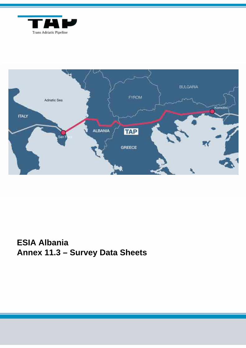
ESIA AlbaniaAnnex 11.3 – Survey Data Sheets

Page 2 of 190
Area Code
Comp. Code
System Code
Disc. Code
Doc.- Type
Ser. No.
Project Title: Trans Adriatic Pipeline – TAP
Document Title: Annex 11.3 – Survey Data Sheets AAL00-ERM-641-Y-TAE-1010
Rev.: 00 / at10
TABLE OF CONTENTS
1 FAUNA DATA SHEETS 3 1.1 HDA Survey April 2012 3 1.2 Route Refinement Surveys July 2012 50
2 FLORA DATA SHEETS 110 2.1 HDA Survey April 2012 110 2.2 Route Refinement Surveys July 2012 140
Page 3 of 190
Area Code
Comp. Code
System Code
Disc. Code
Doc.- Type
Ser. No.
Project Title: Trans Adriatic Pipeline – TAP
Document Title: Annex 11.3 – Survey Data Sheets AAL00-ERM-641-Y-TAE-1010
Rev.: 00 / at10
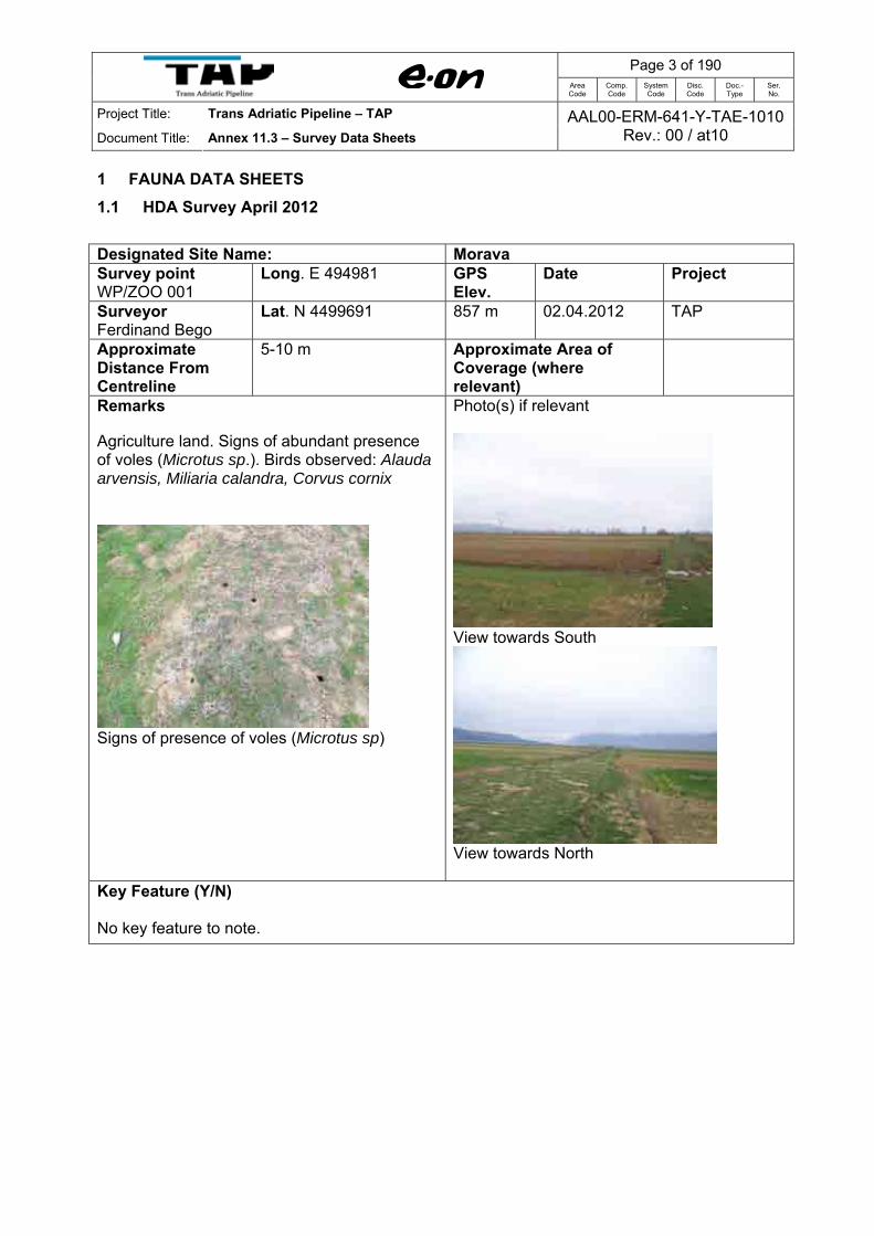
1 FAUNA DATA SHEETS 1.1 HDA Survey April 2012 Designated Site Name: Morava Survey point WP/ZOO 001
Long. E 494981 GPS Elev.
Date Project
Surveyor Ferdinand Bego
Lat. N 4499691 857 m 02.04.2012 TAP
Approximate Distance From Centreline
5-10 m Approximate Area of Coverage (where relevant)
Remarks Agriculture land. Signs of abundant presence of voles (Microtus sp.). Birds observed: Alauda arvensis, Miliaria calandra, Corvus cornix
Signs of presence of voles (Microtus sp)
Photo(s) if relevant
View towards South
View towards North
Key Feature (Y/N) No key feature to note.
Page 4 of 190
Area Code
Comp. Code
System Code
Disc. Code
Doc.- Type
Ser. No.
Project Title: Trans Adriatic Pipeline – TAP
Document Title: Annex 11.3 – Survey Data Sheets AAL00-ERM-641-Y-TAE-1010
Rev.: 00 / at10
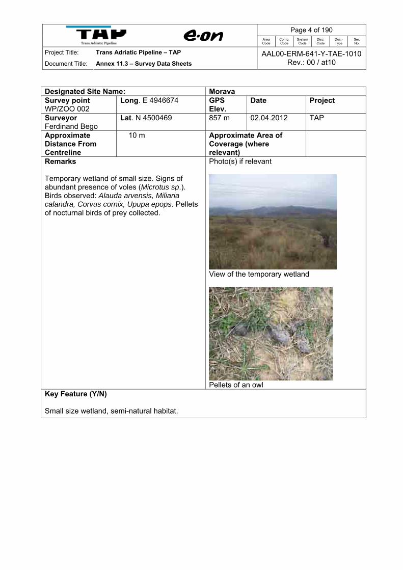
Designated Site Name: Morava Survey point WP/ZOO 002
Long. E 4946674 GPS Elev.
Date Project
Surveyor Ferdinand Bego
Lat. N 4500469 857 m 02.04.2012 TAP
Approximate Distance From Centreline
10 m Approximate Area of Coverage (where relevant)
Remarks Temporary wetland of small size. Signs of abundant presence of voles (Microtus sp.). Birds observed: Alauda arvensis, Miliaria calandra, Corvus cornix, Upupa epops. Pellets of nocturnal birds of prey collected.
Photo(s) if relevant
View of the temporary wetland
Pellets of an owl
Key Feature (Y/N) Small size wetland, semi-natural habitat.

Page 5 of 190
Area Code
Comp. Code
System Code
Disc. Code
Doc.- Type
Ser. No.
Project Title: Trans Adriatic Pipeline – TAP
Document Title: Annex 11.3 – Survey Data Sheets AAL00-ERM-641-Y-TAE-1010
Rev.: 00 / at10
Designated Site Name: Morava Survey point WP/ZOO 003
Long. E 494523 GPS Elev.
Date Project
Surveyor Ferdinand Bego
Lat. N 4500645 860 m 02.04.2012 TAP
Approximate Distance From Centreline
15 m Approximate Area of Coverage (where relevant)
Remarks Drainage channel. Some ponds created in the drainage channel. Important site for frogs and toads (eggs and larva observed). Birds observed: Actitis hypoleucos (6 inds), Corvus cornix (12 inds. and nests on Poplar trees).
Photo(s) if relevant
View of the drainage channel
Frog’s eggs in the drainage channel
Key Feature (Y/N) No key feature to note

Page 6 of 190
Area Code
Comp. Code
System Code
Disc. Code
Doc.- Type
Ser. No.
Project Title: Trans Adriatic Pipeline – TAP
Document Title: Annex 11.3 – Survey Data Sheets AAL00-ERM-641-Y-TAE-1010
Rev.: 00 / at10
Designated Site Name: Morava Survey point WP/ZOO004
Long. E 494515 GPS Elev.
Date Project
Surveyor Ferdinand Bego
Lat. N 4500739 855 m 02.04.2012 TAP
Approximate Distance From Centreline
5 m Approximate Area of Coverage (where relevant)
Remarks Mosaic of agriculture fields. Artesian well, drilled some 60 m deep for irrigation purposes. Eggs and toad poles of Bufo bufo observed. From birds Miliaria calandra, Hirundo rustica and Sturnus vulgaris.
Photo(s) if relevant
Artesian well for irrigation
Key Feature (Y/N) No key feature to note.
Page 7 of 190
Area Code
Comp. Code
System Code
Disc. Code
Doc.- Type
Ser. No.
Project Title: Trans Adriatic Pipeline – TAP
Document Title: Annex 11.3 – Survey Data Sheets AAL00-ERM-641-Y-TAE-1010
Rev.: 00 / at10
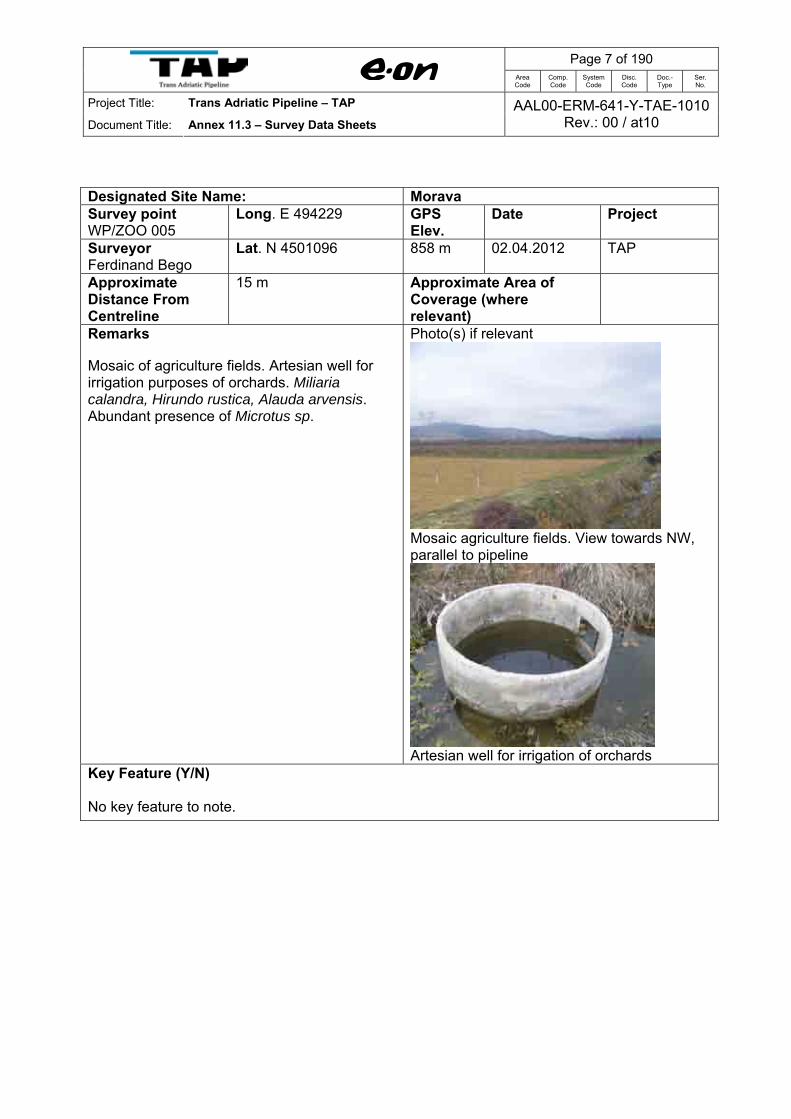
Designated Site Name: Morava Survey point WP/ZOO 005
Long. E 494229 GPS Elev.
Date Project
Surveyor Ferdinand Bego
Lat. N 4501096 858 m 02.04.2012 TAP
Approximate Distance From Centreline
15 m Approximate Area of Coverage (where relevant)
Remarks Mosaic of agriculture fields. Artesian well for irrigation purposes of orchards. Miliaria calandra, Hirundo rustica, Alauda arvensis. Abundant presence of Microtus sp.
Photo(s) if relevant
Mosaic agriculture fields. View towards NW, parallel to pipeline
Artesian well for irrigation of orchards
Key Feature (Y/N) No key feature to note.

Page 8 of 190
Area Code
Comp. Code
System Code
Disc. Code
Doc.- Type
Ser. No.
Project Title: Trans Adriatic Pipeline – TAP
Document Title: Annex 11.3 – Survey Data Sheets AAL00-ERM-641-Y-TAE-1010
Rev.: 00 / at10
Designated Site Name: Morava Survey point WP/ZOO 006
Long. E 494212 GPS Elev.
Date Project
Surveyor Ferdinand Bego
Lat. N 4501171 857 m 02.04.2012 TAP
Approximate Distance From Centreline
15 m Approximate Area of Coverage (where relevant)
ha
Remarks Same as WP/ZOO005.
Photo(s) if relevant
View towards south-east, parallel to pipeline route
Artesian well. View towards NW, parallel to centreline (subject to minor changes during final planning).
Key Feature (Y/N) No key feature to note.
Page 9 of 190
Area Code
Comp. Code
System Code
Disc. Code
Doc.- Type
Ser. No.
Project Title: Trans Adriatic Pipeline – TAP
Document Title: Annex 11.3 – Survey Data Sheets AAL00-ERM-641-Y-TAE-1010
Rev.: 00 / at10
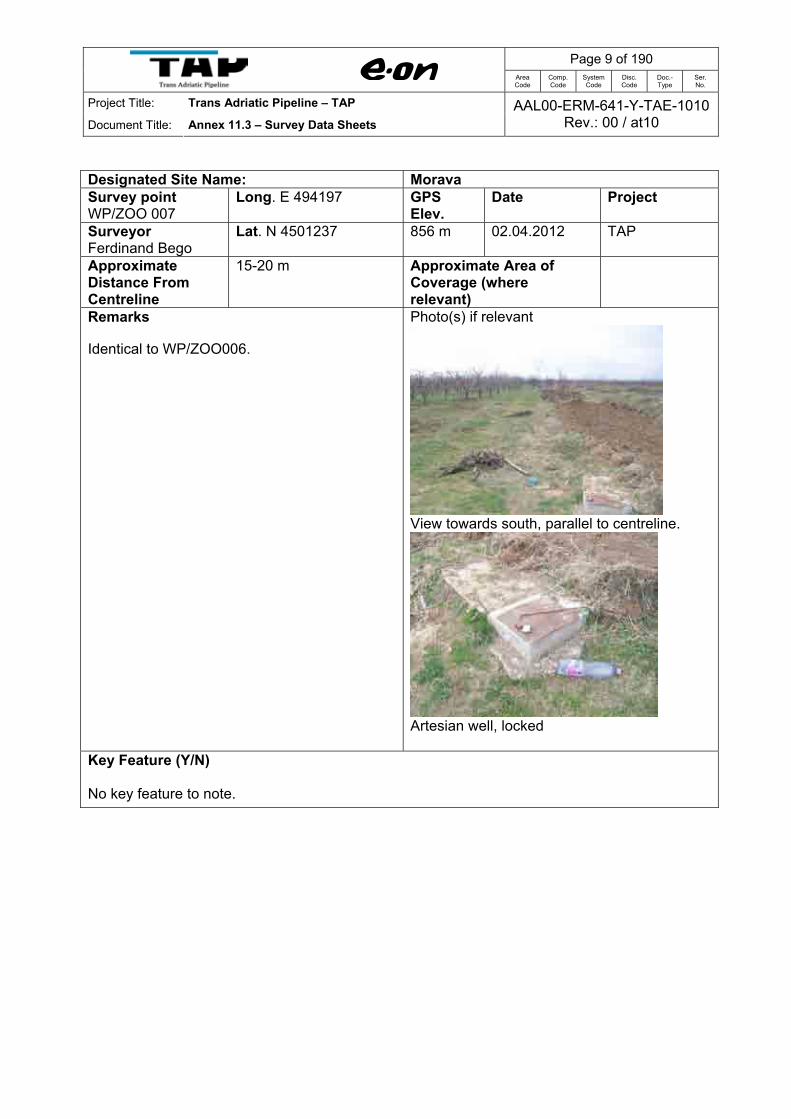
Designated Site Name: Morava Survey point WP/ZOO 007
Long. E 494197 GPS Elev.
Date Project
Surveyor Ferdinand Bego
Lat. N 4501237 856 m 02.04.2012 TAP
Approximate Distance From Centreline
15-20 m Approximate Area of Coverage (where relevant)
Remarks Identical to WP/ZOO006.
Photo(s) if relevant
View towards south, parallel to centreline.
Artesian well, locked
Key Feature (Y/N) No key feature to note.
Page 10 of 190
Area Code
Comp. Code
System Code
Disc. Code
Doc.- Type
Ser. No.
Project Title: Trans Adriatic Pipeline – TAP
Document Title: Annex 11.3 – Survey Data Sheets AAL00-ERM-641-Y-TAE-1010
Rev.: 00 / at10
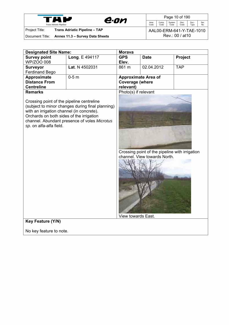
Designated Site Name: Morava Survey point WP/ZOO 008
Long. E 494117 GPS Elev.
Date Project
Surveyor Ferdinand Bego
Lat. N 4502031 861 m 02.04.2012 TAP
Approximate Distance From Centreline
0-5 m Approximate Area of Coverage (where relevant)
Remarks Crossing point of the pipeline centreline (subject to minor changes during final planning) with an irrigation channel (in concrete). Orchards on both sides of the irrigation channel. Abundant presence of voles Microtus sp. on alfa-alfa field.
Photo(s) if relevant
Crossing point of the pipeline with irrigation channel. View towards North.
View towards East.
Key Feature (Y/N) No key feature to note.

Page 11 of 190
Area Code
Comp. Code
System Code
Disc. Code
Doc.- Type
Ser. No.
Project Title: Trans Adriatic Pipeline – TAP
Document Title: Annex 11.3 – Survey Data Sheets AAL00-ERM-641-Y-TAE-1010
Rev.: 00 / at10
Designated Site Name: Morava Survey point WP/ZOO 009
Long. E 494220 GPS Elev.
Date Project
Surveyor Ferdinand Bego
Lat. N 4502160 854 m 02.04.2012 TAP
Approximate Distance From Centreline
15-20 m Approximate Area of Coverage (where relevant)
Remarks Mosaic agriculture fields. Artesian well for irrigation purposes of orchards. Birds observed; Carduelis carduelis, M. calandra, Alauda arvensis, Sturnus vulgaris. Abundant presence of Microtus sp.
Photo(s) if relevant
Artesian well for irrigation of orchards
Key Feature (Y/N) No key feature to note.

Page 12 of 190
Area Code
Comp. Code
System Code
Disc. Code
Doc.- Type
Ser. No.
Project Title: Trans Adriatic Pipeline – TAP
Document Title: Annex 11.3 – Survey Data Sheets AAL00-ERM-641-Y-TAE-1010
Rev.: 00 / at10
Designated Site Name: Morava Survey point WP/ZOO 010
Long. E 494146 GPS Elev.
Date Project
Surveyor Ferdinand Bego
Lat. N 4502603 851 m 02.04.2012 TAP
Approximate Distance From Centreline
0-5 m Approximate Area of Coverage (where relevant)
Remarks Drainage channel situated between Piluri and Vranisht mosaic agriculture fields. Important site for frogs and toads (eggs and larva observed). Birds observed: Emberiza calandra, Carduelis carduelis.
Photo(s) if relevant
Crossing point of the pipeline route with drainage channel.
Drainage channel. View towards East
Key Feature (Y/N) No key feature to note.
Page 13 of 190
Area Code
Comp. Code
System Code
Disc. Code
Doc.- Type
Ser. No.
Project Title: Trans Adriatic Pipeline – TAP
Document Title: Annex 11.3 – Survey Data Sheets AAL00-ERM-641-Y-TAE-1010
Rev.: 00 / at10
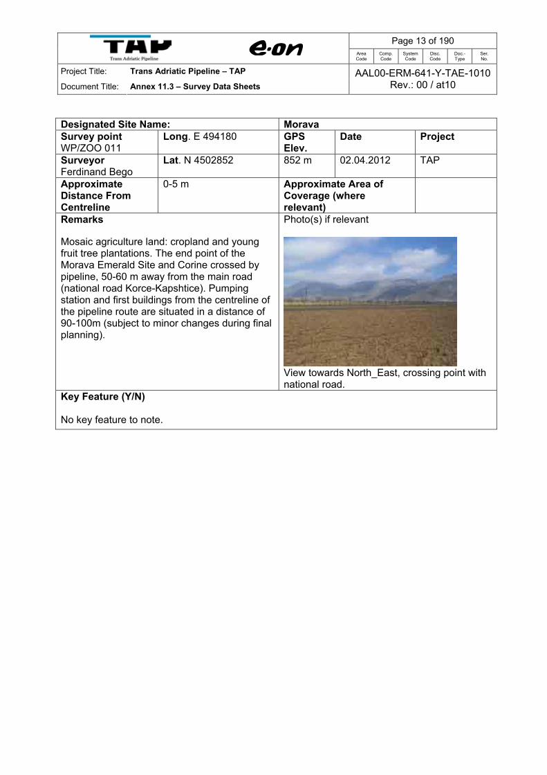
Designated Site Name: Morava Survey point WP/ZOO 011
Long. E 494180 GPS Elev.
Date Project
Surveyor Ferdinand Bego
Lat. N 4502852 852 m 02.04.2012 TAP
Approximate Distance From Centreline
0-5 m Approximate Area of Coverage (where relevant)
Remarks Mosaic agriculture land: cropland and young fruit tree plantations. The end point of the Morava Emerald Site and Corine crossed by pipeline, 50-60 m away from the main road (national road Korce-Kapshtice). Pumping station and first buildings from the centreline of the pipeline route are situated in a distance of 90-100m (subject to minor changes during final planning).
Photo(s) if relevant
View towards North_East, crossing point with national road.
Key Feature (Y/N) No key feature to note.

Page 14 of 190
Area Code
Comp. Code
System Code
Disc. Code
Doc.- Type
Ser. No.
Project Title: Trans Adriatic Pipeline – TAP
Document Title: Annex 11.3 – Survey Data Sheets AAL00-ERM-641-Y-TAE-1010
Rev.: 00 / at10
Designated Site Name: Morava Survey point WP/ZOO 013
Long. E 491033 GPS Elev.
Date Project
Surveyor Ferdinand Bego
Lat. N 4505293 844 m 02.04.2012 TAP
Approximate Distance From Centreline
0-5 m Approximate Area of Coverage (where relevant)
Remarks Cropland and orchards. Crossing point of the pipeline with the main national road Korce-Kapshtice. Some 60 m distance from the Devolli river. Observed: Podarcis muralis and Lacerta viridis
Photo(s) if relevant
Mosaic agriculture fields. View towards NW
Crossing point of the pipeline with the national road.
Key Feature (Y/N) No key feature to note.

Page 15 of 190
Area Code
Comp. Code
System Code
Disc. Code
Doc.- Type
Ser. No.
Project Title: Trans Adriatic Pipeline – TAP
Document Title: Annex 11.3 – Survey Data Sheets AAL00-ERM-641-Y-TAE-1010
Rev.: 00 / at10
Designated Site Name: Morava Survey point WP/ZOO 014
Long. E 490912 GPS Elev.
Date Project
Surveyor Ferdinand Bego
Lat. N 4505239 858 m 02.04.2012 TAP
Approximate Distance From Centreline
0-5 m Approximate Area of Coverage (where relevant)
Remarks Crossing point of the centreline of the pipeline route with a concrete irrigation channel (subject to minor changes during final planning). Orchards downhill of the irrigation channel and degraded shrubland with Juniperus spp, Pinus nigra, Rubus spp, Rosa spp. Observed: Podarcis muralis, Parus palustris and Sylvia sp.
Photo(s) if relevant
Crossing point of the pipeline with the irrigation channel.
Mosaic agriculture fields. View towards SE
Degraded shrubs and rare planted pine trees uphill; View towards NW

Page 16 of 190
Area Code
Comp. Code
System Code
Disc. Code
Doc.- Type
Ser. No.
Project Title: Trans Adriatic Pipeline – TAP
Document Title: Annex 11.3 – Survey Data Sheets AAL00-ERM-641-Y-TAE-1010
Rev.: 00 / at10
Key Feature (Y/N) No key feature to note.

Page 17 of 190
Area Code
Comp. Code
System Code
Disc. Code
Doc.- Type
Ser. No.
Project Title: Trans Adriatic Pipeline – TAP
Document Title: Annex 11.3 – Survey Data Sheets AAL00-ERM-641-Y-TAE-1010
Rev.: 00 / at10
Designated Site Name: Morava Survey point WP/ZOO 015
Long. E 490735 GPS Elev.
Date Project
Surveyor Ferdinand Bego
Lat. N 4505227 887 m 02.04.2012 TAP
Approximate Distance From Centreline
15 m Approximate Area of Coverage (where relevant)
Remarks Shrub formations of Carpinus spp, with elements of Pinus nigra, Castanea sativa, Corillus avellana, Cornus mass, Juniperus spp, Ostrya carpinifolia. Observed: Carduelis carduelis, Parus sp.
Photo(s) if relevant
Shrub formation with Carpinus spp.
View towards SE, parallel to pipeline
Key Feature (Y/N) No key feature to note.

Page 18 of 190
Area Code
Comp. Code
System Code
Disc. Code
Doc.- Type
Ser. No.
Project Title: Trans Adriatic Pipeline – TAP
Document Title: Annex 11.3 – Survey Data Sheets AAL00-ERM-641-Y-TAE-1010
Rev.: 00 / at10
Designated Site Name: Morava Survey point WP/ZOO 016
Long. E 490592 GPS Elev.
Date Project
Surveyor Ferdinand Bego
Lat. N 4505299 890 m 02.04.2012 TAP
Approximate Distance From Centreline
0-5 m Approximate Area of Coverage (where relevant)
Remarks Grasslands dominated by Poa spp, Brachypodium spp, Hordelymus sp., Carlina sp., Rubus sp., and Rosa spp.. Abundant presence signs of voles (Microtus sp.). Observed: Podarcis muralis, Fringilla coelebs, Carduelis carduelis, Serinus serinus, Carduelis chloris, Hirundo rustica.
Signs of voles (Microtus spp.)
Photo(s) if relevant
Grassland. View towards SE, parallel to centreline
Grassland. View towards NW, parallel to Centreline (subject to minor changes during final planning).
Key Feature (Y/N) No key feature to note.

Page 19 of 190
Area Code
Comp. Code
System Code
Disc. Code
Doc.- Type
Ser. No.
Project Title: Trans Adriatic Pipeline – TAP
Document Title: Annex 11.3 – Survey Data Sheets AAL00-ERM-641-Y-TAE-1010
Rev.: 00 / at10
Designated Site Name: Morava Survey point WP/ZOO 017
Long. E 490402 GPS Elev.
Date Project
Surveyor Ferdinand Bego
Lat. N 4505354 860 m 02.04.2012 TAP
Approximate Distance From Centreline
0-5 m Approximate Area of Coverage (where relevant)
Remarks Pine (Pinus nigra) plantations with understory of Juniperus spp, Corrillus avellana, and Populus alba. Observed: Podarcis muralis, Fringilla coelebs, Carduelis carduelis, Serinus serinus, Carduelis chloris, Hirundo rustica, Parus major
Photo(s) if relevant
Pine tree plantations
View towards E, parallel to centreline
View towards W, parallel to centreline
Key Feature (Y/N) No key feature to note.

Page 20 of 190
Area Code
Comp. Code
System Code
Disc. Code
Doc.- Type
Ser. No.
Project Title: Trans Adriatic Pipeline – TAP
Document Title: Annex 11.3 – Survey Data Sheets AAL00-ERM-641-Y-TAE-1010
Rev.: 00 / at10
Designated Site Name: Morava Survey point WP/ZOO 018
Long. E 490349 GPS Elev.
Date Project
Surveyor Ferdinand Bego
Lat. N 4505383 853 m 02.04.2012 TAP
Approximate Distance From Centreline
0-5 m Approximate Area of Coverage (where relevant)
Remarks Crossing point of the centreline of the pipeline route with the irrigation channel (subject to minor changes during final planning). Podarcis muralis observed
Photo(s) if relevant
Crossing point of the pipeline with the irrigation channel, nearby Zemblaku village
Key Feature (Y/N) No key feature to note.

Page 21 of 190
Area Code
Comp. Code
System Code
Disc. Code
Doc.- Type
Ser. No.
Project Title: Trans Adriatic Pipeline – TAP
Document Title: Annex 11.3 – Survey Data Sheets AAL00-ERM-641-Y-TAE-1010
Rev.: 00 / at10
Designated Site Name: Morava Survey point WP/ZOO 019
Long. E 490135 GPS Elev.
Date Project
Surveyor Ferdinand Bego
Lat. N 4505419 837 m 02.04.2012 TAP
Approximate Distance From Centreline
5 m Approximate Area of Coverage (where relevant)
Remarks Cropland and orchards next to crossing point of the pipeline with the main national road Korce-Kapshtice. Some 100 m distance from the Zemblaku village and Zemblaku Power Substation. Abundant presence signs of Microtus spp. Observed: Passer domesticus.
Photo(s) if relevant
Mosaic agriculture fields, nearby Zemblaku village. View towards E.
Key Feature (Y/N) No key feature to note.

Page 22 of 190
Area Code
Comp. Code
System Code
Disc. Code
Doc.- Type
Ser. No.
Project Title: Trans Adriatic Pipeline – TAP
Document Title: Annex 11.3 – Survey Data Sheets AAL00-ERM-641-Y-TAE-1010
Rev.: 00 / at10
Designated Site Name: Morava Survey point WP/ZOO 020
Long. E 489988 GPS Elev.
Date Project
Surveyor Ferdinand Bego
Lat. N 4505402 834 m 02.04.2012 TAP
Approximate Distance From Centreline
0-5 m Approximate Area of Coverage (where relevant)
Remarks Mosaic agriculture fields. Crossing point of the pipeline route with national road and irrigation channel of Zemblak. Agriculture land (cropland and orchards) on both side of the crossings.
Photo(s) if relevant
Crossing point of the centreline with the National Road (subject to minor changes during final planning). (View towards N)
Crossing point of the centreline with the irrigation channel of Zemblaku. (view towards SW)
View of Zemblaku village from WP/ZOO 020

Page 23 of 190
Area Code
Comp. Code
System Code
Disc. Code
Doc.- Type
Ser. No.
Project Title: Trans Adriatic Pipeline – TAP
Document Title: Annex 11.3 – Survey Data Sheets AAL00-ERM-641-Y-TAE-1010
Rev.: 00 / at10
Key Feature (Y/N) No key feature to note.

Page 24 of 190
Area Code
Comp. Code
System Code
Disc. Code
Doc.- Type
Ser. No.
Project Title: Trans Adriatic Pipeline – TAP
Document Title: Annex 11.3 – Survey Data Sheets AAL00-ERM-641-Y-TAE-1010
Rev.: 00 / at10
Designated Site Name: Morava Survey point WP/ZOO 021
Long. E 489875 GPS Elev.
Date Project
Surveyor Ferdinand Bego
Lat. N 4505473 837 m 02.04.2012 TAP
Approximate Distance From Centreline
0-5 m Approximate Area of Coverage (where relevant)
Remarks Mosaic agriculture fields. Ending point of the Corine and Emerald Site of Morava crossed by the pipeline route. 60 m north of national road Korce-Kapshtice. Abundant presence signs of voles (Microtus spp.). Observed: Buteo buteo and Passer domesticus.
Photo(s) if relevant
Mosaic agriculture fields. View towards E, parallel to centreline
View towards West, parallel to centreline
Key Feature (Y/N) No key feature to note.

Page 25 of 190
Area Code
Comp. Code
System Code
Disc. Code
Doc.- Type
Ser. No.
Project Title: Trans Adriatic Pipeline – TAP
Document Title: Annex 11.3 – Survey Data Sheets AAL00-ERM-641-Y-TAE-1010
Rev.: 00 / at10
Designated Site Name: Vithkuq – Ostrovice Survey point WP/ZOO 027
Long. E 462624 GPS Elev.
Date Project
Surveyor Ferdinand Bego
Lat. N 4485475 1610 m 03.04.2012 TAP
Approximate Distance From Centreline
700 m Approximate Area of Coverage (where relevant)
Remarks Beech forest (Fagus sylvatica). Young stands (coppice). Track from main road (Shtylla village) to WP/ZOO 001 is characterised by alterations of beech forest and grasslands (photo 7200-7210). Observed: Vulpes vulpes (one ind.), footprints of a sub-adult wolf (Canis lupus), Erithacus rubecula, Fringilla coelebs.
Photo(s) if relevant
Coppice of Beech forest.
View towards South from the WP/ZOO 027
Key Feature (Y/N)

Page 26 of 190
Area Code
Comp. Code
System Code
Disc. Code
Doc.- Type
Ser. No.
Project Title: Trans Adriatic Pipeline – TAP
Document Title: Annex 11.3 – Survey Data Sheets AAL00-ERM-641-Y-TAE-1010
Rev.: 00 / at10
Landscape of special beauty. Provide habitats for large carnivores.

Page 27 of 190
Area Code
Comp. Code
System Code
Disc. Code
Doc.- Type
Ser. No.
Project Title: Trans Adriatic Pipeline – TAP
Document Title: Annex 11.3 – Survey Data Sheets AAL00-ERM-641-Y-TAE-1010
Rev.: 00 / at10
Designated Site Name: Vithkuq – Ostrovice Survey point WP/ZOO 028
Long. E 462715 GPS Elev.
Date Project
Surveyor Ferdinand Bego
Lat. N 4485055 1546 m 03.04.2012 TAP
Approximate Distance From Centreline
250 m Approximate Area of Coverage (where relevant)
Remarks Grasslands mostly covered by deep snow. In some spots without snow, abundant signs of voles presence observed. Lepus europaeus (droppings). Current centreline passes some 250 m south of the WP.
Droppings of hare (Lepus europaeus)
Photo(s) if relevant
Grassland covered by deep snow.
Signs of voles (Microtus spp) activity under snow, just after snow melt
Key Feature (Y/N) Part of a landscape of special beauty and attraction.

Page 28 of 190
Area Code
Comp. Code
System Code
Disc. Code
Doc.- Type
Ser. No.
Project Title: Trans Adriatic Pipeline – TAP
Document Title: Annex 11.3 – Survey Data Sheets AAL00-ERM-641-Y-TAE-1010
Rev.: 00 / at10
Designated Site Name: Vithkuq – Ostrovice Survey point WP/ZOO 029
Long. E 463144 GPS Elev.
Date Project
Surveyor Ferdinand Bego
Lat. N 4484675 1624 m 03.04.2012 TAP
Approximate Distance From Centreline
0-5 m Approximate Area of Coverage (where relevant)
Remarks Centreline of pipeline passes this site (subject to minor changes during final planning). Coppice of beech forest (trees of diameter some 5-10 cm, height 5-7 m). Deep snow coverage. Observed: Erithacus rubecula, Fringilla coelebs.
Photo(s) if relevant
View towards West, parallel to centreline Young Beech forest (coppice)
View towards North
Key Feature (Y/N) Same as previous WPs.
Page 29 of 190
Area Code
Comp. Code
System Code
Disc. Code
Doc.- Type
Ser. No.
Project Title: Trans Adriatic Pipeline – TAP
Document Title: Annex 11.3 – Survey Data Sheets AAL00-ERM-641-Y-TAE-1010
Rev.: 00 / at10
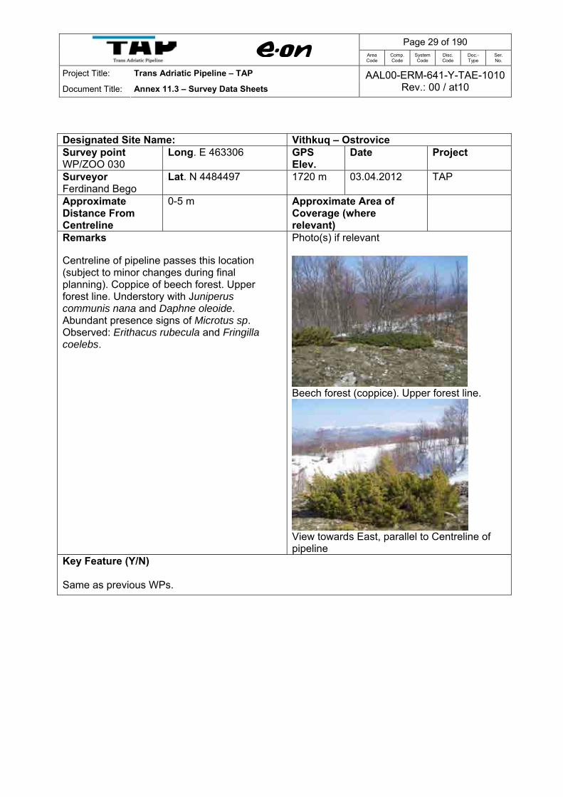
Designated Site Name: Vithkuq – Ostrovice Survey point WP/ZOO 030
Long. E 463306 GPS Elev.
Date Project
Surveyor Ferdinand Bego
Lat. N 4484497 1720 m 03.04.2012 TAP
Approximate Distance From Centreline
0-5 m Approximate Area of Coverage (where relevant)
Remarks Centreline of pipeline passes this location (subject to minor changes during final planning). Coppice of beech forest. Upper forest line. Understory with Juniperus communis nana and Daphne oleoide. Abundant presence signs of Microtus sp. Observed: Erithacus rubecula and Fringilla coelebs.
Photo(s) if relevant
Beech forest (coppice). Upper forest line.
View towards East, parallel to Centreline of pipeline
Key Feature (Y/N) Same as previous WPs.

Page 30 of 190
Area Code
Comp. Code
System Code
Disc. Code
Doc.- Type
Ser. No.
Project Title: Trans Adriatic Pipeline – TAP
Document Title: Annex 11.3 – Survey Data Sheets AAL00-ERM-641-Y-TAE-1010
Rev.: 00 / at10
Designated Site Name: Vithkuq – Ostrovice Survey point WP/ZOO 031
Long. E 464462 GPS Elev.
Date Project
Surveyor Ferdinand Bego
Lat. N 4484427 1575 m 03.04.2012 TAP
Approximate Distance From Centreline
5 m Approximate Area of Coverage (where relevant)
Remarks Matorral of Juniperus communis and J. communis nana. Abundant presence signs of Microtus sp. Observed Turdus merula.
Signs of voles (Microtus spp) activity under snow, just after snow melt.
Photo(s) if relevant
Matorral of Juniperus spp.
View towards East, parallel to Centreline of pipeline
Key Feature (Y/N) Same as previous WPs.

Page 31 of 190
Area Code
Comp. Code
System Code
Disc. Code
Doc.- Type
Ser. No.
Project Title: Trans Adriatic Pipeline – TAP
Document Title: Annex 11.3 – Survey Data Sheets AAL00-ERM-641-Y-TAE-1010
Rev.: 00 / at10
Designated Site Name: Vithkuq – Ostrovice Survey point WP/ZOO 032
Long. E 465441 GPS Elev.
Date Project
Surveyor Ferdinand Bego
Lat. N 4483976 1472 m 03.04.2012 TAP
Approximate Distance From Centreline
60 m Approximate Area of Coverage (where relevant)
Remarks Mixed and mature (old growth) forest of Pinus nigra, Quercus petreae, Fagus sylvatica, with understory of Juniperus communis. Very sensitive habitat, well preserved, situated some 60 m north of centreline of the pipeline (subject to minor changes during final planning. It is situated outside the Corine site (Vithkuq-Ostrovice), but it should be protected. Observed: different species of tits (Parus spp.), Erithacus rubecula, Fringilla coelebs, Turdus merula, Sitta europaea, Columba palumbus. Signs of woodpeckers (Piciformes) (Photo 7283-7284).
Feeding signs of woodpeckers
Photo(s) if relevant
Old growth/mature mixed stand of Pinus nigra, Fagus sylvatica, and Quercus petraea.

Page 32 of 190
Area Code
Comp. Code
System Code
Disc. Code
Doc.- Type
Ser. No.
Project Title: Trans Adriatic Pipeline – TAP
Document Title: Annex 11.3 – Survey Data Sheets AAL00-ERM-641-Y-TAE-1010
Rev.: 00 / at10
Key Feature (Y/N) Mixed old growth forest, natural habitat of special importance for birds linked with old growth forest. The best stand of forest inside the Vithkuq-Ostrovice CORINE Biotope observed in this area..
Page 33 of 190
Area Code
Comp. Code
System Code
Disc. Code
Doc.- Type
Ser. No.
Project Title: Trans Adriatic Pipeline – TAP
Document Title: Annex 11.3 – Survey Data Sheets AAL00-ERM-641-Y-TAE-1010
Rev.: 00 / at10
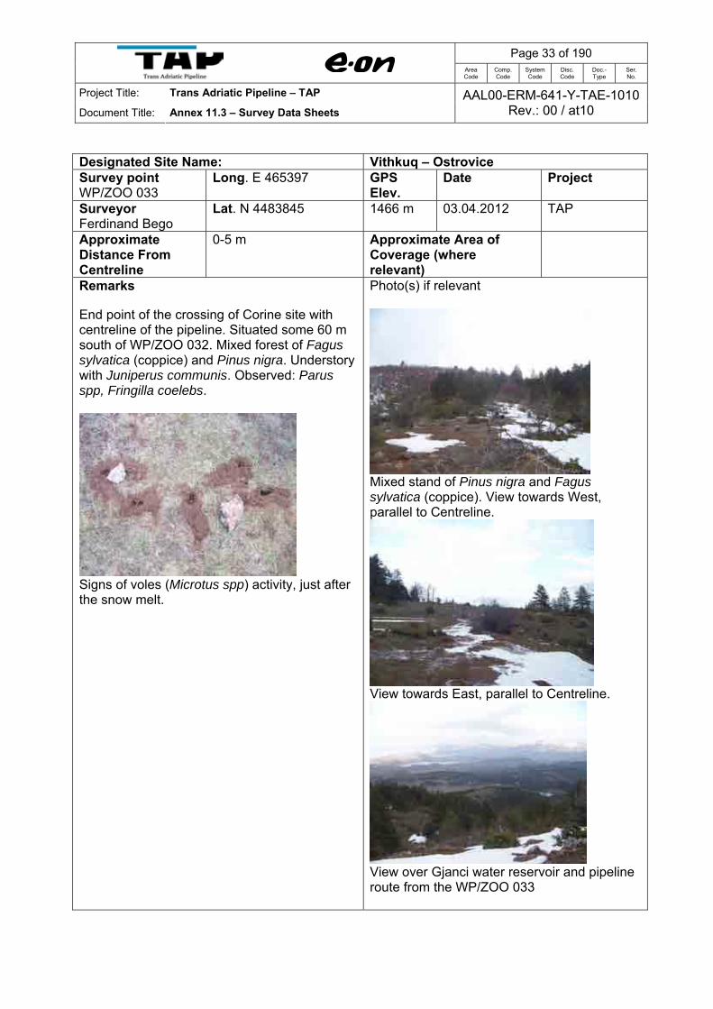
Designated Site Name: Vithkuq – Ostrovice Survey point WP/ZOO 033
Long. E 465397 GPS Elev.
Date Project
Surveyor Ferdinand Bego
Lat. N 4483845 1466 m 03.04.2012 TAP
Approximate Distance From Centreline
0-5 m Approximate Area of Coverage (where relevant)
Remarks End point of the crossing of Corine site with centreline of the pipeline. Situated some 60 m south of WP/ZOO 032. Mixed forest of Fagus sylvatica (coppice) and Pinus nigra. Understory with Juniperus communis. Observed: Parus spp, Fringilla coelebs.
Signs of voles (Microtus spp) activity, just after the snow melt.
Photo(s) if relevant
Mixed stand of Pinus nigra and Fagus sylvatica (coppice). View towards West, parallel to Centreline.
View towards East, parallel to Centreline.
View over Gjanci water reservoir and pipeline route from the WP/ZOO 033

Page 34 of 190
Area Code
Comp. Code
System Code
Disc. Code
Doc.- Type
Ser. No.
Project Title: Trans Adriatic Pipeline – TAP
Document Title: Annex 11.3 – Survey Data Sheets AAL00-ERM-641-Y-TAE-1010
Rev.: 00 / at10
Key Feature (Y/N) Attractive and scenic landscape.

Page 35 of 190
Area Code
Comp. Code
System Code
Disc. Code
Doc.- Type
Ser. No.
Project Title: Trans Adriatic Pipeline – TAP
Document Title: Annex 11.3 – Survey Data Sheets AAL00-ERM-641-Y-TAE-1010
Rev.: 00 / at10
Designated Site Name: Vithkuq – Ostrovice Survey point WP/ZOO 034
Long. E 466266 GPS Elev.
Date Project
Surveyor Ferdinand Bego
Lat. N 4484815 1201 m 03.04.2012 TAP
Approximate Distance From Centreline
1 km Approximate Area of Coverage (where relevant)
Remarks Access road Vithkuq-Markese field and forest. Abandoned agriculture fields that are turned into grasslands used for grazing.
Photo(s) if relevant
View of the access road Vithkuq-Markeze field.
Key Feature (Y/N) No key feature to note.
Page 36 of 190
Area Code
Comp. Code
System Code
Disc. Code
Doc.- Type
Ser. No.
Project Title: Trans Adriatic Pipeline – TAP
Document Title: Annex 11.3 – Survey Data Sheets AAL00-ERM-641-Y-TAE-1010
Rev.: 00 / at10
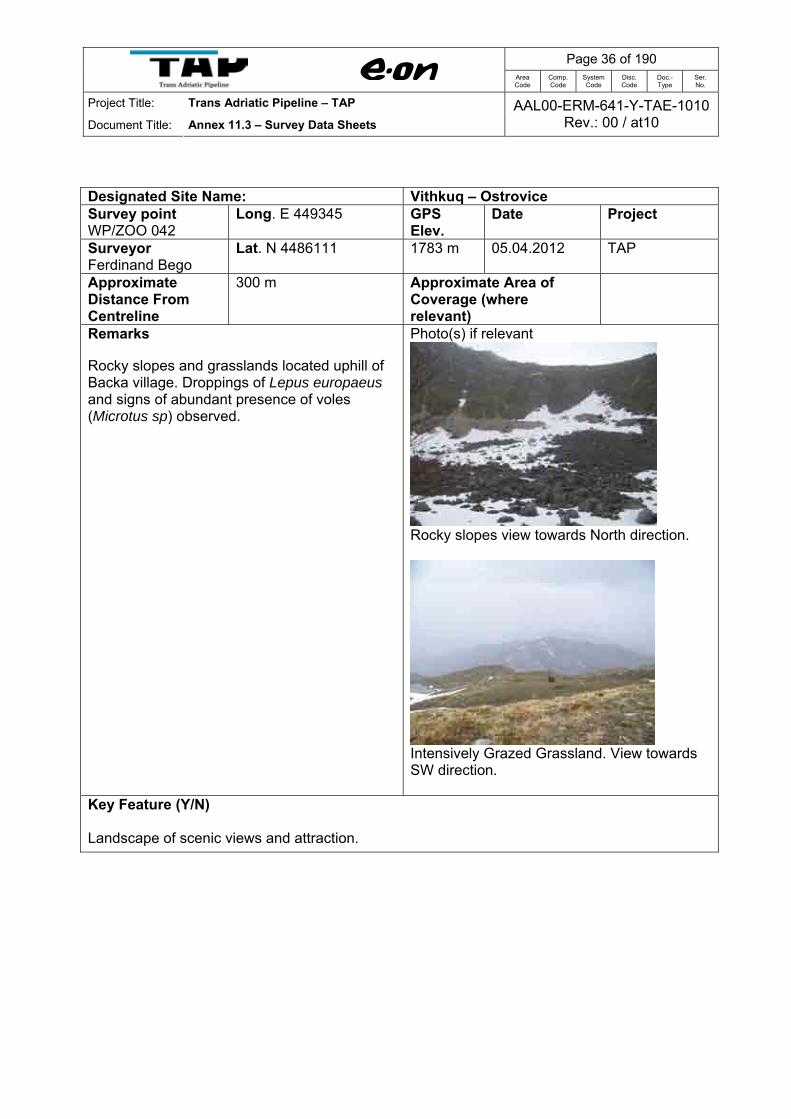
Designated Site Name: Vithkuq – Ostrovice Survey point WP/ZOO 042
Long. E 449345 GPS Elev.
Date Project
Surveyor Ferdinand Bego
Lat. N 4486111 1783 m 05.04.2012 TAP
Approximate Distance From Centreline
300 m Approximate Area of Coverage (where relevant)
Remarks Rocky slopes and grasslands located uphill of Backa village. Droppings of Lepus europaeus and signs of abundant presence of voles (Microtus sp) observed.
Photo(s) if relevant
Rocky slopes view towards North direction.
Intensively Grazed Grassland. View towards SW direction.
Key Feature (Y/N) Landscape of scenic views and attraction.
Page 37 of 190
Area Code
Comp. Code
System Code
Disc. Code
Doc.- Type
Ser. No.
Project Title: Trans Adriatic Pipeline – TAP
Document Title: Annex 11.3 – Survey Data Sheets AAL00-ERM-641-Y-TAE-1010
Rev.: 00 / at10
Designated Site Name: Vithkuq – Ostrovice Survey point WP/ZOO 043
Long. E 449859 GPS Elev.
Date Project
Surveyor Ferdinand Bego
Lat. N 4486060 1748 m 05.04.2012 TAP
Approximate Distance From Centreline
5 m Approximate Area of Coverage (where relevant)
-
Remarks A small and young stand of beech forest (coppice) located downhill of the Tunnel, nearby the sheep hut.
Photo(s) if relevant
Sheep hut, beech forest coppice.
View from waypoint in northerly direction
View towards SE direction
Key Feature (Y/N) No key feature to note.

Page 38 of 190
Area Code
Comp. Code
System Code
Disc. Code
Doc.- Type
Ser. No.
Project Title: Trans Adriatic Pipeline – TAP
Document Title: Annex 11.3 – Survey Data Sheets AAL00-ERM-641-Y-TAE-1010
Rev.: 00 / at10
Designated Site Name: Vithkuq – Ostrovice Survey point WP/ZOO 044
Long. E 449728 GPS Elev.
Date Project
Surveyor Ferdinand Bego
Lat. N 4485757 1657 m 05.04.2012 TAP
Approximate Distance From Centreline
50 m Approximate Area of Coverage (where relevant)
-
Remarks Grassland intensively grazed by sheep.
Photo(s) if relevant
View toward NE from waypoint.
Key Feature (Y/N) No key feature to note.

Page 39 of 190
Area Code
Comp. Code
System Code
Disc. Code
Doc.- Type
Ser. No.
Project Title: Trans Adriatic Pipeline – TAP
Document Title: Annex 11.3 – Survey Data Sheets AAL00-ERM-641-Y-TAE-1010
Rev.: 00 / at10
Designated Site Name: Vithkuq – Ostrovice Survey point WP/ZOO 045
Long. E 449285 GPS Elev.
Date Project
Surveyor Ferdinand Bego
Lat. N 4485483 1611 m 05.04.2012 TAP
Approximate Distance From Centreline
5 m Approximate Area of Coverage (where relevant)
-
Remarks Grassland as previous point, also intensively grazed.
Photo(s) if relevant
View towards SW along ridge.
Key Feature (Y/N) No key feature to note.

Page 40 of 190
Area Code
Comp. Code
System Code
Disc. Code
Doc.- Type
Ser. No.
Project Title: Trans Adriatic Pipeline – TAP
Document Title: Annex 11.3 – Survey Data Sheets AAL00-ERM-641-Y-TAE-1010
Rev.: 00 / at10
Designated Site Name: Grykederdhje e Semanit-Pishe Poro Survey point WP/ZOO 068
Long. E 364848 GPS Elev.
Date Project
Surveyor Ferdinand Bego
Lat. N 4515552 2 m 07.04.2012 TAP
Approximate Distance From Centreline
1.2 km Approximate Area of Coverage (where relevant)
Remarks Salicornia and others annuals colonising mud and sand; Mediterranean salt meadows (Juncetalia maritimi). Bridge over drainage channel along the access road to pipeline route. Birds observed: Emberiza calandra, Upupa epops, Lanius collurio, Pica pica, Corvus corone cornix, Passer domesticus. Otter (Lutra lutra) spraints found under the bridge on both sides of the drainage channel.
Photo(s) if relevant
Access road towards the pipeline route (view towards NW)
Bridge over the drainage channel.
Otter (Lutra lutra) spraints on stone under the bridge

Page 41 of 190
Area Code
Comp. Code
System Code
Disc. Code
Doc.- Type
Ser. No.
Project Title: Trans Adriatic Pipeline – TAP
Document Title: Annex 11.3 – Survey Data Sheets AAL00-ERM-641-Y-TAE-1010
Rev.: 00 / at10
Key Feature (Y/N) Mediterranean salt meadow is a habitat of community interest.

Page 42 of 190
Area Code
Comp. Code
System Code
Disc. Code
Doc.- Type
Ser. No.
Project Title: Trans Adriatic Pipeline – TAP
Document Title: Annex 11.3 – Survey Data Sheets AAL00-ERM-641-Y-TAE-1010
Rev.: 00 / at10
Designated Site Name: Grykederdhje e Semanit-Pishe Poro Survey point WP/ZOO 069
Long. E 364257 GPS Elev.
Date Project
Surveyor Ferdinand Bego
Lat. N 4516701 2 m 07.04.2012 TAP
Approximate Distance From Centreline
240 m Approximate Area of Coverage (where relevant)
Remarks Salicornia and others annuals colonising mud and sand; Mediterranean salt meadows (Juncetalia maritimi). End point of the access road to pipeline. Birds observed: Emberiza calandra, Upupa epops, Carduelis carduelis. Footprints of red fox (Vulpes vulpes).
Photo(s) if relevant
Key Feature (Y/N) Mediterranean salt meadow is a habitat of community interest.

Page 43 of 190
Area Code
Comp. Code
System Code
Disc. Code
Doc.- Type
Ser. No.
Project Title: Trans Adriatic Pipeline – TAP
Document Title: Annex 11.3 – Survey Data Sheets AAL00-ERM-641-Y-TAE-1010
Rev.: 00 / at10
Designated Site Name: Grykederdhje e Semanit-Pishe Poro Survey point WP/ZOO 070
Long. E 364365 GPS Elev.
Date Project
Surveyor Ferdinand Bego
Lat. N 4516915 -0 m 07.04.2012 TAP
Approximate Distance From Centreline
0-5 m Approximate Area of Coverage (where relevant)
Remarks Salicornia and others annuals colonising mud and sand; Mediterranean salt meadows (Juncetalia maritimi). Centreline of the pipeline route. Birds observed: Galerida cristata, Alauda arvensis, Emberiza calandra. A drainage channel located some 20 m away from the centreline provides habitat for frogs and toads (Rana sp. and Bufo sp.) during breeding season.
Photo(s) if relevant
Looking towards East direction, parallel with Centreline
Looking towards West, parallel with Centreline
Key Feature (Y/N) Mediterranean salt meadows represent a habitat of community conservation interest.
Page 44 of 190
Area Code
Comp. Code
System Code
Disc. Code
Doc.- Type
Ser. No.
Project Title: Trans Adriatic Pipeline – TAP
Document Title: Annex 11.3 – Survey Data Sheets AAL00-ERM-641-Y-TAE-1010
Rev.: 00 / at10
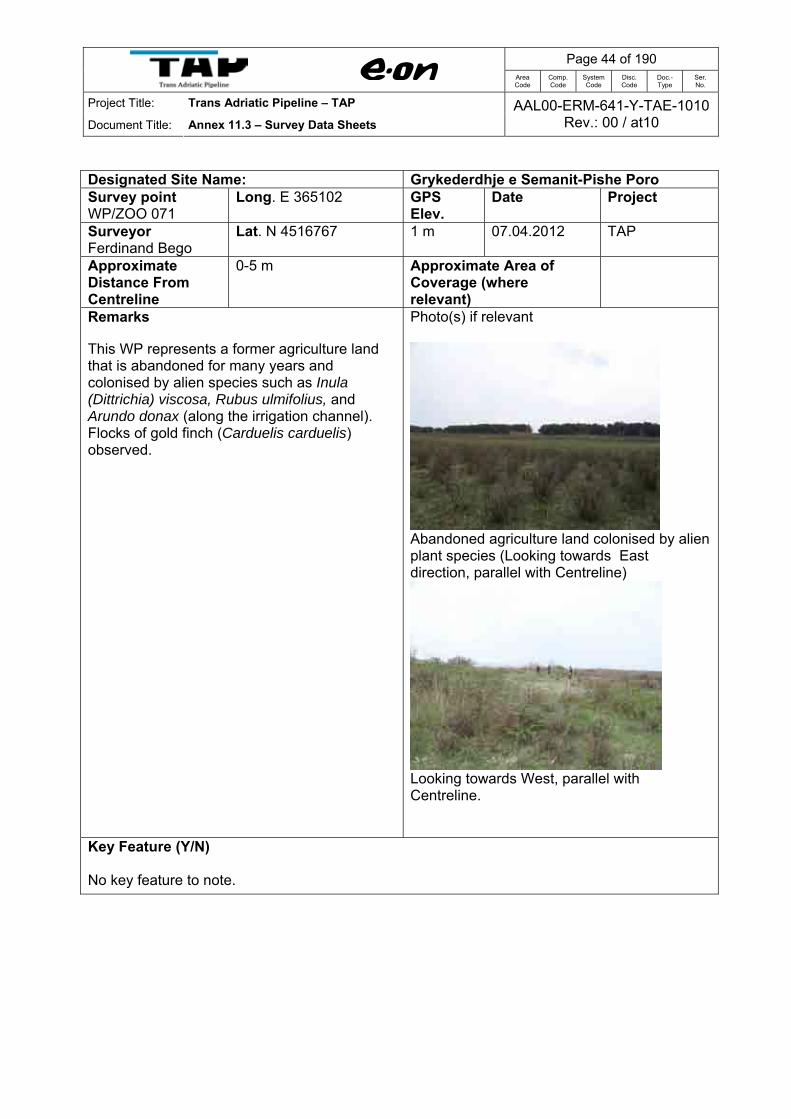
Designated Site Name: Grykederdhje e Semanit-Pishe Poro Survey point WP/ZOO 071
Long. E 365102 GPS Elev.
Date Project
Surveyor Ferdinand Bego
Lat. N 4516767 1 m 07.04.2012 TAP
Approximate Distance From Centreline
0-5 m Approximate Area of Coverage (where relevant)
Remarks This WP represents a former agriculture land that is abandoned for many years and colonised by alien species such as Inula (Dittrichia) viscosa, Rubus ulmifolius, and Arundo donax (along the irrigation channel). Flocks of gold finch (Carduelis carduelis) observed.
Photo(s) if relevant
Abandoned agriculture land colonised by alien plant species (Looking towards East direction, parallel with Centreline)
Looking towards West, parallel with Centreline.
Key Feature (Y/N) No key feature to note.
Page 45 of 190
Area Code
Comp. Code
System Code
Disc. Code
Doc.- Type
Ser. No.
Project Title: Trans Adriatic Pipeline – TAP
Document Title: Annex 11.3 – Survey Data Sheets AAL00-ERM-641-Y-TAE-1010
Rev.: 00 / at10
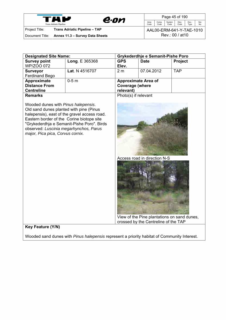
Designated Site Name: Grykederdhje e Semanit-Pishe Poro Survey point WP/ZOO 072
Long. E 365368 GPS Elev.
Date Project
Surveyor Ferdinand Bego
Lat. N 4516707 2 m 07.04.2012 TAP
Approximate Distance From Centreline
0-5 m Approximate Area of Coverage (where relevant)
Remarks Wooded dunes with Pinus halepensis. Old sand dunes planted with pine (Pinus halepensis), east of the gravel access road. Eastern border of the Corine biotope site "Grykederdhja e Semanit-Pishe Poro". Birds observed: Luscinia megarhynchos, Parus major, Pica pica, Corvus cornix.
Photo(s) if relevant
Access road in direction N-S
View of the Pine plantations on sand dunes, crossed by the Centreline of the TAP
Key Feature (Y/N) Wooded sand dunes with Pinus halepensis represent a priority habitat of Community Interest.

Page 46 of 190
Area Code
Comp. Code
System Code
Disc. Code
Doc.- Type
Ser. No.
Project Title: Trans Adriatic Pipeline – TAP
Document Title: Annex 11.3 – Survey Data Sheets AAL00-ERM-641-Y-TAE-1010
Rev.: 00 / at10
Designated Site Name: Grykederdhje e Semanit-Pishe Poro Survey point WP/ZOO 073
Long. E 365281 GPS Elev.
Date Project
Surveyor Ferdinand Bego
Lat. 4516662 1 m 07.04.2012 TAP
Approximate Distance From Centreline
50 m Approximate Area of Coverage (where relevant)
Remarks This WP represents a temporary wetland created due to excavation (abstraction of sand). Important biotope for frogs and toads during breeding season (January-April). Larva and toad poles were observed in abundant in the shallow ponds. This biotope is located some 50 m away (south) from the centreline and 50-60 m distance from the planted dunes with Pinus halepensis (WP/ZOO 072). A specimen of Hermann's tortoise (Testudo hermanni) observed.
Testudo hermanni
Photo(s) if relevant
View of temporary wetland created from sand abstraction/excavation.
Frog larvae and toad poles
Key Feature (Y/N) Temporary fresh water wetland is a habitat of community conservation importance.

Page 47 of 190
Area Code
Comp. Code
System Code
Disc. Code
Doc.- Type
Ser. No.
Project Title: Trans Adriatic Pipeline – TAP
Document Title: Annex 11.3 – Survey Data Sheets AAL00-ERM-641-Y-TAE-1010
Rev.: 00 / at10
Designated Site Name: Grykederdhje e Semanit-Pishe Poro Survey point WP/ZOO 074
Long. E 363306 GPS Elev.
Date Project
Surveyor Ferdinand Bego
Lat. N 4517140 1 m 07.04.2012 TAP
Approximate Distance From Centreline
0-5 m Approximate Area of Coverage (where relevant)
Remarks Salicornia and others annuals colonising mud and sand; Mediterranean salt meadows (Juncetalia maritimi). Crossing point of the Centreline with a drainage channel (subject to minor variation during final planning). both sides of the channel with Phragmites australis, Tamarix and Juncus maritimus, and J. acutus. Birds observed: Emberiza calandra, Upupa epops (a specimen eaten by red fox).
Photo(s) if relevant
Crossing point of the Centreline with a drainage channel
A specimen of Hoopoe (Upupa epops) eaten by a red fox.

Page 48 of 190
Area Code
Comp. Code
System Code
Disc. Code
Doc.- Type
Ser. No.
Project Title: Trans Adriatic Pipeline – TAP
Document Title: Annex 11.3 – Survey Data Sheets AAL00-ERM-641-Y-TAE-1010
Rev.: 00 / at10
Key Feature (Y/N) Mediterranean salt meadows represent a habitat of community conservation interest.

Page 49 of 190
Area Code
Comp. Code
System Code
Disc. Code
Doc.- Type
Ser. No.
Project Title: Trans Adriatic Pipeline – TAP
Document Title: Annex 11.3 – Survey Data Sheets AAL00-ERM-641-Y-TAE-1010
Rev.: 00 / at10
Designated Site Name: Grykederdhje e Semanit-Pishe Poro Survey point WP/ZOO 075
Long. E 363051 GPS Elev.
Date Project
Surveyor Ferdinand Bego
Lat. N 4517198 2 m 07.04.2012 TAP
Approximate Distance From Centreline
0-5 m Approximate Area of Coverage (where relevant)
Remarks Narrow belt of embryonic shifting dunes (low dunes up to 1 m high) at the landfall of the pipeline. Red fox footprints and Charadrius alexandrinus (2 inds) observed.
Red fox tracks on the sand
Photo(s) if relevant
Embryonic shifting dunes at the Centreline (Looking towards South direction)
(Looking towards North direction)
Key Feature (Y/N) Embryonic shifting sand dunes represent a habitat of community interest.

Page 50 of 190
Area Code
Comp. Code
System Code
Disc. Code
Doc.- Type
Ser. No.
Project Title: Trans Adriatic Pipeline – TAP
Document Title: Annex 11.3 – Survey Data Sheets AAL00-ERM-641-Y-TAE-1010
Rev.: 00 / at10
1.2 Route Refinement Surveys July 2012 Survey points taken as part of the route refinement survey were not specifically undertaken in
relation to the Vithkuq-Ostrovice or Grykederdhje e Semanit-Pishe Poro designated sites. As
such many of the points recorded are located outside of the CORINE Biotope boundaries,
particularly for the Vithkuq-Ostrovice site. However, data collected is still of relevance so has
been included within this document.
Designated Site Name: Vithkuq – Ostrovice Long. E20 29.030 GPS Elev. Date Project Survey point
Z-04 Lat. N40 31.455 5163 ft 18.07.2012 TAP
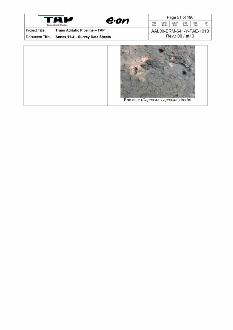
Remarks Section: Central Eastern Access road going through beech forest. Bear (Ursus arctos) track on the road. Roe deer (Capreolus capreolus) (footprints), wild boar (Sus socraca)(footprints), beech marten (Martes foina)(scants), badger (Meles meles)(tracks) and Yellow bellied toad (Bombina variegata) presence confirmed.
Yellow bellied toad (Bombina variegata)
Access Road 7 in the beech forest
Bear (Ursus arctos) footprint
Page 51 of 190
Area Code
Comp. Code
System Code
Disc. Code
Doc.- Type
Ser. No.
Project Title: Trans Adriatic Pipeline – TAP
Document Title: Annex 11.3 – Survey Data Sheets AAL00-ERM-641-Y-TAE-1010
Rev.: 00 / at10
Roe deer (Capreolus capreolus) tracks

Page 52 of 190
Area Code
Comp. Code
System Code
Disc. Code
Doc.- Type
Ser. No.
Project Title: Trans Adriatic Pipeline – TAP
Document Title: Annex 11.3 – Survey Data Sheets AAL00-ERM-641-Y-TAE-1010
Rev.: 00 / at10
Designated Site Name: Vithkuq – Ostrovice
Long. E20 27.631 GPS Elev. Date Project Survey point Z/B-05 Lat. N40 31.451 5073 ft 18.07.2012 TAP
Remarks
Section: Central Eastern
At this time of the year this small wetland (pond) was totally dried, although in July 2011 at this pond there were observed grass snake (Natrix natrix), frogs and yellow bellied toads. However, few individuals of yellow bellied toad (Bombina variegata) and stream frog (Rana graeca) were observed some 50 m away from the pond.
Individuals of Bombina variegata
Stream frog (Rana graeca)
Pond totally dry (18July 2012)
View of the same pond in 2 July, 2011

Page 53 of 190
Area Code
Comp. Code
System Code
Disc. Code
Doc.- Type
Ser. No.
Project Title: Trans Adriatic Pipeline – TAP
Document Title: Annex 11.3 – Survey Data Sheets AAL00-ERM-641-Y-TAE-1010
Rev.: 00 / at10
Designated Site Name: Vithkuq – Ostrovice
Long. E20 26.466 GPS Elev. Date Project Survey point Z/B-06 Lat. N40 31.391 5936 ft 18.07.2012 TAP
Remarks Section: Central Eastern Upper forest line confined with subalpine grassland. Woodlark (Lullula arborea), Skylark (Alauda arvensis).
Upper forest line
Access road 7 projected alignment

Page 54 of 190
Area Code
Comp. Code
System Code
Disc. Code
Doc.- Type
Ser. No.
Project Title: Trans Adriatic Pipeline – TAP
Document Title: Annex 11.3 – Survey Data Sheets AAL00-ERM-641-Y-TAE-1010
Rev.: 00 / at10
Designated Site Name: Vithkuq – Ostrovice
Long. E20 26.312 GPS Elev. Date Project Survey point Z/B-07 Lat. N40 31.243 6007 ft 18.07.2012 TAP
Remarks
Section: Central Eastern Subalpine grassland at Marta's pass, nearby the memorial of the Second World War. Woodlark (Lululla arborea), Skylark (Alauda arvensis), Erhard’s lizard (Podarcis erhardi), Common wall lizard (P. muralis).
Subalpine grassland at Marta’s pass
Memorial of the Second World War

Page 55 of 190
Area Code
Comp. Code
System Code
Disc. Code
Doc.- Type
Ser. No.
Project Title: Trans Adriatic Pipeline – TAP
Document Title: Annex 11.3 – Survey Data Sheets AAL00-ERM-641-Y-TAE-1010
Rev.: 00 / at10
Designated Site Name: Vithkuq – Ostrovice
Long. E20 25.978 GPS Elev. Date Project Survey point Z/B-08 Lat. N40 31.748 6415 ft 18.07.2012 TAP
Remarks Section: Central Eastern Subalpine grassland. Similar to Z/B-07. Presence of voles (Microtus sp.).
Subalpine grasslands along ridge south from Ostrovice
mountain
Subalpine grasslands with presence of Common juniper
(Juniperus communis nana).

Page 56 of 190
Area Code
Comp. Code
System Code
Disc. Code
Doc.- Type
Ser. No.
Project Title: Trans Adriatic Pipeline – TAP
Document Title: Annex 11.3 – Survey Data Sheets AAL00-ERM-641-Y-TAE-1010
Rev.: 00 / at10
Designated Site Name: Vithkuq – Ostrovice
Long. E20 25.907 GPS Elev. Date Project Survey point Z/B-09 Lat. N40 31.805 6547 ft 18.07.2012 TAP
Remarks Section: Central Eastern Subalpine grassland. Similar to Z/B-08. Presence of voles (Microtus sp.).
Subalpine grasslands
Subalpine grasslands with presence of Common juniper
(J.c.nana) along the Access Road 7
Page 57 of 190
Area Code
Comp. Code
System Code
Disc. Code
Doc.- Type
Ser. No.
Project Title: Trans Adriatic Pipeline – TAP
Document Title: Annex 11.3 – Survey Data Sheets AAL00-ERM-641-Y-TAE-1010
Rev.: 00 / at10
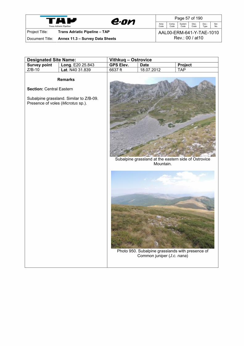
Designated Site Name: Vithkuq – Ostrovice
Long. E20 25.843 GPS Elev. Date Project Survey point Z/B-10 Lat. N40 31.839 6637 ft 18.07.2012 TAP
Remarks
Section: Central Eastern Subalpine grassland. Similar to Z/B-09. Presence of voles (Microtus sp.).
Subalpine grassland at the eastern side of Ostrovice
Mountain.
Photo 950. Subalpine grasslands with presence of
Common juniper (J.c. nana)

Page 58 of 190
Area Code
Comp. Code
System Code
Disc. Code
Doc.- Type
Ser. No.
Project Title: Trans Adriatic Pipeline – TAP
Document Title: Annex 11.3 – Survey Data Sheets AAL00-ERM-641-Y-TAE-1010
Rev.: 00 / at10
Designated Site Name: Vithkuq – Ostrovice
Long. E20 26.489 GPS Elev. Date Project Survey point Z/B-11 Lat. N40 30.802 5987 ft
18.07.2012 TAP
Remarks
Section: Central Eastern Subalpine grassland along the Potom Route. Similar to Z/B-07. Presence of voles (Microtus sp.) and hare (Lepus europaeus) confirmed.
Subalpine grasslands
Presence of signs of voles (Microtus sp.)
Page 59 of 190
Area Code
Comp. Code
System Code
Disc. Code
Doc.- Type
Ser. No.
Project Title: Trans Adriatic Pipeline – TAP
Document Title: Annex 11.3 – Survey Data Sheets AAL00-ERM-641-Y-TAE-1010
Rev.: 00 / at10
Designated Site Name: Vithkuq – Ostrovice
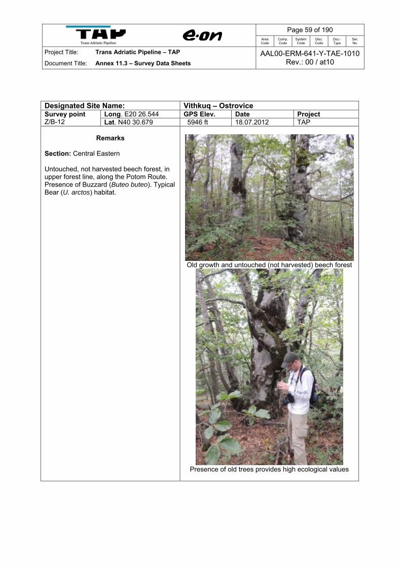
Long. E20 26.544 GPS Elev. Date Project Survey point Z/B-12 Lat. N40 30.679 5946 ft 18.07.2012 TAP
Remarks Section: Central Eastern Untouched, not harvested beech forest, in upper forest line, along the Potom Route. Presence of Buzzard (Buteo buteo). Typical Bear (U. arctos) habitat.
Old growth and untouched (not harvested) beech forest
Presence of old trees provides high ecological values
Page 60 of 190
Area Code
Comp. Code
System Code
Disc. Code
Doc.- Type
Ser. No.
Project Title: Trans Adriatic Pipeline – TAP
Document Title: Annex 11.3 – Survey Data Sheets AAL00-ERM-641-Y-TAE-1010
Rev.: 00 / at10
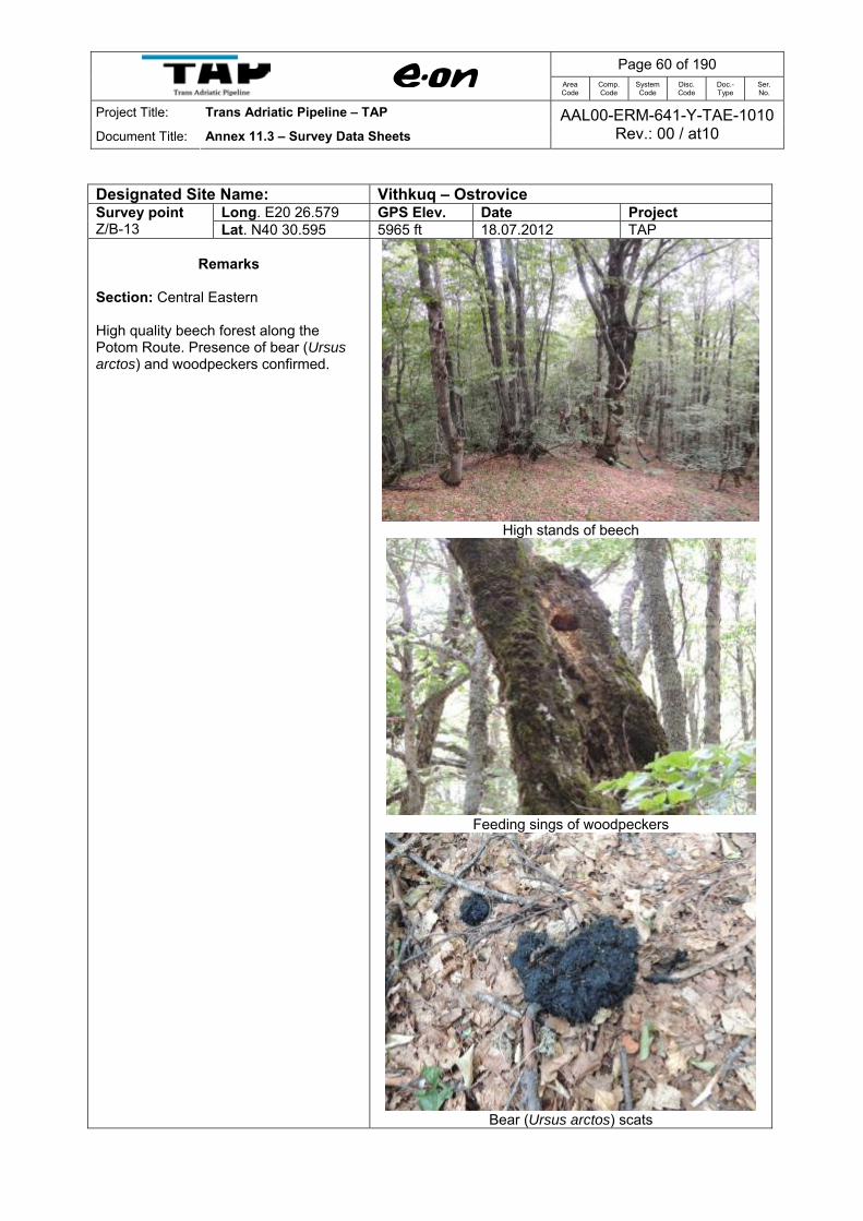
Designated Site Name: Vithkuq – Ostrovice
Long. E20 26.579 GPS Elev. Date Project Survey point Z/B-13 Lat. N40 30.595 5965 ft 18.07.2012 TAP
Remarks
Section: Central Eastern High quality beech forest along the Potom Route. Presence of bear (Ursus arctos) and woodpeckers confirmed.
High stands of beech
Feeding sings of woodpeckers
Bear (Ursus arctos) scats
Page 61 of 190
Area Code
Comp. Code
System Code
Disc. Code
Doc.- Type
Ser. No.
Project Title: Trans Adriatic Pipeline – TAP
Document Title: Annex 11.3 – Survey Data Sheets AAL00-ERM-641-Y-TAE-1010
Rev.: 00 / at10
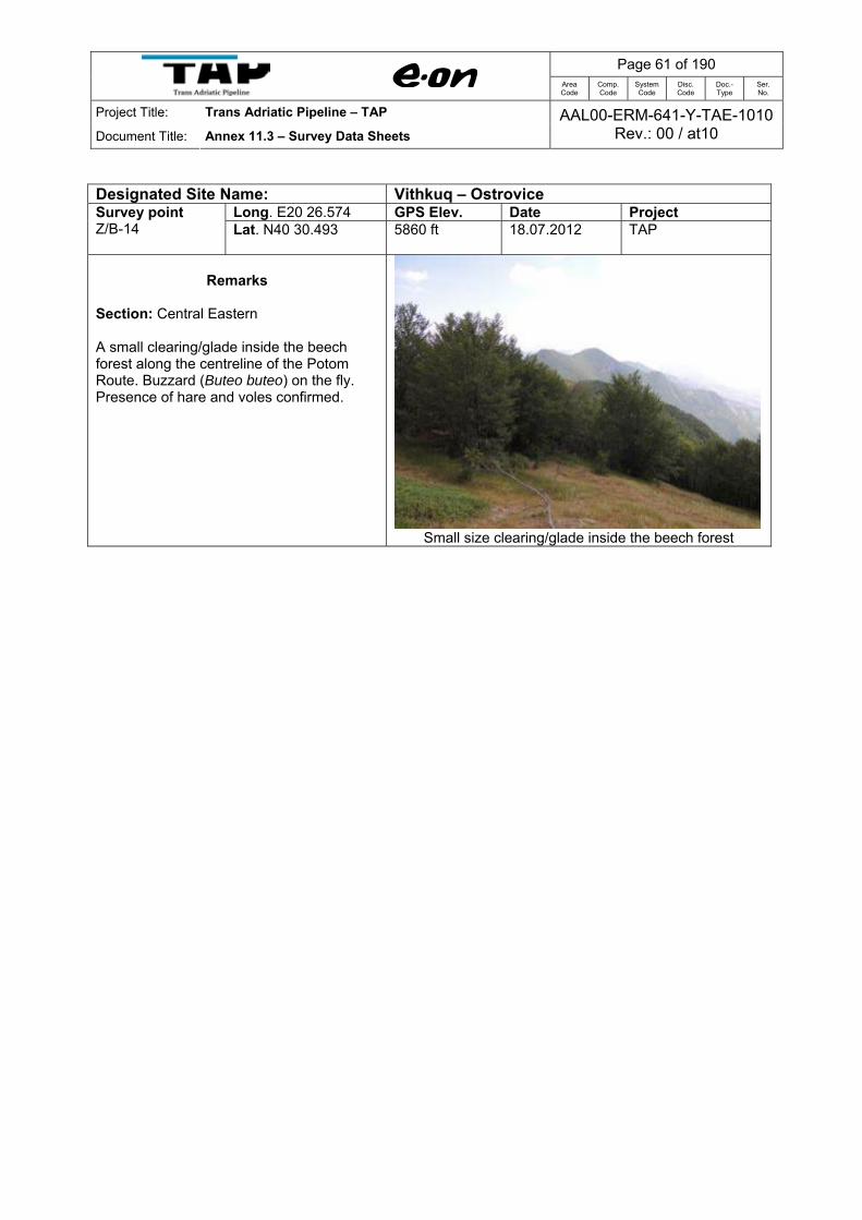
Designated Site Name: Vithkuq – Ostrovice
Long. E20 26.574 GPS Elev. Date Project Survey point Z/B-14 Lat. N40 30.493 5860 ft
18.07.2012 TAP
Remarks
Section: Central Eastern A small clearing/glade inside the beech forest along the centreline of the Potom Route. Buzzard (Buteo buteo) on the fly. Presence of hare and voles confirmed.
Small size clearing/glade inside the beech forest

Page 62 of 190
Area Code
Comp. Code
System Code
Disc. Code
Doc.- Type
Ser. No.
Project Title: Trans Adriatic Pipeline – TAP
Document Title: Annex 11.3 – Survey Data Sheets AAL00-ERM-641-Y-TAE-1010
Rev.: 00 / at10
Designated Site Name: Vithkuq – Ostrovice
Long. E20 26.425 GPS Elev. Date Project Survey point Z-15 Lat. N40 31.174 5991 ft 18.07.2012 TAP
Remarks Section: Central Eastern Small ponds downstream of the mountain spring. Presence of Yellow-bellied Toad (Bombina variegata) and Grass Snake (Natrix sp.) confirmed (photos)
Ponds in open subalpine grasslands
Yellow bellied Toad (Bombina variegata)
A water snake (Natrix sp.) was found inside the pond

Page 63 of 190
Area Code
Comp. Code
System Code
Disc. Code
Doc.- Type
Ser. No.
Project Title: Trans Adriatic Pipeline – TAP
Document Title: Annex 11.3 – Survey Data Sheets AAL00-ERM-641-Y-TAE-1010
Rev.: 00 / at10
Designated Site Name: Vithkuq – Ostrovice
Long. E20 28.859 GPS Elev. Date Project Survey point Z/B-16 Lat. N40 31.620 5038 ft 18.07.2012 TAP
Remarks
Section: Central Eastern Clearing/glade inside the beech forest (harvested). Presence of voles (Microtus sp.)
Glade along the access road
Presence signs of voles (Microtus sp.)
Page 64 of 190
Area Code
Comp. Code
System Code
Disc. Code
Doc.- Type
Ser. No.
Project Title: Trans Adriatic Pipeline – TAP
Document Title: Annex 11.3 – Survey Data Sheets AAL00-ERM-641-Y-TAE-1010
Rev.: 00 / at10
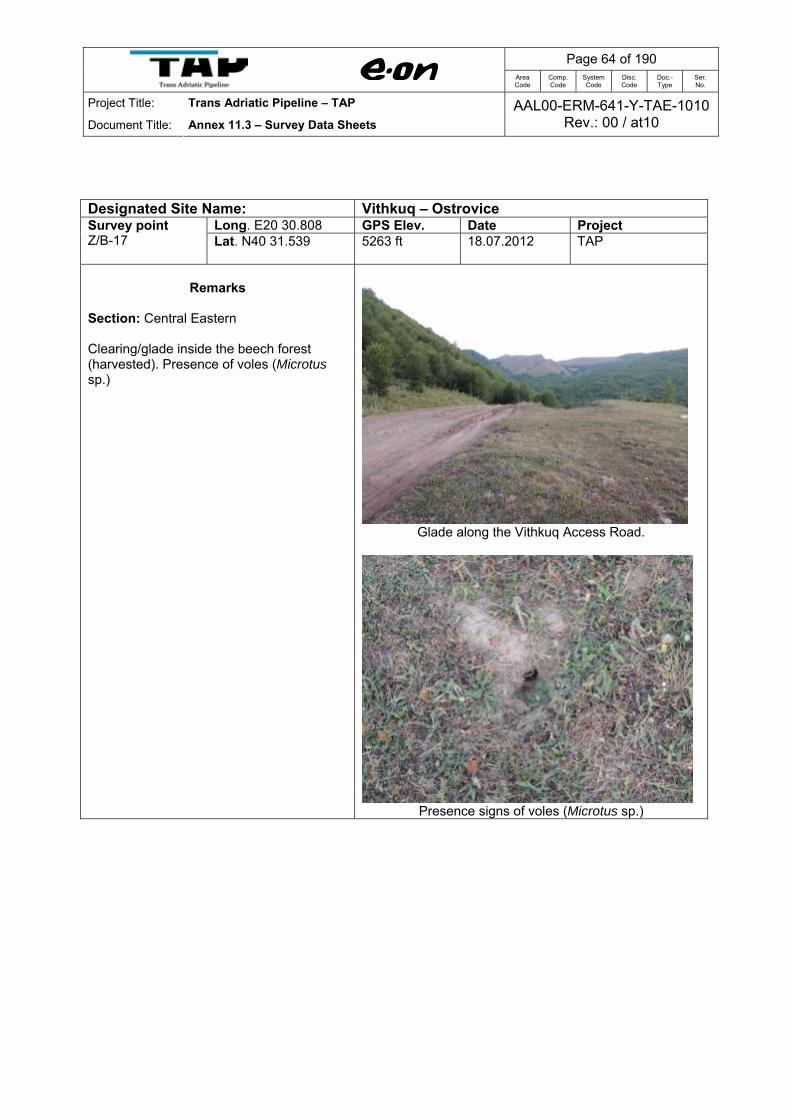
Designated Site Name: Vithkuq – Ostrovice
Long. E20 30.808 GPS Elev. Date Project Survey point Z/B-17 Lat. N40 31.539 5263 ft
18.07.2012 TAP
Remarks
Section: Central Eastern Clearing/glade inside the beech forest (harvested). Presence of voles (Microtus sp.)
Glade along the Vithkuq Access Road.
Presence signs of voles (Microtus sp.)
Page 65 of 190
Area Code
Comp. Code
System Code
Disc. Code
Doc.- Type
Ser. No.
Project Title: Trans Adriatic Pipeline – TAP
Document Title: Annex 11.3 – Survey Data Sheets AAL00-ERM-641-Y-TAE-1010
Rev.: 00 / at10
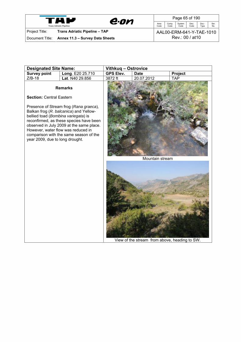
Designated Site Name: Vithkuq – Ostrovice Long. E20 25.710 GPS Elev. Date Project Survey point
Z/B-18 Lat. N40 29.856 3872 ft 20.07.2012 TAP
Remarks Section: Central Eastern Presence of Stream frog (Rana graeca), Balkan frog (R. balcanica) and Yellow-bellied toad (Bombina variegata) is reconfirmed, as these species have been observed in July 2009 at the same place. However, water flow was reduced in comparison with the same season of the year 2009, due to long drought.
Mountain stream
View of the stream from above, heading to SW.

Page 66 of 190
Area Code
Comp. Code
System Code
Disc. Code
Doc.- Type
Ser. No.
Project Title: Trans Adriatic Pipeline – TAP
Document Title: Annex 11.3 – Survey Data Sheets AAL00-ERM-641-Y-TAE-1010
Rev.: 00 / at10
Designated Site Name: Vithkuq – Ostrovice
Long. E20 26.246 GPS Elev. Date Project Survey point Z-19 Lat. N40 29.824 4663 ft
20.07.2012 TAP
Remarks
Section: Central Eastern Luzulo-Fagetum forest. Mature beech forest. Presence of Rosalia longicorn (Rosalia alpina) and indicator of old growth and good quality forest. Feeding signs of woodpeckers observed.
Feeding signs of woodpeckers
Mature beech forest
Rosalia longicorn (Rosalia alpina), a threatened species
in Europe
Page 67 of 190
Area Code
Comp. Code
System Code
Disc. Code
Doc.- Type
Ser. No.
Project Title: Trans Adriatic Pipeline – TAP
Document Title: Annex 11.3 – Survey Data Sheets AAL00-ERM-641-Y-TAE-1010
Rev.: 00 / at10
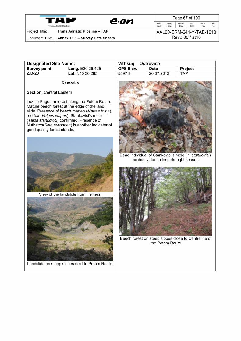
Designated Site Name: Vithkuq – Ostrovice
Long. E20 26.425 GPS Elev. Date Project Survey point Z/B-20 Lat. N40 30.285 5597 ft 20.07.2012 TAP
Remarks Section: Central Eastern Luzulo-Fagetum forest along the Potom Route. Mature beech forest at the edge of the land slide. Presence of beech marten (Martes foina), red fox (Vulpes vulpes), Stankovici‘s mole (Talpa stankovici) confirmed. Presence of Nuthatch(Sitta europaea) is another indicator of good quality forest stands.
View of the landslide from Helmes.
Landslide on steep slopes next to Potom Route.
Dead individual of Stankovici’s mole (T. stankovici),
probably due to long drought season
Beech forest on steep slopes close to Centreline of
the Potom Route

Page 68 of 190
Area Code
Comp. Code
System Code
Disc. Code
Doc.- Type
Ser. No.
Project Title: Trans Adriatic Pipeline – TAP
Document Title: Annex 11.3 – Survey Data Sheets AAL00-ERM-641-Y-TAE-1010
Rev.: 00 / at10
Designated Site Name: Vithkuq – Ostrovice
Long. E20 26.487 GPS Elev. Date Project Survey point Z-21 Lat. N40 30.260 5648 ft 20.07.2012 TAP
Remarks
Section: Central Eastern Mature beech forest at the upper forest line, along the centreline of the pipeline route of tunnel alternative. Scants of beech marten (Martes foina) observed.
Beech forest along the Centreline of the Potom Route.
Scant of beech marten (Martes foina)

Page 69 of 190
Area Code
Comp. Code
System Code
Disc. Code
Doc.- Type
Ser. No.
Project Title: Trans Adriatic Pipeline – TAP
Document Title: Annex 11.3 – Survey Data Sheets AAL00-ERM-641-Y-TAE-1010
Rev.: 00 / at10
Designated Site Name: Vithkuq – Ostrovice
Long. E20 26.560 GPS Elev. Date Project Survey point Z-22 Lat. N40 30.477 5838 ft 20.07.2012 TAP
Remarks Section: Central Eastern A small clearing/glade of subalpine grassland surrounded by mature beech forest. Steep slope. Signs of erosion verified. Presence of voles (Microtus sp.), hare (Lepus europaeus), and wolf (Canis lupus) and fox (Vulpes vulpes) nearby. Feeding signs of woodpeckers on old dead trees. Few individuals of butterflies observed.
Feeding signs of woodpeckers
Glade, surrounded by mature beech forest.
Signs of erosion/landslide
Butterfly(Papilio machaon).

Page 70 of 190
Area Code
Comp. Code
System Code
Disc. Code
Doc.- Type
Ser. No.
Project Title: Trans Adriatic Pipeline – TAP
Document Title: Annex 11.3 – Survey Data Sheets AAL00-ERM-641-Y-TAE-1010
Rev.: 00 / at10
Designated Site Name: Vithkuq – Ostrovice
Long. E20 26.583 GPS Elev. Date Project Survey point Z-23 Lat. N40 30.418 5766 ft 20.07.2012 TAP
Remarks Section: Central Eastern
Mature beech forest along the centreline of the Potom Route (subject to minor changes during final planning). Bear (Ursus arctos) scant some 10 m away from the centreline of the pipeline route Tunnel Alternative. Part of the bear habitat. Wolf (Canis lupus) scants observed nearby.
Mature beech forest
Bear (Ursus arctos) scant
Wolf (Canis lupus) scant
Page 71 of 190
Area Code
Comp. Code
System Code
Disc. Code
Doc.- Type
Ser. No.
Project Title: Trans Adriatic Pipeline – TAP
Document Title: Annex 11.3 – Survey Data Sheets AAL00-ERM-641-Y-TAE-1010
Rev.: 00 / at10
Designated Site Name: Vithkuq – Ostrovice
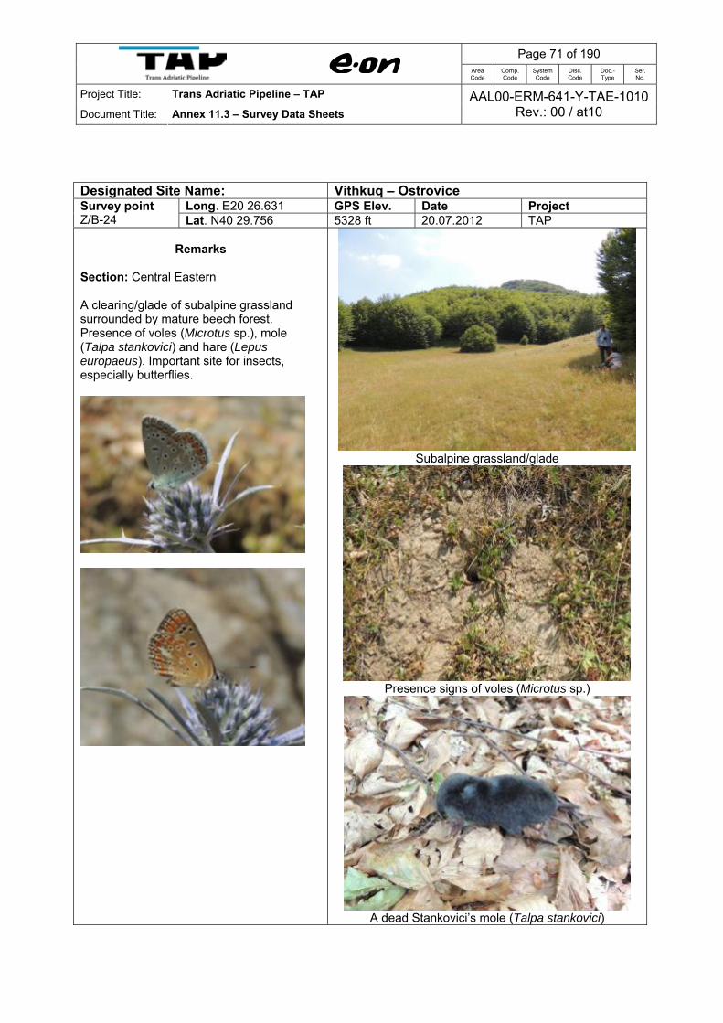
Long. E20 26.631 GPS Elev. Date Project Survey point Z/B-24 Lat. N40 29.756 5328 ft 20.07.2012 TAP
Remarks
Section: Central Eastern A clearing/glade of subalpine grassland surrounded by mature beech forest. Presence of voles (Microtus sp.), mole (Talpa stankovici) and hare (Lepus europaeus). Important site for insects, especially butterflies.
Subalpine grassland/glade
Presence signs of voles (Microtus sp.)
A dead Stankovici’s mole (Talpa stankovici)

Page 72 of 190
Area Code
Comp. Code
System Code
Disc. Code
Doc.- Type
Ser. No.
Project Title: Trans Adriatic Pipeline – TAP
Document Title: Annex 11.3 – Survey Data Sheets AAL00-ERM-641-Y-TAE-1010
Rev.: 00 / at10
Designated Site Name: Vithkuq – Ostrovice
Long. E20 26.614 GPS Elev. Date Project Survey point Z-25 Lat. N40 29.682 5418 ft 20.07.2012 TAP
Remarks Section: Central Eastern Luzulo-Fagetum forest. Bear (Ursus arctos) scant few meters away from the centreline of the pipeline route Tunnel Alternative. Part of the bear habitat.
Beech forest
Bear (Ursus arctos) scant
Page 73 of 190
Area Code
Comp. Code
System Code
Disc. Code
Doc.- Type
Ser. No.
Project Title: Trans Adriatic Pipeline – TAP
Document Title: Annex 11.3 – Survey Data Sheets AAL00-ERM-641-Y-TAE-1010
Rev.: 00 / at10
Designated Site Name: Vithkuq – Ostrovice
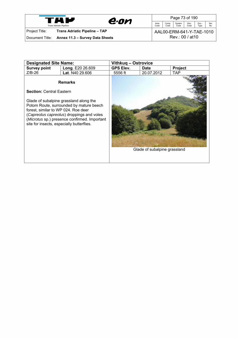
Long. E20 26.609 GPS Elev. Date Project Survey point Z/B-26 Lat. N40 29.606 5556 ft 20.07.2012 TAP
Remarks Section: Central Eastern Glade of subalpine grassland along the Potom Route, surrounded by mature beech forest, similar to WP 024. Roe deer (Capreolus capreolus) droppings and voles (Microtus sp.) presence confirmed. Important site for insects, especially butterflies.
Glade of subalpine grassland
Page 74 of 190
Area Code
Comp. Code
System Code
Disc. Code
Doc.- Type
Ser. No.
Project Title: Trans Adriatic Pipeline – TAP
Document Title: Annex 11.3 – Survey Data Sheets AAL00-ERM-641-Y-TAE-1010
Rev.: 00 / at10
Designated Site Name: Vithkuq – Ostrovice
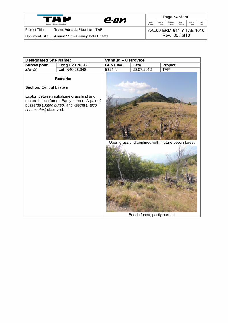
Long E20 26.208 GPS Elev. Date Project Survey point Z/B-27 Lat. N40 28.948 5324 ft 20.07.2012 TAP
Remarks
Section: Central Eastern Ecoton between subalpine grassland and mature beech forest. Partly burned. A pair of buzzards (Buteo buteo) and kestrel (Falco tinnunculus) observed.
Open grassland confined with mature beech forest
Beech forest, partly burned

Page 75 of 190
Area Code
Comp. Code
System Code
Disc. Code
Doc.- Type
Ser. No.
Project Title: Trans Adriatic Pipeline – TAP
Document Title: Annex 11.3 – Survey Data Sheets AAL00-ERM-641-Y-TAE-1010
Rev.: 00 / at10
Designated Site Name: Vithkuq – Ostrovice
Long. E20 25.956 GPS Elev. Date Project Survey point Z-28 Lat. N40 29.072 5104 ft 20.07.2012 TAP
Remarks
Section: Central Eastern Lirza Beech Forest, Nature Monument. A memorial of the Second World War (commemorate of the First Congress of the Antifascist Youth Union of Albania on 08 August, 1944) found in a subalpine wet meadow situated inside the beech forest.
Mature beech forest of Lirza, Nature Monument.
Memorial of the Second Wold War at Lirza Nature
Monument

Page 76 of 190
Area Code
Comp. Code
System Code
Disc. Code
Doc.- Type
Ser. No.
Project Title: Trans Adriatic Pipeline – TAP
Document Title: Annex 11.3 – Survey Data Sheets AAL00-ERM-641-Y-TAE-1010
Rev.: 00 / at10
Designated Site Name: Vithkuq – Ostrovice
Long. E20 25.438 GPS Elev. Date Project Survey point Z-29 Lat. N40 28.895 4041 ft 21.07.2012 TAP
Remarks
Section: Central Eastern Access road through beech forest. Although chopped, some old growth trees are still present inside the beech forest. Part of bear (Ursus arctos) habitat, as bear scant observed along the road. Red fox (Vulpes vulpes) scants also observed.
Access road through beech forest
Bear (Ursus arctos) scant
Path where bear scant was found

Page 77 of 190
Area Code
Comp. Code
System Code
Disc. Code
Doc.- Type
Ser. No.
Project Title: Trans Adriatic Pipeline – TAP
Document Title: Annex 11.3 – Survey Data Sheets AAL00-ERM-641-Y-TAE-1010
Rev.: 00 / at10
Designated Site Name: Vithkuq – Ostrovice
Long. E20 25.831 GPS Elev. Date Project Survey point Z/B-30 Lat. N40 29.025 4604 ft 21.07.2012 TAP
Remarks Section: Central Eastern Access road. Glade of wet meadows, with presence of water springs and small ponds. Common leech (Hirundo officinalis), Yellow-bellied toad (Bombina variegata), and tadpoles observed. Tracks of beech marten (Martes foina) observed.
Glade of wet meadow along the access road
Tadpoles in small ponds next to the access road
Tracks of beech marten (Martes foina)

Page 78 of 190
Area Code
Comp. Code
System Code
Disc. Code
Doc.- Type
Ser. No.
Project Title: Trans Adriatic Pipeline – TAP
Document Title: Annex 11.3 – Survey Data Sheets AAL00-ERM-641-Y-TAE-1010
Rev.: 00 / at10
Designated Site Name: Vithkuq – Ostrovice
Long. E20 26.180 GPS Elev. Date Project Survey point Z/B-31 Lat. N40 28.869 5446 ft 21.07.2012 TAP
Remarks Section: Central Eastern Luzulo-Fagetum forest. Potom Route. Beech forest in upper forest line, along the mountain ridge. Birds of prey observed: Buzzard (Buteo buteo), Kestrel (Falco tinnunculus), Honey buzzard (Pernis apivorus). Butterflies (Papilionids) observed.
Buzzard (Buteo buteo) on the fly
Beech forest along the Potom Route
Butterfly (Iphiclides podalirius)

Page 79 of 190
Area Code
Comp. Code
System Code
Disc. Code
Doc.- Type
Ser. No.
Project Title: Trans Adriatic Pipeline – TAP
Document Title: Annex 11.3 – Survey Data Sheets AAL00-ERM-641-Y-TAE-1010
Rev.: 00 / at10
Designated Site Name: Vithkuq – Ostrovice
Long. E20 25.807 GPS Elev. Date Project Survey point Z/B-32 Lat. N40 28.627 5148 ft 21.07.2012 TAP
Remarks
Section: Central Eastern Temporary wetland, totally dry, due to long drought season. However, this biotope seems to be important as breeding ground for frogs and toads during breeding season.
View of the temporary wetland
Closer view to the wetland

Page 80 of 190
Area Code
Comp. Code
System Code
Disc. Code
Doc.- Type
Ser. No.
Project Title: Trans Adriatic Pipeline – TAP
Document Title: Annex 11.3 – Survey Data Sheets AAL00-ERM-641-Y-TAE-1010
Rev.: 00 / at10
Designated Site Name: Vithkuq – Ostrovice
Long. E20 25.660 GPS Elev. Date Project Survey point Z/B-33 Lat. N40 28.494 5181 ft 21.07.2012 TAP
Remarks Section: Central Eastern Proposed Laydown site of the pipeline. Beech forest on north facing slopes and subalpine grassland on south facing slopes. Potential bear (Ursus arctos) habitat. Skylark (Alauda arvensis) observed on the rock.
Skylark (Alauda arvensis)
Beech forest on north facing slopes and open grasslands
on south facing slopes

Page 81 of 190
Area Code
Comp. Code
System Code
Disc. Code
Doc.- Type
Ser. No.
Project Title: Trans Adriatic Pipeline – TAP
Document Title: Annex 11.3 – Survey Data Sheets AAL00-ERM-641-Y-TAE-1010
Rev.: 00 / at10
Designated Site Name: Vithkuq – Ostrovice
Long. E20 25.369 GPS Elev. Date Project Survey point Z/B-34 Lat. N40 28.375 4975 ft 21.07.2012 TAP
Remarks Section: Central Eastern Proposed Laydown site of the pipeline . Beech forest on north facing slopes and subalpine grassland on south facing slopes. Old tree present. Potential bear (Ursus arctos) habitat. Slope 20-25 degree.
Old beech tree
View of the proposed laydown site (heading to the NE)
View of the proposed laydown site (heading to SW)

Page 82 of 190
Area Code
Comp. Code
System Code
Disc. Code
Doc.- Type
Ser. No.
Project Title: Trans Adriatic Pipeline – TAP
Document Title: Annex 11.3 – Survey Data Sheets AAL00-ERM-641-Y-TAE-1010
Rev.: 00 / at10
Designated Site Name: Vithkuq – Ostrovice
Long. E20 25.085 GPS Elev. Date Project Survey point Z/B-35 Lat. N40 28.432 4259 ft 21.07.2012 TAP
Remarks
Section: Central Eastern Harvested beech forest in lower forest line. Centreline of the Potom Route (subject to minor changes during final planning). Other broadleaved tree species present. Impacted by chopping, grazing and fires. Potential habitat for fox (Vulpes vulpes), badger (Meles meles) and beech marten (Martes foina).
Beech forest, lower forest line (heading to SE)
Degraded beech forest (heading to NW)
Along the centreline, leaving behind the beech forest

Page 83 of 190
Area Code
Comp. Code
System Code
Disc. Code
Doc.- Type
Ser. No.
Project Title: Trans Adriatic Pipeline – TAP
Document Title: Annex 11.3 – Survey Data Sheets AAL00-ERM-641-Y-TAE-1010
Rev.: 00 / at10
Designated Site Name: Vithkuq – Ostrovice
Long. E20 24.980 GPS Elev. Date Project Survey point Z-36 Lat. N40 28.537 4010 ft 21.07.2012 TAP
Remarks Section: Central Eastern Close to Potom Route. Water spring, with small size ponds downhill of the water spring, providing an important biotope for frogs and toads. Balkan frog (Rana balcanica), Yellow-bellied toad (Bombina variegata) and tadpoles observed.
Small sized ponds
Yellow-bellied toad (Bombina variegata)
Balkan frog (Rana balcanica)

Page 84 of 190
Area Code
Comp. Code
System Code
Disc. Code
Doc.- Type
Ser. No.
Project Title: Trans Adriatic Pipeline – TAP
Document Title: Annex 11.3 – Survey Data Sheets AAL00-ERM-641-Y-TAE-1010
Rev.: 00 / at10
Designated Site Name: Vithkuq – Ostrovice
Long. E20 24.690 GPS Elev. Date Project Survey point Z/B-37 Lat. N40 28.752 3635 ft 21.07.2012 TAP
Remarks Section: Central Eastern Along the Potom Route, Centreline. Degraded shrub land due to over grazing and overcutting. Red fox (Vulpes vulpes) presence confirmed.
Degraded shrubland (heading to SE)
Degraded scrubland (heading to NW)

Page 85 of 190
Area Code
Comp. Code
System Code
Disc. Code
Doc.- Type
Ser. No.
Project Title: Trans Adriatic Pipeline – TAP
Document Title: Annex 11.3 – Survey Data Sheets AAL00-ERM-641-Y-TAE-1010
Rev.: 00 / at10
Designated Site Name: Vithkuq – Ostrovice
Long E20 24.539 GPS Elev. Date Project Survey point Z-38 Lat. N40 28.843 3429 ft 21.07.2012 TAP
Remarks
Section: Central Eastern Potom Route. Similar to Z/B-37. A graveyard is located nearby the centreline of the alternative pipeline route.
View of the Graveyard next to Access Road and
Centreline of the Potom Route
View of the degraded scrubland nearby the graveyard
(heading to SE)

Page 86 of 190
Area Code
Comp. Code
System Code
Disc. Code
Doc.- Type
Ser. No.
Project Title: Trans Adriatic Pipeline – TAP
Document Title: Annex 11.3 – Survey Data Sheets AAL00-ERM-641-Y-TAE-1010
Rev.: 00 / at10
Designated Site Name: Vithkuq – Ostrovice
Long. E20 24.432 GPS Elev. Date Project Survey point Z-39 Lat. N40 28.829 3255 ft 21.07.2012 TAP
Remarks
Section: Central Eastern Crossing points of the access road with pipeline route. Degraded shrubland uphill and grazed grassland downhill. A water reservoir is located nearby.
Crossing point of the Access Road with Potom Route
(heading to S)
View heading to N

Page 87 of 190
Area Code
Comp. Code
System Code
Disc. Code
Doc.- Type
Ser. No.
Project Title: Trans Adriatic Pipeline – TAP
Document Title: Annex 11.3 – Survey Data Sheets AAL00-ERM-641-Y-TAE-1010
Rev.: 00 / at10
Designated Site Name: Vithkuq – Ostrovice
Long E20 24.353 GPS Elev. Date Project Survey point Z/B-40 Lat. N40 28.794 3178 ft 21.07.2012 TAP
Remarks
Section: Central Eastern Black pine (Pinus nigra) plantations (not beech forest as indicated on the map) around the water reservoir of Staravecka.
Pine tree plantations around the Staravecka water
reservoir

Page 88 of 190
Area Code
Comp. Code
System Code
Disc. Code
Doc.- Type
Ser. No.
Project Title: Trans Adriatic Pipeline – TAP
Document Title: Annex 11.3 – Survey Data Sheets AAL00-ERM-641-Y-TAE-1010
Rev.: 00 / at10
Designated Site Name: Vithkuq – Ostrovice
Long. E20 24.232 GPS Elev. Date Project Survey point Z/B-41 Lat. N40 28.956 3135 ft 21.07.2012 TAP
Remarks
Section: Central Eastern Crossing points of the access road with pipeline route (Potom Route). Degraded shrubland between terraces cultivated with annual and perennial crops. Papilionid (butterflies) observed.
Crossing point of the Access Road with Potom Route
Arable land on terraced land
Degraded shrubland on steep slopes between terraces.

Page 89 of 190
Area Code
Comp. Code
System Code
Disc. Code
Doc.- Type
Ser. No.
Project Title: Trans Adriatic Pipeline – TAP
Document Title: Annex 11.3 – Survey Data Sheets AAL00-ERM-641-Y-TAE-1010
Rev.: 00 / at10
Designated Site Name: Vithkuq – Ostrovice
Long. E20 24.253 GPS Elev. Date Project Survey point Z-42 Lat. N40 28.938 3094 ft 22.07.2012 TAP
Remarks
Section: Central Eastern Crop fields with alfalfa and degraded shrubland on slopes between terraces. Observed: Corn bunting (Miliaria calandra)
Crop fields with alfalfa surrounded by degraded scrubs
(heading to SE)

Page 90 of 190
Area Code
Comp. Code
System Code
Disc. Code
Doc.- Type
Ser. No.
Project Title: Trans Adriatic Pipeline – TAP
Document Title: Annex 11.3 – Survey Data Sheets AAL00-ERM-641-Y-TAE-1010
Rev.: 00 / at10
Designated Site Name: Vithkuq – Ostrovice
Long. E20 24.173 GPS Elev. Date Project Survey point Z/B-43 Lat. N40 28.950 2967 ft 22.07.2012 TAP
Remarks Section: Central Eastern Degraded transitional woodland-scrubs between terraces, on steep slope, dominated by Macedonian oak (Quercus trojana), Turkey oak (Q. cerris), Sessile oak (Q. petraea) and European hornbeam (Carpinus betulus). Feeding signs of red fox. Corn bunting (Miliaria calandra) and Finch (Fringilla coelebs) observed.

Page 91 of 190
Area Code
Comp. Code
System Code
Disc. Code
Doc.- Type
Ser. No.
Project Title: Trans Adriatic Pipeline – TAP
Document Title: Annex 11.3 – Survey Data Sheets AAL00-ERM-641-Y-TAE-1010
Rev.: 00 / at10
Designated Site Name: Vithkuq – Ostrovice
Long. E20 23.912 GPS Elev. Date Project Survey point Z/B-44 Lat. N40 28.986 2836 ft 22.07.2012 TAP
Remarks Section: Central Eastern Heavily degraded shrubs, dominated by Common juniper (Juniperus communis) and European hornbeam (Carpinus betulus). Observed: Corn bunting (Miliaria calandra)
Degraded scrubs (heading to NW)

Page 92 of 190
Area Code
Comp. Code
System Code
Disc. Code
Doc.- Type
Ser. No.
Project Title: Trans Adriatic Pipeline – TAP
Document Title: Annex 11.3 – Survey Data Sheets AAL00-ERM-641-Y-TAE-1010
Rev.: 00 / at10
Designated Site Name: Vithkuq – Ostrovice
Long. E20 23.933 GPS Elev. Date Project Survey point Z/B-45 Lat. N40 29.044 2746 ft 22.07.2012 TAP
Remarks
Section: Central Eastern Wet meadow and narrow belt of riparian habitat dominated by Willow (Salix spp.) and Common reed (Phragmites australis). Important site for butterflies.
View of the wet meadow and narrow belt of riparian habitat
Closer view to the wet meadow
Page 93 of 190
Area Code
Comp. Code
System Code
Disc. Code
Doc.- Type
Ser. No.
Project Title: Trans Adriatic Pipeline – TAP
Document Title: Annex 11.3 – Survey Data Sheets AAL00-ERM-641-Y-TAE-1010
Rev.: 00 / at10
Designated Site Name: Vithkuq – Ostrovice
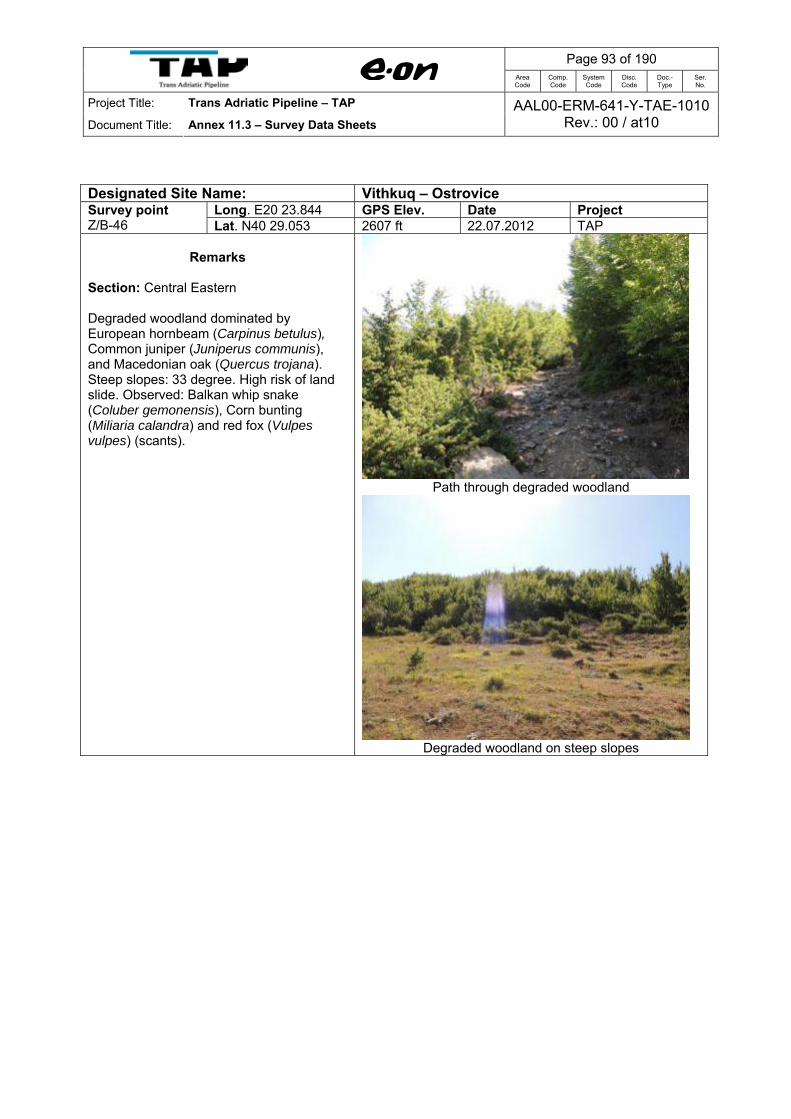
Long. E20 23.844 GPS Elev. Date Project Survey point Z/B-46 Lat. N40 29.053 2607 ft 22.07.2012 TAP
Remarks Section: Central Eastern Degraded woodland dominated by European hornbeam (Carpinus betulus), Common juniper (Juniperus communis), and Macedonian oak (Quercus trojana). Steep slopes: 33 degree. High risk of land slide. Observed: Balkan whip snake (Coluber gemonensis), Corn bunting (Miliaria calandra) and red fox (Vulpes vulpes) (scants).
Path through degraded woodland
Degraded woodland on steep slopes

Page 94 of 190
Area Code
Comp. Code
System Code
Disc. Code
Doc.- Type
Ser. No.
Project Title: Trans Adriatic Pipeline – TAP
Document Title: Annex 11.3 – Survey Data Sheets AAL00-ERM-641-Y-TAE-1010
Rev.: 00 / at10
Designated Site Name: Grykederdhje e Semanit-Pishe Poro
Long. E19 27.063 GPS Elev. Date Project Survey point Z/B-85 Lat. N40 47.518 5 ft 26.07.2012 TAP
Remarks Section: Western Entrance point to CS03. Mosaic agriculture land. Drainage channel with Spiny rush (Juncus acutus) and Tamarisk (Tamarix sp). In some depressions nearby there is found halophytic vegetation of Rush (Juncus sp)., Reed (Typha sp). and Salicornia (Salicornia sp). Observed: House sparrow (Hirundo rustica), Skylark (Alauda arvensis). Presence of fox (Vulpes vulpes) confirmed.
Entrance to CS03.
Halophytic vegetation at the CS03 site
Halophytic vegetation in depression

Page 95 of 190
Area Code
Comp. Code
System Code
Disc. Code
Doc.- Type
Ser. No.
Project Title: Trans Adriatic Pipeline – TAP
Document Title: Annex 11.3 – Survey Data Sheets AAL00-ERM-641-Y-TAE-1010
Rev.: 00 / at10
Designated Site Name: Grykederdhje e Semanit-Pishe Poro
Long. E19 27.169 GPS Elev. Date Project Survey point Z/B-86 Lat. N40 47.382 13 ft 26.07.2012 TAP
Remarks Section: Western Halophytic vegetation of Rush (Juncus sp), Salicornia and Tamarisk. Ending point of Grid Connection, nearby the CS03 site. Observed: Swallow (Hirundo rustica), Spanish sparrow (Passer hispaniolensis), Crested lark (Galerida cristata).
Ending point of the Grid Connection to CS03

Page 96 of 190
Area Code
Comp. Code
System Code
Disc. Code
Doc.- Type
Ser. No.
Project Title: Trans Adriatic Pipeline – TAP
Document Title: Annex 11.3 – Survey Data Sheets AAL00-ERM-641-Y-TAE-1010
Rev.: 00 / at10
Designated Site Name: Grykederdhje e Semanit-Pishe Poro
Long. E19 26.766 GPS Elev. Date Project Survey point Z/B-87 Lat. N40 47.307 0 ft 26.07.2012 TAP
Remarks
Section: Western Mosaic agriculture land and reeds of Common reed (Phragmites australis) and Giant cane (Arundo donax) along the drainage/irrigation channel. Observed: Quail (Coturnix coturnix), Crested lark (Galerida cristata), Swallow (Hirundo rustica), Thomas pine vole (Microtus thomasi)
Mosaic arable land and reeds along the drainage/irrigation
channel

Page 97 of 190
Area Code
Comp. Code
System Code
Disc. Code
Doc.- Type
Ser. No.
Project Title: Trans Adriatic Pipeline – TAP
Document Title: Annex 11.3 – Survey Data Sheets AAL00-ERM-641-Y-TAE-1010
Rev.: 00 / at10
Designated Site Name: Grykederdhje e Semanit-Pishe Poro
Long. E19 26.355 GPS Elev. Date Project Survey point Z/B-88 Lat. N40 47.256 12 ft 26.07.2012 TAP
Remarks Section: Western Thickets of Tamarisk (Tamarix sp), Common reed (Phragmites australis) and Rush (Juncus sp.). Crossing point of the Grid Connection with the drainage channel. Presence of fish, Balkan frogs (Rana balcanica) and dragonflies verified.
Crossing point of Grid Connection with a drainage channel
Balkan frogs (Rana balcanica) and fish present in the drainage channel.
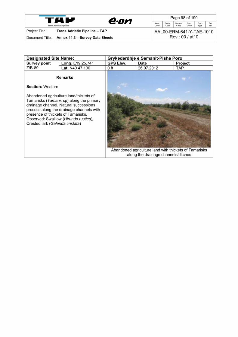
Page 98 of 190
Area Code
Comp. Code
System Code
Disc. Code
Doc.- Type
Ser. No.
Project Title: Trans Adriatic Pipeline – TAP
Document Title: Annex 11.3 – Survey Data Sheets AAL00-ERM-641-Y-TAE-1010
Rev.: 00 / at10
Designated Site Name: Grykederdhje e Semanit-Pishe Poro
Long. E19 25.741 GPS Elev. Date Project Survey point Z/B-89 Lat. N40 47.130 0 ft 26.07.2012 TAP
Remarks Section: Western Abandoned agriculture land/thickets of Tamarisks (Tamarix sp) along the primary drainage channel. Natural successions process along the drainage channels with presence of thickets of Tamarisks. Observed: Swalllow (Hirundo rustica), Crested lark (Galerida cristata)
Abandoned agriculture land with thickets of Tamarisks along the drainage channels/ditches

Page 99 of 190
Area Code
Comp. Code
System Code
Disc. Code
Doc.- Type
Ser. No.
Project Title: Trans Adriatic Pipeline – TAP
Document Title: Annex 11.3 – Survey Data Sheets AAL00-ERM-641-Y-TAE-1010
Rev.: 00 / at10
Designated Site Name: Grykederdhje e Semanit-Pishe Poro
Long. E19 24.500 GPS Elev. Date Project Survey point Z/B-90 Lat. N40 46.912 11 ft 26.07.2012 TAP
Remarks Section: Western Salt marshes with Salicornia fruticosa, accompanied with Sea rush (Juncus maritima) and Tamarisks (Tamarix sp.) Observed: Crested lark (Galerida cristata), Sand martin (Riparia riparia), Goldfinch (Carduelis carduelis)
Salt marshes with Salicornia fruticosa (heading NW
direction)
Salt marshes (heading SW direction)

Page 100 of 190
Area Code
Comp. Code
System Code
Disc. Code
Doc.- Type
Ser. No.
Project Title: Trans Adriatic Pipeline – TAP
Document Title: Annex 11.3 – Survey Data Sheets AAL00-ERM-641-Y-TAE-1010
Rev.: 00 / at10
Designated Site Name: Grykederdhje e Semanit-Pishe Poro
Long. E19 23.898 GPS Elev. Date Project Survey point Z/B-91 Lat. N40 46.812 17 ft 26.07.2012 TAP
Remarks Section: Western Reeds with Lesser bulrush (Typha angustifolia) and Common reed (Phragmites australis). Main drainage channel (collector) at crossing point with Grid Connection and Access Road. Presence of Otter (Lutra lutra), Balkan frogs (Rana balcanica) confirmed. Birds observed: Magpie (Pica pica), Hooded crow (Corvus cornix), Goldfinch (Carduelis carduelis).
Otter (Lutra lutra) footprint found under the bridge
Otter spraints found under the bridge
Crossing point of Grid Connection with main drainage
channel
View of the Access Road at crossing point with Grid
Connection and main drainage channel
Balkan frog (Rana balcanica)

Page 101 of 190
Area Code
Comp. Code
System Code
Disc. Code
Doc.- Type
Ser. No.
Project Title: Trans Adriatic Pipeline – TAP
Document Title: Annex 11.3 – Survey Data Sheets AAL00-ERM-641-Y-TAE-1010
Rev.: 00 / at10
Designated Site Name: Grykederdhje e Semanit-Pishe Poro
Long. E19 22.639 GPS Elev. Date Project Survey point Z/B-92 Lat. N40 47.553 12 ft 26.07.2012 TAP
Remarks Section: Western Salt marshes with Salicornia fruticosa. Ending point of Access Road to main pipeline route at Landfall (sea shore). Observed: Swallow (Hirundo rustica), Red-rumped swallow (H. daurica), Skylark (Alauda arvensis), Zitting cisticola (Cisticola juncidis), Fox (Vulpes vulpes) (footprints), and Balkan frog (Rana balcanica) (photo). Presence of frogs is linked with presence nearby of freshwaters in ditches and depressions.
Salt marshes with Salicornia fruticosa at Landfall site (ending
point of the Access Road)
Balkan frog (Rana balcanica)

Page 102 of 190
Area Code
Comp. Code
System Code
Disc. Code
Doc.- Type
Ser. No.
Project Title: Trans Adriatic Pipeline – TAP
Document Title: Annex 11.3 – Survey Data Sheets AAL00-ERM-641-Y-TAE-1010
Rev.: 00 / at10
Designated Site Name: Grykederdhje e Semanit-Pishe Poro
Long. E19 23.526 GPS Elev. Date Project Survey point Z/B-93 Lat. N40 47.320 4 ft 26.07.2012 TAP
Remarks Section: Western Access road. Degraded alluvial forest. Observed: Magpie (Pica pica) (photos), Buzzard (Buteo buteo)
Degraded alluvial forest
Magpie (Pica pica)

Page 103 of 190
Area Code
Comp. Code
System Code
Disc. Code
Doc.- Type
Ser. No.
Project Title: Trans Adriatic Pipeline – TAP
Document Title: Annex 11.3 – Survey Data Sheets AAL00-ERM-641-Y-TAE-1010
Rev.: 00 / at10
Designated Site Name: Grykederdhje e Semanit-Pishe Poro
Long. E19 23.616 GPS Elev. Date Project Survey point Z/B-94 Lat. N40 47.035 3 ft 26.07.2012 TAP
Remarks
Section: Western Halophytic vegetation dominated by Sea rush (Juncus maritima) and Tamarisks (Tamarix sp) along the access road. Observed: Swallow (Hirundo rustica), Magpie (Pica pica), Hooded crow (Corvus cornix).
Access Road to Landfall
Halophytic vegetation dominated by Sea rush (Juncus
maritima) and Tamarisks (Tamarix sp)

Page 104 of 190
Area Code
Comp. Code
System Code
Disc. Code
Doc.- Type
Ser. No.
Project Title: Trans Adriatic Pipeline – TAP
Document Title: Annex 11.3 – Survey Data Sheets AAL00-ERM-641-Y-TAE-1010
Rev.: 00 / at10
Designated Site Name: Grykederdhje e Semanit-Pishe Poro
Long. E19 23.696 GPS Elev. Date Project Survey point Z/B-95 Lat. N40 46.578 4 ft 26.07.2012 TAP
Remarks Section: Western Along the Grid Connection. Halophytic vegetation dominated by Tamarisks (Tamarix sp.)/abandoned agriculture land infested with False yellowhead (Ditrischia viscosa). Observed: Common wall lizard (Podarcis muralis), Swallow (Hirundo rustica), Magpie (Pica pica), Alpine swift (Apus melba), Balkan frog (Rana balcanica).
Balkan frog (Rana balcanica) along the drainage channel situated nearby
Halophytic vegetation dominated by Tamarisks (Tamarix
sp.)
Abandoned agriculture land heavily invested with False
yellowhead (Ditrischia viscosa).

Page 105 of 190
Area Code
Comp. Code
System Code
Disc. Code
Doc.- Type
Ser. No.
Project Title: Trans Adriatic Pipeline – TAP
Document Title: Annex 11.3 – Survey Data Sheets AAL00-ERM-641-Y-TAE-1010
Rev.: 00 / at10
Designated Site Name: Grykederdhje e Semanit-Pishe Poro
Long. E19 23.480 GPS Elev. Date Project Survey point Z/B-96 Lat. N40 46.229 8 ft 26.07.2012 TAP
Remarks Section: Western Wooded sand dunes with pine tree plantations of Maritime pine (Pinus pinaster) and Stone pine (P. pinea). Observed: Magpie (Pica pica), Alpine swift (Apus melba). Abundant presence of cicadas (Cicada ornis).
Wooded sand dunes with pine trees

Page 106 of 190
Area Code
Comp. Code
System Code
Disc. Code
Doc.- Type
Ser. No.
Project Title: Trans Adriatic Pipeline – TAP
Document Title: Annex 11.3 – Survey Data Sheets AAL00-ERM-641-Y-TAE-1010
Rev.: 00 / at10
Designated Site Name: Grykederdhje e Semanit-Pishe Poro
Long. E19 23.367 GPS Elev. Date Project Survey point Z/B-97 Lat. N40 46.012 6 ft 26.07.2012 TAP
Remarks
Section: Western Reed beds of Common reed (Phragmites australis). Crossing point of the Grid Connection with drainage channel inside the Wooded sand dunes with pine trees. A power line is crossing by. Observed: Bee-eater (Merops apiaster) (5 inds), Collared dove (Streptopelia decaocto) (3 inds), Swallow (Hirundo rustica), and Moustached warbler (Acrocephalus arundinaceus).
Reeds along the drainage channel inside the wooded
sand dunes with pine trees
Bee-eater (Merops apiaster)
Collared dove (Streptopelia decaocto)

Page 107 of 190
Area Code
Comp. Code
System Code
Disc. Code
Doc.- Type
Ser. No.
Project Title: Trans Adriatic Pipeline – TAP
Document Title: Annex 11.3 – Survey Data Sheets AAL00-ERM-641-Y-TAE-1010
Rev.: 00 / at10
Designated Site Name: Grykederdhje e Semanit-Pishe Poro
Long. E19 23.028 GPS Elev. Date Project Survey point WP 098 Lat. N40 45.649 4 ft 26.07.2012 TAP
Remarks Section: Western Halophytic vegetation with Sea rush (Juncus maritima) and Tamarisks (Tamarix sp.), surrounded by Pine tree plantations on old sand dunes. Observed: Bee-eater (Merops apiaster), Alpine swift (Apus melba).
Halophytic vegetation on depressions between old sand dunes
wooded with pine tree plantations

Page 108 of 190
Area Code
Comp. Code
System Code
Disc. Code
Doc.- Type
Ser. No.
Project Title: Trans Adriatic Pipeline – TAP
Document Title: Annex 11.3 – Survey Data Sheets AAL00-ERM-641-Y-TAE-1010
Rev.: 00 / at10
Designated Site Name: Grykederdhje e Semanit-Pishe Poro
Long. E19 22.912 GPS Elev. Date Project Survey point WP 099 Lat. N40 45.471 58 ft 26.07.2012 TAP
Remarks Section: Western Wooded sand dunes with pine tree plantations of Maritime pine (Pinus pinaster) and Stone pine (P. pinea). Understory dominated by rush (Juncus sp). Observed: Bee-eater (Merops apiaster), Alpine swift (Apus melba)
Wooded sand dunes with pine trees
Wooded sand dunes with pine trees, with understory
dominated by Sea rush (Juncus maritima).
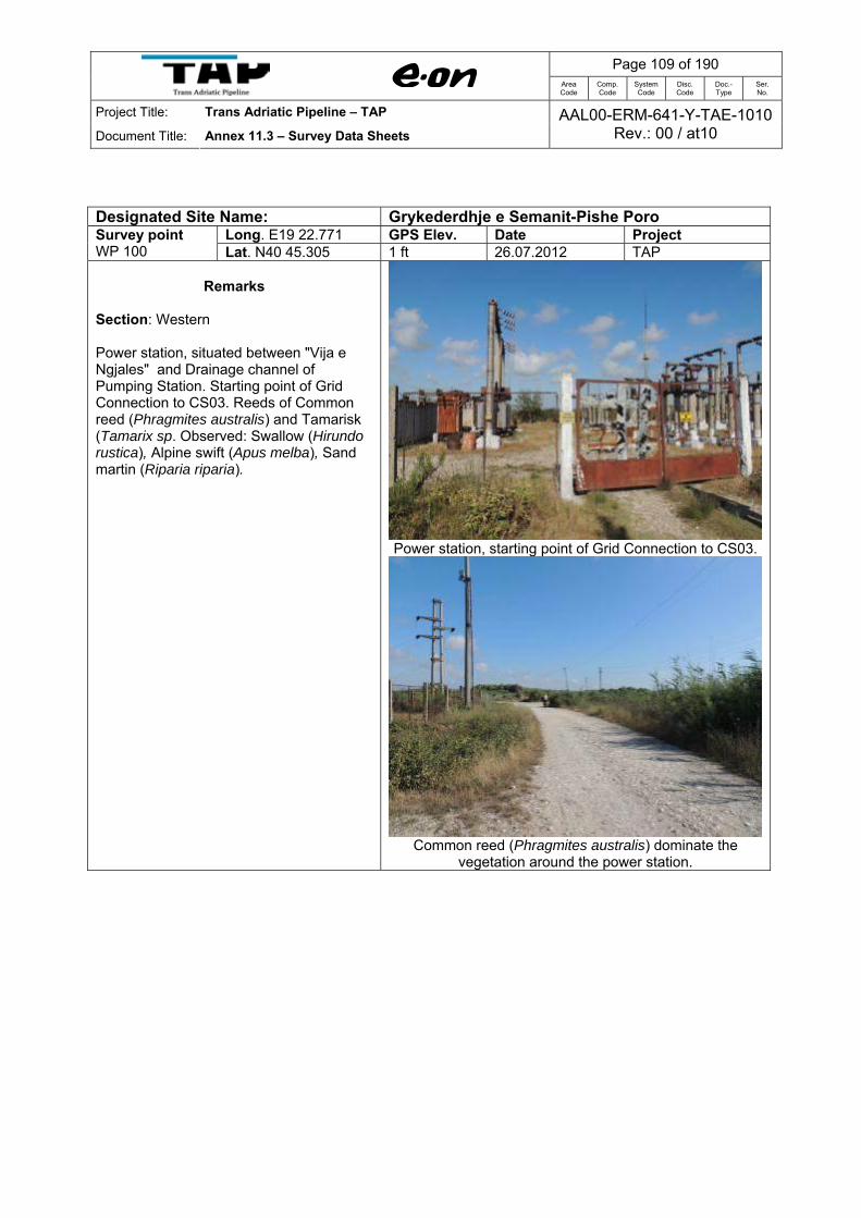
Page 109 of 190
Area Code
Comp. Code
System Code
Disc. Code
Doc.- Type
Ser. No.
Project Title: Trans Adriatic Pipeline – TAP
Document Title: Annex 11.3 – Survey Data Sheets AAL00-ERM-641-Y-TAE-1010
Rev.: 00 / at10
Designated Site Name: Grykederdhje e Semanit-Pishe Poro
Long. E19 22.771 GPS Elev. Date Project Survey point WP 100 Lat. N40 45.305 1 ft 26.07.2012 TAP
Remarks Section: Western Power station, situated between "Vija e Ngjales" and Drainage channel of Pumping Station. Starting point of Grid Connection to CS03. Reeds of Common reed (Phragmites australis) and Tamarisk (Tamarix sp. Observed: Swallow (Hirundo rustica), Alpine swift (Apus melba), Sand martin (Riparia riparia).
Power station, starting point of Grid Connection to CS03.
Common reed (Phragmites australis) dominate the
vegetation around the power station.
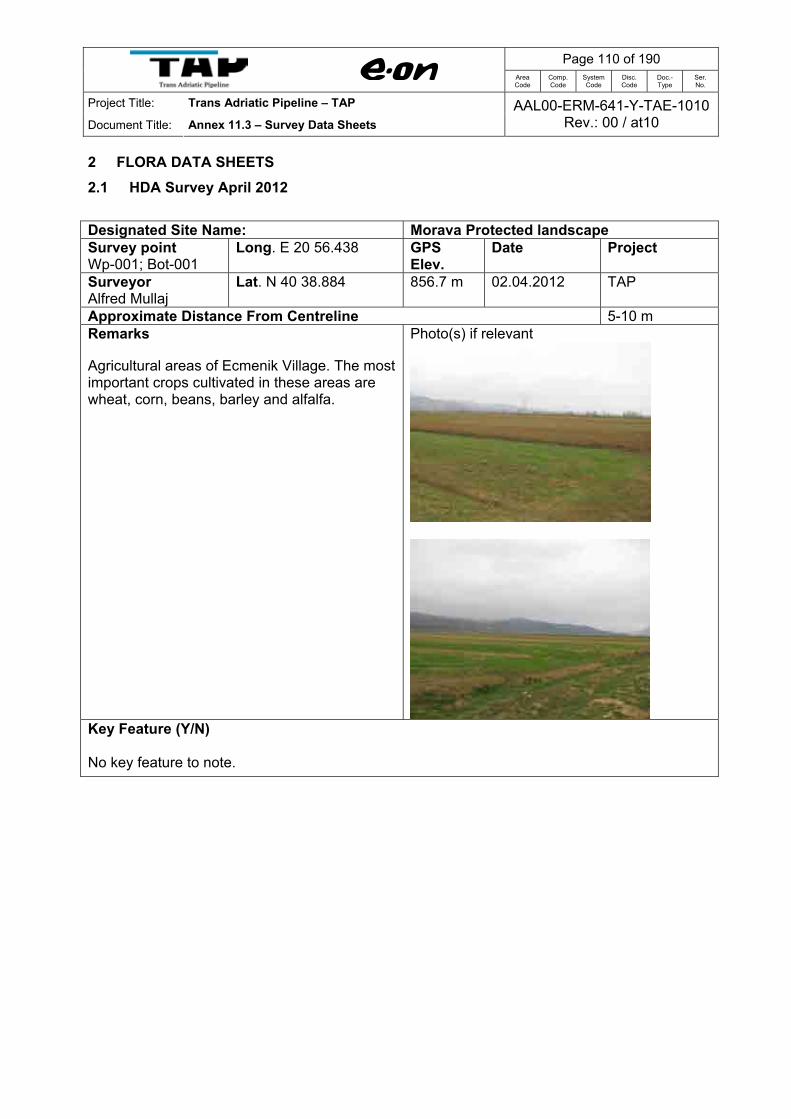
Page 110 of 190
Area Code
Comp. Code
System Code
Disc. Code
Doc.- Type
Ser. No.
Project Title: Trans Adriatic Pipeline – TAP
Document Title: Annex 11.3 – Survey Data Sheets AAL00-ERM-641-Y-TAE-1010
Rev.: 00 / at10
2 FLORA DATA SHEETS 2.1 HDA Survey April 2012 Designated Site Name: Morava Protected landscape Survey point Wp-001; Bot-001
Long. E 20 56.438 GPS Elev.
Date Project
Surveyor Alfred Mullaj
Lat. N 40 38.884 856.7 m 02.04.2012 TAP
Approximate Distance From Centreline 5-10 m Remarks Agricultural areas of Ecmenik Village. The most important crops cultivated in these areas are wheat, corn, beans, barley and alfalfa.
Photo(s) if relevant
Key Feature (Y/N) No key feature to note.

Page 111 of 190
Area Code
Comp. Code
System Code
Disc. Code
Doc.- Type
Ser. No.
Project Title: Trans Adriatic Pipeline – TAP
Document Title: Annex 11.3 – Survey Data Sheets AAL00-ERM-641-Y-TAE-1010
Rev.: 00 / at10
Designated Site Name: Morava Protected landscape Survey point Wp-002; Bot-002
Long. E 20 56.215 GPS Elev.
Date Project
Surveyor Alfred Mullaj
Lat. N 40 39.304 856.7 m 02.04.2012 TAP
Approximate Distance From Centreline 10 m Remarks Agricultural areas of Ecmenik Village. The most important crops cultivated in these areas are wheat, corn, beans, barley and alfalfa. Horticulture in the area is mostly represented by apple and plum trees.
Photo(s) if relevant
Freshwater marshes represented by a small area are important habitats within this wp; common species found around the freshwater marshes are Typha angustifolia, Phragmites australis, Juncus effusus, Eleocharis acicularis, Cyperus fuscus, Rorippa amphibia, Lythrum salicaria, Oenanthe aquatica, Myosotis scorpioides, Apium nodiflorum, Veronica anagallis-aquatica, Mentha aquatica, Nasturtium officinale accompanied by water loving shrubs such as Salix alba, Tamarix parviflora, etc., typical of the fresh water marshes.
Temporary Freshwater marshes
Key Feature (Y/N) No key feature to note.

Page 112 of 190
Area Code
Comp. Code
System Code
Disc. Code
Doc.- Type
Ser. No.
Project Title: Trans Adriatic Pipeline – TAP
Document Title: Annex 11.3 – Survey Data Sheets AAL00-ERM-641-Y-TAE-1010
Rev.: 00 / at10
Designated Site Name: Morava Protected landscape Survey point Wp-003; Bot-003
Long. E 20 56.112 GPS Elev.
Date Project
Surveyor Alfred Mullaj
Lat. N 40 39.399 860.4 m 02.04.2012 TAP
Approximate Distance From Centreline 15 m Remarks Agricultural areas of Pilur Village. The most important crops cultivated in these areas are wheat, corn, beans, barley and alfalfa. Intensive horticulture in the area is mostly represented by apple and plum trees.
Photo(s) if relevant
Drainage channel (crossing point) and a narrow belt of aquatic habitats, freshwater marshes and riparian forests support a high floral biodiversity. The riparian woodlands are largely dominated by Populus nigra, Salix alba, Populus canadensis. In some places there are very developed patches of hidro-higrophilic vegetation dominated by Phragmites australis, Typha latifolia and Iris psedacorus etc.
Some artesian wells are found in this area. Patches of the aquatic vegetation dominated by Chara sp. and by Lemna minor, a small and usually rootless floating plant occurs on the waters of these artesian wells.
Key Feature (Y/N) Freshwater marshes and riparian forests support a high floral biodiversity.

Page 113 of 190
Area Code
Comp. Code
System Code
Disc. Code
Doc.- Type
Ser. No.
Project Title: Trans Adriatic Pipeline – TAP
Document Title: Annex 11.3 – Survey Data Sheets AAL00-ERM-641-Y-TAE-1010
Rev.: 00 / at10
Designated Site Name: Morava Protected landscape Survey point Wp-004; Bot-004
Long. E 20 55.823 GPS Elev.
Date Project
Surveyor Alfred Mullaj
Lat. N 40 40.148 861.0 m 02.04.2012 TAP
Approximate Distance From Centreline 5 m Remarks Irrigation channel of the Piluri village (crossing point).
Photo(s) if relevant
In both sides there are intensive agricultural areas of the Piluri village mostly cultivated by apple and plum trees. The most important crops cultivated in these areas are alfalfa, wheat, corn, beans.
Key Feature (Y/N) No key feature to note.
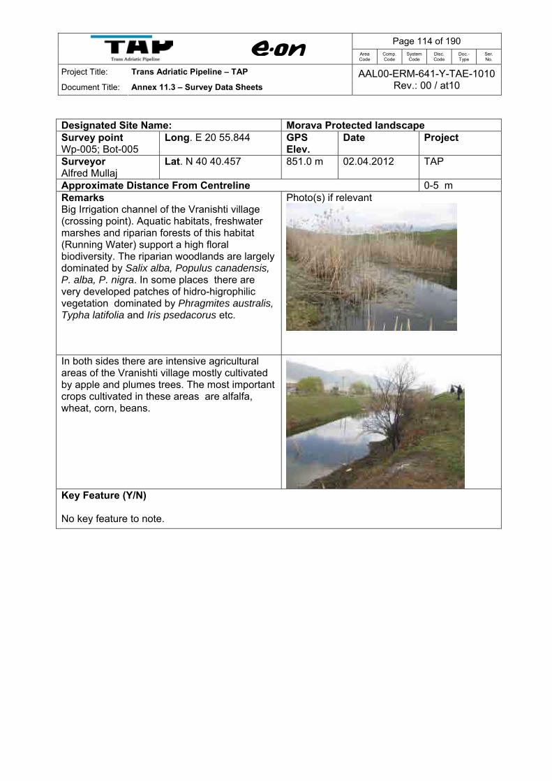
Page 114 of 190
Area Code
Comp. Code
System Code
Disc. Code
Doc.- Type
Ser. No.
Project Title: Trans Adriatic Pipeline – TAP
Document Title: Annex 11.3 – Survey Data Sheets AAL00-ERM-641-Y-TAE-1010
Rev.: 00 / at10
Designated Site Name: Morava Protected landscape Survey point Wp-005; Bot-005
Long. E 20 55.844 GPS Elev.
Date Project
Surveyor Alfred Mullaj
Lat. N 40 40.457 851.0 m 02.04.2012 TAP
Approximate Distance From Centreline 0-5 m Remarks Big Irrigation channel of the Vranishti village (crossing point). Aquatic habitats, freshwater marshes and riparian forests of this habitat (Running Water) support a high floral biodiversity. The riparian woodlands are largely dominated by Salix alba, Populus canadensis, P. alba, P. nigra. In some places there are very developed patches of hidro-higrophilic vegetation dominated by Phragmites australis, Typha latifolia and Iris psedacorus etc.
Photo(s) if relevant
In both sides there are intensive agricultural areas of the Vranishti village mostly cultivated by apple and plumes trees. The most important crops cultivated in these areas are alfalfa, wheat, corn, beans.
Key Feature (Y/N) No key feature to note.

Page 115 of 190
Area Code
Comp. Code
System Code
Disc. Code
Doc.- Type
Ser. No.
Project Title: Trans Adriatic Pipeline – TAP
Document Title: Annex 11.3 – Survey Data Sheets AAL00-ERM-641-Y-TAE-1010
Rev.: 00 / at10
Designated Site Name: Morava Protected landscape Survey point Wp-006; Bot-006
Long. E 20 55.868 GPS Elev.
Date Project
Surveyor Alfred Mullaj
Lat. N 40 40.592 852.2 m 02.04.2012 TAP
Approximate Distance From Centreline 0-5 m Remarks Agricultural areas of the Vranishti village.
Photo(s) if relevant
The most important crops cultivated in these areas are wheat, corn, beans, barley and alfalfa. Intensive horticulture in the area is mostly represented by apple and plumes trees.
Key Feature (Y/N) No key feature to note.
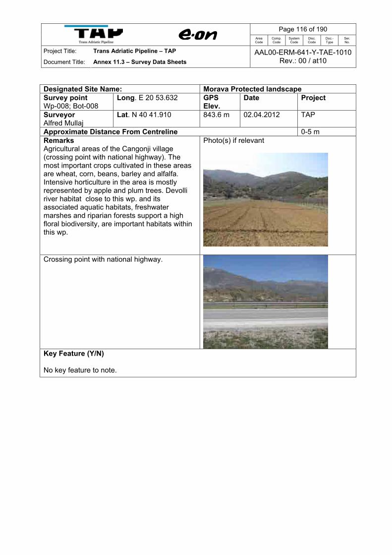
Page 116 of 190
Area Code
Comp. Code
System Code
Disc. Code
Doc.- Type
Ser. No.
Project Title: Trans Adriatic Pipeline – TAP
Document Title: Annex 11.3 – Survey Data Sheets AAL00-ERM-641-Y-TAE-1010
Rev.: 00 / at10
Designated Site Name: Morava Protected landscape Survey point Wp-008; Bot-008
Long. E 20 53.632 GPS Elev.
Date Project
Surveyor Alfred Mullaj
Lat. N 40 41.910 843.6 m 02.04.2012 TAP
Approximate Distance From Centreline 0-5 m Remarks Agricultural areas of the Cangonji village (crossing point with national highway). The most important crops cultivated in these areas are wheat, corn, beans, barley and alfalfa. Intensive horticulture in the area is mostly represented by apple and plum trees. Devolli river habitat close to this wp. and its associated aquatic habitats, freshwater marshes and riparian forests support a high floral biodiversity, are important habitats within this wp.
Photo(s) if relevant
Crossing point with national highway.
Key Feature (Y/N) No key feature to note.

Page 117 of 190
Area Code
Comp. Code
System Code
Disc. Code
Doc.- Type
Ser. No.
Project Title: Trans Adriatic Pipeline – TAP
Document Title: Annex 11.3 – Survey Data Sheets AAL00-ERM-641-Y-TAE-1010
Rev.: 00 / at10
Designated Site Name: Morava Protected landscape Survey point Wp-009; Bot-009
Long. E 20 53.420 GPS Elev.
Date Project
Surveyor Alfred Mullaj
Lat. N 40 41.873 886.6 m 02.04.2012 TAP
Approximate Distance From Centreline 15 m Remarks Galio Carpinetum Oak-Hornbeam Forests. This habitat type, generally dominated by Carpinus orientalis, extends in a large part of this wp. close to the Cangonji village. A strong human impact is associated with this habitat as a result of cutting, intensive grazing, and deforestation.
Photo(s) if relevant
The dominant species of this habitat type are shrubs, such as Carpinus orientalis, Corylus avellana, Castanea sativa, Pinus nigra, Ostrya carpinifolia, Quercus cerris, Quercus trojana, Juniperus oxycedrus, J. communis, Rubus ulmifolius, Crataegus monogyna, Rosa canina etc.
Key Feature (Y/N) No key feature to note.

Page 118 of 190
Area Code
Comp. Code
System Code
Disc. Code
Doc.- Type
Ser. No.
Project Title: Trans Adriatic Pipeline – TAP
Document Title: Annex 11.3 – Survey Data Sheets AAL00-ERM-641-Y-TAE-1010
Rev.: 00 / at10
Designated Site Name: Morava Protected landscape Survey point Wp-010; Bot-010
Long. E 20 53.319 GPS Elev.
Date Project
Surveyor Alfred Mullaj
Lat. N 40 41.912 890.0 m 02.04.2012 TAP
Approximate Distance From Centreline 0-5 m Remarks Lowland hay meadows. Some areas of former agriculture land in this wp, which were abandoned 15 - 20 years ago, now support a semi-natural grasslands dominated by Alopecurus pratensis, Sanguisorba officinalis, Arrhenatherum elatius, Trisetum flavescens, Pimpinella major, Centaurea jacea, Crepis biennis, Knautia arvensis, Tragopogon pratensis, Daucus carota, Leucanthemum vulgare.
Photo(s) if relevant
Rubus ulmifolius indicator of the intensive grazzing
Key Feature (Y/N) No key feature to note.
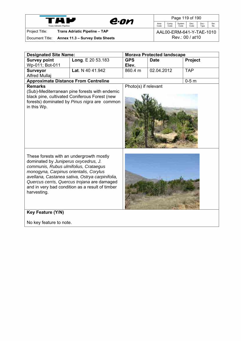
Page 119 of 190
Area Code
Comp. Code
System Code
Disc. Code
Doc.- Type
Ser. No.
Project Title: Trans Adriatic Pipeline – TAP
Document Title: Annex 11.3 – Survey Data Sheets AAL00-ERM-641-Y-TAE-1010
Rev.: 00 / at10
Designated Site Name: Morava Protected landscape Survey point Wp-011; Bot-011
Long. E 20 53.183 GPS Elev.
Date Project
Surveyor Alfred Mullaj
Lat. N 40 41.942 860.4 m 02.04.2012 TAP
Approximate Distance From Centreline 0-5 m Remarks (Sub)-Mediterranean pine forests with endemic black pine, cultivated Coniferous Forest (new forests) dominated by Pinus nigra are common in this Wp.
Photo(s) if relevant
These forests with an undergrowth mostly dominated by Juniperus oxycedrus, J. communis, Rubus ulmifolius, Crataegus monogyna, Carpinus orientalis, Corylus avellana, Castanea sativa, Ostrya carpinifolia, Quercus cerris, Quercus trojana are damaged and in very bad condition as a result of timber harvesting.
Key Feature (Y/N) No key feature to note.
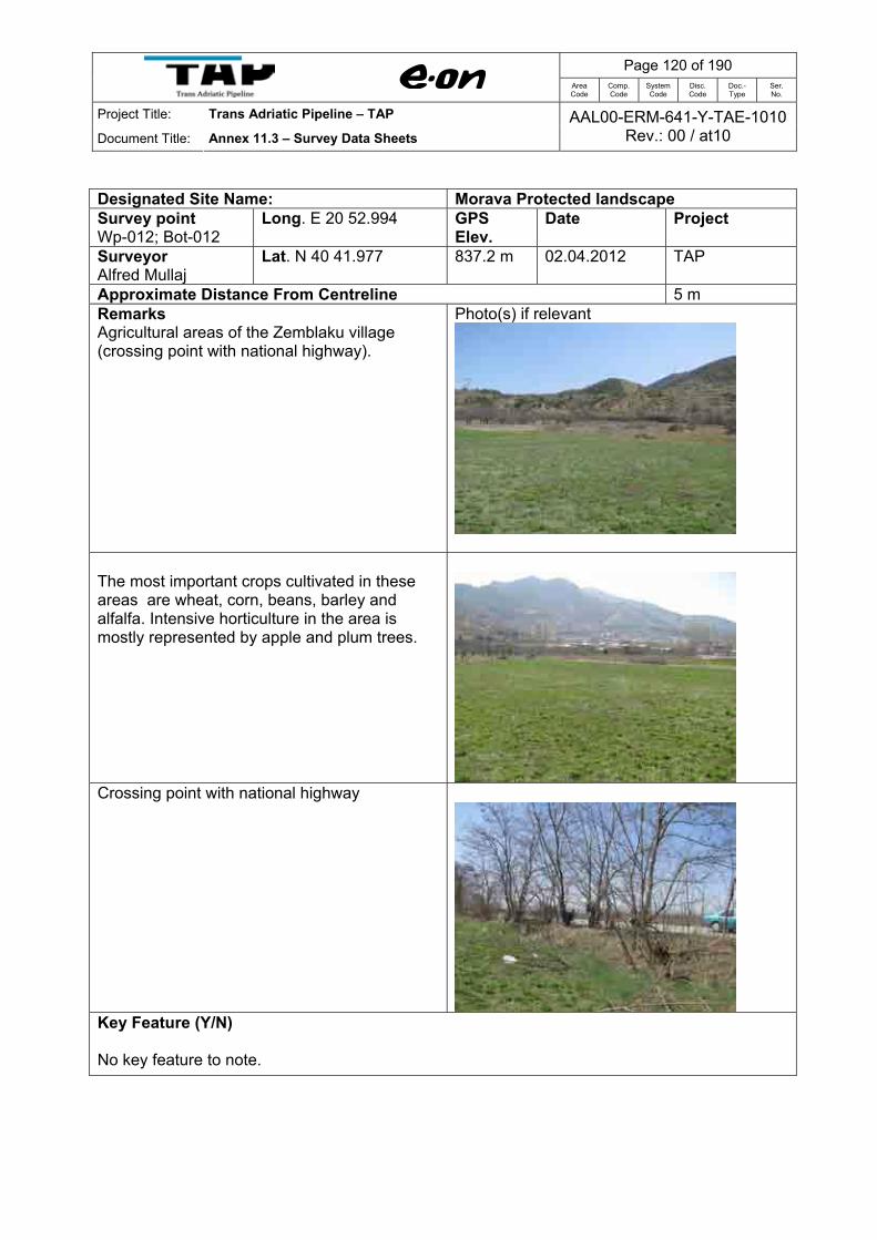
Page 120 of 190
Area Code
Comp. Code
System Code
Disc. Code
Doc.- Type
Ser. No.
Project Title: Trans Adriatic Pipeline – TAP
Document Title: Annex 11.3 – Survey Data Sheets AAL00-ERM-641-Y-TAE-1010
Rev.: 00 / at10
Designated Site Name: Morava Protected landscape Survey point Wp-012; Bot-012
Long. E 20 52.994 GPS Elev.
Date Project
Surveyor Alfred Mullaj
Lat. N 40 41.977 837.2 m 02.04.2012 TAP
Approximate Distance From Centreline 5 m Remarks Agricultural areas of the Zemblaku village (crossing point with national highway).
Photo(s) if relevant
The most important crops cultivated in these areas are wheat, corn, beans, barley and alfalfa. Intensive horticulture in the area is mostly represented by apple and plum trees.
Crossing point with national highway
Key Feature (Y/N) No key feature to note.

Page 121 of 190
Area Code
Comp. Code
System Code
Disc. Code
Doc.- Type
Ser. No.
Project Title: Trans Adriatic Pipeline – TAP
Document Title: Annex 11.3 – Survey Data Sheets AAL00-ERM-641-Y-TAE-1010
Rev.: 00 / at10
Designated Site Name: Morava Protected landscape Survey point Wp-013; Bot-013
Long. E 20 52.809 GPS Elev.
Date Project
Surveyor Alfred Mullaj
Lat. N 40 42.006 837.2 m 02.04.2012 TAP
Approximate Distance From Centreline 0-5 m Remarks Agricultural areas of the Zemblaku village. The most important crops cultivated in these areas are wheat, corn, beans, barley and alfalfa.
Photo(s) if relevant
Intensive horticulture in the area is mostly represented by apple and plum trees.
Key Feature (Y/N) No key feature to note.

Page 122 of 190
Area Code
Comp. Code
System Code
Disc. Code
Doc.- Type
Ser. No.
Project Title: Trans Adriatic Pipeline – TAP
Document Title: Annex 11.3 – Survey Data Sheets AAL00-ERM-641-Y-TAE-1010
Rev.: 00 / at10
Designated Site Name: Vithkuq – Ostrovicё Survey point WP 001; Bot-019
Long. E 20 33.526 GPS Elev.
Date Project
Surveyor Alfred Mullaj
Lat. N 40 31.149 1610 m 03.04.2012 TAP
Approximate Distance From Centreline 700 m
Remarks Luzulo-Fagetum beech forests (Fagus sylvatica). This formation is of seedling origin, newly formed by young trees of 5-10 cm diameter, 6-7 m height and less than 20 years old as a result of regular management of the woodlands for firewood and livestock fodder. These very open forests are dominated by Fagus sylvatica, but often feature occasional Pinus nigra and Abies alba.
Photo(s) if relevant
The shrub layer is dominated by Juniperus communis, Daphne oleoides, Fraxinus ornus, Coryllus avellana.
Juniperus communis
The ground flora of these forests are dominated by species typical of beech forests such as Asperula odoratum, Agrimonia eupatoria, Crocus chrysanthus.
Crocus chrysanthus
Key Feature (Y/N) Landscape of special beauty. Track from main road (Shtylla village) to Bot-019 is characterised by alterations of beech forest and grasslands. Grasslands and forests are one of the main resources of this area that are largely used by the local population in their daily living.

Page 123 of 190
Area Code
Comp. Code
System Code
Disc. Code
Doc.- Type
Ser. No.
Project Title: Trans Adriatic Pipeline – TAP
Document Title: Annex 11.3 – Survey Data Sheets AAL00-ERM-641-Y-TAE-1010
Rev.: 00 / at10
Designated Site Name: Vithkuq – Ostrovice Survey point WP 002 Bot-020
Long. E 20 33.593 GPS Elev.
Date Project
Surveyor Alfred Mullaj
Lat. N 40 30.923 1546 m 03.04.2012 TAP
Approximate Distance From Centreline 250 m
Remarks Mountain Hay Meadows of this wp are dominated by Bromus erectus, Chrysopogon gryllus, Avenula pratensis, Arrhenatherum elatius, Trisetum flavescens, and sporadically by bulb plants such as Crocus chrysanthus and Scilla bifolia etc.
Photo(s) if relevant
Mountain Hay Meadows covered by deep snow.
Crocus chrysanthus
Scilla bifolia
Key Feature (Y/N) Part of a landscape of special beauty and attraction. Pastures and forests are one of the main resources of this area that are largely used by the local population in their daily living.

Page 124 of 190
Area Code
Comp. Code
System Code
Disc. Code
Doc.- Type
Ser. No.
Project Title: Trans Adriatic Pipeline – TAP
Document Title: Annex 11.3 – Survey Data Sheets AAL00-ERM-641-Y-TAE-1010
Rev.: 00 / at10
Designated Site Name: Vithkuq – Ostrovice Survey point WP 003 Bot-021
Long. E 20 33.898 GPS Elev.
Date Project
Surveyor Alfred Mullaj
Lat. N 40 30.719 1624 m 03.04.2012 TAP
Approximate Distance From Centreline 0-5 m Remarks Centreline of pipeline. Luzulo-Fagetum beech forests habitat. This formation is of seedling origin; very open forests dominated by Fagus sylvatica, but often feature occasional Pinus nigra and Abies alba. The shrub layer is dominated by Juniperus communis, Daphne oleoides, Fraxinus ornus, Coryllus avellana. The ground flora of these forests is dominated by species typical of beech forests such as Asperula odoratum, Agrimonia eupatoria. The majority of the Fagus sylvatica forest in this wp is dominated by trees less than 6 m in height and less than 20 years old as a result of regular management of the woodlands for firewood and livestock fodder.
Photo(s) if relevant
Key Feature (Y/N) Same as previous Bot-019. Grasslands and forests are one of the main resources of this area that are largely used by the local population in their daily living.

Page 125 of 190
Area Code
Comp. Code
System Code
Disc. Code
Doc.- Type
Ser. No.
Project Title: Trans Adriatic Pipeline – TAP
Document Title: Annex 11.3 – Survey Data Sheets AAL00-ERM-641-Y-TAE-1010
Rev.: 00 / at10
Designated Site Name: Vithkuq – Ostrovice Survey point WP 004 Bot-022
Long. E 20 34.013 GPS Elev.
Date Project
Surveyor Alfred Mullaj
Lat. N 40 30.623 1720 m 03.04.2012 TAP
Approximate Distance From Centreline 0-5 m Remarks Centreline of the pipeline route. Luzulo-Fagetum beech forests habitat. This formation is of seedling origin; very open forests dominated by Fagus sylvatica, but often feature occasional Pinus nigra and Abies alba. The majority of the Fagus sylvatica forest in this wp is dominated by trees less than 6 m in height and less than 20 years old as a result of regular management of the woodlands for firewood and livestock fodder.
Photo(s) if relevant
Fagus sylvatica formation of seedling origin
The shrub layer is dominated by Juniperus communis, Daphne oleoides, Fraxinus ornus, Coryllus avellana. The ground flora of these forests is dominated by species typical of beech forests such as Asperula odoratum, Agrimonia eupatoria.
Daphne oleoides
Key Feature (Y/N) Same as previous Bot-019. Grasslands and forests are one of the main resources of this area that are largely used by the local population in their daily living.

Page 126 of 190
Area Code
Comp. Code
System Code
Disc. Code
Doc.- Type
Ser. No.
Project Title: Trans Adriatic Pipeline – TAP
Document Title: Annex 11.3 – Survey Data Sheets AAL00-ERM-641-Y-TAE-1010
Rev.: 00 / at10
Designated Site Name: Vithkuq – Ostrovice Survey point WP 005 Bot-023
Long. E 20 34.832 GPS Elev.
Date Project
Surveyor Alfred Mullaj
Lat. N 40 30.588 1575 m 03.04.2012 TAP
Approximate Distance From Centreline 5 m Remarks Juniperus communis formations on heaths or calcareous grasslands. Large areas of sparsely vegetated shrubby evergreen formations dominated by Juniperus communis, Juniperus communis subsp. nana, Pyrus amygdaliformis, Daphne oleoides, Festuca sp., Quercus cerris, Fraxinus ornus and Sideritis raeseri are distributed in this wp. This habitat represents the advanced stages of degradation of mixed oak forests.
Photo(s) if relevant
Juniperus communis formations on heaths or calcareous grasslands.
Draba aizoides
Key Feature (Y/N) These shrubby formations, subject to heavy grazing pressures, are much degraded and consequently support reduced biodiversity compared to mixed oak forests. The degradation is caused by human activity (grazing and cuttings) and the low nutrients of the underlying bedrock.

Page 127 of 190
Area Code
Comp. Code
System Code
Disc. Code
Doc.- Type
Ser. No.
Project Title: Trans Adriatic Pipeline – TAP
Document Title: Annex 11.3 – Survey Data Sheets AAL00-ERM-641-Y-TAE-1010
Rev.: 00 / at10
Designated Site Name: Vithkuq – Ostrovice Survey point WP 006 Bot-024
Long. E 20 35.527 GPS Elev.
Date Project
Surveyor Alfred Mullaj
Lat. N 40 30.347 1472 m 03.04.2012 TAP
Approximate Distance From Centreline 70 m Remarks Highly valuable Mature Old Growing mixed forest are present in this wp, including Luzulo-Fagetum beech forests dominated by Fagus sylvatica; (Sub)- Mediterranean Pine forests with endemic black pine (Pinus nigra); Pannonian-Balkanic Turkey Oak sesssile oak forests dominated by Quercus petraea, with understory of Juniperus communis.
Very high trees of Quercus petraea
Photo(s) if relevant
Mature mixed forest of Pinus nigra, and Quercus petraea.
The shrub layer is dominated by Juniperus communis and seedling of Quercus petraea
Key Feature (Y/N) Very sensitive habitat, well preserved, situated some 70 m north of Centreline of the pipeline route. It is situated outside the Corine site (Vithkuq-Ostrovice), but it should be protected. Maximum care will in this area will be required during the construction phase.
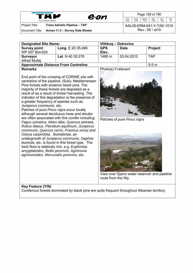
Page 128 of 190
Area Code
Comp. Code
System Code
Disc. Code
Doc.- Type
Ser. No.
Project Title: Trans Adriatic Pipeline – TAP
Document Title: Annex 11.3 – Survey Data Sheets AAL00-ERM-641-Y-TAE-1010
Rev.: 00 / at10
Designated Site Name: Vithkuq – Ostrovice Survey point WP 007 Bot-025
Long. E 20 35.496 GPS Elev.
Date Project
Surveyor Alfred Mullaj
Lat. N 40 30.276 1466 m 03.04.2012 TAP
Approximate Distance From Centreline 0-5 m Remarks End point of the crossing of CORINE site with centreline of the pipeline. (Sub)- Mediterranean Pine forests with endemic black pine. The majority of these forests are degraded as a result of as a result of timber harvesting. The indicator of this degradation is the presence of a greater frequency of species such as Juniperus communis, etc. Patches of pure Pinus nigra occur locally although several deciduous trees and shrubs are often associated with this conifer including: Fagus sylvatica, Abies alba, Quercus petraea, Rubus idaeus, Pteridium aquilinum, Juniperus communis, Quercus cerris, Fraxinus ornus and Ostrya carpinifolia. Sometimes, an undergrowth of Juniperus communis, Daphne laureola, etc. is found in this forest type. The herb flora is relatively rich, e.g. Euphorbia amygdaloides, Bellis perennis, Agrimonia agrimonoides, Mercurialis perennis, etc.
Photo(s) if relevant
Patches of pure Pinus nigra
View over Gjanci water reservoir and pipeline route from the Wp.
Key Feature (Y/N) Coniferous forests dominated by black pine are quite frequent throughout Albanian territory.

Page 129 of 190
Area Code
Comp. Code
System Code
Disc. Code
Doc.- Type
Ser. No.
Project Title: Trans Adriatic Pipeline – TAP
Document Title: Annex 11.3 – Survey Data Sheets AAL00-ERM-641-Y-TAE-1010
Rev.: 00 / at10
Designated Site Name: Vithkuq – Ostrovice Survey point WP 001 Bot-031
Long. E 20 14.641 GPS Elev.
Date Project
Surveyor Alfred Mullaj
Lat. Nv40 28.882 1783 m 05.04.2012 TAP
Approximate Distance From Centreline 300 m Remarks Calcareous rocky slopes with chasmophytic vegetation and Mountain hay meadows located uphill of Backa village. Mountain hay meadows are developed in the forest limits of Fagus sylvatica, and in some gaps as replacements for those forest areas lost due to cutting, grazing and burning. They are dominated by different cold resistant grasses, as Calamagrostis varia, Potentilla erecta, Luzula luzulina.
Photo(s) if relevant
Mountain hay meadows
The Calcareous rocky slopes with chasmophytic vegetation consist of small patches of sparse plant cover on rocky outcrops and stony places of this wp. The vegetation cover is very low. The erosion process is very active and the bed rock is to a great extent exposed. Characteristic chasmophytic vascular plants include Juniperus communis subsp. nana, Asplenium trichomanes, Asplenium viride.
Calcareous rocky slopes with chasmophytic vegetation
Key Feature (Y/N) Landscape of scenic views and attraction.

Page 130 of 190
Area Code
Comp. Code
System Code
Disc. Code
Doc.- Type
Ser. No.
Project Title: Trans Adriatic Pipeline – TAP
Document Title: Annex 11.3 – Survey Data Sheets AAL00-ERM-641-Y-TAE-1010
Rev.: 00 / at10
Designated Site Name: Vithkuq – Ostrovice Survey point WP 002 Bot-032
Long. E 20 24.119 GPS Elev.
Date Project
Surveyor Alfred Mullaj
Lat. N 40 31.451 1748 m 05.04.2012 TAP
Approximate Distance From Centreline 5 m Remarks There are some stands of pure young forest (coppice) dominated by Fagus sylvatica, located here nearby a sheep hut. These stands developed in the upper forest zone, are dominated by trees less than 6 m in height and less than 20 years old as a result of regular management of the woodlands for firewood and livestock fodder. The shrub layer is dominated by Juniperus communis subsp.nana, and the ground flora by species typical of beech forests such as Brachypodium sylvaticum, etc.
Photo(s) if relevant
Pure young forest (coppice) dominated by Fagus sylvatica and Calcareous rocky slopes with chasmophytic vegetation.
Key Feature (Y/N) No key feature to note.

Page 131 of 190
Area Code
Comp. Code
System Code
Disc. Code
Doc.- Type
Ser. No.
Project Title: Trans Adriatic Pipeline – TAP
Document Title: Annex 11.3 – Survey Data Sheets AAL00-ERM-641-Y-TAE-1010
Rev.: 00 / at10
Designated Site Name: Vithkuq – Ostrovice Survey point WP 003 Bot-033
Long. E 20 24.482 GPS Elev.
Date Project
Surveyor Alfred Mullaj
Lat. N 40 31.425 1657 m 05.04.2012 TAP
Approximate Distance From Centreline 50 m Remarks Mountain hay meadows are developed here in the forest belt of Fagus sylvatica, as replacements for those forests lost due to cutting, grazing and burning. They are dominated by different cold resistant grasses, as Calamagrostis varia, Potentilla erecta, Luzula luzulina, Veronica bellidioides, Plantago lanceolata, Bromus erectus, and dwarf-shrubs of Juniperus communis ssp. nana or Daphne oleoides.
Photo(s) if relevant
Key Feature (Y/N) These grasslands formations, subject to heavy grazing pressures, are much degraded and consequently support reduced biodiversity.

Page 132 of 190
Area Code
Comp. Code
System Code
Disc. Code
Doc.- Type
Ser. No.
Project Title: Trans Adriatic Pipeline – TAP
Document Title: Annex 11.3 – Survey Data Sheets AAL00-ERM-641-Y-TAE-1010
Rev.: 00 / at10
Designated Site Name: Vithkuq – Ostrovice Survey point WP 004 Bot-034
Long. E 20 24.391 GPS Elev.
Date Project
Surveyor Alfred Mullaj
Lat. N 40 31.261 1611 m 05.04.2012 TAP
Approximate Distance From Centreline 5 m Remarks Mountain hay meadows, intensively grazed, in this wp are developed in the forest belt of Fagus sylvatica, as replacements for those forests lost due to cutting, grazing and burning. They are dominated by different cold resistant grasses, as Calamagrostis varia, Potentilla erecta, Luzula luzulina, and dwarf-shrubs of Juniperus communis ssp. nana or Daphne oleoides. Grassland.
Photo(s) if relevant
Low vegetation and coppiced woodland
Juniperus communis indicator of intensive grazing.
Key Feature (Y/N) These grassland formations, subject to heavy grazing pressures, are much degraded and consequently support reduced biodiversity.

Page 133 of 190
Area Code
Comp. Code
System Code
Disc. Code
Doc.- Type
Ser. No.
Project Title: Trans Adriatic Pipeline – TAP
Document Title: Annex 11.3 – Survey Data Sheets AAL00-ERM-641-Y-TAE-1010
Rev.: 00 / at10
Designated Site Name: Grykederdhje e Semanit-Pishe Poro Survey point WP 001 Bot-055
Long. E 19 23.900 GPS Elev.
Date Project
Surveyor Alfred Mullaj
Lat. N 40 46.790 2 m 07.04.2012 TAP
Approximate Distance From Centreline 1.2 km Remarks Bridge over the drainage channel along the access road surrounded by different types of habitats: Salicornia and others annuals colonising mud and sand dominated by glasswort (Salicornia europaea), pioneer marsh communities; Mediterranean salt meadows (Juncetalia maritimi) dominated by Juncus maritimus or J. acutus ; Mediterranean and Thermo-Atlantic halophilous scrubs mainly composed of scrub such as Sarcocornia fruticosa, Sarcocornia perennis. The other species recorded in high frequency in these habitats are Limonium vulgare, Puccinellia festuciformis, Tamarix dalmaticum, etc. The banks of drainage channel with brackish waters are covered by water fringe vegetation mostly dominated by thickets of common reed (Phragmites australis), Scirpus maritimus, Schoenus nigricans, Tamarix dalmatica, Juncus acutus, Carex distans, Saccharum ravennae.
Photo(s) if relevant
Bridge over the drainage channel and access road towards the pipeline route
Mediterranean salt meadows (Juncetalia maritimi) dominated by Juncus maritimus or J. acutus
Key Feature (Y/N) Salicornia and others annuals colonising mud and sand dominated by glasswort (Salicornia europaea), pioneer marsh communities; Mediterranean salt meadows (Juncetalia maritimi) dominated by Juncus maritimus or J. acutus; Mediterranean and Thermo-Atlantic halophilous scrubs mainly composed of scrub such as Sarcocornia fruticosa, Sarcocornia perennis are habitats of community interest.

Page 134 of 190
Area Code
Comp. Code
System Code
Disc. Code
Doc.- Type
Ser. No.
Project Title: Trans Adriatic Pipeline – TAP
Document Title: Annex 11.3 – Survey Data Sheets AAL00-ERM-641-Y-TAE-1010
Rev.: 00 / at10
Designated Site Name: Grykederdhje e Semanit-Pishe Poro Survey point WP 002 Bot-056
Long. E 19 23.465 GPS Elev.
Date Project
Surveyor Alfred Mullaj
Lat. N 40 47.406 2 m 07.04.2012 TAP
Approximate Distance From Centreline 240 m Remarks End point of the access road to pipeline surrounded by different types of habitats: Salicornia and others annuals colonising mud and sand dominated by glasswort (Salicornia europaea), pioneer marsh communities; Mediterranean salt meadows (Juncetalia maritimi) dominated by Juncus maritimus or J. acutus ; Mediterranean and Thermo-Atlantic halophilous scrubs mainly composed of scrub such as Sarcocornia fruticosa, Sarcocornia perennis. The other species recorded in high frequency in these habitats are Limonium vulgare, Puccinellia festuciformis, Tamarix dalmaticum, etc.
Photo(s) if relevant
Salicornia and others annuals colonising mud and sand dominated by glasswort (Salicornia europaea), pioneer marsh communities
Inula crithmoides
Mediterranean salt meadows (Juncetalia maritimi) dominated by Juncus acutus
Key Feature (Y/N) Salicornia and others annuals colonising mud and sand, Mediterranean salt meadows (Juncetalia maritimi), Mediterranean and Thermo-Atlantic halophilous scrubs are habitats of community interest.

Page 135 of 190
Area Code
Comp. Code
System Code
Disc. Code
Doc.- Type
Ser. No.
Project Title: Trans Adriatic Pipeline – TAP
Document Title: Annex 11.3 – Survey Data Sheets AAL00-ERM-641-Y-TAE-1010
Rev.: 00 / at10
Designated Site Name: Grykederdhje e Semanit-Pishe Poro Survey point WP 003 Bot-057
Long. E 19 23.539 GPS Elev.
Date Project
Surveyor Alfred Mullaj
Lat. N 40 47.522 -0 m 07.04.2012 TAP
Approximate Distance From Centreline 0-5 m Remarks Centreline of the pipeline route surrounded by different types of habitats: Salicornia and others annuals colonising mud and sand dominated by glasswort (Salicornia europaea), pioneer marsh communities; Mediterranean salt meadows (Juncetalia maritimi) dominated by Juncus maritimus or J. acutus ; Mediterranean and Thermo-Atlantic halophilous scrubs mainly composed of scrub such as Sarcocornia fruticosa, Sarcocornia perennis. The other species frequently recorded in these habitats are Limonium vulgare, Puccinellia festuciformis, Tamarix dalmaticum, etc.
Photo(s) if relevant
Mediterranean and Thermo-Atlantic halophilous scrubs mainly composed of scrub such as Sarcocornia fruticosa
Mediterranean salt meadows (Juncetalia maritimi) dominated by Juncus acutus
Key Feature (Y/N) Salicornia and others annuals colonising mud and sand, Mediterranean salt meadows (Juncetalia maritimi), Mediterranean and Thermo-Atlantic halophilous scrubs are habitats of community interest.

Page 136 of 190
Area Code
Comp. Code
System Code
Disc. Code
Doc.- Type
Ser. No.
Project Title: Trans Adriatic Pipeline – TAP
Document Title: Annex 11.3 – Survey Data Sheets AAL00-ERM-641-Y-TAE-1010
Rev.: 00 / at10
Designated Site Name: Grykederdhje e Semanit-Pishe Poro Survey point WP 004 Bot-058
Long. E 19 24.065 GPS Elev.
Date Project
Surveyor Alfred Mullaj
Lat. N 40 47.449 1 m 07.04.2012 TAP
Approximate Distance From Centreline 0-5 m Remarks This Wp represents former agriculture land that has been abandoned for many years (sandy salted soils) and has become invaded mostly by alien invasive species like Dittrichia viscosa. Other species observed are: Lagurus ovatus, Trifolium nigriscens, Scirpus holoschoenus, Bellis perennis, Rubus ulmifolius, Schoenus nigricans, Teucrium polium, Alkanna tinctoria and Arundo donax (along the irrigation channel).
Photo(s) if relevant
Abandoned agriculture land invaded by alien plant species Dittrichia viscosa
Arundo donax along the irrigation channel
Verbascum sinuatum
Key Feature (Y/N) No key feature to note.

Page 137 of 190
Area Code
Comp. Code
System Code
Disc. Code
Doc.- Type
Ser. No.
Project Title: Trans Adriatic Pipeline – TAP
Document Title: Annex 11.3 – Survey Data Sheets AAL00-ERM-641-Y-TAE-1010
Rev.: 00 / at10
Designated Site Name: Grykederdhje e Semanit-Pishe Poro Survey point WP 005 Bot-059
Long. E 19 24.255 GPS Elev.
Date Project
Surveyor Alfred Mullaj
Lat. N 40 47.420 2 m 07.04.2012 TAP
Approximate Distance From Centreline 0-5 m Remarks Wooded dunes with Pinus halepensis, cultivated c. 40 - 50 ago, with a dense cover, shrub and herbaceous layer developed. This habitat type represents a priority habitat (2270*). East of the gravel access road and Eastern border of the Corine biotope site "Grykederdhja e Semanit-Pishe Poro". Main shrub species of this habitat type are: Pistacia lentiscus, Myrtus communis, Phyllirea angustifolia, Periploca graeca, Erica multiflora, Juniperus oxycedrus ssp. macrocarpa, Crataegus monogyna, Cornus mas, Rubus ulmifolius, etc, as well as lianas Periploca graeca, Smilax aspera, Hedera helix etc. The herbaceous vegetation, mainly xerophile, is rare and the most typical representatives are Lagurus ovata, Alkanna tinctoria, Sporobolus pungens, Vulpia fasciculata, etc.
Photo(s) if relevant
Access road in direction N-S
Wooded dunes with Pinus halepensis,, crossed by the Centreline of the TAP
Romulea bulbocodium
Key Feature (Y/N) Wooded dunes with Pinus halepensis represents a priority habitat (2270*).
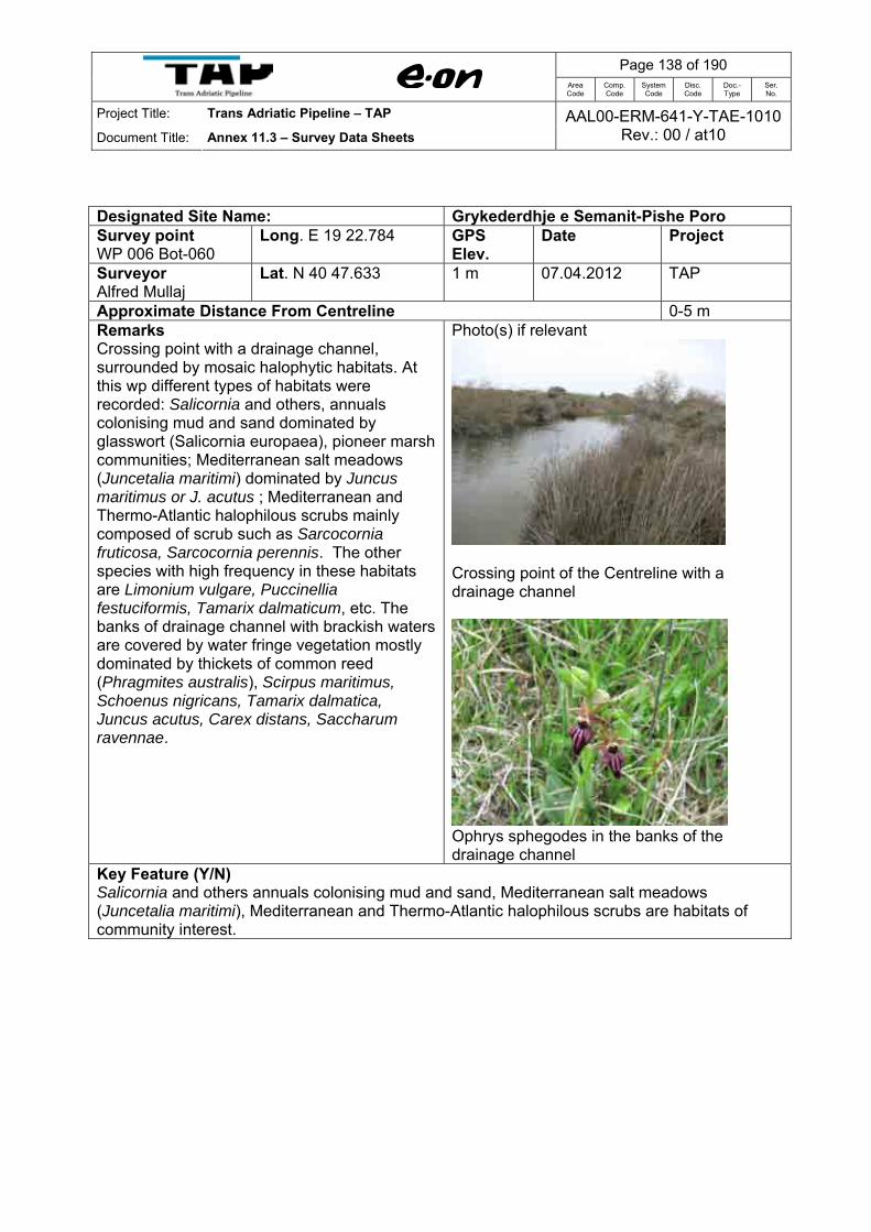
Page 138 of 190
Area Code
Comp. Code
System Code
Disc. Code
Doc.- Type
Ser. No.
Project Title: Trans Adriatic Pipeline – TAP
Document Title: Annex 11.3 – Survey Data Sheets AAL00-ERM-641-Y-TAE-1010
Rev.: 00 / at10
Designated Site Name: Grykederdhje e Semanit-Pishe Poro Survey point WP 006 Bot-060
Long. E 19 22.784 GPS Elev.
Date Project
Surveyor Alfred Mullaj
Lat. N 40 47.633 1 m 07.04.2012 TAP
Approximate Distance From Centreline 0-5 m Remarks Crossing point with a drainage channel, surrounded by mosaic halophytic habitats. At this wp different types of habitats were recorded: Salicornia and others, annuals colonising mud and sand dominated by glasswort (Salicornia europaea), pioneer marsh communities; Mediterranean salt meadows (Juncetalia maritimi) dominated by Juncus maritimus or J. acutus ; Mediterranean and Thermo-Atlantic halophilous scrubs mainly composed of scrub such as Sarcocornia fruticosa, Sarcocornia perennis. The other species with high frequency in these habitats are Limonium vulgare, Puccinellia festuciformis, Tamarix dalmaticum, etc. The banks of drainage channel with brackish waters are covered by water fringe vegetation mostly dominated by thickets of common reed (Phragmites australis), Scirpus maritimus, Schoenus nigricans, Tamarix dalmatica, Juncus acutus, Carex distans, Saccharum ravennae.
Photo(s) if relevant
Crossing point of the Centreline with a drainage channel
Ophrys sphegodes in the banks of the drainage channel
Key Feature (Y/N) Salicornia and others annuals colonising mud and sand, Mediterranean salt meadows (Juncetalia maritimi), Mediterranean and Thermo-Atlantic halophilous scrubs are habitats of community interest.

Page 139 of 190
Area Code
Comp. Code
System Code
Disc. Code
Doc.- Type
Ser. No.
Project Title: Trans Adriatic Pipeline – TAP
Document Title: Annex 11.3 – Survey Data Sheets AAL00-ERM-641-Y-TAE-1010
Rev.: 00 / at10
Designated Site Name: Grykederdhje e Semanit-Pishe Poro Survey point WP 007 Bot-061
Long. E 19 22.601 GPS Elev.
Date Project
Surveyor Alfred Mullaj
Lat. N 40 47.662 2 m 07.04.2012 TAP
Approximate Distance From Centreline 0-5 m Remarks Embryonic shifting dunes (Cakiletea maritimae & Ammophiletea, low dunes up to 1 m high) at the landfall of the pipeline. The sandy dunes of this wp comprise a narrow belt along the Adriatic Sea, with a variable width that ranges from 30 to 50 meters and which reach a maximum height of c. 1 meter. The sandy belt closer to the seaside is completely vegetation free. Pioneer species Cakile maritima, Xanthium strumarium subsp. italicum, Salsola kali, which look very isolated at the beginning, become denser further from the coast. Gradually going away from coast line as the height of dunes increase, the physiognomy of vegetation changes and species such as Elymus farctus, Euphorbia paralias, Cyperus capitatus Sporobolus pungens, belonging to a more evolved stage of vegetation cover appear.
Photo(s) if relevant
Embryonic shifting dunes
Eryngium maritimum
Echinophora spinosa
Key Feature (Y/N) Embryonic shifting sand dunes represent are habitats of community interest.
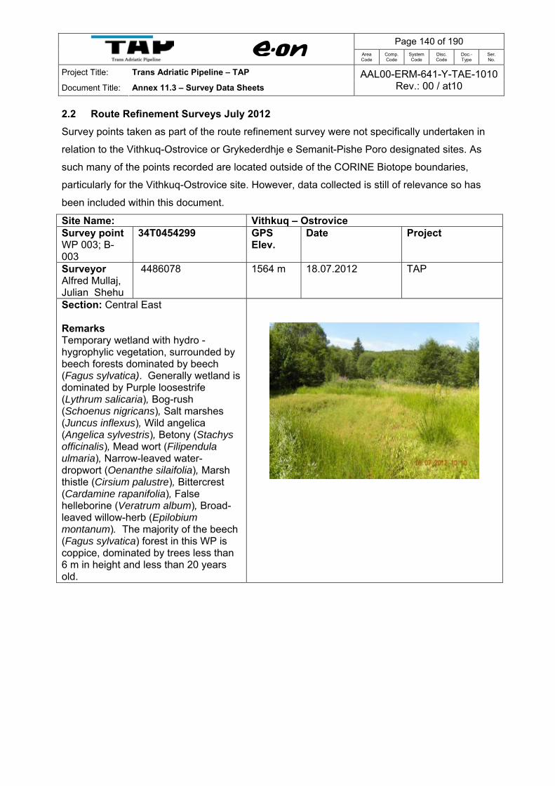
Page 140 of 190
Area Code
Comp. Code
System Code
Disc. Code
Doc.- Type
Ser. No.
Project Title: Trans Adriatic Pipeline – TAP
Document Title: Annex 11.3 – Survey Data Sheets AAL00-ERM-641-Y-TAE-1010
Rev.: 00 / at10
2.2 Route Refinement Surveys July 2012 Survey points taken as part of the route refinement survey were not specifically undertaken in
relation to the Vithkuq-Ostrovice or Grykederdhje e Semanit-Pishe Poro designated sites. As
such many of the points recorded are located outside of the CORINE Biotope boundaries,
particularly for the Vithkuq-Ostrovice site. However, data collected is still of relevance so has
been included within this document.
Site Name: Vithkuq – Ostrovice Survey point WP 003; B-003
34T0454299 GPS Elev.
Date Project
Surveyor Alfred Mullaj, Julian Shehu
4486078 1564 m 18.07.2012 TAP
Section: Central East Remarks Temporary wetland with hydro - hygrophylic vegetation, surrounded by beech forests dominated by beech (Fagus sylvatica). Generally wetland is dominated by Purple loosestrife (Lythrum salicaria), Bog-rush (Schoenus nigricans), Salt marshes (Juncus inflexus), Wild angelica (Angelica sylvestris), Betony (Stachys officinalis), Mead wort (Filipendula ulmaria), Narrow-leaved water-dropwort (Oenanthe silaifolia), Marsh thistle (Cirsium palustre), Bittercrest (Cardamine rapanifolia), False helleborine (Veratrum album), Broad-leaved willow-herb (Epilobium montanum). The majority of the beech (Fagus sylvatica) forest in this WP is coppice, dominated by trees less than 6 m in height and less than 20 years old.
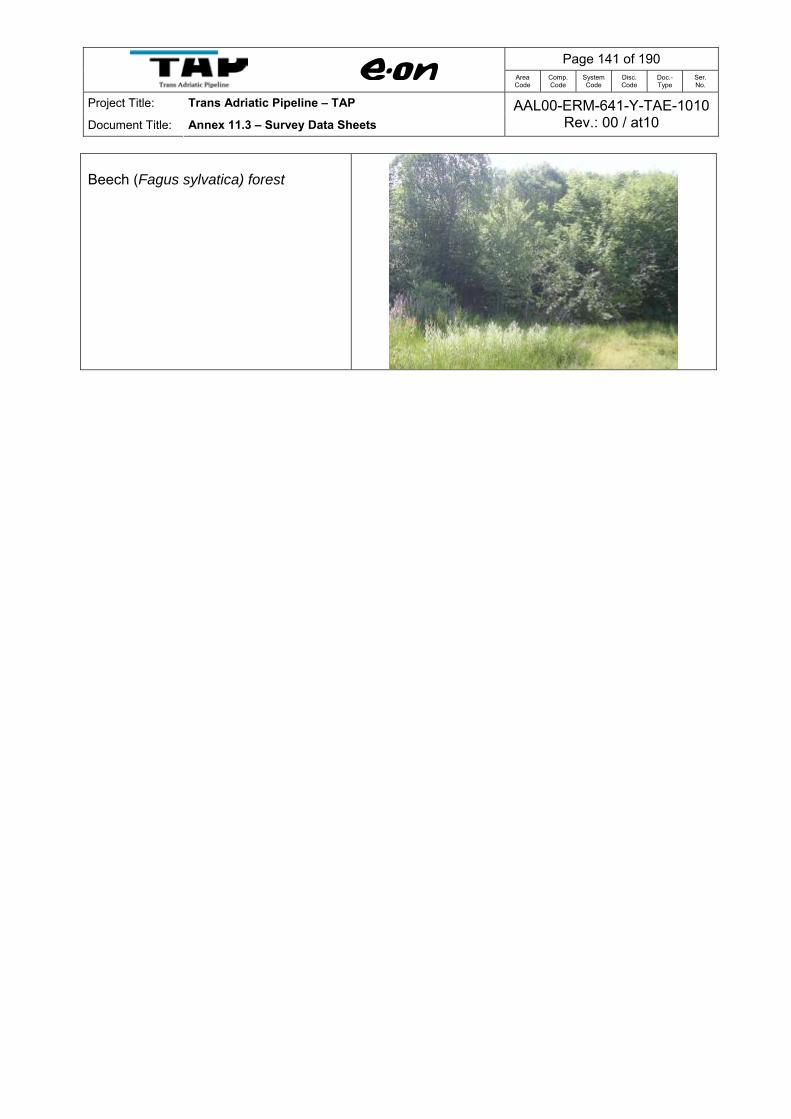
Page 141 of 190
Area Code
Comp. Code
System Code
Disc. Code
Doc.- Type
Ser. No.
Project Title: Trans Adriatic Pipeline – TAP
Document Title: Annex 11.3 – Survey Data Sheets AAL00-ERM-641-Y-TAE-1010
Rev.: 00 / at10
Beech (Fagus sylvatica) forest

Page 142 of 190
Area Code
Comp. Code
System Code
Disc. Code
Doc.- Type
Ser. No.
Project Title: Trans Adriatic Pipeline – TAP
Document Title: Annex 11.3 – Survey Data Sheets AAL00-ERM-641-Y-TAE-1010
Rev.: 00 / at10
Site Name: Vithkuq – Ostrovice Survey point WP 004; B-004
34T0452646 GPS Elev.
Date Project
Surveyor Alfred Mullaj, Julian Shehu
4485979 1795 m 18.07.2012 TAP
Section: Central East Remarks Mountain hay meadows of the Ostrovica mountain. They have as main component different cold resistant grasses, as Bushgrass (Calamagrostis varia), Koeleria grass flower head (Koeleria splendens), Hairy melick (Melica ciliata), Bulbous meadow grass (Poa bulbosa), Hair-like feather-grass (Stipa joannis), and Juniper (Juniperus nana).
Upper line of forest vegetation (represented by beech forest) followed by summer pastures or Mountain hay meadows.
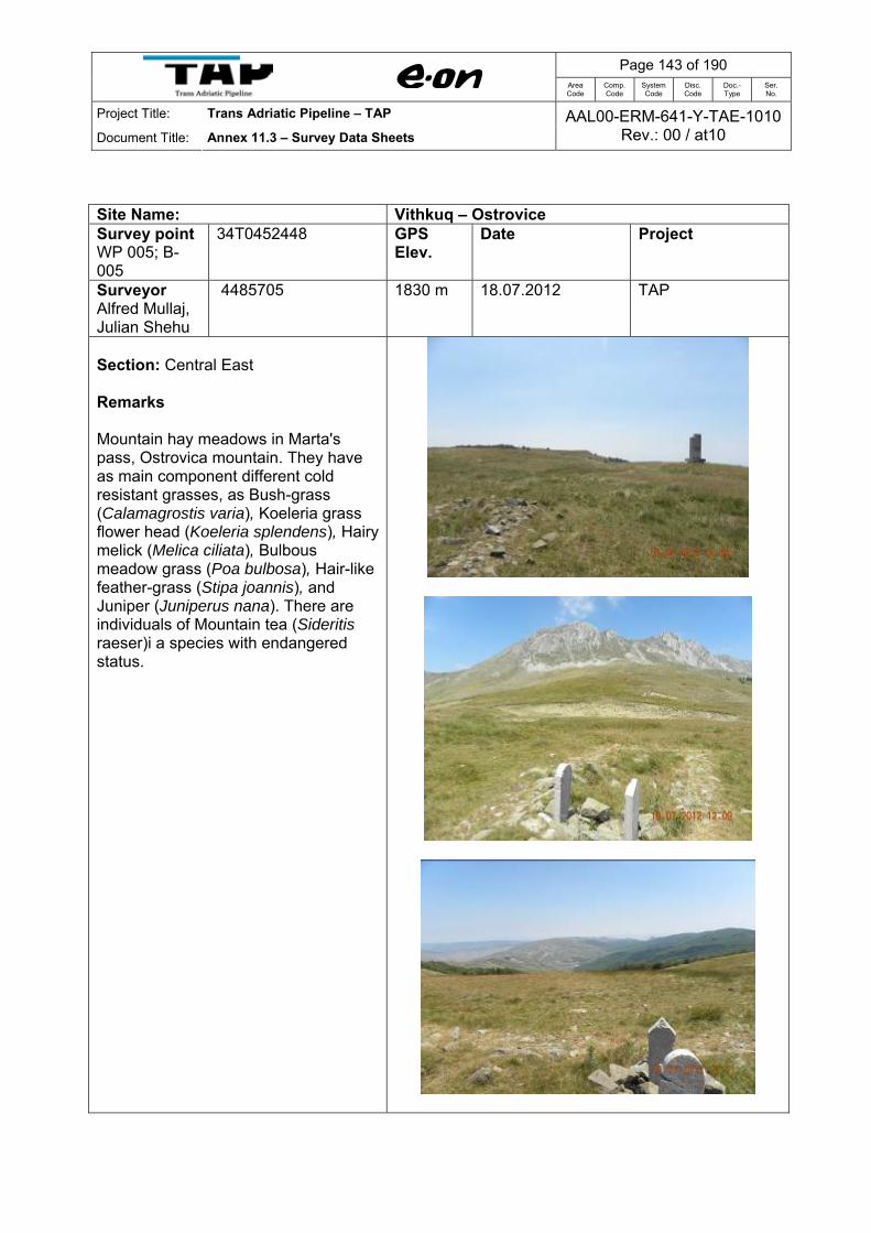
Page 143 of 190
Area Code
Comp. Code
System Code
Disc. Code
Doc.- Type
Ser. No.
Project Title: Trans Adriatic Pipeline – TAP
Document Title: Annex 11.3 – Survey Data Sheets AAL00-ERM-641-Y-TAE-1010
Rev.: 00 / at10
Site Name: Vithkuq – Ostrovice Survey point WP 005; B-005
34T0452448 GPS Elev.
Date Project
Surveyor Alfred Mullaj, Julian Shehu
4485705 1830 m 18.07.2012 TAP
Section: Central East Remarks Mountain hay meadows in Marta's pass, Ostrovica mountain. They have as main component different cold resistant grasses, as Bush-grass (Calamagrostis varia), Koeleria grass flower head (Koeleria splendens), Hairy melick (Melica ciliata), Bulbous meadow grass (Poa bulbosa), Hair-like feather-grass (Stipa joannis), and Juniper (Juniperus nana). There are individuals of Mountain tea (Sideritis raeser)i a species with endangered status.

Page 144 of 190
Area Code
Comp. Code
System Code
Disc. Code
Doc.- Type
Ser. No.
Project Title: Trans Adriatic Pipeline – TAP
Document Title: Annex 11.3 – Survey Data Sheets AAL00-ERM-641-Y-TAE-1010
Rev.: 00 / at10
Site Name: Vithkuq – Ostrovice Survey point WP 006; B-006
34T0451788 GPS Elev.
Date Project
Surveyor Alfred Mullaj, Julian Shehu
4486823 2003 m 18.07.2012 TAP
Section: Central East Remarks Mountain hay meadows in Entrance of tunnel, Ostrovica mountain. They have as main component different cold resistant grasses, as Bush-grass (Calamagrostis varia), Koeleria grass flower head (Koeleria splendens), Hairy melick (Melica ciliata), Bulbous meadow grass (Poa bulbosa), Hair-like feather-grass (Stipa joannis), and Juniper (Juniperus nana).
Calcareous rocky slopes with chasmophytic vegetation
There are individuals of Mountain tea (Sideritis raeseri) species with endangered status.
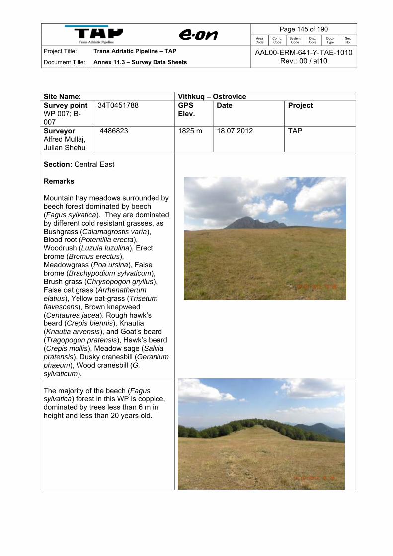
Page 145 of 190
Area Code
Comp. Code
System Code
Disc. Code
Doc.- Type
Ser. No.
Project Title: Trans Adriatic Pipeline – TAP
Document Title: Annex 11.3 – Survey Data Sheets AAL00-ERM-641-Y-TAE-1010
Rev.: 00 / at10
Site Name: Vithkuq – Ostrovice Survey point WP 007; B-007
34T0451788 GPS Elev.
Date Project
Surveyor Alfred Mullaj, Julian Shehu
4486823 1825 m 18.07.2012 TAP
Section: Central East Remarks Mountain hay meadows surrounded by beech forest dominated by beech (Fagus sylvatica). They are dominated by different cold resistant grasses, as Bushgrass (Calamagrostis varia), Blood root (Potentilla erecta), Woodrush (Luzula luzulina), Erect brome (Bromus erectus), Meadowgrass (Poa ursina), False brome (Brachypodium sylvaticum), Brush grass (Chrysopogon gryllus), False oat grass (Arrhenatherum elatius), Yellow oat-grass (Trisetum flavescens), Brown knapweed (Centaurea jacea), Rough hawk’s beard (Crepis biennis), Knautia (Knautia arvensis), and Goat’s beard (Tragopogon pratensis), Hawk’s beard (Crepis mollis), Meadow sage (Salvia pratensis), Dusky cranesbill (Geranium phaeum), Wood cranesbill (G. sylvaticum).
The majority of the beech (Fagus sylvatica) forest in this WP is coppice, dominated by trees less than 6 m in height and less than 20 years old.
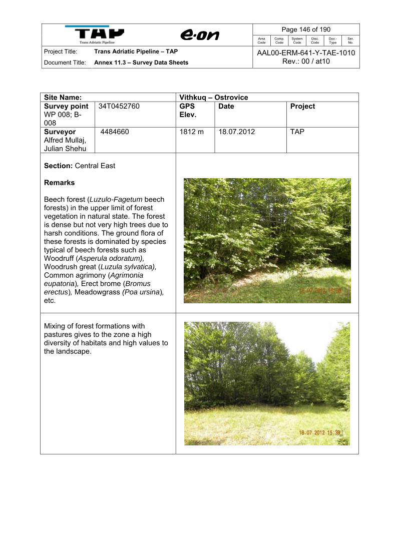
Page 146 of 190
Area Code
Comp. Code
System Code
Disc. Code
Doc.- Type
Ser. No.
Project Title: Trans Adriatic Pipeline – TAP
Document Title: Annex 11.3 – Survey Data Sheets AAL00-ERM-641-Y-TAE-1010
Rev.: 00 / at10
Site Name: Vithkuq – Ostrovice Survey point WP 008; B-008
34T0452760 GPS Elev.
Date Project
Surveyor Alfred Mullaj, Julian Shehu
4484660 1812 m 18.07.2012 TAP
Section: Central East Remarks Beech forest (Luzulo-Fagetum beech forests) in the upper limit of forest vegetation in natural state. The forest is dense but not very high trees due to harsh conditions. The ground flora of these forests is dominated by species typical of beech forests such as Woodruff (Asperula odoratum), Woodrush great (Luzula sylvatica), Common agrimony (Agrimonia eupatoria), Erect brome (Bromus erectus), Meadowgrass (Poa ursina), etc.
Mixing of forest formations with pastures gives to the zone a high diversity of habitats and high values to the landscape.

Page 147 of 190
Area Code
Comp. Code
System Code
Disc. Code
Doc.- Type
Ser. No.
Project Title: Trans Adriatic Pipeline – TAP
Document Title: Annex 11.3 – Survey Data Sheets AAL00-ERM-641-Y-TAE-1010
Rev.: 00 / at10
Site Name: Vithkuq – Ostrovice Survey point WP 009; B-009
34T0452804 GPS Elev.
Date Project
Surveyor Alfred Mullaj, Julian Shehu
4484507 1815 m 18.07.2012 TAP
Section: Central East Remarks Old beech forest dominated by beech (Fagus sylvatica) in the upper limit of forest vegetation. The forest is dense with trees higher and with high biodiversity values. The shrub layer is dominated by Common juniper (Juniperus communis), Hornbeam (Carpinus betulus), Hazel (Coryllus avellana). Most herbaceous plants populating these forests are typical species of beech forests such as: Woodruff (Asperula odoratum), Common agrimony (Agrimonia eupatoria), Rock cranesbill (Geranium macrorrhizum), Maidenhair spleenwort (Asplenium trichomanes), Achillea (Achillea frasii), Large-flowered calamint (Calamintha grandiflora), Meadowgrass (Poa ursina), False brome (Brachypodium sylvaticum).

Page 148 of 190
Area Code
Comp. Code
System Code
Disc. Code
Doc.- Type
Ser. No.
Project Title: Trans Adriatic Pipeline – TAP
Document Title: Annex 11.3 – Survey Data Sheets AAL00-ERM-641-Y-TAE-1010
Rev.: 00 / at10
Site Name: Vithkuq – Ostrovice Survey point WP 0010; B-010
34T0452801 GPS Elev.
Date Project
Surveyor Alfred Mullaj, Julian Shehu
4484316 1786 m 18.07.2012 TAP
Section: Central East Remarks Mixing of forest formations dominated by beech (Fagus sylvatica) with pastures or mountain hay meadows gives to the zone a high diversity of habitats and high values to the landscape. Mountain hay meadows of forest zone often have as main component dwarf shrub Common juniper (Juniperus communis subsp. Nana) and different cold resistant grasses, as Reed-grass (Calamagrostis varia), Koeleria grass flower head (Koeleria splendens), Hairy melick (Melica ciliata),Bulbous meadowgrass (Poa bulbosa), Hair-like feather-grass (Stipa joannis), Blood root (Potentilla erecta).
The majority of the beech (Fagus sylvatica) forest in this WP is coppice, dominated by trees less than 6 m in height and less than 20 years old.
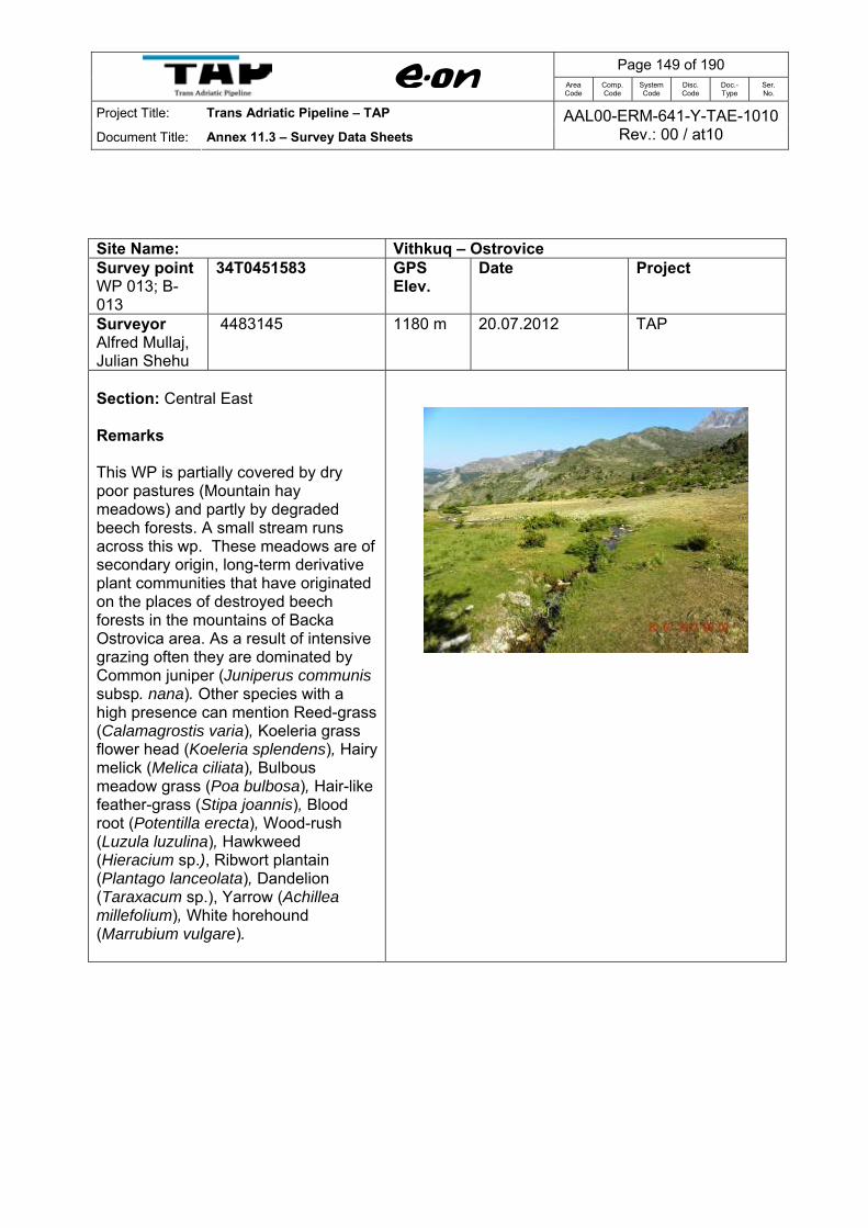
Page 149 of 190
Area Code
Comp. Code
System Code
Disc. Code
Doc.- Type
Ser. No.
Project Title: Trans Adriatic Pipeline – TAP
Document Title: Annex 11.3 – Survey Data Sheets AAL00-ERM-641-Y-TAE-1010
Rev.: 00 / at10
Site Name: Vithkuq – Ostrovice Survey point WP 013; B-013
34T0451583 GPS Elev.
Date Project
Surveyor Alfred Mullaj, Julian Shehu
4483145 1180 m 20.07.2012 TAP
Section: Central East Remarks This WP is partially covered by dry poor pastures (Mountain hay meadows) and partly by degraded beech forests. A small stream runs across this wp. These meadows are of secondary origin, long-term derivative plant communities that have originated on the places of destroyed beech forests in the mountains of Backa Ostrovica area. As a result of intensive grazing often they are dominated by Common juniper (Juniperus communis subsp. nana). Other species with a high presence can mention Reed-grass (Calamagrostis varia), Koeleria grass flower head (Koeleria splendens), Hairy melick (Melica ciliata), Bulbous meadow grass (Poa bulbosa), Hair-like feather-grass (Stipa joannis), Blood root (Potentilla erecta), Wood-rush (Luzula luzulina), Hawkweed (Hieracium sp.), Ribwort plantain (Plantago lanceolata), Dandelion (Taraxacum sp.), Yarrow (Achillea millefolium), White horehound (Marrubium vulgare).
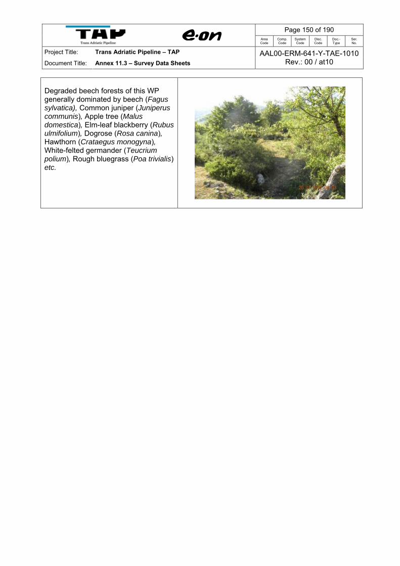
Page 150 of 190
Area Code
Comp. Code
System Code
Disc. Code
Doc.- Type
Ser. No.
Project Title: Trans Adriatic Pipeline – TAP
Document Title: Annex 11.3 – Survey Data Sheets AAL00-ERM-641-Y-TAE-1010
Rev.: 00 / at10
Degraded beech forests of this WP generally dominated by beech (Fagus sylvatica), Common juniper (Juniperus communis), Apple tree (Malus domestica), Elm-leaf blackberry (Rubus ulmifolium), Dogrose (Rosa canina), Hawthorn (Crataegus monogyna), White-felted germander (Teucrium polium), Rough bluegrass (Poa trivialis) etc.

Page 151 of 190
Area Code
Comp. Code
System Code
Disc. Code
Doc.- Type
Ser. No.
Project Title: Trans Adriatic Pipeline – TAP
Document Title: Annex 11.3 – Survey Data Sheets AAL00-ERM-641-Y-TAE-1010
Rev.: 00 / at10
Site Name: Vithkuq – Ostrovice Survey point WP 014; B-014
34T0452588 GPS Elev.
Date Project
Surveyor Alfred Mullaj, Julian Shehu
4483932 1706 m 20.07.2012 TAP
Section: Central East Remarks Area characterized by a very high degree of erosion, and a sparse cover of vegetation, dominated by Common juniper (Juniperus communis), Thistle (Cirsium arvense), False brome (Bromus erectus), Brush grass (Chrysopogon gryllus), Avenula pratensis, False oat grass (Arrhenatherum elatius), Yellow oat grass (Trisetum flavescens).
This point is also characterized by the presence of young beech forests or coppice dominated by Fagus sylvatica (100 m far away of the pipeline corridor). The shrub layer is dominated by Common juniper (Juniperus communis), Flowering ash (Fraxinus ornus), Hornbeam (Carpinus betulus), Hazel (Coryllus avellana). Most herbaceous plants populating these forests are typical species of beech forests such as: Wood-ruff (Asperula odoratum), Common agrimony (Agrimonia eupatoria), Rock cranesbill (Geranium macrorrhizum), Maidenhair spleenwort (Asplenium trichomanes), Achillea (Achillea frasii), Large-flowered calamint (Calamintha grandiflora), Meadowgrass (Poa ursina), False brome (Brachypodium sylvaticum).
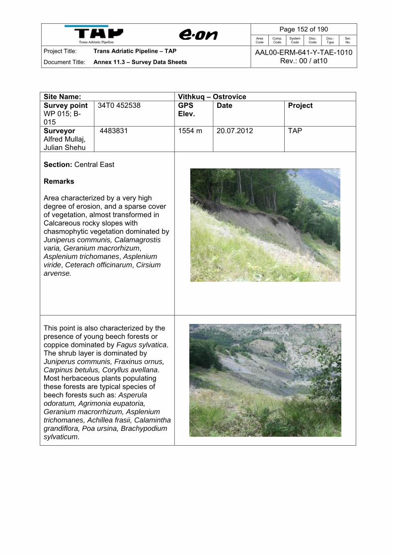
Page 152 of 190
Area Code
Comp. Code
System Code
Disc. Code
Doc.- Type
Ser. No.
Project Title: Trans Adriatic Pipeline – TAP
Document Title: Annex 11.3 – Survey Data Sheets AAL00-ERM-641-Y-TAE-1010
Rev.: 00 / at10
Site Name: Vithkuq – Ostrovice Survey point WP 015; B-015
34T0 452538 GPS Elev.
Date Project
Surveyor Alfred Mullaj, Julian Shehu
4483831 1554 m 20.07.2012 TAP
Section: Central East Remarks Area characterized by a very high degree of erosion, and a sparse cover of vegetation, almost transformed in Calcareous rocky slopes with chasmophytic vegetation dominated by Juniperus communis, Calamagrostis varia, Geranium macrorhizum, Asplenium trichomanes, Asplenium viride, Ceterach officinarum, Cirsium arvense.
This point is also characterized by the presence of young beech forests or coppice dominated by Fagus sylvatica. The shrub layer is dominated by Juniperus communis, Fraxinus ornus, Carpinus betulus, Coryllus avellana. Most herbaceous plants populating these forests are typical species of beech forests such as: Asperula odoratum, Agrimonia eupatoria, Geranium macrorrhizum, Asplenium trichomanes, Achillea frasii, Calamintha grandiflora, Poa ursina, Brachypodium sylvaticum.

Page 153 of 190
Area Code
Comp. Code
System Code
Disc. Code
Doc.- Type
Ser. No.
Project Title: Trans Adriatic Pipeline – TAP
Document Title: Annex 11.3 – Survey Data Sheets AAL00-ERM-641-Y-TAE-1010
Rev.: 00 / at10
Calcareous rocky slopes with chasmophytic vegetation

Page 154 of 190
Area Code
Comp. Code
System Code
Disc. Code
Doc.- Type
Ser. No.
Project Title: Trans Adriatic Pipeline – TAP
Document Title: Annex 11.3 – Survey Data Sheets AAL00-ERM-641-Y-TAE-1010
Rev.: 00 / at10
Site Name: Vithkuq – Ostrovice Survey point WP 016; B-016
34T0452870 GPS Elev.
Date Project
Surveyor Alfred Mullaj, Julian Shehu
4482962 1650 m 20.07.2012 TAP
Section: Central East Remarks Luzulo-Fagetum beech forests are developed in this WP, with main component element the beech (Fagus sylvatica). These forests are of pure forest dominated by beech (Fagus sylvatica). The majority of the forest in this WP are dominated by trees less than 6 m in height and less than 20 years old as a result of regular management of the woodlands for firewood and livestock fodder.
Mountain hay meadows are wide-spread all over this WP. They have as main component different cold resistant grasses, as Reed-grass (Calamagrostis varia), Koeleria grass flower head (Koeleria splendens), Hairy melick (Melica ciliata), Bulbous meadow grass (Poa bulbosa), Hair-like feather-grass (Stipa joannis), Blood root (Potentilla erecta), Wood-rush (Luzula luzulina), Hawkweed (Hieracium sp.), Ribwort plantain (Plantago lanceolata), Dandelion (Taraxacum sp.), Yarrow (Achillea millefolium), White horehound (Marrubium vulgare).
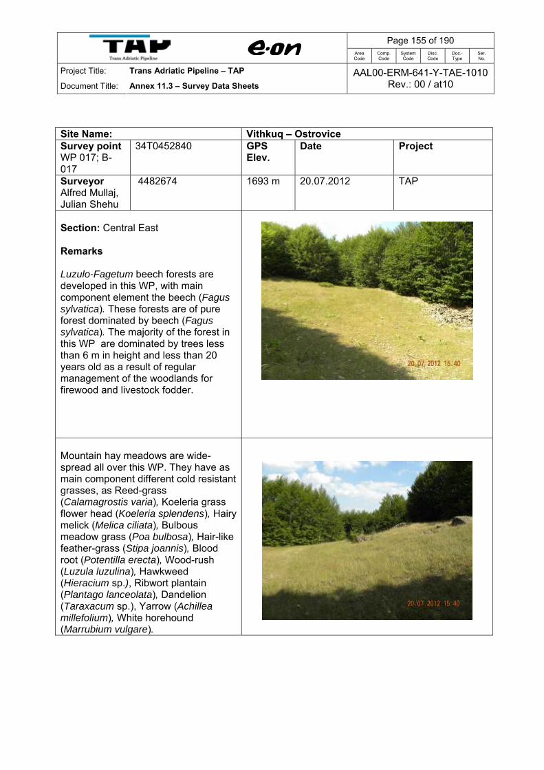
Page 155 of 190
Area Code
Comp. Code
System Code
Disc. Code
Doc.- Type
Ser. No.
Project Title: Trans Adriatic Pipeline – TAP
Document Title: Annex 11.3 – Survey Data Sheets AAL00-ERM-641-Y-TAE-1010
Rev.: 00 / at10
Site Name: Vithkuq – Ostrovice Survey point WP 017; B-017
34T0452840 GPS Elev.
Date Project
Surveyor Alfred Mullaj, Julian Shehu
4482674 1693 m 20.07.2012 TAP
Section: Central East Remarks Luzulo-Fagetum beech forests are developed in this WP, with main component element the beech (Fagus sylvatica). These forests are of pure forest dominated by beech (Fagus sylvatica). The majority of the forest in this WP are dominated by trees less than 6 m in height and less than 20 years old as a result of regular management of the woodlands for firewood and livestock fodder.
Mountain hay meadows are wide-spread all over this WP. They have as main component different cold resistant grasses, as Reed-grass (Calamagrostis varia), Koeleria grass flower head (Koeleria splendens), Hairy melick (Melica ciliata), Bulbous meadow grass (Poa bulbosa), Hair-like feather-grass (Stipa joannis), Blood root (Potentilla erecta), Wood-rush (Luzula luzulina), Hawkweed (Hieracium sp.), Ribwort plantain (Plantago lanceolata), Dandelion (Taraxacum sp.), Yarrow (Achillea millefolium), White horehound (Marrubium vulgare).

Page 156 of 190
Area Code
Comp. Code
System Code
Disc. Code
Doc.- Type
Ser. No.
Project Title: Trans Adriatic Pipeline – TAP
Document Title: Annex 11.3 – Survey Data Sheets AAL00-ERM-641-Y-TAE-1010
Rev.: 00 / at10
Site Name: Vithkuq – Ostrovice Survey point WP 018; B-018
34T0452301 GPS Elev.
Date Project
Surveyor Alfred Mullaj, Julian Shehu
4482248 1777 m 20.07.2012 TAP
Section: Central East Remarks Luzulo-Fagetum beech forests are developed in this WP, with main component element the beech (Fagus sylvatica). These forests are of pure forest dominated by beech (Fagus sylvatica). The majority of the forest in this WP are dominated by trees less than 6 m in height and less than 20 years old as a result of regular management of the woodlands for firewood and livestock fodder.
Mountain hay meadows are wide-spread all over this WP. They have as main component different cold resistant grasses, as Reed-grass (Calamagrostis varia), Koeleria grass flower head (Koeleria splendens), Hairy melick (Melica ciliata), Bulbous meadow grass (Poa bulbosa), Hair-like feather-grass (Stipa joannis), Blood root (Potentilla erecta), Wood-rush (Luzula luzulina), Hawkweed (Hieracium sp.), Ribwort plantain (Plantago lanceolata), Dandelion (Taraxacum sp.), Yarrow (Achillea millefolium), White horehound (Marrubium vulgare).
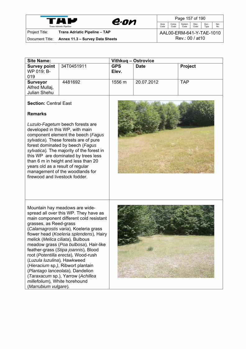
Page 157 of 190
Area Code
Comp. Code
System Code
Disc. Code
Doc.- Type
Ser. No.
Project Title: Trans Adriatic Pipeline – TAP
Document Title: Annex 11.3 – Survey Data Sheets AAL00-ERM-641-Y-TAE-1010
Rev.: 00 / at10
Site Name: Vithkuq – Ostrovice Survey point WP 019; B-019
34T0451911 GPS Elev.
Date Project
Surveyor Alfred Mullaj, Julian Shehu
4481692 1556 m 20.07.2012 TAP
Section: Central East Remarks Luzulo-Fagetum beech forests are developed in this WP, with main component element the beech (Fagus sylvatica). These forests are of pure forest dominated by beech (Fagus sylvatica). The majority of the forest in this WP are dominated by trees less than 6 m in height and less than 20 years old as a result of regular management of the woodlands for firewood and livestock fodder.
Mountain hay meadows are wide-spread all over this WP. They have as main component different cold resistant grasses, as Reed-grass (Calamagrostis varia), Koeleria grass flower head (Koeleria splendens), Hairy melick (Melica ciliata), Bulbous meadow grass (Poa bulbosa), Hair-like feather-grass (Stipa joannis), Blood root (Potentilla erecta), Wood-rush (Luzula luzulina), Hawkweed (Hieracium sp.), Ribwort plantain (Plantago lanceolata), Dandelion (Taraxacum sp.), Yarrow (Achillea millefolium), White horehound (Marrubium vulgare).

Page 158 of 190
Area Code
Comp. Code
System Code
Disc. Code
Doc.- Type
Ser. No.
Project Title: Trans Adriatic Pipeline – TAP
Document Title: Annex 11.3 – Survey Data Sheets AAL00-ERM-641-Y-TAE-1010
Rev.: 00 / at10
Site Name: Vithkuq – Ostrovice Survey point WP 020; B-020
34T0 451911 GPS Elev.
Date Project
Surveyor Alfred Mullaj, Julian Shehu
4481692 1556 m 20.07.2012 TAP
Section: Central East Remarks Mountain hay meadows are wide-spread in the Marta's pass . They have as main component different cold resistant grasses, as Reed-grass (Calamagrostis varia), Koeleria grass flower head (Koeleria splendens), Hairy melick (Melica ciliata), Bulbous meadow grass (Poa bulbosa), Hair-like feather-grass (Stipa joannis), Blood root (Potentilla erecta), Wood-rush (Luzula luzulina), Hawkweed (Hieracium sp.), Ribwort plantain (Plantago lanceolata), Dandelion (Taraxacum sp.), Yarrow (Achillea millefolium), White horehound (Marrubium vulgare).
Memorial in the Marta's pass

Page 159 of 190
Area Code
Comp. Code
System Code
Disc. Code
Doc.- Type
Ser. No.
Project Title: Trans Adriatic Pipeline – TAP
Document Title: Annex 11.3 – Survey Data Sheets AAL00-ERM-641-Y-TAE-1010
Rev.: 00 / at10
Old Luzulo-Fagetum beech forests are developed in this WP, with main component element the beech (Fagus sylvatica). These forests are of pure forest dominated by beech (Fagus sylvatica). The forest is dense, high trees and with high biodiversity values.

Page 160 of 190
Area Code
Comp. Code
System Code
Disc. Code
Doc.- Type
Ser. No.
Project Title: Trans Adriatic Pipeline – TAP
Document Title: Annex 11.3 – Survey Data Sheets AAL00-ERM-641-Y-TAE-1010
Rev.: 00 / at10
Site Name: Vithkuq – Ostrovice Survey point WP 021; B-021
34T0451176 GPS Elev.
Date Project
Surveyor Alfred Mullaj, Julian Shehu
4481371 1231 m 21.07.2012 TAP
Section: Central East Remarks Access road to Lirza. Luzulo-Fagetum beech forests are developed in this WP with main component element the beech (Fagus sylvatica) often accompanied by Maple (Acer pseudoplatanus). The majority of the beech (Fagus sylvatica) forest in this WP is dominated by trees less than 6 m in height and less than 20 years old as a result of regular management of the woodlands for firewood and livestock fodder.

Page 161 of 190
Area Code
Comp. Code
System Code
Disc. Code
Doc.- Type
Ser. No.
Project Title: Trans Adriatic Pipeline – TAP
Document Title: Annex 11.3 – Survey Data Sheets AAL00-ERM-641-Y-TAE-1010
Rev.: 00 / at10
Site Name: Vithkuq – Ostrovice Survey point WP 022; B-022
34T0 451734 GPS Elev.
Date Project
Surveyor Alfred Mullaj, Julian Shehu
4481607 1403 m 21.07.2012 TAP
Section: Central East Remarks Access road. Temporary wetland with hydro - hygrophylic vegetation, surrounded by beech forests dominated by beech (Fagus sylvatica). Generally wetland is dominated by Purple loosestrife (Lythrum salicaria), Bog-rush (Schoenus nigricans), Hard rush (Juncus inflexus), Wild angelica (Angelica sylvestris), Betony (Stachys officinalis), Mead wort (Filipendula ulmaria), Narrow-leaved water-dropwort (Oenanthe silaifolia), Marsh thistle (Cirsium palustre), Watercress (Cardamine rapanifolia), False helleborine (Veratrum album), Broad-leaved willowherb (Epilobium montanum)
There are individuals of a specie Perforate St. John’s Wort (Hyppericum perforatum) with endangered status.
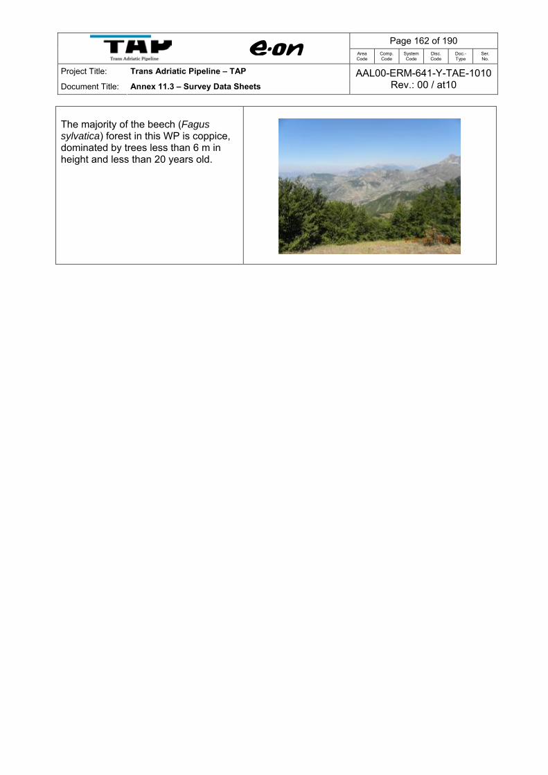
Page 162 of 190
Area Code
Comp. Code
System Code
Disc. Code
Doc.- Type
Ser. No.
Project Title: Trans Adriatic Pipeline – TAP
Document Title: Annex 11.3 – Survey Data Sheets AAL00-ERM-641-Y-TAE-1010
Rev.: 00 / at10
The majority of the beech (Fagus sylvatica) forest in this WP is coppice, dominated by trees less than 6 m in height and less than 20 years old.

Page 163 of 190
Area Code
Comp. Code
System Code
Disc. Code
Doc.- Type
Ser. No.
Project Title: Trans Adriatic Pipeline – TAP
Document Title: Annex 11.3 – Survey Data Sheets AAL00-ERM-641-Y-TAE-1010
Rev.: 00 / at10
Site Name: Vithkuq – Ostrovice Survey point WP 023; B-023
34T0 452225 GPS Elev.
Date Project
Surveyor Alfred Mullaj, Julian Shehu
4481314 1660 m 21.07.2012 TAP
Section: Central East Remarks Top of the hill above the Lirza beech forest, Nature Monument. Mountain hay meadows surrounded by beech forest dominated by Fagus sylvatica. They are dominated by different cold resistant grasses, as Bushgrass (Calamagrostis varia), Blood root (Potentilla erecta), Woodrush (Luzula luzulina), Erect brome (Bromus erectus), Meadowgrass (Poa ursina), False brome (Brachypodium sylvaticum), Brush grass (Chrysopogon gryllus), False oat grass (Arrhenatherum elatius), Yellow oat-grass (Trisetum flavescens), Brown knapweed (Centaurea jacea), Rough hawk’s beard (Crepis biennis), Knautia (Knautia arvensis), and Goat’s beard (Tragopogon pratensis), Hawk’s beard (Crepis mollis), Meadow sage (Salvia pratensis), Dusky cranesbill (Geranium phaeum), Wood cranesbill (G. sylvaticum).
The majority of the Fagus sylvatica forest in this WP is coppice, dominated by trees less than 6 m in height and less than 20 years old.
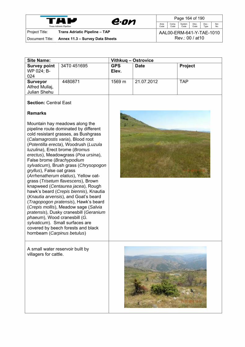
Page 164 of 190
Area Code
Comp. Code
System Code
Disc. Code
Doc.- Type
Ser. No.
Project Title: Trans Adriatic Pipeline – TAP
Document Title: Annex 11.3 – Survey Data Sheets AAL00-ERM-641-Y-TAE-1010
Rev.: 00 / at10
Site Name: Vithkuq – Ostrovice Survey point WP 024; B-024
34T0 451695 GPS Elev.
Date Project
Surveyor Alfred Mullaj, Julian Shehu
4480871 1569 m 21.07.2012 TAP
Section: Central East Remarks Mountain hay meadows along the pipeline route dominated by different cold resistant grasses, as Bushgrass (Calamagrostis varia), Blood root (Potentilla erecta), Woodrush (Luzula luzulina), Erect brome (Bromus erectus), Meadowgrass (Poa ursina), False brome (Brachypodium sylvaticum), Brush grass (Chrysopogon gryllus), False oat grass (Arrhenatherum elatius), Yellow oat-grass (Trisetum flavescens), Brown knapweed (Centaurea jacea), Rough hawk’s beard (Crepis biennis), Knautia (Knautia arvensis), and Goat’s beard (Tragopogon pratensis), Hawk’s beard (Crepis mollis), Meadow sage (Salvia pratensis), Dusky cranesbill (Geranium phaeum), Wood cranesbill (G. sylvaticum). Small surfaces are covered by beech forests and black hornbeam (Carpinus betulus)
A small water reservoir built by villagers for cattle.

Page 165 of 190
Area Code
Comp. Code
System Code
Disc. Code
Doc.- Type
Ser. No.
Project Title: Trans Adriatic Pipeline – TAP
Document Title: Annex 11.3 – Survey Data Sheets AAL00-ERM-641-Y-TAE-1010
Rev.: 00 / at10
Site Name: Vithkuq – Ostrovice Survey point WP 025; B-025
34T0 451486 GPS Elev.
Date Project
Surveyor Alfred Mullaj, Julian Shehu
4480625 1579 m 21.07.2012 TAP
Section: Central East Remarks Luzulo-Fagetum beech forests are developed in this WP (the upper part of Staravecka mountain), with main component element the beech (Fagus sylvatica) often accompanied by maple (Acer pseudoplatanus). The majority of the beech (Fagus sylvatica) forest in this WP are degraded, dominated by trees less than 6 m in height and less than 20 years old as a result of regular management of the woodlands for firewood and livestock fodder.
Mountain hay meadows dominated by different cold resistant grasses, as Reed-grass (Calamagrostis varia), Blood root (Potentilla erecta), Woodrush (Luzula luzulina), Erect brome (Bromus erectus), Meadowgrass (Poa ursina), False brome (Brachypodium sylvaticum), Brush grass (Chrysopogon gryllus), False oat grass (Arrhenatherum elatius), and often by Common juniper (Juniperus communis).

Page 166 of 190
Area Code
Comp. Code
System Code
Disc. Code
Doc.- Type
Ser. No.
Project Title: Trans Adriatic Pipeline – TAP
Document Title: Annex 11.3 – Survey Data Sheets AAL00-ERM-641-Y-TAE-1010
Rev.: 00 / at10
Site Name: Vithkuq – Ostrovice Survey point WP 026; B-026
34T0 451074 GPS Elev.
Date Project
Surveyor Alfred Mullaj, Julian Shehu
4480408 1517 m 21.07.2012 TAP
Section: Central East Remarks Luzulo-Fagetum beech forests are developed in this WP, with main component element the beech (Fagus sylvatica). The majority of the beech (Fagus sylvatica) forest in this WP are degraded, dominated by trees less than 6 m in height and less than 20 years old as a result of regular management of the woodlands for firewood and livestock fodder.
Mountain hay meadows dominated by Bracken (Pteridium aqualinum), as a result of intensive grazing or fire. Other species with a high presence can mention Foxtail (Alopecurus mysoroides), Erect brome (Bromus erectus), Meadowgrass (Poa ursina), False brome (Brachypodium sylvaticum), Brush grass (Chrysopogon gryllus), False oat grass (Arrhenatherum elatius), Blood root (Potentilla erecta), Woodrush (Luzula luzulina), Common juniper (Juniperus communis).

Page 167 of 190
Area Code
Comp. Code
System Code
Disc. Code
Doc.- Type
Ser. No.
Project Title: Trans Adriatic Pipeline – TAP
Document Title: Annex 11.3 – Survey Data Sheets AAL00-ERM-641-Y-TAE-1010
Rev.: 00 / at10
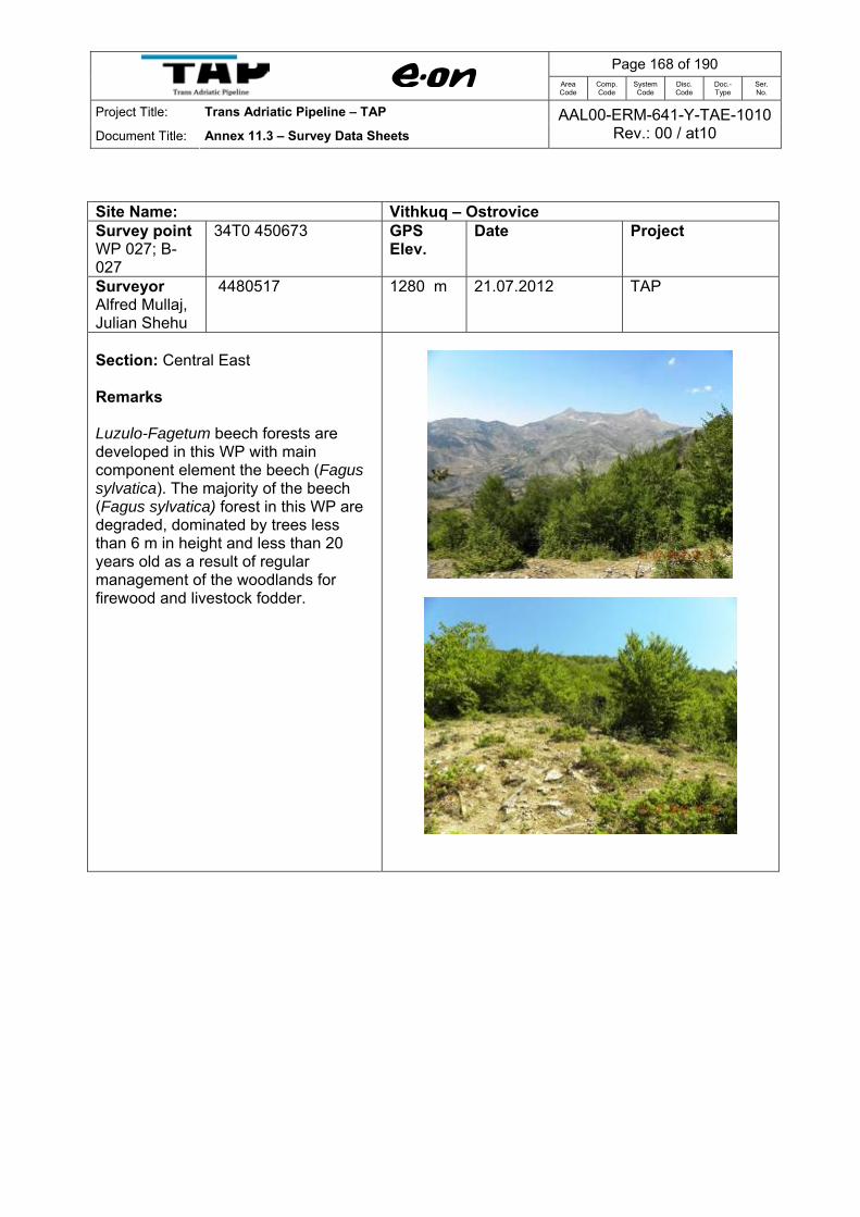
Page 168 of 190
Area Code
Comp. Code
System Code
Disc. Code
Doc.- Type
Ser. No.
Project Title: Trans Adriatic Pipeline – TAP
Document Title: Annex 11.3 – Survey Data Sheets AAL00-ERM-641-Y-TAE-1010
Rev.: 00 / at10
Site Name: Vithkuq – Ostrovice Survey point WP 027; B-027
34T0 450673 GPS Elev.
Date Project
Surveyor Alfred Mullaj, Julian Shehu
4480517 1280 m 21.07.2012 TAP
Section: Central East Remarks Luzulo-Fagetum beech forests are developed in this WP with main component element the beech (Fagus sylvatica). The majority of the beech (Fagus sylvatica) forest in this WP are degraded, dominated by trees less than 6 m in height and less than 20 years old as a result of regular management of the woodlands for firewood and livestock fodder.
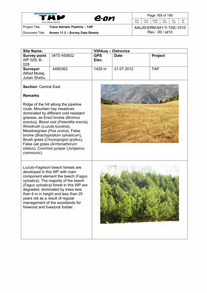
Page 169 of 190
Area Code
Comp. Code
System Code
Disc. Code
Doc.- Type
Ser. No.
Project Title: Trans Adriatic Pipeline – TAP
Document Title: Annex 11.3 – Survey Data Sheets AAL00-ERM-641-Y-TAE-1010
Rev.: 00 / at10
Site Name: Vithkuq – Ostrovice Survey point WP 028; B-028
34T0 450822 GPS Elev.
Date Project
Surveyor Alfred Mullaj, Julian Shehu
4480363 1429 m 21.07.2012 TAP
Section: Central East Remarks Ridge of the hill allong the pipeline route. Mountain hay meadows dominated by different cold resistant grasses, as Erect brome (Bromus erectus), Blood root (Potentilla erecta), Woodrush (Luzula luzulina), Meadowgrass (Poa ursina), False brome (Brachypodium sylvaticum), Brush grass (Chrysopogon gryllus), False oat grass (Arrhenatherum elatius), Common juniper (Juniperus communis).
Luzulo-Fagetum beech forests are developed in this WP with main component element the beech (Fagus sylvatica). The majority of the beech (Fagus sylvatica) forest in this WP are degraded, dominated by trees less than 6 m in height and less than 20 years old as a result of regular management of the woodlands for firewood and livestock fodder.
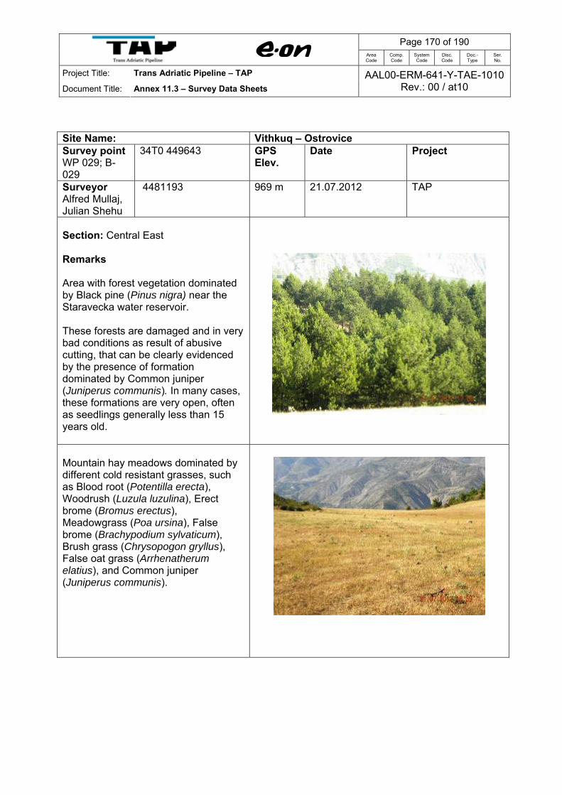
Page 170 of 190
Area Code
Comp. Code
System Code
Disc. Code
Doc.- Type
Ser. No.
Project Title: Trans Adriatic Pipeline – TAP
Document Title: Annex 11.3 – Survey Data Sheets AAL00-ERM-641-Y-TAE-1010
Rev.: 00 / at10
Site Name: Vithkuq – Ostrovice Survey point WP 029; B-029
34T0 449643 GPS Elev.
Date Project
Surveyor Alfred Mullaj, Julian Shehu
4481193 969 m 21.07.2012 TAP
Section: Central East Remarks Area with forest vegetation dominated by Black pine (Pinus nigra) near the Staravecka water reservoir. These forests are damaged and in very bad conditions as result of abusive cutting, that can be clearly evidenced by the presence of formation dominated by Common juniper (Juniperus communis). In many cases, these formations are very open, often as seedlings generally less than 15 years old.
Mountain hay meadows dominated by different cold resistant grasses, such as Blood root (Potentilla erecta), Woodrush (Luzula luzulina), Erect brome (Bromus erectus), Meadowgrass (Poa ursina), False brome (Brachypodium sylvaticum), Brush grass (Chrysopogon gryllus), False oat grass (Arrhenatherum elatius), and Common juniper (Juniperus communis).

Page 171 of 190
Area Code
Comp. Code
System Code
Disc. Code
Doc.- Type
Ser. No.
Project Title: Trans Adriatic Pipeline – TAP
Document Title: Annex 11.3 – Survey Data Sheets AAL00-ERM-641-Y-TAE-1010
Rev.: 00 / at10
Site Name: Vithkuq – Ostrovice Survey point WP 030; B-030
34T0 449461 GPS Elev.
Date Project
Surveyor Alfred Mullaj, Julian Shehu
4481492 953 m 21.07.2012 TAP
Section: Central East Remarks This WP is characterized by advanced stages of degradation of mixed oak forests and agricultural areas.. In many cases the vegetation of these habitats is characterized by dominance of Oriental hornbeam (Carpinus orientalis). Other species with high presence can mention Macedonian oak (Quercus trojana), Turken oak (Quecus cerris), Dogwood (Cornus mas), Hornbeam (Carpinus betulus), Common juniper (Juniperus communis), Dogrose (Rosa canina), Almond pear tree (Pyrus amygdaliformis), Christ’s thorn (Paliurus spina-christi), Elm leaf blackberry (Rubus ulmifolius), Bracken (Pteridium aqualinum), Wig tree (Cotinus coggygria), Flowering ash (Fraxinus ornus).

Page 172 of 190
Area Code
Comp. Code
System Code
Disc. Code
Doc.- Type
Ser. No.
Project Title: Trans Adriatic Pipeline – TAP
Document Title: Annex 11.3 – Survey Data Sheets AAL00-ERM-641-Y-TAE-1010
Rev.: 00 / at10
Site Name: Vithkuq – Ostrovice Survey point WP 031; B-031
34T0449503 GPS Elev.
Date Project
Surveyor Alfred Mullaj, Julian Shehu
4481457 945 m 22.07.2012 TAP
Section: Central East Remarks Agricultural areas. The most important crops cultivated in these areas are wheat, corn, barley and alfalfa. Galio Carpinetum Oak-Hornbeam Forests, generally dominated by Oriental hornbeam (Carpinus orientalis), extends in a large part of this WP. A strong human impact is associated with this habitat as a result of cutting, intensive grazing. Some small surfaces cultivated by Coniferous Forest (new forests) dominated by Black pine (Pinus nigra) are also found in this WP.
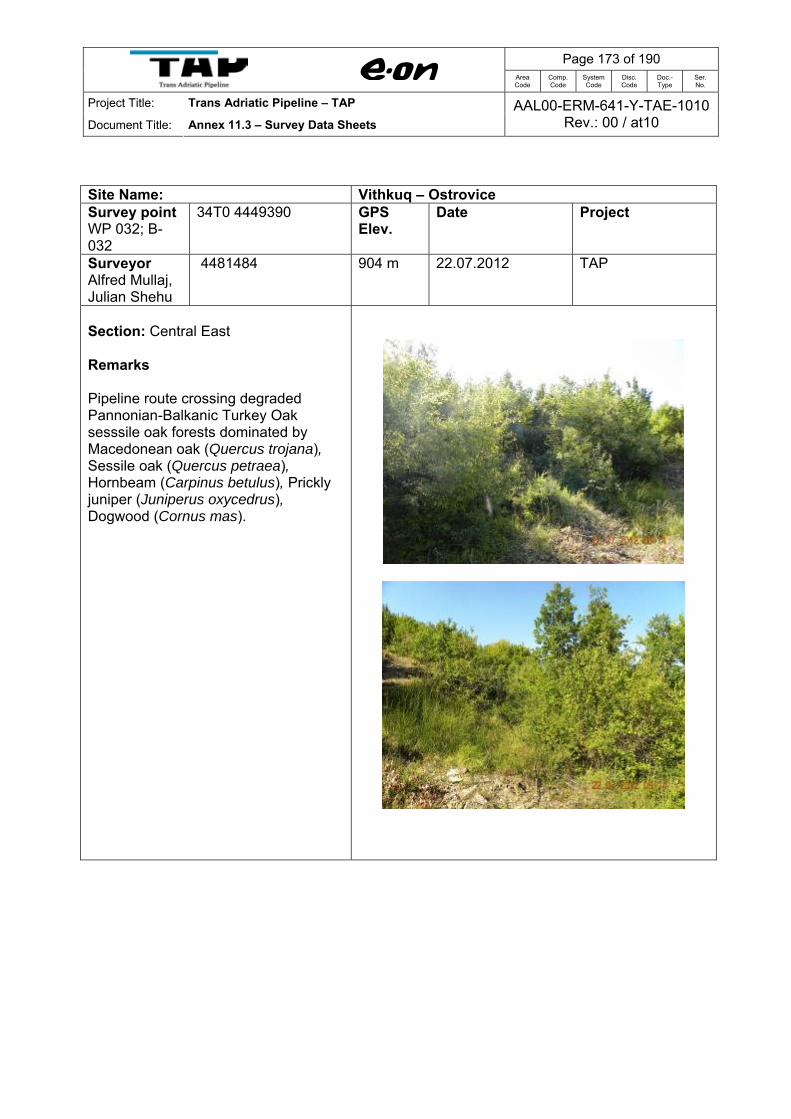
Page 173 of 190
Area Code
Comp. Code
System Code
Disc. Code
Doc.- Type
Ser. No.
Project Title: Trans Adriatic Pipeline – TAP
Document Title: Annex 11.3 – Survey Data Sheets AAL00-ERM-641-Y-TAE-1010
Rev.: 00 / at10
Site Name: Vithkuq – Ostrovice Survey point WP 032; B-032
34T0 4449390 GPS Elev.
Date Project
Surveyor Alfred Mullaj, Julian Shehu
4481484 904 m 22.07.2012 TAP
Section: Central East Remarks Pipeline route crossing degraded Pannonian-Balkanic Turkey Oak sesssile oak forests dominated by Macedonean oak (Quercus trojana), Sessile oak (Quercus petraea), Hornbeam (Carpinus betulus), Prickly juniper (Juniperus oxycedrus), Dogwood (Cornus mas).

Page 174 of 190
Area Code
Comp. Code
System Code
Disc. Code
Doc.- Type
Ser. No.
Project Title: Trans Adriatic Pipeline – TAP
Document Title: Annex 11.3 – Survey Data Sheets AAL00-ERM-641-Y-TAE-1010
Rev.: 00 / at10
Site Name: Vithkuq – Ostrovice Survey point WP 033; B-033
34T0 449022 GPS Elev.
Date Project
Surveyor Alfred Mullaj, Julian Shehu
4481552 864 m 22.07.2012 TAP
Section: Central East Remarks Very degraded Galio Carpinetum Oak-Hornbeam Forests, generally dominated by Oriental hornbeam (Carpinus orientalis), extends in a large part of this WP. A strong human impact is associated with this habitat as a result of cutting, intensive grazing, and deforestation. The dominant species of this habitat type are: Oriental hornbeam (Carpinus orientalis), Hazel (Corylus avellana), Castanea sativa, Black pine (Pinus nigra), Hop hornbeam (Ostrya carpinifolia), Turkey oak (Quercus cerris, Macedonean oak (Quercus trojana), Prickly juniper (Juniperus oxycedrus), Common juniper (J. communis), Elm leaf blackberry (Rubus ulmifolius), Hawthorn (Crataegus monogyna), Dogrose (Rosa canina),

Page 175 of 190
Area Code
Comp. Code
System Code
Disc. Code
Doc.- Type
Ser. No.
Project Title: Trans Adriatic Pipeline – TAP
Document Title: Annex 11.3 – Survey Data Sheets AAL00-ERM-641-Y-TAE-1010
Rev.: 00 / at10
Site Name: Vithkuq – Ostrovice Designated Site Name:
Backe – Ostrovicё Designated Site Name:
Backe – Ostrovicё Designated Site Name:
Survey point WP 034; B-034
34T0 449053 Survey point WP 034; B-034
34T0 449053 Survey point WP 034; B-034
Section: Central East Remarks Reed beds and White willow (Salix alba) and White poplar (Populus alba) galleries or riparian vegetation give the dominant aspect this wp (between km 8 and 8.5). These species-rich habitats add much to the botanical diversity of the study area. The formation of reed-beds is also wide spread in this wp dominated by helophytes, such as Common reed (Phragmites australis), Lesser bulrush (Typha angustifolia),Lake club-rush (Scirpus lacustris), Purple loosestrife (Lythrum salicaria).
The riparian woodlands are largely dominated by White willow (Salix alba), White poplar (Populus alba),Black poplar (P. nigra), Purple willow (Salix elaeagnos), S. purpurea, Hawthorn (Crataegus monogyna).

Page 176 of 190
Area Code
Comp. Code
System Code
Disc. Code
Doc.- Type
Ser. No.
Project Title: Trans Adriatic Pipeline – TAP
Document Title: Annex 11.3 – Survey Data Sheets AAL00-ERM-641-Y-TAE-1010
Rev.: 00 / at10
Site Name: Vithkuq – Ostrovice Survey point WP 035; B-035
34T0 448927 GPS Elev.
Date Project
Surveyor Alfred Mullaj, Julian Shehu
4481678 795 m 22.07.2012 TAP
Section: Central East Remarks Very degraded Galio Carpinetum Oak-Hornbeam Forests, generally dominated by Oriental hornbeam (Carpinus orientalis), extends in a large part of this WP. A strong human impact is associated with this habitat as a result of cutting, intensive grazing, and deforestation. The dominant species of this habitat type are: Oriental hornbeam (Carpinus orientalis), Hazel (Corylus avellana), Castanea sativa, Black pine (Pinus nigra), Hop hornbeam (Ostrya carpinifolia), Turkey oak (Quercus cerris, Macedonean oak (Quercus trojana), Prickly juniper (Juniperus oxycedrus), Common juniper (J. communis), Elm leaf blackberry (Rubus ulmifolius), Hawthorn (Crataegus monogyna), Dogrose (Rosa canina),
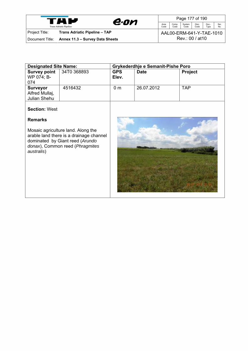
Page 177 of 190
Area Code
Comp. Code
System Code
Disc. Code
Doc.- Type
Ser. No.
Project Title: Trans Adriatic Pipeline – TAP
Document Title: Annex 11.3 – Survey Data Sheets AAL00-ERM-641-Y-TAE-1010
Rev.: 00 / at10
Designated Site Name: Grykederdhje e Semanit-Pishe Poro Survey point WP 074; B-074
34T0 368893 GPS Elev.
Date Project
Surveyor Alfred Mullaj, Julian Shehu
4516432 0 m 26.07.2012 TAP
Section: West Remarks Mosaic agriculture land. Along the arable land there is a drainage channel dominated by Giant reed (Arundo donax), Common reed (Phragmites australis)

Page 178 of 190
Area Code
Comp. Code
System Code
Disc. Code
Doc.- Type
Ser. No.
Project Title: Trans Adriatic Pipeline – TAP
Document Title: Annex 11.3 – Survey Data Sheets AAL00-ERM-641-Y-TAE-1010
Rev.: 00 / at10
Designated Site Name: Grykederdhje e Semanit-Pishe Poro Survey point WP 075; B-075
34T0 368306 GPS Elev.
Date Project
Surveyor Alfred Mullaj, Julian Shehu
4513660 1 m 26.07.2012 TAP
Section: West Remarks Grid connection crossing point with a drainage channel. The banks of drainage channel are covered by water fringe vegetation mostly dominated by Giant reed (Arundo donax), thickets of common reed (Phragmites australis), Lesser bulrush (Typha angustifolia), Dalmatian tamarisk (Tamarix dalmatica), Sea rush (Juncus acutus).

Page 179 of 190
Area Code
Comp. Code
System Code
Disc. Code
Doc.- Type
Ser. No.
Project Title: Trans Adriatic Pipeline – TAP
Document Title: Annex 11.3 – Survey Data Sheets AAL00-ERM-641-Y-TAE-1010
Rev.: 00 / at10
Designated Site Name: Grykederdhje e Semanit-Pishe Poro Survey point WP 076; B-076
34T0 367448 GPS Elev.
Date Project
Surveyor Alfred Mullaj, Julian Shehu
4516129 1 m 26.07.2012 TAP
Section: West Remarks Saline tamarisk thickets. This habitat contains tamarisk (Tamarix dalmatica and Tamarix hampeana) thickets accompanied by Sea rush (Juncus maritimus), Beardgrass (Polypogon maritimus), Common sea lavender (Limonium vulgare), Squirrel tail-grass (Hordeum marinum) and Common reed (Phragmites australis). In higher areas, Elm leaf blackberry (Rubus ulmifolius), Terebint tree (Pistacia terebinthus) and Viscous fleabane (Dittrichia viscosa) were observed. Large area in this WP represents a former agriculture land that is abandoned for many years (sandy salted soils) invaded mostly by alien invasive species Viscous fleabane (Dittrichia viscosa) and a large number of opportunistic ruderal species such as Daisy (Bellis perennis), Elm leaf blackberry (Rubus ulmifolius), Bog rush (Schoenus nigricans), White-felted germander (Teucrium polium), Dyer’s alkannet (Alkanna tinctoria) and Giant reed (Arundo donax) (along the irrigation channel).

Page 180 of 190
Area Code
Comp. Code
System Code
Disc. Code
Doc.- Type
Ser. No.
Project Title: Trans Adriatic Pipeline – TAP
Document Title: Annex 11.3 – Survey Data Sheets AAL00-ERM-641-Y-TAE-1010
Rev.: 00 / at10
Designated Site Name: Grykederdhje e Semanit-Pishe Poro Survey point WP 077; B-077
34T0 365696 GPS Elev.
Date Project
Surveyor Alfred Mullaj, Julian Shehu
4515762 1 m 26.07.2012 TAP
Section: West Remarks At this WP noticed different types of habitats: Salicornia and others annuals colonising mud and sand dominated by glasswort (Salicornia europaea), pioneer marsh communities; Mediterranean and Thermo-Atlantic halophilous scrubs mainly composed of scrub such as Shrubby swampgrass (Sarcocornia fruticosa), Perennial glasswort (Sarcocornia perennis). The other species with high frequence in these habitats are Common sea lavender (Limonium vulgare), Torrey alkali grass (Puccinellia festuciformis), Dalmatian tamarisk (Tamarix dalmaticum), etc.

Page 181 of 190
Area Code
Comp. Code
System Code
Disc. Code
Doc.- Type
Ser. No.
Project Title: Trans Adriatic Pipeline – TAP
Document Title: Annex 11.3 – Survey Data Sheets AAL00-ERM-641-Y-TAE-1010
Rev.: 00 / at10
Designated Site Name: Grykederdhje e Semanit-Pishe Poro Survey point WP 078; B-078
34T0 364846 GPS Elev.
Date Project
Surveyor Alfred Mullaj, Julian Shehu
4515592 1 m 26.07.2012 TAP
Section: West Remarks Crossing point of grid connection with Hoxhara drainage channel. The banks of drainage channel are covered by water fringe vegetation mostly dominated by Giant reed (Arundo donax), thickets of common reed (Phragmites australis), Lesser bulrush (Typha angustifolia), Dalmatian tamarisk (Tamarix dalmatica), Sea rush (Juncus acutus).
Aquatic vegetation is dominated by Potamogeton natans.
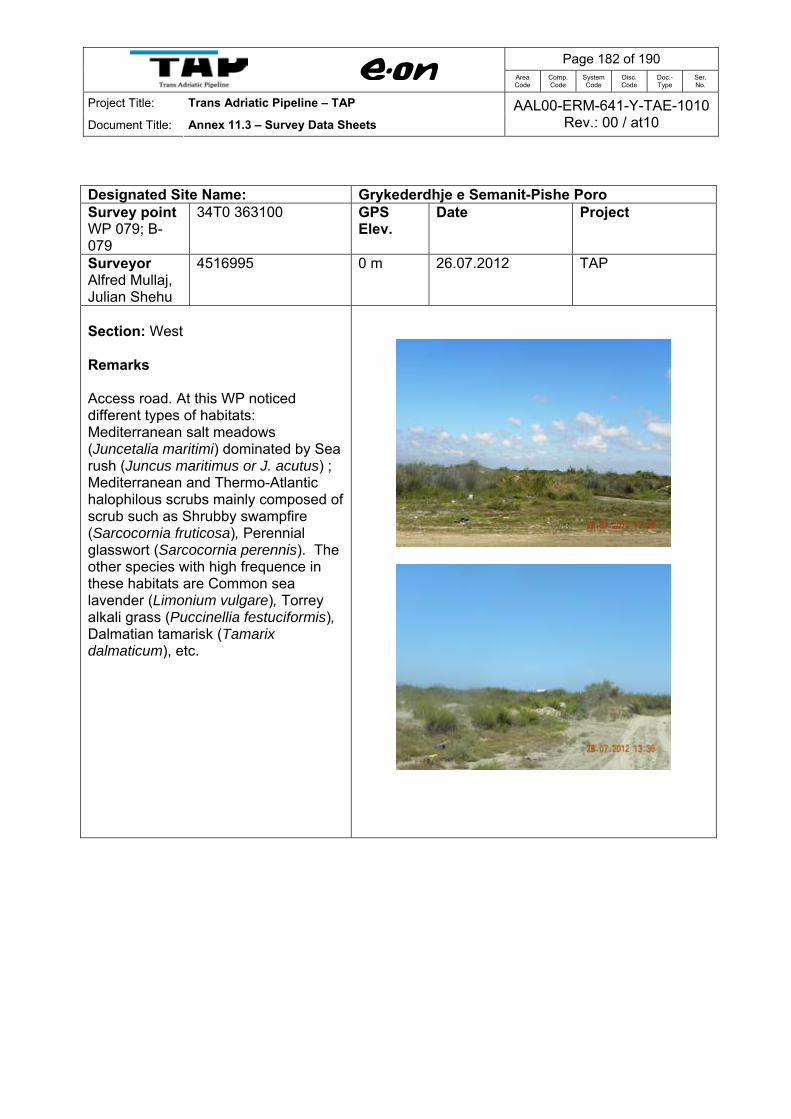
Page 182 of 190
Area Code
Comp. Code
System Code
Disc. Code
Doc.- Type
Ser. No.
Project Title: Trans Adriatic Pipeline – TAP
Document Title: Annex 11.3 – Survey Data Sheets AAL00-ERM-641-Y-TAE-1010
Rev.: 00 / at10
Designated Site Name: Grykederdhje e Semanit-Pishe Poro Survey point WP 079; B-079
34T0 363100 GPS Elev.
Date Project
Surveyor Alfred Mullaj, Julian Shehu
4516995 0 m 26.07.2012 TAP
Section: West Remarks Access road. At this WP noticed different types of habitats: Mediterranean salt meadows (Juncetalia maritimi) dominated by Sea rush (Juncus maritimus or J. acutus) ; Mediterranean and Thermo-Atlantic halophilous scrubs mainly composed of scrub such as Shrubby swampfire (Sarcocornia fruticosa), Perennial glasswort (Sarcocornia perennis). The other species with high frequence in these habitats are Common sea lavender (Limonium vulgare), Torrey alkali grass (Puccinellia festuciformis), Dalmatian tamarisk (Tamarix dalmaticum), etc.
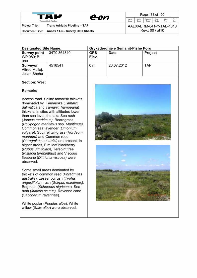
Page 183 of 190
Area Code
Comp. Code
System Code
Disc. Code
Doc.- Type
Ser. No.
Project Title: Trans Adriatic Pipeline – TAP
Document Title: Annex 11.3 – Survey Data Sheets AAL00-ERM-641-Y-TAE-1010
Rev.: 00 / at10
Designated Site Name: Grykederdhje e Semanit-Pishe Poro Survey point WP 080; B-080
34T0 364340 GPS Elev.
Date Project
Surveyor Alfred Mullaj, Julian Shehu
4516541 0 m 26.07.2012 TAP
Section: West Remarks Access road. Saline tamarisk thickets dominated by Tamarisks (Tamarix dalmatica and Tamarix hampeana) thickets. In sites with altitudes lower than sea level, the taxa Sea rush (Juncus maritimus), Beardgrass (Polypogon maritimus ssp. Maritimus), Common sea lavender (Limonium vulgare), Squirrel tail-grass (Hordeum marinum) and Common reed (Phragmites australis) are present. In higher areas, Elm leaf blackberry (Rubus ulmifolius), Terebint tree (Pistacia terebinthus) and Viscous fleabane (Dittrichia viscosa) were observed. Some small areas dominated by thickets of common reed (Phragmites australis), Lesser bulrush (Typha angustifolia), rush (Scirpus maritimus), Bog rush (Schoenus nigricans), Sea rush (Juncus acutus), Ravenna cane (Saccharum ravennae). White poplar (Populus alba), White willow (Salix alba) were observed.

Page 184 of 190
Area Code
Comp. Code
System Code
Disc. Code
Doc.- Type
Ser. No.
Project Title: Trans Adriatic Pipeline – TAP
Document Title: Annex 11.3 – Survey Data Sheets AAL00-ERM-641-Y-TAE-1010
Rev.: 00 / at10
Designated Site Name: Grykederdhje e Semanit-Pishe Poro Survey point WP 081; B-081
34T0 364457 GPS Elev.
Date Project
Surveyor Alfred Mullaj, Julian Shehu
4516012 1 m 26.07.2012 TAP
Section: West Remarks Access road. At this WP noticed different types of habitats: Mediterranean salt meadows (Juncetalia maritimi) dominated by Sea rush (Juncus maritimus or J. acutus) ; Mediterranean and Thermo-Atlantic halophilous scrubs mainly composed of scrub such as Shrubby swampfire (Sarcocornia fruticosa), Perennial glasswort (Sarcocornia perennis). The other species with high frequence in these habitats are Common sea lavender (Limonium vulgare), Torrey alkali grass (Puccinellia festuciformis), Elm leaf blackberry (Rubus ulmifolius), Viscous fleabane (Dittrichia viscosa), etc.
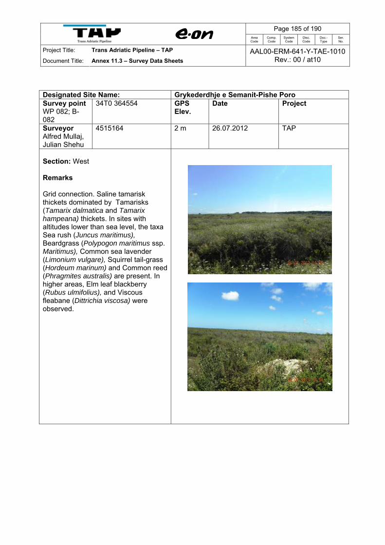
Page 185 of 190
Area Code
Comp. Code
System Code
Disc. Code
Doc.- Type
Ser. No.
Project Title: Trans Adriatic Pipeline – TAP
Document Title: Annex 11.3 – Survey Data Sheets AAL00-ERM-641-Y-TAE-1010
Rev.: 00 / at10
Designated Site Name: Grykederdhje e Semanit-Pishe Poro Survey point WP 082; B-082
34T0 364554 GPS Elev.
Date Project
Surveyor Alfred Mullaj, Julian Shehu
4515164 2 m 26.07.2012 TAP
Section: West Remarks Grid connection. Saline tamarisk thickets dominated by Tamarisks (Tamarix dalmatica and Tamarix hampeana) thickets. In sites with altitudes lower than sea level, the taxa Sea rush (Juncus maritimus), Beardgrass (Polypogon maritimus ssp. Maritimus), Common sea lavender (Limonium vulgare), Squirrel tail-grass (Hordeum marinum) and Common reed (Phragmites australis) are present. In higher areas, Elm leaf blackberry (Rubus ulmifolius), and Viscous fleabane (Dittrichia viscosa) were observed.

Page 186 of 190
Area Code
Comp. Code
System Code
Disc. Code
Doc.- Type
Ser. No.
Project Title: Trans Adriatic Pipeline – TAP
Document Title: Annex 11.3 – Survey Data Sheets AAL00-ERM-641-Y-TAE-1010
Rev.: 00 / at10
Designated Site Name: Grykederdhje e Semanit-Pishe Poro Survey point WP 083; B-083
34T0 364238 GPS Elev.
Date Project
Surveyor Alfred Mullaj, Julian Shehu
4514524 3 m 26.07.2012 TAP
Section: West Remarks Wooded dunes with Pines (Pinus pinea or Pinus pinaster) occupy a small part of the study area distributed mainly on sandy dunes. In general, they represent relatively young forests, cultivated recently (c. 40 - 50 years ago) in order to stabilize the sandy dunes and protect the agricultural lands. The shrubby layer is represented by typical Mediterranean species. Main shrub species of this habitat type are: Mastic tree (Pistacia lentiscus), Elm leaf blackberry (Rubus ulmifolius), Common myrtle (Myrtus communis), Narrow-leaved phyllirea (Phyllirea angustifolia), Silk vine (Periploca graeca), Mediterranean heather (Erica multiflora), Prickly juniper (Juniperus oxycedrus ssp. Macrocarpa), Rabit-tail (Lagurus ovata), Dyer’s alkannet (Alkanna tinctoria), Sand sporobolus (Sporobolus pungens), Dune fescue (Vulpia fasciculata), etc.
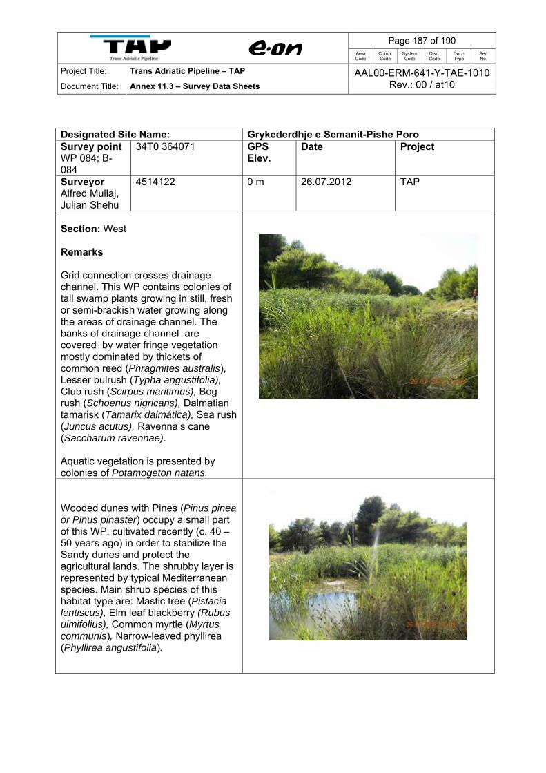
Page 187 of 190
Area Code
Comp. Code
System Code
Disc. Code
Doc.- Type
Ser. No.
Project Title: Trans Adriatic Pipeline – TAP
Document Title: Annex 11.3 – Survey Data Sheets AAL00-ERM-641-Y-TAE-1010
Rev.: 00 / at10
Designated Site Name: Grykederdhje e Semanit-Pishe Poro Survey point WP 084; B-084
34T0 364071 GPS Elev.
Date Project
Surveyor Alfred Mullaj, Julian Shehu
4514122 0 m 26.07.2012 TAP
Section: West Remarks Grid connection crosses drainage channel. This WP contains colonies of tall swamp plants growing in still, fresh or semi-brackish water growing along the areas of drainage channel. The banks of drainage channel are covered by water fringe vegetation mostly dominated by thickets of common reed (Phragmites australis), Lesser bulrush (Typha angustifolia), Club rush (Scirpus maritimus), Bog rush (Schoenus nigricans), Dalmatian tamarisk (Tamarix dalmática), Sea rush (Juncus acutus), Ravenna’s cane (Saccharum ravennae). Aquatic vegetation is presented by colonies of Potamogeton natans.
Wooded dunes with Pines (Pinus pinea or Pinus pinaster) occupy a small part of this WP, cultivated recently (c. 40 – 50 years ago) in order to stabilize the Sandy dunes and protect the agricultural lands. The shrubby layer is represented by typical Mediterranean species. Main shrub species of this habitat type are: Mastic tree (Pistacia lentiscus), Elm leaf blackberry (Rubus ulmifolius), Common myrtle (Myrtus communis), Narrow-leaved phyllirea (Phyllirea angustifolia).
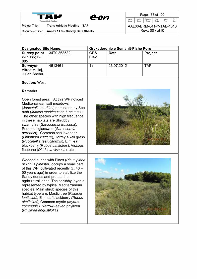
Page 188 of 190
Area Code
Comp. Code
System Code
Disc. Code
Doc.- Type
Ser. No.
Project Title: Trans Adriatic Pipeline – TAP
Document Title: Annex 11.3 – Survey Data Sheets AAL00-ERM-641-Y-TAE-1010
Rev.: 00 / at10
Designated Site Name: Grykederdhje e Semanit-Pishe Poro Survey point WP 085; B-085
34T0 363582 GPS Elev.
Date Project
Surveyor Alfred Mullaj, Julian Shehu
4513461 1 m 26.07.2012 TAP
Section: West Remarks Open forest area. At this WP noticed Mediterranean salt meadows (Juncetalia maritimi) dominated by Sea rush (Juncus maritimus or J. acutus) ; The other species with high frequence in these habitats are Shrubby swampfire (Sarcocornia fruticosa), Perennial glasswort (Sarcocornia perennis). Common sea lavender (Limonium vulgare), Torrey alkali grass (Puccinellia festuciformis), Elm leaf blackberry (Rubus ulmifolius), Viscous fleabane (Dittrichia viscosa), etc.
Wooded dunes with Pines (Pinus pinea or Pinus pinaster) occupy a small part of this WP, cultivated recently (c. 40 – 50 years ago) in order to stabilize the Sandy dunes and protect the agricultural lands. The shrubby layer is represented by typical Mediterranean species. Main shrub species of this habitat type are: Mastic tree (Pistacia lentiscus), Elm leaf blackberry (Rubus ulmifolius), Common myrtle (Myrtus communis), Narrow-leaved phyllirea (Phyllirea angustifolia).

Page 189 of 190
Area Code
Comp. Code
System Code
Disc. Code
Doc.- Type
Ser. No.
Project Title: Trans Adriatic Pipeline – TAP
Document Title: Annex 11.3 – Survey Data Sheets AAL00-ERM-641-Y-TAE-1010
Rev.: 00 / at10
Designated Site Name: Grykederdhje e Semanit-Pishe Poro Survey point WP 086; B-086
34T0 363413 GPS Elev.
Date Project
Surveyor Alfred Mullaj, Julian Shehu
4513136 1 m 26.07.2012 TAP
Section: West Remarks Grid connection. Wooded dunes with Pines (Pinus pinea or Pinus pinaster) occupy a large part of this WP, cultivated recently (c. 40 – 50 years ago) in order to stabilize the Sandy dunes and protect the agricultural lands. The shrubby layer is represented by typical Mediterranean species. Main shrub species of this habitat type are: Mastic tree (Pistacia lentiscus), Elm leaf blackberry (Rubus ulmifolius), Common myrtle (Myrtus communis), Narrow-leaved phyllirea (Phyllirea angustifolia).

Page 190 of 190
Area Code
Comp. Code
System Code
Disc. Code
Doc.- Type
Ser. No.
Project Title: Trans Adriatic Pipeline – TAP
Document Title: Annex 11.3 – Survey Data Sheets AAL00-ERM-641-Y-TAE-1010
Rev.: 00 / at10
Designated Site Name: Grykederdhje e Semanit-Pishe Poro Survey point WP 087; B-087
34T0 363208 GPS Elev.
Date Project
Surveyor Alfred Mullaj, Julian Shehu
4512832 0 m 26.07.2012 TAP
Section: West Remarks Power electric station close to the Vija e Ngjales channel.
At this WP noticed Mediterranean salt meadows (Juncetalia maritimi) dominated by Sea rush (Juncus maritimus or J. acutus) and saline tamarisk thickets dominated by Tamarix dalmatica and Tamarix hampeana. The banks of Vija e ngjalёs channel are covered by water fringe vegetation mostly dominated by thickets of common reed (Phragmites australis), Lesser bulrush (Typha angustifolia), Club rush (Scirpus maritimus), Bog rush (Schoenus nigricans), Dalmatian tamarisk (Tamarix dalmática), Sea rush (Juncus acutus), Ravenna’s cane (Saccharum ravennae).

Trans Adriatic Pipeline AG – Albania (Branch Office)Torre Drin, Rruga Abdi Toptani
Tirana, AlbaniaTel.: + 355 44 306 937Fax: + 355 42 265 685
Date 01/2013
Copyright Reserved: This document may not be copied, shown to or placed at the disposal of third parties without prior consent of TAP AG.The latest version of the document is registered in the TAP Project's Database.