ESA update for CEOS LSI-VCceos.org/document_management/Virtual_Constellations/LSI/Meetings... ·...
43
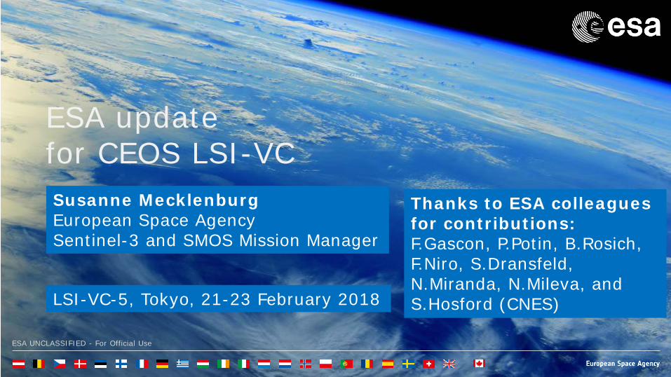
ESA UNCLASSIFIED - For Official Use ESA update for CEOS LSI-VC Susanne Mecklenburg European Space Agency Sentinel-3 and SMOS Mission Manager LSI-VC-5, Tokyo, 21-23 February 2018 Thanks to ESA colleagues for contributions: F.Gascon, P.Potin, B.Rosich, F.Niro, S.Dransfeld, N.Miranda, N.Mileva, and S.Hosford (CNES)
Transcript of ESA update for CEOS LSI-VCceos.org/document_management/Virtual_Constellations/LSI/Meetings... ·...
ESA UNCLASSIFIED - For Official Use
ESA update for CEOS LSI-VC Susanne Mecklenburg European Space Agency Sentinel-3 and SMOS Mission Manager
LSI-VC-5, Tokyo, 21-23 February 2018
Thanks to ESA colleagues for contributions: F.Gascon, P.Potin, B.Rosich, F.Niro, S.Dransfeld, N.Miranda, N.Mileva, and S.Hosford (CNES)

ESA UNCLASSIFIED - For Official Use Susanne Mecklenburg | 06/02/2018 | Slide 2
Focus on
• Update on Copernicus Space Segment • ESA’s contribution to FDA activities
• Copernicus Data Access • Data and Information Access Services (DIAS)
• ESA’s contribution to ARD activities • Current data products over land • Future developments
• Further ARD consultations • Land Product Validation and Evolution Workshop • IGARSS 2018

ESA UNCLASSIFIED - For Official Use Susanne Mecklenburg | 06/02/2018 | Slide 3
Copernicus Space Segment – update

ESA UNCLASSIFIED - For Official Use Susanne Mecklenburg | 06/02/2018 | Slide 4
Sentinel-1: mission status Sentinel-1 nominal routine operations on-going
Overall mission in a very good shape The mission provides: global and routine coverage, with a
systematic production scenario, Sentinel-1A and -1B data routinely provided to Copernicus
Services and users worldwide On-going support to various activations from the Copernicus
Emergency Management Service and International Charter Space and Major Disasters
Sentinel-1 constellation generates now 11 TB of products daily (against a specification of 3 TB)
Sentinel-1 is operated close to its full mission capacity (i.e difficulty to accommodate additional observations)
Upcoming activities Identify and implement mission evolution to support new user
needs, assess an increased system capacity enabling further mission exploitation, etc.
Sentinel-1 overall mission status
Md 4.0 Earthquake in Ischia, Italy, 21/08/2017. Ground deformation measured by Sentinel-1 © Contains Copernicus Sentinel Data (2017) / CNR-IREA

ESA UNCLASSIFIED - For Official Use Susanne Mecklenburg | 06/02/2018 | Slide 5
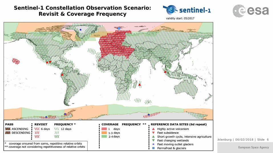
ESA UNCLASSIFIED - For Official Use Susanne Mecklenburg | 06/02/2018 | Slide 6

ESA UNCLASSIFIED - For Official Use Susanne Mecklenburg | 06/02/2018 | Slide 7
• Sentinel-2A and -2B are together acquiring Europe, Africa and Greenland with 5-day revisit and the rest of the World is revisited every 6.6 days in average. Global systematic 5-day revisit will be reached once EDRS or the 4th ground station (Inuvik) become fully operational.
• In addition to the baseline acquisition areas, Antarctica is being imaged every 10 days.
• A new version of the Sentinel-2A spectral response functions has been released. These updated Sentinel-2A spectral responses are mainly changing the responses for bands B01 and B02, correcting inaccurate spectral responses provided previously.
• The systematic global production of Level 2A core products is being implemented in the ground segment. Systematic production using Sen2Cor algorithm is planned to start in Q1 2018 for Europe, and reach full global coverage in mid 2018.
Sentinel-2 mission status

ESA UNCLASSIFIED - For Official Use Susanne Mecklenburg | 06/02/2018 | Slide 8
Sentinel-2 mission status
Nile valley
Kinshasa
2016 Africa land cover 20m
The Africa map (6 GBytes) comprises 180 000 Sentinel-2A images captured between December 2015 and December 2016
contains modified Copernicus Sentinel data (2015-2016), processed by Land Cover CCI, ESA

ESA UNCLASSIFIED - For Official Use Susanne Mecklenburg | 06/02/2018 | Slide 9
Sentinel-3 mission status
Land Surface Temperature monthly composite for September 2016; Credit: D. Ghent, University of Leicester
• Sentinel-3A is now in routine operations phase and has reached full operational capacity: ESA-EUMETSAT Joint Routine Operations Readiness Review – successfully completed in October 2017.
• Overall status of Sentinel-3A is nominal, with all space and ground subsystems and instruments (OLCI, SLSTR, SRAL, MWR) performing nominally.
• All Level 1 and Level 2 Land and Marine core data product have been released.
• Definition and implementation of new core data products (AOD and FRP, EC change request) on-going; sample products expected in Q1/Q2 2018
• Reprocessing campaigns, including data from commissioning phase are ongoing for optical and altimetry data.
• Intense on ground validation activities are on-going to ensure the best possible user acceptance of the Sentinel-3A products.
• Preparations for Sentinel-3B launch, planned for April 2018, on-going, including implementation of the Tandem Phase and orbit phase shift to 140 degree between Sentinel-3A and –B

ESA UNCLASSIFIED - For Official Use Susanne Mecklenburg | 06/02/2018 | Slide 10
CSC Development Status: Space Segment Sentinel-1
With the authorization of the Satellite Production Review (SPR) Board, Sentinel-1C and -1D procurement programme progressed well with the production of flight units and with the successful closure of the AIS Receiver PDR (Preliminary Design Review).
The satellite platform, the SAR instrument and the Optical Communication Payload (OCP) are progressing according to plan.
Sentinel-2
The production of flight units progressed well at platform and instrument level. With regards to the Sentinel-2C/-2D platform procurements, all delivery dates are still in line with the project need dates.
The Multi-Spectral Instrument (MSI) equipment manufacturing is progressing as planned, except for the SOFRADIR SWIR detectors. Mitigation actions are in place to reduce schedule impact.

ESA UNCLASSIFIED - For Official Use Susanne Mecklenburg | 06/02/2018 | Slide 11
CSC Development Status: Space Segment Sentinel-3
The Sentinel-3B satellite is fully integrated with all flight units. The Assembly, Integration and Test Phase has been completed in Quarter 4/2017, which comprised platform tests, System Validation Test and launch adapter fit checks for both Rockot and Vega.
The Sentinel-3B Flight Acceptance Review (FAR) closed successfully with the Board meeting on 12 December 2017.
Following the request from EC to maintain the launch activities with Eurockot as per nominal launch service contract, the Agency proceeded with the launch preparations for Rockot. The present Sentinel-3B launch slot is from 30 March to 30 April 2018, with tentative launch date starting from mid April 2018 (tbc).
The Sentinel-3C and -3D development activities are proceeding as planned at
platform/instruments level. The Sea and Land Surface Temperature Radiometer (SLSTR) and the Ocean and Land Colour Instrument (OLCI) remain the main drivers of the Sentinel-3C schedule, as such followed-up closely by the project team.
Sentinel-3B during the Rockot Launcher Fit Check Test

ESA UNCLASSIFIED - For Official Use Susanne Mecklenburg | 06/02/2018 | Slide 12
A Long Term Scenario (LTS) • Fundamental aspects of a LTS:
• assure user-driven continuity and increase the robustness of the existing CSC in the future (Priority)
• increase the quality and quantity of the existing measurements • expand observation types according to policies and user needs • employ latest technologies for maximum efficiency • Partnerships and cooperation are essential to success
• Key driver is the evolving needs of the services prioritized by EC through various consultative
processes over the last year

ESA UNCLASSIFIED - For Official Use Susanne Mecklenburg | 06/02/2018 | Slide 13
Copernicus Space Component Evolution
November 2017 => Draft CSC Long-Term Scenario submitted to ESA’s Earth Observation Programme Board
December 2017 => ESA released the Invitation To Tenders for Copernicus Space Component Phases A/B1 of Potential Expansion Sentinels: Phase A/B1 of Anthropogenic CO2 Monitoring Mission Phase A/B1 of High Spatio-Temporal Resolution Land Surface Temperature (LST) Monitoring
Mission Phase A/B1 of Polar Ice and Snow Topographic Mission Phase A/B1 of Passive Microwave Imaging Mission Phase A/B1 of HyperSpectral Imaging Mission Phase A/B1 L-Band SAR Mission
Activities related to the above are expected to start by mid 2018.

ESA UNCLASSIFIED - For Official Use Susanne Mecklenburg | 06/02/2018 | Slide 14
ESA FDA activities – Data Access

ESA UNCLASSIFIED - For Official Use Susanne Mecklenburg | 06/02/2018 | Slide 15
Sentinels Data Access at ESA - Configuration
Statistics at end December 2017
4 Sentinel data access hubs operated by ESA

ESA UNCLASSIFIED - For Official Use Susanne Mecklenburg | 06/02/2018 | Slide 16
Sentinels Data Access at ESA - Statistics
Total volume of data downloads during last 3 months 8.3
PBytes
Some evidences of the success of Copernicus:
1. A continuous increase of users registered on Open Access Hub (+ 100% in 1 year)
2. A weekly average of 0.7 PB of data downloaded by users
Statistics at end December 2017

ESA UNCLASSIFIED - For Official Use Susanne Mecklenburg | 06/02/2018 | Slide 17
Sentinels Data Access – Open Access Hub Distribution of active users on ESA Open Access Hub (i.e. downloading
data) during last 3 months Statistics of ESA Open Access Hub do not include active users downloading
Sentinel data through :
• Eumetsat (Sentinel-3)
• Partners within national collaborative ground segment (in Europe)
• Partners within international ground segment (e.g. US or Australia)
Statistics at end December 2017
Statistics of ESA Open Access Hub do not include active users using Sentinel
data (without downloading products) through image visualisation and
handling tools:
• “EO Browser” (see next slide)
45 %
22 %
11 %
15 %
4 %
2 %

ESA UNCLASSIFIED - For Official Use Susanne Mecklenburg | 06/02/2018 | Slide 18
Sentinels Data Access – Image visualisation
Many Sentinel data users (in particular general public) only need basic image handling tools (i.e. not requiring data download)
EO Browser is a good example of such tool (~2300 unique users per week)
http://apps.sentinel-hub.com/eo-browser
Sentinel-2 Forest fire in Corsica (2 January 2018)
ESA UNCLASSIFIED - For Official Use Susanne Mecklenburg | 06/02/2018 | Slide 19
ESA FDA activities – Data and Information Access Services (DIAS)

ESA UNCLASSIFIED - For Official Use Susanne Mecklenburg | 06/02/2018 | Slide 20
Pg. 20
Third-Party: User implementing and/or operating an application or service using the DIAS computing and/or storage resources based on the data available on DIAS
Scalable on-line storage
Interface for storage access & processing and management
DIAS Provider: In charge of DIAS Back-Office Services & Interfaces operations & of providing Third-parties with the access to the DIAS computing and storage resources
End user User of free DIAS services or of services provided by Third-parties
DIAS: Creating and enabling a European EO Data ecosystem
for research and business
A common European approach to EO data exploitation
with Copernicus data at its core
ESA UNCLASSIFIED - For Official Use Susanne Mecklenburg | 06/02/2018 | Slide 21
Data and Information Access Services (DIAS) - Status
• Following an Invitation to Tender issued by ESA in January 2017, 4 DIAS contracts were signed by ESA and the respective DIAS providers on 14 December 2017 in Brussels in the presence of the EC;
• The 4 DIAS contracts were effectively kicked-off on 15 December 2017;
• The foreseen 6 months of preparatory activities (phase-in), before opening the operations, are now on going;
• The start of operations is planned for June 2018;
• Data and service offer form part of the DIAS concept

ESA UNCLASSIFIED - For Official Use Susanne Mecklenburg | 06/02/2018 | Slide 22
DIAS ecosystem ALL DIAS
• offer access to Copernicus Data and Information, including Sentinel data and the Copernicus services information.
• may provide access to additional EO & non-EO data according to the respective DIAS business models.
• allow users (end users and Third-parties) to freely discover, view and download available data & information
• offer cloud computing & storage resources to be
procured by Third-parties for further data processing
• Provide additional interfaces and services available to store and integrate “user data” into the DIAS “data offer”.
• Provide interfaces for local processing, offering standard OGC interfaces, popular cloud APIs (e.g. swift), and/or new innovative solutions (e.g. ENS, data cube, etc.) to access the Data Offer.

ESA UNCLASSIFIED - For Official Use Susanne Mecklenburg | 06/02/2018 | Slide 23
ESA’s contribution to ARD activities
ESA UNCLASSIFIED - For Official Use Susanne Mecklenburg | 06/02/2018 | Slide 24
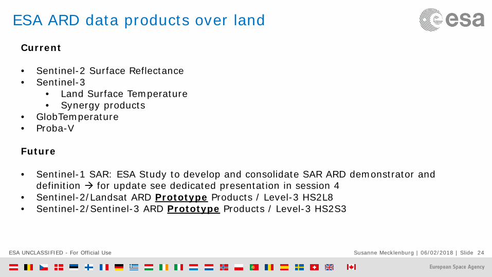
ESA ARD data products over land
Current • Sentinel-2 Surface Reflectance • Sentinel-3
• Land Surface Temperature • Synergy products
• GlobTemperature • Proba-V
Future • Sentinel-1 SAR: ESA Study to develop and consolidate SAR ARD demonstrator and
definition for update see dedicated presentation in session 4 • Sentinel-2/Landsat ARD Prototype Products / Level-3 HS2L8 • Sentinel-2/Sentinel-3 ARD Prototype Products / Level-3 HS2S3

ESA UNCLASSIFIED - For Official Use Susanne Mecklenburg | 06/02/2018 | Slide 25
Band 11 B11
Sentinel-2 ARD Products / Level-2A Surface Reflectance
General Sentinel-2 Surface reflectances provided on UTM-WGS84 projection and a MRPG-based tiling grid.
External reference datasets • DEM (PlanetDEM90) for orthorectification and topographic correction • O3 (ECMWF) for atmospheric correction • Land Cover (CCI) for cloud masking improvement
Processing approach Sen2Cor processor (Louis et al., 2017) including Dark Dense Vegetation (DDV) algorithm for aerosol optical thickness (AOT) estimation and APDA (Atmospheric Precorrected Differential Absorption) for water vapour estimation.
Input data Level-1C products
Coverage European coverage every 5 days since May 2017. Worldwide coverage every 5 days by mid-2018.
Spatial/temporal resolution 10/20/60m
Distribution channels • Copernicus Open Access Hub: https://scihub.copernicus.eu/

ESA UNCLASSIFIED - For Official Use Susanne Mecklenburg | 06/02/2018 | Slide 26
Sentinel-2 ARD Products / Level-2A Surface Reflectance • Systematic production over EEA39 areas started since May 2017. • Expansion to worldwide coverage by mid 2018.

ESA UNCLASSIFIED - For Official Use Susanne Mecklenburg | 06/02/2018 | Slide 27
New Sen2Cor 2.5
Several Bugs fixed.
Full compatibility to PSD 14.3
Backward PSD compatibility assured.
Improvement of Ozone selection.
Improvement of AOT retrieval
Improvement of Cloud Screening and Scene Classification over coastal/inland/muddy waters, urban areas/bright surfaces.
New version of Sen2Cor released (v2.5) supporting Sentinel-2B

ESA UNCLASSIFIED - For Official Use Susanne Mecklenburg | 06/02/2018 | Slide 28
Feedback from Sentinel-2 Validation Team on S2 L2A

ESA UNCLASSIFIED - For Official Use Susanne Mecklenburg | 06/02/2018 | Slide 29
Band 11 B11
Level-2A Product
L1C
L2A Scene Classification
AOT WV
L1C

ESA UNCLASSIFIED - For Official Use Susanne Mecklenburg | 06/02/2018 | Slide 30
Band 11 B11
Level-1C versus Level-2A Example
ESA UNCLASSIFIED - For Official Use Susanne Mecklenburg | 06/02/2018 | Slide 31
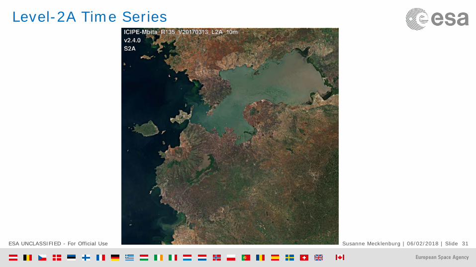
Band 11 B11
Level-2A Time Series

ESA UNCLASSIFIED - For Official Use Susanne Mecklenburg | 06/02/2018 | Slide 32
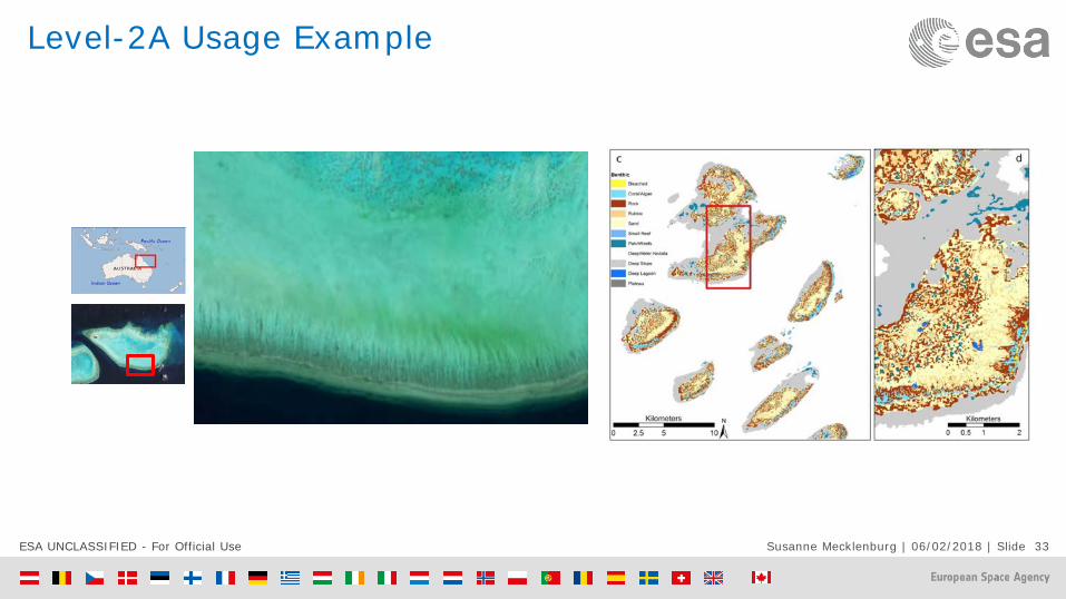
Level-2A Usage Example
Seoul National University: Agriculture
Sen2Coral project for coral reefs monitoring
Legend
UnclassifiedCornSoybean
ESA UNCLASSIFIED - For Official Use Susanne Mecklenburg | 06/02/2018 | Slide 33
Band 11 B11
Level-2A Usage Example
Band 11 B11

ESA UNCLASSIFIED - For Official Use Susanne Mecklenburg | 06/02/2018 | Slide 34
Band 11 B11
Level-2A performances from ACIX
MSI Band 4 Red, 665 nm

ESA UNCLASSIFIED - For Official Use Susanne Mecklenburg | 06/02/2018 | Slide 35
Band 11
Sentinel-2/Landsat ARD Prototype Products Level-3 HS2L8
General Prototype products HS2L8 (Harmonisation Sentinel-2 and Landsat-8) combining both missions in a single fused product on the common bands of both missions and at the spatial resolution of Sentinel-2 bands.
External reference datasets • DEM (PlanetDEM90) for orthorectification and topographic correction • O3 (ECMWF) for atmospheric correction. • AOT(ECMWF) for atmospheric correction. • WV (ECMWF) for atmospheric correction.
Processing approach • Atmospheric corrections short-term solution with SMAC (Rahman & Dedieu, 1994) and mid-term solution with Sen2Cor (expanded to correct Landsat-8 data).
• Fusion approach based on STAR-FM method (Gao et al., 2006). • BRDF correction (Roy et al., 2016).
Input data Sentinel-2 Level-2A and Landsat-8 Level-1T products.
Coverage N/A
Spatial/temporal resolution 10/20/60m
Distribution channels N/A

ESA UNCLASSIFIED - For Official Use Susanne Mecklenburg | 06/02/2018 | Slide 36
Band 11
S2 ARD Prototype Products / Level-3 HS2S3
General Prototype products HS2S3 (Harmonisation Sentinel-2 and Sentinel-3 OLCI) combining both missions in a single fused product on Sentinel-2 VNIR bands and using the spectral and spatial resolution of Sentinel-2 VNIR bands and the temporal resolution of Sentinel-3.
External reference datasets • DEM (PlanetDEM90) for orthorectification and topographic correction • O3 (ECMWF) for atmospheric correction. • AOT(Aeronet) for atmospheric correction. • WV (ECMWF) for atmospheric correction.
Processing approach • Atmospheric corrections with SMAC (Rahman & Dedieu, 1994). • Fusion approach based on STAR-FM method (Gao et al., 2006).
Input data Sentinel-2 Level-1C and Sentinel-3 OLCI Level-1B.
Coverage N/A
Spatial/temporal resolution 10m
Distribution channels N/A

ESA UNCLASSIFIED - For Official Use Susanne Mecklenburg | 06/02/2018 | Slide 37
Sentinel-3 Land Surface Temperature (LST) “quasi ARD-ready”
General Land Surface Temperature (LST) is retrieved from thermal radiances measured by the Sea and Land Surface Temperature Radiometer (SLSTR)
External reference datasets
• Pressure, temperature, and water vapour (ECMWF – Atmospheric HRES-10 day dataset) • Carbon dioxide, nitric acid, chlorofluorocarbons (CFCs) and ozone (RAMIgclim; Remedios
et al, 2007) • Globcover Land Cover (reduced-resolution ~1 km) • Fractional vegetation cover climatology
Processing approach Evolution of the LST algorithm developed for the Advanced Along track Radiometer (AATSR) by CSIRO (Prata 2002) (Ref: S3-L2-SD-03-T03-ULNILU-ATBD_L2LST, 2012)
Input data 11 and 12 µm channels brightness temperature of the SLSTR nadir view
Coverage • Global coverage
Spatial/temporal resolution
• 1 km • 2 days at the equator
Distribution channels Sentinel data Hub: https://scihub.copernicus.eu/dhus/#/home

ESA UNCLASSIFIED - For Official Use Susanne Mecklenburg | 06/02/2018 | Slide 38
Sentinel-3 Synergy “quasi ARD-ready” General Sentinel-3 Synergy products are obtained combining information from the OLCI and SRTL
instruments. The standard product is a 300m SDR product. Moreover we provide SPOT VGT-like products in Plate Carrée projection to be consistent with standard 1 km SPOT Vegetation products consisting of instantaneous acquisition, daily and 10 day composites.
External reference datasets
• Auxiliary data: O3, Water vapour, and surface pressure (ECMWF) • OLCI and SLSTR Lev-1B ortho-geolocated using GETASSE30 DEM
Processing approach • AOT estimation (North et al., 2010) • Level-1C resampling adopting OLCI as reference image grid • Currently cloud detection based on operational OLCI cloud mask • Ice/snow detection uses the results of the OLCI L2 Pixel classification • Level-2 SDR retrieval(Sentinel-3 Synergy products ATBD – North, Heckel, 2010)
Input data • TOA reflectance data for the 6 solar reflective SLSTR at both nadir and forward views an 18 OLCI bands at all non-absorbing channels (bands 14,15,20)
Coverage • Common part of the OLCI and SLSTR nadir view swaths for the daylight part of the SENTINEL-3 orbit, i.e. the entire OLCI swath: ~1 270 km. Two days at the equator
Spatial/temporal resolution
• 300 m for Synergy L2 SDR and 1 km for VGT-like products (Daily and 10 day)
Distribution channels Sentinel data Hub: https://scihub.copernicus.eu/dhus/#/home (Currently only Exp. Hub)

ESA UNCLASSIFIED - For Official Use Susanne Mecklenburg | 06/02/2018 | Slide 41
Globe Temperature “quasi ARD-ready” General The aim of ESA's GlobTemperature project is to promote the wider uptake of global-scale
satellite LST, to merge LST data set from thermal infrared (geostationary & polar orbiter) and passive microwave satellite data to provide best possible coverage, including information on the diurnal cycle and clear-sky bias.
External reference datasets
All datasets used at single sensor level for generating L2-LST products
Processing approach • Level-2: geophysical variables derived from the Level 1b source data from a single orbit of a sensor at the same resolution and location as the Level 1b data
• Level-3: “uncollated” – single sensor data regridded and/or spatially averaged onto a spatial grid without combination of observations from overlapping orbits; “collated” - multiple orbits from a single sensor have been combined onto a spatial/temporal grid
• Level-4:datasets constructed from multiple orbits and sensor • Complete description of all processing variables at L2-4 in GlobT-WP3-DEL-11, 2018
(Globtemp Product user Guide)
Input data Land Surface Temperature (LST) data sets from: (A)ATSR; SEVIRI; SSM/I; AMSR-E, MODIS, JAMI, GOES, MTSAT, ATSR-CDR; SLSTR
Coverage • Global coverage
Spatial/temporal resolution
• 1 km for merged dataset • 3 hourly daily for merged dataset
Distribution channels GlobTemperature Project portal: http://data.globtemperature.info/

ESA UNCLASSIFIED - For Official Use Susanne Mecklenburg | 06/02/2018 | Slide 42
Proba-V Surface Reflectances “quasi ARD-ready” General Proba-V Top-Of-Canopy (TOC) Reflectances provided as synthesis products in Plate
Carrée projection for different compositing period: 1-day, 5-days (for 100m), 10-days [Specs in continuity with SPOT-VGT data record]
External reference datasets
• DEM (GLSDEM) for hortorectification and surf pressure • WV (ECMWF) and O3 (TOMS climatology) for A/C • Surface Reflectance climatology (MERIS) and Land Cover (CCI) for cloud masking
Processing approach • Cloud/Shadow/Snow masking (Wolters et al. 2017) • AOT estimation (Maisongrande et al., 2004) • A/C using SMAC (Rahman et al., 1994) • Compositing using MVC (Holben, 1986)
Input data • L2-B (intermediate product, not for users): atmospherically corrected segment files to be combined in the synthesis products
Coverage • Global quasi-daily coverage, two days for [-35°:35°]
Spatial/temporal resolution
• 1km and 333m with quasi-daily revisit • 100 m 5-days revisit
Distribution channels • VITO PDF portal: http://www.vito-eodata.be/PDF/ • Proba-V MEP: https://proba-v-mep.esa.int

ESA UNCLASSIFIED - For Official Use Susanne Mecklenburg | 06/02/2018 | Slide 43
ESA’s contribution to ARD - outlook • “Quasi” compliant to ARD Product Family Specifications • DOI planned for product type (e.g. LST) and in future also algorithm (e.g. LST retrieval)
identification • New ARD activities
• Prototype products over land being developed • ESA Study to develop and consolidate SAR ARD demonstrator and definition
• On-going evaluation for the Evolution of the Digital Elevation Model (DEM) used in the Copernicus Space Component Data Processing; ESA performing study to provide recommendations for the evolution of the DEM to be used for the generation of Copernicus Space Component (CSC) core products:
• Collect DEM requirements from the different CSC elements (i.e. Sentinel missions and Copernicus Contributing Missions).
• Identify different candidate DEM available. • Provide preliminary quantitative assessment of the impact of the pre-selected DEMs on
the different missions’ products data quality and on the production operational set-up. • Financial assessment (cost, license, maintenance …). • Final conclusions and recommendations for the choice of the DEMs (by April 2018).

ESA UNCLASSIFIED - For Official Use Susanne Mecklenburg | 06/02/2018 | Slide 44
Day 3: Thursday, 1 March 2018 Session 3: Harmonization and Consistency
09:00 – 09:30 Keynote: Reaching new users through the CEOS Analysis Ready Data for Land (CARD4L) Framework
Steven Hosford, ESA, Italy
09:30 – 09:50 Quality assessment of the Level-2 Sentinel-2 products through the Harmonized Landsat and Sentinel-2 (HLS) data set
Martin Claverie, UCLouvain, Belgium
09:50 – 10:10 Towards achieving continental scale field validation and multi-sensor interoperability of satellite derived surface reflectance in Australia
Medhavy Thankappan, Geoscience Australia, Australia
10:10 – 10:30 Validating PCI ARD data with Sen2Cor and LaSRC including BRDF correction and Topographic Normalization.
Wolfgang Lück, Pci Geomatics, Canada
10:30 – 10:50 A new ‘system state vector’ of optical, thermal and microwave EO data for terrestrial change detection
Mathias Disney, UCL Geography, UK

ESA UNCLASSIFIED - For Official Use Susanne Mecklenburg | 06/02/2018 | Slide 45
Take home messages • The Copernicus Space Component delivers high quality and timely data to the user
community • Current fleet of missions: nominal operations and all core data products released • C/D units in preparation • Long-term Scenario/ future Sentinel extension and expansion/ consolidated
• ESA’s provides important contribution to FDA activities • Excellent Copernicus data access service provided, including data provision working in
partnership in international environment • DIAS contracts now up and running
• ESA’s data products over land provide a considerable contribution to the CEOS ARD portfolio and are “quasi” compliant to ARD principles
• New ARD activities triggered by ESA • ESA lead for MRI activities has been appointed: Ferran Gascon (Sentinel-2 mission
manager)