Erosion Datas
25
• About this Project • • Resources • • Glossary • • Feedback • Home • 1. Up date Wetland Maps • 2. Estimate Wetland Loss • 3. Identify Priority Wetlands ○ 3a. Assess Wetland Functions (desktop) ○ 3b. Evaluate Vulnerability ○ 3c. Assess Wetland Functions (field) • 4. Estimate Wetland Values • 5. Protect Wetlands
-
Upload
bizimana-anthere -
Category
Documents
-
view
235 -
download
0
Transcript of Erosion Datas
8/3/2019 Erosion Datas
http://slidepdf.com/reader/full/erosion-datas 1/25
• About this Project
•
• Resources
•
• Glossary
•
• Feedback
• Home •
• 1. Update Wetland Maps •
• 2. Estimate Wetland Loss •
• 3. Identify Priority Wetlands ○
○ 3a. Assess Wetland Functions (desktop) ○
○ 3b. Evaluate Vulnerability ○
○ 3c. Assess Wetland Functions (field) •
• 4. Estimate Wetland Values •
• 5. Protect Wetlands
8/3/2019 Erosion Datas
http://slidepdf.com/reader/full/erosion-datas 2/25
Home 5. Protect Wetlands
Protect Wetlands Locally
Local governments play a key role in filling the gaps in wetland protection, because they
have primary responsibility for local land use management. Local action is particularly
critical in states that do not have comprehensive wetland protection programs. Protect
Wetlands Using Regulatory or Voluntary Measures provides a review of regulatory and non-
regulatory options for local governments. Ideally, a combination of approaches will be used.
Managing wetlands at the watershed scale can help minimize indirect impacts to
wetlands. Direct impacts to wetlands include the removal or addition of material such as
dredging, filling, or draining that are largely regulated through the federal and state wetland
permitting process. Indirect impacts such as altered hydrology, increased pollutant
loadings, and buffer encroachment caused by urbanization are summarized in Wetlands &
Watersheds Article 1. Using a watershed approach allows communities to make betterchoices about preserving the highest quality wetlands, protecting the most vulnerable
wetlands, and finding the best sites for wetland restoration. Wetlands & Watersheds Article
2 provides detailed information on using local watershed plans to protect wetlands.
Protect Wetlands Using Regulatory or Voluntary Measures
Communities vary greatly in their size, technical and financial resources, development
review process, and prior experience in wetland management and watershed planning. A
menu of different wetland protection techniques that communities can choose from to
protect wetlands from direct and indirect impacts is provided in Table 5.1.
The protection techniques are organized by the eight tools of watershed protection that
represent a comprehensive approach to protect wetlands in watersheds facing land
development (derived fromWetlands & Watersheds Article 3). The eight tools roughly
correspond to the stages of the development cycle including initial land use planning, site
design and construction, and ultimate occupancy and long-term maintenance. Each of the
eight tools should be specifically applied to protect unique wetland resources in watersheds
that may be vulnerable to impacts from future development. Communities should examine
the numerous techniques within each category that best protects wetlands identified as
priorities. Some techniques are more restrictive than others, and the choice of techniques
depends on the future wetland protection needs in the community, as well as the capacity of
the community to implement the techniques.
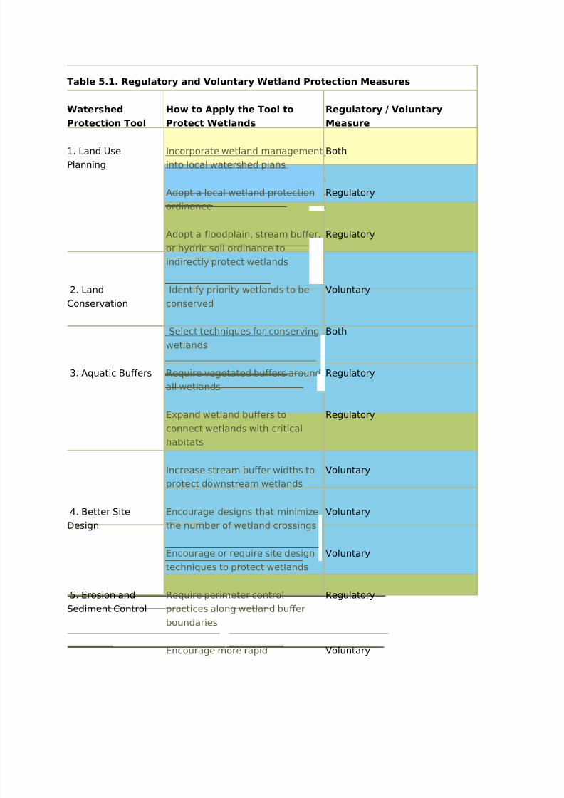
Click on the links in Table 5.1 below to read a description of each regulatory and voluntary
wetland protection measure, as well as case studies as available and additional
information. Wetlands & Watersheds Article 3 provides more detailed information about
each approach.
8/3/2019 Erosion Datas
http://slidepdf.com/reader/full/erosion-datas 3/25
Table 5.1. Regulatory and Voluntary Wetland Protection Measures
Watershed
Protection Tool
How to Apply the Tool to
Protect Wetlands
Regulatory / Voluntary
Measure
1. Land Use
Planning
Incorporate wetland management
into local watershed plans
Both
Adopt a local wetland protection
ordinance
Regulatory
Adopt a floodplain, stream buffer,
or hydric soil ordinance to
indirectly protect wetlands
Regulatory
2. Land
Conservation
Identify priority wetlands to be
conserved
Voluntary
Select techniques for conserving
wetlands
Both
3. Aquatic Buffers Require vegetated buffers around
all wetlands
Regulatory
Expand wetland buffers toconnect wetlands with critical
habitats
Regulatory
Increase stream buffer widths to
protect downstream wetlands
Voluntary
4. Better Site
Design
Encourage designs that minimize
the number of wetland crossings
Voluntary
Encourage or require site design
techniques to protect wetlands
Voluntary
5. Erosion and
Sediment Control
Require perimeter control
practices along wetland buffer
boundaries
Regulatory
Encourage more rapid Voluntary

8/3/2019 Erosion Datas
http://slidepdf.com/reader/full/erosion-datas 4/25
stabilization near wetlands
Reduce disturbance thresholds
that trigger ESC plans
Regulatory
Increase ESC requirements
during rainy season
Regulatory
Encourage use of site
fingerprinting or construction
phasing
Voluntary
Increase frequency of site
inspections
Both
6. Stormwater
Treatment
Prohibit use of natural wetlands
for stormwater treatment
Regulatory
Restrict discharges of untreated
stormwater to natural wetlands
Regulatory
Discourage installation of
stormwater treatment practices
within wetland boundaries
Voluntary
Discourage constrictions at
wetland outlets
Voluntary
Encourage progressive
stormwater management
techniques
Voluntary
Develop special sizing criteria for
stormwater treatment practices
Regulatory
Promote effective stormwater
treatment practices to protect
downstream wetlands
Voluntary
7. Non-Stormwater
Discharges
Conduct illicit discharge surveys
for all outfalls to wetlands
Voluntary
8/3/2019 Erosion Datas
http://slidepdf.com/reader/full/erosion-datas 5/25
Actively enforce restrictions on
dumping in wetlands and their
buffers
Regulatory
Require enhanced nutrientremoval from on-site wastewater
treatment systems
Regulatory
Require regular septic system
inspections
Regulatory
8. Watershed
Stewardship
Incorporate wetlands into
watershed education programs
Voluntary
Post signs to identify wetlands,buffers, and wetland drainage
area boundaries
Voluntary
Manage invasive wetland plants Voluntary
Establish volunteer wetland
monitoring and adoption
programs
Voluntary
Encourage wetland landowner
stewardship
Voluntary
Establish partnerships for funding
and implementing wetland
projects
Voluntary
Key
Strategies that address direct impacts to wetlands
Strategies that address indirect impacts to wetlandsStrategies that address both indirect and direct impacts to wetlands
Incorporate Wetland Management into Local Watershed Plans
Incorporating wetland protection into the local watershed planning process can help
minimize impacts to wetlands and identify priority wetlands to be conserved. During the
watershed planning process, local wetlands must be inventoried, assessed, managed, and
8/3/2019 Erosion Datas
http://slidepdf.com/reader/full/erosion-datas 6/25
prioritized on a watershed scale rather than on a site-by-site basis. This can be done
through an initial desktop inventory of wetlands based on available mapping, followed by a
detailed field assessment to verify the location of the wetland, function and condition.
Selecting priority wetlands for conservation will vary for each community. Factors to
consider when choosing wetland conservation sites include: aligning functions provided by
the wetland to existing community goals, location in the watershed, size and connection to
landscape features, ownership and vulnerability to future development. The wetland
inventory is then used by the community to make better choices to preserve the highest
quality wetlands, protect the most vulnerable wetlands, and find the best sites for wetland
restoration. By identifying the best wetland sites in advance of development, there is an
increased chance of permanent protection. Additionally, the watershed plan is shared with
the regulatory community as a proactive approach to inform wetland permit decisions made
by state and federal agencies, to affect compensatory mitigation decisions regarding
impacted wetland resources, or to identify opportunities for voluntary wetland conservation
and restoration programs.
CASE STUDY: Lake County, IL Advanced Identification (ADID) Study
Located in the Chicago suburbs, Lake County, Illinois was facing development pressure and
experiencing unwanted wetland loss. In order to protect the existing wetlands in the
County, a partnership with federal, state and local agencies was developed to complete an
Advanced Identification (ADID) study. The ADID study provides an inventory of high quality
wetland resources in the County that were defined as wetlands that provide the following
functions; habitat quality, stormwater storage, and water quality mitigation. The data from
the study provides upfront information on the location of wetlands designated for protection
which allows more predictability in the wetland permitting process. The study is used at the
federal level as an advisory document during federal 404 wetland permit reviews, at the
local level to inform local land use decisions, identify potential mitigation/restoration sites,
and identify potential sites for acquisition.
Source: Dreher, Elston, and Schaal (1992)
Adopt a Local Wetland Protection Ordinance
A local wetland protection ordinance can provide more stringent protection for a greater
range of wetland types than is currently being regulated by state and/or federal agencies.
Local wetland protection ordinances can restrict or require a special permit for certain
activities -- such as dredging, filling, clearing, and paving -- within wetland boundaries or
buffers. Communities can either adopt a new wetland protection ordinance or revise
existing ordinances such as zoning, erosion and sediment control, and stormwater
management ordinances.
CASE STUDY: A Model Local Ordinance to Protect Wetland Functions
Wetlands & Watersheds Article 4 presents a model wetland drainage area protection
8/3/2019 Erosion Datas
http://slidepdf.com/reader/full/erosion-datas 7/25
ordinance available for use by local governments to protect wetland functions. The model
ordinance aims to protect wetlands from indirect impacts not addressed under the Section
404 permit program. The model ordinance uses the following concepts and principles for
protecting wetlands: identifying sensitive wetlands, addressing wetland contributing
drainage areas, and applying wetland protection criteria.
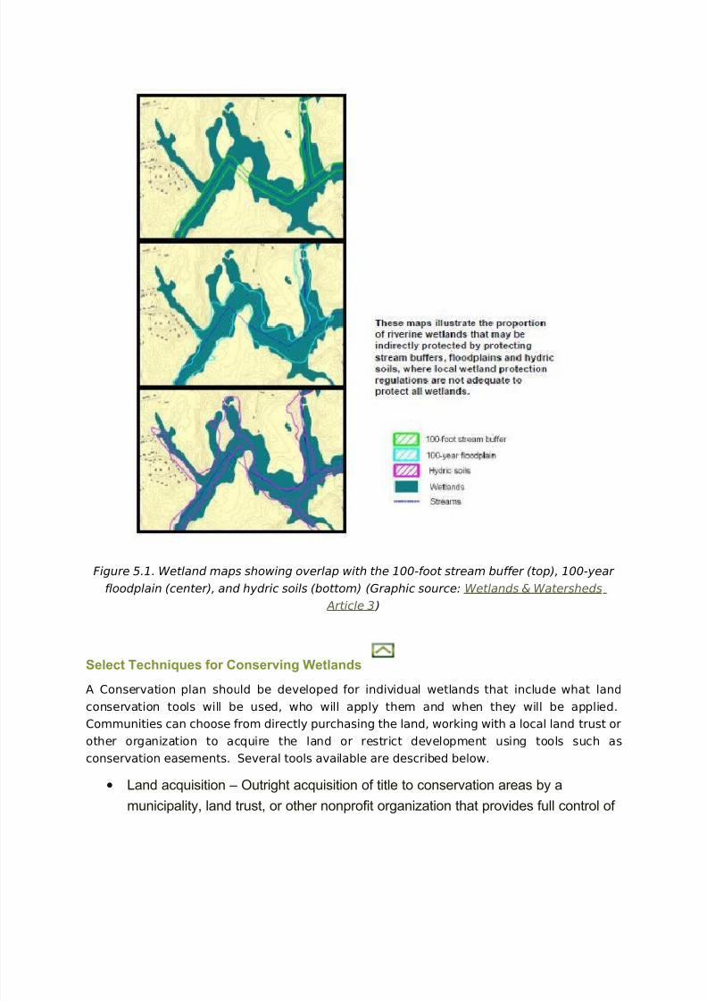
Adopt Floodplain, Stream Buffer, or Hydric Soil Ordinance to Indirectly Protect
Wetlands
As discussed in Update Local Wetland Maps, most communities lack a detailed inventory
of their wetlands and instead rely on federally available National Wetlands Inventory maps.
These maps are outdated and thus can result in a lack of comprehensive wetland
protection. In these cases, communities may choose to protect wetlands indirectly through
the protection of other natural resource features as a surrogate for wetlands such as
floodplains, stream buffers, and hydric soil features. Figure 5.1 provides an example of how
to overlap GIS layers with wetlands to provide significant wetland protection. A moredetailed approach to protecting local wetlands is provided in Update Local Wetlands
Maps.
8/3/2019 Erosion Datas
http://slidepdf.com/reader/full/erosion-datas 8/25
Figure 5.1. Wetland maps showing overlap with the 100-foot stream buffer (top), 100-year
floodplain (center), and hydric soils (bottom) (Graphic source: Wetlands & Watersheds
Article 3 )
Select Techniques for Conserving Wetlands
A Conservation plan should be developed for individual wetlands that include what land
conservation tools will be used, who will apply them and when they will be applied.
Communities can choose from directly purchasing the land, working with a local land trust or
other organization to acquire the land or restrict development using tools such as
conservation easements. Several tools available are described below.
• Land acquisition – Outright acquisition of title to conservation areas by a
municipality, land trust, or other nonprofit organization that provides full control of
8/3/2019 Erosion Datas
http://slidepdf.com/reader/full/erosion-datas 9/25
the land.
• Conservation easement or Purchase of Development Rights (PDRs) –
Conveyances of development rights necessary for protection of specific
conservation values from a property’s landowner to a municipality, land trust, or
other nonprofit organization. In a PDR program, the development rights are
purchased by the program.
• Transfer of Development Rights (TDRs) – Land use planning technique that
transfers development potential from environmentally sensitive areas, called
sending zones, to specific areas designated for growth, called receiving zones.
CASE STUDY: Eightmile River Watershed, Connecticut
The lower Connecticut River is home to internationally recognized tidal marsh communities,
exceptionally intact forest blocks and tributaries, and a multitude of creatures, including sixkinds of plants and animals that are rare or endangered worldwide. The Nature Conservancy
(TNC) has protected more than 4,000 acres in the Lower Connecticut River region since
1960. A key component of TNC’s Lower Connecticut River Program is community
partnerships, particularly in East Haddam, Lyme and Salem, the three towns through which
the Eightmile River flows. This tributary of the Connecticut has remarkably high water
quality, and is surrounded by large blocks of undeveloped forest. Despite more than 350
years of settlement, the area today is more than 80 percent forested. It comprises a variety
of habitats, from its cold, fast-flowing headwaters to the freshwater tidal marshes where it
meets theConnecticut.
Local government partners have been working with TNC to protectthe Eightmile River watershed by acquiring key parcels of land and conservation easements.
In October of 2004, the town of Lyme and TNC protected the town's highest conservation
priority, the 480-acre Jewett property. A total of 434 acres were purchased, while
conservation easements protected the remaining 46 acres for a total of $3,270,500. It was
one of the three largest unprotected parcels in the Eightmile River watershed, and includes
more than a mile of high quality tributaries of the Connecticut River. The land links a 1,000-
acre block of protected open space to the south with a 3,000-acre block to the northeast,
forming more than 10 miles of open space predominantly along the Eightmile River. The
cost of the acquisition was split by TNC and the town of Lyme. A portion of the town’s
funding came from the state Department of Environmental Protection Open Space andWatershed Protection grant program.
Source: TNC (no date)
Require Vegetated Buffers around all Wetlands
Wetland buffers provide numerous benefits including wildlife habitat, removal of pollutants
from runoff, reduction in erosion, temperature moderation, storage of floodwaters, increased
8/3/2019 Erosion Datas
http://slidepdf.com/reader/full/erosion-datas 10/25
aesthetic and recreational value, and providing a visual separation between wetlands and
developed areas. The benefits provided by the wetland buffer depend on the buffer width.
Widths of 50 -100 feet are recommended to protect wetland water quality, while widths of
100 to 300 feet or more are recommended for wetlands with important wildlife functions
(EOR, 2001; Chase et al., 1997; Castelle et al., 1992). Wetland buffer widths can be set for
all wetlands, or a community may choose to set buffer widths based on wetland type or
wetland functions performed. Communities can choose to require vegetated buffers around
wetlands through expanding or adding to a local wetland protection ordinance, adding
wetlands to an existing stream buffer ordinance, or incorporating wetland buffers into a
post-construction stormwater management ordinance.
CASE STUDY: Washington State Wetlands Rating System
Washington State Department of Ecology developed a rating system for wetlands based on
functions, values, sensitivity to disturbance, rarity, and replacement difficulty. Local
management decisions that are based on this rating include: the level of impact avoidancerequired, width of buffers necessary to protect from adjacent development, mitigation
acreage and replacement ratios, and permitted uses in wetlands. The wetlands rating
system includes four categories, ranging from the highest quality, rare wetland types
(Category I) to the smallest, and least diverse wetlands (Category IV). Category I wetlands
include Natural Heritage wetlands and bogs, and require a buffer width of 215 feet, while
only a 50 foot buffer is required for Category IV wetlands.
Source: WADOE (1993)
Expand Wetland Buffers to Connect Wetlands with Critical Habitats
Communities can provide for flexible wetland buffer widths that allow linking wetlands
together with high value upland habitats. Large, unbroken habitat areas are valuable for
habitat thus providing for improved habitat value and function of the wetland. In addition,
upland habitat adjacent to wetlands provide critical habitat for many semi-aquatic and
terrestrial ecotone species (Semlitsch and Jensen, 2001). Communities should be flexible in
their ordinance requirements to encourage the creation of large, contiguous habitat areas
and linkages between these areas.
CASE STUDY: King County, Washington Critical Areas Ordinance
King County, Washington’s Critical Areas Ordinance states that an increase in buffer width of
50 feet may be required for certain wetland types if located within 300 feet of priority
habitat areas, as defined by the state. Alternatively, the developer may provide a relatively
undisturbed vegetated corridor at least 100 feet wide between wetlands and all priority
habitat areas located within 300 feet of the wetland, provided this corridor is protected by
easement.
Source: King County, Washington (2005)

8/3/2019 Erosion Datas
http://slidepdf.com/reader/full/erosion-datas 11/25
Increase Stream Buffer Widths to Protect Downstream Wetlands
Wetland buffers can’t provide protection from all activities within the wetland drainage
area. To provide for extra protection, communities can increase the stream buffer width on
tributaries to sensitive wetland drainage areas or on direct tributaries to sensitive wetlands.
Changes to a community’s stream buffer ordinance can be made to reflect increased buffer
widths for streams that drain to sensitive wetlands.
Encourage Designs that Minimize the Number of Wetland Crossings
Wetland crossings by roads or utilities often result in outlet constrictions and cause
hydrologic impacts to wetlands. Communities should limit the number of wetland crossings
in a new development by:
• Using efficient road layouts
• Focus development away from the wetlands
• Use existing crossings
• Use a single crossing for utilities and roads
Developers should be required to provide an inventory of natural resources before a site is
developed to allow for identification of sensitive areas and the design of the site to avoid
these areas at the early planning stages of site design. In addition, the local site plan review
process should coordinate with federal and state regulatory processes to determine whether
wetland impacts are minimized or avoided altogether.
Encourage or Require Site Design Techniques to Protect Wetlands
Use of Open Space Design
Open space design is a site layout technique that achieves the conservation of natural
resources on a lot by clustering the development on another portion of the lot. This design
creates less impervious cover, preserves forest and wetlands, and reduces stormwater
runoff. Communities can require open space design community-wide through their existing
subdivision regulations or may require the practice within a wetland protection overlay zone,
within drainage areas to sensitive wetlands, or on sites with wetlands. A local open space
design ordinance should require a percentage of existing open space be conserved for each
zoning district, define allowable and restricted uses for the open space, and an enforcementmechanism.
Utilize Natural Drainage Systems
During the development process, land is cleared and graded often resulting in soil
compaction and destruction of natural drainage ways. Communities can minimize these
impacts by combining the following goals into the site development regulations as shown in

8/3/2019 Erosion Datas
http://slidepdf.com/reader/full/erosion-datas 12/25
Figure 5.2.
• Avoid construction activity in the most sensitive areas
• Develop the site using the existing terrain
• Use the natural topography and vegetated waterways to convey runoff • Direct runoff to pervious areas for infiltration
Figure 5.2. Conventional development (top) versus development that works with the existing
topography (bottom) (Graphic source: MNSWAG, 1997)
CASE STUDY: The Villages of Thomas Run
When originally proposed, the Village of Thomas Run in Harford County, Maryland consisted
of 450 single-family homes on individual lots. The plan required extensive filling of wetlands
and five stream crossings. When the County rejected the proposal, citing adverse impacts
on wetlands, the developer hired a local planning and engineering consultant to redesign
the site. The revised plan called for townhomes to be clustered on upland portions of the
site. Careful designing of the site allowed nearly half of the site to be preserved as openspace, reduced the number of stream crossings, and greatly minimized the impact to
wetlands.
Source: ULI (1994)
Require Perimeter Control Practices Along Wetland Buffer Boundaries
Perimeter controls at development sites are typically placed on the upland boundary of
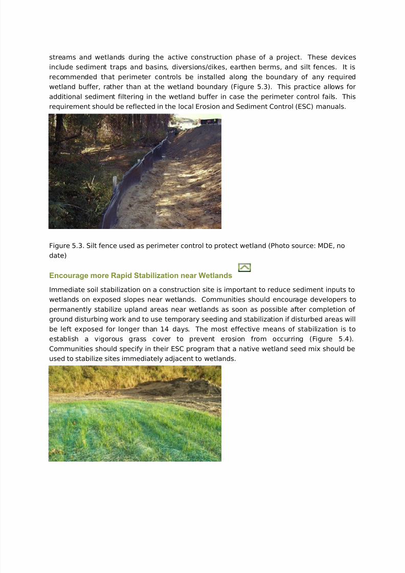
8/3/2019 Erosion Datas
http://slidepdf.com/reader/full/erosion-datas 13/25
streams and wetlands during the active construction phase of a project. These devices
include sediment traps and basins, diversions/dikes, earthen berms, and silt fences. It is
recommended that perimeter controls be installed along the boundary of any required
wetland buffer, rather than at the wetland boundary (Figure 5.3). This practice allows for
additional sediment filtering in the wetland buffer in case the perimeter control fails. This
requirement should be reflected in the local Erosion and Sediment Control (ESC) manuals.
Figure 5.3. Silt fence used as perimeter control to protect wetland (Photo source: MDE, no
date)
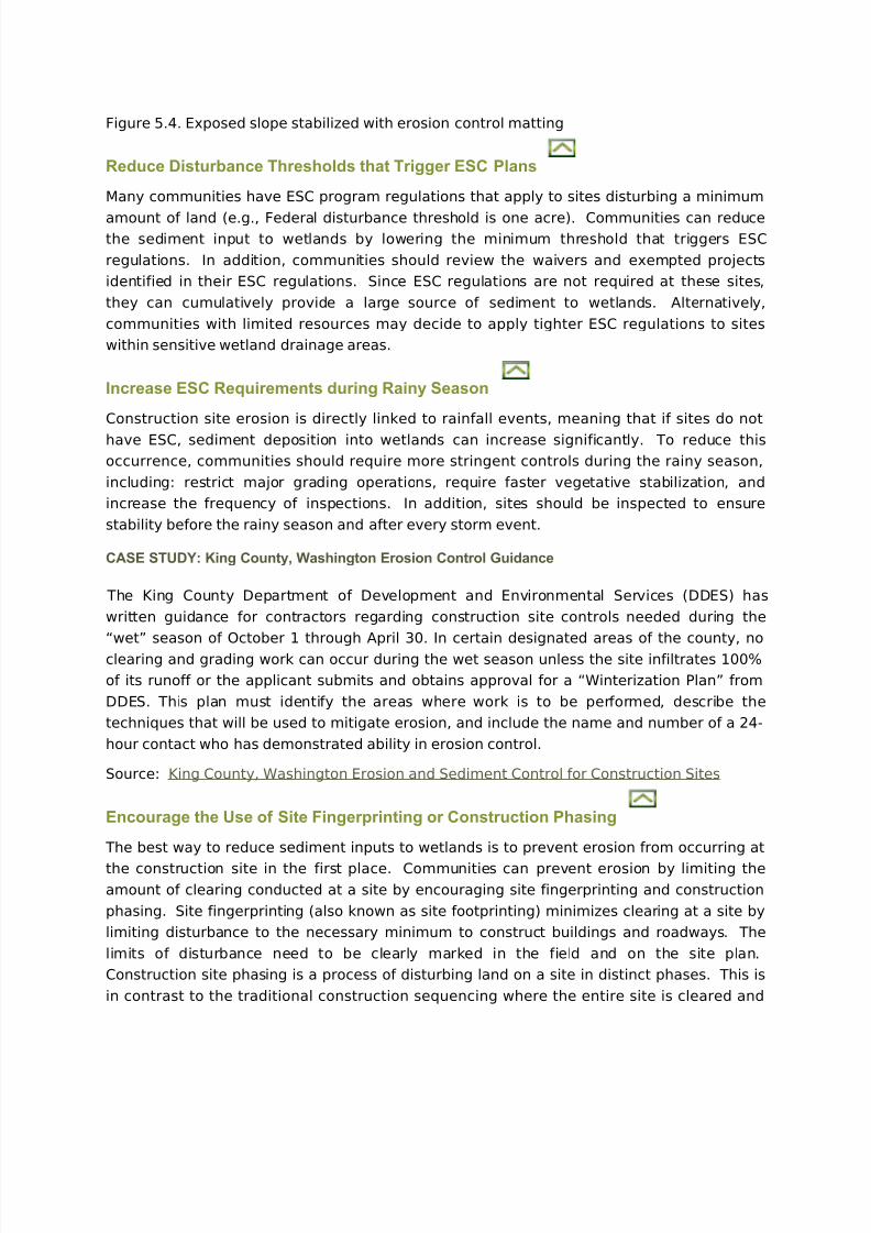
Encourage more Rapid Stabilization near Wetlands
Immediate soil stabilization on a construction site is important to reduce sediment inputs to
wetlands on exposed slopes near wetlands. Communities should encourage developers topermanently stabilize upland areas near wetlands as soon as possible after completion of
ground disturbing work and to use temporary seeding and stabilization if disturbed areas will
be left exposed for longer than 14 days. The most effective means of stabilization is to
establish a vigorous grass cover to prevent erosion from occurring (Figure 5.4).
Communities should specify in their ESC program that a native wetland seed mix should be
used to stabilize sites immediately adjacent to wetlands.
8/3/2019 Erosion Datas
http://slidepdf.com/reader/full/erosion-datas 14/25
Figure 5.4. Exposed slope stabilized with erosion control matting
Reduce Disturbance Thresholds that Trigger ESC Plans
Many communities have ESC program regulations that apply to sites disturbing a minimum
amount of land (e.g., Federal disturbance threshold is one acre). Communities can reducethe sediment input to wetlands by lowering the minimum threshold that triggers ESC
regulations. In addition, communities should review the waivers and exempted projects
identified in their ESC regulations. Since ESC regulations are not required at these sites,
they can cumulatively provide a large source of sediment to wetlands. Alternatively,
communities with limited resources may decide to apply tighter ESC regulations to sites
within sensitive wetland drainage areas.
Increase ESC Requirements during Rainy Season
Construction site erosion is directly linked to rainfall events, meaning that if sites do not
have ESC, sediment deposition into wetlands can increase significantly. To reduce this
occurrence, communities should require more stringent controls during the rainy season,
including: restrict major grading operations, require faster vegetative stabilization, and
increase the frequency of inspections. In addition, sites should be inspected to ensure
stability before the rainy season and after every storm event.
CASE STUDY: King County, Washington Erosion Control Guidance
The King County Department of Development and Environmental Services (DDES) has
written guidance for contractors regarding construction site controls needed during the
“wet” season of October 1 through April 30. In certain designated areas of the county, no
clearing and grading work can occur during the wet season unless the site infiltrates 100%
of its runoff or the applicant submits and obtains approval for a “Winterization Plan” from
DDES. This plan must identify the areas where work is to be performed, describe the
techniques that will be used to mitigate erosion, and include the name and number of a 24-
hour contact who has demonstrated ability in erosion control.
Source: King County, Washington Erosion and Sediment Control for Construction Sites
Encourage the Use of Site Fingerprinting or Construction Phasing
The best way to reduce sediment inputs to wetlands is to prevent erosion from occurring at
the construction site in the first place. Communities can prevent erosion by limiting the
amount of clearing conducted at a site by encouraging site fingerprinting and construction
phasing. Site fingerprinting (also known as site footprinting) minimizes clearing at a site by
limiting disturbance to the necessary minimum to construct buildings and roadways. The
limits of disturbance need to be clearly marked in the field and on the site plan.
Construction site phasing is a process of disturbing land on a site in distinct phases. This is
in contrast to the traditional construction sequencing where the entire site is cleared and
8/3/2019 Erosion Datas
http://slidepdf.com/reader/full/erosion-datas 15/25
graded at one time. Under construction site phasing, a portion of the site is cleared and
graded, infrastructure is installed, and the disturbed soil is stabilized before work begins on
the next phase. Since the amount of soil exposure is limited, this is a preventative approach
to ESC.
CASE STUDY: Mecklenburg County, North Carolina ESC Ordinance
Mecklenburg County, North Carolina has incorporated construction site phasing into its
erosion and sediment control ordinance. The County encourages contractors not to disturb
more than 20 acres at any one time. When an area larger than 20 acres is disturbed, the
corresponding ESC plan must contain five additional measures to ensure that soils are
exposed for the shortest amount of time possible. Included among these measures is
construction sequencing and construction phasing to “justify the time and amount of
exposure.”
Source: Mecklenburg County, North Carolina (2002)
Increase Frequency of Site Inspections
An important part of any ESC program is frequent inspections and enforcement. Surveys
reveal that 16% to 50% of ESC practices specified in plans are never installed or are
installed improperly (Paterson, 1994; Mitchell, 1993). These findings highlight the
importance of bi-weekly inspections and/or inspections after certain sized storms.
Communities can require more frequent ESC inspections within the drainage areas of
sensitive wetlands. In order to avoid overburdening local ESC inspectors, communities can
require contractors to hire an independent, certified erosion and sediment inspector to
ensure proper installation and performance of ESC practices.
Prohibit Use of Natural Wetlands for Stormwater Treatment
Allowing natural wetlands to treat stormwater runoff increases the depth of temporary or
permanent ponding in a wetland. Over time, the altered hydrology transforms a natural
wetland into a stormwater wetland with the loss of biological diversity and functional value.
To prevent this from occurring, communities should review their existing stormwater
ordinances to makes sure they prohibit the use of natural wetlands for stormwater
treatment.
Restrict Discharges of Untreated Stormwater to Natural WetlandsSince wetlands are located at the low point in the landscape, stormwater outfalls may
unintentionally be discharged to natural wetlands. To prevent this from occurring,
communities can require treatment of stormwater from new and existing stormwater pipe
outfalls that discharge directly to wetlands through a local stormwater ordinance. This
allows removal of pollutants, such as sediment and nutrients, and dissipates the velocity of
runoff into the wetland. In addition, communities may want to consider retrofitting existing
8/3/2019 Erosion Datas
http://slidepdf.com/reader/full/erosion-datas 16/25
stormwater outfalls that discharge to wetlands with some form of stormwater treatment.
Discourage Installation of Stormwater Treatment Practices within Wetland
Boundaries
Wetland buffers are intended to connect the wetland with upland habitat areas and providea transitional area of native vegetation that protects it from future disturbance or
encroachment. As a general rule, communities should strongly discourage the location of
large stormwater treatment practices, such as stormwater ponds or created wetlands, inside
the wetland buffer. In some cases, the use of a filter strip may be desirable in the wetland
buffer. This approach works well when the stormwater occurs as sheet flow or shallow
concentrated flow. When the stormwater becomes more concentrated, a stormwater
depression or bioretention area may need to be used at the buffer boundary to store and
release the increased runoff volumes.
Discourage Constrictions at Wetland OutletsConstrictions built below wetland outlets increase stormwater runoff to natural wetlands.
Constrictions may be caused by downstream culverts, bridges, dikes, roadway
embankments, stormwater embankments and other water control structures. Each type of
constriction has the potential to back water up into the wetland – increasing ponding or the
frequency of inundation. These hydrological alterations have strong influence on the
wetland plant community, and can cause dieback for some woody species, and may impact
other wetland dependant species. In order to avoid these impacts, communities should
carefully evaluate the effect of any proposed constriction in or near a wetland, either as part
of the preliminary site plan review process or as part of the local wetland permit review.
Encourage Progressive Stormwater Management Techniques
In situations where development is located near wetlands, communities should use
progressive stormwater management techniques to prevent a direct discharge or fill into the
wetland. These techniques use a combination of site design, source control, and stormwater
treatment approaches(Hirschman and Kosco , 2008):
1. Reduce runoff through design – use site planning and design techniques to
reduce impervious cover, disturbed soils and stormwater impacts.
2. Reduce pollutants carried by runoff – use source control and pollution prevention
practices to reduce the exposure of pollutants to rainfall and runoff.
3. Capture and treat runoff – design stormwater practices to collect and treat the
stormwater that is generated after applying the first 2 steps. This is
accomplished through the use of small-scale, distributed practices close to the
source of runoff (e.g. rain gardens and pervious parking) combined with
conventional practices (ponds and filters).
8/3/2019 Erosion Datas
http://slidepdf.com/reader/full/erosion-datas 17/25
Additional information is found in (Hirschman and Kosco , 2008) and Wetlands & Watersheds
Article 4.
Develop Special Sizing Criteria for Stormwater Treatment Practices
Local or state stormwater manuals or regulations outline the amount of stormwater runoff that needs to be managed for storm events of various sizes. These sizing criteria may
involve recharge, water quality, channel protection, overbank flooding, and extreme flood
control. Communities may adjust their existing stormwater sizing criteria to protect
wetlands from the indirect impacts of stormwater runoff. They can also require additional
information including a field investigation of any wetlands present at a development site to
determine their sensitivity, delineate the drainage area to the wetland, and evaluate
whether any additional runoff will be delivered to the wetland as a result of the proposed
project.
This information can be used to determine special sizing criteria to protect sensitive
wetlands. Components of special sizing criteria include the recharge volume, water quality
volume, channel protection volume and hydroperiod standards. These special stormwater
criteria are outlined in a model wetland ordinance that can be adopted by local
communities.
Recharge volume criteria are designed to maintain existing groundwater recharge rates at
development sites in order to preserve existing water table elevations and maintain wetland
hydrology. Since many sensitive wetlands depend on groundwater to maintain their natural
hydrology, communities may choose to require recharge to maintain predevelopment
recharge rates within sensitive wetland drainage areas.
The water quality volume captures and treats runoff from about 90% of the rain events eachyear into a stormwater treatment practice. Communities should ensure that the water
quality volume is fully treated before any stormwater is discharged to a down-gradient
wetland. For sensitive wetlands such as bogs or calcareous fens, a higher level of
stormwater treatment may be required.
The channel protection criteria is designed to prevent stream channel enlargement and
stream habitat degradation due to the increased frequency of bankfull and sub-bankfull
flows that follow urbanization( Schueler and Brown, 2004). Channel protection can be
applied to protect wetlands where future development faces a headwater stream that leads
directly to a wetland and where a large proportion of freshwater wetlands are located in or
near headwater stream channels that are expected to be impacted by increased stormwater
discharges.
Wetland hydroperiod refers to the extended duration of inundation and/or saturation of
wetland systems. Small changes in wetland hydroperiod can have negative effects in
sensitive wetlands. Communities can adopt hydroperiod standards into their existing
stormwater management regulations in order to maintain the existing wetland hydroperiod
in all sensitive wetlands.
8/3/2019 Erosion Datas
http://slidepdf.com/reader/full/erosion-datas 18/25
8/3/2019 Erosion Datas
http://slidepdf.com/reader/full/erosion-datas 19/25
area is very important in protecting sensitive wetlands. Within wetland drainage areas,
communities can review their stormwater design manuals to provide more guidance on the
use of infiltration and filtering practices as well as encourage the following Better Site
Design techniques:
• Disconnection of rooftops and other impervious surfaces from the stormdrain
network
• Use of pervious areas to treat runoff close to the source through recharge and
infiltration
• Use of swales rather than curb and gutters along streets wherever possible
• Conserve forests and other natural areas at the site to maintain predevelopment
hydrology
• Replant open or turf areas to achieve greater site forest cover or other native
vegetative cover
• Take care during clearing and construction to minimize the degree of soil
compaction
For additional information on the use of specific stormwater treatment practices to protect
wetlands refer to Wetlands & Watersheds Article 3 and Hirschman and Kosco (2008).
Conduct Illicit Discharge Surveys for all Outfalls to Wetlands
A storm drain that has measurable flow during dry weather containing pollutants is defined
as an “illicit discharge.” Sources of illicit discharges include cross-connections between the
sewer system and the storm drain system, as well as land use activities that illegally
discharge pollutants to the storm drain system. Storm drain outfalls can contribute a variety
of pollutants to a wetland during both dry and wet weather. A discussion of the impact of
urban stormwater pollutants to wetlands is provided in Wetlands and Watersheds Article 1.
To help protect wetlands from illicit discharges, communities can conduct illicit discharge
surveys for all outfalls that discharge directly to wetlands or are located within wetland
drainage areas. Brown et al. (2004) provides guidance on conducing illicit discharge surveys.
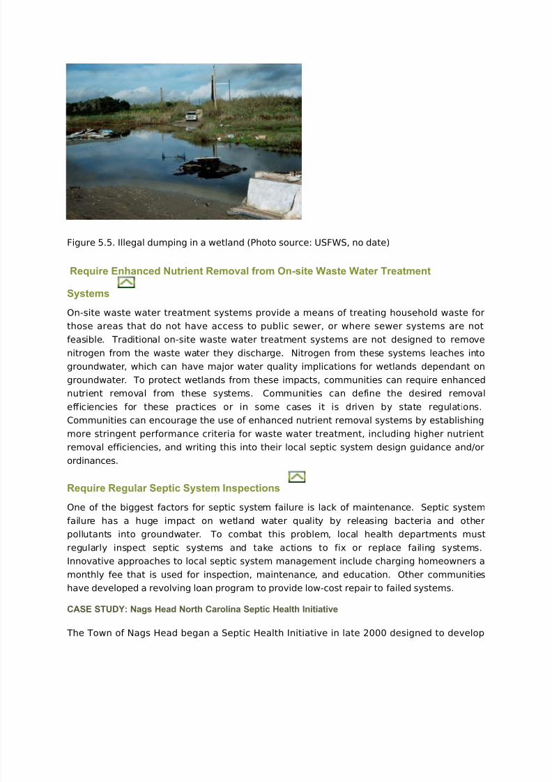
Actively Enforce Restrictions on Dumping in Wetlands and their Buffers
Illegal dumping is a problem in urban stream valleys and wetlands because these areas donot have obvious landowners, are not usually policed, and are often poorly lit (Figure 5.5).
Even though most communities have ordinances that prohibit dumping, they are difficult to
enforce. To combat this problem, communities should specifically identify wetlands and
buffers as restricted dumping areas, postNo Dumping signs, and make use of community
groups or adopt-a-wetland groups as monitors, and clearly define enforcement penalties.
8/3/2019 Erosion Datas
http://slidepdf.com/reader/full/erosion-datas 20/25
Figure 5.5. Illegal dumping in a wetland (Photo source: USFWS, no date)
Require Enhanced Nutrient Removal from On-site Waste Water Treatment
Systems
On-site waste water treatment systems provide a means of treating household waste for
those areas that do not have access to public sewer, or where sewer systems are not
feasible. Traditional on-site waste water treatment systems are not designed to remove
nitrogen from the waste water they discharge. Nitrogen from these systems leaches into
groundwater, which can have major water quality implications for wetlands dependant on
groundwater. To protect wetlands from these impacts, communities can require enhanced
nutrient removal from these systems. Communities can define the desired removal
efficiencies for these practices or in some cases it is driven by state regulations.Communities can encourage the use of enhanced nutrient removal systems by establishing
more stringent performance criteria for waste water treatment, including higher nutrient
removal efficiencies, and writing this into their local septic system design guidance and/or
ordinances.
Require Regular Septic System Inspections
One of the biggest factors for septic system failure is lack of maintenance. Septic system
failure has a huge impact on wetland water quality by releasing bacteria and other
pollutants into groundwater. To combat this problem, local health departments must
regularly inspect septic systems and take actions to fix or replace failing systems.Innovative approaches to local septic system management include charging homeowners a
monthly fee that is used for inspection, maintenance, and education. Other communities
have developed a revolving loan program to provide low-cost repair to failed systems.
CASE STUDY: Nags Head North Carolina Septic Health Initiative
The Town of Nags Head began a Septic Health Initiative in late 2000 designed to develop
8/3/2019 Erosion Datas
http://slidepdf.com/reader/full/erosion-datas 21/25
strategies and programs to improve the performance of septic systems in the Town. The
programs developed were based on the work of the Town of Nags Head Septic Health
Committee. This committee is composed of a cross-section of Town citizens sharing a deep
concern for the protection of water quality within and around the Town. The goals of the
Septic Health Committee in developing the Initiative were to improve septic systems
performance while maintaining acceptable surface and ground water quality, as well as
controlling the density of developed land by promoting the use of on-site waste systems.
The Septic Health Committee developed a series of four programs designed to improve the
performance of septic systems while gathering information about septic systems in the
town. The four programs are:
• Septic Tank Pumping and Inspection Program
• Water Quality Monitoring Program
• Education Program
• Decentralized Wastewater Management Plan
Click here for additional information.
Incorporate Wetlands into Watershed Education Programs
The general public is unaware of the benefits that wetlands provide and may have
misconceptions about wetlands, including the idea that wetlands function only as breeding
grounds for mosquitoes that carry the West Nile Virus. Communities have the challenge of
educating the public to overcome these barriers and provide information on the benefits of
wetlands. Key information that should be included in a wetland education program includes
providing information on how the average citizen can reduce inputs of nutrients and otherpollutants to wetlands, enhance or restore wetlands on their property, and provide input on
the federal wetland permitting process and state or local programs, where applicable.
Examples of wetland education resources include:
• USEPA Wetland Fact Sheet Series
• USACE – Recognizing Wetlands
• Digital Frog International – The Digital Field Trip to Wetlands
• Environmental Concern Wetland Information Website
•
Ducks Unlimited• University of Florida Wetland Extension
Post Signs to Identify Wetlands, Buffers, and Wetland Drainage Area
Boundaries
An important companion to any new local ordinance or wetland protection program is a
means of notifying the public of wetland values and/or new requirements. Signs are most

8/3/2019 Erosion Datas
http://slidepdf.com/reader/full/erosion-datas 22/25
commonly used to notify the public about ordinances that protect natural resources, such as
wetlands and their buffers. Signs are posted to identify the boundaries of the protected
area, to inform residents of restricted uses and penalties, and to educate residents as to
why these areas are protected. Communities should post signs around protected wetlands
and their buffers, and may even be used to identify the boundaries of sensitive wetland
drainage areas (Figure 5.6).
Figure 5.6. Sign posted at conserved wetland (Photo source: www.landandfarm.com)
Manage Invasive Wetland Plants
In disturbed wetland ecosystems invasive plants may become dominant because they are
tolerant of changes in hydrology and pollutant inputs. Common invasive plant species
include purple loosestrife, phragmites, reed canary grass, cattails, kudzu, multiflora rose,
Asiatic tearthumb, water hyacinth, and Eurasian watermilfoil. Invasive plant control
methods vary with each species and can range from simple measures, such as mowing, to
methods that require heavy equipment, herbicides, or burning. Most methods require
repeat application and constant monitoring, and will never fully eradicate the species from a
site. Therefore, communities should focus on the prevention of invasive species. Invasive
plant removal can be prioritized in sensitive wetlands and include control of invasive plants
with wetland restoration projects. Several resources for wetland invasive plant management
are listed below.
• American Wetlands Campaign Kit 2001: Common Invasive Wetland Plants
• University of Florida: Center for Aquatic and Invasive Plants
• USACE Jacksonville District: Biological Control of Exotic Aquatic and Wetland
Plants
• USACE: Aquatic Plant Control Research Program
http://www.saj.usace.army.mil/Divisions/Operations/Branches/InvSpecies/ControlMethods_Biological.htm
http://www.saj.usace.army.mil/Divisions/Operations/Branches/InvSpecies/ControlMethods_Biological.htm
http://www.saj.usace.army.mil/Divisions/Operations/Branches/InvSpecies/ControlMethods_Biological.htm
8/3/2019 Erosion Datas
http://slidepdf.com/reader/full/erosion-datas 23/25
• Aquatic Ecosystem Restoration Foundation
Establish Volunteer Wetland Monitoring and Adoption Programs
Communities can establish programs that engage citizen volunteers to monitor and ‘adopt’
wetlands in the watershed. Adopt-a-wetland programs are similar in concept to thesuccessful adopt-a-highway program – volunteers adopt a specific wetland and can perform
a range of general maintenance such as trash removal, invasive species removal, and buffer
plantings. These types of programs provide educational and research opportunities for
residents and can lead to increased concern, understanding, and stewardship or wetlands.
Another way to engage the community is through a wetland monitoring program that can
range from simple, qualitative assessments to more advanced monitoring including surveys
of invasive species, water quality, amphibians, and benthic macroinvertebrates. Volunteers
can range from school children to scout groups to senior citizen groups.
CASE STUDY: Oakdale, Minnesota Adopt-A-Wetland Program
The City of Oakdale, Minnesotaestablished an adopt-a-wetland program for community
groups, homeowner associations, businesses, or other interested parties who want to help
with the improvement and upkeep of a particular Oakdale wetland, pond, lake or stream.
Volunteers can select their own water body or have the City suggest one for them, and
choose from the following list of activities:
• Trash removal
• Invasive plant removal (e.g., buckthorn, purple loosestrife)
• Native buffer planting
• Water quality monitoring
• Wetland data collection
• Wetland monitoring
• Community education
Volunteers can conduct the activity as frequently as they wish, and have officially ‘adopted’
the wetland after having completed one activity. Volunteers receive an Adopt-A-Wetland
certificate, and a sign commemorating the volunteer group may be installed at the site. The
City has created an Adopt-A-Wetland How-To Kit, which contains instructional materials and
resources for adopting a wetland. This kit is available on the City’s website.
Source: City of Oakdale, Minnesota (no date)
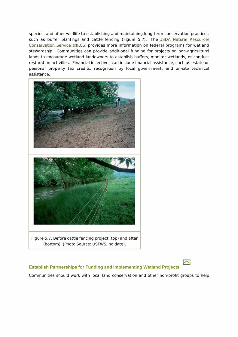
Encourage Wetland Landowner Stewardship
There are several federal funded programs through the USDA to implement wetland
conservation and restoration techniques on agricultural lands. These programs range from
cost-sharing assistance to landowners for developing habitat for threatened and endangered
8/3/2019 Erosion Datas
http://slidepdf.com/reader/full/erosion-datas 24/25
species, and other wildlife to establishing and maintaining long-term conservation practices
such as buffer plantings and cattle fencing (Figure 5.7). The USDA Natural Resources
Conservation Service (NRCS) provides more information on federal programs for wetland
stewardship. Communities can provide additional funding for projects on non-agricultural
lands to encourage wetland landowners to establish buffers, monitor wetlands, or conduct
restoration activities. Financial incentives can include financial assistance, such as estate or
personal property tax credits, recognition by local government, and on-site technical
assistance.
Figure 5.7. Before cattle fencing project (top) and after
(bottom). (Photo Source: USFWS, no date).
Establish Partnerships for Funding and Implementing Wetland Projects
Communities should work with local land conservation and other non-profit groups to help
8/3/2019 Erosion Datas
http://slidepdf.com/reader/full/erosion-datas 25/25
implement wetland conservation and restoration projects recommended as part of a
watershed plan. These groups can provide volunteers to monitor or maintain project sites or
implement simple projects, such as wetland buffer plantings. Other groups, such as land
trusts, can hold conservation easements or raise funds to acquire priority conservation
lands. A list of example potential partners can be found inWetlands & Watersheds Article 3.
CASE STUDY: Wetland Restoration in the San Francisco Bay Estuary
The San Francisco Bay Estuary is the Nation's second largest and perhaps the most
biologically significant estuary on the Pacific Coast. It has also suffered the most extensive
degradation of any estuary in the nation. Many years of filling, pollution, and alien species
invasions have taken a great toll on the ecosystem. Despite these losses, however, the San
Francisco Bay Estuary is now a major center for a vibrant habitat restoration movement.
The Bay Estuary's ecological value lies mainly in the wetlands along its edge, and in the
riparian habitats of streams and rivers feeding into it. These habitats are essential to the
health of the myriad fish and wildlife populations of the region. Millions of shorebirds and
waterfowl stop by during their annual migrations between Alaska and South America. The
Western Hemisphere Shorebird Reserve Network has designated the San Francisco Bay
Estuary as a site of "Hemispheric Importance" (its highest ranking), and the North American
Waterfowl Management Plan has listed it as one of 34 waterfowl habitats of major concern in
North America.
Over the past two decades, the San Francisco Bay Joint Venture (SFBJV) has made significant
progress to protect what remains and to begin restoring as much as possible of what was
lost. This partnership of public agencies, environmental organizations, the business
community, local governments, the agricultural community, and landowners works
cooperatively to protect, restore, increase, and enhance wetlands and riparian habitat in
the San Francisco Bay watershed.
The SFBJV helps partners put habitat restoration, acquisition and enhancement projects on
the ground by connecting partners with the funding opportunities, information and resources
they need to make projects happen. Over the past few years, the San Francisco Bay Joint
Venture (SFBJV) partners have completed 22 wetland protection, restoration, or
enhancement projects involving over 11,100 acres, with another 31,400 acres in progress.
Working with the SFBJV, Ducks Unlimited staff has created a comprehensive, yet user-
friendly habitat project tracking system that will help the SFBJV with their facilitation role
and help the partnership track regional progress towards their restoration goals.
Source: http://www.sfbayjv.org/
Resources for Protecting Wetlands Locally
Copyright 2010 • All rights reserved.