
Epithermal gold, and foreland faulting and magmatism ... · Epithermal gold, and foreland faulting...
2
BMR Research Newsleut!T 9 tonic graptolites. Separate latest Cambrian-Early Ordovician local stages, the Datsonian and Warrendian, have been established in the platform sequences of the Georgina Basin, with conodont zones of mainly North American aspect. When the Cambrian/Ordovician boundary is ratified inter• nationally, it is likely to be located within the Datsonian succession. The Ordovician/Silurian boundary is recognised in an apparently contin• uous succession near Darraweit Guim, north of Melbourne. For both the Silurian and Devonian, major international decisions, defining the Period boun• daries and many of the Series and Stage boun• daries, have had an immediate effect on correla• tion of Australian sequences. In the Silurian to Early Devonian, there have been advances in the use of conodonts, with the setting up of a zonation for most of the Early Silurian. In the later Devonian, the standard ammonoid zones are now better correlated with conodonts, as are bra• chiopod zones. An analysis of recent radiometric work shows the base of the Silurian can be confidently set at 434 Ma. The SilurianlDevonian boundary lies at approximately 408 Ma, but Australian data would suggest 410 Ma may be closer. Australian data also support the suggestion that the boundary with the Carboniferous lies at about 354 Ma. For the Carboniferous, three areas - western Europe, USSR, and North America - provide standard stratigraphic scales. Of these, the scale from western Europe is most appropriate for Australia, where the cosmopolitan shelly faunas of the Early Carboniferous (i.e Dinantian) are re• placed by el\demic, poorly diversified Gondwana faunas in the Late Carboniferous. Some radiometric (K/Ar) age data from the ' Hunter Valley have been used to provide age estimates for Stage boundaries. The Paterson Toscanite, with an average age of 308 Ma, would fall within the Westphalian C. The Visean/Namurian boundary lies at about 325 Ma, the base of the Brigantian Stage at 331 Ma, and the TournaisianlYisean boundary at about 342 Ma. For the Permian, an integrated correlation chart for Australia has been prepared using invertebrate faunas and microfloras. Following recent discus• sions of the Subcommission on Permian Stratigra• phy at the Carboniferous Congress in Beijing in 1987, a twofold subdivision of the System is favoured . For the Lower Permian, division into Asselian , Sakmarian, Artinskian , and Kungurian is recognised; for the Upper Permian, a fivefold division is used: Ufimian, Kazanian, Midian , Dzhulfian, and Changhsingian. For the Mesozoic, preliminary compilations of fossil zones are available for the Triassic, Jurassic, and Cretaceous. The available Cainozoic chart shows interrelationships between zones based on foraminifera (both assemblage zones and first and last appearance datums) , calcareous nannofossils, palynology (spores and pollen and dino• flagellates), molluscs, and land mammals. Con• siderable problems remain with the calibration of Australian local stages, and stratotypes of Bairns• dalean, Cheltenhamian, and Mitchellian may overlap. There is a need for firmer establishment of relationships of southern margin foraminiferal events with international scales, and a need too to establish ways of dating sequences in inland basins. Opportunities for relating biozones to radiometrically dated volcanics exist in the eastern highlands, where palynological assemblages are being recovered from sediments interbedded with basalts. For more informarion, conracr Dr Elizaberh Truswell ar BMR (Division of Conrinenral Geology). Furrher informarion on rhe APIRA projecr may be obrained from Mr 1. Cucuzzo, AU5rraiian Perroleum Indusrry Research Associa• rion, Ilrh Floor, 63 Exhibirion Srreer, Melbourne 3000. 4 October J 988 Epithermal gold, and foreland faulting and magmatism, Kalimantan, Indonesia Gold mineralisation, although widespread in Kalimantan, is particularly abundant in an east-trending belt up to 100 km wide that conforms to an uplifted and strongly faulted foreland basement high between latitudes 0° and IO N, and west of longitude 1l6°E (Fig_ 4). The gold deposits are thought to have formed as a result of hydrothermal activity associated with a Late Oligocene to Miocene igneous event (mainly sma ll, high-level intrusives) coeval with the uplift of the basement high. Although the gold is hosted by a wide variety of rock types (BMR Research Newsletter 8, 4-6), its distribu• tion is largely controlled by a complex system of faults. East of longitude 116°E the foreland belt remains poorly mapped, but swings northeas• terly. Regional geology: continent• continent collision The foreland belt is the southern part of a Late Cretaceous to Eocene orogen that formed as the result of southward subduction followed by coll• ision between two continental terranes. The north• ern terrane is the southern extension of southeast China and Indo-China. and represents an atten• uated and block-faulted passive margin; it is mostly covered by the South China Sea and Cainozoic sediments. The southern terrane is exposed in places in Kalimantan as basement comprising Palaeozoic to Jurassic deformed sedimentary, volcanic, and plutonic rocks, and their metamorphosed equivalents. Cretaceous to Early Eocene ophiolite, unstable shelf sediments and turbidites were intensely folded and fractured . low-grade-metamorphosed , thrust southward and possibly also northward, and incorporated in melange zones during convergence of the contin• ental terranes. At the same time granitoids were emplaced in the southern terrane (hanging plate) at various crustal levels; one phase was accompanied by intermediate volcanism. and acidic volcanics including ignimbrite were erupted in the Middle Eocene (too small to show in Fig. 4) and locally overlie the orogenic sediments and ophiolite. A remarkably synchronous Late Eocene uncon• formity that has been traced for hundreds of kilometres along the southern flank of the orogen, truncates the deformed sediments and ophiolite. The unconformity is overlain by terrestrial to shallow and open-marine Late Eocene to Oligocene foreland sediments with several vol• canic intercalations. However, convergence con• tinued, and in the foreland belt gave rise to foldings and thrusting, and locally to an unconfor• mity between the Late Eocene and Oligocene sediments. Foreland basement high In the Late Oligocene to Miocene, basement underlying the foreland was uplifted along an easterly trend and intruded by numerous plugs, stocks, dykes, and sills. The elongate basement high conforms to a Bouguer anomaly high, and uplift is thought to have been due to isostatic rebound of tectonically thickened crust after the collision. The shallow intrusives have a gran• odioritic composition, grading into granite and diorite; remnants of volcanic cones are preserved in places . The uplift of the foreland high was accompan• ied by three different types of faulting. (I) At several places the basement, where it is exposed in windows, is separated from overlying unstable shelf sediments, turbidite, ophiolite, or melange composed of these associations, by gently dipping detachment faults. The basement rocks are am• phibolite-facies metagranite, gneiss, schist, and metagabbro that show evidence of strong ductile deformation such as gently dipping mylonite. In contrast, the overlying rocks have been deformed in a brittle way, as shown by slickensiding and dense fracturing. Both cover and particularly basement are riddled with quartz veins, and rivers transecting the detachment faults are choked with milky quartz. In places chloritic breccia derived from the cover rocks also occurs. Apparently the cover rocks and basement were only juxtaposed after the basement had been emplaced at a high crustal level. (2) A second type of fault system is clearly expressed in the topography as fault-line valleys and long linear ridges. The faults are normal and steeply dipping and have tilted the foreland sediments to dips between 30-80°. It is not certain if these faults are planar or listric. or if they merge with the detachment faults. (3) The faults of the third category are steep to vertical and cut into the basement. They include thick zones of brecciation and shearing; horizontal slickensides indicate a component of strike-slip movement, but lateral displacements greater than 1- 2 km have not been documented. Between the Late Oligocene- Miocene mag• matic event and a phase of basaltic volcanism in the Pliocene- Pleistocene a conjugate fracture system was formed. usually at high angles to the mostly east-trending older structures. Displace• ment along these fractures is slight. Alteration Hydrothermal alteration is common where the rocks have been cut by all three types of faults, and especially also where these faults intersect the (earlier) thrust faults, and the melange and shear zones that formed during one of the compressive phases. So far two types of hydrothermal altera• tion have been recognised: silicification, and oxidation/argillisation. Silicification appears to be mostly associated with the detachment faults and steep faults that cut basement, and affects a wide range of rock types, including the basement, Cretaceous granitoids, Cretaceous to Early Eocene turbidites, etc, and the sediments and volcanics of the foreland sequence. The degree of silicification ranges from scattered quartz veining to almost complete replacement. The silicified rocks may contain epidote-c1inozoisite and chlorite, but pyrite is everywhere present. Oxidation/argillisa• tion is widespread in rocks of the foreland sedimentary and volcanic sequence where dis• placed by normal faults. The altered rocks are off• white to light orange-brown; pyrite is oxidised to limonite forming networks of black to brown crusts. Sandstone is commonly friable and ferruginous, and the other lithologies are more or less altered to clay. Remarkably, the subvoIcanic intrusives are only sporadically silicified, oxidised , or argillised, although commonly slight• ly propylitised. Gold The gold occurs in quartz veins and stockworks in the silicified zones, but is also disseminated, some being associated with pyrite. In the oxidisedl argillised rocks the gold is disseminated in clayey zones, but in friable sandstone it may form irregular coarse grains filling pores. Quartz vein• ing is minor in zones of oxidation/argillisation, but
Transcript of Epithermal gold, and foreland faulting and magmatism ... · Epithermal gold, and foreland faulting...
BMR Research Newsleut!T 9
tonic graptolites. Separate latest Cambrian-Early Ordovician local stages, the Datsonian and Warrendian, have been established in the platform sequences of the Georgina Basin, with conodont zones of mainly North American aspect. When the Cambrian/Ordovician boundary is ratified inter•nationally, it is likely to be located within the Datsonian succession. The Ordovician/Silurian boundary is recognised in an apparently contin•uous succession near Darraweit Guim, north of Melbourne.
For both the Silurian and Devonian, major international decisions, defining the Period boun•daries and many of the Series and Stage boun•daries, have had an immediate effect on correla•tion of Australian sequences. In the Silurian to Early Devonian , there have been advances in the use of conodonts, with the setting up of a zonation for most of the Early Silurian. In the later Devonian, the standard ammonoid zones are now better correlated with conodonts, as are bra•chiopod zones. An analysis of recent radiometric work shows the base of the Silurian can be confidently set at 434 Ma. The SilurianlDevonian boundary lies at approximately 408 Ma, but Australian data would suggest 410 Ma may be closer. Australian data also support the suggestion that the boundary with the Carboniferous lies at about 354 Ma.
For the Carboniferous, three areas - western Europe, USSR, and North America - provide standard stratigraphic scales. Of these, the scale from western Europe is most appropriate for Australia , where the cosmopolitan shelly faunas of the Early Carboniferous (i.e Dinantian) are re•placed by el\demic, poorly diversified Gondwana faunas in the Late Carboniferous. Some radiometric (K/Ar) age data from the ' Hunter Valley have been used to provide age estimates for Stage boundaries. The Paterson Toscanite, with an average age of 308 Ma, would fall within the Westphalian C. The Visean/Namurian boundary lies at about 325 Ma, the base of the Brigantian Stage at 331 Ma, and the TournaisianlYisean boundary at about 342 Ma.
For the Permian, an integrated correlation chart for Australia has been prepared using invertebrate faunas and microfloras. Following recent discus•sions of the Subcommission on Permian Stratigra•phy at the Carboniferous Congress in Beijing in 1987, a twofold subdivision of the System is favoured . For the Lower Permian, division into Asselian , Sakmarian, Artinskian , and Kungurian is recognised; for the Upper Permian , a fivefold division is used: Ufimian , Kazanian , Midian , Dzhulfian, and Changhsingian.
For the Mesozoic, preliminary compilations of fossil zones are available for the Triassic , Jurassic, and Cretaceous. The available Cainozoic chart shows interrelationships between zones based on foraminifera (both assemblage zones and first and last appearance datums) , calcareous nannofossils , palynology (spores and pollen and dino•flagellates), molluscs , and land mammals. Con•siderable problems remain with the calibration of Australian local stages, and stratotypes of Bairns•dalean , Cheltenhamian, and Mitchellian may overlap. There is a need for firmer establishment of relationships of southern margin foraminiferal events with international scales, and a need too to establish ways of dating sequences in inland basins. Opportunities for relating biozones to radiometrically dated volcanics exist in the eastern highlands , where palynological assemblages are being recovered from sediments interbedded with basalts.
For more informarion, conracr Dr Elizaberh Truswell ar BMR (Division of Conrinenral Geology). Furrher informarion on rhe APIRA projecr may be obrained from Mr 1. Cucuzzo, AU5rraiian Perroleum Indusrry Research Associa•rion, Ilrh Floor, 63 Exhibirion Srreer , Melbourne 3000.
4
October J 988
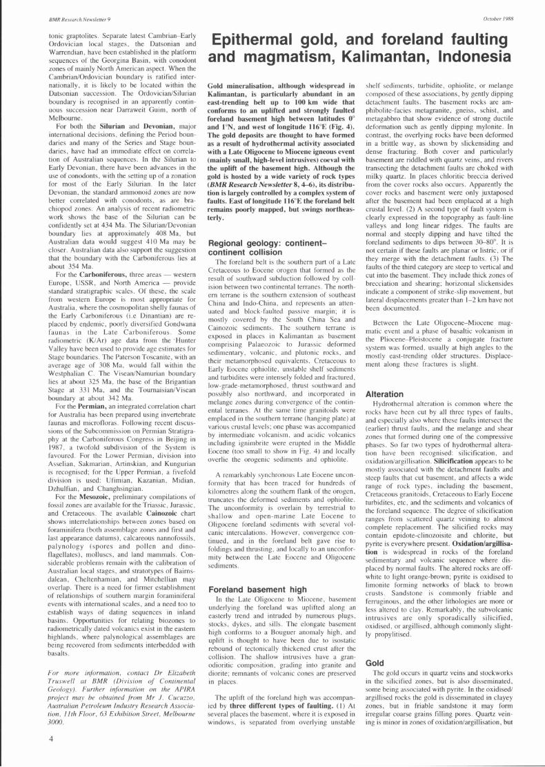
Epithermal gold, and foreland faulting and magmatism, Kalimantan, Indonesia Gold mineralisation, although widespread in Kalimantan, is particularly abundant in an east-trending belt up to 100 km wide that conforms to an uplifted and strongly faulted foreland basement high between latitudes 0° and ION, and west of longitude 1l6°E (Fig_ 4). The gold deposits are thought to have formed as a result of hydrothermal activity associated with a Late Oligocene to Miocene igneous event (mainly small, high-level intrusives) coeval with the uplift of the basement high. Although the gold is hosted by a wide variety of rock types (BMR Research Newsletter 8, 4-6), its distribu•tion is largely controlled by a complex system of faults. East of longitude 116°E the foreland belt remains poorly mapped, but swings northeas•terly.
Regional geology: continent•continent collision
The foreland belt is the southern part of a Late Cretaceous to Eocene orogen that formed as the result of southward subduction followed by coll•ision between two continental terranes . The north•ern terrane is the southern extension of southeast China and Indo-China. and represents an atten•uated and block-faulted passive margin; it is mostly covered by the South China Sea and Cainozoic sediments. The southern terrane is exposed in places in Kalimantan as basement comprising Palaeozoic to Jurassic deformed sedimentary , volcanic , and plutonic rocks , and their metamorphosed equivalents . Cretaceous to Early Eocene ophiolite , unstable shelf sediments and turbidites were intensely folded and fractured . low-grade-metamorphosed , thrust southward and possibly also northward, and incorporated in melange zones during convergence of the contin•ental terranes . At the same time granitoids were emplaced in the southern terrane (hanging plate) at various crustal levels; one phase was accompanied by intermediate volcanism. and acidic volcanics including ignimbrite were erupted in the Middle Eocene (too small to show in Fig. 4) and locally overlie the orogenic sediments and ophiolite .
A remarkably synchronous Late Eocene uncon•formity that has been traced for hundreds of kilometres along the southern flank of the orogen, truncates the deformed sediments and ophiolite . The unconformity is overlain by terrestrial to shallow and open-marine Late Eocene to Oligocene foreland sediments with several vol•canic intercalations. However , convergence con•tinued, and in the foreland belt gave rise to foldings and thrusting, and locally to an unconfor•mity between the Late Eocene and Oligocene sediments.
Foreland basement high In the Late Oligocene to Miocene, basement
underlying the foreland was uplifted along an easterly trend and intruded by numerous plugs , stocks, dykes, and sills. The elongate basement high conforms to a Bouguer anomaly high, and uplift is thought to have been due to isostatic rebound of tectonically thickened crust after the collision. The shallow intrusives have a gran•odioritic composition , grading into granite and diorite; remnants of volcanic cones are preserved in places .
The uplift of the foreland high was accompan•ied by three different types of faulting. (I) At several places the basement , where it is exposed in windows, is separated from overlying unstable
shelf sediments, turbidite, ophiolite, or melange composed of these associations, by gently dipping detachment faults. The basement rocks are am•phibolite-facies metagranite, gneiss, schist , and metagabbro that show evidence of strong ductile deformation such as gently dipping mylonite. In contrast, the overlying rocks have been deformed in a brittle way , as shown by slickensiding and dense fracturing. Both cover and particularly basement are riddled with quartz veins, and rivers transecting the detachment faults are choked with milky quartz. In places chloritic breccia derived from the cover rocks also occurs. Apparently the cover rocks and basement were only juxtaposed after the basement had been emplaced at a high crustal level. (2) A second type of fault system is clearly expressed in the topography as fault-line valleys and long linear ridges. The faults are normal and steeply dipping and have tilted the foreland sediments to dips between 30-80°. It is not certain if these faults are planar or listric. or if they merge with the detachment faults. (3) The faults of the third category are steep to vertical and cut into the basement. They include thick zones of brecciation and shearing; horizontal slickensides indicate a component of strike-slip movement, but lateral displacements greater than 1- 2 km have not been documented.
Between the Late Oligocene- Miocene mag•matic event and a phase of basaltic volcanism in the Pliocene- Pleistocene a conjugate fracture system was formed. usually at high angles to the mostly east-trending older structures. Displace•ment along these fractures is slight.
Alteration Hydrothermal alteration is common where the
rocks have been cut by all three types of faults, and especially also where these faults intersect the (earlier) thrust faults, and the melange and shear zones that formed during one of the compressive phases. So far two types of hydrothermal altera•tion have been recognised: silicification , and oxidation/argillisation. Silicification appears to be mostly associated with the detachment faults and steep faults that cut basement , and affects a wide range of rock types, including the basement , Cretaceous granitoids , Cretaceous to Early Eocene turbidites, etc, and the sediments and volcanics of the foreland sequence. The degree of silicification ranges from scattered quartz veining to almost complete replacement. The silicified rocks may contain epidote-c1inozoisite and chlorite, but pyrite is everywhere present. Oxidation/argillisa•tion is widespread in rocks of the foreland sedimentary and volcanic sequence where dis•placed by normal faults. The altered rocks are off•white to light orange-brown; pyrite is oxidised to limonite forming networks of black to brown crusts. Sandstone is commonly friable and ferruginous, and the other lithologies are more or less altered to clay. Remarkably, the subvoIcanic intrusives are only sporadically silicified, oxidised , or argillised, although commonly slight•ly propylitised.
Gold The gold occurs in quartz veins and stockworks
in the silicified zones, but is also disseminated , some being associated with pyrite. In the oxidisedl argillised rocks the gold is disseminated in clayey zones , but in friable sandstone it may form irregular coarse grains filling pores. Quartz vein•ing is minor in zones of oxidation/argillisation, but

October} 988
110°
SOUTH
SOUTH
Plio - Pleistocene basaltic volcanics
Oligocene - Miocene sediments
Late Eocene - Oligocene foreland sediments & volcanics
Late Cretaceous - Early Eocene turbidites (structural trend)
Cretaceous unstable shelf sediments; some Late Cretaceous - Early Eocene turbidites; partly melange
BMR Research Newsleller 9
+:+:+:+ Cretaceous granitoid
l1li Palaeozoic-Jurassic basement
--- Major fault
50 km '--_--'I
Detachment fault
~ Thrust fault
~ Normal fault
--+-- Steep fault cutting basement
Fault. style unknown
x Primary deposit known by local people or located by IAGMP
Fig. 4. Geology of central Kalimantan and part of Sarawak. Sarawak geology compiled from Geological Map of Sarawak (Geological Survey of Malaysia, 1982).
gold is associated with pyrite and its oxidation products. The coarse gold in the sandstone is probably the product of supergene reworking and agglomeration of microscopic gold liberated from gold-bearing pyrite during oxidation.
The most common accessory ore minerals are cinnabar and stibnite . Both have been mined in small-scale operations. Base metals are notably rare or absent. So far gold has only been recovered from alluvial placers by the local people, but a vigorous exploration program for primary deposits by various mineral companies since 1982 has led to the discovery of several prospects.
Although there is no apparent direct link between the Late Oligocene to Miocene shallow intrusives and the mineralisation and alteration, their close spatial and temporal association sug•gests that the gold deposits are epithermal. The wide occurrence of cinnabar and stibnite , the low values of base metals, and the diagnostic types of alteration and ore textures support such an origin.
The shallow intrusive bodies probably supplied the heat source to initiate and sustain convection and circulation of meteoric waters. The three types of fault systems provided pathways for the upward movement of the fluids into structurally and chemically favourable horizons. Because of the
Late Oligocene - Miocene stock or plug , 6/05/44
structural complexity , deposition took place in a wide range of rock types. The alteration also occurred when the hydrothermal fluids ascended but was not necessarily contemporaneous with the gold mineralisation. (Published with the permis•sion of the Director, GRDC).
The Indonesia-Australia Geoloxical Mappinx Project (IAGMP). a joint project oJthe Indonesian Geological Research & Developmelll Celllre (GRDC) and the BMR (under the auspices oj the Australian IllIernational Developmelll Assistance Bureau), carried out the Jirst systematic geoloxical and gravity mappinx at 1:250 000 scale oj the northern part oj west and celllral Kalimantan between 1982 and 1986. This article covers some oj the preliminary results, but Jor a beller understanding oj the cOlllrols and history oj xold mineralisation and alteration much more detailed field work and research are required. Some results oj the mapping are available in published Jorm or as open-file reports at GRDC, lalan Diponegoro 57, Bandung, Indonesia; they may be discussed with Dr Rab SukamlO or Mr Sam Supriatna at GRDC , phone (022) 73205, and Mr Peter Pieters (BMR) in Bandung at lalan Cilaki 49, phone (022) 72103.
Release of 'GOA', BMR's new whole-rock geochemical dat~
analYSis system GOA is a comprehensive IBM PC-based whole-rock geochemical data analysis system. It is written in Fortran 77 and uses the Media Cybernetics HALO package for plotting routines . This system was designed to accept data from the BMR ORACLE database. but any correctly formatted ASCII data files can be used as input. or the data may be e ntered into files directly from the keyboard .
The GOA system includes programs for producing a variety of plots (XY. triangular. histograms. and spider•grams) and calculating statistical functions (e .g .. mean. standard-deviation. regression lines. correlation coef•ficients , and cluster analysi s). Specialised petrological packages are also available and include C1PW norms and petrogenetic modelling (batch me lting. Rayleigh fraction •ation , least-squares mixing. etc.). There are also facilitie s for producing hard-copy plots. tables of geochemical data . and for editing and merging datafiles .
It is expected that the Fortran source code will soon be available for purchase for $750. but prospective users will also need to have Microsoft FORTRAN and Media Cybernetics HALO. The price reflects the fact that no software support will be avai lable from BMR.
For Jurther inJormation. contact Dr John Sheraton at BMR (Division oj Petrology & Geochemistrv).
5


