ENVIRONMENTAL STEWARDSHIP PLAN FOR THE … · The Project will provide USBP agents with the tools...
130
ENVIRONMENTAL STEWARDSHIP PLAN FOR THE CONSTRUCTION,OPERATION, AND MAINTENANCE OF TACTICAL INFRASTRUCTURE U.S. Border Patrol Del Rio Sector, Texas July 2008
-
Upload
nguyenhanh -
Category
Documents
-
view
217 -
download
2
Transcript of ENVIRONMENTAL STEWARDSHIP PLAN FOR THE … · The Project will provide USBP agents with the tools...

ENVIRONMENTAL STEWARDSHIP PLANFOR THE CONSTRUCTION, OPERATION, AND MAINTENANCE
OF TACTICAL INFRASTRUCTUREU.S. Border Patrol Del Rio Sector, Texas
July 2008


COVER SHEET
ENVIRONMENTAL STEWARDSHIP PLAN FOR THE CONSTRUCTION, OPERATION, AND MAINTENANCE
OF TACTICAL INFRASTRUCTURE U.S. BORDER PATROL DEL RIO SECTOR, TEXAS
Responsible Agencies: U.S. Department of Homeland Security (DHS), U.S. Customs and Border Protection (CBP), U.S. Border Patrol (USBP).
Coordinating Agencies: U.S. Army Corps of Engineers (USACE) Fort Worth District, the United States Section of the International Boundary and Water Commission (USIBWC), and U.S. Fish and Wildlife Service (USFWS).
Affected Location: U.S./Mexico international border in Val Verde and Maverick counties, Texas.
Project Description: The Project includes the construction, operation, and maintenance of tactical infrastructure, to include primary pedestrian fencing, concrete retaining walls, access and patrol roads, and lights along approximately 4 miles of the U.S./Mexico international border within the USBP Del Rio Sector, Texas. The Project will be implemented in two discrete sections, approximately 3 miles and 1 mile in length, respectively. The section in Maverick County will connect to a previously evaluated primary pedestrian fence section.
Report Designation: Environmental Stewardship Plan (ESP).
Abstract: CBP plans to construct, operate, and maintain approximately 4 miles of tactical infrastructure, including two discrete sections of primary pedestrian fence, concrete retaining walls, lights, and access and patrol roads, along the U.S./Mexico international border in Val Verde and Maverick counties, Texas. Individual sections will be approximately 3 miles and 1 mile in length. The tactical infrastructure will encroach on parcels of privately and publicly owned land.
This ESP analyzes and documents environmental consequences associated with the Project.
The public may obtain additional copies of the ESP from the Project Web site at www.BorderFencePlanning.com; by emailing [email protected]; or by written request to Mr. Loren Flossman, Program Manager, Secure Border Initiative (SBI) Tactical Infrastructure, 1300 Pennsylvania Ave, NW, Suite 7.2C, Washington, DC 20229, Tel: (877) 752-0420, Fax: (703) 752-7754.

ENVIRONMENTAL STEWARDSHIP PLAN FOR THE
CONSTRUCTION, OPERATION, AND MAINTENANCE OF TACTICAL INFRASTRUCTURE
U.S. BORDER PATROL DEL RIO SECTOR, TEXAS
U.S. Department of Homeland Security U.S. Customs and Border Protection
U.S. Border Patrol
JULY 2008
This document printed on paper that contains at least 30 percent postconsumer fiber.


Del Rio Sector Tactical Infrastructure
Environmental Stewardship Plan, Version 1 July 2008
ES-1
EXECUTIVE SUMMARY
Background On April 1, 2008, the Secretary of the U.S. Department of Homeland Security (DHS), pursuant to his authority under Section 102(c) of Illegal Immigration Reform and Immigrant Responsibility Act (IIRIRA) of 1996, as amended, exercised his authority to waive certain environmental and other laws in order to ensure the expeditious construction of tactical infrastructure along the U.S./Mexico international border. The tactical infrastructure described in this Environmental Stewardship Plan (ESP) is covered by the Secretary’s April 1, 2008, waiver (see Appendix A). Although the Secretary’s waiver means that U.S Customs and Border Protection (CBP) no longer has any specific legal obligations under the laws that are included in the waiver, the Secretary committed DHS to continue to protect valuable natural and cultural resources. CBP strongly supports the Secretary’s commitment to responsible environmental stewardship. To that end, CBP has prepared this ESP, which analyzes the potential environmental impacts associated with construction, operation, and maintenance of tactical infrastructure in the USBP’s Del Rio Sector. The ESP also discusses CBP’s plans as to how it can mitigate potential environmental impacts. The ESP will guide CBP’s efforts going forward.
As it moves forward with the project described in this ESP, CBP will continue to work in a collaborative manner with local governments, state and Federal land managers, and the interested public to identify environmentally sensitive resources and develop appropriate best management practices (BMPs) to avoid or minimize adverse impacts resulting from the installation of tactical infrastructure.
Goals and Objectives of the Project The Project will provide USBP agents with the tools necessary to strengthen their control of the U.S. borders between ports of entry (POEs) in the USBP Del Rio Sector. The Project will help to deter illegal entries within the USBP Del Rio Sector by improving enforcement efficiency, thus preventing terrorists and terrorist weapons, illegal aliens, drugs, and other cross border violators and contraband from entering the United States, while providing a safer work environment for USBP agents. The USBP Del Rio Sector has identified two discrete areas along the border that experience high levels of illegal entry. Illegal cross-border activity typically occurs in areas that are remote and not easily accessed by USBP agents, near POEs where concentrated populations might live on either side of the border, or in locations that have quick access to U.S. transportation routes.
The Project is being carried out pursuant to Section 102 of IIRIRA, 8 United States Code (U.S.C.) § 1103 note. In Section 102(b) of IIRIRA, Congress called
Del Rio Sector Tactical Infrastructure
Environmental Stewardship Plan, Version 1 July 2008
ES-2
for the installation of fencing, barriers, roads, lighting, cameras, and sensors on not less than 700 miles of the southwestern border. This total includes certain priority miles of fencing that are to be completed by December of 2008. Section 102(b) further specifies that these priority miles are to be constructed in areas where it would be practical and effective in deterring smugglers and aliens attempting to gain illegal entry into the United States.
Public Outreach and Coordination CBP notified relevant Federal, state, and local agencies of the Project and requested input on environmental concerns that such parties might have regarding the Project. CBP has coordinated with the U.S. Environmental Protection Agency (USEPA); U.S. Fish and Wildlife Service (USFWS); State Historic Preservation Office (SHPO); and other Federal, state, and local agencies.
A Draft Environmental Assessment (EA) was prepared, copies were mailed to interested parties, it was posted on a public Web site, and a 30-day public review and comment period was announced. A public open house was advertised and held at the City of Del Rio Civic Center in Del Rio, Texas, on January 24, 2008. The open house was attended by 30 people. Although the Secretary issued the waiver, CBP has continued to work in a collaborative manner with agencies and has considered and incorporated agency and public comments into this ESP. CBP responses to public comments on the Draft EA will also be provided on the www.BorderFencePlanning.com Web site. Analyses from the Draft EA have been used to develop this ESP.
Description of the Project CBP plans to construct, operate, and maintain tactical infrastructure consisting of two discrete sections of primary pedestrian fencing, concrete retaining walls, patrol and access roads, and lights along the U.S./Mexico international border in the USBP Del Rio Sector, Texas. This Project also includes the removal and management of an invasive giant reed species (Arundo donax) to improve line of sight for USBP agents in Section M-1. The section in Maverick County will connect to a previously evaluated and approved primary pedestrian fence. The locations of tactical infrastructure are based on a USBP Del Rio Sector assessment of local operational requirements where such infrastructure will assist USBP agents in reducing illegal cross-border activities.
Environmental Impacts, Mitigation, and Best Management Practices Table ES-1 provides an overview of potential environmental impacts by specific resource areas. Chapters 2 through 11 of this ESP address these impacts in more detail.
Del Rio Sector Tactical Infrastructure
Environmental Stewardship Plan, Version 1 July 2008
ES-3
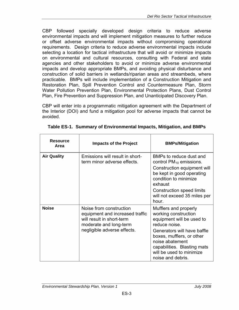
CBP followed specially developed design criteria to reduce adverse environmental impacts and will implement mitigation measures to further reduce or offset adverse environmental impacts without compromising operational requirements. Design criteria to reduce adverse environmental impacts include selecting a location for tactical infrastructure that will avoid or minimize impacts on environmental and cultural resources, consulting with Federal and state agencies and other stakeholders to avoid or minimize adverse environmental impacts and develop appropriate BMPs, and avoiding physical disturbance and construction of solid barriers in wetlands/riparian areas and streambeds, where practicable. BMPs will include implementation of a Construction Mitigation and Restoration Plan, Spill Prevention Control and Countermeasure Plan, Storm Water Pollution Prevention Plan, Environmental Protection Plans, Dust Control Plan, Fire Prevention and Suppression Plan, and Unanticipated Discovery Plan.
CBP will enter into a programmatic mitigation agreement with the Department of the Interior (DOI) and fund a mitigation pool for adverse impacts that cannot be avoided.
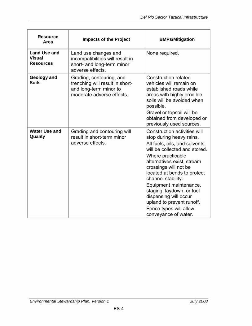
Table ES-1. Summary of Environmental Impacts, Mitigation, and BMPs
Resource Area Impacts of the Project BMPs/Mitigation
Air Quality Emissions will result in short-term minor adverse effects.
BMPs to reduce dust and control PM10 emissions. Construction equipment will be kept in good operating condition to minimize exhaust Construction speed limits will not exceed 35 miles per hour.
Noise Noise from construction equipment and increased traffic will result in short-term moderate and long-term negligible adverse effects.
Mufflers and properly working construction equipment will be used to reduce noise. Generators will have baffle boxes, mufflers, or other noise abatement capabilities. Blasting mats will be used to minimize noise and debris.
Del Rio Sector Tactical Infrastructure
Environmental Stewardship Plan, Version 1 July 2008
ES-4
Resource Area Impacts of the Project BMPs/Mitigation
Land Use and Visual Resources
Land use changes and incompatibilities will result in short- and long-term minor adverse effects.
None required.
Geology and Soils
Grading, contouring, and trenching will result in short- and long-term minor to moderate adverse effects.
Construction related vehicles will remain on established roads while areas with highly erodible soils will be avoided when possible. Gravel or topsoil will be obtained from developed or previously used sources.
Water Use and Quality
Grading and contouring will result in short-term minor adverse effects.
Construction activities will stop during heavy rains. All fuels, oils, and solvents will be collected and stored. Where practicable alternatives exist, stream crossings will not be located at bends to protect channel stability. Equipment maintenance, staging, laydown, or fuel dispensing will occur upland to prevent runoff. Fence types will allow conveyance of water.

Del Rio Sector Tactical Infrastructure
Environmental Stewardship Plan, Version 1 July 2008
ES-5
Resource Area Impacts of the Project BMPs/Mitigation
Biological Resources Vegetation Disturbance and clearing will
result in short- and long-term minor to moderate adverse effects.
Construction equipment will be cleaned to minimize spread of non-native species. Removal of brush in Federally protected areas will be limited to smallest amount possible. Invasive plants that appear on project area will be removed. Fill material, if required, will be weed-free to the maximum extent practicable.
Wildlife and Aquatic Species
Disturbance and clearing will result in short- and long-term minor to moderate adverse effects.
To prevent entrapment of wildlife all excavated holes or trenches will either be covered or provided with wildlife escape ramps. All poles and posts will be covered to prevent entrapment and discourage roosting.

Del Rio Sector Tactical Infrastructure
Environmental Stewardship Plan, Version 1 July 2008
ES-6
Resource Area Impacts of the Project BMPs/Mitigation
Special Status Species
Disturbance and clearing will result in short- and long-term minor to moderate adverse effects.
Environmental monitor onsite during construction to account for occurrences of special status species. If Federally protected species is encountered, monitor can recommend the temporary suspension of construction activities to the construction manager. Fence types will allow transboundary migration of small animals. Ground disturbance during migratory bird nesting season will require migratory bird nest survey and possible removal and relocation. Small openings will be integrated into bollard type fence design to allow for passage of small animals. Specific BMPs for endangered species are outlined in the Biological Resource Plan in Appendix G.
Cultural Resources
Long-term minor adverse effects will be expected.
Excavation activities will be monitored for cultural resources. Any discoveries will halt construction and be coordinated with the SHPO.
Socioeconomic Resources
Short- and long-term minor beneficial effects on the local economy and safety, respectively, will be expected, and potential minor adverse effects on low-income or minority populations will be expected.
None required.

Del Rio Sector Tactical Infrastructure
Environmental Stewardship Plan, Version 1 July 2008
ES-7
Resource Area Impacts of the Project BMPs/Mitigation
Utilities and Infrastructure
No new effects on storm water management, or electrical or natural gas systems. Short-term minor adverse effects on municipal water, sanitary sewer systems, and solid waste management.
None required

Del Rio Sector Tactical Infrastructure
Environmental Stewardship Plan, Version 1 July 2008
ES-8
THIS PAGE INTENTIONALLY LEFT BLANK
Del Rio Sector Tactical Infrastructure
Environmental Stewardship Plan, Version 1 July 2008
i
DRAFT ENVIRONMENTAL STEWARDSHIP PLAN FOR THE CONSTRUCTION, OPERATION, AND MAINTENANCE
OF TACTICAL INFRASTRUCTURE U.S. BORDER PATROL DEL RIO SECTOR, TEXAS
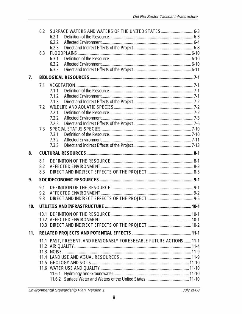
TABLE OF CONTENTS
EXECUTIVE SUMMARY ........................................................................................................... ES-1 1. GENERAL PROJECT DESCRIPTION ................................................................................ 1-1
1.1 INTRODUCTION TO THE ENVIRONMENTAL STEWARDSHIP PLAN .................... 1-1 1.2 USBP BACKGROUND ............................................................................................... 1-2 1.3 GOALS AND OBJECTIVES OF THE PROJECT ....................................................... 1-3 1.4 DESCRIPTION OF THE PROJECT ........................................................................... 1-3 1.5 PUBLIC OUTREACH AND COORDINATION .......................................................... 1-10 1.6 BMPS AND MITIGATION PLAN .............................................................................. 1-12
2. AIR QUALITY ...................................................................................................................... 2-1 2.1 DEFINITION OF THE RESOURCE ........................................................................... 2-1 2.2 AFFECTED ENVIRONMENT ..................................................................................... 2-3 2.3 DIRECT AND INDIRECT EFFECTS OF THE PROJECT .......................................... 2-3
3. NOISE.................................................................................................................................. 3-1 3.1 DEFINITION OF THE RESOURCE ........................................................................... 3-1 3.2 AFFECTED ENVIRONMENT ..................................................................................... 3-3 3.3 DIRECT AND INDIRECT EFFECTS OF THE PROJECT .......................................... 3-5
4. LAND USE AND VISUAL RESOURCES ............................................................................ 4-1 4.1 DEFINITION OF THE RESOURCE ........................................................................... 4-1
4.1.1 Affected Environment .................................................................................... 4-1 4.1.2 Direct and Indirect Effects of the Project ....................................................... 4-3
4.2 VISUAL RESOURCES ............................................................................................... 4-4 4.2.1 Definition of the Resource ............................................................................. 4-4 4.2.2 Affected Environment .................................................................................... 4-6 4.2.3 Direct and Indirect Effects of the Project ..................................................... 4-12
5. GEOLOGY AND SOILS ...................................................................................................... 5-1 5.1 DEFINITION OF THE RESOURCE ........................................................................... 5-1 5.2 AFFECTED ENVIRONMENT ..................................................................................... 5-2 5.3 DIRECT AND INDIRECT EFFECTS OF THE PROJECT .......................................... 5-4
6. WATER USE AND QUALITY .............................................................................................. 6-1 6.1 HYDROLOGY AND GROUNDWATER ...................................................................... 6-1
6.1.1 Definition of the Resource ............................................................................. 6-1 6.1.2 Affected Environment .................................................................................... 6-1 6.1.3 Direct and Indirect Effects of the Project ....................................................... 6-2
Del Rio Sector Tactical Infrastructure
Environmental Stewardship Plan, Version 1 July 2008
ii
6.2 SURFACE WATERS AND WATERS OF THE UNITED STATES .............................. 6-3 6.2.1 Definition of the Resource ............................................................................. 6-3 6.2.2 Affected Environment .................................................................................... 6-4 6.2.3 Direct and Indirect Effects of the Project ....................................................... 6-8
6.3 FLOODPLAINS ........................................................................................................ 6-10 6.3.1 Definition of the Resource ........................................................................... 6-10 6.3.2 Affected Environment .................................................................................. 6-10 6.3.3 Direct and Indirect Effects of the Project ..................................................... 6-11
7. BIOLOGICAL RESOURCES ............................................................................................... 7-1 7.1 VEGETATION ............................................................................................................ 7-1
7.1.1 Definition of the Resource ............................................................................. 7-1 7.1.2 Affected Environment .................................................................................... 7-1 7.1.3 Direct and Indirect Effects of the Project ....................................................... 7-2
7.2 WILDLIFE AND AQUATIC SPECIES ......................................................................... 7-2 7.2.1 Definition of the Resource ............................................................................. 7-2 7.2.2 Affected Environment .................................................................................... 7-3 7.2.3 Direct and Indirect Effects of the Project ....................................................... 7-6
7.3 SPECIAL STATUS SPECIES .................................................................................. 7-10 7.3.1 Definition of the Resource ........................................................................... 7-10 7.3.2 Affected Environment .................................................................................. 7-11 7.3.3 Direct and Indirect Effects of the Project ..................................................... 7-13
8. CULTURAL RESOURCES .................................................................................................. 8-1 8.1 DEFINITION OF THE RESOURCE ........................................................................... 8-1 8.2 AFFECTED ENVIRONMENT ..................................................................................... 8-2 8.3 DIRECT AND INDIRECT EFFECTS OF THE PROJECT .......................................... 8-5
9. SOCIOECONOMIC RESOURCES ...................................................................................... 9-1 9.1 DEFINITION OF THE RESOURCE ........................................................................... 9-1 9.2 AFFECTED ENVIRONMENT ..................................................................................... 9-2 9.3 DIRECT AND INDIRECT EFFECTS OF THE PROJECT .......................................... 9-5
10. UTILITIES AND INFRASTRUCTURE ............................................................................... 10-1 10.1 DEFINITION OF THE RESOURCE ......................................................................... 10-1 10.2 AFFECTED ENVIRONMENT ................................................................................... 10-1 10.3 DIRECT AND INDIRECT EFFECTS OF THE PROJECT ........................................ 10-2
11. RELATED PROJECTS AND POTENTIAL EFFECTS ...................................................... 11-1 11.1 PAST, PRESENT, AND REASONABLY FORESEEABLE FUTURE ACTIONS ....... 11-1 11.2 AIR QUALITY ........................................................................................................... 11-4 11.3 NOISE ...................................................................................................................... 11-9 11.4 LAND USE AND VISUAL RESOURCES ................................................................. 11-9 11.5 GEOLOGY AND SOILS ......................................................................................... 11-10 11.6 WATER USE AND QUALITY ................................................................................. 11-10
11.6.1 Hydrology and Groundwater ..................................................................... 11-10 11.6.2 Surface Water and Waters of the United States ....................................... 11-10

Del Rio Sector Tactical Infrastructure
Environmental Stewardship Plan, Version 1 July 2008
iii
11.6.3 Floodplains ................................................................................................ 11-11 11.7 BIOLOGICAL RESOURCES .................................................................................. 11-11
11.7.1 Vegetation Resources ............................................................................... 11-11 11.7.2 Wildlife and Aquatic Resources ................................................................ 11-11 11.7.3 Special Status Species ............................................................................. 11-12
11.8 CULTURAL RESOURCES .................................................................................... 11-12 11.9 SOCIOECONOMIC RESOURCES ........................................................................ 11-13 11.10 UTILITIES AND INFRASTRUCTURE .................................................................... 11-14
12. REFERENCES .................................................................................................................. 12-1 13. ACRONYMS AND ABBREVIATIONS ............................................................................... 13-1
APPENDICES A. Secretary of Homeland Security, Determination Pursuant to Section 102 of the Illegal
Immigration Reform and Immigrant Responsibility Act of 1996, as Amended B. Standard Design for Tactical Infrastructure C. Air Quality Information D. Detailed Maps of Fence Sections E. Detailed Maps of the Tactical Infrastructure Sections Showing Soils F. Biological Survey Report G. Biological Resources Plan

Del Rio Sector Tactical Infrastructure
Environmental Stewardship Plan, Version 1 July 2008
iv
FIGURES 1-1. Location of the Section M-1, Del Rio, Texas ..................................................................... 1-7 1-2. Location of the Section M-2A, Eagle Pass, Texas ............................................................ 1-8 1-3. Schematic of Typical Project Corridor – Section M-1 ........................................................ 1-9 3-1. Common Noise Levels...................................................................................................... 3-2 4-1. Photograph View of Del Rio Residential Areas (Section M-1) .......................................... 4-7 4-2. Photograph View of Rio Grande Channel from Bluff (Section M-2A) ................................ 4-8 4-3. Schematic Showing Visibility of Fencing at Various Distances ....................................... 4-10 4-4. Typical Views Towards Impact Corridor, Section M-1 .................................................... 4-15 4-5. Typical Views Towards Impact Corridor, Section M-2A (Northern Portion) .................... 4-16
TABLES ES-1. Summary of Environmental Impacts, Mitigation, and BMPs .......................................... ES-3 1-1. Tactical Infrastructure Sections for USBP Del Rio Sector ................................................. 1-4 2-1. National Ambient Air Quality Standards ............................................................................ 2-2 2-2. Estimates of Total Construction Emissions from the Project in Tons Per Year ................. 2-4 3-1. Noise Levels for Construction Equipment ......................................................................... 3-3 4-1. Land Classifications Within the Impact Corridor ............................................................... 4-3 4-2. Character of Visual Resources within Typical Del Rio Sector Landscape Units
(Current Conditions) ......................................................................................................... 4-9 4-3. Quality of Visual Resources within Typical Del Rio Sector Landscape Units
(Current Conditions) ......................................................................................................... 4-9 4-4. Effect on the Character of Visual Resources within Typical Del Rio Sector
Landscape Units ............................................................................................................. 4-14 4-5. Quality of Visual Resources within Typical Del Rio Sector Landscape Units after
Construction ................................................................................................................... 4-15 6-1. Wetlands and Other Waters of the United States within the 60-Foot Potential
Impact Areas .................................................................................................................... 6-6 7-1. Wildlife Species Observed in November 2007 Survey ...................................................... 7-5 7-2. Light Source Intensity ....................................................................................................... 7-8 7-3. Federal- and State-Listed Species Potentially Occurring in the Impact corridor ............. 7-12 8-1. NRHP-Listed Properties, Texas Historic Landmarks, and State Historic Markers
near the Impact corridor .................................................................................................... 8-4 9-1. Employed Persons by Industry Type in Census Tracts, Val Verde and Maverick
Counties, and the State of Texas (Percent) ...................................................................... 9-3 9-2. Demographic and Economic Characteristics of Census Tracts, Val Verde and
Maverick Counties, and the State of Texas ...................................................................... 9-4 10-1. Water/Sewer Systems Infrastructure Within the Impact Corridor .................................... 10-2 10-2. Remaining Capacity of Municipal Landfills as of 2005 .................................................... 10-2 11-1. Summary of Potential Cumulative Effects ....................................................................... 11-5
Del Rio Sector Tactical Infrastructure
Environmental Stewardship Plan, Version 1 July 2008
1-1
1. GENERAL PROJECT DESCRIPTION
1.1 INTRODUCTION TO THE ENVIRONMENTAL STEWARDSHIP PLAN On April 1, 2008, the Secretary of the U.S. Department of Homeland Security (DHS), pursuant to his authority under Section 102(c) of the Illegal Immigration Reform and Immigrant Responsibility Act (IIRIRA), exercised his authority to waive certain environmental and other laws in order to ensure expeditious construction of tactical infrastructure along the U.S./Mexico international border. The tactical infrastructure described in this Environmental Stewardship Plan (ESP) is covered by the Secretary’s April 1, 2008, waiver (73 Federal Register [FR] 65, pp. 18293–24, Appendix A). Although the Secretary’s waiver means that U.S. Customs and Border Protection (CBP) no longer has any specific legal obligations under the laws that are included in the waiver, the Secretary committed DHS to continue to protect valuable natural and cultural resources.
CBP strongly supports the Secretary’s commitment to responsible environmental stewardship. To that end, CBP has prepared this ESP, which analyzes the potential environmental impacts associated with construction of tactical infrastructure in the USBP’s Del Rio Sector. The ESP also discusses CBP’s plans as to how it can mitigate potential environmental impacts. The ESP will guide CBP’s efforts going forward.
As it moves forward with the project described in this ESP, CBP will continue to work in a collaborative manner with local governments, state and Federal land managers, and the interested public to identify environmentally sensitive resources and develop appropriate best management practices (BMPs) to avoid or minimize adverse impacts resulting from the installation of tactical infrastructure.
This ESP is divided into 13 chapters plus appendices. The first chapter presents a detailed description of the Project. Subsequent chapters present information on the resources present and evaluate the direct, indirect, and cumulative effects of the Project. The ESP also describes measures CBP has identified—in consultation with Federal, state, and local agencies—to avoid, minimize, or mitigate impacts on the environment, whenever possible. The following resource areas are presented in this ESP: air quality, noise, land use and visual resources, geological resources and soils, water use and quality, biological resources (i.e., vegetation, wildlife and aquatic species, special status species), cultural resources, socioeconomic resources, and utilities and infrastructure. Some environmental resources were not included in this ESP because they were not relevant to the analysis. These potential resource areas include roadways and traffic (omitted because the Project will not be accessible from public roadways), sustainability (omitted because the Project will use minimal amounts of resources during construction and maintenance), and human health and safety (omitted because construction workers will be subject to Occupational Safety and Health
Del Rio Sector Tactical Infrastructure
Environmental Stewardship Plan, Version 1 July 2008
1-2
Administration [OSHA] standards and the Project will not introduce new or unusual safety risks).
Appendix A presents the Secretary’s published waiver pursuant to IIRIRA. Appendix B provides information on primary pedestrian and vehicle fence designs. Appendix C provides air quality emissions calculations. Appendix D presents detailed maps of fence sections, Appendix D presents detailed soils maps, Appendix E presents the Biological Survey Report., and Appendix F presents the Biological Resources Plan.
CBP will follow specially developed design criteria to reduce adverse environmental impacts and will implement mitigation measures to further reduce or offset adverse environmental impacts to the extent possible. Design criteria to reduce adverse environmental impacts include avoiding physical disturbance and construction of solid barriers in wetlands/riparian areas and streambeds, where practicable. Consulting with Federal and state agencies and other stakeholders will augment efforts to avoid or minimize adverse environmental impacts. Developing appropriate BMPs to protect natural and cultural resources will be utilized to the extent possible.
1.2 USBP BACKGROUND The mission of CBP is to prevent terrorists and terrorist weapons from entering the United States, while also facilitating the flow of legitimate trade and travel. In supporting CBP’s mission, USBP is charged with establishing and maintaining effective control of the international borders of the United States. USBP’s mission strategy consists of the following five main objectives:
• Establish substantial probability of apprehending terrorists and their weapons as they attempt to enter illegally between the Ports of Entry (POEs)
• Deter illegal entries through improved enforcement
• Detect, apprehend, and deter smugglers of humans, drugs, and other contraband
• Leverage “smart border” technology to multiply the effect of enforcement personnel
• Reduce crime in border communities and consequently improve quality of life and economic vitality of targeted areas.
USBP has nine administrative sectors along the U.S./Mexico international border. Each sector is responsible for implementing an optimal combination of personnel, technology, and infrastructure appropriate to its operational requirements. The USBP Del Rio Sector is responsible for 59,541 square miles of Texas and 210 miles of the U.S./Mexico international border. The USBP Del Rio Sector stations are located in Abilene, Brackettville, Carrizo Springs, Comstock, Del Rio, Eagle

Del Rio Sector Tactical Infrastructure
Environmental Stewardship Plan, Version 1 July 2008
1-3
Pass, Llano, Rocksprings, San Angelo, and Uvalde, Texas (CBP undated). Within the USBP Del Rio Sector, areas for tactical infrastructure improvements have been identified that will help the Sector gain more effective control of the border and significantly contribute to USBP’s priority mission of homeland security.
1.3 GOALS AND OBJECTIVES OF THE PROJECT The Project will provide USBP agents with the tools necessary to strengthen their control of the U.S. border between POEs in the USBP Del Rio Sector. The Project will help to deter illegal entries within the USBP Del Rio Sector by improving enforcement efficiency, thus preventing terrorists and terrorist weapons, illegal aliens, drugs, and other cross border violators and contraband from entering the United States, while providing a safer work environment for USBP agents. The USBP Del Rio Sector has identified two discrete areas along the border that experience high levels of illegal cross-border activity. Illegal cross-border activity typically occurs in areas that are remote and not easily accessed by USBP agents, near POEs where concentrated populations live on either side of the border, or in locations that have quick access to U.S. transportation routes.
The Project is being carried out pursuant to Section 102 of IIRIRA, 8 United States Code (U.S.C.) § 1103 note. In Section 102(b) of IIRIRA, Congress called for the installation of fencing, barriers, roads, lighting, cameras, and sensors on not less than 700 miles of the southwestern border. This total includes certain priority miles of fencing that are to be completed by December of 2008. Section 102(b) further specifies that these priority miles are to be constructed in areas where it would be practical and effective in deterring smugglers and aliens attempting to gain illegal entry into the United States.
1.4 DESCRIPTION OF THE PROJECT CBP plans to install fencing, vehicle barriers, roads, and lighting along 4 miles of the U.S./Mexico international border. The fencing, barriers, and roads will be installed in areas of high illegal cross-border activity.
The Project includes installation of primary pedestrian fence sections in areas of the border that are not currently fenced. The locations of tactical infrastructure are based on a USBP Del Rio Sector assessment of local operational requirements where such infrastructure will assist USBP agents in reducing illegal cross-border activities.
The tactical infrastructure will be constructed in two discrete sections within the USBP Del Rio Sector in the city of Del Rio in Val Verde County and in the city of Eagle Pass in Maverick County. The individual sections will be approximately 3 miles and 1 mile in length, respectively. Each tactical infrastructure section will be an individual project that may proceed independent of the other section. The
Del Rio Sector Tactical Infrastructure
Environmental Stewardship Plan, Version 1 July 2008
1-4
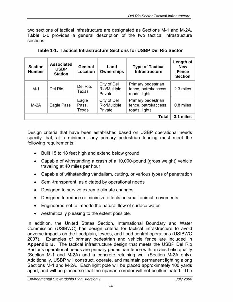
two sections of tactical infrastructure are designated as Sections M-1 and M-2A. Table 1-1 provides a general description of the two tactical infrastructure sections.
Table 1-1. Tactical Infrastructure Sections for USBP Del Rio Sector
Section Number
Associated USBP
Station General Location
Land Ownerships
Type of Tactical Infrastructure
Length of New
Fence Section
M-1 Del Rio Del Rio, Texas
City of Del Rio/Multiple Private
Primary pedestrian fence, patrol/access roads, lights
2.3 miles
M-2A Eagle Pass Eagle Pass, Texas
City of Del Rio/Multiple Private
Primary pedestrian fence, patrol/access roads, lights
0.8 miles
Total 3.1 miles
Design criteria that have been established based on USBP operational needs specify that, at a minimum, any primary pedestrian fencing must meet the following requirements:
• Built 15 to 18 feet high and extend below ground
• Capable of withstanding a crash of a 10,000-pound (gross weight) vehicle traveling at 40 miles per hour
• Capable of withstanding vandalism, cutting, or various types of penetration
• Semi-transparent, as dictated by operational needs
• Designed to survive extreme climate changes
• Designed to reduce or minimize effects on small animal movements
• Engineered not to impede the natural flow of surface water
• Aesthetically pleasing to the extent possible.
In addition, the United States Section, International Boundary and Water Commission (USIBWC) has design criteria for tactical infrastructure to avoid adverse impacts on the floodplain, levees, and flood control operations (USIBWC 2007). Examples of primary pedestrian and vehicle fence are included in Appendix B. The tactical infrastructure design that meets the USBP Del Rio Sector’s operational needs are primary pedestrian fence with an aesthetic quality (Section M-1 and M-2A) and a concrete retaining wall (Section M-2A only). Additionally, USBP will construct, operate, and maintain permanent lighting along Sections M-1 and M-2A. Each light pole will be placed approximately 100 yards apart, and will be placed so that the riparian corridor will not be illuminated. The

Del Rio Sector Tactical Infrastructure
Environmental Stewardship Plan, Version 1 July 2008
1-5
tactical infrastructure will also encroach on multiple privately and publicly owned land parcels. Figures 1-1 and 1-2 show Sections M-1 and M-2A.
In Section M-1, the Project will parallel the USIBWC floodplain. Commencing just east of Cienegas Creek the Project will run for approximately 1.8 miles in a southeasterly direction parallel to Garza Lane, and then Rio Grande Road, to the intersection of Rio Grande Road and U.S. Highway 277. The Project will then extend 0.18 miles in a northeasterly direction, across Rio Grande Road to a point identified as the new toll facility for the new POE facilities currently under construction. Since Rio Grande Road will be fenced at the intersection with U.S. Highway 277, future through traffic will be diverted along Alderete Lane. The Project will recommence on the eastern side of the POE for an additional 0.36 of a mile. Section M-1 will be outside of the USIBWC floodplain and inside of the FEMA 100-year floodplain. Giant reed (an invasive species) and other brush will also be removed as part of the Project to improve line of sight for USBP agents. The impact corridor will be seeded with native grasses to provide soil stability and maintain an open space for patrol purposes. A portion of the land that will be between the western part of Section M-1 and the Rio Grande is owned by the City of Del Rio. In an agreement reached between the city and CBP, an area of approximately 35 acres, between the fence, the river and U.S. Highway 277 will be selectively cleared of underbrush and giant reed to create an open space park that will also add to line of sight security.
The tactical infrastructure will affect an approximately 150-foot-wide corridor along Section M-1. This corridor will include a primary pedestrian fence, patrol and access roads, and lights. In Section M-1, a new road will be needed for construction access and patrols along the impact corridor.
In Eagle Pass, the tactical infrastructure will generally follow the bank of the Rio Grande. Approximately 0.5 miles of Section M-2A will be a 15- to 18-foot-high concrete retaining wall and the remaining tactical infrastructure will be primary pedestrian fence with an aesthetic quality. In Section M-2A, existing roads will be used for construction access and staging areas. Improvement of existing patrol roads along the entire length of the primary pedestrian fence section is also included in the Project for Section M-2A. However, giant reed will not be cleared along the bank of the Rio Grande. The impact corridor will be revegetated as appropriate to maintain an open space for patrol purposes. Lights will also be installed. The tactical infrastructure will affect an approximately 60-foot-wide or smaller corridor along Section M-2A. In Section M-2A, the area affected by the construction of tactical infrastructure will total approximately 5 acres. Figure 1-3 shows a schematic drawing of the impact corridor.
Section M-2A is inside of the FEMA 100-year floodplain and will connect to fence section M-2B which was evaluated and approved in a 2007 Environmental Assessment (EA) (CBP 2007). The EA for M-2B was released for a 30-day public review period beginning January 11, 2007 and ending February 9, 2007. During the EA process a total of two comments were received and the EA is
Del Rio Sector Tactical Infrastructure
Environmental Stewardship Plan, Version 1 July 2008
1-6
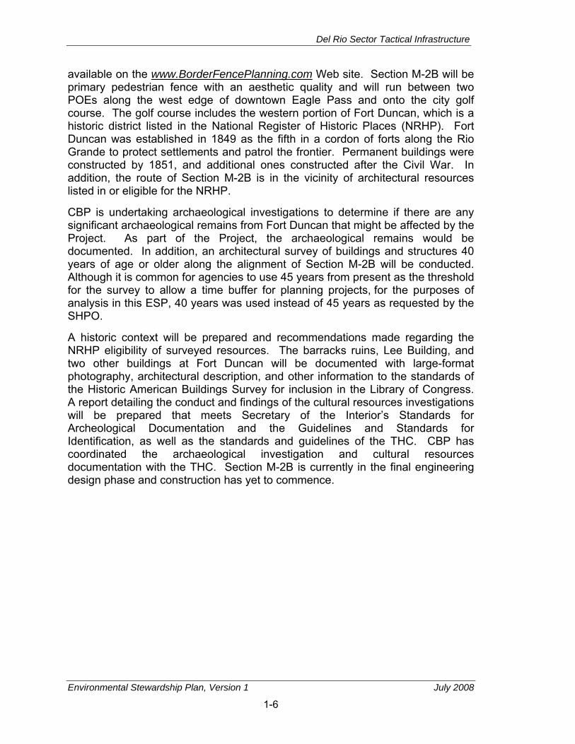
available on the www.BorderFencePlanning.com Web site. Section M-2B will be primary pedestrian fence with an aesthetic quality and will run between two POEs along the west edge of downtown Eagle Pass and onto the city golf course. The golf course includes the western portion of Fort Duncan, which is a historic district listed in the National Register of Historic Places (NRHP). Fort Duncan was established in 1849 as the fifth in a cordon of forts along the Rio Grande to protect settlements and patrol the frontier. Permanent buildings were constructed by 1851, and additional ones constructed after the Civil War. In addition, the route of Section M-2B is in the vicinity of architectural resources listed in or eligible for the NRHP.
CBP is undertaking archaeological investigations to determine if there are any significant archaeological remains from Fort Duncan that might be affected by the Project. As part of the Project, the archaeological remains would be documented. In addition, an architectural survey of buildings and structures 40 years of age or older along the alignment of Section M-2B will be conducted. Although it is common for agencies to use 45 years from present as the threshold for the survey to allow a time buffer for planning projects, for the purposes of analysis in this ESP, 40 years was used instead of 45 years as requested by the SHPO.
A historic context will be prepared and recommendations made regarding the NRHP eligibility of surveyed resources. The barracks ruins, Lee Building, and two other buildings at Fort Duncan will be documented with large-format photography, architectural description, and other information to the standards of the Historic American Buildings Survey for inclusion in the Library of Congress. A report detailing the conduct and findings of the cultural resources investigations will be prepared that meets Secretary of the Interior’s Standards for Archeological Documentation and the Guidelines and Standards for Identification, as well as the standards and guidelines of the THC. CBP has coordinated the archaeological investigation and cultural resources documentation with the THC. Section M-2B is currently in the final engineering design phase and construction has yet to commence.

Del Rio Sector Tactical Infrastructure
Environmental Stewardship Plan, Version 1 July 2008
1-7
277
Sour
ce:
ES
RI S
treet
Map
US
A 20
05
Te
xa
s
Un
it
ed
S
ta
te
s
Proj
ectio
n: A
lber
sU
SA C
ontig
uous
Alb
ers
Equ
al A
rea
Con
icN
orth
Am
eric
an D
atum
of 1
983
Sca
le0
2,00
04,
000
1,00
0
Feet
M-1
Fenc
e Se
ctio
n La
bel
Del
Rio
M-1
Fenc
e Se
ctio
ns
Acc
ess
Roa
ds
Stag
ing
Are
as*
Bru
sh C
lear
ing
Port
of E
ntry
Lare
doSe
ctor
Del
Rio
Sect
or
Mar
faSe
ctor
Lare
doSe
ctor
Pe
co
s Ri v
e r
El P
aso
Sect
or Mex
ico
San
Ant
onio
Te
xa
sN
ew
Me
xic
o
Ode
ssa
San
Ang
elo
M-1
Inte
rnat
iona
lB
ridge
, TX-
239-
Spur
, US-
277
Ri o
Gr a n d e
M-1
Me
xi
co
*Sta
ging
are
a is
bas
ed o
n a
file
prov
ided
from
USA
CE
Gal
vest
on D
istr
ict o
n 31
Mar
ch 2
008
via
e-m
ail a
nd re
conf
irmed
on
6 Ju
ne 2
008.
Ri
o
Gr
a
nd
e
Figu
re 1
-1.
Loca
tion
of th
e Se
ctio
n M
-1, D
el R
io, T
exas

Del Rio Sector Tactical Infrastructure
Environmental Stewardship Plan, Version 1 July 2008
1-8
431
57
277
Del Rio Blvd
Inte
rnat
iona
l Brid
geG
arri
son
St
Mai
n St
El In
dio
Hwy
Sour
ce:
ES
RI S
treet
Map
USA
200
5
Me
xi
co
Te
xa
s
Un
it
ed
S
ta
te
s
Proj
ectio
n: A
lber
sU
SA C
ontig
uous
Alb
ers
Equ
al A
rea
Con
icN
orth
Am
eric
an D
atum
of 1
983
Scal
e0
2,00
04,
000
1,00
0
Feet
M-2
AFe
nce
Sect
ion
Labe
l
Eagl
ePa
ss
M-2
A
R i o G r a n d e
Fenc
e Se
ctio
ns
Acc
ess
Roa
ds
Stag
ing
Are
as
Port
of E
ntry
Lare
doSe
ctor
Del
Rio
Sect
or
Mar
faSe
ctor
El P
aso
Sect
or Pe
co
s R
i v e r
Lare
doSe
ctor
Mex
ico
San
Ant
onio
Te
xa
sN
ew
Me
xic
o
Ode
ssa
San
Ang
elo
M-2
A
Cam
ino
Rea
lIn
tern
atio
nal
Brid
ge, U
S-57
Eagl
e Pa
ssB
ridge
II
Sout
hern
Paci
ficR
ailro
ad
Ri o
Gr a n d e
Figu
re 1
-2.
Loca
tion
of th
e Se
ctio
n M
-2A
, Eag
le P
ass,
Tex
as

Del Rio Sector Tactical Infrastructure
Environmental Stewardship Plan, Version 1 July 2008
1-9
Figu
re 1
-3.
Sche
mat
ic o
f Typ
ical
Pro
ject
Cor
ridor
– S
ectio
n M
-1

Del Rio Sector Tactical Infrastructure
Environmental Stewardship Plan, Version 1 July 2008
1-10
Construction access roads will be 30 to 60 feet wide. Wherever possible, existing roads and previously disturbed areas will be used for construction access and staging areas. If fill material is needed, the construction contractor will use clean material from commercially available sources that do not pose an adverse effect on biological or cultural resources.
There will be no change in overall USBP Sector operations. The USBP Del Rio Sector activities routinely adapt to operational requirements, and will continue to do so under this Project. The USBP Del Rio Sector operations will retain the same flexibility to most effectively provide a law enforcement resolution to illegal cross-border activity.
Fence maintenance will either be performed by USBP Del Rio Sector personnel or contracted personnel. The fences will be made from nonreflective steel and no painting will be required. Fence maintenance will include removing any accumulated debris on the fence after a rain event to avoid potential future flooding. Sand that builds up against the fence and brush will also be removed, as needed. Brush removal could include mowing, removal of small trees, and application of herbicide, if needed. During normal patrols, Sector personnel will observe the condition of the fence. Any destruction or breaches of the fence will be repaired, as needed, by a contractor.
Construction of other tactical infrastructure may be required in the future as mission and operational requirements are continually reassessed. To the extent that other current and future actions are known, they are discussed in Chapter 11, Related Projects and Potential Effects.
1.5 PUBLIC OUTREACH AND COORDINATION CBP notified relevant Federal, state, and local agencies of the Project and requested input on potential environmental concerns such parties might have regarding the Project. CBP has coordinated with the U.S. Environmental Protection Agency (USEPA); U.S. Fish and Wildlife Service (USFWS); State Historic Preservation Office (SHPO); and other Federal, state, and local agencies.
Along some of the fence sections the tactical infrastructure will follow rights−of−way (ROWs) administered, maintained, or used by the USIBWC. The IBWC is an international body composed of a U.S. Section and a Mexican Section, each headed by an Engineer-Commissioner appointed by its respective president. Each Section is administered independently of the other. The USIBWC is a Federal government agency headquartered in El Paso, Texas, and operates under the foreign policy guidance of the Department of State (USIBWC 2007). The USIBWC will provide access and ROWs to construct tactical infrastructure within the Del Rio Sector. The USIBWC will also ensure that design and placement of the tactical infrastructure does not impact flood control
Del Rio Sector Tactical Infrastructure
Environmental Stewardship Plan, Version 1 July 2008
1-11
processes and does not violate treaty obligations between the United States and Mexico.
A Draft Environmental Assessment (EA) was prepared, copies were mailed to interested parties, it was posted on a public Web site, and a 30-day public review and comment period was announced. A public open house was advertised and held at the City of Del Rio Civic Center in Del Rio, Texas, on January 24, 2008. The open house was attended by 30 people. Although the Secretary issued the waiver, CBP has continued to work in a collaborative manner with agencies and has considered and incorporated agency and public comments into this ESP. CBP responses to public comments on the Draft EA will also be provided on the www.BorderFencePlanning.com Web site. Analyses from the Draft EA have been used to develop this ESP.
Although the Secretary of DHS issued the waiver, and thus, CBP has no responsibilities under the National Environmental Policy Act (NEPA) for this project, CBP reviewed, considered, and incorporated comments received from the public and other Federal, state, and local agencies, as appropriate, during the preparation of this ESP.
In addition to the past public involvement and outreach program, CBP has continued to coordinate with various Federal and state agencies during the development of this ESP. These agencies are described in the following paragraphs.
• U.S. Section, International Boundary and Water Commission. CBP has coordinated with USIBWC to ensure that any construction along the international border does not adversely affect International Boundary Monuments or substantially impede floodwater conveyance within international drainages.
• U.S. Army Corps of Engineers, Galveston District. CBP has coordinated all activities with USACE to identify potential jurisdictional waters of the United States, including wetlands, and to develop measures to avoid, minimize or compensate for losses to these resources.
• U.S. Fish and Wildlife Service. CBP has coordinated extensively with USFWS to identify listed species that have the potential to occur in the project area and has cooperated with the USFWS to prepare a Biological Resources Plan (BRP) that presents the analysis of potential effects to listed species and the BMPs proposed to reduce or off-set any adverse impacts. A copy of the BRP is contained in Appendix G.
Del Rio Sector Tactical Infrastructure
Environmental Stewardship Plan, Version 1 July 2008
1-12
1.6 BMPS AND MITIGATION PLAN CBP applied various design criteria to reduce adverse environmental impacts associated with the Project, including selecting a route that will avoid or minimize effects on environmental and cultural resources. Nonetheless, CBP has determined that construction, operation, and maintenance of tactical infrastructure in USBP Del Rio Sector will result in adverse environmental impacts. These impacts will be most adverse during construction. Mitigation resources that are available during implementation of the Project include the following:
• CBP will require construction contractors to prepare Environmental Protection Plans (EPPs) that include BMPs on General Construction Activities, soils, cultural resources, air and water quality, noise, vegetation and biological resources. These BMPs are specified in construction documents. BMPs specifically developed to protect sensitive species are included in the Biological Resources Plan (see Appendix F).
• CBP will continue to consult with the USFWS, the Texas Department of Fish and Game (TxDFG), Texas SHPO, Native American tribes, and others to identify appropriate mitigation measures.

Del Rio Sector Tactical Infrastructure
Environmental Stewardship Plan, Version 1 July 2008
2-1
2. AIR QUALITY
2.1 DEFINITION OF THE RESOURCE Although the Secretary’s waiver means that CBP no longer has any specific obligation under the Clean Air Act (CAA), the Secretary committed CBP to responsible environmental stewardship of our valuable natural and cultural resources. CBP supports this objective and has applied the appropriate standards and guidelines associated with the CAA as the basis for evaluating potential environmental impacts and developing appropriate mitigations for air quality.
The air quality in a given region or area is measured by the concentrations of various pollutants in the atmosphere. The measurements of these “criteria pollutants” in ambient air are expressed in units of parts per million (ppm), micrograms per cubic meter (µg/m3), or milligrams per cubic meter (mg/m3).
The CAA directed USEPA to develop National Ambient Air Quality Standards (NAAQS), for pollutants that have been determined to affect human health and the environment. NAAQS are currently established for six criteria air pollutants: ozone (O3), carbon monoxide (CO), nitrogen dioxide (NO2), sulfur dioxide (SO2), respirable particulate matter (including particulate matter equal to or less than 10 microns in diameter [PM10] and particulate matter equal to or less than 2.5 microns in diameter [PM2.5]), and lead (Pb). The primary NAAQS are ambient air quality standards to protect the public health; secondary NAAQS specify levels of air quality to protect the public welfare such as effects on vegetation, crops, wildlife, economic values, and visibility.
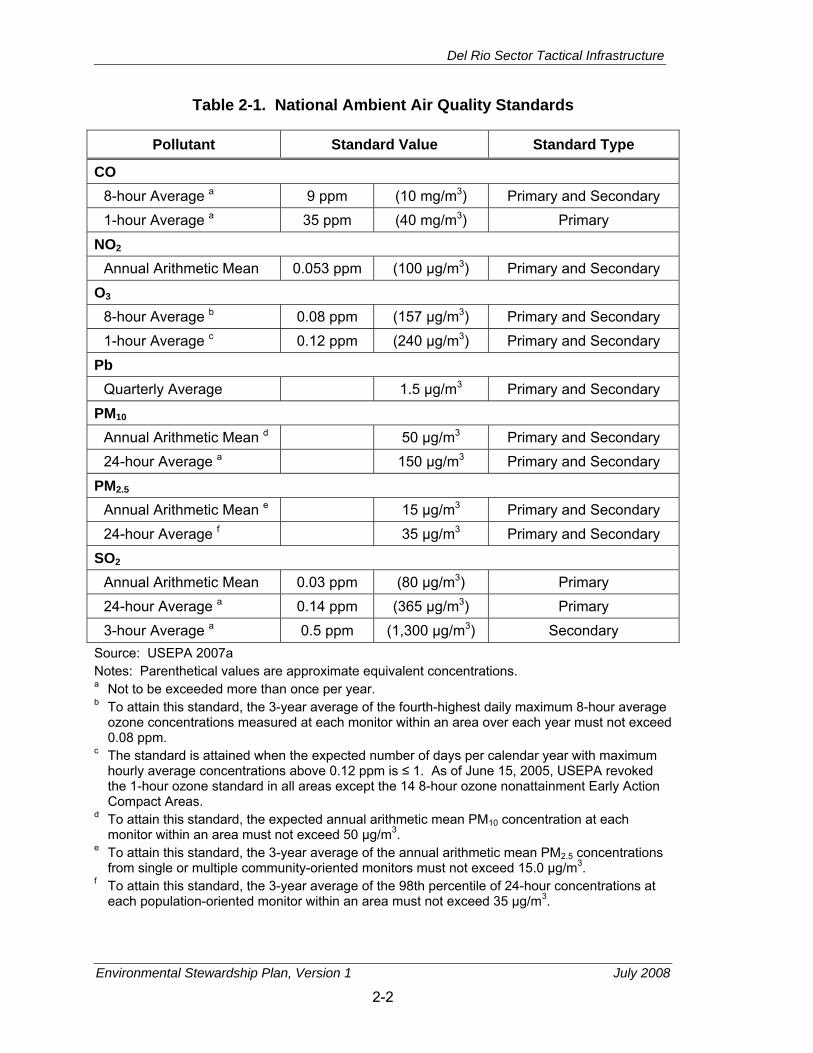
The Federal CAA and USEPA delegated responsibility for ensuring compliance with NAAQS to the states and local agencies. The State of Texas has adopted the NAAQS as the Texas Ambient Air Quality Standards (TAAQS) for the entire State of Texas. Table 2-1 presents the primary and secondary USEPA NAAQS that apply to the air quality in the State of Texas.
USEPA classifies the air quality in an air quality control region (AQCR), or in subareas of an AQCR, according to whether the concentrations of criteria pollutants in ambient air exceed the primary or secondary NAAQS. All areas within each AQCR are therefore designated as either “attainment,” “nonattainment,” “maintenance,” or “unclassified” for each of the six criteria pollutants. Attainment means that the air quality within an AQCR is better than the NAAQS, nonattainment indicates that criteria pollutant levels exceed NAAQS, maintenance indicates that an area was previously designated nonattainment but is now in attainment, and unclassified means that there is not enough information to appropriately classify an AQCR, so the area is considered in attainment.
Del Rio Sector Tactical Infrastructure
Environmental Stewardship Plan, Version 1 July 2008
2-2
Table 2-1. National Ambient Air Quality Standards
Pollutant Standard Value Standard Type
CO 8-hour Average a 9 ppm (10 mg/m3) Primary and Secondary 1-hour Average a 35 ppm (40 mg/m3) Primary
NO2 Annual Arithmetic Mean 0.053 ppm (100 µg/m3) Primary and Secondary
O3 8-hour Average b 0.08 ppm (157 µg/m3) Primary and Secondary 1-hour Average c 0.12 ppm (240 µg/m3) Primary and Secondary
Pb Quarterly Average 1.5 µg/m3 Primary and Secondary
PM10 Annual Arithmetic Mean d 50 µg/m3 Primary and Secondary 24-hour Average a 150 µg/m3 Primary and Secondary
PM2.5 Annual Arithmetic Mean e 15 µg/m3 Primary and Secondary 24-hour Average f 35 µg/m3 Primary and Secondary
SO2 Annual Arithmetic Mean 0.03 ppm (80 µg/m3) Primary 24-hour Average a 0.14 ppm (365 µg/m3) Primary 3-hour Average a 0.5 ppm (1,300 µg/m3) Secondary
Source: USEPA 2007a Notes: Parenthetical values are approximate equivalent concentrations. a Not to be exceeded more than once per year. b To attain this standard, the 3-year average of the fourth-highest daily maximum 8-hour average
ozone concentrations measured at each monitor within an area over each year must not exceed 0.08 ppm.
c The standard is attained when the expected number of days per calendar year with maximum hourly average concentrations above 0.12 ppm is ≤ 1. As of June 15, 2005, USEPA revoked the 1-hour ozone standard in all areas except the 14 8-hour ozone nonattainment Early Action Compact Areas.
d To attain this standard, the expected annual arithmetic mean PM10 concentration at each monitor within an area must not exceed 50 μg/m3.
e To attain this standard, the 3-year average of the annual arithmetic mean PM2.5 concentrations from single or multiple community-oriented monitors must not exceed 15.0 µg/m3.
f To attain this standard, the 3-year average of the 98th percentile of 24-hour concentrations at each population-oriented monitor within an area must not exceed 35 µg/m3.

Del Rio Sector Tactical Infrastructure
Environmental Stewardship Plan, Version 1 July 2008
2-3
Many chemical compounds found in the Earth’s atmosphere act as “greenhouse gases.” These gases allow sunlight to enter the atmosphere freely. When sunlight strikes the Earth’s surface, some of it is reflected back towards space as infrared radiation (heat). Greenhouse gases absorb this infrared radiation and trap the heat in the atmosphere. Over time, barring other influences, the trapped heat results in the phenomenon of global warming.
In April 2007, the U.S. Supreme Court declared that carbon dioxide (CO2) and other greenhouse gases are air pollutants under the CAA. The Court declared that the USEPA has the authority to regulate emissions from new cars and trucks under the CAA.
Many gases exhibit these “greenhouse” properties. The majority of greenhouse gases are created by natural sources but are also contributed to by human activity.
2.2 AFFECTED ENVIRONMENT The Project is within Maverick and Val Verde counties, Texas, within the Metropolitan San Antonio Intrastate Air Quality Control Region (MSAI AQCR). The MSAI AQCR is composed of 21 counties in western Texas. Although portions of the MSAI AQCR are classified as being in nonattainment for 8-hour ozone, Maverick and Val Verde counties are classified as being in attainment/unclassified for all criteria pollutants.
2.3 DIRECT AND INDIRECT EFFECTS OF THE PROJECT Pollutant emissions associated with the Project will not contribute to or affect local or regional NAAQS attainment status. Project activities will generate air pollutant emissions from the construction, maintenance activities, and the operation of generators to supply power to construction equipment and portable lights. BMPs will include a Dust Control Plan to minimize fugitive dust emissions.
Construction Projects. Minor short-term adverse effects will be expected from construction emissions and land disturbance associated with the Project. The Project will affect air quality primarily from site-disturbing activities and operation of construction equipment. The construction will generate total suspended particulate and PM10 emissions as fugitive dust from ground-disturbing activities (e.g., grading, trenching, soil piles) and from combustion of fuels in construction equipment. Fugitive dust emissions will be greatest during the initial site preparation activities and will vary from day to day depending on the construction phase, level of activity, and prevailing weather conditions. The quantity of uncontrolled fugitive dust emissions from a construction site is proportional to the area of land being worked and the level of construction activity.
Construction operations will also result in emissions of criteria pollutants as combustion products from construction equipment. These emissions will be of a

Del Rio Sector Tactical Infrastructure
Environmental Stewardship Plan, Version 1 July 2008
2-4
temporary nature. The NAAQS emissions factors and estimates were generated based on guidance provided in USEPA AP-42, Volume II, Mobile Sources. Fugitive dust emissions for various construction activities were calculated using emissions factors and assumptions published in USEPA’s AP-42 Section 11.9. The emissions for CO2 were calculated using emissions coefficients reported by the Energy Information Administration (EIA 2007).
For purposes of this analysis, the Project duration and impact corridor that will be disturbed (presented in Chapter 1) were used to estimate fugitive dust and all other pollutant emissions. The construction emissions presented in Table 2-2 include the estimated annual construction PM10 emissions associated with the Project. These emissions will produce slightly elevated short-term PM10 ambient air concentrations. However, the effects will be temporary, and will fall off rapidly with distance from the construction sites. As seen in Table 2-2, the emissions of NAAQS pollutants will not contribute to the deterioration of the air quality in the region. In addition, the effect of this Project on air quality will not exceed 10 percent of the regional values.
Table 2-2. Estimates of Total Construction Emissions from the Project in Tons Per Year
Description NOx VOC CO CO2 SOx PM10
Construction Emissions 0.518 0.077 0.605 11.711 0.001 0.0171
Construction Fugitive Emissions 0.000 0.000 0.000 0.000 0.000 17.73
Maintenance Emissions 0.042 0.005 0.021 0.20 0.010 0.005
Generator Emissions 8.02 0.655 1.728 274 0.053 0.564
Total Project Emissions 8.58 0.74 2.35 285.9 0.055 18.32
Federal de minimis Threshold NA NA NA NA NA NA
MSAI AQCR Regional Emissions 111,196 112,137 671,869 1,395,000 50,220 192,504
Project Percent of MSAI AQCR Regional Emissions
0.008 0.001 >0.001 0.021 >0.001 0.010
Source: USEPA 2007b
The construction emissions presented in Table 2-2 include the estimated annual emissions from construction equipment exhaust and operation of agricultural mowers and diesel-powered generators associated with the Project in Calendar
Del Rio Sector Tactical Infrastructure
Environmental Stewardship Plan, Version 1 July 2008
2-5
Year (CY) 2008. Early phases of construction projects typically involve heavier diesel equipment and earthmoving, resulting in higher nitrogen oxide (NOx) and PM10 emissions. Later phases of construction projects typically involve more light gasoline equipment and surface coating, resulting in more CO and volatile organic compound (VOC) emissions. However, the effects will be temporary, fall off rapidly with distance from the construction sites, and will not result in any long-term effects.
Operations and Maintenance Activities. The tactical infrastructure will require mowing approximately two times per year to maintain vegetation height and allow enhanced visibility and security. It was assumed that two 40-horsepower (hp) agricultural mowers will mow the vegetation in the impact corridor approximately 14 days per year. No adverse effects on local or regional air quality will be expected from these maintenance activities. It is anticipated that future maintenance of tactical infrastructure will be conducted by contractors, and will primarily consist of welding and fence section replacements, as needed. Negligible long-term adverse impacts on air quality will be expected.
After construction is completed, USBP Del Rio Sector will begin patrols along Sections M-1 and M-2A. The vehicles used for surveillance of the existing border area are currently generating criteria pollutants and will not introduce new pollutant sources. Therefore, no net increase of criteria pollutant emissions will be expected from these patrol operations.
Generators. Project activities will require six diesel-powered generators to power construction equipment. It is assumed that these generators will be approximately 75 hp and operate approximately 8 hours per day for 120 working days. The use of generators is calculated to emit approximately 90 percent of Project emissions.
Greenhouse Gases. USEPA has estimated that the total greenhouse emissions for Texas were 189 million metric tons of carbon equivalent (MMTCE) in 1999. Of this, an estimated 1,395,000 tons of CO2 were associated with the MSAI AQCR regions. Therefore, estimates of construction emissions of CO2 will represent less than 10 percent of the regional emissions, as shown in Table 2-2 (USEPA 2007c). Therefore greenhouse gas emissions are not expected to be major.
Current USBP operational activities will continue during and after construction. Vehicles that will patrol Sections M-1 and M-2A are currently in use and generate CO2; therefore, no net increase of CO2 emissions will be expected from the Project. Therefore, no net increase of greenhouse emissions will be expected.
Summary. The air emissions from the Project, as presented in Table 2-2, will be minor adverse and much less than 10 percent of the emissions inventory for MSAI AQCR (USEPA 2007b). Therefore, no adverse effects on regional or local air quality will be expected from the Project.
Del Rio Sector Tactical Infrastructure
Environmental Stewardship Plan, Version 1 July 2008
2-6
THIS PAGE INTENTIONALLY LEFT BLANK

Del Rio Sector Tactical Infrastructure
Environmental Stewardship Plan, Version 1 July 2008
3-1
3. NOISE
3.1 DEFINITION OF THE RESOURCE Although the Secretary's waiver means that CBP no longer has any specific legal obligations for the tactical infrastructure segments addressed in this ESP, the Secretary committed CBP to responsible environmental stewardship of our valuable natural and cultural resources. CBP supports this objective and has applied the appropriate standards and guidelines for evaluating environmental impacts and mitigations on noise resources.
Noise and sound share the same physical properties, but noise is considered a disturbance while sound is defined as an auditory effect. Sound is defined as a particular auditory effect produced by a given source, for example the sound resulting from rain hitting a metal roof. Noise is defined as any sound that is undesirable because it interferes with communication, is intense enough to damage hearing, or is otherwise annoying. Sound or noise (depending on one’s perception) can be intermittent or continuous, steady or impulsive, and can involve any number of sources and frequencies. It can be readily identifiable or generally nondescript. Human response to increased sound levels varies according to the source type, characteristics of the sound source, distance between source and receptor, receptor sensitivity, and time of day. How an individual responds to the sound source will determine if the sound is viewed as music to one’s ears or an annoying noise. Affected receptors are specific (e.g., schools, churches, or hospitals) or broad (e.g., nature preserves or designated districts) in which occasional or persistent sensitivity to noise above ambient levels exists.
Sound is measured with instruments that record instantaneous sound levels in decibels (dB). A-weighted decibels (dBA) are sound level measurements used to characterize sound levels that can be sensed by the human ear. “A-weighted” denotes the adjustment of the frequency content of a sound-producing event to represent the way in which the average human ear responds to the audible event. Construction and vehicle noise levels are analyzed using dBA.
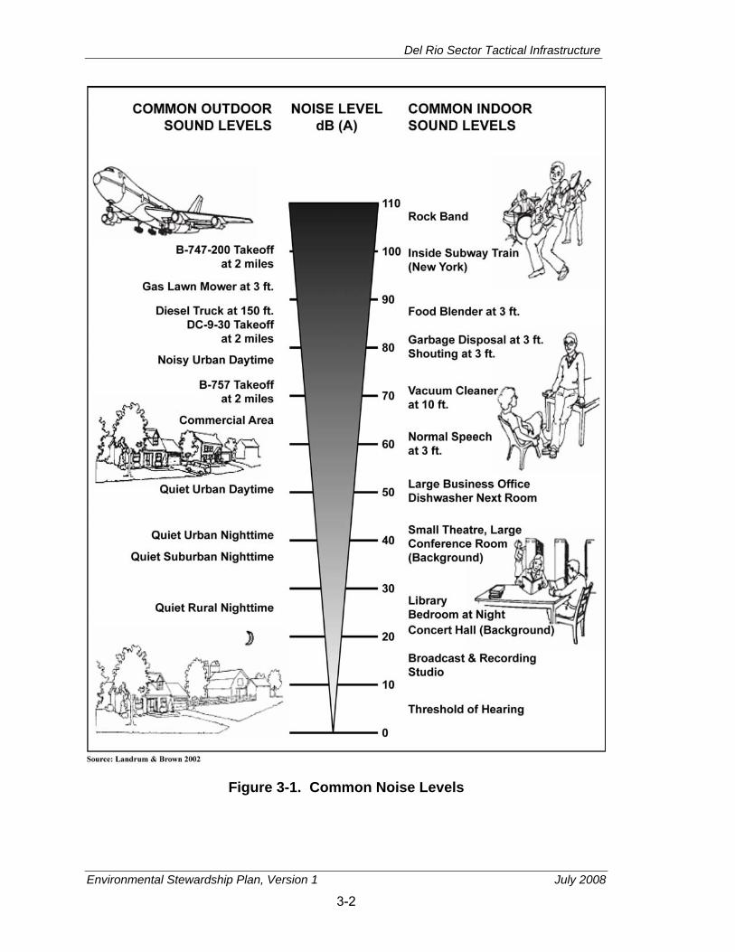
Noise levels in residential areas vary depending on the housing density, location, and surrounding use. As shown in Figure 3-1, a quiet urban area in the daytime is about 50 dBA, which increases to 65 dBA for a commercial area, and 80 dBA for a noisy urban daytime area.
Construction Sound Levels. Construction activities can cause an increase in sound that is well above the ambient level. A variety of sounds come from graders, pavers, trucks, welders, and other work processes. Table 3-1 lists noise levels associated with common types of construction equipment that are likely to be used for the Project. Construction equipment usually exceeds the
Del Rio Sector Tactical Infrastructure
Environmental Stewardship Plan, Version 1 July 2008
3-2
Figure 3-1. Common Noise Levels

Del Rio Sector Tactical Infrastructure
Environmental Stewardship Plan, Version 1 July 2008
3-3
Table 3-1. Noise Levels for Construction Equipment
Construction Category and Equipment
Predicted Noise Level at 50 feet (dBA)
Bulldozer 80 Grader 80–93 Truck 83–94 Roller 73–75 Backhoe 72–93 Jackhammer 81–98 Concrete mixer 74–88 Welding generator 71–82 Pile driver 91–105 Crane 75–87 Paver 86–88
Source: USEPA 1971
ambient sound levels by 20 to 25 dBA in an urban environment and up to 30 to 35 dBA in a quiet suburban area.
In general, construction equipment usually exceeds the ambient sound levels by 20 to 25 dBA in an urban environment and up to 30 to 35 dBA in a quiet suburban area. Pile driving will exceed ambient sound levels by approximately 25 to 35 dBA in an urban environment and 35 to 45 dBA in a quiet suburban area.
3.2 AFFECTED ENVIRONMENT The two sections of tactical infrastructure will be in areas with different acoustical environments. Del Rio, Texas, directly abuts the U.S./Mexico international border, and sits across the Rio Grande from Ciudad Acuña, Mexico. The ambient acoustical environment near Del Rio is primarily affected by vehicle traffic, agricultural equipment, aircraft operations, and industrial noise sources. Noise levels for the majority of Del Rio are likely to be equivalent to a quiet rural or suburban area (30 to 50 dBA). The dominant noise sources adjacent to the border likely originate from residential or commercial sources.
Major transportation routes in the vicinity of Del Rio include U.S. Highway 277, State Route (SR) 90, and State Highway Spur 239. SR 277 passes through the northern side of Del Rio, running southeast to northwest and abuts several residential communities as it passes through the city. SR 90 runs north to south through central Del Rio and continues east from the city. SR 90 runs through many residential communities both to the north and east of Del Rio. State Highway Spur 239 runs northeast to southwest from central Del Rio to the

Del Rio Sector Tactical Infrastructure
Environmental Stewardship Plan, Version 1 July 2008
3-4
U.S./Mexico international border, and passes by several residential areas on the southwestern side of the city. State Highway Spur 239 handles a heavy volume of traffic that crosses the border in both directions. Additionally, there are several trucking companies along State Highway Spur 239, Garza Lane, and Rio Grande Road. Traffic from these businesses contributes to the ambient acoustic environment along the impact corridor in Section M-1.
Industrial and commercial facilities in the vicinity of Del Rio are present mainly on the western side of the city with some on the northern side. However, there are several commercial and industrial businesses along Garza Lane in the southwestern section of Del Rio as well. Noise from these facilities contributes to the ambient acoustic environment along the impact corridor in Section M-1.
Del Rio International Airport is approximately 1.5 miles northwest of downtown Del Rio. There is an average of 48 aircraft operations at Del Rio International Airport each day (AirNav 2007). Consequently, noise from aircraft operations contributes slightly to the ambient acoustic environment in the vicinity of Del Rio, especially in close proximity to the airport.
Along the U.S./Mexico international border in areas south of Del Rio, agricultural activities are prominent. Noise from agricultural equipment can reach up to 100 dBA for the operator (OSU 2007). Irrigation activities occurring at these farm sites will also contribute to the ambient acoustical environment at times when they are in operation. While farms are generally spread out, noise from agricultural activities is likely to extend past the farm boundaries. Noise generated by small farms near the impact corridor will have an effect on the acoustic environment of Section M-1.
Eagle Pass, Texas, directly abuts the U.S./Mexico international border, and sits across the Rio Grande from Piedras Negras, Mexico. The ambient acoustical environment near Eagle Pass is primarily affected by vehicular traffic and industrial noise sources. Noise levels in Eagle Pass are likely to be equivalent to a quiet suburban or urban area (40 to 65 dBA). Noise sources directly adjacent to the border likely originate from residential sources.
Major transportation routes in the vicinity of Eagle Pass include SR 57, SR 277, and Ranch Road 1021. SR 57 runs east to west through central Eagle Pass, and connects Eagle Pass to Piedras Negras. Cross-border traffic on SR 57 will contribute heavily to the ambient acoustical environment in the vicinity of the border station. SR 277 traverses north-south in Eagle Pass and then continues east from the city. Ranch Road 1021 runs northwest to southeast, passing through the town of Las Quintas Fronterizas, Texas. Each of these major transportation routes passes by several residential areas in the vicinity of Eagle Pass. Traffic along these roads contributes to the ambient acoustical environment. USBP currently uses patrol roads along the border and, therefore, USBP activities contribute to the acoustic environment along the border.
Del Rio Sector Tactical Infrastructure
Environmental Stewardship Plan, Version 1 July 2008
3-5
Industrial activities in Eagle Pass are concentrated mainly on the northeastern side of the city. There are several commercial operations in southwestern Eagle Pass. Noise from industrial activities and commercial operations, as well as traffic entering and leaving the facilities, contributes to the ambient acoustic environment of Section M-2A.
3.3 DIRECT AND INDIRECT EFFECTS OF THE PROJECT Short-term, moderate to major adverse effects will be expected. Temporary sources of noise will include operation of construction equipment and vehicles. Noise from construction activities and vehicle traffic can affect wildlife as well as humans. Noise effects on wildlife, particularly birds and mid- to large-sized mammals, are described in Chapter 7.
Construction of the tactical infrastructure will result in noise effects on populations in the vicinity of the sites. Construction will result in increased noise levels associated with construction equipment used for grading, building, and possible pile-driving activities. Populations that could be affected by construction noise include adjacent residents; people visiting the adjacent recreation areas; or patrons and employees in nearby office, retail, or commercial buildings.
Noise from construction activities varies depending on the type of construction equipment being used, the area that the Project will occur in, and the distance from the source. To predict how these activities will affect adjacent populations, noise from construction was estimated. For example, as shown on Table 3-1, construction usually involves several pieces of equipment (e.g., a backhoe and haul truck) that can be used simultaneously. Under the Project, cumulative noise from construction equipment used during the busiest day was estimated to determine the total effect of noise from building activities at a given distance. Since noise attenuates over distance, a gradual decrease in noise level occurs the further a receptor is away from the source of noise. The closest residence in Del Rio and Eagle Pass will be approximately 100 feet from Section M-1. At this distance, anticipated noise levels from construction will be approximately 79 dBA. Possible pile-driving noise from the construction of the tactical infrastructure could reach 95 dBA for residents 100 feet from the construction.
Implementation of the Project will have temporary adverse effects on the acoustic environment from the use of heavy equipment during construction activities.
Increased noise levels from construction activities will affect residents as well as populations using recreational facilities. In general, users of recreational areas anticipate a quiet environment. Noise from construction will affect the ambient acoustical environment around these sites but will be temporary.
Noise effects from increased construction traffic will be temporary in nature. These effects will last only as long as the construction activities are ongoing. Most of the major roadways in the vicinity pass by residential areas. Therefore,

Del Rio Sector Tactical Infrastructure
Environmental Stewardship Plan, Version 1 July 2008
3-6
short-term minor adverse noise effects are expected from an increase in traffic, most notably in the areas around SRs 277, 90, and 57.
Long-term, negligible, adverse effects on the acoustical environment will result from vehicle traffic patrols. While adjustments to USBP operations due to tactical infrastructure construction will be anticipated to be negligible, shifts in operation pattern, location, or frequency will affect the noise environment in the vicinity of the tactical infrastructure.
Del Rio Sector Tactical Infrastructure
Environmental Stewardship Plan, Version 1 July 2008
4-1
4. LAND USE AND VISUAL RESOURCES
4.1 DEFINITION OF THE RESOURCE Although the Secretary's waiver means that CBP no longer has any specific legal obligations for the tactical infrastructure segments addressed in this ESP, the Secretary committed CBP to responsible environmental stewardship of our valuable natural and cultural resources. CBP supports this objective and has applied the appropriate standards and guidelines for evaluating environmental impacts and mitigations associated with land use.
The term land use refers to real property classifications that indicate either natural conditions or the types of human activity occurring on a parcel. In many cases, land use descriptions are codified in local zoning laws. There is, however, no nationally recognized convention or uniform terminology for describing land use categories. As a result, the meanings of various land use descriptions, labels, and definitions vary among jurisdictions.
Two main objectives of land use planning are to ensure orderly growth and compatible uses among adjacent property parcels or areas. Compatibility among land uses fosters the societal interest of obtaining the highest and best uses of real property. Tools supporting land use planning include written master plans/management plans and zoning regulations. In appropriate cases, the location and extent of the Project needs to be evaluated for its potential effects on the impact corridor and adjacent land uses. The Project was evaluated in terms of land use and its compatibility with any applicable land use or zoning regulations. Other relevant factors include matters such as existing land use in the impact corridor, the types of land uses on adjacent properties and their proximity to a project, the duration of the activity, and its permanence.
4.1.1 Affected Environment
The existing land use in the vicinity of the impact corridor includes well-developed urban centers of commerce (i.e., Del Rio and Eagle Pass), and open natural land. For the purposes of this ESP, a land use analysis was conducted using the National Land Cover Dataset. The National Land Cover Dataset is the first land cover mapping project with a national scope. Land cover and land use are closely related in that land uses commonly have similarly associated cover types, such as agricultural and residential. The National Land Cover Dataset provides 21 different land cover classes for the lower 48 states. The 21 land cover classes were generalized into the following 4 land classification categories: agricultural, developed, undeveloped, and water. The definitions of each category are defined below.
• Agricultural – Areas characterized by herbaceous vegetation that have been planted or are intensively managed for the production of food, feed,
Del Rio Sector Tactical Infrastructure
Environmental Stewardship Plan, Version 1 July 2008
4-2
or fiber; or are maintained in developed settings for specific purposes. Specific land cover classes grouped for the agricultural classification include pasture/hay; row crops; small grains; fallow areas used for the production of crops that are temporarily barren or with sparse vegetative cover; and urban/recreational grasses consisting of vegetation planted in developed settings for recreation, erosion control, or aesthetic purposes.
• Developed – Areas characterized by a high percentage (30 percent or greater) of constructed materials such as asphalt, concrete, and buildings. These include low- and high-intensity residential uses (e.g., single-family housing units and apartment complexes/rowhouses, respectively), and commercial/industrial/transportation infrastructure, which consists of all highly developed areas not classified as high-intensity residential and transportation infrastructure such as roads and railroad.
• Water – This land classification consists of all areas of open water (typically 25 percent or greater cover of water), including naturally occurring and man-made lakes, reservoirs, gulfs, bays, rivers, and streams; and perennial ice/snow, although no ice or snow was detected within the area analyzed for this ESP.
• Undeveloped – This land classification consists of the remaining 11 land cover classes not used for the agricultural, developed, and water land use classifications. These land cover classes include barren (bare rock/sand/clay, quarries/strip mines/gravel pits, and transitional), forested upland (deciduous forest, evergreen forest, and mixed forest), shrubland, nonnatural woody (orchards/vineyards/other), herbaceous upland (grasslands/herbaceous), and wetlands (woody wetlands and emergent herbaceous wetlands).
The following is a brief description of the land classifications and associated land uses within and adjacent to the impact corridor. The impact corridor traverses 17 land parcels in Section M-1 and 3 private and public land parcels in Section M-2A and is classified by approximately 43 percent developed land, 4.3 percent water, and 52 percent undeveloped land (see Table 4-1).
• Agricultural – sections M-1 and M-2A consist of no agricultural land.
• Developed – Approximately 43.2 percent of Sections M-1 and M-2A consist of developed lands. A majority of the developed land within Section M-1 is immediately north of Garza Lane, Rio Grande Road, and Qualia Drive, and consist of private residences, commercial entities, and other structures such as the Silver Lake Wastewater Treatment Plant.
• Water – There is no water within the impact corridor of Section M-1, however there are approximately 2 acres of water within Section M-2A, representing approximately 4.3 percent of the impact corridor.

Del Rio Sector Tactical Infrastructure
Environmental Stewardship Plan, Version 1 July 2008
4-3
• Undeveloped – The majority (52.5 percent) of the impact corridor consists of undeveloped land. The undeveloped land is privately and publicly owned.
Table 4-1. Land Classifications Within the Impact Corridor
Tactical Infrastructure
Section Number
Land Classification (acres) Total Acres
Total PercentAgricultural Developed Water Undeveloped
M-1 - 20.2 - 23.2 43.3 89.0% M-2A - 0.9 2.1 2.4 5.4 11.0%
Total Acres 0.0 21.0 2.1 25.5 48.7 Total Percent 0% 43.2% 4.3% 52.5%
4.1.2 Direct and Indirect Effects of the Project
Constructing the tactical infrastructure will result in long-term minor adverse effects on land use. Additionally, no land designated as agricultural will be affected by the Project. The figures in Chapter 1.4 show the locations of the tactical infrastructure and the proximity of adjacent and intersecting land.
Short-term minor adverse effects will occur from construction. Effects on land use will vary depending on potential changes in land use and the land use of adjacent properties.
Construction of the tactical infrastructure will require the government to acquire various interests in land. Section M-1 will traverse 17 private and public land parcels in Del Rio, Texas, and Section M-2A will traverse 3 private and public land parcels in Eagle Pass, Texas. Property owners and residents could be directly, adversely affected by restricted access, visual effects (see Chapter 4.2.3), noise effects during construction (see Chapter 3.3), and other disruptions during construction. Under current law, the Secretary of Homeland Security has the authority to contract for or buy an interest in land that is adjacent to or in the vicinity of the U.S./Mexico international border when the Secretary deems the land essential to control and guard the boundaries and borders of the United States (8 U.S.C. § 1103(b)).
Because the tactical infrastructure will traverse both public and private lands, various methods could be used to acquire the necessary interests in land. These methods include, among other things, acquiring permanent easements, ROWs, or outright purchase in fee simple. There will be long-term major adverse effects on property owners who do not wish to sell their property or relocate, however, the adverse effects will be mitigated through compensation at fair market value for the property.

Del Rio Sector Tactical Infrastructure
Environmental Stewardship Plan, Version 1 July 2008
4-4
On private land, the government will likely purchase the land or some interest in land from the relevant landowner. Acquisition from private landowners will be a negotiable process that will be carried out between the government and the landowner on a case-by-case basis. The government also has the statutory authority to acquire such interests through eminent domain.
Gates may be installed in the primary pedestrian fence to provide landowners, whose properties will be affected, to provide access to other portions of their property to reduce potential inconvenience. Private and public developed and undeveloped lands within the impact corridor will not be available for future development.
4.2 VISUAL RESOURCES
4.2.1 Definition of the Resource
Although the Secretary's waiver means that CBP no longer has any specific legal obligations for the tactical infrastructure segments addressed in this ESP, the Secretary committed CBP to responsible environmental stewardship of our valuable natural and cultural resources. CBP supports this objective and has applied the appropriate standards and guidelines for evaluating environmental impacts and mitigations associated with visual resources.
CBP does not currently have a standard methodology for the analysis and assessment of effects on visual resources. Accordingly, a standard methodology developed by another Federal agency was adopted for the analysis and assessment of effects on visual resources for this ESP. Methodologies reviewed included those developed by the National Park Service (NPS), the Bureau of Land Management (BLM), and the Federal Highway Administration (FHWA). It was determined that the FHWA methodology was the most applicable for this analysis due to its focus on linear corridors that include a variety of features and cross-cut a variety of landscapes. The FHWA methodology examines visual resources in similar ways (texture, contrast, visual quality) as those of NPS and BLM, but unlike those methodologies, the FHWA does not tie the assessment to the management goals for a given parcel of land (i.e., BLM- and NPS-owned land parcels typically have specific management goals and the assessment of effects on visual resources within a given parcel is tied to the management priorities for those parcels).
The discussion in the following paragraphs summarizes the methology presented in FHWA Publication No. FHWA-HI-88-054: Visual Impact Assessment for Highway Projects (USDOT undated). Under the FHWA approach, the major components of the visual analysis process include establishing the visual environment of a project, assessing the visual resources of the project area, and identifying viewer response to those resources.
Del Rio Sector Tactical Infrastructure
Environmental Stewardship Plan, Version 1 July 2008
4-5
Establishing a Visual Environment. Two related steps are performed to characterize the visual environment: (1) develop a framework for visual assessment for the project area, and (2) define the physical limits of the visual environment that a project might affect. The landscape classification process establishes the general visual environment of a project and its place in the regional landscape. The starting point for the classification is an understanding of the landscape components that make up the regional landscape, which then allows comparisons between landscapes. Regional landscapes consist of landforms (or topography) and land cover. It should be noted that land cover is not equivalent to land use, as that term is defined and used in Chapter 4.1.1. Land cover is essential to the identification of what features (e.g., water, vegetation, type of man-made development) dominate the land within a given parcel. Examples of land cover include agricultural field, residential development, airport, forest, grassland, and reservoir. While there is some overlap with land use, land cover does not distinguish function or ownership of parcels.
Relatively homogenous combinations of landforms and land cover that recur throughout a region can be considered landscape types. To provide a framework to determine the visual effects of the Project, the regional landscape is divided into distinct landscape units; these are usually enclosed by clear landform or land cover boundaries and many of the views within the unit are inward-looking. Landscape units are usually characterized by diverse visual resources, and it is common for several landscape types to be in view at any one time.
Assessing the Visual Resources. An assessment of the visual resources within a project area involves characterization of the character and quality of those resources. Descriptions of visual character can distinguish at least two levels of attributes: pattern elements and pattern character. Visual pattern elements are primary visual attributes of objects; they include form, line, color, and texture. Awareness of these pattern elements varies with distance. The visual contrast between a project and its visual environment can frequently be traced to four aspects of pattern character: dominance, scale, diversity, and continuity.
Visual quality is subjective, as it relies on the viewer’s enjoyment or interpretation of experience. For example, there is a clear public agreement that the visual resources of certain landscapes have high visual quality and that plans for projects in those areas should be subject to careful examination. Approaches to assessing visual quality include identifying landscapes already recognized at the national, regional, or local level for their visual excellence (e.g., National Historic Landmarks [NHLs], National Scenic Rivers); asking viewers to identify quality visual resources; or looking to the regional landscape for specific resource indicators of visual quality. One evaluative approach that has proven useful includes three criteria: vividness (the visual power or memorable character of the landscape), intactness (the visual integrity of the natural and man-made landscape and its freedom from encroaching elements), and unity (the visual

Del Rio Sector Tactical Infrastructure
Environmental Stewardship Plan, Version 1 July 2008
4-6
coherence and compositional harmony of the landscape considered as a whole). A high value for all three criteria equates to a high visual quality; combinations of lesser values indicate moderate or low visual quality. It should be noted that low visual quality does not necessarily mean that there will be no concern over the visual effects of a project. In instances such as urban settings, communities might ask that projects be designed to improve existing visual quality.
Identifying Viewer Response. An understanding of the viewers who might see the project and the aspects of the visual environment to which they are likely to respond is important to understanding and predicting viewer response to the appearance of a project. The receptivity of different viewer groups to the visual environment and its elements is not equal. Viewer sensitivity is strongly related to visual preference; it modifies visual experience directly by means of viewer activity and awareness, and indirectly by means of values, opinions, and preconceptions. Because viewers in some settings are more likely to share common distractions, activities, and awareness of their visual environment, it is reasonable to distinguish among project viewers located in residential, recreational, and industrial areas.
Visual awareness is the extent to which the receptivity of viewers is heightened by the immediate experience of visual resource characteristics. Visual change heightens awareness of, for example, a landscape transition, such as entering a mountain range or a major city, and can heighten viewer awareness within that particular viewshed. Measures that modify viewer exposure, such as selective clearing or screening, can also be deliberately employed to modify viewer awareness. Viewers also tend to notice and value the unusual, so they might see more value in preserving the view towards a particularly dramatic stand of trees than the view towards more ubiquitous landscape features.
Local values and goals operate indirectly on viewer experience by shaping view expectations, aspirations, and appreciations. For example, at a regional or national level, viewers might be particularly sensitive to the visual resources and appearance of a particular landscape due to its cultural significance, and any visual evidence of change might be seen as a threat to these values or resources. Concern over the appearance of the project often might be based on how it will affect the visual character of an area rather than on the particular visual resources it will displace.
Aesthetics is the science or philosophy concerned with the quality of visual experience. One cannot meaningfully assess the effects of an action on visual experience unless one considers both the stimulus (visual resources) and the response (viewers) aspects of that experience.
4.2.2 Affected Environment
Visual Environment. Primary landform types present within the project area includes the Rio Grande channel and that of a stream that intersects the Rio

Del Rio Sector Tactical Infrastructure
Environmental Stewardship Plan, Version 1 July 2008
4-7
Grande on the south side of Del Rio in Section M-1, the floodplains and terraces of those waterways, and the bluff along the river in Section M-2A. Within the Rio Grande terrace are a number of oxbow lakes, some containing water, and some only visible as traces on aerial photographs.
Land cover overlying these landforms can be simplified into four primary types: agricultural, developed, undeveloped, and water, with developed composing the dominant land cover type in Sections M-1 and M-2A (see Chapter 4.1.2). There are also certain features that cross-cut or link land cover types, such as transportation features (e.g., highways, paved and unpaved roads, bridges).
Although there is significant development in both Sections M-1 and M-2A, views that contain only undeveloped areas remain within each section. Accordingly, the most applicable landscape unit types that can be defined for these sections are undeveloped and urban/industrial. Figures 4-1 and 4-2 show the range of variation of views within these landscape units.
Figure 4-1. Photograph View of Del Rio Residential Areas (Section M-1)
The undeveloped unit includes the terraces and floodplain of the Rio Grande where they are overlain by undeveloped, open areas. The underlying landforms are clearly visible and play the primary role in the layout or location of overlying features. Typical features include field breaks, dirt roads, and isolated structures such as electrical transmission lines or water tanks.
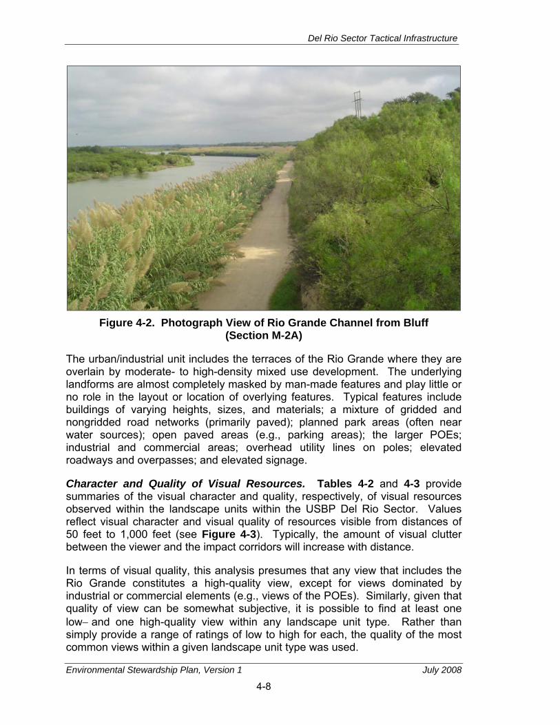
Del Rio Sector Tactical Infrastructure
Environmental Stewardship Plan, Version 1 July 2008
4-8
Figure 4-2. Photograph View of Rio Grande Channel from Bluff
(Section M-2A)
The urban/industrial unit includes the terraces of the Rio Grande where they are overlain by moderate- to high-density mixed use development. The underlying landforms are almost completely masked by man-made features and play little or no role in the layout or location of overlying features. Typical features include buildings of varying heights, sizes, and materials; a mixture of gridded and nongridded road networks (primarily paved); planned park areas (often near water sources); open paved areas (e.g., parking areas); the larger POEs; industrial and commercial areas; overhead utility lines on poles; elevated roadways and overpasses; and elevated signage.
Character and Quality of Visual Resources. Tables 4-2 and 4-3 provide summaries of the visual character and quality, respectively, of visual resources observed within the landscape units within the USBP Del Rio Sector. Values reflect visual character and visual quality of resources visible from distances of 50 feet to 1,000 feet (see Figure 4-3). Typically, the amount of visual clutter between the viewer and the impact corridors will increase with distance.
In terms of visual quality, this analysis presumes that any view that includes the Rio Grande constitutes a high-quality view, except for views dominated by industrial or commercial elements (e.g., views of the POEs). Similarly, given that quality of view can be somewhat subjective, it is possible to find at least one low− and one high-quality view within any landscape unit type. Rather than simply provide a range of ratings of low to high for each, the quality of the most common views within a given landscape unit type was used.
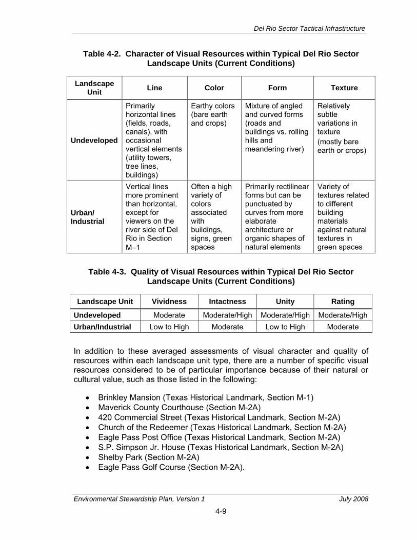
Del Rio Sector Tactical Infrastructure
Environmental Stewardship Plan, Version 1 July 2008
4-9
Table 4-2. Character of Visual Resources within Typical Del Rio Sector Landscape Units (Current Conditions)
Landscape Unit Line Color Form Texture
Undeveloped
Primarily horizontal lines (fields, roads, canals), with occasional vertical elements (utility towers, tree lines, buildings)
Earthy colors (bare earth and crops)
Mixture of angled and curved forms (roads and buildings vs. rolling hills and meandering river)
Relatively subtle variations in texture (mostly bare earth or crops)
Urban/ Industrial
Vertical lines more prominent than horizontal, except for viewers on the river side of Del Rio in Section M−1
Often a high variety of colors associated with buildings, signs, green spaces
Primarily rectilinear forms but can be punctuated by curves from more elaborate architecture or organic shapes of natural elements
Variety of textures related to different building materials against natural textures in green spaces
Table 4-3. Quality of Visual Resources within Typical Del Rio Sector
Landscape Units (Current Conditions)
Landscape Unit Vividness Intactness Unity Rating
Undeveloped Moderate Moderate/High Moderate/High Moderate/High Urban/Industrial Low to High Moderate Low to High Moderate In addition to these averaged assessments of visual character and quality of resources within each landscape unit type, there are a number of specific visual resources considered to be of particular importance because of their natural or cultural value, such as those listed in the following:
• Brinkley Mansion (Texas Historical Landmark, Section M-1) • Maverick County Courthouse (Section M-2A) • 420 Commercial Street (Texas Historical Landmark, Section M-2A) • Church of the Redeemer (Texas Historical Landmark, Section M-2A) • Eagle Pass Post Office (Texas Historical Landmark, Section M-2A) • S.P. Simpson Jr. House (Texas Historical Landmark, Section M-2A) • Shelby Park (Section M-2A) • Eagle Pass Golf Course (Section M-2A).

Del Rio Sector Tactical Infrastructure
Environmental Stewardship Plan, Version 1 July 2008
4-10
Figure 4-3. Schematic Showing Visibility of Fencing at Various Distances

Del Rio Sector Tactical Infrastructure
Environmental Stewardship Plan, Version 1 July 2008
4-11
Viewer Response. The pool of viewers making up the affected environment includes single individuals, such as rural landowners on whose property the primary pedestrian fence will be constructed, and groups of individuals such as residents and business owners in the cities of Del Rio and Eagle Pass, or recreational users of public access recreation areas. Viewers could also include advocational groups such as local historical societies or local chapters of the National Audubon Society that have interests in preserving the settings of cultural or natural resources. These viewers are likely to have both individual responses to specific resources related to their experiences and emotional connection to those resources, as well as collective responses to visual resources considered to be important on a regional, state, or national level. Although individual viewer responses will be captured where possible from viewer comments, for the purposes of this analysis, the pool of affected viewers will be grouped into the following general categories:
• Residential viewers
• Urban residents
• Commercial viewers - Urban businesses
• Industrial viewers - Town and urban
• Recreational viewers - Tourists visiting towns and cities
• Special interest viewers
− Native American tribes - Local historical societies - Local chapters of conservation societies (e.g., Audubon Society) - Park commissions - Regulatory agencies (e.g., USFWS, Texas Historical Commission
[THC])
• Intermittent viewers (view primarily from transportation corridors)
− Commuters - Commercial (e.g., vehicle drivers).
Within each of these categories, viewer response will also vary depending on the typical duration of exposure to visual resources and the typical distance from which they view those resources. For example, a residential viewer who currently has an unobstructed view of a high-quality resource from their backyard will be affected differently than a residential viewer who lives several streets away and already has an obstructed view of those resources, or a viewer that only views the resource from the highway as they pass through the region.
Del Rio Sector Tactical Infrastructure
Environmental Stewardship Plan, Version 1 July 2008
4-12
4.2.3 Direct and Indirect Effects of the Project
The Project will affect visual resources both directly and indirectly. Construction of tactical infrastructure will result in the introduction of both temporary (e.g., heavy equipment, supplies) and permanent (e.g., fencing and patrol roads) visual elements into existing viewsheds. Clearing and grading of the landscape during construction will result in the removal of visual elements from existing viewsheds. Finally, the primary pedestrian fence sections will create a physical barrier potentially preventing access to some visual resources.
Effects on aesthetic and visual resources will include short-term effects associated with the construction phase of the Project and use of staging areas, recurring effects associated with monitoring and maintenance, and long-term effects associated with the completed Project. Effects can range from minor, such as the effects on visual resources adjacent to the impact corridor when seen from a distance or when views of primary pedestrian fences are obstructed by intervening elements (e.g., trees, buildings) to major, such as the intrusion of primary pedestrian fence sections into high-quality views of the Rio Grande or the setting of an NHL. The nature of the effects will range from neutral for those land units containing lower quality views or few regular viewers, to adverse, for those land units containing high-quality views, important cultural or natural resources, or viewers who will have constant exposure to the primary pedestrian fence at close distances. Beneficial effects are also possible (e.g., addition of the primary pedestrian fence increases the unity or dramatic effect of a view, removal of visual clutter within the impact corridor clarifies a view, or a viewer positively associates the primary pedestrian fence with a feeling of greater security), but are considered to be less common.
Project Characteristics. The primary introduced visual elements associated with the Project in Section M-1 will be the single line of fencing, gates, patrol and access roads, and construction clutter (e.g., stockpiles of supplies and heavy equipment during construction). The Project will also potentially remove existing visual elements, such as buildings, vegetation, and subtle landforms (through grading or filling) that occur within the impact corridor. Finally, the primary pedestrian fence will act as a physical barrier between viewers and those views that can only be viewed from vantage points on the other side of the fence.
The addition of fencing and the associated patrol road, removal of existing elements from the impact corridor in Section M-1, and the loss of access to specific visual resources due to the fact that the primary pedestrian fence is a barrier, will have long-term effects on visual resources, while the remaining elements will have temporary or short-term effects limited to the period of construction. The nature (adverse or beneficial) and degree (minor to major) of the long-term effects can be affected by the appearance of the fencing (width, height, materials, color), the patrol road (paved or unpaved, width), the lighting configuration (number of lighting poles, number of lights per pole, angle and screening of lights), and the access roads (number, paved or unpaved, width).

Del Rio Sector Tactical Infrastructure
Environmental Stewardship Plan, Version 1 July 2008
4-13
In all cases, removal of existing elements will have the net result of exposing more of the primary pedestrian fence, patrol road, and other tactical infrastructure. In settings where the addition of the fence is considered to have a major adverse effect on visual resources, any benefit occurring from removal of existing elements will be outweighed by the more dominant adverse visual effect of the primary pedestrian fence.
The effects associated with the loss of access to specific visual resources in Section M-1 and the northern portion of Section M-2A can be affected primarily by the placement of the primary pedestrian fence relative to those resources and inclusion of gates that allow access to those resources. CBP has already included provisions for a number of gates to allow access to agricultural fields, businesses, and cemeteries. These gates also allow access to some of the visual resources that will otherwise be blocked.
The patrol road will be the existing road between the bluff and the river bank. The primary new visual addition to the corridor will be lighting poles, placed at approximately 100-yard intervals along the patrol road. Clearing of vegetation and some cutting of the bluff will likely be required as part of the retaining wall construction.
Visual Resource Concerns. In Chapter 4.2.2, Tables 4-2 and 4-3 provide a summary of the character and quality of visual resources currently present within the impact corridor. Tables 4-4 and 4-5 show how implementation of the Project will likely alter the character and quality of existing visual resources within each landscape unit. Figures 4-4 and 4-5 provide examples of typical effects; these images show the effects associated with the addition of a fence constructed using a type of primary pedestrian fence currently being constructed in other USBP sectors. These photographs provide approximations of the degree of alteration that will result from introduction of the primary pedestrian fence and patrol road to these viewsheds.
In Section M-1, most viewers would look out towards the Rio Grande and, beyond that, to an urban landscape backed by mountains. In Section M-2A, viewers are closer to the Rio Grande, but views on the opposite bank are primarily natural vegetation backed by mountains. Views in the southern portion of Section M-2A could also include Shelby Park or the Eagle Pass Golf Course in the foreground, the international bridge and Eagle Pass POE and the Rio Grande in the mid-ground, and an urban landscape backed by mountains in the distance.
From within Del Rio or Eagle Pass, typically greater screening of the primary pedestrian fence will be expected due to the greater variety of lines, colors, forms, and textures present. More common occurrences of other tactical infrastructures and tall or massive forms will also increase the ability of the tactical infrastructure to blend with its surroundings in Section M-1 and the northern part of Section M-2A. The effect of the tactical infrastructure at closer

Del Rio Sector Tactical Infrastructure
Environmental Stewardship Plan, Version 1 July 2008
4-14
Table 4-4. Effect on the Character of Visual Resources within Typical Del Rio Sector Landscape Units
Landscape Units Line Color Form Texture
Undeveloped
At short distances the fence will introduce a primarily horizontal line that might blend with other dominant horizontal lines. With greater distance, the vertical posts of the fence might blend where other vertical elements are present (power poles, remote video surveillance system) depending on the height of those elements in each area. The regularity of the lines could contrast with less regular lines.
The current fence design parameters call for fencing to be black. Although the vertical posts in the fence might blend with tree trunks, choice of a color scheme that matches the dominant vegetation will reduce the impact.
The fence and patrol road are rectilinear in form and might result in greater domination of rectilinear forms compared to organic forms when viewed at a distance.
As a man-made, synthetic element, the fence will contrast with the dominant textures of this land unit. The patrol roads and access roads will not alter the viewshed for most rural landscapes, as a number of roads and field breaks are already present in this land unit.
Urban/ Industrial
In Section M-1, views include a mix of vertical and horizontal lines. In Section M-2A, linear elements are more typically horizontal. The introduction of additional linear features will be consistent with the existing landscape from a distance. In closer proximity, however, the height and regularity of the fence line will likely contrast with existing lines.
The pedestrian fence planned for all sections except the southern portion of Section M-2A is black, which might blend or contrast with its surroundings depending on the colors in the foreground and background.
Against a more natural or organic background, such as what viewers see in Section M-2A, the fence will be a noticeable contrast. Against a more developed background (Section M-1), the form and massing of the fence will be less of a contrast.
Except where the fence will be constructed within or immediately adjacent to existing development, the texture of the fence will contrast with natural elements around it. From a distance, the texture of the fence will blend against urban backgrounds that contain mixed textures, but will stand out relative to more natural backgrounds.

Del Rio Sector Tactical Infrastructure
Environmental Stewardship Plan, Version 1 July 2008
4-15
Table 4-5. Quality of Visual Resources within Typical Del Rio Sector Landscape Units after Construction
Land Units Vividness Intactness Unity Rating
Undeveloped Moderate Moderate/High Moderate Moderate Urban/Industrial Low to Moderate Low/Moderate Low to Moderate Moderate
Figure 4-4. Typical Views Towards Impact Corridor, Section M-1
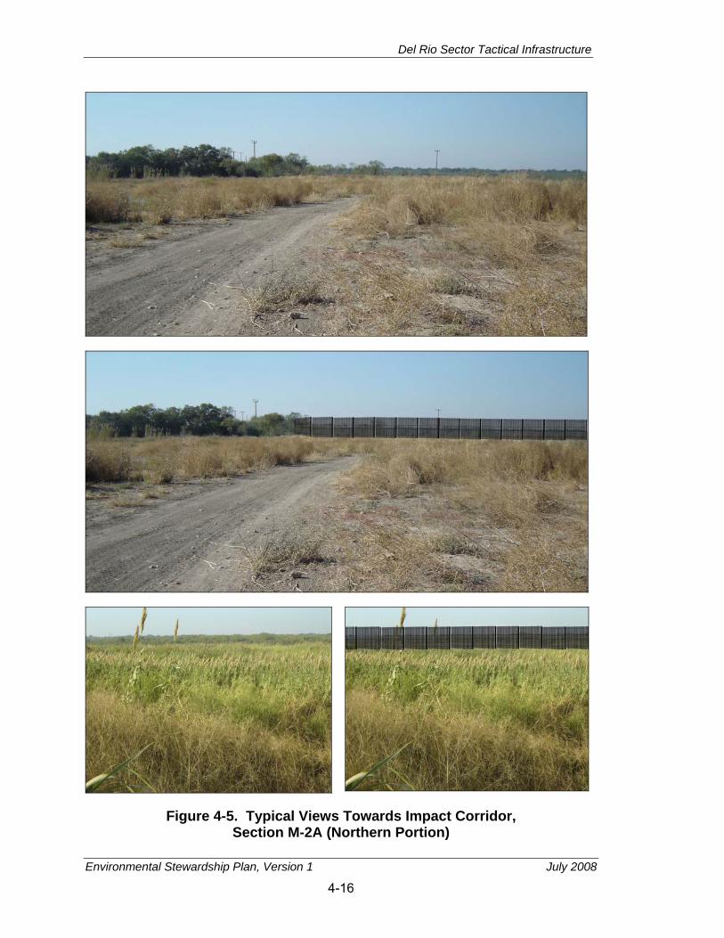
Del Rio Sector Tactical Infrastructure
Environmental Stewardship Plan, Version 1 July 2008
4-16
Figure 4-5. Typical Views Towards Impact Corridor, Section M-2A (Northern Portion)

Del Rio Sector Tactical Infrastructure
Environmental Stewardship Plan, Version 1 July 2008
4-17
distances will vary depending on its immediate setting; the more exposed the primary pedestrian fence is the greater the contrast between it and surrounding elements, and the greater the visual effect. For Section M-1 and the northern part of Section M-2A, the impacts will range from minor to major, and neutral to adverse. The FHWA guidance (USDOT undated) cites examples where the addition of a consistent aesthetic element to an urban setting helps create greater unity to the views within the land unit, thus resulting in a beneficial effect. Although this outcome is possible within this land unit type, a review of the settings along the impact corridor suggests that the best-case scenario will be a neutral or minor adverse effect.
In the southern part of Section M-2A, where the primary pedestrian fence will consist of a retaining wall on the river side of the existing bluff, the primary effect related to the Project will be from the lighting along the patrol road. The poles themselves should blend with existing visual clutter at a distance, but will be noticeable intrusions in the back yards of people living along the bluff. Perhaps more importantly, though, the pool of light generated by the lights will be a new visual element in the nighttime view for anyone looking towards the Rio Grande in this direction; depending on the intensity of the light and the amount of background lighting associated with the POE and the development across the river in Mexico, the pool of light might blend or stand in stark contrast to a typically dark setting. Accordingly, effects on visual resources in the southern part of Section M-2A will range from minor to major, and neutral to adverse.
Finally, with respect to the effects on the specific visual resources, implementation of the Project is expected to have short- or long-term adverse effects on the settings of those resources. The greater the distance between the resource and the intrusive visual elements (primarily the primary pedestrian fence), and the more intervening visual elements between them, the less the degree of the effect. For example, construction of the primary pedestrian fence at a distance of 60 feet from a historic building will typically constitute a major adverse effect, while construction of the primary pedestrian fence several hundred feet from the resource with intervening vegetation or buildings will reduce the effect to moderate or minor. Placement of the fence within the boundaries of an NHL or historic district, particularly where there is a high degree of visual continuity between resources (few noncontributing elements) will also be considered a major adverse effect on that resource. A more detailed discussion of the effects on the settings or viewsheds of specific cultural resources is provided in Chapter 8.
Viewer Response Concerns. In many respects, the principle of “not in my backyard” has a strong correlation with the responses of viewers for whom view of the primary pedestrian fence will be regular or constant (i.e., residential, commercial, or industrial viewers). Where the primary pedestrian fence will directly affect private property, the viewer response from the landowner will likely be that the Project will represent a major adverse effect on visual resources visible from their property. In the case of the properties in Eagle Pass, however,

Del Rio Sector Tactical Infrastructure
Environmental Stewardship Plan, Version 1 July 2008
4-18
the use of a retaining wall on the back side of the bluff might be considered less of an adverse effect than the clearing of vegetation from the impact corridor. As vegetation is re-established along the banks of the Rio Grande, the long-term effect might become neutral. There is also a possibility that the viewer response in this instance could be beneficial, based on a feeling of increased safety or security (e.g., fence as protection). Responses from viewers located a greater distance from the primary pedestrian fence, particularly if their view of the fence is obstructed by other elements or is simply part of the overall visual clutter, will typically be less intense (minor) and more likely neutral, unless the fence will obstruct a visual resource considered to be of high quality or of cultural importance. In general, the closer the proximity of the viewer to the fence, the more likely the response is to be major and adverse.
For viewers likely to view the primary pedestrian fence on a less-regular basis (i.e., recreational viewers, special interest viewers, intermittent viewers), viewer responses will be tied to perception of how the tactical infrastructure will alter their access (i.e., impede existing views or impede physical access to views) to valued visual resources. Although any of these groups might object on principle to any type of alteration or feel a beneficial response due to a sense of increased security, responses will be more intense and adverse where alterations downgrade the quality or character of existing visual resources.
As a final point, for viewers accustomed to accessing views available from settings other than parks or refuges, the construction of the tactical infrastructure will place a permanent barrier between the viewer and the visual resources in those locales. By presumption, any visual resource regularly sought out by a viewer will constitute a moderate- or high-quality visual resource; and restricting physical access to those resources will thus constitute a long-term major adverse effect for those viewers.
Del Rio Sector Tactical Infrastructure
Environmental Stewardship Plan, Version 1 July 2008
5-1
5. GEOLOGY AND SOILS
5.1 DEFINITION OF THE RESOURCE Although the Secretary's waiver means that CBP no longer has any specific legal obligations for the tactical infrastructure segments addressed in this ESP, the Secretary committed CBP to responsible environmental stewardship of our valuable natural and cultural resources. CBP supports this objective and has applied the appropriate standards and guidelines for evaluating environmental impacts and mitigations associated with geological and soils resources.
Geology and soils resources include the surface and subsurface materials of the earth. Within a given physiographic province, these resources typically are described in terms of topography, soils, geology, minerals, and paleontology, where applicable.
Topography is defined as the relative positions and elevations of the natural or human-made features of an area that describe the configuration of its surface. Regional topography is influenced by many factors, including human activity, seismic activity of the underlying geological material, climatic conditions, and erosion. Information describing topography typically encompasses surface elevations, slope, and physiographic features (i.e., mountains, ravines, or depressions).
Site-specific geological resources typically consist of surface and subsurface materials and their inherent properties. Principal factors influencing the ability of geological resources to support structural development are seismic properties (i.e., potential for subsurface shifting, faulting, or crustal disturbance), topography, and soil stability. Soils are the unconsolidated materials overlying bedrock or other parent material. They develop from weathering processes on mineral and organic materials and are typically described in terms of their landscape position, slope, and physical and chemical characteristics. Soil types differ in structure, elasticity, strength, shrink-swell potential, drainage characteristics, and erosion potential, which can affect their ability to support certain applications or uses. In appropriate cases, soil properties must be examined for compatibility with particular construction activities or types of land use.
Prime and unique farmland is protected under the Farmland Protection Policy Act (FPPA) of 1981. Prime farmland is defined as land that has the best combination of physical and chemical characteristics for producing food, feed, forage, fiber, and oilseed crops, and is also available for these uses. Unique farmland is defined as land other than prime farmland that is used for the production of specific high-value food and fiber crops. It has the special combination of soil quality, location, growing season, and moisture supply needed to economically produce sustained high quality or high yields of a specific crop when treated and
Del Rio Sector Tactical Infrastructure
Environmental Stewardship Plan, Version 1 July 2008
5-2
managed according to acceptable farming methods. Soil qualities, growing season, and moisture supply are needed for well-managed soil to produce a sustained high yield of crops in an economic manner. The land could be cropland, pasture, rangeland, or other land, but not urban built-up land or water. The intent of the FPPA is to minimize the extent that Federal programs contribute to the unnecessary conversion of farmland to nonagricultural uses. The FPPA also ensures that Federal programs are administered in a manner that, to the extent practicable, will be compatible with private, state, and local government programs and policies to protect farmland.
The FPPA and Natural Resources Conservation Service (NRCS) pertain to activities on prime and unique farmland, as well as farmland of statewide and local importance (see 7 CFR Part 658, 5 July 1984). Determination of whether an area is considered prime or unique farmland and potential impacts associated with a project is based on preparation of the Farmland Conversion Impact Rating Form AD-1006 for areas where prime farmland soils occur and by applying criteria established at Section 658.5 of the FPPA (7 CFR 658).
5.2 AFFECTED ENVIRONMENT Physiography and Topography. Section M-1 in Del Rio, Texas, is on Edwards Plateau. The Edwards Plateau is known for the extent and quality of its groundwater aquifer system. Landforms around Del Rio include rolling hills. Most of the landscape features in the area have been the result of erosion caused by the Rio Grande and its tributaries (USACE 1994).
Section M-2A in Eagle Pass, Texas, is on the Balcones Escarpment of the Blackland Prairies which is the innermost section of the Gulf Coastal Plains. The blacklands have a gentle undulating surface where the majority of natural vegetation has been cleared to grow crops (University of Texas 2006).
Geology. The impact corridor lies on recent floodplain deposits adjacent to the Rio Grande. The soils are composed of sediments that include unconsolidated mixed gravel, sand, silt, and clay. The predominant rock types are mixed shales and sandstones. Some areas include bedrock along the channels of the Rio Grande. The landforms reflect the different rock types with the sandstones forming gentle hills and the shales forming valleys. The soils along the Del Rio Sector are subject to periodic flooding (NRCS 1982).
Section M-1 is underlain by hard limestone that is resistant to erosion. Val Verde County’s surface geology is dominated by sedimentary rock derived from deposits of three geologic periods (NRCS 1982). Section M-2A is underlain by the Navarro and Taylor Groups of the Quaternary Period including undivided Quaternary materials.
Soils. Section M-1 will cross over three soil units. The soil units (Lagloria loam, Rio Grande silt loam, and Rio Grande soils) are derived from Rio Grande

Del Rio Sector Tactical Infrastructure
Environmental Stewardship Plan, Version 1 July 2008
5-3
alluvium and are nearly level to sloping soils on floodplains and low terraces. The location for the Project lies primarily in Rio Grande soils and crosses over two excavation pits (see Appendix D).
Rio Grande soils (Ro) are deep, nearly level to gently sloping soils found on the bottom lands of the Rio Grande that are frequently flooded. Along the Del Rio Sector below Amistad Reservoir, these soils are flooded every 4 to 20 years when the floodgates are opened or from local runoff from nearby tributaries. Slopes range from 0 to 3 percent with an average of 1 percent. Mapped areas are long and parallel the Rio Grande. The surface layer is composed of silt loam, very fine sandy loam, loam, and very fine sand with no regular pattern. The surface layer is light brownish gray, very fine sandy loam about 8 inches thick. The underlying layer is light brownish gray. The Rio Grande soils are well−drained with slow surface runoff and are susceptible to erosion. Rio Grande soils are considered hydric soils. Hydric soils are defined as soils that formed under conditions of saturation, flooding, or ponding long enough during the growing season to develop anaerobic conditions in the upper layer (NRCS 1982).
Lagloria loam (LaB) is a deep, nearly level to gently sloping soil found on the low terraces of the Rio Grande. Slopes average 0.3 percent. The surface layer is brown loam and the subsoil is light yellowish brown loam. The soil is moderately alkaline and calcareous throughout. The soil is well-drained and surface runoff is medium. This soil is susceptible to erosion (NRCS 1982).
The Rio Grande silt loam (Rg) is a deep, nearly level to gently sloping soil found on the bottom lands of the Rio Grande. The soil below the Amistad Reservoir is occasionally flooded when the floodgates are opened or from local runoff from nearby tributaries. However, the dam protects these soils from the majority of flood events. Slopes range from 0 to 3 percent. The surface layer is pale brown silt loam and the subsoil is light brownish gray loam. The soil is well-drained with slow surface runoff (NRCS 1982).
The Rio Grande silt loam is the only soil map unit listed as prime farmland. Prime farmland has the combination of soil properties, growing season, and moisture supply needed to produce sustained high yields of crops in an economic manner if it is treated and managed according to acceptable farming methods (NRCS 2007). Although the soil type indicates it could be prime farmland, the area mapped as prime farmland is mostly located under the Del Rio POE. Therefore, no part of the impact corridor for Section M-1 is considered prime farmland.
The routes for Section M-2A will cross over four soil map units according to the Web Soil Survey. They are Copita sandy clay loam, Lagloria very fine sandy loam (0 to 1 percent slope), Lagloria very fine sandy loam (1 to 3 percent slope), and Rio Grande and Zalla soils, frequently flooded (NRCS 2007).

Del Rio Sector Tactical Infrastructure
Environmental Stewardship Plan, Version 1 July 2008
5-4
Rio Grande and Zalla soils (Rz) are found on the Rio Grande terrace adjacent to the river. These soils are flooded when sufficient water is released from Amistad Reservoir or from local runoff from nearby tributaries. Slopes range from 0 to 1 percent. The surface layer is 10 inches thick and is a very fine sandy loam while the subsoil (10 to 80 inches thick) is a stratified silt loam. The soil is well-drained to somewhat excessively drained (NRCS 2007).
The Copita sandy clay loam (CoB) forms linear bands in interfluves. The slope ranges from 1 to 3 percent. The surface soil layer and subsoil layer are both sandy clay loams. Between 20 and 40 inches, the soil reaches a restrictive paralithic bedrock layer. The soil is well-drained (NRCS 2007).
The Lagloria very fine sandy loam, 0 to 1 percent slope (LgA), forms linear bands on the upper reaches of the Rio Grande terrace. The slope ranges from 0 to 1 percent. The surface soil layer is very fine sandy loam and the subsoil layer is stratified silty clay loam. The Lagloria very fine sandy loam, 1 to 3 percent slope (LgB) has identical soil characteristics as LgA, but is found further from the Rio Grande on slight slopes (NRCS 2007). Both Lagloria very fine sandy loam soil types (LgA and LgB) are considered prime farmland when properly irrigated. However, the project area is not irrigated. Therefore, no part of the impact corridor for Section M-2A is considered prime farmland.
5.3 DIRECT AND INDIRECT EFFECTS OF THE PROJECT Short- and long-term minor adverse impacts on the natural topography are expected. Grading, contouring, and trenching associated with the installation of the tactical infrastructure will impact approximately 55 acres for Section M-1 and approximately 6 acres for Section M-2A, which could result in minor alterations of the existing microtopography. The impact corridor will be regraded, contoured, and revegetated following tactical infrastructure installation. This will minimize modifications to existing flood-flow characteristics.
The Storm Water Pollution Prevention Plans (SWPPPs) should contain one or more site maps that show the construction site perimeter, existing and buildings, lots, roadways, storm water collection and discharge points, general topography both before and after construction, and drainage patterns across the impact corridor. The SWPPPs must list BMPs that the discharger will use to protect storm water runoff along with the locations of those BMPs. Additionally, the SWPPPs must contain a visual monitoring program, a chemical monitoring program for nonvisible pollutants to be implemented if there is a failure of BMPs, and a sediment monitoring plan if the site discharges directly to a water body listed on the 303(d) list for sediment. Minor adverse impacts due to potential increased sheet flow as a result of grading, contouring, and trenching is expected to be temporary and mitigated by the implementation of the BMPs developed during preparation of the SWPPP.
Del Rio Sector Tactical Infrastructure
Environmental Stewardship Plan, Version 1 July 2008
5-5
Geology. Short- and long-term negligible to minor adverse impacts on geologic resources could occur at locations where bedrock is at the surface and blasting will be necessary to grade for fence placement or patrol road development. Geologic resources could affect the placement of the primary pedestrian fence or patrol roads due to the occurrence of bedrock at the surface, or as a result of structural instability. Site-specific geotechnical surveys will be conducted prior to construction to determine depth to bedrock. In most cases, it is expected that Project design and engineering practices could be implemented to mitigate geologic limitations to site development.
Soils. Short-term minor direct adverse impacts on soils are expected. Soil disturbance and compaction due to grading, contouring, and trenching associated with the installation of the tactical infrastructure sections will impact approximately 43 acres in Section M-1 and approximately 5 acres in Section M-2A. Short- and long-term minor to moderate adverse impacts are expected on approximately 3 acres for Section M-1 and approximately 1 acre for Section M-2A of the permanent soil disturbance as a result of grading, contouring, trenching, and compaction associated with the installation of the fence. The volume of soil disturbance cannot be determined due to the operational sensitivity of disclosing the exact depth of soil disturbance. However, displaced soil will be properly stockpiled to prevent erosion and sedimentation and excess soils will be disposed of properly if not utilized during regrading and recontouring activities following installation of the fence. In areas where soils have not been previously disturbed by development and other land uses prior to this Project, minor adverse effects on natural soil structure and soil organisms will be expected.
Increased soil erosion as a result of the construction activities will be minimized with the implementation of BMPs established during the development of the SWPPP. Implementing these BMPs will minimize adverse effects associated with sediments that could potentially be transported from construction sites and deposited in the Rio Grande. Construction activities expected to directly impact the existing soils as a result of grading, excavating, placement of fill, compaction, and mixing or augmentation necessary to prepare the sites for development of the fence sections and patrol roads and associated utility lines will also be avoided by the proper implementation of the BMPs. Due to the semi-arid climate of the region, wind erosion could potentially impact disturbed soils in areas where vegetation has been removed. However, following construction activities, the areas disturbed will be revegetated with native species to the maximum extent practicable to reestablish native plant communities and help stabilize soils.
Long-term minor direct adverse impacts on Rio Grande silt loam in Section M-1 and Lagloria soil types in Section M-2A, both designated prime farmland soils by the NRCS, will occur as a result of construction activities. The impact corridor will be linear and limited in extent, therefore any impacts on the areas considered prime farmland will be considered minor. Soils in open areas between the tactical infrastructure sections could be adversely impacted by cross-border
Del Rio Sector Tactical Infrastructure
Environmental Stewardship Plan, Version 1 July 2008
5-6
violators in the areas where there will be no fence. However, changes to cross-border violator traffic patterns result from a myriad of factors in addition to USBP operations and therefore are considered unpredictable and beyond the scope of this ESP.

Del Rio Sector Tactical Infrastructure
Environmental Stewardship Plan, Version 1 July 2008
6-1
6. WATER USE AND QUALITY
6.1 HYDROLOGY AND GROUNDWATER
6.1.1 Definition of the Resource
Although the Secretary’s waiver means that CBP no longer has any specific obligation under the Clean Water Act (CWA), the Secretary committed CBP to responsible environmental stewardship of our valuable natural and cultural resources. CBP supports this objective and has applied the appropriate standards and guidelines associated with the CWA as the basis for evaluating potential environmental impacts and developing appropriate mitigations for hydrology and groundwater.
Hydrology addresses the redistribution of water through the processes of evapotranspiration, surface runoff, and subsurface flow. Hydrology results primarily from temperature and total precipitation that determine evapotranspiration rates, topography which determines rate and direction of surface flow, and soil properties that determine the rate of subsurface flow and recharge to the groundwater reservoir. Groundwater consists of subsurface hydrologic resources. It is an essential resource that functions to recharge surface water and is used for drinking, irrigation, and industrial processes. Groundwater typically can be described in terms of depth from the surface, aquifer or well capacity, water quality, recharge rate, and surrounding geologic formations.
6.1.2 Affected Environment
The Project is in the Middle Rio Grande Valley Subbasin in the Rio Grande Basin. The Rio Grande Basin drains an area of more than 330,000 square miles in Colorado, New Mexico, and Texas in the United States and Chihuahua, Durango, Coahuila, Nuevo Leon, and Tamaulipas in Mexico. It is the international boundary between the United States and Mexico along the last 1,255 miles from the Colorado Rockies to the Gulf of Mexico. In Texas, the Rio Grande Basin drains an area of 86,720 square miles. Water development projects in the Middle Rio Grande Valley have disrupted natural flow regimes, including structures such as Falcon Dam and Amistad Dam. Substantial quantities of surface water are diverted from the Rio Grande to meet municipal, industrial, and agricultural demands in Texas and Mexico, with a significant portion used in the Middle Rio Grande Valley for farming and urban applications. The International Amistad Reservoir impounds water upstream of Del Rio and the release of water is based on allocation of water rights in the United States and Mexico (USIBWC 2003).
The northwestern portion of Section M-1 in Del Rio, Texas, starts at Cienegas Creek which is a tributary of the Rio Grande. The northwestern portion of

Del Rio Sector Tactical Infrastructure
Environmental Stewardship Plan, Version 1 July 2008
6-2
Section M-2A is adjacent to an arroyo. Both sections are parallel to the Rio Grande.
The City of Del Rio obtains water from both the Rio Grande and the Edwards-Trinity Aquifer. The land beneath the corridor for Section M-1 lies adjacent to the Rio Grande and does not recharge the Edwards-Trinity Aquifer. The City of Eagle Pass obtains its water exclusively from the Rio Grande. The depth to the water table for the soil map units for Sections M-1 and M-2A is more than 80 inches.
6.1.3 Direct and Indirect Effects of the Project
Short- and long-term negligible direct adverse effects on the hydrology of the Rio Grande will be expected to occur as a result of the grading and contouring associated with the Project. Grading and contouring will be expected to alter the topography and remove vegetation of approximately 49 acres within the floodplain of the Rio Grande, which could in turn increase erosion potential and increase runoff during heavy precipitation events. Revegetating the area following construction along with other BMPs to abate runoff and wind erosion could reduce the effects of erosion and runoff. Additionally, the small increase in impervious surface within the floodplain will result in negligible increases in the quantity and velocity of storm water flows to the Rio Grande. BMPs will be developed as part of the SWPPPs to manage storm water both during and after construction. Therefore, effects are expected to be negligible.
Short-term minor direct adverse construction-related effects on groundwater resources in Maverick and Val Verde counties will also be expected. During construction, water will be required for pouring concrete, watering of road and ground surfaces for dust suppression during construction, and for washing construction vehicles. Water use for construction will be temporary, and the volume of water used for construction will be minor when compared to the amount used annually in the area for municipal, agricultural, and industrial purposes. The source for this water is currently unknown; prior to construction a water source with a current allocation will be identified. The potential for short−term negligible adverse effects on groundwater related to an increase in storm water runoff will also occur. Implementation of storm water and spill prevention BMPs developed consistent with the SWPPPs and other applicable plans will minimize potential runoff or spill-related impacts on groundwater quality during construction. Development of spill prevention practices as part of the SWPPP will minimize potential for adverse effects on groundwater quality resulting from spills or leakage from construction equipment.
Del Rio Sector Tactical Infrastructure
Environmental Stewardship Plan, Version 1 July 2008
6-3
6.2 SURFACE WATERS AND WATERS OF THE UNITED STATES
6.2.1 Definition of the Resource
Although the Secretary’s waiver means that CBP no longer has any specific obligation under the CWA, the Secretary committed CBP to responsible environmental stewardship of our valuable natural and cultural resources. CBP supports this objective and has applied the appropriate standards and guidelines associated with the CWA as the basis for evaluating potential environmental impacts and developing appropriate mitigations for surface waters and waters of the United States.
Surface water resources generally consist of wetlands, lakes, rivers, and streams. Surface water is important for its contributions to the economic, ecological, recreational, and human health of a community or locale.
Waters of the United States are defined in 33 CFR 328.3. Navigable waters are defined in 33 CFR 329.4. USEPA and the USACE assert jurisdiction over (1) traditional navigable waters, (2) wetlands adjacent to navigable waters, (3) nonnavigable tributaries of traditional navigable waters that are relatively permanent where the tributaries typically flow year-around or have continuous flow at least seasonally, and (4) wetlands that directly abut such tributaries. In addition, the Supreme Court issued a decision on June 19, 2006, under Rapanos versus the United States (Rapanos Decision), limiting the scope of the CWA jurisdiction over isolated waters of the United States, including wetlands. On June 5, 2007, USEPA and the USACE issued joint guidance clarifying CWA jurisdiction in light of the Rapanos Decision.
Wetlands and riparian habitats represent some of the most ecologically important and rare vegetation communities on desert landscapes. They provide keystone habitat for a wide array of plant and animal species including resident and migrating birds, amphibian and fish species, mammals, and insects. Vegetation production and diversity are usually very high in and around these mesic to aquatic sites, with many plant species adapted only to these unique environments. In addition, wetlands and riparian zones provide a variety of hydrologic functions vital to ecosystem integrity. These include water filtration of sediment, groundwater recharge, and nutrient/chemical capture (USFWS 1995). Development and conversion of wetlands and riparian zones affect wildlife diversity, carrying capacity, and hydrologic regime. Changes to and removal of wetlands can cause effects that are proportionally greater than elsewhere in an ecosystem (Graber 1996).
Wetlands have been defined by agencies responsible for their management. The term “wetland” used herein, is defined using USACE conventions. The USACE has jurisdiction to protect wetlands under Section 404 of the CWA using the following definition:
Del Rio Sector Tactical Infrastructure
Environmental Stewardship Plan, Version 1 July 2008
6-4
. . . areas that are inundated or saturated by surface or ground water at a frequency and duration sufficient to support, and that under normal circumstances do support, a prevalence of vegetation typically adapted for life in saturated soil conditions (33 CFR 328.3[b]). Wetlands generally include swamps, marshes, bogs, and similar areas. Wetlands have three diagnostic characteristics that include: (1) over 50 percent of the dominant species present must be classified as obligate, facultative wetland, or facultative, (2) the soils must be classified as hydric, and (3) the area is either permanently or seasonally inundated, or saturated to the surface at some time during the growing season of the prevalent vegetation (USACE 1987).
Wetlands are protected as a subset of “the waters of the United States” under Section 404 of the CWA. The term “waters of the United States” has a broad meaning under the CWA and incorporates deepwater aquatic habitats and special aquatic habitats (including wetlands).
6.2.2 Affected Environment
Surface Water
Surface Waters and Other Waters of the United States. Surface water and wash features in the impact corridor include the Rio Grande, Cienegas Creek, washes (arroyos), drainage channels, and wetlands. The northwestern section of Section M-1 starts at Cienegas Creek which is a tributary of the Rio Grande. The northwestern section of Section M-2A is adjacent to a wash. Both sections of tactical infrastructure will parallel the Rio Grande. According to a reconnaissance survey conducted in November 2007, wetlands were identified along the eastern end of Section M-1 based on vegetation and hydrology (see Appendix E).
Wetland indicator species are listed in Appendix E and include the following vegetation associations: sugarberry (Celtis laevigata) riparian woodland and giant reed (Arundo donax) herbaceous vegetation. The sugarberry riparian woodland is a rare vegetation association found in narrow bands on the outer floodplain margin of the Rio Grande and the banks of Cienegas Creek within Section M-2A. Dense Arundo donax stands were observed in association with Rio Grande floodplain terraces, floodplains of tributary drainages, and ditch banks of Sections M-1 and M-2A. The locations of potential wetlands identified during the November 2007 natural resources survey are presented in Appendix E.
Jurisdictional Wetlands and Other Waters of the United States within the Project Areas. Field surveys were conducted in Sections M-1 and M-2A on January 31 and February 1, 2008, to delineate jurisdictional wetlands and other waters of the United States within project areas. Delineations were also

Del Rio Sector Tactical Infrastructure
Environmental Stewardship Plan, Version 1 July 2008
6-5
conducted along planned access roads and staging areas associated with the fence alignments. Formal delineations were conducted within a 150-foot-corridor associated with the fence alignments, 60 feet to either side of planned access roads, and within staging areas.
Determination of the occurrence and extent of jurisdictional wetlands and other waters of the United States was based on the application of procedures established in the USACE Wetlands Delineation Manual, Technical Report Y−87−1 (USACE 1987) and the Interim Regional Supplement to the Corps of Engineers Wetland Delineation Manual: Arid West Region, Technical Report ERDC/EL TR-06-16 (USACE 2006). Determination of the occurrence of jurisdictional wetlands was based on the presence or absence of hydrophytic (wetland) vegetation, hydric (wetland) soils, and wetland hydrology. The presence of all three of the criteria is necessary for an area to be designated as a jurisdictional wetland under normal conditions.
Determination of the extent of jurisdictional washes (arroyos) and other waters of the United States in the project areas was based on characterization of the landward extent of the ordinary high water mark (OHM). Indicators used to determine the occurrence and extent of jurisdictional washes included the presence of developed channels, typically 2 feet or greater in width; the occurrence of an OHM; the absence of fine sediments along flow paths; distinct changes in the vegetative assemblage or larger or more dense vegetation than surrounding areas; the presence of cut banks; the presence of litter, debris, or rack lines; occurrence of desiccation cracks or other indicators of hydrology; and other indicators of the occurrence of intermittent water flow regimes.
Table 6-1 provides the section locations, wetland or other waters of the United States types, total acreages delineated, and the acreage of each identified wetland or other waters of the United States within the 60-foot potential impact area. Maps showing the locations and boundaries of delineated wetlands and other waters of the United States in the Project assessment areas are provided in Appendix E.
Based on the field surveys, three wetlands or other waters of the United States (WL7, WL8, and WL9) were identified in Section M-1, five wetlands or other waters of the United States (WL1 through WL5) occur within the assessment area in Section M-2A, and one water of the United States (WL6) was identified outside of the project areas to the south of Section M-1. General characteristics of wetlands or other waters of the United States identified during the January 31 and February 01, 2008, field surveys are described in the following text. Wetlands and other waters of the United States are described in numeric progression, which reflects the order in which they were delineated in the field.

Del Rio Sector Tactical Infrastructure
Environmental Stewardship Plan, Version 1 July 2008
6-6
Table 6-1. Wetlands and Other Waters of the United States within the 60-Foot Potential Impact Areas
Wetland or Other Waters of the United
States Identification
Section Wetland or Other
Waters of the United States Type
Total Acreage Delineated
Acreage within the 60-Foot
Potential Impact Area
WL 1 M-2A Riverine – Rio Grande River 1.09 acres 0.00 acres
WL 2 M-2A Drainage channel 0.018 acres 0.018 acres WL 3 M-2A Drainage channel 0.03 acres 0.03 acres
WL 4 M-2A Riverine/palustrine emergent 0.23 acres 0.19 acres
WL 5 M-2A Palustrine emergent 0.37 acres 0.29 acres
WL 6
Outside of fence Sections M-1 and
M-2A
Hardened stream channel 0.67 acres 0.00 acres
WL 7 M-1 Wash 0.09 acres 0.00 acres WL 8 M-1 Wash 0.06 acres 0.03 acres WL 9 M-1 Palustrine emergent 0.75 acres 0.00 acres
• WL1 (Section M-2A) is the Rio Grande. The Rio Grande borders Section M-2A on its western side in the project area. Dense stands of Arundo donax occur in association with the banks of the Rio Grande in the project area.
• WL2 (Section M-2A) is a deeply incised drainage channel that conveys ephemeral flows down a bluff and directly into the Rio Grande. The channel ends approximately 150 feet east of the existing road that parallels the Rio Grande (180 feet from Rio Grande). The channel ends in the back yards of a housing development that borders the bluff. The channel discharges to the Rio Grande approximately 30 feet west of the existing access road. The channel width at base is approximately 2 feet. The vegetation or soils do not meet the criteria in the 1987 manual for WL2 to be classified as a vegetated wetland. WL2 encompasses 0.018 acres within the project area.
• WL3 (Section M-2A) is a wide drainage channel that conveys ephemeral flows down a bluff and directly into the Rio Grande. The channel ends approximately 100 feet east of the existing road that parallels the Rio Grande (120 feet from the Rio Grande). The channel ends in the back
Del Rio Sector Tactical Infrastructure
Environmental Stewardship Plan, Version 1 July 2008
6-7
yards of a housing development that borders the bluff. The channel discharges to the Rio Grande approximately 20 feet west of the existing access road. The channel width at base is approximately 10 feet. The vegetation or soils do not meet the criteria in the 1987 manual for WL3 to be classified as a vegetated wetland. WL3 encompasses 0.03 acres within the project area.
• WL4 (Section M-2A) is riverine/palustrine emergent wetland with perennial flows. The wetland, which receives flows from the adjacent city water treatment plant to the east, flows via culvert under the existing access road that parallels the Rio Grande and then for approximately 100 feet to the west and into the Rio Grande. The wetland occurs both within the drainage channel and on and adjacent to the channel banks. Vegetation in the wetland is characterized by a near monotypic stand of Aruno donax. WL4 encompasses 0.19 acres within the project area.
• WL5 (Section M-2A) is a palustrine emergent wetland bordering a drainage channel. The wetland drains from east to west under an existing bridge towards the Rio Grande approximately 500 feet west of the bridge. The wetland occurs both within the drainage channel and on and adjacent to its banks. Vegetation in the wetland is characterized by a near monotypic stand of Aruno donax with some Salix nigra near the wetland boundary. WL5 encompasses 0.29 acres within the project area.
• WL6 is an unnamed stream channel that has been hardened with concrete. The channel width at base is approximately 20 feet. WL6 is outside of the impact corridors.
• WL7 (Section M-1) is a palustrine emergent wetland immediately abutting Cienegas Creek approximately 100 feet upstream of its confluence with the Rio Grande. WL7 is on the banks of Cienegas Creek and receives overbank flows from the creek. Hydrology in the wetland is also driven by a high groundwater table associated with the creek. Vegetation in the wetland is characterized by Scirpus americanus, Andropogon glomeratus, and Arundo donax with some Baccharis salicifolia occurring near its upland boundary. WL7 encompasses 0.034 acres within the project area.
• WL8 (Section M-1) in the project area is at the current headwater end of an ephemeral drainage that drains to the south towards the Rio Grande. The Rio Grande is approximately 2,000 feet to the south of the project area. The drainage in the project area conveys storm water flows via a box culvert under Frontera Road and then into a channel on the south side of the road. The channel has head cut up to the box culvert under Frontera Road and the culvert has been undercut by storm water flows. The channel width at base just downstream of Frontera Road is approximately 10 feet. The vegetation or soils in the project area do not meet the criteria in the 1987 manual for WL8 to be classified as a wetland. The drainage channel to the south of the project area is vegetated with Arundo donax. WL8 encompasses 0.27 acres within the project area.
Del Rio Sector Tactical Infrastructure
Environmental Stewardship Plan, Version 1 July 2008
6-8
• WL9 (Section M-1) is a palustrine emergent wetland that drains to the southwest towards the Rio Grande. The Rio Grande is approximately 2,000 feet to the southwest of WL9. The northern boundary of WL9 is just south of the planned fence alignment and project area, but was delineated due to its proximity to the alignment. Several springs and seeps drain into the wetland along its northern boundary. Vegetation in the wetland is characterized by near monotypic Aundo donax with some Salix nigra. Minor Baccharis salicifolia also occurs near the upland boundary. Abundant household trash (e.g., shoes, clothes) has been dumped along the northern boundary of the wetland. The wetland was inundated up to the wetland/upland boundary at the time of the field survey. WL9 encompasses 0.75 acres within the project area.
Surface Water Quality. The Rio Grande is used for drinking water, irrigation, and recreation. The water quality in the Middle Rio Grande Valley Subbasin is better than other sections of the Rio Grande drainage (USIBWC 2003). The primary concern for the area is the high levels of bacteria and nutrient loading. The increases are found below return drains and tributaries where wastewater discharges enter the Rio Grande. Cities along the Rio Grande, including Del Rio and Eagle Pass and their sister cities in Mexico, Ciudad Acuña and Piedras Negras, are addressing the issue by constructing or upgrading wastewater treatment facilities (USIBWC 2003).
Water tested upstream of the SR 277 bridge in Del Rio had high levels of phosphorus, although these levels had decreased during the sampling period. Water tested 4.5 miles downstream of Del Rio, Texas, at Moody Ranch had increased levels of fecal coliform bacteria. Similar trends are observed for water sampled upstream and downstream of Eagle Pass where bacteria levels increased above the surface water standard for water that has passed through the City of Eagle Pass (USIBWC 2003). The waters downstream of Amistad Dam (Segment 2304 of the Rio Grande, 12 miles northwest of Del Rio) was identified on the State of Texas 1999 CWA § 303(d) lists as “not supporting” aquatic life uses due to toxicity of ambient water downstream of Del Rio and was retained in the draft 2000 1999 CWA § 303(d) list and due to insufficient data available in 2002 to assess water quality was identified on the 2002 list. However, testing in 2003 revealed no lethal toxicity to fish and minimal levels of sublethal toxicity to invertebrates. It was determined that aquatic life uses were not impaired due to toxicity and it was recommended that this segment of the Rio Grande be removed from the 303(d) list and also indicated the development of a total maximum daily load (TMDL) will be impractical due to inconsistent evidence of sublethal toxic effects not positively linked to a source in Texas (TCEQ 2003).
6.2.3 Direct and Indirect Effects of the Project
Minor short- and long-term impacts on wetlands and washes in Section M-2A are expected. Section M-2A parallels the Rio Grande adjacent to its eastern bank. In addition, the alignment crosses two ephemeral drainages (WL2 and WL3),

Del Rio Sector Tactical Infrastructure
Environmental Stewardship Plan, Version 1 July 2008
6-9
wetland WL4 and wash WL5. A patrol road currently exists along the entire alignment of Section M-2A, but will likely require some upgrade. A bridge currently exists where the patrol road crosses WL5. The bridge will not likely require any upgrade. Placement of tactical infrastructure adjacent or within wetlands and across drainages and the wash channel will result in potential short-term effects on the wetlands, drainages, and wash as a result of land disturbance and associated erosion and sedimentation. Erosion and sediment controls and storm water management practices (discussed below) will be implemented during construction to minimize potential for adverse effects on wetlands adjacent to the tactical infrastructure alignment and to the drainages and wash crossed by the alignment. Long-term effects will occur as a result of the placement of fill associated with construction of the fence and upgrades to existing patrol roads. Impacts on the wetlands and washes will be avoided to the maximum extent practicable. Minor short- and long-term impacts on wetlands and washes in Section M-1 will be expected. The tactical infrastructure alignment for Section M-1 starts on its north end at Cienegas Creek and associated WL7. The alignment crosses one ephemeral drainage (WL8) in its central section, then passes just north of the northern boundary of an emergent wetland (WL9) near the southern end of the alignment. Placement of tactical infrastructure adjacent to, or within wetlands and across the ephemeral drainage could result in potential short-term impacts on the wetlands and the drainage as a result of land disturbance and associated erosion and sedimentation. Erosion and sediment controls and storm water management practices (discussed below) will be implemented during construction to minimize potential for adverse effects on wetlands adjacent to the tactical infrastructure alignment and the ephemeral drainage crossed by the alignment. Long-term effects will occur as a result of the placement of fill associated with construction of the fence. Impacts on the wetlands and ephemeral drainage will be avoided to the maximum extent practicable.
Under the Project, as a component of tactical infrastructure development in Section M-1, CBP plans to clear vegetation from an approximate 36-acre area west of the Del Rio POE. Wetlands and other waters of the United States within the project area have not been delineated to date. Prior to conducting any clearing within this area, a field delineation will be conducted. All jurisdictional wetlands and other waters of the United States occurring within the clearing area will be avoided, so no impacts on jurisdictional wetlands and other waters of the United States are to be expected.
Implementation of the Project will be expected to have minor short-term adverse effects on surface water quality as a result of potential erosion and associated transport of sediments into adjacent surface waters. Development of an SWPPP will aid in controlling water pollution, and will require designing BMPs, including erosion and sediment controls, that the discharger will use to protect storm water runoff.
Del Rio Sector Tactical Infrastructure
Environmental Stewardship Plan, Version 1 July 2008
6-10
Adverse effects on jurisdictional wetlands, washes, and other waters of the United States will be avoided and minimized to the maximum extent practicable. Appropriate mitigation will be developed to compensate for unavoidable impacts. As a result, impacts on wetlands and other waters of the United States associated with implementation of the Project are expected to be minor.
6.3 FLOODPLAINS
6.3.1 Definition of the Resource
Although the Secretary’s waiver means that CBP no longer has any specific obligation under the CWA, the Secretary committed CBP to responsible environmental stewardship of our valuable natural and cultural resources. CBP supports this objective and has applied the appropriate standards and guidelines associated with the CWA as the basis for evaluating potential environmental impacts and developing appropriate mitigations for floodplains.
Floodplains are areas of low-level ground and alluvium adjacent to rivers, stream channels, or coastal waters. The living and nonliving parts of natural floodplains interact with each other to create dynamic systems in which each component helps to maintain the characteristics of the environment that supports it. Floodplain ecosystem functions include natural moderation of floods, flood storage and conveyance, groundwater recharge, nutrient cycling, water quality maintenance, and a diversity of plants and animals. Floodplains provide a broad area to spread out and temporarily store floodwaters. This reduces flood peaks and velocities and the potential for erosion. In their natural vegetated state, floodplains slow the rate at which the incoming overland flow reaches the main water body (FEMA 1986).
Floodplains are subject to periodic or infrequent inundation due to runoff of rain or melting snow. Risk of flooding typically hinges on local topography, the frequency of precipitation events, and the size of the watershed upstream from the floodplain. Flood potential is evaluated by Federal Emergency Management Agency (FEMA), which defines the 100-year floodplain. The 100-year floodplain is the area that has a 1 percent chance of inundation by a flood event in a given year. Certain facilities inherently pose too great a risk to be constructed in either the 100- or 500-year floodplain, including hospitals, schools, or storage buildings for irreplaceable records. Federal, state, and local regulations often limit floodplain development to passive uses, such as recreational and preservation activities, to reduce the risks to human health and safety.
6.3.2 Affected Environment
Section M-1 is mapped in Zone A (100-year floodplain). No Base Flood Elevations or depths are shown on the FIRM (FEMA undated). In addition to FEMA mapping, detailed hydraulic studies have determined base flood

Del Rio Sector Tactical Infrastructure
Environmental Stewardship Plan, Version 1 July 2008
6-11
elevations. Site-specific surveys have determined that the Project is in the FEMA 100-year floodplain, but not in the USIBWC floodplain (see Figure 1-1).
Section M-2A occurs in FEMA FIRM Panel No. 4804710004C for Eagle Pass, Texas, effective October 19, 2005. The section is mapped in Zone AE which lies in the 100-year floodplain of the Rio Grande.
6.3.3 Direct and Indirect Effects of the Project
Effects on floodplains will be avoided to the maximum extent practicable. Potential short- and long-term minor adverse effects on the Rio Grande floodplain in Sections M-1 and M-2A will occur as a result of construction activities associated with the Project. Approximately 43 acres in Section M-1 and approximately 5 acres in Section M-2A of the FEMA 100-year floodplain will be affected. Placement of the primary pedestrian fence and removal of vegetation in Sections M-1 and M-2A will increase the volume and velocity of sheet flow and runoff in the floodplain.
Erosion and sediment control and storm water management practices during and after construction will be implemented consistent with the SWPPP. Based on this plan, adverse effects on floodplain resources will be minimized.
A primary pedestrian fence within the floodplain could affect flood flows if blockages to flow following high flow events are not removed. The primary pedestrian fence will be constructed parallel to the high flow contours to the maximum extent practicable. Periodic maintenance of the primary pedestrian fence to remove debris will minimize the potential for it to modify flood flows.
Hydraulic modeling indicates that no impacts on the USIBWC international floodplain will be expected for Section M-1. Hydraulic modeling will be conducted to determine if Section M-2A will have an impact on the USIBWC international floodplain.
CBP has determined that Sections M-1 and M-2A cannot be practicably located outside the floodplain since the current floodplain extends inland past local communities and roads strategic to the operations of USBP. CBP will mitigate unavoidable impacts associated with floodplains using planning guidance developed by the USACE. Properly designed erosion and sediment controls and storm water management practices will be implemented to minimize potential for adverse impacts.

Del Rio Sector Tactical Infrastructure
Environmental Stewardship Plan, Version 1 July 2008
6-12
THIS PAGE INTENTIONALLY LEFT BLANK

Del Rio Sector Tactical Infrastructure
Environmental Stewardship Plan, Version 1 July 2008
7-1
7. BIOLOGICAL RESOURCES
7.1 VEGETATION
7.1.1 Definition of the Resource
Although the Secretary's waiver means that CBP no longer has any specific legal obligations for the tactical infrastructure segments addressed in this ESP, the Secretary committed CBP to responsible environmental stewardship of our valuable natural and cultural resources. CBP supports this objective and has applied the appropriate standards and guidelines for evaluating environmental impacts and mitigations associated with vegetation resources.
Vegetation resources include native or naturalized plants and serve as habitat for a variety of animal species. Wetlands are discussed in Chapter 6. This section describes the affected environment for native and nonnative vegetation followed by potential impacts on those resources from the Project. This analysis is based on site surveys conducted in September and October 2007. More detailed information on vegetation resources, including vegetation classification, species observed, and the survey methodology is contained in the Biological Survey Report (see Appendix E). CBP also worked closely with the USFWS to develop the Biological Resources Plan (see Appendix F).
7.1.2 Affected Environment
The vegetation near Del Rio and Eagle Pass has been classified as Dry Domain (300), Tropical/Subtropical Steppe Division (310) (Bailey 1995). The impact corridor is more finely classified as the Southwestern Plateau and Plains Dry Steppe and Shrub Province (315). The Texas Parks and Wildlife Department (TPWD) provides discussion and describes vegetation geography of biotic provinces and natural regions using topographic features, climate, vegetation types, and terrestrial vertebrates. This system places the impact corridor in the Tamaulipan Biotic Province, South Texas Brush Country (Rio Grande Basin) Natural Region, Brush Country Sub-region, and the Level III Ecoregion of the Southern Texas Plains. The climate for the area is generally considered semi arid continental (NOAA 2007) and has been further described as subtropical steppe within the Modified Marine climatic type (e.g., summers are long and hot and winters are short, dry, and mild) (Larkin and Bomar 1983, Bailey 1995). A long growing season of approximately 300 days is experienced for the area.
Tamaulipan Brushland represents a unique ecosystem (USFWS 1988). The characteristic natural vegetation is dense and thorny, and plant species distribution can be correlated with geologic formations. The Rio Grande floodplain supports tall, dense riparian forest, woodland, shrubland, and herbaceous vegetation while the xeric upland areas support mostly spiny shrubs, short-stature trees, and dense nonnative grasslands. Between the 1920s and

Del Rio Sector Tactical Infrastructure
Environmental Stewardship Plan, Version 1 July 2008
7-2
1980s, more than 95 percent of the native brushland and 90 percent of the riparian vegetation had been converted to agriculture and urban land use (USFWS 1988). In 1988, it was estimated that 98 percent of the lush, subtropical region of the Rio Grande Valley had been cleared of native vegetation in the United States and a large but unknown percentage cleared in Mexico. This chapter describes and illustrates the existing condition and distribution of vegetation as it occurred in the 2007 Biological Survey Report (see Appendix E) within Sections M-1 and M-2A.
In general, the vegetation of Sections M-1 and M-2A consists of small stands of native sugarberry, black willow, granjeno, huisache, and honey mesquite woodlands; honey mesquite and retama shrublands regrowing from nonnative Bermuda grass pastures; and nonnative Bermuda grass, giant reed, and Russian-thistle stands. Some agriculture, mostly pastures of Bermuda grass, occur along the northeastern side of Garza Lane of Section M-1. Emergent and forested wetland communities (identified by type in Chapter 6.2.2) occur rarely within the corridor in seep and spring sites and giant reed wetland stands are common; Project-related effects on wetlands are presented in Chapter 6.2.3.
7.1.3 Direct and Indirect Effects of the Project
The impact corridor will include approximately 43.3 acres of vegetation removal for Section M-1 and approximately 5.4 acres of vegetation removal for Section M-2A. Construction grading for this Project will result in approximately 49 acres of direct, adverse impacts on vegetation. Vegetation clearing and removal within this section will result in moderate short- and long-term adverse effects on strips and patches of sugarberry, granjeno, and honey mesquite woodland; honey mesquite and retama shrubland; Bermuda grassland; Russian-thistle forbland; and giant reed communities. The 150-foot corridor in Section M-1 will also be maintained clear of giant reed and other woodland, shrubland, and other grassland vegetation. Dust generated from vehicles on access roads will result in negligible to minor, short- and long-term adverse effects on downwind vegetation due to interference with pollination and photosynthesis.
The fencing is expected to provide protection for vegetation in the areas north of the tactical infrastructure from foot traffic impacts by cross−border violators. However, changes to cross-border violator traffic patterns result from a myriad of factors in addition to USBP operations and therefore are considered unpredictable and beyond the scope of this ESP.
7.2 WILDLIFE AND AQUATIC SPECIES
7.2.1 Definition of the Resource
Although the Secretary's waiver means that CBP no longer has any specific legal obligations for the tactical infrastructure segments addressed in this ESP, the Secretary committed CBP to responsible environmental stewardship of our

Del Rio Sector Tactical Infrastructure
Environmental Stewardship Plan, Version 1 July 2008
7-3
valuable natural and cultural resources. CBP supports this objective and has applied the appropriate standards and guidelines for evaluating environmental impacts and mitigations on wildlife and aquatic resources.
Wildlife and aquatic resources are native or naturalized animals, including migratory birds, and the habitats in which they exist. Federal- and state-listed species and designated critical habitats are discussed in further detail in Chapter 7.3.
This analysis is based on site surveys conducted in September and October 2007. More detailed information on wildlife and aquatic resources, including species observed and the survey methodology is contained in the Biological Survey Report in Appendix E.
7.2.2 Affected Environment
Wildlife. Sections M-1 and M-2A of the Project are in the South Texas Brush Country Natural Region within the Tamaulipan Biotic Province, in a transition zone with the Chihuahuan Biotic Province boundary a few miles northwest and the Balconian Biotic Province boundary a few miles north. Wildlife species from all three biotic provinces are likely to frequent the impact corridor. Both sections border the Rio Grande. Additionally, the Rio Grande is a major migratory flyway for numerous bird species, particularly waterfowl, shore birds, and those associated with riparian habitats.
The Chihuahuan Biotic Province includes the northwestern region of Texas that borders Mexico. The antelope (Antilocapra americana) and mule deer (Odocoileus hemionus) are the most widely distributed large game animals. The collared peccary or javelina (Pecari tajacu) is common in the southern part of the region. The blacktail jackrabbit (Lepus californicus), desert cottontail (Sylvilagus audubonii), kangaroo rat (Dipodomys spp.), wood rat (Neotoma floridana), and numerous smaller rodents compete with domestic and wild herbivores for available forage. Mammalian predators include the coyote (Canis latrans) and bobcat (Lynx rufus). The black-throated sparrow (Amphispiza bilineata) is one of the most abundant birds of the province. Greater roadrunner (Geococcyx californianus), curve-billed thrasher (Toxostoma curvirostre), and Chihuahuan raven (Corvus cryptoleucus) are also common. Scaled quail (Callipepla squamata) and Gambel’s quail (Callipepla gambelii) occupy most of the area, and northern bobwhite (Colinus virginianus) populations reach into its eastern portion. Raptors include the golden eagle (Aquila chrysaetos), great horned owl (Bubo virginianus), red-tailed hawk (Buteo jamaicensis), ferruginous hawk (Buteo regalis), and the rare zone-tailed hawk (Buteo albonotatus). The many reptiles include the common chuckwalla (Sauromalus ater), Texas horned lizard (Phrynosoma cornutum), desert spiny lizard (Sceloporus magister), and various species of rattlesnakes (Crotalus spp.) (Bailey 1995).
Del Rio Sector Tactical Infrastructure
Environmental Stewardship Plan, Version 1 July 2008
7-4
The Balconian Biotic Province includes the Edwards Plateau north of the USBP Del Rio Sector. The Mexican ground squirrel (Spermophilus mexicanus) and gray fox (Urocyon cinereoargenteus) are found in this province. Whitetail deer (Odocoileus virginianus) are abundant, and nine-banded armadillo (Dasypus novemcinctus) are present. The fox squirrel (Sciurus niger) is hunted in wooded areas along streams. Chief furbearers are the ringtail (Bassariscus astutus) and raccoon (Procyon lotor). Wild turkey (Meleagris gallopavo), mourning dove (Zenaida macroura), scaled quail, and bobwhite are common game birds, and several species of hawks and owls are present (Bailey 1995).
The Tamaulipan Biotic Province includes a variety of wildlife species. Common species of amphibians in the region include spadefoot toads (Scaphiopus spp.), chorus frogs (Pseudacris spp.), true toads (Bufo spp.), and true frogs (Rana spp.). Common snakes include rat snakes (Elaphe spp.), water snakes (Nerodia spp.), western diamondback rattlesnakes (Crotalus atrox), and Texas coral snakes (Micrurus fulviustener). Common turtles in the region include eastern river cooter (Pseudemys concinna), ornate box turtle (Terrapene ornata), yellow mud turtle (Kinosternon flavescens), Texas tortoise (Gopherus berlandieri), smooth softshell (Apalone mutica), and spiny softshell (A. spinifera). Mammal species likely to occur within or near the project area include coyote (Canis latrans), raccoon (Procyon lotor), cottontail (Sylvilagus floridanus), eastern fox squirrel (Sciurus niger), bobcat (Lynx rufus), and the nine-banded armadillo (Dasypus novemcinctus) (CBP 2007).
During a November 2007 survey, habitats observed within the impact corridor were native and nonnative woodlands, desert shrublands, riparian communities, and nonnative pastures and forblands (see Chapter 7.1). The riparian community is dominated by giant reed along the banks and undeveloped natural floodplains of the Rio Grande. Giant reed has become highly invasive, colonizing vast areas of riparian zones and displacing native vegetation along the Rio Grande and its tributaries. Because the impact corridor lies adjacent to densely populated urban areas, the riparian habitat could be used as a corridor for some wildlife species to travel through to less-disturbed habitat (CBP 2007). Wildlife species observed during the survey are presented in Table 7-1. During the survey 3 invertebrates, 1 reptile species, 2 amphibian species, 1 mammal species, and 21 bird species were recorded.
Aquatic Resources. The aquatic ecosystems are restricted to the Rio Grande and the tributaries that flow into the Rio Grande. In the Rio Grande, the dominant fish species include alligator gar (Lepisosteus spatula), thread-fin shad (Dorosoma petenense), common carp (Cyprinus carpio), bullhead minnow (Pimephales vigilax), striped bass (Roccus saxatilus), and Rio Grande perch (Cichlasoma cyanoguttatum) (CBP 2007).

Del Rio Sector Tactical Infrastructure
Environmental Stewardship Plan, Version 1 July 2008
7-5
Table 7-1. Wildlife Species Observed in November 2007 Survey
Common Name Scientific Name Species Status M-1 M-2A
Insects Cloudless sulfur Phoebis sennae eubule C X Monarch butterfly Danaus plexippus C X Painted lady butterfly Vanessa cardui C X
Amphibians Bullfrog Rana catesbiena C X Rio Grande leopard frog Rana berlandieri C X
Reptiles Indigo snake Drymarchon corais ST X
Birds Baltimore oriole Icterus galbula C X X Barn swallow Riparia riparia C X Black-bellied whistling duck Dendrocygna autumnalis C X Bufflehead Bucephala albeola C X Couch’s kingbird Tyrannus couchii C X X Double-crested cormorant Phalacrocorax auritus C X Gadwall Anas Strepera C X Great egret Ardea alba C X Great-tailed grackle Quiscalus mexicanus C X X Inca dove Columbina inca C X Kingfisher Megaceryle sp. C X Mallard Anas platyrhynchos C X Mourning dove Zenaida macroura C X Northern cardinal Cardinalis cardinalis C X Northern shoveler Anas clypeata C X Red-shouldered hawk Buteo lineatus C X Says phoebe Sayornis saya C X Scissor-tailed flycatcher Tyrannus forticatus C X Sparrow Spizella sp. C X X Vermilion flycatcher Pyrocephalus rubinus C X Wild turkey Meleagris gallopavo C X
Mammals Raccoon Procyon lotor C X Notes: ST = State Threatened; C = Common

Del Rio Sector Tactical Infrastructure
Environmental Stewardship Plan, Version 1 July 2008
7-6
7.2.3 Direct and Indirect Effects of the Project
Wildlife. Potential threats to wildlife along the Rio Grande in the Del Rio Sector include barrier to movement, interruption of corridors, increased human activity, impacts of lights on nocturnal species, and loss of habitat. Some wildlife deaths, particularly reptiles and amphibians, could increase due to the improved accessibility of the area and increased vehicle traffic. Although some deaths might occur due to vehicular traffic, the road proximal to the fence will not be traveled at highway or even city street speeds under normal patrol conditions, providing better opportunity for wildlife to avoid collisions. As such, it is not anticipated that wildlife populations within the impact corridor will be affected by road-based mortality through the implementation of the Project.
Noise created during construction will be anticipated to result in short-term, moderate, adverse effects on wildlife, particularly birds and mid- to large-sized mammals. Noise levels after construction are anticipated to return to close to current ambient levels. Elevated noise levels during construction could result in reduced communication ranges, interference with predator/prey interactions, or habitat avoidance. More intense effects, potentially resulting with intense pulses of noise associated with blasting, could include behavioral change, disorientation, or hearing loss. Predictors of wildlife response to noise include noise type (i.e., continuous or intermittent), prior experience with noise, proximity to a noise source, stage in the breeding cycle, activity, and age. Prior experience with noise is the most important factor in the response of wildlife to noise, because wildlife can become accustomed (or habituate) to the noise. The rate of habituation to short-term construction is not known, but it is anticipated that wildlife will be permanently displaced from the areas where the habitat is cleared and the primary pedestrian fence and associated tactical infrastructure constructed, and temporarily dispersed from areas adjacent to the project areas during construction periods. See Chapter 3 for additional details on expected noise levels associated with the Project.
The approximate 49 acres of vegetation that will be removed are dominated by sugarberry, granjeno, and honey mesquite woodlands; honey mesquite and retama shrublands; giant reed wetlands; and nonnative grasslands and forblands. This vegetation removal will result in short- and long-term, minor adverse effects on wildlife due to habitat conversion.
The fencing is expected to provide protection for wildlife and wildlife habitats in the areas north of the tactical infrastructure from foot traffic impacts by cross−border violators. However, changes to cross-border violator traffic patterns result from a myriad of factors in addition to USBP operations and therefore are considered unpredictable and beyond the scope of this ESP.
Reduction in habitat connectivity resulting from implementation of the Project will likely impact wildlife movement, access to traditional water sources, and potential for gene flow. Smaller, less-mobile species might be more heavily impacted than
Del Rio Sector Tactical Infrastructure
Environmental Stewardship Plan, Version 1 July 2008
7-7
larger species. However, smaller species will also be able to fit through the bollard-style fence planned for much of the fence sections. Although larger species, such as ungulates and carnivores, might not be able to pass through the fence, such species tend to be more mobile, have larger home ranges, and will be able to move between fence sections. Although there is the potential to impact migratory birds during the actual construction, it is not anticipated that migratory birds will be affected by the presence of the fence given their mobility. The open area created along the impact corridor might serve to discourage movement across it for more brush- or woodland-specific species. However, the distance such species will have to traverse will be small relative to highways, towns, and other types of less-suitable habitat and it is anticipated that they could make the passage. The need for USBP pursuit and apprehension activities, which could serve to discourage passage by migratory bird and other wildlife movements, is expected to be reduced with the fence in place. As such, the impacts on wildlife movement are anticipated to be long-term, negligible to minor depending upon the species, and adverse.
In parallel with the impacts on wildlife movement anticipated for implementation of the Project, this route could cause some individuals of wildlife species to search for alternative water sources. However, alternative water sources are available and this impact will be only negligible and adverse over both the short and long terms.
Finally, because the number of successful dispersals required to maintain genetic diversity is small, any restriction of wildlife movement resulting from the Project is not anticipated to noticeably impact genetic diversity of most wildlife species. Hence the impact of the Project on population genetic structure of wildlife species in general is anticipated to be long-term, negligible, and adverse.
Lights along the impact corridor could behaviorally exclude nocturnal wildlife such as the bobcat from the illuminated zone, although potential use of these areas by bobcat is likely minimal given their proximity to urban development. Lights will be anticipated to have only minor adverse impacts on nocturnal wildlife depending on the species examined. Potential impacts of lights on ocelot and jaguarundi are addressed in Chapter 7.3.3.
CBP has included plans to use lighting, cameras, and other technology to support its efforts. Lighting an area will have an effect on the behaviors of diurnal and nocturnal species, and likely a direct or indirect effect on crepuscular species in the area. The height of the lights, direction of lighting, power source, and wattage will be assessed by USFWS prior to installation and use. Lights will operate from dusk to dawn. Light poles adjacent to USIBWC levees will be coordinated with and approved by the USIBWC. The final placement and direction of lighting has been and will continue to be coordinated with the USFWS. USBP has used lighting and other means for several years in many sectors along the U.S./Mexico international border. In general, the following
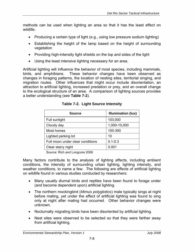
Del Rio Sector Tactical Infrastructure
Environmental Stewardship Plan, Version 1 July 2008
7-8
methods can be used when lighting an area so that it has the least effect on wildlife:
• Producing a certain type of light (e.g., using low pressure sodium lighting)
• Establishing the height of the lamp based on the height of surrounding vegetation
• Providing high-intensity light shields on the top and sides of the light
• Using the least intensive lighting necessary for an area.
Artificial lighting will influence the behavior of most species, including mammals, birds, and amphibians. These behavior changes have been observed as changes in foraging patterns, the location of nesting sites, territorial singing, and migration routes. Other influences that might occur include disorientation, an attraction to artificial lighting, increased predation or prey, and an overall change to the ecological structure of an area. A comparison of lighting sources provides a better understanding (see Table 7-2).
Table 7-2. Light Source Intensity
Source Illumination (lux)
Full sunlight 103,000 Cloudy day 1,000-10,000 Most homes 100-300 Lighted parking lot 10 Full moon under clear conditions 0.1-0.3 Clear starry night 0.001 Source: Rich and Longcore 2006
Many factors contribute to the analysis of lighting effects, including ambient conditions, the intensity of surrounding urban lighting, lighting intensity, and weather conditions, to name a few. The following are effects of artificial lighting on wildlife found in various studies conducted by researchers:
• Many usually diurnal birds and reptiles have been found to forage under (and become dependent upon) artificial lighting.
• The northern mockingbird (Mimus polyglottos) male typically sings at night before mating, yet under the effect of artificial lighting was found to sing only at night after mating had occurred. Other behavior changes were unknown.
• Nocturnally migrating birds have been disoriented by artificial lighting.
• Nest sites were observed to be selected so that they were farther away from artificial lighting.

Del Rio Sector Tactical Infrastructure
Environmental Stewardship Plan, Version 1 July 2008
7-9
• Many believe an increase in predation risk on open habitats occurs under bright moonlight, and will therefore occur under artificial lighting as well. Although no field study conclusively confirms or refutes this explanation, circumstantial evidence supports this idea (Longcore and Rich 2004).
• Bat foraging studies conducted at streetlights found a decrease in the attraction of moths to streetlights when lamps were changed from mercury vapor to high-pressure sodium vapor lamps (Rich and Longcore 2006).
Other studies, however, reflect different long-term findings. For example, studies have shown that within several weeks under constant lighting, migratory birds and mammals will quickly stabilize and reset their circadian rhythms back to their original schedules (when returned to normal lighting conditions).
The greatest impacts on wildlife from lighting will probably be to birds and insects that will be affected by the lights while migrating, causing them to alter their course or schedule. The tendency for nocturnal birds and other wildlife species (e.g., bats) to congregate around the lights to feed on insects attracted by the lights could also increase. This change in behavior could make these species more vulnerable to predation or injury (USACE 2003).
As such, lights will have minor to moderate, adverse and beneficial impacts on nocturnal wildlife depending on the species examined.
Effects on migratory birds could be substantial and are highly dependent upon the timing of tactical infrastructure construction. Implementing BMPs to avoid or minimize adverse effects could markedly reduce their intensity. A standard BMP to reduce or avoid adverse effects on migratory birds will include the following:
• Any groundbreaking construction activities should be performed before migratory birds return to the area (approximately 1 March) or after all young have fledged (approximately 31 July) to avoid incidental take.
• If construction is scheduled to start during the period in which migratory bird species are present, steps should be taken to prevent migratory birds from establishing nests in the impact corridor. These steps could include covering equipment and structures, and use of various excluders (e.g., noise). Birds can be hazed to prevent them from nesting on the site. Once a nest is established, they cannot be harassed until all young have fledged and left the nest site.
• If construction is scheduled to start during the period when migratory birds are present, a supplemental site-specific survey for nesting migratory birds should be performed immediately prior to site clearing.
• If nesting birds are found during the supplemental survey, construction should be deferred until the birds have left the nest. Confirmation that all young have fledged should be made by a competent biologist.

Del Rio Sector Tactical Infrastructure
Environmental Stewardship Plan, Version 1 July 2008
7-10
Assuming implementation of the above BMP to the fullest extent feasible, effects of the Project on migratory birds is anticipated to be short- and long-term, minor, and adverse due to construction disturbance and associated loss of habitat, and long-term, minor, and beneficial due to reduction of foot traffic through migratory bird habitat north of the impact corridor.
Aquatic Resources. Removal of vegetation and grading during construction could temporarily increase siltation in the river and therefore have short-term minor adverse effects on fish and aquatic resources within the Rio Grande.
7.3 SPECIAL STATUS SPECIES
7.3.1 Definition of the Resource
Although the Secretary’s waiver means that CBP no longer has any specific obligation under the Endangered Species Act (ESA), the Secretary committed CBP to responsible environmental stewardship of our valuable natural and cultural resources. CBP supports this objective and has applied the appropriate standards and guidelines associated with the ESA as the basis for evaluating potential environmental impacts and developing appropriate mitigations for threatened and endangered species. Three groups of special status species are addressed in this ESP: Federal threatened and endangered species, state threatened and endangered species, and migratory birds. Each group has its own definitions, and legislative and regulatory drivers for consideration; these are briefly described below.
Three groups of special status species are addressed in this ESP: Federal threatened and endangered species, state threatened and endangered species, and migratory birds. Each group has its own definitions, and legislative and regulatory drivers for consideration; these are briefly described below.
The ESA, as amended (16 U.S.C. 1531–1544 et seq.) provides broad protection for species of fish, wildlife, and plants that are listed as threatened or endangered in the United States or elsewhere. Provisions are made for listing species, as well as for recovery plans and the designation of critical habitat for listed species. Under the ESA, a Federal endangered species is defined as any species that is in danger of extinction throughout all or a significant portion of its range. The ESA defines a Federal threatened species as any species that is likely to become an endangered species within the foreseeable future throughout all or a significant portion of its range.
In 1973, the Texas legislature authorized the TPWD to establish a list of endangered animals in the state. State endangered species are those species which the Executive Director of the TPWD has named as being “threatened with statewide extinction.” Threatened species are those species which the TPWD has determined are likely to become endangered in the future (TPWD 2007b).

Del Rio Sector Tactical Infrastructure
Environmental Stewardship Plan, Version 1 July 2008
7-11
In 1988, the Texas legislature authorized TPWD to establish a list of threatened and endangered plant species for the state. An endangered plant is one that is "in danger of extinction throughout all or a significant portion of its range.” A threatened plant is one that is likely to become endangered within the foreseeable future (TPWD 2007b).
7.3.2 Affected Environment
An additional 15 species that are listed by the State of Texas as threatened or endangered have the potential to be present (see Table 7-3). Further information on the natural history of the federally listed species is presented in Appendix E.
Onsite review of the project area with USFWS biologists in September 2007 revealed that although the project area is within the range of the federally listed species, habitat for most of them does not occur within the project area. The ocelot and jaguarundi were the two Federal exceptions, with potential habitat for them observed during the site review. Although habitat similar to ocelot and jaguarundi corridor habitat occurs in the Del Rio impact area, this area is not considered potential cat corridor habitat because of the lack of evidence that either species occurs in the proximity of Del Rio or in Val Verde County. A biological survey of the project area, conducted November 5, 2007, recorded the presence of only one state-listed species, indigo snake (Drymarchon corais); and the presence of potential habitat for ocelot and jaguarundi. These two species are further discussed here. Detailed information on the methods and results of the November 5, 2007, survey and further information on the other Federal threatened or endangered species are provided in Appendix E.
The habitat of the jaguarundi is similar to that of the ocelot and is found within the Tamaulipan Biotic Province which includes several variations of subtropical thornscrub brush. Jaguarundi and ocelot both prefer dense thornscrub habitats with greater than 95 percent canopy cover. Habitat for the ocelot and jaguarundi occurs within Section M-1, although no records for either species are known from this area.
The indigo snake is listed as threatened by TPWD. This species occupies a range that includes Texas south of the Guadalupe River and the Balcones Escarpment. It inhabits thornbush-chaparral woodlands of south Texas, in particular dense riparian corridors. The indigo snake can do well in suburban areas and irrigated croplands if not molested or indirectly poisoned. It requires moist microhabitats, such as rodent burrows, for shelter. An indigo snake was observed near wetland habitat in Section M-1.
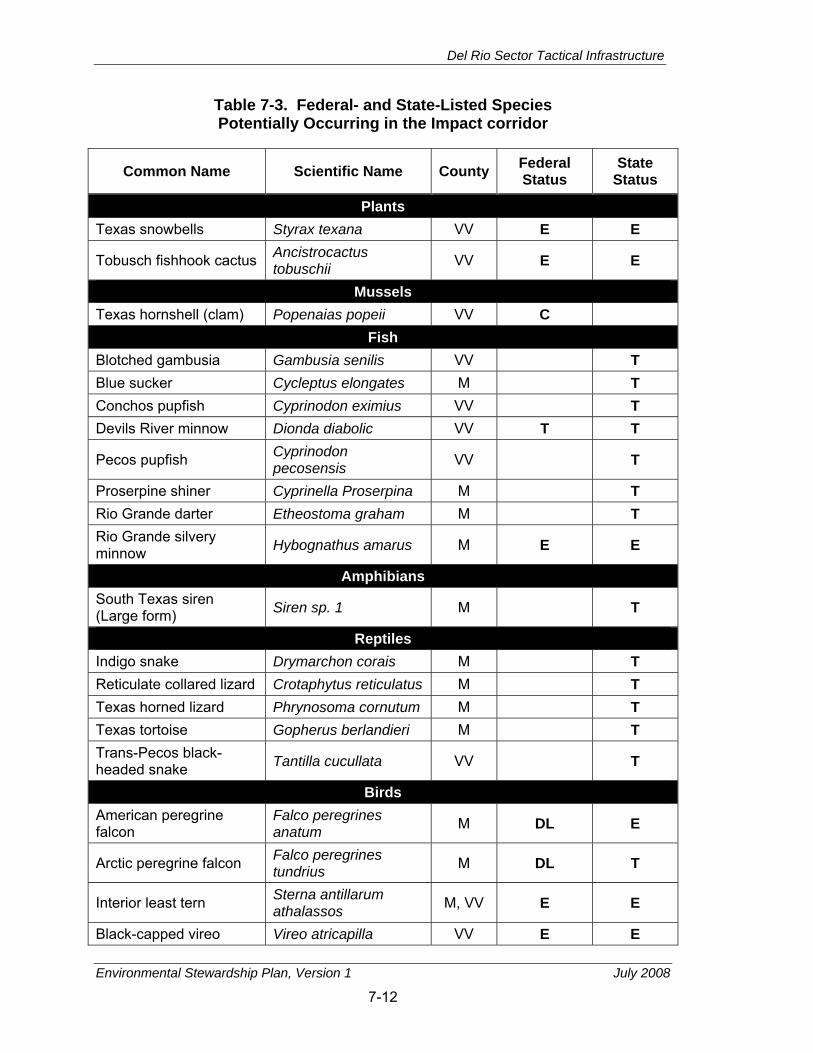
Del Rio Sector Tactical Infrastructure
Environmental Stewardship Plan, Version 1 July 2008
7-12
Table 7-3. Federal- and State-Listed Species Potentially Occurring in the Impact corridor
Common Name Scientific Name County Federal Status
State Status
Plants Texas snowbells Styrax texana VV E E
Tobusch fishhook cactus Ancistrocactus tobuschii VV E E
Mussels Texas hornshell (clam) Popenaias popeii VV C
Fish Blotched gambusia Gambusia senilis VV T Blue sucker Cycleptus elongates M T Conchos pupfish Cyprinodon eximius VV T Devils River minnow Dionda diabolic VV T T
Pecos pupfish Cyprinodon pecosensis VV T
Proserpine shiner Cyprinella Proserpina M T Rio Grande darter Etheostoma graham M T Rio Grande silvery minnow Hybognathus amarus M E E
Amphibians South Texas siren (Large form) Siren sp. 1 M T
Reptiles Indigo snake Drymarchon corais M T Reticulate collared lizard Crotaphytus reticulatus M T Texas horned lizard Phrynosoma cornutum M T Texas tortoise Gopherus berlandieri M T Trans-Pecos black-headed snake Tantilla cucullata VV T
Birds American peregrine falcon
Falco peregrines anatum M DL E
Arctic peregrine falcon Falco peregrines tundrius M DL T
Interior least tern Sterna antillarum athalassos M, VV E E
Black-capped vireo Vireo atricapilla VV E E
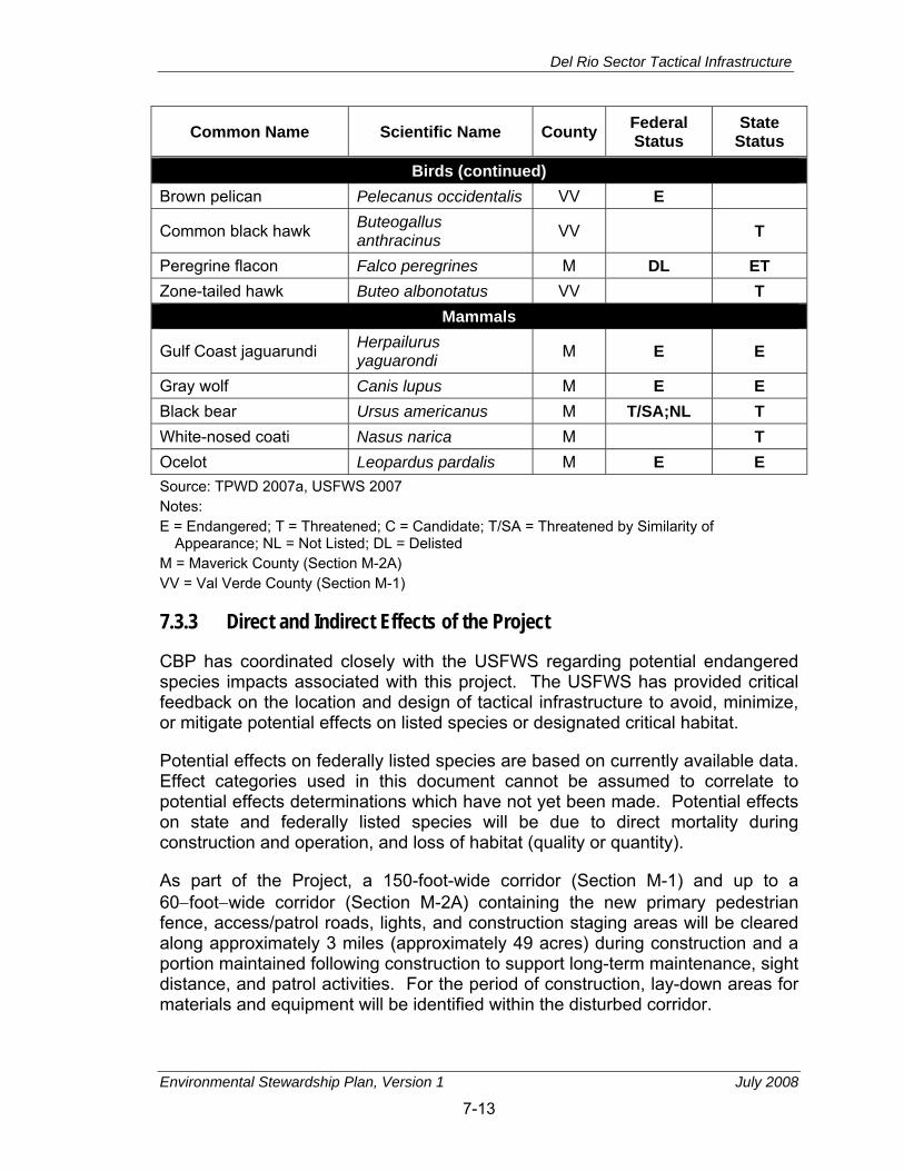
Del Rio Sector Tactical Infrastructure
Environmental Stewardship Plan, Version 1 July 2008
7-13
Common Name Scientific Name County Federal Status
State Status
Birds (continued) Brown pelican Pelecanus occidentalis VV E
Common black hawk Buteogallus anthracinus VV T
Peregrine flacon Falco peregrines M DL ET Zone-tailed hawk Buteo albonotatus VV T
Mammals
Gulf Coast jaguarundi Herpailurus yaguarondi M E E
Gray wolf Canis lupus M E E Black bear Ursus americanus M T/SA;NL T White-nosed coati Nasus narica M T Ocelot Leopardus pardalis M E E Source: TPWD 2007a, USFWS 2007 Notes: E = Endangered; T = Threatened; C = Candidate; T/SA = Threatened by Similarity of
Appearance; NL = Not Listed; DL = Delisted M = Maverick County (Section M-2A) VV = Val Verde County (Section M-1)
7.3.3 Direct and Indirect Effects of the Project
CBP has coordinated closely with the USFWS regarding potential endangered species impacts associated with this project. The USFWS has provided critical feedback on the location and design of tactical infrastructure to avoid, minimize, or mitigate potential effects on listed species or designated critical habitat.
Potential effects on federally listed species are based on currently available data. Effect categories used in this document cannot be assumed to correlate to potential effects determinations which have not yet been made. Potential effects on state and federally listed species will be due to direct mortality during construction and operation, and loss of habitat (quality or quantity).
As part of the Project, a 150-foot-wide corridor (Section M-1) and up to a 60−foot−wide corridor (Section M-2A) containing the new primary pedestrian fence, access/patrol roads, lights, and construction staging areas will be cleared along approximately 3 miles (approximately 49 acres) during construction and a portion maintained following construction to support long-term maintenance, sight distance, and patrol activities. For the period of construction, lay-down areas for materials and equipment will be identified within the disturbed corridor.

Del Rio Sector Tactical Infrastructure
Environmental Stewardship Plan, Version 1 July 2008
7-14
Direct mortality during construction activities is unlikely for the ocelot, jaguarundi, or indigo snake, but the indigo snake will be the most susceptible of the three. Operational effects such as road kill of indigo snakes or disturbance of ocelots or jaguarundi potentially using the corridor will not be anticipated to increase measurably above current conditions. The use of lights for nighttime construction and the operational use of lights will have the potential to adversely affect any ocelot and jaguarundi in the vicinity of M-2A. However, the dense habitat through which these cats tend to move resists substantial light penetration. Lights used for construction and operations will be shielded to avoid unnecessary illumination of potential habitat for these two species. Finally, the Project for M-2A is proximal to a POE and runs along the edge of Eagle Pass, areas that already experience above-normal illumination. Therefore, it is not anticipated that impacts of lights (used during construction or operations) will have more than minor adverse impacts on any ocelot or jaguarundi inhabiting the area, should such species occur. USFWS expressed concern that the band of giant reed along the river could provide a movement corridor for the ocelot and jaguarundi. Under the Project, no giant reed will be removed south of the existing road paralleling the river in Section M-2A, retaining this potential movement corridor for these cats.
Construction grading for this route will result in 49 acres of clearing and removal of vegetation including approximately 9 acres of giant reed wetlands (habitat for the indigo snake, and movement corridor for ocelots and jaguarundi); strips and patches of sugarberry, granjeno, and honey mesquite woodland; honey mesquite and retama shrubland (habitat for ocelot and jaguarundi); Bermuda grassland; and Russian-thistle forbland communities. This loss of habitat within this section will result in negligible to minor (for cats and the indigo snake, respectively) short− and long-term, adverse effects on state- and Federal-listed species.

Del Rio Sector Tactical Infrastructure
Environmental Stewardship Plan, Version 1 July 2008
8-1
8. CULTURAL RESOURCES
8.1 DEFINITION OF THE RESOURCE Although the Secretary’s waiver means that CBP no longer has any specific obligation under the National Historic Preservation Act (NHPA), the Secretary committed CBP to responsible environmental stewardship of our valuable natural and cultural resources. CBP supports this objective and has applied the appropriate standards and guidelines associated with the NHPA as the basis for evaluating potential environmental impacts and developing appropriate mitigations for cultural resources.
Cultural resources are commonly subdivided into archaeological resources, architectural resources, and traditional cultural properties (TCPs). Archaeological resources comprise areas where human activity has measurably altered the earth or where deposits of physical remains of human activity are found. Architectural resources include standing buildings, bridges, dams, and other structures of historic, architectural, engineering, or aesthetic significance. Traditional cultural resources include TCPs, which are properties eligible for or listed in the NRHP that Native Americans or other groups consider essential for the preservation of traditional cultures. Examples of TCPs are certain archaeological resources, prominent topographic features, habitat, plants, minerals, animals and their physical location or resource referent, and locations referenced in origin myths.
The NRHP is the official listing of properties significant in U.S. history, architecture, or prehistory, and includes both publicly and privately owned properties. The list is administered by the NPS on behalf of the Secretary of the Interior. Cultural resources that are listed in or eligible for listing in the NRHP (36 CFR 800.16(l)) are called historic properties. Properties are determined eligible for listing in the NRHP by the Secretary of the Interior (NPS) or by consensus of a Federal agency official and the SHPO. Generally, resources must be more than 50 years old to be considered for listing in the NRHP. More recent resources, such as Cold War-era buildings, might warrant listing if they have the potential to gain significance in the future or if they meet “exceptional” significance criteria. NRHP-listed properties of exceptional national significance can also be designated as NHLs by the Secretary of the Interior.
Buildings, structures, sites, objects, or districts are property types that might be considered historic properties. To be listed in or eligible for listing in the NRHP, a resource must be one of these property types, generally should be at least 50 years of age or older, and must meet at least one of the four following criteria (36 CFR 60.4):
• The resource is associated with events that have made a significant contribution to the broad pattern of history (Criterion A)
Del Rio Sector Tactical Infrastructure
Environmental Stewardship Plan, Version 1 July 2008
8-2
• The resource is associated with the lives of people significant in the past (Criterion B)
• The resource embodies distinctive characteristics of a type, period, or method of construction; represents the work of a master; possesses high artistic value; or represents a significant and distinguishable entity whose components might lack individual distinction (Criterion C)
• The resource has yielded, or could be likely to yield, information important in prehistory or history (Criterion D).
In addition to meeting at least one of the above criteria, a historic property must also possess integrity of location, design, setting, materials, workmanship, feeling, and association. Integrity is defined as the authenticity of a property’s historic identity, as evidenced by the survival of physical characteristics it possessed in the past and its capacity to convey information about a culture or group of people, a historic pattern, or a specific type of architectural or engineering design or technology. Resources that might not be considered individually significant can be considered eligible for listing on the NRHP as part of a historic district. According to the NPS, a historic district possesses a significant concentration, linkage, or continuity of sites, buildings, structures, or objects that are historically or aesthetically united by plan or physical development.
8.2 AFFECTED ENVIRONMENT
Area of Potential Effect
Cultural resource surveys were carried out within the Area of Potential Effect (APE) which is defined as the geographical area within which effects on historic properties might occur if such properties hypothetically exist. The APE should account for both direct and indirect effects. 36 CFR 800.5(a)(2) specifically cites visual effects and changes to the setting of a historic property where the setting contributes to the significance of the property as potential adverse effects that should be considered in delineating the APE of a Project. Other possible adverse effects include damage or destruction of historic properties due to grading, construction, noise, or vibrations.
In delineating the APE, direct effects will occur within a 60-footwide corridor that accounts for grading of vegetation and fence construction. A second, larger APE has been delineated for the Project to include indirect impacts on architectural or other aboveground cultural resources. Topography, type, and density of vegetation and intervening development, orientation of streets and properties in relation to the Project, traffic patterns, and surrounding development are factors considered in the definition of this latter APE for a specific location.
Del Rio Sector Tactical Infrastructure
Environmental Stewardship Plan, Version 1 July 2008
8-3
Previously Recorded Resources in the Vicinity
Information about previously recorded archaeological, historic, and architectural sites within a 1-mile radius of the Project was gathered from THC Texas Historic Sites Atlas and Texas Archaeological Sites Atlas, the Texas Archaeological Research Laboratory, and other sources. Resources recognized by THC as Recorded Texas Historic Landmarks (RTHLs) and those previously surveyed under their Neighborhood Survey program also were gathered. This information was plotted on Project maps, aerial photographs, and topographic maps to gain an idea of the types of resources likely to occur within the project areas, site densities, and areas of interest for further identification and evaluation. In general, previously reported prehistoric archaeological resources within 1 mile of the impact corridor include open air campsites and lithic scatters. Temporal and cultural affiliations for these sites are unclear, and few sites are very extensive.
Based on the Texas Historic Sites Atlas, the Texas Archaeological Site Atlas, and information at the Texas Archaeological Research Laboratory (TARL), Section M-1 passes within 1 mile of two RTHLs in Del Rio: the Brinkley Mansion and the Val Verde Winery. Section M-1 also passes within 1 mile of four archaeological sites and the historic marker for the Brinkley Mansion. Two of the archaeological sites are prehistoric. Little is known about the other two sites. None of these resources are within the APE for Section M-1 or will be affected by it.
Section M-2A passes within 1 mile of two properties listed in the NRHP. The Fort Duncan Historic District is 0.66 miles south of the southern terminus of Section M-2A, and the Maverick County Courthouse is 0.41 miles east of the southern terminus of Section M-2A. The Fort Duncan Historic District is a 1,000-acre property that was listed on the NRHP in 1971. The fort is historically significant for its mid-19th century military contributions and as an example of mid-19th century frontier military architecture. The Maverick County Courthouse, erected in 1885, is significant for its architectural and historic associations. It is located in downtown Eagle Pass. Additional information on these historic properties is presented in (see Appendix F). In addition to these two NRHP properties, five properties within 1 mile of Section M-2A are recognized as RTHLs or designated with Official State Historic Markers (OSHM). These properties are summarized in Table 8-1. These include the Eagle Pass Post Office, S.P. Simpson Jr. House, Church of the Redeemer, 420 Commercial Street, and the Lee Building. All of these properties are outside the APE for the Project.
Section M-2A is within 1 mile of four other previously recorded archaeological sites. The previously recorded site within the APE is 41MV65. It is a lithic artifact scatter of unknown temporal or chronological affiliation that covers an area of 180,000 square meters. The site was initially recorded in 1979 and although it was encountered by subsequent surveys the site form has not been updated since the initial recording and no recommendations have been made on

Del Rio Sector Tactical Infrastructure
Environmental Stewardship Plan, Version 1 July 2008
8-4
Table 8-1. NRHP-Listed Properties, Texas Historic Landmarks, and State Historic Markers near the Impact corridor
Section Historic Property Designation Date of
Construction/ Significance
M-1 Brinkley Mansion, Del Rio RTHL 1934 M-1 Val Verde Winery, Del Rio OSHM 1882
M-2A 420 Commercial Street, Eagle Pass RTHL 1880s
M-2A Fort Duncan National Register District NRHP- Listed 1971 1848+
M-2A Maverick County Courthouse NRHP- Listed 1980 1884–5
M-2A Church of the Redeemer, Eagle Pass RTHL 1887
M-2A Eagle Pass Post Office, Eagle Pass RTHL 1912
M-2A S.P. Simpson Jr. House, Eagle Pass RTHL 1883
M-2A Lee Building, Eagle Pass RTHL, cont. structure to Fort Duncan NRHP District 1849–1875
its NRHP eligibility. Archaeological sites within 1 mile of the survey section include one possible Paleo-Indian site, two open-air camps of unknown cultural or temporal affiliation, and two historic sites.
Cultural Resources Surveys
Cultural resources surveys have been conducted within the impact corridors. The goal of these surveys is to identify cultural resources potentially affected by the Project. Tribal consultations are ongoing; and, as of February 2008, no resources of traditional, religious, or cultural significance to Native American tribes have been identified within the APE (direct construction effects).
An architectural/historic resource survey has been completed for Sections M-1 and M-2A. Fieldwork occurred between 4 and 8 January 2008. Preliminary research was performed prior to fieldwork to determine areas of interest, find construction dates when available from county tax records, and provide an historic context to frame the NRHP evaluation of cultural resources. The larger APE described above was surveyed for buildings and other historic resources. All resources constructed prior to 1969 were documented as per the recommendations of THC.

Del Rio Sector Tactical Infrastructure
Environmental Stewardship Plan, Version 1 July 2008
8-5
Forty-six buildings and other historic-period resources were surveyed in Sections M-1 and M-2A. Three properties in Section M-1 and 12 properties in Section M−2A were recommended eligible for NRHP listing. The majority of these resources is residential in nature and is significant as excellent examples of early 20th-century residential building styles and construction methods.
Archaeological surveys of Sections M-1 and M-2A have been conducted. Two sites were identified. In Section M-1 a small, previously unrecorded site was located. It will be tested to enable NRHP eligibility evaluation. In Section M-2A, one previously recorded site was identified in the survey. It also will need to be tested to enable NRHP eligibility evaluation.
Native American tribes with ancestral ties to lands within the Del Rio Sector have been contacted for input on the cultural resources survey; however, no input has been received to date
8.3 DIRECT AND INDIRECT EFFECTS OF THE PROJECT One previously recorded archaeological site was identified within the APE for Section M-2A. This site will require testing to enable its NRHP eligibility evaluation. As a result of the architectural survey of Section M-2A, 12 historic houses have been recommended eligible for the NRHP. These properties are located on Commercial, Ryan, Jefferson, and Ceylon streets. The Project calls for a retaining wall to be integrated into the bluff along the southern half of Section M-2A. This wall will reduce visual effects on the houses on Commercial and Ryan streets. The three houses on Commercial Street might incur short-term impacts from noise, dust, and vibrations during construction. The two houses on Ryan Street might incur minor long-term visual impacts from proximity to the infrastructure, and short-term impacts from noise, dust, and vibrations during construction. The three houses on Commercial, Jefferson, and Ceylon streets recommended as NRHP-eligible might incur minor long-term visual impacts. However, Section M-2A will be a distant element in the open viewshed of these residences.
The Fort Duncan Historic District, including the Lee Building, Maverick County Courthouse, Eagle Pass Post Office, Church of the Redeemer, and S.P. Simpson Jr. House, are removed geographically from the project area and will not be affected by Section M-2A. These properties are located a considerable distance from Section M-2A and outside its APE for visual and other effects. A residence at 420 Commercial Street, an RTHL, is located a developed city block from the southern terminus of M-2A, a distance of about 250 feet. It will not be affected by the Project.
In Section M-1, one archaeological site, previously unrecorded, was identified and will be subject to archaeological testing to enable NRHP eligibility evaluation. Three historic-era resources are recommended as NRHP eligible in Section M-1. One of the historic-era resources surveyed is a residential/commercial structure
Del Rio Sector Tactical Infrastructure
Environmental Stewardship Plan, Version 1 July 2008
8-6
on Las Vacas Street and the other two are residences on Qualia Drive. Section M-1 will primarily parallel the USIBWC floodplain at distances of 50–500 feet south of Garza Lane and Rio Grande Road. On the west side of the POE, the route will cross Rio Grande Road and proceed north to meet a new toll facility. The Project will continue on the east side of the POE and parallel Rio Grande Road, terminating approximately 50 feet from the intersection at Qualia Drive. The three residences recommended as eligible for the NRHP might incur minor long-term visual impacts from Section M-1.

Del Rio Sector Tactical Infrastructure
Environmental Stewardship Plan, Version 1 July 2008
9-1
9. SOCIOECONOMIC RESOURCES
9.1 DEFINITION OF THE RESOURCE Although the Secretary's waiver means that CBP no longer has any specific legal obligations for the tactical infrastructure segments addressed in this ESP, the Secretary committed CBP to responsible environmental stewardship of our valuable natural and cultural resources. CBP supports this objective and has applied the appropriate standards and guidelines for evaluating environmental impacts associated with socioeconomic resources.
Socioeconomics. Socioeconomics is defined as the basic attributes and resources associated with the human environment, particularly characteristics of population and economic activity. Regional birth and death rates and immigration and emigration affect population levels. Economic activity typically encompasses employment, personal income, and industrial or commercial growth. Changes in these two fundamental socioeconomic indicators are typically accompanied by changes in other components, such as housing availability and the provision of public services.
Data in three areas provide key insights into socioeconomic conditions that might be affected by a Project. Data on employment identify gross numbers of employees, employment by industry or trade, and unemployment trends. Data on personal income in a region can be used to compare the “before” and “after” effects of any jobs created or lost as a result of a Project. Data on industrial or commercial growth or growth in other sectors provide baseline and trend line information about the economic health of a region.
Demographics identify the population levels and changes to population levels of a region. Demographics data might also be obtained to identify, as appropriate to the evaluation of a Project, a region’s characteristics in terms of race, ethnicity, poverty status, educational attainment level, and other broad indicators.
Socioeconomic data in this chapter are presented at census tract, county, and state levels to characterize baseline socioeconomic conditions in the context of regional and state trends. Census tracts are designed to be relatively homogenous units with respect to population characteristics, economic status, and living conditions at the time of establishment. Data have been collected from previously published documents issued by Federal, state, and local agencies; and from state and national databases (e.g., U.S. Census Bureau).
Environmental Justice and Protection of Children. There are no Federal regulations specifically addressing socioeconomics; however, there is one EO that pertains to environmental justice issues. Although the Secretary’s waiver means that CBP no longer has any specific obligation under Executive Order (EO) 12898, the Secretary committed CBP to responsible environmental

Del Rio Sector Tactical Infrastructure
Environmental Stewardship Plan, Version 1 July 2008
9-2
stewardship of our valuable natural and cultural resources. CBP supports this objective and has applied the appropriate standards and guidelines associated with EO 12898 as the basis for evaluating potential environmental impacts and developing appropriate mitigations for air quality.
EO 12898 is included in the socioeconomic resources section because it relates to various socioeconomic groups and the health effects that could be imposed on them. On February 11, 1994, President Clinton issued EO 12898, Federal Actions to Address Environmental Justice in Minority Populations and Low−Income Populations. This EO requires that Federal agencies’ actions substantially affecting human health or the environment do not exclude persons, deny persons benefits, or subject persons to discrimination because of their race, color, or national origin. The purpose of the EO is to ensure the fair treatment and meaningful involvement of all people regardless of race, color, national origin, or income with respect to the development, implementation, and enforcement of environmental laws, regulations, and policies. Fair treatment means that no groups of people, including racial, ethnic, or socioeconomic groups, should bear a disproportionate share of the negative environmental consequences resulting from industrial, municipal, and commercial operations or the execution of Federal, state, tribal, and local programs and policies.
Consideration of environmental justice concerns includes race, ethnicity, and the poverty status of populations in the vicinity of a project. Databases were searched in an attempt to identify potential sources of environmental hazards near the Project. Such information aids in evaluating whether a project will render vulnerable any of the groups targeted for protection in the EO. EO 13045, Protection of Children from Environmental Health Risks and Safety Risks, addresses the Federal policy of protection of children from exposure to disproportionate environmental health and safety risks. This EO established that each agency has a responsibility to ensure that its policies, programs, activities, and standards address risk to children that results from environmental health risks or safety risks.
9.2 AFFECTED ENVIRONMENT Socioeconomics. Tactical infrastructure will occur adjacent to residential and commercial areas in the United States. The most current census tract data are from Census 2000. Section M-1 is within Val Verde County, Census Tract 9507 and Section M-2A is within Maverick County, Census Tract 9505. For the purposes of this Project, Census Tract 9507 is considered the Region of Influence (ROI) in Val Verde County and Census Tract 9505 is considered the ROI in Maverick County.
The largest employment type in Census Tract 9507, Val Verde County, Census Tract 9505, Maverick County, and Texas is educational, health, and social services, which accounts for 25.0, 21.4, 32.5, 26.7, and 19.3 percent,

Del Rio Sector Tactical Infrastructure
Environmental Stewardship Plan, Version 1 July 2008
9-3
respectively, of employed persons (see Table 9-1) (U.S. Census Bureau 2002). Construction accounts for 5.9 percent of the employed persons in Census Tract 9507, 7.5 percent in Val Verde County, 2.7 in Census Tract 9505, 6.8 percent in Maverick County, and 8.1 percent in the State of Texas.
Table 9-1. Employed Persons by Industry Type in Census Tracts, Val Verde and Maverick Counties, and the State of Texas (Percent)
Economic and Social Indicators Census
Tract 9507
Val Verde
County
Census Tract 9505
Maverick County
State of
Texas
Employed Persons in Armed Forces 0.6 4.0 0.4 0.1 0.7 Employed Persons in Civilian Labor Force (By Industry) Agriculture, forestry, fishing and hunting, and mining 1.8 2.8 5.0 3.8 2.7
Construction 5.9 7.5 2.7 6.8 8.1 Manufacturing 10.6 10.7 8.6 10.1 11.8 Wholesale trade 1.3 2.1 2.9 2.0 3.9 Retail trade 8.8 13.8 14.8 14.7 12.0 Transportation and warehousing, and utilities 6.6 6.0 5.5 9.6 5.8
Information 0.4 1.0 1.2 1.2 3.1 Finance, insurance, real estate, and rental and leasing 5.9 3.6 4.0 3.7 6.8
Professional, scientific, management, administrative, and waste management services
5.3 5.5 3.6 3.3 9.5
Educational, health and social services 25.0 21.4 32.5 26.7 19.3
Arts, entertainment, recreation, accommodation and food services 10.1 8.4 6.5 5.8 7.3
Other services (except public administration) 7.9 5.3 2.9 4.7 5.2
Public administration 10.5 11.9 10.0 7.6 4.5 Source: U.S. Census Bureau 2002 Note: Census 2000 data are the most recent comprehensive employment data for the ROI.
In 2006, Val Verde and Maverick counties had unemployment rates of 6.1 percent and 13 percent, respectively, compared to a 4.9 percent unemployment rate for Texas (Fedstats 2007a, 2007b). Table 9-2 shows demographic data and economic indicators of the ROI, Val Verde and Maverick counties, and the State of Texas.

Del Rio Sector Tactical Infrastructure
Environmental Stewardship Plan, Version 1 July 2008
9-4
Table 9-2. Demographic and Economic Characteristics of Census Tracts, Val Verde and Maverick Counties, and the State of Texas
Census
Tract 9507
Val Verde
County
Census Tract 9505
Maverick County Texas
Total Population 6,397 44,856 5,685 47,297 20,851,820Percent Hispanic or Latino 83.3 75.5 93.2 95.0 32.0Percent White 81.1 76.4 68.0 70.9 71.0Percent Black or African American 0.9 1.5 0.4 0.3 11.5
Percent American Indian Alaska Native 0.7 0.7 0.5 1.3 0.6
Percent Asian 0.1 0.6 1.0 0.4 2.7Percent Native Hawaiian and Other Pacific Islander 0.1 0.1 0.0 <0.1 0.1
Percent “Some other race” 14.7 18.2 26.5 24.1 11.7Percent Reporting 2 or more races 2.4 2.6 3.7 2.9 2.5
Percent Below Poverty 28.9 26.1 37.2 34.8 15.4Per Capita Income $13,070 $12,096 $9,644 $8,758 $19,617Median Household Income $23,667 $28,376 $17,218 $21,232 $39,927Source: U.S. Census Bureau 2002 Note: Census 2000 data are the most recent comprehensive economic and demographic data
for the ROI.
The populations of Ciudad Acuña and Piedras Negras, Mexico, are approximately 124,232 and 142,011, respectively. The Del Rio POE connects Ciudad Acuña and Del Rio (TxDOT 2007a). There are two POEs (Camino Real International Bridge and Eagle Pass Bridge I) and one international rail bridge that connect Eagle Pass to Piedras Negras.
Environmental Justice and Protection of Children. The ROI is considered to have a disproportionately high percentage of low-income or minority residents under either of two conditions: (1) the percentage of low-income (below poverty) or minority populations (race other than “white alone,” or Hispanic or Latino) within each census tract is greater than its perspective county’s minority percentage or low-income percentage, or (2) the percentage of persons in low-income or minority populations within each census tract is greater than 50 percent. Census Tract 9507 has a higher percentage of low-income and Hispanic or Latino residents than the county. Table 9-2 shows that 28.9 percent of the population in Census Tract 9507 is living below the poverty level as compared to 26.1 percent in Val Verde County and 15.4 percent in Texas. Eighty-three percent of the population of Census Tract 9507 is Hispanic or Latino
Del Rio Sector Tactical Infrastructure
Environmental Stewardship Plan, Version 1 July 2008
9-5
as compared to 75.5 percent of Val Verde County and 32 percent of Texas. Census Tract 9505 has a higher percentage of minority and low-income residents than Maverick County (see Table 9-2). Approximately 32 percent of residents in Census Tract 9505 reported to be a race other than “white alone,” while 93.2 percent reported to be Hispanic or Latino, compared to 29.1 percent and 95 percent, respectively, in Maverick County. In addition, approximately 37.2 percent of the population in Census Tract 9505 live below the poverty line, as compared to 34.8 percent in Maverick County and 15.4 percent in the State of Texas.
Residents living in the ROI have a lower median household income than that of their respective county and the State of Texas (see Table 9-2). However, the per capita incomes of Census Tracts 9507 and 9505 are higher than Val Verde and Maverick counties, respectively, but lower than the State of Texas.
In Section M-1, the Project will be south of the existing residential and commercial structures along Garza Lane and Rio Grande Road, and will run 0.18 miles in a northeasterly direction, across Rio Grande Road to the new POE toll facility currently under construction.
9.3 DIRECT AND INDIRECT EFFECTS OF THE PROJECT Socioeconomics. Short-term minor direct beneficial effects will be expected as a result of the construction, operation, and maintenance of the Project. The construction activities will occur from Spring 2008 to December 2008. Some local materials, supplies, and contractors will be used, providing a minor beneficial effect on the local economy through new jobs and increased local spending. Construction of the tactical infrastructure will require up to 75 workers consisting of one fabrication crew (35 workers) and one installation crew (40 workers) completing 1 mile of tactical infrastructure per month. Based upon U.S. Census data, there are 1,051 and 872 construction workers in Val Verde and Maverick counties, respectively. The 75 construction workers required for this Project represent approximately 7 percent and 9 percent of the available construction workers in Val Verde and Maverick counties, respectively (U.S. Census Bureau 2002). Due to the existing supply of construction workers in each of these counties, it will likely not be necessary for workers from other locations to participate in the construction activities. The temporary nature of the construction and new employment (up to 75 workers) associated with the Project will have a minor indirect beneficial effect on local businesses and the local economy from the temporary influx of construction workers.
The tactical infrastructure will intersect 20 private and public land parcels. Additionally, the Project will be south of the existing residential and commercial structures along Garza Lane and Rio Grande Road, and will run 0.18 miles in a northeasterly direction, across Rio Grande Road to the new POE toll facility currently under construction. The additional 0.18-mile portion of the infrastructure will run adjacent to several additional structures on State Spur 239.

Del Rio Sector Tactical Infrastructure
Environmental Stewardship Plan, Version 1 July 2008
9-6
The construction and operation of the infrastructure along State Spur 239 could cause minor adverse socioeconomic effects on any businesses that might operate in the immediate vicinity due to indirect adverse effects associated with the visual effects (see Chapter 4.2.3) and noise effects (see Chapter 3.3), as well as decreased access from State Spur 239.
Environmental Justice and Protection of Children. Minor adverse disproportionate effects on minority or low-income populations could occur, as the Project will intersect 20 parcels, running behind or adjacent to the structures. Direct beneficial effects on safety and the protection of children will be expected from the projected deterrence of cross-border violators, to include smugglers, terrorists, and terrorist weapons from entering the United States. Therefore, border communities will be safer for minority and low-income populations and children. Indirect adverse effects associated with the visual effects (see Chapter 4.2.3) and noise effects (see Chapter 3.3) will occur.
The closure of Rio Grande Road and diversion of future through-traffic to SR 277 along Alderete Lane are not part of the Project. Therefore, any potential socioeconomic, environmental justice, and safety effects were previously discussed in a Supplemental Environmental Impact Statement prepared by the General Services Administration (GSA) (GSA 2004).
The tactical infrastructure will have short- to long-term direct beneficial effects on children and safety in the surrounding areas. The addition of tactical infrastructure could increase the safety of USBP agents in the USBP Del Rio Sector. In addition, this Project will help to deter cross-border violators in the immediate area, which could prevent illegal aliens, smugglers, and their contraband from entering.

Del Rio Sector Tactical Infrastructure
Environmental Stewardship Plan, Version 1 July 2008
10-1
10. UTILITIES AND INFRASTRUCTURE
10.1 DEFINITION OF THE RESOURCE Although the Secretary's waiver means that CBP no longer has any specific legal obligations for the tactical infrastructure segments addressed in this ESP, the Secretary committed CBP to responsible environmental stewardship of our valuable natural and cultural resources. CBP supports this objective and has applied the appropriate standards and guidelines for evaluating environmental impacts on utilities and infrastructure.
Infrastructure consists of the systems and physical structures that enable a population in a specified area to function. Infrastructure is wholly human-made, with a high correlation between the type and extent of infrastructure and the degree to which an area is characterized as “urban” or developed. The availability of infrastructure and its capacity to support growth are generally regarded as essential to the economic growth of an area. The infrastructure components discussed in this chapter include municipal water systems, sanitary sewer systems, storm water drainage systems, solid waste management, and utilities, including electrical and natural gas systems.
Solid waste management primarily relates to the availability of landfills to support a population’s residential, commercial, and industrial needs. Alternative means of waste disposal might involve waste-to-energy programs or incineration. In some localities, landfills are designed specifically for, and limited to, disposal of construction and demolition debris. Recycling programs for various waste categories (e.g., glass, metals, papers, asphalt, and concrete) reduce reliance on landfills for disposal.
10.2 AFFECTED ENVIRONMENT Municipal Water Systems. The Rio Grande and several aquifers, reservoirs, and springs are the main sources of water for many communities and cities in Maverick and Val Verde counties. Municipal water infrastructure within the impact corridor includes the Eagle Pass Regional Water Treatment Plant (WTP) and associated interceptor, collector, distribution, or transmission pipelines; pumps; and storage tanks (see Table 10-1), which are located at the northern terminus of Section M-2A. This WTP removes and treats water from the Rio Grande for drinking water for the City of Eagle Pass, portions of Maverick County, and the Kickapoo Indian Nation.
Municipal Sanitary Sewer Systems. Some municipal sanitary sewer systems in Maverick and Val Verde counties discharge through the land application method, while others discharge into water bodies, including the Rio Grande and San Felipe Creek (USEPA 1998, BECC undated). The Silver Lake Wastewater

Del Rio Sector Tactical Infrastructure
Environmental Stewardship Plan, Version 1 July 2008
10-2
Table 10-1. Water/Sewer Systems Infrastructure Within the Impact Corridor
Section Water/Sewer Systems Infrastructure
M-1 Silver Lake Wastewater Treatment Plant (includes associated infrastructure)
M-2A Eagle Pass Regional Water Treatment Plant (includes associated infrastructure)
Treatment Plant (WWTP) and its associated pipelines, pumps, and storage tanks are located within the impact corridor, approximately 0.5 miles south of Cienegas Creek at the northern terminus of Section M-1 (see Table 10-1). This WWTP provides sewerage services for the City of Del Rio, and discharges into the Rio Grande and through the land application method.
Storm Water Drainage Systems. No storm water drainages are known to occur within the impact corridor; however the number of storm water drainage systems along the impact corridor has not been inventoried.
Solid Waste Management. As of 2005, there was one active municipal landfill in Maverick County and one active municipal landfill in Val Verde County. The remaining capacity in terms of years for these landfills was determined based on compaction rate and the amount disposed of in 2005 (TCEQ 2006). The remaining capacity of these landfills as of 2005 is reported in Table 10-2.
Table 10-2. Remaining Capacity of Municipal Landfills as of 2005
Landfill Name County Remaining Capacity*
(Years)
City of Eagle Pass Type IV Landfill Site Maverick 90.54 City of Del Rio Municipal Landfill Val Verde 15.20 Source: TCEQ 2006 Note: * Based on rate of compaction and amount disposed of in 2005.
Electrical and Natural Gas Systems. There are overhead electric lines adjacent and perpendicular to Section M-2A, and natural gas pipelines run along the Rio Grande and the roadway (Garza Lane and Rio Grande Road) at Section M-1. Lights that will be installed along Sections M-1 and M-2A will connect into existing electric distribution infrastructure in the area.
10.3 DIRECT AND INDIRECT EFFECTS OF THE PROJECT No effects on storm water drainage systems, or electrical and natural gas systems, will be expected due to the absence of these systems’ infrastructure within the impact corridor. However, if infrastructure was identified during design, short-term minor adverse effects on these systems could occur. The primary

Del Rio Sector Tactical Infrastructure
Environmental Stewardship Plan, Version 1 July 2008
10-3
pedestrian fence line and patrol road will avoid most storm water drainage culverts or reroute the Project around this infrastructure. Any infrastructure that will be affected by the construction will be moved, and temporary interruptions to these systems could be experienced. No long-term effects will be expected.
The Project will not substantially increase impervious surface area that could potentially affect local storm water management. Adherence to proper engineering practices will reduce storm water runoff-related effects to a level of insignificance. In addition, erosion and sedimentation controls will be in place during construction to reduce and control siltation or erosion effects on areas outside of the construction site.
Short-term minor adverse effects on municipal water and sanitary sewer systems will be expected due to the presence of the Silver Lake WWTP and the Eagle Pass Regional WTP and the associated infrastructure (e.g., pipelines, pumps, and tanks) along Section M-1 and Section M-2A. Any infrastructure that will be affected by the construction will be moved. No long-term effects will be expected.
Short-term minor adverse effects on solid waste management will be expected. Solid waste generated from the construction activities will consist of building materials such as concrete and metals (conduit and piping). The contractor will recycle construction materials to the greatest extent possible. Nonrecyclable construction debris will be taken to either the City of Eagle Pass Type IV Landfill Site or the City of Del Rio Municipal Landfill, which are both permitted to take this type of waste. Both landfills have sufficient capacity. Therefore, solid waste generated as a result of the Project will be expected to be negligible compared to the solid waste currently generated in Maverick and Val Verde counties, and will not exceed the capacity of either landfill.

Del Rio Sector Tactical Infrastructure
Environmental Stewardship Plan, Version 1 July 2008
10-4
THIS PAGE INTENTIONALLY LEFT BLANK

Del Rio Sector Tactical Infrastructure
Environmental Stewardship Plan, Version 1 July 2008
11-1
11. RELATED PROJECTS AND POTENTIAL EFFECTS
The following analysis summarizes expected environmental effects from the Project when added to other past, current, and reasonably foreseeable future actions. The geographic scope of the analysis varies by resource area. For example, the geographic scope of cumulative impacts on resources such as noise, visual resources, soils, and vegetation is very narrow and focused on the location of the resource. The geographic scope of air quality, wildlife and sensitive species, and socioeconomic resources is much broader and considers more county- or regionwide activities. Projects that were considered for this analysis were identified by reviewing USBP documents, news releases, and published media reports, and through consultation with planning and engineering departments of local governments, and state and Federal agencies. Projects that do not occur in close proximity (i.e., within several miles) of the fence will not contribute to a cumulative impact and are generally not evaluated further.
11.1 PAST, PRESENT, AND REASONABLY FORESEEABLE FUTURE ACTIONS
Cumulative Fencing, Southern Border. There are currently 62 miles of landing mat fence at various locations along the U.S./Mexico international border (CRS 2006); 14 miles of single, double, and triple fence in San Diego, California; 70 miles of new pedestrian fence constructed at various locations along the U.S./Mexico international border; and fences at POE facilities throughout the southern border. In addition, 225 miles of fence are planned (including the approximately 4 miles presented in this ESP). New fence sections are also being studied for specified areas in Texas, New Mexico, Arizona, and California.
Past Actions. Past actions are those actions that occurred within the geographic scope of cumulative impacts prior to the development of this ESP. Past actions have shaped the current environmental conditions in close proximity (i.e., within several miles) to the infrastructure. Therefore, the effects of identified past actions are now part of the existing environment, and are generally included in the affected environment described in each resource chapter of this ESP.
• Secure Border Initiative (SBI). The SBI is a comprehensive multi-year plan established by the DHS to secure America’s borders and reduce illegal immigration. DHS’s comprehensive plan to gain effective control of our Nation’s borders includes substantial investments in technology, infrastructure, and enforcement personnel. SBI supports CBP frontline agents and officers by deploying an optimal, integrated solution that develops, installs, and integrates technology and tactical infrastructure solutions. Examples of planned tactical infrastructure could consist of, but not limited to, roads, pedestrian and vehicle fence, and lights.
Del Rio Sector Tactical Infrastructure
Environmental Stewardship Plan, Version 1 July 2008
11-2
Present Actions. Present actions include current or funded construction projects, CBP or other agency operations in close proximity to the infrastructure locations, and current resource management programs and land use activities within the affected areas. Ongoing actions considered in the cumulative effects analysis include the following:
• Office of Field Operations CBP. The Del Rio POE facility is currently being expanded by the GSA, and is scheduled for completion in early 2008 (TxDOT 2007a). The project will bring the primary inspection facilities and possibly toll booths further into the City of Del Rio, as well as expand the bridge over the Rio Grande from four to six lanes (PPTCC 2007).
• Texas Department of Transportation (TxDOT). TxDOT has several ongoing road construction and improvement projects scheduled for the counties potentially impacted by the project. However, the geographic scope of cumulative impacts would tend to be small, as the majority of the construction would be within existing ROWs. These projects are in various stages of completion: - Rehabilitation Projects. Several rehabilitation projects in the area
include resurfacing of an approximate 3-mile section of U.S. Highway 277 south of U.S. Highway 377 in Del Rio, and a 0.6-mile section of U.S. Highway 277 in Eagle Pass.
- Ports to Plains Corridor. This project consists of a 1,400-mile highway route stretching from the U.S./Mexico international border in Laredo, Texas, to Denver, Colorado. The route was designated a High Priority Corridor under the Transportation Equity Act for the 21st Century. The project is a joint effort by the state departments of transportation from Colorado, Texas, Oklahoma, and New Mexico to evaluate transportation improvement needs along the existing corridor to facilitate and enhance trade between the United States and Mexico. Currently, a Feasibility Study and a Corridor Development and Management Plan have been completed for this project. The route would utilize U.S. Highway 277 through Del Rio and Eagle Pass, Texas, and would include the construction of relief routes and other upgrades in these areas (TxDOT 2007b).
- State Loop 480. Construction of an outer loop from the Camino Real International Bridge around the City of Eagle Pass was scheduled to begin in 2007. Phase I includes construction of a four-lane divided highway on a new location with two grade separated interchanges, and will extend from the Camino Real International Bridge to U.S. Highway 57. Phase II construction is in the process of being coordinated, and will include building a connecting highway from U.S. Highway 57 to U.S. Highway 277 North (TxDOT 2007a).

Del Rio Sector Tactical Infrastructure
Environmental Stewardship Plan, Version 1 July 2008
11-3
- Eagle Pass Truck Route. Several phases of this project have been completed to date; however construction of an overpass is scheduled to begin in May 2009 (TxDOT 2007a).
• North American Development Bank (NADB). The NADB is funding several projects in Maverick County, Texas, as well as Piedras Negras and Ciudad Acuña, Mexico, which are south of the cities of Del Rio and Eagle Pass, respectively (NADB 2007). - Water and Wastewater Regional System Improvements (Eagle Pass,
Texas). Construction of a new wastewater treatment plant, including transmission mains and sewer lines began in August 2007.
- Water Conservation Improvement Project (Maverick County, Texas). The lining of lateral canals within the Maverick County Water Control and Improvement District No. 1 is scheduled to be undertaken in December 2007.
- Comprehensive Sanitation Project (Piedras Negras, Coahuila, Mexico). Phase I of this project is complete; however construction of three collector and sewer line elements is currently underway. This project will allow wastewater to be adequately treated, and eliminate raw sewage discharges into the Rio Grande.
- Comprehensive Sanitation Project (Ciudad Acuña, Coahuila, Mexico). Phase I of this project is complete; however construction of 14 collector and sewer line elements is currently underway. This project will allow wastewater to be adequately treated, and eliminate raw sewage discharges into the Rio Grande.
- Maverick County Detention Facility. The GEO Group, Inc., will develop, manage, and operate a 654-bed detention facility in Eagle Pass, Texas, which is expected to be used by Maverick County and other state and Federal detention agencies. The project is expected to be complete in 2008. GEO estimates that the facility will generate approximately $10 million in annual operating revenues at full occupancy (All Business 2007).
Reasonably Foreseeable Future Actions. Reasonably foreseeable future actions consist of activities that have been proposed or approved and can be evaluated with respect to their effects. The following are reasonably foreseeable future actions that are related to securing the southern international border:
• Texas Department of Transportation. In addition to TxDOT’s ongoing construction and maintenance projects, there are several TxDOT projects in the planning phases. The Del Rio Outer Loop (also known as the Del Rio Relief Loop) is a four-lane, 12.1-mile highway segment. Phase I will consist of a two-lane highway connecting U.S. Highway 277 South and U.S. Highway 90 West with overpass spans and an additional highway connection to Laughlin Air Force Base (TxDOT 2007a). Construction of

Del Rio Sector Tactical Infrastructure
Environmental Stewardship Plan, Version 1 July 2008
11-4
the project is expected to begin in mid to late 2008, with completion scheduled for 2011 (Southwest Texas Live 2007).
• Eagle Pass Road and Various Infrastructure Projects. CBP plans improvements to 1.3 miles of existing patrol roads along the eastern bank of the Rio Grande and construction and maintenance of 1.1 miles of primary pedestrian fence with an aesthetic quality in Eagle Pass, Texas. The project includes the installation of 15 permanent lights along the eastern boundary of Eagle Pass Golf Course.
• Expansion of Eagle Pass Border Station. The City of Eagle Pass and GSA jointly developed a master plan for phased expansion of the border station. Phase I of the border station was built by the City and is leased to GSA. Phase II of the expansion of the border station is to be designed and constructed by GSA on land donated by the City. This project is on hold pending donation of land (TxDOT 2008).
• Proposed Housing Development (Northern end of Section M-2A). A housing development has been proposed for the area north of the western terminus of Section M-2A. The development would include the construction of new residences, streets, and other public works/utility infrastructure.
• Giant Reed Removal Project. In a separate action, CBP plans to remove additional giant reed along Section M-1 from the primary pedestrian fence to the Rio Grande in order to decrease cover, which is used by cross-border violators, and increase USBP agents’ line of sight towards the Rio Grande.
Table 11-1 presents the cumulative effects that might occur from implementation of the Project.
11.2 AIR QUALITY Short-term, minor, adverse cumulative impacts on air quality would be expected from the construction of tactical infrastructure in combination with other reasonably foreseeable future actions. As discussed in Chapter 2, emissions from construction, operation, and maintenance activities would not contribute to or affect local or regional attainment status with the NAAQS, and would be below thresholds established by the USEPA for CAA cumulative impacts analysis. Construction equipment would temporarily increase fugitive dust and operation emissions from combustion fuel sources. Since there would be no substantive change in USBP operations for this Project, emissions from vehicles would remain constant and no cumulative impacts on air quality would be expected.

Del R
io Sector Tactical Infrastructure
Environm
ental Stew
ardship Plan, V
ersion 1 July 2008
11-5
Table 11-1. Summary of Potential Cumulative Effects
Resource Past Actions Current
Background Activities
Project Known Future Actions Cumulative Effects
Air Quality Attainment criteria for all criteria pollutants.
Existing emissions sources continue to adversely affect regional air quality.
Fugitive dust and combustion emissions generation during construction.
Existing emissions sources continue to adversely affect regional air quality.
Continued attainment.
Noise Commercial and residential development, vehicles dominate ambient noise near urban areas.
Commercial and residential development, vehicles dominate ambient noise near urban areas.
Short-term noise from construction equipment and increased traffic.
Commercial and residential development near urban areas contributes to ambient noise.
Existing sources would be the dominant noise source. Negligible cumulative impacts.
Land Use, Recreation, and Visual Resources
Agricultural/open lands impacted by development. Past development affected natural viewshed.
Development of open and agricultural lands. Development of natural areas for community and industry infrastructure.
Government would purchase land or easements to construct tactical infrastructure. Natural areas developed for tactical infrastructure. Constant static visual interruption at fixed points.
Commercial development permanently alters natural areas and agricultural lands. Constant static visual interruption at fixed points.
Moderate adverse impacts on open and agricultural lands. Minor to moderate long-term impacts from permanent infrastructure.

Del R
io Sector Tactical Infrastructure
Environm
ental Stew
ardship Plan, V
ersion 1 July 2008
11-6
Resource Past Actions Current
Background Activities
Project Known Future Actions Cumulative Effects
Geology and Soils
Installation of infrastructure and other features.
Installation of infrastructure; continued cross-border violator activities adversely affect soils.
Minor grading and recontouring would disturb soils; installation of primary pedestrian fence might affect geology.
Continued illegal border crossings adversely affect soils.
Minor long-term impact from new development.
Water Use and Quality Hydrology and Groundwater
Degradation of aquifers due to historical pollution.
Continued degradation of aquifers from pollution.
Short-term minor adverse effects on hydrology from grading and contouring. Short-term minor adverse effects from possible use of groundwater.
Improvements to the WWTP should reduce current adverse impacts on water quality.
Minor short- and long-term impacts.
Surface Waters and Waters of the United States
Point and nonpoint discharges including wastewater treatment effluent, agricultural runoff, and storm water have impacted water quality. Removal of wetland vegetation and fill of waters of the United States, including wetlands.
Point and nonpoint discharges including wastewater treatment effluent, agricultural runoff, and storm water have impacted water quality.
Construction erosion and sediment runoff, potential oil spills and leaks. Removal of wetland vegetation and fill of waters of the United States, including wetlands, and temporary degradation of water quality.
Construction erosion and sediment runoff, potential oil spills and leaks. Removal of wetland vegetation and fill of waters of the United States, including wetlands, and temporary degradation of water quality.
Moderate short-term impacts from construction activities, including removal of wetland vegetation and fill of waters of the United States, and temporary degradation of water quality. Minor long-term erosion impacts from infrastructure.
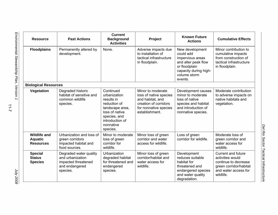
Del R
io Sector Tactical Infrastructure
Environm
ental Stew
ardship Plan, V
ersion 1 July 2008
11-7
Resource Past Actions Current
Background Activities
Project Known Future Actions Cumulative Effects
Floodplains Permanently altered by development.
None. Adverse impacts due to installation of tactical infrastructure in floodplain.
New development could add impervious areas and alter peak flow or floodplain capacity during high-volume storm events.
Minor contribution to cumulative impacts from construction of tactical infrastructure in floodplain.
Biological Resources Vegetation Degraded historic
habitat of sensitive and common wildlife species.
Continued urbanization results in reduction of landscape area, loss of native species, and introduction of nonnative species.
Minor to moderate loss of native species and habitat, and creation of corridors for nonnative species establishment.
Development causes minor to moderate loss of native species and habitat and introduction of nonnative species.
Moderate contribution to adverse impacts on native habitats and vegetation.
Wildlife and Aquatic Resources
Urbanization and loss of green corridors impacted habitat and food sources.
Minor to moderate loss of green corridor for wildlife.
Minor loss of green corridor and water access for wildlife.
Loss of green corridor for wildlife.
Moderate loss of green corridor and water access for wildlife.
Special Status Species
Degraded water quality and urbanization impacted threatened and endangered species.
Urbanization degraded habitat for threatened and endangered species.
Minor loss of green corridor/habitat and water access for wildlife.
Development reduces suitable habitat for threatened and endangered species and water quality degradation.
Current and future activities would continue to decrease green corridor/habitat and water access for wildlife.

Del R
io Sector Tactical Infrastructure
Environm
ental Stew
ardship Plan, V
ersion 1 July 2008
11-8
Resource Past Actions Current
Background Activities
Project Known Future Actions Cumulative Effects
Cultural Resources
Development and infrastructure improvements adversely affected cultural resources.
Development and infrastructure improvements adversely affect cultural resources.
Moderate to major long-term adverse impacts on cultural resources.
Continued development and infrastructure improvements adversely affect cultural resources.
Moderate to major long-term adverse impacts on cultural resources.
Socioeconomic Resources
Commercial and residential development affected local economies.
Commercial and residential development.
Minor to moderate short-term and long-term beneficial impacts on local economy and safety.
Commercial development and infrastructure improvements around urban areas.
Minor stimulation of local economy from construction projects and improvement of roadways. Minor adverse impacts on environmental justice or protection of children and human health and safety.
Utilities and Infrastructure
Historical development and maintenance of utilities and infrastructure in area.
Utilities and infrastructure have been upgraded as necessary.
Minor short-term adverse impacts on local utilities and infrastructure during construction.
Continued development and maintenance of utilities and infrastructure in area.
Major benefit to infrastructure and utilities from addition and upgrade of facilities.
Del Rio Sector Tactical Infrastructure
Environmental Stewardship Plan, Version 1 July 2008
11-9
11.3 NOISE Minor cumulative impacts on ambient noise would be expected from the additive impacts of construction, operation, and maintenance of tactical infrastructure, and anticipated residential and commercial development activities and infrastructure improvement projects that routinely occur throughout the project area. Noise intensity and duration from construction, operation, and maintenance of tactical infrastructure would be similar to construction activities from other development activities and road construction and maintenance. Because noise attenuates over distance, a gradual decrease in noise levels occurs the farther a receptor is away from the source of noise. Construction, operation, and maintenance of tactical infrastructure would be distant from most other substantial noise-generating activities. Increased noise from construction of tactical infrastructure could combine with existing noise sources or other construction activities to produce a temporary cumulative impact on sensitive noise receptors. Construction noise would not be louder, but might be heard over a greater distance or over a longer time period.
11.4 LAND USE AND VISUAL RESOURCES Construction of tactical infrastructure would result in minor changes to land use. Recent activities that have affected land use near the tactical infrastructure are increased commercial and residential development of agricultural and open lands. Moderate cumulative impacts on land use are expected from the additive effects of the past, present, and reasonably foreseeable future actions, but changes in local land use would continue to be dominated by development. For example, the conversion of approximately 49 to 61 acres to support tactical infrastructure would be minimal when compared to other development occurring in Val Verde and Maverick counties. Residential areas and agricultural lands would be displaced by the Project. Future development of residential areas would further alter the current land use.
Minor to moderate impacts on aesthetics and visual resources would be expected from the additive effects of past, present, and reasonably foreseeable future actions. The presence of construction equipment would produce a short-term adverse impact on visual resources. Once installed, the tactical infrastructure would create a permanent visual interruption at fixed points. Adverse cumulative effects could include temporary construction impacts and the introduction of light poles and increased night illumination during construction. Other development activities would introduce night illumination into previously open or agricultural lands. Recreational activities such as star gazing would be adversely affected in certain locations by this cumulative impact in night illumination.

Del Rio Sector Tactical Infrastructure
Environmental Stewardship Plan, Version 1 July 2008
11-10
11.5 GEOLOGY AND SOILS Additive effects include minor changes in topography due to grading, contouring, and trenching; minor soil disturbance; a minor increase in erosion; and a minor loss of prime farmland. Construction of most of the tactical infrastructure would not be in close proximity to residential and commercial development and would not cumulatively affect geological resources, including soils. However, each present or reasonably foreseeable future action identified has the potential for temporary erosion from construction activities.
11.6 WATER USE AND QUALITY
11.6.1 Hydrology and Groundwater
Moderate impacts on hydrology and groundwater would occur from the construction of tactical infrastructure when combined with other past, present, and reasonably foreseeable future actions due to increased erosion and stream sedimentation.
11.6.2 Surface Water and Waters of the United States
Moderate impacts on surface water and waters of the United States could occur from increased erosion and stream sedimentation. Disturbance from construction and operation of the tactical infrastructure along with residential and commercial development have the potential for additional erosion and stream sedimentation and adverse cumulative effects. However, as discussed in Chapter 6.2.3, a SWPPP and sediment control and storm water BMPs to minimize potential impacts would be developed. Past actions, including sewage, agricultural runoff, and industrial discharges, have generally degraded the quality of water in the Middle Rio Grande basin and have resulted in long-term direct moderate impacts on water quality. The Rio Grande is a CWA Section 303(d) impaired water. Upgrades to existing wastewater facilities and construction of new wastewater facilities in Maverick County, Texas, and Piedras Negras and Ciudad Acuña, Mexico, could produce a moderate beneficial effect on water quality of the Rio Grande.
Wetland losses in the United States have resulted from draining, dredging, filling, leveling, and flooding for urban, agricultural, and residential development. An unknown amount of wetlands could be permanently impacted by construction of the tactical infrastructure. Formal delineation or jurisdictional determination of the extent of wetlands or other waters of the United States has not yet been conducted. The cumulative impacts on wetlands would be long-term and adverse.

Del Rio Sector Tactical Infrastructure
Environmental Stewardship Plan, Version 1 July 2008
11-11
11.6.3 Floodplains
Floodplain resources can be adversely impacted by development, increases in impervious areas, loss of vegetation, changes in hydrology, and soil compaction. Construction, operation, and maintenance of tactical infrastructure has the potential for negligible to minor impacts on floodplains from further loss of vegetation, soil compaction on access roads and patrol roads, and the placement of structures in the floodplains. When added to other past, present, and reasonably foreseeable future actions, impacts from the tactical infrastructure would be minor due to the relatively small impact within floodplains. As discussed in Chapters 1.6 and 6.3.3, CBP will follow the FEMA process to floodproof the structures and minimize adverse impacts on floodplain resources.
11.7 BIOLOGICAL RESOURCES
11.7.1 Vegetation Resources
Moderate impacts on native species vegetation and habitat and introductions of nonnative species are observable from past and present development and land use and are expected from reasonably foreseeable future actions. Urbanization and agricultural use of the area has directly reduced and modified habitat for common, sensitive, and rare plant species and resulted in the introduction of nonnative species. Indirect impacts from urbanization and agricultural land use include changes in drainage patterns, water quality and volume, and maintenance actions to sustain managed landscapes.
Development of land for urban/industrial use would continue at an unknown pace resulting in continued loss and alteration of plant communities and wildlife habitat. Expansion and upgrade of existing POEs and other border facilities, and construction of the tactical infrastructure would contribute to future development effects.
11.7.2 Wildlife and Aquatic Resources
Minor to moderate effects on wildlife species would be expected from the additive effects of past, present, and reasonably foreseeable future actions. Urbanization of the area has reduced green corridor and water access for wildlife. Cumulative impacts would mainly result from loss of habitat as described in Chapter 7.2.3, habitat disturbance and degradation, construction traffic, and permanent loss of green corridors. Displaced wildlife would move to adjacent habitat if sufficient habitat exists. Since residential, commercial, and industrial development has occurred in close proximity (i.e., within several miles) to the infrastructure and such development is projected to continue, the amount of potentially suitable habit is likely to decrease, producing a long-term, minor to moderate adverse cumulative effect. Wildlife could also be adversely impacted by noise during construction, operational lighting, and loss of potential prey species. The permanent lighting could have minor, adverse cumulative impacts on migration,

Del Rio Sector Tactical Infrastructure
Environmental Stewardship Plan, Version 1 July 2008
11-12
dispersal, and foraging activities of nocturnal species. Species would also be impacted by equipment spills and leaks. Cumulative, adverse impacts on migratory birds could be substantial depending on the time of year of construction of the tactical infrastructure. However, implementation of BMPs presented in Chapter 7.2.3 could reduce the intensity of such impacts.
11.7.3 Special Status Species
As discussed in Chapter 7.3.3, CBP has coordinated closely with the USFWS regarding potential effects on listed species or designated critical habitat. Potential direct and indirect impacts on federally listed species presented in this ESP are based on currently available data.
Threatened and endangered species are commonly protected because their historic range and habitat has been reduced and will only support a small number of individuals. Pedestrian surveys of the project area recorded the presence of only one state-listed species, indigo snake (Drymarchon corais); and the presence of potential habitat for the Federal- and state-listed endangered species, ocelot and jaguarundi. Construction, operation, and maintenance of tactical infrastructure, when combined with past, present, and foreseeable future residential and commercial development, has the potential to result in long-term minor to major adverse cumulative impacts on these species. However, the Project will contribute only a small portion of this impact. Potential threats to federally listed species within the impact corridor include trampling (for plants), habitat conversion, and potential changes to ocelot and jaguarundi movements due to loss of corridor habitat and noise.
11.8 CULTURAL RESOURCES Long-term, moderate to major, adverse impacts on cultural resources are expected from the additive effects of past, present, and reasonably foreseeable future actions. Past, current, and future commercial and residential development, improvements to infrastructure such as highway and water/wastewater projects, and the clearing of land for other development projects have caused significant impacts on cultural resources and can be expected to continue to do so. Cumulative effects on historic properties are expected to be moderate to major, adverse, and long-term.
In compliance with Section 106 of the NHPA, cultural resources surveys were completed to identify and evaluate properties listed on or eligible for listing on the NRHP that might be affected by the tactical infrastructure. Consultation with Native American tribes would ensure that properties of religious and cultural significance to the tribes are addressed. It is anticipated that additional properties determined as eligible for listing in the NRHP will be identified that would be affected. Known historic properties will also be affected.

Del Rio Sector Tactical Infrastructure
Environmental Stewardship Plan, Version 1 July 2008
11-13
Impacts on cultural resources (including resources potentially eligible for inclusion in the NRHP) will be avoided, minimized, or reduced through careful planning, siting, and design of the tactical infrastructure and development of special measures. In other cases, special designs could be developed to reduce effects on historic properties.
11.9 SOCIOECONOMIC RESOURCES Short-term beneficial impacts on local and regional socioeconomic resources would be expected from the additive effects of past, present, and reasonably foreseeable future actions. Economic benefits would be realized by construction companies, their employers and suppliers, and by Val Verde and Maverick counties through a minor increase in tax receipts for the purchase of goods and services. Construction of the tactical infrastructure has the potential for minor beneficial effects from temporary increases in construction jobs and the purchase of goods and services in Val Verde and Maverick counties. Approximately 975 workers are employed in the construction industry in the two counties. An increase of 75 construction jobs will only represent an approximate 8 percent increase of construction jobs, so the cumulative effect will be minimal. Since the construction jobs will be temporary, negligible cumulative effects on population growth, income, or other services will be expected.
Val Verde and Maverick counties have experienced some growth, including residential and commercial development. The permanent conversion of approximately 49 acres to support the tactical infrastructure will be a minimal cumulative impact compared to other development occurring in Val Verde and Maverick counties.
Some privately owned land will be used to support tactical infrastructure, and these affected residents might be adversely impacted by the construction and government purchase of their property.
As discussed in Chapters 4.3 and 9.3, some tactical infrastructure will be constructed on or adjacent to private property. Residences and other structures will need to be relocated at some locations along Section M-1, due to their encroachment on the route of the tactical infrastructure. Census Tract 9507 that encompasses Section M-1 has a high percentage of low-income residents. However, the number of structures requiring removal, and the amount of potential low-income residents in close proximity to the impact corridor that will be affected will be low.
Tactical infrastructure for Section M-2A, which has high percentages of minority and low-income residents, will be adjacent to private residences and commercial properties, however relocation will be required. Therefore, while the two affected census tracts do have disproportionately higher minority and low-income residents, the amount of residents that will actually be affected by the Project will
Del Rio Sector Tactical Infrastructure
Environmental Stewardship Plan, Version 1 July 2008
11-14
be low, and the overall effects of the tactical infrastructure on these populations will be minor.
11.10 UTILITIES AND INFRASTRUCTURE Residential and commercial development and accompanying population increases in Val Verde and Maverick counties have increased demand for utilities such as drinking water, wastewater treatment, and natural gas and electric power distribution. New infrastructure has been constructed to rehabilitate and upgrade aging infrastructure that is defective and has inadequate capacity. The construction, operation, and maintenance of tactical infrastructure will have minimal demand for utilities and infrastructure, and, therefore, a minimal adverse cumulative effect.

Del Rio Sector Tactical Infrastructure
Environmental Stewardship Plan, Version 1 July 2008
12-1
12. REFERENCES
AirNav 2007 AirNav. 2007. Airport Information for Del Rio International Airport. Available online <http://www.airnav.com/airport/KDRT>. Accessed 1 November 2007.
All Business 2007
All Business. 2007. “The GEO Group, Inc. Signs Contract with Maverick County, Texas for the Development and Operation of a 654-Bed Detention Facility.” July 24, 2007. Available online <http://www.allbusiness.com/services/business-services/4515917-1.html>. Accessed November 13, 2007.
Bailey 1995 Bailey, Robert F. 1995. Ecoregions of the United States. U.S. Forest Service. Accessed online at: <http://www.fs.fed.us/colorimagemap/images/300.html>. Accessed October
BECC undated
Border Environment Cooperation Commission (BECC). Undated. “Water and Wastewater Regional System Improvements for the City of Eagle Pass, Texas.” Available online <http://www.cocef.org/aproyectos/ExComEaglePass2002_01ing.htm>. Accessed October 30, 2007.
Boeing 2007 Boeing Integrated Defense System. 2007. SBInet Backgrounder. March 2007.
CBP 2007 U.S. Customs and Border Protection (CBP). 2007. Environmental Assessment for the Eagle Pass Road and Various Infrastructures Project , Del Rio Sector, Office of Border Patrol, Maverick County, Texas.
CBP undated
CBP. Undated. Border Patrol Sectors, Del Rio Sector. Available online: <http://www.cbp.gov/xp/cgov/border_security/ border_patrol/border_patrol_sectors/delrio_sector_tx/>. Accessed October 2, 2007.
EIA 2007 Energy Information Administration (EIA). 2007. Voluntary Reporting of Greenhouse Gases Program. Available online: <www.eis.doe.gov/oiaf/1605/coefficients>. Accessed 4 November 2007.
Fedstats 2007a
Fedstats. 2007. “Mapstats, Val Verde County, Texas.” Available online <http://www.fedstats.gov/qf/states/48/48465.html>. Accessed November 5, 2007.
Fedstats 2007b
Fedstats. 2007. “Mapstats, Maverick County, Texas.” Available online <http://www.fedstats.gov/qf/states/48/48323.html>. Accessed November 5, 2007.
FEMA undated
Federal Emergency Management Agency (FEMA). FEMA FIRM Panel No. 4804710004C

Del Rio Sector Tactical Infrastructure
Environmental Stewardship Plan, Version 1 July 2008
12-2
FEMA 1986 Federal Emergency Management Agency. 1986. A Unified National Program for Floodplain Management, March 1986.
Graber 1996 Graber, D.M. 1996. “Status of terrestrial vertebrates.” Sierra Nevada Ecosystem 2:709-734. Davis, CA: University of California. 1996.
GSA 2004 General Services Administration (GSA). 2004. Final Supplement, GSA, TX, Del Rio Port of Entry (POE), Increased Security Measures Associated with Phase II Expansion, Supplement to the 1992 Del Rio Border Patrol Station, Del Rio, Val Verde County, TX. December 2004.
Landrum & Brown 2002
Landrum & Brown, Inc. 2002. Common Noise Sources. Available online <www.landrum-brown.com/env/PVD/EIS/ Jan%202002%20Chapter%204/ 4%201-1%20%20common_ noise_sources.pdf>. Accessed 6 July 2004.
Larkin and Bomar 1983
Larkin, Thomas J. and George W. Bomar. 1983. Climatic Atlas of Texas. Texas Department of Water Resources. Austin, TX.
Longcore and Rich 2004
Longcore, Travis and Catherine Rich. 2004. “Ecological Light Pollution.” In Frontiers in Ecology and the Environment, 2(4): 191-198 (2004). Available online: <http://www.urbanwildlands.org/Resources/ LongcoreRich2004.pdf>. Accessed 15 May 2008.
NADB 2007 North American Development Bank (NADB). 2007. Summary of Financing Activities, Active Projects. September 30, 2007. Available online <http://www.nadbank.org/pdfs/ ProjectMatrix_Eng.pdf>. Accessed November 8, 2007.
NOAA 2007 National Oceanic and Atmospheric Administration (NOAA). 2007. Del Rio Val Verde Airport Weather Station. Accessed online: <http://www4.ncdc.noaa.gov/>.
NRCS 1982 Natural Resources Conservation Service (NRCS). 1982. Soil Survey of Val Verde County, Texas.
NRCS 2007 NRCS. 2007. Soil Survey Staff, Natural Resources Conservation Service (NRCS), United States Department of Agriculture. Web Soil Survey. Available online: <http://websoilsurvey.nrcs.usda.gov/>. Accessed November 14, 2007.
OSU 2007 Ohio State University (OSU). 2007. “Noise on the Farm Can Cause Hearing Loss.” Available online <http://ohioline.osu.edu/aex-fact/0590.html>. Accessed 20 October 2007.

Del Rio Sector Tactical Infrastructure
Environmental Stewardship Plan, Version 1 July 2008
12-3
PPTCC 2007
Ports to Plains Trade Corridor Coalition (PPTCC). 2007. “Ports to Plains Information Highway” Newsletter, Volume 5, Issue 4. April 2007. Available online: <http://portstoplains.com/Newsletter/apr2007_news.pdf>. Accessed 8 November 2007.
Rich and Longcore 2006
Rich, Catherine and Travis Longcore. 2006. Ecological Consequences of Artificial Lighting. Available online: <http://www.urbanwildlands.org/Resources/ LongcoreRich2004.pdf>. Accessed 15 May 2008.
Southwest Texas Live 2007
Southwest Texas Live. 2007. Civic leaders on economic development: Can they cooperate long enough to collaborate? Available online: <http://www.swtexaslive.com/node/5419>. Accessed 13 November 2007.
TCEQ 2006 Texas Commission on Environmental Quality (TCEQ). 2006. Municipal Solid Waste in Texas: A Year in Review. June 2006.
TPWD 2007a
Texas Parks and Wildlife Department (TPWD). 2007. Texas Wildlife Action Plan, Section II-Introduction and Purpose. Last updated 9 February 2007. Available online: <http://www.tpwd.state.tx.us/business/grants/wildlife/wildlife_ action_plan/>. Accessed 9 October 2007.
TPWD 2007b
TPWD. 2007. The Vegetation Types of Texas. Accessed online: <http://www.tpwd.state.tx.us/publications>.
TxDOT 2007a
Texas Department of Transportation (TxDOT). 2007. Texas-Mexico International Bridges and Border Crossings Existing and Proposed 2007. Available online: <ftp://ftp.dot.state.tx.us/pub/TDOT-info/iro/2007final.pdf>. Accessed October 31, 2007.
TxDOT 2007b
TxDOT. 2007. Ports to Plains Corridor Study Reports. Available online: <http://www/dot.state.co.us/ports2plains/reports/ reports.html>. Accessed 13 November 2007.
TxDOT 2008 TxDOT. 2008. Texas-Mexico International Bridges and Border Crossings Existing and Proposed 2008. Available online: <http://www.dot.state.tx.us/publications/international.htm>. Accessed July 1, 2008.
U.S. Census Bureau 2002
U.S. Census Bureau. 2002. “Decennial, Census 2000.” Available online <http://factfinder.census.gov/servlet/ DatasetMainPageServlet?_program=DEC&_submenuId=datasets_0&_lang=en>. Accessed November 5, 2007.
University of Texas 2006
University of Texas. 2006. The Physiography of Texas. University of Texas Library System, the Walter Geology Library. 24 July 2006. Available online: <http://www.lib.utexas.edu/geo/ physiography.html>. Accessed 15 October 2007.

Del Rio Sector Tactical Infrastructure
Environmental Stewardship Plan, Version 1 July 2008
12-4
USACE 1987
U.S Army Corps of Engineers (USACE). 1987. Wetland Delineation Manual. Technical Report Y-87-1. 1987.
USACE 1994
USACE. 1994. Environmental Baseline Document in Support of the Supplemental Programmatic Environmental Impact Statement for INS and JTF-6 Activities Along the U.S./Mexico Border. Volume 2: Texas Land Border Study Area. USACE Fort Worth District. March 1999.
USACE 2003
USACE. 2003. Final Supplemental Environmental Assessment for Infrastructure within U.S. Border Patrol Naco-Douglas Corridor Cochise County, Arizona. EA prepared by USACE for USBP. Available online: <http://www.swf.usace.army.mil/pubdata/ notices/nacodouglaspdf/preface.pdf>.
USACE 2006
USACE. 2006. Interim Regional Supplement to the Corps of Engineers Wetland Delineation Manual: Arid West Region. Available online: <http://www.usace.army.mil/cw/cecwo/reg/ inte_aridwest_sup.pdf>
USDOT undated
U.S. Department of Transportation (USDOT). Undated. Visual Impact Assessment for Highway Projects.
USEPA 1971
U.S. Environmental Protection Agency (USEPA). 1971. Noise from Construction Equipment and Operations, Building Equipment, and Home Appliances. NTID 300-1.
USEPA 1998
USEPA. 1998. Finding of No Significant Impact/Environmental Assessment for the Awarding of U.S. Environmental Protection Agency Grant Funds from the Border Environmental Infrastructure Fund for the Water Treatment Plant Project for the City of Del Rio, Val Verde County, Texas. May 16. Available online <http://www.epa.gov/earth1r6/6en/xp/delrio.pdf>. Accessed October 30, 2007.
USEPA 2007a
USEPA. 2007. National Ambient Air Quality Standards (NAAQS). Available online: <http://www.epa.gov/air/ criteria.html>. Accessed 13 November 2007.
USEPA 2007b
USEPA. 2007. AirData NET Tier Report for MSAI AQCR. Available online: <http://www.epa.gov/air/data/geosel.html>. Accessed 13 November 2007.
USEPA 2007c
USEPA. 2007. Texas Greenhouse Gas Emissions and Sinks Inventory. November 2007.
USFWS 1995
U.S. Fish and Wildlife Service (USFWS). 1995. Forested Woodland. U.S. Department of Agriculture, Forest Service, Northern Area State and Private Forestry. 1995.
Del Rio Sector Tactical Infrastructure
Environmental Stewardship Plan, Version 1 July 2008
12-5
USFWS 1988
USFWS. 1988. Tamaulipan Brushland of the Lower Rio Grande Valley of South Texas: Description, Human Impacts, and Management Options. Biological Report 88(36). S. E. Jahradoerfer and D. M. Leslie, Jr. Washington, D.C.
USFWS 2007
USFWS. 2007. Wetlands Online Mapper. Last Modified October 24, 2007. Available online: http://wetlandsfws.er.usgs.gov/wtlnds/launch.html. Accessed November 6, 2007.
USIBWC 2003
U.S. Section of International Boundary and Water Commission (USIBWC). 2003. Regional Assessment of Water Quality in the Rio Grande Basin.
USIBWC 2007
USIBWC. 2007. Letter to Mr Keith Tharp (CBP) from Richard Peace (USIBWC), regarding USIBWC comments on fence design. 16 July 2007.
Del Rio Sector Tactical Infrastructure
Environmental Stewardship Plan, Version 1 July 2008
12-6
THIS PAGE INTENTIONALLY LEFT BLANK

Del Rio Sector Tactical Infrastructure
Environmental Stewardship Plan, Version 1 July 2008
13-1
13. ACRONYMS AND ABBREVIATIONS
µg/m³ micrograms per cubic meter
APE Area of Potential Effect
AQCR air quality control region
BLM Bureau of Land Management
BMP Best Management Practice
BRP Biological Resources Plan
CAA Clean Air Act
CBP U.S. Customs and Border Protection
CO carbon monoxide
CO2 carbon dioxide
CWA Clean Water Act
CY calendar year
dB decibels
dBA A-weighted decibels
DHS U.S. Department of Homeland Security
EA Environmental Assessment
EO Executive Order
EPP Environmental Protection Plan
ESA Endangered Species Act
ESP Environmental Stewardship Plan
FEMA Federal Emergency Management Agency
FHWA Federal Highway Administration
FIRM Flood Insurance Rate Map
FPPA Farmland Protection Policy Act
FR Federal Register
FY fiscal year
GSA General Services Administration
hp horsepower
IIRIRA Illegal Immigration Reform and Immigrant Responsibility Act
MBTA Migratory Bird Treaty Act
mg/m³ milligrams per cubic meter
MMTCE million metric tons of carbon equivalent
MSAI AQCR
Metropolitan San Antonio Intrastate Air Quality Control Region
NAAQS National Ambient Air Quality Standards
NADB North American Development Bank
NHL National Historic Landmark
NO2 nitrogen dioxide
NOx nitrogen oxide
NPS National Park Service
NRCS Natural Resources Conservation Service

Del Rio Sector Tactical Infrastructure
Environmental Stewardship Plan, Version 1 July 2008
13-2
NRHP National Register of Historic Places
O3 ozone
OHM ordinary high water mark
OSHA Occupational Safety and Health Administration
OSHM Official State Historic Markers
P.L. Public Law
Pb lead
PM10 particle matter equal to or less than 10 microns in diameter
PM2.5 particle matter equal to or less than 2.5 microns in diameter
POE Port of Entry
ppm parts per million
ROI Region of Influence
ROW right-of-way
RTHL Recorded Texas Historic Landmark
SBI Secure Border Initiative
SHPO State Historic Preservation Office
SO2 sulfur dioxide
SPCC Spill Prevention Control and Countermeasures
SR State route
SWPPP Storm Water Pollution Prevention Plan
TAAQS Texas Ambient Air Quality Standards
TARL Texas Archaeological Research Laboratory
TCEQ Texas Commission on Environmental Quality
TCP traditional cultural properties
THC Texas Historical Commission
TMDL Total Maximum Daily Load
TPWD Texas Parks and Wildlife Department
TxDOT Texas Department of Transportation
U.S.C. United States Code
USACE U.S. Army Corps of Engineers
USBP U.S. Border Patrol
USEPA U.S. Environmental Protection Agency
USFWS U.S. Fish and Wildlife Service
USIBWC United States Section, International Boundary and Water Commission
VOC volatile organic compound
WTP Water Treatment Plant
WWTP Wastewater Treatment Plant