
Environmental Statement Volume 1 Chapter 11: Geology and Soils · Chapter 11: Geology and Soils...
86
Welsh Government M4 Corridor around Newport Environmental Statement Volume 1 Chapter 11: Geology and Soils M4CaN-DJV-EGT-ZG_GEN-RP-EN-0027 At Issue | March 2016 CVJV/AAR 3 rd Floor Longcross Court, 47 Newport Road, Cardiff CF24 0AD
Transcript of Environmental Statement Volume 1 Chapter 11: Geology and Soils · Chapter 11: Geology and Soils...

Welsh Government
M4 Corridor around Newport
Environmental Statement Volume 1
Chapter 11: Geology and Soils
M4CaN-DJV-EGT-ZG_GEN-RP-EN-0027
At Issue | March 2016
CVJV/AAR
3rd
Floor
Longcross Court,
47 Newport Road,
Cardiff
CF24 0AD
Welsh Government M4 Corridor around Newport Environmental Statement
Contents
Page
11 Geology and Soils 11-1
11.1 Introduction 11-1
11.2 Legislation and Policy Context 11-1
11.3 Assessment Methodology 11-5
11.4 Baseline Environment 11-21
11.5 Mitigation Measures Forming Part of the Scheme Design 11-46
11.6 Assessment of Potential Land Take Effects 11-47
11.7 Assessment of Potential Construction Effects 11-51
11.8 Assessment of Potential Operational Effects 11-57
11.9 Additional Mitigation and Monitoring 11-61
11.10 Assessment of Land Take Effects 11-67
11.11 Assessment of Construction Effects Following Mitigation 11-69
11.12 Assessment of Operational Effects 11-72
11.13 Assessment of Cumulative Effects 11-74
11.14 Inter-relationships 11-74
11.15 Summary of Effects 11-74
Welsh Government M4 Corridor around Newport Environmental Statement
Chapter 11: Geology and Soils 11-1 March 2016
11 Geology and Soils
11.1 Introduction
11.1.1 This chapter of the Environmental Statement (ES) assesses those effects that
may arise from the Scheme with respect to ground conditions, ground stability,
geology, hydrogeology and land contamination, in accordance with the Design
Manual for Roads and Bridges (DMRB) (Vol 11, Section 3, Part 11) (Highways
Agency, 1993) and associated Interim Advice Notes (IAN). The Scheme has the
potential to have direct impacts on designated and non-designated areas of
geological and geomorphological interest, either at a local or national scale. This
assessment considers the potential significance of such effects and also the
potential for the creation of new exposure through the construction works.
11.1.2 The chapter describes the assessment methodology, the baseline conditions
currently existing in the study area, the potential significant environmental effects,
the mitigation measures required to prevent, reduce or offset any significant
adverse effects and the likely residual effects after these measures have been
employed.
11.1.3 A number of potential sites of land contamination have been identified along the
route of the proposed new section of motorway and the assessment of risk
associated with potential contamination and remediation works to control and
minimise identified risks is discussed in this chapter. Full details concerning land
contamination management are provided in the Land Contamination Assessment
Report and the Outline Remediation Strategy (Appendix 11.1 and Appendix 11.2,
respectively).
11.1.4 The management of soils and materials is described in Chapter 12 of this ES
(Materials). However, the suitability for reuse of contaminated soils is described
in this chapter.
11.1.5 It should be noted that the effects on the agricultural use of soils are considered
within Chapter 15 (Community and Private Assets) of this ES.
11.2 Legislation and Policy Context
11.2.1 The following sections describe the relevant legislation governing this Geology
and Soils chapter. Due regard is also given to planning policy set out in the latter
section.
Relevant Legislation
11.2.2 Geological sites of national importance are principally afforded protection under
the Wildlife and Countryside Act 1981 (as amended) or the National Parks and
Access to the Countryside Act 1949 by designation as Sites of Special Scientific
Interest (SSSIs) or National Nature Reserves (NNRs). The Joint Nature
Conservation Committee (JNCC) Geological Conservation Review (GCR) also
identifies the best, most representative, earth science sites in Great Britain, with a
view to their long term conservation. Many of these sites are of at least national
importance and are either already notified as SSSIs or are being considered for
notification.
Welsh Government M4 Corridor around Newport Environmental Statement
Chapter 11: Geology and Soils 11-2 March 2016
11.2.3 Environmental legislation implemented as either Acts of Parliament or
Regulations provides separate legislative drivers to manage land contamination.
11.2.4 The list below, though not exhaustive, includes the main legislative drivers for
managing risks to human health and the environment from land contamination.
Part IIA of the Environmental Protection Act (1990).
Environment Act (1995).
Contaminated Land (Wales) Regulations (2006) and Amendment (2012).
Environmental Permitting (England and Wales) Regulations (2010).
Groundwater Regulations (1998).
Groundwater (England and Wales) Regulations (2009).
Water Resources Act (1991).
Water Act (2003).
Groundwater Regulations (1998), which transpose the EC Groundwater
Directive 80/68/EC into UK law.
Water Environment (Water Framework Directive) (England and Wales)
Regulations (2003), which transpose the Water Directive 200/60/EC into UK
law.
Waste Framework Directive (2008) as transposed via Waste (England and
Wales) Regulations 2011.
Landfill (England and Wales) Regulations (2002).
Hazardous Waste (England and Wales) Regulations (2005).
11.2.5 In Wales, Part IIA of the Environmental Protection Act (EPA) 1990, as introduced
by Section 57 of the Environment Act 1995, came into effect in September 2001
with the implementation of the Contaminated Land Regulations 2000 (now
superseded by the Contaminated Land Regulations 2006/2012). Under Part IIA
of the EPA, sites are identified as 'contaminated land' if they are causing, or if
there is a significant possibility of causing, significant harm to human health or
significant pollution of controlled waters. Controlled waters are defined by the
Water Act 2003 as including both surface waters and groundwater within an
aquifer. In general terms, the legislation advocates the use of a risk assessment
approach to assessing contamination and remedial requirements.
Planning Policy Context
National Planning Policy
11.2.6 Planning Policy Wales (PPW 8) (Welsh Government, January 2016)
acknowledges that the natural heritage of Wales includes its geology and
associated land forms and soils. PPW provides extensive information on
planning objectives and puts particular emphasis on the need for sustainable
development in terms of the resources used, the maintenance of the
environment, the economic use of land and the consideration of society in the
general area. Within the document, it states the importance of the restoration of
derelict and contaminated land.
Welsh Government M4 Corridor around Newport Environmental Statement
Chapter 11: Geology and Soils 11-3 March 2016
11.2.7 The current national guidance on planning and pollution control, including
development on potentially contaminated land, is outlined in Chapter 13 of PPW,
Minimising and Managing Environmental Risks and Pollution.
11.2.8 PPW recognises that the planning system has an important role in avoiding or
minimising the adverse effects of any environmental risks on present or future
land use. The objectives for minimising and managing environmental risks and
pollution are to (paragraph 13.1.2 of PPW):
maximise environmental protection for people, natural and cultural resources,
property and infrastructure; and
prevent or manage pollution and promote good environmental practice.
11.2.9 This chapter also addresses ground stability. PPW sets out the following relevant
principles (summary sections 13.5 to 13.9 of PPW).
The planning system should guide development to lessen the risk from
natural or human-made hazards.
Land contamination and land instability should be considered when defining
development plans.
Planning decisions and policies should consider the requirements of Part IIA
of the EPA and be consistent with it and need to take account of:
the potential hazards that contamination and instability present to the
development itself, its occupants and the local environment; and
the results of specialist ground investigation and assessment to establish
the presence or otherwise of contamination and unstable ground.
11.2.10 PPW recognises that geology forms part of the natural heritage of Wales and is
not constrained to statutorily designated sites but extends across all of Wales.
The objectives for the conservation and improvement of natural heritage outlined
in Chapter 5 of PPW, Conserving and Improving Natural Heritage and the Coast,
are to (paragraph 5.1.2):
promote the conservation of landscape and biodiversity, in particular the
conservation of native wildlife and habitats;
ensure that action in Wales contributes to meeting international
responsibilities and obligations for the natural environment;
ensure that statutorily designated sites are properly protected and managed;
safeguard protected species; and
promote the functions and benefits of soils, and in particular their function as
a carbon store.
11.2.11 Chapter 5 also comments upon ground stability.
11.2.12 PPW further states that non-statutory geological designations such as Special
Landscape Areas (SLAs) or Sites of Interest for Nature Conservation (SINCs),
should be soundly based on a formal scientific assessment of the nature
conservation, landscape or geological value of the site but that such designations
should not unduly restrict acceptable development (paragraph 5.3.11).
Welsh Government M4 Corridor around Newport Environmental Statement
Chapter 11: Geology and Soils 11-4 March 2016
11.2.13 To comply with this requirement, some geological sites are afforded
consideration at a local level.
11.2.14 Regionally Important Geodiversity Sites (RIGS) are currently the most important
places for earth science conservation outside statutorily protected land such as
SSSIs. RIGS form a network of sites within a county or region of geological sites
that are considered worthy of protection for their earth science importance. They
are identified by locally developed criteria, which may emphasise the local
educational, historic and recreational resource rather than the national scientific
significance (which is the remit of SSSI status). RIGS form a network of second
tier sites that support the SSSI network but which do not have statutory protection
(BGS, 2012).
Local Planning Policy
11.2.1 The assessment has had regard to the following local policy documents. It
should be noted that whilst these documents provide context, they are not
determinative.
11.2.2 The Local Development Plan (LDP) for Newport was adopted on 27 January
2015 (Newport City Council, 2015). The LDP sets out a number of objectives to
achieve the overall goals of the Plan. Objective 6 relates to the Conservation of
the Natural Environment while Objective 9 relates to Health and Wellbeing.
11.2.3 General Development Principle GP7 relates to Environmental Protection and
Public Health and states that:
'Development will not be permitted which would cause or result in unacceptable
harm to health because of land contamination, dust, instability or subsidence, air,
heat, noise or light pollution, flooding, water pollution, or any other identified risk
to environment, local amenity or public health and safety.'
11.2.4 Policy CE7 relates to Locally Designated Nature Conservation and Geological
Sites.
'Proposals affecting locally designated sites will only be permitted where:
- There would be no overall loss of the nature conservation resource for which
the site has been designated;
- There would be no significant adverse effect on the geological interest of the
site;
- Appropriate mitigation or compensatory measures can be achieved.’
11.2.5 Other relevant policies include the following.
SP1 - Sustainability, which requires development to be concentrated on
sustainable locations on brownfield land and the provision of integrated
transport systems.
SP5 - Countryside, the supporting text for which includes consideration of the
geological value of the countryside.
CE8 - Locally Designated Nature Conservation and Geological Sites, which
states that proposals affecting locally designated sites will only be permitted
where there would be no significant adverse effect on the geological interest

Welsh Government M4 Corridor around Newport Environmental Statement
Chapter 11: Geology and Soils 11-5 March 2016
of the site. Furthermore, CE8 identifies that the ‘British Geological Survey
have undertaken a South Wales RIGS Audit (BGS, 2012) which identifies 3
RIGS within the Newport County boundary, these are identified on the
Constraints Map. Developers will need to ensure that proposals do not have
a detrimental impact upon this important and finite element of the natural
heritage’.
11.2.6 The Monmouthshire Local Development Plan 2011-2021 was adopted in
February 2014 (Monmouthshire County Council, 2014). Relevant policies include
the following.
Policy S13 - Landscape, Green Infrastructure and the Natural Environment,
which requires that development proposals musty identify and, where
appropriate, enhance the distinctive geological heritage. In addition, it
requires the protection, management and enhancement of geological
interests.
Policy LC1 - New Development in the Open Countryside, which requires that
development will have no unacceptable adverse impact on geological
heritage.
Policy NE1 - Nature Conservation and Development, which relates to locally
designated sites of biodiversity or geological importance.
11.3 Assessment Methodology
Relevant Guidance
11.3.1 The assessment has been undertaken with due consideration of the following key
guidance and standards.
Highways Agency (1993, amended August 1994) DMRB Volume 11, Section
3, Part 11 Geology and Soils.
Highways Agency et al. (1995) DMRB Volume 4, Section 1, Part 7, HD73/95
Site Investigation for Highway Works on Contaminated Land.
Highways Agency et al. (2008a) DMRB Volume 4, Section 1, Part 2, HD22/08
Managing Geotechnical Risk.
Highways Agency et al. (2008b) DMRB Volume 11, Section 2, Part 5 (HA
205/08).
British Standards Institute (2010) BS5930: Code of Practice for Site
Investigations including Amendment 2, issued 2010.
British Standards Institute (2013a) BS10175: Code of Practice for
Investigation of Potentially Contaminated Sites.
British Standards Institute (2013b) Eurocode 7 (BS EN 1997-1 & EN 1997-2)
(British Standards Institution 2007) and all relevant Normatives.
British Standards Institute (2013c) BS8576: Guidance on investigations of
ground gas. Permanent gases and Volatile Organic Compounds (VOCs).
Environment Agency and Defra (2004) Model Procedures for the
Management of Land Contamination (CLR11).
Welsh Government M4 Corridor around Newport Environmental Statement
Chapter 11: Geology and Soils 11-6 March 2016
Environment Agency (2013) Groundwater Protection: Principles and Practice
(GP3).
CIRIA (1996) Construction Industry Research and Information Association
R132: A Guide for Safe Working on Contaminated Sites.
CIRIA (2001) Contaminated land risk assessment: A guide to good practice
(C552).
CIRIA (2007) Assessing risks posed by hazardous ground gases to buildings
(C665).
CIRIA (2014) Asbestos in soil and made ground: A guide to understanding
and managing risks (C733).
CL:AIRE (2011) The Definition of Waste: Development Industry Code of
Practice v2.
Interim Advice Note 125/09(W) (2010) Supplementary guidance for users of
DMRB Volume 11 ‘Environmental Assessment.
Welsh Local Government Association (WLGA) and Environment Agency
(2012) Development of Land Affected by Contamination: A Guide for
Developers.
Study Area
11.3.2 The study area for the assessment covers the construction land take and
permanent land take areas associated with the Scheme, including areas affected
by Complementary Measures. Figure 2.16 of this ES shows the areas affected
by permanent and temporary land take. The study area for land contamination
includes all known potential areas of land contamination that intersect the new
section of motorway and those sites that have plausible pollutant linkages that
may be intercepted by the alignment. The potential for land contamination
outside of the known potential areas of land contamination along the route has
also been considered.
11.3.3 The geology and soils study area has been determined on the basis of the
regional geology for the area and the site-specific data gathered during
investigations. The detailed study area for geology is therefore based along a
corridor following the route of the new section of motorway. Consideration is also
given to the other sites associated with ancillary activities that may be situated
outside the route alignment, most notably areas of excavation (borrow pits) and
temporary land use during construction, including construction laydown areas
that may be required.
11.3.4 In terms of the study areas for hydrology and hydrogeology a nominal 250 metre
buffer either side of the proposed new section of motorway has been used. A
larger area has been considered where effects have the potential to extend
outside of this corridor (such as temporary land take) and/or the understanding of
the baseline conditions is dependent on wider appreciation of conditions within
the system as discussed within Chapter 16: Road Drainage and the Water
Environment of this ES.

Welsh Government M4 Corridor around Newport Environmental Statement
Chapter 11: Geology and Soils 11-7 March 2016
Approach to Identification of Baseline Conditions
11.3.5 The 2014 Preliminary Sources Study Report (PSSR) (Arup, 2014), a primarily
desk based study, and the Land Contamination Assessment Report (Appendix
11.1) form the majority of the work undertaken to date in relation to the
assessment of soils, geology and land contamination with respect to establishing
baseline conditions. These documents utilise information obtained from the
following sources.
Factual Report on Ground Investigation for the Welsh Government
(Geotechnical Engineering, 2015).
Previous ground investigation data collected for the Scheme.
The additional investigations local to the Scheme available in the archives of
the British Geological Survey (BGS).
Previous geotechnical desk study and interpretative reports.
Reports on unexploded ordnance (UXO).
GroundSure MapInsight report (including historic Ordnance Survey (OS)
mapping of the docks area).
Published geological information including geological maps, memoirs and
technical papers.
Other historic ground investigation data.
Information from Natural Resources Wales (NRW).
Walkover surveys.
Local planning authority records.
11.3.6 The information contained within the PSSR has been validated and updated
where appropriate. The assessment methodology and supplementary
information used to validate the existing information and provide updated
information is discussed in the following sections. Further details of the
assessment of land contamination are provided in the Land Contamination
Assessment Report (see Appendix 11.1).
Land Use
11.3.7 Consideration of land use establishes the former and current uses of the site,
which could have caused land contamination. Significant issues associated with
current and past activities, neighbouring land uses and other key environmental
issues have been identified and considered. Information was obtained from the
following sources.
High resolution 2013/2014 aerial imagery and light detection and ranging
(LiDAR) data.
Current and historic OS mapping along the route obtained from the Welsh
Government.
Historic aerial photography along the route obtained from the Welsh
Government.
Environmental information obtained from NRW, including historic and
authorised landfills, environmental pollution incidents ('major' and 'significant'
Welsh Government M4 Corridor around Newport Environmental Statement
Chapter 11: Geology and Soils 11-8 March 2016
only as 'minor' incidents are not considered likely to have resulted in
substantial levels of land contamination), industrial and waste sites, sites with
current exemptions, licensed water abstractions and consented discharges to
controlled waters.
Local planning authority records (including contaminated land).
Walkover surveys of selected sites.
Environmental Setting
11.3.8 It is important to establish the environmental setting because, irrespective of the
level of contamination at a site, if its location is not 'sensitive' to this
contamination, there is a reduced risk of an environmental impact to a receptor.
Further detailed aspects of the environmental setting, including geology and
hydrogeology, are presented in detail within the Baseline Water Environment
(BWE) report provided in Appendix 16.2 of Chapter 16 of this ES.
11.3.9 The geological sequence underlying the sites and the hydrogeological
classification has been established. The vulnerability of groundwater has been
determined from this mapping and geological information. The locations of
surface watercourses were identified along with the groundwater regime.
Information from the following sources was obtained.
Published BGS geological mapping.
Published BGS RIGS audit report.
Recent OS mapping.
Environmental information obtained from NRW including historic and
authorised landfills, environmental pollution incidents ('major' and 'significant'
only), industrial and waste sites, sites with current exemptions, licensed water
abstractions and consented discharges to controlled waters.
Local planning authority records (including contaminated land).
Newport City Council and Monmouthshire County Council websites.
Walkover surveys of selected sites.
NRW aquifer classification database.
Ground conditions based on information provided by intrusive ground
investigations, where available (see below).
11.3.10 Details of sensitive habitats and vegetation are shown in the figures to Chapter
10 of this ES.
Ground Conditions
11.3.11 Ground conditions pertaining to the Scheme have been obtained from ground
investigation reports. Several ground investigations have been undertaken in the
vicinity of the proposed new section of motorway, a number of which have
included sampling within potentially contaminated sites. The key ground
investigations reviewed and relied upon are set out below.
Welsh Government M4 Corridor around Newport Environmental Statement
Chapter 11: Geology and Soils 11-9 March 2016
Ground Investigation (Norwest Holst Soil Engineering Ltd., 1998)
11.3.12 Details are provided in a factual report presenting the results of a detailed ground
investigation carried out between Castleton and Magor along the 1995 alignment
of the then ‘M4 Relief Road’ by Norwest Holst between October and December
1997. The 1995 alignment is within an approximate 150 metre buffer of the
current alignment of the new section of motorway. The report includes logs from
87 cable percussion boreholes, of which 30 were extended by rotary coring
techniques, 50 rotary cored boreholes, 15 rotary open hole boreholes
(undertaken to facilitate groundwater monitoring installations), 11 machine dug
trial pits and geophysical surveys in the vicinity of Castleton and Magor. The
results from in situ and geotechnical and chemical laboratory testing are also
included in the report.
Preliminary Chemical Investigation (Exploration Associates, 2000)
11.3.13 Details are provided in a factual report presenting the results of a preliminary
chemical investigation carried out at ten separate sites along the then ‘M4 Relief
Road’ alignment by Exploration Associates between January and February 2000.
This alignment is within an approximate 170 metre buffer of the current alignment
of the new section of motorway. The report includes the logs of 33 window
sampler boreholes and 29 trial pits. The results from in situ and chemical
laboratory testing are also included in the report.
Second Preliminary Ground and Chemical Investigation (Norwest Holst Soil
Engineering, 2008)
11.3.14 Details are provided in a factual report including the results of the detailed ground
investigation carried out between Magor and Castleton along the alignment of the
2006 ‘M4 South of Newport’, which is similar to the alignment of the proposed
new section of motorway. The investigation was undertaken between November
2007 and January 2008. The report includes logs from 53 cable percussion
boreholes, 33 rotary cored boreholes, 51 window sampler probe holes, 10 cone
penetration tests, 56 machine dug trial pits and 2 surface samples. The results
from in situ and geotechnical and chemical laboratory testing are also included in
the report.
11.3.15 In addition to the above investigations, data obtained from the supplementary
phase of intrusive investigation for the Welsh Government were utilised.
Factual Report on Ground Investigation (Geotechnical Engineering, 2015)
11.3.16 Details are provided in the report for the supplementary phase of intrusive
investigation undertaken for Welsh Government in 2015, presenting the results of
a detailed ground investigation carried out along the route for the new section of
motorway. The investigation was undertaken between January and April 2015
and included 138 boreholes, 45 trial pits and associated in situ testing. The
report includes the results of chemical and geotechnical laboratory testing of
soils, rocks and water samples. A programme of gas and groundwater
monitoring during February to May 2015 was also undertaken and detailed with
each borehole monitored on four occasions at approximately weekly intervals.
Welsh Government M4 Corridor around Newport Environmental Statement
Chapter 11: Geology and Soils 11-10 March 2016
Other Reports
11.3.17 Other ground investigations undertaken at specific locations along the route for
the new section of motorway have been undertaken by third parties associated
with ongoing environmental liability management and regulatory obligations (e.g.
at Tata Steelworks and Docks Way Landfill) and other new developments.
Details of these other ground investigations are provided in the Land
Contamination Assessment Report (Appendix 11.1).
Consultation
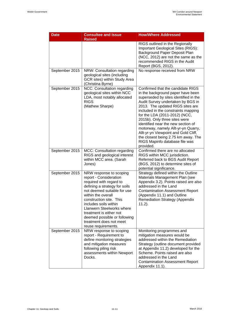
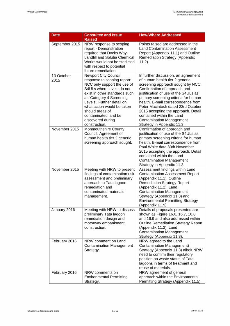
11.3.18 Table 11.1 provides details of the consultation undertaken in relation to geology
and soils.
Table 11.1: Consultation Responses Relevant to this Chapter
Date Consultee and Issue Raised
How/Where Addressed
Draft Plan consultation response (Welsh Government, 2014)
Public response: Potential effect of runoff on farm land. Assessment would be required of possible contamination of soils in areas that have been historically industrial.
This risk is considered at each of the potentially contaminated sites, the details of which can be found in Appendix 11.1 of this ES
Draft Plan consultation response (Welsh Government 2014)
Newport City Council: Potential for contaminated land to be present. Note that consideration would need to be given to implications for human health and environmental risk before re-using any material recovered from contaminated sites.
Both aspects are addressed throughout this ES chapter, in particular in the Baseline Environment and Mitigation sections. Further detail is provided in Appendix 11.1.
17 September 2015
Meeting with Natural Resources Wales (NRW), Monmouthshire County Council (MCC) and Newport City Council (NCC). Consideration would need to be given to potential sterilisation of contaminated sites where there is potential for future remediation action. Use of Suitable for Use Levels (S4ULs) to be agreed.
A draft Land Contamination Management Strategy (LCMS) has been prepared and agreed in principal setting out the general approach and regulatory position specific to the Scheme regarding the assessment and management of land contamination, including reuse of contaminated materials. The draft LCMS is provided in Appendix 11.3. Points raised are also addressed in the Land Contamination Assessment Report and Outline Remediation Strategy Report (Appendix 11.1 and 11.2, respectively).
September 2015 British Geological Survey: Consultation regarding the audit of RIGS in South Wales (BGS, 2012) (Rhian Kendall)
Identified two key sites within Newport County, namely Allt-yr-yn Quarry (OS grid reference ST 29004 88576) and Allt-yr-yn Viewpoint (OS grid reference ST 29285 88232). They also provided a copy of the 2013 Audit Report that was submitted to NCC. BGS confirmed that the candidate
Welsh Government M4 Corridor around Newport Environmental Statement
Chapter 11: Geology and Soils 11-11 March 2016
Date Consultee and Issue Raised
How/Where Addressed
RIGS outlined in the Regionally Important Geological Sites (RIGS): Background Paper Deposit Plan (NCC, 2012) are not the same as the recommended RIGS in the Audit Report (BGS, 2012).
September 2015 NRW: Consultation regarding geological sites (including GCR sites) within Study Area (Christina Byrne)
No response received from NRW
September 2015 NCC: Consultation regarding geological sites within NCC LDA, most notably allocated RIGS (Mathew Sharpe)
Confirmed that the candidate RIGS in the background paper have been superseded by sites identified in the Audit Survey undertaken by BGS in 2013. The updated RIGS sites are included in the constraints mapping for the LDA (2011-2012) (NCC, 2015b). Only three sites were identified near the new section of motorway, namely Allt-yr-yn Quarry, Allt-yr-yn Viewpoint and Gold Cliff, the closest being 2.75 km away. The RIGS Mapinfo database file was provided.
September 2015 MCC: Consultation regarding RIGS and geological interest within MCC area. (Sarah Jones)
Confirmed there are no allocated RIGS within MCC jurisdiction. Referred back to BGS Audit Report (BGS, 2012) to determine sites of potential significance.
September 2015 NRW response to scoping report - Consideration required with regard to defining a strategy for soils not deemed suitable for use within the overall construction site. This includes soils within Llanwern Steelworks where treatment is either not deemed possible or following treatment does not meet reuse requirements.
Strategy defined within the Outline Materials Management Plan (see Appendix 3.2). Points raised are also addressed in the Land Contamination Assessment Report (Appendix 11.1) and Outline Remediation Strategy (Appendix 11.2).
September 2015 NRW response to scoping report - Requirement to define monitoring strategies and mitigation measures following piling risk assessments within Newport Docks.
Monitoring programmes and mitigation measures would be addressed within the Remediation Strategy (outline document provided at Appendix 11.2) developed for the Scheme. Points raised are also addressed in the Land Contamination Assessment Report Appendix 11.1).
Welsh Government M4 Corridor around Newport Environmental Statement
Chapter 11: Geology and Soils 11-12 March 2016
Date Consultee and Issue Raised
How/Where Addressed
September 2015 NRW response to scoping report - Demonstration required that Docks Way Landfill and Solutia Chemical Works would not be sterilised with respect to potential future remediation.
Points raised are addressed in the Land Contamination Assessment Report (Appendix 11.1) and Outline Remediation Strategy (Appendix 11.2).
13 October 2015
Newport City Council response to scoping report: NCC only support the use of S4ULs where levels do not exist in other standards such as 'Category 4 Screening Levels'. Further detail on what action would be taken should areas of contaminated land be discovered during construction.
In further discussion, an agreement of human health tier 2 generic screening approach sought by NCC. Confirmation of approach and justification of use of the S4ULs as primary screening criteria for human health. E-mail correspondence from Peter Macintosh dated 23rd October 2015 accepting the approach. Detail contained within the Land Contamination Management Strategy in Appendix 11.3.
November 2015 Monmouthshire County Council: Agreement of human health tier 2 generic screening approach sought.
Confirmation of approach and justification of use of the S4ULs as primary screening criteria for human health. E-mail correspondence from Paul White data 30th November 2015 accepting the approach. Detail contained within the Land Contamination Management Strategy in Appendix 11.3.
November 2015 Meeting with NRW to present findings of contamination risk assessment and preliminary approach to Tata lagoon remediation and contaminated materials management.
Assessment findings within Land Contamination Assessment Report (Appendix 11.1), Outline Remediation Strategy Report (Appendix 11.2), Land Contamination Management Strategy (Appendix 11.3) and Environmental Permitting Strategy (Appendix 11.5).
January 2016 Meeting with NRW to discuss preliminary Tata lagoon remediation design and motorway embankment construction.
Details of proposals presented are shown as Figure 16.6, 16.7, 16.8 and 16.9 and also addressed within Outline Remediation Strategy Report (Appendix 11.2), Land Contamination Management Strategy (Appendix 11.3).
February 2016 NRW comment on Land Contamination Management Strategy.
NRW agreed to the Land Contamination Management) Strategy (Appendix 11.3) albeit NRW need to confirm their regulatory position on waste status of Tata lagoons in terms of treatment and reuse of materials.
February 2016 NRW comments on Environmental Permitting Strategy.
NRW agreement of general approach within the Environmental Permitting Strategy (Appendix 11.5).
Welsh Government M4 Corridor around Newport Environmental Statement
Chapter 11: Geology and Soils 11-13 March 2016
Approach to Assessment
Geology and Soils
11.3.19 An assessment of effects on geology is provided within this chapter. This
provides a qualitative assessment of the effects on all designated and non-
designated areas of geological and geomorphological interest within the study
area. This assessment includes consideration of the potential for geological
enhancement through the creation of new exposure.
11.3.20 The conditions along the new section of motorway have been reviewed in detail
and the presence of existing cuttings and exposures recorded and assessed in
terms of their value and/or sensitivity to inform the baseline conditions. The
vertical and horizontal alignments of the route of the new section of motorway
have been reviewed and, where existing cuttings and exposure are to be
affected, these have been identified, as well as all areas where new exposures
and cuttings would be created or where the route passes through areas of
potential land contamination. Each of these has been assessed in relation to the
following aspects.
The potential for the proposed works to cause changes to the drainage and
the hydrogeological regime.
The potential for the proposed works to create new pathways between
contaminated materials and identified receptors.
The potential for the proposed works to spread contaminated material.
The potential for the proposed works to affect designated and non-designated
geodiversity sites.
The potential for the proposed works to cause instability, soil erosion, topsoil
loss/reduced quality or changes in topography.
The potential for the proposed works to impact or be impacted by
mining/quarrying including effects of mineral resource sterilisation.
Land Contamination Assessment
11.3.21 A detailed assessment of land contamination has been undertaken and full
details of the assessment are contained within the Land Contamination
Assessment Report (provided in Appendix 11.1). A summary of the approach to
the assessment of land contamination is provided in this section.
11.3.22 Based upon guidance within Contaminated Land Report 11 (CLR-11)
(Environment Agency and Defra, 2004), a risk assessment approach has been
adopted to assess the risks associated with historic land contamination that may
be present along the proposed route of the new section of motorway. The
findings of the risk assessment have been used to enable management decisions
to be taken on whether control measures are required to be implemented to
mitigate potential risks to the environment and human health.
11.3.23 The tiers of the assessment are as follows.
1) Preliminary Risk Assessment and Defining Outline Conceptual Site Model
(CSM).

Welsh Government M4 Corridor around Newport Environmental Statement
Chapter 11: Geology and Soils 11-14 March 2016
2) Generic Site-Specific Risk Assessment (screening) and Subsequent
Refinement of CSM.
3) Site-Specific Detailed Risk Assessment.
4) Remediation Strategy Design.
11.3.24 This tiered approach has been adopted for each of the potentially contaminated
sites identified in the 2014 Preliminary Sources Study Report (PSSR) (Arup,
2014), which has the potential to affect or be affected by the new section of
motorway along with other areas of interest identified during this assessment
(since the 2014 PSSR was published). A total of 27 specific potentially
contaminated sites have been considered along with other data, such as ground
investigation reports and historic maps, along the proposed route of the new
section of motorway.
11.3.25 The need for progression from tier to subsequent tier was driven by the findings
of the previous tier with respect to the level and nature of risk identified and the
type of likely remedial action or control measure needed to manage the risks
identified. Tier 1 and Tier 2 risk assessments have been undertaken for all of the
27 identified potentially contaminated sites. An outline remediation strategy has
also been designed and this may be supported by Tier 3 assessments to further
refine specific areas of remediation to enable the remediation strategy to be
finalised prior to construction. The Outline Remediation Strategy Report is
provided in Appendix 11.2.
11.3.26 Details of the Tier 1 and Tier 2 risk assessment are set out below.
Preliminary Risk Assessment (Tier 1)
11.3.27 The Preliminary Risk Assessment consists of an appraisal of the source-
pathway-receptor 'contaminant linkages', which is central to the approach used to
determine the existence of 'Contaminated Land' according to the definition set out
under Part 2A of the Environmental Protection Act 1990. For a risk to exist
(under Part 2A), all three of the following components must be present to
facilitate a potential 'contaminant linkage'.
Source of contamination (Hazard).
Pathway for the contaminant to move from the source(s) to receptor(s).
Receptor (Target) that could be affected by the contaminant(s).
11.3.28 The mere presence of a contaminant source/hazard at a site does not mean that
there will necessarily be attendant risks requiring remedial action or that the site
will be designated as 'Contaminated Land'.
Generic Risk Assessment (Tier 2)
11.3.29 The purpose of the Tier 2 generic risk assessment is to further evaluate potential
risks identified in the Tier 1 preliminary risk environment.
Generic Quantitative Risk Assessment (Tier 2) - Screening Criteria (Human
Health)
11.3.30 The Generic Quantitative Risk Assessment (GQRA) aims to identify
contaminants of concern and their spatial distribution and requires benchmarks

Welsh Government M4 Corridor around Newport Environmental Statement
Chapter 11: Geology and Soils 11-15 March 2016
against which to compare the concentrations of soil contaminants. This requires
the comparison of contaminant concentrations with Generic Assessment Criteria
(GAC). The following GAC have been used in the assessment of human health.
Suitable 4 Use Levels (S4ULs).
Soil Guideline Values (SGV) for dioxins, furans and dioxin-like
Polychlorinated biphenyls (PCBs).
Category 4 Screening Level (C4SL) for lead.
11.3.31 Further details of the rationale and methodology are provided within the Land
Contamination Assessment Report in Appendix 11.1. Where the concentrations
of contaminants in soils are less than the S4ULs, the risks to human health are
considered to be at minimal or tolerable levels and thus remediation is not
required. Where concentrations are above S4ULs, this indicates that a risk to
human health may exist warranting further assessment and, potentially,
remediation.
11.3.32 For the end users of the new section of motorway (general public and
maintenance workers), the chemical test results for soil samples, where
available, have been screened against the lower of the public open space (POS)
park land use and commercial land use scenarios. It is considered that the lower
of the two scenarios would provide stringent criteria for the Scheme and
represent a conservative approach. In addition, for organic contaminants those
values corresponding to a Soil Organic Matter (SOM) of 1% are used, providing
further conservatism to the assessment. These criteria are presented in the Land
Contamination Assessment Report in Appendix 11.1.
11.3.33 Short term (acute) health risks to construction workers and the general public
would be managed through the adoption and implementation of strict control and
protection measures required under the Construction (Design and Management)
Regulations (CDM) 2015 and the Health and Safety at Work Act (HSWA) 1974.
At this stage, a qualitative risk assessment has been undertaken and the findings
are described within this chapter. Full details of the assessment and
management of risk to workers and the general public during construction are
provided in the Land Contamination Assessment Report (Appendix 11.1).
Generic Quantitative Risk Assessment (Tier 2) - Screening Criteria
(Groundwater)
11.3.34 Preliminary evaluation of potential impacts to surface water and groundwater
from land contamination is undertaken via a screening assessment that
compares observed water quality data with appropriate water quality Assessment
Criteria (AC). The selection of AC depends on the conceptual model developed
for a site and in particular the nature and sensitivity of controlled water receptors
for which active pollutant linkages are considered likely to exist. Two sources of
statutory and non-statutory water quality AC are typically used for the purpose of
such screening assessments.
Environmental Quality Standards (EQS), defined for the protection of the
ecology of surface water environments.
Drinking Water Standards (DWS), defined on the basis of health for water
intended for human consumption.

Welsh Government M4 Corridor around Newport Environmental Statement
Chapter 11: Geology and Soils 11-16 March 2016
11.3.35 The selection of screening criteria is discussed in detail within Chapter 16: Road
Drainage and the Water Environment of this ES. Further details are also
provided within the Contaminated Land Assessment Report in Appendix 11.1.
Generic Quantitative Risk Assessment (Tier 2) - Screening Criteria (Ground Gas)
11.3.36 The emission of soil gases may occur either from Made Ground, buried waste,
soils and rocks or from other organic contamination.
11.3.37 Using guidance provided in CIRIA C665 'Assessing risk posed by hazardous
ground gases to buildings' (CIRIA, 2007) and reference to the Workplace
Exposure Limits (WELs) (Health and Safety Executive, 2011) ground gas
monitoring results from ground investigations have been compared with
screening threshold values as follows.
Methane > 1 volume/volume percent (% v/v).
Carbon dioxide > 5 % v/v.
Carbon monoxide > 30 parts per million (ppm).
Hydrogen sulphide > 5 ppm.
11.3.38 Where gas concentrations exceed the above criteria, further detailed risk
assessment has been undertaken based upon CIRIA C665 (CIRIA, 2007). It is of
note that this guidance is used to inform the gas risk assessment only as the
Scheme is for a motorway (and other highway) end use and does not therefore
include buildings. Further detail is provided within the Land Contamination
Assessment Report provided in Appendix 11.1.
Assessment Criteria and Assignment of Significance
11.3.39 The Scheme has been assessed to ensure that all relevant impacts on
geodiversity, hydrogeology and ground conditions are identified and that any
environmental issues and risks associated with land contamination are
considered. The overall assessment has been carried out in accordance with
guidance as set out in the DMRB Volume 11, Section 3, Part 11 Geology and
Soils (Highways Agency, 1993, amended August 1994), whilst the detailed
assessment of the magnitude of impacts and significance criteria for effects has
been undertaken using the methodology outlined in DMRB Volume 11, Section 2,
Part 5 HA 205/08 (Highways Agency et al., 2008b).
Receptor Sensitivity
11.3.40 The first step in undertaking the assessment was to assess the value (sensitivity)
of the receptor or area affected by the Scheme. This was done using the
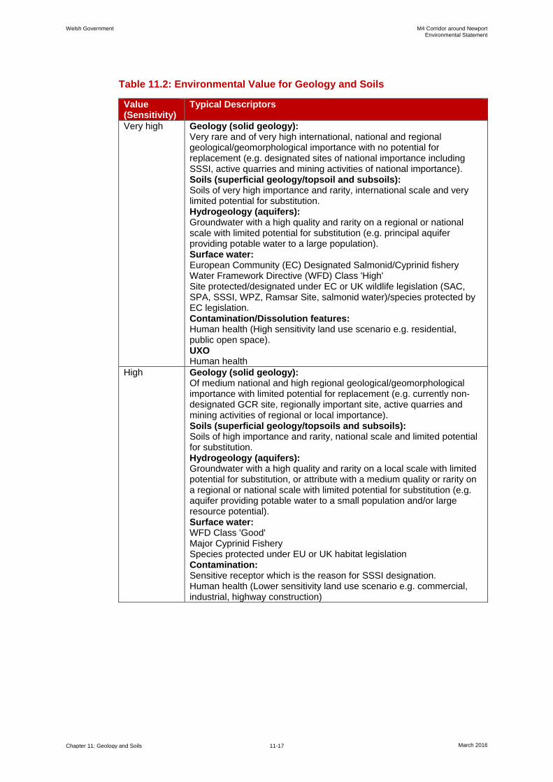
descriptors of value described in Table 2.1 of HA205/08, as shown in Table 11.2.
Welsh Government M4 Corridor around Newport Environmental Statement
Chapter 11: Geology and Soils 11-17 March 2016
Table 11.2: Environmental Value for Geology and Soils
Value (Sensitivity)
Typical Descriptors
Very high Geology (solid geology): Very rare and of very high international, national and regional geological/geomorphological importance with no potential for replacement (e.g. designated sites of national importance including SSSI, active quarries and mining activities of national importance). Soils (superficial geology/topsoil and subsoils): Soils of very high importance and rarity, international scale and very limited potential for substitution. Hydrogeology (aquifers): Groundwater with a high quality and rarity on a regional or national scale with limited potential for substitution (e.g. principal aquifer providing potable water to a large population). Surface water: European Community (EC) Designated Salmonid/Cyprinid fishery Water Framework Directive (WFD) Class 'High' Site protected/designated under EC or UK wildlife legislation (SAC, SPA, SSSI, WPZ, Ramsar Site, salmonid water)/species protected by EC legislation. Contamination/Dissolution features: Human health (High sensitivity land use scenario e.g. residential, public open space). UXO Human health
High Geology (solid geology): Of medium national and high regional geological/geomorphological importance with limited potential for replacement (e.g. currently non-designated GCR site, regionally important site, active quarries and mining activities of regional or local importance). Soils (superficial geology/topsoils and subsoils): Soils of high importance and rarity, national scale and limited potential for substitution. Hydrogeology (aquifers): Groundwater with a high quality and rarity on a local scale with limited potential for substitution, or attribute with a medium quality or rarity on a regional or national scale with limited potential for substitution (e.g. aquifer providing potable water to a small population and/or large resource potential). Surface water: WFD Class 'Good' Major Cyprinid Fishery Species protected under EU or UK habitat legislation Contamination: Sensitive receptor which is the reason for SSSI designation. Human health (Lower sensitivity land use scenario e.g. commercial, industrial, highway construction)

Welsh Government M4 Corridor around Newport Environmental Statement
Chapter 11: Geology and Soils 11-18 March 2016
Value (Sensitivity)
Typical Descriptors
Medium Geology (solid geology): Of low regional and high local geological/geomorphological importance with some potential for replacement (e.g. allocated RIGS or recommended RIGS). Soils (superficial geology/topsoils and subsoils): Soils of medium importance and rarity, regional scale, limited potential for substitution. Hydrogeology (aquifers): Groundwater with a medium quality and rarity on a local scale with limited potential for substitution, or attribute with a low quality and rarity on a regional or national scale with limited potential for substitution (e.g. secondary aquifer unit supporting abstraction for agricultural or industrial use and/or moderate resource potential). Surface Water: WFD Class 'Moderate' Contamination: Receptor which is of regional importance.
Low (or Lower)
Geology (solid geology): Of local geological/geomorphological importance with potential for replacement (e.g. non-designated exposure/former quarries and mining activities). Soils(superficial geology/topsoils and subsoils): Soils of low importance and rarity, local scale. Hydrogeology (aquifers): Groundwater with a low quality and rarity on a local scale with limited potential for substitution (e.g. non-aquifer unit that does not afford protection to underlying water bearing units). Surface Water: WFD Class 'Poor' Contamination: Receptor which is of local importance.
Negligible Geology (solid geology): Of little local geological/geomorphological interest. Soils (superficial geology/topsoils and subsoils): Soils of very low importance and rarity, local scale. Contamination: Receptor with low importance and rarity.
Magnitude of Impact
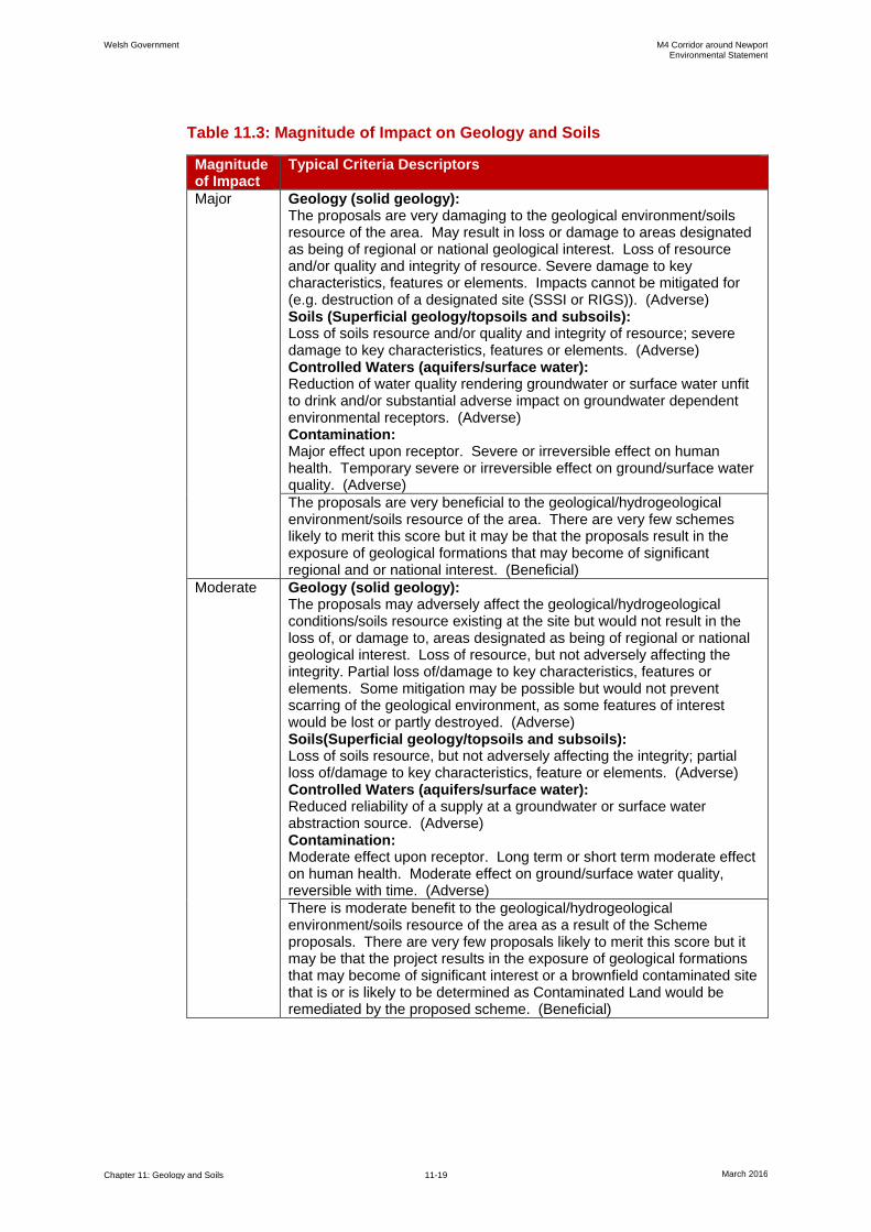
11.3.41 The impacts of the Scheme, which are described in terms of the magnitude of the
impact, have been determined on the basis of the five-point scale described in
Table 11.3 below. These follow the general guidance set out in DMRB Volume
11, Section 2, Part 5 HA 205/08 (Highways Agency et al., 2008b).
11.3.42 The definitions of certain magnitudes in relation to contamination are based on
CIRIA C552 (CIRIA, 2001) and informed by CLR11 (Environment Agency and
Defra, 2004).
Welsh Government M4 Corridor around Newport Environmental Statement
Chapter 11: Geology and Soils 11-19 March 2016
Table 11.3: Magnitude of Impact on Geology and Soils
Magnitude of Impact
Typical Criteria Descriptors
Major Geology (solid geology): The proposals are very damaging to the geological environment/soils resource of the area. May result in loss or damage to areas designated as being of regional or national geological interest. Loss of resource and/or quality and integrity of resource. Severe damage to key characteristics, features or elements. Impacts cannot be mitigated for (e.g. destruction of a designated site (SSSI or RIGS)). (Adverse) Soils (Superficial geology/topsoils and subsoils): Loss of soils resource and/or quality and integrity of resource; severe damage to key characteristics, features or elements. (Adverse) Controlled Waters (aquifers/surface water): Reduction of water quality rendering groundwater or surface water unfit to drink and/or substantial adverse impact on groundwater dependent environmental receptors. (Adverse) Contamination: Major effect upon receptor. Severe or irreversible effect on human health. Temporary severe or irreversible effect on ground/surface water quality. (Adverse)
The proposals are very beneficial to the geological/hydrogeological environment/soils resource of the area. There are very few schemes likely to merit this score but it may be that the proposals result in the exposure of geological formations that may become of significant regional and or national interest. (Beneficial)
Moderate Geology (solid geology): The proposals may adversely affect the geological/hydrogeological conditions/soils resource existing at the site but would not result in the loss of, or damage to, areas designated as being of regional or national geological interest. Loss of resource, but not adversely affecting the integrity. Partial loss of/damage to key characteristics, features or elements. Some mitigation may be possible but would not prevent scarring of the geological environment, as some features of interest would be lost or partly destroyed. (Adverse) Soils(Superficial geology/topsoils and subsoils): Loss of soils resource, but not adversely affecting the integrity; partial loss of/damage to key characteristics, feature or elements. (Adverse) Controlled Waters (aquifers/surface water): Reduced reliability of a supply at a groundwater or surface water abstraction source. (Adverse) Contamination: Moderate effect upon receptor. Long term or short term moderate effect on human health. Moderate effect on ground/surface water quality, reversible with time. (Adverse)
There is moderate benefit to the geological/hydrogeological environment/soils resource of the area as a result of the Scheme proposals. There are very few proposals likely to merit this score but it may be that the project results in the exposure of geological formations that may become of significant interest or a brownfield contaminated site that is or is likely to be determined as Contaminated Land would be remediated by the proposed scheme. (Beneficial)
Welsh Government M4 Corridor around Newport Environmental Statement
Chapter 11: Geology and Soils 11-20 March 2016
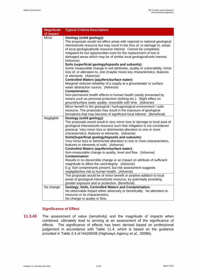
Magnitude of Impact
Typical Criteria Descriptors
Minor Geology (solid geology): The proposals would not affect areas with regional or national geological interest/soils resource but may result in the loss of, or damage to, areas of local geological/soils resource interest. Cannot be completely mitigated for but opportunities exist for the replacement of lost or damaged areas which may be of similar local geological/soils interest. (Adverse) Soils (superficial geology/topsoils and subsoils): Some measurable change in soil attributes, quality or vulnerability; minor loss of, or alteration to, one (maybe more) key characteristics, features or elements. (Adverse) Controlled Waters (aquifers/surface water): Marginal reduced reliability of a supply at a groundwater or surface water abstraction source. (Adverse) Contamination: Non-permanent health effects to human health (easily prevented by means such as personal protective clothing etc.). Slight effect on ground/surface water quality, reversible with time. (Adverse)
Minor benefit to the geological / hydrogeological environment / soils resource. The proposals may result in the exposure of geological formations that may become of significant local interest. (Beneficial)
Negligible Geology (solid geology): The proposals would result in very minor loss or damage to local area of geological interest/soils resource such that mitigation is not considered practical. Very minor loss or detrimental alteration to one or more characteristics, features or elements. (Adverse) Soils(Superficial geology/topsoils and subsoils): Very minor loss or detrimental alteration to one or more characteristics, features or elements of soils. (Adverse) Controlled Waters (aquifers/surface water): Non-measurable change to quality, level and flow. (Adverse) Contamination: Results in no discernible change or an impact on attribute of sufficient magnitude to affect the use/integrity. (Adverse) E.g. Soil contaminants present, but risk assessment suggests negligible/low risk to human health. (Adverse)
The proposals would be of minor benefit or positive addition to local areas of geological interest/soils resource, by potentially providing greater exposure and or protection. (Beneficial).
No change Geology, Soils, Controlled Waters and Contamination: No observable impact either adversely or beneficially. No alteration to resource or its characteristics. No change to quality or flow.
Significance of Effect
11.3.43 The assessment of value (sensitivity) and the magnitude of impacts when
combined, ultimately lead to arriving at an assessment of the significance of
effects. The significance of effects has been derived based on professional
judgement in accordance with Table 11.4, which is based on the guidance
provided in Table 2.4 of HA205/08 (Highways Agency et al., 2008b).
Welsh Government M4 Corridor around Newport Environmental Statement
Chapter 11: Geology and Soils 11-21 March 2016
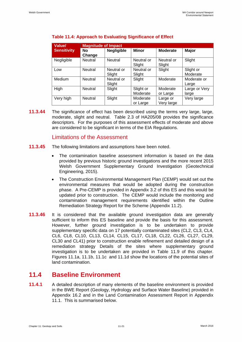
Table 11.4: Approach to Evaluating Significance of Effect
Value/ Sensitivity
Magnitude of Impact
No Change
Negligible Minor Moderate Major
Negligible Neutral Neutral Neutral or Slight
Neutral or Slight
Slight
Low Neutral Neutral or Slight
Neutral or Slight
Slight Slight or Moderate
Medium Neutral Neutral or Slight
Slight Moderate Moderate or Large
High Neutral Slight Slight or Moderate
Moderate or Large
Large or Very large
Very high Neutral Slight Moderate or Large
Large or Very large
Very large
11.3.44 The significance of effect has been described using the terms very large, large,
moderate, slight and neutral. Table 2.3 of HA205/08 provides the significance
descriptors. For the purposes of this assessment effects of moderate and above
are considered to be significant in terms of the EIA Regulations.
Limitations of the Assessment
11.3.45 The following limitations and assumptions have been noted.
The contamination baseline assessment information is based on the data
provided by previous historic ground investigations and the more recent 2015
Welsh Government Supplementary Ground Investigation (Geotechnical
Engineering, 2015).
The Construction Environmental Management Plan (CEMP) would set out the
environmental measures that would be adopted during the construction
phase. A Pre-CEMP is provided in Appendix 3.2 of this ES and this would be
updated prior to construction. The CEMP would include the monitoring and
contamination management requirements identified within the Outline
Remediation Strategy Report for the Scheme (Appendix 11.2).
11.3.46 It is considered that the available ground investigation data are generally
sufficient to inform this ES baseline and provide the basis for this assessment.
However, further ground investigation is to be undertaken to provide
supplementary specific data on 17 potentially contaminated sites (CL2, CL3, CL4,
CL6, CL8, CL10, CL13, CL14, CL15, CL17, CL18, CL22, CL26, CL27, CL29,
CL30 and CL41) prior to construction enable refinement and detailed design of a
remediation strategy Details of the sites where supplementary ground
investigation is to be undertaken are provided in Table 11.9 of this chapter.
Figures 11.1a, 11.1b, 11.1c and 11.1d show the locations of the potential sites of
land contamination.
11.4 Baseline Environment
11.4.1 A detailed description of many elements of the baseline environment is provided
in the BWE Report (Geology, Hydrology and Surface Water Baseline) provided in
Appendix 16.2 and in the Land Contamination Assessment Report in Appendix
11.1. This is summarised below.
Welsh Government M4 Corridor around Newport Environmental Statement
Chapter 11: Geology and Soils 11-22 March 2016
Topography, Landform and Land Use
11.4.2 The proposed route of the new section of motorway would cross three distinct
topographic zones as set out below.
High elevation, Devonian hills in the west around Castleton (Junction 29 of
the existing M4) (elevation of up to approximately 60 metre Above Ordnance
Datum (AOD)).
Low-lying, flat coastal plain of Gwent Levels (elevation below 10 metres
AOD).
High elevation Carboniferous hills in the east around Magor (Junction 23A of
the existing M4) (elevation of up to approximately 60 metres AOD).
11.4.3 In its mid-section the new section of motorway would cross the River Ebbw and
the River Usk, which discharge into the Severn Estuary, to the south of Newport.
The proposed new section of motorway would also cross the Alexandra Docks,
between the Usk and Ebbw. To the west and east are the Wentlooge Levels and
Caldicot Levels, respectively. In the vicinity of Newport and at Llanwern
steelworks the Levels have been extensively developed.
11.4.4 On the basis of topography, land use and drainage, the new section of motorway
can be divided broadly into five zones, namely Castleton, Wentlooge Levels, the
central section (including the River Ebbw Underbridge, Docks Way Junction and
River Usk Crossing), Caldicot Levels and Magor. These are shown within
drawings contained within the BWE Report in Appendix 16.2.
11.4.5 The predominant land use along the route of the new section of motorway is
arable and pastoral farmland with isolated residential dwellings. The land use
and Agricultural Land Classification across the study area are presented in
Chapter 15 of this ES: Community and Private Assets.
11.4.6 Over half of the land within the permanent highway boundary of the new section
of motorway would be constructed on brownfield land such as Newport Docks,
Llanwern Steelworks and Solutia chemical works.
Geology
11.4.7 A detailed summary of the geology within the study area is provided in the BWE
report in Appendix 16.2, with the key aspects of baseline geology summarised in
Figures 16.2a to 16.2e and 163a to 16.3e. A summary of the geological ground
model identified within the study area is provided in the Conceptual
Hydrogeological Models presented in Figures 16.5a to 16.5e.
11.4.8 The geology encountered within the study area is summarised in Table 16.6 of
this ES, which is reproduced below as Table 11.5.
Table 11.5: Geological Sequence
Geological Period Supergroup Group Subgroup / Formation
Quaternary - - Glacial Till (GT)
Alluvium (ALV)
Head (HD)
River Terrace Deposits (RTD)
Tidal Flat Deposits (TFD)
Glaciofluvial Deposits (GFD)
Welsh Government M4 Corridor around Newport Environmental Statement
Chapter 11: Geology and Soils 11-23 March 2016
Geological Period Supergroup Group Subgroup / Formation
Triassic - Mercia Mudstone Group (MMG)
- Mercia Mudstone (marginal facies)
Carboniferous Carboniferous Limestone
Pembroke Limestone Group
Gulley Oolite Formation (GOF)
Blackrock Limestone subgroup (BLF)
Avon Group (AVG)
Devonian Old Red Sandstone (ORS)
Upper ORS Tintern Sandstone (TSF)
Quartz Conglomerate (QZ)
Lower (ORS)
Brownstone Formation (BWF)
St Maughans Formation (SMF)
Silurian Raglan Mudstone Formation (RMF)
Solid Geology
11.4.9 The solid geology present beneath the study area consists of bedrock of Silurian,
Devonian, Carboniferous and Triassic ages.
11.4.10 Areas of high elevation at the eastern end of the study area are dominated by
Carboniferous strata, principally limestone units of the Avon Group and
Pembroke Limestone Group, the latter including the Black Rock Limestone
Formation and Gully Oolite Formation.
11.4.11 The majority of the route is situated above Triassic bedrock, which comprises
Mercia Mudstone (formerly Keuper Marl). Localised areas of the Mercia
Mudstone marginal facies are encountered in the east around the Carbonifeorus
limestone high ground.
11.4.12 The western section of the study area is situated on older bedrock that includes
Devonian St Maughan's Formation and Silurian Raglan Mudstone formation.
Other Devonian units (i.e. the Brownstones Formation and Tintern Sandstone)
are also encountered along the proposed route of the new section of motorway.
The general description for each of the key lithological units encountered within
the study area is provided in Table 11.6. These descriptions are taken from the
BGS Lexicon of Named Rock Units (BGS, 2015).
Table 11.6: BGS Lithological Descriptions
Unit (Reference)
BGS Lithological Description
Mercia Mudstone Group (MMG)
Dominantly red, less commonly green-grey, mudstones and subordinate siltstones with thick halite-bearing units in some basinal areas. Thin beds of gypsum/anhydrite widespread, sandstones are also present.
Mercia Mudstone marginal facies (MMMF)
Variable, typically consisting of conglomerate and/or breccia with clasts derived locally from rocks lying immediately below the unconformable base of these deposits. The matrix generally consists of finer-grained rock fragments or, less commonly, siltstone, sandstone or micritic limestone.
Gully Oolite Formation (GOF)
Medium- to thick-bedded, pale grey, oolitic grainstone with subordinate beds of fine-grained skeletal packstones. Cross-laminated and cross-bedded, some burrowing. Locally dolomitized.
Welsh Government M4 Corridor around Newport Environmental Statement
Chapter 11: Geology and Soils 11-24 March 2016
Unit (Reference)
BGS Lithological Description
Black Rock Limestone subgroup (BRL)
Thin- to thick-bedded, dark grey to black, foetid, fine- to coarse-grained skeletal (mainly crinoid) packstones with subordinate thin beds of shaly argillaceous skeletal packstone and mudstone. Widespread burrowing.
Avon Group (AG)
Interbedded grey mudstones and thin- to medium-bedded skeletal packstones with one to several thick units of ooidal and skeletal grainstones. Thin units of calcite mudstone and mudstone locally present. Sparse thin ironstones.
Tintern Sandstone Formation (TSF)
Buff-yellow sandstone with local lenticles of pebbles and subordinate marl partings.
Brownstone Formation (BWF)
Red, brown and purple fluvial sandstones with red mudstone interbeds.
St Maughans Formation (SMF)
Interbedded purple, brown and green sandstones and red mudstones with intraformational conglomerates containing calcrete clasts.
Raglan Mudstone Formation (RMF)
Red mudstones and silty mudstones with calcretes and sandstones.
11.4.13 The distribution of the key bedrock units is described in detail within the BWE
Report (Appendix 16.2). The various previous ground investigations that have
been undertaken (Section 11.3) have confirmed the geological sequence set out
in published information.
Superficial Deposits
11.4.14 The superficial deposits within the study area are principally of Quaternary age
and dominated by the sequence of deposits contained within the Gwent Levels.
On higher ground located outside of the Gwent Levels, the Quaternary sequence
is dominated by glacial till and more recent fluvial (i.e. river terrace deposits and
alluvium) or head deposit. These superficial deposits have a poorly constrained
relationship with the Quaternary sequence within the Gwent Levels themselves.
11.4.15 The detailed stratigraphy of the Gwent Levels sequence is described by Allen
(Allen, 2001). The geology is dominated by Holocene deposits typically 10 to
15 m thick that comprise alternating estuarine clays and silts with peat horizons
(recently termed Tidal Flat Deposits). Beneath much of the Wentlooge Levels
and Caldicot Levels this sequence directly overlies a relatively continuous
platform in the underlying bedrock with an elevation of between -7.5 metres AOD
and -5 metres AOD that declines gently towards the Severn Estuary. In the
central region of the study area around Newport, the bedrock platform is incised
by valleys associated with the River Ebbw and River Usk. These valleys have
been infilled with Pleistocene valley gravels and some sands that are
occasionally capped by head deposits. These gravels directly underlie the
Holocene estuarine sequence. The Pleistocene valley gravels extend to the west
and east, beneath the Wentlooge Levels and Caldicot Levels, respectively.
Welsh Government M4 Corridor around Newport Environmental Statement
Chapter 11: Geology and Soils 11-25 March 2016
11.4.16 This general sequence is described below with respect to recent terminology of
the BGS (lexicon) summarised in Table 5.1 of the BWE report within Appendix
16.2 of this ES.
Alluvium
11.4.17 Recent fluvial deposits that are contained within the non-tidal valleys of principal
watercourses are termed alluvium (ALV). The alluvium is of highly variable
composition and extent, but typically comprises silty clay, with layers of silt, sand,
peat and basal gravel.
Head
11.4.18 Head (HD) is a poorly sorted and poorly stratified deposit formed mostly by
solifluction and/or hillwash and soil creep. Head essentially comprises sand and
gravel, locally with lenses of silt, clay or peat and organic material. Small areas
of localised head deposits are identified within the study area and are also
expected in places beneath the Gwent Levels.
River Terrace Deposits
11.4.19 Isolated outcrops of River Terrace Deposits (RTDs) are present along the inland
margin of the Tidal Flat Deposits of the Gwent Levels. The subcrop pattern of the
River Terrace Deposits is not proven, but these deposits are generally restricted
to areas of higher elevation situated outside of the Gwent Levels. The River
Terrace Deposits comprise sand and gravel units, locally with lenses of silt, clay
or peat and are of fluvial origin.
Glacial Till
11.4.20 Glacial Till (GT) caps bedrock to the north of the Gwent Levels along much of the
local area, particularly in the west of the study area. Glacial Till has been
previously termed Morainic Drift and is described as being ‘highly variable from
stiff, gravelly, silty clay to predominantly unconsolidated and unsorted gravels’.
Tidal Flat Deposits
11.4.21 The majority of the study area crosses the Gwent Levels which is underlain by
Tidal Flat Deposits (TFD) of Holocene age. The BGS consider that the Tidal Flat
Deposits typically comprise soft silty clay, with layers of sand, gravel and peat
and represent deposit laid down within the tidal zone, although these areas are
now reclaimed through the construction of sea defences. The Tidal Flat Deposits
have historically been termed estuarine alluvium, although this is now an
obsolete lithostratigraphic term (see BGS lexicon). For the purpose of this study,
the Tidal Flat Deposits are considered to be equivalent to the Holocene estuarine
deposits of Allen (Allen, 2001), described above.
Glaciofluvial Deposits
11.4.22 Glaciofluvial Deposits (GFDs) have been identified at outcrops in localised areas
along the inland margin of the Tidal Flat Deposits in the west of the study area.
The Glaciofluvial Deposits comprise sand and gravel, locally with lenses of silt,
clay or organic material, thought to be of glaciofluvial origin and sometimes
occurring as sheet deposits.
Welsh Government M4 Corridor around Newport Environmental Statement
Chapter 11: Geology and Soils 11-26 March 2016
11.4.23 For the purpose of this study, it has also been assumed that the Glaciofluvial
Deposits defined by the BGS are equivalent to the Pleistocene sand and gravel
deposits described by Allen (Allen, 2001) that pre-date and underlie the silty clays
(and peats) of the Holocene Tidal Flat Deposits. It should be noted that historic
geological cross-sections presented in the PSSR identify the concealed granular
deposits situated beneath the estuarine alluvium as deep (granular) fluvial
alluvium (Arup, 2014). Conversely, other authors have suggested that these
granular deposits are the basal unit of that estuarine alluvium sequence (i.e. the
Tidal Flat Deposits) (e.g. Andrews et al., 1984). In light of this uncertainty, these
granular deposits have been termed Glaciofluvial Deposits, reflecting the
significant lithological and hydrogeological difference of the unit relative to other
deposits within the expected stratigraphic sequence, most notably the overlying
silt and clay of the Tidal Flat Deposits.
11.4.24 Although not proven, continuity between the concealed Glaciofluvial Deposits on
the Gwent Levels and the superficial deposits situated inland from the Levels is
not generally expected.
Topsoil and Anthropogenic Soils
Topsoils/Subsoils
11.4.25 Previous ground investigations have identified topsoils/subsoils being present
along the route of the proposed new section of motorway particularly in areas that
have not been subject to previous development such as agricultural land. The
composition of the topsoils/subsoils is heavily influenced by the underlying
geology. Topsoils/subsoils may be absent or generally of lower quality in areas
that have been developed and in such areas its composition is typically variable
with the potential to contain man-made inclusions such as fragments of brick and
concrete. Further information on the nature and thicknesses of topsoils and
subsoil horizons in areas of agricultural land is provided in Chapter 15 or this ES:
Community and Private Assets.
Made Ground
11.4.26 Previous ground investigations and research has identified Made Ground within
developed areas along the route of the proposed new section of motorway.
Made Ground by its very nature is inherently variable both in terms of thickness
and composition. More significant areas of Made Ground have been identified
within the following areas along the route.
Docks Way landfill comprising predominantly landfill waste.
Newport Docks often associated with land reclamation activities to construct
the docks.
Historical landfills.
Llanwern Steelworks comprising predominantly lagoon waste slag and reed
beds.
11.4.27 Further detail is provided within the Land Contamination Assessment Report
contained within Appendix 11.1 and associated annexes.
Welsh Government M4 Corridor around Newport Environmental Statement
Chapter 11: Geology and Soils 11-27 March 2016
Designated and Non-designated Geological Sites
11.4.28 The following hierarchy of designated and non-designated geological sites has
been used for the assessment.
Designated geological sites of national or international importance (e.g. SSSI,
NNR).
Nationally important sites that have not been designated (e.g. JNCC GCR
sites).
RIG sites that have been adopted by the NCC and MCC as shown on their
online planning constraints map (e.g. NCC, 2015b).
Non-adopted RIG sites recommended by British Geological Survey in the
South Wales RIGS Audit (2012).
Special Landscape Areas or Sites of Importance for Nature Conservation.
Non-designated geological exposure in road cuttings and/or historic quarries.
11.4.29 Through consultation with Newport City Council (NCC), Monmouthshire County
Council (MCC) and British Geological Survey (BGS), all statutory and non-
statutory designated geological sites located in the study area have been
identified.
11.4.30 It can be concluded that no designated sites (statutory or non-statutory), nor rock
faces associated with historical quarries (save backfilled pits and quarries
identified within the Land Contamination Assessment Report), are located on the
route of the new section of motorway. Areas of existing rock cut do exist in the
vicinity of existing highways, most notably along the existing M4 around Castleton
and Magor although these are not designated.
Structural Geology
11.4.31 An inferred fault (displacement unknown) cuts through the eastern end of the
Magor junction on the existing M48.
11.4.32 Engineering geological mapping of rock cuts on the existing M4 located just east
of Junction 23A Magor, was undertaken in order to characterise the geology and
geotechnical properties of the rock masses to assist in the design of new rock
cuts proposed as part of the widening works for the new section of motorway.
11.4.33 Descriptions of the Carboniferous Limestone in the Magor area indicate that
dissolution features are common (e.g. sinkholes formed by dissolution of soluble
rocks). Boreholes in this area have not conclusively established the presence or
absence of sink holes in the vicinity of the proposed cut.
Geomorphology
11.4.34 On the basis of the topography and geology, the study area can be divided into
five distinct geomorphological zones, namely Castleton, the Wentlooge Levels to
the west of the River Usk, the Docks alongside the River Usk, the Caldicot Levels
to the east of the River Usk and Magor.
Welsh Government M4 Corridor around Newport Environmental Statement
Chapter 11: Geology and Soils 11-28 March 2016
Hydrology
11.4.35 A full description of the baseline hydrology in the vicinity of the new section of
motorway is provided in the BWE report (Appendix 16.2) and summarised in
Chapter 16 of this ES: Road Drainage and the Water Environment. Groundwater
abstraction data are contained within the BWE report and flood risk is detailed
within the Flood Consequence Assessment (Appendix 16.1).
11.4.36 The route of the new section of motorway would cross high ground in the east
and west around Magor and Castleton, respectively. In its mid-section, the
proposed new section of motorway would be low lying and would cross the River
Ebbw and River Usk, to the south of Newport. The study area also includes the
Alexandra Docks managed by Associated British Ports (ABP), situated between
the River Usk and River Ebbw.
11.4.37 Approximately two thirds of the proposed new section of motorway would cross
the reclaimed coastal marshes of the Gwent Levels. The Gwent Levels comprise
the Wentlooge Levels and Caldicot Levels, to the west and east of the River Usk
and River Ebbw, respectively. The Gwent Levels are an area of flat, reclaimed,
coastal marshes that extend up to the Severn Estuary with an elevation typically
of between 5 metres AOD and 6 metres AOD.
Hydrogeology
11.4.38 A full description of the baseline hydrogeology is provided in the BWE report
(Appendix 16.2) and is summarised in Chapter 16 of this ES: Road Drainage and
the Water Environment.
11.4.39 The general hydrogeological status of each of the geological units identified
within the study area is summarised in Table 11.7. This includes the NRW
aquifer designation for each unit and the BGS hydrogeological description.
11.4.40 NRW provides no formal designation for the Glaciofluvial Deposits that underlie
the Tidal Flat Deposits within the centre of the study area. Where present, the
Glaciofluvial Deposits form a laterally continuous saturated groundwater unit that
is confined by the overlying silty clay of the Tidal Flat Deposits. Where exposed
at the ground surface along the inland boundary with the Tidal Flat Deposits, the
Glaciofluvial Deposits are designated a Secondary aquifer unit.
11.4.41 The majority of the study area is underlain by bedrock that comprises either the
Mercia Mudstone Group or St Maughan's Formation. NRW consider these
geological units to be Secondary B or Secondary A aquifers, reflecting the
generally low productivity of these argillaceous rocks.
11.4.42 The limestone bedrock of the Carboniferous Limestone Series and localised
breccias/conglomerates of the marginal facies of the Mercia Mudstone Group are
designated as Principal aquifer units. These geological units are of limited extent
and are largely restricted to the east of the study area.

Welsh Government M4 Corridor around Newport Environmental Statement
Chapter 11: Geology and Soils 11-29 March 2016
Table 11.7: Hydrogeological Status of Geological Units
Unit (Reference)
Aquifer Designation (NRW)
Hydrogeology (BGS)
General Hydrogeological Status
Made Ground (MG)
- - Depends on lithology
Head (HD)
Secondary (undifferentiated)
- Depends on lithology
Glacial Till (GT)
Secondary (undifferentiated)
- Aquitard
Alluvium (ALV)
Secondary A - Depends on lithology
River Terrace Deposit (RTD)
Secondary A - Aquifer
Tidal Flat Deposit (TFD)
Unproductive strata in east. No designation in west.
- Aquitard
Glaciofluvial Deposit (GFD)
Secondary A. Not defined for GFD below TFD
- Aquifer Unit
Mercia Mudstone Group (MMG)
Secondary B
Low productivity aquifer. Largely argillaceous sequence with occasional sandstones yielding less than 0.5 litres per second (l/s) can be highly mineralised.
Aquifer Unit
Mercia Mudstone marginal facies (MMMF)
Principal aquifer
Moderately productive aquifer. Locally important aquifer generally producing hard groundwater from solution enhanced joints.
Aquifer Unit
Gully Oolite Formation (GOF)
Principal aquifer
Moderately productive aquifer. Massive karstic limestone aquifer with rapid response to rainfall. Yields highly variable from dry to 40 l/s.
Aquifer Unit
Black Rock Limestone (BRL)
Avon Group (AG)
Tintern Sandstone Formation (TSF)
Principal aquifer
Low productivity aquifer. Indurated multi-layered aquifer with small local yields from secondary fractures.
Aquifer Unit
Brownstone Formation (BWF)
Secondary A
Low productivity aquifer. Local sandstone and conglomerate aquifers yield small supplies.
Aquifer Unit
St Maughan's Formation (SMF)
Secondary A
Low productivity aquifer. Local sandstone and conglomerate aquifers yield small supplies.
Aquifer Unit

Welsh Government M4 Corridor around Newport Environmental Statement
Chapter 11: Geology and Soils 11-30 March 2016
Unit (Reference)
Aquifer Designation (NRW)
Hydrogeology (BGS)
General Hydrogeological Status
Raglan Mudstone Formation (RMF)
Secondary A
Low productivity aquifer. Highly indurated argillaceous rocks with limited groundwater.
Aquifer Unit
11.4.43 A Conceptual Hydrogeological Model (CHM) has been developed for the Scheme
based on a review of the hydrogeological baseline characterisation as presented
in the BWE report (Appendix 16.2). The CHM is summarised in Figures 16.5a to
16.5e and is described further in Chapter 16: Road Drainage and the Water
Environment of this ES.
Water Abstractions
11.4.44 Details of known water abstractions are provided in Chapter 16 of this ES and are
shown on Figures 16.4a to 16.4e. In summary there are very limited numbers of
abstraction points in the vicinity of the proposed new section of motorway and
these relate to the following.
Surface water abstraction in the Gwent Levels used by land owners for stock
watering. No NRW abstraction licences have been issued in the Gwent
Levels.
Groundwater abstraction sources are restricted to bedrock or spring sources
on higher ground around Castleton and Magor and are used for small
domestic or agricultural supplies.
11.4.45 There are no documented abstractions from the Glaciofluvial Deposits, Tidal Flat
Deposits or the underlying bedrock, in part because of the level of chloride
rendering the groundwater non potable.
Mining
11.4.46 A review of mining and mineral resources within the study area has identified the
following information.
The mineral resources map of south east Wales indicates that the Scheme is
outside the South Wales coalfield. There are no workable coal seams within
5 km of the route of the new section of motorway. There are no coal mining
development areas within the Newport and Monmouthshire local planning
authority boundaries. Coal is not identified as a mineral resource within either
Newport of Monmouthshire within the Local Development Plans.
There are no large operational quarries within the study area but there are a
number of disused quarries along the route. These quarries are associated
with the Carboniferous and Devonian rocks to the east of the study area.
The mineral resources map shows two active workings within the immediate
vicinity of the proposed new section of motorway. These are associated with
the Llanwern Steelworks and the commodity worked is slag.
Approximately 1 km to the east of the proposed new section of motorway
there is a dormant limestone quarry called Ifton. The quarry is also marked
as a significant building stone quarry and would be used as a source of
Welsh Government M4 Corridor around Newport Environmental Statement
Chapter 11: Geology and Soils 11-31 March 2016
primary limestone aggregate to assist construction of the new section of
motorway.
No quarries are noted within or in close proximity to the western extent of the
study area (between Castleton and west of the River Ebbw).
Unexploded Ordnance
11.4.47 The Scheme is located within areas at risk from the potential presence of buried
unexploded ordnance (UXO), Newport Docks being a known target during World
War II (WWII), with records of bombings in and around Newport. A detailed UXO
assessment has been undertaken by Bactec (Bactec, 2014).
11.4.48 The study area has been subdivided into Low, Low-Medium, Medium and
Medium-High Risk Zones as follows.
Low Risk Zone - Parts of the study area occupied by historically unused,
undeveloped agricultural land.
Low-Medium Risk Zone - 300 metre radius centred on the WWII-era Heavy
Anti-Aircraft Battery and the pillbox.
Medium Risk Zone - 1.5 km radius centred on the WWII-era bombing decoy
sites.
Medium-High Risk Zone - 1.5 km radius centred on the Newport Docks,
which were bombed several times, and 500 metre radii centred on the three
bombing decoy sites, closest to the route.
11.4.49 A risk map presented in Annex P of the Bactec UXO report, which also shows the
recommended risk mitigation measures, is provided within Appendix 11.4 of this
ES.
Land Contamination and Ground Gas
11.4.50 A detailed description of land contamination potentially affecting the new section
of motorway is provided in the Land Contamination Assessment Report in
Appendix 11.1.
Identification of Potential Sources of Contamination
11.4.51 The 2014 PSSR identified 43 sites of potential land contamination source areas
located within 150 m of six different route alignment options identified at that time
and shown on Figure 11.1a to 11.1d. Based upon the route of the new section of
motorway, 16 of the potential sites were considered to be very unlikely in terms of
their off-site potential to impact the new section of motorway or for them to be
affected by the new section of motorway as they are located beyond the
temporary and permanent land take. They were therefore screened out from
further assessment. The remaining 27 sites are presented within Table 11.8 and
these have been assessed in further detail within the Land Contamination
Assessment Report. All sites shown on Figure 11.1a to 11.1d are also
differentiated between those potentially affected by the new section of motorway
and those assessed as unlikely to be affected by the new section of motorway.

Welsh Government M4 Corridor around Newport Environmental Statement
Chapter 11: Geology and Soils 11-32 March 2016
Table 11.8: Potential Land Contamination Sources Impacted by the Scheme
Potential Land Contamination Source Area
Description
CL-1 Castleton Interchange Spoil Heaps
Anecdotal evidence suggests that the spoil heaps were formed from excavation of surplus suitable fill and unsuitable marshy material and top soil during A48 (M) construction, in the late 1970s and from excavation spoil of an attenuation pond in 2009. Part of the site is within the permanent land take with no proposed construction works.
CL-2 Former Construction Storage Compound
Used as a storage compound for machinery and materials for M4/A48 (M), and later M4, construction and maintenance work.
CL-3 Pound Hill A backfilled pit.
CL-4 Cefn Llogel Farm A historic landfill which reportedly accepted inert waste.
CL-5 Church Road An area of infilling and historic fly tipping.
CL-6 Radiator Manufacturers and Adjacent Land
Large areas of disturbed ground with ponds, some of which have been backfilled and former industrial site uses.
CL-8 Former Railway Bridge Made Ground associated with embankments approach of former railway bridge.
CL-9 Green Lane Landfill Licensed inert landfill with prior use for refuse tipping.
CL-10 Made Ground Area with anecdotal evidence of Made Ground identified during 2014 walk over survey.
CL-13 Docks Way Landfill Area 1 - historic landfill (now restored) accepting inert, household, commercial and industrial waste. Area 2 – active landfill receiving domestic refuse and industrial/commercial waste.
CL-14 Newport Docks Industrialised area with many industrial and commercial uses. Also includes infilled historic River Ebbw channel. Possible refuse waste extending from Docks Way landfill onto the proposed Southern Distributor Road spur road.
CL-15 Stephenson Street Industrial Estate
Industrial area and docks with discrete features including former refuse tip and backfilled ponds.
CL-16 Infilled River Ebbw Infilled River Ebbw area has been included within CL-14.
CL-17 Solutia Chemical Works
Chemical works including historical manufacturing processes associated with polychlorinated biphenyls (PCB). Particular site features comprising PCB cell (buried PCB impacted soil and wastes), Solutia Landfill (inert and industrial waste) and Phase III Monsanto landfill (inert waste).
CL-18 River Usk Pier Location Mudflats of the River Usk (potentially contaminated river sediment).
CL-20 Mir Steel Works and Associated Waste Disposal Site
Steelworks, lagoons and waste disposal area (Slobsland Landfill). This area has been included as part of the CL-15 assessment.
CL-22 Former Llanwern Research Laboratories
Former research laboratories and benzene pipeline.
CL-26 Llanwern Steelworks Including reedbeds, metal recovery area and lagoons
Reedbeds, metal recovery area and 4 no. lagoons associated with adjacent steelworks.
CL-27 Elver Pill Reen and Historic landfill, known infilling in the vicinity of Elver
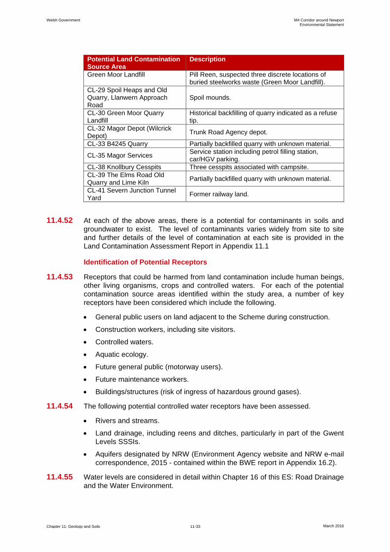
Welsh Government M4 Corridor around Newport Environmental Statement
Chapter 11: Geology and Soils 11-33 March 2016
Potential Land Contamination Source Area
Description
Green Moor Landfill Pill Reen, suspected three discrete locations of buried steelworks waste (Green Moor Landfill).
CL-29 Spoil Heaps and Old Quarry, Llanwern Approach Road
Spoil mounds.
CL-30 Green Moor Quarry Landfill
Historical backfilling of quarry indicated as a refuse tip.
CL-32 Magor Depot (Wilcrick Depot)
Trunk Road Agency depot.
CL-33 B4245 Quarry Partially backfilled quarry with unknown material.
CL-35 Magor Services Service station including petrol filling station, car/HGV parking.
CL-38 Knollbury Cesspits Three cesspits associated with campsite.
CL-39 The Elms Road Old Quarry and Lime Kiln
Partially backfilled quarry with unknown material.
CL-41 Severn Junction Tunnel Yard
Former railway land.
11.4.52 At each of the above areas, there is a potential for contaminants in soils and
groundwater to exist. The level of contaminants varies widely from site to site
and further details of the level of contamination at each site is provided in the
Land Contamination Assessment Report in Appendix 11.1
Identification of Potential Receptors
11.4.53 Receptors that could be harmed from land contamination include human beings,
other living organisms, crops and controlled waters. For each of the potential
contamination source areas identified within the study area, a number of key
receptors have been considered which include the following.
General public users on land adjacent to the Scheme during construction.
Construction workers, including site visitors.
Controlled waters.
Aquatic ecology.
Future general public (motorway users).
Future maintenance workers.
Buildings/structures (risk of ingress of hazardous ground gases).
11.4.54 The following potential controlled water receptors have been assessed.
Rivers and streams.
Land drainage, including reens and ditches, particularly in part of the Gwent
Levels SSSIs.
Aquifers designated by NRW (Environment Agency website and NRW e-mail
correspondence, 2015 - contained within the BWE report in Appendix 16.2).
11.4.55 Water levels are considered in detail within Chapter 16 of this ES: Road Drainage
and the Water Environment.
Welsh Government M4 Corridor around Newport Environmental Statement
Chapter 11: Geology and Soils 11-34 March 2016
Identification of Potential Pathways
11.4.56 There are a number of primary pathways through which contaminants could
impact receptors and these include the following.
Ingestion, dermal contact and inhalation of soils and dusts, and inhalation of
vapours (construction workers, future motorway users and maintenance
workers). It is expected that any contaminated soils within the majority of the
new section of motorway would be encapsulated by either the motorway
embankment or structures, thus severely limiting potential exposure and
contamination to humans. However, in areas of cut or where soils are reused
to construct the embankment and in any landscaping areas, there is potential
for future motorway users and maintenance workers to be exposed to shallow
soils.
Ingestion, dermal contact and inhalation of dusts (adjacent site users).
During construction, without control measures, dusts and soils may migrate
offsite and impact nearby members of the public.
Ingestion and dermal contact with potentially contaminated surface waters
and groundwaters (construction workers and maintenance workers).
Inhalation and accumulation of hazardous ground gases (humans and
structures). Ground gases, such as methane or carbon dioxide, may migrate
into confined places such as manholes or beneath/into buildings during the
operational phase of the Scheme. Piled foundations may create preferential
flow paths for ground gas.
Lateral and vertical migration of contaminants (controlled waters).
Contaminants within soils and groundwaters may migrate vertically or laterally
through the underlying strata. The design of foundations and construction
methods may also create preferential flow paths for vertical migration to
underlying aquifers and potentially surface waters (e.g. piled foundations).
Risk Evaluation
11.4.57 An initial assessment of the 27 sites of potential land contamination has been
made using the source-pathway-receptor approach consistent with CLR11
guidance. This is described in detail in the Land Contamination Assessment
report, which includes the findings of the Tier 1 and Tier 2 Risk Assessments.
Table 11.9 provides a summary of the potential sources and receptors relating to
each potential site of land contamination, as well as potential contaminants of
concern identified following the risk assessment undertaken in the Land
Contamination Assessment Report. For each site, the source-pathway-receptor
link is assigned a likelihood, severity and risk level as described within the Land
Contamination Assessment Report (Appendix 11.1). The assessment is based
on and informed by CIRIA C552 (CIRIA, 2001) and CLR11 (Environment Agency
and Defra, 2004). The level of risk is defined on the following basis.
Low Risk - it is considered unlikely that the source-pathway-receptor
scenarios assigned to this risk designation will give rise to an impact on
human health or the environment.
Moderate Risk - it is possible, but not certain, that the source-pathway-
receptor scenarios assigned to this designation may give rise to an impact on
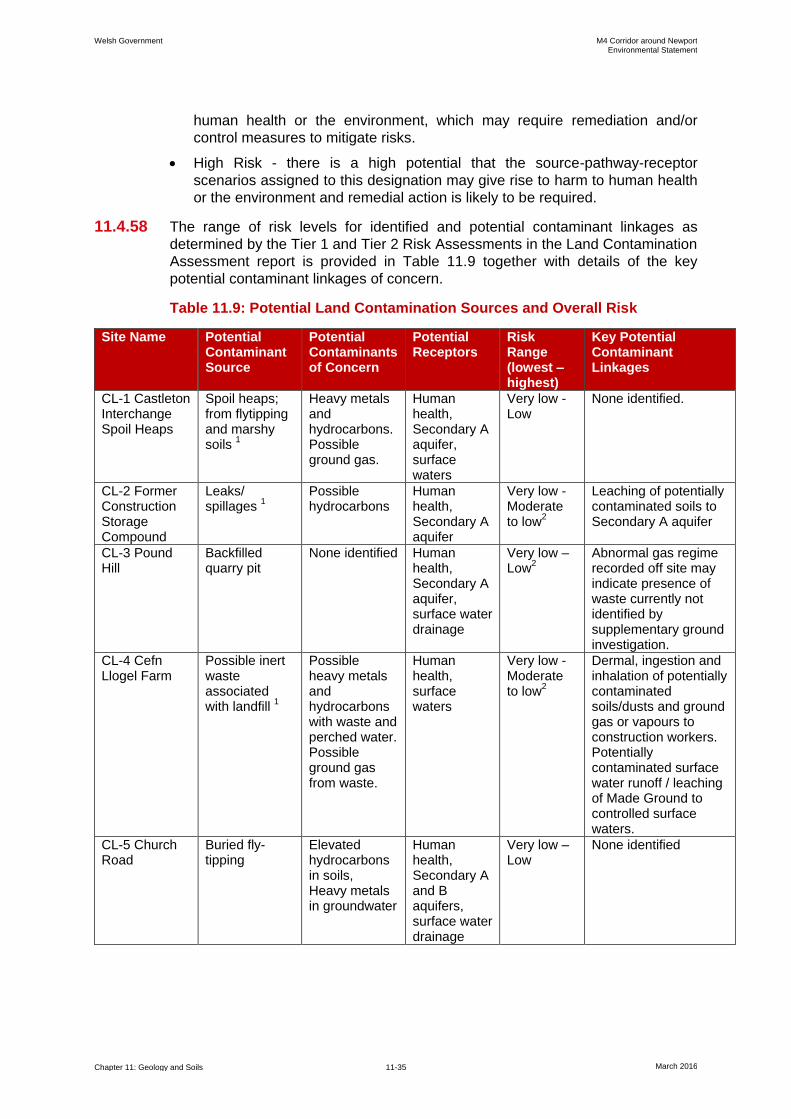
Welsh Government M4 Corridor around Newport Environmental Statement
Chapter 11: Geology and Soils 11-35 March 2016
human health or the environment, which may require remediation and/or
control measures to mitigate risks.
High Risk - there is a high potential that the source-pathway-receptor
scenarios assigned to this designation may give rise to harm to human health
or the environment and remedial action is likely to be required.
11.4.58 The range of risk levels for identified and potential contaminant linkages as
determined by the Tier 1 and Tier 2 Risk Assessments in the Land Contamination
Assessment report is provided in Table 11.9 together with details of the key
potential contaminant linkages of concern.
Table 11.9: Potential Land Contamination Sources and Overall Risk
Site Name Potential Contaminant Source
Potential Contaminants of Concern
Potential Receptors
Risk Range (lowest – highest)
Key Potential Contaminant Linkages
CL-1 Castleton Interchange Spoil Heaps
Spoil heaps; from flytipping and marshy soils
1
Heavy metals and hydrocarbons. Possible ground gas.
Human health, Secondary A aquifer, surface waters
Very low - Low
None identified.
CL-2 Former Construction Storage Compound
Leaks/ spillages
1
Possible hydrocarbons
Human health, Secondary A aquifer
Very low - Moderate to low
2
Leaching of potentially contaminated soils to Secondary A aquifer
CL-3 Pound Hill
Backfilled quarry pit
None identified Human health, Secondary A aquifer, surface water drainage
Very low – Low
2
Abnormal gas regime recorded off site may indicate presence of waste currently not identified by supplementary ground investigation.
CL-4 Cefn Llogel Farm
Possible inert waste associated with landfill
1
Possible heavy metals and hydrocarbons with waste and perched water. Possible ground gas from waste.
Human health, surface waters
Very low - Moderate to low
2
Dermal, ingestion and inhalation of potentially contaminated soils/dusts and ground gas or vapours to construction workers. Potentially contaminated surface water runoff / leaching of Made Ground to controlled surface waters.
CL-5 Church Road
Buried fly-tipping
Elevated hydrocarbons in soils, Heavy metals in groundwater
Human health, Secondary A and B aquifers, surface water drainage
Very low – Low
None identified
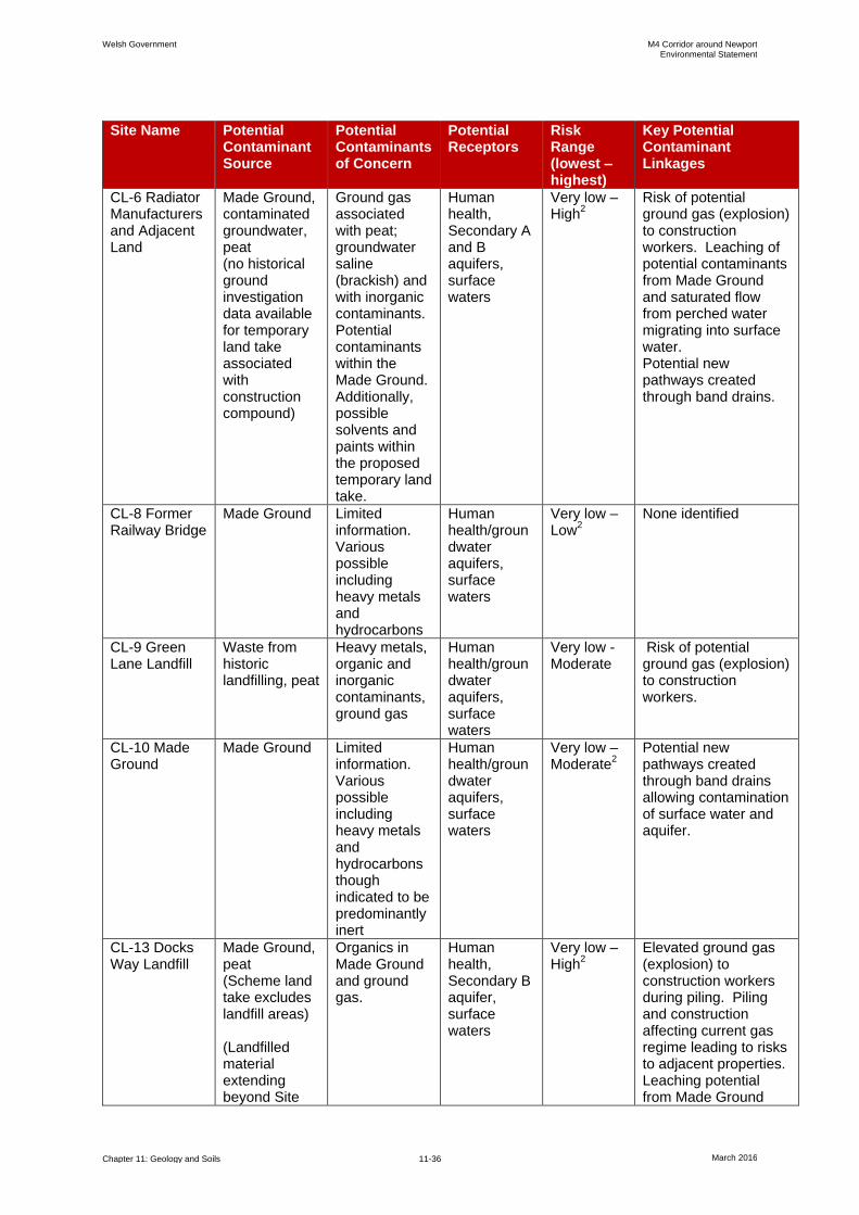
Welsh Government M4 Corridor around Newport Environmental Statement
Chapter 11: Geology and Soils 11-36 March 2016
Site Name Potential Contaminant Source
Potential Contaminants of Concern
Potential Receptors
Risk Range (lowest – highest)
Key Potential Contaminant Linkages
CL-6 Radiator Manufacturers and Adjacent Land
Made Ground, contaminated groundwater, peat (no historical ground investigation data available for temporary land take associated with construction compound)
Ground gas associated with peat; groundwater saline (brackish) and with inorganic contaminants. Potential contaminants within the Made Ground. Additionally, possible solvents and paints within the proposed temporary land take.
Human health, Secondary A and B aquifers, surface waters
Very low – High
2
Risk of potential ground gas (explosion) to construction workers. Leaching of potential contaminants from Made Ground and saturated flow from perched water migrating into surface water. Potential new pathways created through band drains.
CL-8 Former Railway Bridge
Made Ground Limited information. Various possible including heavy metals and hydrocarbons
Human health/groundwater aquifers, surface waters
Very low – Low
2
None identified
CL-9 Green Lane Landfill
Waste from historic landfilling, peat
Heavy metals, organic and inorganic contaminants, ground gas
Human health/groundwater aquifers, surface waters
Very low - Moderate
Risk of potential ground gas (explosion) to construction workers.
CL-10 Made Ground
Made Ground Limited information. Various possible including heavy metals and hydrocarbons though indicated to be predominantly inert
Human health/groundwater aquifers, surface waters
Very low – Moderate
2
Potential new pathways created through band drains allowing contamination of surface water and aquifer.
CL-13 Docks Way Landfill
Made Ground, peat (Scheme land take excludes landfill areas) (Landfilled material extending beyond Site
Organics in Made Ground and ground gas.
Human health, Secondary B aquifer, surface waters
Very low – High
2
Elevated ground gas (explosion) to construction workers during piling. Piling and construction affecting current gas regime leading to risks to adjacent properties. Leaching potential from Made Ground

Welsh Government M4 Corridor around Newport Environmental Statement
Chapter 11: Geology and Soils 11-37 March 2016
Site Name Potential Contaminant Source
Potential Contaminants of Concern
Potential Receptors
Risk Range (lowest – highest)
Key Potential Contaminant Linkages
boundary considered in CL-15 Stephenson Street Industrial Estate).
and saturated flow from perched water migrating into surface water. Potential new pathways created through piles allowing contamination of surface water and aquifer.
CL-14 Newport Docks
Various industrial usage, peat
Various possible including heavy metals, organics/inorganics, asbestos and ground gas.
Human health, Secondary B aquifer, surface waters
Very low – Moderate
2
Hydrocarbon and inorganic impacted soils impacting on construction workers. Migration of contaminants in soils and perched waters into aquifers and surface waters through piling. Elevated ground gas (explosion) to construction workers during piling.
CL-15 Stephenson Street Industrial Estate
Various industrial usage, peat, historical landfilled material associated with adjacent Docks Way Landfill.
Various possible including heavy metals, organics/inorganics and ground gas.
Human health, Secondary B aquifer, surface waters
Very low – Moderate
2
Risk of potential ground gas (explosion) to construction workers. Localised hydrocarbon impaction of soils. Impacted shallow and deep aquifers and potential new pathways through piling.
CL-16 Infilled River Ebbw (included in CL-14 above)
CL-17 Solutia Chemical Works
Chemical works, inert and industrial waste landfills
Organochlorines and aromatic based organic compounds including PCBs. Widespread elevated PCBs and pH in soils. Ground gas.
Human health, Secondary B aquifer, surface waters
Very low – High
2
Migration of contaminants in soils and perched waters into aquifers and surface waters through piling. Elevated ground gas (explosion) to construction workers during piling.

Welsh Government M4 Corridor around Newport Environmental Statement
Chapter 11: Geology and Soils 11-38 March 2016
Site Name Potential Contaminant Source
Potential Contaminants of Concern
Potential Receptors
Risk Range (lowest – highest)
Key Potential Contaminant Linkages
CL-18 River Usk Pier Location
Contaminated river sediments
Various including hydrocarbons, heavy metals and other inorganics.
Human health/Secondary B aquifer, surface waters, River Usk
Very low – Moderate
2
Inhalation of ground gas or hydrocarbon vapours from superficial deposits during construction. Dermal contact with, and ingestion of contaminated perched groundwaters/aquifer.
CL-20 Mir Steelworks and Associated Waste Disposal Site (included in CL-15 above)
CL-22 Former Llanwern Research Laboratories
Made Ground comprising ash, slag and demolition rubble. Benzene pipeline
Various including heavy metals, hydrocarbons (including benzene)
Secondary B aquifer, human health
Very low–Moderate
2
Potential new pathways created through band drains allowing contamination
to surface water and aquifer.
CL-26 Llanwern Steel Works - Including Lagoons Areas
Made Ground including sludge and slag with impacted perched water
Various including heavy metals, inorganics and hydrocarbons. Ground gas.
Human health, Secondary B aquifer, surface waters
Very low - High
2
Dermal, ingestion and inhalation of potentially contaminated soils/dusts and ground gas by construction workers. Potential new pathways created through band drains allowing contamination to surface water and aquifer.
CL-26 Llanwern Steel Works – Reedbed 1 and Metal Recovery Areas (main alignment)
Made Ground comprising slag and reedbed sediment with impacted perched water
Various including heavy metals, inorganics and, hydrocarbons
Human health, groundwater aquifers, surface waters
Very low – High
2
Dermal, ingestion and inhalation of potentially contaminated soils/dusts and ground gas to construction/maintenance workers and general public. Potential new pathways created through band drains allowing contamination to surface water and aquifer.
CL-27 Elver Pill Reen and Green Moor Landfill
Slag and industrial wastes
Various including heavy metals, hydrocarbons
Human health, Secondary B aquifer, surface waters
Very low - High
2
Potential new pathways created through band drains allowing contamination of surface water and aquifer.
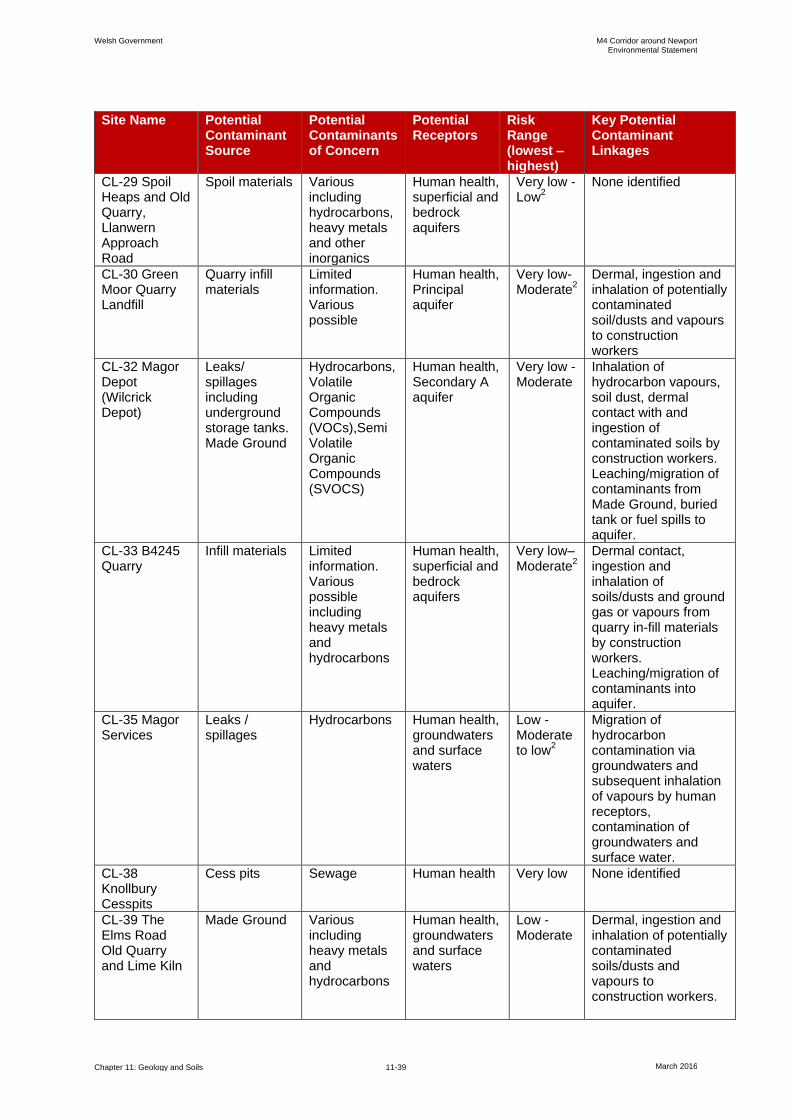
Welsh Government M4 Corridor around Newport Environmental Statement
Chapter 11: Geology and Soils 11-39 March 2016
Site Name Potential Contaminant Source
Potential Contaminants of Concern
Potential Receptors
Risk Range (lowest – highest)
Key Potential Contaminant Linkages
CL-29 Spoil Heaps and Old Quarry, Llanwern Approach Road
Spoil materials Various including hydrocarbons, heavy metals and other inorganics
Human health, superficial and bedrock aquifers
Very low - Low
2
None identified
CL-30 Green Moor Quarry Landfill
Quarry infill materials
Limited information. Various possible
Human health, Principal aquifer
Very low-Moderate
2 Dermal, ingestion and inhalation of potentially contaminated soil/dusts and vapours to construction workers
CL-32 Magor Depot (Wilcrick Depot)
Leaks/ spillages including underground storage tanks. Made Ground
Hydrocarbons, Volatile Organic Compounds (VOCs),Semi Volatile Organic Compounds (SVOCS)
Human health, Secondary A aquifer
Very low - Moderate
Inhalation of hydrocarbon vapours, soil dust, dermal contact with and ingestion of contaminated soils by construction workers. Leaching/migration of contaminants from Made Ground, buried tank or fuel spills to aquifer.
CL-33 B4245 Quarry
Infill materials Limited information. Various possible including heavy metals and hydrocarbons
Human health, superficial and bedrock aquifers
Very low– Moderate
2
Dermal contact, ingestion and inhalation of soils/dusts and ground gas or vapours from quarry in-fill materials by construction workers. Leaching/migration of contaminants into aquifer.
CL-35 Magor Services
Leaks / spillages
Hydrocarbons Human health, groundwaters and surface waters
Low - Moderate to low
2
Migration of hydrocarbon contamination via groundwaters and subsequent inhalation of vapours by human receptors, contamination of groundwaters and surface water.
CL-38 Knollbury Cesspits
Cess pits Sewage Human health Very low None identified
CL-39 The Elms Road Old Quarry and Lime Kiln
Made Ground Various including heavy metals and hydrocarbons
Human health, groundwaters and surface waters
Low - Moderate
Dermal, ingestion and inhalation of potentially contaminated soils/dusts and vapours to construction workers.
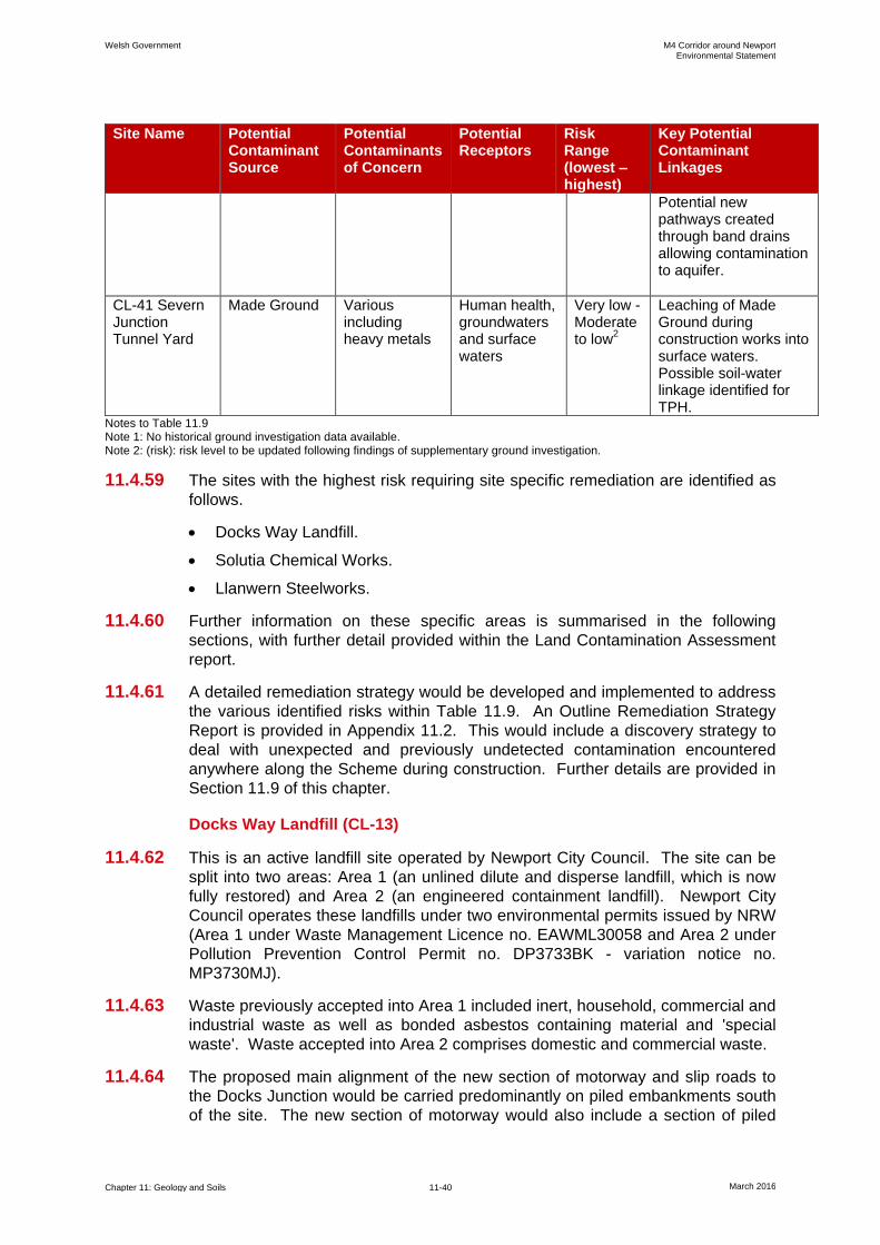
Welsh Government M4 Corridor around Newport Environmental Statement
Chapter 11: Geology and Soils 11-40 March 2016
Site Name Potential Contaminant Source
Potential Contaminants of Concern
Potential Receptors
Risk Range (lowest – highest)
Key Potential Contaminant Linkages
Potential new pathways created through band drains allowing contamination to aquifer.
CL-41 Severn Junction Tunnel Yard
Made Ground Various including heavy metals
Human health, groundwaters and surface waters
Very low - Moderate to low
2
Leaching of Made Ground during construction works into surface waters. Possible soil-water linkage identified for TPH.
Notes to Table 11.9 Note 1: No historical ground investigation data available. Note 2: (risk): risk level to be updated following findings of supplementary ground investigation.
11.4.59 The sites with the highest risk requiring site specific remediation are identified as
follows.
Docks Way Landfill.
Solutia Chemical Works.
Llanwern Steelworks.
11.4.60 Further information on these specific areas is summarised in the following
sections, with further detail provided within the Land Contamination Assessment
report.
11.4.61 A detailed remediation strategy would be developed and implemented to address
the various identified risks within Table 11.9. An Outline Remediation Strategy
Report is provided in Appendix 11.2. This would include a discovery strategy to
deal with unexpected and previously undetected contamination encountered
anywhere along the Scheme during construction. Further details are provided in
Section 11.9 of this chapter.
Docks Way Landfill (CL-13)
11.4.62 This is an active landfill site operated by Newport City Council. The site can be
split into two areas: Area 1 (an unlined dilute and disperse landfill, which is now
fully restored) and Area 2 (an engineered containment landfill). Newport City
Council operates these landfills under two environmental permits issued by NRW
(Area 1 under Waste Management Licence no. EAWML30058 and Area 2 under
Pollution Prevention Control Permit no. DP3733BK - variation notice no.
MP3730MJ).
11.4.63 Waste previously accepted into Area 1 included inert, household, commercial and
industrial waste as well as bonded asbestos containing material and 'special
waste'. Waste accepted into Area 2 comprises domestic and commercial waste.
11.4.64 The proposed main alignment of the new section of motorway and slip roads to
the Docks Junction would be carried predominantly on piled embankments south
of the site. The new section of motorway would also include a section of piled
Welsh Government M4 Corridor around Newport Environmental Statement
Chapter 11: Geology and Soils 11-41 March 2016
embankment to support the Southern Distributor Road (SDR) link road along the
eastern edge of the landfill.
11.4.65 The only area where the alignment impinges upon the landfill permit boundary
would be the southern tip of Area 2 where the piled embankment abuts to the
bridge over the River Ebbw. This is outside of the engineered waste disposal
cells and therefore no landfilling of waste is expected to have taken place at this
location. Consequently, no specific works associated with Area 2 are expected to
be needed other than ensuring the existing containment and engineering controls
are maintained during construction and future operation. The proposed land take
would, however, extend onto the landfill's permitted area and therefore it is
proposed the environmental permit for this area is surrendered by Newport City
Council and the permit boundary revised accordingly.
11.4.66 Borehole records confirm that landfilled materials, typically 4-5 metres thick have
been placed beyond the landfill boundary of Area 1 and further ground
investigation is to be undertaken to confirm the extent and nature of these
materials along the proposed SDR link road. The potential presence of asbestos
within the landfill materials cannot be discounted and would be investigated
during the proposed ground investigation.
11.4.67 Ground gases elevated above screening criteria have been recorded within
borehole monitoring wells on the periphery of Area 1 and Area 2 within and in the
vicinity of the proposed SDR link road which are associated with wells
constructed within the waste materials.
Solutia Chemical Works (CL-17)
11.4.68 The site comprises an active chemical plant with a number of waste disposal
areas including an engineered cell (known as the 'PCB cell') containing buried
chemical (mainly polychlorinated biphenyls - PCBs) waste, as well as a historic
inert and an active industrial landfill. The site is operated by Solutia.
11.4.69 A piled embankment is proposed to be constructed in the eastern part of the site
and the new section of motorway would continue over the western part of the site
on a viaduct.
11.4.70 It is currently proposed that no construction would be undertaken in or on the
PCB cell so as not to affect its integrity. To achieve this, the motorway viaduct
over the Solutia site has been designed such that the PCB cell is bridged and the
viaduct piers and foundations would be constructed outside the PCB cell. The
bridging over the PCB cell would also enable the cell to be regularly inspected,
monitored and maintained to allow Solutia to maintain its integrity.
11.4.71 The piled embankment section crosses part of the historic inert and industrial
landfill.
11.4.72 Soil testing has identified elevated concentrations of some heavy metals,
Polycyclic Aromatic Hydrocarbons (PAHs) and PCBs within the landfill area and
external areas outside the PCB cell.
11.4.73 Perched water within the Made Ground has been identified as grossly
contaminated with hydrocarbons. Further investigation of this site is to be
undertaken to further refine the conceptual site model and allow remediation
design to be developed further.

Welsh Government M4 Corridor around Newport Environmental Statement
Chapter 11: Geology and Soils 11-42 March 2016
Llanwern Steelworks (CL-26)
11.4.74 The Llanwern Steelworks were constructed in the early 1960s. Slag heaps and
settlement lagoons associated with the steelworks have been constructed to the
south of the main steelworks site located to the north of the A4810. This lagoons
area (CL-26) comprises, from west to east, Reedbed 1, former fragmentation and
metal recovery area, sludge lagoons and a non-hazardous landfill. These are
described separately in the following sections and detailed information is
contained within the Land Contamination Assessment report.
Reedbed 1
11.4.75 This comprises a 600 metre by 300 metre area of reedbed network for surface
water treatment for the Llanwern Steelworks prior to authorised discharge into the
Severn Estuary. These are formed by a raised bund creating wetland basins with
reed growth. This reedbed is used as a backup reedbed in case Reedbed 2
(located in CL-27) is unable to operate.
11.4.76 Reedbed 1 is located within the Gwent Levels SSSIs. Water quality monitoring
found the adjacent boundary ditches and reens to be of relatively poorer quality
than seen elsewhere within the Levels, with possible evidence of impact from the
Llanwern Steelworks land use in this area.
11.4.77 The previous ground investigations have identified the bunds to be typically 0.5-
1 metre higher than surrounding ground levels and comprising of coarse slag
material. The base of the bunds was found in previous investigations to be
generally 0.5-1.5 metres below surrounding ground level. Within the reedbeds,
sediment described as black sandy clay with many roots was encountered with a
typical thickness of 1-2.4 metres.
11.4.78 The new section of motorway would cross through the south western section of
Reedbed 1. It is proposed that the highway would be constructed on a 1-2 m
high earth embankment. As set out in Chapter 3, construction of the
embankment would require surcharge and the installation of band drains.
11.4.79 With the exception of widespread alkaline conditions and discrete raised
organics, no other contaminants were found to be in exceedance of the generic
Tier 2 human health screening assessment.
11.4.80 Elevated levels of metals and inorganics were identified within the perched water
within the Made Ground and Tidal Flat Deposits. Elevated levels of organic
contaminants were also identified within the perched water within the Made
Ground and to a lesser extent within the perched groundwater within the Tidal
Flat Deposits (noted to be intermittent and inconsistent).
11.4.81 Contaminated perched waters in Made Ground may be in continuity with land
drainage and would require suitable water management strategy to prevent
potential impact to surface waters as well as protection against any contaminated
run-off. During the operational phase, the motorway hardstanding would
significantly limit the infiltration of rainwater through the soils and therefore
leaching any soil contaminants in Made Ground into the water would be very
limited.
11.4.82 The use of band drain and piles may provide new pathways which may lead to
water within the Tidal Flat Deposits and possibly any perched water within the

Welsh Government M4 Corridor around Newport Environmental Statement
Chapter 11: Geology and Soils 11-43 March 2016
Made Ground to enter the currently confined aquifer within the Glaciofluvial
Deposits and Mercia Mudstone. A piling risk assessment would be required prior
to construction and based on the results of the piling risk assessment, control
measures may be required to protect controlled waters.
Metal Recovery Area
11.4.83 This comprises the former slag process metal recovery of Llanwern Steelworks.
Whilst the slag process ceased in the late 1980's, the land is now leased for
industrial processes including asphalt manufacturing and slag recycling.
11.4.84 The Metal Recovery Area is located within the Gwent Levels SSSIs. Water
quality within the boundary ditches and reens was found to be of relatively poorer
quality than seen elsewhere within the Gwent Levels, indicating possible
evidence of impact from the Llanwern Steelworks land use in this area.
11.4.85 Consistent with the historical land use as a slag process area, typically a 2-
3 metre thick mantle of coarse slag material with variable proportion of bricks was
identified across the whole area. Widespread hydrocarbon contamination was
identified in the exploratory hole records within the soils and perched water within
the area of a former Frag Plant1 location.
11.4.86 The new section of motorway would cross through part of the Metal Recovery
Area. In this area the new section of motorway would include the following.
A new junction (Glan Llyn junction) is proposed to provide a connection to the
A4810. This would include a piled overbridge some 10 metres in height and
piled embankments associated with the slip roads. The slip roads on the
north of the junction would encroach on the area.
A link road is proposed across the area, running from the Glan Llyn junction
on piled embankment until the height drops below 5 metres, then on
embankment with band drains.
A new highway maintenance depot (Glan Llyn Depot) is proposed towards
the north western corner of the Metal Recovery Area (highway boundary
shown in Figure 18 of the relevant annex of Appendix 11.1).
11.4.87 As well as widespread alkaline conditions, the main contaminant of concern to
human health is associated with the widespread hydrocarbon contamination
within the area of the proposed Glan Llyn Depot.
11.4.88 Elevated levels of metals and pH were identified within the perched water within
the Made Ground. The presence of organics (TPH and PAHs) specific to the
Glyn Llyn Depot was also identified.
11.4.89 Elevated levels of metals and inorganics were identified within the perched
groundwater within the Tidal Flat Deposits. The presence of organic
contaminants has also been identified beneath the Glyn Llyn Depot area and off
site (noted to be intermittent and inconsistent). The groundwater within the
Mercia Mudstone is indicated to have similar metal and inorganic concentrations
to the perched water body within the Tidal Flat Deposit.
1 Defragmentation plant used to process, crush and sort slag material.
Welsh Government M4 Corridor around Newport Environmental Statement
Chapter 11: Geology and Soils 11-44 March 2016
11.4.90 Water quality in some surrounding ditches / reens is considered to be of good
quality with elevated metals and organics identified in others. The presence of
organics may be linked with the hydrocarbon contamination identified within the
Metal Recovery Area although this cannot be confirmed.
11.4.91 Risks to controlled waters are in line with those defined within Reedbed 1.
Llanwern Lagoons
11.4.92 As part of the Llanwern Steelworks, a number of sludge lagoons were filled with
wastes and byproducts from the Basic Oxygen Steelmaking (BOS) processes
and blast furnaces. The sludge lagoons are operated by Tata Steel under an
environmental permit (EPR/HP3899FC/V003) and include Lagoon 12, Lagoon
25, Lagoon 27 (split into four quadrants NE, SE, SW, NW) and Lagoon 26. The
latest modification of the permit in 2009 is to cease any further waste disposal
operation and the area has since been put into aftercare. Lagoon 27SE and
Lagoon 26 have not been filled.
11.4.93 A second permit (EPR/GP3331SV) issued in 2007 is specific to Lagoon 26 for the
use of the area as a non-hazardous landfill. Whilst the permit is currently active,
no installations associated with the permit requirement have been constructed
and no waste has been disposed within the lagoon. Previous ground
investigations have identified the presence of slag material with various
inclusions of limestone, concrete, brick, metal and wood fragments to depths of
generally between 1-4.5 metres below ground level. The Made Ground is
believed to be associated with material disposal under the former permit.
11.4.94 A third environmental permit (EPR/BS3905IP) is held by Tata Steel applicable to
Lagoon 27 which forms part of the on-site treatment facility, accepting waste from
the Hot Mill activity.
11.4.95 In general, the lagoons consist of 5-8 metre raised bunds made of coarse slag
containing slag sludge and waste within. The base of the lagoons is considered
to be some 2-4 metres below general ground level.
11.4.96 The lagoon materials are considered to require treatment so as to render the
material suitable for reuse as engineered fill for the proposed highway
construction and also to ensure that the waste is considered fully recovered and
does not cause an unacceptable risk to human health and controlled waters.
11.4.97 The southern boundary of the lagoon area is bounded by the northern extent of
the Gwent Levels SSSIs. Water quality within the boundary ditches and reens
was found to be of relatively good quality with no obvious evidence of impact
from the Llanwern Steelworks land use in this area.
11.4.98 The slag material used to form the lagoon bunds containing the waste has
elevated concentrations of lead and a high pH and as such could cause a risk to
construction workers.
11.4.99 The main alignment of the new section of motorway within the site is to be
positioned on an embankment and a junction (Glan Llyn junction) is proposed
linking the new section of motorway to the A4810. The link road joining the
motorway and the A4810 is currently proposed to pass through the Metal
Recovery Area and join the A4810 at an existing roundabout. The junction would
be founded on piled embankment whilst the main alignment and link road would
Welsh Government M4 Corridor around Newport Environmental Statement
Chapter 11: Geology and Soils 11-45 March 2016
initially be surcharged with settlement enhanced by the installation of band
drains.
11.4.100 The area impacted by the route corridor comprises the south western corner of
Reedbed No.1 and the south eastern corner of the Metal Recovery Area of the
Site.
11.4.101 A water treatment area to collect road drainage from the motorway and link road
is proposed within the eastern area of the Metal Recovery Area.
11.4.102 The construction of the new section of motorway across the lagoons would
require the reinstatement of the existing peripheral containment through
construction of a new bund within the area of the waste lagoons being retained
by Tata Steel. The existing environmental permits would require modification and
the land within the permanent land take would be surrendered. Areas of land to
the south of the permanent land take would also require remediation to enable
permit surrender.
Land Contamination Elsewhere Within the Study Area
11.4.103 The potential for ground contamination and ground gas for the areas outside the
sites of potential contamination shown on Figure 11.1 has been assessed and is
discussed within the Land Contamination Assessment report. It is noted that the
risk assessment uses a conservative screening criterion for the protection of
human health (chromium VI, which is anthropogenic). The levels of total
chromium in soils, although elevated in some soil samples above the screening
criterion, are considered to be at background levels and are not considered to
represent unacceptable risks to human health. No other specific areas of land
contamination requiring remediation have been identified within the permanent
and temporary land take. However, the following issues would require
management in accordance with the remediation strategy.
Alkaline soils particularly within the existing M4 junctions and Castleton and
Magor.
Elevated ground gases considered to be associated predominantly with
natural soils (organics clays and peats of the Tidal Flat Deposits).
11.4.104 The overall risk level for areas outside the study area is considered to be very
low. However, a discovery strategy would be implemented to manage
unexpected or previously unidentified land contamination encountered during
excavation.
Future Baseline Conditions
11.4.105 Consideration has been given to the potential for changes in the baseline
conditions in the medium to long term as a result of climate change. The Climate
Change Risk Assessment in Wales (Welsh Government and Defra, 2012) has
been reviewed, together with other climate change prediction tools. With respect
to soils, the Climate Change Risk Assessment for Wales identifies the following
considerations.
Reduction in soil moisture and lower river flows, and an increase in the
frequency and magnitude of droughts.

Welsh Government M4 Corridor around Newport Environmental Statement
Chapter 11: Geology and Soils 11-46 March 2016
Changes in soil organic carbon, although the ways in which it might be
affected are not adequately understood at present.
Increase in soil erosion in drier summers.
Wetter soils and increased waterlogging in winters with higher levels of
precipitation.
It is not considered likely that there would be significant changes in geological
conditions.
11.4.106 These factors have been taken into consideration, where practicable, in the
assessment of effects.
11.5 Mitigation Measures Forming Part of the Scheme Design
11.5.1 The design of the new section of motorway has taken into account the locations
of existing features, including known areas of contaminated land. For example, it
is proposed that no construction would be undertaken in or on the Solutia PCB
cell so as not to affect its integrity. To achieve this, the motorway viaduct over
the Solutia site has been designed such that the PCB cell would be bridged and
the viaduct piers and foundations would be constructed outside the PCB cell.
The bridging over the PCB cell would also enable the cell to be regularly
inspected, monitored and maintained to allow Solutia to maintain its integrity.
11.5.2 Based on the assessment of ground investigation data, it is considered that
ground instability may be caused by soft soils of the Tidal Flat Deposits beneath
embankments. Therefore the following ground improvement measures have
been included within the design (see Chapter 3 for further details).
Surcharging to be used with band drains for embankments up to 5 metres
(permanent height).
Piling for embankments over 5 metres (permanent height).
Placement of geotextile basal reinforcement.
11.5.3 Following the philosophy of the Land Contamination Management Strategy
provided in Appendix 11.3 the design of the new section of motorway has been
undertaken such that the potentially large volumes of contaminated materials are
not simply excavated and removed from the permanent and temporary land take
areas and disposed of off site. Instead, a substantially more sustainable risk
based design approach has been adopted using UK good practice guidance to
meet legal and regulatory requirements. The general design principle of retention
and reuse of contaminated materials within the Scheme, provided the materials
are geotechnically suitable and, once placed, do not result in unacceptable risks
to human health or controlled waters, is proposed. Unsuitable contaminated
materials would be treated on site under a suitable environmental permit to
render them suitable. The lagoon waste material in the Llanwern Steelworks
area would be treated on site including the use of cement stabilisation methods
undertaken by a specialist remediation contractor.
11.5.4 To minimise risks to human health and the environment, whilst maintaining the
design principle, the following mitigation measures have been incorporated into
the design.
Welsh Government M4 Corridor around Newport Environmental Statement
Chapter 11: Geology and Soils 11-47 March 2016
Placement of contaminated soils and treated contaminated soils within the
core of the main motorway embankment subject to compliance with specific
risk based suitability for reuse criteria).
The motorway carriageway and placement of uncontaminated topsoils and
subsoils on the flanks of the motorway embankment would act as a barrier
between the contaminated materials and site users during the operation of
the new section of motorway.
Bridging solution over the Solutia PCB cell.
11.5.5 This approach also has the following positive sustainability benefits.
Reduction of construction traffic from public roads as most contaminated
materials would be retained on site and not disposed of off site.
Mitigation of substantial burden on waste management facilities and landfill
through reuse of contaminated soils on site.
Reduction in the need for imported or site won clean materials.
11.5.6 Operational impacts of the new section of motorway include potential pollution of
surface watercourses, the groundwater and soils immediately adjacent to the
route. This may result from fuel and chemical spills as a result of accidents,
general vehicle or road degradation, incomplete fuel combustion and atmospheric
deposition. The design includes appropriate mitigation measures in the form of
suitable drainage systems with hydrocarbon interceptors to capture road runoff
and prevent contamination of the surrounding environment. The potential for
surface spray and airborne pollutants impacting on adjacent soils would be
mitigated by the planting of vegetation tolerant to such environments.
11.5.7 In addition, the construction phase for the new section of motorway would include
a range of mitigation measures developed taking into account the findings of the
assessment process. Details of these measures are provided in Section 11.9
below.
11.5.8 The following mitigation measures are form part of the design of the Scheme.
All surface water runoff from the Scheme would be directed to the Scheme
drainage system (see Appendix 2.2).
Cutting drainage would be installed to minimise the risk of seepage and
consequent exposure.
11.6 Assessment of Potential Land Take Effects
Proposed New Section of Motorway
11.6.1 In order to assess the potential environmental effects on geology and soils along
the route of the new section of motorway as a result of permanent land take it is
first necessary to identify the geology and soils receptors and their sensitivity.
Table 11.10 sets out the receptors relevant to geology and soils.
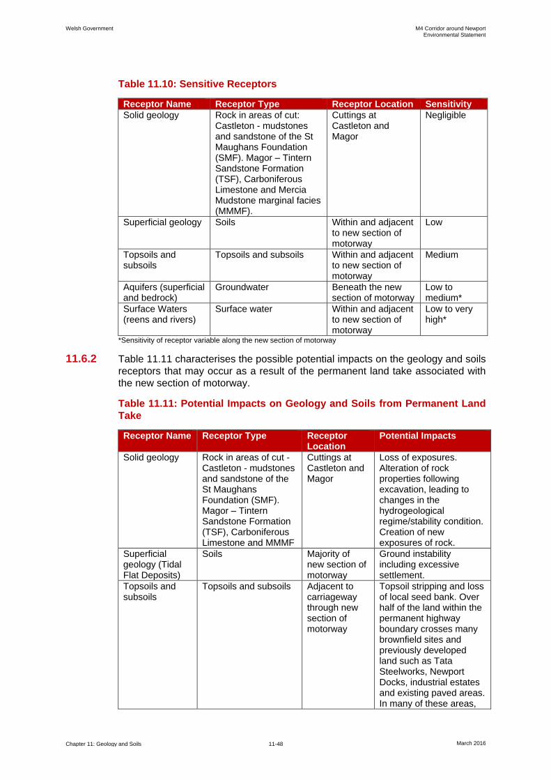
Welsh Government M4 Corridor around Newport Environmental Statement
Chapter 11: Geology and Soils 11-48 March 2016
Table 11.10: Sensitive Receptors
Receptor Name Receptor Type Receptor Location Sensitivity
Solid geology Rock in areas of cut: Castleton - mudstones and sandstone of the St Maughans Foundation (SMF). Magor – Tintern Sandstone Formation (TSF), Carboniferous Limestone and Mercia Mudstone marginal facies (MMMF).
Cuttings at Castleton and Magor
Negligible
Superficial geology Soils Within and adjacent to new section of motorway
Low
Topsoils and subsoils
Topsoils and subsoils Within and adjacent to new section of motorway
Medium
Aquifers (superficial and bedrock)
Groundwater Beneath the new section of motorway
Low to medium*
Surface Waters (reens and rivers)
Surface water Within and adjacent to new section of motorway
Low to very high*
*Sensitivity of receptor variable along the new section of motorway
11.6.2 Table 11.11 characterises the possible potential impacts on the geology and soils
receptors that may occur as a result of the permanent land take associated with
the new section of motorway.
Table 11.11: Potential Impacts on Geology and Soils from Permanent Land
Take
Receptor Name Receptor Type Receptor Location
Potential Impacts
Solid geology Rock in areas of cut - Castleton - mudstones and sandstone of the St Maughans Foundation (SMF). Magor – Tintern Sandstone Formation (TSF), Carboniferous Limestone and MMMF
Cuttings at Castleton and Magor
Loss of exposures. Alteration of rock properties following excavation, leading to changes in the hydrogeological regime/stability condition. Creation of new exposures of rock.
Superficial geology (Tidal Flat Deposits)
Soils Majority of new section of motorway
Ground instability including excessive settlement.
Topsoils and subsoils
Topsoils and subsoils Adjacent to carriageway through new section of motorway
Topsoil stripping and loss of local seed bank. Over half of the land within the permanent highway boundary crosses many brownfield sites and previously developed land such as Tata Steelworks, Newport Docks, industrial estates and existing paved areas. In many of these areas,
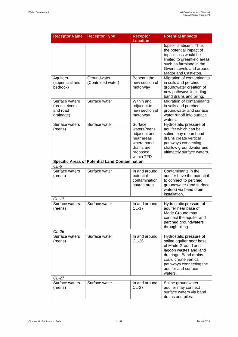
Welsh Government M4 Corridor around Newport Environmental Statement
Chapter 11: Geology and Soils 11-49 March 2016
Receptor Name Receptor Type Receptor Location
Potential Impacts
topsoil is absent. Thus the potential impact of topsoil loss would be limited to greenfield areas such as farmland in the Gwent Levels and around Magor and Castleton.
Aquifers (superficial and bedrock)
Groundwater (Controlled water)
Beneath the new section of motorway
Migration of contaminants in soils and perched groundwater creation of new pathways including band drains and piling.
Surface waters (reens, rivers and road drainage)
Surface water Within and adjacent to new section of motorway
Migration of contaminants in soils and perched groundwater and surface water runoff into surface waters.
Surface waters (reens)
Surface water Surface waters/reens adjacent and near areas where band drains are proposed within TFD
Hydrostatic pressure of aquifer which can be saline may mean band drains create vertical pathways connecting shallow groundwater and ultimately surface waters.
Specific Areas of Potential Land Contamination
CL-6
Surface waters (reens)
Surface water In and around potential contamination source area
Contaminants in the aquifer have the potential to connect to perched groundwater (and surface waters) via band drain installation.
CL-17
Surface waters (reens)
Surface water In and around CL-17
Hydrostatic pressure of aquifer near base of Made Ground may connect the aquifer and perched groundwaters through piling.
CL-26
Surface waters (reens)
Surface water In and around CL-26
Hydrostatic pressure of saline aquifer near base of Made Ground and lagoon wastes and land drainage. Band drains could create vertical pathways connecting the aquifer and surface waters.
CL-27
Surface waters (reens)
Surface water In and around CL-27
Saline groundwater aquifer may connect surface waters via band drains and piles.
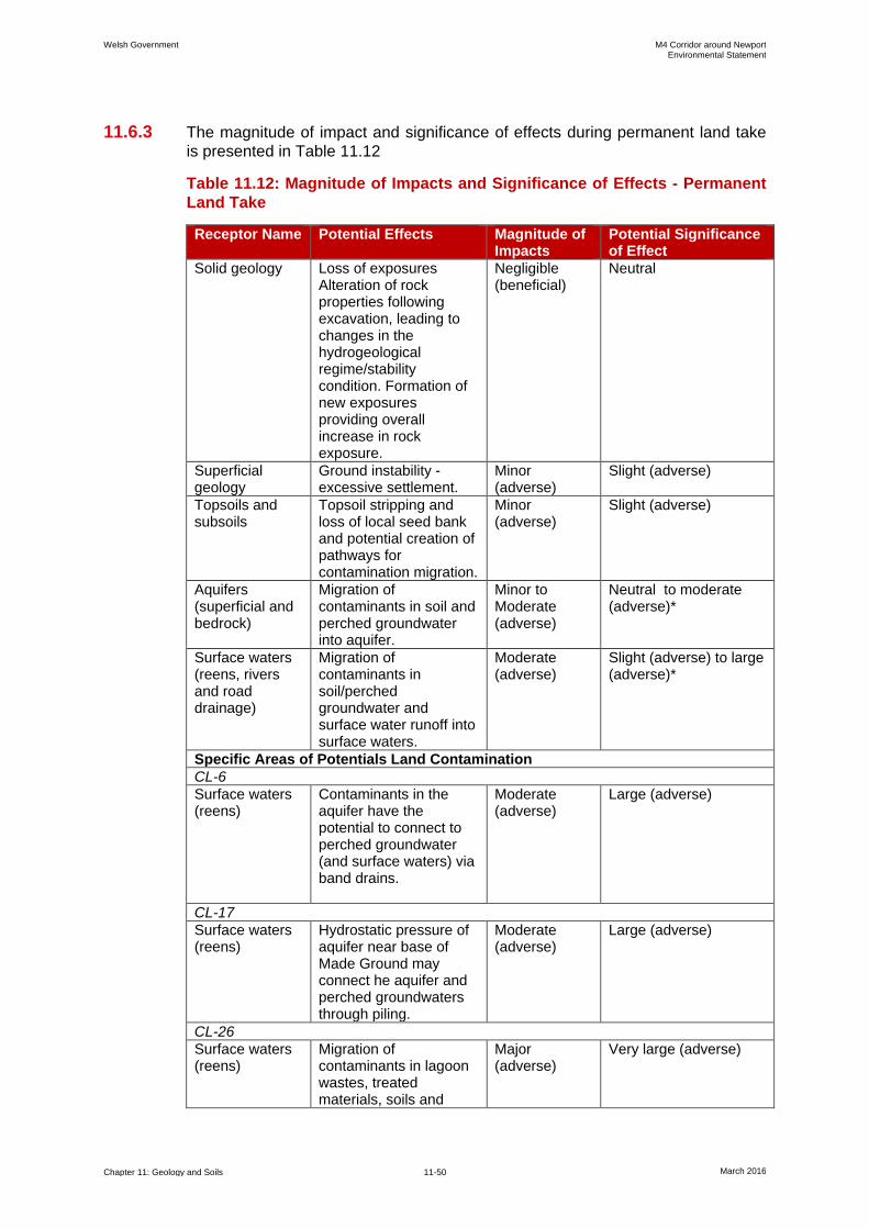
Welsh Government M4 Corridor around Newport Environmental Statement
Chapter 11: Geology and Soils 11-50 March 2016
11.6.3 The magnitude of impact and significance of effects during permanent land take
is presented in Table 11.12
Table 11.12: Magnitude of Impacts and Significance of Effects - Permanent
Land Take
Receptor Name Potential Effects Magnitude of Impacts
Potential Significance of Effect
Solid geology Loss of exposures Alteration of rock properties following excavation, leading to changes in the hydrogeological regime/stability condition. Formation of new exposures providing overall increase in rock exposure.
Negligible (beneficial)
Neutral
Superficial geology
Ground instability - excessive settlement.
Minor (adverse)
Slight (adverse)
Topsoils and subsoils
Topsoil stripping and loss of local seed bank and potential creation of pathways for contamination migration.
Minor (adverse)
Slight (adverse)
Aquifers (superficial and bedrock)
Migration of contaminants in soil and perched groundwater into aquifer.
Minor to Moderate (adverse)
Neutral to moderate (adverse)*
Surface waters (reens, rivers and road drainage)
Migration of contaminants in soil/perched groundwater and surface water runoff into surface waters.
Moderate (adverse)
Slight (adverse) to large (adverse)*
Specific Areas of Potentials Land Contamination
CL-6
Surface waters (reens)
Contaminants in the aquifer have the potential to connect to perched groundwater (and surface waters) via band drains.
Moderate (adverse)
Large (adverse)
CL-17
Surface waters (reens)
Hydrostatic pressure of aquifer near base of Made Ground may connect he aquifer and perched groundwaters through piling.
Moderate (adverse)
Large (adverse)
CL-26
Surface waters (reens)
Migration of contaminants in lagoon wastes, treated materials, soils and
Major (adverse)
Very large (adverse)
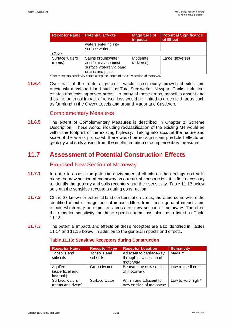
Welsh Government M4 Corridor around Newport Environmental Statement
Chapter 11: Geology and Soils 11-51 March 2016
Receptor Name Potential Effects Magnitude of Impacts
Potential Significance of Effect
waters entering into surface water.
CL-27
Surface waters (reens)
Saline groundwater aquifer may connect surface waters via band drains and piles.
Moderate (adverse)
Large (adverse)
*This receptors sensitivity varies along the length of the new section of motorway.
11.6.4 Over half of the route alignment would cross many brownfield sites and
previously developed land such as Tata Steelworks, Newport Docks, industrial
estates and existing paved areas. In many of these areas, topsoil is absent and
thus the potential impact of topsoil loss would be limited to greenfield areas such
as farmland in the Gwent Levels and around Magor and Castleton.
Complementary Measures
11.6.5 The extent of Complementary Measures is described in Chapter 2: Scheme
Description. These works, including reclassification of the existing M4 would be
within the footprint of the existing highway. Taking into account the nature and
scale of the works proposed, there would be no significant predicted effects on
geology and soils arising from the implementation of complementary measures.
11.7 Assessment of Potential Construction Effects
Proposed New Section of Motorway
11.7.1 In order to assess the potential environmental effects on the geology and soils
along the new section of motorway as a result of construction, it is first necessary
to identify the geology and soils receptors and their sensitivity. Table 11.13 below
sets out the sensitive receptors during construction.
11.7.2 Of the 27 known or potential land contamination areas, there are some where the
identified effect or magnitude of impact differs from those general impacts and
effects which may be expected across the new section of motorway. Therefore
the receptor sensitivity for these specific areas has also been listed in Table
11.13.
11.7.3 The potential impacts and effects on these receptors are also identified in Tables
11.14 and 11.15 below, in addition to the general impacts and effects.
Table 11.13: Sensitive Receptors during Construction
Receptor Name Receptor Type Receptor Location Sensitivity
Topsoils and subsoils
Topsoils and subsoils
Adjacent to carriageway through new section of motorway
Medium
Aquifers (superficial and bedrock)
Groundwater Beneath the new section of motorway.
Low to medium *
Surface waters (reens and rivers)
Surface water Within and adjacent to new section of motorway
Low to very high *

Welsh Government M4 Corridor around Newport Environmental Statement
Chapter 11: Geology and Soils 11-52 March 2016
Receptor Name Receptor Type Receptor Location Sensitivity
Adjacent site users Human Adjacent to carriageway through new section of motorway
Very high
Construction workers
Human Construction works area including temporary land take
High
Specific Areas of Potential Land Contamination
CL-6
Surface waters (reens)
Surface water In and around CL-6 Very high
CL-13
Construction workers
Human Construction works area within CL-13
High
Surface waters (River Ebbw)
Surface water In and around CL-13 High
Aquifers (superficial and bedrock)
Groundwater Beneath and around CL-13
Medium
CL-14
Construction workers
Human Construction works area within CL-14
High
CL-17
Construction workers
Human Construction works area within CL-17
High
Adjacent site users Human Adjacent to construction works area
Very high
Surface waters (reens)
Surface water In and around CL-17 Very high
Aquifers (superficial and bedrock)
Groundwater Beneath and around CL-17
Low
CL-18
Surface waters (River Usk)
Surface water In and around CL-18 Very high
Construction workers
Human Construction works area within CL-18
High
CL-26
Construction workers
Human Construction works area within CL-26
High
Adjacent site users Human Adjacent to construction works in CL-26
Very high
Surface waters (reens)
Surface water In and around CL-26 Very high
Aquifers (superficial and bedrock)
Groundwater Beneath and around CL-26
Low
CL-27
Surface waters (reens)
Surface water In and around CL-27 Very high
* This receptor’s sensitivity varies along the length of the new section of motorway.
11.7.4 Table 11.14 characterises the potential impacts that may occur as a result of the
construction of the new section of motorway on geology and soils receptors.
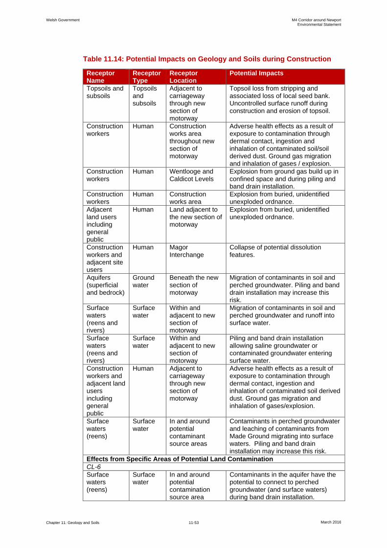
Welsh Government M4 Corridor around Newport Environmental Statement
Chapter 11: Geology and Soils 11-53 March 2016
Table 11.14: Potential Impacts on Geology and Soils during Construction
Receptor Name
Receptor Type
Receptor Location
Potential Impacts
Topsoils and subsoils
Topsoils and subsoils
Adjacent to carriageway through new section of motorway
Topsoil loss from stripping and associated loss of local seed bank. Uncontrolled surface runoff during construction and erosion of topsoil.
Construction workers
Human Construction works area throughout new section of motorway
Adverse health effects as a result of exposure to contamination through dermal contact, ingestion and inhalation of contaminated soil/soil derived dust. Ground gas migration and inhalation of gases / explosion.
Construction workers
Human Wentlooge and Caldicot Levels
Explosion from ground gas build up in confined space and during piling and band drain installation.
Construction workers
Human Construction works area
Explosion from buried, unidentified unexploded ordnance.
Adjacent land users including general public
Human Land adjacent to the new section of motorway
Explosion from buried, unidentified unexploded ordnance.
Construction workers and adjacent site users
Human Magor Interchange
Collapse of potential dissolution features.
Aquifers (superficial and bedrock)
Ground water
Beneath the new section of motorway
Migration of contaminants in soil and perched groundwater. Piling and band drain installation may increase this risk.
Surface waters (reens and rivers)
Surface water
Within and adjacent to new section of motorway
Migration of contaminants in soil and perched groundwater and runoff into surface water.
Surface waters (reens and rivers)
Surface water
Within and adjacent to new section of motorway
Piling and band drain installation allowing saline groundwater or contaminated groundwater entering surface water.
Construction workers and adjacent land users including general public
Human Adjacent to carriageway through new section of motorway
Adverse health effects as a result of exposure to contamination through dermal contact, ingestion and inhalation of contaminated soil derived dust. Ground gas migration and inhalation of gases/explosion.
Surface waters (reens)
Surface water
In and around potential contaminant source areas
Contaminants in perched groundwater and leaching of contaminants from Made Ground migrating into surface waters. Piling and band drain installation may increase this risk.
Effects from Specific Areas of Potential Land Contamination
CL-6
Surface waters (reens)
Surface water
In and around potential contamination source area
Contaminants in the aquifer have the potential to connect to perched groundwater (and surface waters) during band drain installation.

Welsh Government M4 Corridor around Newport Environmental Statement
Chapter 11: Geology and Soils 11-54 March 2016
Receptor Name
Receptor Type
Receptor Location
Potential Impacts
CL-13
Construction workers
Human Construction works area
Exposure to waste / Made Ground with potentially elevated levels of soil contamination and asbestos. Inhalation of ground gases with elevated concentrations.
Surface waters (River Ebbw)
Surface water
In and around CL-13
Contaminants in perched groundwater and leaching of contaminants from Made Ground migrating into surface waters. Piling and band drain installation may increase this risk.
Aquifers (superficial and bedrock)
Groundwater
Beneath and around CL-13
Installation of piles and band drains may create pathways connecting the impacted perched groundwaters and aquifer.
CL-14
Construction workers
Human Construction works area
Exposure to Made Ground with elevated levels of contamination and visual/olfactory evidence of hydrocarbons.
CL-17
Construction workers
Human Construction works area
Exposure to widespread soil contamination. Exposure to ground gas.
Construction workers and adjacent land users including general public
Human Adjacent construction works area
Exposure to contaminated soil derived dusts.
Surface waters (reens)
Surface water
In and around CL-17
Contaminants in perched groundwater and leaching of contaminants from Made Ground migrating into surface waters. Piling and band drain installation may increase this risk.
Aquifers (superficial and bedrock)
Groundwater
Beneath and around CL-17
Migration of contamination within Made Ground and perched groundwater during piling.
CL-18
Construction workers
Human Construction works area within CL-18
Exposure to groundwater contamination.
Surface waters (River Usk)
Surface water
In and around CL-18
Contaminants in groundwaters potentially mobilised during dewatering impacting upon surface waters.
CL-26
Construction worker
Human Constructions works area within CL-26
Exposure to contaminants in soils and waters and ground gases
Adjacent site users
Human Adjacent to construction works in CL-26
Exposure to contaminated soil derived dusts and ground gases
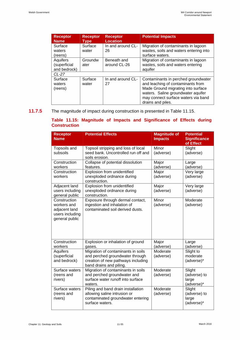
Welsh Government M4 Corridor around Newport Environmental Statement
Chapter 11: Geology and Soils 11-55 March 2016
Receptor Name
Receptor Type
Receptor Location
Potential Impacts
Surface waters (reens)
Surface water
In and around CL-26
Migration of contaminants in lagoon wastes, soils and waters entering into surface waters.
Aquifers (superficial and bedrock)
Groundwater
Beneath and around CL-26
Migration of contaminants in lagoon wastes, soils and waters entering aquifer
CL-27
Surface waters (reens)
Surface water
In and around CL-27
Contaminants in perched groundwater and leaching of contaminants from Made Ground migrating into surface waters. Saline groundwater aquifer may connect surface waters via band drains and piles.
11.7.5 The magnitude of impact during construction is presented in Table 11.15.
Table 11.15: Magnitude of Impacts and Significance of Effects during
Construction
Receptor Name
Potential Effects Magnitude of Impacts
Potential Significance of Effect
Topsoils and subsoils
Topsoil stripping and loss of local seed bank. Uncontrolled run off and soils erosion.
Minor (adverse)
Slight (adverse)
Construction workers
Collapse of potential dissolution features.
Major (adverse)
Large (adverse)
Construction workers
Explosion from unidentified unexploded ordnance during construction.
Major (adverse)
Very large (adverse)
Adjacent land users including general public
Explosion from unidentified unexploded ordnance during construction.
Major (adverse)
Very large (adverse)
Construction workers and adjacent land users including general public
Exposure through dermal contact, ingestion and inhalation of contaminated soil derived dusts.
Minor (adverse)
Moderate (adverse)
Construction workers
Explosion or inhalation of ground gases.
Major (adverse)
Large (adverse)
Aquifers (superficial and bedrock)
Migration of contaminants in soils and perched groundwater through creation of new pathways including band drains and piling.
Moderate (adverse)
Slight to moderate (adverse)*
Surface waters (reens and rivers)
Migration of contaminants in soils and perched groundwater and surface water runoff into surface waters.
Moderate (adverse)
Slight (adverse) to large (adverse)*
Surface waters (reens and rivers)
Piling and band drain installation allowing saline intrusion or contaminated groundwater entering surface waters.
Moderate (adverse)
Slight (adverse) to large (adverse)*
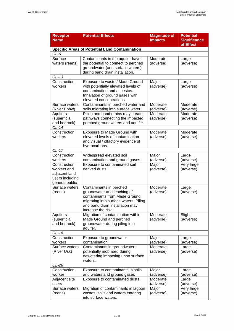
Welsh Government M4 Corridor around Newport Environmental Statement
Chapter 11: Geology and Soils 11-56 March 2016
Receptor Name
Potential Effects Magnitude of Impacts
Potential Significance of Effect
Specific Areas of Potential Land Contamination
CL-6
Surface waters (reens)
Contaminants in the aquifer have the potential to connect to perched groundwater (and surface waters) during band drain installation.
Moderate (adverse)
Large (adverse)
CL-13
Construction workers
Exposure to waste / Made Ground with potentially elevated levels of contamination and asbestos. Inhalation of ground gases with elevated concentrations.
Major (adverse)
Large (adverse)
Surface waters (River Ebbw)
Contaminants in perched water and soils migrating into surface water.
Moderate (adverse)
Moderate (adverse)
Aquifers (superficial and bedrock)
Piling and band drains may create pathways connecting the impacted perched groundwaters and aquifer.
Moderate (adverse)
Moderate (adverse)
CL-14
Construction workers
Exposure to Made Ground with elevated levels of contamination and visual / olfactory evidence of hydrocarbons.
Moderate (adverse)
Moderate (adverse)
CL-17
Construction workers
Widespread elevated soil contamination and ground gases.
Major (adverse)
Large (adverse)
Construction workers and adjacent land users including general public
Exposure to contaminated soil derived dusts.
Major (adverse)
Very large (adverse)
Surface waters (reens)
Contaminants in perched groundwater and leaching of contaminants from Made Ground migrating into surface waters. Piling and band drain installation may increase the risk.
Moderate (adverse)
Large (adverse)
Aquifers (superficial and bedrock)
Migration of contamination within Made Ground and perched groundwater during piling into aquifer.
Moderate (adverse)
Slight (adverse)
CL-18
Construction workers
Exposure to groundwater contamination.
Major (adverse)
Large (adverse)
Surface waters (River Usk)
Contaminants in groundwaters potentially mobilised during dewatering impacting upon surface waters.
Moderate (adverse)
Large (adverse)
CL-26
Construction worker
Exposure to contaminants in soils and waters and ground gases
Major (adverse)
Large (adverse)
Adjacent site users
Exposure to contaminated dusts. Moderate (adverse)
Large (adverse)
Surface waters (reens)
Migration of contaminants in lagoon wastes, soils and waters entering into surface waters.
Major (adverse)
Very large (adverse)

Welsh Government M4 Corridor around Newport Environmental Statement
Chapter 11: Geology and Soils 11-57 March 2016
Receptor Name
Potential Effects Magnitude of Impacts
Potential Significance of Effect
Aquifers (superficial and bedrock)
Migration of contaminants in lagoon wastes, soils and waters entering aquifer.
Moderate (adverse)
Slight (adverse)
CL-27
Surface waters (reens)
Contaminants in perched groundwater and leaching of contaminants from Made Ground migrating into surface waters. Saline groundwater aquifer may connect surface waters via band drains and piles.
Moderate (adverse)
Large (adverse)
*This receptor's sensitivity varies along the length of the new section of motorway
Complementary Measures
11.7.6 The extent of Complementary Measures is described in Chapter 2: Scheme
Description. These works, including reclassification of the existing M4 would be
within the footprint of the existing highway. Taking into account the nature and
scale of the works proposed, there would be no significant predicted effects on
geology and soils arising from the implementation of complementary measures.
11.8 Assessment of Potential Operational Effects
Proposed New Section of Motorway
11.8.1 The sensitivity of the geology and soils receptors is in line with those identified
within the construction effects assessment with the addition of motorway end
users / maintenance worker receptors. These are set out in Table 11.16.
Table 11.16: Sensitive Receptors during Operation
Receptor Name Receptor Type Receptor Location Sensitivity
End users (motorists) and maintenance workers
Human Carriageway and adjacent areas through new section of motorway
High
11.8.2 Table 11.17 characterises the potential impacts that may occur as a result of the
operation of the new section of motorway on geology and soils receptors.
11.8.3 Where potential effects on receptors have been identified that are related to
areas of known or potential land contamination, an assessment of potential
effects has been undertaken.
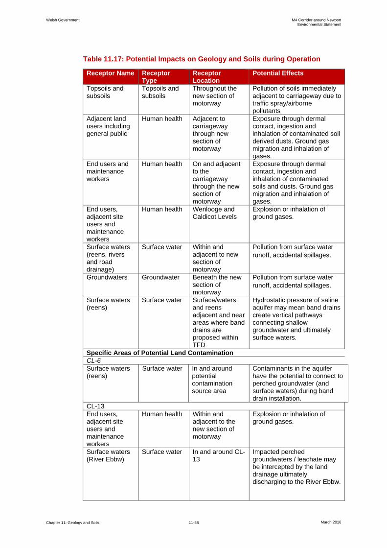
Welsh Government M4 Corridor around Newport Environmental Statement
Chapter 11: Geology and Soils 11-58 March 2016
Table 11.17: Potential Impacts on Geology and Soils during Operation
Receptor Name Receptor Type
Receptor Location
Potential Effects
Topsoils and subsoils
Topsoils and subsoils
Throughout the new section of motorway
Pollution of soils immediately adjacent to carriageway due to traffic spray/airborne pollutants
Adjacent land users including general public
Human health Adjacent to carriageway through new section of motorway
Exposure through dermal contact, ingestion and inhalation of contaminated soil derived dusts. Ground gas migration and inhalation of gases.
End users and maintenance workers
Human health On and adjacent to the carriageway through the new section of motorway
Exposure through dermal contact, ingestion and inhalation of contaminated soils and dusts. Ground gas migration and inhalation of gases.
End users, adjacent site users and maintenance workers
Human health Wenlooge and Caldicot Levels
Explosion or inhalation of ground gases.
Surface waters (reens, rivers and road drainage)
Surface water Within and adjacent to new section of motorway
Pollution from surface water
runoff, accidental spillages.
Groundwaters Groundwater Beneath the new section of motorway
Pollution from surface water
runoff, accidental spillages.
Surface waters (reens)
Surface water Surface/waters and reens adjacent and near areas where band drains are proposed within TFD
Hydrostatic pressure of saline aquifer may mean band drains create vertical pathways connecting shallow groundwater and ultimately surface waters.
Specific Areas of Potential Land Contamination
CL-6
Surface waters (reens)
Surface water In and around potential contamination source area
Contaminants in the aquifer have the potential to connect to perched groundwater (and surface waters) during band drain installation.
CL-13
End users, adjacent site users and maintenance workers
Human health Within and adjacent to the new section of motorway
Explosion or inhalation of ground gases.
Surface waters (River Ebbw)
Surface water In and around CL-13
Impacted perched groundwaters / leachate may be intercepted by the land drainage ultimately discharging to the River Ebbw.
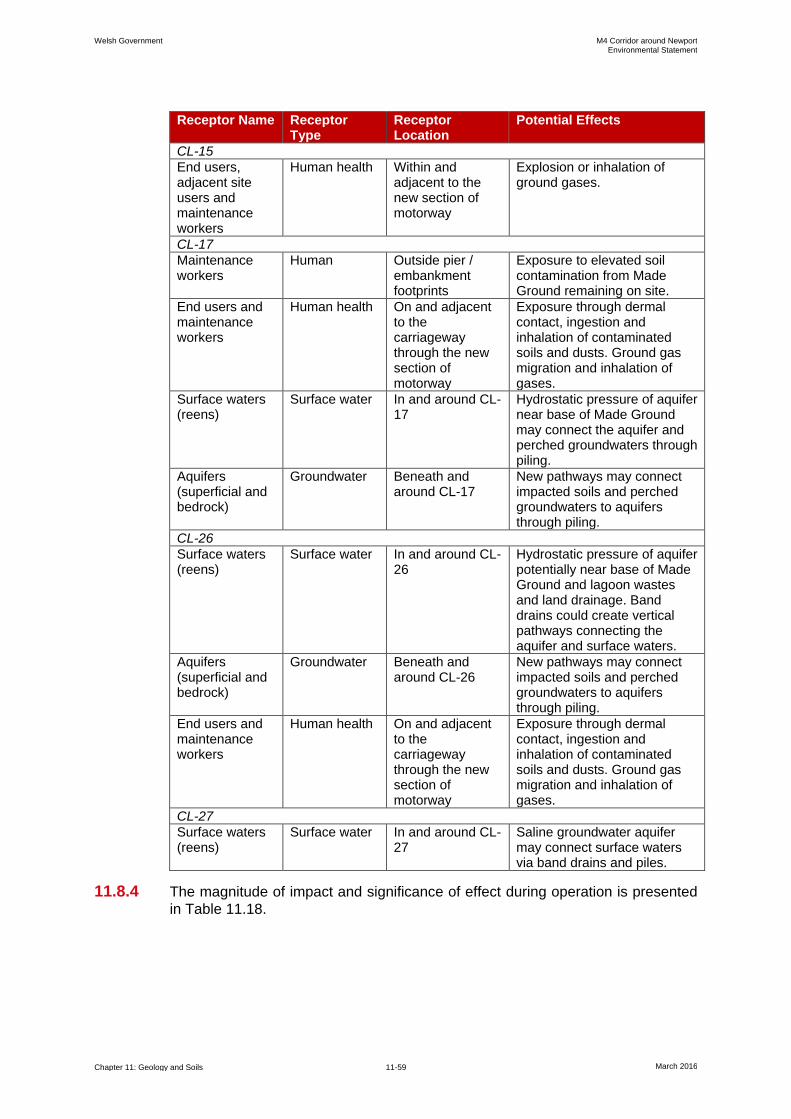
Welsh Government M4 Corridor around Newport Environmental Statement
Chapter 11: Geology and Soils 11-59 March 2016
Receptor Name Receptor Type
Receptor Location
Potential Effects
CL-15
End users, adjacent site users and maintenance workers
Human health Within and adjacent to the new section of motorway
Explosion or inhalation of ground gases.
CL-17
Maintenance workers
Human Outside pier / embankment footprints
Exposure to elevated soil contamination from Made Ground remaining on site.
End users and maintenance workers
Human health On and adjacent to the carriageway through the new section of motorway
Exposure through dermal contact, ingestion and inhalation of contaminated soils and dusts. Ground gas migration and inhalation of gases.
Surface waters (reens)
Surface water In and around CL-17
Hydrostatic pressure of aquifer near base of Made Ground may connect the aquifer and perched groundwaters through piling.
Aquifers (superficial and bedrock)
Groundwater Beneath and around CL-17
New pathways may connect impacted soils and perched groundwaters to aquifers through piling.
CL-26
Surface waters (reens)
Surface water In and around CL-26
Hydrostatic pressure of aquifer potentially near base of Made Ground and lagoon wastes and land drainage. Band drains could create vertical pathways connecting the aquifer and surface waters.
Aquifers (superficial and bedrock)
Groundwater Beneath and around CL-26
New pathways may connect impacted soils and perched groundwaters to aquifers through piling.
End users and maintenance workers
Human health On and adjacent to the carriageway through the new section of motorway
Exposure through dermal contact, ingestion and inhalation of contaminated soils and dusts. Ground gas migration and inhalation of gases.
CL-27
Surface waters (reens)
Surface water In and around CL-27
Saline groundwater aquifer may connect surface waters via band drains and piles.
11.8.4 The magnitude of impact and significance of effect during operation is presented
in Table 11.18.
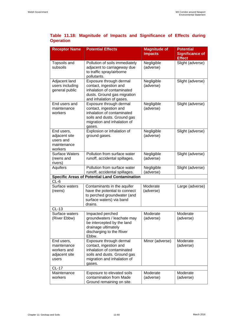
Welsh Government M4 Corridor around Newport Environmental Statement
Chapter 11: Geology and Soils 11-60 March 2016
Table 11.18: Magnitude of Impacts and Significance of Effects during
Operation
Receptor Name Potential Effects Magnitude of Impacts
Potential Significance of Effect
Topsoils and subsoils
Pollution of soils immediately adjacent to carriageway due to traffic spray/airborne pollutants.
Negligible (adverse)
Slight (adverse)
Adjacent land users including general public
Exposure through dermal contact, ingestion and inhalation of contaminated dusts. Ground gas migration and inhalation of gases.
Negligible (adverse)
Slight (adverse)
End users and maintenance workers
Exposure through dermal contact, ingestion and inhalation of contaminated soils and dusts. Ground gas migration and inhalation of gases.
Negligible (adverse)
Slight (adverse)
End users, adjacent site users and maintenance workers
Explosion or inhalation of ground gases.
Negligible (adverse)
Slight (adverse)
Surface Waters (reens and rivers)
Pollution from surface water runoff, accidental spillages.
Negligible (adverse)
Slight (adverse)
Aquifers Pollution from surface water runoff, accidental spillages.
Negligible (adverse)
Slight (adverse)
Specific Areas of Potential Land Contamination
CL-6
Surface waters (reens)
Contaminants in the aquifer have the potential to connect to perched groundwater (and surface waters) via band drains.
Moderate (adverse)
Large (adverse)
CL-13
Surface waters (River Ebbw)
Impacted perched groundwaters / leachate may be intercepted by the land drainage ultimately discharging to the River Ebbw.
Moderate (adverse)
Moderate (adverse)
End users, maintenance workers and adjacent site users
Exposure through dermal contact, ingestion and inhalation of contaminated soils and dusts. Ground gas migration and inhalation of gases.
Minor (adverse) Moderate (adverse)
CL-17
Maintenance workers
Exposure to elevated soils contamination from Made Ground remaining on site.
Moderate (adverse)
Moderate (adverse)
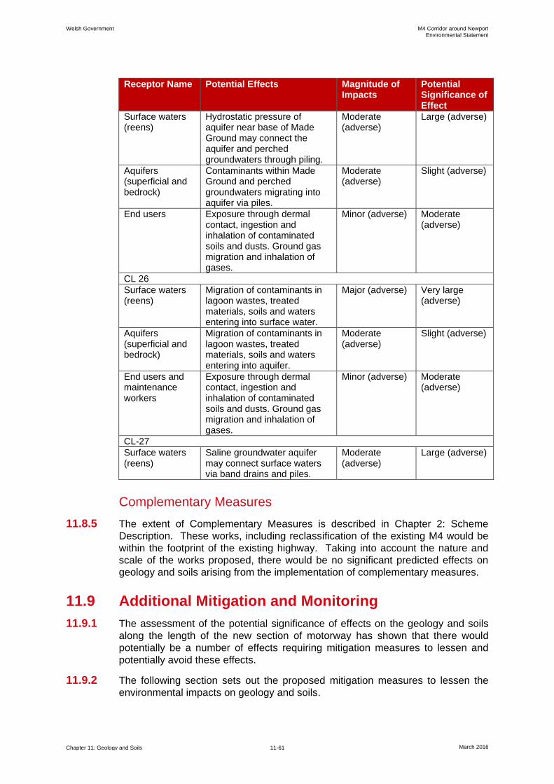
Welsh Government M4 Corridor around Newport Environmental Statement
Chapter 11: Geology and Soils 11-61 March 2016
Receptor Name Potential Effects Magnitude of Impacts
Potential Significance of Effect
Surface waters (reens)
Hydrostatic pressure of aquifer near base of Made Ground may connect the aquifer and perched groundwaters through piling.
Moderate (adverse)
Large (adverse)
Aquifers (superficial and bedrock)
Contaminants within Made Ground and perched groundwaters migrating into aquifer via piles.
Moderate (adverse)
Slight (adverse)
End users Exposure through dermal contact, ingestion and inhalation of contaminated soils and dusts. Ground gas migration and inhalation of gases.
Minor (adverse) Moderate (adverse)
CL 26
Surface waters (reens)
Migration of contaminants in lagoon wastes, treated materials, soils and waters entering into surface water.
Major (adverse) Very large (adverse)
Aquifers (superficial and bedrock)
Migration of contaminants in lagoon wastes, treated materials, soils and waters entering into aquifer.
Moderate (adverse)
Slight (adverse)
End users and maintenance workers
Exposure through dermal contact, ingestion and inhalation of contaminated soils and dusts. Ground gas migration and inhalation of gases.
Minor (adverse) Moderate (adverse)
CL-27
Surface waters (reens)
Saline groundwater aquifer may connect surface waters via band drains and piles.
Moderate (adverse)
Large (adverse)
Complementary Measures
11.8.5 The extent of Complementary Measures is described in Chapter 2: Scheme
Description. These works, including reclassification of the existing M4 would be
within the footprint of the existing highway. Taking into account the nature and
scale of the works proposed, there would be no significant predicted effects on
geology and soils arising from the implementation of complementary measures.
11.9 Additional Mitigation and Monitoring
11.9.1 The assessment of the potential significance of effects on the geology and soils
along the length of the new section of motorway has shown that there would
potentially be a number of effects requiring mitigation measures to lessen and
potentially avoid these effects.
11.9.2 The following section sets out the proposed mitigation measures to lessen the
environmental impacts on geology and soils.
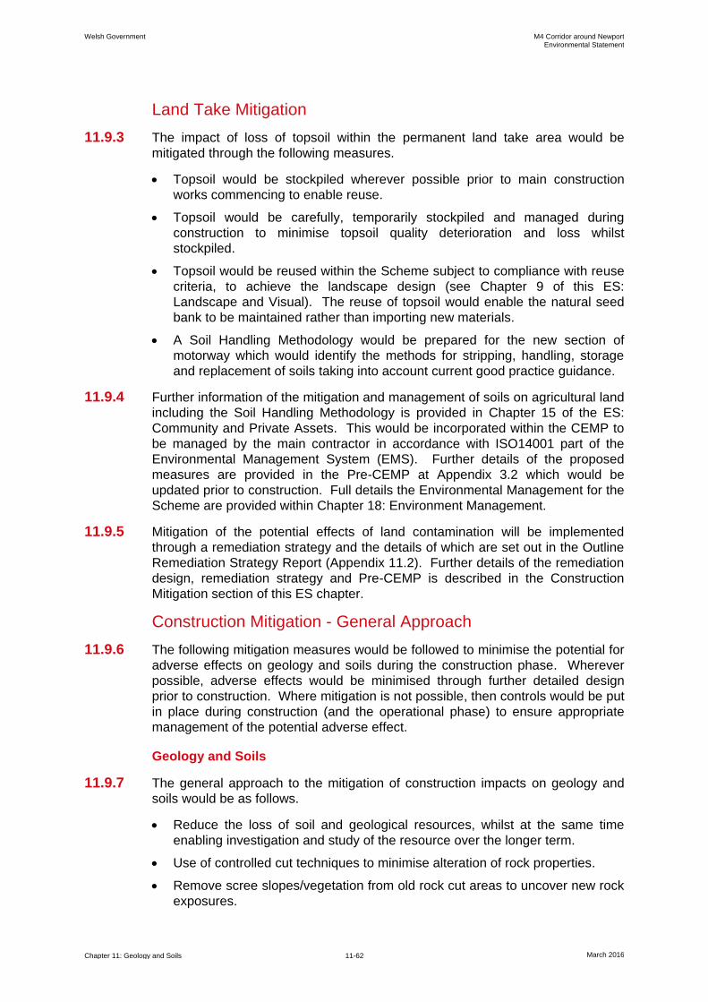
Welsh Government M4 Corridor around Newport Environmental Statement
Chapter 11: Geology and Soils 11-62 March 2016
Land Take Mitigation
11.9.3 The impact of loss of topsoil within the permanent land take area would be
mitigated through the following measures.
Topsoil would be stockpiled wherever possible prior to main construction
works commencing to enable reuse.
Topsoil would be carefully, temporarily stockpiled and managed during
construction to minimise topsoil quality deterioration and loss whilst
stockpiled.
Topsoil would be reused within the Scheme subject to compliance with reuse
criteria, to achieve the landscape design (see Chapter 9 of this ES:
Landscape and Visual). The reuse of topsoil would enable the natural seed
bank to be maintained rather than importing new materials.
A Soil Handling Methodology would be prepared for the new section of
motorway which would identify the methods for stripping, handling, storage
and replacement of soils taking into account current good practice guidance.
11.9.4 Further information of the mitigation and management of soils on agricultural land
including the Soil Handling Methodology is provided in Chapter 15 of the ES:
Community and Private Assets. This would be incorporated within the CEMP to
be managed by the main contractor in accordance with ISO14001 part of the
Environmental Management System (EMS). Further details of the proposed
measures are provided in the Pre-CEMP at Appendix 3.2 which would be
updated prior to construction. Full details the Environmental Management for the
Scheme are provided within Chapter 18: Environment Management.
11.9.5 Mitigation of the potential effects of land contamination will be implemented
through a remediation strategy and the details of which are set out in the Outline
Remediation Strategy Report (Appendix 11.2). Further details of the remediation
design, remediation strategy and Pre-CEMP is described in the Construction
Mitigation section of this ES chapter.
Construction Mitigation - General Approach
11.9.6 The following mitigation measures would be followed to minimise the potential for
adverse effects on geology and soils during the construction phase. Wherever
possible, adverse effects would be minimised through further detailed design
prior to construction. Where mitigation is not possible, then controls would be put
in place during construction (and the operational phase) to ensure appropriate
management of the potential adverse effect.
Geology and Soils
11.9.7 The general approach to the mitigation of construction impacts on geology and
soils would be as follows.
Reduce the loss of soil and geological resources, whilst at the same time
enabling investigation and study of the resource over the longer term.
Use of controlled cut techniques to minimise alteration of rock properties.
Remove scree slopes/vegetation from old rock cut areas to uncover new rock
exposures.
Welsh Government M4 Corridor around Newport Environmental Statement
Chapter 11: Geology and Soils 11-63 March 2016
Careful management, stockpiling and reuse of topsoils and subsoils.
Land Contamination
11.9.8 The general approach to the mitigation of construction impacts from
contamination by the contractor would include the following.
Avoid the mobilisation and spread of potential contaminants in soils and
waters during construction.
Treatment of known areas of contamination causing a potential risk to
receptors.
Use of guidance such as the Environment Agency's Pollution Prevention
Guidelines (PPG) (in particular PPG1, PPG5, PPG6, PPG21) as sources of
good practice. These guidance documents although formally withdrawn on
17th December 2015 include recommendations regarding use of fuel spill kits
and safe storage requirements. The application of appropriate working
methods developed using these guidance documents would be used to
mitigate against potential human health and controlled water contaminant
linkages being created during construction.
Good working practices would be applied, e.g. damping down of dust during
dry conditions to prevent exposure to workers and off-site dispersion, good
hygiene to be adopted by construction workers and use of appropriate
Personal Protective Equipment (PPE).
Pollution risks from the storage of fuel for plant and machinery as well as
leaks and spillages would be addressed with the adoption of appropriate
method statements and working practices.
Controls for dealing with previously unidentified or unexpected contamination.
Construction Mitigation - Specific Approach
11.9.9 Prior to construction, the following assessments and plans would be undertaken
and prepared to refine the design and mitigation measures.
Geology and Soils
11.9.10 The use of band drains and piles within areas of potential land contamination
would be subject to site specific piling risk assessments in line with NRW
guidance (EA, 2001) and may require the use of additional control measures
such as clean drilling techniques particularly in any potential areas of land
contamination. Where contamination risks are considered high, band drains
would not be installed through contaminated soils for instance at the Tata
lagoons area.
11.9.11 Soil erosion may be encountered in deep cuttings during formation works as a
consequence of groundwater seepage and silt/fine sand content of the soil strata.
Residual instability following construction would be mitigated by installation of
deep drainage trenches to lower groundwater and inhibit seepage, and
placement or erosion protection matting at specified locations.
11.9.12 All cut and fill slope would require stability assessments.
Welsh Government M4 Corridor around Newport Environmental Statement
Chapter 11: Geology and Soils 11-64 March 2016
11.9.13 Implementation of a discovery strategy would ensure appropriate mitigation of
risks in the event that dissolution features are encountered during construction
works in the eastern part of the new section of motorway.
Land Contamination Management and Remediation Strategy
11.9.14 The assessments have identified a number of sites that have or could have
contaminated soils or groundwater and soils that are known to generate ground
gas that would be affected by the Scheme. Potential contaminant linkages and
potential risks have been identified to controlled waters, construction workers and
the general public during and post construction and future maintenance workers
at some of the sites. Further action would be undertaken by the contractor to
minimise the risks and undertake remediation as necessary. The overarching
philosophy and regulatory mechanisms of the management of land contamination
in relation to the Scheme is set out within the Land Contamination Management
Strategy provided in Appendix 11.3. This has been agreed with NRW, MCC and
NCC.
11.9.15 An outline remediation strategy has been prepared using guidance within CLR-11
Model Procedures for the Management of Land Contamination (Environment
Agency and Defra, 2004). The outline strategy is provided in Appendix 11.2.
Prior to construction the remediation strategy would be agreed with NRW, MCC
and NCC.
11.9.16 Further ground investigation would be undertaken at some of the potential land
contamination source areas. The data from the ground investigation would be
used to further refine the potential risks and the design of any remediation
required. The remediation strategy would be prepared and implemented to
reduce potential and identified risks from land contamination to tolerable risk
levels both during construction and also during operation (including permanent
land take). As a minimum, the remediation strategy would ensure that, following
construction, the permanent land take area could not meet the definition of
Contaminated Land under Part IIA of the Environment Act 1990.
11.9.17 The remediation strategy would include the following.
A Remedial Options Appraisal, which would consider the most appropriate
remediation option to break each identified contaminant linkage.
A Remediation Implementation Plan that sets out the objectives and
requirements of the remediation to be undertaken.
A Remediation Verification Plan that sets out the 'lines of evidence' to be
gathered during remediation to demonstrate that the remediation objectives
are achieved.
11.9.18 The remediation strategy would include information on procedures, controls and
requirements to be followed during the management of contaminated materials
during construction including the following.
Dealing with previously unidentified or unexpected contamination.
Verification, inspection, sampling and analysis to confirm expected
contamination and ground conditions.
Verification, inspection, sampling and analysis to enable material arisings to
be checked for suitability for reuse with or without treatment.

Welsh Government M4 Corridor around Newport Environmental Statement
Chapter 11: Geology and Soils 11-65 March 2016
Methodologies for the treatment, handling, stockpiling and reusing of
contaminated materials.
Control measures to prevent risks to prevent identified risks to construction
workers and general public during construction.
Design and implementation of groundwater and surface water monitoring
programme pre- and post- construction.
Piling risk assessment (with specific reference to the EA guidance piling into
contaminated sites) and control measures to be adopted during piling and
band drain installation to mitigate any unacceptable risks to controlled waters.
Detailed ground gas risk assessment and gas control measures needed
during construction and, if required, during operation.
Detailed dewatering risk assessment and control measures.
11.9.19 The majority of identified potential land contamination source sites and areas
outside these sites within the permanent and temporary land take would not
require specific remediation. Rather the contaminated soils and waters in the
permanent and temporary land take area would be managed through the
implementation of the Remediation Strategy Report and the Materials
Management Plan as well as general compliance with the Health and Safety at
Work Act 1974 and associated regulations.
11.9.20 An Outline Remediation Strategy has been prepared and is included in Appendix
11.2. This would be developed further following the outcome of the additional
ground investigation and during detailed design. The final remediation strategy
would be agreed with NRW, MCC and NCC prior to the construction phase
commencing and would be described in the Remediation Strategy Report.
Specific remediation would be required at CL-26 (Llanwern Steelworks) to deal
with contaminated materials and wastes which are present within the permanent
and temporary land take area. The remediation would also be designed and
undertaken to facilitate partial surrender of the existing environmental permits at
Llanwern Steelworks. Similarly, the remediation design would also enable
modification or surrender of other environmental permits shown on Figure 11.2
affected by the new section of motorway.
Land Contamination Remediation Design
11.9.21 If contaminated materials cannot be treated on site they would be disposed of off-
site to a suitably licensed disposal facility, However, it is not anticipated that large
volumes of materials would require off-site disposal based upon the considerable
amount of ground investigations undertaken to date.
11.9.22 Figures 16.6, 16.7, 16.8 and 16.9 of this ES provide information on the
preliminary conceptual design of the embankment wherein potentially
contaminated and contaminated materials would be used as part of general
embankment fill subject to complying with suitable for reuse criteria. The
potential risk for contaminants to migrate from the motorway embankment core
and pollute surface waters and groundwater has been assessed and is
considered low. This is discussed in Chapter 16: Road Drainage and the Water
Environment.
11.9.23 Suitability for reuse criteria for soils to be used as general embankment fill have
been developed which would be used during the construction phase to determine
Welsh Government M4 Corridor around Newport Environmental Statement
Chapter 11: Geology and Soils 11-66 March 2016
whether contaminated soils can be reused. The suitability for reuse criteria would
be protective of both human health and the sensitive water environment of the
Gwent Levels. Contaminated soils that fail the suitability for reuse criteria would
require treatment or would be disposed of off site.
11.9.24 The design would be refined further following assessment of the additional
ground investigation results and during detailed design and the remediation
design would be agreed with the NRW, NCC and MCC, prior to construction.
11.9.25 The deep aquifer is identified to have elevated metals and inorganic
contaminants which could reduce surface water quality during construction if the
band drain/pile allow direct or indirect linkage. Groundwater controls would need
to be put in place to collect any waters arising from band drains during
construction to prevent pollution of any adjacent surface waters. Furthermore a
piling risk assessment following NRW guidance would be undertaken to mitigate
the potential impact of the band drains and sites to allow specific mitigation
measures to be implemented.
11.9.26 The reuse of contaminated materials within the Scheme would be set out in, and
managed by, the implementation of the Remediation Strategy and also the
preparation and implementation of a Materials Management Plan (MMP),
prepared in accordance with Definition of Waste: Development Industry Code of
Practice (CL:AIRE, 2011). The Outline Remediation Strategy is provided at
Appendix 11.2. An Outline Materials Management Plan has been prepared
(Appendix 3.2) and is included within the Outline Remediation Strategy Report in
Appendix 11.2 and would be developed further and then formally submitted to
NRW prior to construction commencing.
11.9.27 Further detail of the reuse of materials is provided in Chapter 12 of this ES:
Materials.
11.9.28 A UXO Mitigation Strategy would be developed using guidance within
Unexploded Ordnance: A guide for the Construction Industry (CIRIA, 2009), to
mitigate risks from unidentified unexploded ordnance. The UXO Mitigation
Strategy would draw upon information from within the Explosive Ordnance Threat
Assessment Report (Bactec, 2014).
Construction Environmental Management Plan (CEMP)
11.9.29 The Construction Environmental Management Plan (CEMP) would set out the
environmental measures that would be adopted during the construction phase by
the contractor. A Pre-Construction Environmental Management Plan (Pre-
CEMP) is provided in Appendix 3.2 of this ES. The Pre-CEMP would be
reviewed and updated by the contractor following detailed design such that
appropriate environmental management controls and protocols are in place prior
to construction. The CEMP would include controls to be adopted by the
contractor during construction that would mitigate potential impacts associated
with geology and soils, as well as topsoil and land contamination management.
The CEMP would incorporate controls set out in the following documents.
Soil Handling Methodology Report.
Remediation Strategy Report, including Materials Management Plan.
Pollution and Prevention Plan
Welsh Government M4 Corridor around Newport Environmental Statement
Chapter 11: Geology and Soils 11-67 March 2016
Groundwater and Surface Water Management Plan
UXO Mitigation Strategy Report.
11.9.30 An Outline Remediation Strategy is contained within Appendix 11.2 of this ES.
An Outline Pollution and Prevention Plan and Groundwater and Surface Water
Management Plan have all been prepared and are contained within the Pre-
CEMP (Appendix 3.2 of this ES). These outline plans would all be updated and
agreed with NRW prior to construction.
Operational Mitigation
Mitigation of Potential Impacts on Geology and Soils
11.9.31 As set out in Section 11.5, the design includes appropriate mitigation measures in
the form of suitable drainage systems with hydrocarbon interceptors to capture
road runoff and prevent contamination of the surrounding environment.
11.9.32 The following additional mitigation measures are to be implemented during the
operational phase.
No confined spaces associated with the Scheme would be accessible to the
public. Any maintenance workers entering into any confined spaces would
require adoption and strict health and safety controls to comply with current
health and safety legislation and guidance concerning entry into confined
spaces.
Monitoring of groundwater, surface waters and slope stability would continue
for 5 years after the completion of construction.
Routine maintenance and regular inspections of the slopes would continue for
the lifetime of the new section of motorway.
A remediation verification report would be produced upon completion of
construction and this would include details and plans of where any
contaminated, potentially contaminated and treated contaminated soils have
been used in construction. Such information would be provided within the
Health and Safety File which would be a reference document for designing
future maintenance works so that adequate controls can be introduced to
protect maintenance workers should they be deemed a requirement.
11.9.33 Mitigation of the potential effects from existing land contamination during the
operational phase would be provided through the implementation of the
remediation strategy.
11.10 Assessment of Land Take Effects
Proposed New Section of Motorway
11.10.1 On the basis of the mitigation measures discussed in Section 11.9, the
magnitude of impacts and significance of the effects of land take following
mitigation are summarised in Table 11.19.
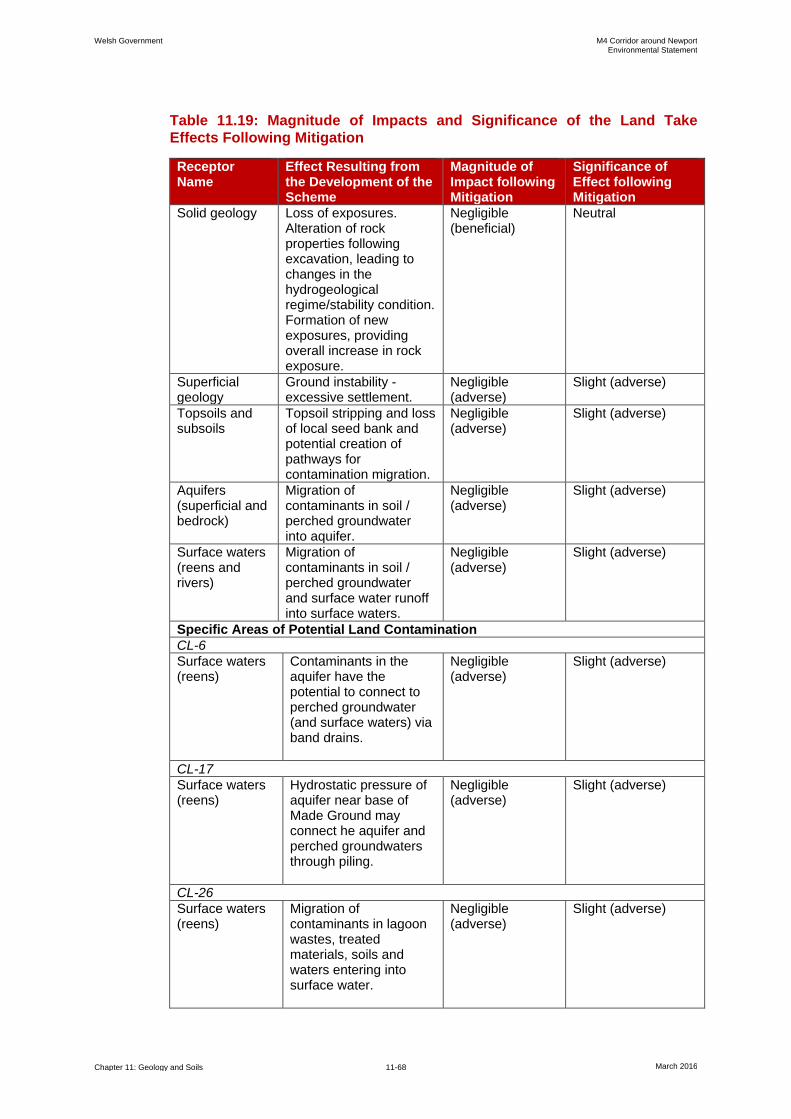
Welsh Government M4 Corridor around Newport Environmental Statement
Chapter 11: Geology and Soils 11-68 March 2016
Table 11.19: Magnitude of Impacts and Significance of the Land Take
Effects Following Mitigation
Receptor Name
Effect Resulting from the Development of the Scheme
Magnitude of Impact following Mitigation
Significance of Effect following Mitigation
Solid geology Loss of exposures. Alteration of rock properties following excavation, leading to changes in the hydrogeological regime/stability condition. Formation of new exposures, providing overall increase in rock exposure.
Negligible (beneficial)
Neutral
Superficial geology
Ground instability - excessive settlement.
Negligible (adverse)
Slight (adverse)
Topsoils and subsoils
Topsoil stripping and loss of local seed bank and potential creation of pathways for contamination migration.
Negligible (adverse)
Slight (adverse)
Aquifers (superficial and bedrock)
Migration of contaminants in soil / perched groundwater into aquifer.
Negligible (adverse)
Slight (adverse)
Surface waters (reens and rivers)
Migration of contaminants in soil / perched groundwater and surface water runoff into surface waters.
Negligible (adverse)
Slight (adverse)
Specific Areas of Potential Land Contamination
CL-6
Surface waters (reens)
Contaminants in the aquifer have the potential to connect to perched groundwater (and surface waters) via band drains.
Negligible (adverse)
Slight (adverse)
CL-17
Surface waters (reens)
Hydrostatic pressure of aquifer near base of Made Ground may connect he aquifer and perched groundwaters through piling.
Negligible (adverse)
Slight (adverse)
CL-26
Surface waters (reens)
Migration of contaminants in lagoon wastes, treated materials, soils and waters entering into surface water.
Negligible (adverse)
Slight (adverse)
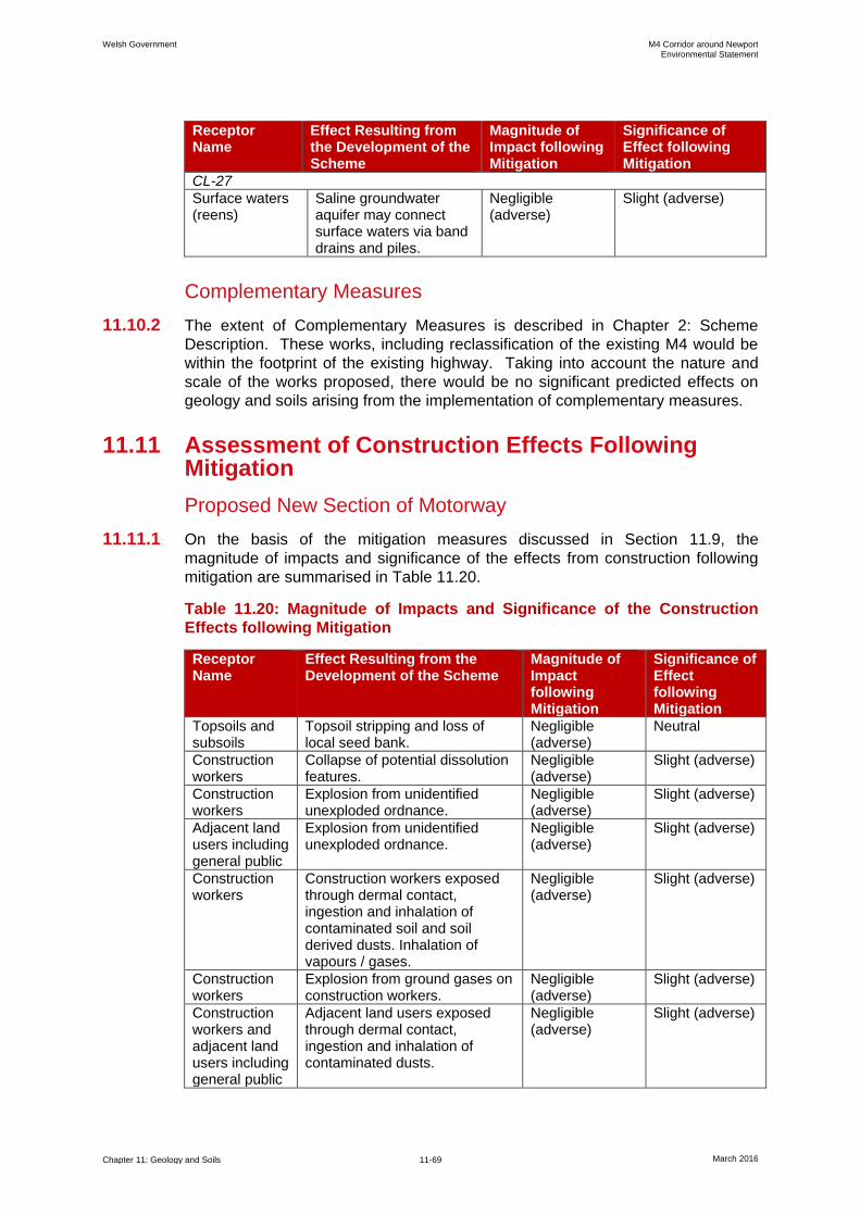
Welsh Government M4 Corridor around Newport Environmental Statement
Chapter 11: Geology and Soils 11-69 March 2016
Receptor Name
Effect Resulting from the Development of the Scheme
Magnitude of Impact following Mitigation
Significance of Effect following Mitigation
CL-27
Surface waters (reens)
Saline groundwater aquifer may connect surface waters via band drains and piles.
Negligible (adverse)
Slight (adverse)
Complementary Measures
11.10.2 The extent of Complementary Measures is described in Chapter 2: Scheme
Description. These works, including reclassification of the existing M4 would be
within the footprint of the existing highway. Taking into account the nature and
scale of the works proposed, there would be no significant predicted effects on
geology and soils arising from the implementation of complementary measures.
11.11 Assessment of Construction Effects Following Mitigation
Proposed New Section of Motorway
11.11.1 On the basis of the mitigation measures discussed in Section 11.9, the
magnitude of impacts and significance of the effects from construction following
mitigation are summarised in Table 11.20.
Table 11.20: Magnitude of Impacts and Significance of the Construction
Effects following Mitigation
Receptor Name
Effect Resulting from the Development of the Scheme
Magnitude of Impact following Mitigation
Significance of Effect following Mitigation
Topsoils and subsoils
Topsoil stripping and loss of local seed bank.
Negligible (adverse)
Neutral
Construction workers
Collapse of potential dissolution features.
Negligible (adverse)
Slight (adverse)
Construction workers
Explosion from unidentified unexploded ordnance.
Negligible (adverse)
Slight (adverse)
Adjacent land users including general public
Explosion from unidentified unexploded ordnance.
Negligible (adverse)
Slight (adverse)
Construction workers
Construction workers exposed through dermal contact, ingestion and inhalation of contaminated soil and soil derived dusts. Inhalation of vapours / gases.
Negligible (adverse)
Slight (adverse)
Construction workers
Explosion from ground gases on construction workers.
Negligible (adverse)
Slight (adverse)
Construction workers and adjacent land users including general public
Adjacent land users exposed through dermal contact, ingestion and inhalation of contaminated dusts.
Negligible (adverse)
Slight (adverse)

Welsh Government M4 Corridor around Newport Environmental Statement
Chapter 11: Geology and Soils 11-70 March 2016
Receptor Name
Effect Resulting from the Development of the Scheme
Magnitude of Impact following Mitigation
Significance of Effect following Mitigation
Aquifers (superficial and bedrock)
Migration of contaminants in soils and perched groundwater to aquifer.
Negligible (adverse)
Slight (adverse)
Surface waters (reens, rivers and road drainage)
Migration of contaminants in soils and perched groundwater and surface water runoff into surface waters.
Negligible (adverse)
Slight (adverse)
Surface waters (reens and rivers)
Piling and band drain installation allowing saline intrusion or contaminated groundwater entering surface waters.
Negligible (adverse)
Slight (adverse)
CL-6
Surface waters (reens)
Contaminants in aquifer have potential to connect to perched groundwaters (and surface waters) during band drain installation.
Negligible (adverse)
Slight (adverse)
CL-13
Construction workers
Construction workers exposed to waste / Made Ground with potentially elevated levels of contamination and asbestos. Inhalation of ground gases with elevated concentrations.
Negligible (adverse)
Slight (adverse)
Surface waters (River Ebbw)
Impacted perched groundwaters / leachate may be intercepted but the land drainage ultimately discharging to the River Ebbw.
Minor (adverse) Slight (adverse)
Aquifers (superficial and bedrock)
Piling and band drains may create pathways connecting the impacted perched groundwaters and aquifer.
Minor (adverse) Slight (adverse)
CL-14
Construction workers
Construction workers exposed to Made Ground with elevated levels of contamination and visual / olfactory evidence of hydrocarbons.
Negligible (adverse)
Slight (adverse)
CL-17
Construction workers
Construction workers exposed to elevated soil contamination and ground gases.
Negligible (adverse)
Slight (adverse)
Construction workers and adjacent land users including general public
Construction workers and adjacent land users exposed to contaminated soil derived dusts.
Negligible (adverse)
Slight (adverse)
Surface waters (reens)
Contaminants in perched groundwater and leaching of contaminants from Made Ground migrating into surface waters. Band drains would not be installed through contaminated soils,
Negligible (adverse)
Slight (adverse)
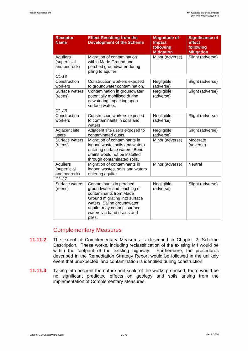
Welsh Government M4 Corridor around Newport Environmental Statement
Chapter 11: Geology and Soils 11-71 March 2016
Receptor Name
Effect Resulting from the Development of the Scheme
Magnitude of Impact following Mitigation
Significance of Effect following Mitigation
Aquifers (superficial and bedrock)
Migration of contamination within Made Ground and perched groundwater during piling to aquifer.
Minor (adverse) Slight (adverse)
CL-18
Construction workers
Construction workers exposed to groundwater contamination.
Negligible (adverse)
Slight (adverse)
Surface waters (reens)
Contamination in groundwater potentially mobilised during dewatering impacting upon surface waters.
Negligible (adverse)
Slight (adverse)
CL-26
Construction workers
Construction workers exposed to contaminants in soils and waters.
Negligible (adverse)
Slight (adverse)
Adjacent site users
Adjacent site users exposed to contaminated dusts.
Negligible (adverse)
Slight (adverse)
Surface waters (reens)
Migration of contaminants in lagoon waste, soils and waters entering surface waters. Band drains would not be installed through contaminated soils,
Minor (adverse) Moderate (adverse)
Aquifers (superficial and bedrock)
Migration of contaminants in lagoon wastes, soils and waters entering aquifer.
Minor (adverse) Neutral
CL-27
Surface waters (reens)
Contaminants in perched groundwater and leaching of contaminants from Made Ground migrating into surface waters. Saline groundwater aquifer may connect surface waters via band drains and piles.
Negligible (adverse)
Slight (adverse)
Complementary Measures
11.11.2 The extent of Complementary Measures is described in Chapter 2: Scheme
Description. These works, including reclassification of the existing M4 would be
within the footprint of the existing highway. Furthermore, the procedures
described in the Remediation Strategy Report would be followed in the unlikely
event that unexpected land contamination is identified during construction.
11.11.3 Taking into account the nature and scale of the works proposed, there would be
no significant predicted effects on geology and soils arising from the
implementation of Complementary Measures.
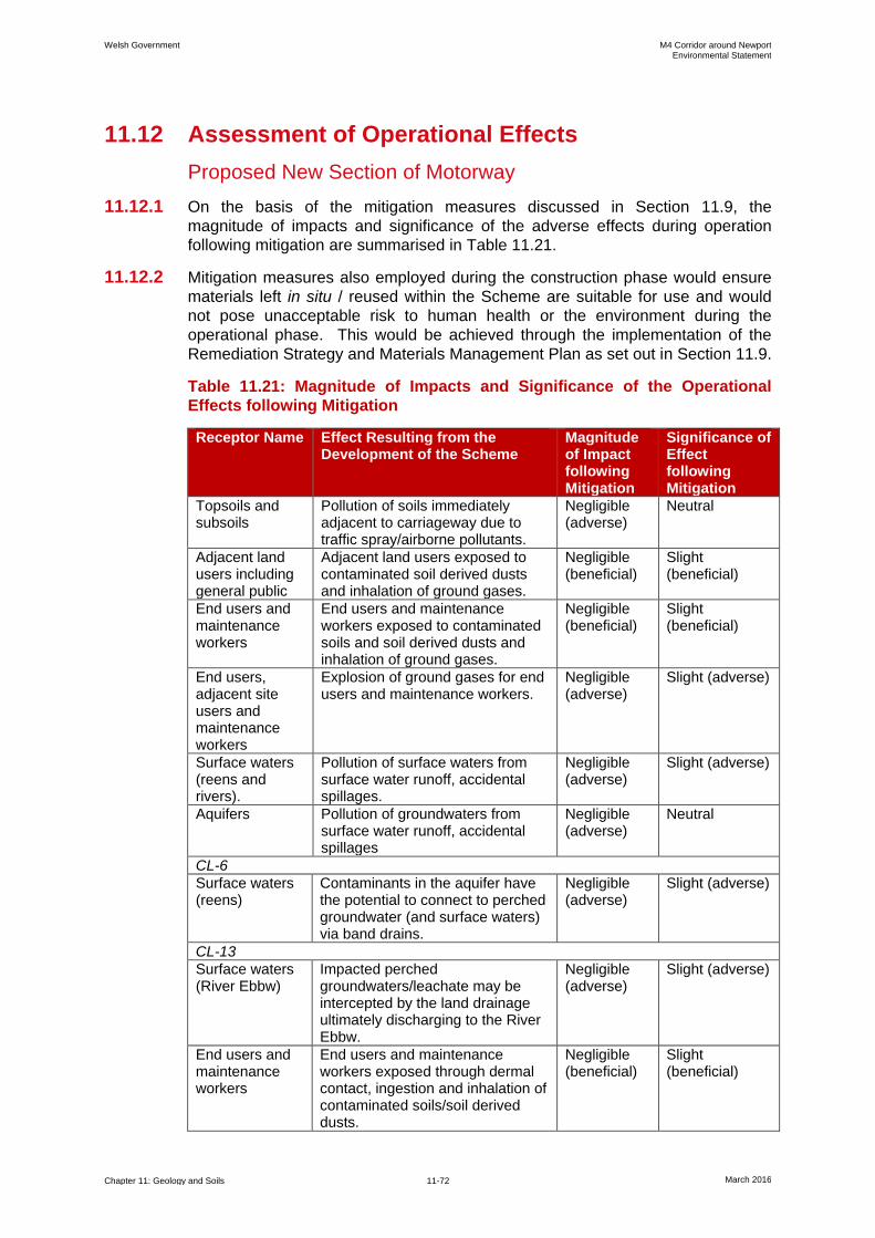
Welsh Government M4 Corridor around Newport Environmental Statement
Chapter 11: Geology and Soils 11-72 March 2016
11.12 Assessment of Operational Effects
Proposed New Section of Motorway
11.12.1 On the basis of the mitigation measures discussed in Section 11.9, the
magnitude of impacts and significance of the adverse effects during operation
following mitigation are summarised in Table 11.21.
11.12.2 Mitigation measures also employed during the construction phase would ensure
materials left in situ / reused within the Scheme are suitable for use and would
not pose unacceptable risk to human health or the environment during the
operational phase. This would be achieved through the implementation of the
Remediation Strategy and Materials Management Plan as set out in Section 11.9.
Table 11.21: Magnitude of Impacts and Significance of the Operational
Effects following Mitigation
Receptor Name Effect Resulting from the Development of the Scheme
Magnitude of Impact following Mitigation
Significance of Effect following Mitigation
Topsoils and subsoils
Pollution of soils immediately adjacent to carriageway due to traffic spray/airborne pollutants.
Negligible (adverse)
Neutral
Adjacent land users including general public
Adjacent land users exposed to contaminated soil derived dusts and inhalation of ground gases.
Negligible (beneficial)
Slight (beneficial)
End users and maintenance workers
End users and maintenance workers exposed to contaminated soils and soil derived dusts and inhalation of ground gases.
Negligible (beneficial)
Slight (beneficial)
End users, adjacent site users and maintenance workers
Explosion of ground gases for end users and maintenance workers.
Negligible (adverse)
Slight (adverse)
Surface waters (reens and rivers).
Pollution of surface waters from surface water runoff, accidental spillages.
Negligible (adverse)
Slight (adverse)
Aquifers Pollution of groundwaters from surface water runoff, accidental spillages
Negligible (adverse)
Neutral
CL-6
Surface waters (reens)
Contaminants in the aquifer have the potential to connect to perched groundwater (and surface waters) via band drains.
Negligible (adverse)
Slight (adverse)
CL-13
Surface waters (River Ebbw)
Impacted perched groundwaters/leachate may be intercepted by the land drainage ultimately discharging to the River Ebbw.
Negligible (adverse)
Slight (adverse)
End users and maintenance workers
End users and maintenance workers exposed through dermal contact, ingestion and inhalation of contaminated soils/soil derived dusts.
Negligible (beneficial)
Slight (beneficial)
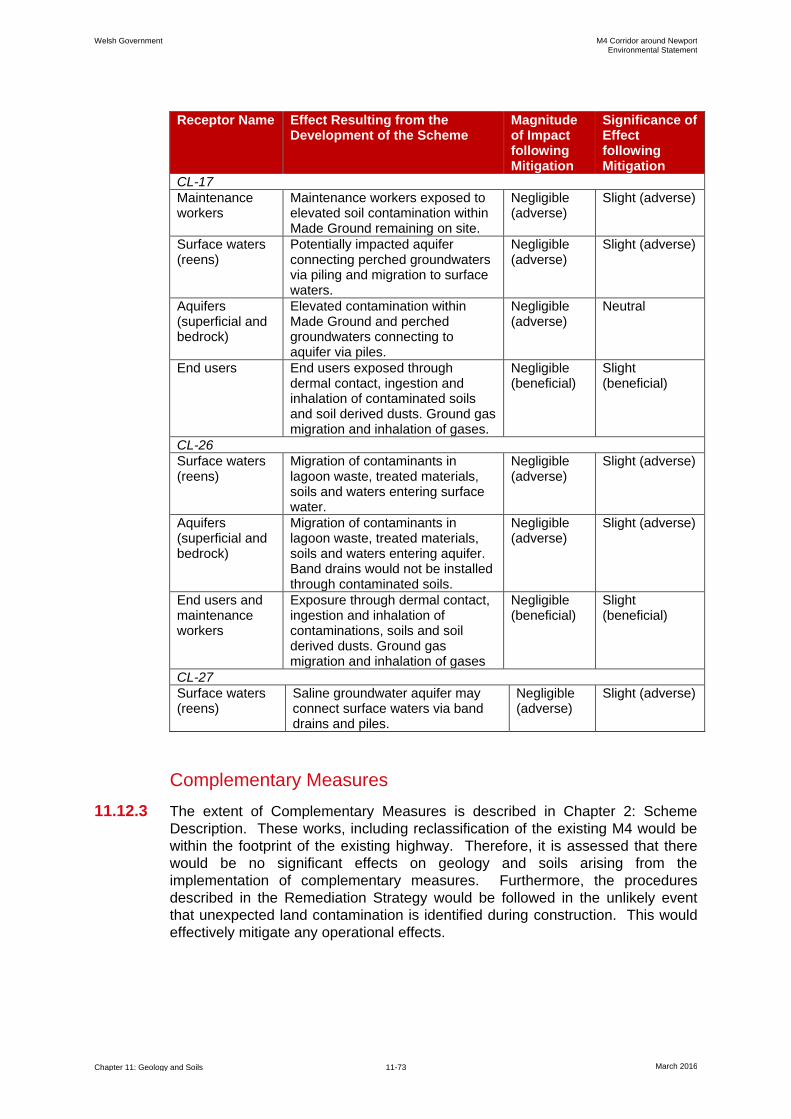
Welsh Government M4 Corridor around Newport Environmental Statement
Chapter 11: Geology and Soils 11-73 March 2016
Receptor Name Effect Resulting from the Development of the Scheme
Magnitude of Impact following Mitigation
Significance of Effect following Mitigation
CL-17
Maintenance workers
Maintenance workers exposed to elevated soil contamination within Made Ground remaining on site.
Negligible (adverse)
Slight (adverse)
Surface waters (reens)
Potentially impacted aquifer connecting perched groundwaters via piling and migration to surface waters.
Negligible (adverse)
Slight (adverse)
Aquifers (superficial and bedrock)
Elevated contamination within Made Ground and perched groundwaters connecting to aquifer via piles.
Negligible (adverse)
Neutral
End users End users exposed through dermal contact, ingestion and inhalation of contaminated soils and soil derived dusts. Ground gas migration and inhalation of gases.
Negligible (beneficial)
Slight (beneficial)
CL-26
Surface waters (reens)
Migration of contaminants in lagoon waste, treated materials, soils and waters entering surface water.
Negligible (adverse)
Slight (adverse)
Aquifers (superficial and bedrock)
Migration of contaminants in lagoon waste, treated materials, soils and waters entering aquifer. Band drains would not be installed through contaminated soils.
Negligible (adverse)
Slight (adverse)
End users and maintenance workers
Exposure through dermal contact, ingestion and inhalation of contaminations, soils and soil derived dusts. Ground gas migration and inhalation of gases
Negligible (beneficial)
Slight (beneficial)
CL-27
Surface waters (reens)
Saline groundwater aquifer may connect surface waters via band drains and piles.
Negligible (adverse)
Slight (adverse)
Complementary Measures
11.12.3 The extent of Complementary Measures is described in Chapter 2: Scheme
Description. These works, including reclassification of the existing M4 would be
within the footprint of the existing highway. Therefore, it is assessed that there
would be no significant effects on geology and soils arising from the
implementation of complementary measures. Furthermore, the procedures
described in the Remediation Strategy would be followed in the unlikely event
that unexpected land contamination is identified during construction. This would
effectively mitigate any operational effects.
Welsh Government M4 Corridor around Newport Environmental Statement
Chapter 11: Geology and Soils 11-74 March 2016
11.13 Assessment of Cumulative Effects
11.13.1 The assessment of cumulative effects with other proposed developments is
provided in Chapter 17 of this ES.
11.14 Inter-relationships
11.14.1 This chapter assesses the significance of effects on geology and soils. Other
potential impacts on the water environment are considered within Chapter 16:
Road Drainage and the Water Environment, which provides a detailed
assessment of the baseline water environment conditions. The sensitivity of the
surface water and groundwater receptors used within this chapter are as defined
within Chapter 16.
11.14.2 The receptors discussed in this chapter are also linked to Chapter 12: Materials.
The design of the new section of motorway in terms of the cut and fill balance is
discussed within Chapter 12. The design aims for all materials (soils and rocks)
generated by the Scheme to be reused within the Scheme, wherever possible.
The reuse of these materials (and materials derived from Scheme designated
borrow pits) would require demonstration that they are both environmentally and
geotechnically suitable.
11.14.3 In terms of loss of topsoil as a resource this has been qualitatively assessed
within this chapter. Further more detailed assessment is provided within Chapter
15: Community and Private Assets, including the assessment of impacts on
agricultural land using the agricultural land classification.
11.14.4 The impact of construction dusts is assessed in greater detail within Chapter 7:
Air Quality.
11.14.5 Environmental Management of the Scheme is set out within Chapter 18:
Environmental Management.
11.14.6 Further details of inter-related effects are provided in Chapter 17.
11.15 Summary of Effects
11.15.1 The effects of the Scheme on soils and geology including land contamination
have been assessed and these are summarised in Table 11.22.
11.15.2 The route of the proposed new section of motorway has been subject to a
number of detailed ground investigations that have provided data on the ground
conditions to provide a detailed understanding of the geological and
hydrogeological baseline conditions. The data generated during ground
investigations have also allowed assessments to be undertaken on the level of
risk to humans and the environment associated with land contamination based on
the Scheme both during construction and its operation.
11.15.3 The Scheme would not affect any designated geological sites and some new rock
exposures would be created providing a beneficial effect.
11.15.4 The potential impacts on topsoil and subsoil during construction would be
mitigated through the adoption of a Soils Handling Strategy. This would be used
to control the way that topsoils and subsoils are managed and stored during
Welsh Government M4 Corridor around Newport Environmental Statement
Chapter 11: Geology and Soils 11-75 March 2016
construction to allow reuse as part of the Scheme whilst maintaining soil quality,
as far as possible. The effect on topsoils from pollutants in traffic spray during
operation would be of neutral significance.
11.15.5 In total, 27 areas potentially affected by land contamination along the proposed
route of the new section of motorway have been identified, each of which has
been subject to an individual assessment to determine the need for remediation
to protect the environment and human health. For some of the potentially
contaminated sites, potential risks have been identified that require remediation
to ensure human health and the environment (including the sensitive reens of the
Gwent Levels) are mitigated. Exposure by construction workers, the general
public and future maintenance workers to potentially contaminated soils, waters
and ground gases have been assessed along with the risk of contaminants
migrating into surface waters and ground waters.
11.15.6 A remediation strategy has been developed in line with UK guidance to mitigate
risks from known potential areas of land contamination and this is set out in the
Outline Remediation Strategy Report (Appendix 11.2). Contaminated soil
arisings from excavations would be subject to compliance testing against
suitability for reuse criteria. Suitable materials would then be reused within the
Scheme typically as general embankment fill. Some contaminated soils would
need treatment particularly in the Tata lagoons area. The Outline Remediation
Strategy also provides procedures to deal with the unlikely event of unexpected
or previously unidentified land contamination being encountered during
construction. The final remediation strategy would also ensure the handling,
treatment, movement and reuse of contaminated soils is controlled in line with a
Material Management Plan that would be prepared using the Definition of Waste
Code of Practice (CL:AIRE 2011). Upon completion of construction of the
Scheme, a Remediation Verification Report would be prepared to prove ‘Lines of
Evidence’ to NRW, MCC and NCC that the remediation has been completed in
line with the agreed remediation strategy.
11.15.7 The potential effects of potentially contaminated surface water runoff and
prevention of potentially contaminated groundwaters entering surface waters
during construction would be mitigated through the implementation of a
Groundwater and Surface Water Management Plan. Surface water and
groundwater monitoring would be undertaken during construction and for up to 5
years following construction. With these measures in place effects on water
quality would be of neutral or slight adverse significance. The exception to this is
during the construction phase in the area of the sludge lagoons (CL-26), where a
minor adverse impact, whilst unlikely, could occur and thus the potential effect
could be of moderate adverse significance.
11.15.8 Potential effects from ground gases impacting on human health during
construction would be mitigated using good practice guidance and adoption of
strict safe working procedures resulting in slight adverse effects. The effects
from any ground gases during the operational stage would be mitigated through
the incorporation of gas protective mitigation measures and the significance of
effects would be limited to slight adverse.
11.15.9 Risks to human health from any contamination during the operational phase
would be minimal. This is because the construction of the Scheme would result in
a barrier being created in the form of the motorway embankment itself or clean
topsoils and subsoils being placed as part of Scheme landscaping. The
Welsh Government M4 Corridor around Newport Environmental Statement
Chapter 11: Geology and Soils 11-76 March 2016
hardstanding and landscaped areas would effectively break any potential
contaminant linkages between contaminated soils and human receptors. The
effects to human health during operation would generally be of slight beneficial
significance as a result of the Scheme as the likelihood for humans coming into
contact with contamination is reduced compared to the baseline.
11.15.10 The effects of potential contamination on surface waters during operation would
be mitigated through the remediation strategy and modifying construction
methods in known and potentially contaminated areas, such as not installing
band drains in contaminated soils and careful selection of piling techniques. The
Scheme would result in slight adverse effects to the water environment.
11.15.11 The potential risks during construction in the unlikely event of buried UXO being
encountered would be mitigated through the implementation of a UXO Mitigation
Strategy which would follow good practice guidance. The risks from buried UXO
being encountered during construction are assessed to be of slight adverse
significance.
11.15.12 With the mitigation measures proposed, the only potentially significant effect
could be on the sensitive surface waters of the Gwent Levels where a potentially
significant effect is predicted during construction associated with the handling and
management of lagoon wastes.
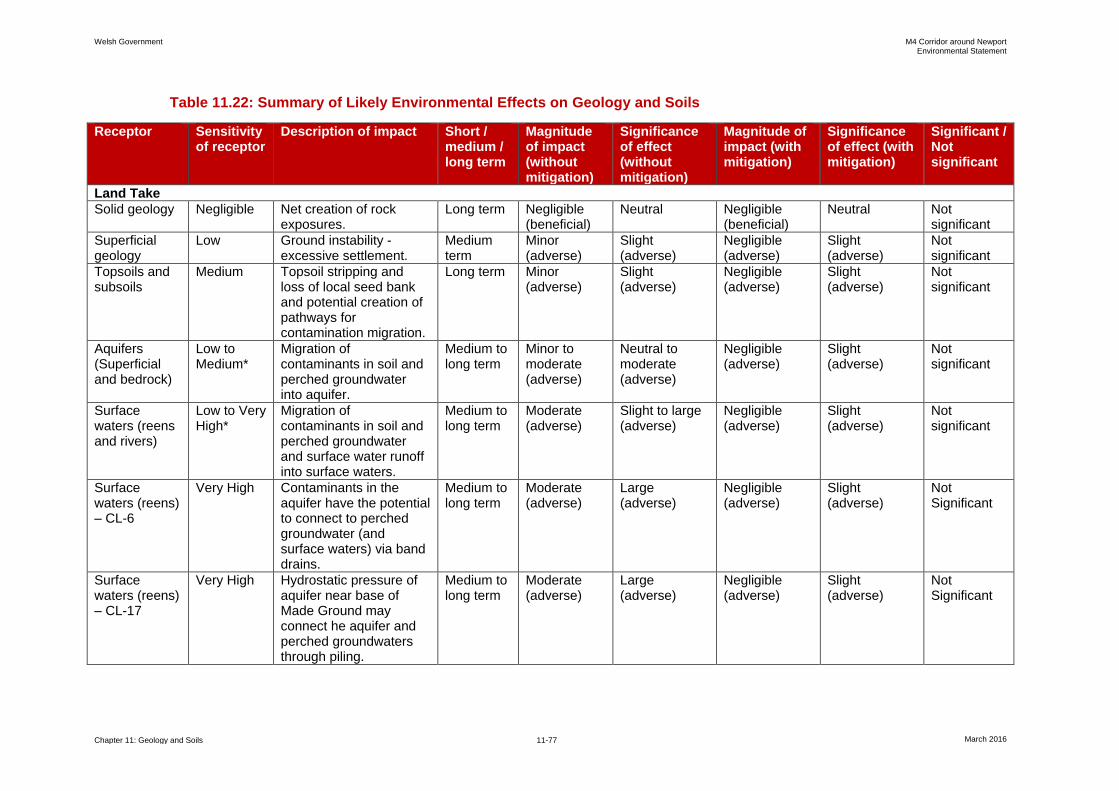
Welsh Government M4 Corridor around Newport Environmental Statement
Chapter 11: Geology and Soils 11-77 March 2016
Table 11.22: Summary of Likely Environmental Effects on Geology and Soils
Receptor Sensitivity of receptor
Description of impact Short / medium / long term
Magnitude of impact (without mitigation)
Significance of effect (without mitigation)
Magnitude of impact (with mitigation)
Significance of effect (with mitigation)
Significant / Not significant
Land Take
Solid geology Negligible Net creation of rock exposures.
Long term Negligible (beneficial)
Neutral
Negligible (beneficial)
Neutral
Not significant
Superficial geology
Low Ground instability - excessive settlement.
Medium term
Minor (adverse)
Slight (adverse)
Negligible (adverse)
Slight (adverse)
Not significant
Topsoils and subsoils
Medium Topsoil stripping and loss of local seed bank and potential creation of pathways for contamination migration.
Long term Minor (adverse)
Slight (adverse)
Negligible (adverse)
Slight (adverse)
Not significant
Aquifers (Superficial and bedrock)
Low to Medium*
Migration of contaminants in soil and perched groundwater into aquifer.
Medium to long term
Minor to moderate (adverse)
Neutral to moderate (adverse)
Negligible (adverse)
Slight (adverse)
Not significant
Surface waters (reens and rivers)
Low to Very High*
Migration of contaminants in soil and perched groundwater and surface water runoff into surface waters.
Medium to long term
Moderate (adverse)
Slight to large (adverse)
Negligible (adverse)
Slight (adverse)
Not significant
Surface waters (reens) – CL-6
Very High Contaminants in the aquifer have the potential to connect to perched groundwater (and surface waters) via band drains.
Medium to long term
Moderate (adverse)
Large (adverse)
Negligible (adverse)
Slight (adverse)
Not Significant
Surface waters (reens) – CL-17
Very High Hydrostatic pressure of aquifer near base of Made Ground may connect he aquifer and perched groundwaters through piling.
Medium to long term
Moderate (adverse)
Large (adverse)
Negligible (adverse)
Slight (adverse)
Not Significant

Welsh Government M4 Corridor around Newport Environmental Statement
Chapter 11: Geology and Soils 11-78 March 2016
Receptor Sensitivity of receptor
Description of impact Short / medium / long term
Magnitude of impact (without mitigation)
Significance of effect (without mitigation)
Magnitude of impact (with mitigation)
Significance of effect (with mitigation)
Significant / Not significant
Surface waters (reens) – CL-26
Very High Migration of contaminants in lagoon wastes, treated soils and waters entering into surface water.
Medium to long term
Major (adverse)
Very large (adverse)
Negligible (adverse)
Slight (adverse)
Not Significant
Surface waters (reens) – CL-27
Very High Saline groundwater may connect to surface waters via band drains.
Medium to long term
Moderate (adverse)
Large (adverse)
Negligible (adverse)
Slight (adverse)
Not Significant
Construction
Topsoils and subsoils
Medium Topsoil loss and loss of local seed bank. Uncontrolled surface water runoff and erosion of topsoil.
Long term Minor (adverse)
Slight (adverse)
Negligible (adverse)
Neutral Not significant
Construction workers
High Collapse of potential dissolution features - hazard to human health.
Long term Major (adverse)
Large (adverse)
Negligible (adverse)
Slight (adverse)
Not significant
Construction workers and adjacent land users including general public
High and Very High
Explosion from buried unidentified unexploded ordnance - hazard to human health.
Long term Major (adverse)
Very large (adverse)
Negligible (adverse)
Slight (adverse)
Not significant
Construction workers and adjacent land users including general public
Very High Exposure to contamination through dermal contact, ingestion and inhalation of contaminated soil/soil derived dust.
Short to long term
Minor (adverse)
Moderate (adverse)
Negligible (adverse)
Slight (adverse)
Not significant
Construction workers
High Explosion from ground gas build up in confined space and during piling and band drain installation - hazard to human health.
Long term Major (adverse)
Large (adverse)
Negligible (adverse)
Slight (adverse)
Not significant
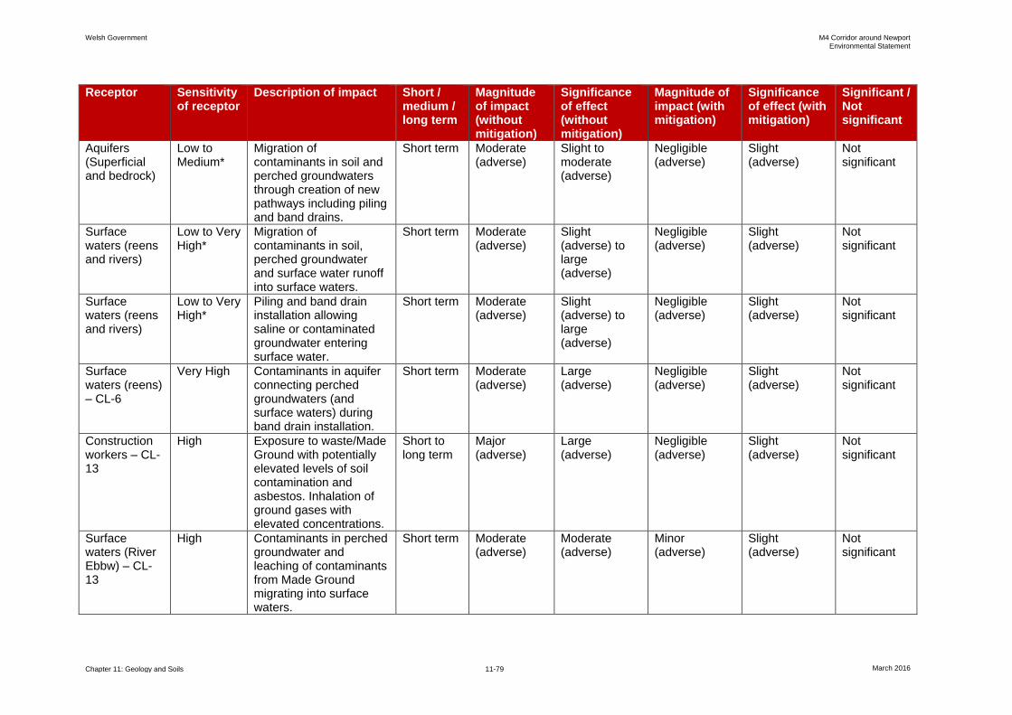
Welsh Government M4 Corridor around Newport Environmental Statement
Chapter 11: Geology and Soils 11-79 March 2016
Receptor Sensitivity of receptor
Description of impact Short / medium / long term
Magnitude of impact (without mitigation)
Significance of effect (without mitigation)
Magnitude of impact (with mitigation)
Significance of effect (with mitigation)
Significant / Not significant
Aquifers (Superficial and bedrock)
Low to Medium*
Migration of contaminants in soil and perched groundwaters through creation of new pathways including piling and band drains.
Short term Moderate (adverse)
Slight to moderate (adverse)
Negligible (adverse)
Slight (adverse)
Not significant
Surface waters (reens and rivers)
Low to Very High*
Migration of contaminants in soil, perched groundwater and surface water runoff into surface waters.
Short term Moderate (adverse)
Slight (adverse) to large (adverse)
Negligible (adverse)
Slight (adverse)
Not significant
Surface waters (reens and rivers)
Low to Very High*
Piling and band drain installation allowing saline or contaminated groundwater entering surface water.
Short term Moderate (adverse)
Slight (adverse) to large (adverse)
Negligible (adverse)
Slight (adverse)
Not significant
Surface waters (reens) – CL-6
Very High Contaminants in aquifer connecting perched groundwaters (and surface waters) during band drain installation.
Short term Moderate (adverse)
Large (adverse)
Negligible (adverse)
Slight (adverse)
Not significant
Construction workers – CL-13
High Exposure to waste/Made Ground with potentially elevated levels of soil contamination and asbestos. Inhalation of ground gases with elevated concentrations.
Short to long term
Major (adverse)
Large (adverse)
Negligible (adverse)
Slight (adverse)
Not significant
Surface waters (River Ebbw) – CL-13
High Contaminants in perched groundwater and leaching of contaminants from Made Ground migrating into surface waters.
Short term Moderate (adverse)
Moderate (adverse)
Minor (adverse)
Slight (adverse)
Not significant
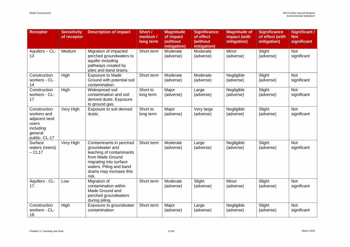
Welsh Government M4 Corridor around Newport Environmental Statement
Chapter 11: Geology and Soils 11-80 March 2016
Receptor Sensitivity of receptor
Description of impact Short / medium / long term
Magnitude of impact (without mitigation)
Significance of effect (without mitigation)
Magnitude of impact (with mitigation)
Significance of effect (with mitigation)
Significant / Not significant
Aquifers – CL-13
Medium Migration of impacted perched groundwaters to aquifer including pathways created by piles and band drains.
Short term Moderate (adverse)
Moderate (adverse)
Minor (adverse)
Slight (adverse)
Not significant
Construction workers - CL-14
High Exposure to Made Ground with potential soil contamination.
Short term Moderate (adverse)
Moderate (adverse)
Negligible (adverse)
Slight (adverse)
Not significant
Construction workers - CL-17
High Widespread soil contamination and soil derived dusts. Exposure to ground gas.
Short to long term
Major (adverse)
Large (adverse)
Negligible (adverse)
Slight (adverse)
Not significant
Construction workers and adjacent land users including general public- CL-17
Very High Exposure to soil derived dusts.
Short to long term
Major (adverse)
Very large (adverse)
Negligible (adverse)
Slight (adverse)
Not significant
Surface waters (reens) – CL17
Very High Contaminants in perched groundwater and leaching of contaminants from Made Ground migrating into surface waters. Piling and band drains may increase this risk.
Short term Moderate (adverse)
Large (adverse)
Negligible (adverse)
Slight (adverse)
Not significant
Aquifers - CL-17.
Low Migration of contamination within Made Ground and perched groundwaters during piling.
Short term Moderate (adverse)
Slight (adverse)
Minor (adverse)
Slight (adverse)
Not significant
Construction workers - CL-18.
High Exposure to groundwater contamination
Short term Major (adverse)
Large (adverse)
Negligible (adverse)
Slight (adverse)
Not significant
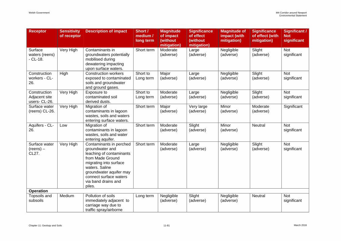
Welsh Government M4 Corridor around Newport Environmental Statement
Chapter 11: Geology and Soils 11-81 March 2016
Receptor Sensitivity of receptor
Description of impact Short / medium / long term
Magnitude of impact (without mitigation)
Significance of effect (without mitigation)
Magnitude of impact (with mitigation)
Significance of effect (with mitigation)
Significant / Not significant
Surface waters (reens) - CL-18.
Very High Contaminants in groundwaters potentially mobilised during dewatering impacting upon surface waters.
Short term Moderate (adverse)
Large (adverse)
Negligible (adverse)
Slight (adverse)
Not significant
Construction workers - CL-26.
High Construction workers exposed to contaminated soils and groundwater and ground gases.
Short to Long term
Major (adverse)
Large (adverse)
Negligible (adverse)
Slight (adverse)
Not significant
Construction Adjacent site users- CL-26.
Very High Exposure to contaminated soil derived dusts.
Short to Long term
Moderate (adverse)
Large (adverse)
Negligible (adverse)
Slight (adverse)
Not significant
Surface water (reens) CL-26.
Very High Migration of contaminants in lagoon wastes, soils and waters entering surface waters.
Short term Major (adverse)
Very large (adverse)
Minor (adverse)
Moderate (adverse)
Significant
Aquifers - CL-26.
Low Migration of contaminants in lagoon wastes, soils and water entering aquifer.
Short term Moderate (adverse)
Slight (adverse)
Minor (adverse)
Neutral Not significant
Surface water (reens) – CL27.
Very High Contaminants in perched groundwater and leaching of contaminants from Made Ground migrating into surface waters. Saline groundwater aquifer may connect surface waters via band drains and piles.
Short term Moderate (adverse)
Large (adverse)
Negligible (adverse)
Slight (adverse)
Not significant
Operation
Topsoils and subsoils
Medium Pollution of soils immediately adjacent to carriage way due to traffic spray/airborne
Long term Negligible (adverse)
Slight (adverse)
Negligible (adverse)
Neutral Not significant

Welsh Government M4 Corridor around Newport Environmental Statement
Chapter 11: Geology and Soils 11-82 March 2016
Receptor Sensitivity of receptor
Description of impact Short / medium / long term
Magnitude of impact (without mitigation)
Significance of effect (without mitigation)
Magnitude of impact (with mitigation)
Significance of effect (with mitigation)
Significant / Not significant
pollutants.
Adjacent land users including general public
Very High Exposure through dermal contact, ingestion and inhalation of contaminated soil derived dusts. Ground gas migration and inhalation of gases.
Long term Negligible (adverse)
Slight (adverse)
Negligible (beneficial)
Slight (beneficial)
Not significant
End users/ maintenance workers
High Exposure through dermal contact, ingestion and inhalation of contaminated soil derived dusts. Ground gas migration and inhalation of gases.
Long term Negligible (adverse)
Slight (adverse)
Negligible (beneficial)
Slight (beneficial)
Not significant
End users, adjacent site users and maintenance workers
Very High Explosion from ground gases - human health hazard.
Long term Negligible (adverse)
Slight (adverse)
Negligible (adverse)
Slight (adverse)
Not significant
Surface Waters (reens and rivers)
Low to Very High
Pollution of surface waters from surface water runoff, accidental spillages.
Long term Negligible (adverse)
Slight (adverse)
Negligible (adverse)
Slight (adverse)
Not significant
Aquifers (superficial and bedrock)
Low to Medium
Pollution of groundwaters from surface water runoff, accidental spillages
Long term Negligible (adverse)
Slight (adverse)
Negligible (adverse)
Neutral Not significant
Surface waters (reens) – CL-6
Very High Contaminants in aquifer have the potential to connect perched groundwaters (and surface waters) via band drains.
Medium term
Moderate (adverse)
Large (adverse)
Negligible (adverse)
Slight (adverse)
Not significant

Welsh Government M4 Corridor around Newport Environmental Statement
Chapter 11: Geology and Soils 11-83 March 2016
Receptor Sensitivity of receptor
Description of impact Short / medium / long term
Magnitude of impact (without mitigation)
Significance of effect (without mitigation)
Magnitude of impact (with mitigation)
Significance of effect (with mitigation)
Significant / Not significant
Surface waters (River Ebbw) - CL-13
High Impacted perched groundwaters/leachate may be intercepted by the land drainage ultimately discharging to the River Ebbw.
Medium term
Moderate (adverse)
Moderate (adverse)
Negligible (adverse)
Slight (adverse)
Not significant
End users and maintenance workers and adjacent users - CL-13
High Exposure through dermal contact, ingestion and inhalation of contaminated soil derived dusts. Ground gas migration and inhalation of gases.
Long term Minor (adverse)
Moderate (adverse)
Negligible (beneficial)
Slight (beneficial)
Not significant
Maintenance workers - CL-17
High Exposure to soil contamination from Made Ground remaining on site.
Medium term
Moderate (adverse)
Moderate (adverse)
Negligible (adverse)
Slight (adverse)
Not significant
End users – CL-17
High Exposure through dermal contact, ingestion and inhalation of contaminated soil derived dusts. Ground gas migration and inhalation of gases.
Long term Minor (adverse)
Moderate (adverse)
Negligible (beneficial)
Slight (beneficial)
Not significant
Surface waters (reens) – CL-17
Very High Hydrostatic pressure of aquifer near base of Made Ground may connect to aquifer and perched groundwaters (and surface waters) via piling.
Medium term
Moderate (adverse)
Large (adverse)
Negligible (adverse)
Slight (adverse)
Not significant

Welsh Government M4 Corridor around Newport Environmental Statement
Chapter 11: Geology and Soils 11-84 March 2016
Receptor Sensitivity of receptor
Description of impact Short / medium / long term
Magnitude of impact (without mitigation)
Significance of effect (without mitigation)
Magnitude of impact (with mitigation)
Significance of effect (with mitigation)
Significant / Not significant
Aquifers – CL-17
Low Contaminants within Made Ground and perched groundwaters migrating into aquifer during piling.
Medium term
Moderate (adverse)
Slight (adverse)
Negligible (adverse)
Neutral Not significant
Surface waters (reens) – CL-26
Very High Migration of contaminants in lagoon wastes, treated materials soils and water entering surface water.
Medium term
Major (adverse)
Very Large (adverse)
Negligible (adverse)
Slight (adverse)
Not significant
Aquifers – CL-26
Low Migration of contaminants in lagoon wastes, treated materials soils and water entering aquifers.
Medium term
Moderate (adverse)
Slight (adverse)
Negligible (adverse)
Slight (adverse)
Not significant
End users and maintenance workers – CL-26
High Exposure through dermal contact, ingestion and inhalation of contaminations soils and soil derived dusts. Ground gas migration and inhalation of gases.
Long term Minor (adverse)
Moderate (adverse)
Negligible (beneficial)
Slight (beneficial)
Not significant
Surface waters (reens) -CL-27
Very High Saline groundwater aquifer may connect surface waters via band drains and piles.
Medium term
Moderate (adverse)
Large (adverse)
Negligible (adverse)
Slight (adverse)
Not significant


