ENVIRONMENTAL SATELLITE DATA AND … · Satellite (GOES) systems and ... Y.. 7 UNCLASS I...
128
= -AI65 244 MOW SATELLITE RIGUIREMENTS FORECAST(U) ATIOMA 1/2 ENVIRONMENTAL SATELLITE DATA AND INFORMATION SERVICE .36 A0MSNINGTON DC D COTTER ET AL. MAY 85 UNCLASSIFIED F/6 22/2 NU.
Transcript of ENVIRONMENTAL SATELLITE DATA AND … · Satellite (GOES) systems and ... Y.. 7 UNCLASS I...

= -AI65 244 MOW SATELLITE RIGUIREMENTS FORECAST(U) ATIOMA 1/2ENVIRONMENTAL SATELLITE DATA AND INFORMATION SERVICE
.36 A0MSNINGTON DC D COTTER ET AL. MAY 85UNCLASSIFIED F/6 22/2 NU.

AdiI, 1.0 hof 11 1.
1.1 I~3.1
IIIJIL25 I
MICROCOPY RESOLUTION TEST CHARTr4ICNAI RLIFH U(IF StAHD A11+1Th A

ATonENVIROSAT-2000 Report
0 NOAA SatelliteRequirements Forecast
May 1985
In
C
U..DPRMN FCMEC
Naioa Oeai adAtoshri dmnitatoNaioalEvion ena Stelie Dta adInorato Srvc

UNCLASSIFIED, UNLIMITED
SECURITY CLASSIFICATION OF THIS PAGE
REPORT DOCUMENTATION PAGEla. REPORT SECURITY CLASSIFICATION lb. RESTRICTIVE MARKINGS
Unclassified/unlimited
12a. SECURITY CLASSIFICATION AUTHORITY 3. DISTRIBUTION/ AVAILABIUTY OF REPORT
"_Approved for Public Release:2b. DECLASSIFICATION I DOWNGRADING SCHEDULE Distribution unlimited
4. PERFORMING ORGANIZATION REPORT NUMBER(S) S. MONITORING ORGANIZATION REPORT NUMBER(S)
6a. NAME OF PERFORMING ORGANIZATION 6b. OFFICE SYMBOL 7a. NAME OF MONITORING ORGANIZATION
National Environmental Satel- (If applicable)lite, Data & Information Svc. Exl
6c. ADDRESS (City, State, and ZIP Code) 7b. ADDRESS (City, State, and ZIP Code)
Washington, D.C. 20233
Sa. NAME OF FUNDING/SPONSORING Sb. OFFICE SYMBOL 9. PROCUREMENT INSTRUMENT IDENTIFICATION NUMBERORGNIJATIONNational Environ- Of applicable)
mental atellite, Data and Exl
Information Service __I
8. ADDRESS (City, State, and ZIP Code) 10. SOURCE OF FUNDING NUMBERS
PROGRAM PROJECT TASK WORK UNITWashington, D.C. 20233 ELEMENT NO. NO. NO. ACCESSION NO.
7II. TITLE (Include Security Classification)
NOAA Satellite Requirements Forecast
S12. PERSONAL AUTHOR(S)Cotter, D.; Fisher, L.; Montgomery, D.; Pyle, T.; Zbar, F.; Hussey, W. (editor)
13a. TYPE OF REPORT 13b. TIME COVERED 14. DATE OF REPORT (Year, Month, Day) S. PAGE COUNT
FINAL FROM TO 8505 134
16. SUPPLEMENTARY NOTATION
An ENVIROSAT-2000 Report
17. COSATI CODES 18. SUBJECT TERMS (Continue on reverse if necessary and identify by block number)
0 FIELD GROUP SUB-GROUP Environmental Satellites, NOAA Satellite Requirements,,_.-_._ Satellite Observations, Weather, Atmosphere, Oceans, Sun,
Climate, Fisheries, Space Environment, Environmental Researc
"9. ABSTRACT (Continue on reverse if necessary and identify by block number)
Environmental satellites have been an essential component ofNOAA's global observing system for 25 years. This reportoffers a projection of NOAA's requirements for satellite dataand services covering the next 15 years. These requirementsderive from the mission responsibilities of NOAA's public ser-vice and research agencies: the National Weather Service, theNational Ocean Service, the National Marine Fisheries Service,and the Office of Oceanic and Atmospheric Research. The
r' National Environmental Satellite, Data, and Information Ser-* "vice operates the Polar-orbiting Operational Environmental, Satellite (POES) and Geostationary Operational Environmental
Satellite (GOES) systems and provides data archive and distri-
20 DISTRIBUTION /AVAILABILITY OF ,,STRACT 21. ABSTRACT SECURITY CLASSIFICATION
OUNCLASSIFIEOAJNLIMITEO (2 SAME AS RPT. QOTKC USERS Unclassified/unlimited
22s. NAME OF RESPONSIBLE INDIVIDUAL 22b. TELEPHONE (Include Area Code) 22c. OFFICE SYMBOL
Daniel J. Cotter (301) 763-8078 NESDIS E/SPDI
DO FORM 1473, 84 MAR 83 APR edition may be used until exhausted. SECURITY CLASSIFICATION OF THIS PAGEAll other editions are obsolete. UICLASSI FI ED/UNLI MITED
.' %
I.
UNCI.ASS 1 F1 ED/ UNLIMITEDiECU1ITY CLASIPICATIOW4 OF T1I PAG4
19. Abstract (cont.)
e-bution services to the public and private sectors. The satel-lite support needed to help meet their mission goals throughthe end of this century are presented as they have been iden-tified by each agency. The requirements specified in thisreport will be a major factor in the long-range planning forNOAA's future satellite programs.
SJ
*. I 1D N T
SCRT ,I
OF T P
, .*.".. ..Y.. 7 UNCLASS I PIED/UNLIMITED• . , m * ' * %. S cu Iry CL.ASS1FICATgON OF THIS PAGE
" * 0 - 0-', .-. y- ., ,.... . .,.+ . . + ,.. .. . . . , . ..- ,. ., . .. ,.. . . , .. . .

ENVIROSAT-2000 Report
-. NOAA SatelliteRequirements Forecast
"MENT OflotW. John Hussey, Editor
+ Contributors:
D. Cotter, NESDISL. Fisher, NMFSD. Montgomery, NOS A-n
I T. Pyle, OAR Accession For. B~TIS CP. SIF. Zbar, NWS DTIS TG.AI
-'" J i' i f ! -: -: ... ----------
"" ~~~May 1985 i- T:'
U.S. DEPARTMENT OF COMMERCEMalcolm Baldrige, Secretary
National Oceanic and Atmospheric AdministrationAnthony J. Calio, Deputy Administrator
.. q
S. National Environmental Satellite, Data, and Information ServiceJohn H. McElroy, Assistant Administrator

NOAA SATELLITE REQUIREMENTS FORECAST
ABSTRACT
Environmental satellites have been an essential component ofNOAA's global observing system for 25 years. This reportoffers a projection of NOAA's requirements for satellite dataand services covering the next 15 years. These requirementsderive from the mission responsibilities of NOAA's public ser-vice and research agencies: the National Weather Service, the
- National Ocean Service, the National Marine Fisheries Service,and the Office of Oceanic and Atmospheric Research. TheNational Environmental Satellite, Data, and Information Ser-vice operates the Polar-orbiting Operational EnvironmentalSatellite (POES) and Geostationary Operational EnvironmentalSatellite (GOES) systems and provides data archive and distri-bution services to the public and private sectors. The satel-lite support needed to help meet their mission goals throughthe end of this century are presented as they have been iden-tified by each agency. The requirements specified in thisreport will be a major factor in the long-range planning for
NOAA's future satellite programs.[I
°ii

TABLE OF CONTENTS
Chapter Page
Abstract ............................................ i
I. INTRODUCTION ........................................ 1
II. INTEGRATION OF DATA REQUIREMENTS ........................ 5
III. SATELLITE REQUIREMENTS OF THE NATIONAL WEATHERSERVICE ........................................... 13
IV. SATELLITE REQUIREMENTS OF THE NATIONAL OCEANSERVICE ........................................... 49
V. SATELLITE REQUIREMENTS OF THE OFFICE OF OCEANICAND ATMOSPHERIC RESEARCH .......................... 77
VI. SATELLITE REQUIREMENTS OF THE NATIONAL MARINEFISHERIES SERVICE ................................. 103
VII. SUMMARY i.............................................111
Appendix
A. CURRENT AND PLANNED NOAA SATELLITES ................... A-I
B. GLOSSARY OF ACRONYMS ................................ B-I
L
2ii

Index to Tables
Table Panfe
II-1 Integrated Primary Requirements forSatellite Observations .............................. 9
11-2 NOAA Geostationary Satellite Productsand Services i...................................11
11-3 NOAA Polar-orbiting Satellite Productsand Services ................................... 12
III-1 Current DCP Requirements (NWS) .................. 26
111-2 GOES Imagery Requirements (NWS) .................. 28
_ 111-3 GOES Sounding Requirements (NWS) ................. 29
111-4 PROFS Satellite Data Requirements (NWS) ......... 38
111-5 Summary of NWS Ocean Climate Requirements ....... 40
111-6 Basic Set of Global Observational DataRequirements to be Met by the GOS by theYear 2000 ...................................... 44
111-7 NWS Composite Data Requirements (1985-2000) .... 46
IV-1 Satellite Data and Services (NOS) ................ 57
IV-2 U.S. Oceanographic Measurement SystemCapabilities of Interest to NOS .................. 69
IV-3 Capabilities of the Planned Navy N-ROSSSatellite ...................................... 70
IV-4 Foreign Satellite Systems of Interest to NOSOceanographic Measurement Requirements ......... 71
IV-5 NOS Composite Data Requirements (1985-2000) -Basic Observations ............................. 72
IV-6 NOS Composite Data Requirements (1985-2000) -
Sea and Lake Ice ............................... 74
IV-7 NOS Composite Data Requirements (1985-2000) -
Auxiliary Satellite Services ................... 76
i i-i . . . .. . . .. . . . . . . . . . .
. .// / ' '.'' .. ' ." ;,/ ,," . ,-'' /;-4 i7 " ,- -7 -*- -- --

Index to Tables
Table Page
V-1 OAR Composite Data Requirements (J.985-2000) -Mesoscale Phenomena ............................ 89
V-2 OAR Composite Data Requirements (1985-2000) -Numerical Weather Predictions .................... 90
V-3 OAR Composite Data Requirements (1985-2000) -Climate ........................................ 91
V-4 OAR Composite Data Requirements (1985-2000) -- Marine Resources ............................... 92
V-5 OAR Composite Data Requirements (1985-2000) -Marine Observations and Predictions ............ 93
V-6 OAR Data Transmission and VerificationRequirements. ................................... 94
V-7 OAR Composite Data Requirements (1985-2000) -z Geostationary, Polar, and Libration Orbit Data
Products Requirements .............................. 95
. V-8 OAR Composite Data Requirements (1985-2000) --. Polar and Geostationary Platform Requirements .. 101
VI-I NMFS Composite Data Requirements (1985-2000) ... 109
iv
A 9
., •

I. INTRODUCTION
The purpose of this report is to provide a consolidated pro-jection of the requirements of the National Oceanic and Atmos-pheric Administration (NOAA) for operational environmentalsatellite support through the end of this century. This pro-jection is the sum of the anticipated requirements of thepublic service and research agencies of NOAA--the NationalWeather Service (NWS), the National Ocean Service (NOS), theNational Marine Fisheries Service (NMFS), and the Office ofOceanic and Atmospheric Research (OAR). The National Environ-mental Satellite, Data, and Information Service (NESDIS)operates NOAA's satellites and manages the systems that pro-vide satellite data product delivery and archives. NESDISdoes not have satellite data requirements that are independentof the other NOAA agencies.
The service and research agencies of NOAA are chartered toprovide public benefits through the analysis, forecast, andstudy of Earth environmental conditions and the solar influ-ences that impact on them. These NOAA agencies also operatesystems for observing the state of the Earth environment and
. "the sun, exchange similar observations with others, and sup-port the archives that maintain accessibility to the observa-tions. At the core of each of these NOAA functions is theobservational data base. The data base either serves as aprime tool for the activities of the function or is, itself,the object of the function.
NOAA mission responsibilities are the basis for establishingthe requirements for the data base. Usually the serviceagency states its data needs in terms of the types of measure-ments required and specifies the frequency, timeliness, distri-bution, and skill of measurement called for by currentpractices and practical considerations, such as resources
% available. Sometimes agencies state their data requirementsas specific levies against observing systems that are plannedfor implementation. Because data needs are usually satisfiedfrom a mix of observing systems, final decisions about datasources consider alternate data collection methods. One ofthe papers in this ENVIROSAT-2000 series (The U.S. Weather
-' Watch: A Composite System) further discusses observing systemalternatives and their respective roles.
The satellite requirements expressed in this report have beenprovided by the data-using agencies of NOAA to help develop along-range plan for conducting NOAA's satellite activities.This approach is not the usual one, because the agencies were
4V.

[ required to focus on their future requirements for data from a* particular future observing system, without the benefits of
parallel long-range planning for data support from complemen-tary or competing observing systems. The agencies judged theemerging capabilities of satellites and other observing sys-tems to identify the likely role of satellites in satisfyingfuture mission requirements. In all cases, the agencies rec-ognize that the feasibility of meeting their future needs bysatellite or other systems will depend upon the technologicalprogress and funding conditions that exist in coming years.
The satellite data and service requirements that have beenspecified by the NOAA user agencies reflect their missionassignments. To provide context for this report, these mis-sions are stated briefly, as follows:
o The National Weather Service mission is to monitor andpredict the state of the atmospheric and hydrologicenvironment. NWS observes and reports weather, river,and ocean conditions of the United States and its pos-sessions, and issues warnings and forecasts of weather,flood, and ocean conditions. It operates nationalmeteorological, hydrological, and oceanic service sys-tems; provides climatic data products; and issues warn-ings of severe weather to government, industry, and thegeneral public. NWS is responsible for public weathersupport during civil emergencies, conducts postdisastersurveys, and cooperates with the Department of Defense(DOD) in the event of a declared national emergency. NWSdischarges the Federal coordinating functions assigned toNOAA for meteorology and marine prediction services. Itperforms applied meteorological research; assists in
* developing community awareness for weather-relatednatural disasters; and participates in internationalmeteorological activities, including the exchange,coding, and monitoring of data forecasts.
0 The National Ocean Service mission is to provide ocean3 and coastal zone management services and information
products in support of national needs. NOS providesservices and products to support the development andutilization of the oceans and the management of marineand coastal resources. It promotes improvements inmarine and coastal commerce and the safety of marine and
v" coastal activities. It facilitates the development ofocean mineral resources and energy, and conducts nationalassessments of marine resource utilization. NOS provides
- services, predictions, and warnings, as well as maps,charts, and publications, to assure safe use of U.S
I.: 2,, % % %''~~~~~~~.. .. . .. . - .%° .".". " ," ...... ....... ... ,.. .....- ,

marine waters and air space. It carries out NOAA'sresponsibilities in marine environmental qualityresearch, development, and monitoring. NOS furnishesmarine operational support to other NOAA components andadministers NOAA's coastal zone management, coastalenergy impact, an. marine and estuarine sanctuaryprograms. NOS manages programs in physical, biological,chemical, and geological oceanography that support theocean services program, lead to better understanding ofthe marine environment, and provide a scientificinformation base for the development of national policyon the oceans and their uses.
- The National Marine Fisheries Service mission is topromote the conservation, management, and development ofliving marine resources for commercial and recreationaluses. It implements programs to assist the U.S. fishingindustry in enhancing production and marketing, anddeveloping positions on international fisheries issues.NMFS assesses and provides guidance on the conservationand protection of marine mammals and their habitats, and
S-. on matters related to the environmental impact of humanS- -. activities on living marine resources. It coordinates
aquaculture research, and contributes advice on thesocioeconomic condition of fisheries and the quality,safety, and use of their products.
* The Office of Oceanic and Atmospheric Research mission isto conduct laboratory and extramural research projectsthat are relevant to NOAA's service and resource manage-ment programs, and that provide sound technological andscientific principles on which to base improvements ofthose services and products. OAR coordinates researchprograms throughout NOAA to ensure their compatibilityand effectiveness in serving NOAA's program needs. Itconducts research to promote a better understanding ofthe atmospheric, coastal and oceanic, and geophysical
- processes that underlie the service and informationproducts of NOAA's service-oriented components.
The NOAA responsibility for civil operational satellite activi-ties includes the management of resident satellite systems andthe coordination of access to the satellite data of systemsoperated by others. The satellite support requirements of
or NOAA's user agencies usually are met through the resources ofNOAA's own operational satellite systems, both environmental
*. (POES and GOES) and land-observing (Landsat); however, this isnot exclusively the case. The National Aeronautics and Space
" Administration (NASA) research and development satellitescontribute, as do those of the DOD Defense MeteorologicalSatellite Program (DMSP) and foreign system operators. Datafrom NASA systems are obtained under interagency agreements,
3
'7..
-- . . . * .. .* * .. . * * - - . . - * . .

T -
and foreign system data are obtained either through interna-tional bilateral or World Meteorological Organization (WMO)agreements or exchanges. Agreements between NOAA and DOD -
assure data product interchanges that benefit each. Forexample, the mechanics of NOAA access to the data products of
-. the Navy Remote Ocean Sensing Satellite (N-ROSS), to belaunched in 1990, are being developed now. The future
-. satellite support needs of NOAA agencies will be met by thecontinuation of access to data from satellites managed by NOAAand other operators.
The normal operational array of NOAA satellites is two Polar-orbiting Operational Environmental Satellites (POES), twoGeostationary Operational Environmental Satellites (GOES), andone Landsat. Under present planning and budgets, POES andGOES will be continued into the 1990's, with a next-generationGOES introduced about 1989 and a next-generation POES early inthe next decade. It is anticipated that Landsat will be con-tinued as a Government function, under commercial operation,until the end of the design life of Landsat 5 (aboutmid-1987). The Government's Landsat contractor will operatethe system, be responsible for marketing Landsat products, andprovide the next-generation (Landsat 6 and 7) satellites. Thecurrent and planned capabilities of NOAA's satellites aregiven briefly in Appendix A.
The long lead times that precede the ir)lementation of opera-tional satellite systems make it possible to anticipate many
*of the technical opportunities that could become available toEarth remote-sensing satellite programs by the mid-1990's.These opportunities are unfocused at the moment because
*. Federal and international decisions concerning them are only4 now being considered. This report should help sharpen that
focus. Other papers in the ENVIROSAT-2000 series discussfuture technology, including the options opened by the U.S.commitment to the Space Station, as well as the satellite dataneeds of the other Federal user agencies and the future roleof ground-based observing systems. This report contributes tothe outlook of decision makers by providing a perspective onthe requirements that are important to national programs for
J protecting life and property and improving social and economic- conditions.
I4
[ 4
':|.. - * - --.- * * - ~ *.*i*

II. INTEGRATION OF DATA REQUIREMENTS
Operational missions of the National Weather Service (NWS) andthe National Ocean Service (NOS) require them to provide dailyenvironmental advice and information that impact the safetyand economic well-being of individuals and United Statesinterests. Because of this impact, their data requirements
rexert the strongest influence on the designs of NOAA's opera-tional observation systems, including satellite systems. Thedata needs of the National Marine Fisheries Service (NMFS) arerelated to operational assessments and advice rendered toGovernment entities and the NMFS user community. The addi-
*tional data needs of NMFS are accommodated in NOAA's opera-tional observation systems wherever practical. The Office of
T Oceanic and Atmospheric Research (OAR) is NOAA's research anddevelopment arm. It is not always possible to satisfy OAR'sspecial needs for data from operational observation systems.
-- When and where possible, however, OAR's special data needs areserved by designing the systems to be responsive to OAR re-quirements, usually on the basis of noninterference with thesystem's primary operational objectives.
-* This chapter provides an integration of the satellite datarequirements of the four NOAA user agencies, which are dis-
i cussed in detail in the following four chapters. The purposeis to highlight the similarities and differences among theserequirements and show how they are integrated for the long-
-. range satellite planning process. The requirements are dis-- cussed with respect to major categories of products, such as
cloud cover, vertical temperature profiles, winds, and seasurface temperatures.ITable II-1 provided at the end of this chapter lists the pri-mary NOAA requirements for satellite observations. This table
-. was developed from the detailed requirements discussed in sub-sequent chapters for each NOAA user agency. Table II-1 is notintended to be a complete listing of all NOAA requirements but
-rather a synopsis of the most important observations towardwhich space-based remote sensing can contribute. Tables 11-2and 11-3 illustrate the temporal progression of NOAA satelliteproduct and service improvements. Table 11-2 shows this pro-gression for the geostationary system and Table 11-3 shows theexpected progression of the polar-orbiting system.
A. ATMOSPHERIC OBSERVATIONS
1. Cloud Cover
Day and night measurements of global and regional cloud coverare needed by NWS, NOS, and OAR. Satellite systems that meet
5
i,- . .. . ... + - ... l - I

~~~~ .. .. .. - - . .- . .. ..
NWS regional coverage requirements for Geostationary Operation-al Environmental Satellites (GOES) spatial resolutions of 1 kmvisible and 4 km infrared, at a frequency of 5 to 30 minutes,automatically satisfy the primary regional requirements of NOSand OAR. Additionally, there is a stated OAR Program for Re-gional Observing and Forecasting Services (PROFS) requirementfor infrared GOES imagery at 2 km resolution. On the globalscale, resolutions of 4 to 10 km are needed to provide cloudcoverage measurements, accurate within 10 to 20 percent, foruse in models with 50 to 250 km grids. Global coverage obser-vations are needed two to four times a day to support thesemodels, with data timeliness keyed to the scheduled run timesof the computations.
2. Vertical Temperature Profiles
The requirements of NWS, NOS, and OAR for the mean tempera-tures of atmospheric layers are similar: accuracies of 1 to2.5 °C for layers 500 to 1,500 m deep, ranging to altitudesof 30 to 45 km. Temperatures for 40 layers are required by
* NWS now, and will climb to more than 60 layers in the 1990's.A horizontal resolution of 10 km is desired. NWS uses data tothe 30 km level for numerical weather prediction and data forthe layers above for climate change monitoring. Observationstwo to four times a day are needed for NWS operational globalmodels; eight observations a day meet severe weather moni-toring needs for the continental U.S. An ability to repeatGOES temperature soundings every 30 minutes over threatenedU.S. areas is required by NWS. OAR has a requirement forvertical resolutions of 300 m for some applications. Thethree agencies need sounding data from cloud-covered areaswhere satellite infrared sensors are ineffective below cloudtops.
3. Atmospheric Humidity Profiles
NWS, NOS, and OAR require information about the vertical dis-tribution of atmospheric water vapor on global and regionilscales. Expressed either in terms of layer moisture (g/cm )or relative humidity (percent of saturation in a layer), therequirements are for measurements accurate within 10 to 30percent for several significant layers from the surface to the50 mbar level. The NWS need for half-hourly measurements at10 km resolution over the continental U.S. also satisfies thecontinental U.S. coverage needs of NOS and OAR. Regional NWSapplications for other areas are satisfied by observationsevery 2 to 4 hours at resolutions of 10 to 50 km. On theglobal scale, measurements are needed two to four times a dayat resolutions of 50 to 250 km for NWS and OAR.
6
0A o. -._

4. Winds
Requirements for wind observations are broad. NOS states aS .need for boundary layer wind measurements over oceans that areaccurate to 0.5 m/s on a 5 km grid. OAR needs regional andglobal wind measurements accurate to 1 to 3 m/s on 10 to 50 kmgrids. The ability to satisfy these requirements would accom-modate NMFS and NWS needs. At present, winds inferred fromcloud motions in a time series of GOES images are used to meetNWS regional needs for 2 to 7 m/s accuracy, four times perday, on a 350 km grid. Very advanced sensors will be neces-sary to obtain the wind measurements that are being called forin this report.
5. Precipitation
The occurrence and rate of precipitation, and the amount ofprecipitable water in an atmospheric column, are informationelements needed by NWS and OAR. Precipitable water estimates,at 7 km resolution and accurate to 30 percent, on a 50 km U.S.grid, are needed hourly by NWS for continental U.S. applica-tions. OAR needs global, coarse assessments of the times and
*rates of precipitation.
B. OCEANIC OBSERVATIONS
1. Sea Surface Temperature
The NWS requirement for global sea surface temperatures (SSTs)calls for 2 °C accuracy at 25 km horizontal resolution, with
* .. measurements made every 3 days. NMFS and NOS need dailyglobal observations at 1 °C accuracy on a 5 to 10 km grid.SSTs for U.S. coastal waters are needed at 1 °C accuracy and8 km resolution by the NWS, and 0.5 °C accuracy and 1 kmresolution by NMFS and NOS. OAR states that accuracies of 0.1to 0.5 °C are needed for climate research and detection ofthe onset of anomalies such as El Nino events.
2. Sea Surface Currents
*. The ability to detect sea surface currents at resolutions of50 km or less, and to determine their speeds to an accuracy ofa few centimeters per second, is called for by NWS, NOS, and
-. NMFS requirements. NOS has needs for resolutions as small as5 km in this regard, and sees the need for some observationsas often as every 6 to 48 hours. NOS would use the finer
- detail to determine the wind, thermal, and geostrophic com-* ponents of surface ocean currents. Monthly observations
satisfy NWS needs.
7
,.2.2' ,.' ".':' ' .".. . ,-", " ",", .""." . " " ., ".'". ° " "," " *'' "2" ".
-.'
-. -' ." ,*'* -.'2*'' ''' *.","i

3. Sea and Lake Ice
Sea ice coverage, measured to 2 percent accuracy at 50 kmresolution every 3 days, is an NWS requirement. NOS and NMFSalso require estimates of sea and lake ice extent and thick-ness. NOS needs regional coverage at 5 km resolution on adaily basis. OAR is interested in obtaining measurement ofice albedo.
4. Ocean Surface Topography
NOS ocean observation requirements include ice height abovethe sea surface. Along with NMFS, NOS also needs wave heightand direction information, as well as data about tides.
C. ENERGY BALANCE
NWS, NOS, and OAR have requirements for measurements relatingto heat exchange between the oceans and atmosphere, the atmos-phere and space, and within the atmosphere. Earth's albedo isa prominent measurement requirement. Because energy balanceis a global question requiring a global review, satellites arethe primary source of data for satisfying these requirements.
Q D. OTHER MEASUREMENTS
Among other satellite-derived requirements that are expressedby the NOAA user agencies and deserve mention here are:
- Snow cover, measured weekly over the Northern Hemisphereat 1 km visible resolution, for use by NWS and OAR
e Total ozone and its changes, for NOAA (OAR) climate andNWS operational purposes
* Cloud-top heights, especially over the continental U.S.,for NWS severe weather monitoring programs
e Soil moisture estimates for OAR, which will be madepossible by the introduction of the Advanced MicrowaveSounding Unit (AMSU) on NOAA I
8I.. '

oiI
00 n I
L. Eu I
I I I R0C1hvq(I' 1r

4%, -
.,- -C
I I non
HI If 'dI.81 4,9
-. " 'I .
4H 1C H -1 H
1,H V H
2,. H 'I
'i
10
:i

,m i
* I I
i.i
I J .1
OD19 z v
.IJ 1-4
(a 4

r. -
.4,. i .W
oili
-44 A
H8
~~12

([ III. SATELLITE REQUIREMENTS
OF THE
NATIONAL WEATHER SERVICE
1
9'°
if
. 13
S ,

III. SATELLITE REQUIREMENTS OF THENATIONAL WEATHER SERVICE
This chapter states National Weather Service (NWS) require-ments for satellite data, products, and services for usageprojected to the year 2000. It is recognized that theserequirements must still be measured against the technological
V and financial feasibility of meeting these service needs.
Most requirements stated in this document have been underdevelopment for some time. NWS requires timely data regard-less of the source. The requirements are driven by theutility of the data in meeting the NWS mission. The require-ments in this document represent projections of future satel-lite-derived data that may meet the NWS need. These data maybe derived from NOAA's Visible and Infrared Spin-Scan Radi-ometer (VISSR) Atmospheric Sounder (VAS) capabilities, thecharacteristics of the next generation of geostationary andpolar orbiters, including future oceanographic satellites, andrequirements for the delivery of satellite information to NWSoffices. The requirements do not represent a radical depar-ture from previously expressed requirements, since they draw
-" heavily upon existing official and previously coordinatedstatements of need. Any actions to meet a requirement ex-pressed for the year 2000 time frame need to be under way, asmajor programs require extremely long lead times to beimplemented.
S'-Satellite data requirements result from the specific goals setby NOAA in response to its mandated missions. Foremost amongNWS goals requiring satellite data for their achievement are:
S The provision of timely, accurate, and cost-effectivepublic warnings and forecasts of severe weather events,to reduce the potential loss of life and property and toadvance the national economy
£ * The provision of aviation, agricultural, and marineweather services aimed at increasing U.S. productivity
Satellites are virtually the "glue" that holds the GlobalObserving System (GOS) together. They provide key observa-tions in data-sparse areas and communicate data from other
* types of observing systems. There will be a continued needS." **~through the 1990's for increased quality of soundings and
products of higher spatial and temporal resolution for globalforecasting (numerical weather prediction) and climate ser-vices. In addition, satellites provide the best opportunityto obtain global data fields of surface characteristics over
* the oceans. These fields are particularly important in de-riving wind, wave, and ice information needed for warnings and
15

forecasts. Also, provisions for more extensive worldwidesharing of the available satellite information will be needed.
Wider access to imagery and derived products also will berequired during the 1980's and 1990's. The expanded need forimagery and derived products stems from the NWS desire toimprove warnings, forecasts, and services for events such assevere thunderstorms, tornadoes, and flash floods that areshort lived but devastating. The need will be most intensefor the smaller scale of atmospheric motion often correlatedwith severe weather. High-resolution (in space and time)information can be provided cost effectively only by remote-sensing observation systems. Combinations of data fromground- and space-based systems currently appear to be themost likely candidates to satisfy these needs. These includesatellite observing systems, ground radars, sounders, data
Ar buoys, and ships, in complementary fashion. Equally importantin satisfying these observational requirements is the timelyprovision of the information to various NWS offices. Avail-ability is the key to improving services.
e7In summary, the future use of satellite data will becharacterized by:
e Expanded operational use
* Increased demand for improved reliability and immediateavailability of products to the forecaster
o Emphasis on short-period hydrometeorological forecastsand warnings over local areas
e Increased use of digital data on global, national, andlocal scales
* Flexibility for growth, development, and research
9 Accompanying developments in communications, dissemina-tion, meteorological interpretation, and display systems
e Increased observations of ocean areas previously notavailable
e Enhanced information on ocean circulation and other dataoneeded for climate research
A. ASSUMPTIONS AND CONSTRAINTS
"-'. A number of assumptions have been made and constraints havebeen imposed for the purposes of this document. The overallmission of NWS through the year 2000 is assumed to remain thesame, with more detailed and extensive services expected
16
O-*

during this period as a result of new capabilities in scienceand technology.
The requirements, for the most part, are restricted to NWSneeds. In certain areas, applied research is under way inclosely coupled programs of the Environmental Research Labo-ratories (ERL), National Environmental Satellite, Data, andInformation Service (NESDIS), and National Ocean Service(NOS). These programs, which include VAS, Profiler, andthe Program for Regional Observing and Forecasting Services(PROFS), are expected to have a major impact upon NWS observingand processing capabilities. These requirements are includedto highlight their importance and identify NWS expectations.On a related issue, NWS does not expect satellite data toreplace conventional observations, but they will complement andenhance the ground and airborne observing systems.
It is assumed, for planning purposes, that other nations willmaintain, and in some cases increase, their satellite contribu-tions to the maintenance of the Global Observing System.Access to the Japanese Geostationary Meteorological Satellite(GMS), the European Space Agency's (ESA's) Meteosat and othergeostationary systems is within the scope of NWS eirements,as is access to data from U.S. military weather and ocean satel-lites such as the Defense Meteorological Satellite Program(DMSP) and the Navy Remote Ocean Sensing System (N-ROSS). Inaddition, it is assumed that NWS will have access to oceansatellite information, such as from the ESA Remote-SensingSatellite (ERS-I), from other countries. Excluded are Earthresource sensing systems such as Landsat.
Studies are still under way to ce-ermine the most cost effec-tive specific technical solutiwi, for large-scale communicationof observation information and forecasts in both NWS and
NESDIS. However, it is assumed that, in general, satelliteswill continue to play a central and expanding role in pro-viding these capabilities [e.g., Aircraft to Satellite DataRelay (ASDAR), data buoys, Shipboard Environmental (Data)Acquisition System (SEAS), hydrologic information]. There-fore, they are included in the document.
Every effort has been made to make judgments about require-ments that are consistent with technological and financial
- realities. Still, there is no guarantee that the statement ofrequirements satisfies that constraint in all areas.
B. CONTEXT OF THE REQUIREMENTS
The NWS requirements for space-based remote-sensing capabi-lities, as stated in Section C, emerged from the following
£ considerations: 1) the state of the art and science ofenvironmental forecasting, its expected evo: :tion over the
17

next 15 years, and assessments of the cost and capabilities ofspace-based systems to support and promote that evolution; 2)the strengths of the other major observing systems in theoverall observational network [ground-based Profilers, radars,data buoys, Automated Surface Observing Systems (ASOS), etc.],how these systems complement one another, and how they arebest complemented by satellite systems; 3) the plans forimproving NWS information and communications, and the needsand impacts related to the handling of satellite data by thesesystems; and 4) the anticipated organization changes needed toimprove efficiency and effectiveness of operations, and thepotential of satellite systems to support those changes.
1. Advances in Science
Advances in environmental forecasting are closely coupled withimprovements in observing systems. The quality of computer-generated forecasts and guidance to forecasters is in largemeasure dependent upon the quality and completeness of thedata that are used to define initial conditions for numericalmodels. Also, the ability of forecasters to detect andmonitor the growth and decay of severe local weather whilethese events are under way is directly linked to their rapidaccess to high-resolution information on a storm and itsenvironment.
The course of scientific advances over the next decade can begauged by the kinds of research and development programs thatare under way or being planned. While numerous internationaland national efforts are important in their own right, it isthe current scientific interest in mesoscale research foratmosphere and oceans that holds the greatest potential forimproving NWS forecasting operations through the 1990's.
Scientific advances over the next 15 years, in large- andsmall-scale modeling, and in very short-range predictiontechniques, will depend greatly on the availability ofaccurate measurements derived from satellite-based sounding
Sand imaging instruments and the ability to assimilate tne datafrom these systems.
2. Other Observing Systems
Just as there must be a balance of resources among the major* components of the forecasting process (i.e., observation, data*. assimilation, decision making, product formulation, and pro-. duct dissemination), there also needs to be a balance among* the various elements of these components. Thus, in consi-. dering observations, the types of systems in use and those
under development must be surveyed, and the strengths andweaknesses of each must be assessed, to promote development ofthe most effective observing network.
18
6

q-
Of primary concern to NWS is the integration of the followingmajor observing systems: the Next-Generation Weather Radar(NEXRAD), the Automated Surface Observing System (ASOS), theProfiler network, the Automated Radio Theodolites (ART), andthe next generation of geostationary and polar-orbitingsatellites (GOES-Next and NOAA K, L, and M). Also, it isanticipated that oceanic satellite data from N-ROSS, ERS-I,and other similar observing systems will need to be integratedwith conventional observing systems. To accomplish the neededdata integration within the time constraints of operationalforecasting, the requisite preprocessing must be done beforethe data are acquired by NWS information systems. This is
- especially true for satellite data, which must be calibratedand Earth-located to accommodate the changing location andperformance of the sensors.
3. Information and Communication System Plans
NWS has a program for an Advanced Weather Interactive Process-ing System for the 1990's (AWIPS-90). The goal of the
0 AWIPS-90 program is to implement a highly automated, inte-grated information processing, communication, and displaysystem to support the operational demands of NWS field officesand national centers in the 1990's.
Systems such as NEXRAD; ASOS; GOES-Next; NOAA K, L, and M; Pro-filer; data buoys; SEAS; oceanic satellites; and ART will, infact, be the NWS observing systems through the year 2000 andwill provide a wealth of data. The major task remaining is todevelop communications links and processing systems to trans-
*form these data into true information.
O [ In addition to preprocessing satellite data, effective methodsmust be developed for centrally extracting the most meaningfulinformation from the abundance of raw data. Processingresources in the field should be dedicated to using informa-tion to analyze and forecast the weather, and not to processraw observational data.
4. Organizational Directions
The NWS plan to modernize and restructure field organizationis in progress. Under this plan, NWS will strive to meetincreasing demands for more timely and accurate warning andforecast services under tight financial and personal con-straints. The key to this effort is the incorporation of cur-rent and emerging technologies for observations, communica-tion, interactive processing, and modeling. More automatedmethods for acquiring observational data and the availability
- x of more timely and comprehensive meteorological and hydrolo-gical data are critical to enable NWS to consolidate warning
19

-, W; 'V -7!. ;;
and forecast hydrological operations at a significantly re-duced number of field offices.
C. GEOSTATIONARY AND POLAR-ORBITING SATELLITE REQUIREMENTS
This section details requirements, both current and future,for both geostationary and polar-orbiting satellites. Also
* addressed are particular aspects of NWS service programs thatrequire specific products.
1. Current Operational NWS Requirements forGeostationary Satellite Data Products and Services
The principal requirements for geostationary data and services ILL
are:
e Continual monitoring and tracking of the development,motion, and intensity of severe storms, includinghurricanes, tornadoes, severe thunderstorms, and squalllines, using visible, infrared (IR), and moisture channelimagery
e Routinely providing a full-disk view of the Earth every30 minutes in the visible and infrared spectra, fromwhich sectors are produced; smaller sectors can be viewedevery 15 minutes for the derivation of resoscale cloudmotion winds and severe storms monitoring
e Providing image distribution to users in near-real time,which includes the division of the full-disk image intoselectable sectors covering special and routine areas ofinterest
e Collecting, interrogating, and relaying environmentaldata from instrumented platforms to a central site forprocessing and delivery to the platform owners/operators
e Providing a weather facsimile (WEFAX) broadcast serviceto ground stations within radio range of the satellite
The principal sensing instrument on the GOES satellites is theVAS. Major communication capabilities include the GOES DataCollection System (DCS), the direct transmission of VAS data,and the WEFAX service.
The function and operation of each of these systems arediscussed in this section, as are the products and servicesthey produce. NWS uses of these outputs are also described.The products and services produced from these systems form thepresent NWS requirements for geostationary satellites.
a. VISSR Atmospheric Sounder WVAS). The VAS has both an
j° 20
I7'
.5. . *. . . . . . . . . .
2..e-.

-'.
-.N iimaging and a sounding capability, and provides near-contin-uous cloud viewing (images) with ground resolution of 1 km inthe visible and 7 to 14 km in the infrared wavelengths. Ithas 12 infrared channels, which are used to derive verticaltemperature and moisture profiles (soundings) over selectableareas. The concept of obtaining useful atmospheric soundingsfrom geostationary satellites is being tested. VAS soundingdata have been used experimentally by the National Meteoro-logical Center (NMC) for initialization of the Limited FineMesh (LFM) numerical models, by the National Hurricane Center(NHC) for use in hurricane environment determinations and inthe Sanders Barotropic (SANBAR) forecast models, and by theNational Severe Storms Forecast Center (NSSFC) to determineparameters used in severe weather forecasting. Results havebeen encouraging, and efforts are under way to integrate the
- VAS data into NOAA's operational weather analysis and fore-casting programs during the remainder of the 1980's.
VAS data are broadcast by GOES in real time and are receivedat Federal Building 4 in Suitland, Maryland.* The data arethen routed to two processing systems. The first processing
0 system creates digital data for NMC from the imagery. Quanti-tative products (cloud motion winds, sea surface temperatures,cloud top heights, etc.) are derived from these data. Thesecond processing system, the Central Data Distribution Faci-lity (CDDF), is where the full-disk imagery is formed intoselected geographic sectors and distributed via telephonelines to seven Satellite Field Services Stations (SFSS's).The SFSS's are located within NWS forecast offices in Washing-ton, D.C.; Kansas City, Missouri; Miami, Florida; Slidell,Louisiana; San Francisco, California; Anchorage, Alaska; andHonolulu, Hawaii. NWS meteorologists at these field servicesstations analyze and interpret the data, and assist the NWSforecasters with their regional forecasting responsibilities.
The SFSS's store sequences of images on a video disk system.The sequences are transferred to a TV display, which producesanimated motion of the cloud and weather patterns and selectedenhancements of the imagery to highlight particular weatherfeatures. This animated imagery is extremely useful for
- 7. interpreting the development, movement, growth, and decay of* - cloud, storm, and weather systems.
* In addition to the NOAA VAS receiving station at Suitland,there are 19 other VAS direct broadcast receiving stationsin the Western Hemisphere. They are run by foreign govern-
£; ments (Canada, Mexico, France-ESA, Brazil), DOD, NOAA, NASA,universities, and commercial interests.
21...
: "~. . . . . . . . . .

At each SFSS, communications facilities switch the analogimagery signal at 15- or 30-minute intervals to 56 NWS officesand hundreds of Federal and non-Federal users throughout theUnited States.
Currently, the SFSS's receive water vapor imagery four times aday. For its Weather Service Forecast Offices (WSFOs), NWS isdeveloping an interactive system to subjectively evaluatesatellite imagery and simultaneously compare it with NMC-gene-rated graphic material. This system, the Satellite WeatherInformation Service (SWIS), can display imagery by NESDIS-pro-duced sector or SWIS-produced subsector. It also has capabi-
* lities for animation and conversion of the NMC graphics fromAFOS to satellite projection, so that imagery and graphics canbe superimposed. SWIS should be in operation at all WSFOs by
* the late 1980's. The WSFOs will require full-resolution GOESvisible, infrared, and water vapor imagery.
NWS Requirements for Derived Digital Data From VAS--The NWSrequirements for derived digital data from VAS are as follows:
0- Cloud Motion Winds--Using successive images and objec-
tive analysis techniques, an automated computer techniquederives low-level (below 10,000 feet) winds from thecloud motions over the oceans. These winds are used inNMC numerical weather prediction models. Interactivetechniques produce high-level (near 30,000 feet) cloudmotion winds. Typically, 1,000 low-level and 300 high-and midlevel wind estimates are derived daily. Thesecloud motion winds are produced over oceanic areas from500 N. to 500 S. latitude and from 200 W. to1700 E. longitude. This data set is required by theNWS/NMC four times daily, at 0000 GMT, 0600 GMT, 1200GMT, and 1800 GMT, at a density of about one data pointper 350 km. By agreement with the World MeteorologicalOrganization (WMO), NWS transmits all cloud motion windsto international users on the Global TelecommunicationsSystem (GTS).
e Cloud Top Heights--The infrared imagery provides cloudtop temperatures. An interactive computer system com-bines these temperatures with radiosonde data and conven-tional temperature analyses to assign height values tothe cloud tops. These data are required at a minimum offour times daily by the WSFOs, and are used in domestic
• - and international aviation forecasting.
* Quantitative Precipitation Estimates--A combination ofmanual interpretation and interactive computer enhance-ment techniques of visible and IR imagery (at 7 km
* resolution) is used to estimate the amount of precipi-tation from convective storms and hurricanes. During
22
7'? 7 - I )A

significant rainfall or flood events, these estimates arerequired by the NMC, the River Forecast Centers (RFCs),and the WSFOs hourly to depict cumulative rainfallamounts for areas as small as 50 by 50 km.
e Moisture Analysis--An estimate of the mean atmosphericrelative humidity from the surface to 300 mbar at 0000GMT and 1200 GMT is required by NMC to initializenumerical models of the atmosphere.
. Snow Cover Analysis--The NWS Office of Hydrology (OH)requires 1 km digital visible data biweekly to deriveriver basin, regional, and national snow cover charts.
NWS Requirements for Imagerv and Analog Data From VAS--Currentrequirements for VAS imagery include:
e Full-disk visible and infrared images every 3 hours, forcloud motion wind vectors used at NMC and NHC
e Partial-disk images (sectors) every 30 minutes, for*i NWS-wide synoptic and mesoscale system monitoring
e Limited-scan images at 5- to 15-minute intervals forsevere storm (at NSSFC) and tropical cyclone (at NHC)monitoring
* Full-disk water vapor images at 6-hour intervals, formidlevel wind vectors and global atmospheric moistureevaluation at NMC
The following interpretive products and services are requiredfrom the imagery data:
* Oral Briefings--Oral briefings are provided four timesper day to the Quantitative Precipitation, Basic Weather,and Upper Air Branches at NMC. These briefings supportthe generation of NMC's weather analysis and forecasts.
e Hurricane Classification--The National, East Pacific, andCentral Pacific Hurricane Centers use a semiobjectivemethod to classify the stages of development and the maxi-mum winds of tropical cyclones throughout their life-times. The locations and tracks of tropical cyclonesalso are derived from the imagery, and are distributed toNWS forecast offices.
. Satellite Interpretation Messages (SIMs)--The SFSS's pro-duce descriptions of synoptic and mesoscale weathersystems as interpreted from the imagery and related NMC
£ guidance. These SIMs are required at least four times
23

-.
daily by NWS forecast offices, with more frequentupdates provided during severe weather.
o Marine Cloud and Weather Analysis--A plain languagedescription of weather conditions over the North Atlan-tic, Central Pacific, East Pacific, and Gulf of Mexicois required by certain NWS forecast offices four timesdaily, to assist in marine forecast preparation.
b. GOES Data Collection System (GOES DCS). The GOES DCS is acommunication relay system that uses the transponder carriedon the GOES spacecraft to relay UHF transmission from Data Col-lection Platforms (DCPs) to properly equipped ground stations.The primary purpose of the GOES DCS is the collection ofmeteorological, hydrological, and oceanic data, and a remote
calibration of these systems.
As of Feb. 1, 1985, there were 87 organizations managing 4,803platforms using the DCS system. NOAA has 703 platforms ondata buoys, river gauging stations, and remote sites. TheCorps of Engineers has 1,540, and the Departments of theInterior and Agriculture have 1,400 and 223 platforms, respec-tively. Other Federal users account for 110 more. The re-maining platforms are operated by various foreign, academic,or other entities, cooperatively or under the sponsorship ofU.S. agencies.
A potentially important use of satellite communications is thetimely relay of accurate high-altitude weather parameterreports from aircraft specially equipped with a device knownas the Aircraft to Satellite Data Relay (ASDAR). This systemwas developed during the First GARP Global Experiment (FGGE),and it shows good potential to increase the quantity of high-level observational data, particularly over the oceans. TheASDAR processes the parameters (temperature and wind) sensedby the aircraft's instruments for relay via GOES satellite toanalysis centers such as NMC. Aircraft reports are a reliableand important data source for global analyses and forecastmodel inputs, but they are not always received in a timelymanner under current communications methods. ASDAR offers away to provide timely data. Aircraft from WMO members will beequipped with ASDARs; plans are for 65 to 85 ASDARs to be inoperation by 1990. In addition to temperature and wind re-ports, turbulence and maximum-wind data reporting capabilitiesare planned.
Similarly, the number of data buoys also is expected to in-crease during this period. Provision must be made for an in-creased capacity to relay these kinds of information.
Requirements for the Acquisition of Data From the GOES DCS--£ NWS uses hydrometeorological data from about 75 percent of the
24
' '". , 'A ' " w .* - -. " -. .- *-*... - . '-- " ".* . *. . - ' .' - ,' '-*," '

4,803 DCPs in river-stage and flood forecasting; the DCPs alsoprovide information for site maintenance. The platformsroutinely provide reports every 1 to 6 hours, depending onlocation and need. Special observations are made morefrequently, when needed. All these data are made available tousers within 10 minutes of observation time.
Many DCPs are at unattended or nearly inaccessible locations.They are often the only source of ground-based data in theseareas. NWS has come to rely on DCP data in preparing floodwarnings and forecasts, and expects that it will continue toneed at least as much data as are available currently.
\% ".-.
The most reliable data from ocean areas are communicated viathe DCS on the GOES satellite. DCPs located on data buoys,offshore platforms, and tsunami-reporting tide gauges providedata on a scheduled time basis and on an event-triggeredthreshold. These platforms also are capable of beinginterrogated through the DCS, particularly during severeevents such as tsunamic earthquakes, hurricanes, and stormsurge. The NWS forecasters will continue to depend on this
.0 type of information to issue warnings and advisories. Datatypes and reporting intervals vary widely, as shown in Table
c. Weather Facsimile (WEFAX) Service. Under the auspices ofthe WMO, the United States has had a long-standing responsi-bility to provide for dissemination of meteorological data tothe international user community. One important way to ful-fill this responsibility is the WEFAX service, an S-bandbroadcast of processed satellite images, National WeatherService meteorological charts, and alphanumeric products.These products are sent at scheduled times, via the geostation-ary U.S. satellites, from the NOAA Command and Data Acquisi-
.. tion Station in Virginia.
In the Western Hemisphere, WEFAX broadcasts are acquired atapproximately 160 locations, of which 57 are operated byforeign governments and 23 are operated by the U.S. Govern-
ment. The remainder are academic, commercial, and amateurstations. More WEFAX stations probably will be establishedin the future.
In an effort to reduce communications costs, NWS has sub-stantially increased the number of weather charts sent by
-7 WEFAX. This also benefits many foreign governments, and ispart of the NWS policy of supplying and exchanging data toaccomplish NOAA's operational mission and to satisfy the U.S.commitments to the WMO. NWS expects to continue theseactivities in the future.
At present, about 42 percent of the WEFAX transmissions are
25
< -. :. .i --* :.- . -* **, .- . *.- - *..:-. .. -. : ..-.. .-'-:.. -.. .;. . .i : :: ".: : , : - . ' " :"

Table III-1Current DCP Requirements
Routine SpecialData Type Report Interval Report Interval Interrogate
Precipitation 6 hourly 15 min to hourly -
River stage 6 hourly hourly --
Lake elevation 6 hourly hourly --
Water temperature daily 6 hourly --
Snow water equivalent daily 6 hourlyAir temperature 6 hourly .....Dew point temperature 6 hourly ... -
Pan water temperature 6 hourly ....
Soil temperature daily ....Humidity daily 6 hourly _
Wind velocity khydrology) daily 6 hourly --
Battery voltage daily ....
SST daily 6 hourly --
Atmospheric pressure 3 hourly 15 min to hourly yes
Wave height 6 hourly hourly yes
Wind velocity (marine) 3 hourly 15 min to hourly yes
2
22

.-
GOES imagery, most of which are gridded; 20 percent are mappedpolar orbiter Advanced Very High Resolution Radiometer (AVHRR)imagery; 35 percent are NWS meteorological charts; and theremaining 3 percent are scheduling charts and other opera-tional data. NOAA does not operate WEFAX receiving stations,but it uses the WEFAX system to broadcast meteorologicalcharts to users, especially in remote areas. NWS supportsWEFAX as an inexpensive mode of disseminating weather charts
[. to the international meteorological community.
d. NWS Requirements for Future (Beyond 1990) GeostationarySatellites (GOES-Next). The NWS emphasis during the 1990's
t x will be on improving warnings and short-term (0 to 12-hour)forecasts of severe weather events such as tornadoes, severethunderstorms, hail, and flash floods. NWS expects thatGOES-Next satellites will provide strong support to thiseffort. Larger scale weather forecasting also is expected tobenefit from improvements in imagery and vertical tempera-ture/moisture sounding capabilities. The following inforna-
17A tion summarizes NOAA's GOES-Next requirements. (For more* detailed information, see "NWS GOES-Next Requirements," April
1, 1983.)
NWS expects that GOES-Next imagery data must be acquired anddistributed in five channels, including the visible(0.55-0.75 pm) and split-window infrared (10.2-11.2 pm and11.5-12.5 pm). These channels will be used for storm detec-tion, low-level water vapor detection, precipitation-rate esti-mates, and cloud tracking. In addition, two more multispec-tral channels will be carried by OES-Next: the 3.8-4.0 pmchannel, for improved cloud detection at night and water vaporestimation, and the 6.5-7.0 pm channel, for midlevel water
• vapor detection and cloud tracking. Images will be over the- United States and will be distributed in 5-, 15-, or 30-minute
cycles. Spatial resolution will range from 1 km for visibleimagery to 4 km for the infrared channels, and to 8 km for themidtropospheric water vapor (6.5-7.0 pm) channels. The satel-
",N. lite imagery will be navigated accurately in both a relative(picture-to-picture) and an absolute (picture-to-ground) senseto facilitate its use with high-resolution radar imagery andother data.
Further, NWS expects that sounding capabilities will includethe acquisition of abbreviated profiles of temperature andhumidity at 25 to 30 km resolution over the U.S. on a half-hourly basis for mesoscale forecasting, and more comprehensivetemperature/humidity profiles from the surface to the tropo-pause within one-half hour of observation time twice a day fornumerical guidance models. These sounding requirements must
1A be met without disrupting the acquisition of imagery. Tables* 111-2 and 111-3 present NWS's requirements.
['" 27

Ij
1A R1
.. a
a U)
0
4JiU iU4J
tnu, j
28 N."
ql&J

4,-)
.4.',
.1*0
i r
4 1 l
0
'4~4 4.4 0 L
40) S .94
.9-41
22
44'4
2

2. Operational NWS Requirements for Polar-OrbitinQSatellite Products and Services
The NOAA Polar-orbiting Operational Environmental Satellites(POES) are designed to provide the quantitative data requiredfor improved NWS numerical weather prediction models. Thesespacecraft carry instruments that supply temperature sound-ings; microwave channels are included to facilitate soundingretrieval in cloudy areas. They also provide multichannelimage data, and carry a data collection and platform location
* system. The principal requirements for polar-orbiter satel-lite data are to:
- - o Provide vertical temperature and water vapor profiles(soundings) in the troposphere, and temperature profilesin the stratosphere
a Provide multispectral imagery and radiance data at spa-
tial resolutions of from 1-4 km
0 Provide imagery distribution to users in near-real time
-.4 * Collect and relay environmental data from instrumentedplatforms to a central site for delivery to platformowners/operators
Provision should be made for an alternate means to acquirepolar-orbiting satellite data in the event of a NOAA satellitefailure. The DOD's DMSP should be examined as a possiblealternate.
The principal sensing capabilities used by NWS and carried onNOAA's polar-orbiting satellites include the TIROS OperationalVertical Sounder (TOVS), the AVHRR, and the DCS. Major commu-nication capabilities that support these systems are the HighResolution Picture Transmission System (HRPT) and the DirectSounder Broadcast (DSB) system.
a. TIROS Operational Vertical Sounder (TOVS). The TOVS sys-tem consists of a High Resolution Infrared Radiation Sounder(HIRS/2), the Stratospheric Sounding Unit (SSU), and theMicrowave Sounding Unit (MSU). The primary instrument fortropospheric data, HIRS/2, provides data for the calculationof vertical temperature profiles, water vapor content at threelevels of the atmosphere, and total ozone content. The SSUinstrument provides temperature information in the strato-sphcre. The MSU is used in conjunction with the HIRS/2instrument to enable atmospheric sounding computations to bemade in the presence of clouds.
5. A variety of computer and analytical products is required byNWS and also is distributed to other users over various
30
21w

national and international telecommunications links. NWSrequirements for TOVS derived products include:
e Mean temperatures for 40 atmospheric layers from thesurface to 0.40 mbar and precipitable water amounts forthree layers of the atmosphere: surface to 700 mbar, 700to 500 mbar, and above 500 mbar. TOVS soundings arerequired at a spatial resolution of 250 km, and they mustbe delivered to NMC for use in numerical models by 0000GMT and 1200 GMT. They are transmitted to internationalusers via the Global Telecommunications System (GTS).These data play a crucial role in the production ofnational and global numerical guidance products.
* Approximately 600 sounding retrievals per orbit; the twopolar-orbiting satellites provide 16,000 global soundingsper day for global models.
b. Advanced Very High Resolution Radiometer (AVHRR). TheAVHRR provides multispectral (visible, near-infrared, and
," infrared) imagery and quantitative radiance data for forecast-ing purposes in a variety of ways. High-resolution (1 km)data are broadcast in real time via the High Resolution Pic-ture Transmission (HRPT) system. The high-resolution datafrom Local Area Coverage (LAC) are recorded on onboard satel-lite tape recorders. All AVHRR data are processed and stored(at 4 km resolution) on board the satellite for Global AreaCoverage (GAC). The LAC and GAC data are played back andtransmitted when the satellite is within view of a NOAA ground
- station. The low-resolution data from two channels are alsobroadcast in real time in an analog facsimile format via theAutomatic Picture Transmission (APT) system.
NWS Requirements for Derived Digital Products From AVHRR--Seasurface temperature (SST) analyses are used for locatingthermal boundaries, analyzing and forecasting sea fog, andlocating major current boundaries (Gulf Stream, equatorialcounter currents, etc.). Between 20,000 and 40,000 observa-tions of sea surface temperature are produced each day fromtwo satellites. The number of observations varies with cloudcover. SST observations are required at 25 km resolution forglobal applications and at 8 km for U.S. coastal region appli-cations.
* NWS Requirements for Derived Analog or Imagery Products FromAVHRR
9 Global cloud maps, both visible (day) and infrared (dayand night), are required by NMC to prepare global analy-ses of weather patterns. The GAC data are required innear-real time, as data from an Earth orbit are being
31
!L. ?,- L I -. ,

processed. Imagery sectors are required by internationalusers, and are sent via National Weather Service facsi-mile circuits and the WEFAX communications system on theGOES satellite.
e The U.S. Navy/NOAA Joint Ice Center (JIC) in Suitland,Maryland, requires the high-resolution visible andinfrared images for analyzing ice conditions over oceanareas and the Great Lakes.
- Visible imagery data are required by the NWS Office ofHydrology, in support of the NWS flood forecastingprograms, to produce snow cover maps used for estimatingsnow pack in watersheds and predicting spring melt.
o The NWS/NMC Climatic Analysis Center (CAC) requiressatellite-derived sea surface conditions analyses(imagery and sea surface temperature) for monitoringocean conditions and for analysis and forecasting ofclimatic abnormalities (e.g., the 1982-83 El Niio), andtheir potential effects.
* Measurements of daytime and nighttime outgoing longwaveflux and incoming available and absorbed solar radiation,using infrared and visible radiances averaged for 50 kmregions, are required. Radiation budget measurementsmust be mapped into 2.5 degree latitude/longitude fields(250 km resolution) and stored on a monthly archivefile. The satellite-derived global radiation budgetfields are required by NWS for long-range forecasting andclimate monitoring and research.
* The WSFOs in Alaska require high-resolution polar-orbiting imagery for their warning and forecast programs.At high latitudes in the Northern Hemisphere, it ispossible to obtain such imagery every 90 minutes. Thelack of surface reporting stations in the Arctic makesthese satellite data important sources of weatherinformation.
c. Data Transmission Capabilities--APT, HRPT, and DSB. Inaddition to the satellite transmission capabilities needed byNESDIS to command the satellite, monitor the condition of theonboard systems, and transmit data to NESDIS facilities for
icentral processing, thre,? communication systems are used:APT, HRPT, and DSB.
Automatic Picture Transmission (APT)--Low-resolution data fromtwo channels (visible and infrared) of the AVHRR are broadcastin real time via APT, principally to users in other countries.
* This service is part of NOAA's long-time international commit-*. ment to provide satellite data.
32
. -.-.

High Resolution Picture Transmission (HRPT)--The NOAApolar-orbiting satellites carry three S-band transmitters. Twotransmitters are required to send data to NOAA's Command andData Acquisition (CDA) stations in Alaska and Virginia. Thethird provides redundancy and also serves as the HRPTtransmitter, which constantly broadcasts the high-resolutionAVHRR data to any ground station equipped to receive thesignals. NWS requires the acquisition and delivery of AVHRRdata both directly at WSFO San Francisco and indirectlythrough the GOES-Tap system.
Direct Sounder Broadcast (DSB)--DSB services are derived fromthe operation of the TOVS instruments flown on TIROS-N seriespolar-orbiting spacecraft. Data from the current instruments(MSU, SSU, and HIRS/2), when processed on the ground, providea detailed profile of atmospheric temperature and humidity.Direct Sounder Broadcast enables other countries to accesssatellite data when the satellite is directly overhead. Thereceipt of DSB data requires the use of sophisticated andcostly systems and processing techniques. Although the numberof sites receiving these data is expected to increase, thatincrease will be slow.
j Analysis of TOVS data requires very sophisticated computerprocessing. To date, only eight countries (Australia, Canada,
*the Federal Republic of Germany, France, Poland, the U.K., theU.S., and the U.S.S.R.) have developed facilities to analyzeTIROS vertical sounding data adequately, and all are operatedby government meteorological services.
d. NWS Requirements for Future (Through 1995) Polar-OrbiterSatellites (NOAA K, L, and M). While NWS will be emphasizing
4 fimprovements in small-scale forecasting through the 1990's, itwill maintain its historic focus on the area of synoptic-scaleforecasting. The NOAA polar-orbiting satellites have becomereliable suppliers of high-quality data to numerical weatherprediction models, and future satellites will concentrate onsupplying data to improve forecast models. NOAA K, L, and Mwill satisfy NWS requirements for polar orbiter data through1995. Further work will be necessary to define the require-ments through the year 2000. The NWS requirements forimproved satellite input to the models are:
* Better accuracy of temperature data, especially in cloudy
areas
o Better horizontal and vertical sounding resolution
* More information on atmospheric moisture (water content,4 U" precipitable water)
33
e More timely delivery of observations
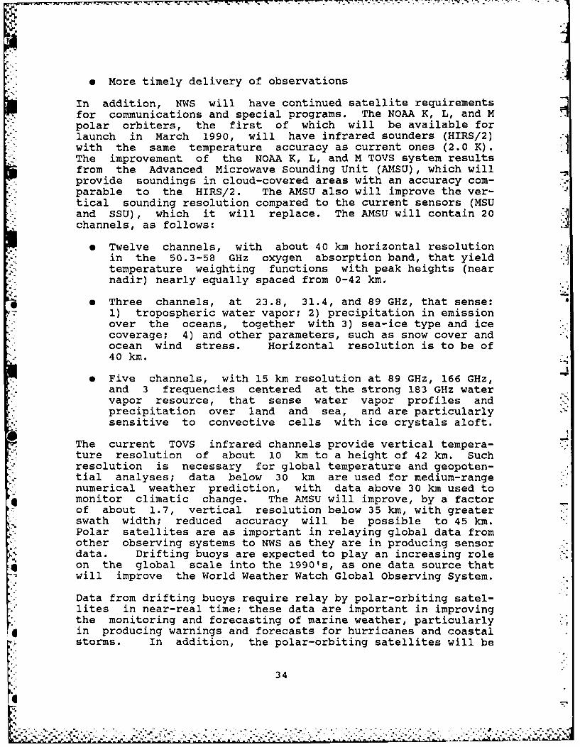
In addition, NWS will have continued satellite requirementsfor communications and special programs. The NOAA K, L, and Mpolar orbiters, the first of which will be available forlaunch in March 1990, will have infrared sounders (HIRS/2)with the same temperature accuracy as current ones (2.0 K).The improvement of the NOAA K, L, and M TOVS system resultsfrom the Advanced Microwave Sounding Unit (AMSU), which willprovide soundings in cloud-covered areas with an accuracy com-parable to the HIRS/2. The AMSU also will improve the ver- -
tical sounding resolution compared to the current sensors (MSUand SSU), which it will replace. The AMSU will contain 20channels, as follows:
Twelve channels, with about 40 km horizontal resolutionin the 50.3-58 GHz oxygen absorption band, that yield
temperature weighting functions with peak heights (nearnadir) nearly equally spaced from 0-42 km.
e Three channels, at 23.8, 31.4, and 89 GHz, that sense:1) tropospheric water vapor; 2) precipitation in emissionover the oceans, together with 3) sea-ice type and icecoverage; 4) and other parameters, such as snow cover andocean wind stress. Horizontal resolution is to be of40 km.
e Five channels, with 15 km resolution at 89 GHz, 166 GHz,and 3 frequencies centered at the strong 183 GHz watervapor resource, that sense water vapor profiles andprecipitation over land and sea, and are particularlysensitive to convective cells with ice crystals aloft.
. The current TOVS infrared channels provide vertical tempera-ture resolution of about 10 km to a height of 42 km. Suchresolution is necessary for global temperature and geopoten-tial analyses; data below 30 km are used for medium-rangenumerical weather prediction, with data above 30 km used to
* monitor climatic change. The AMSU will improve, by a factorof about 1.7, vertical resolution below 35 km, with greaterswath width; reduced accuracy will be possible to 45 km.Polar satellites are as important in relaying global data fromother observing systems to NWS as they are in producing sensordata. Drifting buoys are expected to play an increasing roleon the global scale into the 1990's, as one data source thatwill improve the World Weather Watch Global Observing System.
Data from drifting buoys require relay by polar-orbiting satel-lites in near-real time; these data are important in improvingthe monitoring and forecasting of marine weather, particularly
*in producing warnings and forecasts for hurricanes and coastalstorms. In addition, the polar-orbiting satellites will be
344.

able to receive, process, and retransmit data from other obser-vation platforms worldwide, such as free-floating balloons,moored buoys, and remote automatic observing stations, andwill be capable of tracking platforms in motion. DSB, AVHRR,APT, and HRPT capabilities, or their equivalents, will beprovided that have characteristics at least identical to thoseof the current satellites.
Other NWS programs served by the AMSU will include sea-ice* monitoring and forecasting. Three channels (31.4 GHz, 89.0
GHz, and 166.0 GHz) will provide data at 50 km horizontalresolution, with an accuracy of 10 percent in location.
e. NWS Requirements for Other Future Polar-Orbiting Satel-lites/Platforms. NASA research and development spacecraft
-- programs (e.g., Nimbus, Seasat) have shown that satelliteobservations can play an important role in providing data forboth the operational analysis of, and research on, oceanicconditions. Building on that satellite heritage, the NationalOceanic Satellite System (NOSS) was proposed as a limited
*operational demonstration to test the feasibility of obtainingmicrowave spectral interval measurements of surface windvelocity, sea surface temperature, significant wave height,sea ice conditions, current measurements, chlorophyll concen-tration, and other optical characteristics from a polar-orbit-ing satellite. Because of the ability of microwave sensors toeffect surface observation during cloudy conditions, microwavedata are expected to improve significantly the efficiency,
4 .safety, and effectiveness of marine transportation, offshoreexploration, platform operations, construction, and scientificknowledge of ocean surface dynamics.
_ [ Several of these sensors have now been flown in space, and ithas been demonstrated that they can be used as a part of the
w operational warning and forecast program of NWS. As a result,there is a requirement for an operational polar-orbitingsatellite/platform system that can provide information on thecharacteristics of the ocean surface.
3. Research Requirements
Hydrometeorological, oceanic, and NWS research applications ofsatellite data cover a wide range of NWS activities. Emphasiz-ing multiple uses of image and digital data, applied researchis aimed at a better understanding of atmospheric and oceanic. processes and improving NWS services. Satellite image dataare essential for case studies of severe storms, flash floods,and hurricanes. Specific digital parameters from satellitesounding systems, such as wind direction and speed and tempera-ture profiles, support forecast modeling research. Studies to
* improve measurement of ocean currents, ice, and sea surfacetemperatures are vital to routine weather prediction, the
35
.............................................

analysis of air-sea interaction, and ongoing climate change.
Over the next 15 years, NWS will need increased access todigital and infrared image data and rapid-scan data, improvedtime-sequence imagery, increased resolution of the geostation-ary infrared image data to 4 km, and access to ocean satellitedata and derived products. These data are required for de-veloping and testing interactive small-scale warning andforecast techniques and procedures. These techniques and pro-cedures would be transferred from research organizations tothe operational components of NWS.
The use of operational environmental satellites to carry re-search instruments, which provide research data, and/or collec-tion and data relay capabilities has proven to be cost effec-tive and is a basic requirement for successful research.Flight testing of prototypes for future operational instru-ments is essential for ensuring trouble-free operation in thefuture.
*°i a. NWS MeteoroloQical Satellite Research Program. Meteoro-logical research on small-scale processes during the nextdecade will require access to high-frequency (5- to 15-minute)satellite data on request. Such requests, in most cases, willbe related to meteorological conditions that are precursors to
*-.-. or associated with the development of severe convectivestorms, tornadoes, hurricanes, flash floods, and heavy snow-fall. The 13 channels on the VAS will provide detailed infor-mation of importance to operational forecasters throughout theNWS. More specific details may be found in the referencedocument entitled "Program Development Plan: Improving NOAAWeather Services Through More Effective Use of GOES RemoteSensing Capabilities," November 1982.
Current VAS satellite operations will continue to provide 5-to 30-minute multispectral imaging, hourly soundings, directreadout capabilities, navigational parameters, and digitaldata bases in support of applied hydrometeorological researchactivities.
Specific projects that will be developed in conjunction withresearch components throughout NOAA and have a high assuranceof coming to fruition within the ENVIROSAT-2000 period aredescribed in the following sections.
Joint Profiler-VAS Evaluations--Joint satellite/Profilersoundings are under active study to inprove the measurement ofatmospheric variables from satellites, especially in the loweraltitudes of the atmosphere. The Profiler acts as a benchmarkproviding accurate absolute values in joint profilinc. Theconcept now being studied envisions realistic spatial extrapo-lations of joint profiling products, since the satellite
36

sounder can measure the horizontal gradients of the temperatureand humidity between Profiler stations. This work is expectedto lead to operational mesoscale forecasts and forecastmodels, and improved synoptic-scale satellite observations oftemperature and humidity. Present and future research needsfor NOAA satellite products include all thermal soundings forthe continental U.S. and nearby oceanic areas, and all presentand future polar orbiter sounding products.
Mesoscale Analysis and Modeling--Studies to integrate Profiler,NEXRAD, and other data sources, and to apply them to mesoscaleevents and studies of atmospheric dynamics, require full reso-lution VAS and polar orbiter sounding data sets. Also, VASimaging products and derived polar orbiter sea surface tempera-ture products are required.
VISSR Atmospheric Sounder (VAS)--NWS requires continued assess-ment and development of VAS data and products during the period1985-87. VAS data delivery is required as follows:
9 Dwell soundings (a VAS-specific term) are being evaluatedat NMC and NHC for use in operational numerical weatheranalysis and forecast models. Vertical temperature andmoisture profiles derived over oceanic areas and VAS-derived fields will be entered into the models andevaluated with respect to their effect on both analysesand forecasts.
0 Multispectral imagery from the VAS instrument will pro-vide, at hourly intervals, measurements of thermodynamicstability and atmospheric humidity over selected areas ofthe United States. Derived stability indices and poten-tial thickness values will be used interactively andevaluated at the National Severe Storms Forecast Center(NSSFC) for forecasting the outbreak of severe convectivestorms.
" Individual imagery channels, such as the 6.7 m watervapor channel, and composite imagery will be evaluatedfor their utility in depicting atmospheric moisturefields and subsequently improving analysis and forecasttechniques for severe storm outbreaks and hurricanemovement. Composite imagery is being evaluated routinelyat NSSFC, and water vapor imagery is evaluated at allnational centers and WSFOs.
Program for Regional Observing and Forecasting Services(PROFS)--The Program for Regional Observing and ForecastingServices requires satellite data to support requirements anddesign efforts for an interactive system (AWIPS-90) designprototype. PROFS requirements for satellite data are shown inTable 111-4.
37
• °,

Table 111-4
PROFS Satellite rata Requfirents
Product Dcma n Frequency Map Base Resolutici Delay
Visible image Cont. U.S. 5 min Lambert 1 km I min
Infrared images Cont. U.s. 5 min Lambert 2 km 1 min(4 VAS channels)
VAS soundings Cont. U.S. 1 hour NA 10 km 10 min
Infrared images N. America 1 hour Polar 10 km
(2 VAS channels) (LFM) stereographic
Note: Navigation sild be 1 km RMS for all products.
4%..
38
. . . . . . . . .

b. NWS Oceanographic Satellite Research Needs. The need fortimely and accurate measurements of the marine environment hasincreased dramatically during the past decade. Analyses andprediction of oceanic and coastal conditions are essential forsupporting rapidly increasing maritime activities. The avail-ability of satellite data is of primary importance for improve-ments in derived ocean surface information from both polar-orbiting and geostationary satellites.
Future oceanic satellites equipped with various sensors willprovide a myriad of parameters needed by NWS. The sensors onthese satellites will be both active and passive, and willinclude:
9 Scatterometers that will provide global sea surface windfields and wave height information. This will enablescientists to study waves, wind driven ocean circulation,and interaction between the oceans and atmosphere.
e Altimeters that measure sea surface topography willprovide information on ocean currents and waves. Thealtimeters also will be used for determining ice sheetheights and ice boundaries.
e Ocean Color Instruments that will monitor chlorophyllconcentration. This information could be used by NWS to
*aid in the detection of water masses and eddies.
9 Radiometers that will provide all-weather global seasurface temperatures, ice age, rainfall rates, windspeed, and atmospheric water vapor content.
* Synthetic aperture radars that can resolve ice boundariesto the order of tens of meters. These high-resolutionice data can determine individual ice floes and theirmotions, which can impact navigation and mineralexploration.
The data derived from these instruments should help in re-search to improve the efficiency, safety, and effectiveness ofmarine transportation, offshore exploration, construction, andscientific knowledge of ocean surface dynamics. A partiallisting of derived parameters for oceanic climate research andprediction is given in Table 111-5.
c. Hydrological Research Program. The NWS Office of Hydrol-ogy (OH) requires weekly imagery for depictions of snowcoverage, water equivalence, soil moisture, plant vegetationmoisture, and wet areas at 50 km resolution. OH also requiresquantitative satellite-derived estimates of precipitation forradar research projects at a spatial resolution of 2-4 km at
L half-hourly intervals.
39
................. ....................
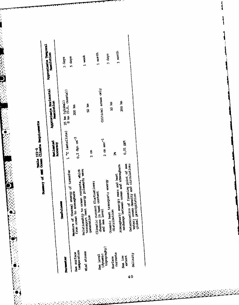
CDA.,4
io
t4:~ id
H u
*14
0

Other operational quantitative measurements include:
* Areas of flood inundation at 50 km resolution for select-ed river basins weekly
e Frozen ground areas at 2 km resolution weekly
e Forest-fire-burned areas at 50 km resolution within 2days of a fire
d. Long-Range Research Potential. Certain programs and acti-vities currently initiated or developing that have a long leadtime may affect NWS needs during the ENVIROSAT-2000 period.These activities will likely extend into the next century.They include Windsat, satellite-borne radars, the LightningMapper, and the possibility of geostationary microwave sen-sors, which offer potential for improved observations orproducts.
Windsat--An example of possible future NWS needs includes aconcept known as the wind satellite (Windsat). This concept,developed in the mid-1970's, is designed to measure globalwinds using IR Doppler lidar mounted on a polar-orbiting satel-lite, which would provide twice-daily input for NMC numericalguidance and would obtain a truer measure of atmospheric dynam-ics.
The Windsat concept uses aerosol backscatter from lidar toobtain profiles of wind speed, which are (theoretically, atleast) better indications of atmospheric dynamic conditionsthan are temperature profiles. These wind profiles also areheld to be superior to present-day winds derived from cloudmotions (which are limited in height and geographic distribu-tion) and temperature soundings in the tropics. Data fromground-based and airborne lidars are being evaluated as partof a plan for a global backscatter assessment. Cost considera-tions make testing of a satellite-borne lidar unlikely beforethe year 2000, but prototypes may need to be evaluated withinthe ENVIROSAT-2000 period.
Satellite-Borne Radars--Space-borne radar is regarded as anextension of the ground-based radar system for measuring rain-fall rates over land areas; it also would be the only sourceof this information over the oceans. Research studies at thepresent time envision an airborne meteorological radar, modi-fied to find the minimum detectable rain rates by path attenu-ation rather than reflectivity, to be used in designing a
* .satellite-borne sensor. Preliminary results show that thismethod works best directly beneath the aircraft subpointtrack, but there is the potential for further refinement.
In conjunction with these studies, a ground-based radar at
41
Fe.t X4'-.* '.~ ' '' - * .0 *j

Wallops Island, Virginia, is being modified to permit measure-ment of rainfall rate based on differential reflectivity,which will help serve as ground truth for airborne (and latersatellite-borne) radars. NWS has a requirement for improvingrainfall rate data via satellite sensors, and NESDIS should
* . continue to monitor developments in that area.
Space-Based Lightning Detectors--NWS is evaluating the useful-ness of lightning detection mapping systems. Current researchusing experimental ground- and aircraft-based sensors has sug-gested several potential uses of lightning mapping in severestorm monitoring and warning. A satellite-based lightningdetector would be able to cover ocean areas to enhance marineand aviation warning and forecast services, and it couldaugment (but not replace) a projected operational network of
* ground-based sensors.
'*. Lightning monitoring could be done on a large scale, permit-ting evaluation, for research and operations, of the relation-ship of lightning to storm development, growth rates, precipi-
S- tation, and wind fields. Present optical technology appearsto allow detection of lightning from geosynchronous altitudesduring daylight and darkness over nearly the full disk, with aspatial resolution of 10 by 10 km and a time resolution of1 Ms. Should such a space-based system be both accurate andcost effective, GOES-Next might supply the vehicle to providesuch information; however, further examination of space-basedlightning detection feasibililty and cost effectiveness isrequired.
Geostationary Microwave Sounding Sensor--Despite the substan-tial improvements expected with the GOES-Next sensors, the
problem of taking accurate sounding observations in cloudyareas will most certainly remain. NWS recognizes this problemas technologically and financially based. Every effort shouldbe made to remain aware and capitalize on potential break-throughs.
4. International Reguirements
Meteorology and oceanography represent two of the few sciencesin which cooperation on a global scale is a necessity ratherthan an option. The provision of observations around theglobe aids in specification of the atmosphere for predictionpurposes. Without these observations, trade and commerceperiodically would be subjected to unacceptable losses muchlike those experienced by shipping operations a century ago.
V.. In a wide variety of ways, these losses and inefficiencieswould translate into higher costs for goods either imported orproduced in the U.S.
Environmental satellites play an increasingly important role
42
* - . . . ... . * . * * * . . . .

in the provision of a large observational data base coveringoceanic areas. Included in that data base are imagery (visi-
ble, IR, and water vapor channels) and soundings. As in theU.S., the imagery is used in many different subjective ways,including the provision of marine, agricultural, and publicservices. Soundings are utilized by a few developed countriesto specify initial conditions for global and regional models.This trend is not expected to abate.
The World Meteorological Center's demand for sounding data mayeasily outstrip the ability to provide it at reasonable cost.Although numerical modelers have talked about having satellite
-> soundings over data-sparse ocean areas as frequently as eighttimes per day and at resolutions of 10 km, a more realisticsummary of overall global observational requirements (space-based and ground-based) has been developed by the WorkingGroup on the Global Observing System (GOS) of the Commissionfor Basic Systems (CBS) of the WMO. These results are summa-rized in Table 111-6 and represent a trend of global observingneeds.
A second category of requirements centers about the need to*: provide increased DCP capacity for observing systems such as
ASDAR, the Automated Shipboard Aerological Programme (ASAP),the Shipboard Environmental (Data) Acquisition System (SEAS),and data buoys. There is no question of the growth of theseprograms, but channel capacity or new technological approachesfor satellite communications should be explored.
S..* Satellite requirements currently are being formulated for theAWIPS-90 program. It is expected that data from the Geosta-tionary Meteorological Satellite (GMS), Meteosat, and polarsatellites will be required for NWS programs such as hurricaneforecasting and the issuance of marine and internationalaviation advisories.
5. Composite Satellite Data Requirements
Composite satellite data requirements of NWS are shown inTable 111-7.
.- .
|L
443
4~2.

4 N 4
0 in 4')
C'4 4l
~11§
V7 H
4'-44
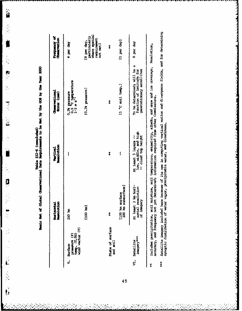
-4-.
roM
S i
0!-4 IVIIj 0
45j
"" 45

N.-H .4 -4 >1-
4J r-NA t
46D

4.j 4.J 4-; 4 41) 4-1(a0. it. to. 4* 0
IA I LAO LAO 'no U
(N 14 (N (N (N ( N
C)0
-44r
44
14 +1 +II -H +1 +1 C
1
44 4 1 ~
47

................................................... *4
4. ,\ -"4
-- '4 ".4
* -
--. 4 *44**
an4 1~ ~ -I
CJ~iu ii''4-',
ii
_ 411 1411_ an g-4 -4 (~
*i,,rn .~.
ii i~4- I"
4..,.
.1 1I
~
0.44 00 -~
0 ('4-4..44'
.1'
~ 4~4 *~
'44~ ~S '4. 444*4~4, I Ii ~ I *~ >4
I48
*1
- . . - . -4-.,
'-S - . . - . .
.. 44.4.. '4 *444
4~ #....!...SA~ a t-~ ~~pua

IV. SATELLITE REQUIREMENTS
OF THE
NATIONAL OCEAN SERVICE
449
. .. . . .

IV. SATELLITE REQUIREMENTS OF THENATIONAL OCEAN SERVICE
In the United States, the National Oceanic and AtmosphericAdministration (NOAA) is responsible for both weather andoceanographic services supporting a wide variety of users inboth the civilian and military sectors. The National Weather
i. t.Service (NWS) traditionally has focused the majority of itsefforts and resources on weather services for land-based users(the general public, aviation, agriculture, etc.) because themajority of the user requirements stem from land-'ased opera-tions. In November 1983, the Administrator of NOAA reorga-
_ nized the National Ocean Survey to become the National OceanService (NOS), and instructed it to provide integrated ser-
* -vices to mariners through activation of an Office of OceanServices and establishment of an Ocean Products Center (OPC)
• -and two prototype Ocean Service Centers (OSCs), in Seattle,Washington, and Anchorage, Alaska.
Under contract to NOAA, the Jet Propulsion Laboratory (JPL)published an "Ocean Services User Needs Assessment" (JPLPublication 84-19, April 5, 1984), which details ocean ser-vices requirements for various user communities and NOAA's
- present capabilities to satisfy these requirements. Thisassessment clearly revealed that more and better observationsare needed from ocean areas to support generation of the manyproducts required by marine user groups. Because of theremote nature of the areas to be observed and the scarcity ofsurface observation platforms, it is obvious that satelliteremote-sensing technology will have to be applied to thisproblem. In addition, satellites offer unusual opportunities
tin the areas of international ocean data exchange, nationaland international marine broadcasts, and data collection fromautomatic surface stations on ships, buoys, offshore plat-
:. ~ forms, islands, and remote headlands.
The purpose of this document is to summarize NOS requirementsfor satellite data, products, and services for support tousers until the year 2000. The contents are based in largepart on a review and analysis of JPL Publication 84-19 (parti-cularly chapters 5 and 6).
A. BACKGROUND
1. Status of the Requirements
Most requirements stated here have been under development forsome time. They are dictated by the oceanic observation anddata handling requirements needed to meet the NOS mission.
EThey represent projections of future ocean user requirements,next-generation geostationary and polar orbiter satellite
51
-.*. . . . .
v-.--...-.

plans (including special-purpose oceanographic satellites),and the requirements to deliver raw oceanographic observationsand ocean guidance products to NOS and NWS offices, other coun-tries, and some end users. These requirements draw heavily onnational needs coordinated with the U.S. Navy and its NavyRemote Ocean Sensing System (N-ROSS) program.
a. Atmosphere-Ocean Coupling. In assembling systems todescribe the variability of the oceans and atmosphere,NOAA/NOS finds it important to treat the oceans and the atmos-phere as mutually dependent, coupled, fluid media, even thoughthe precise nature of that coupling remains to be determinedfully. The requirement to couple atmosphere and ocean models,in general, can be related both to the types and attributes ofthe models, modeling objectives (such as forecast length orgeographical domain), and system constraints. Historically,atmospheric model outputs have been used to drive oceanograph-ic models. Only in recent times has much thought been appliedto the introduction of time-varying oceanographic model out-puts to be fed back into atmospheric models.
Correct specification of the time-varying winds in the atmos-pheric boundary layer over a water surface plays an importantrole in many oceanographic models, such as spectral sea state,ocean currents, ice drift, water levels, and ocean thermalstructure. The boundary layer winds explain a large fractionof the observed variability in these parameters. When an icemodel has to account for growth and decay in addition todrift, air-ocean heat exchange has to be specified. Thelatter also is needed as an input to ocean thermal structuremodels.
b. Coupling Models of Varying Attributes. Even though _NOAA/NOS places emphasis on describing the variability ofmarine weather and oceanographic conditions in the coastalzone, successful realization of this objective will not beachieved without taking a global perspective. Long periodswell that affects offshore platforms, for example, may appearto be a local phenomenon, but the source of the swell may bethousands of miles distant.
The design and operational implementation of fine-mesh modelsfor the coastal zone, therefore, presume the availability oftime-dependent lateral boundary conditions from a model ofcomparable, if not identical, type whose domain is muchlarger, i.e., hemispheric or global in extent. In short, theoceans do not lend themselves to arbitrary partitioning interms of local, regional, or global aspects.
c. Optimal Data Utilization. Although additional convention-al observations can be taken in ocean areas, especially re-gions with few or no such observations, the validity of most
52
........................,- ,...

oceanographic products will depend, in large measure, on 1)the design and use of more advanced satellites and sensorsystems and 2) the development of innovative methods to fullyutilize satellite-sensed measurements of ocean state para-meters. As in the acquisition of temperature profiles of theatmosphere over the oceans, there is no economically feasible
..-. alternative. If broad advances are not made using remotelysensed information, they probably will not be made at all.
Global and regional sea surface temperature analyses alreadyS-: benefit from large numbers of multi-channel sea surface
- temperature (MCSST) observations. On a typical day, about50,000 MCSST observations are generated over the world'soceans. This is to be compared to the 5,000 ship reportsreceived daily. The prediction of sea state, ocean currents,and ocean thermal structure has been improved by betterpredictions of ocean-area atmospheric pressure systems andassociated marine-level winds, as a consequence of havinglarge numbers of satellite temperature retrievals and
- cloud-track wind vectors available for the analyses of the* atmosphere over oceanic areas.
Future satellite sensors may be capable of measuring addi-i tional ocean properties. Remotely sensed altimeter data will
present new modeling opportunities of the oceans. Some of thev >sensors, such as the synthetic aperture radar, will severely
tax available communications and data processing capabilities.
2. NOS Mission
"* Satellite data requirements within NOS result from specificresponsibilities set by NOAA. As part of the NOAA reorgani-
* . zation of November 1983 (DOC Organization Order 25-5B), NOSwas directed to: 1) establish requirements for ocean observa-tions, and 2) coordinate ocean service programs throughoutNOAA. Foremost among NOAA/NOS/NWS goals requiring satellite
. idata are:
e Provision of accurate and timely marine and coastalweather forecasts to reduce loss of life and advance the
* - national economy
, Provision of accurate and timely oceanographic forecasts.. of sea state, ocean currents, ocean thermal structure,
tides and water levels, sea ice, vessel superstructureicing, etc.
, Provision of oceanic data in support of ocean research,climate studies, pollution monitoring, and value-addedservices to marine users
53SI
- * * .5..N3

3. Areas of Special Importance to NOS
NOAA needs for wider access to imagery, and increased numbersand quality of atmospheric soundings, have been stressed inthe previous chapter by the National Weather Service. NOSconcurs with these needs and believes they are particularlyimportant over ocean areas. In addition, NOS has uniquerequirements for observation of parameters not so commonlyused in the provision of "meteorological" services. Some ofthese parameters are surface wind stress, sea state, subsur-face thermal structure, water topography, currents, watercolor, and turbidity. The specialized measurement require-ments that can be met by satellite sensor systems will besummarized in later sections of this chapter.
As part of a new Integrated Ocean Observation Program involv-ing a diverse variety of sensor systems and platforms, NOS isplanning a mix of new surface observation systems to be inter-rogated by satellites using Data Collection Platform (DCP)technology. Consequently, NOS has a rapidly expanding require-ment for Data Collection System (DCS) communications supportcapabilities on U.S. satellites to retrieve and forwardobservations from systems such as:
* Manual-entry Shipboard Environmental (Data) AcquisitionSystems (SEAS)
* Semiautomatic SEAS installations, including ExpendableBathythermograph (XBT) launchers, recorders, and digi-tizers
* Operational drifting buoys
* Coastal-Marine Automated Network (C-MAN) stations
e Small anchored coastal buoys
e Automated Water Level Measurement Systems (WLMS) for tidedata
To handle these new observations, NOS requires that all U.S.geostationary and polar orbiter satellites have DCS communi-cations capabilities and are configured to operate in both"self-timed" and "special interrogation" modes. It also isessential that Argos-type positioning be available to permitfurther automation of report generation for moving platformssuch as ships and drifting buoys.
During the period covered by this document, a worldwide in-crease in the sharing of valuable oceanographic observationsis a certainty. NOS is particularly interested in the rapidreceipt of observations from foreign ships, buoys, and planned
54

- European/Japanese oceanographic satellites. Full use of the33 international channels on U.S. Geostationary OperationalEnvironmental Satellites (GOES) for exchange of oceanographicdata will be required.
As more products become available from the newly implementedOcean Products Center, NOS foresees a growing requirement tobroadcast these products directly to ocean users using GOESweather facsimile (WEFAX) technology. Before the year 2000,it is anticipated that as many as 40 ocean products per daywill be added to GOES-WEFAX transmissions. Primary users forthese broadcast products will be:
-* . Offshore oil and gas industry
e Ocean transportation industry
o Ocean mining industries
. Commercial fishing industry
6 Construction and support industries
e Private forecasting and value-added service industries
* Climate community
e Sea grant and academic institutions
o NOAA activities
e U.S. Navy activities
P e Foreign countries
NOS also has special in-house requirements for sea surfacealtimetry, ice topography, and gravimetry measurements insupport of Charting and Geodetic Services (C&GS), and forwater color/composition measurements in support of MarineAssessment and Coastal Resource Management programs. Thesecan be partially met by existing satellite technology and areincluded in subsequent requirements tables.
B. OCEAN USER REQUIREMENTS
, The major user groups identified previously have differentrequirements for satellite data and ancillary services such as
, surface platform interrogation, satellite broadcasts, andsatellite data relay. In some cases, the users require raw
' satellite observations (or observations relayed by satellites" i from other collection systems). In other cases, the end user
55|1

requires an analysis of forecasts based upon satellite andother observations.
Table IV-i presents an overview of ocean user requirements forsatellite data (observations or products) and ancillary
. services. The table is stratified by general satellite typeand shows in a quantitative manner the scope of each require-ment (major, moderate, minor, or no/little importance to theuser segment). For the polar orbiter satellites (weather oroceanographic), the requirement is foremost for data orservices from U.S. spacecraft; however, the basic needs alsoapply to information from foreign environmental satellites.NOS is especially interested in receiving oceanographicobservations from planned European and Japanese systems and,therefore, requires international data relay capabilities onall GOES systems.
It is essential that future U.S. polar orbiter and geosta-tionary satellites have DCS communications capabilities. NOSis planning major expansions in its SEAS/XBT combination and
* its automatic WLMS. In order to eliminate manual input of aship's position into SEAS/XBT reports, and to speed up theprocessing of drifting buoy reports and oil slick tracking, itis important that all future U.S. DCS systems include provi-sions for position location.
The stated NOS requirements for images and soundings from allU.S. systems are essentially the same as those specified byNWS. They are included in Table IV-I to emphasize the impor-tance of those observations to marine user applications; de-tailed specifications are not repeated in the NOS CompositeData Requirements tables at the end of this chapter becausethey are given in earlier NWS tables.
C. NOS OPERATIONAL REQUIREMENTS
1. Geostationary Satellite Data Products and Services
a. Images and Soundings. The requirements specified by NWSfor images and vertical soundings of temperature and moisturefrom the Visible and Infrared Spin-Scan Radiometer (VISSR)Atmospheric Sounder (VAS) and any follow-on sensors on GOESand GOES-Next satellites parallel NOS requirements for suchobservations. NOS requires the soundings, cloud motion winds,and sea surface temperatures from VAS to the extent theyimprove initial analyses (and subsequent numerical forecasts)
* :of meteorological parameters over ocean areas. NOS also has arequirement for full-disk imagery from the Central DataDistribution Facility (CDDF) to be dispersed to major OceanService Centers (OSCs) for regional analysis and interpreta-tion directly supporting marine users.
56

Table IV- ISatellite Data and Services
LU
LUiL
pC1.
SATELLITE > LTYPE A
L/) Go cc LU)- 0 U t-- L
-D L'. Z 0 /J0D _ j - ) 0_ Z ~ .- ,.. LU I
DATA , L z -
OR CDSERVICE LA_ ," w
U LU w D ) C.D UoD 0> 0) LU . LU Lf)
GEOSTATIONARY
o Images
o Soundings
o OCS Data Services
-SEAS/XBT
-WLMS I ( D (- Buoys
-Platforms/Headlands * ) • * O i 0o WEFAX Broadcast Services
-Images
-Marine Weather Charts * * * * O
- Oceanographic Charts * * * * O
o Ocean Data Relay Services 0 0 (a) (3 0 @POLAR ORBITER (MARINE WEATHER)
o Images 0 a O
o Soundings 000000030o Sea Surface Temp. ~C )0 * ((3 3 (D ] • • • 1 •
MAJOR MODERATE T MINOR
K "57

Table IV- I (continued)Satellite Data and Services
V) < L
SATELLITE <TYPE
- () 0 V 0 L
cC I U_ U~ C-
DATA w L-OR 0 - -
SERVICE w U IE <LJ_ L.) L.) CD C) Uj CD
ooo 0 0 0)I) L )(I(I Z
o Ice
o Wind Stress 1 3 ( 3 3 0 0 3o DCS Data Services
-SEAS/XBT ~~
-WLMS-Buoys I () 1
- Platforms/Headlands O 3 0 0 3 ' 1o DCS Locator Services
-SEAS/XBT Ships 3 0 3 0 0 1 , 3-Drifting Buoys ( 0 I 0 ( R S
POLAR ORBITER (OCEANOG)
olImages3 3 3 3 3 0o Soundings 1@ 0 ' ".
ooo°,~ ,,(I T (I) 0 (I) ( 0 3)o Sea Surface Temp. 0 @ :0 @o Ilce T 1 3 0o Waves*e e eeo Surface Winds
* ~ ~~ oOcean Topography 0 ~ 0 0* MAOR 3 MODERATE MINOR
58

Table IV-= (concluded)Satellite Data and Services
SATELLITE m <- m > ,TYPE C ). .
0- C U- - Uj
K.0 tQ- CF U-
LDATA ,
%: "SERVICE Ln X: V) X-: <. - 1/ Z C .1/) Z /0- w w X~ C L -
U- U- L.L CD C) 0
OR 0 ) CD- U-
0 0 0 0 0 0) i-
o Air/Ocean Heat Exchange 03 (0 (3 0 C) C) 0 (3l *o Color/Chlorophyll (D ( 0 0 0 0 (Do Turbidity0 04 ((D( 0 3o DCS Data Services
-SEAS/XBT (3 0 0 0 ) ( 0I- -WLMS (R300
-Buoys *))001 .: 3
- Platforms/Headlands*(0 0 R0o DCS Locator Services
-SEAS/XBTuShips (0 ( ) 0 1 O 0-Drifting Buoys (30 0 0 0 0 (3 *-Oil Slick Transponders 0 0 0 0 (1) 0 0
1
MAJOR MODERATE MINOR 0 NONE 0
59
4.:

*L- -_7 -k K- .
NWS requirements for derived digital, imagery, and analog datafrom the VAS all fully satisfy NOS needs for processed datafrom this type of sensor system. NOS is particularlyinterested in semiobjective hurricane classification methodsand marine cloud and weather analysis messages.
b. Data Collection System (DCS) Services. Subject to budgetconstraints, NOS is planning a major expansion in its OceanData Collection Program in the next 5 years. Preliminaryplans call for new surface-based ocean observation initia-tives, as follows:
1 100 manual-entry SEAS per year
* 80 semiautomatic SEAS systems equipped with XBT launchersand recorders per year
, 40 drifting buoys in operation at all times
e 10 new C-MAN stations per year0
- 4 new coastal buoys per year
e 375 automated WLMS, for tide and other site-significantmarine measurements, in operation by 1990
In addition, NOS is investigating Shipboard Acoustic DopplerProfilers, Automated Shipboard Aerological Programme (ASAP)radiosonde launchers, Expendable Current Profilers (XCPs), andExpendable Conductivity/Temperature/Depth (XCTD) Profilers.All of these new measurement systems are being designed toexploit DCP communications technology. These programs projecta DCS communications requirement for GOES and/or polar orbitersatellites to handle at least 1,420 new ocean-oriented DCPinstallations by 1990; this figure does not include any in-creases planned by the NOAA Data Buoy Center (NDBC) for large,moored-buoy installations.
c. GOES-WEFAX Services. Under the auspices of the WMO, theUnited States is responsible for marine broadcasts for its
assigned area. NOAA/NWS currently disseminates processedsatellite images, meteorological charts, and alphanumericproducts via an S-band, GOES-WEFAX service. WEFAX broadcastsare now acquired at approximately 160 locations (57 by foreigngovernments, 23 by the U.S. Government, and 80 by academic,commercial, and amateur stations). As the NOAA Ocean ProductsCenter reaches full operation, it is expected to contribute upto 40 new ocean products per day to the daily WEFAX broadcastschedule. These products include:
e Sea state analysis and forecast guidance charts
r2 60
iOd
I - ' - + * t i : i - ' t i: '' ,': J~l , l" ',: " : ':.': " :.-, ,
. .
-', * Current charts
j e Ocean thermal structure (surface and subsurface) analysischarts
* Ocean color charts
e Water level anomaly charts
It is conceivable that the U.S may be required to activate anew GOES broadcast channel (OCEANFAX) in the future to handlethese products. It is probable that new GOES broadcast re-ceiver stations will be activated within the marine user commu-nity. Candidates include:
i Commercial fisheries associations
e Major harbormaster offices
e Shipping company offices
e Private ocean forecast service companies
o Sea grant institutions
* " 2. Polar-Orbiting Weather Satellite Products and Services
The NOAA polar-orbiting satellites are designed primarily to- provide data in support of numerical weather prediction
models. However, the imagery also has high value in deter-mining the extent of polar and Great Lakes ice cover, as wellas water surface temperatures.
a. Images. NOS concurs with the NWS requirements stated forday and night cloud detection from U.S. polar orbiter weathersatellites: cloud mapping/typing, jetstream identification,storm detection, differential cloud motion, etc. The AdvancedVery High Resolution Radiometer (AVHRR) on NOAA's TIROS seriessatisfies NOS requirements for imagery. NOS is particularlyinterested in high-resolution (I km) broadcast in real timevia the High Resolution Picture Transmission (HRPT) system.One of the most critical problems in support of small boat(under 35 feet) commercial fishermen is accurate predictionand warning of small-scale severe weather phenomenaapproaching the coast (6-12 hour advisories are usually
Ssufficient).
b. Soundings. NWS requirements for all-weather soundingsfrom the TIROS Operational Vertical Sounder (TOVS) and thenext-generation Advanced Microwave Sounding Unit (AMSU) do not
L satisfy NOS needs for atmospheric sounding from ocean areas.Neither sounder is capable of observing the detailed vertical
61.b

.1 7 V -7- - . -
variation of the mass structure in the marine boundary layer(MBL). Thus, diagnostic MBL models cannot compute the marinewind or the vertical flux of horizontal momentum--both ofwhich are of critical importance to oceanographic prediction
..-i' models, especially spectral sea state models. New sensorsand/or processing algorithms will be required to satisfy thisNOS requirement. NOS strongly endorses the stated requirementfor at least two polar orbiter weather satellites to meetcoverage and timeliness limits for global soundings.
c. Sea Surface Temperatures. Providing environmental informa-tion to the U.S. commercial fishing industry to help it remaincompetitive with foreign fishing fleets is an important NOSgoal. Recent studies have shown clearly that certain fishspecies have strong preferences for specific ocean temperatureranges; for example, most albacore tuna are caught within afew degrees of 62 OF, and salmon are seldom caught at tem-peratures much warmer than 52 OF. Sea surface temperature(SST) analyses and anomalies also are critical to the climate
.A:,community. The NOS open-ocean requirements for scale-* representative SST are +1.0 °C with a horizontal resolution
of 10 km for daily analysis; the requirements for coastalzones and inland waters are more exacting. It appears thatthe AVHRR instrument can meet accuracy requirements but mayhave difficulty in satisfying resolution requirements forlocal SST analysis.
d. Ice Measurements. Studies of commercial user requirementsreveal that accurate descriptions and specifications of seaice characteristics are particularly important to offshore oiland gas industries operating in the Arctic area, and to oceantransportation and offshore construction and support indus-tries serving Arctic oil and gas operations. U.S. commercialfishing fleets in the Alaska area frequently fish along theedges of the Bering Sea ice fields and also need accuratedescriptions of ice extent and movement.
The Navy/NOAA Joint Ice Center (JIC) in Suitland, Maryland, isthe nation's primary user of polar orbiter AVHRR data foranalyzing ice conditions in the Arctic and Antarctic polarareas and the Great Lakes. Accurate ice descriptions also arecritical to shipping operations on the Great Lakes and the St.Lawrence Seaway.
W NWS requirements for sea ice extent shown in the NWS CompositeData Requirements tables do not fully address ice characteris-tics requirements needed by NOS; however, detailed require-ments are presented in NOS Composite Data Requirementstables. It is doubtful if the polar orbiter weather satel-lites, as now planned, can satisfy these needs. (See latersections of this chapter for discussions concerning sensor
62
45

systems on planned polar orbiter oceanographic satellites.)
In particular, the JIC needs access to active all-weathersatellite sensing capabilities and coarse-resolution, passivemicrowave sensors. While present ground processing systemsare limiting, it is likely that high-resolution syntheticaperture radar (SAR) information will become extremely usefulwhen NOAA's ground processing facilities are substantiallyupgraded.
e. Data Collection System (DCS) Services. NOAA polar orbiter>1. weather satellites carry a data collection and platform loca-
tion system. As specified previously, NOS is planning atleast 1,420 new ocean-oriented DCP installations by the year1990, and DCS capabilities are essential to the success of the
- NOS integrated Ocean Data Collection Program.
3. Polar Orbiter Oceanographic Satellite Products andServices
Although the Seasat satellite clearly demonstrated the utilityof dedicated polar orbiter oceanographic satellites with sen-sors specifically designed for oceanographic measurements, theU.S. does not have such a system at the present time. TheU.S. Navy's N-ROSS is planned for launch in 1990. However, NOSrequirements for oceanographic satellite products and servicesstated in the following sections remain to be met.
* .a. Sea Surface Temperature. Sea surface temperature (SST) isa key oceanic parameter to be measured by oceanographic satel-
* 'lites. NOS requirements for accuracy, resolution, and fre-Squency of coverage were given earlier in this chapter. The
NOAA Ocean Products Center is developing new global SST analy-IJ. sis models that blend SST observations from all sources, in-cluding satellites, ships, buoys, XBT systems, CTD systems,and aircraft radiometers. For regional commercial fisheriesapplications, however, the emphasis is on fine-mesh localanalyses capable of showing SST microstructure (e.g., localcurrent shear and frontal zones where nutrients are mostlikely to concentrate).
Because of the lack of temperature profiles of the oceans, andthe difficulty of inferring thermal structure at depth from
- surface temperature information, there is a compelling needfor a new type of satellite-borne sensor (perhaps the blue-
-.green laser) to obtain upper-ocean temperature information.It is not feasible to obtain such data coverage with surfaceplatforms and expendable bathythermographs. Failing this typeof development, the enormous disparity in the numbers of sur-
--. face and subsurface temperature observations will increaserapidly with time.
63*J .:
- . . . * *,. * .* *. . . .

For climate studies, the emphasis is on global or hemisphericSST analyses and sea surface temperature anomalies (SSTAs)from long-term normals. Since SSTA fields have normal annualranges of about 0.5 °C to 2.0 °C (an average of about1.0 °C) and SST measurement accuracies should be aboutone-fourth of the monthly variation to be studied, climatespecialists would prefer a measurement accuracy of 0.25 °C.(Note: This is even higher than specified earlier in thisreport.)
Climate researchers believe a 3-day temporal resolution cycleis sufficient. Albacore fishermen working the early seasontuna migration across the North Pacific Transition Zone preferdaily hemispheric analysis to pin down the location of the60 OF to 64 F band.
b. Wind Stress and/or Surface Winds. Surface wind stress isthe major driving force in the generation of ocean waves andin the maintenance of ocean currents. Currents, in turn, playa major role in meridional transport of heat, while wavescause mechanical mixing that influences the depth of the uppermixed layer in the ocean. The mixed layer depth (MLD) isimportant to climate researchers because it is related toocean heat storage and to fishermen because certain speciesprefer to feed within or below the thermocline, especially atnight.
General Circulation Model (GCM) designers have developetypical accuracy requirements for wind stress of 0.2 dyn/cmwith spatial and temporal resolution requirements of 200 kmand 5 days. U.S. Navy verification studies on theirstate-of-the-art Spectral Ocean Wave Model (SOWM) reveal that
*such models will not yield results any better than the windfields that drive the model. Consequently, the Navy has foundit very important to specify the surface wind field every 3hours. NOS Composite Data Requirements tables, therefore,specify an absolute accuracy of ±10 degrees in wind directionand +0.5 m/s in speed for boundary layer winds with spatialand temporal resolutions of 5 km and 3 hours, respectively,for regional problems.
The scatterometer on the Seasat satellite clearly demonstratedthe utility of surface wind measurements from remote sensors.It is essential that the directional ambiguity problem is re-solved before satellite winds are input to marine wind analy-sis models.
c. Ocean Waves. Assessments of user needs for ocean servicesrevealed that analyses and forecasts of ocean waves (sea andswell) were the most important requirements overall. Seastate is the most important factor in Optimum Track Ship Rout-
* ing (OTSR). It is critical to deep ocean mining industries
64

during mining string deployment/retrieval and ore transferoperations. It also determines whether small boat fishermencan operate with safety and frequently controls offshore con-struction and support operations.
While measurement of significant wave height (H-1/3) is theprimary requirement, some oceanic applications such as shiprouting and hull structure design ideally require specifi-cation of the wave energy spectrum as a function of bothfrequency and direction. NOS composite data requirements
• "specify a maximum significant wave height accuracy of +0.5 m,- - with horizontal and temporal resolution of 5 km and 3 hours
for regional applications.
The altimeter and the SAR flown on Seasat demonstrated theutility of wave observations from spacecraft. It is essentialthat U.S. polar orbiter oceanographic satellites be equippedwith wave measurement systems. At least two such satellitesare recommended to approach the required coverage.
d. Sea Surface Topography. Measurements of the dynamic0 height of the ocean surface are useful because the shapes are
proportional to speeds in the large-scale current systems ofthe world. These currents are major factors in meridionalheat transport and exchange; fluctuations in their intensityare keys to the monitoring of climate changes. Topographymeasurements also are useful in bathymetric mapping of sea-mounts. Climate researchers interested primarily in thefluctuations in major current systems specify accuracy re-quirements of +2 cm, with space and time resolutions of 50 kmand 1 week, respectively.
* e. Tides. Users of NOS tide data primarily are interested incombined astronomical/storm-driven water levels at coastallocations. Because of local variability due to bathymetry andland/sea topographic boundaries, NOS intends to focus on satel-lite DCS interrogation of automatic tide guage stations in itsWLMS program. It also happens that water level measurementsites are strategic locations for measuring other significantmarine-weather variables, such as coastal winds and air andwater temperatures. It is essential that future U.S. oceano-graphic satellites have a DCP capability to retrieve thesedata. Specified NOS tide measurement accuracies are +5 cm.
f. Ocean Currents. While major current systems and theirchanges probably can be monitored through measurement of thesea surface topography, marine users also are interested in
" - mesoscale eddies with horizontal dimensions of several hundredkilometers and life cycles of about 60 days. These eddies maybe colder or warmer than the surrounding waters and exhibit
*, dynamic height anomalies on the order of 50 cm. They areimportant to fishermen because certain parts of the eddies are
65

characterized by concentrations of nutrients (fish food).
NOS believes that smaller scale ocean currents also can bemonitored by satellite. For the smallest features, specifiedaccuracies are ±1 cm/s for speed and 10 degrees for direction,with horizontal resolutions of 1 to 10 km and temporal resolu-tion of 6 to 24 hours, depending on the size of the feature.
NOS also is investigating the use of Expendable CurrentProfilers (XCP) to measure surface and subsurface currentstructure. These systems require weather and oceanographicsatellites to have data collection and position locationsystems.
g. Sea Ice. Sea ice is an important consideration in climateand General Circulation Model (GCM) studies. NWS hasspecified a requirement for sea ice extent measurements forthese purposes, with horizontal resolutions of 15 to 50 km andrevisit cycles of 3 days.
For operational support of ocean user activities such asArctic oil and gas exploration, operations, and shipping, itis not sufficient to know only the extent. These sophisti-cated users require the following ice information:
9 Ice edge limits
e Sea ice age (density)
e Sea ice thickness
, Sea ice percent coverage
0e Ridge density/height/orientation
e Percentage/location of floebergs, growlers, and icebergs
While most polar orbiter weather satellites have an icemeasurement capability, the altimeter and Synthetic ApertureRadar on Seasat clearly demonstrated the superiority of thesesensors in making special ice measurements. Overall icemeasurement requirements are listed in Composite Data Require-ments tables at the end of this chapter.
It is important to NOS and the Joint Ice Center that ice datafrom Canadian and European satellites are received in the U.S.on a routine schedule.
h. Water Color/Chlorophyll Concentration. During a recentNASA/NOAA Fisheries Demonstration Project off the west coastof the United States, it was found that processed informationfrom the Nimbus-7 Coastal Zone Color Scanner (CZCS) was very
66
-N -a

useful in pinpointing optimum fishing areas. A number ofdifferent species tend to congregate at locations exhibitingthe maximum horizontal contrast between deep blue oceanicwater and upwelled, light green coastal water. Fishermen whofirst sought the optimum thermal band for a particular speciesand then found the best color contrast within the thermalband, and who fished inside the thermocline, brought in thelargest catches (particularly for albacore tuna).
To support U.S. commercial fisheries needs, water color/chlo-rophyll concentration charts must be prepared for all coastalareas--preferably out to at least 500 nm--several times a weekso as to reflect constantly changing conditions. While theCZCS provides valuable data, the coverage is limited tocloudless days, and the amount of computer processing requiredis prohibitive except for high-priority areas. These problemsneed to be solved before future operational ocean colorimagers are deployed.
A NOS composite data requirements for water color/chlorophyllconcentration specify an absolute accuracy of +30 percent (inmg/L), with spatial and temporal resolutions of 1 km and 24hours, respectively, for regional/local mapping.
i. Turbidity. Turbidity measurements are used formonitoring pollution and river discharges in coastal waters,and also have been useful to commercial fishermen seeking mud
* bottom dwelling species. Both visual radiometers and the CZCSsensors have proven capabilities for turbidity measurements.
NOS composite data requiremen~s specify absolute accuracies of+30 to 40 percent (in g/m ), with horizontal resolution of
* 1 km and a revisit cycle of 12 hours. Coastal areas out to500 km are most important.
j. Surface Salinity. Salinity determines the freezing pointof seawater and its vertical density structure (stability).Because salinity is largely controlled by the differencebetween evaporation and precipitation, or river discharges, itis considered an important indicator of climatic conditions.NWS has specified an observational accuracy of 0.01 ppt(judged by NOS to be very high), with a horizontal resolution
~ of 200 km and a temporal resolution of 1 month. Should satel-lite-borne salinity sensors become a reality, NOS could acceptan observational accuracy of 0.5 ppt, 200 km, and 1 month
ai
for global analyses. For monitoring coastal changes in sur-face salinity, such as outside bays and river mouths, NOSrequires spatial and temporal resolution on the order of0.2 ppt, 10 km, and 3 days.
£k. Surface Heat Exchancfe. Researchers have a need to knowthe air-sea temperature difference or surface heat exchange
67
I I I*

- uY Y- _m' J.
patterns--preferably on a global scale--for climate studiesand numerical forecast model work. NOS as specified heatexchange measurement accuracies of +50 W/m with spatial andtemporal resolutions of 50 km and 12 hours.
4. Oceanographic Satellite Capabilities of Interest to NOS
The NOS oceanographic satellite measurement requirements werediscussed earlier in this chapter. There are a number ofcurrent and planned U.S. satellites capable of satisfyingmajor portions of these overall requirements. Table IV-2 indi-cates the extent to which the most important ocean parametersof interest to NOS can be measured. Table IV-3, from the samesource, provides a more detailed summary of the capabilitiesplanned for the N-ROSS satellite. This system will go a longway toward meeting NOS requirements for oceanographic data
*[ from spacecraft in the foreseeable future.
Table IV-4 presents a summary of foreign satellites andplanned sensor systems of interest to NOS because of their
* oceanographic measurement capabilities. Considering the* uncertainties in procurement of U.S. oceanographic satellite"-. systems, it is essential that the U.S. makes firm plans for
exchange and receipt of data from foreign systems.
D. COMPOSITE DATA REQUIREMENTS SUMMARY
Requirements for cloud imagery and atmospheric measurementsfrom geostationary and polar-orbiting satellites specified byNWS are generally satisfactory for NOS application and,therefore, are not readdressed in this chapter. Requirementsfor observations and ancillary services that are primarilyoceanographic in nature are specified in Tables IV-5, IV-6,and IV-7.
68.- .* *..-.
* .- * * *.°*

¢,
II0 0
je IO!
x-v
..- K4 ,+ K , ,
,, m
0
-~~~1 a _ _ ~ ' - - " -
.o 0
w w v4 0
0.. ', ®0 • .. ...
I u v 2- 0 , * - z
'4J w H I 0 ' " . 39j 0 u0
I4 -A
___ " '. L ;; t '; o I _"_ ,. 3 .4,.-- E F l- 0 4,
54" i::: 1... . ..4o,
,4 '.9
0J

0~~' 0
-v, .- 4 .
co 4 4
cl1
ul 00
140
-I... ,,
41
00 00
N N
0-0'r. 0 r0
000
t~. -A L-nl
-, 0 V
JO. CL WV (
07
o 44 -,
",- 0"
-. 4)4)l O 04 .
.4)o o - 0
o _
iU,
,'. , - . , ' - I, .
-". .c'' 7
", ' ., ,"/ " " ': , ". '- ", X "? . -., .2,' -" - " ." ." " " \ " ." '" ' '- - -r , " _ -. '.' '. . -', . . " - -'/ -- .. --" ' - " . .. • • ' -
"'. " . ' - - • -"

th >
0-3
4) )4:4 -4)
En U)04
0* ___ ___ __ ___ ___ __ ___ ___ ___ __ ___ __CA_
4)0
*n 14 F- x
(D w
00 GO F. -C A Ea0 0 0 a
0
14)
u~ z
- OOA ra O4 0 0
cw 0d -z 0 -4zWzI
-1 0 wuV 93. u w 0 0l 0 nCAt4: w.J CL Ad 0c a. Q 0 w-a co -
XCT] F-C 040" 00 O~ 0 0
caa LJ
u Uj
0 0 z 40. r~ ~ <
(A (n LC V
F- F-I
-4 4: C) 4:71

S I
II
t t t . I
-~ ~ -,• "- i I iI "
S-,7
U -.- T

H P H44 11
~I D
I NNr.-4
_ I I In N
44 44 4 4
I~ I I8N
IM73

1LI110 10
I iii8 H ' t-4 0I~' rqC 0~ r-4 0 ~
WI-44 H H H- - 0t
o 00
0 ,4H00 o
*1I144.J H74

A 44 4 4 1-4 14 K
r-4 4
Ii4 114
* 4175 -

-. 90
1~41
~~ L,.
LC4
I1I i.76

V. SATELLITE REQUIREMENTS
OF THE
" OFFICE OF OCEANIC AND ATMOSPHERIC RESEARCH
L
I'7
I,
I '.
w ,, -7 7

V. SATELLITE DATA REQUIREMENTS OF THEOFFICE OF OCEANIC AND ATMOSPHERIC RESEARCH
Oceanic and atmospheric processes traditionally have beeninvestigated by sampling from instruments in situ, which yieldquantitative measurements that are intermittent in both timeand space. Over the last several decades, satellite sensors
K have been developed that have yielded important new measure-ments in these four dimensions. The need to obtain propersampling of input quantities in existing or proposed analyti-cal and numerical models is probably the most significantlimitation on the advancement of our physical understanding ofatmospheric and oceanic processes. It is generally recognizedthat satellite sensors offer an important advancement inglobal measuring techniques when used in conjunction withground-based measurements.
Measurements from present satellites have demonstrated theirusefulness. For example, NASA research and development space-
craft (Seasat and Nimbus) and the NOAA operational spacecraft(GOES and POES) have shown that satellite measurements canplay an important role for both operational analysis andresearch on the lower atmosphere, oceans, and near-Earth spaceenvironment. However, additional research is needed to ensurethat future sensors are based on new technology and not ontechnology developed in the 1970's, when many of the currentsatellite sensors were designed. This research would ensurethat the limitations of the existing satellite sensors wouldbe addressed.
The need for frequent and accurate measurements of the ocean,atmosphere, and near-Earth space environment has increaseddramatically during the last decade. The purpose of thepresent report is to specify the requirements for futuresatellite sensors. These requirements have been evolvingwithin NOAA over the last 10 to 20 years.
a. The future satellite requirements of the Office of Oceanic andAtmospheric Research (OAR) cover a wide range of needs, fromocean and atmosphere research to operational spaceenvironmental services. Satellite sensing of the oceans andatmosphere offers a unique opportunity both for global
* -observations needed as input to geophysical models and for theresearch needed to improve these models. Satellite sensing ofthe near-Earth space environment is needed for serviceactivities, including monitoring reports, issuing alerts, andforecasting solar-terrestrial events.
For understanding the global weather and climate systems, no* measurements are more important than winds and tropical
79
.~~~~~~~.~~ a * * 4 . . . . . . . . . . .

precipitation. Satellite sensors for providing wind profiles(e.g., Windsat) in conjunction with ground-based systems andfor providing quantitative estimates of tropical precipita-tion, especially over the oceans, should be given highestpriority in planning for the year 2000.
A similarly broad, generic approach to global biological andchemical processes should be taken, and priority should beplaced on a satellite sensor such as the Ocean Color Instru-ment (OCI) that will provide information on oceanic biomassand its changes. This approach should yield invaluable datafor productivity and fisheries investigations and, if newhypotheses are correct, should indicate changes in the biologi-cal controls mediating many global tropospheric chemical reac-tions and exchanges with the ocean.
A. FUTURE APPLIED RESEARCH REQUIREMENTS
1. Atmosphere
0 Remote sensing plays an integral role in meteorological fieldexperiments. Over the past two decades, these experimentshave evolved into complex programs involving numerous re-searchers and many resources as investigators face the need tostudy weather on increasingly finer time and space scales.Satellites are extremely important platforms for research,sensing various meteorological parameters on space and timescales not possible with conventional systems. For example,in many instances the synoptic scale rawinsonde network andthe climatological gauge network are not sufficiently densenor do they acquire measurements frequently enough to documentthe phenomena of interest. Remote sensors on geostationarysatellites fill the data gap between ground-based networks andaircraft observing systems. The former are sparse networksand usually provide infrequent measurements; the latter pro-vide finely resolved observations, but over narrow paths andonly on special occasions. Satellites bridge the gap, makefrequent and routine observations, and serve as a vital mediumfor communications and data transmissions for field experi-ments.
The process of numerical weather prediction classically isviewed as an "initial value problem," wherein the governing
Vr equations of geophysical fluid dynamics are integrated forwardfrom determined values of the meteorological field at someinitial time. Solving this "initial value problem" is verydifficult, given the properties of geophysical fluids, thecomplexities of atmospheric processes, and the nonlinearity ofthe equations. Even if the mathematical equations were solv-
ro able, half of the problem would remain, that is, the diffi-culty of accurately determining from real observations of the
80
*1>.

real atmosphere the initial values of many time-dependentquantities.
Ideally, observations should specify values for each parameterat the initial time, t = 0. This ideal case is never real-ized, for several reasons:
e Conventional pressure, temperature, and wind observationstaken at synoptic times, 0000 GMT and 1200 GMT, are inade-quately sampled globally, leaving geographic holes in theinput data.
e Conventional observations are subject to significant ran-dom instrument errors.
e Remote satellite observations of vertical temperature pro-Ile files go a long way toward providing a homogeneous global
coverage. These observations are not synoptic, however,but are distributed in space and time following the
* -satellite orbit.
a Remote satellite observations of cloud motion from geosta-tionary satellites, used to infer winds, are available atsynoptic times, but the vertical resolution, limited toone or two levels, is grossly inadequate.
e * Indirect satellite observations always involve physicalassumptions and sophisticated data processing for recon-structing the meteorological parameters.
Future weather satellite programs must be carefully planned,so that these problems can be addressed properly.
2. Oceans
There is a variety of satellite observations that, if avail-able continuously over several years and reduced to a formdesigned for research use, would supply a needed data set fornumerical and analytical ocean models. These models are impor-tant for providing a detailed description of ocean parameters
* - and, hence, a better understanding of ocean physical pro-cesses.
Models of various types are becoming increasingly powerfultools by which diverse observations of the ocean are tied to-gether. A number of models, based on the equations of motion,address the general circulation in the world's oceans. Thegoal of these models is to determine the circulation, heatcontent, horizontal heat flux, and variability of the oceans,which are important for both marine weather and climatestudies.
81
i*1

For example, a general circulation model normally assumesfields of surface wind stress, surface temperature, and netprecipitation minus evaporation. The model predicts meanfields of subsurface temperature, salinity, and velocity, to-gether with sea level and surface heat flux. Varying the in-puts allows the model to be used to determine the sensitivityof the ocean to variations in parameters. If the mathematical
K-, models are solvable, half the problem still remains, as withthe atmosphere; that is, obtaining accurate input parametersfrom observations of the real ocean. Therefore, future marineweather and climate programs also must be carefully planned,so that the proper satellite sensor inputs are obtainable forthe different ocean models.
3. Space Environment
OAR/Environmental Research Laboratories (ERL) space environ-ment services are provided to the public, corporations, andvarious entities of the Federal Government. Historically,NASA and DOD have been the agencies most heavily dependent onthe products of the Space Environment Services Center (SESC).The SESC continuously monitors and predicts the solar activitythat leads to Earth events in the upper atmosphere, themagnetosphere, and the ionosphere that affect communications,
'- electric power systems, air and marine navigation, and Earthsatellite functions.
The Solar-Terrestrial Program of ERL's Space Environment Lab(SEL) is unique in OAR, since it contains both research andservices; the major user of the research is the services com-ponent. Because of the currently primitive state of spaceweather service, such close liaison is essential in developingmore sophisticated predictive techniques. To better under-stand the physical processes causing the disruptive eventsreported by SESC, guidance must be given to the service com-ponent from research models. Such models are constructed fromreal-time data provided by SESC from space and ground-basedmonitors. These data are augmented with data sets acquired bysatellite sensors that are off line from strictly serviceuses. Thus, SEL satellite data requirements for the next 15years are not solely for utilization in environment services,but also are the R&D investment for developing the servicestechniques needed by the year 2000.
B. REQUIREMENTS OF FUTURE SATELLITE SENSORS
1. Atmospheric Sensors
The age of remote sensing in the field of meteorology beganwith the launch of the first Television and Infrared Obser-vation Satellite (TIROS) on April 1, 1960. From this begin-ning, which provided only simple black and white photos of
82

clouds, satellite observations have come to include data fromscanning radiometers operating in the visible, infrared, andmicrowave segments of the spectrum. Their resolutions havebeen improved both spatially and temporally, and their dataare used to measure or infer a number of atmospheric para-meters, such as winds at multiple levels, Earth albedo, sur-
N .face precipitation, and the vertical distributions of tempera-ture and moisture.
i -Remote sensing of the atmosphere has many roles to fulfill inthe wide variety of space and time scales that represent thecurrent state of atmospheric research. Observationalrequirements for problems that relate to climate can generallybe fulfilled by polar-orbiting satellites (precipitation isone exception, because of its diurnal variation, even overopen ocean), whereas phenomena that change more rapidly (e.g.,convective systems of all scales) require observation fromgeostationary platforms.
a. Mesoscale Convective Systems. OAR scientists have made
major discoveries in the field of mesoscale meteorology, andOAR will be one of the principal players in the Storm-scale
. .Operational and Research Meteorology (STORM) program. Measure-.. -ments of the dynamic, thermodynamic, and microphysical proper-
ties of mesoscale convective systems are needed for both phe-nomenological and numerical modeling studies of these systems.In addition to the visible, infrared, and moisture channel
* pictures that historically have been available from weathersatellites, the parameters needed to investigate mesoscalesystems and are amenable to remote observation are as follows:
* Surface temperaturee Vertical temperature profilese Vertical moisture profileso Vertical profiles of boundary layer windso Vertical profiles of winds above the boundary layere Precipitation occurrenceo Precipitation rateo Lower tropospheric moisture gradientse Cloud top heights and temperatureso Precipitation type (rain versus hail)e Total ozonee Soil moisture
*Present satellite sounding configurations are limited to clearair soundings. Requirements for sounding retrievals fromcloudy regions exist as well. Table V-1 gives detailed obser-vational requirements for these parameters.
b. Numerical Weather Prediction. The utilization of satel-*' lite data in numerical weather prediction has two aspects,
model initialization and verification of model results. The
83

effects on model performance of using satellite measurementsof atmospheric parameters to fill data-sparse or data-voidareas is under investigation. The utility of satellite-inferred precipitation for verifying models is yet to bedetermined.
A fertile area of research is the concern with the meshing ofground-based and satellite-based observations. For example,is it possible to create a vertical temperature profile,useful in numerical models, from ground-based Profilers andthe satellite soundings?
The parameters that satellites can provide for model initiali-zation include:
* Vertical temperature profilese Vertical wind profilese Vertical moisture profiles* Cloud top heights* Precipitation
Table V-2 gives detailed observational requirements for theseparameters.
2. Ocean Sensors
In 1978, the low-orbiting satellite, Seasat, was flown withfour active and passive microwave sensors dedicated to oceano-graphic measurements. The active microwave instruments were:a radio scatterometer used for measuring winds; a radio alti-meter used for measuring ocean wave heights and the oceangeoid (from which geostrophic currents can be calculated); andthe Synthetic Aperture Radar (SAR) used for measuring oceanwaves, fronts, mesoscale eddies, and ice boundaries. Thefourth sensor was the Scanning Multichannel Microwave Radi-
-' ometer (SMMR) used for measuring sea surface temperature andmonitoring sea ice conditions. These sensors demonstrated thefeasibility of real-time satellite measurement of surfacewinds, ocean currents, and wave heights based on scatterometerand altimeter data. Further research is needed before themicrowave radiometers and synthetic aperture radars can beused continuously for operational needs. Within the next 5 to10 years, a new series of satellites is planned, dedicated tooceanographic measurements. These satellites include:
e N-ROSS, approved for launch in 1990, with active andpassive microwave sensors aboard. This U.S. Navy space-craft will carry sensors similar to Seasat, except synthe-tic aperture radar will not be included.
* ERS-I, approved for launch in late 1989, with active andpassive sensors aboard. This European Space Agency (ESA)
84

spacecraft will carry sensors similar to Seasat,including dual mode synthetic aperture radar.
e TOPEX, proposed for launch in 1990, with an advancedradio altimeter designed to measure sea surface elevationto within a few centimeters. In addition to the advancedaltimeter, this NASA spacecraft will carry an experimen-tal Global Positioning System (GPS).
The future requirements for ocean observations have been deter-mined primarily by considering the results from the Seasat sen-sors. These Seasat sensors and other proposed sensors can pro-
* vide important new information for numerous ocean programswithin OAR, including climate research, marine resources andservices, marine operational and prediction services, andmarine assessment research and services.
a. Climate Research. The tropical ocean is likely the mostdominant element affecting interannual climate variations.
* Indeed, the Tropical Ocean Global Atmosphere (TOGA) programhas shown that causal relationships do exist between large-scale changes in the tropical ocean thermal structure andmajor atmospheric flow patterns. The required inputs for theclimate models being developed in the TOGA program can mosteasily be obtained from satellite sensors. These parametersare:
e Sea surface temperaturee Surface wind velocity* Precipitationo Surface topography (geostropic currents)9 Cloud coverp o Liquid water and ice content
Table V-3 gives more detailed data requirements for climatestudies.
" b. Marine Resources Research and Services. OAR develops andtransfers scientific information to support decisions perti-nent to marine pollution, exploitation of marine resources,
* water utilization, coastal power generation, and otheractivities affecting marine ecosystems. Research activitiesfocus on coastal regions, estuaries, and the Great Lakes.
* Satellite sensors are useful for observing the ice, snow, andmoisture in and near the Great Lakes and Alaska. The datarequired in these areas are as follows:
o Ice extento Ice thicknesso * Ice albedo
L * Ice surface temperatureo Ice concentration
85
L- .-

e Snow cover extente Snow cover moisture equivalente Soil moisture* Aquatic plant biomass
Table V-4 gives the detailed data requirements for the ice,snow, and moisture measurements.
c. Marine Observations and Prediction. This research im-proves the capability of providing services to the marinecommunity through increased understanding and improved obser-vations of the behavior of the atmospheric boundary layer overthe oceans, the waves and currents in the surface layer, andthe physical properties of the surface and subsurface watersof the oceans. Observations in which the global all-weathercoverage by satellite sensors can be used effectively are asfollows:
9 Surface winds* Surface wavese * Storm surge* Hurricanese Sea surface temperaturee Ocean currents- Ocean color/chlorophyll
Storm surges and hurricanes are natural phenomena that, be-cause of the destructive environments surrounding them, canbest be observed remotely by satellites. Table V-5 gives de-
- . tailed data requirements for the observable ocean parameters.
d. Data Transmission and Verification. The transmittal ofresearch and operational ocean data via satellite has been aservice since about 1970. Many environmental research pro-grams rely on the GOES geostationary spacecraft for datatransmission from sensor platforms in remote locations and forverification that the platform sensors are working properly.Expansion of these services is essential to numerous researchprograms. Table V-6 gives the requirements for the existingdata transmission system.
3. Space Environment Sensors
The primary causes of all space environment disturbances arefound at the sun. Various forms of solar activity startchains of events that cause reactive processes at the Earth,ultimately leading to disturbances in systems important tohumankind. It is the mandate of the ERL/SEL Space EnvironmentServices Center to monitor the links in such chains and, in sodoing, to predict the terrestrial effects.
Because of the primitive state of space environment services,
86
N-'a-

predictions of the terrestrial effects of observed solarevents often cannot be made with certitude. While it isimpossible today to specify the complete solar-terrestriallinkage in terms of systems of physical laws and equationsthat connect events in the interior of the sun to Earth
*-. events, some limited correlative segments of this process are:- ~predictable with proper input data.
NOAA is required to provide the necessary data sets of thosesolar physical parameters for which service use can be made.As with meteorological forecasting, a tradeoff must be madebetween lengthening the lead time of a prediction and:-" : increasing its reliability. For the typical mix of SESC
.-. customers with varying needs, long-range crude predictionsmust be provided along with more accurate short-term alerts.
With changes in the state of the art, opportunities occasional-ly present themselves for improvements on one front or theother--either in accuracy or in lead time--and must be ex-ploited. NOAA must avail itself of opportunities for improv-
Sing the products of the ERL/SEL space weather services betweennow and the year 2000.
Specific sensing needs, required over the next 15 years by theSEL, have been listed in Table V-7. In this list, the samenatural phenomenon may appear more than once. Rather than dup-lications, these multiple appearances are aimed at gainingdata sets that help provide either short-term reliable fore-casts or longer lead-time predictions of the gross aspects ofcoming events.
4 . a. Geostationary Orbit Requirements. Fully sunlit spacecraft
in geostationary orbits must be used for remote sensing of the• sun, to detect the incipient solar wind, and to measure the
other space environment parameters requiring near-continuousmonitoring. Geostationary vehicles also provide in situ moni-toring of their local environments and carry ionospheric radio
*beacons.
* Solar remote sensing includes observing the parameters offlares, coronal mass ejections, and radio bursts at thesurface of the sun.
, Incipient solar wind remote sensing includes detectingcoronal mass ejections carried on the incipient solarwind.
e Geostationary environment (in situ) sensing includesmeasuring plasma, particle, and field parameters at the
- satellite's location.
87
V .+..,. . .. .+ . .+ , ..

e Radio beacon support provides the means for ionospherictotal electron content determinations and observing theirlongitudinal variations.
b. Polar Orbit Requirements. Polar-orbiting spacecraft arerequired for remote sensing of the polar caps of the Earth,for in situ monitoring over the polar regions, and for carry-ing ionospheric radio beacons. Polar orbiters representeconomical vehicles for the remote sensing of those solarparameters not requiring high cadence rates.
9 Polar cap remote sensing includes auroral imaging.
e Polar orbit environment (in situ) sensing includesmeasuring plasma, particle, and field parameters alongthe satellite's orbital path.
o Radio beacon support provides the means for ionospherictotal electron content determinations and observing theirlatitudinal variations.
e Solar remote sensing includes observing sunspots,magnetohydrodynamic flows, filament disappearances, EUVflux, X-ray coronal holes, and vector solar magneticfields.
c. Libration Point Sensor. Ambient conditions iY the solarwind must be monitored by a vehicle at the L librationpoint before encountering the Earth's magnetosphere.
* Solar wind (in situ) sensing includes measuring plasma,particle, and field parameters at the satellite's loca-tion.
d. Platform Items for Common Usage. Generic features thatwould serve all NOAA organizations are as follows:
. Advanced data collection systems, used for retrieval ofremote data caches
• Quick-reaction pad (reserve power and space on the satel-lite), used for instrument development and state-of-the-art breakthroughs (Table V-8)
64
88
.. . . . . . . . . . .
. .-.. ,. ...-....-.-..-..-.....-... ....-...... .. ..... ...........--.- .- .- ---.-.-.-. -,.

Iz z
c 0 0 0 0 0 0 00 0
lb N- lb4
4 I- 1-
I .- 4in i
0 0pd
-4 -in14~
'1 89
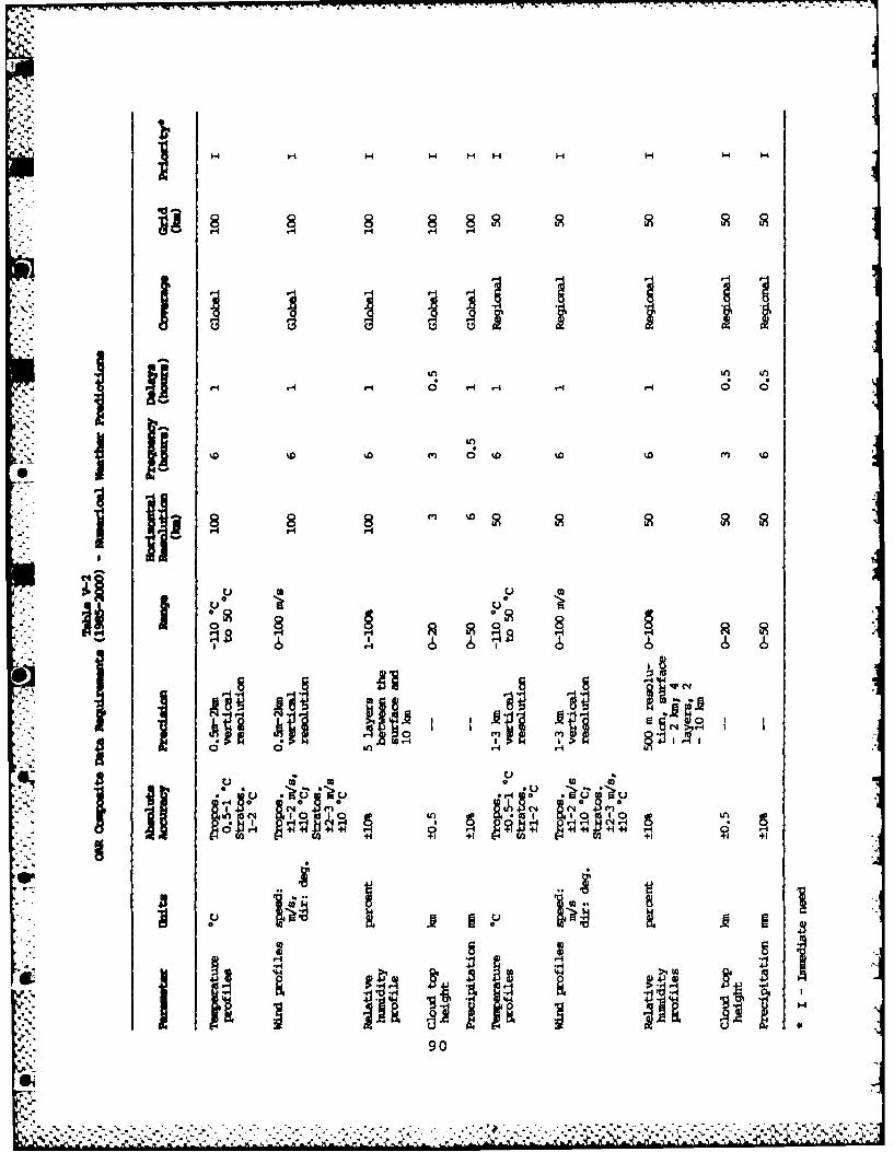
fAf- fl
ma I.
H1 H HH + H 04 0
* aq
U U90

* 0 0 0
I I
0 Iin r-
H IN
H 14
91

I -Al6.5 244 NOAR SATELLITE REQUIREMENTS FORECASTCU) NATIONAL 2/2ENVIRONMENTAL SATELLITE DATA AND INFORMATION SERVICEWASHINGTON DC D COTTER ET AL. MAY 85
UNCLASSIFIED F/G 2212 NL"
I7.IIIIIIIIIIII/
IIIIIIIIIIIIII

.1111 1.0111I.2
14 111112.
MICROCOPY RESOLUTION TEST CHART-41 IA A I l FAll Ofl STANIIARLD> 19H A

-4
14 0 2:
(aI(N N N N ( 92(

R8
4 8 R n
I It 'I . noL
N. 8N (W* 0 (N Ow I (N
* -4 *-
1-4 p. 93

Table V-6OAR Data Transmission and Verification Requirements
GOES TemporaryScientific Transmission Uplink/ Platform Position DataProgress Interval Downlink Positioning Accuracy Storage
Climate 12 h Yes/Yes Yes 1 km Yes
Marineservices 12 h Yes/Yes Yes 1 km Yes
Event-activated Yes/Yes Yes 1 km Yes
Marineassessment 12 h Yes/Yes Yes 1 km Yes
*Event-activated Yes/Yes Yes 1 km Yes
,. 9
,'-','.94
0~ .

vII
% 95

~rrr vrv v r rr'? .- n-. -r-v .- '.- - W .4 . - -' -T - T: - WV (V 477. -Cv ---- 7 W' Z9 R~'
-St
H H H H H
* -4.-4 44
*'96

H H -1 HH
I0 1 19 19
en~ H
0 H +1+
at14 U) OP doH
~~1 Cj
97

.C44
1-4 Z ~ H H- m
I- 1
-4 -4 -4
8n v
01 - rl, +1
.- 4~i r-I- -
C144
IA oI m tI
-4 c.- 4 0~ dP >
49 2 oc'~ e.98
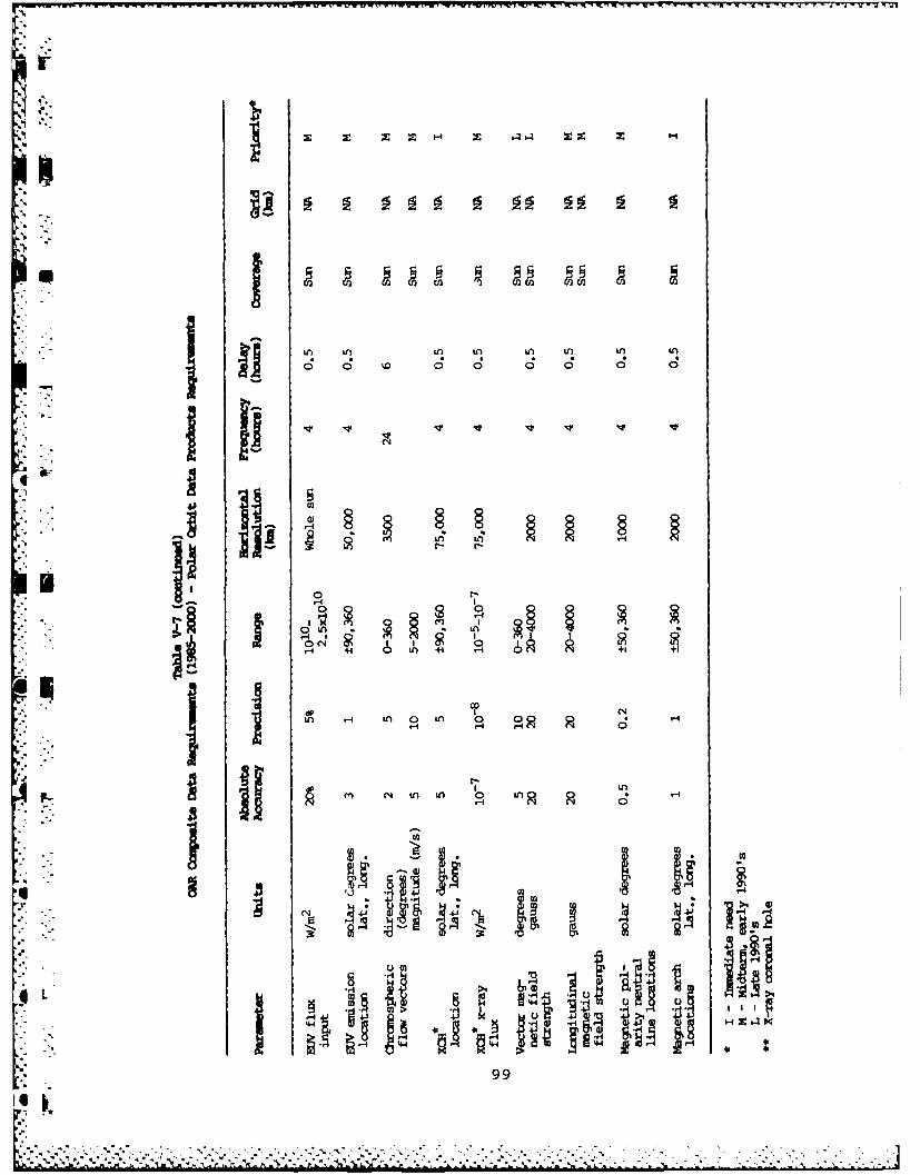
In n i n IA W! I
j IJ0 C .9 0 0 0 0 0
0.n
(S n +1 1 1 +
II I m 14 toIA 0 IA 0
4L hj
99L..

44B
U ~ ~ ~ ~ ~ -*.C; '4 '4 -.
0 0 0 0in0 0
c .4 1 . .
0 0to0 0 0w
H H 0)
0,100

- IWI- 4
al
.0.
4-
101

VI. SATELLITE REQUIREMENTS
OF THE
NATIONAL MARINE FISHERIES SERVICE
1
01
103

VI. SATELLITE REQUIREMENTS OF THE
NATIONAL MARINE FISHERIES SERVICE
Satellite remote sensing of the oceans is becoming increas-"' ingly important to fishery management and research. Varia-
tions in oceanic conditions cause fluctuations in the recruit-ment, distribution, abundance, and harvest of fish stocks. Tounderstand and eventually predict these fluctuations, synopticinformation on the ocean environment, rather than the mean oraverage conditions, is needed. Satellite measurements ofocean environmental parameters, combined with conventionaldata collection techniques, provides a method for obtainingthe synoptic information required.
A. APPLICATIONS OF SATELLITE DATA
The use of satellite remote sensing in oceanography has ex-panded considerably in recent years. The National Marine
* Fisheries Service (NMFS) has adapted the technology forJ applications in operational and research programs.
At the Southeast Fisheries Center, Seasat-A scatterometer datawere used to compute wind-induced surface currents and todelineate areas of upwelling and downwelling. This informa-tion is valuable in determining the direction of transport offish eggs and larvae. Shrimp, for example, spawn offshore anddepend on currents to transport their eggs and larvae intoestuarine nursery grounds where the shrimp mature. If surfacecurrents are moving offshore during peak spawning periods, thenumber of shrimp entering the estuaries will be reduced andthe fishery adversely impacted. Refinement of this technique
*. will provide a valuable tool for forecasting recruitment andyields of shrimp and other species dependent on this transportmechanism.
The Southeast Center uses data from the Coastal Zone ColorScanner (CZCS) to detect and map areas of hypoxia in thenorthern Gulf of Mexico. Hypoxia, an environmental conditioncharacterized by bottom water oxygen concentrations near zero,is not well understood and occurs frequently in the northernGulf. Location of areas of hypoxia is important to fisheriesbecause waters with low oxygen content will support few, ifany, shrimp or finfish, and may block the normal migrationpatterns of these animals.
Additionally, the Southeast Center uses satellite data trans-mission links to relay fishery and environmental survey datafrom survey ships to data users. Daily transmissions ofsurvey data are made from the ships to shore-based computers
* through the Applications Technology Satellite (ATS-3) andthrough portable Argos transmitters. The data are summarized
105
@1"

wl
on charts and distributed weekly to fishermen, fishing associa-
tions, State fishery management organizations, and others forvarious applications.
The ATS system also was used by fishery scientists participa-ting in the Antarctic Marine Ecosystem Research at theIce-Edge Zone (AMERIEZ) program to study physical andbiological processes active during the retreat of the iceedge. Fisheries scientists received NASA/Goddardnear-real-time ice maps derived from Nimbus-7 microwave data.The maps were sent to research vessels by means of the ATSsystem. In return, the scientists at sea transmitted winddata to NASA/Goddard for use in analyzing changes in icecover.
At the Southwest Fisheries Center, CZCS and AVHRR data areused to produce charts showing the location of ocean colorboundaries or fronts. These charts are used widely by tunafishermen to locate favorable areas for fishing. Studies atthe center have shown that the tuna tend to concentrate in thewarm, bluish oceanic waters along the fronts. Very few or notuna are found in the cooler, greenish coastal waters. Recent-ly, the satellite information has been particularly useful inlocating fish. Because of the abnormal warming of oceanwaters resulting from the El Nino phenomenon, many fish stockswere displaced northward from their usual habitats. Thesatellite data provided the information required to locate theareas to which the fish migrated.
The CZCS imagery also is used by the Southwest Center todescribe ocean processes related to the spawning of northernanchovy. Imagery was collected coincident with fine-gridoceanographic ship observations. Preliminary results indicatethat anchovy avoid areas of low chlorophyll concentrations,presumably because of insufficient food availability.Additionally, CZCS data are being used to investigate thedistribution and abundance of juvenile salmon off theOregon-Washington coast.
The Northeast Fisheries Center has joined with a community ofFederal, State, and private users of remote-sensing data toform the Northeast Area Remote Sensing System (NEARSS) Associ-ation. The association focuses on solutions to the problems ofmember institutions in acquiring and using, efficiently andeconomically, remote-sensing data and data analysis tech-niques. Through contributions from these institutions, aregional net for distribution of the analog satellite imagestransmitted by NOAA over the GOES-Tap has been established.
The long-term NEARSS goal is to obtain near-real-time accessto full-resolution digital data from NOAA's polar-orbitingsatellites.
106
L' -- ,-WV-
The Coastal Habitat Assessment Research Mensuration (CHARM)Program at the Northeast Center is designed to respond to thenational goal of zero net loss of wetlands productivity.
-- Wetlands provide and support habitats suitable as spawning,nursery, and feeding areas for 96 percent of the commercialfisheries and 50 percent of the recreational catch. Theapproach is to use Landsat data to provide a uniform format toclassify and monitor wetlands, and to integrate the results todetermine the effects on fisheries.
Satellite infrared imagery also is used by the NortheastCenter to delineate the areas affected by sediment plumes fromthe Chesapeake, Delaware, and Raritan Bays. The plumes con-tain biostimulants, contaminants, and other materials that canhave an effect on fishery resources.
The remote-sensing activities at the National Marine FisheriesService are designed to improve the management and utilizationof coastal fishery resources. Remote-sensing data, in conjunc-
* . tion with traditional data bases, have provided a valuabletool for describing broad ocean area physical processes thatmay affect fishery resources. As the data flow from satelliteocean sensors increases over the next few years, NMFS will con-
.-- [tinue to develop new techniques that can be used to incorpo-rate these data into operational and research programs.
B. REQUIREMENTS
Fisheries applications require satellite data on all measur-able oceanographic environmental parameters, with particularemphasis on sea surface temperature, surface currents, andocean color. The need exists for real-time and archived dataon these parameters for the entire U.S. Exclusive Economic
: ,Zone (EEZ), as well as those open ocean areas of importance toU.S. tuna fishing activities and marine mammal migrations.These data are required in studies to:
S.
e Improve the efficiency of commercial fishing vesseloperations
e Relate the dynamics of ocean currents and fronts to fishabundance, availability, and behavior
- Improve estimates of primary productivity and fish yieldem
- Determine migration patterns of highly mobile species(tuna, billfish, and marine mammals)
- e Predict fish stock availability
• Improve fish harvesting
107
@1 w
%%° -- Pj.. m.x _

e Measure loss of spawning habitat and monitor changes in
wetland use
Improve resource assessments
0 Improve fishery conservation and management techniques
o Chart areas of polluted waters or areas of adverse envi-ronmental conditions that may affect fishery resources
* NMFS satellite data requirements are shown on Table VI-l.
* -
I "
I.
108
-VA
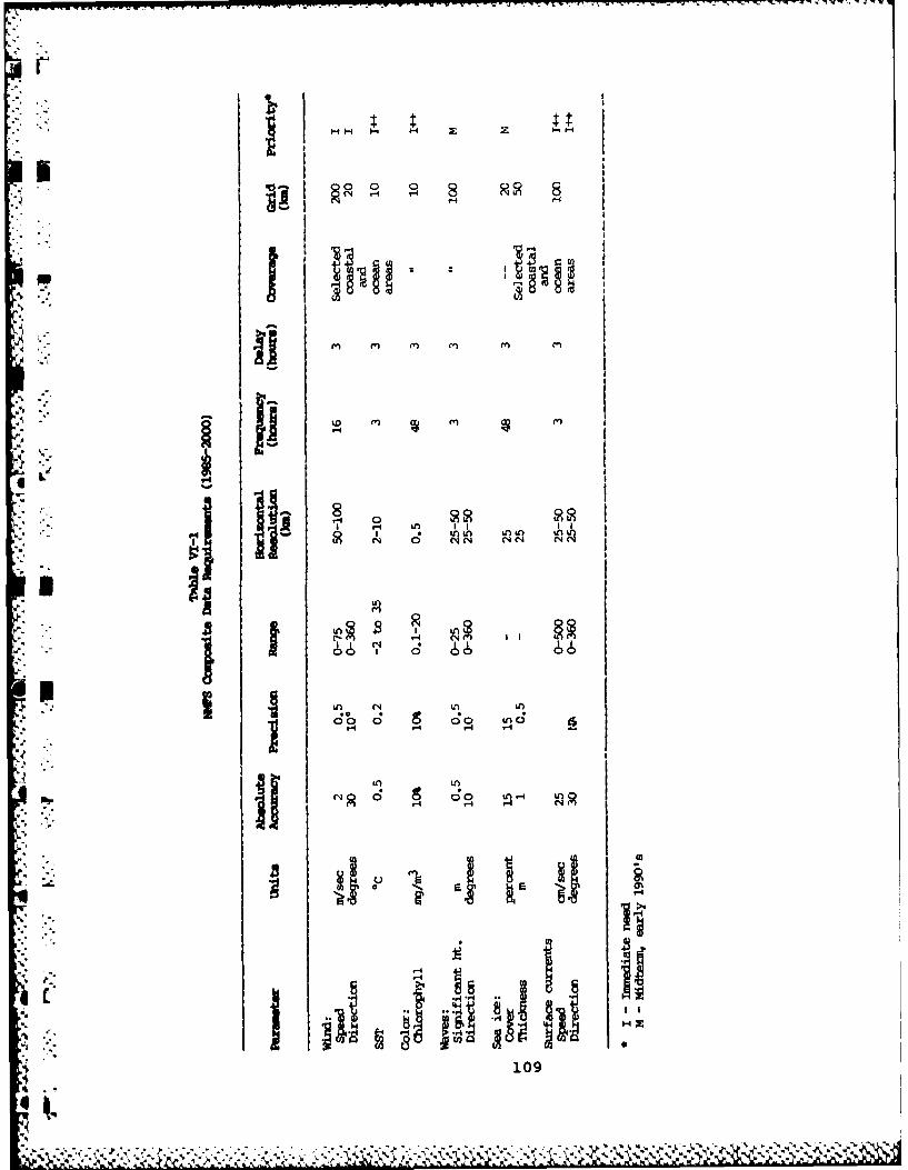
Sn m
fn ~ ~ l Cl C
*62 o nR~ Cl
10

VII. SUMMARY
AS shown in the previous chapters, NOAA user requirements forenvironmental satellite data and services overlay and inter-lock with each other in many ways. Satellites enable NOAAusers to obtain frequent, high-resolution data on a global
W basis for a multitude of operational and research purposes.Many scientific disciplines are served by data from any giveninstrument. This results in users from several disciplinesopting for observations in the same spectral channels, withtheir requirements differing only in terms of details such as
, '. resolution, coverage, frequency, timeliness, and the like.
This overlap of user requirements makes it possible to serve awide range of applications from a single design for a satel-lite sensor or service. In many instances, such as globalcloud cover, environmental satellites are the only cost-effec-tive means of obtaining data that have the space and timeresolutions needed for certain applications. In theseinstances, the satellite's design accommodates the highestpriority requirements and accounts for similar, but differing,needs to the extent possible. For example, GOES observationsof severe weather processes serve weather forecasters andresearchers alike, but the design of GOES favors operationalforecasting needs in terms of surface spatial resolution andthe frequency of observations. Researchers benefit from theroutine data that GOES provides, but a design capability alsois provided that enables the more frequent observations neededfor research purposes. This research capability is exercisedwhenever practical.
Developing effective operational satellite systems for sup-porting environmental programs requires that the mix ofground-based and space-based observing systems blend effi-ciently and complement each other. With rare exceptions,in situ methods of measurement give more accurate results thanremote sensing. The advantage of space remote sensing is thatit provides economic global observations of a myriad of para-meters, measured with good accuracy by consistent instruments.The NOAA requirements presented in this paper will help definethe future mix of observing systems. Polar-orbiting andgeostationary satellites, along with ground and ocean systemssuch as NEXRAD, ASOS, ART, Profilers, ocean buoys, and ship-board measurements, will comprise an effective, integrated
S["future NOAA observing system.
The ground processing and distribution of satellite data is
111

another critical element in the satisfaction of user require-ments. NOAA users, and most others, look to NESDIS topreprocess raw sensor data and convert them to calibrated,Earth-located information expressed in geophysical units, suchas temperature or distance. The process requires that the sig-nals from the instrument be interpreted in terms of sensorcharacteristics (calibration), corrected for atmospheric andother influences, and assigned a geographic location. Thestep from calibrated, corrected, Earth-located values togeophysical units may involve mixing or comparing data fromseveral channels or from other instruments, statistical pro-cessing, or other complexities. The efficiencies of central-ized preprocessing are very high. From the point of view ofmost users, the preprocessed satellite-derived product is allthat is required for their applications purposes.
The requirements of NOAA users express, explicitly r impli-citly, the need for distributed data handling and processingsystems. This data preprocessing, to the highest practicallevels, should take place at central locations. The computerfacilities at field locations should be connected to thesepreprocessing centers to access scheduled product deliveriesand tap the data base on demand. The computer capabilities atthe field sites should be reserved for analysis and forecast-ing functions and should be protected from duplicating prepro-cessing tasks that are best performed centrally. Thisrequirement is a general one, applying to products derived -
from satellite, ocean, and ground-based observing system data,as well as to real-time and retrospective applications.
Swift, responsive data relay between its nodes will be adesign imperative of the future NOAA distributed data handlingsystem. NOAA plans to improve services and contain realoperating costs by taking advantage of emerging computer,telecommunications, and other technological opportunities forconsolidating field operations and eliminating much of themanual intervention necessary in the present system. The fullbenefits of the distributed system can be realized only ifdata products (scheduled, on-line, and off-line) reach userswith the accuracy and in the formats and time frames theyneed. Properly bringing this about is a significant systemdesign challenge and will influence the selection of thehardware and the software construction for the physicalsystem.
Satellites have been a valuable source of global environmentaldata for the past quarter-century. Throughout the period,they have made strong contributions to operational and re-search programs and their data have blended well with those
112

from other observing systems. Within NOAA, the advantages ofsatellites in operational and research environmental programs,and fisheries management programs, are very great today andare projected to increase in the future. The outlook is fortechnology that will enable NOAA to develop an effective,synergistic observing system, including satellites, that willsatisfy the varied data demands of NOAA's missions.
97
-.
1
-
a..
.. 113
a.1

.o
.4
APPENDIX A
CURRENT AND PLANNED NOAA SATELLITES
NOAA's Polar-orbiting Operational Environmental Satellites(POES):
The current POES series has spacecraft in sun-synchronouspolar orbits at 833 and 870 km. Imaging, surface tempera-tures, and cloud mapping are provided by a 5-channel visible
* and infrared radiometer with 1.1 km resolution. Three"" ., instruments provide atmospheric sounding data: a 20-channel
high-resolution infrared sounder, a 3-channel selectiveabsorption sensor to determine weighting functions at 15 pmwavelengths, and a 4-channel Dicke microwave radiometer.Additionally, these satellites monitor solar particle flux atthe spacecraft and provide for the collection and relay ofdata from fixed and moving automatic sensor platforms. Satel-lite sensor data are broadcast continuously for intercept by
0' any ground station within range.
The next POES series will include the Advanced MicrowaveSounding Unit (AMSU), which will replace the 3-channelinfrared absorption and 4-channel Dicke microwave soundinginstruments now in use. The AMSU will provide 15 channels ofcoverage in the 20-90 GHz range and 5 channels in the 90-184GHz range. It will add new capabilities for atmospherichumidity measurements, distinguishing sea ice, and gatheringinformation about snow thickness and soil moisture. AMSU willmake soundings more accurate and will permit sounding throughclouds over areas with active weather patterns. The currentimager will be improved by adding one or two new channels andsharpening others; some channel changes also are planned for
_ the High-Resolution Infrared Radiation Sounder (HIRS). Amajor planned sensor addition is the Ocean Color Instrument(OCI), which probably will be introduced on an early space-craft in this series. The other functions and services of theseries will remain as they are currently.
NOAA's Geostationary Operational Environmental Satellites(GOES):
The current GOES series provides imaging and sounding data viaa single instrument. A visible channel (0.55 to 0.75 pm) and12 IR channels (from 3.9 to 15.0 pm) are provided. Subpointresolution is 1 km in the visible and 7 or 14 km in the IR,determined by detector selection. The single optical system
.* of the instrument precludes its simultaneous operation in both
'A-1

imaging and sounding modes. GOES are equipped to monitor theflux of solar X-rays, alpha particles, protons, and electronsat the spacecraft. They are provided with data collectionsystems for the relay of information from automatic sensorplatforms. Sensor data are broadcast continuously for receipt
* by ground stations. A GOES service is the retransmission ofmeteorological charts and other environmental information,including satellite imagery, in facsimile format.
The next GOES series will provide separate imaging and sound-ing instruments, so that these functions can occur simul-taneously. More imaging and sounding channels will be in-cluded. The other capabilities and services of the currentseries will be continued.
NOAA's Land Remote-Sensing Satellites (Landsat):
Current Landsat spacecraft provide Earth-imaging through twoseparate instruments. The Multi-Spectral Scanner (MSS) is a4-channel instrument that provides visible and infrared dataat 80 m subpoint resolution. The other, the Thematic Mapper(TM), is a 7-channel visible and infrared spectrometer thatprovides data at 30 m resolution, except for 120 m resolutionin the thermal infrared band. Two spacecraft of the currentseries are in orbit: Landsat 4 and 5. The orbit is sun-synchronous at 705 km, providing a 16-day repeat cycle forrevisits to the same Earth scene. Direct data broadcasts areprovided to non-Federal ground stations, which pay a dataaccess fee and enter into formal agreements covering the
" receipt and distribution of Landsat data.
The Landsat system is being commercialized. Under the ex-* pected conditions of commercialization, the U.S. Government
will continue services from Landsat 4 and 5 through theirdesign lifetimes (probably mid-1987) by contracting with a
- - private company for the management and day-to-day operation ofthe present system. The same company also will be responsible
" for the marketing of Landsat data. The company will continueservice beyond Landsat 5 by launching an improved Landsat 6,
*[ in late 1988, and the follow-on Landsat 7, probably in late* 1992. Landsat 6 and 7 will provide TM-class instruments and*i MSS emulators. The emulators will convert the TM-like data to* MSS format. The new satellites also will provide a* panchromatic imager with 15 m subpoint resolution. A 5-year*lifetime is projected for Landsat 6 and 7.
.4, A-2
* **** . . . .

APPENDIX B
S GLOSSARY OF ACRONYMS
AFOS - Automation of Field Operations and Services
AMERIEZ - Antarctic Marine Ecosystem Research at theIce-Edge Zone
AMSU - Advanced Microwave Sounding Unit
APT - Automatic Picture Transmission
.[. Argos - French Data Collection and Platform LocationSystem
ART Automated Radio Theodolites
ASAP Automated Shipboard Aerological Programme
ASDAR Aircraft to Satellite Data Relay
ASOS Automated Surface Observing System
ATS - Applications Technology Satellite
AVHRR - Advanced Very High Resolution Radiometer
AWIPS-90 - Advanced Weather Interactive Processing Systemp(for the 1990's)
CAC Climate Analysis Center
CBS Commission for Basic Systems
, CDA Command and Data Acquisition
CDDF Central Data Distribution Facility
-L C&GS Charting and Geodetic Services
CHARM Coastal Habitat Assessment Research Mensuration
C-MAN Coastal-Marine Automated Network
B-1
A4A .7-J

po.-
CONUS - Contiguous 48 States
CTD - Conductivity and Temperature With Depth
CZCS Coastal Zone Color Scanner
DCP Data Collection Platforms
DCS Data Collection System
DMSP Defense Meteorological Satellite Program
DOD Department of Defense
DOI - Department of the Interior
DOT - Department of Transportation
DSB - Direct Sounder Broadcast
EEZ Exclusive Economic Zone
ERL Environmental Research Laboratories
-. ERS-I ESA Remote-Sensing Satellite
ESA European Space Agency
FGGE First GARP Global Experiment
GAC - Global Area Coverage
GARP - Global Atmosphere Research Program
GCM - General Circulation Model
, GMS - Geostationary Meteorological Satellite
GMT - Greenwich Mean Time
- GOES Geostationary Operational EnvironmentalSatellites
B-2

GOES-Next - Next Generation Geostationary Satellites
GOS - Global Observing System
GPS - Global Positioning System
GTS - Global Telecommunications System
HIRS/2 - High-Resolution Infrared Radiation Sounder
HRPT - High Resolution Picture Transmission System
IR Infrared
JIC - Joint Ice Center
JPL - Jet Propulsion Laboratory
LAC -Local Area Coverage
Landsat - Land Satellite
LFM - Limited Fine Mesh
MBL - Marine Boundary Layer
MCSST - Multi-Channel Sea Surface Temperature
MLD - Mixed Layer Depth
MSS - Multi-Spectral Scanner
MSU - Microwave Sounding Unit
."4F
NASA - National Aeronautics and Space Administration
NDBC - NOAA Data Buoy Center
. NEARSS - Northeast Area Remote Sensing System Association
B-3
A•'6 I -%-" " " "% ,' -% ' % • " - • " "" - ."." -" - •" , ,°"%"""" %""". '" ", """" ''".

NESDIS - National Environmental Satellite, Data, andInformation Service
NEXRAD Next Generation Weather Radar
NHC National Hurricane Center
NMC National Meteorological Center
NMFS National Marine Fisheries Service
NOAA National Oceanic and Atmospheric Administration
NOS National Ocean Service
NOSS National Oceanic Satellite System
N-ROSS Navy Remote Ocean Sensing System
NSSFC National Severe Storms Forecast Center
4 NWS National Weather Service
OAR - Office of Oceanic and Atmospheric Research
OCEANFAX - Ocean Facsimile (proposed)
OCI - Ocean Color Instrument
OH - Office of Hydrology
OMA - Oceanography and Marine Assessments
OPC - Ocean Products Center
OSC - Ocean Service Center
OSD - Ocean Services Division
OTSR Optimum Track Ship Routing
I POES Polar-orbiting Operational EnvironmentalSatellites
, PROFS Program for Regional Observing and ForecastingServices
B-4

RFC - River Forecast Center
SANBAR Sanders Barotropic Model
SAR Synthetic Aperture Radar
SEAS Shipboard Environmental Data Acquisition System
Seasat Sea Satellite
SEL Space Environment Laboratory
SESC - Space Environment Services Center
SFSS - Satellite Field Services Station
SIm - Satellite Interpretation Message
SMMR - Scanning Multi-channel Microwave Radiometer
SOWM Spectral Ocean Wave Model
SST - Sea Surface Temperature
SSTA - Sea Surface Temperature Anomaly
SSU - Stratospheric Sounding Unit
STORMr a Storm-scale Operational and Research Meteorology
Program
* 1 SWIS Satellite Weather Information Service
TIROS Television and Infrared Observation Satellite
TM - Thematic Mapper
TOGA Tropical Ocean Global Atmosphere Program
TOVS TIROS Operational Vertical Sounder
UHF - Ultra-High Frequency
B-5
I-'
L... ..5

VAS VISSR Atmospheric Sounder
VISSR Visible and Infrared Spin-Scan Radiometer
WEFAX Weather Facsimile
WI-CDA - Wallops Island Command and Data Acquisition
Windsat - Wind Satellite
WLMS - Water Level Measurement System
WMO World Meteorological Organizataion
WSFO Weather Service Forecast office
XBT - Expendable Bathythermograph
XCP - Expendable Current Profilers
XCTD - Expendable Conductivity/Temperature/DepthProfilers
B-6
S

DT I
0d