Environmental research in a seismic area Victorin-Emilian ...Victorin-Emilian Toader, Iren-Adelina...
12
ECOTERRA - Journal of Environmental Research and Protection www.ecoterra-online.ro 2018, Volume 15, Issue 3 20 Environmental research in a seismic area Victorin-Emilian Toader, Iren-Adelina Moldovan, Constantin Ionescu, Alexandru Marmureanu, Andrei Mihai National Institute for Earth Physics, Calugareni 12, Magurele, Romania. Corresponding author: V. E. Toader, [email protected] Abstract. A multidisciplinary network is monitoring a seismic area from Romania, Vrancea, sitting at curvature of Carpathian Mountains. The last major earthquake here produced distant effects (Moscow, Istanbul) in 1977 with Mw = 7.4 and there is a high probability of having a similar event soon. Romania has a large seismic network and 10 multidisciplinary stations near to faults that monitoring the precursor factors in correlation with environmental conditions. A high quantity of information is stored and analyzed online and offline. A part of it is shared with EPOS - ORFEUS organization in real time. The tectonic stress generates many effects in lithosphere and atmosphere that affect the environment. Out database includes information about air ionization, radon concentration, CO 2 , telluric and electromagnetic fields, solar radiation, acoustic effects of explosions or microfracturing of rocks, ULF and VLF radio waves, GPS data, meteorological data, electrostatic field in air, lighting, magnetic and electric field, next to seismic records. The main goal of this monitoring effort is to help the authorities with information about risk situation and effects of climate change. The targets in research are the phenomena between the lithosphere and near surface low atmosphere, the effect of tectonic stress on the ionosphere, and the impacts of climate change. The environmental information like CO 2 , radon, air ionization or aerosols is valuable if it is obtained in areas where we have manifestations of tectonic stress. To assess the magnetic pollution we installed a magnetometer in the center of Bucharest but the same type of sensor works in a tunnel in Muntele Rosu (an isolated mountain area) for monitoring the geomagnetic field. The correlation of environmental factors with seismicity is a main method for analysis the precursor phenomena. Seismic prediction is not possible but a forecast could be. We have many examples of anomalies before earthquakes including animal behavior. The challenge is to generate useful information before the phenomenon occurs. For seismic event we have a EWS information network connected to authorities in real time. The next step is to introduce environmental events with large effects in our information system. Key Words: environmental monitoring, multidisciplinary network, natural hazards assessment, geochemistry monitoring, acoustic emission. Introduction. The monitoring network presented in this paper is a multidisciplinary application in an active seismic area located in the curvature of Carpathian Mountains, called Vrancea zone (Figure 1). Tectonic stress has many effects that depend on the local geological structure. For this reason, monitoring and data analysis equipment must be chosen according to the particularities observed in the area. The structure of the network has changed over time as a result of the observations made. For example, the noise produced by micro fracture of rocks is recorded only in certain stations where this phenomenon occurs. In the case of radon, observation times are long (at least one year) and the results may be inconclusive. In other cases, the location and equipment can be correctly chosen but their incorrect installation leads to erroneous results. The implementation of the monitoring network has encountered many difficulties, including financial and operating constraints. It works on the structure of a seismic network to which equipment has been added according to the particularities of observed precursor factors. The result of this multidisciplinary monitoring is a research on the behavior of the environment under tectonic stress. According to the presentation of effects of tectonic stress presented by Ouzounov et al (2012) and Pulinets & Ouzounov (2011) our research is oriented to earthquake forecast. We analysis ground deformation using inclinometers, geomagnetic anomalies with magnetometers, earthquake clouds with video camera, radon concentration, infrasound, abnormal behavior of animals with microphones and video camera, telluric field, electromagnetic field in ground, seismic gaps, air ionization, CO 2 , ULF waves, ground temperature, solar radiation correlated with meteorological condition. Gill & Malamud (2017) explain the role of 18 anthropogenic factors in determining natural hazards. Next to Vrancea we have two situations under investigation: Izvoarele (Galati) with oil and gas extraction and the dam Poiana Uzului with seismicity induced by the accumulation lake. The monitoring stations are far from anthropogenic factors. Acoustic
Transcript of Environmental research in a seismic area Victorin-Emilian ...Victorin-Emilian Toader, Iren-Adelina...
ECOTERRA - Journal of Environmental Research and Protection
www.ecoterra-online.ro 2018, Volume 15, Issue 3
20
Environmental research in a seismic area Victorin-Emilian Toader, Iren-Adelina Moldovan, Constantin Ionescu, Alexandru Marmureanu, Andrei Mihai
National Institute for Earth Physics, Calugareni 12, Magurele, Romania. Corresponding author: V. E. Toader, [email protected]
Abstract. A multidisciplinary network is monitoring a seismic area from Romania, Vrancea, sitting at curvature of Carpathian Mountains. The last major earthquake here produced distant effects (Moscow, Istanbul) in 1977 with Mw = 7.4 and there is a high probability of having a similar event soon. Romania has a large seismic network and 10 multidisciplinary stations near to faults that monitoring the precursor factors in correlation with environmental conditions. A high quantity of information is stored and analyzed online and offline. A part of it is shared with EPOS - ORFEUS organization in real time. The tectonic stress generates many effects in lithosphere and atmosphere that affect the environment. Out database includes information about air ionization, radon concentration, CO2, telluric and electromagnetic fields, solar radiation, acoustic effects of explosions or microfracturing of rocks, ULF and VLF radio waves, GPS data, meteorological data, electrostatic field in air, lighting, magnetic and electric field, next to seismic records. The main goal of this monitoring effort is to help the authorities with information about risk situation and effects of climate change. The targets in research are the phenomena between the lithosphere and near surface low atmosphere, the effect of tectonic stress on the ionosphere, and the impacts of climate change. The environmental information like CO2, radon, air ionization or aerosols is valuable if it is obtained in areas where we have manifestations of tectonic stress. To assess the magnetic pollution we installed a magnetometer in the center of Bucharest but the same type of sensor works in a tunnel in Muntele Rosu (an isolated mountain area) for monitoring the geomagnetic field. The correlation of environmental factors with seismicity is a main method for analysis the precursor phenomena. Seismic prediction is not possible but a forecast could be. We have many examples of anomalies before earthquakes including animal behavior. The challenge is to generate useful information before the phenomenon occurs. For seismic event we have a EWS information network connected to authorities in real time. The next step is to introduce environmental events with large effects in our information system. Key Words: environmental monitoring, multidisciplinary network, natural hazards assessment, geochemistry monitoring, acoustic emission.
Introduction. The monitoring network presented in this paper is a multidisciplinary application in an active seismic area located in the curvature of Carpathian Mountains, called Vrancea zone (Figure 1). Tectonic stress has many effects that depend on the local geological structure. For this reason, monitoring and data analysis equipment must be chosen according to the particularities observed in the area. The structure of the network has changed over time as a result of the observations made. For example, the noise produced by micro fracture of rocks is recorded only in certain stations where this phenomenon occurs. In the case of radon, observation times are long (at least one year) and the results may be inconclusive. In other cases, the location and equipment can be correctly chosen but their incorrect installation leads to erroneous results. The implementation of the monitoring network has encountered many difficulties, including financial and operating constraints. It works on the structure of a seismic network to which equipment has been added according to the particularities of observed precursor factors. The result of this multidisciplinary monitoring is a research on the behavior of the environment under tectonic stress.
According to the presentation of effects of tectonic stress presented by Ouzounov et al (2012) and Pulinets & Ouzounov (2011) our research is oriented to earthquake forecast. We analysis ground deformation using inclinometers, geomagnetic anomalies with magnetometers, earthquake clouds with video camera, radon concentration, infrasound, abnormal behavior of animals with microphones and video camera, telluric field, electromagnetic field in ground, seismic gaps, air ionization, CO2, ULF waves, ground temperature, solar radiation correlated with meteorological condition. Gill & Malamud (2017) explain the role of 18 anthropogenic factors in determining natural hazards. Next to Vrancea we have two situations under investigation: Izvoarele (Galati) with oil and gas extraction and the dam Poiana Uzului with seismicity induced by the accumulation lake. The monitoring stations are far from anthropogenic factors. Acoustic
ECOTERRA - Journal of Environmental Research and Protection
www.ecoterra-online.ro 2018, Volume 15, Issue 3
21
emission (AE) is implemented in 5 stations and has best results. In this case the analysis is correlated with ground deformation, seismic energy (Gregori et al 2005) and animal behavior. We calculate a cumulative energy from earthquake magnitude with an original software created for seismicity analysis (Toader et al 2015). Paparo et al (2002) describe the AE like a diagnostic tool in geophysics and associates it with ground deformation, microfracturing, and porosity of rocks. We have the same monitoring goal but the equipment are different. It uses two sample rates (200 kHz - AE HF and 25 kHz - AE LF) in air and rock, and we have only 22 kHz. We use our accelerometer network filtered at very low frequency for evaluation the deformation. The acoustic emission is associated with ULF magnetic and radio anomalies (Molchanov et al 2005). We have ULF monitoring in 4 stations at 100 Hz sample rate. The results were presented at EGU2017-18037 conference (Toader et al 2017). The ULF band (0.005-1 Hz) is used for analysis of geomagnetic field, too (Chavez et al 2010). Our fluxgate magnetometers works at 1 Hz sample rate. Radon concentration is another seismic precursor factor (Papastefanou et al 2001; Liperovsky et al 2005; Pulinets & Ouzounov 2011; Perrier et al 2012) consider that radon emission affects the ionosphere and an effect is the perturbation of VLF wave propagation. We monitor radon in 5 stations starting with 2014. In some cases we have to change the locations because the results were inconclusive. The ground temperature is another earthquake precursor factor (Liperovsky et al 2005). High tectonic stress determinates an increase of temperature, emission of radon, and increase the air ionization. Davies (2013) makes a correlation between heat flow and geology. In this case we monitor the ground temperature in borehole, in cavities of 1 m deep, and with a net radiometer. Solar radiation monitoring allows us to evaluate the thermal emission of the earth's surface. The data analysis is correlated with seasons and daily hour. The main objective of our research is to help the authorities with information about risk situation and effects of climate change. We have information from our network about Vrancea seismic area and the possibility to share our alerts in real time like in EWS case. The LAIC phenomena between the lithosphere and near surface low atmosphere, the effect of tectonic stress on the ionosphere, and the impacts of climate change are parts of environmental monitoring.
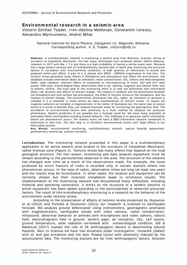
Investigation area, monitoring network. Figure 1 presents the epicenter distribution in Romania and the hypocenter depths (H) in three colors: yellow < 50 Km, light blue > 50 Km and dark blue > 100 km. The monitoring area is marked by a black polygon and represents the Vrancea area. This is our investigation area characterized by intermediate earthquakes with large effects. The last seismic event was in 1977 (MW = 7.4) and there is the risk to have a similar one.
The Romanian Emergency Inspectorate next to National Institute of Earth Physics (NIEP) developed an emergency plan to reduce the effects of seismic events. The monitoring network has mainly seismic equipment and a part of stations include multidisciplinary sensors.
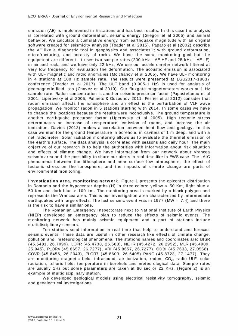
Ten stations send information in real time that help to understand and forecast seismic events. These data are useful in other research like effects of climate change, pollution and, meteorological phenomena. The stations names and coordinates are: BISR (45.5481, 26.7099), LOPR (45.4738, 26.568), NEHR (45.4272, 26.2952), MLR (45.4909, 25.945), PLOR4 (45.8657, 26.7277), VRI (45.8657, 26.7277), ODBI (45.7633, 27.0558), COVR (45.8456, 26.2043), PLOR7 (45.8603, 26.6405) PANC (45.8723, 27.1477). They are monitoring magnetic field, infrasound, air ionization, radon, CO2, radio ULF, solar radiation, telluric field, temperature in borehole and meteorological data. Sample rates are usually 1Hz but some parameters are taken at 60 sec or 22 KHz. (Figure 2) is an example of multidisciplinary station.
We developed geological models using electrical resistivity tomography, seismic and geoelectrical investigations.
ECOTERRA - Journal of Environmental Research and Protection
www.ecoterra-online.ro 2018, Volume 15, Issue 3
22
Figure 1. Romanian seismicity, 2012-2018, Vrancea monitoring area.
Figure 2. Multidisciplinary monitoring station in VRI.
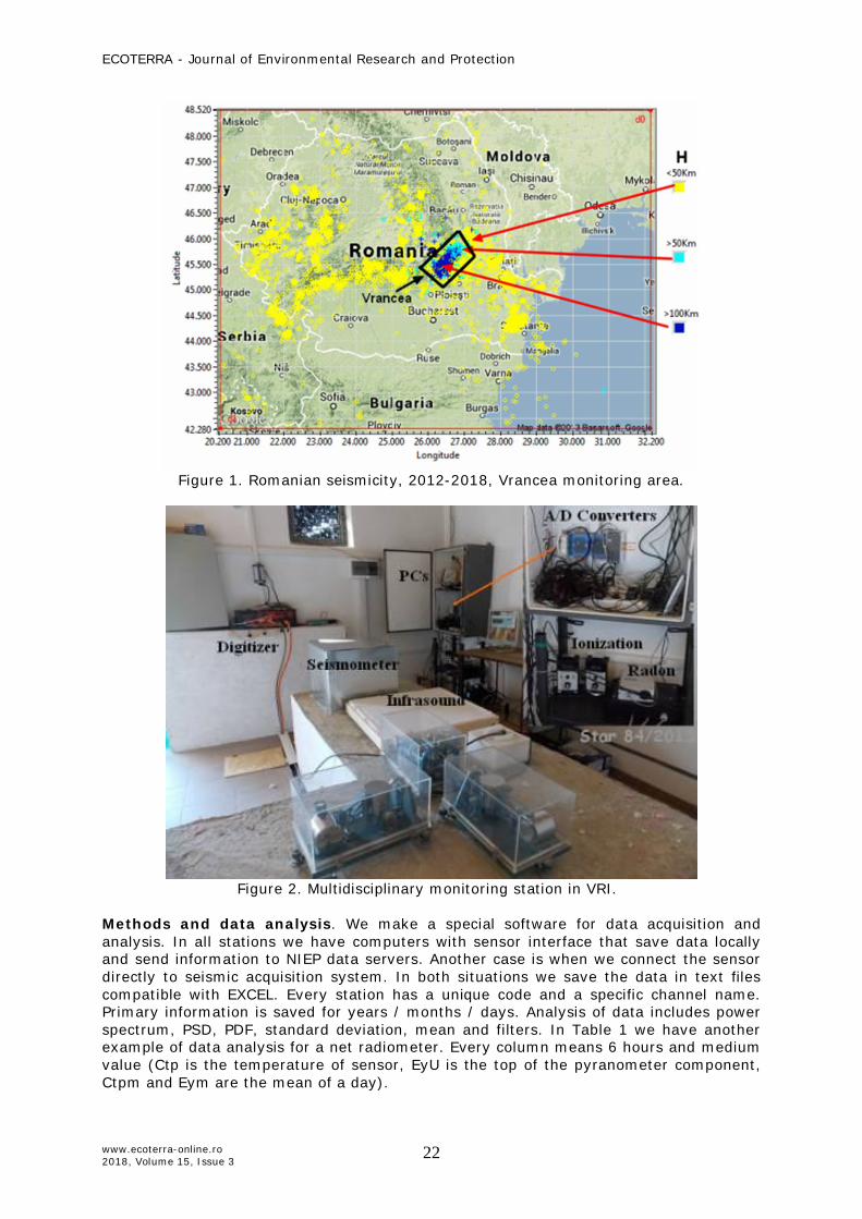
Methods and data analysis. We make a special software for data acquisition and analysis. In all stations we have computers with sensor interface that save data locally and send information to NIEP data servers. Another case is when we connect the sensor directly to seismic acquisition system. In both situations we save the data in text files compatible with EXCEL. Every station has a unique code and a specific channel name. Primary information is saved for years / months / days. Analysis of data includes power spectrum, PSD, PDF, standard deviation, mean and filters. In Table 1 we have another example of data analysis for a net radiometer. Every column means 6 hours and medium value (Ctp is the temperature of sensor, EyU is the top of the pyranometer component, Ctpm and Eym are the mean of a day).
ECOTERRA - Journal of Environmental Research and Protection
www.ecoterra-online.ro 2018, Volume 15, Issue 3
23
Table 1 Solar radiation monitoring
Date Ctp1 Ctp2 Ctp3 Ctp4 Ctpm EyU1 EyU2 EyU3 EyU4 EyUm
16/01/01 -10.438 -9.945 -11.442 -6.138 -9.429 10.636 10.077 21.908 370.096 95.909 16/01/02 -11.827 -12.191 -12.491 -10.737 -12.332 13.861 13.011 15.827 124.119 41.652 16/01/03 -14.975 -15.68 -16.022 -12.748 -15.124 12.798 12.393 16.364 530.996 95.095 16/01/04 -13.949 -12.39 -12.062 -7.628 -8.714 12.941 13.306 15.184 333.753 66.729 16/01/05 -6.829 -4.316 -1.531 0.566 -1.355 13.393 14.423 15.84 107.721 39.161
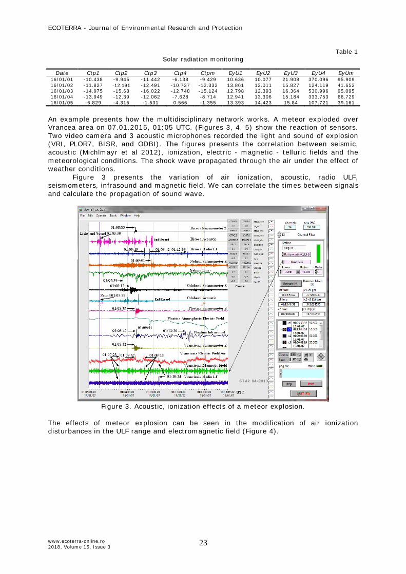
An example presents how the multidisciplinary network works. A meteor exploded over Vrancea area on 07.01.2015, 01:05 UTC. (Figures 3, 4, 5) show the reaction of sensors. Two video camera and 3 acoustic microphones recorded the light and sound of explosion (VRI, PLOR7, BISR, and ODBI). The figures presents the correlation between seismic, acoustic (Michlmayr et al 2012), ionization, electric - magnetic - telluric fields and the meteorological conditions. The shock wave propagated through the air under the effect of weather conditions.
Figure 3 presents the variation of air ionization, acoustic, radio ULF, seismometers, infrasound and magnetic field. We can correlate the times between signals and calculate the propagation of sound wave.
Figure 3. Acoustic, ionization effects of a meteor explosion.
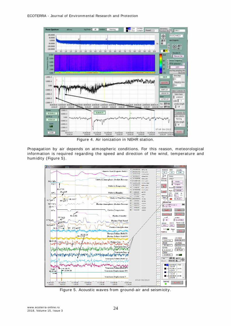
The effects of meteor explosion can be seen in the modification of air ionization disturbances in the ULF range and electromagnetic field (Figure 4).
ECOTERRA - Journal of Environmental Research and Protection
www.ecoterra-online.ro 2018, Volume 15, Issue 3
24
Figure 4. Air ionization in NEHR station.
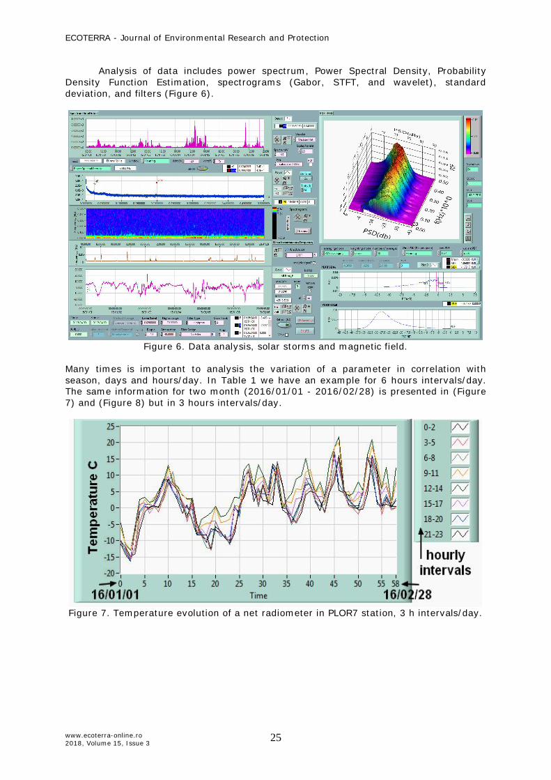
Propagation by air depends on atmospheric conditions. For this reason, meteorological information is required regarding the speed and direction of the wind, temperature and humidity (Figure 5).
Figure 5. Acoustic waves from ground-air and seismicity.
ECOTERRA - Journal of Environmental Research and Protection
www.ecoterra-online.ro 2018, Volume 15, Issue 3
25
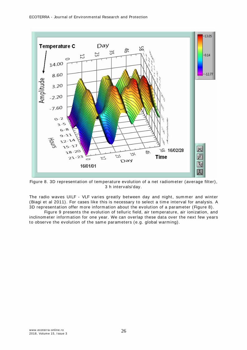
Analysis of data includes power spectrum, Power Spectral Density, Probability Density Function Estimation, spectrograms (Gabor, STFT, and wavelet), standard deviation, and filters (Figure 6).
Figure 6. Data analysis, solar storms and magnetic field.
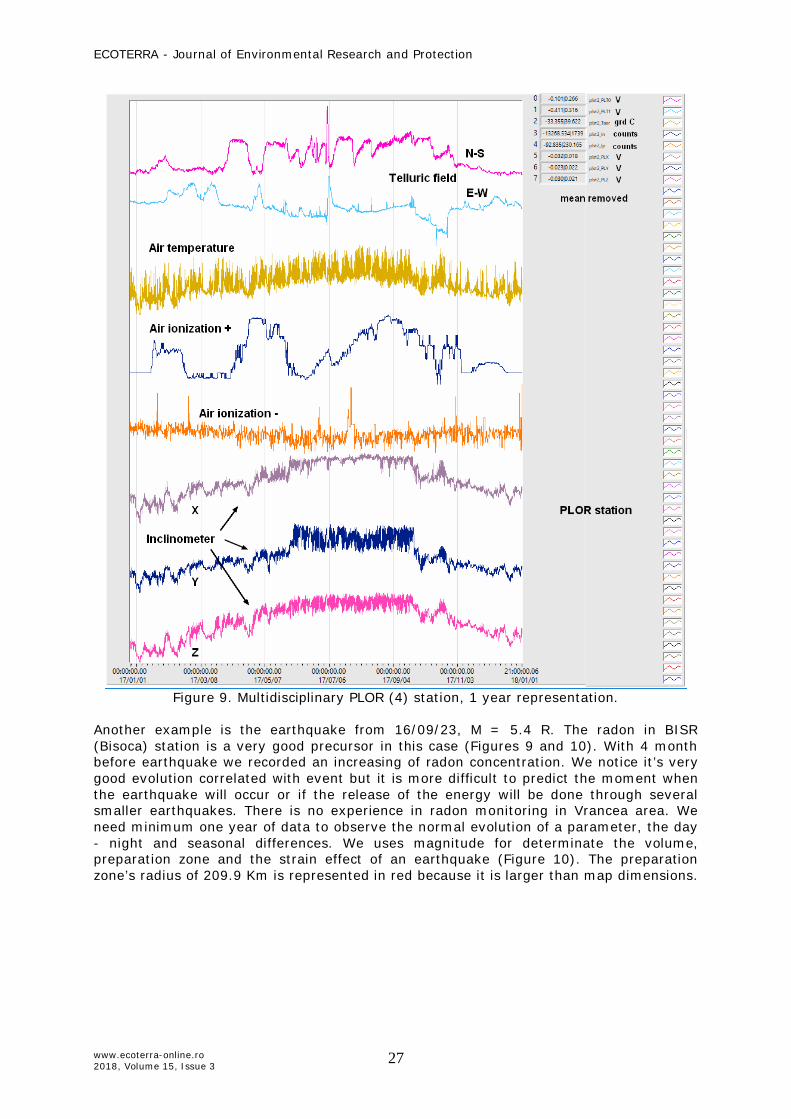
Many times is important to analysis the variation of a parameter in correlation with season, days and hours/day. In Table 1 we have an example for 6 hours intervals/day. The same information for two month (2016/01/01 - 2016/02/28) is presented in (Figure 7) and (Figure 8) but in 3 hours intervals/day.
Figure 7. Temperature evolution of a net radiometer in PLOR7 station, 3 h intervals/day.
ECOTERRA - Journal of Environmental Research and Protection
www.ecoterra-online.ro 2018, Volume 15, Issue 3
26
Figure 8. 3D representation of temperature evolution of a net radiometer (average filter),
3 h intervals/day.
The radio waves UILF - VLF varies greatly between day and night, summer and winter (Biagi et al 2011). For cases like this is necessary to select a time interval for analysis. A 3D representation offer more information about the evolution of a parameter (Figure 8). Figure 9 presents the evolution of telluric field, air temperature, air ionization, and inclinometer information for one year. We can overlap these data over the next few years to observe the evolution of the same parameters (e.g. global warming).
ECOTERRA - Journal of Environmental Research and Protection
www.ecoterra-online.ro 2018, Volume 15, Issue 3
27
Figure 9. Multidisciplinary PLOR (4) station, 1 year representation.
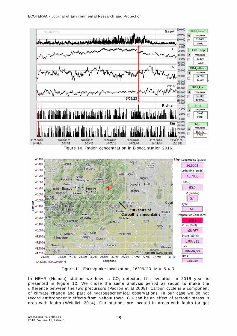
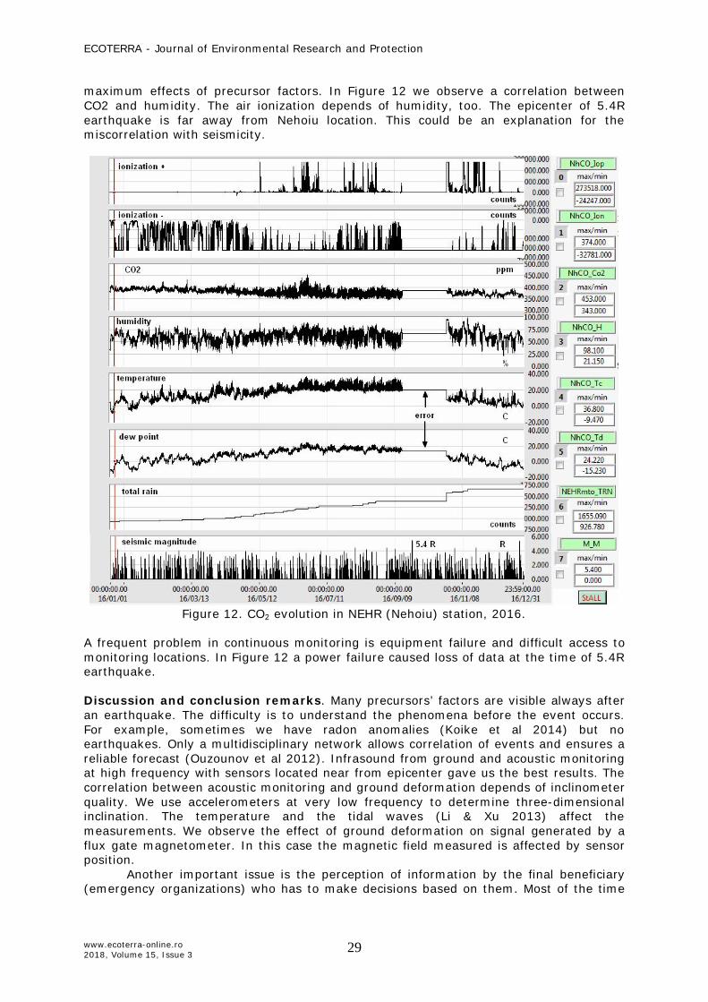
Another example is the earthquake from 16/09/23, M = 5.4 R. The radon in BISR (Bisoca) station is a very good precursor in this case (Figures 9 and 10). With 4 month before earthquake we recorded an increasing of radon concentration. We notice it’s very good evolution correlated with event but it is more difficult to predict the moment when the earthquake will occur or if the release of the energy will be done through several smaller earthquakes. There is no experience in radon monitoring in Vrancea area. We need minimum one year of data to observe the normal evolution of a parameter, the day - night and seasonal differences. We uses magnitude for determinate the volume, preparation zone and the strain effect of an earthquake (Figure 10). The preparation zone’s radius of 209.9 Km is represented in red because it is larger than map dimensions.
ECOTERRA - Journal of Environmental Research and Protection
www.ecoterra-online.ro 2018, Volume 15, Issue 3
28
Figure 10. Radon concentration in Bisoca station 2016.
Figure 11. Earthquake localization, 16/09/23, M = 5.4 R.
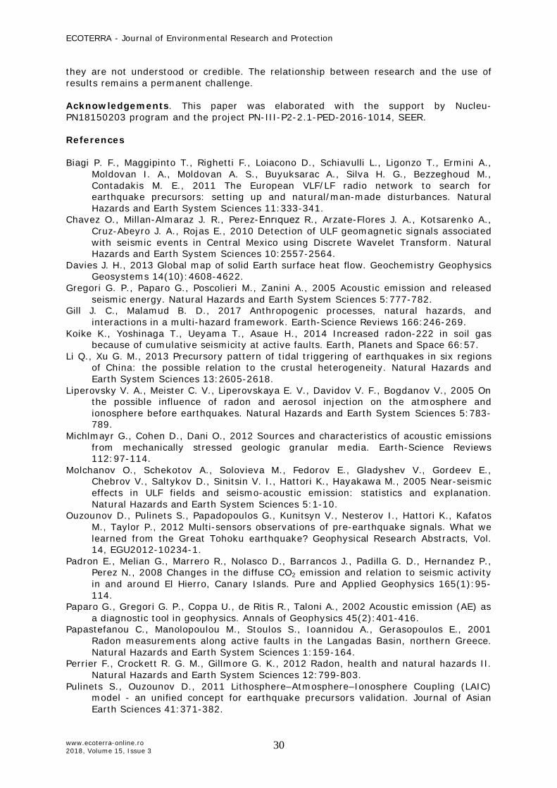
In NEHR (Nehoiu) station we have a CO2 detector. It’s evolution in 2016 year is presented in Figure 12. We chose the same analysis period as radon to make the difference between the two precursors (Padron et al 2008). Carbon cycle is a component of climate change and part of hydrogeochemical observations. In our case we do not record anthropogenic effects from Nehoiu town. CO2 can be an effect of tectonic stress in area with faults (Weinlich 2014). Our stations are located in areas with faults for get
ECOTERRA - Journal of Environmental Research and Protection
www.ecoterra-online.ro 2018, Volume 15, Issue 3
29
maximum effects of precursor factors. In Figure 12 we observe a correlation between CO2 and humidity. The air ionization depends of humidity, too. The epicenter of 5.4R earthquake is far away from Nehoiu location. This could be an explanation for the miscorrelation with seismicity.
Figure 12. CO2 evolution in NEHR (Nehoiu) station, 2016.
A frequent problem in continuous monitoring is equipment failure and difficult access to monitoring locations. In Figure 12 a power failure caused loss of data at the time of 5.4R earthquake. Discussion and conclusion remarks. Many precursors’ factors are visible always after an earthquake. The difficulty is to understand the phenomena before the event occurs. For example, sometimes we have radon anomalies (Koike et al 2014) but no earthquakes. Only a multidisciplinary network allows correlation of events and ensures a reliable forecast (Ouzounov et al 2012). Infrasound from ground and acoustic monitoring at high frequency with sensors located near from epicenter gave us the best results. The correlation between acoustic monitoring and ground deformation depends of inclinometer quality. We use accelerometers at very low frequency to determine three-dimensional inclination. The temperature and the tidal waves (Li & Xu 2013) affect the measurements. We observe the effect of ground deformation on signal generated by a flux gate magnetometer. In this case the magnetic field measured is affected by sensor position.
Another important issue is the perception of information by the final beneficiary (emergency organizations) who has to make decisions based on them. Most of the time
ECOTERRA - Journal of Environmental Research and Protection
www.ecoterra-online.ro 2018, Volume 15, Issue 3
30
they are not understood or credible. The relationship between research and the use of results remains a permanent challenge.
Acknowledgements. This paper was elaborated with the support by Nucleu- PN18150203 program and the project PN-III-P2-2.1-PED-2016-1014, SEER. References Biagi P. F., Maggipinto T., Righetti F., Loiacono D., Schiavulli L., Ligonzo T., Ermini A.,
Moldovan I. A., Moldovan A. S., Buyuksarac A., Silva H. G., Bezzeghoud M., Contadakis M. E., 2011 The European VLF/LF radio network to search for earthquake precursors: setting up and natural/man-made disturbances. Natural Hazards and Earth System Sciences 11:333-341.
Chavez O., Millan-Almaraz J. R., Perez-Enrıquez R., Arzate-Flores J. A., Kotsarenko A., Cruz-Abeyro J. A., Rojas E., 2010 Detection of ULF geomagnetic signals associated with seismic events in Central Mexico using Discrete Wavelet Transform. Natural Hazards and Earth System Sciences 10:2557-2564.
Davies J. H., 2013 Global map of solid Earth surface heat flow. Geochemistry Geophysics Geosystems 14(10):4608-4622.
Gregori G. P., Paparo G., Poscolieri M., Zanini A., 2005 Acoustic emission and released seismic energy. Natural Hazards and Earth System Sciences 5:777-782.
Gill J. C., Malamud B. D., 2017 Anthropogenic processes, natural hazards, and interactions in a multi-hazard framework. Earth-Science Reviews 166:246-269.
Koike K., Yoshinaga T., Ueyama T., Asaue H., 2014 Increased radon-222 in soil gas because of cumulative seismicity at active faults. Earth, Planets and Space 66:57.
Li Q., Xu G. M., 2013 Precursory pattern of tidal triggering of earthquakes in six regions of China: the possible relation to the crustal heterogeneity. Natural Hazards and Earth System Sciences 13:2605-2618.
Liperovsky V. A., Meister C. V., Liperovskaya E. V., Davidov V. F., Bogdanov V., 2005 On the possible influence of radon and aerosol injection on the atmosphere and ionosphere before earthquakes. Natural Hazards and Earth System Sciences 5:783-789.
Michlmayr G., Cohen D., Dani O., 2012 Sources and characteristics of acoustic emissions from mechanically stressed geologic granular media. Earth-Science Reviews 112:97-114.
Molchanov O., Schekotov A., Solovieva M., Fedorov E., Gladyshev V., Gordeev E., Chebrov V., Saltykov D., Sinitsin V. I., Hattori K., Hayakawa M., 2005 Near-seismic effects in ULF fields and seismo-acoustic emission: statistics and explanation. Natural Hazards and Earth System Sciences 5:1-10.
Ouzounov D., Pulinets S., Papadopoulos G., Kunitsyn V., Nesterov I., Hattori K., Kafatos M., Taylor P., 2012 Multi-sensors observations of pre-earthquake signals. What we learned from the Great Tohoku earthquake? Geophysical Research Abstracts, Vol. 14, EGU2012-10234-1.
Padron E., Melian G., Marrero R., Nolasco D., Barrancos J., Padilla G. D., Hernandez P., Perez N., 2008 Changes in the diffuse CO2 emission and relation to seismic activity in and around El Hierro, Canary Islands. Pure and Applied Geophysics 165(1):95-114.
Paparo G., Gregori G. P., Coppa U., de Ritis R., Taloni A., 2002 Acoustic emission (AE) as a diagnostic tool in geophysics. Annals of Geophysics 45(2):401-416.
Papastefanou C., Manolopoulou M., Stoulos S., Ioannidou A., Gerasopoulos E., 2001 Radon measurements along active faults in the Langadas Basin, northern Greece. Natural Hazards and Earth System Sciences 1:159-164.
Perrier F., Crockett R. G. M., Gillmore G. K., 2012 Radon, health and natural hazards II. Natural Hazards and Earth System Sciences 12:799-803.
Pulinets S., Ouzounov D., 2011 Lithosphere–Atmosphere–Ionosphere Coupling (LAIC) model - an unified concept for earthquake precursors validation. Journal of Asian Earth Sciences 41:371-382.
ECOTERRA - Journal of Environmental Research and Protection
www.ecoterra-online.ro 2018, Volume 15, Issue 3
31
Toader V. E., Moldovan I. A., Ionescu C., Marmureanu A., 2017 ULF radio monitoring network in a seismic area. Geophysical Research Abstracts, 2017 Vol. 19, EGU2017-18037.
Toader V. E., Popescu I. M, Moldovan I. A., Ionescu C., 2015 Vrancea seismicity analysis based on cumulative seismic energy. University Politehnica of Bucharest Scientific Bulletin-Series A-Applied Mathematics and Physics 77(2):297-308.
Weinlich F. H., 2014 Carbon dioxide controlled earthquake distribution pattern in the NW Bohemian swarm earthquake region, western Eger Rift, Czech Republic - gas migration in the crystalline basement. Geofluids 14:143-159.
Received: 28 March 2018. Accepted: 29 August 2018. Published online: 30 September 2018. Authors: Victorin-Emilian Toader, National Institute for Earth Physics, Calugareni 12, Magurele, Romania, e-mail: [email protected] Iren-Adelina Moldovan, National Institute for Earth Physics, Calugareni 12, Magurele, Romania. Constantin Ionescu, National Institute for Earth Physics, Calugareni 12, Magurele, Romania. Alexandru Marmureanu, National Institute for Earth Physics, Calugareni 12, Magurele, Romania. Andrei Mihai, National Institute for Earth Physics, Calugareni 12, Magurele, Romania. This is an open-access article distributed under the terms of the Creative Commons Attribution License, which permits unrestricted use, distribution and reproduction in any medium, provided the original author and source are credited. How to cite this article: Toader V. E., Moldovan I. A., Ionescu C., Marmureanu A., Mihai A., 2018 Environmental research in a seismic area. Ecoterra 15(3):20-31.