Environmental Planning GIS Tools -...
9
Environmental Planning GIS Tools Integrating Transportation and Resource Conservation Executive Overview
Transcript of Environmental Planning GIS Tools -...

Environmental Planning GIS Tools
Integrating Transportation and Resource Conservation
Executive Overview
Environmental Planning GIS Tools
Page 1
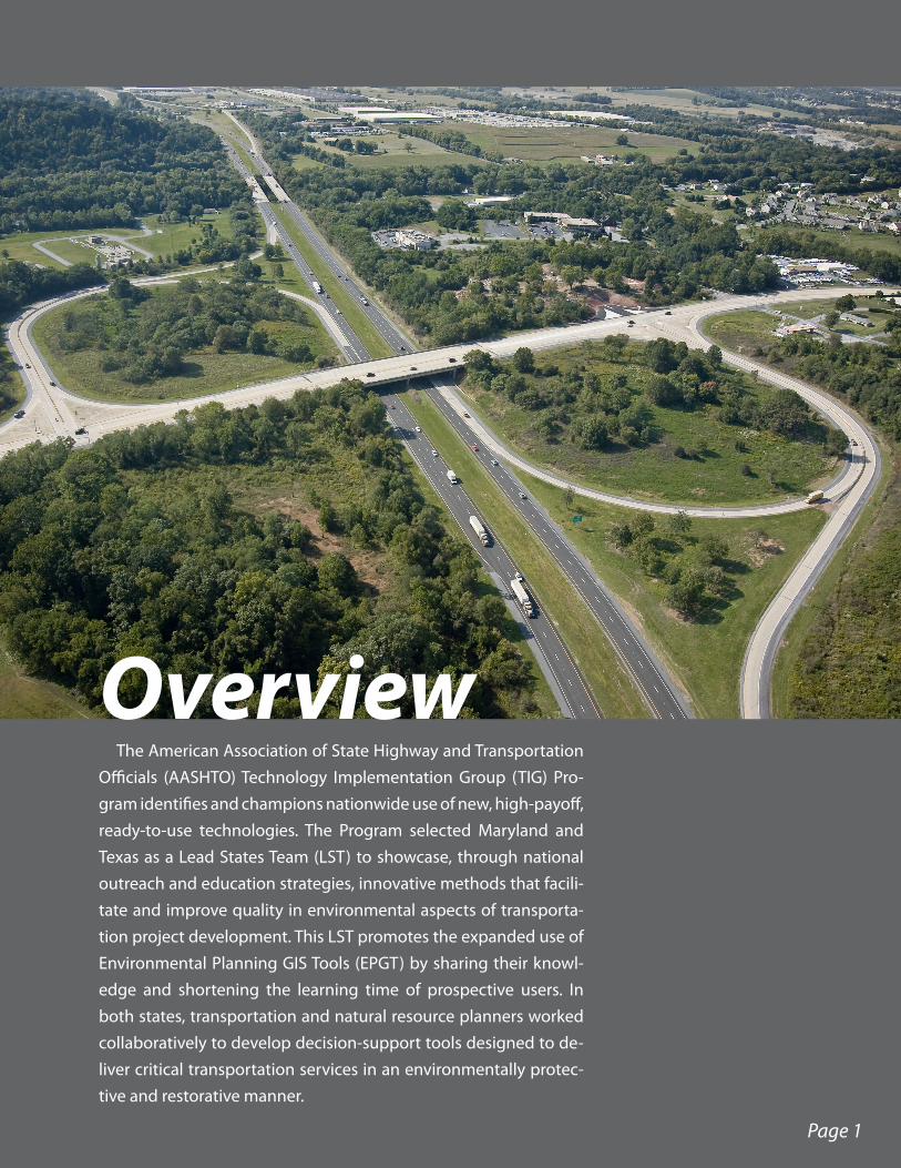
OverviewThe American Association of State Highway and Transportation
Officials (AASHTO) Technology Implementation Group (TIG) Pro-gram identifies and champions nationwide use of new, high-payoff, ready-to-use technologies. The Program selected Maryland and Texas as a Lead States Team (LST) to showcase, through national outreach and education strategies, innovative methods that facili-tate and improve quality in environmental aspects of transporta-tion project development. This LST promotes the expanded use of Environmental Planning GIS Tools (EPGT) by sharing their knowl-edge and shortening the learning time of prospective users. In both states, transportation and natural resource planners worked collaboratively to develop decision-support tools designed to de-liver critical transportation services in an environmentally protec-tive and restorative manner.

The use of EPGT facilitates the planning and design process for transportation projects. These tools highlight the importance of an integrated, multi-scale planning process to facilitate the development of transportation infrastructure within the context of intercon-nected networks of ecologically important lands.
Maryland is continuing to expand the use of its Green Infrastructure (GI) Approach, integrating cutting-edge GI assessment tools with the transportation project de-velopment process to promote sustainable transportation solutions that seek to protect critical habitats and ecosystems from the encroachment of highway infrastructure. GI encompasses “strategically planned and managed networks of natural lands, work-ing landscapes, and other open spaces that conserve ecosystem functions and provide associated benefits to human populations.” GI assessment tools attempt to recognize a variety of natural resources, how one system fits into the big picture, the significance of open space in rural and developed areas, and the importance of an integrated planning process at all levels of government. These
tools also provide the opportunity to support strategic mitigation and conservation efforts at muliple scales in support of federal, state, and local initiatives.
Texas, in partnership with EPA Region 6, has implemented a Geographic Information System Screening Tool (GISST), which evalu-ates environmental vulnerability and impact of project alternatives using multiple types of environmental resource and stressor crite-ria. The system derives aggregate scores for each alternative that reflect the “potential for significant environmental risk.” Information from the statewide Texas Ecological Assess-ment Protocol (TEAP) has been integrated with the GISST for early identification and consideration of regional areas with high ecological importance, based on the diver-isty, rarity and sustainability of species and habitats.
NEPAssist, another EPGT created by EPA and used by TX DOT, is a web-based screen-ing tool that provides resource information on multiple environmental media in support of National Environmental Policy Act (NEPA) compliance. NEPAssist is now available on a national basis.
Page 2

What Environmental Planning GIS Tools are available?
Many EPGTs are readily available for use or replication. Information related to available EPGTs is provided in the fol-lowing list, which is not all-inclusive:
• EPA NEPAssist: http://www.epa.gov/oecaerth/nepa/nepassist-mapping.html
• Texas GISST Manual: http://nepis.epa.gov - document #906B05003
• Maryland GI assessment: http://www.dnr.state.md.us/greenways/gi/gi.html
• FHWA (searchable list of GIS transportation and environmental practices by state): http://gis.fhwa.dot.gov/statepracs.asp
How do these tools differ from other GIS-based tools?
EPGTs are systematic, geospatial tools that enable users to analyze environmental impacts and prioritize environmental protection measures. These GIS tools go well beyond simply mapping resources by using spatial technology merged with ecological science to analyze and prioritize environmental as-sets. EPGTs are useful in considering single media and cumu-lative environmental concerns. The tools are also scalable and can be customized for almost any application.
For example, GISST performs complex spatial analyses and imposes a scoring structure on GIS data coverage. By using this approach, GISST allows users to prioritize environmental resources and compare transportation alternatives. The GISST scoring structure eliminates the subjectivity of a typical GIS ap-plication to create a more objective decision-making process.
Other EPGTs, such as Maryland’s GI assessment and Texas’ TEAP applications, are useful as screening-level planning tools. Through the use of available GIS and field-level inven-tory data, these tools aid in identifying important ecological resources to help decision makers focus on conservation and restoration efforts. An optimization component of the GI Approach also allows a cost benefit analysis of potential mitigation efforts to maximize ecological benefit while mini-mizing cost.
Page 3

Can these tools be used at any scale or for any type of project?
One of the greatest benefits of EPGTs is that they are scalable and can be adjusted and modified to meet the needs of a specific project or program. The tools can be used at national, state, regional, and local levels.
Can the tools assist land and resource conservation efforts?
Use of EPGTs can help transportation agencies, in partnership with resource agencies and/or environmental organizations, identify and strategize resource conservation efforts. The tools rely on accepted natural resource scientific ap-proaches to identify important resource features with high ecological value based on multi-media considerations (vegetation, wetlands, surface waters, habitat, etc.). This approach provides a well-founded basis for identifying key conservation land priorities.
Why should transportation agencies preserve natural lands?
Goods provided by natural ecosystems, or ecosystem services, are the basic building blocks of human welfare. Increasingly, the value of natural lands to pro-vide services such as stormwater filtration and detention, soil retention, and re-duced energy consumption, while increasing recreation opportunities and overall aesthetics, is being recognized as a common good. EPGTs can help transportation agencies integrate mobility improvements while supporting ecosystem services.
Can the tools help to develop more efficient and effective natural resource mitigation?
The environmental mitigation strategy of EPA and other regulatory age-nices is evolving toward the use of a broader ecosystem approach. Unlike the traditional approach, which emphasizes on-site mitigation, this approach emphasizes the development of more effective resource improvements at a watershed level. Application of EPGTs in the transportation development and design process allows transportation and resource agencies to identify stra-tegic mitigation opportunities that may provide a greater overall benefit to
Page 4
U.S. 301 Waldorf Area Transportation Improvements Project - Composite GI based on defined Core Areas

the environment. Cost-benefit analysis of mitigation opportunities, using a watershed or landscape ap-proach to the valuation of environmental improve-ments, helps ensure that mitigation provides opti-mal return from both an ecological and economic perspective.
What is needed to implement the tools?
A key consideration for organizations contemplat-ing the implementation of EPGTs is communication with local, state, and national planning, environ-mental, and transportation organizations to gain an understanding of existing tools and readily available data. There are numerous examples around the country of federal and state agencies, often working with local agencies and non-governmental envi-ronmental interests, collaboratively implementing EPGTs. EPGTs highlighted here can be modified and applied to almost any type of program or project, regardless of its scale and the user’s GIS experience.
From a technology perspective, in-depth knowl-edge of GIS is beneficial but not imperative. It is necessary, however, to have established and verified digital GIS data layers. Many organizations within the transportation and environmental industries offer downloadable GIS data layers. Field reconnaissance may be necessary to bridge gaps in existing spatial data. Resources for obtaining basic resource and transportation GIS data include:
• Federal OneStop Geospatial Center: http://geo.data.gov/
• FHWA GIS in Transportation Data Sources: http://www.gis.fhwa.dot.gov/gisData.asp
• AASHTO Center for Environmental Excellence: http://www.environment.transportation.org/environmental_issues/gis/organizations.aspx
• EPA National Geospatial Program datasets: http://www.epa.gov/geospatial/data.html
• EPA Environmental Dataset Gateway: https://edg.epa.gov/metadata/ (requires EPA authorization)
Page 5
U.S. 301 Waldorf Area Transportation Improvements Project - GI Ecological Rankings

Are funding and training opportunities available? To help initiate or further develop EPGTs for trans-
portation, states should consider seeking additional funding and technical assistance through a variety of governmental and non-governmental partners. Those opportunities include:
Potential Funding Sources:• FHWA Eco-Logical Grant: http://environment.
fhwa.dot.gov/ecological/eco_entry.asp• FHWA Transportation, Community and System
Preservation Program: http://www.fhwa.dot.gov/tcsp/index.html
• FHWA Surface Transportation Environment and Planning Cooperative Research Program (STEP): http://www.fhwa.dot.gov/hep/step/
Potential Training Opportunities:• FHWA GIS in Transportation: http://gis.fhwa.
dot.gov/training.asp• The Conservation Fund, Conservation
Leadership Network: http://www.conservationfund.org/our-conservation-strategy/major-programs/conservation-leadership-network/
• USFWS National Conservation Training Center: http://nctc.fws.gov/learn/trainingprograms.htm
Southern High Plains
Texas High Plains
Basin and
Range
Rolling Plains
Redbed Plains
Cross Timbers and Prairie
Blac
klan
d Pr
airie
s
Edwards Plateau
Rio Grande Plain
Southern Gulf Prairies and Marshes
Central Gulf Prairies and Marshes
Eastern Gulf Prairies and Marshes
Coastal Plains and Flatwoods, Western Gulf
Mid Coastal Plains, Western
Oak Woods and Prairies
Louisiana Coast Prairies and Marshes
Sacramento-Monzano Mountain
Stockton Plateau
0 50 100 150 20025
Miles
¹Figure D. Composite map with ecoregion boundaries. This map is a composite of the diversity layer (Figure A), rarity layer (Figure B), and sustainability layer (Figure C).
Top 1%
51 - 100%
26 - 50%
11 - 25%
2 - 10%
8
Page 6
Texas Ecoregions TEAP Composite Map

What role do partnerships play in implementing Environmental Planning GIS Tools?
Establishing partnerships with local, state, federal, and/or industry non-profit organizations is crucial to the successful implementation of EPGTs.
For example, GISST was developed by the EPA Region 6 and was successfully used on the Texas De-partment of Transportation I-69 Trans-Texas Corridor Study though an Interagency Agreement between the parties. Two key components of this interagency agreement included provisions for technical assis-tance and training in the use of GISST.
In Maryland, the Maryland State Highway Ad-ministration, The Conservation Fund, the Maryland Department of Natural Resources, and the U.S. Fish
and Wildlife Service formed a partnership to develop and implement the GI Approach and assessment tools on the US 301 Waldorf Area Transportation Improvements Project. Using an existing base layer of GIS data, members of this partnership completed enhanced field reconnaissance, data collection, and scientific analysis to provide detailed refinement of the GIS data.
Creating partnerships in the development and use of EPGTs improves transparency, increases stakehold-er confidence in the data and the process, streamlines decision making, and ultimately saves time.
How do I learn more?This EPGT initiative is a joint effort between the Maryland State Highway Administration and the Texas
Department of Transportation through the AASHTO Technology Implementation Group program.The Lead States Team includes state transportation representatives, EPA experts, and environmental
conservation leaders who can help you evaluate and promote the use of EPGTs in your organization. The team can provide assistance in the development of data-driven GIS support systems, the building of multi-agency partnerships, and the incorporation of an environmental systems approach to support sustainable transportation decision-making for your state, region, or community.
For more information or to contact team members for insight, expertise, and advice, visit: http://tig.transportation.org/Pages/EnvironmentalPlanningGISToolsforTransportationPlanning.aspx.
Page 7
TEAP Criteria Layers