Environmental Impact Assessment Sustainability and ... · PDF fileEnvironmental Impact...
27
1 Sustainable Development Evaluation of Road Infrastructure Programmes and Projects Section 1/2 Environmental Impact Assessment, Sustainability and Archaeology Michael Gibbons February 2007
-
Upload
doannguyet -
Category
Documents
-
view
216 -
download
0
Transcript of Environmental Impact Assessment Sustainability and ... · PDF fileEnvironmental Impact...
1
Sustainable Development Evaluation of Road Infrastructure
Programmes and Projects
Section 1/2
Environmental Impact Assessment, Sustainability and Archaeology
Michael Gibbons
February 2007
2
We would like to gratefully acknowledge the assistance of the following: Tadhg O’Mahony, Kevin Woods and Brian Donlon (EPA), John O’Neill, DoEHLG, Hugh Creegan, Michael Egan, Vincent O’Malley and Christian Nea (NRA), Rob Verheem, (Commissie voor de milieueffectrapportage), Mary Twomey, (Forfás), Emer Ó Siocrú, Enid O’Dowd and Clare Taylor (FEASTA)
ACKNOWLEDGEMENTS
This report has been prepared as part of the Environmental Research Technological Development and Innovation Programme under the Productive Sector Operational Programme 2000-2006. The programme is financed by the Irish Government under the National Development Plan 2000-2006. It is administered on behalf of the Department of the Environment and Local Government by the Environmental Protection Agency which has the statutory function of co-ordinating and promoting environmental research.
DISCLAIMER
Although every effort has been made to ensure the accuracy of the material contained in this publication, complete accuracy cannot be guaranteed. Neither the Environmental Protection Agency nor the author(s) accept any responsibility whatsoever for loss or damage occasioned or claimed to have been occasioned, in part or in full, as a consequence of any person acting, or refraining from acting, as a result of a matter contained in this publication. All or part of this publication may be reproduced without further permission, provided the source is acknowledged.
SOCIO ECONOMICS
The Socio Economics Section of the Environmental RTDI Programme addresses the need for research in Ireland to inform policymakers and other stakeholders on a range of questions in this area. The reports in this series are intended as contributions to the necessary debate on Socio Economics and the environment.
3
Sustainability and Archaeology
“Sustainable development is development that meets the needs of the present without compromising the ability of future generations to meet their own needs” – (Brundtland Report 1987)
“The archaeological heritage is a finite non-renewable physical and material resource. Archaeology is the study of past human societies through their material remains and artefactual assemblages. The study of archaeological remains increases our understanding and knowledge of the structure and culture of past and ancient societies that are not recorded by any other means.” – “Guidelines for the Assessment of the Archaeological Heritage Impact of National Road Schemes (Draft)”.
Archaeological remains are a finite resource, they decay over time as a result of natural processes and any form of excavation tends to completely destroy them. Their value lies in the information, which can be derived from them and in their importance as a social resource for the host community. All large-scale development work, notably road schemes, involves the inevitable destruction of at least some of the country’s archaeological heritage. As such Sustainability in archaeology must be focused on minimising the loss of information that results by
A: Minimising the destruction of archaeological resources to the greatest degree possible by avoiding damage to known archaeological features and detecting the presence of and preventing the destruction of previously unknown archaeological resources.
B: Maximising the knowledge gained in circumstances where such destruction is inevitable
C: Maintaining the broader cultural value of the archaeological heritage of the area ie: minimising interference with definable archaeological landscapes and retaining access to and use of areas of cultural value on the part of local stakeholders against both immediate effects of development and from likely later development.
Present practice in the compilation of Archaeological Heritage Impact Assessments is summarised in the NRA’s “Guidelines for the Assessment of the Archaeological Heritage Impact of National Road Schemes (Draft)”. The specific choice of the preferred route through the Tara-Skreen valley for the (get specifics) section of the M3 was studied in detail as an example of the process at work in a controversial case. The study also looked at several individual archaeological reports and environmental impact assessments in order to see how the process summarised in the guidelines was put into practice in a variety of different settings. These included one EIA from the M3 Road project (Clonee – North of Kells (Navan ByPass)), the EIA from a portion of the N5 (Charlestown Bypass) and a section of the N6 (Galway to East Ballinasloe Gleannascaul – East Ballinasloe). The N5 and N6 EIA’s were studied as examples of smaller road schemes which use the same methodology in their Assessments.
4
This study summarises and discusses the EIA process as described in the Guidelines and the approach taken in terms of research and mitigation recommendations in the individual EIAs. In the course of the research these Academics, NRA Archaeologists, DOE Archaeologists, Members of the Institute of Archaeologists of Ireland and Officials from An Taisce were consulted anonymously for their views and their insights have been incorporated into the discussion of individual points and into the conclusions.
Road Planning Process
The archaeological heritage impact assessment of national road schemes is broadly divided into three phases. The Constraints Study involves the consultation of available published sources on the area in question in order to assess the numbers and positions of known archaeological sites. Based on the information contained in the constraints studies a series of Route Corridors are then selected for further assessment. During Route Selection these route corridors are studied and mapped in more detail. The likely impacts of road development on features within the corridor are assessed and ranked. Once a specific route corridor has been selected the archaeological section of the Environmental Impact Statement details the likely impact of development on sites and monuments identified by the previous two phases and by later fieldwork, highlights areas of archaeological potential along the route in question and recommends monitoring, mitigation measures etc. where appropriate.
Constraints Study and Route Selection
The Constraints Study and Route Selection Phases of the EIA process are crucial in determining the overall archaeological impact of road developments. The most effective single mitigation measure is that of routing the proposed road around archaeological features. Once the final route corridor has been selected the ability to do this is radically curtailed so it is crucial that researchers draw on the maximum amount of information during these early stages of the process.
Constraints Study
At present the Constraints Study, as outlined in the NRA Draft Guidelines is intended to allow the creation of a constraints map, on which the route selection phase of the process will draw in the selection of the various route corridors. The process is summarised in the Draft Guidelines (pg.16). The goal of the constraints study phase is to produce an “inventory of archaeological constraints” along with their legal status which can then be used to formulate a Planning Constraints Map from which a series of possible 2route corridors” can be
5
selected.
Route Corridor Selection Study
The route corridors created as a result of the Constraints Study phase tend be several hundred metres in width. The goal of the Route Corridor Selection Study is to evaluate the likely adverse heritage impacts of construction within each route corridor. The principal methods recommended for the Study are an expanded desktop study, visits to recorded sites to assess their condition and aerial survey to identify previously unrecorded sites. Based on this an Inventory of Archaeological Heritage giving the precise location, legal status, ownership and likely level of impact of each identified monument is created and the identified monuments are mapped. An Impact Assessment table is then created for each route so that the likely impacts of each route can be easily compared. Based on the resulting tables a “preferred route” then emerges which is the subject of the Archaeological Impact assessment.
Archaeological Impact Assessment
The archaeological impact assessment involves a further desktop study phase along the preferred route corridor which is accompanied by a detailed programme of field walking to assess the archaeological potential of areas along the route along with the condition and extent of monuments located during earlier phases of the study. New sites discovered during field work are mapped and described and the resulting information is then used to mitigate the effects of the road development on the archaeology of the area. Where possible the route is fine tuned to avoid actual or potential archaeological sites and where this proves impractical mitigation ranges from archaeological monitoring, test trenching and topographical and geophysical surveys to establish archaeological significance to preservation by record and full excavation.
EIA’s Reviewed During the Study
The EIAs reviewed during the study included those on stretches of several national road schemes. The EIA process for the M3 North of Kells was reviewed in more detail than the others as an example of the process running into controversy. For the other EIAs (M3 Clonee – North of Kells 4C M3 Clonee-North of Kells 5A M3 Clonee-North of Kells 5C N6 Galway to East Ballinasloe, Vol 4A Vol 4 B, N6 Ballinasloe – Athlone Vol.4) only the final EIA was studied. The objective was to assess and review the information made available at each stage of the process and the ways in which this information informed mitigation measures and recommendations for knowledge creation.
6
The M3 North of Kells
Impact of Roadway
The decision to route the M3 roadway through the Tara/Screen valley will constitute the single largest human imprint on the local landscape since it was first settled six millennia ago. The presence of lighting along the road in addition to the headlights of traffic will entirely transform the immediate area around the road and almost certainly the view across the valley itself by night. The one existing physical connection between the hills of Tara and Skreen, the network of field boundaries which crosses the valley, will be broken and large areas of the boundaries themselves destroyed. Other than the direct impacts on those sites already discovered to be directly in the path of construction this will have an impact on the archaeological landscape heritage (considered in its wider sense) of the entire valley by entirely transforming the setting from a rural environment to that of the decidedly less rural setting for one of modern Ireland’s larger transport projects. This may in turn encourage further development which will further alter the setting and backdrop to the existing monuments.
The Selection of the Preferred Route
Route Selection
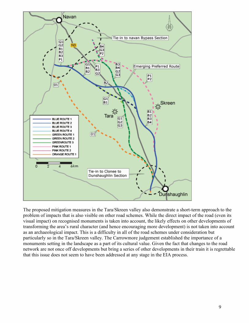
Ten route options were considered, nine of which passed through the Tara/Skreen valley. The route selection study noted that the route corridor P (see illustration below)
1 would have the least archaeological impact and
was “the only unreservedly recommended route in this discussion.” This was also the opinion of the Chief archaeologist but the present route, Blue 2 was ultimately selected as the preferred route on non-archaeological grounds. The green and grey route corridors were rejected as passing too close to Tara itself and the Pink and Orange corridors were rejected on non-archaeological grounds, based mainly on their impact on populated areas and their likely effect on existing minor roads.
The Desktop survey for Route Selection, in spite of the area’s historical and cultural significance at both a national and international level, concentrated on the more easily accessible published sources. As elsewhere the key archaeological criteria used were whether or not the proposed route would directly the monuments noted in the RMP. Where setting was considered it was in terms of the effect the road development might have on the intervisibility of individual monuments, in this case the main complex on the hill of Tara and Rath Lugh rather than on the overall historical/archaeological setting of the Tara/Skreen valley itself. The direct visual impact of the road from Tara itself. The archaeological assessment process appears to have
1
7
focused on direct impact on known monuments. The direct visual impact of the preferred route (Blue 2) on the Hill and on the intervisibility of the monuments at Skreen and Tara, as illustrated on the NRA Tara CD, appear to be less than those of Orange Route One which passed west of the valley but would have dominated the view westwards from the hill. The wider significance of transforming what had been a rural setting featuring a small, albeit busy, road into does not appear to have been considered relevant from an archaeological/historical perspective.
Knowledge creation at Tara was still in progress at the time of the decision. The ongoing research being conducted by the Discovery Programme was acknowledged in that some Discovery Programme Staff were consulted by the researchers. The consultation process seems to have been cursory however. No formal approach was made to the Discovery Programme and as a result key individuals involved in the Tara project were not consulted. The growing body of evidence that the entire Skreen-Tara complex exists as a single, interrelated archaeological landscape of crucial importance in the Medieval period and containing a series of previously unsurveyed material intimately connected to the larger monuments does not seem to have affected the assessment process.
Geophysical and other survey work created as part of the EIA along the preferred route has since located at least 28 new sites of archaeological interest. This underlines a fundamental difficulty with the use of desktop study as the primary tool during both the Constraints Study and the Route Selection phases of the EIA process; the number of archaeological sites which have been identified and mapped is vastly outnumbered by those that remain undetected. Decisions based on Desktop study are forced to rely on a very restricted set of data in comparison to the amount of archaeology actually present.
Mitigation
Mitigation along Blue Route 2 involved avoiding known and recognised archaeological monuments listed in the RMP and minimising visual signature. This appears to have been essentially confined to sites already listed in the RMP and SMR, both the NRA’s FAQ and their description of the route selection process make a point of noting the distance between the planned route of the M3 and the official “exclusion zone” established around the surviving monuments on the hill. The intervisibility of the surviving monuments was recognised as being of some importance. The NRAs promotional CD on the project demonstrates the extent to which the view of Screen from Tara and vice-versa will be unaffected by the proposed road, during daylight at least, and the fact that there would have been an adverse effect on the view westwards from Tara was given as a reason for rejecting the alternative orange route during the route selection process. The design of the Blundelstown interchange and of its accompanying lighting, appear to have been extensively altered to minimise light pollution and the related negative effects.
The network of field-walls running through the study area were largely ignored as archaeological features, meriting neither mention nor mitigation. This is regrettably because, as elsewhere, the large scale destruction of these boundaries is on of the largest single impacts that road projects have on the archaeological landscape. While it is quite possible that those the boundaries crossed were of no importance the question

8
itself does not seem to have been addressed at any point in the proceedings. No effort was made to quantify the number or overall length of the boundaries and linear earthworks to be destroyed during road construction, many of which are likely to have been of considerable antiquity and of at least medieval date. This is suggested by the surviving placenames of townlands such as Berrilstown, Clowanstown, Barronstown, Blundelstown and Philpotstown.
Geophysical survey techniques and test trenching along the preferred route were a central part of the mitigation, as mentioned above this has since identified over 28 sites along the preferred route. While apparently the tests have “not revealed any archaeological sites that would be considered unexpected on any similar sized road scheme anywhere in Meath
1,” the fact that the number is so much greater than those
known before the process began underlines a key weakness in the Route Selection process as it applies to archaeology. The route selection study commented that
“The monuments around Tara cannot be viewed in isolation, or as individual sites, but must be seen in the context of an intact archaeological landscape, which should not under any circumstances be disturbed, in terms of visual or direct impact on the monuments themselves. As all the routes cross the archaeologically rich plateau around Tara and Skreen it is highly probable that new archaeological monuments will be discovered during the course of construction”
This argument does not appear to have been taken on board however, possibly due to the difficulty of measuring a previously undiscovered site as a direct impact. At the Planning Hearings the fact that the road passed outside the circles marked on the SMR and RMP maps appears to have been given much greater weight than the impact on a “landscape” that, although agreed by all to be present, is remarkably difficult to define precisely. This is in spite of the fact that these circles are purely a visual marker to clearly indicate the presence of sites rather than a guide to their extent or to any “zone of protection.”
1
9
The proposed mitigation measures in the Tara/Skreen valley also demonstrate a short-term approach to the problem of impacts that is also visible on other road schemes. While the direct impact of the road (even its visual impact) on recognised monuments is taken into account, the likely effects on other developments of transforming the area’s rural character (and hence encouraging more development) is not taken into account as an archaeological impact. This is a difficulty in all of the road schemes under consideration but particularly so in the Tara/Skreen valley. The Carrowmore judgement established the importance of a monuments setting in the landscape as a part of its cultural value. Given the fact that changes to the road network are not once off developments but bring a series of other developments in their train it is regrettable that this issue does not seem to have been addressed at any stage in the EIA process.
10
M3 – Clonee – North of Kells (Navan ByPass)
Desktop
The desktop survey drew on the RMP, SMR Topographical files and Archaeology Inventory of County Meath, the Duchas archives and an unpublished report by John Bradley the Urban Archaeological Survey of County Meath. Journals consulted included Ríocht na Mídhe, the JRSAI and Archaeology Ireland although the specific articles consulted are not specified. These were used to both identify specific sites and to provide an overview of the settlement history of the area and, notably, of Navan. The limitations of the archaeological sources when dealing with post-1700 sites were acknowledged.
Regrettably, however, this acknowledgement was not accompanied by a great enough effort on the part of the researcher to compensate for this deficiency in the desktop study. The dividing line between conventional archaeology and the post-medieval remains seems to leave elements of the archaeological heritage stranded with no obvious defender. The presence of Ardbrackan House and Demesne are noted in the EIA but the likely consequences of this are not taken sufficiently into account. The M3 is to cut through the confines of the demesne, a defined archaeological landscape in existence in the 17th century. But none of the usual protections recommended by the Guidelines and brought into play with regard to other site types are even mentioned. The report itself identifies Ardbracan as the site of a Bishop’s Seat since the fourteenth century and notes the presence of a stone church there in the 12th.
The architectural report refers to the prior existence of two castles which are not mentioned in the archaeological report. The Down Survey Maps were used and referred to by the architectural team but not by the archaeological. While the precise locations of the castles’ remains are unknown but they are almost certain to be within the demesne boundaries as are any associated roadways, dwellings etc. Even the possibility of encountering them is absent from the archaeological report nor are they considered as candidates for mitigation in the architectural report.
This lack of coordination between the two teams reflects the artificial and now anachronistic divide between archaeology and architecture, which needs to be addressed as it can seriously hinder the full understanding of the impacts involved. Close cooperation between the two disciplines is required as the origins of many estates lie in the medieval period and the limited education and experience of most archaeologists with post-medieval remains and demesnes in general and of architects with archaeological material and relict landscapes which may be present in the area surrounding and incorporated into the fabric of Big Houses can lead to material “falling through the cracks” and going unrecorded.
11
The presence of a succession of secular and religious centres ranging over at least seven centuries and contained somewhere in Ardbracan demesne is acknowledged in both the archaeological and architectural reports. The presence (actual not potential) of these sites somewhere inside the study area might have been expected to lead to a more focused research process inside the demesne in order to identify the sites in question and avoid them. In spite of this, all of the mitigation measures are premised on the need to avoid sites identified in the RMP and to investigate sites identified during the field-walking phase of the study. The structure of the mitigation process, premised as it is on avoiding effects on sites of known location, militates against effective mitigation in cases such as these.
Fieldwork
The fieldwork component involved both inspection of sites identified by the Desktop Survey and visual inspection of the road-route and proposed related works. Sites identified as being of possible archaeological interest were noted and the likely impact assessed. Some areas were unavailable for inspection due to political difficulties at the time but this is at least partially compensated for by a recommended low-level aerial survey. One troubling omission from both the desktop study and the fieldwork was any inspection or consideration of field boundaries. The destruction of these is neither noted as an impact nor the subject of any proposed mitigation (discussed in more detail below).
Mitigation Measures
The recommended mitigation measures included a recommendation that potential archaeological sites should be avoided if possible. Where some impact was inevitable the report recommends a process of aerial survey along the route, topographical and geophysical survey as well as trial trenching of specific sites to determine their precise nature followed by full excavation if they turn out to be archaeologically significant. In addition to this a general programme of topsoil stripping in a herringbone pattern is also recommended along the length of the route prior to construction to maximise the chance of detecting any further sites.
N5 - Charlestown Bypass
Desktop
12
The N5 Archaeological Assessment also focuses on the direct impact of road construction on known monuments. The desktop element of the survey shows some signs of having been cursory. The available sources including the RMP, SMR, NMI topographical files and the results of drainage schemes were all consulted but the lack of any direct referencing within the report or in the bibliography to specific articles or editions of Cathair na Mart (the local Journal which is simply referenced en-bloc) suggests that the use of local published sources was not as thorough as it might have been.
Fieldwork
With regard to the discovery of previously unlisted sites the preliminary fieldwork appears to have been thorough, although in several cases wetland and forest areas were described as impassable or else as being too dangerous for adequate inspection.
Mitigation Measures
The recommendations dealing with knowledge creation tend to be cursory and show a tendency to tick the boxes rather than consider the full potential of each stage of the development process for gathering information. Several vernacular buildings are to be destroyed during the construction process, as are two crossing points. The remains at both of these are assumed to be late and preservation by record is recommended for them. The possibility that surviving nineteenth century settlement remains may overlay earlier deposits was not considered nor is the possibility that excavation or survey in the immediate area of these vernacular houses might increase the information gain from the soon to be destroyed houses. The authors acknowledge the importance of river crossing points and recommend the use of an underwater survey but while surviving remains at the crossing point are to be preserved by record the likelihood that these stepping-stones may overlie an earlier crossing point is not considered.
Similarly, the importance and archaeological sensitivity of bogland areas is acknowledged in the text but the full implications of this are not recognised in the recommendations. The monitoring archaeologist is directed to play close attention to topsoil stripping but, surprisingly in view of the discovery of two Bronze Age artefacts in townlands along the route, a metal detector survey is not recommended which might bring more finds to light. In view of the fact that a combination of weather and difficult ground made it impossible for the field survey teams to inspect some of the wetland and forest areas it would have been appropriate to direct the monitoring archaeologist to dedicate some time and effort to completing the inspection of these areas prior to construction but he is instead reminded that archaeological finds have been made in woodlands from time to time.
13
N6 Galway to East Ballinasloe Gleannascaul – East Ballinasloe
Desktop
The Desktop study drew on the SMR, RMP and NMI Topographical files as its primary sources. The literature review included Lewis Topographical Dictionary, The Archaeological Inventory of North Galway, JGAHS, PRIA, JRSAI. Recently published sources included the “Atlas of the Irish Rural Landscape”, “Souterrains of Ireland” and the more esoteric “Turoe and Athenry: ancient capitals of Celtic Ireland”. The online Excavations database was also consulted. Aerial photographic resources consulted included APs from the Ordnance Survey, Geological Survey and the Cambridge UniversityCommittee for Aerial Photography as well as photographs of the route provided by the developer. Cartographic sources consulted were limited to 1st Edition OS 6 inch sheets of the area and the SMR and RMP maps.
Fieldwork
Previously identified sites were inspected and described during field work and the route itself walked although difficulties were acknowledged due to undergrowth.
Mitigation Measures
The use of Mitigation for effected sites includes topographical and geophysical survey combined with test trenching and possible full excavation for sites identified during field walking or from aerial photographic sources. The range of sites identified in the EIA demonstrates a greater appreciation of the variety of archaeological site types than those previously discussed. The effect of the proposed development on field systems is specified in the report in contrast to the others.
As is the case with Ardbracan House mentioned above, there appears to have been a disconnect between the Architectural Heritage team and the Archaeological Researchers. Mackney House which is to be directly impacted by road construction is discussed in the Architectural Heritage Report as an 18th-19th century Big House and Demesne centre but fails utterly the address the surrounding demesne. The Archaeological Heritage report also fails to draw attention to the potential archaeological impacts on the demesne or to assess or to assess the full settlement history of the buildings described in the architectural report. The mitigation
14
measures mentioned in the architectural report, preservation by record of the surviving remains, photographic record and further research, do not compensate for the lack of any archaeological work to elucidate the origins of settlement on the site or its possible antiquity.
Trends noticeable in EIA’s Studied
In addition to individual lapses and difficulties there are several gaps in the EIA’s studied which seem to be common to all of them. Taken together these could seriously compromise the value of the resulting research.
Mesolithic Material
One glaring omission from all of the EIAs studied has been the Mesolithic (c.7,000 –4,000BC), the single longest period in Irish prehistory. Knowledge of the Mesolithic has been increasing over the past decade with evidence for Mesolithic settlement being discovered over increasingly large areas of the country. In spite of this the possibility of encountering Mesolithic material at river crossings or in other areas is not mentioned in any of the reports. Woodman (XXXX)
1has noted the lack of Mesolithic material encountered on National
Road Schemes and it seems likely that the failure of the EIA process to draw attention to the likely presence of Mesolithic material may be partially responsible for this deficiency.
Inconsistent Treatment of Sites
Overall the material considered as worth “preservation by record” in the different EIAs lacks consistency. While the process followed in each case is more or less the same for each of the archaeological reports consulted, and the recommended mitigations all more or less identical, avoidance or preservation by record, the types of monuments considered as valid archaeological sites varies widely and appears to have expanded over time. In the M3 EIAs field systems, townland and parish boundaries etc receive no mention. On the N6 (Gleannascaul – East Ballinasloe) archaeological heritage report by contrast, field systems are noted as sites in their own right and the percentage of them to be impacted is specified. One gets the impression, difficult to verify or demonstrate, that theses sites, as well as vernacular architecture in general, are only brought into the discussion when there is a perceived lack of “real archaeology” to consider.
1
15
The lack of specific guidelines on which features should be included leaves the decision to the subjective opinion of the researcher in the field. It might be wise if the decision to call for a certain level of mitigation (photograph, detailed record, trial excavation etc) was accompanied by a description of why this particular level was considered appropriate. This might help to clarify, to both the reader of the report and the researchers themselves, the thought processes and principals involved in making these judgements.
Linear Boundaries and Field Walls
None of the assessments reviewed show makes any serious attempt to analyse in any coherent way the date and cultural context of the myriad of linear boundaries both of earth and stone that carpet the study areas. Yet these are largest man made features impacted by road developments. This is a major failing, given the widespread survival of a whole range of these boundaries and a scholarly tradition of analysing field systems in Ireland.
Parish and townland boundaries are often of medieval date and these are clearly marked on a myriad of early map sources. While surviving field systems are often assumed to be of 18th/19th century date this is not necessarily the case. The only mitigation normally recommended is “preservation by record” rather than full excavation. This may well be the appropriate response in most cases but there is no indication in the text of the reports that the possibility that the field boundaries might be of much earlier date was even considered.
Similarly, there is an almost complete failure to analyse the placename evidence, even at a townland level, as a clue to former settlement and land usage patterns. This is particularly apparent in the Tara-Skreen valley but is also visible in the N6 EIA where a site in Deerpark townland is to be impacted but no analysis of the Deerpark is presented. These have their origins in the medieval period and can be clearly defined entities in their own right and delineating the location and boundaries of the Deerpark should have been a major objective in minimising impact on it or else allowing an effective excavation strategy. The failure to do this, in spite of the name, is symptomatic of the failure to deal with the reality of large self-contained archaeological landscapes which do not lend themselves well to the recommended mitigation measures in the Draft Guidelines.
Mitigation Measures
The EIA process is centred around identifying and then avoiding or mitigating the effect on single archaeological monuments or sites. The concept of an archaeological landscape, needs to be incorporated into the process, although recent efforts to identify and delineate such landscapes have proven difficult. The setting in which both monuments and landscapes are found, the legal existence of which is implied in the
16
Carrowmore judgement1, also needs to be taken into account early in the process – ideally during the
Constraints Study or Route Selection phases.
A crucial weakness of the mitigation measures proposed, both in the Guidelines and in the individual EIA’s, is that they focus purely on immediate impacts to the archaeology involved rather than taking a longer view. The N6 EIA, for example, rightly highlights bogland areas as areas of high archaeological potential and incorporates this into the recommendations made with regard to them. Changes in the water regime of an area however, (water retention or exclusion, flow patterns and rates, quality and temperature etc) have recently been highlighted as one of the most significant impacts on “the character of the burial environment”. Changes in the presence or absence of water can have physical, chemical and biological effects on the buried archaeology – even where there has been no immediate impact as a result of construction work. Similarly, post-construction remedial and maintenance activities (which are likely to be of long duration on a road project) can also have adverse effects on archaeological remains long after the completion of the road itself. (Davis, Gdaniec, Brice and White, 2004, 9) These longer-term effects should be considered as part of the recommended mitigation strategy on every major road scheme.
Observations on the EIA Process
The EIA Process has tended to be quite amateurish in the past and quality has varied widely, publication of the NRA’s draft guidelines is a valuable step forward. Serious weaknesses remain however in both the process outlined in the guidelines and in the way in which EIAs are compiled by private companies and assessed by nobody.
Constraints Study and Route Selection Process: Limitations of the Desktop Survey
Desktop survey, as a technique is a vital element in assessing the archaeological heritage. Its importance to the decision making process is not always reflected in the time, resources and expertise given to it.
There is a tendency to draw on the recommended sources listed in the Draft Guidelines without critically assessing the values and limitations of each. The Desktop Surveys that take place during the creation of the Constraints Map and the more detailed studies during route selection are the key archaeological influence on the choice of preferred route. For this reason, it is crucial that the limitations of the available sources be understood and that available material be critically assessed and “stress tested.”
1
17
The principal official sources consulted, notably the SMR/RMP lists and the County Inventories (which are based on the SMR, RMP material), vary widely in the criteria used for selecting material and the extent and depth of the field-work involved can vary quite widely. For example, in 1985 new research techniques and organisational structures were introduced by the Office of Public Works to enhance and streamline the quality and efficiency of the states pre-field work research component. This was done by the creation of the Sites and Monuments Record Office, which was responsible for sixteen counties, with Cork and Galway Universities responsible for three more. The level of expertise with the SMR Office increased during the process of its work so the quality of the resulting SMRs is not uniform. The other counties, including Co Meath, were surveyed by the Archaeological Survey of Ireland, which did not have the benefit of the integrated approach adopted by the SMR Office. County Inventories from these counties are therefore less complete than the others and any desktop survey that relies on them will be more likely to miss sites of archaeological significance.
The criteria used for including sites in the archaeological inventories vary as well. For example, in the Meath, Monaghan and Louth Inventories, Holy Wells are not included as distinct site types although those that are found in association with other monuments, such as a dated inscribed stone (see Meath Inventory pg.153), may be included in the text. In the West Galway Inventory they are included as monuments in their own right. The omission of Holy Wells from a number of Inventories was a policy decision within the Archaeological Survey of Ireland which was later reversed but the Inventories based on the earlier policy have not been replaced or updated.
The transition between the SMR (Sites and Monuments Record) and the revised RMP (Record of Monuments and Places) involved the addition of newly discovered sites but also the delisting of large numbers of monuments (although no precise figures are available), which had been included on the old Record. Concerns have been expressed within the archaeological community that the process of adding new sites has lacked consistency. The delisting of monuments appears to have been done in a haphazard, unsystematic and highly individualistic way for which the criteria are unavailable. “Non-diagnostic” monuments have been delisted, sometimes with disastrous consequences as in the case of Telltown close to Tara. The Archaeological Survey staff delisted a series of linear earthworks, which were subsequently bulldozed. In the case of Telltown the site was subsequently excavated and re-entered on the RMP. There has been a lack of transparency about the process of delisting monuments and about the process of re-assessment that follows the detection of errors. As a result, in the absence of a full scale review of these decisions, previously delisted sites should be considered as potential sites during the creation of Planning Constraint Maps.
The RMP tends to be at its weakest in including post-medieval archaeological features. This also tends to be the period for which archaeologists themselves are least well equipped in experience and education to handle the sources (although this is improving). This is a result of a historic bias towards the later prehistoric and early Christian periods in Irish archaeology. The Cork Inventories and RMP are a notable exception to this trend, due to the particular expertise contained within the Archaeological Survey of Cork. Mesolithic sites are also virtually absent from the SMR and RMP. As a result the first 4,000 years of Irish settlement are virtually ignored in the most crucial part of the EIA process and there is little consciousness of this lack. There has been a spectacular failure to identify significant numbers of Mesolithic sites on major road schemes and it is
18
unlikely that this is coincidental (Woodman, 20031).
Another weakness of the official Published sources is that the sites recorded in them tend to be discrete individual diagnostic monuments. The existence of archaeological landscapes consisting of a palimpsest of related features, relict field systems, roadways etc is poorly reflected in the usual sources (SMR, RMP etc) despite the obvious richness of the Irish landscape in these features from the early Neolithic onwards. The single largest impact of the road building process is its effect on the integrity of these landscapes. Road construction inevitably traverses large numbers of these multi-period areas. In spite of this the system of recording recommended in the guidelines is based around the identification and description of discrete monuments. This is a conceptual difficulty and limits the researcher’s ability to understand and appreciate the impact of developments on the landscape as a whole. It is also visible in the publications which have resulted from National Road Schemes. These tend to describe the excavation of single sites rather than reflecting on the wider patterns of settlement and change uncovered by the work in progress. A detailed overview of settlement patterns in the area created during the EIA process might help to clarify the picture and to reduce this tendency.
The SMR, RMP and County Inventories are the principal sources used in the creation of Constraints Maps and in the route selection process. As we have seen however these contain only a fraction of the existing archaeology and vary among themselves in both quality and in the criteria used to identify monuments as archaeological. As a result the SMR and RMP should be treated as independent sources which must be assessed independently by the researcher in each individual desktop study rather than being treated as authoritative documents. Similarly, the use of County Inventories should be supplemented by direct consultation of the sources which they quote. Other desktop sources such as the available Down Survey Maps, Estate Maps, Hayes Catalogue etc should be consulted in each case. The availability of estate maps can add as many as ¾ of the known sites to those recorded on the OS maps and the edition of Down Survey information (mid 17th century), in the case of Co Kilkenny added almost 200 additional castle sites to the known record. Similarly, vertical aerial photographs held by the Ordnance Survey and Geological Surveys of Ireland as well as the new Colour Vertical Coverage (where appropriate) should be consulted as part of the Constraints and route selection phase even where this appears to have already been done in the compilation of the County Inventory or RMP listing.
There is a high likelihood, amounting to certainty in many areas of the country for which estate maps are unavailable or where the record kept by the OS Surveyors is known to have been weak, that a desktop survey will fail to identify a large proportion of the surviving archaeology in an area means that the constraints mapping and route corridor selections phases of the process should involve both geophysical and aerial survey techniques in order to minimise surprises later in the process.
Every effort should be made to identify the likely weaknesses in the Desktop Survey, ie sources not consulted, unavailable etc. These weaknesses should be specified in the resulting reports and every effort
1
19
made to remedy them during consultation with outside experts. The limitations and deficiencies in both the data and sources used in the Desktop study phase and in the fieldwork along the route itself should be explicitly stated and explained, not only in the body of the report but also in the non-technical summary. Given the limitations of these sources, the list of recommended sources should be extended to include the Hayes Catalogue in the National Library which contains a quite comprehensive and cross-referenced listing of early maps.
Where sites mentioned in the historical sources were known to exist but cannot be precisely located it is likely, as in the case of Ardbracan above, that they will not be listed in the Inventories or marked on the SMR or RMP maps. They do still exist however, archaeological sites are virtually impossible to destroy completely. The presence of these sites, not as a possibility which suggests that they might not exist, should be incorporated into both the Constraints Study and Route Selection phases of the EIA process so that they can be avoided if at all possible. If the decision is made to proceed with construction in these areas anyway, which will inevitably happen in some cases then recommendations to the monitoring archaeologist should be specifically tailored to maximise the chance of discovery of these sites prior to the route being finalised.
The discovery of a series of sites in the Tara-Skreen Valley, in an area where the RMP had listed only two sites, provides one more example of a fact well-known to all archaeological professionals – the vast bulk of the archaeological heritage remains undiscovered and unmapped. Improved Desktop study and Consultation in the Constraints Study and Route-Selection phases of the Planning process will provide better data on which planners can base their decisions but the picture provided by existing sources will remain a limited one. The use of detailed archaeological and technical survey work can help with mitigation in the pre-construction phase but takes place too late in the process to make a major difference to planning decisions. In order to maximise the information available for the creation of a “preferred route” a programme of Geophysical and aerial Survey take place along the various route corridors should take place during Route Selection rather than only along the preferred route as is the case at present.
This minimises the possibility of avoiding newly discovered sites since it is likely that the route will already have been decided by the time they are detected. There may be an impression that the use of Geophysical survey techniques can compensate for weaknesses in the Desktop Survey and the EIS as a whole. There may be a sense that what is missed in the initial assessment will be discovered during Geophysical Surveying along the final route or else during monitoring of road construction. The difficulty with this approach is that by the time modern techniques come into play the preferred route has already been selected and the information derived can only be used to mitigate rather than completely avoid negative impacts.
Route Corridors
Another reservation with regard to the route selection process is the use of several broad “corridors” as the basis for comparison. The number and significance of recorded monuments in each of these is recorded in Table form and used to assess and compare likely impacts. The corridor considered to have the lowest
20
potential impact based on archaeological and other factors is chosen for the road development. The assessment of “potential impact” is quite crude however. It has been pointed out that if it proves possible to route the road around many of the sensitive areas within a corridor then a route corridor with an apparently greater number of monuments and areas of archaeological potential can potentially have a lower archaeological impact than what appears at first to be the best option.
Consultation
Given the dynamic nature of archaeological knowledge and the vast increase in information available to researchers since the main sources cited in the Draft guidelines were compiled it would seem to be appropriate to bring outside experts into the process earlier than during the rather haphazard public consultation process. There is a need to consult with and assess the opinions of experts (where applicable) working in the area early in the process, ideally during the route selection phase. A good example of this is Dr. Hiram Murtagh’s
1 contribution in rtlation to the site of the battle of Aughrim which should ideally have
helped to inform the Route Selection process.
This should include an active effort on the part of staff doing the report to take account of ongoing research, which has not necessarily entered the public domain and would thus be missed by a desktop survey following the NRA Guidelines. An overall settlement history of the areas concerned, based on the available general histories, archaeological inventories etc, during the constraint mapping phase of the road planning process might, in concert with consultation with local archaeologists and recognised experts, make it easier to predict the likely presence of unlisted archaeological remains. At present the constraint mapping phase of the planning process only takes account of listed sites. An overview of settlement history would allow potential sites to be given at least some weighting in the road and would also provide a source of information when it came to assessing the relative significance of sites. Such a process might have been decisive in the case of the M3 where the settlement history would have pointed very strongly to the likely existence of undiscovered archaeological material which was directly related to the Tara complex throughout the valley and might have tended to push the discussion in the direction of the “orange” route which passes west of the Tara Complex.
In order to guarantee a consistent level of consultation prior to the Planning Hearings every effort should be made by both the NRA planners and the archaeologists concerned with the EIS to consult with acknowledged experts, local archaeological groups and landowners during the constraints mapping and route selection phases of the process. The consultation process should be detailed in the EIS, including dates, individuals and organisations contacted. At a minimum it would seem that those consulted should include:
The National Museum of Ireland
1
21
An Taisce
The Department of the Environment
The Heritage Council
The Discovery Programme
Local Heritage Officers
County Archaeologists
Local Museum Staff
Local Field Clubs and Archaeological/Historical Societies
Archaeology Departments of the National Universities
Landowners across whose land the proposed routes (during route selection) will pass
Knowledge Creation and The Role of State Bodies
Statutory and policy framework guiding development process is almost entirely focused on preserving existing recorded monuments. This process is also visible in the individual EIAs studied. While the range of sites covered and the use of sources to identify these varies from report to report they are treated as individual monuments which will be impacted to one degree or another. The Assessment process focuses on recording and excavations as a means of mitigating these impacts. However, promoting sustainability in archaeology must also involve a process of knowledge creation in order to extract the maximum information value from the destruction of archaeological assets.
22
The National Road Schemes cut across the Irish rural landscape and pass through areas that have been in use for agriculture since at least the Neolithic. The existing network of field boundaries earthworks and old road and trackways which delineate this landscape is unavoidably damaged or destroyed by the process of road construction. As a result a major goal of the EIA process should be to limit the resulting damage to the archaeological heritage by gaining the best understanding possible of the landscape as a unit rather than as a series of discrete features. Recent efforts to provide a definition of an archaeological landscape have proven difficult but, even if the area covered cannot be precisely defined, it should be possible to gain an improved understanding of the development of the Rural landscape over time. This understanding should, in turn, help to inform later EIAs.
State Bodies could play a more creative role in the EIA process than merely acting as consultees. The entire process is extremely responsive to priorities set by official bodies and by officially published information. This is visible in the importance given to the SMR, RMP and published inventories in the desktop study phase. Prominence is given to water bodies in each individual EIA in response to a Duchas memo from 1998 stressing the potential of these areas.
Regular updates on the archaeological importance of, for example, townland and parish boundaries or vernacular architecture would almost certainly increase the status that these are given during the assessment process and the resulting gains in terms of knowledge creation. The same holds true of written sources used during the Constraints study, Route Selection and in the final EIA. The value of vertical aerial photography, the Hayes Catalogue and the available Down Survey and Estate Maps as well as more recent publications in identifying new monuments and in deepening the researchers’ understanding of the settlement history of the areas in which they work is clear. If this were emphasised at an official level would doubtless pay immediate dividends in the quality and quantity of information made available at all stages of the process.
Lack of Clarity of Responsibility in the Final Compilation and Presentation
After the completion of the report by the archaeological consultant it is then passed to the client (in this case the County Council) who then compiles it and includes it with the overall planning application. The non-technical summary is often written without a direct input by the original consultants who might have chosen to emphasise details differently. There appears to be no final, “signing off” process on the part of the archaeological consultants or agreement as to how their information is to be used. This is important as the non-technical summary plays an important role in the public consultation process after the EIA has been completed and every effort should be made to make sure that it reflects the opinions of the authors of the report.
Lack of Revue or Assessment for Completed EIAs.
23
At present a potential conflict of interest exists for Archaeological Consultancy Companies working on major roads schemes. Since the contracts for the resulting excavations are likely to fall to the same companies they are potentially major beneficiaries of any failure to detect previously unknown sites in time for them to be avoided. This is far from an ideal. The objectivity of assessments produced by these companies could potentially be compromised and the integrity of the system cast into doubt in the public mind by this conflict.
No system of assessment exists for EIAs which leaves archaeological consultants in the unenviable position of assessing their own work. There is, at present, no independent body whose specific function it is to assess the quality or accuracy of archaeological impact statements. The NRA is a state body enacting government policy and doubts have been expressed on several occasions, notably during the Carrickmines controversy as well as at Woodstown and most recently in the M3 Tara-Skreen dispute as to whether Dúchas (as was) or the Department of the Environment, Heritage and Local Government have been sufficiently active in the defence of archaeological interests as opposed to those involved in road construction. The Heritage Council, whose role this might seem to be, has tended not to involve itself in specific cases.
The state’s responsibility for transport policy and its, often conflicting, responsibility to protect the National Heritage argue for either an independent body to adjudicate the decision making process and revue the research produced on road construction process or else for an agreed set of standards which could be independently verified in any particular case.
The EIA process is currently still developing and the NRA Draft Guidelines are playing an important part in this process. Major improvements in methodology are visible between the M3 EIAs (2001) and those for the N6 (2004) and many of these appear to have been adopted as a result of individual initiative rather than coherent policy. In addition to its value in bringing transparency to the debate some form of assessment by an outside body not believed to have an interest in road construction, (possibly the EPA, Heritage Council, Office of Public Works or the Department of the Environment), could help to institutionalise a process of constant improvement by rapidly bringing useful innovations in practice to the attention of other researchers in the field.
Conclusion
The EIA process on major road schemes is the principal means by which the state fulfils its obligations to protect the National Archaeological Heritage and maximise its value to the community as a sustainable resource into the future. Archaeological resources destroyed unnecessarily due to failings or gaps in the EIA process are irreplaceable and at present the archaeological assessment process fails to adequately address the threats to the cultural heritage posed by large-scale motorway developments. While, the points raised above cannot claim to be an exhaustive list and the recommendations are far from a panacea they do at least draw attention to a series of inadequacies in the present system
24
While work is ongoing in the NRA and elsewhere on improving procedures and the quality of published EIAs, there is still considerable cause for concern. The NRA Draft Guidelines as they stand are inadequate in several areas. Just as there is a clear need for the teams involved in different portions of EIS research to coordinate their efforts and integrate their results more effectively on individual projects there is a similarly pressing need for all concerned parties to contribute to the drafting of a new set of Guidelines. This should involve a far wider consultancy process than appears to have been the case with the initial set which seem to have merely codified existing practice.
The EIA process should be a central plank in the maintenance of sustainability in Ireland. It can be argued, based on the evidence examined that thus far it has thus far failed to do so in the field of archaeology.
25
Bibliography
Department of Arts, Heritage, Gaeltacht and the Islands and the National Roads Authority “Code of Practice Between the National Roads Authority and The Minister for Arts, Heritage, Gaeltacht and the Islands”
Environmental Protection Agency (March 2002)“Guidelines on the Information to be Contained in Environmental Impact Statements,” CAAS Environmental Services Ltd, 6 Merrion Square, Dublin 2
Environmental Protection Agency (September 2003) “Advice Notes on Current Practice (in the Preparation of Environmental Impact Statements),” CAAS Environmental Services Ltd, 6 Merrion Square, Dublin 2
European Union (1987) “Council Directive of 27 June 1985 on the assessment of the effects of certain public and private projects on the environment (85/337/EEC)”
European Union (1997) “Council Directive 97/11/EC of 3 March 1997 amending Directive 85/337/EEC on the assessment of the effects of certain public and private projects on the environment”
National Roads Authority “Guidelines for the Assessment of Archaeological Heritage Impact of National
26
Road Schemes (Draft),” Margaret Gowan and Co., Archaeological Consultants and Project Managers, Dublin
National Roads Authority “Guidelines for the Assessment of Architectural Heritage Impact of National Road Schemes (Draft)”
National Roads Authority “A Guide to NRA Archaeology”
National Roads Authority “The NRA, The M3 and Archaeology: The Facts”
National Roads Authority and Meath County Council (July 2005) “The M3 Clonee to North of Kells Road Scheme: Archaeological Research Framework,”
O’Rourke, Dara (2004) “The Modern Road Network and its Impact on Archaeology and History”
(August 2004) “N6 Galway to East Ballinasloe Environmental Impact Statement: Vol 4A Doughiska to Gleannascaul, Vol 4B Gleannascaul to East Ballinasloe Technical Report”
(April 2005) “N6 Ballinasloe-Athlone Environmental Impact Statement Vol. 4”
27
http://m3motorway.ie/M3Background/PlanningProcess/RouteSelection/
The M3 Motorway: Route Selection: http://www.m3motorway.ie/M3Background/PlanningProcess/RouteSelection Woodman 2003, "Pushing Back the Boundaries,", Peter Jackson Memorial Lecture, Occasional Papers in Irish Science and Technology, No 27, Dublin, RDS
"Judgement of McCarthy, J. delivered the 17th February 1989 in The Supreme Court: The Attorney General at the Relation of Frank McGarry, Paddy O'Hara, Patricia Mulligan, Neil Cremin, John Hamilton and Frank McGarry, Paddy O'Hara, Patricia Mulligan, Neil Cremin,and John Hamilton in their own right as plaintiffs and County Council of the County of Sligo, Defendant”.
Woodman 2003, "Pushing Back the Boundaries,", Peter Jackson Memorial Lecture, Occasional Papers in Irish Science and Technology, No 27, Dublin, RDS
H. Murtagh in N6 Gleannascaul to East Ballinasloe/Loughrea link road schemes Vol 4b Cultural Heritage