Environmental Impact Assessment for proposed Isimba 132 kV … · · 2013-10-07MINISTRY OF ENERGY...
188
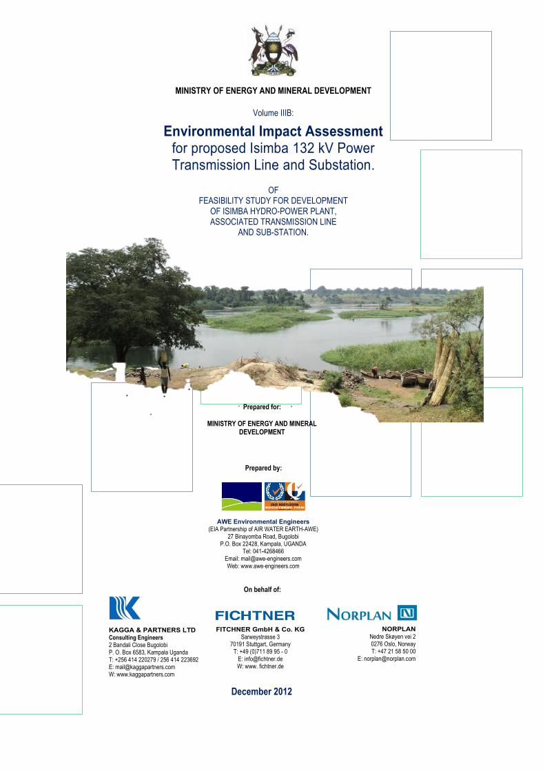
MINISTRY OF ENERGY AND MINERAL DEVELOPMENT Volume IIIB: Environmental Impact Assessment for proposed Isimba 132 kV Power Transmission Line and Substation. OF FEASIBILITY STUDY FOR DEVELOPMENT OF ISIMBA HYDRO-POWER PLANT, ASSOCIATED TRANSMISSION LINE AND SUB-STATION. Prepared for: MINISTRY OF ENERGY AND MINERAL DEVELOPMENT Prepared by: (EIA Partnership of AIR WATER EARTH-AWE) 27 Binayomba Road, Bugolobi P.O. Box 22428, Kampala, UGANDA Tel: 041-4268466 Email: [email protected] Web: www.awe-engineers.com On behalf of: Consulting Engineers 2 Bandali Close Bugolobi P. O. Box 6583, Kampala Uganda T: +256 414 220279 / 256 414 223692 E: [email protected] W: www.kaggapartners.com Sarweystrasse 3 70191 Stuttgart, Germany T: +49 (0)711 89 95 - 0 E: [email protected] W: www. fichtner.de Nedre Skøyen vei 2 0276 Oslo, Norway T: +47 21 58 50 00 E: [email protected] December 2012
Transcript of Environmental Impact Assessment for proposed Isimba 132 kV … · · 2013-10-07MINISTRY OF ENERGY...
MINISTRY OF ENERGY AND MINERAL DEVELOPMENT
Volume IIIB:
Environmental Impact Assessment for proposed Isimba 132 kV Power Transmission Line and Substation.
OF
FEASIBILITY STUDY FOR DEVELOPMENT OF ISIMBA HYDRO-POWER PLANT, ASSOCIATED TRANSMISSION LINE
AND SUB-STATION.
Prepared for:
MINISTRY OF ENERGY AND MINERAL DEVELOPMENT
Prepared by:
(EIA Partnership of AIR WATER EARTH-AWE) 27 Binayomba Road, Bugolobi
P.O. Box 22428, Kampala, UGANDA Tel: 041-4268466
Email: [email protected] Web: www.awe-engineers.com
On behalf of:
Consulting Engineers 2 Bandali Close Bugolobi P. O. Box 6583, Kampala Uganda T: +256 414 220279 / 256 414 223692 E: [email protected] W: www.kaggapartners.com
Sarweystrasse 3 70191 Stuttgart, Germany
T: +49 (0)711 89 95 - 0 E: [email protected] W: www. fichtner.de
Nedre Skøyen vei 2 0276 Oslo, Norway T: +47 21 58 50 00
December 2012
MINISTRY OF ENERGY AND MINERAL DEVELOPMENT
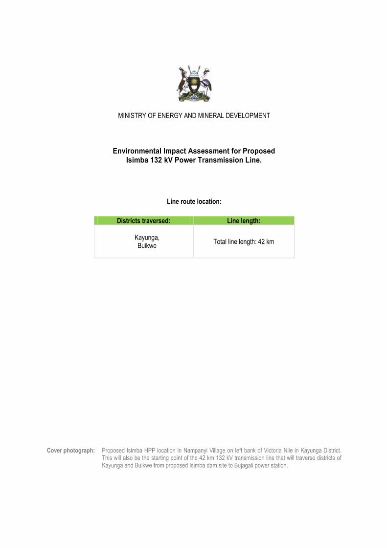
Environmental Impact Assessment for Proposed Isimba 132 kV Power Transmission Line.
Line route location:
Districts traversed: Line length:
Kayunga, Buikwe
Total line length: 42 km
Cover photograph: Proposed Isimba HPP location in Nampanyi Village on left bank of Victoria Nile in Kayunga District. This will also be the starting point of the 42 km 132 kV transmission line that will traverse districts of Kayunga and Buikwe from proposed Isimba dam site to Bujagali power station.
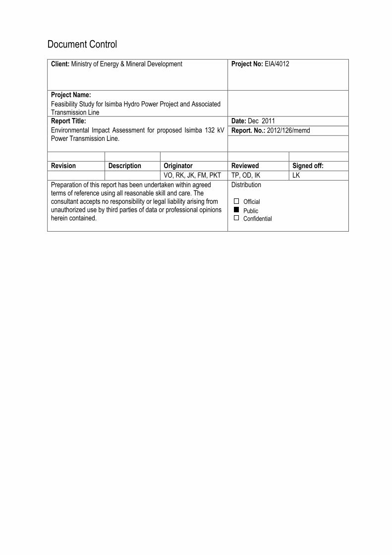
Document Control
Client: Ministry of Energy & Mineral Development
Project No: EIA/4012
Project Name:
Feasibility Study for Isimba Hydro Power Project and Associated Transmission Line
Report Title:
Environmental Impact Assessment for proposed Isimba 132 kV Power Transmission Line.
Date: Dec 2011
Report. No.: 2012/126/memd
Revision Description Originator Reviewed Signed off:
VO, RK, JK, FM, PKT TP, OD, IK LK
Preparation of this report has been undertaken within agreed terms of reference using all reasonable skill and care. The consultant accepts no responsibility or legal liability arising from unauthorized use by third parties of data or professional opinions herein contained.
Distribution
Official
Confidential
Public
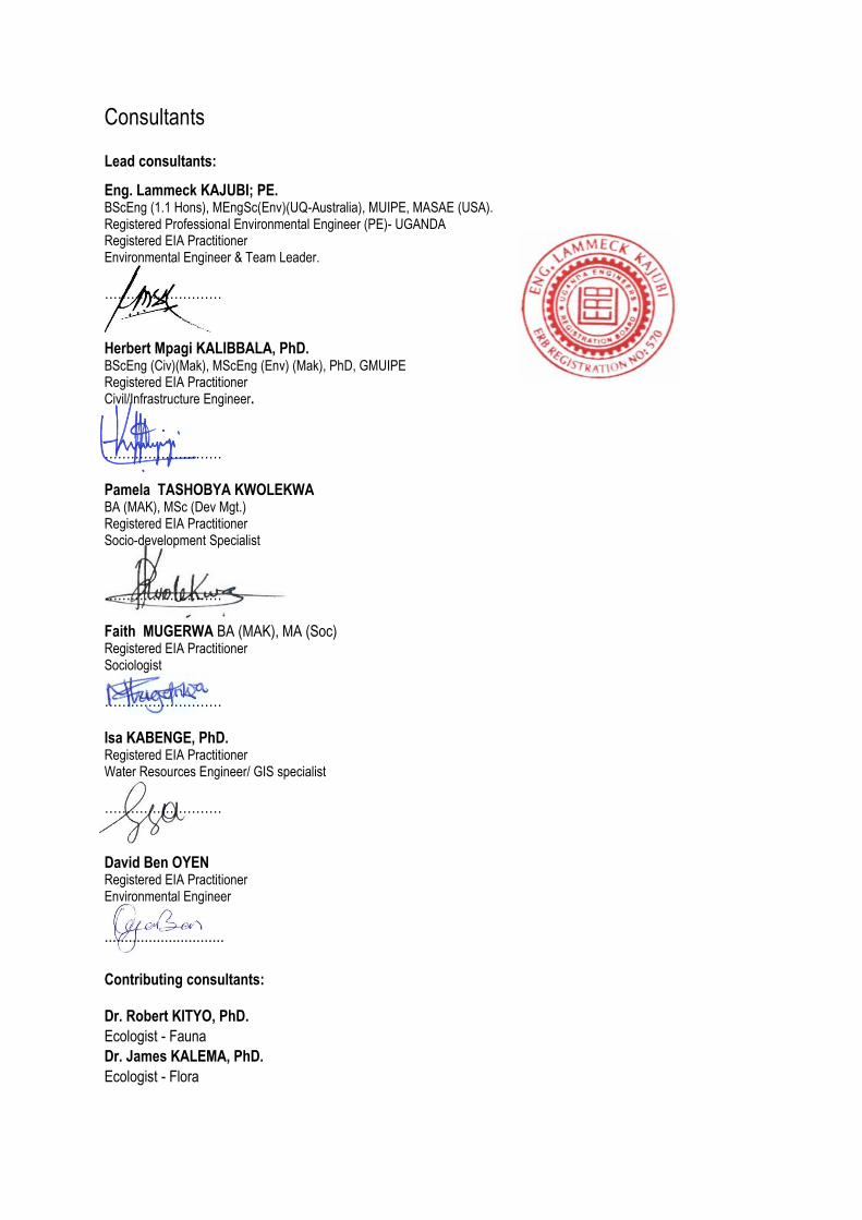
Consultants
Lead consultants:
Eng. Lammeck KAJUBI; PE. BScEng (1.1 Hons), MEngSc(Env)(UQ-Australia), MUIPE, MASAE (USA). Registered Professional Environmental Engineer (PE)- UGANDA Registered EIA Practitioner Environmental Engineer & Team Leader.
……………………… Herbert Mpagi KALIBBALA, PhD. BScEng (Civ)(Mak), MScEng (Env) (Mak), PhD, GMUIPE Registered EIA Practitioner Civil/Infrastructure Engineer.
……………………… Pamela TASHOBYA KWOLEKWA BA (MAK), MSc (Dev Mgt.) Registered EIA Practitioner Socio-development Specialist
……………………… Faith MUGERWA BA (MAK), MA (Soc) Registered EIA Practitioner Sociologist
……………………… Isa KABENGE, PhD. Registered EIA Practitioner Water Resources Engineer/ GIS specialist
……………………… David Ben OYEN Registered EIA Practitioner Environmental Engineer
..............................
Contributing consultants: Dr. Robert KITYO, PhD.
Ecologist - Fauna
Dr. James KALEMA, PhD.
Ecologist - Flora
I | P A G E
Contents
LIST OF FIGURES .................................................................................................................................................................... III
LIST OF BOXES ....................................................................................................................................................................... III
LIST OF TABLES ..................................................................................................................................................................... IV
ACRONYMS, MEASURES AND DEFINITIONS ....................................................................................................................... V
EXECUTIVE SUMMARY ......................................................................................................................................................... VII
1 INTRODUCTION .............................................................................................................................................................. 1
1.1 OVERVIEW OF UGANDA‟S POWER SECTOR ..................................................................................................... 1
1.2 PROJECT BACKGROUND ..................................................................................................................................... 2
1.3 OBJECTIVE OF THE EIA ........................................................................................................................................ 3
1.4 PROJECT JUSTIFICATION .................................................................................................................................... 4
2 POLICY, LEGAL AND INSTITUTIONAL FRAMEWORK ................................................................................................ 5
2.1 INTRODUCTION ............................................................................................................................................................. 5
2.2 POLICY FRAMEWORK .......................................................................................................................................... 5
2.2.1 The National Environment Management Policy, 1994 .................................................................................. 5
2.2.2 The Energy Policy, 2002 ............................................................................................................................... 5
2.2.3 National Development Plan, 2010 ................................................................................................................. 6
2.2.4 Wetlands Policy, 1995 ................................................................................................................................... 6
2.2.5 Uganda‟s Vision 2040 ................................................................................................................................... 7
2.2.6 National Gender Policy (1997) ...................................................................................................................... 7
2.2.7 The Forestry Policy, 2001 ............................................................................................................................. 7
2.2.8 HIV/AIDS Policy 1992 ................................................................................................................................... 7
2.2.9 Occupational Health and Safety (OHS) Policy .............................................................................................. 8
2.2.10 Renewable Energy Policy, 2007 ................................................................................................................... 8
2.2.11 Master Plan Study on Hydropower Development in Uganda, 2010 .............................................................. 8
2.3 LEGAL FRAMEWORK ............................................................................................................................................ 9
2.3.1 Constitution of the Republic of Uganda, 1995 ............................................................................................... 9
2.3.2 National Environment Act, Cap 153 ............................................................................................................ 10
2.3.3 Land Act, Cap 227 ....................................................................................................................................... 10
2.3.4 Electricity Act, Cap 145 ............................................................................................................................... 11
2.3.5 Town and Country Planning Act, Cap 246 .................................................................................................. 11
2.3.6 Public Health Act, Cap 281 ......................................................................................................................... 12
2.3.7 Occupational Safety and Health Act, 2006 .................................................................................................. 12
2.3.8 National Environment (Wetlands, River Banks and Lakeshores management) Regulations, 2000 ............ 12
2.3.9 National Environment (Noise Standards and Control) Regulations, 2003................................................... 12
2.3.10 National Environment (Minimum Standards for Management of Soil Quality) Regulations, 2001 .............. 12
2.3.11 Water Act, Cap 152 ..................................................................................................................................... 13
2.3.12 National Environment (Waste Management) Regulations, 1999. ............................................................... 13
2.3.13 The Mining Act, Cap. 148 ............................................................................................................................ 13
2.3.14 Workers‟ Compensation Act (2000) ............................................................................................................ 13
2.3.15 Local Governments Act, Cap 243 ............................................................................................................... 14
2.3.16 Environmental Impact Assessment Regulations, 1998 ............................................................................... 14
2.3.17 National Forestry and Tree Planting Act, 2003 ........................................................................................... 14
2.3.18 Petroleum Supply Act, 2003 ........................................................................................................................ 14
2.3.19 International Agreements ............................................................................................................................ 14
2.4 INSTITUTIONAL FRAMEWORK........................................................................................................................... 15
2.4.1 National Environmental Management Authority, NEMA .............................................................................. 15
2.4.2 Ministry of Energy and Mineral Development, MEMD ................................................................................. 16
2.4.3 Electricity Regulatory Authority, ERA .......................................................................................................... 16
2.4.4 Uganda Electricity Transmission Company Limited .................................................................................... 16
2.4.5 Electricity Regulatory Authority ................................................................................................................... 16

II | P A G E
2.4.6 Local Government Administration Structures .............................................................................................. 17
2.4.7 The Ministry of Gender, Labour & Social Development, MGLSD ............................................................... 17
2.4.8 National Forestry Authority, NFA ................................................................................................................. 17
3 PROJECT DESCRIPTION ............................................................................................................................................. 18
3.1 DAM LOCATION, HENCE ORIGIN OF THE LINE ............................................................................................................. 18
3.2 TECHNICAL DESCRIPTION OF THE 42 KM 132 KV TRANSMISSION LINE .......................................................................... 20
3.3 SUBSTATIONS ......................................................................................................................................................... 20
3.3.1 New Isimba Substation .......................................................................................................................................... 20
3.3.2 Extension of 132 kV outdoor switchyard Bujagali .................................................................................................. 21
4 BASELINE CONDITIONS .............................................................................................................................................. 22
4.1 DISTRICT PROFILES ........................................................................................................................................... 22
4.1.1 Kayunga District .......................................................................................................................................... 22
4.1.2 Buikwe District ............................................................................................................................................. 22
4.2 CLIMATE............................................................................................................................................................... 22
4.3 WATER RESOURCES ALONG THE LINE ROUTE .............................................................................................. 23
4.4 BASELINE NOISE AND AIR QUALITY ................................................................................................................. 25
4.4.1 Noise ........................................................................................................................................................... 25
4.4.2 Air Quality .................................................................................................................................................... 27
4.5 FAUNA AND FLORA ............................................................................................................................................. 29
4.5.1 Flora and species richness .......................................................................................................................... 32
4.5.2 Flora species of conservation concern ........................................................................................................ 33
4.5.3 Fauna .......................................................................................................................................................... 34
4.6 GENERAL OBSERVATIONS ALONG THE POWER LINE ROUTE ...................................................................... 36
5 EIA METHODOLOGY .................................................................................................................................................... 42
5.1 INTRODUCTION................................................................................................................................................... 42
5.2 PHYSICAL ENVIRONMENT ................................................................................................................................. 42
5.3 BIOLOGICAL RESOURCES ................................................................................................................................. 43
5.4 IMPACT SIGNIFICANCE ...................................................................................................................................... 45
5.5 MITIGATION OF ENVIRONMENTAL IMPACTS ................................................................................................... 46
5.6 CONSULTATION AND DISCLOSURE ................................................................................................................. 46
5.7 APPROACH FOR STAKEHOLDER CONSULTATION ......................................................................................... 46
5.8 WATER QUALITY ................................................................................................................................................. 46
6 RESULTS OF STAKEHOLDER CONSULTATION ....................................................................................................... 48
7 POTENTIAL IMPACTS AND MITIGATION MEASURES .............................................................................................. 51
7.1 FAUNA AND FLORA IMPACTS ............................................................................................................................ 51
7.2 WATER QUALITY AND QUANTITY IMPACTS ..................................................................................................... 52
7.3 LANDSCAPE AND VISUAL AMENITY IMPACTS ................................................................................................. 53
7.4 NOISE AND AIR QUALITY IMPACTS ................................................................................................................... 54
7.5 SOIL QUALITY IMPACTS ..................................................................................................................................... 55
7.6 CLIMATE CHANGE IMPACTS.............................................................................................................................. 56
8 LINE DECOMMISSIONING IMPACTS .......................................................................................................................... 58
8.1 TRANSMISSION LINE REMOVAL........................................................................................................................ 58
8.2 FOUNDATION REMOVAL .................................................................................................................................... 58
8.3 PUBLIC AND OCCUPATIONAL SAFETY ............................................................................................................. 59
8.4 FIRE AND OIL SPILL PREVENTION .................................................................................................................... 59
8.5 WORKERS CAMP AND EQUIPMENT YARD ....................................................................................................... 59
9 ANALYSIS OF ALTERNATIVES ................................................................................................................................... 60
9.1 LINE ROUTE ALTERNATIVES AND REASONS FOR DISREGARDING THEM .................................................. 60
9.1.1 Line alternative A1 ....................................................................................................................................... 60
9.1.2 Line alternative A2 ....................................................................................................................................... 60
III | P A G E
9.1.3 Line alternative B1 ....................................................................................................................................... 60
9.1.4 Line alternative B2 ....................................................................................................................................... 61
9.2 NO PROJECT SCENARIO ........................................................................................................................................... 62
10 ENVIRONMENTAL MANAGEMENT & MONITORING PLAN .................................................................................. 63
ANNEX A: RECORD OF STAKEHOLDER CONSULTATION................................................................................................ 68
ANNEX B: BIOLOGICAL ASSESSMENT ALONG LINE ROUTE ........................................................................................ 129
REFERENCES ....................................................................................................................................................................... 168
LIST OF FIGURES
FIGURE 1. PROPOSED ISIMBA DAM IN KAYUNGA AND KAMULI DISTRICTS ........................................................................................ 18 FIGURE 2. PROPOSED LOCATION OF ISIMBA DAM DOWNSTREAM OF BUJAGALI HPP ........................................................................ 19 FIGURE 3: POTENTIAL NATURAL VEGETATION TYPES ALONG THE PROPOSED 132 KV TRANSMISSION LINE ......................................... 31 FIGURE 4: DISTRIBUTION OF PLANT SPECIES (BY THEIR LIFE FORM) ALONG PROPOSED ISIMBA TRANSMISSION LINE ROUTE ................ 33 FIGURE 5. ILLUSTRATIONS OF EQUIPMENT USED FOR BASELINE MEASUREMENTS ............................................................................ 47 FIGURE 6: ILLUSTRATION OF TOWER COLOR TO MITIGATE VISUAL IMPACT ....................................................................................... 54 FIGURE 7: TRANSMISSION LINE ALTERNATIVES A1, A2, B1 AND B2 (A1 IS PREFERRED) .................................................................. 60
LIST OF BOXES BOX 1: PROJECT CATEGORISATION FOR ENVIRONMENTAL ASSESSMENT ........................................................................................... 3 BOX 1: FINDINGS FROM STAKEHOLDER CONSULTATION ................................................................................................................. 49

IV | P A G E
LIST OF TABLES
TABLE 1. SURFACE WATER QUALITY MONITORING RESULTS AT A SWAMP........................................................................................ 24 TABLE 2: SOUND PRESSURE MONITORING RESULTS .................................................................................................................... 26 TABLE 3: TOTAL SUSPENDED PARTICULATES MONITORING RESULTS ............................................................................................ 28 TABLE 4: NUMBER OF BIRD SPECIES ENCOUNTERED IN THE TWO MAIN HABITATS ALONG LINE ROUTE ................................................ 34 TABLE 5: MAMMAL SPECIES REPORTED IN DIFFERENT PLACES ALONG THE PROPOSED TRANSMISSION LINE ROUTE ............................ 35 TABLE 6: OBSERVATIONS ALONG THE PROPOSED POWER TRANSMISSION LINE ROUTE ..................................................................... 37 TABLE 7: COORDINATES AND GENERAL HABITAT CHARACTERISTICS AT THE 10 FAUNA AND FLORA SAMPLING POINTS ........................ 44 TABLE 8: STAKEHOLDER ANALYSIS MATRIX ................................................................................................................................... 48 TABLE 9: KEY ATTRIBUTES OF ALTERNATIVE TRANSMISSION LINE ROUTES ...................................................................................... 61 TABLE 10: SCORES ASSIGNED TO EACH IMPACT LEVEL .................................................................................................................. 61 TABLE 11: EVALUATION OF ALTERNATIVE LINE ROUTES ................................................................................................................. 61 TABLE 12: ENVIRONMENTAL MANAGEMENT AND MONITORING PLAN .............................................................................................. 64

V | P A G E
ACRONYMS, MEASURES AND DEFINITIONS Acronyms:
AP: Angle point(s) CFR: Central Forest Reserve CO2: Carbon dioxide dBA: Decibel (on scale “A”: a measure of sound level as heard by a human ear) EIA: Environmental Impact Assessment ERA: Electricity Regulatory Authority ESMP: Environmental and Social Management Plan HFO: Heavy fuel oil HPP: Hydropower project HV: High Voltage IPP: Independent Power Producer(s) LC: Local Council MEMD: Ministry of Energy and Development NDP: National Development Plan NEMA: National Environment Management Authority NOx: Oxides of Nitrogen OHS: Occupational Health and Safety PAP: Project-affected person(s) PPP: Public Private Partnership RAP: Resettlement Action Plan REA: Rural Electrification Agency ROW: Right-of-Way (a roadway procured under a powerline by UETCL for line access) SIA: Social Impact Assessment STD: Sexually transmitted disease UETCL: Uganda Electricity Transmission Company Limited WMD: Wetlands Management Department XLPE: Cross-Linked Polyethelene
Measures and units:
A: Ampere (a unit of current) g: gram Ha: Hectare (10 000 square metres) kph: kilometre per hour km: Kilometer (1 000 metres) kV: Kilovolt (1000 volt) kVA: Kilovolt-ampere (1000 volt-ampere) kWh: Kilowatt-hour (1000 watt-hour) m: Meters MVA: Mega volt-ampere (106 volt-ampere) MWh: Megawatt-hour (106 watt-hour) MW: Megawatt (106 watt)
Definitions: Angle point: A grid structure (pole or steel lattice tower/pylon) at which the powerline changes direction (horizontal orientation). Grid structures at AP are usually bigger and of greater strength to support lateral forces imposed by a change in line direction. Between APs can be located several intermediate support structures. The straighter a line is the fewer AP it would have.
VI | P A G E
“Clearance” is the distance that must be maintained between a powerline and an object, to avoid risk of a fatal electric shock. (Minimum recommended safe clearance from a conductor for a person working and/or anything extended towards a 132 kV powerline is 5 m). Compensation: Payment in cash or in kind at replacement value for an asset or a resource affected by the project at the time the assets need to be replaced. Conductor: A wire carrying current. Easement (also known as a Wayleave): The 30 m strip of land across the centerline of the 132 kV transmission line for which UETCL will compensate land owners or other affected people for the right to restrict the use of the land in accordance with provisions defined under the Electricity Act Part IV sections 68-72. Physical Displacement: Loss of shelter and assets resulting from land acquisition associated with the project, requiring affected persons to move to other locations. Project: Collectively, the proposed 132 kV transmission line and associated substations. Project-Affected Areas: Line route in the five districts subject to a change in use as a result of construction and operation of the project. Project-Affected Households (PAH): A PAH is a household that includes one or several project-affected persons and usually comprises of a head of household, their spouses, children and dependents. Project-Affected Person (PAP): Any person who, as a result of the implementation of the project, loses the right to own, use, or otherwise benefit from a built structure, land (residential, agricultural, quarries, pasture or undeveloped/unused land), annual or perennial crops and trees, or any other fixed or moveable asset, either in full or in part, permanently or temporarily. Affected people might be displaced either physically (“Physically Displaced People”) or economically (“Economically Displaced People”). Maintenance Road: a portion of the easement that UETCL may procure to enable it to construct and maintain a road under the line to enable access during line operation, inspection and maintenance. Wayleave: (also known as Easement or Right of Way): The 30 m strip of land across the centerline of the 132 kV transmission line for which UETCL will compensate land owners or other affected people for the right to restrict the use of the land in accordance with provisions defined under the Electricity Act Part IV sections 68-72.
VII | P A G E
EXECUTIVE SUMMARY
1 PROJECT BACKGROUND
Uganda Government represented by the Ministry of Energy and Mineral Development plans to construct
Isimba hydropower project on Victoria Nile to generate 180 MW. The power station will be located at
Isimba, about 40 km downstream of Bujagali hydropower station. A 42 km 132 kV power line will transmit
power generated at the proposed power station to an existing substation at Bujagali power station.
Government awarded the Project “Feasibility Studies for the Development of Isimba Hydro-Power Plant
and Associated Transmission Line and Substations” to a Consortium of Fichtner GmbH & Co. KG and
Norplan AS (the Consultant). The feasibility study on transmission line and corresponding network
analysis as well as the environmental and socio impact assessment studies and corresponding
resettlement actions plans are reported in other volumes.
Third Schedule of the National Environment Act, Cap 153 (Section 10(a), (b),(c): “Electrical infrastructure
including electricity transmission lines and substations.” requires this project to undertake an EIA.
This EIA focuses on only environmental impacts since social impacts were analysed and documented in a
separate report (Social Impact Assessment Report, SIA).
2 PROJECT JUSTIFICATION
The proposed 132 kV double circuit transmission is in line with Government‟s continued pursuit for
sufficient power supply to match present and foreseeable future national demand. To connect electricity
generated at Isimba HPP to the national grid it is necessary to construct a new 132 kV double circuit
powerline from a substation at Isimba dam to existing substation at Bujagali Dam.
Uganda has abundant energy resources, especially hydrological and other renewable resources, yet it
suffers prevalent “energy poverty”. There is an urgent need to develop the sector and improve energy
supply for sustainable economic growth. An inadequate and inefficient power system arising from,
inadequate transmission and distribution infrastructure currently characterize the energy sector.
Sustainable development is difficult to achieve with poverty and environmental degradation associated
with low supply coverage, deforestation and health impacts associated with indoor use of biomass fuel by
rural poor households prevalent in the country. Therefore, Uganda Government is investing in expanding
access to affordable, reliable and adequate electricity supplies to lower poverty in line with its national
development plan. Consequently, development of the country‟s hydropower potential and transmission
lines to evacuate power to demand centers is a key undertaking of Government‟s effort to develop the
power sector. Hence, the proposed Isimba powerline is one of the undertakings to achieve this objective.
.3 DESCRIPTION OF THE POWER LINE
The 132 kV double circuit transmission line shall run from a substation at Bujagali HPP to a new substation at Isimba hydropower dam in order to connect power generated (at Isimba HPP) to the national grid. The line on steel lattice towers will be 42 km long and have a 30 meter wayleave with a 5 meter right of way, hence a total footprint of 1.26 km2 or 311.353 acres. The transmission line shall follow existing roads in order have easy access during construction and maintenance. In addition, a portion of the wayleave will be procured to enable construction of a road, under the line for line inspection and maintenance. Due to linear settlements along the roads, the proposed powerline line shall be at a distance ranging between 50 m and 100 m from existing roads.
The following general criteria were considered in line routing:
Highly populated areas will be avoided as much as possible to minimise resettlement Crossings over other overhead lines, main roads and rivers to be optimized
VIII | P A G E
River Nile crossings to be located at suitable positions Access to tower locations and angle points to be provided to enable transportation of conductor drums
and stringing equipment Future access for maintenance purposes during operation Due attention to environmental aspects
In order to connect the electricity generated at Isimba HPP to the electrical grid it a new 132 kV substation will be constructed near the hydropower station.
4 SUMMARY OF BASELINE CONDITIONS
The proposed 42 km 132 kV powerline will be built in Kayunga and Buikwe Districts traversing predominantly rural settings with sparse inhabitation. In several sections the proposed line will cross swamps, most of which have been modified by subsistence cultivation. In some places such as Nampanyi village, the transmission line will pass through relatively forested areas that are increasingly being cleared for subsistence farming.
5 POTENTIAL ENVIRONMENTAL IMPACTS
i) Fauna and flora impacts
The transmission line may pose physical hazard to birds and climbing animals especially primates.
However, no areas along the line route were noted to have high densities of large birds, primates or
colonies of migratory avifauna species, therefore fauna-related impacts may be marginal.
To enable vehicle and crew access during tower construction and stringing, vegetation in the right of way
will be cleared. During line operation and maintenance, clearing the wayleave to avoid tall trees touching
power line conductors will result in permanent loss of vegetation in areas that would otherwise have had
tall trees and shrubs. Loss of tree cover will notably be in areas such as Nampanyi village, where the
proposed power line route passes through a patch of encroached natural forest. However, no biodiversity
impacts or loss of habits will result from construction and operation of the proposed power line. In
consultation and agreement with NFA, UETCL can undertake restoration or offset interventions in areas
where flora is cleared.
Mitigation measures:
The contractor will judiciously limit vegetation clearing in the line corridor to avoid excessive and
unnecessary loss of trees outside the line corridor. Restoration programs shall be put in place for
vegetation lost during construction of the power line.
ii) Impact on water quality and quantity
Power line construction activities are not expected to require considerable quantities of water. Therefore
impact on watercourses will relate to quality and arise from contamination by construction activities and
sediment deposition into surface watercourses. Sediment increase in watercourses will originate from
construction activities but cease on completion of line construction. Localised alteration of watercourse
hydrology will manifest at tower footings constructed in swamps and this will be long-term lasting for as
long as the footings exist. Improper disposal of waste including human excreta during line construction
poses a risk of surface water contamination, a negative but short-term and reversible environmental (and
public health) impact. Construction of access roads to line route may cause soil erosion, sediment
transport and deposition into swamps and streams. This impact will manifest during line construction.
Mitigation measures:
The contractor will take due care to avoid excessive sediment migration into surface watercourses.
No waste will be dumped in watercourses.
IX | P A G E
Where sedimentation risk is high, sediment traps will be provided at tower and substation construction
sites.
Contractor will provide mobile toilets to be used by construction workers.
iii) Landscape and visual amenity impacts
The proposed power transmission line will be carried on visually imposing steel lattice towers. Due to their
height, the towers will be visible from almost all locations near the power line, especially where the line
goes over hills. However, for communities in rural areas or even trading centres, presence of the power
line will be considered a sign of economic advancement and hope for a prosperous future. This outlook
will turn the power line‟s landscape blight into a less significant visual impact. Additionally, there are no
tourism activities in all areas to be traversed by the proposed power line, which renders visual impact to be
of low concern.
Mitigation measures:
Other than using lattice structures of matt finish hence low-glare, no mitigation measure is practical or
feasible for this line route and communities traversed.
If there is no comparable cost difference, towers facing vegetated hill slopes should be pre-painted
green to blend with their background while those on hilltop or hillsides should be of grey colour to
avoid visual contrast with the sky. This mitigation should only be considered if there is no comparative
cost difference from the conventional galvanised lattice types.
iv) Noise and air quality impacts
During power line construction, regulatory noise levels could temporarily be exceeded due to operation of project traffic and equipment.
Corona or electrical discharges into the air are sometimes produced by high voltage power lines. Corona is sometimes visible on a humid night or during rain storms and can generate noise and ozone. Eventhough negative and long-term manifesting throughout the life of the power line, anticipated noise levels and ozone concentrations will be localized impacts with no health consequence. Project construction traffic will generate noise, exhaust emissions and road dust. Road dust would affect roadside retail shops, markets and dwellings, especially in trading centres. Air emissions from construction equipment and traffic will be localised, minor and of negligible impact on ambient air quality. Mitigation measures:
Project vehicles will have a restricted speed limit of 40 kph through settlements and trading centres to
minimise road dust.
Line construction workers will be provided appropriate safety gear for protection against excessive
noise and dust emissions.
v) Soil quality impacts
During line construction, waste will be generated including packaging waste (paper, polyethene sheets,
and wood pallets), metal scrap, wire cuttings, wooden planks, polyethene sheets, PET water bottles and
waste oil from construction equipment or vehicles. Once improperly disposed of, some of this waste could
contaminate soil at line construction sites. Although this impact will commonly be localised to tower
footings, a power line length of 42 km potentially presents many contamination sites if due caution and
pollution prevention measures are not considered. Comparatively, lesser waste quantities hence
contamination is anticipated during line maintenance, which will happen only once in a while.
X | P A G E
Mitigation measures:
Workers will be sensitised about responsible litter control and waste management practices.
All waste generated at a given construction location will be collected in appropriate containers and
disposed of as required by NEMA guidelines.
vi) Climate change impacts
During line construction, vegetation will be cleared along access roads and stretches of the maintenance
road to enable access by equipment and crews. Loss of biomass reduces sinks necessary for carbon
sequestration. Line maintenance during the operation phase will keep the wayleaves clear of trees taller
than 2 meters. Each tree taller than 5 meters can absorb about 21 kg of carbondioxide annually. Not all
stretches of the line will have tree cover but evidently loss of biomass is a negative effect in reducing
carbondioxide levels in the atmosphere. Carbondioxide gas is greenhouse gas that contributes to global
warming hence climate change. Biomass loss will be a negative and long-term regional and global impact
(Note: exhaust emissions from construction equipment would also contribute carbondioxide emissions but
this would be short-term and comparatively insignificant).
Mitigation recommendation:
The transmission line company should consider adopting a proactive approach of being involved in
reforestation programs, or supporting tree-planting as a compensatory measure for forest cover lost during
in development of power transmission line projects.
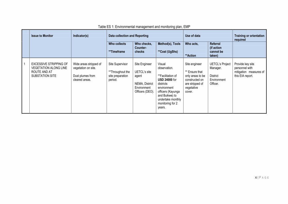
6 ENVIRONMENTAL MONITORING PLAN
Monitoring is necessary to avoid negative effects during construction and operation of the proposed
project and achieve sustained environmental compliance. Issues recommended to be monitored are:
a) Excessive stripping of vegetation along line route and at substation site during construction.
b) Soil erosion and deposition of overburden in wetlands and streams along the line route.
c) Responsible construction waste management.
d) Contamination of watercourses
e) Responsible waste management during line maintenance
f) Noise and air quality impacts
EMP proposed is shown in table below.
XI | P A G E
Table ES 1: Environmental management and monitoring plan, EMP
Issue to Monitor
Indicator(s)
Data collection and Reporting
Use of data
Training or orientation required
Who collects **Timeframe
Who checks, Counter-checks
Method(s), Tools **Cost (UgShs)
Who acts, **Action
Referral (if action cannot be taken)
1
EXCESSIVE STRIPPING OF VEGETATION ALONG LINE ROUTE AND AT SUBSTATION SITE
Wide areas stripped of vegetation on site. Dust plumes from cleared areas.
Site Supervisor **Throughout the site preparation period.
Site Engineer UETCL‟s site agent NEMA, District Environment Officers (DEO).
Visual observation. **Facilitation of USD 24000 for districts environment officers (Kayunga and Buikwe) to undertake monthly monitoring for 2 years.
Site engineer ** Ensure that only areas to be constructed on are stripped of vegetative cover.
UETCL‟s Project Manager. District Environment Officer.
Provide key site personnel with mitigation measures of this EIA report.

XII | P A G E
Issue to Monitor
Indicator(s)
Data collection and Reporting
Use of data
Training or Orientation
Who collects **Timeframe
Who checks, Counter- checks
Method(s), Tools **Cost
Who acts, **Action
Referral (if action cannot be taken)
2
SOIL EROSION AND DEPOSITION OF OVERBURDEN IN SWAMPS, RIVERS AND STREAMS
Overburden dumped close to banks of the watercourses.
Site foremen **Throughout the construction period but emphasis in the site clearing phase.
Site supervisor NEMA, District Environment Officers (DEO) of Buikwe and Kayunga Districts.
Visual observation **Provided for in above monthly monitoring cost for 2 years.
Site Engineer.
** Demarcate overburden deposition area.
UETCL‟s site agent.
Erosion control measures on construction sites. Ensure construction crew is ecologically aware and responsible.
3
RESPONSIBLE CONSTRUCTION WASTE MANAGEMENT
Improper construction waste management practices observed on site throughout construction of the power line and substation. Containers for construction waste collection provided.
Site foremen **Throughout construction period.
Site supervisor NEMA, District Environment Officers (DEO).
Visual Inspection **Provided for in above monthly monitoring cost for 2 years.
Site Engineer ** Provide containers for construction waste collection and storage.
UETCL‟s site agent/ supervising engineer.
Possible problems of improper waste management. Costs incurred from wasted material.

XIII | P A G E
Issue to Monitor
Indicator(s)
Data collection and Reporting
Use of data
Training
Who collects **Timeframe
Who checks, Counter- checks
Method(s), Tools **Cost
Who acts, **Action
Referral (if action cannot be taken)
4
CONTAMINATION OF WATERCOURSES
Excessive deposition of gravel in swamp at tower foundation sites. Waste dumped in watercourses.
Site supervisor **Throughout the line construction period.
Site Engineer NEMA, District Environment Officer (DEO), Wetlands Management Department-WMD.
Visual inspection **Facilitation – USD 12000 for one year‟s monitoring by WMD of line sections through swamps. **USD 20000 for quarterly water monitoring and laboratory analysis for two years
Contractor ** Minimise deposition of gravel, limiting quantities to the bare necessary.
UETCL‟s Project Manager.
--
5
SOIL CONTAMINATION DUE TO IMPROPER WASTE MANAGEMENT DURING LINE CONSTRUCTION
All waste is properly collected stored and transported offsite.
UETCL **Throughout line operation life.
UETCL NEMA, District Environment Officer (DEO).
Visual inspection. **USD 20000 for a spill control kit **USD 10000 for soil analyses at contamination sites during camp and equipment yard closure
UETCL. **Ensure contractors do not litter along line during maintenance
District Environment Officer.
Importance of proper solid waste management. Methods of waste handling.

XIV | P A G E
Issue to Monitor
Indicator(s)
Data collection and Reporting
Use of data
Training
Who collects **Timeframe
Who checks, Counter- checks
Method(s), Tools **Cost
Who acts, **Action
Referral (if action cannot be taken)
6 ENVIRONMENTAL AWARENESS TRAINING
All construction workers aware of basic environmental controls associated with project impacts
UETCL Environmental Officer **Throughout line construction
District Environmental Officers
Random interviews of staff **USD 20000 for environmental awareness training
UETCL Environmental Officer **Training
-- Training in impact construction impacts identification and mitigation
7 NOISE AND AIR QUALITY IMPACTS
Community complaints about excessive noise or dust emissions.
Local leaders **Throughout line construction.
Project Manager
Measurement of dust and noise are complainant receptors **USD 15000: one time purchase of noise meter and dust meter for environmental monitoring. Cost of dust control along roads during line construction **(to be included in construction bid by contractor)
UETCL ** Ensure contractor complies with noise and dust control measures in EIA.
-- None
Total cost (USD) USD 121,000
Note that impact management costs will be included in construction bid by contractor

XV | P A G E
7 CONCLUSION
Overall, the project would have immense positive and long-term national socio-economic development
impact. Adverse environmental impact of the project will stem more from wayleaves requirement of the
transmission line, which would lead to clearing of biomass including sporadic stretches of natural forest.
Most environmental impacts identified can be mitigated with recommendations proposed and this this will
ensure a sustainable renewable energy transmission infrastructure.
1 | P A G E
1 INTRODUCTION
1.1 OVERVIEW OF UGANDA’S POWER SECTOR
Uganda‟s electricity demand has been growing by 10% every year, while supply prior to the commissioning of Bujagali
has remained stagnant. Frequent power shortages and blackouts accounted for between 1 to 1.5% loss to Uganda‟s
GDP, thereby slowing the country‟s economic development. Since the first unit became operational in February 2012,
Bujagali has provided a reliable solution to Uganda‟s power demands, serving as a catalyst for economic growth and
replacing emergency thermal generation costs, thereby saving US$ 9.5 million per month in government subsidies.
The prolonged drought experienced between 2003 and 2007 affected operations of Owen Falls Dam then the
country's main source of electricity. The drop in lake level led to a substantial decrease in electricity output creating a
supply deficit of up to 210 MW, leading to a 24-hour load shedding. This supply shortage negatively impacted the
gross domestic product (GDP), dropping at the rate of 1.5% per annum. In spite of the decline in generation, demand
for electricity continued to grow, widening the gap with peak demand reached 380 MW.
In 2006 the energy ministry prepared a plan to meet the shortfall in electricity supply. The broad objective was not only
to provide adequate and reliable power supply, but to also anticipate new electricity demand. The short-term measures
involved procurement of thermal generation to provide temporarily increase generation capacity. About 150 MW of
additional thermal power plants were installed at Lugogo, Mutundwe and Kiira sub-stations to provide relief to the
consumers. Government also procured a 50 MW heavy fuel thermal plant installed at Namanve by Jacobsen, a
Norwegian power company. However, the stop-gap measures were at a cost. Power became expensive, forcing the
Government to subsidise up to $9.5 m every month despite increase in end-user tariffs. Introduction of thermal power
generation in the energy mix was combined with aggressive energy loss reduction strategy and an energy efficiency/
demand side management. To improve energy efficiency, 800000 energy-saving bulbs were procured at a cost of
US$1.2 million and distributed freely to households which led to a saving of about 30 MW.
The medium-term strategy involved the development of the 250 MW Bujagali Hydropower Project on River Nile.
Construction work of this project started in May 2007, and the plant was commissioned in July 2012. Bujagali project
has doubled electricity supply, reducing load-shedding. The other medium-term has been development of small
hydropower plants and ones commissioned in the recent past include:
3.5 MW Nyagak Hydropower Plant, which supplies West Nile off-grid region.
18 MW Mpanga hydropower station,
13 MW Bugoye hydropower station,
6.5 MW Ishasha mini-hydro,
5 MW Mubuku mini-hydro.
Other hydropower projects under development include Buseruka HPP (9 MW), Kikagati mini-hydro project (16 MW),
Nyamwamba small hydropower project (14 MW) and Nshungyezi mini-hydropower project (35 MW).
It is estimated that there are over 50 feasible small hydro sites dotted around the country, which can generate a total of
200 MW to supplement bigger project located on River Nile. Uganda Government is now focused on construction of
600 MW Karuma Hydropower project. The long-term interventions include development of 180 MW Isimba
Hydropower Project, use of newly discovered oil and gas resources for thermal generation, renewable energy
generation projects, use of solar photovoltaic and solar water heaters. Others are use of biogas, improved efficiency
stoves to cater for rural energy requirements and production of electricity from municipal waste for sale to the grid.
Competition was introduced through licensing of independent power producers. This has attracted a number of private
sector-led investments in the electricity sector raising the nation‟s installed capacity to the current 800 MW. Uganda
will require 2,000 Megawatts (MW) electricity by the year 2025 to run its industries and homes. To achieve this, more
2 | P A G E
than US$3.5 billion will have to be invested in the energy sector. Within 20 years from now the country must generate
an additional 1700 MW to meet its demand.
1.2 PROJECT BACKGROUND
Enactment of the Electricity Act, 1999 paved way for liberalisation of Uganda‟s energy sector, allowing the
establishment and operations of independent power producers. This Act liberalized the power sector breaking up
Uganda Electricity Board that had monopoly for power generation, transmission and distribution, into three companies
responsible for generation (UEGCL), transmission (UETCL) and distribution (UEDCL) of electric power in Uganda.
UETCL has the responsibility of transmission of high voltage power, bulk purchase of power and bulk sale to
independent power distributors. UEDCL owns the electricity supply infrastructure operating at 33 kV and below. Its
assets were leased to UMEME in 2005 under a 20-year concession. UETCL owns and operates the grid connected
electricity supply infrastructure operating above 33 kV. It is the only company responsible for buying power in bulk from
generators and selling it to distribution companies. UEGCL owns the Kiira and Nalubaale hydropower stations. Its
generation assets were leased to Eskom Uganda Limited in April 2003 under a concession agreement.
Energy is one of the key sectors in Uganda‟s economy and it is a major contributor to treasury resources (taxes, VAT on electricity, levy on transmission bulk purchases of electricity, license fees and royalties) and foreign exchange earnings (power exports). Following liberalization, the power sub-sector is not only a vital driver of other sectors of the national economy, but is also a large employer for Ugandans. The Ministry of Energy and Mineral Development is responsible for policy formulation, implementation and monitoring of the energy sector. Uganda‟s access to grid electricity is currently less than 15% with majority of the population depending on traditional
biomass energy. Uganda‟s per capita energy consumption of 0.3 tonnes of oil equivalent (TOE) or 12.72 GJ, is among
the lowest in the World1. Over 90% of energy consumption is biomass, mostly wood and charcoal, which is not
environmentally sustainable.
Uganda‟s Vision 2035 of “Electricity for All” shows that the country must generate at least 4500 MW of electricity to
ensure access by everyone. Uganda‟s Power Sector Investment Plan looked at investments scenarios required to
meet such demand and various energy options available to achieve this vision. Hydropower was the most suitable
power source to meet the country‟s demand to the planning horizon of 2023.
Uganda Government‟s general strategic priorities are expressed in the following policy documents:
The Government‟s 1999 Strategic Plan,
Energy Policy for Uganda, 2002,
Ministry of Energy and Mineral Development-Budget Framework Papers (2005-6,2006-7, 2007-8),
Millennium Development Goals
The emergency power situation in Uganda caused by prolonged drought that resulted in the low levels of Lake Victoria
has been addressed by the MEMD/CEO in the Strategic Plan for Meeting Uganda‟s Electricity Supply Needs in the
Short, Medium to Long Term, of March 2005 and as revised in May 2006. GoU‟s measures to meet the Emergency
situation in the short term (2006/2007) included:
Energy Loss reduction
Energy efficiency/Demand Side Management
Procurement of additional Thermal Generation Capacity
1 Godfrey Bahati, 2003: Geothermal energy in Uganda, country update. International Geothermal Conference, Reykjavík, Sept. 2003.
3 | P A G E
In the Medium term the measures include:
Attract Renewable Energy Generation Projects
Use of Solar Photovoltaic (PV) and Solar Water Heaters
Use of Biogas, Biomass and others
The Bujagali hydroelectric project (250 MW)
The Karuma hydroelectric project (200 MW)
Following discovery of oil reserves in the Albertine area, government has put up a plan for development of 50-100 MW
thermal power plant. The Long term measures include development of other large hydroelectric projects; use of
indigenous petroleum resources for thermal production; interconnection of the regional power grid and use of new (like
geothermal) and other renewable sources of energy.
UETCL will be an important implementer of the GoU‟s plan both as a Single Buyer and System Operator. The latter
role includes planning and implementation of large transmission projects on a medium to long-term perspective.
According to Uganda‟s National Environment Act Cap 153, Section 10(a, b and c), i.e. electrical generation stations,
transmission lines and substations, respectively, the proposed transmission is categorized among “Third Schedule”
developments for which EIA is mandatory.
Additionally, World Bank classifies proposed developments into four categories (A, B, C, and FI) depending on the type, location, sensitivity and scale of the project and nature and magnitude of its potential environmental impacts. These categories are explained below:
Box 1: Project categorisation for environmental assessment
Category A: have high risk and likely to have significant adverse environmental impacts that are sensitive,
diverse, or unprecedented.
Category B: have modest risk and will have potential adverse environmental impacts on human populations
or environmentally important areas--including wetlands, forests, grasslands, and other natural habitats but
are less adverse than of Category A projects.
Category C: are likely to have minimal or no adverse environmental impacts. For these, no detailed EIA is
necessary.
Based on above categorization 132 kV double circuit transmission line is classified as “Category A” project and
therefore subject to full social-environmental assessment.
1.3 OBJECTIVE OF THE EIA
The EIA aimed at assessing potential environmental impacts of developing and operating the powerline and propose
mitigation recommendations.
Specifically, the study aimed to:
Conduct baseline environmental and social investigations along the proposed line route to inform project impacts in such settings;
Conduct consultations with relevant stakeholders, including potentially affected persons, to obtain their views and suggestions regarding the environmental and social impacts of the proposed project;
Propose mitigation measures to address potential negative impacts; and Prepare an EIA report incorporating results of environmental analysis.
Specifically, the EIA study focussed on:
Impacts on flora and fauna; Impacts on drainage and water resources;

4 | P A G E
Impacts on landscape and visual amenity; Impacts on land use and agriculture; Impacts on natural forested areas (loss and biodiversity considerations); Impact on property, settlements and community facilities; Health and safety impacts; and Induced development resulting from project implementation; Impact on noise and air quality, if any.
The environmental and social impacts of the project were predicted in relation to environmental and social receptors or
people (e.g. residents of villages and settlements, and land-use, etc), and natural resources. This was accomplished
by comparing baseline conditions (i.e. the situation before the project) with situations that would ensue when the
project is implemented.
Social impacts of the proposed transmission line were analysed and documented in a separate volume, therefore this
report is limited in scope to assessment of only environmental impacts.
1.4 PROJECT JUSTIFICATION
The proposed 132 kV double circuit transmission is in line with Government‟s continued pursuit for sufficient power
supply to match present and foreseeable future national demand. To connect electricity generated at Isimba HPP to
the national grid it is necessary to construct a new 132 kV double circuit powerline from a substation at Isimba dam to
existing substation at Bujagali Dam.
Uganda has abundant energy resources, especially hydrological and other renewable resources, yet it suffers
prevalent “energy poverty”. There is an urgent need to develop the sector and improve energy supply for sustainable
economic growth. An inadequate and inefficient power system arising from, inadequate transmission and distribution
infrastructure currently characterize the energy sector. Sustainable development is difficult to achieve with poverty and
environmental degradation associated with low supply coverage, deforestation and health impacts associated with
indoor use of biomass fuel by rural poor households prevalent in the country. Therefore, Uganda Government is
investing in expanding access to affordable, reliable and adequate electricity supplies to lower poverty in line with its
national development plan. Consequently, development of the country‟s hydropower potential and transmission lines
to evacuate power to demand centers is a key undertaking of Government‟s effort to develop the power sector. Hence,
the proposed Isimba powerline is one of the undertakings to achieve this objective.
5 | P A G E
2 POLICY, LEGAL AND INSTITUTIONAL FRAMEWORK
2.1 INTRODUCTION
This section provides the legislative, regulatory, and policy context in which the proposed power transmission line
project should comply. National regulations are discussed along with relevant international agreements and conventions to
which, Uganda is a party. Key legislations governing the conduct of EIA in Uganda are the National Environmental Act
(Cap 153) and the Environmental Impact Assessment Regulations (1998). The National Environmental Act established the
National Environment Management Authority (NEMA), and entrusts it with responsibility to ensure compliance with the EIA
process in planning and execution of infrastructural projects. Relevant policies have also been reviewed and the relevance
highlighted as in subsequent sections below.
2.2 POLICY FRAMEWORK
2.2.1 THE NATIONAL ENVIRONMENT MANAGEMENT POLICY, 1994
The overall goal of this policy is promotion of sustainable economic and social development mindful of the needs of
future generations and EIA is one of the vital tools it considers necessary to ensure environmental quality and
resource productivity on long-term basis. The policy calls for intergration of environmental concerns into development
policies, plans and projects at national, district and local levels. Hence, the policy requires that projects likely to have
significant adverse ecological or social impacts undertake an EIA before their implementation. This is also reaffirmed
in the National Environment Act (Cap 153) that makes EIA a legal requirement for “Third Schedule” projects.
According to Uganda‟s National Environment Act Cap 153, Section 10(a, b and c), i.e. electrical generation stations,
transmission lines and substations, respectively, the proposed transmission is categorized among “Third Schedule”
hence necessitating this EIA study.
2.2.2 THE ENERGY POLICY, 2002
The policy goal is to meet energy needs of Uganda‟s population for social and economic development in an
environmentally sustainable manner. The policy recognizes linkages between the energy sector and other sectors
such as economy, environment, water resources, agriculture, forestry, industry, health, transport, education,
decentralization and land use. Hence at the sectoral level, the policy strengthens provisions of the National
Environment Management Policy, 1994 that emphasises need for environmental impact assessment. This policy
recognises the energy sector as potentially having more significant environmental impacts than most other economic
sectors. Since energy development and environmental damage are related, the policy recognises need to mitigate
both physical and social environmental impacts of energy projects.
Objective (5) of the policy aims at managing energy-related environmental impacts and it states that the Government
will ensure that environmental considerations are given priority by energy suppliers and users to protect the
environment and monitor compliance with environmental protection guidelines. To meet these objectives, Government
is required to:
Promote the use of alternative sources of energy and technologies that are environmentally friendly.
Sensitise energy suppliers and users about environmental issues associated with energy.
Work towards the establishment and acceptance of broad targets for the reduction of energy-related emissions
that are harmful to the environment and energy users.
Promote efficient utilisation of energy resources.
In pursuit of those objectives, Uganda government will construct Isimba HPP and associated transmission line, to
increase the proportion of renewable energy in the nation‟s mix. By undertaking this EIA, Government commits to
ensuring that environmental issues are given priority consideration during project development.
6 | P A G E
The Project is consistent with this policy in so far as it seeks to increase access to hydro-electricity, a source of
renewable energy.
2.2.3 NATIONAL DEVELOPMENT PLAN, 2010
In February 2010, Government of Uganda finalized a new five-year National Development Plan (NDP) spanning
FY2011-2015 and this took from achievements of the Poverty Eradication Action Plan (PEAP) that was being
implemented up to 2008. The NDP‟s main theme is “Growth, Employment and Socio-Economic Transformation for
Prosperity,” marking a broadening of the country‟s development strategy from poverty reduction to structural
transformation with the aim to raise growth and living standards. The NDP is the first in a series of six plans intended
to transform Uganda over 30 years into a modern and prosperous nation.
The NDP recognises that limited access and use of energy significantly slows down economic and social
transformation. The low energy consumption per capita in Uganda has largely contributed to the slow economic
transformation by limiting industrialisation as well as value addition. It‟s one major factor that impacted on the country‟s
competitiveness over the last decade. The energy exploitation and consumption patterns reflect that the country is still
in infancy stages of energy application in production processes. The exploitation pattern is such that biomass accounts
for 92 % of total energy consumed while fossil fuels account for 7 % and electricity only 1 %. To improve this situation,
NDP devised two strategies below:
Strategy 1: Construct large hydropower plants and thermal power plants through public and private investments.
i) Complete Bujagali hydropower dam construction. This is expected to ii) Increase power generation capacity by 250 MW. iii) Construct Karuma hydropower plant to generate 700 MW. iv) Study, design and construct Ayago hydro power plant to generate 700 MW. v) Study, design and construct Arianga hydro power plant to generate 400 MW. vi) Construct Isimba hydro power dam. vii) Build a thermal power Plant (700 MW as part of the refinery) to utilize Uganda‟s oil resources. viii) Design and construct solar thermal plants to generate 200 MW. ix) Study, design and build geothermal plants to generate 100 MW. x) Increase the co-generation capacity to 150 MW from wood, waste crop and garbage.
Strategy 2: Develop mini hydro power plants to generate 150 MW.
i) Construct Muzizi, Kikagati, Nshongyenzi, Waki and other mini hydro power projects. ii) Complete the construction of Mpanga, Nsheruka and Nyagak minihydro power plants.
2.2.4 WETLANDS POLICY, 1995
The national policy on conservation and management of wetlands aims at curtailing loss of these resources and
ensuring that their benefits are equitably distributed to all people of Uganda. The wetlands policy calls for:
Sustainable use to ensure that benefits of wetlands are maintained for the foreseeable future;
Environmentally sound management of wetlands to ensure that other aspects of the environment are not
adversely affected;
Equitable distribution of wetland benefits;
Application of environmental impact assessment procedures on all activities to be carried out in a wetland to
ensure that wetland development is well planned and managed.
In order to operationalize the policy and to provide a legal framework for its implementation, wetland related issues
have been adequately incorporated into the National Environmental Act, Cap 153. To minimise population centres and
7 | P A G E
associated resettlement cost, the proposed transmission line route is aligned along fringes of stretches of swamps any
of which are seasonal and have been modified by farming activities.
2.2.5 UGANDA’S VISION 2040
In „Vision 2040‟ Ugandan sets goals to achieve by the year 2040 ranging from political, economic, social, energy, and
environment. With respect to environmental goals, Ugandans aspired to have sustainable social-economic
development that ensures environmental quality and preservation of the ecosystem. Vision 2040 recognises energy as
a key driver of the economic development and notes that for Uganda to shift from a peasantry to an industrialized and
urban society, it must be propelled by electricity as a form of modern energy. It estimates that Uganda will require
41,738 MW of electricity by year 2040 thus increasing its electricity consumption per capita to 3,668 kWh. Furthermore
the access to the national grid must significantly increase to 80%. To this end, Uganda will fully exploit its hydropower
potential by developing large and small Hydropower plants including Isimba, Ayago North, Ayago South, Karuma,
Kalagala, and Murchison Bay besides other renewables such as wind, solar and bio-gas. To reduce the energy deficit,
in the long-term Government will invest in development of nuclear power from uranium deposits in the country. Vision
2040 notes that to improve access and availability of electricity to the rural and urban areas, especially to economic
zones and other productive areas, new transmission lines to evacuate power will be built and rural electrification
programmes accelerated. Therefore proposed Isimba transmission line is in line with aspirations of Vision 2040.
2.2.6 NATIONAL GENDER POLICY (1997)
The overall goal of this policy is to mainstream gender concerns in the national development process in order to
improve the social, legal/civic, political, economic and cultural conditions of the people of Uganda, particularly women.
Thus, in the context of the power sector, this policy aims to redress imbalances which arise from existing gender
inequalities and promotes participation of both women and men in all stages of energy project cycle, equal access to,
and control over significant economic resources and benefits.
This policy would especially apply to recruitment of power line construction labor where women should have equal
opportunity as men for available jobs. This policy also requires provision of a work environment that is conducive to
women as well as for men in addition to gender-disaggregated impacts and vulnerabilities.
2.2.7 THE FORESTRY POLICY, 2001
The forest policy puts an emphasis on the ecological and socio-economic importance of protecting the country‟s forest
resources. Implementation of the Policy is a responsibility of the National Forestry Authority (NFA), which also
provides guidelines for management of forest reserves, community forests and private forests. The Forest Policy
entails provisions for safeguard and conservation of forests so as to ensure sufficient supplies of forest products,
protect water resources, soils, fauna and flora. The policy also mandates government with responsibility to control
unsustainable forest exploitation practices.
This policy is also important in light of the fact that the transmission line will affect about 0.76 km2 (0.08%) of Mabira
Management Area which measures a total 1000 square kilometers.
2.2.8 HIV/AIDS POLICY 1992
In Uganda current effort to combat HIV/AIDS is characterized by a policy of openness by Government and this has, to
a large extent, been emulated by civil society, political and social institutions, and workplaces. HIV/AIDS is recognized
by Ministry of Health as a considerable risk in construction of infrastructure projects and it (together with the ministry
responsible for labor) encourages employers to develop in-house HIV/AIDS policies, provide awareness and
prevention measures to workers and avoid discriminating against workers or living with or affected by HIV/AIDS. To
ensure HIV/AIDS is addressed in the workplace, the policy encourages employee awareness and education on
8 | P A G E
HIV/AIDS. To protect the infected and affected persons from discrimination, employers are required to keep personal
medical records confidential. Employees living with, or affected by, HIV infection and AIDS, and those who have any
related concerns, are encouraged to contact any confidant within the organization to discuss their concerns and obtain
information. It anticipated that during line construction, there may be an influx of people into the project area possibly
resulting into sexual fraternisation and a risk of HIV/AIDS spread. These requirements are expected to be fulfilled by
the power line construction contractors or their subcontractors.
This policy is relevant to the project if implementation of proposed transmission line results in in-migration into project
communities by people seeking construction jobs and possibly sexual fraternisation associated with HIV/AIDS risk.
2.2.9 OCCUPATIONAL HEALTH AND SAFETY (OHS) POLICY This policy seeks to:
Provide and maintain a healthy working environment Institutionalize OHS in the power-sector policies, programs and plans Contribute towards safeguarding the physical environment
The OHS Policy Statement is guided by the Constitution of the Republic of Uganda and other global, national and
sectoral regulations and policies. The Statement also takes into recognition of the Energy Policy and the Health Sector
Strategic Plan, all of which aim to improve the quality of life for all Ugandans in their living and working environment.
This policy will be especially relevant for OHS of power line construction crews and subsequently, maintenance
personnel. This also will have relevance in mitigation measures that protect the public from health and safety impacts
as a result of project construction and subsequent operation and maintenance activities.
2.2.10 RENEWABLE ENERGY POLICY, 2007 The overall objective of the Renewable Energy Policy is to diversify energy supply sources and technologies in Uganda. In particular, the policy goal is to increase the use of renewable energy from 4% (in 2007) to 61% of the total energy consumption by 2017 and the largest proportion of this will evidently be contributed by hydropower stations. Additionally, in January 2011, announced one of the most sophisticated, Feed-in Tariff Program in Africa. A feed-in tariff is a policy mechanism designed to accelerate investment in renewable energy technologies by offering long-term contracts to renewable energy producers based on the cost of generation of each technology. The national feed-in tariffs aimed to offer cost-based compensation to renewable energy producers, providing price certainty and long-term contracts that help finance renewable energy investments. The Uganda program specifies capacity caps for each renewable energy technology by year and this provides clear policy guidance on how much the country wants of which renewable technology. By evacuating renewable energy to be generated at proposed Isimba hydropower station, the transmission line conforms to the broad objectives of this policy. 2.2.11 MASTER PLAN STUDY ON HYDROPOWER DEVELOPMENT IN UGANDA, 2010 The “Hydro Power Master Plan” from December 2010 presented an integrated hydropower development of Victoria Nile River. Based on the estimated daily load pattern with peak demand in the evening hours and no significant variations on weekly and monthly basis, daily peaking power production is allocated to the power plants on the upper reach of Victoria Nile (up to Kyoga Lake). This was mainly due to the natural regulating effect of the Kyoga Lake for the peaking operation discharges from the upstream projects. On the other hand base load is recommended for the projects downstream of Kyoga Lake that mainly have much larger installed capacities. Isimba HPP therefore can utilise water released from Bujagali hydro power station and provide for partial balancing of the daily peak load based on its own limitations in reservoir elevation and size. The study included prioritization of potential hydropower sites based on consideration of technical, environmental, economic and financial aspects for the development in the period of 15 years as well as the optimal scale, basic layout
9 | P A G E
and the framework of development. The study also aimed at implementation of necessary power supply plan that would support economic growth in the Republic of Uganda as well as the East African region. Development of Isimba HPP and associated transmission line are in line with this Master Plan. 2.3 LEGAL FRAMEWORK
2.3.1 CONSTITUTION OF THE REPUBLIC OF UGANDA, 1995
The 1995 Constitution restored all private land tenure regimes (which had previously been abolished under the Land
Reform Decree, 1975). It divested the state and the Uganda Land Commission of radical title to land that was
expropriated in 1975, and vested it directly in the citizens of Uganda. The constitution provides for, inter alia:
The right of every Ugandan to a clean and healthy environment (Article 39);
The responsibility of government to enact laws that protect and preserve the environment from degradation
and to hold in trust for the people of Uganda such natural assets as lakes, rivers, wetlands, game reserves
and national parks [Article 237(2)];
The right of every Ugandan to fair and adequate compensation in instances of land acquisition.
The Constitution provides that every person has a right to own property and that no person shall be compulsorily
deprived of property or any interest in or right over property without prompt payment of fair and adequate
compensation, prior to the taking of possession or acquisition of the property.
On land tenure regimes and transfer of land, the Constitution prescribes tenure regimes in accordance with rights and
interests held in land. Article 237 of the Constitution, 1995, vests land in the citizens of Uganda and identifies four land
tenure systems, namely: customary, freehold, mailo and leasehold. Understanding these systems (detailed in section
4 of the Land Act, 1998) is vital for compensation of households to be affected by the project. These tenure systems
are outlined below:
1) Customary tenure
In this tenure, land is owned in perpetuity and tenure is governed by rules generally accepted as binding and
authoritative by the class of persons to which it applies (that is, “customary regime is not governed by written
law”). Customary occupants are occupant of former public land, and occupy the land by virtue of their
customary rights; they have proprietary interest in the land and are entitled to certificates of customary
ownership. Certificates for customary ownership are issued by the District Land Board, through application to
the Parish Land Committee.
2) Freehold tenure
This tenure derives its legality from the Constitution. It involves the holding of land in perpetuity or for a period
less than fixed by a condition and enables the holder to exercise, subject to the law, full powers of ownership.
3) Leasehold tenure
Lease tenure is created either by contract or by operation of the law. It is a form of tenure under which the
landlord or lessor grants the tenant or lessee exclusive possession of the land, usually for a defined period and
in return for a rental fee. The tenant has security of tenure and a proprietary interest in the land. The
Constitution and the Land Act also protect “rights of spouses and children” with regard to land transactions. The
head of household must acquire the consent of spouse and children prior to any sale of land on which the
family ordinarily resides.
4) Mailo land tenure
The Mailo land tenure system is a feudal ownership introduced in Buganda by the British in 1900 under the
Buganda Agreement. “Mailo” is a Luganda word for “mile” as the original grants under the agreement were
measured in square miles. Prior to the 1975 Land Reform Decree, Mailo land was owned in perpetuity by
10 | P A G E
individuals and by the Kabaka (hereditary King). Since no section of the proposed line traverses Buganda
region, this type of tenure does not apply to the project.
These tenure systems will be important during resettlement planning. Detail of land take and compensation were
addressed in the line project resettlement action plan (RAP) and social impact assessment report (SIA).
2.3.2 NATIONAL ENVIRONMENT ACT, CAP 153
The specific legislation that deals with environmental impact assessments (EIA) in Uganda is the National
Environment Act (NEA), Cap 153. NEMA was created under NEA and mandated with the responsibility to oversee,
coordinate and supervise environmental management activities in Uganda. Third Schedule of the National
Environment Act, Cap 153 (Section 10(a), (b), (c): “Electrical infrastructure including electricity transmission lines and
substations.”) requires this project to undertake an EIA.
The Act provides for various strategies and tools for environment management, which also include EIA (Section 19) for
projects likely to have significant impacts on the environment. NEMA sets multimedia environmental standards
(Sections 24-32) to prevent contamination of air, water and soil resources. Section 36 entrusts NEMA, lead agencies
and the district environment committee with powers to protect quality of watercourses, permanent or seasonal from
human activities that could adversely affect them. Section 56 prohibits discharge of hazardous substances like
chemicals, oil, etc into the environment except in accordance with guidelines prescribed by NEMA. NEMA will also be
responsible for approval of the project EIA and prescribing compliance conditions during project implementation.
All the foregoing sections of the Act are relevant for preservation of the natural environmental on the line route both
during construction and operation of the project.
2.3.3 LAND ACT, CAP 227
The Land Act is an essential legal tool for the proposed project in so far as there are squatters who lay claim to land
that is legally supposed to be owned by the project.
Largely, the Act addresses four issues namely, holding, control, management and dispute resolution. As regards
tenure, the Act repeats in Section 3, provisions of Article 237 of the Constitution which vests all land in the citizens of
Uganda, to be held under customary, freehold, mailo and leasehold tenure systems. It then defines the incidence of
each tenure regime (section 4); provides mechanisms of acquisition of certificates of customary ownership (sections 5-
9); the conversion of customary tenure to freehold (sections 10-15), or collective management of land held under
customary law (sections 16-27); the protection of the rights of women, children and persons with disability (sections
28); the conversion of leasehold into freehold (section 29) and the security of tenure for „tenants by occupancy‟
(sections 30-39).
Provisions regarding land administration (referred to in the Act as “management”) are adequately detailed. The Act
creates a series of land administration institutions consisting of Parish Land Committees, District Land Boards and
Uganda Land Commission (ULC). Each of these entities is largely autonomous of one another and is entrusted with
functions that range from the holding of lands not subject to private ownership, management of land thus held,
processing applications for various grants and certificates, registration and transfer of interest in land (sections 47-74).
The Land Act provides for a decentralized system to resolve land disputes in Uganda (sections 75-90) through
establishment of Land Tribunals at all levels of local government and that they should first arbitrate land disputes
before resorting to legal courts of law. No other organ, except informal traditional authority mediators (section 89) will
henceforth have jurisdiction over land disputes (section 98). Thus the Act favours local landowners by advancing a
process that is localized and free from costs or formalities associated with formal judicial courts.
11 | P A G E
The Act provides procedures to follow during the acquisition of land for public interest and provides for the “prompt
payment of fair and adequate compensation” prior to taking possession of land. This Act mandates local governments
to protect natural resources in interest of public good. For this line route, example of these resources comprises
natural forests, streams and wetlands.
2.3.4 ELECTRICITY ACT, CAP 145
Enactment of the Electricity Act, 1999 paved way for liberalisation of Uganda‟s energy sector, allowing the
establishment and operations of independent power producers. This Act liberalized the power sector breaking up
Uganda Electricity Board that had monopoly for power generation, transmission and distribution, into three companies
responsible for generation (UEGCL), transmission (UETCL) and distribution (UEDCL) of electric power in Uganda. The
Act also authorised licensing of independent power producers (IPP), to generate, distribute and sell power. UETCL
has the responsibility of transmission of high voltage power, bulk purchase from IPP and bulk sale to independent
power distributors.
Section 68 of the Act provides guidelines for the placement of electricity supply lines on land, stating that a developer
shall as much as possible minimise damage to the environment and shall ensure prompt payment of fair and adequate
compensation to all interested persons for any damage or loss sustained by construction of electricity supply
infrastructure. Section 69 of the Act requires a developer or licensee who intends to enter land under the management
or control of the Uganda Land Commission or a District Land Board, to give 30 days‟ notice to the Uganda Land
Commission or a District Land Board, stating the nature and extent of the acts intended to be undertaken. According to
the Act, a 30-day notice should also be given to private property owners affected by the project. For private land, the
Land Act and Constitution of Republic of Uganda require that compensation be paid to owners including issuing a 3-
month or 6-month notice after receipt of compensation before owners can vacate affected properties. The 3-month or
6-month notices to vacate affected property carry a 30% and 15% “disturbance allowance” on top of the property
value, respectively. These aspects are detailed in the resettlement action plan (RAP) prepared for this project.
2.3.5 TOWN AND COUNTRY PLANNING ACT, CAP 246
This Act replaced the Town and Country Planning Act, Cap 246 which was enacted in 1951 and revised in 1964 but is now inconsistent with contemporary government system in Uganda. The 1951 Act was enacted to regulate and operate in a centralised system of governance where physical planning was carried out at national level through the Town and Country Planning Board. Implementation of the Act was supervised by local governments, especially the urban local governments.
Uganda has since gone through many social, political and economic changes. For example, promulgation of the 1995 Constitution established a decentralised system of governance which divulged powers and functions including physical planning, finance and execution of projects from the central government to local governments. This therefore created a need to enact a physical planning legislation which is consistent with this Constitutional requirement. The Physical Planning Act, 2011 establishes district and urban physical planning committees, provides for making and approval of physical development plans and applications for development.
Section 37 of The Physical Planning Act, 2011 requires an EIA permit for developments before they are implemented, stating:
“Where a development application related to matters that require an environmental impact assessment,
the approving authority may grant preliminary approval subject to the applicant obtaining an EIA
certificate in accordance with the National Environment Act”.
Kayunga and Buikwe District Local Governments have jurisdiction over areas along the proposed powerline route and therefore have regulatory control to ensure that this project conforms to local physical planning requirements.
12 | P A G E
2.3.6 PUBLIC HEALTH ACT, CAP 281
This Act provides local authorities with administrative powers to take all lawful, necessary and reasonable measures to
prevent the occurrence or deal with any outbreak or prevalence of any infectious communicable or preventable
disease and to safeguard and promote the public health. The Act mandates local authorities (Section 103) to prevent
pollution of watercourses in interest of public good. This Act is applicable to onsite management of process waste,
sewage and domestic waste during line construction.
2.3.7 OCCUPATIONAL SAFETY AND HEALTH ACT, 2006
The Act requires employers to provide and maintain safe working conditions, and to take measures to protect workers
and the public from risks and dangers of their works, at his or her own cost (Section 13). Employers with more than 20
workers should prepare and often revise a written policy with respect to safety and health of workers (Section 14).
Every workplace must be kept in a clean state, free from effluent arising from any drains and sanitary facilities (Section
46). The contractor therefore is obliged to provide employers with washing facilities, First Aid, facilities for meals and
safe access to workplaces. This Act was discussed in the project‟s SIA.
2.3.8 NATIONAL ENVIRONMENT (WETLANDS, RIVER BANKS AND LAKESHORES MANAGEMENT) REGULATIONS, 2000
These regulations provide principles for sustainable use and conservation of wetlands, riverbanks and lakeshores.
Relevance of these regulations to the EIA study is embedded in the following requirements:
EIA is mandatory for all major activities on riverbanks and lakeshores,
Measures should be put in place for protection of riverbanks and lakeshores such as prevention of soil erosion,
siltation and water pollution.
These regulations are relevant considering that some portions of the line will cross marshes, although most of them
were encroached for cultivation.
2.3.9 NATIONAL ENVIRONMENT (NOISE STANDARDS AND CONTROL) REGULATIONS, 2003 Section 7 of these regulations require that no person shall emit noise in excess of permissible noise levels, unless
permitted by a license issued under these Regulations. Section 8 imparts responsibility onto noise generators to use
the best practicable means to ensure that noise does not exceed permissible noise levels. At construction sites
corresponding limits are 75 dBA and 65 dBA for day and night time levels respectively1.
These regulations will control noise levels generated or received by receptors from project sites and line construction
activities.
2.3.10 NATIONAL ENVIRONMENT (MINIMUM STANDARDS FOR MANAGEMENT OF SOIL QUALITY) REGULATIONS, 2001
Section 12 of this Act requires compliance with prescribed measures and guidelines for soil conservation for the
particular topography, drainage and farming systems, contravention of which constitutes an offence. This Act will be
relevant in regard to prevention of contamination of land communities use to derive their livelihoods. The Act will apply
to waste disposal practices of contractors during line construction or repair and maintenance (during its operation).
1 Time frame: Day 6.00a.m -10.00 p.m; Night 10.00 p.m. - 6.00 a.m.
13 | P A G E
2.3.11 WATER ACT, CAP 152
It is envisaged that water will be required for line construction activities and consumption by construction crew.
Abstraction of water will be regulated by this Act. According to Section 6 of the Act, no person acquires any rights to
use water or to construct or operate any works unless authorized under Part II of the Act. Thus, unless a person is an
occupier of land on which surface water exists, water may not be used for any purpose without the approval of an
authority. The general rights to use surface water are limited to domestic use and fire fighting once again indicating the
importance attached to water supply for domestic purposes. Section 18 states that a person is not allowed to construct
or operate any works unless he has a permit granted for that purpose by the Director, Directorate of Water
Development (DWD). Construction is defined to include alteration, improvement, maintenance and repair. MEMD will
need to apply for such a permit in order to abstract water from Victoria Nile.
Section 31 (1) of the Water Act stipulates that it is an offence for a person to pollute water through discharge of waste
into watercourses. In conformity with this law, the spillage of petroleum products, disposal of overburden, litter or
construction waste should be avoided during powerline construction and operation or maintenance activities.
2.3.12 NATIONAL ENVIRONMENT (WASTE MANAGEMENT) REGULATIONS, 1999.
These Regulations apply to:
all categories of hazardous and non-hazardous waste;
storage and disposal of hazardous waste and its movement into and out of Uganda.
The regulations, which will relate to overall waste management during line construction, promote minimise waste
generation by:
eliminating use of toxic raw materials;
reducing toxic emissions and wastes;
recovering and reuse of waste wherever possible.
2.3.13 THE MINING ACT, CAP. 148
Stone quarry sites and gravel borrow pits will be necessary for material needed for construction of tower foundations
and the relevant licenses shall be obtained from the Commissioner of the Geological Survey and Mines. The Mining
Act of 2003 regulates mining developments including set up of new quarries and/or sandpits. Relevant environmental
studies required for this license application is described in Part XI. The extraction of stone/aggregate and murram
materials will be undertaken in line with the provisions of this Act. Issues of restoration of the sites after murram
extraction will be of key importance construction of the proposed powerline.
2.3.14 WORKERS’ COMPENSATION ACT (2000)
Section 28 of The Workers‟ Compensation Act (2000) states that:
Where a medical practitioner grants a certificate that a worker is suffering from a scheduled disease causing
disablement or that the death of a workman was caused by any scheduled disease; and,
The disease was due to the nature of the worker„s employment and was contracted within 24 months
immediately previous to the date of such disablement or death, the worker or, if he or she is deceased, his or
her dependants shall be entitled to claim and to receive compensation under this Act as if such disablement or
death had been caused by an accident arising out of and in the course of his or her employment.
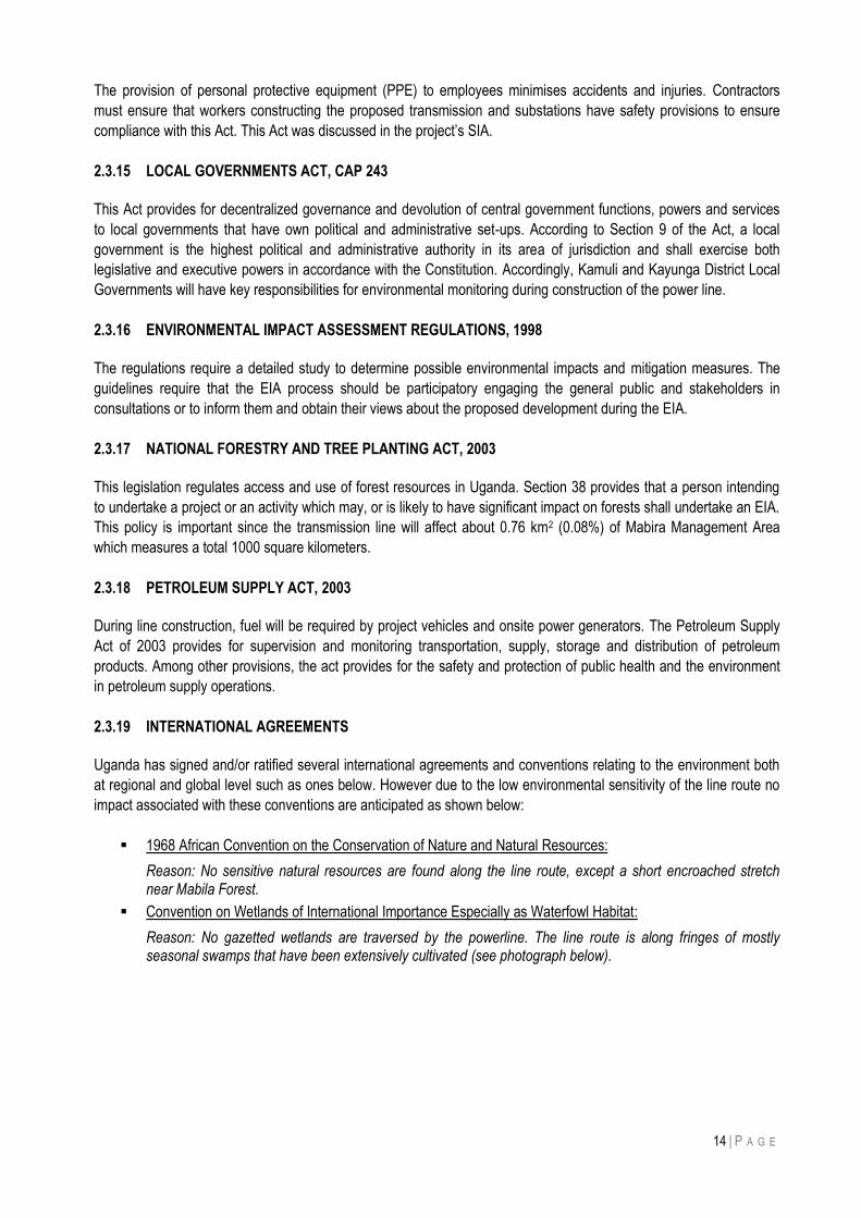
14 | P A G E
The provision of personal protective equipment (PPE) to employees minimises accidents and injuries. Contractors
must ensure that workers constructing the proposed transmission and substations have safety provisions to ensure
compliance with this Act. This Act was discussed in the project‟s SIA.
2.3.15 LOCAL GOVERNMENTS ACT, CAP 243
This Act provides for decentralized governance and devolution of central government functions, powers and services
to local governments that have own political and administrative set-ups. According to Section 9 of the Act, a local
government is the highest political and administrative authority in its area of jurisdiction and shall exercise both
legislative and executive powers in accordance with the Constitution. Accordingly, Kamuli and Kayunga District Local
Governments will have key responsibilities for environmental monitoring during construction of the power line.
2.3.16 ENVIRONMENTAL IMPACT ASSESSMENT REGULATIONS, 1998
The regulations require a detailed study to determine possible environmental impacts and mitigation measures. The
guidelines require that the EIA process should be participatory engaging the general public and stakeholders in
consultations or to inform them and obtain their views about the proposed development during the EIA.
2.3.17 NATIONAL FORESTRY AND TREE PLANTING ACT, 2003
This legislation regulates access and use of forest resources in Uganda. Section 38 provides that a person intending
to undertake a project or an activity which may, or is likely to have significant impact on forests shall undertake an EIA.
This policy is important since the transmission line will affect about 0.76 km2 (0.08%) of Mabira Management Area
which measures a total 1000 square kilometers.
2.3.18 PETROLEUM SUPPLY ACT, 2003
During line construction, fuel will be required by project vehicles and onsite power generators. The Petroleum Supply
Act of 2003 provides for supervision and monitoring transportation, supply, storage and distribution of petroleum
products. Among other provisions, the act provides for the safety and protection of public health and the environment
in petroleum supply operations.
2.3.19 INTERNATIONAL AGREEMENTS
Uganda has signed and/or ratified several international agreements and conventions relating to the environment both
at regional and global level such as ones below. However due to the low environmental sensitivity of the line route no
impact associated with these conventions are anticipated as shown below:
1968 African Convention on the Conservation of Nature and Natural Resources:
Reason: No sensitive natural resources are found along the line route, except a short encroached stretch near Mabila Forest.
Convention on Wetlands of International Importance Especially as Waterfowl Habitat:
Reason: No gazetted wetlands are traversed by the powerline. The line route is along fringes of mostly seasonal swamps that have been extensively cultivated (see photograph below).
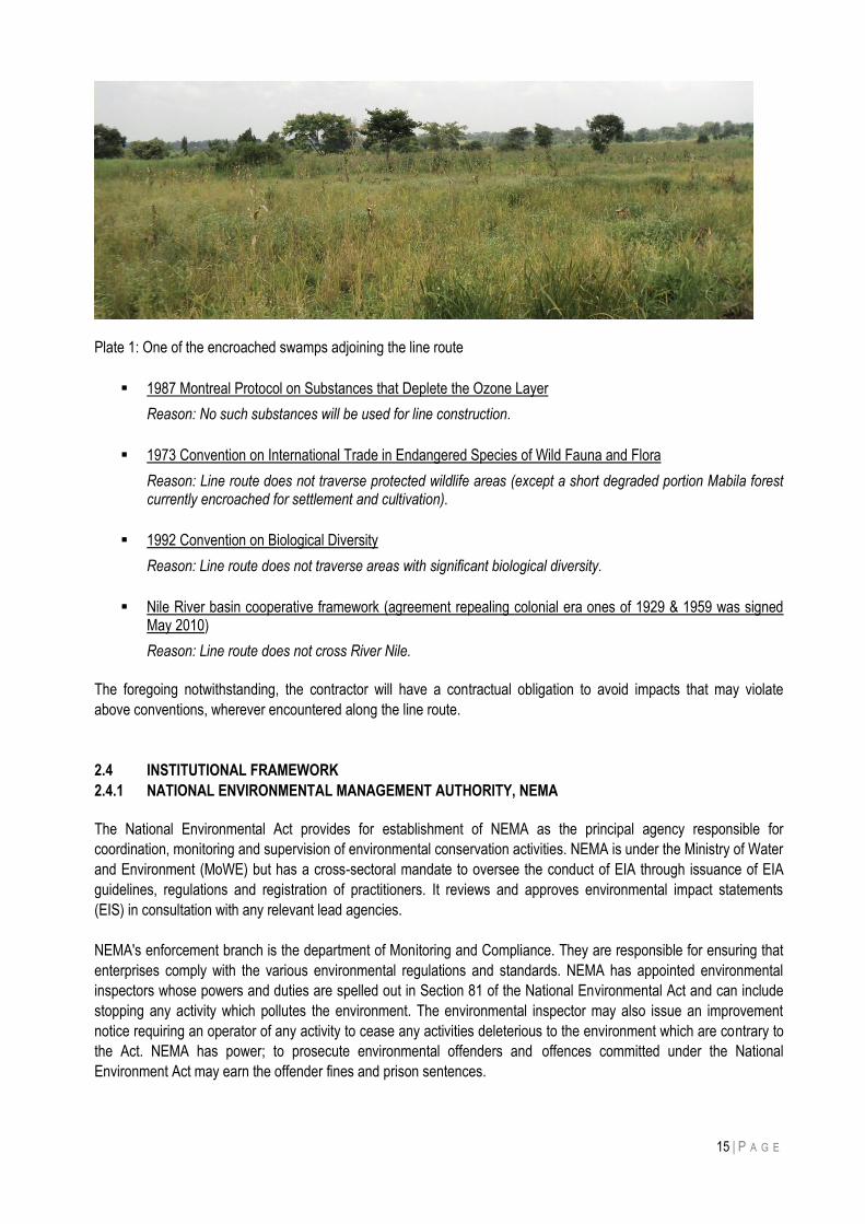
15 | P A G E
Plate 1: One of the encroached swamps adjoining the line route
1987 Montreal Protocol on Substances that Deplete the Ozone Layer
Reason: No such substances will be used for line construction.
1973 Convention on International Trade in Endangered Species of Wild Fauna and Flora
Reason: Line route does not traverse protected wildlife areas (except a short degraded portion Mabila forest currently encroached for settlement and cultivation).
1992 Convention on Biological Diversity
Reason: Line route does not traverse areas with significant biological diversity.
Nile River basin cooperative framework (agreement repealing colonial era ones of 1929 & 1959 was signed May 2010)
Reason: Line route does not cross River Nile.
The foregoing notwithstanding, the contractor will have a contractual obligation to avoid impacts that may violate
above conventions, wherever encountered along the line route.
2.4 INSTITUTIONAL FRAMEWORK
2.4.1 NATIONAL ENVIRONMENTAL MANAGEMENT AUTHORITY, NEMA
The National Environmental Act provides for establishment of NEMA as the principal agency responsible for
coordination, monitoring and supervision of environmental conservation activities. NEMA is under the Ministry of Water
and Environment (MoWE) but has a cross-sectoral mandate to oversee the conduct of EIA through issuance of EIA
guidelines, regulations and registration of practitioners. It reviews and approves environmental impact statements
(EIS) in consultation with any relevant lead agencies.
NEMA's enforcement branch is the department of Monitoring and Compliance. They are responsible for ensuring that
enterprises comply with the various environmental regulations and standards. NEMA has appointed environmental
inspectors whose powers and duties are spelled out in Section 81 of the National Environmental Act and can include
stopping any activity which pollutes the environment. The environmental inspector may also issue an improvement
notice requiring an operator of any activity to cease any activities deleterious to the environment which are contrary to
the Act. NEMA has power; to prosecute environmental offenders and offences committed under the National
Environment Act may earn the offender fines and prison sentences.
16 | P A G E
2.4.2 MINISTRY OF ENERGY AND MINERAL DEVELOPMENT, MEMD
The Ministry is responsible for the energy sector, dealing specifically with policy formulation, policy implementation and
monitoring. In 1999, following approval by cabinet of the Power Sector Reform and Privatization Strategy and
enactment of new electricity law (The Electricity Act, 1999). Through various agencies and departments, MEMD is able
to meet its overall responsibilities.
2.4.3 ELECTRICITY REGULATORY AUTHORITY, ERA
ERA is a corporate body established to oversee implementation of the electricity Act 1999. Under the Act, ERA is
mandated to review proposed investments in the energy sector and guide the promoters through implementation. The
main functions of ERA include:
Issuing licenses for generation, transmission, distribution, of electricity processing applications for investors in the
energy sector;
Enforcement of requirement under the Act to ensure compliance with regulations;
Establishing tariffs, reviewing, and approving rates of investment in the electricity sector;
Advising the minister regarding the need for electricity projects; and
Developing and enforcement of energy standards.
ERA will ensure that, the operations costing of energy from the planned line project will be in accordance with its
set standards and tariffs.
2.4.4 UGANDA ELECTRICITY TRANSMISSION COMPANY LIMITED Uganda Electricity Transmission Company Limited (UETCL) is a Public Limited Company which was incorporated in March 2001 as a result of the power sector reform and liberalization policy that unbundled Uganda Electricity Board (UEB) into successor companies. The Company operates under policy guidance of the Ministry of Energy and Mineral Development. UETCL‟s mission is to dispatch, transmit quality and reliable bulk power in a viable and efficient manner; be an efficient and commercially focused single buyer actor and; mitigate emergency power situations in Uganda. The mandate of UETCL is to develop and implement national strategic as the appointed “Single Buyer Actor” in the power market. UETCL operational licenses requires it to: Operate its Operation of High Voltage Transmission Grid (HVTG) facilities in compliance with the Grid code that
involves promoting and developing policies and programs to achieve high level quality and reliable HVTG services in accordance with the Electricity Act.
Operate the national power system with the objective of dispatching available electricity to meet load requirements at the lowest cost for customer service, maintaining system integrity and reliability.
Purchase power to provide continuous and economic supply of electricity to meet the load requirement for customers served directly or indirectly from HVTG facilities at lowest reasonable cost.
Import and export electricity power to neighboring countries pursuant to the terms of the agreement(s) for such international power transactions.
It is the mandate of UETCL to transmit power to and from different substations in the national grid and in this regard, UETCL will evacuate power from Isimba HPP through the proposed transmission line. 2.4.5 ELECTRICITY REGULATORY AUTHORITY The Electricity Regulatory Authority (ERA) is a statutory body established in accordance with the Electricity Act of 1999 (CAP 145) as an agency of the Ministry of Energy and Mineral Development. The mandate of the ERA is "to provide for the generation, transmission, distribution, sale and use of electricity" in Uganda; to guide the liberalization of the electricity industry; and to manage licensing, rates, safety and other matters concerning the electricity industry.
17 | P A G E
2.4.6 LOCAL GOVERNMENT ADMINISTRATION STRUCTURES
District and Local Council administration of Kayunga and Kamuli would be vital in implementation of the project by
mobilising political goodwill and sensitizing communities. Local administration leaders e.g. District Environmental
Officers (DEO) will also play role during environmental monitoring associated with line construction.
2.4.7 THE MINISTRY OF GENDER, LABOUR & SOCIAL DEVELOPMENT, MGLSD
MGLSD is the leading and coordinating agency for the Social Development Sector. In collaboration with other
stakeholders, MGLSD is responsible for occupational safety, labour relations, community empowerment, protection
and promotion of the rights and obligations of the specified vulnerable groups for social protection and gender
responsive development, making it a stakeholder during in this project.
2.4.8 NATIONAL FORESTRY AUTHORITY, NFA
The National Forestry and Tree Planting Act of 2003 created NFA as semi-autonomous body responsible for
management of central forest reserves. NFA divided the country into sectors and manages forest reserves through its
sector managers. Near Nampanyi village, the proposed line route passes through a patch of encroached natural
forest. In this regard therefore NFA may be a stakeholder during implementation of this project.
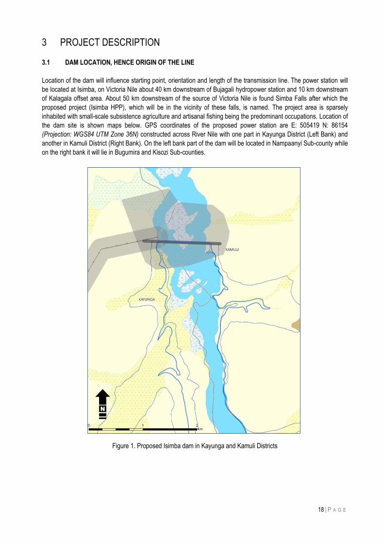
18 | P A G E
3 PROJECT DESCRIPTION
3.1 DAM LOCATION, HENCE ORIGIN OF THE LINE
Location of the dam will influence starting point, orientation and length of the transmission line. The power station will
be located at Isimba, on Victoria Nile about 40 km downstream of Bujagali hydropower station and 10 km downstream
of Kalagala offset area. About 50 km downstream of the source of Victoria Nile is found Simba Falls after which the
proposed project (Isimba HPP), which will be in the vicinity of these falls, is named. The project area is sparsely
inhabited with small-scale subsistence agriculture and artisanal fishing being the predominant occupations. Location of
the dam site is shown maps below. GPS coordinates of the proposed power station are E: 505419 N: 86154
(Projection: WGS84 UTM Zone 36N) constructed across River Nile with one part in Kayunga District (Left Bank) and
another in Kamuli District (Right Bank). On the left bank part of the dam will be located in Nampaanyi Sub-county while
on the right bank it will lie in Bugumira and Kisozi Sub-counties.
Figure 1. Proposed Isimba dam in Kayunga and Kamuli Districts
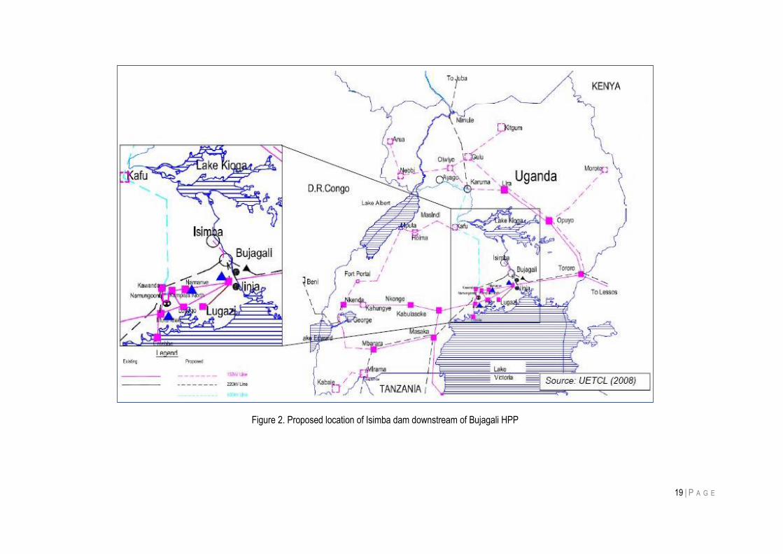
19 | P A G E
Figure 2. Proposed location of Isimba dam downstream of Bujagali HPP
20 | P A G E
3.2 TECHNICAL DESCRIPTION OF THE 42 KM 132 KV TRANSMISSION LINE
A new 132 kV double circuit transmission line shall run from a substation at Bujagali HPP to a new substation at Isimba hydropower dam in order to connect power generated (at Isimba HPP) to the national grid. The line on steel lattice towers will be 42 km long and have a 30 meter wayleave with a 5 meter right of way. The transmission line shall follow existing roads in order have easy access during construction and maintenance. An additional portion of the wayleave may be procured to provide an access road for construction and maintenance vehicles, so called maintenance road, under the line for use in operations and maintenance. Due to linear settlements along the roads, the proposed powerline line shall be at a distance ranging between 50 m and 100 m from existing roads. The following general criteria were considered for selecting the line route:
Highly populated areas will be avoided as much as possible to minimise resettlement Crossings over other overhead lines, main roads and rivers to be optimized River Nile crossings to be located at suitable positions Access to tower locations and angle points to be provided to enable transportation of conductor drums
and stringing equipment Future access for maintenance purposes during operation Due attention to environmental aspects
3.3 SUBSTATIONS
In order to connect the electricity generated at Isimba HPP to the electrical network it is necessary to establish a new 132 kV substation near Isimba dam, lay down one 132 kV double circuit transmission line from Isimba Substation to an existing substation at Bujagali HPP and expand existing Bujagali substation for connection of Isimba transmission line. These substations are described below. 3.3.1 NEW ISIMBA SUBSTATION The new substation shall be a double busbar type with two line bays, 4 Transformer bays, 1 bus coupler and 2 Future bays. Further, the scope includes one control building and necessary access roads, pavement and drainage system. The design shall be prepared considering enough spare space available for future extension of the substation. Thus, cable channels, openings, civil works, building works, arrangement of all secondary equipment shall be designed and prepared for the final stage. Single line, layout, sections, building and other relevant drawings shall show the final extension of the substation. The following 132 kV new equipment shall be included in the scope of supply and works: 1 (one) double busbar system 132 kV outdoor Steel work and busbar, lattice type, busbar conductors 1 (one) busbar coupler:
• 1 (one) set SF6 circuit breaker, • 2 (two) sets of disconnector with 1 (one) earthing switch, • 6 (six) multi-core current transformers.
2 (two) busbar measuring bay consisting of:
• 6 (six) voltage transformer. • 2 (two) sets of disconnector with earthing switch
21 | P A G E
2 (two) line bays consisting each of:
• 1 (one) set SF6 circuit breakers • 1 (one) set of double busbar disconnectors with 1 (one) earthing switch, • 1 (one) set of disconnector with 2 (two) earthing switches, • 3 (three) multi-core current transformers, • 3 (three) voltage transformers, • 3 (three) lightning arresters
4 (four) transformer bays with:
• 1 (one) set SF6 circuit breaker, • 1 (one) set of double busbar disconnectors with 1 (one) earthing switch, • 1 (one) earthing switch, • 3 (three) multi-core current transformers, • 3 (three) voltage transformer, • 3 (three) lightning arresters
The auxiliary power system, power and control cables, earthing, power and lightning control and monitoring equipment, protection equipment, telecommunication system will also be installed at the new substation.
3.3.2 EXTENSION OF 132 KV OUTDOOR SWITCHYARD BUJAGALI Due to the limited space near existing Bujagali substation a connection cable shall be used to connect the double circuit Isimba line to Bujagali Substation. Such connection of Isimba transmission line to existing 132 kV part of the Bujagali Substation will avoid interference with future expansion of Bujagali Substation to 220 kV level. The following 132 kV new equipment shall be included in the scope of supply and works: • Modification of the existing busbar system 132 kV outdoor • Steel work and busbar, lattice type, busbar conductors 2 (two) cable bay Isimba 1/2 with:
• 1 (one) set SF6 circuit breaker, • 1 (one) earthing switch • 3 (three) multi-core current transformers, • 3 (three) voltage transformer, • 3 (three) lightning arresters.
2 (two) cable systems between feeder Isimba 1, Isimba 2 and overhead line 132 kV
• 3 (three) single phase XLPE cable connection to nearby overhead line 132 kV, • 3 (three) cable sealing ends on overhead line, • 3 (three) lightning arrestors on overhead line.
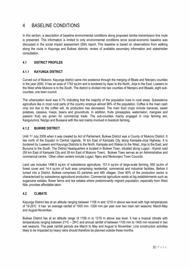
22 | P A G E
4 BASELINE CONDITIONS
In this section, a description of baseline environmental conditions along proposed Isimba transmission line route
is presented. This information is limited to only environmental conditions since social-economic baseline was
discussed in the social impact assessment (SIA) report. This baseline is based on observations from walking
along the route in Kayunga and Buikwe districts, review of available secondary information and stakeholder
consultation.
4.1 DISTRICT PROFILES
4.1.1 KAYUNGA DISTRICT Curved out of Mukono, Kayunga district came into existence through the merging of Bbale and Ntenjeru counties in the year 2000. It has an area of 1742 sq.km and is bordered by Apac to the North, Jinja to the East, Luweero to the West while Mukono is to the South. The district is divided into two counties of Ntenjeru and Bbaale, eight sub-counties, one town council. The urbanization level was 6.7% indicating that the majority of the population lives in rural areas. Subsistence agriculture like in most rural parts of the country employs almost 96% of the population. Coffee is the main cash crop but due to the coffee wilt, its production has decreased. The main food crops include bananas, sweet potatoes, cassava, maize, beans and groundnuts. In addition, fruits (pineapples, watermelon, mangoes and passion fruit) are grown for commercial trade. The sub-counties mainly engaged in crop farming are; Kangulumira, Nazigo and Busaana with the rest mainly involved in livestock farming. 4.1.2 BUIKWE DISTRICT Until 1st July 2009 when it was created by Act of Parliament, Buikwe District was a County of Mukono District. It lies north of the Equator in Central Uganda, 16 km East of Kampala City along Kampala-Jinja Highway. It is bordered by Luweero and Kayunga Districts to the North, Kampala and Wakiso to the West, Jinja to the East, and Buvuma to the South. The District Headquarters is located in Buikwe Town, situated along Lugazi - Kiyindi road (59 km East of Kampala City and 39 km East of Mukono Town). Buikwe Town serves as an Administrative and commercial centre. Other urban centers include Lugazi, Njeru and Nkokonjeru Town Councils. Land use includes 1496.9 sq.km of subsistence agriculture, 151.4 sq.km of large-scale farming, 650 sq.km of forest cover and 14.4 sq.km of built area comprising residential, commercial and industrial facilities. Before it turned into a District, Buikwe comprised 63 parishes and 485 villages. Over 80% of the production sector is characterized by subsistence agricultural production. Commercial agriculture exists at big establishments such as sugarcane estates, flower farms and tea estates where predominantly migrant population, especially from West Nile, provides affordable labor.
4.2 CLIMATE
Kayunga District lies at an altitude ranging between 1158 m and 1219 m above sea level with high temperatures of 19-25oC It has an average rainfall of 1000 mm -1200 mm per year over two main rain seasons: March-May and August-November. Buikwe District lies at an altitude range of 1158 m to 1219 m above sea level. It has a tropical climate with temperatures ranging between 21oC – 29oC and annual rainfall of between 1100 mm to 1400 mm received in two wet seasons. The peak rainfall periods are March to May and August to November. Line construction activities likely to be impacted by heavy rains should therefore be planned outside these months.
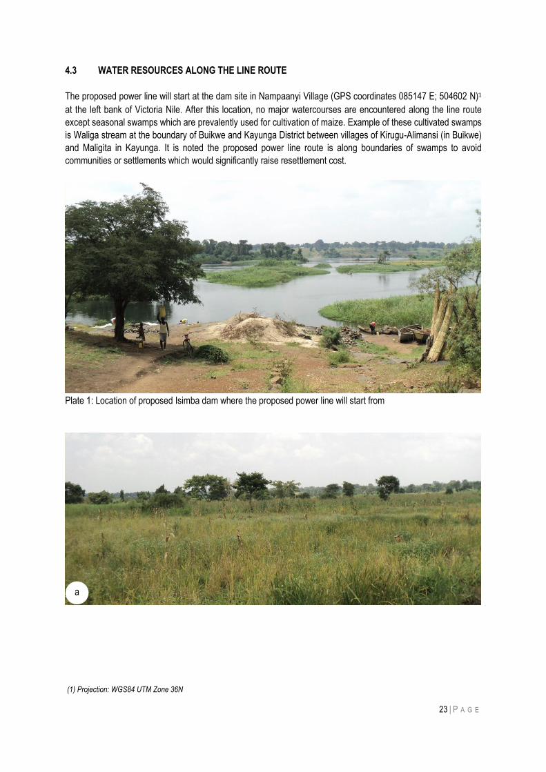
23 | P A G E
4.3 WATER RESOURCES ALONG THE LINE ROUTE
The proposed power line will start at the dam site in Nampaanyi Village (GPS coordinates 085147 E; 504602 N)1
at the left bank of Victoria Nile. After this location, no major watercourses are encountered along the line route
except seasonal swamps which are prevalently used for cultivation of maize. Example of these cultivated swamps
is Waliga stream at the boundary of Buikwe and Kayunga District between villages of Kirugu-Alimansi (in Buikwe)
and Maligita in Kayunga. It is noted the proposed power line route is along boundaries of swamps to avoid
communities or settlements which would significantly raise resettlement cost.
Plate 1: Location of proposed Isimba dam where the proposed power line will start from
(1) Projection: WGS84 UTM Zone 36N
a
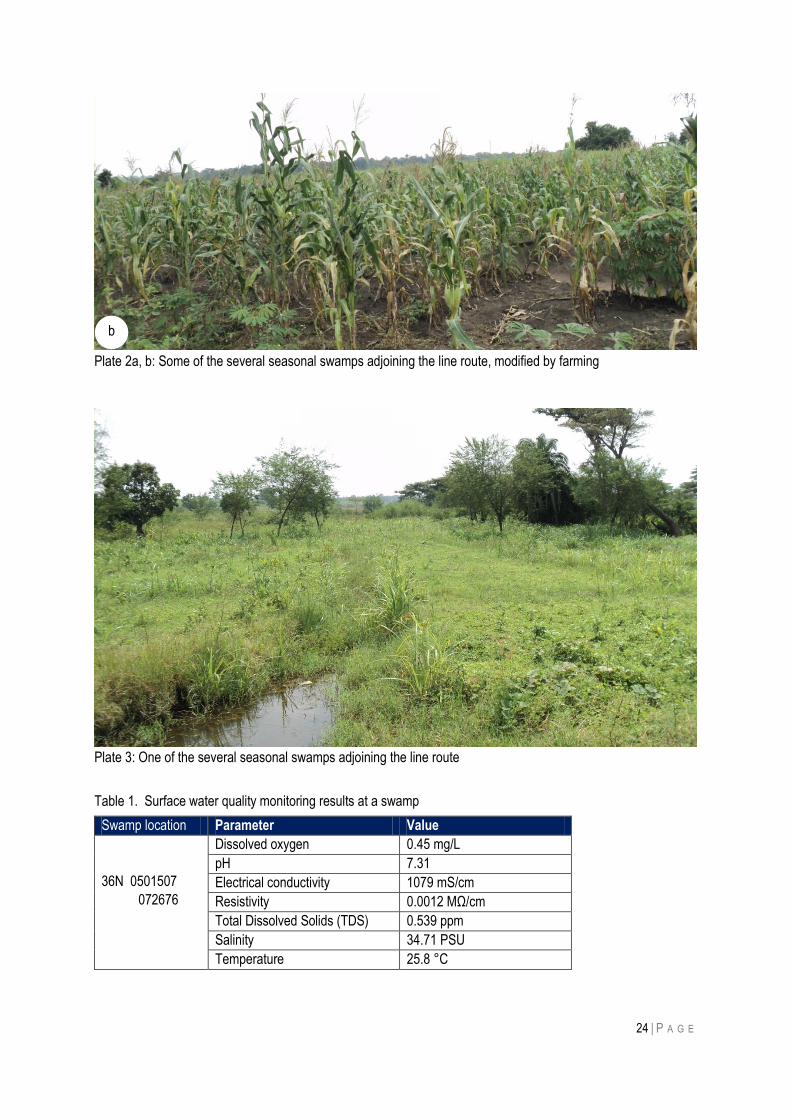
24 | P A G E
Plate 2a, b: Some of the several seasonal swamps adjoining the line route, modified by farming
Plate 3: One of the several seasonal swamps adjoining the line route
Table 1. Surface water quality monitoring results at a swamp
Swamp location Parameter Value
36N 0501507
072676
Dissolved oxygen 0.45 mg/L
pH 7.31
Electrical conductivity 1079 mS/cm
Resistivity 0.0012 MΩ/cm
Total Dissolved Solids (TDS) 0.539 ppm
Salinity 34.71 PSU
Temperature 25.8 °C
b
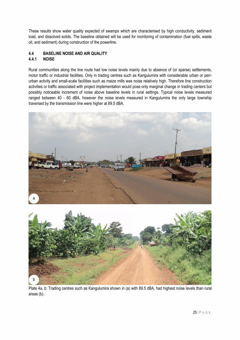
25 | P A G E
These results show water quality expected of swamps which are characterised by high conductivity, sediment
load, and dissolved solids. The baseline obtained will be used for monitoring of contamination (fuel spills, waste
oil, and sediment) during construction of the powerline.
4.4 BASELINE NOISE AND AIR QUALITY
4.4.1 NOISE
Rural communities along the line route had low noise levels mainly due to absence of (or sparse) settlements,
motor traffic or industrial facilities. Only in trading centres such as Kangulumira with considerable urban or peri-
urban activity and small-scale facilities such as maize mills was noise relatively high. Therefore line construction
activities or traffic associated with project implementation would pose only marginal change in trading centers but
possibly noticeable increment of noise above baseline levels in rural settings. Typical noise levels measured
ranged between 40 - 60 dBA, however the noise levels measured in Kangulumira the only large township
traversed by the transmission line were higher at 89.5 dBA.
Plate 4a, b: Trading centres such as Kangulumira shown in (a) with 89.5 dBA, had highest noise levels than rural
areas (b).
b
a
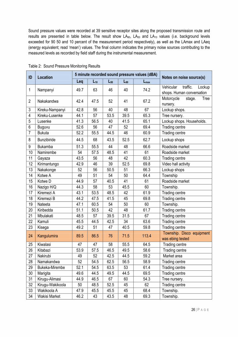
26 | P A G E
Sound pressure values were recorded at 39 sensitive receptor sites along the proposed transmission route and
results are presented in table below. The result show LA90, LA50 and LA10 values (i.e. background levels
exceeded for 90 50 and 10 percent of the measurement period respectively), as well as the LAmax and LAeq
(energy equivalent; read „mean‟) values. The final column indicates the primary noise sources contributing to the
measured levels as recorded by field staff during the instrumental measurement.
Table 2: Sound Pressure Monitoring Results
ID Location 5 minute recorded sound pressure values (dBA)
Notes on noise source(s) Leq L10 L50 L90 Lmax
1 Nampanyi 49.7 63 46 40 74.2 Vehicular traffic. Lockup
shops. Human conversation
2 Nakakandwa 42.4 47.5 52 41 67.2 Motorcycle stage. Tree
nursery.
3 Kireku-Nampanyi 42.8 56 40 48 67 Lockup shops.
4 Kireku-Lusenke 44.1 57 53.5 39.5 65.3 Tree nursery.
5 Lusenke 41.3 56.5 40 41.5 65.1 Lockup shops. Households.
6 Buguvu 52.6 56 47 52 69.4 Trading centre
7 Bukuta 52.2 55.5 44.5 46 60.9 Trading centre
8 Bunzibiride 44.5 68 43.5 52.5 62.7 Lockup shops
9 Bukamba 51.3 55.5 44 48 66.6 Roadside market
10 Namirembe 54 57.5 48.5 41 61 Roadside market
11 Gayaza 43.5 56 48 42 60.3 Trading centre
12 Kirimantungo 42.9 46 39 52.5 69.8 Video hall activity
13 Nakakonge 52 56 50.5 51 66.3 Lockup shops
14 Kotwe A 49 51 54 50 64.4 Township
15 Kotwe D 44.9 57 40.5 41 61 Roadside market
16 Nazigo H/Q 44.3 58 53 45.5 60 Township.
17 Kiremezi A 43.1 53.5 48.5 42 61.9 Trading centre
18 Kiremezi B 44.2 47.5 41.5 45 69.8 Trading centre
19 Nateeta 47.1 60.5 54 50 60 Township.
20 Kiribedda 51.1 50.5 42 48 61.7 Trading centre
21 Mbulakati 48.5 57 39.5 31.5 67 Trading centre
22 Kamuli 45.5 44.5 42.5 34 63.6 Trading centre
23 Kisega 49.2 51 47 40.5 59.8 Trading centre
24 Kangulumira 89.5 86.5 76 71.5 113.4 Township. Disco equipment
was ebing tested
25 Kiwalasi 47 47 58 55.5 64.5 Trading centre
26 Kitabazi 53.9 57.5 46.5 49.5 58.6 Trading centre
27 Nakirubi 49 52 42.5 44.5 59.2 Market area
28 Namakandwa 52 54.5 62.5 56.5 58.9 Trading centre
29 Bukeka-Mirembe 52.1 54.5 63.5 53 61.4 Trading centre
30 Marigita 49.6 44.5 49.5 44.5 69.5 Trading centre
31 Kirugu-Alimasi 44.9 46.5 67 60 54.3 Tree nursery.
32 Kirugu-Wakikoola 50 48.5 52.5 45 62 Trading centre
33 Wakikoola A 47.9 45.5 45.5 45 68.4 Township.
34 Wakisi Market 46.2 43 43.5 48 69.3 Township.
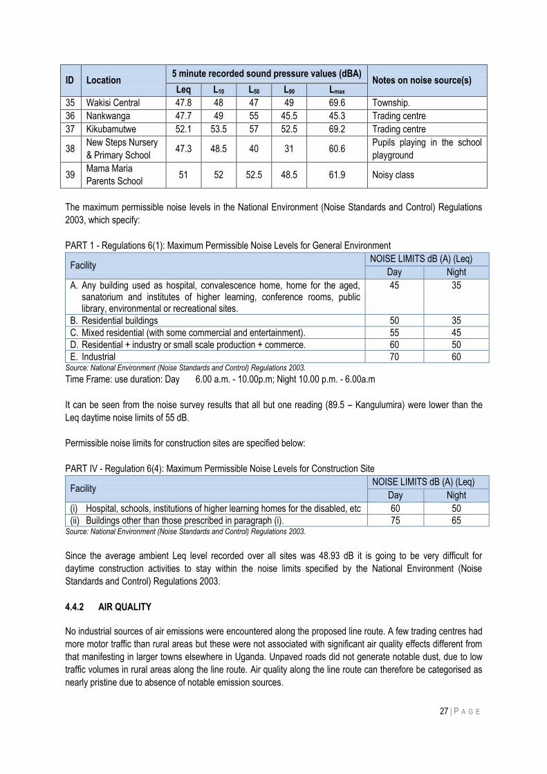
27 | P A G E
ID Location 5 minute recorded sound pressure values (dBA)
Notes on noise source(s) Leq L10 L50 L90 Lmax
35 Wakisi Central 47.8 48 47 49 69.6 Township.
36 Nankwanga 47.7 49 55 45.5 45.3 Trading centre
37 Kikubamutwe 52.1 53.5 57 52.5 69.2 Trading centre
38 New Steps Nursery
& Primary School 47.3 48.5 40 31 60.6
Pupils playing in the school
playground
39 Mama Maria
Parents School 51 52 52.5 48.5 61.9 Noisy class
The maximum permissible noise levels in the National Environment (Noise Standards and Control) Regulations
2003, which specify:
PART 1 - Regulations 6(1): Maximum Permissible Noise Levels for General Environment
Facility NOISE LIMITS dB (A) (Leq)
Day Night
A. Any building used as hospital, convalescence home, home for the aged, sanatorium and institutes of higher learning, conference rooms, public library, environmental or recreational sites.
45 35
B. Residential buildings 50 35
C. Mixed residential (with some commercial and entertainment). 55 45
D. Residential + industry or small scale production + commerce. 60 50
E. Industrial 70 60 Source: National Environment (Noise Standards and Control) Regulations 2003.
Time Frame: use duration: Day 6.00 a.m. - 10.00p.m; Night 10.00 p.m. - 6.00a.m
It can be seen from the noise survey results that all but one reading (89.5 – Kangulumira) were lower than the
Leq daytime noise limits of 55 dB.
Permissible noise limits for construction sites are specified below:
PART IV - Regulation 6(4): Maximum Permissible Noise Levels for Construction Site
Facility NOISE LIMITS dB (A) (Leq)
Day Night
(i) Hospital, schools, institutions of higher learning homes for the disabled, etc 60 50
(ii) Buildings other than those prescribed in paragraph (i). 75 65 Source: National Environment (Noise Standards and Control) Regulations 2003.
Since the average ambient Leq level recorded over all sites was 48.93 dB it is going to be very difficult for
daytime construction activities to stay within the noise limits specified by the National Environment (Noise
Standards and Control) Regulations 2003.
4.4.2 AIR QUALITY
No industrial sources of air emissions were encountered along the proposed line route. A few trading centres had
more motor traffic than rural areas but these were not associated with significant air quality effects different from
that manifesting in larger towns elsewhere in Uganda. Unpaved roads did not generate notable dust, due to low
traffic volumes in rural areas along the line route. Air quality along the line route can therefore be categorised as
nearly pristine due to absence of notable emission sources.
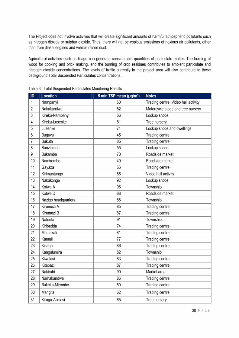
28 | P A G E
The Project does not involve activities that will create significant amounts of harmful atmospheric pollutants such
as nitrogen dioxide or sulphur dioxide. Thus, there will not be copious emissions of noxious air pollutants, other
than from diesel engines and vehicle raised dust.
Agricultural activities such as tillage can generate considerable quantities of particulate matter. The burning of
wood for cooking and brick making, and the burning of crop residues contributes to ambient particulate and
nitrogen dioxide concentrations. The levels of traffic currently in the project area will also contribute to these
background Total Suspended Particulates concentrations.
Table 3: Total Suspended Particulates Monitoring Results
ID Location 5 min TSP mean (µg/m3) Notes
1 Nampanyi 60 Trading centre. Video hall activity
2 Nakakandwa 82 Motorcycle stage and tree nursery
3 Kireku-Nampanyi 66 Lockup shops
4 Kireku-Lusenke 81 Tree nursery
5 Lusenke 74 Lockup shops and dwellings
6 Buguvu 45 Trading centre
7 Bukuta 85 Trading centre
8 Bunzibiride 55 Lockup shops
9 Bukamba 70 Roadside market
10 Namirembe 49 Roadside market
11 Gayaza 66 Trading centre
12 Kirimantungo 86 Video hall activity
13 Nakakonge 92 Lockup shops
14 Kotwe A 96 Township
15 Kotwe D 88 Roadside market
16 Nazigo headquarters 88 Township
17 Kiremezi A 85 Trading centre
18 Kiremezi B 87 Trading centre
19 Nateeta 91 Township.
20 Kiribedda 74 Trading centre
21 Mbulakati 81 Trading centre
22 Kamuli 77 Trading centre
23 Kisega 86 Trading centre
24 Kangulumira 82 Township
25 Kiwalasi 83 Trading centre
26 Kitabazi 87 Trading centre
27 Nakirubi 90 Market area
28 Namakandwa 86 Trading centre
29 Bukeka-Mirembe 80 Trading centre
30 Marigita 62 Trading centre
31 Kirugu-Alimasi 65 Tree nursery
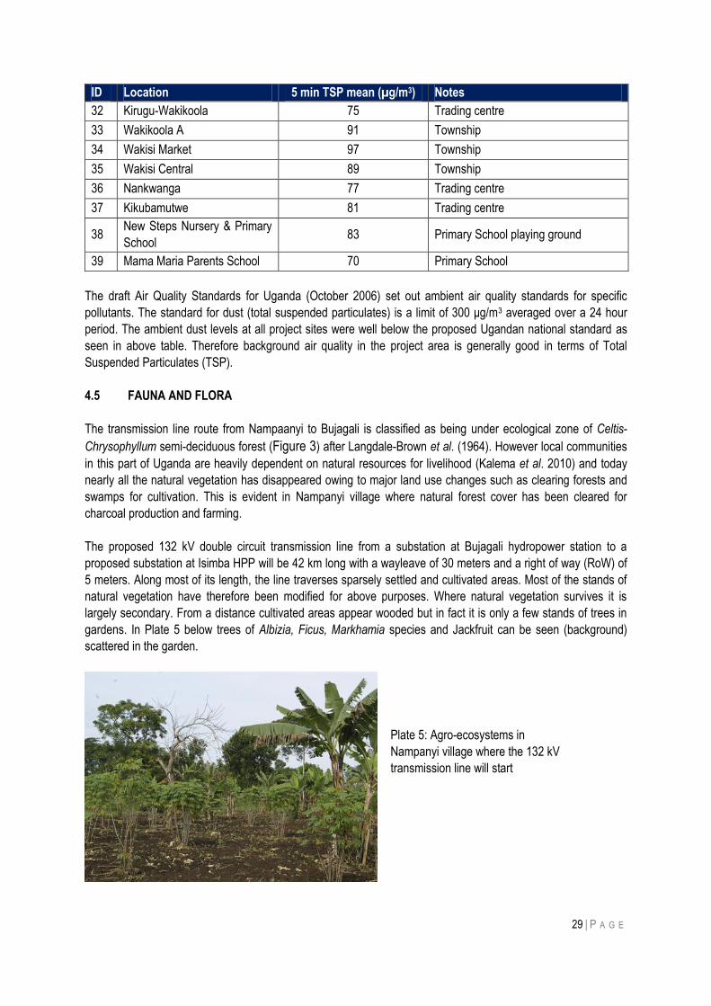
29 | P A G E
ID Location 5 min TSP mean (µg/m3) Notes
32 Kirugu-Wakikoola 75 Trading centre
33 Wakikoola A 91 Township
34 Wakisi Market 97 Township
35 Wakisi Central 89 Township
36 Nankwanga 77 Trading centre
37 Kikubamutwe 81 Trading centre
38 New Steps Nursery & Primary
School 83 Primary School playing ground
39 Mama Maria Parents School 70 Primary School
The draft Air Quality Standards for Uganda (October 2006) set out ambient air quality standards for specific
pollutants. The standard for dust (total suspended particulates) is a limit of 300 μg/m3 averaged over a 24 hour
period. The ambient dust levels at all project sites were well below the proposed Ugandan national standard as
seen in above table. Therefore background air quality in the project area is generally good in terms of Total
Suspended Particulates (TSP).
4.5 FAUNA AND FLORA
The transmission line route from Nampaanyi to Bujagali is classified as being under ecological zone of Celtis-
Chrysophyllum semi-deciduous forest (Figure 3) after Langdale-Brown et al. (1964). However local communities
in this part of Uganda are heavily dependent on natural resources for livelihood (Kalema et al. 2010) and today
nearly all the natural vegetation has disappeared owing to major land use changes such as clearing forests and
swamps for cultivation. This is evident in Nampanyi village where natural forest cover has been cleared for
charcoal production and farming.
The proposed 132 kV double circuit transmission line from a substation at Bujagali hydropower station to a
proposed substation at Isimba HPP will be 42 km long with a wayleave of 30 meters and a right of way (RoW) of
5 meters. Along most of its length, the line traverses sparsely settled and cultivated areas. Most of the stands of
natural vegetation have therefore been modified for above purposes. Where natural vegetation survives it is
largely secondary. From a distance cultivated areas appear wooded but in fact it is only a few stands of trees in
gardens. In Plate 5 below trees of Albizia, Ficus, Markhamia species and Jackfruit can be seen (background)
scattered in the garden.
Plate 5: Agro-ecosystems in
Nampanyi village where the 132 kV
transmission line will start
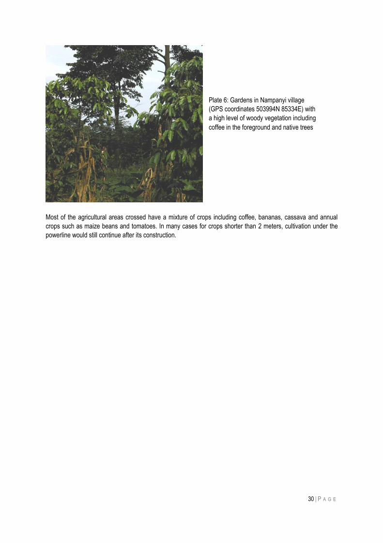
30 | P A G E
Most of the agricultural areas crossed have a mixture of crops including coffee, bananas, cassava and annual
crops such as maize beans and tomatoes. In many cases for crops shorter than 2 meters, cultivation under the
powerline would still continue after its construction.
Plate 6: Gardens in Nampanyi village
(GPS coordinates 503994N 85334E) with
a high level of woody vegetation including
coffee in the foreground and native trees
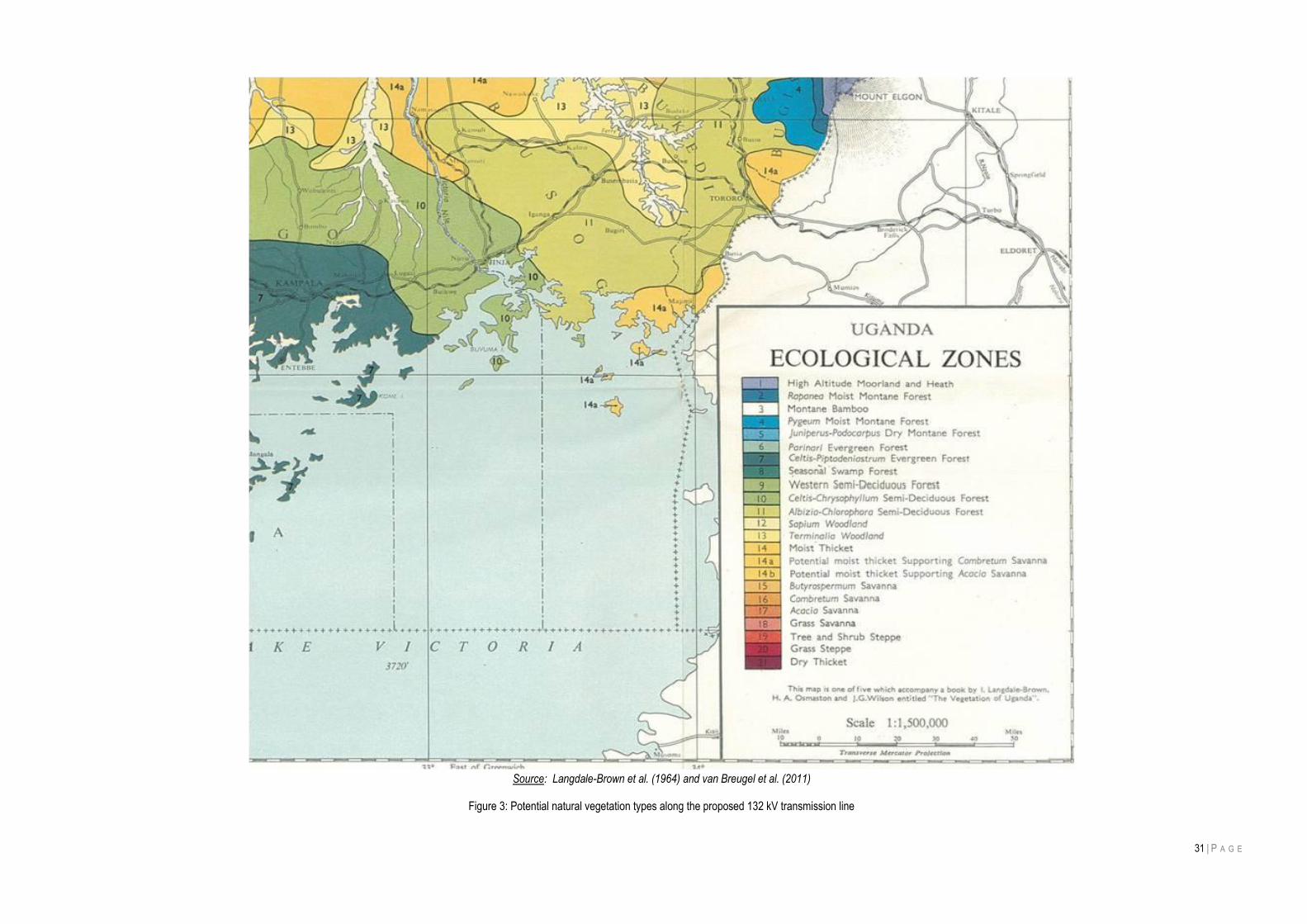
31 | P A G E
Source: Langdale-Brown et al. (1964) and van Breugel et al. (2011)
Figure 3: Potential natural vegetation types along the proposed 132 kV transmission line
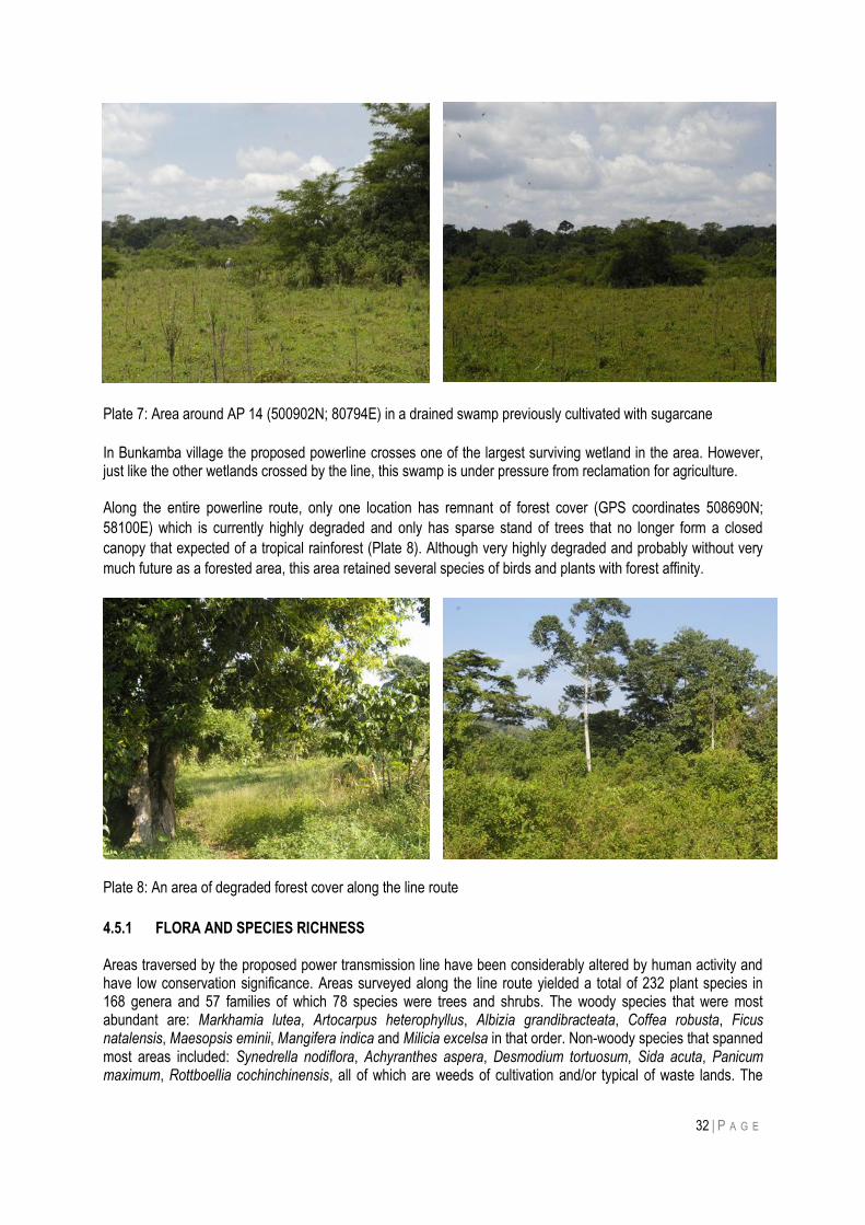
32 | P A G E
Plate 7: Area around AP 14 (500902N; 80794E) in a drained swamp previously cultivated with sugarcane
In Bunkamba village the proposed powerline crosses one of the largest surviving wetland in the area. However, just like the other wetlands crossed by the line, this swamp is under pressure from reclamation for agriculture. Along the entire powerline route, only one location has remnant of forest cover (GPS coordinates 508690N;
58100E) which is currently highly degraded and only has sparse stand of trees that no longer form a closed
canopy that expected of a tropical rainforest (Plate 8). Although very highly degraded and probably without very
much future as a forested area, this area retained several species of birds and plants with forest affinity.
Plate 8: An area of degraded forest cover along the line route
4.5.1 FLORA AND SPECIES RICHNESS Areas traversed by the proposed power transmission line have been considerably altered by human activity and have low conservation significance. Areas surveyed along the line route yielded a total of 232 plant species in 168 genera and 57 families of which 78 species were trees and shrubs. The woody species that were most abundant are: Markhamia lutea, Artocarpus heterophyllus, Albizia grandibracteata, Coffea robusta, Ficus natalensis, Maesopsis eminii, Mangifera indica and Milicia excelsa in that order. Non-woody species that spanned most areas included: Synedrella nodiflora, Achyranthes aspera, Desmodium tortuosum, Sida acuta, Panicum maximum, Rottboellia cochinchinensis, all of which are weeds of cultivation and/or typical of waste lands. The
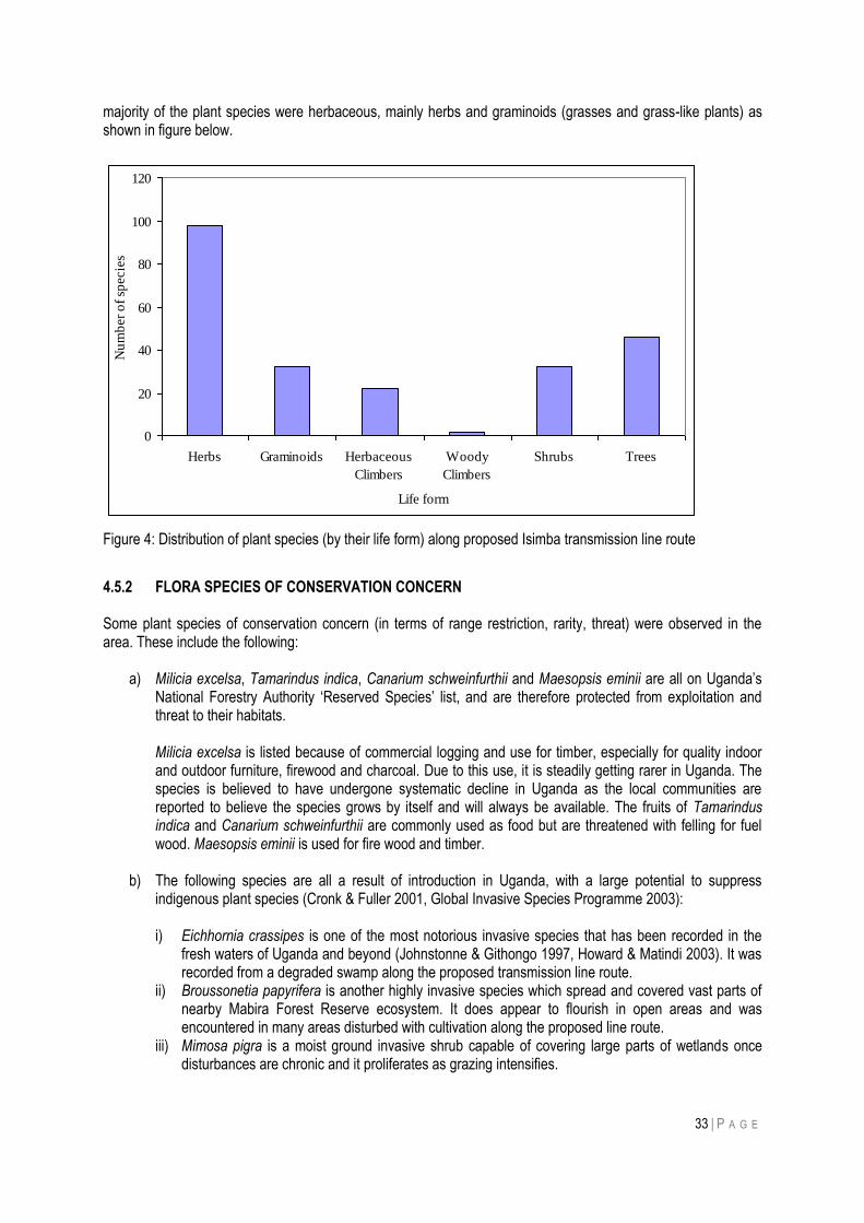
33 | P A G E
majority of the plant species were herbaceous, mainly herbs and graminoids (grasses and grass-like plants) as shown in figure below.
Figure 4: Distribution of plant species (by their life form) along proposed Isimba transmission line route
4.5.2 FLORA SPECIES OF CONSERVATION CONCERN Some plant species of conservation concern (in terms of range restriction, rarity, threat) were observed in the area. These include the following:
a) Milicia excelsa, Tamarindus indica, Canarium schweinfurthii and Maesopsis eminii are all on Uganda‟s National Forestry Authority „Reserved Species‟ list, and are therefore protected from exploitation and threat to their habitats. Milicia excelsa is listed because of commercial logging and use for timber, especially for quality indoor and outdoor furniture, firewood and charcoal. Due to this use, it is steadily getting rarer in Uganda. The species is believed to have undergone systematic decline in Uganda as the local communities are reported to believe the species grows by itself and will always be available. The fruits of Tamarindus indica and Canarium schweinfurthii are commonly used as food but are threatened with felling for fuel wood. Maesopsis eminii is used for fire wood and timber.
b) The following species are all a result of introduction in Uganda, with a large potential to suppress indigenous plant species (Cronk & Fuller 2001, Global Invasive Species Programme 2003): i) Eichhornia crassipes is one of the most notorious invasive species that has been recorded in the
fresh waters of Uganda and beyond (Johnstonne & Githongo 1997, Howard & Matindi 2003). It was recorded from a degraded swamp along the proposed transmission line route.
ii) Broussonetia papyrifera is another highly invasive species which spread and covered vast parts of nearby Mabira Forest Reserve ecosystem. It does appear to flourish in open areas and was encountered in many areas disturbed with cultivation along the proposed line route.
iii) Mimosa pigra is a moist ground invasive shrub capable of covering large parts of wetlands once disturbances are chronic and it proliferates as grazing intensifies.
0
20
40
60
80
100
120
Herbs Graminoids Herbaceous
Climbers
Woody
Climbers
Shrubs Trees
Life form
Nu
mb
er
of
specie
s
34 | P A G E
iv) Lantana camara invades areas that are drier unlike than Mimosa pigra but both species thrive with disturbance (Cronk & Fuller 2001). Their presence makes indigenous flora in any given area susceptible to suppression effects (Cronk & Fuller 2001, Global Invasive Species Programme 2003). Mimosa pigra is invading many wetlands in Uganda and was seen in some swamps along the line route.
4.5.3 FAUNA
4.5.2.1 Birds
Birds and other biodiversity have been extensively studied in what is sometimes referred to as the „coffee-banana
arc‟ north of Lake Victoria (Nalwanga, 2011). Although most of the area, including that to be followed by the
proposed transmission line, is cultivated, it retains considerable bird population. Nalwanga recorded 218 species
across 26 sites and similar numbers have been recorded from the on-going Bird Population Monitoring
programme, co-ordinated by NatureUganda. The Uganda Bird Atlas (Carswell et al, 2005) reflect this diversity.
About 200 of these are specialist waterbirds or forest birds, so Nalwanga recorded just over 60% of the species
that might be expected outside forests and wetlands. Birds are mobile, and in this study were recorded up to 0.5
kilometres from the proposed transmission line route. Including the counts from Bujagali, the survey recorded 130
bird species listed in Annex B. The seven farmland sites yielded 94 species, of which 60 were also found at the
single Bujagali site (and where a further 25 were recorded that were not found in the current survey). The three
valley bottom sites had 63 species, all but 11 of which were also in the farmland. This is expected since the
valleys were almost completely cultivated.
Farmland sites had numerous trees, including a big variety of native species, such as Markhamia, which was particularly common, as well as fruit trees such as jackfruit. Many birds depend upon trees for roosting, nesting or feeding. There was no real forest along the transmission line route, but many forest generalist and visitor species are found outside forest in areas with plenty of trees. Numbers of species in other categories were relatively small, and the four regionally-listed species are all widespread. These are the Grey Parrot (R-NT), Spot-flanked Barbet, White-headed Saw-wing and Red-chested Sunbird. Only a small population of aerial species (swifts, bee-eaters, swallows) were encountered. There were few open areas of grassland, hence few species of that speciality, and only 7 Afrotropical migrants (a further 5 migrants, from the Palearctic region, were recorded at Bujagali, and would be expected in these areas too, between about October and March).
Valley bottom sites of which there were only three, were originally seasonal swamps but now under cultivation,
therefore many of the farmland species occurred here. There were also a few more species associated with
wetlands (w), but most of these are widespread and some, such as Tawny-flanked Prinia, were also encountered
in farmlands and valley bottoms.
Table 4: Number of bird species encountered in the two main habitats along line route
Category Code Number of species in:
Farmland Valley bottoms
Regionally near-threatened R-NT 1 1
Regionally restricted R-RR 3 3
Forest specialist FF 2 1
Forest generalist F 14 2
Forest visitor F 39 23
Waterbird specialist W 3 3
Wetland visitor W 13 15
Aerial species Ae 3 3
Grassland specialist G 6 8
35 | P A G E
Category Code Number of species in:
Farmland Valley bottoms
Afrotropical migrant A 7 4
Total 91 63
Grey Crowned Cranes deserve a special mention, because they are Uganda‟s National Bird and are also rapidly
declining. The National Biodiversity Data Bank estimates that Grey Crowned Cranes population has fallen by
more than 70% in the past 40 years (State of Uganda’s Biodiversity Report for 2010). Cranes breed in seasonal
swamps of the kind that have been extensively drained in areas traversed by the proposed transmission line.
However even in degraded swamps, Grey Crowned Cranes were still encountered, as was reported by local
people. Of seven people interviewed, 3 had seen cranes within the previous week; 2 people within the previous
month and 2 people less frequently.
4.5.2.2 Mammals
Very few data exist on mammal occurrence and diversity in the areas of Uganda that don‟t have any protection status. Some studies from which mammals‟ data relevant to the present project can be sourced include: Dickson and Kityo 1996 (Small mammals in Mabira Forest Biodiversity Report edited by P. Howard, T.
Davenport & M Baltzer), and, Bujagali HPP EIA studies. Mabira Forest which has a relatively good level of protection has over 100 species of mammals (both small and large). Areas outside protected areas in central Uganda have largely been depleted of medium to large sized mammals which were either hunted for meat or killed on sight because were vermin. No wild mammals of conservation concern were encountered along the proposed power line route. A few large
mammal species were reported by local residents to have previously lived in some areas along the line route but
have now been locally exterminated. Species of mammals that would be of significant conservation concern
include Hippopotami, Leopard and Spot-necked Otter. Since none of these were encountered, it is not considered
that the proposed transmission line will have significant conservation concern regarding terrestrial mammals. A
total of 20 species (Table 5) were reported to ever have been seen by local people in different areas along the
proposed power line route.
Table 5: Mammal species reported in different places along the proposed transmission line route
Angle point (AP) along power line route AP01 AP03 AP05 AP07 AP011 74 AP13 AP14 69 AP16
Coordinates 51
5383
N 5
5276
E
5124
15 5
6962
5086
90 5
8100
5033
87 6
2979
5015
38 7
4947
5013
77 7
5576
5007
03 7
9147
5009
02 8
0794
5032
92 8
2775
5045
12 8
5431
Species Land
-use
Agr
o-ec
osys
tem
site
1
Agr
o-ec
osys
tem
site
2
Agr
o-ec
osys
tem
site
3
Agr
o-ec
osys
tem
site
4
Agr
o-ec
osys
tem
site
5
Agr
o-ec
osys
tem
site
6
Val
ley
site
1
Val
ley
site
2
Val
ley
site
3
Agr
o-ec
osys
tem
site
7
Hippopotamus amphibius Hippopotamus pre 1987 p
Sylvicapra grimmia Bush Duiker P pre 1987
Tragelaphus scriptus Bushbuck p P pre 1987
36 | P A G E
Angle point (AP) along power line route AP01 AP03 AP05 AP07 AP011 74 AP13 AP14 69 AP16
Coordinates 51
5383
N 5
5276
E
5124
15 5
6962
5086
90 5
8100
5033
87 6
2979
5015
38 7
4947
5013
77 7
5576
5007
03 7
9147
5009
02 8
0794
5032
92 8
2775
5045
12 8
5431
Species Land
-use
Agr
o-ec
osys
tem
site
1
Agr
o-ec
osys
tem
site
2
Agr
o-ec
osys
tem
site
3
Agr
o-ec
osys
tem
site
4
Agr
o-ec
osys
tem
site
5
Agr
o-ec
osys
tem
site
6
Val
ley
site
1
Val
ley
site
2
Val
ley
site
3
Agr
o-ec
osys
tem
site
7
Cercopithecus aethiops Vervet Monkey p P p
Cercopithecus ascanius Red tailed Monkey P
Papio anubis Olive Baboon
Lutra maculicollis Spot necked Otter p
Ichneumia albicauda White-tailed Mongoose p p p
Herpestes ichneumon Gray Mongoose p P p p p
Herpestes sanguineus Slender Mongoose p P p p
Atilax paludinosus Marsh Mongoose p P p p
Mungos mungo Banded Mongoose P
Civetictis civetta African Civet p
Canis adustus Side stripped Jackal p P P p p
Felis serval Serval cat p
Panthera pardus Leopard pre 1987
Crocuta crocuta Spotted Hyena pre 1987
Heliosciurus rufobrachium Red-legged Sun Squirrel p p
Xerus erythropus Stripped Ground squirrel p
Thryonomys gregorianus Cane rat P
Note: “p” indicates animals reported by local people to ever have been seen in the area. In some cases the list above
includes animals locally extirpated from different areas by the late 1980s. “pre” means “before”.
4.6 GENERAL OBSERVATIONS ALONG THE POWER LINE ROUTE
Table below shows observations by angle point (AP) along the proposed transmission line.
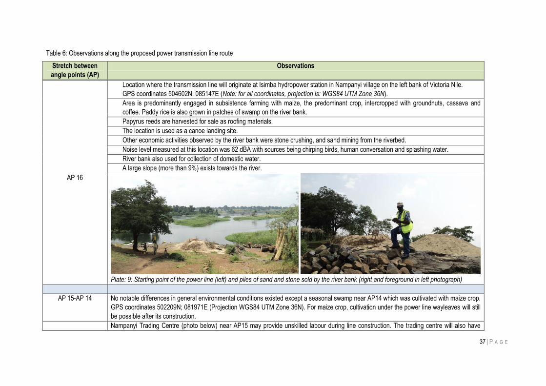
37 | P A G E
Table 6: Observations along the proposed power transmission line route
Stretch between
angle points (AP)
Observations
AP 16
Location where the transmission line will originate at Isimba hydropower station in Nampanyi village on the left bank of Victoria Nile.
GPS coordinates 504602N; 085147E (Note: for all coordinates, projection is: WGS84 UTM Zone 36N).
Area is predominantly engaged in subsistence farming with maize, the predominant crop, intercropped with groundnuts, cassava and
coffee. Paddy rice is also grown in patches of swamp on the river bank.
Papyrus reeds are harvested for sale as roofing materials.
The location is used as a canoe landing site.
Other economic activities observed by the river bank were stone crushing, and sand mining from the riverbed.
Noise level measured at this location was 62 dBA with sources being chirping birds, human conversation and splashing water.
River bank also used for collection of domestic water.
A large slope (more than 9%) exists towards the river.
Plate: 9: Starting point of the power line (left) and piles of sand and stone sold by the river bank (right and foreground in left photograph)
AP 15-AP 14 No notable differences in general environmental conditions existed except a seasonal swamp near AP14 which was cultivated with maize crop.
GPS coordinates 502209N; 081971E (Projection WGS84 UTM Zone 36N). For maize crop, cultivation under the power line wayleaves will still
be possible after its construction.
Nampanyi Trading Centre (photo below) near AP15 may provide unskilled labour during line construction. The trading centre will also have
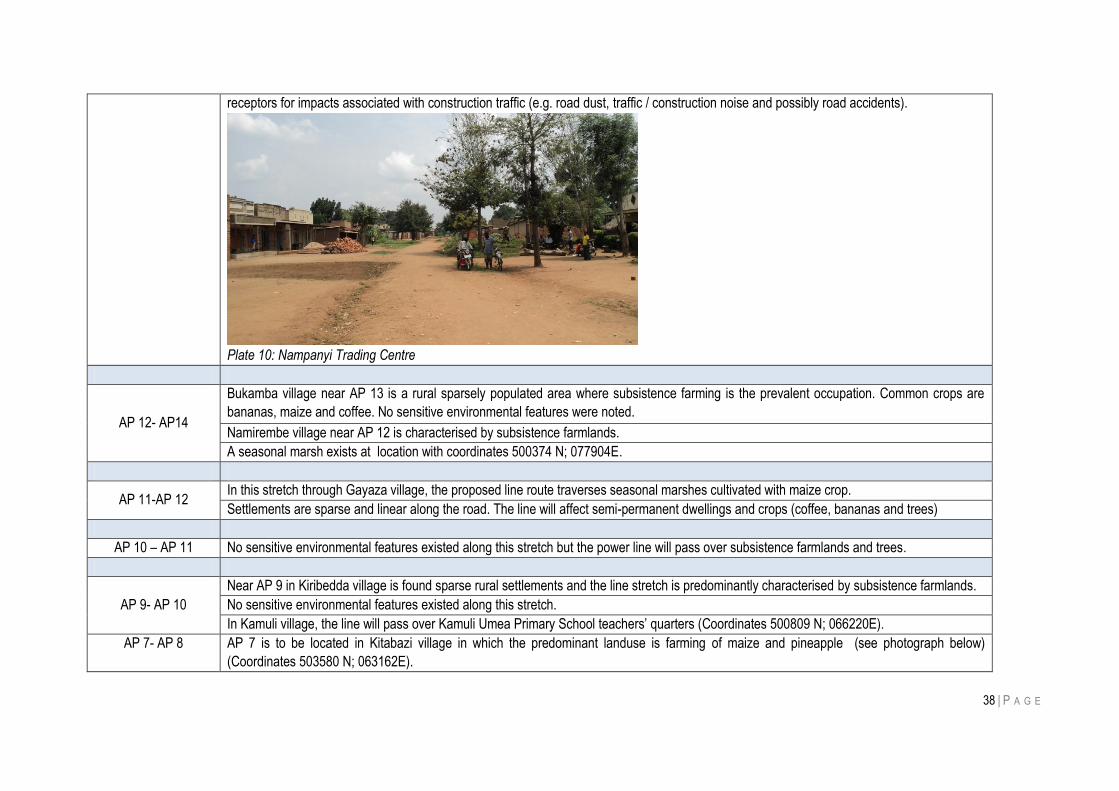
38 | P A G E
receptors for impacts associated with construction traffic (e.g. road dust, traffic / construction noise and possibly road accidents).
Plate 10: Nampanyi Trading Centre
AP 12- AP14
Bukamba village near AP 13 is a rural sparsely populated area where subsistence farming is the prevalent occupation. Common crops are
bananas, maize and coffee. No sensitive environmental features were noted.
Namirembe village near AP 12 is characterised by subsistence farmlands.
A seasonal marsh exists at location with coordinates 500374 N; 077904E.
AP 11-AP 12 In this stretch through Gayaza village, the proposed line route traverses seasonal marshes cultivated with maize crop.
Settlements are sparse and linear along the road. The line will affect semi-permanent dwellings and crops (coffee, bananas and trees)
AP 10 – AP 11 No sensitive environmental features existed along this stretch but the power line will pass over subsistence farmlands and trees.
AP 9- AP 10
Near AP 9 in Kiribedda village is found sparse rural settlements and the line stretch is predominantly characterised by subsistence farmlands.
No sensitive environmental features existed along this stretch.
In Kamuli village, the line will pass over Kamuli Umea Primary School teachers‟ quarters (Coordinates 500809 N; 066220E).
AP 7- AP 8 AP 7 is to be located in Kitabazi village in which the predominant landuse is farming of maize and pineapple (see photograph below)
(Coordinates 503580 N; 063162E).
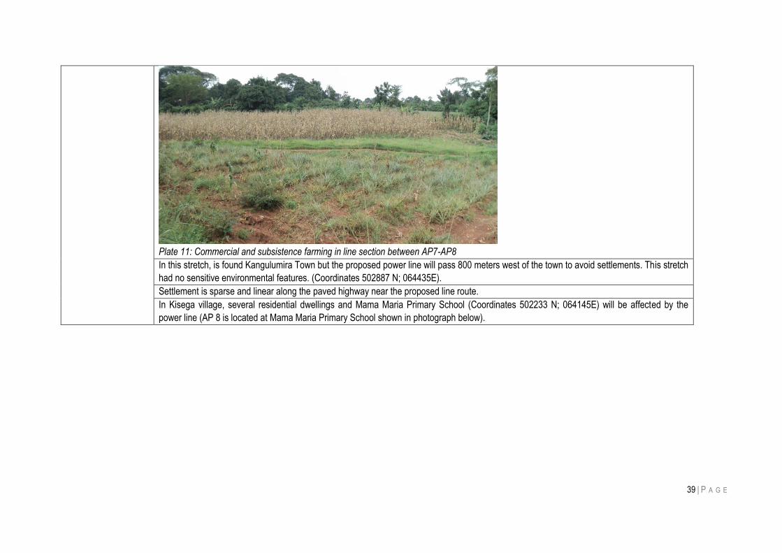
39 | P A G E
Plate 11: Commercial and subsistence farming in line section between AP7-AP8
In this stretch, is found Kangulumira Town but the proposed power line will pass 800 meters west of the town to avoid settlements. This stretch
had no sensitive environmental features. (Coordinates 502887 N; 064435E).
Settlement is sparse and linear along the paved highway near the proposed line route.
In Kisega village, several residential dwellings and Mama Maria Primary School (Coordinates 502233 N; 064145E) will be affected by the
power line (AP 8 is located at Mama Maria Primary School shown in photograph below).
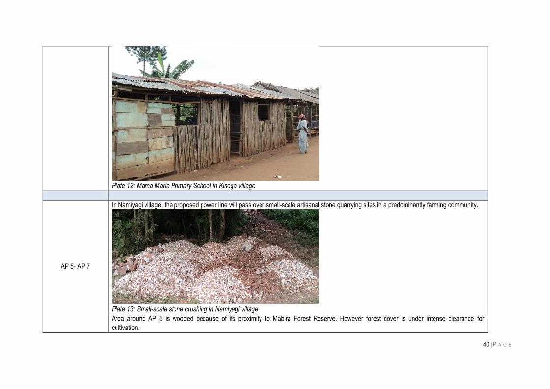
40 | P A G E
Plate 12: Mama Maria Primary School in Kisega village
AP 5- AP 7
In Namiyagi village, the proposed power line will pass over small-scale artisanal stone quarrying sites in a predominantly farming community.
Plate 13: Small-scale stone crushing in Namiyagi village
Area around AP 5 is wooded because of its proximity to Mabira Forest Reserve. However forest cover is under intense clearance for
cultivation.
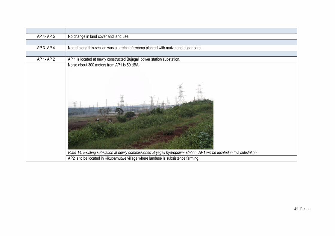
41 | P A G E
AP 4- AP 5 No change in land cover and land use.
AP 3- AP 4 Noted along this section was a stretch of swamp planted with maize and sugar care.
AP 1- AP 2 AP 1 is located at newly constructed Bujagali power station substation.
Noise about 300 meters from AP1 is 50 dBA.
Plate 14: Existing substation at newly commissioned Bujagali hydropower station. AP1 will be located in this substation
AP2 is to be located in Kikubamutwe village where landuse is subsistence farming.
42 | P A G E
5 EIA METHODOLOGY
5.1 INTRODUCTION
This chapter describes the broad principles of methodology and scope of the EIA indicating the approach that
was used to identify, evaluate and recommend mitigation measures for environmental impacts.
5.2 PHYSICAL ENVIRONMENT
Data Sources
This Environmental Assessment (EA) has examined baseline environmental data for both the „macro-
corridor‟ of the transmission line and the wayleave for the preferred route (i.e. the „project area‟), as
identified during the alternatives assessment. This data has been compiled from a range of primary,
secondary and tertiary sources. Primary data was collected by the consultants survey teams and.
methods used varied depending on the nature of the data to be collected. However, standardised,
defensible data collection methodologies were used throughout the study to ensure that high quality
primary data was collected.
Secondary data was relied upon in development of this EIA. Many studies have been conducted on the
ecosystems and biodiversity of central Uganda and where possible, existing information has been used to
maximise the efficiency of the EIA process. Only when critical gaps in the body of existing secondary data
were identified was effort expended in collecting Primary data.
Field Surveys
a) Air Quality
Airborne particulate measurements were made during December 2010 at sensitive receptor sites along
the transmission line route. Ambient Total Suspended Particulates (TSP) readings were taken along the
proposed transmission route using a pre-calibrated Casella Microdust® dust/aerosol monitor then
mounted on a tripod 1-1.5m above ground level. The equipment was zero checked daily, and following an
initial adjustment at the start of the survey the zero calibration was found to be stable. Measurements were
made over five (5) minute sampling periods. The integrated average reading was observed to stabilise
within a few minutes at all locations, so the five-minute average was considered to be a representative
spot reading.
b) Ambient Noise
Ambient noise readings were taken at sites along the proposed transmission route using a Casella CEL-
621C2 sound level meter which was calibrated and mounted on a tripod 1.0-1.5m above ground level.
Between 3 and 4 readings were taken at each site at varying locations. Background noise was monitored
at 30 sec intervals over a ten (10) minute period at each site. For each reading an instantaneous sound
pressure level reading was recorded (LA) and an equivalent continuous A-weighted sound pressure level
reading for the preceding 30 seconds (LAeq).
c) Surface Water Quality
Surface water quality sampling was conducted at swamp crossing with water along the line route.
Physical measurements were taken insitu with a multi-probe water quality meter. The following
physiochemical characteristics of the surface water samples at each site were tested:
43 | P A G E
pH
Conductivity
Colour
Turbidity
Total Dissolved Solids
Total Suspended Solids
Alkalinity as total CaCo3
Hardness as total CaCo3
5.3 BIOLOGICAL RESOURCES
a) Wildlife Survey Rationale
Birds, plants, butterflies, and mammals satisfy most of the criteria specified for good indicator groups that can be
used for environmental evaluation and monitoring (Pearson, 1995; Pollard, 1977). These taxa are taxonomically
well-known and stable, their populations are readily surveyed, and for the most part may be specialised within a
narrow range of habitats. All four taxa are sensitive to environmental change and anthropogenic modifications,
and as such serve as ideal indicators of habitat condition. For this reason these four taxa were targeted during
focused rapid wildlife assessment surveys along the proposed transmission route.
b) Ecosystem Characterisation
The vegetative communities (ecosystems) represented along the transmission route were classified using the
Langdale-Brown et al. (1964) system. This system recognises 22 ecosystem types, identified by letters between
A to Z. Although the Langdale-Brown (L-B) system is now over 40 years old it was used in preference to the
more recent National Biomass Study (1996) for several reasons. The L-B system is based on plant community
composition rather than just plant biomass, which was more relevant to our goals of characterising ecosystems
and identifying sensitive habitats. Secondly, although much of Uganda‟s vegetation has been extensively altered
over the past few decades the L-B system can still be considered to represent the potential of an area to support
an ecosystem type, which is relevant for a study of environmental impacts. Finally the L-B system provides 22
vegetative categories compared to just four provided by the National Biomass System, this greater level of
resolution allows us to assess the potential impacts of the transmission line on ecosystems at a finer scale.
The ecosystem types recognised by the Langdale-Brown classification are described in Error! Reference source
not found.
c) Flora Surveys
Survey Objectives
The objectives of the flora surveys were to:
Review existing terrestrial vegetation data for the Project area;
Provide baseline data on vegetation communities occurring in the Project area;
Identify the occurrence, or expected occurrence, of threatened plant species or species of
significance in terms or rarity, habitat value or importance to the local population;
Identify sensitive habitats in terms of their value for wildlife or the local population.
Flora surveys were conducted at the end of the traditional dry season in central Uganda, from October to
December 2010. The survey involved a botanical survey and assessment of representative sites along
the proposed transmission line route. During the sampling period, the weather fluctuated between fine
and overcast with light rain.
44 | P A G E
A survey of the whole length of the proposed transmission line from Nampaanyi village (AP 16) to Bujagali
HPP (AP 1) was undertaken. Effort was made to survey at angle points where there is expected to be
most disturbance. A total of ten sites were selected and sampled. The sample points were random
locations along the power line. However for birds, being mobile, habitats within 300 meters of the line
centreline were included in the survey. Table 7 gives details of locations that were surveyed. All survey
locations were generally in agro-ecosystem areas, of which seven were upland sites while three were in
valley bottom wetland areas. It was noted however that in all cases swamps along the line route had been
drained to different degrees for farming.
Table 7: Coordinates and general habitat characteristics at the 10 fauna and flora sampling points
Land-use Survey point
Coordinates Trees cover Shrub cover
Agro-ecosystem site 1 AP01 36 N 515383 55276 8 4
Agro-ecosystem site 2 AP03 36 N 512415 56962 10 7
Agro-ecosystem site 3 AP05 36 N 508690 58100 6 4
Agro-ecosystem site 4 AP07 36 N 503387 62979 3 3
Agro-ecosystem site 5 AP011 36 N 501538 74947 5 5
Agro-ecosystem site 6 74 36 N 501377 75576 5 4
Agro-ecosystem site 7 AP16 36 N 504512 85431 7 7
Valley site 1 AP13 36 N 500703 79147 1 2
Valley site 2 AP14 36 N 500902 80794 1 1
Valley site 3 69 36 N 503292 82775 1 2
Mammal surveys along the proposed power transmission line route were conducted through interviews with local people and observations for physical signs (scats, prints, bones, etc) that show mammal presence or actual mammal sightings.
Quantitative Assessment
At each Angle Point (AP) along the proposed transmission route a 20 x 20 m plot was assessed with the AP at its
centre. In areas of the alignment where the AP are widely spaced, or areas where there was an obvious change
in the vegetation type between AP‟s, supplementary sample plots were surveyed between AP‟s. This ensured
that all major vegetative assemblages along the route were captured in the survey effort. Fieldwork within each
plot included plant collection, structural analysis and species diversity characterisation of all flora represented.
Quantitative data collected included: life form characterisation of each species; % coverage; abundance
(DAFOR); max vegetation height; height of 75% of foliage; and tree density. Evidence of previous disturbance,
fire history, incidence of exotic species invasion and general notes were also compiled for each sample plot.
Incidental Observations
Additional species that had potential to be impacted by the transmission line that were not previously recorded by
quantitative assessment techniques were noted from incidental observations.
Specimen Identification
Where available, fruiting and/or flowering specimens were collected in the field to assist with identification. For
those species not field identified, positive identifications of plant specimens were subsequently made under
laboratory conditions.
45 | P A G E
d) Fauna Surveys
Survey Objectives
The objectives of the fauna surveys were to:
Review existing fauna distribution data for the Project area;
Provide rapid assessment baseline data focused on filling gaps in the secondary data;
Identify the occurrence, or expected occurrence, of threatened fauna species or species of significance
in terms or rarity or importance to the local population within the Project area.
Sampling Conditions
Fauna surveys were conducted at the end of the traditional dry season in central Uganda, from October to
December 2010. The survey involved a rapid fauna assessment of representative sites along the proposed
transmission line route. During the sampling period, weather fluctuated between fine and overcast with light rains.
Quantitative Assessment
At each Angle Point (AP) along the proposed transmission line a 20 x 20 m plot was assessed with the AP at its
centre. In areas of the alignment where the AP are widely spaced, or areas where there was an obvious change
in the vegetation type between AP‟s, supplementary sample plots were surveyed between AP‟s. The faunal
surveys were conducted primarily to develop a project area specific species list and to supplement data derived
from secondary sources and the ecosystem characterisation studies. Observational surveys for faunal were
conducted at each AP. Intensive surveying effort was used within a 20 x 20m plot surrounding each AP; while
more casual observational and anecdotal techniques were used outside of the plot to supplement the field data.
The sampling techniques used were:
bird point counts (Dawson & Bull, 1975);
scats, tracks and traces‟ observations for terrestrial vertebrates (Stuart & Stuart, 1994);
pollard walk‟ survey for butterflies (Pollard & Yates, 1993);
opportunistic sightings, photography and evening spotlighting; and
canvassing of local population.
5.4 IMPACT SIGNIFICANCE
Three stages were utilised to establish significance of impacts as follows:
a) Impact severity: how severe is the impact (negligible, low, medium, and high). The severity of an impact is
a function of a range of considerations including:
impact magnitude;
impact extent;
impact duration; and
receptor sensitivity.
b) Likelihood of occurrence: how likely is the impact to occur (none, low medium and high); and
c) Identification of the impact significance, which is the product of a combination of the above two variables.
The process for combining the severity of the impact with the likelihood of the impact is shown as a matrix below.
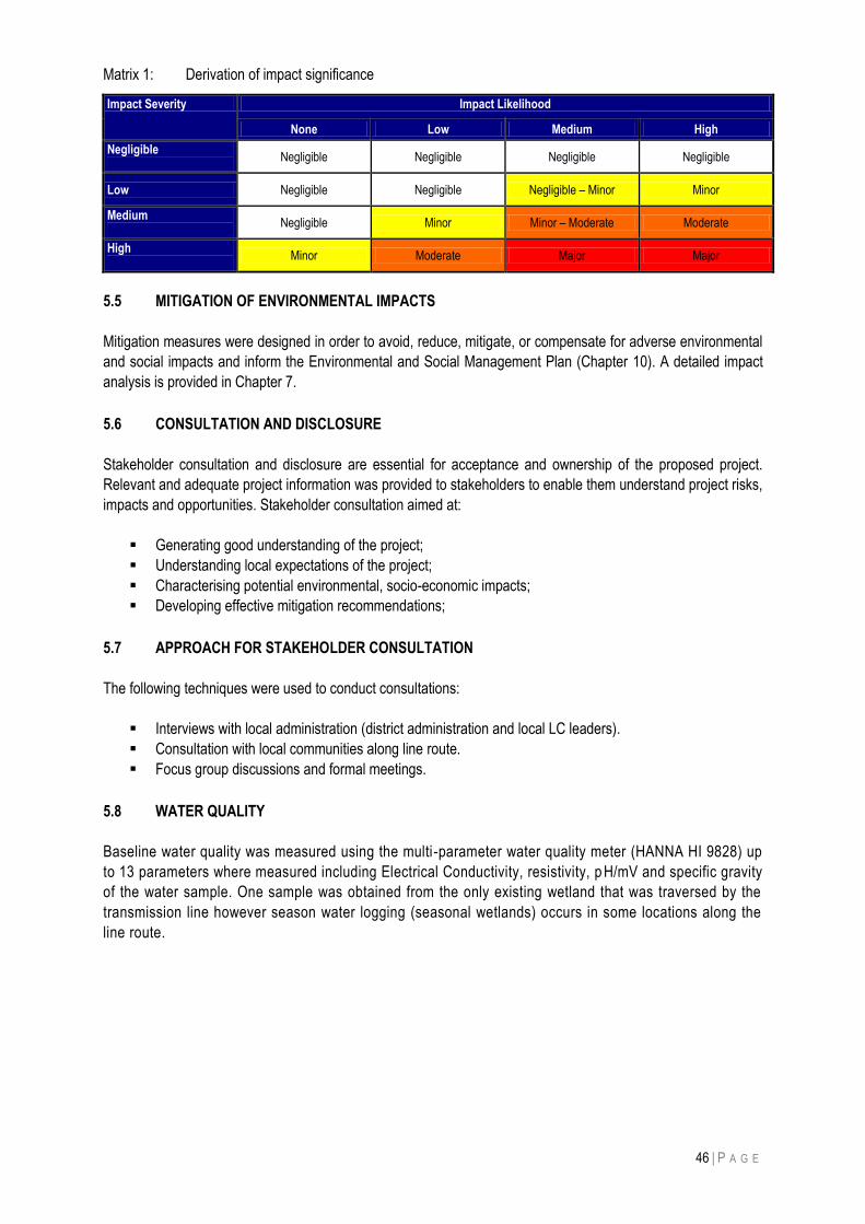
46 | P A G E
Matrix 1: Derivation of impact significance
Impact Severity Impact Likelihood
None Low Medium High
Negligible
Negligible Negligible Negligible Negligible
Low Negligible Negligible Negligible – Minor Minor
Medium
Negligible Minor Minor – Moderate Moderate
High
Minor Moderate Major Major
5.5 MITIGATION OF ENVIRONMENTAL IMPACTS
Mitigation measures were designed in order to avoid, reduce, mitigate, or compensate for adverse environmental
and social impacts and inform the Environmental and Social Management Plan (Chapter 10). A detailed impact
analysis is provided in Chapter 7.
5.6 CONSULTATION AND DISCLOSURE
Stakeholder consultation and disclosure are essential for acceptance and ownership of the proposed project.
Relevant and adequate project information was provided to stakeholders to enable them understand project risks,
impacts and opportunities. Stakeholder consultation aimed at:
Generating good understanding of the project;
Understanding local expectations of the project;
Characterising potential environmental, socio-economic impacts;
Developing effective mitigation recommendations;
5.7 APPROACH FOR STAKEHOLDER CONSULTATION
The following techniques were used to conduct consultations:
Interviews with local administration (district administration and local LC leaders).
Consultation with local communities along line route.
Focus group discussions and formal meetings.
5.8 WATER QUALITY
Baseline water quality was measured using the multi-parameter water quality meter (HANNA HI 9828) up
to 13 parameters where measured including Electrical Conductivity, resistivity, p H/mV and specific gravity
of the water sample. One sample was obtained from the only existing wetland that was traversed by the
transmission line however season water logging (seasonal wetlands) occurs in some locations along the
line route.
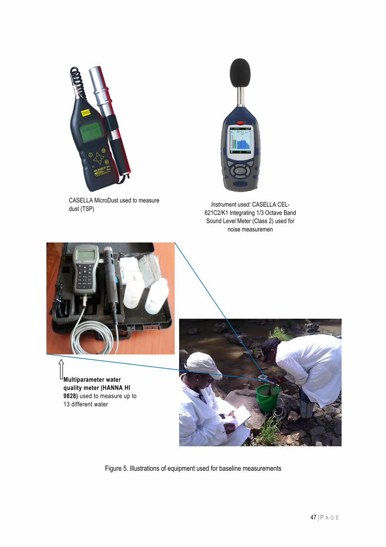
47 | P A G E
Figure 5. Illustrations of equipment used for baseline measurements
Multiparameter water
quality meter (HANNA HI
9828) used to measure up to
13 different water
parameters
CASELLA MicroDust used to measure
dust (TSP) Instrument used: CASELLA CEL-
621C2/K1 Integrating 1/3 Octave Band
Sound Level Meter (Class 2) used for
noise measuremen
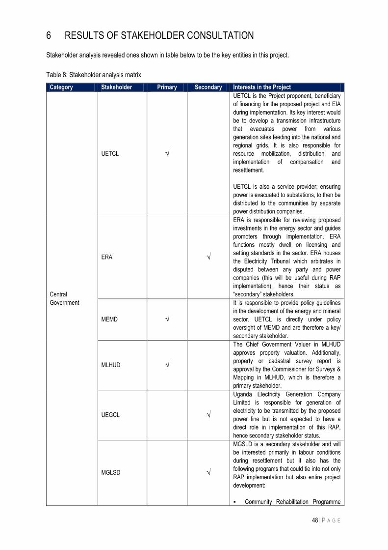
48 | P A G E
6 RESULTS OF STAKEHOLDER CONSULTATION
Stakeholder analysis revealed ones shown in table below to be the key entities in this project.
Table 8: Stakeholder analysis matrix
Category Stakeholder Primary Secondary Interests in the Project
Central
Government
UETCL √
UETCL is the Project proponent, beneficiary
of financing for the proposed project and EIA
during implementation. Its key interest would
be to develop a transmission infrastructure
that evacuates power from various
generation sites feeding into the national and
regional grids. It is also responsible for
resource mobilization, distribution and
implementation of compensation and
resettlement.
UETCL is also a service provider; ensuring
power is evacuated to substations, to then be
distributed to the communities by separate
power distribution companies.
ERA √
ERA is responsible for reviewing proposed
investments in the energy sector and guides
promoters through implementation. ERA
functions mostly dwell on licensing and
setting standards in the sector. ERA houses
the Electricity Tribunal which arbitrates in
disputed between any party and power
companies (this will be useful during RAP
implementation), hence their status as
“secondary” stakeholders.
MEMD √
It is responsible to provide policy guidelines
in the development of the energy and mineral
sector. UETCL is directly under policy
oversight of MEMD and are therefore a key/
secondary stakeholder.
MLHUD √
The Chief Government Valuer in MLHUD
approves property valuation. Additionally,
property or cadastral survey report is
approval by the Commissioner for Surveys &
Mapping in MLHUD, which is therefore a
primary stakeholder.
UEGCL √
Uganda Electricity Generation Company
Limited is responsible for generation of
electricity to be transmitted by the proposed
power line but is not expected to have a
direct role in implementation of this RAP,
hence secondary stakeholder status.
MGLSD √
MGSLD is a secondary stakeholder and will
be interested primarily in labour conditions
during resettlement but it also has the
following programs that could tie into not only
RAP implementation but also entire project
development:
Community Rehabilitation Programme
49 | P A G E
Category Stakeholder Primary Secondary Interests in the Project
for the Disabled (CBR), Functional Adult Literacy Programme
(FAL), Support to AIDS Orphans and Other
Vulnerable Children (PCY), Elimination of Child Labour.
Local Government District
authorities √
These will mobilize and manage
communities, they have jurisdiction over
areas to be traversed by proposed power
line, participate in managing and monitoring
social impacts, mitigations and resettlement
activities and grievances at the local levels.
Though all these roles are major they act as
service providers making them secondary
stakeholders.
Funding agencies (Currently
unknown) √
Implementation of this project will be through
PPP arrangement but private sector partners
may be funded by financing agencies. As a
funding agency, hence hold “secondary”
stakeholder status.
Communities
Communities and
PAPs
√
Communities will derive direct benefit from
project development (construction jobs) and
operation (more reliable power supply)
immediately in some cases and in future for
other communities within project areas.
NGOs
Community,
National and
International
groupings
√
NGOs are usually engaged as “external
monitors” of RAP implementation and
success of resettlement programs. Therefore
their interests are regarded secondary in the
project.
Consultations were conducted by with stakeholders to introduce the project, its potential benefits and impacts and
address the any concerns raised. Issues raised are summarized in Box 1 but were mostly related to social-
economic conditions than environmental conservation. A list of stakeholders consulted and their responses are
presented in Annex A.
Box 1: Findings from stakeholder consultation
a) Land acquisition for line route (wayleaves, right of way):
Common stakeholder queries were: How will easements be registered on land title deeds? If a small parcel of affected land remains, government should purchase entire affected land considering that the
remaining small piece of land would eventually be useless to an owner in the long-term.
b) Damage or pollution of water sources (springs and wells)
Communities noted that construction activities near spring wells might damage their only water sources, or in some cases inconsiderate disposal of waste by construction crews including human excrete at construction sites could contaminate wells from which communities draw water for domestic use.
c) Timely, equitable compensation
Stakeholders considered this essential for smooth relocation. A common reference was to the effect that government projects do not pay adequate compensation to affected people.
d) Loss of private property (land, crops and dwellings) and compensation:
50 | P A G E
Property owners along the line route expressed a need for equitable and prompt compensation before line construction is commenced. To this effect they desired to see the following: An accurate census of the affected people along the line route, A transparent and fair valuation exercise to derive value of property to compensate, Prompt payment of all compensation claims.
e) Employment: Local people desired to be given employment opportunities during project construction. f) Accidents: Communities were concerned about possible road accidents that could injure livestock or people
during transportation of line construction materials and equipment through settlements and trading centres. h) Illicit sexual relationships with local people: Most people associated powerline contractors with social
misdemeanour such as illicit sexual behaviour with local women and girls. This was a prevalent view in urban
centres (and poses a risk of HIV/AIDS).
51 | P A G E
7 POTENTIAL IMPACTS AND MITIGATION MEASURES
Analysis in sections below is limited to environmental impacts of construction and operation of the 132 kV
transmission line and associated substations since social impacts (such as employment, income to suppliers of
line construction materials and equipment, etc) were assessed and documented in a separate Social Impact
Assessment (SIA) report.
Power transmission lines characteristically generate impacts such as acquisition and maintenance of the right of
way, clearing of vegetation from sites and line corridor, construction of access roads, tower pads and substations
are the most obvious sources of construction-related impacts. The line construction phase is the period when
most environment changes will occur. Impacts of the project are discussed in sections below.
7.1 FAUNA AND FLORA IMPACTS
a) Impact identification
i) Fauna
The transmission line may pose physical hazard to birds and climbing animals especially primates. Electrocution
is mainly a problem on smaller transmission lines (lower than 132 kV). Collisions with electricity conductors can
also kill birds. However, no areas along the line route were noted to have high densities of large birds, primates or
colonies of migratory avifauna species, therefore fauna-related impacts will be marginal.
ii) Flora
To enable vehicle and crew access during tower construction and stringing, vegetation in the wayleave and right
of way will be cleared.
During line operation and maintenance, clearing the wayleave to avoid tall trees touching power line conductors
will result in permanent loss of vegetation in areas that would otherwise have had tall trees and shrubs. Loss of
tree cover will notably be in areas such as Nampanyi village, where the proposed power line route passes
through a patch of encroached natural forest. However, no significant impacts or loss of habits will result from
construction and operation of the proposed power line.
These negative impacts will occur both during line construction and operation where clearing of tall trees near the
wayleaves is a routine maintenance practice. The impacts are long-term but of local spatial extent.
Project phase when impact will occur Construction Operation
√ √
b) Impact significance
The likelihood of impact on flora is high since the wayleaves must be kept free of tall trees that could fall onto
the powerline. Impact severity is considered medium and significance is moderate since there are not many
forested stretches along the line route. Moreover where they exist along the proposed line route, natural forests
are rapidly being cleared for farming and settlement.
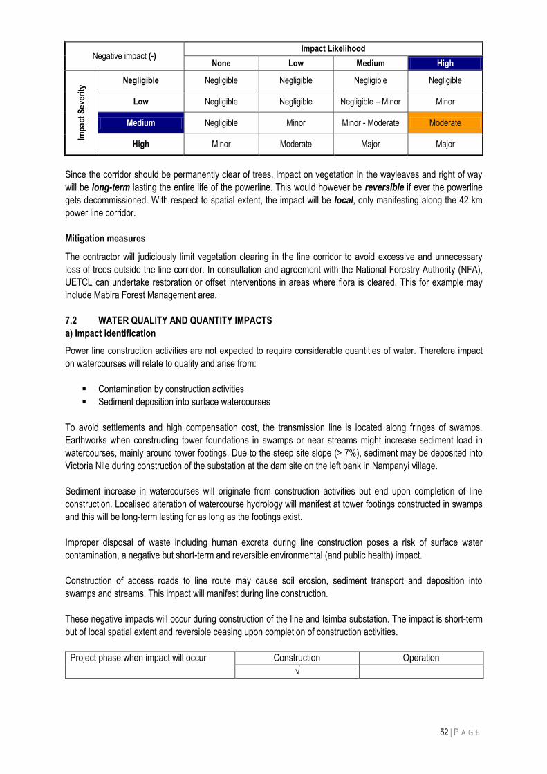
52 | P A G E
Negative impact (-) Impact Likelihood
None Low Medium High
Imp
act
Sev
erit
y Negligible Negligible Negligible Negligible Negligible
Low Negligible Negligible Negligible – Minor Minor
Medium Negligible Minor Minor - Moderate Moderate
High Minor Moderate Major Major
Since the corridor should be permanently clear of trees, impact on vegetation in the wayleaves and right of way
will be long-term lasting the entire life of the powerline. This would however be reversible if ever the powerline
gets decommissioned. With respect to spatial extent, the impact will be local, only manifesting along the 42 km
power line corridor.
Mitigation measures
The contractor will judiciously limit vegetation clearing in the line corridor to avoid excessive and unnecessary
loss of trees outside the line corridor. In consultation and agreement with the National Forestry Authority (NFA),
UETCL can undertake restoration or offset interventions in areas where flora is cleared. This for example may
include Mabira Forest Management area.
7.2 WATER QUALITY AND QUANTITY IMPACTS
a) Impact identification
Power line construction activities are not expected to require considerable quantities of water. Therefore impact
on watercourses will relate to quality and arise from:
Contamination by construction activities
Sediment deposition into surface watercourses
To avoid settlements and high compensation cost, the transmission line is located along fringes of swamps.
Earthworks when constructing tower foundations in swamps or near streams might increase sediment load in
watercourses, mainly around tower footings. Due to the steep site slope (> 7%), sediment may be deposited into
Victoria Nile during construction of the substation at the dam site on the left bank in Nampanyi village.
Sediment increase in watercourses will originate from construction activities but end upon completion of line
construction. Localised alteration of watercourse hydrology will manifest at tower footings constructed in swamps
and this will be long-term lasting for as long as the footings exist.
Improper disposal of waste including human excreta during line construction poses a risk of surface water
contamination, a negative but short-term and reversible environmental (and public health) impact.
Construction of access roads to line route may cause soil erosion, sediment transport and deposition into
swamps and streams. This impact will manifest during line construction.
These negative impacts will occur during construction of the line and Isimba substation. The impact is short-term
but of local spatial extent and reversible ceasing upon completion of construction activities.
Project phase when impact will occur Construction Operation
√
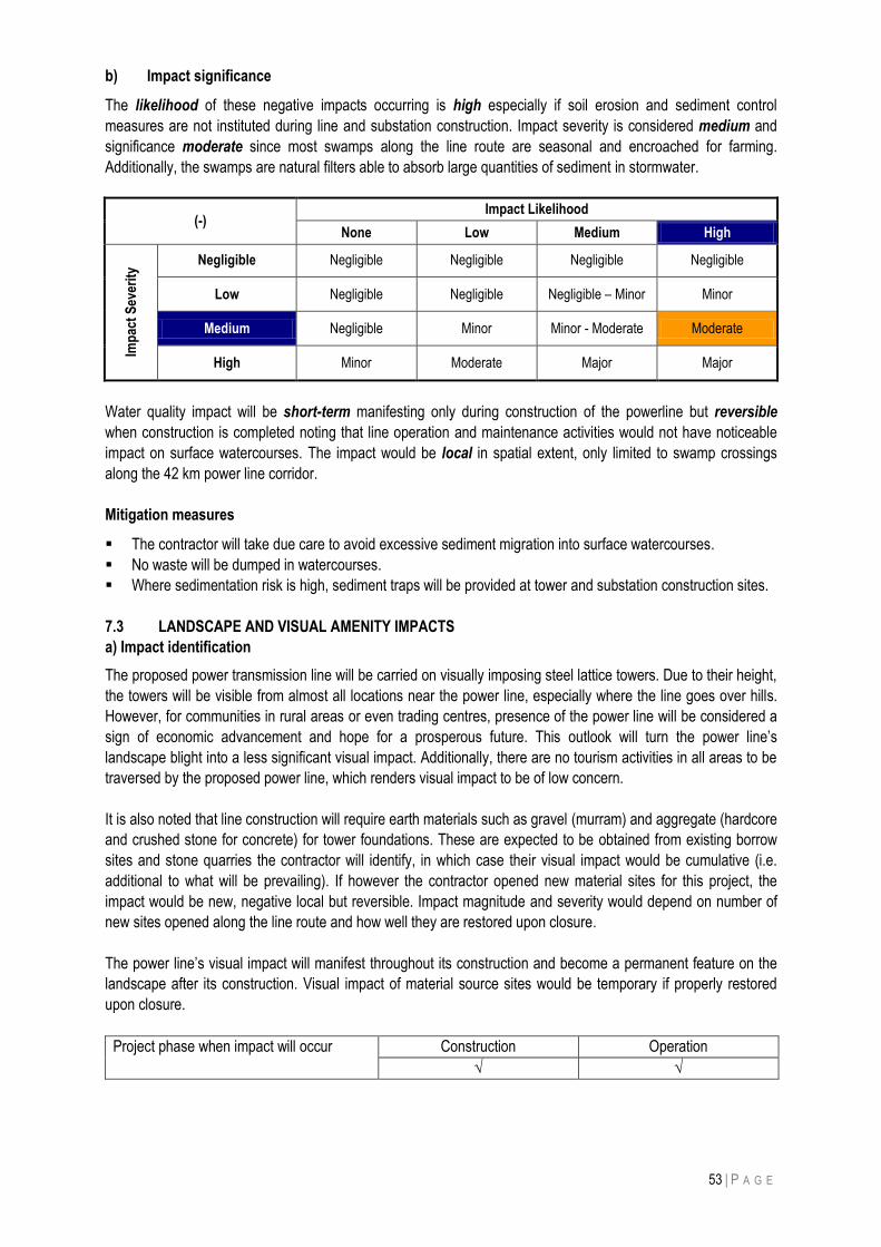
53 | P A G E
b) Impact significance
The likelihood of these negative impacts occurring is high especially if soil erosion and sediment control
measures are not instituted during line and substation construction. Impact severity is considered medium and
significance moderate since most swamps along the line route are seasonal and encroached for farming.
Additionally, the swamps are natural filters able to absorb large quantities of sediment in stormwater.
(-) Impact Likelihood
None Low Medium High
Imp
act
Sev
erit
y
Negligible Negligible Negligible Negligible Negligible
Low Negligible Negligible Negligible – Minor Minor
Medium Negligible Minor Minor - Moderate Moderate
High Minor Moderate Major Major
Water quality impact will be short-term manifesting only during construction of the powerline but reversible
when construction is completed noting that line operation and maintenance activities would not have noticeable
impact on surface watercourses. The impact would be local in spatial extent, only limited to swamp crossings
along the 42 km power line corridor.
Mitigation measures
The contractor will take due care to avoid excessive sediment migration into surface watercourses.
No waste will be dumped in watercourses.
Where sedimentation risk is high, sediment traps will be provided at tower and substation construction sites.
7.3 LANDSCAPE AND VISUAL AMENITY IMPACTS
a) Impact identification
The proposed power transmission line will be carried on visually imposing steel lattice towers. Due to their height,
the towers will be visible from almost all locations near the power line, especially where the line goes over hills.
However, for communities in rural areas or even trading centres, presence of the power line will be considered a
sign of economic advancement and hope for a prosperous future. This outlook will turn the power line‟s
landscape blight into a less significant visual impact. Additionally, there are no tourism activities in all areas to be
traversed by the proposed power line, which renders visual impact to be of low concern.
It is also noted that line construction will require earth materials such as gravel (murram) and aggregate (hardcore
and crushed stone for concrete) for tower foundations. These are expected to be obtained from existing borrow
sites and stone quarries the contractor will identify, in which case their visual impact would be cumulative (i.e.
additional to what will be prevailing). If however the contractor opened new material sites for this project, the
impact would be new, negative local but reversible. Impact magnitude and severity would depend on number of
new sites opened along the line route and how well they are restored upon closure.
The power line‟s visual impact will manifest throughout its construction and become a permanent feature on the
landscape after its construction. Visual impact of material source sites would be temporary if properly restored
upon closure.
Project phase when impact will occur Construction Operation
√ √
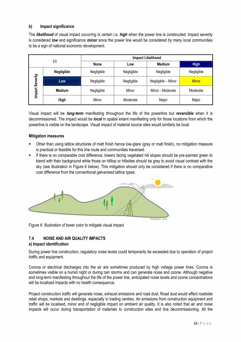
54 | P A G E
b) Impact significance
The likelihood of visual impact occurring is certain i.e. high when the power line is constructed. Impact severity
is considered low and significance minor since the power line would be considered by many local communities
to be a sign of national economic development.
(-) Impact Likelihood
None Low Medium High
Imp
act
Sev
erit
y
Negligible Negligible Negligible Negligible Negligible
Low Negligible Negligible Negligible – Minor Minor
Medium Negligible Minor Minor - Moderate Moderate
High Minor Moderate Major Major
Visual impact will be long-term manifesting throughout the life of the powerline but reversible when it is
decommissioned. The impact would be local in spatial extent manifesting only for those locations from which the
powerline is visible on the landscape. Visual impact of material source sites would similarly be local.
Mitigation measures
Other than using lattice structures of matt finish hence low-glare (gray or matt finish), no mitigation measure
is practical or feasible for this line route and communities traversed.
If there is no comparable cost difference, towers facing vegetated hill slopes should be pre-painted green to
blend with their background while those on hilltop or hillsides should be grey to avoid visual contrast with the
sky (see illustration in Figure 6 below). This mitigation should only be considered if there is no comparative
cost difference from the conventional galvanised lattice types.
Figure 6: Illustration of tower color to mitigate visual impact
7.4 NOISE AND AIR QUALITY IMPACTS
a) Impact identification
During power line construction, regulatory noise levels could temporarily be exceeded due to operation of project traffic and equipment. Corona or electrical discharges into the air are sometimes produced by high voltage power lines. Corona is sometimes visible on a humid night or during rain storms and can generate noise and ozone. Although negative and long-term manifesting throughout the life of the power line, anticipated noise levels and ozone concentrations will be localized impacts with no health consequence. Project construction traffic will generate noise, exhaust emissions and road dust. Road dust would affect roadside retail shops, markets and dwellings, especially in trading centres. Air emissions from construction equipment and traffic will be localised, minor and of negligible impact on ambient air quality. It is also noted that air and noise impacts will occur during transportation of materials to construction sites and line decommissioning. All the
Illustration: AWE
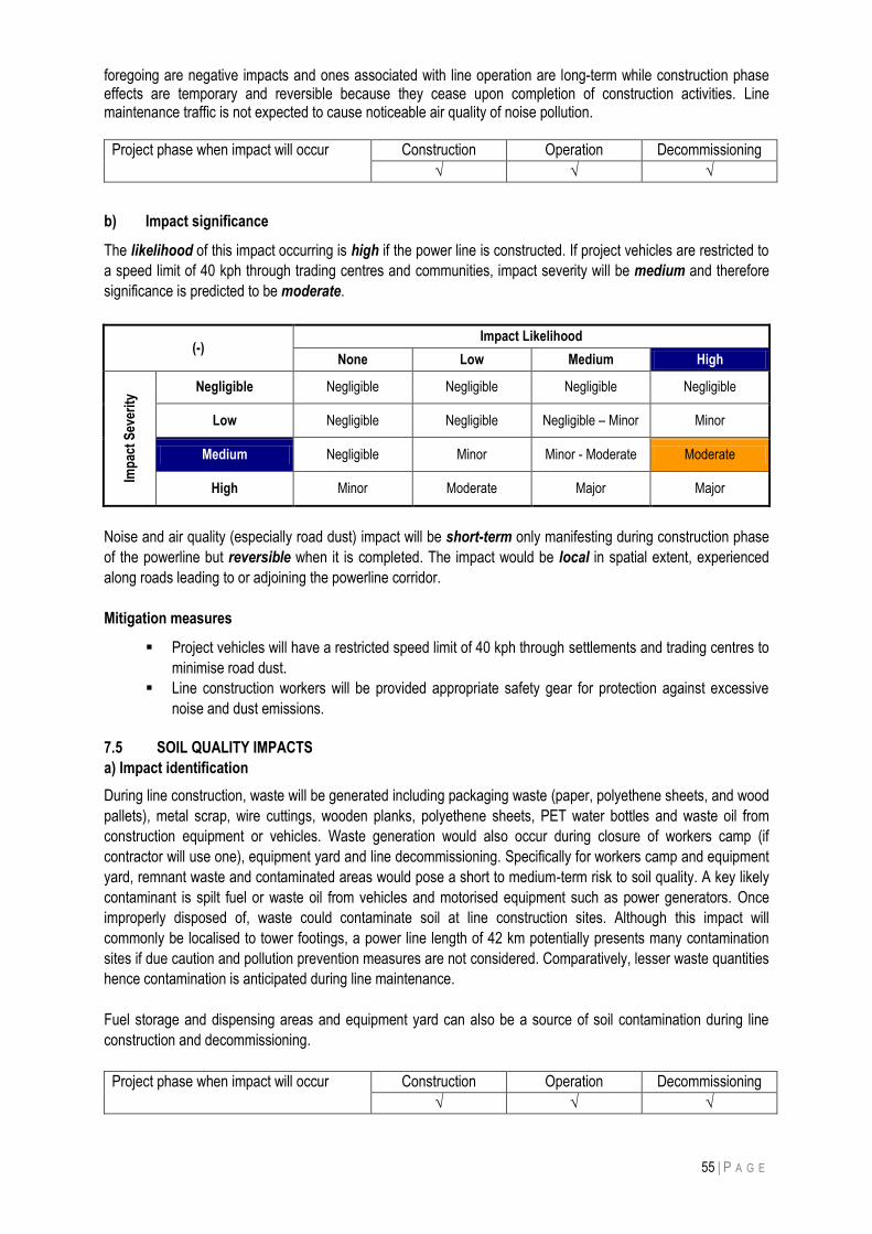
55 | P A G E
foregoing are negative impacts and ones associated with line operation are long-term while construction phase effects are temporary and reversible because they cease upon completion of construction activities. Line maintenance traffic is not expected to cause noticeable air quality of noise pollution.
Project phase when impact will occur Construction Operation Decommissioning
√ √ √
b) Impact significance
The likelihood of this impact occurring is high if the power line is constructed. If project vehicles are restricted to
a speed limit of 40 kph through trading centres and communities, impact severity will be medium and therefore
significance is predicted to be moderate.
(-) Impact Likelihood
None Low Medium High
Imp
act
Sev
erit
y
Negligible Negligible Negligible Negligible Negligible
Low Negligible Negligible Negligible – Minor Minor
Medium Negligible Minor Minor - Moderate Moderate
High Minor Moderate Major Major
Noise and air quality (especially road dust) impact will be short-term only manifesting during construction phase
of the powerline but reversible when it is completed. The impact would be local in spatial extent, experienced
along roads leading to or adjoining the powerline corridor.
Mitigation measures
Project vehicles will have a restricted speed limit of 40 kph through settlements and trading centres to
minimise road dust.
Line construction workers will be provided appropriate safety gear for protection against excessive
noise and dust emissions.
7.5 SOIL QUALITY IMPACTS
a) Impact identification
During line construction, waste will be generated including packaging waste (paper, polyethene sheets, and wood
pallets), metal scrap, wire cuttings, wooden planks, polyethene sheets, PET water bottles and waste oil from
construction equipment or vehicles. Waste generation would also occur during closure of workers camp (if
contractor will use one), equipment yard and line decommissioning. Specifically for workers camp and equipment
yard, remnant waste and contaminated areas would pose a short to medium-term risk to soil quality. A key likely
contaminant is spilt fuel or waste oil from vehicles and motorised equipment such as power generators. Once
improperly disposed of, waste could contaminate soil at line construction sites. Although this impact will
commonly be localised to tower footings, a power line length of 42 km potentially presents many contamination
sites if due caution and pollution prevention measures are not considered. Comparatively, lesser waste quantities
hence contamination is anticipated during line maintenance.
Fuel storage and dispensing areas and equipment yard can also be a source of soil contamination during line
construction and decommissioning.
Project phase when impact will occur Construction Operation Decommissioning
√ √ √
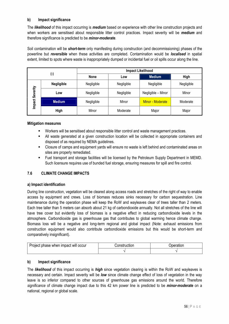
56 | P A G E
b) Impact significance
The likelihood of this impact occurring is medium based on experience with other line construction projects and
when workers are sensitised about responsible litter control practices. Impact severity will be medium and
therefore significance is predicted to be minor-moderate.
Soil contamination will be short-term only manifesting during construction (and decommissioning) phases of the
powerline but reversible when these activities are completed. Contamination would be localised in spatial
extent, limited to spots where waste is inappropriately dumped or incidental fuel or oil spills occur along the line.
(-) Impact Likelihood
None Low Medium High
Imp
act
Sev
erit
y
Negligible Negligible Negligible Negligible Negligible
Low Negligible Negligible Negligible – Minor Minor
Medium Negligible Minor Minor - Moderate Moderate
High Minor Moderate Major Major
Mitigation measures
Workers will be sensitised about responsible litter control and waste management practices.
All waste generated at a given construction location will be collected in appropriate containers and
disposed of as required by NEMA guidelines.
Closure of camps and equipment yards will ensure no waste is left behind and contaminated areas on
sites are properly remediated.
Fuel transport and storage facilities will be licensed by the Petroleum Supply Department in MEMD.
Such licensure requires use of bunded fuel storage, ensuring measures for spill and fire control.
7.6 CLIMATE CHANGE IMPACTS
a) Impact identification
During line construction, vegetation will be cleared along access roads and stretches of the right of way to enable
access by equipment and crews. Loss of biomass reduces sinks necessary for carbon sequestration. Line
maintenance during the operation phase will keep the RoW and wayleaves clear of trees taller than 2 meters.
Each tree taller than 5 meters can absorb about 21 kg of carbondioxide annually. Not all stretches of the line will
have tree cover but evidently loss of biomass is a negative effect in reducing carbondioxide levels in the
atmosphere. Carbondioxide gas is greenhouse gas that contributes to global warming hence climate change.
Biomass loss will be a negative and long-term regional and global impact (Note: exhaust emissions from
construction equipment would also contribute carbondioxide emissions but this would be short-term and
comparatively insignificant).
Project phase when impact will occur Construction Operation
√ √
b) Impact significance
The likelihood of this impact occurring is high since vegetation clearing is within the RoW and wayleaves is
necessary and certain. Impact severity will be low since climate change effect of loss of vegetation in the way
leave is so inferior compared to other sources of greenhouse gas emissions around the world. Therefore
significance of climate change impact due to this 42 km power line is predicted to be minor-moderate on a
national, regional or global scale.
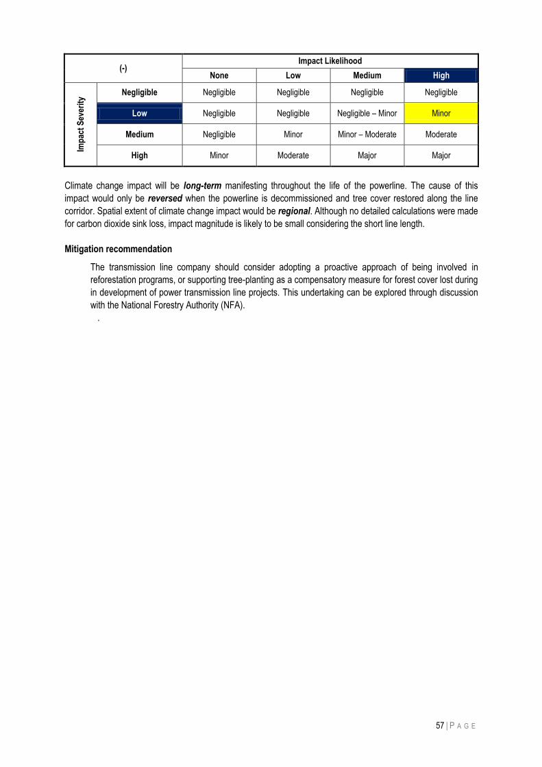
57 | P A G E
(-) Impact Likelihood
None Low Medium High Im
pac
t S
ever
ity
Negligible Negligible Negligible Negligible Negligible
Low Negligible Negligible Negligible – Minor Minor
Medium Negligible Minor Minor – Moderate Moderate
High Minor Moderate Major Major
Climate change impact will be long-term manifesting throughout the life of the powerline. The cause of this
impact would only be reversed when the powerline is decommissioned and tree cover restored along the line
corridor. Spatial extent of climate change impact would be regional. Although no detailed calculations were made
for carbon dioxide sink loss, impact magnitude is likely to be small considering the short line length.
Mitigation recommendation
The transmission line company should consider adopting a proactive approach of being involved in
reforestation programs, or supporting tree-planting as a compensatory measure for forest cover lost during
in development of power transmission line projects. This undertaking can be explored through discussion
with the National Forestry Authority (NFA).
.
58 | P A G E
8 LINE DECOMMISSIONING IMPACTS
The lifespan of the proposed transmission line is expected to be long (over 40-50 years) but at the end of its life,
decommissioning will occur. Even with regular maintenance and replacement, some line project facilities will have
a lifetime after which they may no longer be cost-effective to operate or maintain. During decommissioning, all
transmission line structures and equipment would be dismantled and removed. Physical removal of the line and
lattice towers will literary be a reversal of the construction process. Once corridor maintenance ceases,
vegetation in the wayleaves regenerates to conditions in adjoining areas.
Considering time to decommissioning, activities hereunder discussed could change due advance in technology or
change in environmental legislation. Only at the time of decommissioning can comprehensive strategies be
ascertained. At least two years prior to cessation of operations, a power line decommissioning plan shall be
developed together with NEMA. This plan would identify specific actions and a schedule for decommissioning of
the project, and identify procedures to restore the project area to acceptable conditions. The decommissioning
plan would also provide measures to minimize impacts to surface water, groundwater, air quality and
communities. There will be a programme of rehabilitation of land around the pylons including removal of
foundations and access route in the maintenance road so as to restore compatibility with the surrounding
environment and land use. It is not known whether land rights would be returned to landowners as part of the
decommissioning process but this is a matter to be agreed between UETCL and landowners at the time of
decommissioning. Nevertheless, it is expected that any reuse of the transmission servitude would need a
separate environmental authorisation, and is thus outside the scope of this EIA.
Disposal of materials from the decommissioned transmission line is not expected to pose high environmental risk
since most of the material would be recyclable (steel structures, concrete debris and conductors/ wires) or inert
(insulators, concrete debris, etc.). There are no hazardous wastes expected to be associated with the
transmission decommissioning.
Decommissioning will require contractors to undertake activities below, mitigate negative environmental impacts
and manage health and safety risks.
Tower removal
Electrical system/ substation removal
Restoration of right of way
These are explained below.
8.1 TRANSMISSION LINE REMOVAL
During decommissioning, transmission line structures and equipment would be dismantled and removed, and the
wayleave allowed to rejuvenate to conditions similar to those adjoining the line corridor acceptable. Transmission
line decommissioning will entail removal of conductors from lattice towers and demolishing the concrete tower
footings. Recycling or reuse of materials, such as scrap metal, will depend on prevailing technology, demand and
market. The maintenance/ inspection road in the power line‟s RoW will be scarified and vegetation allowed to
grow back as will be guided by NEMA and local authorities planning regulations.
8.2 FOUNDATION REMOVAL
When lattice towers are removed, their foundations will also be removed to enable landuse restoration. Hence
reinforced concrete footings will be broken-up and removed to appropriate depth. It is expected that technology
and opportunities will be in existence to recycle salvaged steel and concrete debris.
59 | P A G E
8.3 PUBLIC AND OCCUPATIONAL SAFETY
The power line will be completely de-energised before commencing disassembly. This will protect workers from
electrocution. Decommissioning contractor(s) will have a responsibility to ensure public safety by keeping people
away from risk areas. The public will also be protected from dust and noise exposure.
i) Dust impacts: Temporary and localized dust plumes will be unavoidable during decommissioning especially
from project vehicular traffic.
Mitigation:
The contractor will water road section through trading centres and settlements to control dust,
Vehicle speed will limited to 40 kph through trading centres and settlements.
ii) Noise impacts: Decommissioning activities, especially vehicle movement, will generate noise. 30-40 years
from now when the national population has tripled, rural areas along the line route will be heavily inhabited and
noise would affect residences and business receptors.
Mitigation:
Decommissioning activities will take place during day time. Through communications with the local
communities, the contractor will be informed of any noise complaints and noise measurement undertaken
along the project boundary and at the complaining receptor to ascertain the complaint. If the levels are
found to be unsatisfactory, control measures will be implemented.
8.4 FIRE AND OIL SPILL PREVENTION
Fire will be prevented during decommissioning by ensuring that there is adequate availability of fire extinguishers
onsite. Personnel undertaking equipment removal will be trained in fire-fighting practices. All equipment and
machines with potential of spilling or leaking oil and fuel will be checked and necessary safeguard procedures
developed before their dismantling. If oil spills or leaks occur, control and site clean will be undertaken
immediately.
8.5 WORKERS CAMP AND EQUIPMENT YARD
Decommissioning may necessitate use of camps workers and equipment yard. These must be closed when
decommissioning activities are completed and any waste removed and contaminated spots remediated or else
they would pose a short to medium-term risk to soil quality. At camps and equipment yards, contamination
hotspots are usually vehicle parking areas, fuel storage and refuelling area, generator location and waste
disposal site. Besides waste, a key likely contaminant is spilt fuel or waste oil from vehicles and motorised
equipment such as power generators.
Mitigation:
All waste will be removed from camp and equipment yards.
Site remediation will be undertaken during site closure. Assessment on sites will be done to identify
contamination hotspots and soil thereof treated, as guided by NEMA, to remove contaminants.
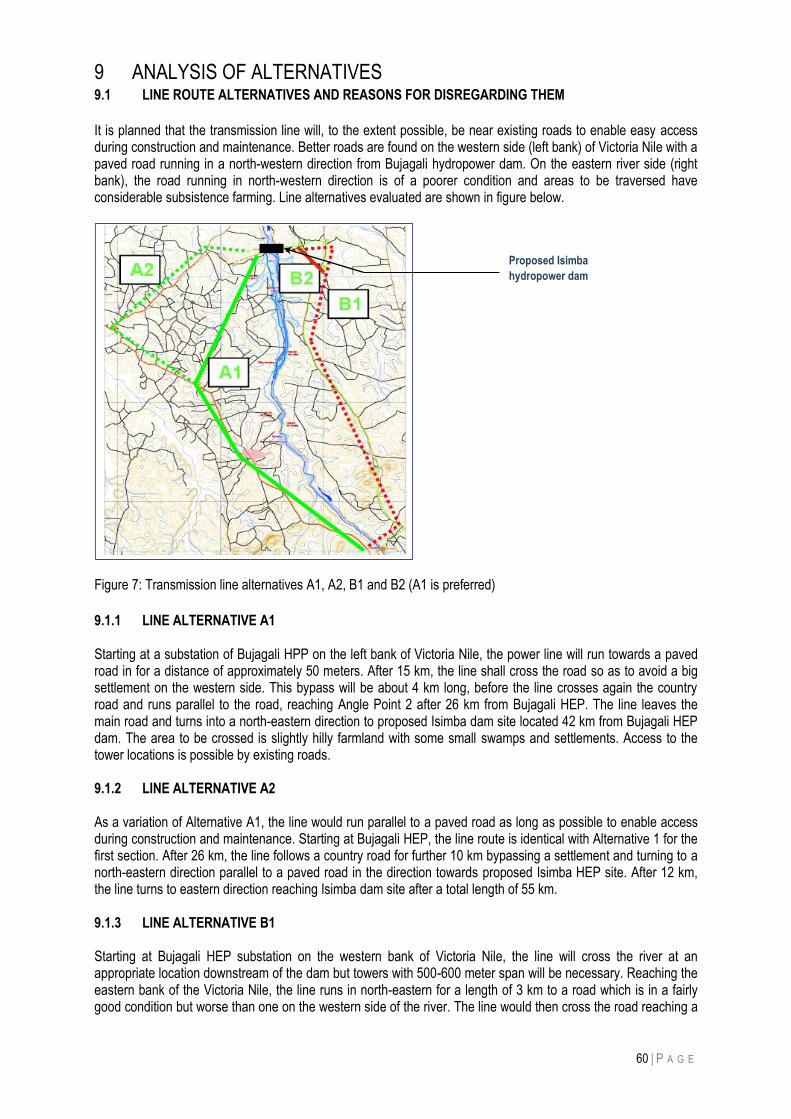
60 | P A G E
9 ANALYSIS OF ALTERNATIVES 9.1 LINE ROUTE ALTERNATIVES AND REASONS FOR DISREGARDING THEM
It is planned that the transmission line will, to the extent possible, be near existing roads to enable easy access during construction and maintenance. Better roads are found on the western side (left bank) of Victoria Nile with a paved road running in a north-western direction from Bujagali hydropower dam. On the eastern river side (right bank), the road running in north-western direction is of a poorer condition and areas to be traversed have considerable subsistence farming. Line alternatives evaluated are shown in figure below.
Figure 7: Transmission line alternatives A1, A2, B1 and B2 (A1 is preferred)
9.1.1 LINE ALTERNATIVE A1 Starting at a substation of Bujagali HPP on the left bank of Victoria Nile, the power line will run towards a paved road in for a distance of approximately 50 meters. After 15 km, the line shall cross the road so as to avoid a big settlement on the western side. This bypass will be about 4 km long, before the line crosses again the country road and runs parallel to the road, reaching Angle Point 2 after 26 km from Bujagali HEP. The line leaves the main road and turns into a north-eastern direction to proposed Isimba dam site located 42 km from Bujagali HEP dam. The area to be crossed is slightly hilly farmland with some small swamps and settlements. Access to the tower locations is possible by existing roads. 9.1.2 LINE ALTERNATIVE A2 As a variation of Alternative A1, the line would run parallel to a paved road as long as possible to enable access during construction and maintenance. Starting at Bujagali HEP, the line route is identical with Alternative 1 for the first section. After 26 km, the line follows a country road for further 10 km bypassing a settlement and turning to a north-eastern direction parallel to a paved road in the direction towards proposed Isimba HEP site. After 12 km, the line turns to eastern direction reaching Isimba dam site after a total length of 55 km. 9.1.3 LINE ALTERNATIVE B1 Starting at Bujagali HEP substation on the western bank of Victoria Nile, the line will cross the river at an appropriate location downstream of the dam but towers with 500-600 meter span will be necessary. Reaching the eastern bank of the Victoria Nile, the line runs in north-eastern for a length of 3 km to a road which is in a fairly good condition but worse than one on the western side of the river. The line would then cross the road reaching a
Proposed Isimba
hydropower dam
61 | P A G E
settlement after 22 km from Bujagali HEP dam. The new substation at Isimba shall be located on the eastern side of the river (right bank) to avoid a second river crossing. For this option, the line length would be 40 kilometers. 9.1.4 LINE ALTERNATIVE B2 This alternative is a minor modification of Alternative B1, removing a sharp elbow near to Isimba dam thereby reducing overall line length (in Alternative B1) by 2 km. The line length in this option is therefore 38 km. In selecting the preferred route, the following aspects were considered:
a) access facilities b) soil conditions c) crossing highly populated areas d) crossings over main roads and rivers e) overall line length
Tables below give an overview of routes evaluation, and how the final choice was reached.
Table 9: Key attributes of alternative transmission line routes
Aspect Routes alternatives
A1 A2 B1 B2
Access Good Good Acceptable Acceptable
Soil conditions Normal Normal Normal Normal Settlements Traverses 2
populated settlements twice; normal along roads and rivers
Traverses 4 populated settlements; normal along roads and rivers
Crosses intense subsistence farming areas
Crosses intense subsistence farming areas
Farmland Normal Normal Crosses intense subsistence farming areas
Crosses intense subsistence farming areas
Road and river crossings Crosses road twice Crosses road twice -Crosses road twice -Crosses River Nile
-Crosses road twice -Crosses River Nile
Line length (km) 42 55 40 38
Using scores for each alternative as shown in Table 10, the line routes can be evaluated as provided in Table 11.
Table 10: Scores assigned to each impact level
Score -3 -2 -1 0 +1 +2 +3
Impact Level Large negative
Moderate negative
Low negative
Insignificant Medium positive
medium positive
Large positive
Utilizing above scoring a quantitative evaluation of the four transmission line routes is presented in Table below.
Table 11: Evaluation of alternative line routes
Aspect Routes alternatives
A1 A2 B1 B2
Access 1 2 2 2
Soil conditions 2 2 2 2
Settlements -1 -2 -3 -3
Farmland 0 0 -1 -1
Road and river crossings 0 0 -2 -2
Line length (km) 1 -1 1 1
Ranking 3 1 -1 -1
62 | P A G E
Table 11 above shows line route A1 being of highest ranking hence preference and reasons are:
Alternatives B1 and B2 have the disadvantage of crossing the River Nile (Victoria Nile) for spans of about 600 meters which necessitate special towers (with a total height of up to 75 m), special foundations and insulator strings. It is estimated that the increased expenses for such a crossing will not compensate the savings due to the shorter line length on these two alternatives.
Alternatives B1 and B2 traverse areas with considerable settlements and farmland implying higher resettlement cost and thus higher line cost per kilometer.
Although there are similar access conditions for all four line route alternatives, A2 scores low due to having the longest line length. Additionally it traverses four high populated areas implying an increase of angle points, hence high line cost.
Alternative A1 scores highest and is the preferred route because access conditions are better than for all other options, bigger settlements can be easily avoided, road crossings are not a major problem and other conditions (settlements, farmland, smaller rivers) are not so significant demerits on this route. Besides, its length of 42 km is competitive in relation to other alternatives that do not have above-mentioned merits. 9.2 NO PROJECT SCENARIO
It is known that power to be generated by Isimba hydropower dam would considerably increase the nation‟s installed capacity of a renewable and cheaper to generate energy supply. Without this project, up to 180 MW of electrical supply would be forfeited on the national grid. This would certainly mean longer than planned reliance on expensive emergency thermal power plants and increased load shedding with significant adverse effect on national economic development. This powerline is essential to evacuate power generated form the dam to the national grid.
63 | P A G E
10 ENVIRONMENTAL MANAGEMENT & MONITORING PLAN
This Chapter presents Construction and Operational Environmental Management Plans developed for the 132 kV Isimba transmission line Project. These constitute the primary instrument for management of the Project‟s environmental performance. An Environmental Management Plan (EMP) is a stand-alone document which outlines mitigation measures,
accountability, monitoring and institutional arrangements for environmental management of the Project. The EMP
also provides information on environmental decisions which need to be made during the design, construction and
operation phases of the Project. It provides key performance indicators for evaluating efficiency of mitigation and
management measures and suggests actions that need to be taken to achieve the desired Project outcomes.
Monitoring is necessary to avoid negative effects during construction and operation of the proposed project and achieve sustained environmental compliance. Details of the recommended environmental monitoring plan (EMP) are presented Chapter 10. Since social impacts were assessed and documented in a separate study (Social Impact Assessment) focus of the EMP is limited to only environmental impacts. In the EMP, the proposed timeframe for monitoring every environmental issue or impact is given in the same cell as the individual to collect monitoring information. The estimated cost (for both the monitoring process and corrective measures) is given in the same cell as the proposed method/tool(s) to be used. However, since some of the mitigation measures are to be executed during the construction phase, the contractor will have to incorporate exact cost estimates into the construction financial proposal. In addition, as part of contractual obligations or procurement requirements, the contractor should prepare management plans for: a) Traffic management around during line construction
b) Waste management during construction
c) Measures for pollution prevention at workers camps and constriction locations
d) Hazardous materials management at workers camps and constriction locations
All Project personnel have a responsibility for their own environmental performance and compliance with the direction of the EMP and national environmental legislation.
There will be also a need to provide environmental awareness and training to all project personnel, the objective
of the environmental awareness and training is to provide personnel working on the Project with:
An understanding of what their responsibilities are as outlined in the EMP;
A means of developing a culture of compliance with the Project environmental requirements; and
A means to improve the environmental awareness of the workforce through the education of Project field
personnel.
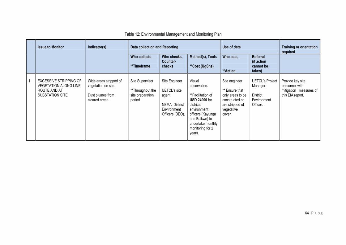
64 | P A G E
Table 12: Environmental Management and Monitoring Plan
Issue to Monitor
Indicator(s)
Data collection and Reporting
Use of data
Training or orientation required
Who collects **Timeframe
Who checks, Counter-checks
Method(s), Tools **Cost (UgShs)
Who acts, **Action
Referral (if action cannot be taken)
1
EXCESSIVE STRIPPING OF VEGETATION ALONG LINE ROUTE AND AT SUBSTATION SITE
Wide areas stripped of vegetation on site. Dust plumes from cleared areas.
Site Supervisor **Throughout the site preparation period.
Site Engineer UETCL‟s site agent NEMA, District Environment Officers (DEO).
Visual observation. **Facilitation of USD 24000 for districts environment officers (Kayunga and Buikwe) to undertake monthly monitoring for 2 years.
Site engineer ** Ensure that only areas to be constructed on are stripped of vegetative cover.
UETCL‟s Project Manager. District Environment Officer.
Provide key site personnel with mitigation measures of this EIA report.
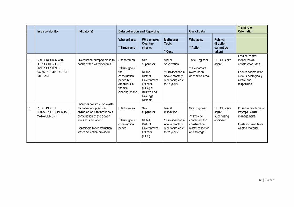
65 | P A G E
Issue to Monitor
Indicator(s)
Data collection and Reporting
Use of data
Training or Orientation
Who collects **Timeframe
Who checks, Counter- checks
Method(s), Tools **Cost
Who acts, **Action
Referral (if action cannot be taken)
2
SOIL EROSION AND DEPOSITION OF OVERBURDEN IN SWAMPS, RIVERS AND STREAMS
Overburden dumped close to banks of the watercourses.
Site foremen **Throughout the construction period but emphasis in the site clearing phase.
Site supervisor NEMA, District Environment Officers (DEO) of Buikwe and Kayunga Districts.
Visual observation **Provided for in above monthly monitoring cost for 2 years.
Site Engineer.
** Demarcate overburden deposition area.
UETCL‟s site agent.
Erosion control measures on construction sites. Ensure construction crew is ecologically aware and responsible.
3
RESPONSIBLE CONSTRUCTION WASTE MANAGEMENT
Improper construction waste management practices observed on site throughout construction of the power line and substation. Containers for construction waste collection provided.
Site foremen **Throughout construction period.
Site supervisor NEMA, District Environment Officers (DEO).
Visual Inspection **Provided for in above monthly monitoring cost for 2 years.
Site Engineer ** Provide containers for construction waste collection and storage.
UETCL‟s site agent/ supervising engineer.
Possible problems of improper waste management. Costs incurred from wasted material.
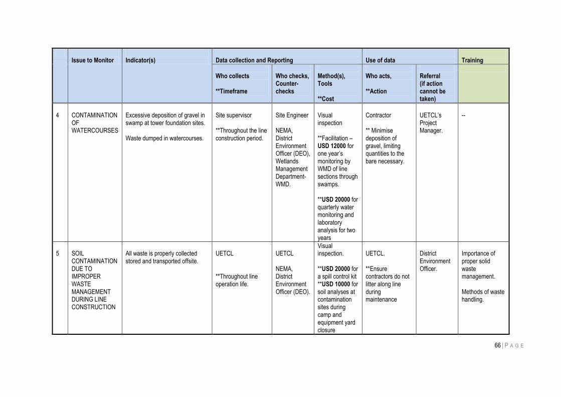
66 | P A G E
Issue to Monitor
Indicator(s)
Data collection and Reporting
Use of data
Training
Who collects **Timeframe
Who checks, Counter- checks
Method(s), Tools **Cost
Who acts, **Action
Referral (if action cannot be taken)
4
CONTAMINATION OF WATERCOURSES
Excessive deposition of gravel in swamp at tower foundation sites. Waste dumped in watercourses.
Site supervisor **Throughout the line construction period.
Site Engineer NEMA, District Environment Officer (DEO), Wetlands Management Department-WMD.
Visual inspection **Facilitation – USD 12000 for one year‟s monitoring by WMD of line sections through swamps. **USD 20000 for quarterly water monitoring and laboratory analysis for two years
Contractor ** Minimise deposition of gravel, limiting quantities to the bare necessary.
UETCL‟s Project Manager.
--
5
SOIL CONTAMINATION DUE TO IMPROPER WASTE MANAGEMENT DURING LINE CONSTRUCTION
All waste is properly collected stored and transported offsite.
UETCL **Throughout line operation life.
UETCL NEMA, District Environment Officer (DEO).
Visual inspection. **USD 20000 for a spill control kit **USD 10000 for soil analyses at contamination sites during camp and equipment yard closure
UETCL. **Ensure contractors do not litter along line during maintenance
District Environment Officer.
Importance of proper solid waste management. Methods of waste handling.
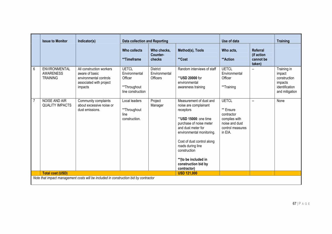
67 | P A G E
Issue to Monitor
Indicator(s)
Data collection and Reporting
Use of data
Training
Who collects **Timeframe
Who checks, Counter- checks
Method(s), Tools **Cost
Who acts, **Action
Referral (if action cannot be taken)
6 ENVIRONMENTAL AWARENESS TRAINING
All construction workers aware of basic environmental controls associated with project impacts
UETCL Environmental Officer **Throughout line construction
District Environmental Officers
Random interviews of staff **USD 20000 for environmental awareness training
UETCL Environmental Officer **Training
-- Training in impact construction impacts identification and mitigation
7 NOISE AND AIR QUALITY IMPACTS
Community complaints about excessive noise or dust emissions.
Local leaders **Throughout line construction.
Project Manager
Measurement of dust and noise are complainant receptors **USD 15000: one time purchase of noise meter and dust meter for environmental monitoring. Cost of dust control along roads during line construction **(to be included in construction bid by contractor)
UETCL ** Ensure contractor complies with noise and dust control measures in EIA.
-- None
Total cost (USD) USD 121,000
Note that impact management costs will be included in construction bid by contractor
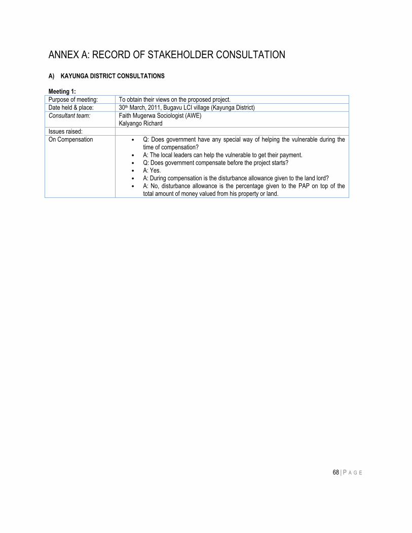
68 | P A G E
ANNEX A: RECORD OF STAKEHOLDER CONSULTATION A) KAYUNGA DISTRICT CONSULTATIONS Meeting 1:
Purpose of meeting: To obtain their views on the proposed project.
Date held & place: 30th March, 2011, Bugavu LCI village (Kayunga District)
Consultant team: Faith Mugerwa Sociologist (AWE) Kalyango Richard
Issues raised:
On Compensation • Q: Does government have any special way of helping the vulnerable during the time of compensation?
• A: The local leaders can help the vulnerable to get their payment. • Q: Does government compensate before the project starts? • A: Yes. • A: During compensation is the disturbance allowance given to the land lord? • A: No, disturbance allowance is the percentage given to the PAP on top of the
total amount of money valued from his property or land.
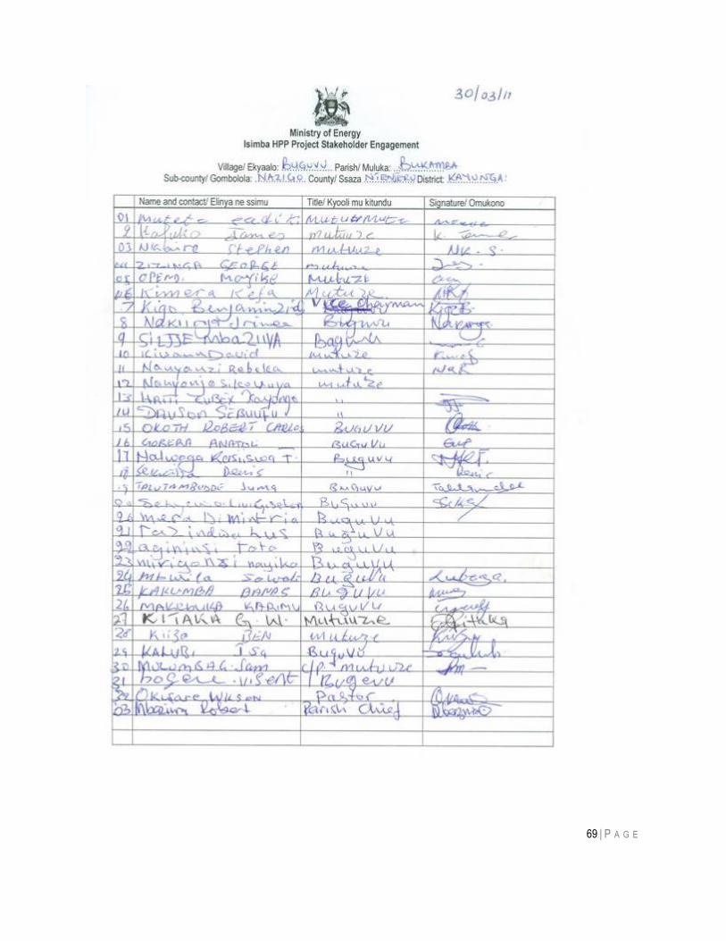
69 | P A G E
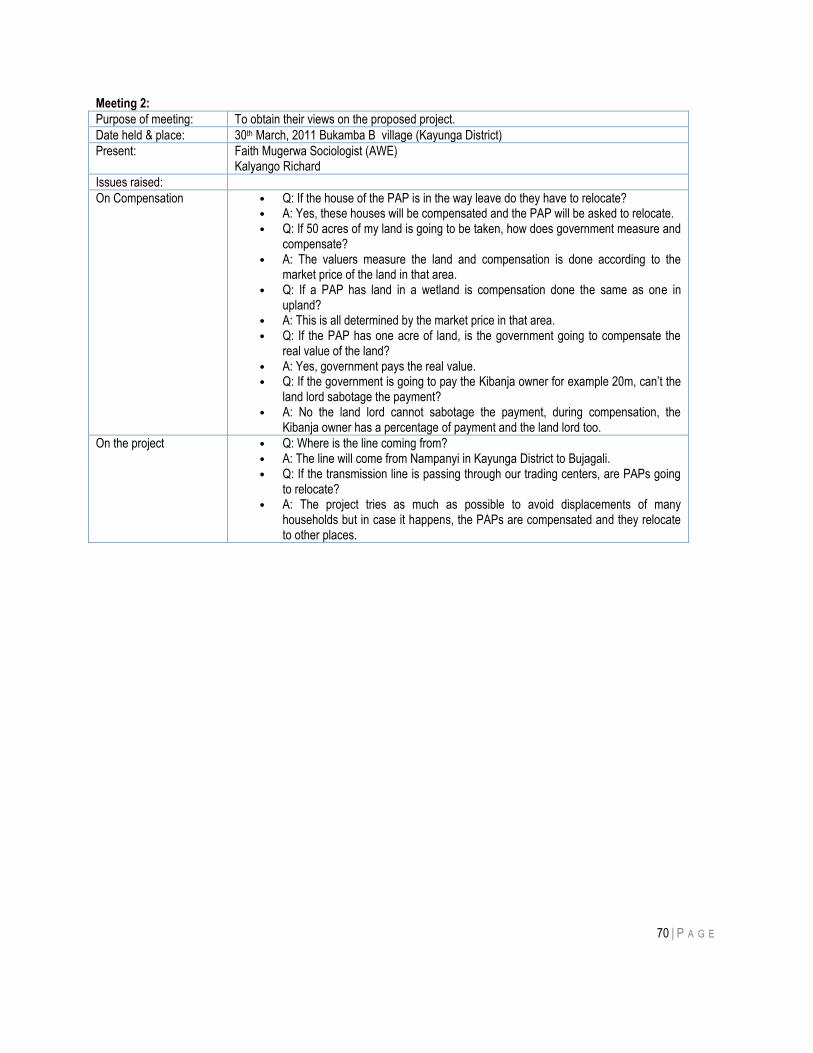
70 | P A G E
Meeting 2:
Purpose of meeting: To obtain their views on the proposed project.
Date held & place: 30th March, 2011 Bukamba B village (Kayunga District)
Present: Faith Mugerwa Sociologist (AWE) Kalyango Richard
Issues raised:
On Compensation • Q: If the house of the PAP is in the way leave do they have to relocate? • A: Yes, these houses will be compensated and the PAP will be asked to relocate. • Q: If 50 acres of my land is going to be taken, how does government measure and
compensate? • A: The valuers measure the land and compensation is done according to the
market price of the land in that area. • Q: If a PAP has land in a wetland is compensation done the same as one in
upland? • A: This is all determined by the market price in that area. • Q: If the PAP has one acre of land, is the government going to compensate the
real value of the land? • A: Yes, government pays the real value. • Q: If the government is going to pay the Kibanja owner for example 20m, can‟t the
land lord sabotage the payment? • A: No the land lord cannot sabotage the payment, during compensation, the
Kibanja owner has a percentage of payment and the land lord too.
On the project • Q: Where is the line coming from? • A: The line will come from Nampanyi in Kayunga District to Bujagali. • Q: If the transmission line is passing through our trading centers, are PAPs going
to relocate? • A: The project tries as much as possible to avoid displacements of many
households but in case it happens, the PAPs are compensated and they relocate to other places.
71 | P A G E
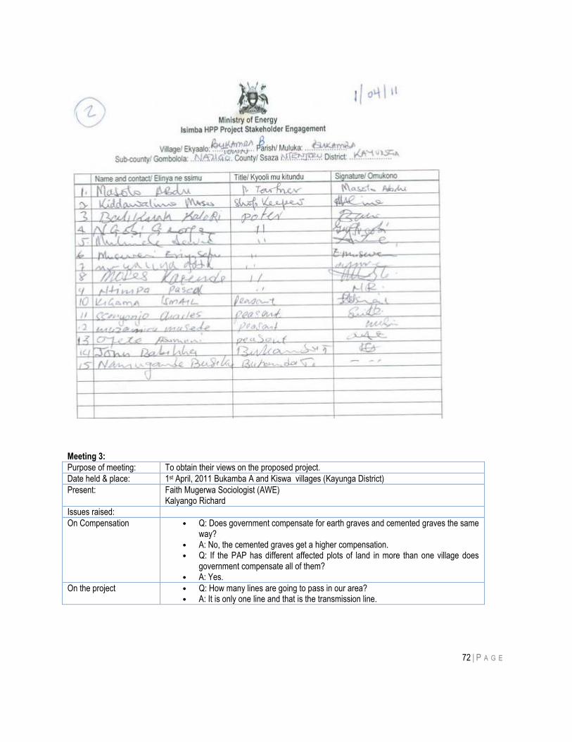
72 | P A G E
Meeting 3:
Purpose of meeting: To obtain their views on the proposed project.
Date held & place: 1st April, 2011 Bukamba A and Kiswa villages (Kayunga District)
Present: Faith Mugerwa Sociologist (AWE) Kalyango Richard
Issues raised:
On Compensation • Q: Does government compensate for earth graves and cemented graves the same way?
• A: No, the cemented graves get a higher compensation. • Q: If the PAP has different affected plots of land in more than one village does
government compensate all of them? • A: Yes.
On the project • Q: How many lines are going to pass in our area? • A: It is only one line and that is the transmission line.
73 | P A G E
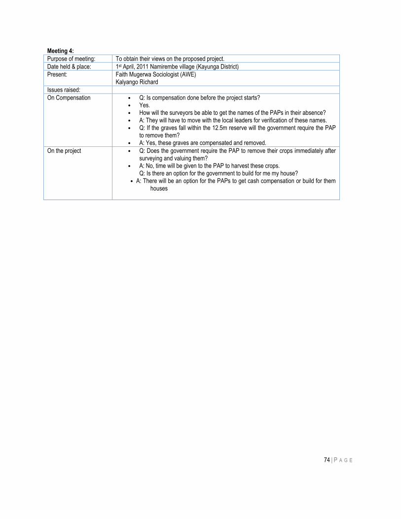
74 | P A G E
Meeting 4:
Purpose of meeting: To obtain their views on the proposed project.
Date held & place: 1st April, 2011 Namirembe village (Kayunga District)
Present: Faith Mugerwa Sociologist (AWE) Kalyango Richard
Issues raised:
On Compensation • Q: Is compensation done before the project starts? • Yes. • How will the surveyors be able to get the names of the PAPs in their absence? • A: They will have to move with the local leaders for verification of these names. • Q: If the graves fall within the 12.5m reserve will the government require the PAP
to remove them? • A: Yes, these graves are compensated and removed.
On the project • Q: Does the government require the PAP to remove their crops immediately after surveying and valuing them?
• A: No, time will be given to the PAP to harvest these crops. Q: Is there an option for the government to build for me my house?
• A: There will be an option for the PAPs to get cash compensation or build for them houses
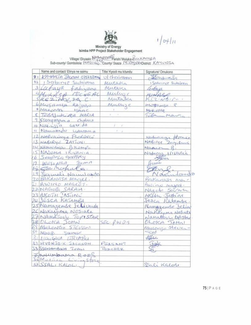
75 | P A G E
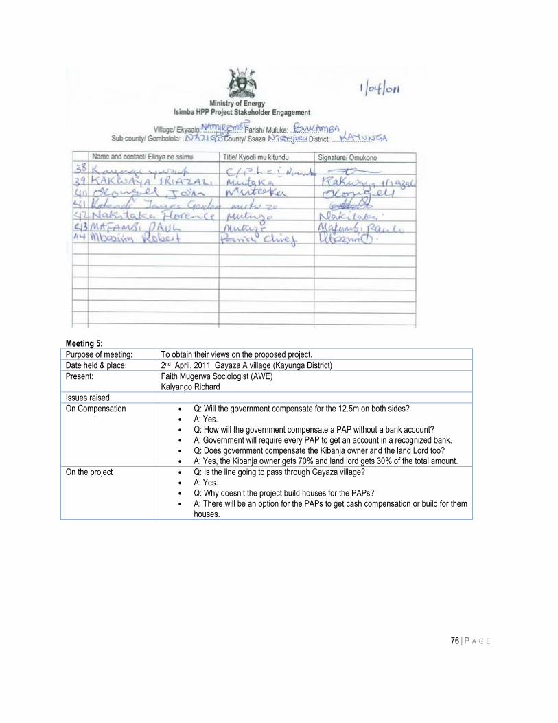
76 | P A G E
Meeting 5:
Purpose of meeting: To obtain their views on the proposed project.
Date held & place: 2nd April, 2011 Gayaza A village (Kayunga District)
Present: Faith Mugerwa Sociologist (AWE) Kalyango Richard
Issues raised:
On Compensation • Q: Will the government compensate for the 12.5m on both sides? • A: Yes. • Q: How will the government compensate a PAP without a bank account? • A: Government will require every PAP to get an account in a recognized bank. • Q: Does government compensate the Kibanja owner and the land Lord too? • A: Yes, the Kibanja owner gets 70% and land lord gets 30% of the total amount.
On the project • Q: Is the line going to pass through Gayaza village? • A: Yes. • Q: Why doesn‟t the project build houses for the PAPs? • A: There will be an option for the PAPs to get cash compensation or build for them
houses.
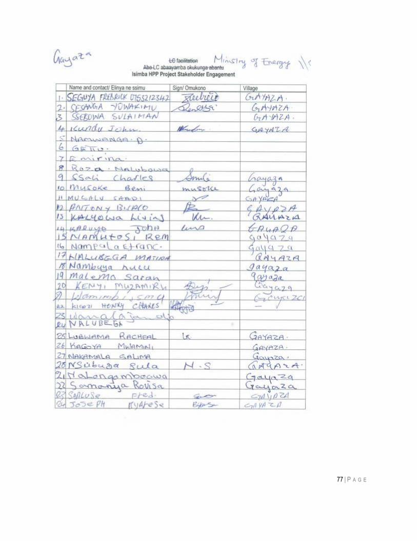
77 | P A G E
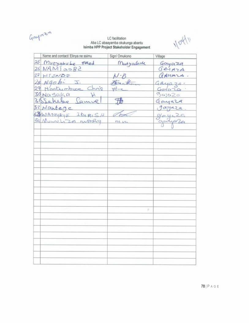
78 | P A G E
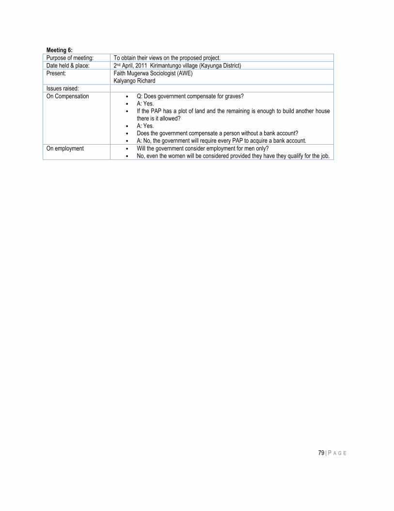
79 | P A G E
Meeting 6:
Purpose of meeting: To obtain their views on the proposed project.
Date held & place: 2nd April, 2011 Kirimantungo village (Kayunga District)
Present: Faith Mugerwa Sociologist (AWE) Kalyango Richard
Issues raised:
On Compensation • Q: Does government compensate for graves? • A: Yes. • If the PAP has a plot of land and the remaining is enough to build another house
there is it allowed? • A: Yes. • Does the government compensate a person without a bank account? • A: No, the government will require every PAP to acquire a bank account.
On employment • Will the government consider employment for men only? • No, even the women will be considered provided they have they qualify for the job.
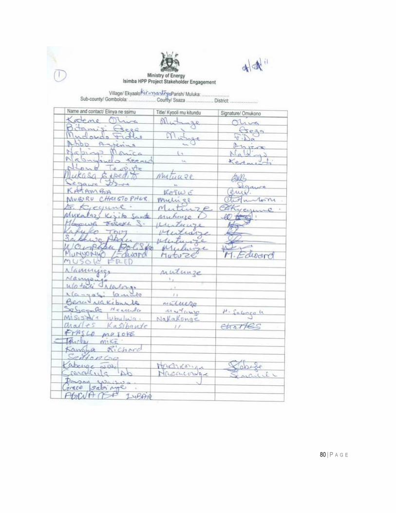
80 | P A G E
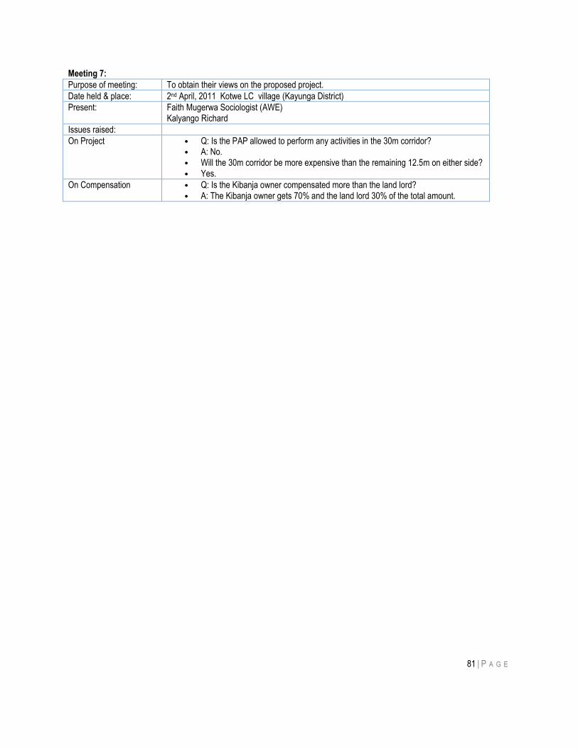
81 | P A G E
Meeting 7:
Purpose of meeting: To obtain their views on the proposed project.
Date held & place: 2nd April, 2011 Kotwe LC village (Kayunga District)
Present: Faith Mugerwa Sociologist (AWE) Kalyango Richard
Issues raised:
On Project • Q: Is the PAP allowed to perform any activities in the 30m corridor? • A: No. • Will the 30m corridor be more expensive than the remaining 12.5m on either side? • Yes.
On Compensation • Q: Is the Kibanja owner compensated more than the land lord? • A: The Kibanja owner gets 70% and the land lord 30% of the total amount.

82 | P A G E
83 | P A G E
Meeting 8:
Purpose of meeting: To obtain their views on the proposed project.
Date held & place: 5th April, 2011 Salaama and Kilemezi A villages (Kayunga District)
Present: Faith Mugerwa Sociologist (AWE) Kalyango Richard
Issues raised:
On Project • If the PAPs house happens to be in the 30m corridor, is the PAP paid and they relocate elsewhere?
• A: Yes.
On Compensation • Q: Is the Kibanja owner compensated more than the land lord? • A: The Kibanja owner gets 70% and the land lord 30% of the total amount. • Q: Will compensation be done before the actual project starts? • A: Yes. • Q: Does the government value old iron sheets? • A: Yes. • Q: Who determines prices for crops? • A: The District Land Board for that particular district.
On Employment • Q: Will government consider employment for the locals? • A: Yes, the government considers the locals for casual jobs.
84 | P A G E
85 | P A G E
Meeting 9:
Purpose of meeting: To obtain their views on the proposed project.
Date held & place: 5th April, 2011 Kilemezi B village (Kayunga District)
Present: Faith Mugerwa Sociologist (AWE) Kalyango Richard
Issues raised:
On Project • Q: Will the people in the villages where the Transmission line will pass be able to tap electricity?
• A: No, this electricity is not for home consumption. • Q: When will the project start? • A: The project has stages of development so the surveyors and valuers are
already underway.
On Compensation • Q: Will government compensate before the actual road project? • A: Yes. • Q: Will the government compensate for all the property that is destroyed? • A: Yes, apart from annual crops that are given time to be compensated. • Q: Is it okay to fill in the form for the PAP if they are absent? • A: Yes, a relative to the PAP can help to fill in this form.
On Employment • Q: Will government consider employment for the locals? • A: Yes, the government considers the locals for casual jobs.
86 | P A G E
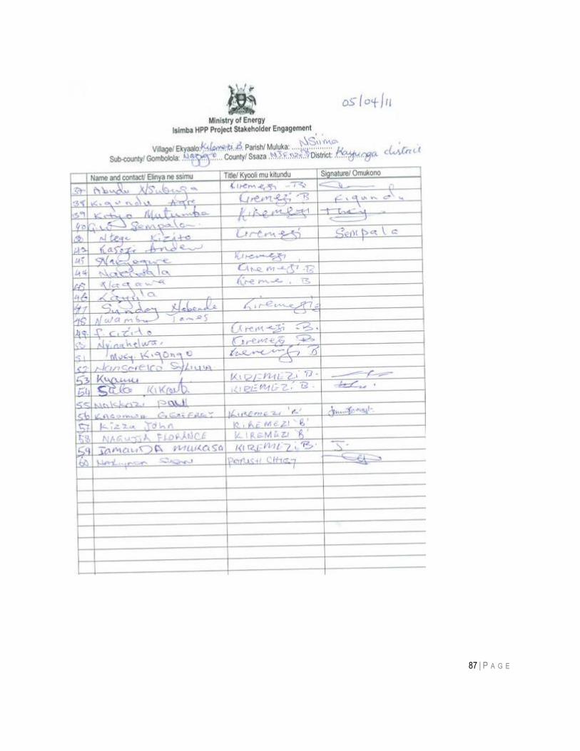
87 | P A G E
88 | P A G E
Meeting 10:
Purpose of meeting: To obtain their views on the proposed project.
Date held & place: 6th April, 2011 Natteta village (Kayunga District)
Present: Faith Mugerwa Sociologist (AWE) Kalyango Richard
Issues raised:
On Project • Q: Will the people in the villages where the Transmission line will pass be able to tap electricity?
• A: No, this electricity is not for home consumption it will be taken to the substation first and then brought back for people to use.
• Q: When will the project start? • A: The project has stages of development so the surveyors and valuers are
already underway.
On Compensation • Q: Will the government compensate a PAP without a land title? • A: No, the government requires the PAP to prove ownership of the land before
compensation is done. • Q: Does government compensate the Kibanja owner? • A: Yes. • Q: Who determines the prices of crops for the PAPs? • A: The District Land Board for the project affected district. • Q: Why aren‟t the PAPs availed with the compensation rates? • A: The leaders in these areas can get for the PAPs these rates.
On Employment • Q: Will government consider employment for the locals? • A: Yes, the government considers the locals for casual jobs.
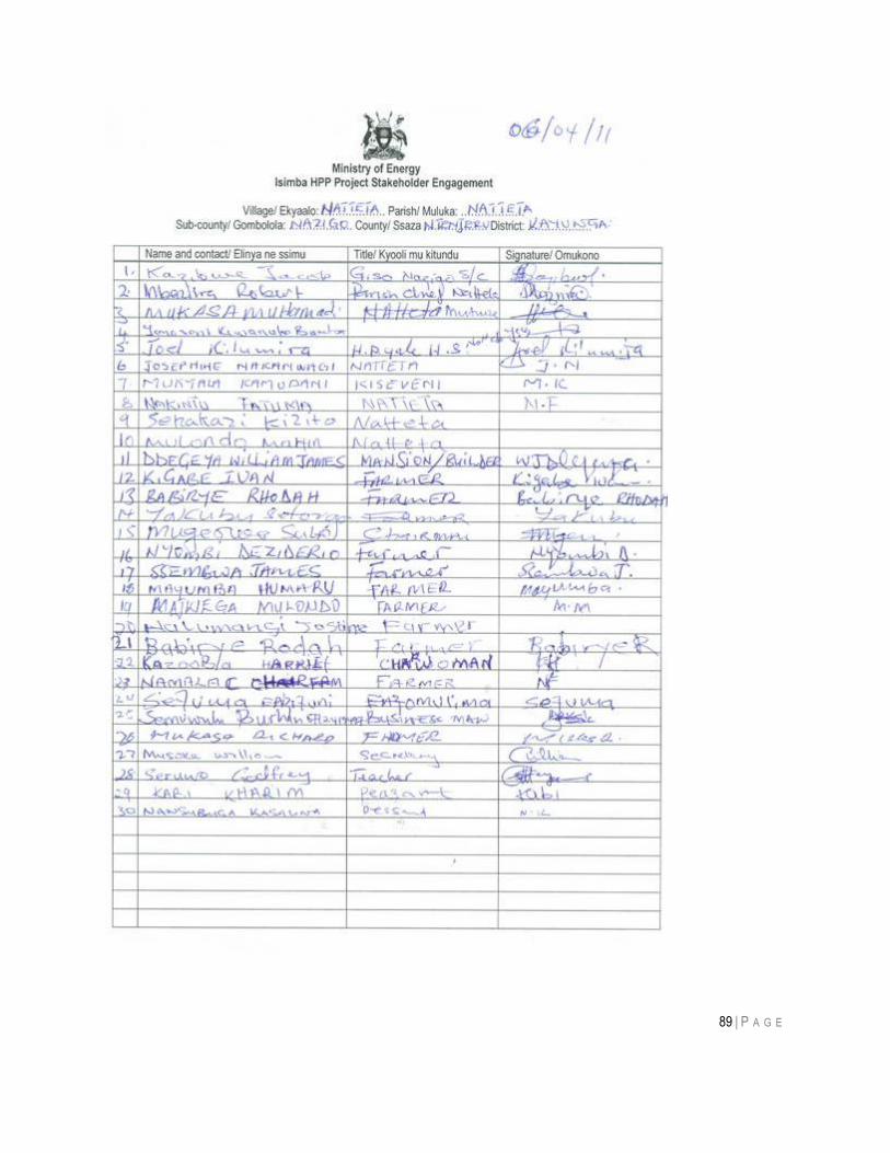
89 | P A G E
90 | P A G E
Meeting 11:
Purpose of meeting: To obtain their views on the proposed project.
Date held & place: 6th April, 2011 Kiribedda and Nakatovu villages (Kayunga District)
Present: Faith Mugerwa Sociologist (AWE) Kalyango Richard
Issues raised:
On Project • Q: Can one plant coffee in the 30m corridor? • A: No. • Q: Will the people in the villages where the Transmission line will pass be able to
tap electricity? • A: No, this electricity is not for home consumption it will be taken to the substation
first and then brought back for people to use. • Q: When will the project start?
A: The project has stages of development so the surveyors and valuers are already underway.
• The people should be notified of areas where the line will pass because they owners of the land might maliciously sell them land that is already affected.
On compensation • Q: Where can the PAP report their queries in case they are not satisfied with the compensation?
• A: They can report to the local leaders. • Q: What is the percentage of the Kibanja owner and the land lord? • A: The Kibanja owner will take 70% and the land lord 30%.
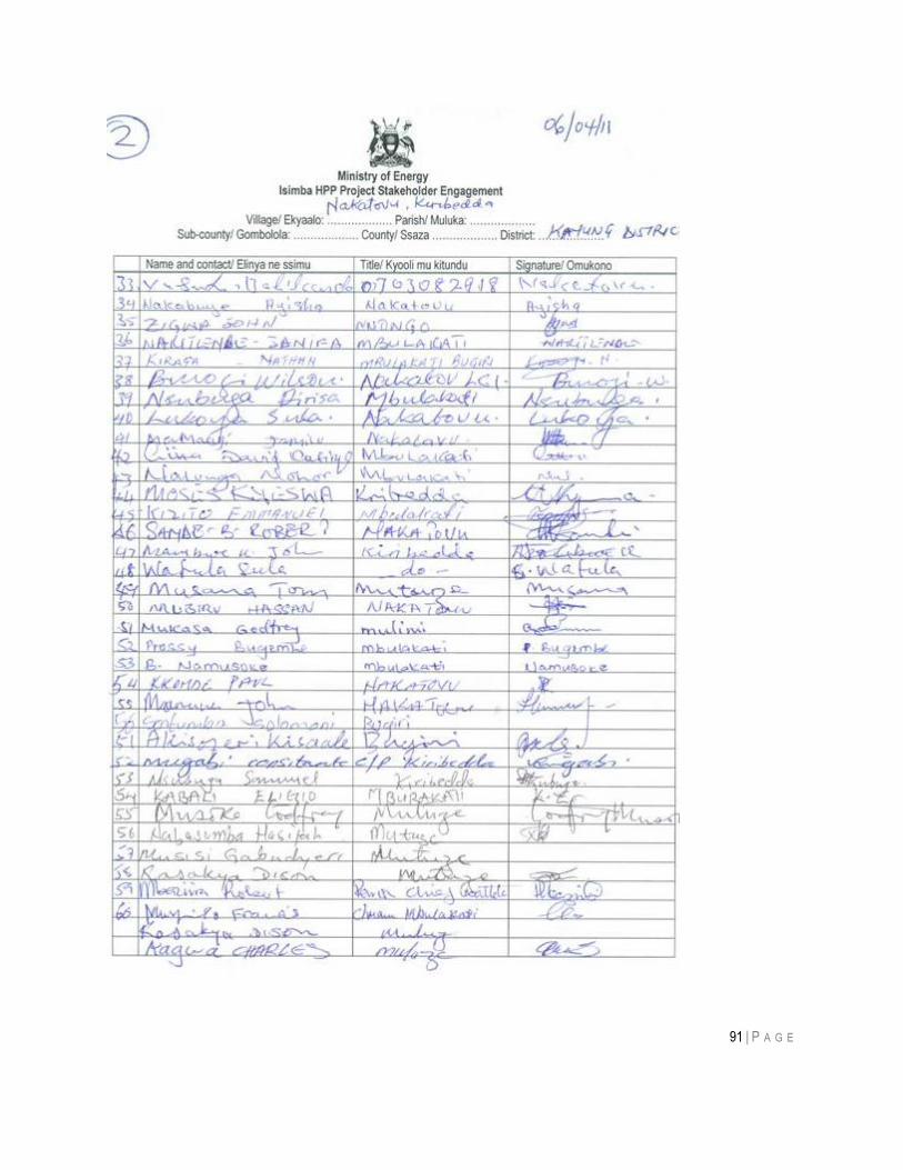
91 | P A G E
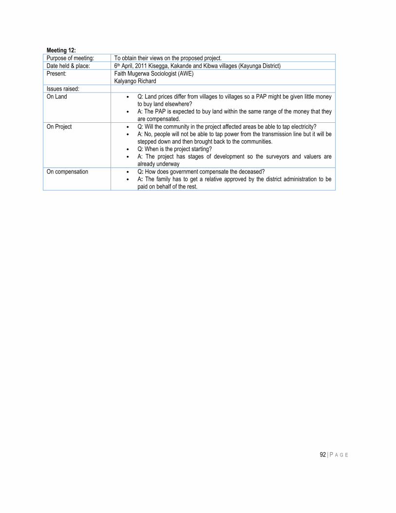
92 | P A G E
Meeting 12:
Purpose of meeting: To obtain their views on the proposed project.
Date held & place: 6th April, 2011 Kisegga, Kakande and Kibwa villages (Kayunga District)
Present: Faith Mugerwa Sociologist (AWE) Kalyango Richard
Issues raised:
On Land • Q: Land prices differ from villages to villages so a PAP might be given little money to buy land elsewhere?
• A: The PAP is expected to buy land within the same range of the money that they are compensated.
On Project • Q: Will the community in the project affected areas be able to tap electricity? • A: No, people will not be able to tap power from the transmission line but it will be
stepped down and then brought back to the communities. • Q: When is the project starting? • A: The project has stages of development so the surveyors and valuers are
already underway
On compensation • Q: How does government compensate the deceased? • A: The family has to get a relative approved by the district administration to be
paid on behalf of the rest.
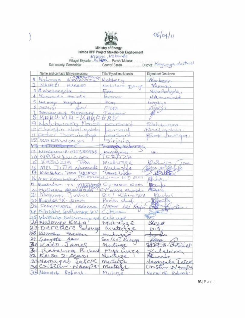
93 | P A G E
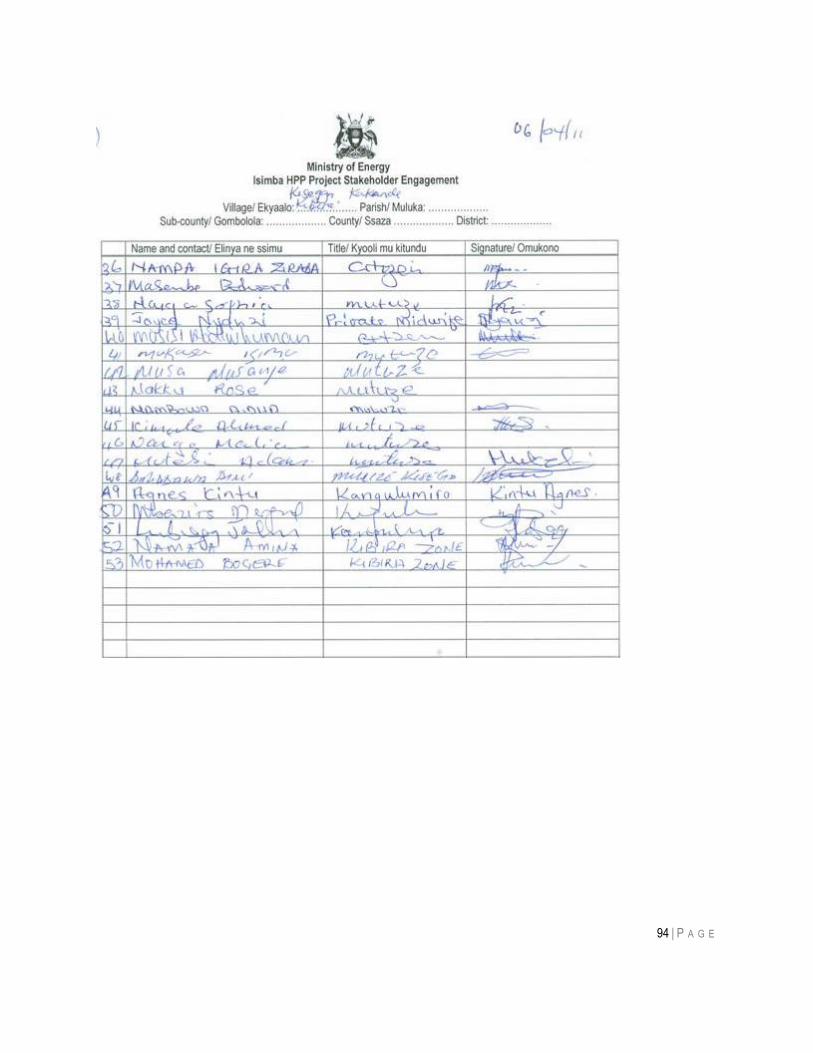
94 | P A G E
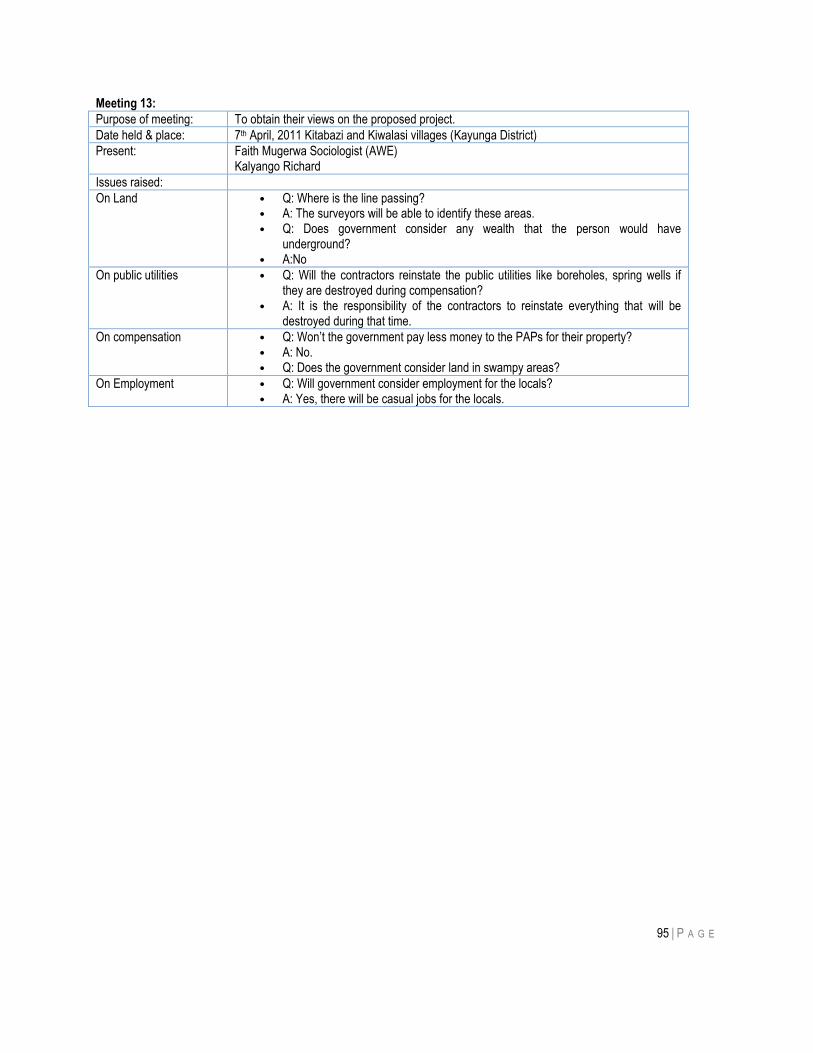
95 | P A G E
Meeting 13:
Purpose of meeting: To obtain their views on the proposed project.
Date held & place: 7th April, 2011 Kitabazi and Kiwalasi villages (Kayunga District)
Present: Faith Mugerwa Sociologist (AWE) Kalyango Richard
Issues raised:
On Land • Q: Where is the line passing? • A: The surveyors will be able to identify these areas. • Q: Does government consider any wealth that the person would have
underground? • A:No
On public utilities • Q: Will the contractors reinstate the public utilities like boreholes, spring wells if they are destroyed during compensation?
• A: It is the responsibility of the contractors to reinstate everything that will be destroyed during that time.
On compensation • Q: Won‟t the government pay less money to the PAPs for their property? • A: No. • Q: Does the government consider land in swampy areas?
On Employment • Q: Will government consider employment for the locals? • A: Yes, there will be casual jobs for the locals.
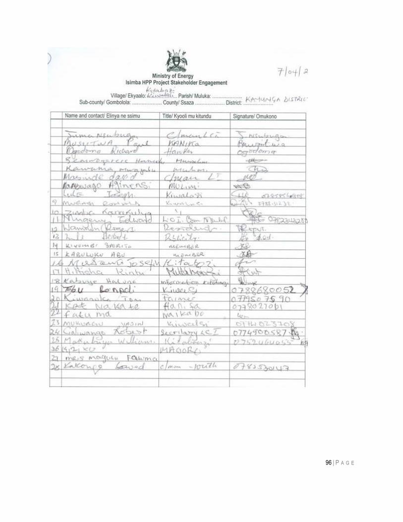
96 | P A G E
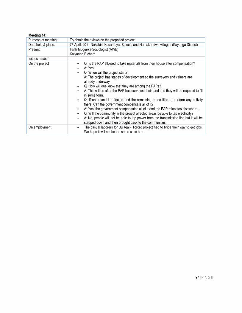
97 | P A G E
Meeting 14:
Purpose of meeting: To obtain their views on the proposed project.
Date held & place: 7th April, 2011 Nakabiri, Kasambya, Bukasa and Namakandwa villages (Kayunga District)
Present: Faith Mugerwa Sociologist (AWE) Kalyango Richard
Issues raised:
On the project • Q: Is the PAP allowed to take materials from their house after compensation? • A: Yes. • Q: When will the project start?
A: The project has stages of development so the surveyors and valuers are already underway
• Q: How will one know that they are among the PAPs? • A: This will be after the PAP has surveyed their land and they will be required to fill
in some form. • Q: If ones land is affected and the remaining is too little to perform any activity
there. Can the government compensate all of it? • A: Yes, the government compensates all of it and the PAP relocates elsewhere. • Q: Will the community in the project affected areas be able to tap electricity? • A: No, people will not be able to tap power from the transmission line but it will be
stepped down and then brought back to the communities.
On employment • The casual laborers for Bujagali- Tororo project had to bribe their way to get jobs. We hope it will not be the same case here.
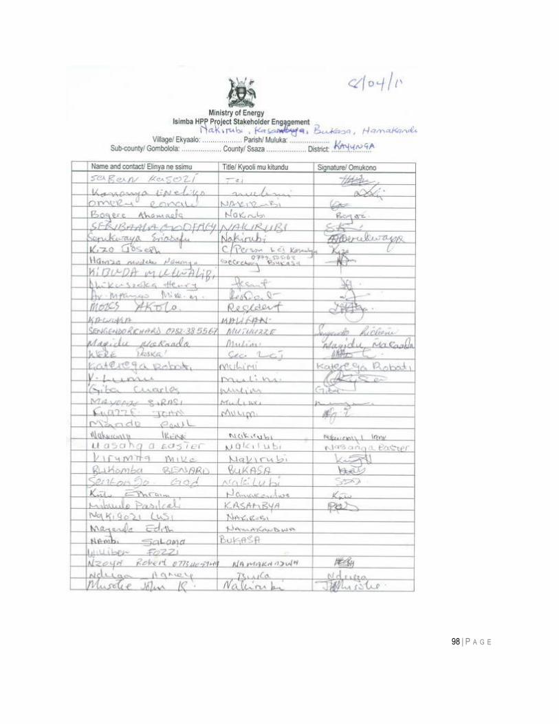
98 | P A G E
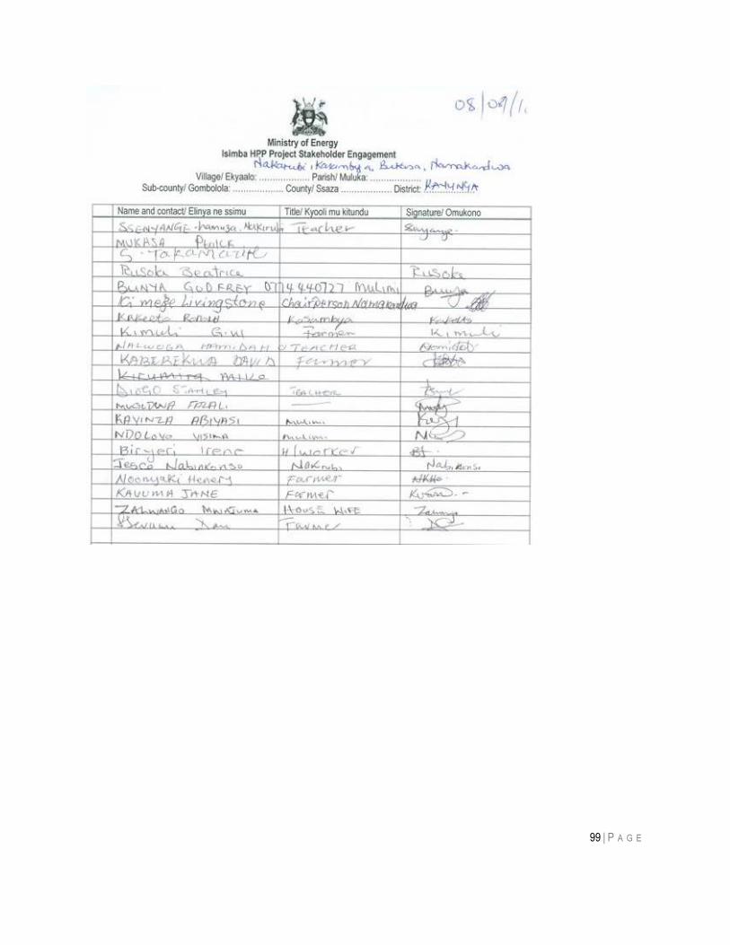
99 | P A G E
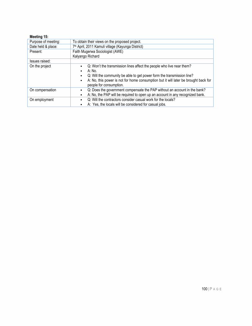
100 | P A G E
Meeting 15:
Purpose of meeting: To obtain their views on the proposed project.
Date held & place: 7th April, 2011 Kamuli village (Kayunga District)
Present: Faith Mugerwa Sociologist (AWE) Kalyango Richard
Issues raised:
On the project • Q: Won‟t the transmission lines affect the people who live near them? • A: No. • Q: Will the community be able to get power form the transmission line? • A: No, this power is not for home consumption but it will later be brought back for
people for consumption.
On compensation • Q: Does the government compensate the PAP without an account in the bank? • A: No, the PAP will be required to open up an account in any recognized bank.
On employment • Q: Will the contractors consider casual work for the locals? • A: Yes, the locals will be considered for casual jobs.
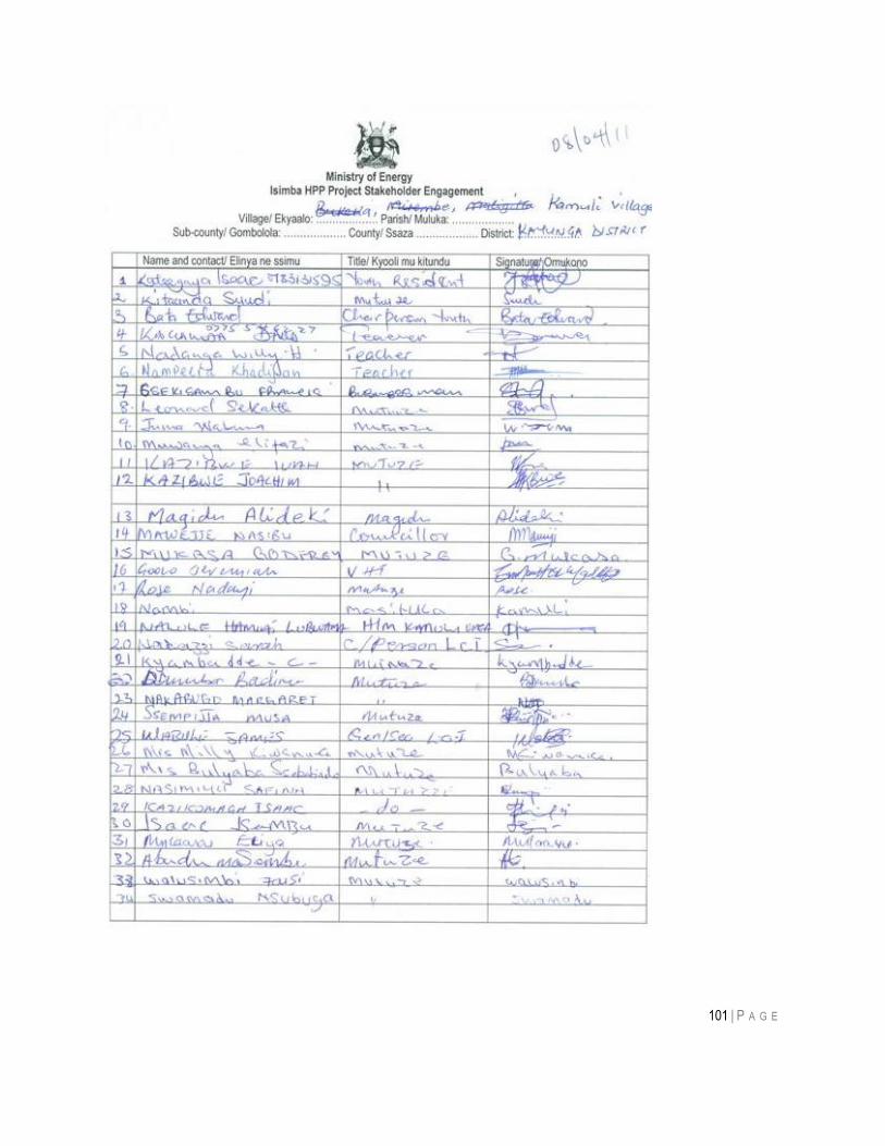
101 | P A G E
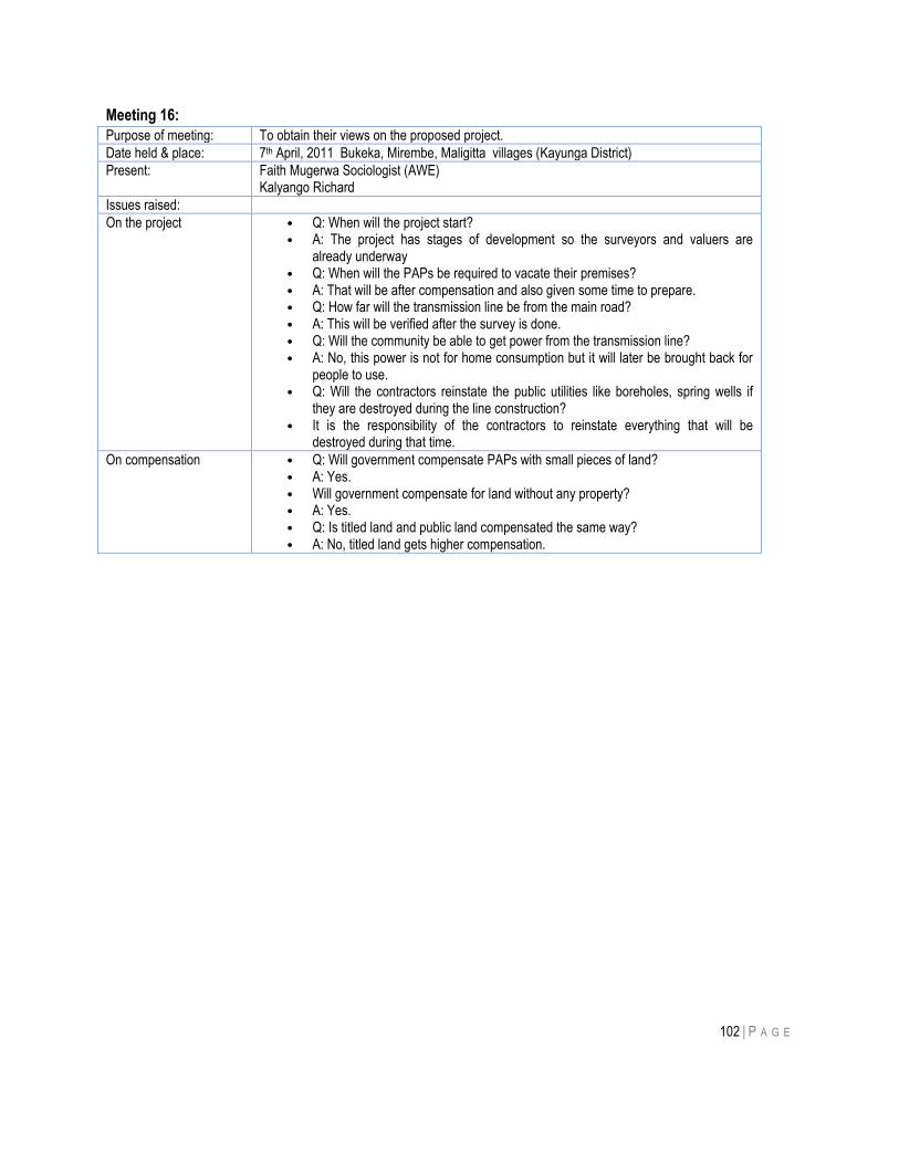
102 | P A G E
Meeting 16:
Purpose of meeting: To obtain their views on the proposed project.
Date held & place: 7th April, 2011 Bukeka, Mirembe, Maligitta villages (Kayunga District)
Present: Faith Mugerwa Sociologist (AWE) Kalyango Richard
Issues raised:
On the project • Q: When will the project start? • A: The project has stages of development so the surveyors and valuers are
already underway • Q: When will the PAPs be required to vacate their premises? • A: That will be after compensation and also given some time to prepare. • Q: How far will the transmission line be from the main road? • A: This will be verified after the survey is done. • Q: Will the community be able to get power from the transmission line? • A: No, this power is not for home consumption but it will later be brought back for
people to use. • Q: Will the contractors reinstate the public utilities like boreholes, spring wells if
they are destroyed during the line construction? • It is the responsibility of the contractors to reinstate everything that will be
destroyed during that time.
On compensation • Q: Will government compensate PAPs with small pieces of land? • A: Yes. • Will government compensate for land without any property? • A: Yes. • Q: Is titled land and public land compensated the same way? • A: No, titled land gets higher compensation.
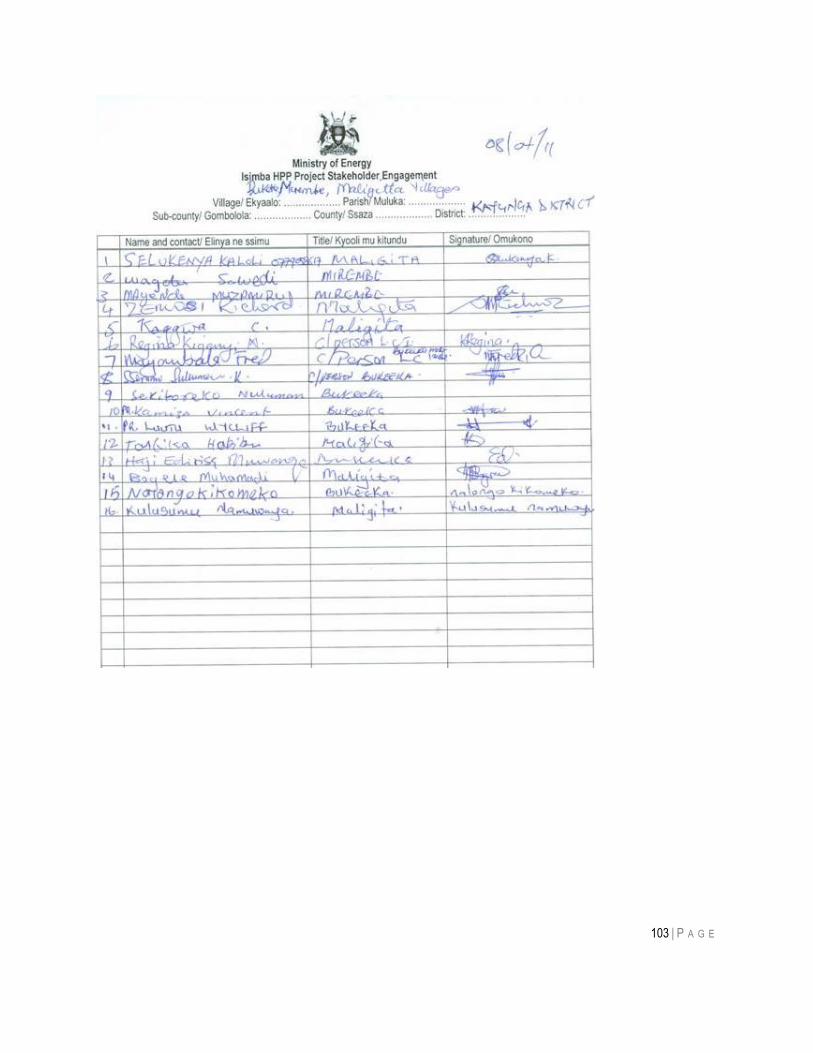
103 | P A G E
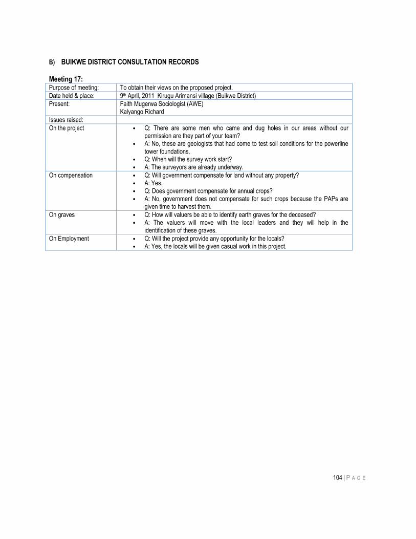
104 | P A G E
B) BUIKWE DISTRICT CONSULTATION RECORDS Meeting 17: Purpose of meeting: To obtain their views on the proposed project.
Date held & place: 9th April, 2011 Kirugu Arimansi village (Buikwe District)
Present: Faith Mugerwa Sociologist (AWE) Kalyango Richard
Issues raised:
On the project • Q: There are some men who came and dug holes in our areas without our permission are they part of your team?
• A: No, these are geologists that had come to test soil conditions for the powerline tower foundations.
• Q: When will the survey work start? • A: The surveyors are already underway.
On compensation • Q: Will government compensate for land without any property? • A: Yes. • Q: Does government compensate for annual crops? • A: No, government does not compensate for such crops because the PAPs are
given time to harvest them.
On graves • Q: How will valuers be able to identify earth graves for the deceased? • A: The valuers will move with the local leaders and they will help in the
identification of these graves.
On Employment • Q: Will the project provide any opportunity for the locals? • A: Yes, the locals will be given casual work in this project.
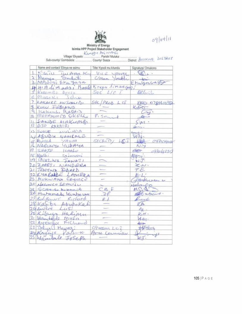
105 | P A G E
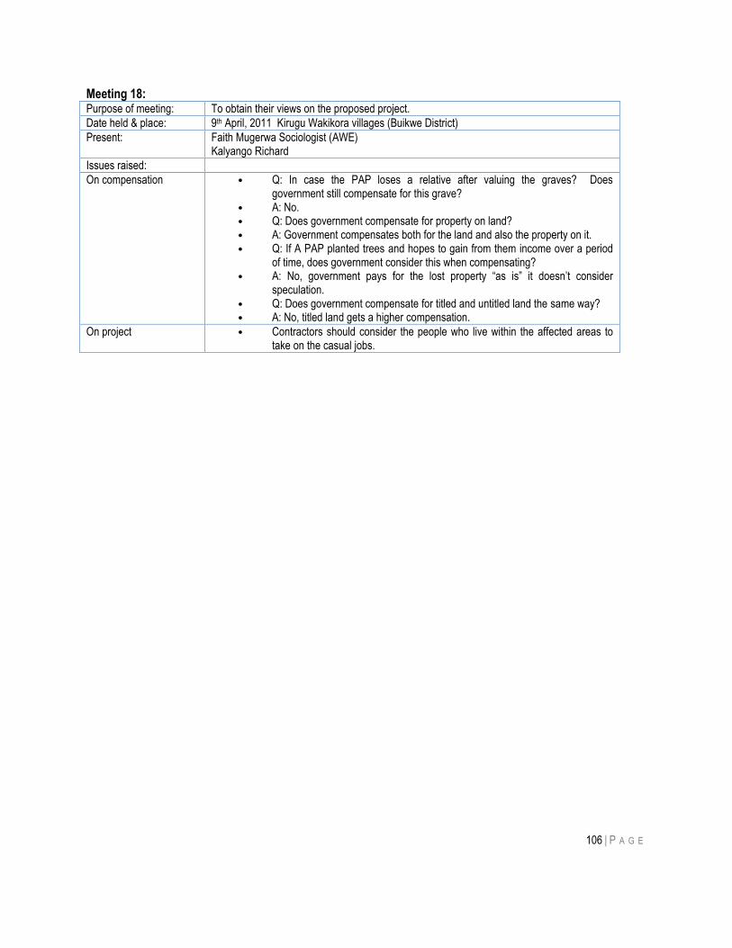
106 | P A G E
Meeting 18: Purpose of meeting: To obtain their views on the proposed project.
Date held & place: 9th April, 2011 Kirugu Wakikora villages (Buikwe District)
Present: Faith Mugerwa Sociologist (AWE) Kalyango Richard
Issues raised:
On compensation • Q: In case the PAP loses a relative after valuing the graves? Does government still compensate for this grave?
• A: No. • Q: Does government compensate for property on land? • A: Government compensates both for the land and also the property on it. • Q: If A PAP planted trees and hopes to gain from them income over a period
of time, does government consider this when compensating? • A: No, government pays for the lost property “as is” it doesn‟t consider
speculation. • Q: Does government compensate for titled and untitled land the same way? • A: No, titled land gets a higher compensation.
On project • Contractors should consider the people who live within the affected areas to take on the casual jobs.
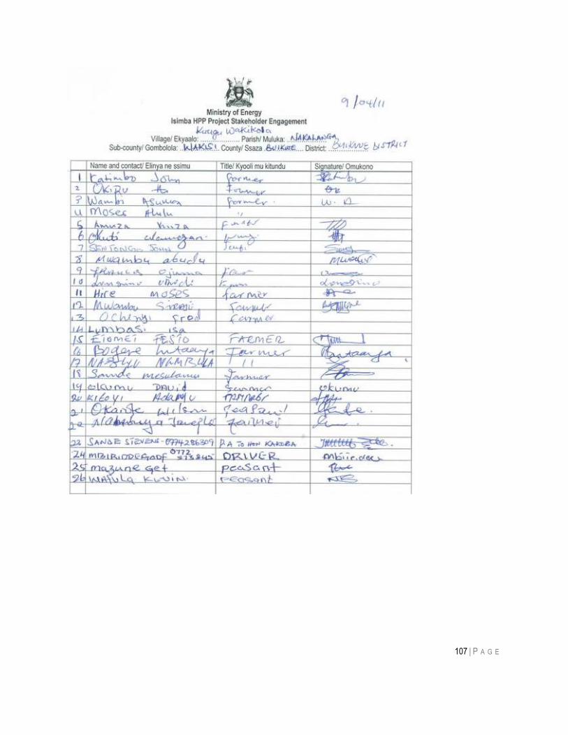
107 | P A G E
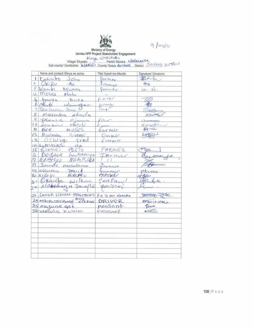
108 | P A G E

109 | P A G E
Meeting 19: Purpose of meeting: To obtain their views on the proposed project.
Date held & place: 9th April, 2011 Wakikora, Wakisi II, Wakisi market (Buikwe District)
Present: Faith Mugerwa Sociologist (AWE) Kalyango Richard
Issues raised:
On compensation • Q: During valuation of the PAPs, will the government consider the wealth that is underground?
• A: No, government does not pay for anything that is underground. • Q: Does the property belong to the PAP even after compensation? • A: Yes. • Q: If a PAP was given a plot of land (thus didn‟t buy for it) who would government
compensate? • A: The person who provides proof of ownership • Q: Will Government compensate before the project starts? • A: Yes.
On project • During the Bujagali –Tororo transmission line, there was stone quarrying that damaged our houses and we have not been compensated for that, we hope that this project is not to affect us in the same way.
On employment • Q: Will the casual jobs be available for the people in Buikwe? • A: Yes, there will be casual jobs for the people.
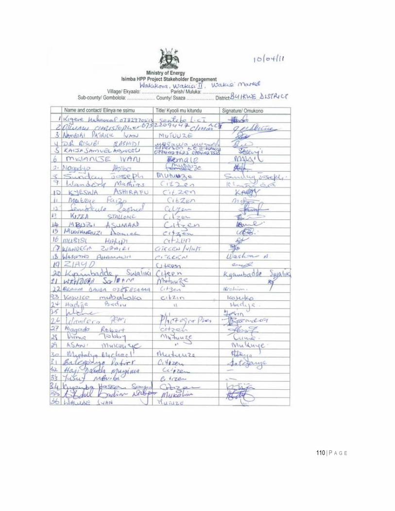
110 | P A G E
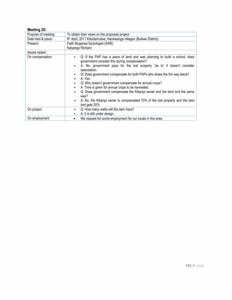
111 | P A G E
Meeting 20: Purpose of meeting: To obtain their views on the proposed project.
Date held & place: 9th April, 2011 Kikubamutwe, Nankwanga villages (Buikwe District)
Present: Faith Mugerwa Sociologist (AWE) Kalyango Richard
Issues raised:
On compensation • Q: If the PAP has a piece of land and was planning to build a school, does government consider this during compensation?
• A: No, government pays for the lost property “as is” it doesn‟t consider speculation.
• Q: Does government compensate for both PAPs who share the 5m way leave? • A: Yes • Q: Why doesn‟t government compensate for annual crops? • A: Time is given for annual crops to be harvested. • Q: Does government compensate the Kibanja owner and the land lord the same
way? • A: No, the Kibanja owner is compensated 70% of the lost property and the land
lord gets 30%
On project • Q: How many watts will the dam have? • A: It is still under design.
On employment We request for some employment for our locals in this area.
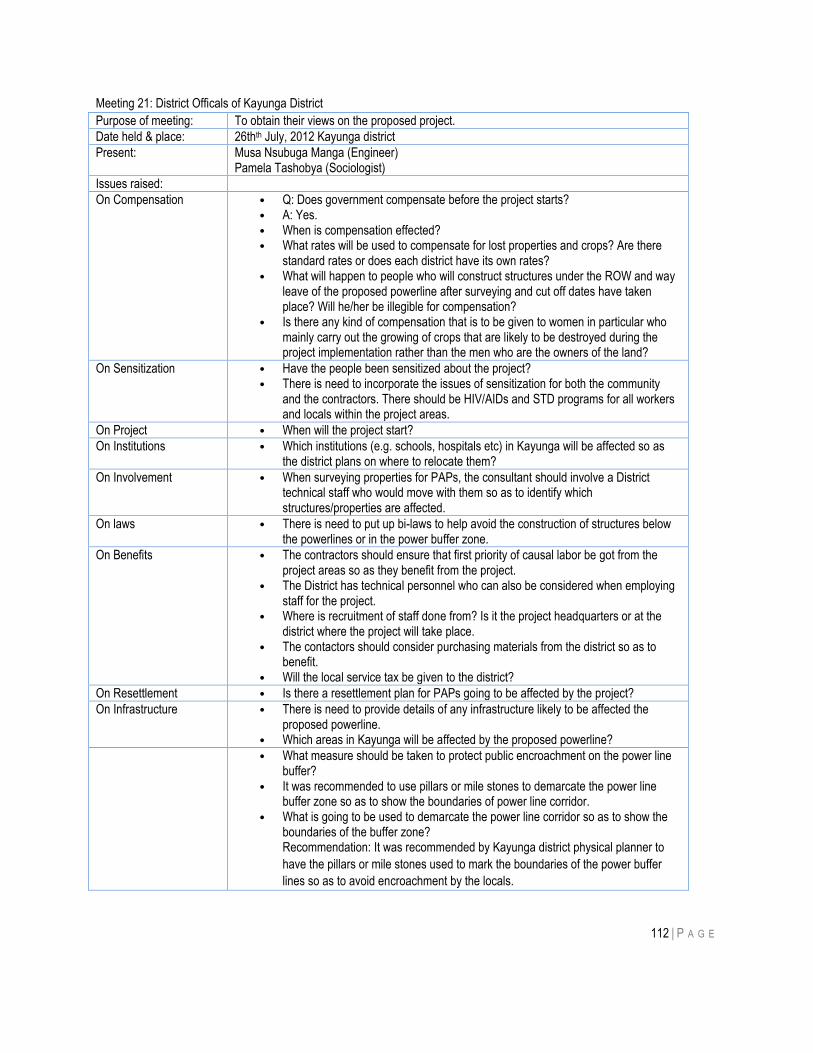
112 | P A G E
Meeting 21: District Officals of Kayunga District
Purpose of meeting: To obtain their views on the proposed project.
Date held & place: 26thth July, 2012 Kayunga district
Present: Musa Nsubuga Manga (Engineer) Pamela Tashobya (Sociologist)
Issues raised:
On Compensation • Q: Does government compensate before the project starts? • A: Yes. • When is compensation effected? • What rates will be used to compensate for lost properties and crops? Are there
standard rates or does each district have its own rates? • What will happen to people who will construct structures under the ROW and way
leave of the proposed powerline after surveying and cut off dates have taken place? Will he/her be illegible for compensation?
• Is there any kind of compensation that is to be given to women in particular who mainly carry out the growing of crops that are likely to be destroyed during the project implementation rather than the men who are the owners of the land?
On Sensitization • Have the people been sensitized about the project? • There is need to incorporate the issues of sensitization for both the community
and the contractors. There should be HIV/AIDs and STD programs for all workers and locals within the project areas.
On Project • When will the project start?
On Institutions • Which institutions (e.g. schools, hospitals etc) in Kayunga will be affected so as the district plans on where to relocate them?
On Involvement • When surveying properties for PAPs, the consultant should involve a District technical staff who would move with them so as to identify which structures/properties are affected.
On laws • There is need to put up bi-laws to help avoid the construction of structures below the powerlines or in the power buffer zone.
On Benefits • The contractors should ensure that first priority of causal labor be got from the project areas so as they benefit from the project.
• The District has technical personnel who can also be considered when employing staff for the project.
• Where is recruitment of staff done from? Is it the project headquarters or at the district where the project will take place.
• The contactors should consider purchasing materials from the district so as to benefit.
• Will the local service tax be given to the district?
On Resettlement • Is there a resettlement plan for PAPs going to be affected by the project?
On Infrastructure • There is need to provide details of any infrastructure likely to be affected the proposed powerline.
• Which areas in Kayunga will be affected by the proposed powerline?
• What measure should be taken to protect public encroachment on the power line buffer?
• It was recommended to use pillars or mile stones to demarcate the power line buffer zone so as to show the boundaries of power line corridor.
• What is going to be used to demarcate the power line corridor so as to show the boundaries of the buffer zone? Recommendation: It was recommended by Kayunga district physical planner to
have the pillars or mile stones used to mark the boundaries of the power buffer
lines so as to avoid encroachment by the locals.
113 | P A G E
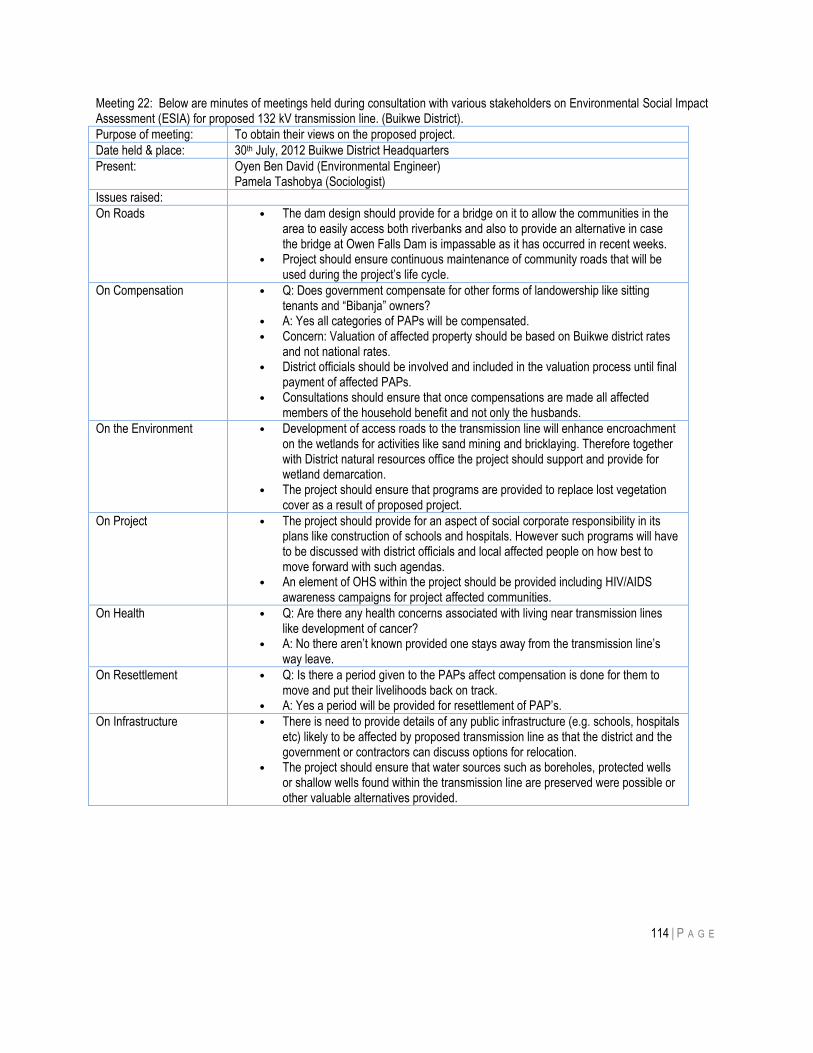
114 | P A G E
Meeting 22: Below are minutes of meetings held during consultation with various stakeholders on Environmental Social Impact Assessment (ESIA) for proposed 132 kV transmission line. (Buikwe District).
Purpose of meeting: To obtain their views on the proposed project.
Date held & place: 30th July, 2012 Buikwe District Headquarters
Present: Oyen Ben David (Environmental Engineer) Pamela Tashobya (Sociologist)
Issues raised:
On Roads • The dam design should provide for a bridge on it to allow the communities in the area to easily access both riverbanks and also to provide an alternative in case the bridge at Owen Falls Dam is impassable as it has occurred in recent weeks.
• Project should ensure continuous maintenance of community roads that will be used during the project‟s life cycle.
On Compensation • Q: Does government compensate for other forms of landowership like sitting tenants and “Bibanja” owners?
• A: Yes all categories of PAPs will be compensated. • Concern: Valuation of affected property should be based on Buikwe district rates
and not national rates. • District officials should be involved and included in the valuation process until final
payment of affected PAPs. • Consultations should ensure that once compensations are made all affected
members of the household benefit and not only the husbands.
On the Environment • Development of access roads to the transmission line will enhance encroachment on the wetlands for activities like sand mining and bricklaying. Therefore together with District natural resources office the project should support and provide for wetland demarcation.
• The project should ensure that programs are provided to replace lost vegetation cover as a result of proposed project.
On Project • The project should provide for an aspect of social corporate responsibility in its plans like construction of schools and hospitals. However such programs will have to be discussed with district officials and local affected people on how best to move forward with such agendas.
• An element of OHS within the project should be provided including HIV/AIDS awareness campaigns for project affected communities.
On Health • Q: Are there any health concerns associated with living near transmission lines like development of cancer?
• A: No there aren‟t known provided one stays away from the transmission line‟s way leave.
On Resettlement • Q: Is there a period given to the PAPs affect compensation is done for them to move and put their livelihoods back on track.
• A: Yes a period will be provided for resettlement of PAP‟s.
On Infrastructure • There is need to provide details of any public infrastructure (e.g. schools, hospitals etc) likely to be affected by proposed transmission line as that the district and the government or contractors can discuss options for relocation.
• The project should ensure that water sources such as boreholes, protected wells or shallow wells found within the transmission line are preserved were possible or other valuable alternatives provided.
115 | P A G E
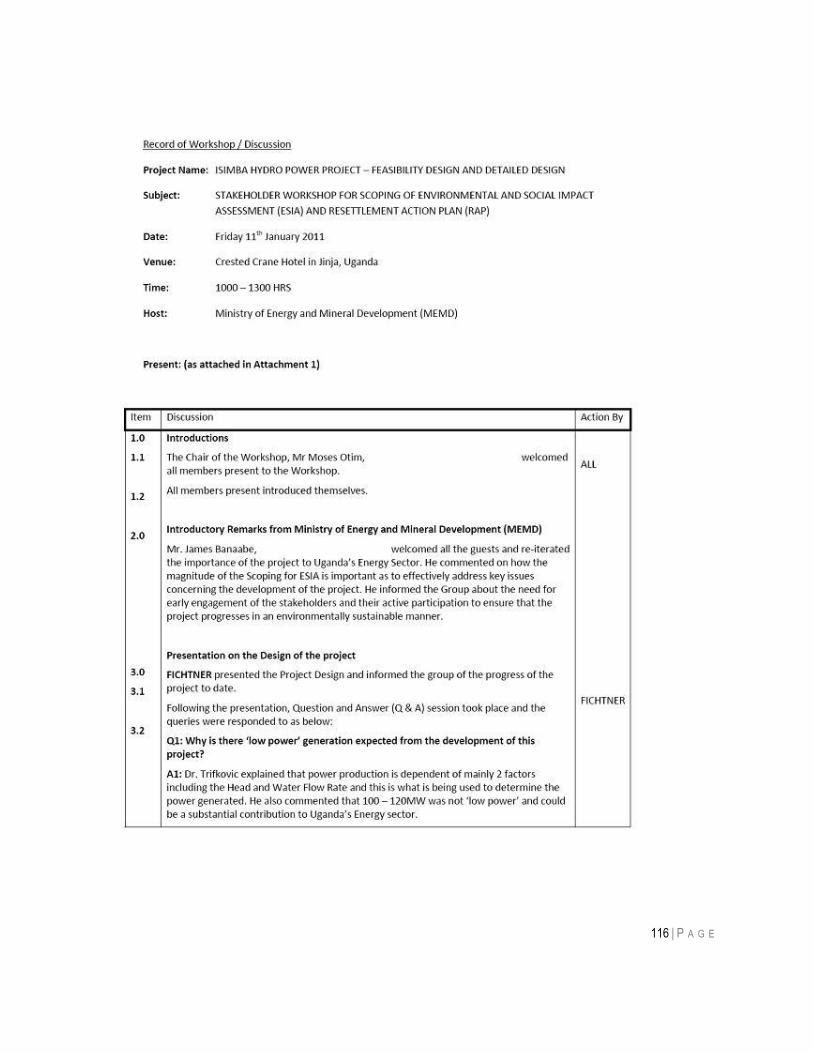
116 | P A G E
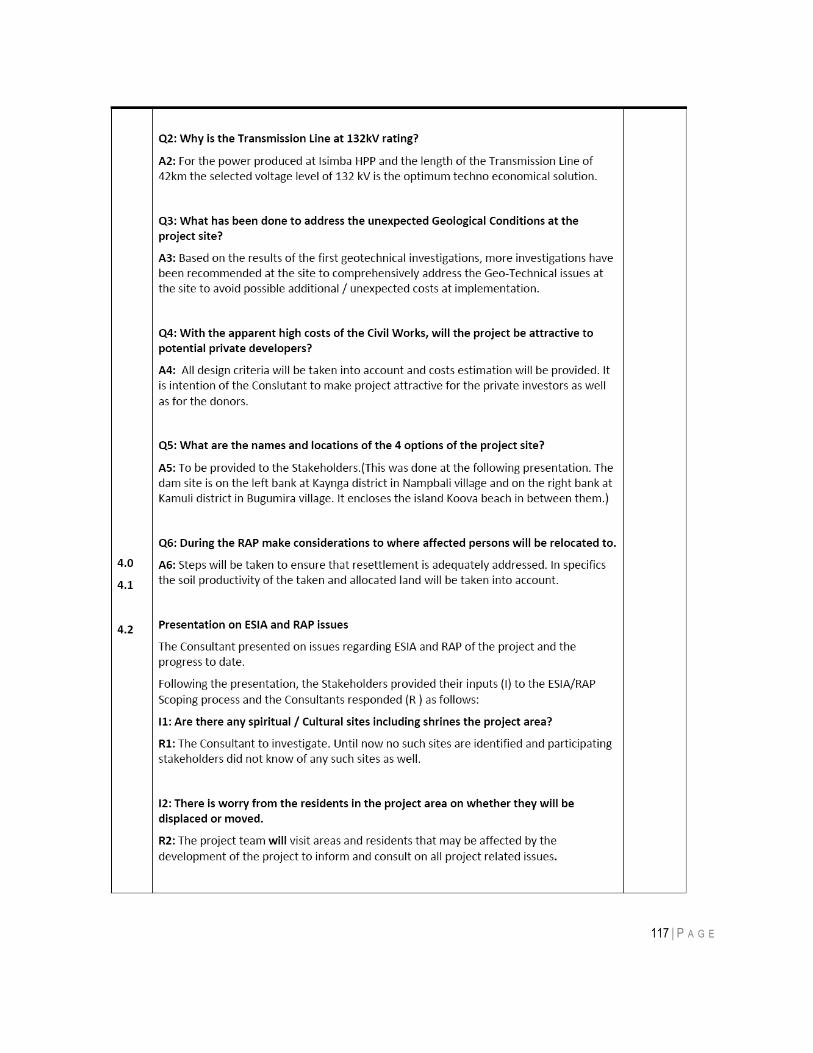
117 | P A G E
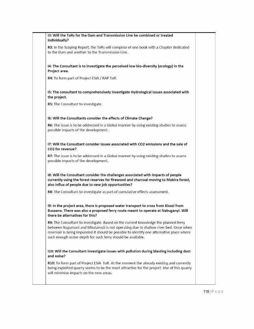
118 | P A G E
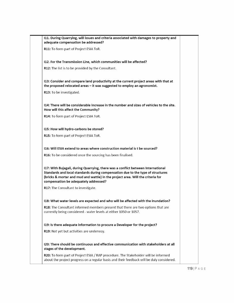
119 | P A G E
120 | P A G E
121 | P A G E
122 | P A G E
123 | P A G E
124 | P A G E
125 | P A G E
126 | P A G E
127 | P A G E
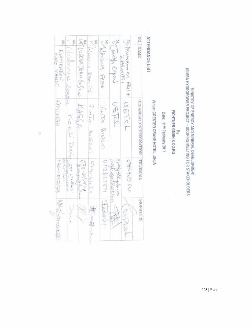
128 | P A G E
129 | P A G E
ANNEX B: BIOLOGICAL ASSESSMENT ALONG LINE ROUTE
1.0 Introduction
The transmission line is proposed to traverse the area from Nampaanyi to Bujagali. Langdale-Brown et al. (1964)
mapped this area as a potential Semi-Deciduous. The area is under the ecological zone of Celtis-Chrysophyllum
Semi-Deciduous Forest after Langdale-Brown et al. (1964). This is one the least developed parts of Uganda, with a
heavy direct dependence of the local communities on the natural resource base for livelihood (Kalema et al. 2010).
Whereas Langdale-Brown et al. (1964) mapped this area as Celtis-Chrysophyllum Semi-Deciduous Forest, today
nearly all the natural vegetation has disappeared owing to major land use changes that have led to conversion of
natural habitat and their modification. The Forest Department (2003) showed that the plant biomass level in the
central part of Uganda, in which this area is situated, had declined tremendously from 1995. Waiswa (2011) observed
that the Lake Victoria Crescent registered a decline in forest cover from 9% in 1989 to 4.4% in 2009. This is a high
level of habitat loss, leaving only very impoverished forest relics or none, in many parts of the region. Wetlands in
most parts of Uganda continue to decline in extent of coverage and quality due to intense human activity (National
Wetlands Conservation and Management Programme 1996, 2000, NEMA 2007).
The Lake Victoria Basin of Uganda is one of the hardest hit parts of Uganda with respect to level of environmental
degradation and habitat loss. This is because of the high human population density and proximity to centers of
commercial activity and political administration. The area is thus subject to heavy pressure owing to increasing
demand for land for cultivation, industrialization and settlement. The area that is proposed for the transmission line
lost most of its natural habitat and hence the important and invaluable ecosystem services for humankind welfare and
conservation of biodiversity. However, the remaining patches of vegetation are still important for the conservation of
plant and other groups of biodiversity, especially birds and invertebrates. The proposed new 132 kV double circuit
transmission line to run from a substation at Bujagali to the new substation of Isimba will be 42 km long. It will have a
way leave of 30 m with a right of way of 5 m (Air Water Earth & Kagga & Associates 2011). This sizeable belt will be
subjected to impact on habitats that will be crossed by the line. In this report, we identify the key habitat components
and ecological services that may be compromised or lost, and propose mitigation measures to minimize the impact.
1.1 Selection of sample sites
A preliminary survey of the whole length of the proposed interconnection transmission line, from Nampaanyi to
Bujagali, was made to identify potential areas for more detailed survey. The sample sites were identified considering
their naturalness, ecological sensitivity and habitat variability. Every effort was however made to get the angle points
where there is expected to be most disturbance, to be represented. A total of ten sites were selected and sampled
and all these sample sites were geo-referenced. Characterization of the project area was done basing on the floristic
and landscape features observed in the different sites.
The sample points were effectively random points along the line, since we had no prior knowledge of what we would
find at each one of them. However, for birds at least, being mobile, habitats within say 300m of the line were
included; from general observations, all those sampled also occurred along the line at various places. Table 1
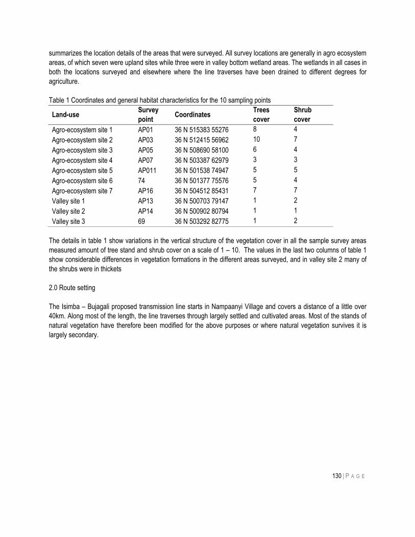
130 | P A G E
summarizes the location details of the areas that were surveyed. All survey locations are generally in agro ecosystem
areas, of which seven were upland sites while three were in valley bottom wetland areas. The wetlands in all cases in
both the locations surveyed and elsewhere where the line traverses have been drained to different degrees for
agriculture.
Table 1 Coordinates and general habitat characteristics for the 10 sampling points
Land-use Survey
point Coordinates
Trees
cover
Shrub
cover
Agro-ecosystem site 1 AP01 36 N 515383 55276 8 4
Agro-ecosystem site 2 AP03 36 N 512415 56962 10 7
Agro-ecosystem site 3 AP05 36 N 508690 58100 6 4
Agro-ecosystem site 4 AP07 36 N 503387 62979 3 3
Agro-ecosystem site 5 AP011 36 N 501538 74947 5 5
Agro-ecosystem site 6 74 36 N 501377 75576 5 4
Agro-ecosystem site 7 AP16 36 N 504512 85431 7 7
Valley site 1 AP13 36 N 500703 79147 1 2
Valley site 2 AP14 36 N 500902 80794 1 1
Valley site 3 69 36 N 503292 82775 1 2
The details in table 1 show variations in the vertical structure of the vegetation cover in all the sample survey areas
measured amount of tree stand and shrub cover on a scale of 1 – 10. The values in the last two columns of table 1
show considerable differences in vegetation formations in the different areas surveyed, and in valley site 2 many of
the shrubs were in thickets
2.0 Route setting
The Isimba – Bujagali proposed transmission line starts in Nampaanyi Village and covers a distance of a little over
40km. Along most of the length, the line traverses through largely settled and cultivated areas. Most of the stands of
natural vegetation have therefore been modified for the above purposes or where natural vegetation survives it is
largely secondary.
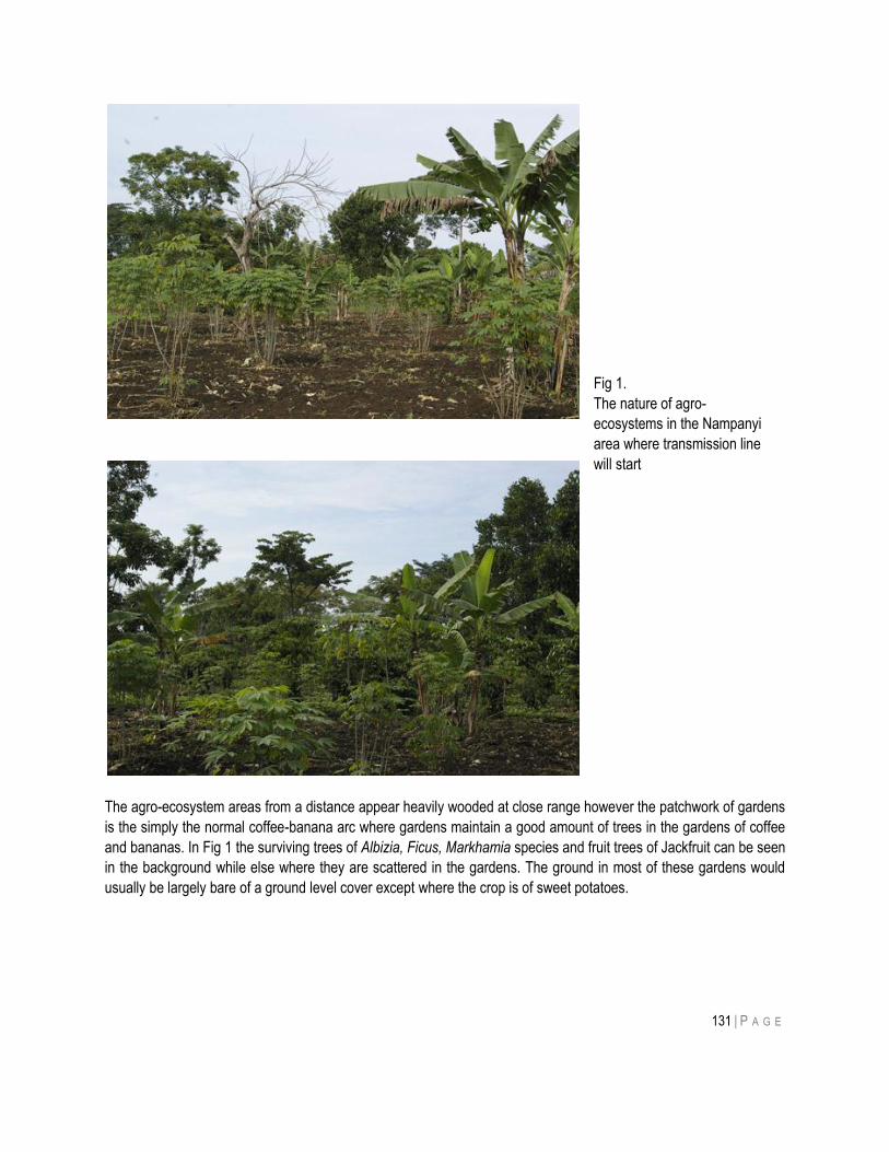
131 | P A G E
The agro-ecosystem areas from a distance appear heavily wooded at close range however the patchwork of gardens
is the simply the normal coffee-banana arc where gardens maintain a good amount of trees in the gardens of coffee
and bananas. In Fig 1 the surviving trees of Albizia, Ficus, Markhamia species and fruit trees of Jackfruit can be seen
in the background while else where they are scattered in the gardens. The ground in most of these gardens would
usually be largely bare of a ground level cover except where the crop is of sweet potatoes.
Fig 1.
The nature of agro-
ecosystems in the Nampanyi
area where transmission line
will start
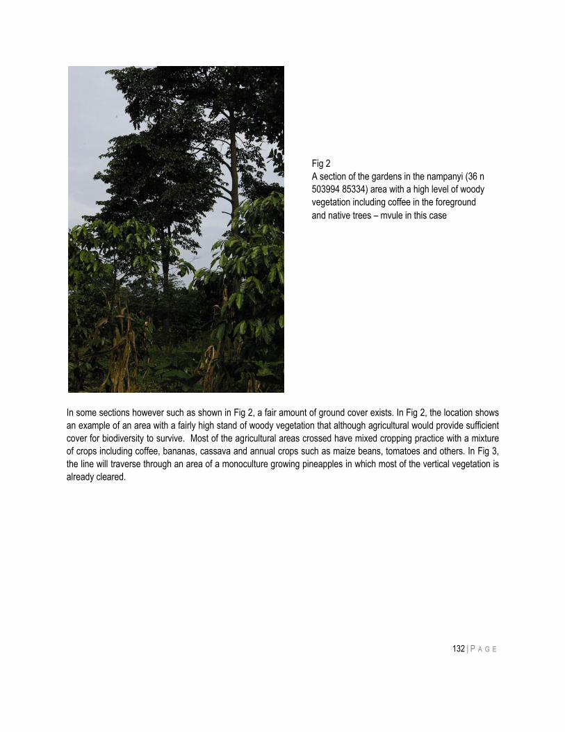
132 | P A G E
In some sections however such as shown in Fig 2, a fair amount of ground cover exists. In Fig 2, the location shows
an example of an area with a fairly high stand of woody vegetation that although agricultural would provide sufficient
cover for biodiversity to survive. Most of the agricultural areas crossed have mixed cropping practice with a mixture
of crops including coffee, bananas, cassava and annual crops such as maize beans, tomatoes and others. In Fig 3,
the line will traverse through an area of a monoculture growing pineapples in which most of the vertical vegetation is
already cleared.
Fig 2
A section of the gardens in the nampanyi (36 n
503994 85334) area with a high level of woody
vegetation including coffee in the foreground
and native trees – mvule in this case
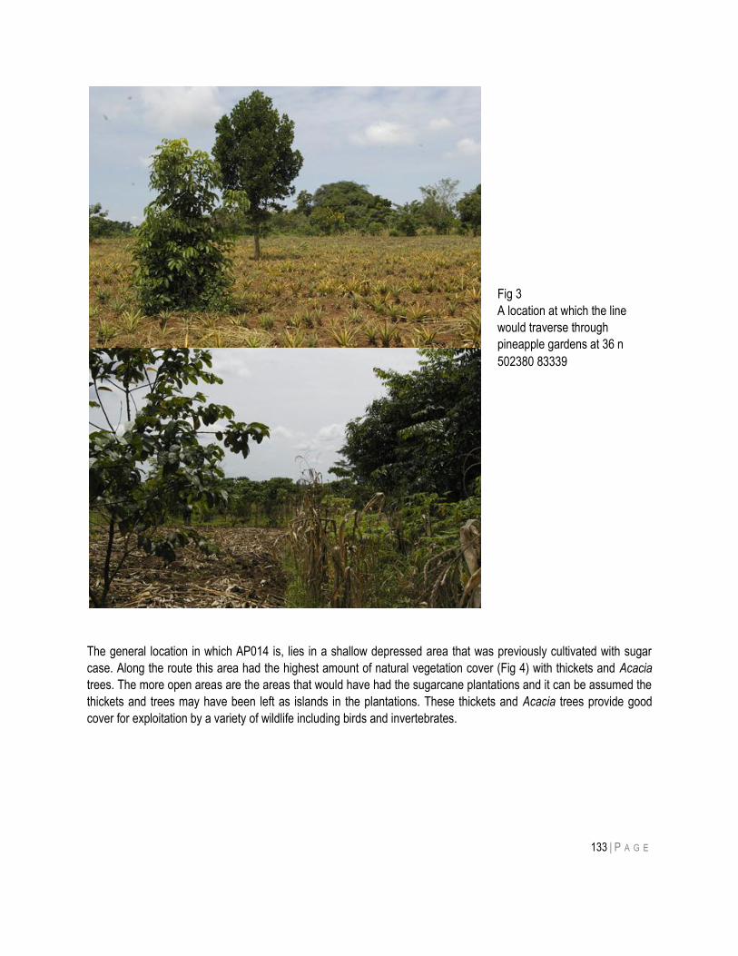
133 | P A G E
The general location in which AP014 is, lies in a shallow depressed area that was previously cultivated with sugar
case. Along the route this area had the highest amount of natural vegetation cover (Fig 4) with thickets and Acacia
trees. The more open areas are the areas that would have had the sugarcane plantations and it can be assumed the
thickets and trees may have been left as islands in the plantations. These thickets and Acacia trees provide good
cover for exploitation by a variety of wildlife including birds and invertebrates.
Fig 3
A location at which the line
would traverse through
pineapple gardens at 36 n
502380 83339
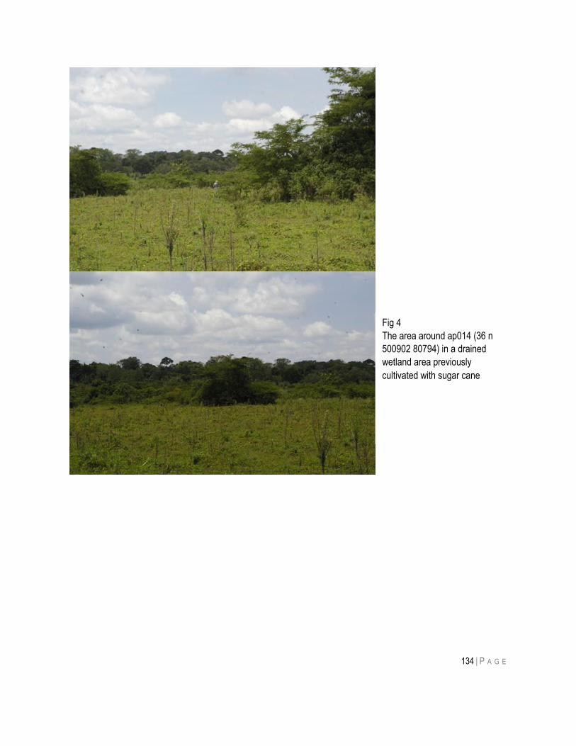
134 | P A G E
Fig 4
The area around ap014 (36 n
500902 80794) in a drained
wetland area previously
cultivated with sugar cane
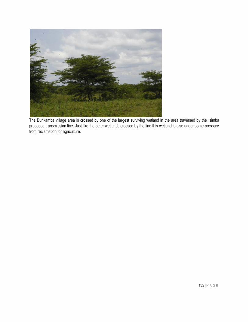
135 | P A G E
The Bunkamba village area is crossed by one of the largest surviving wetland in the area traversed by the Isimba
proposed transmission line. Just like the other wetlands crossed by the line this wetland is also under some pressure
from reclamation for agriculture.
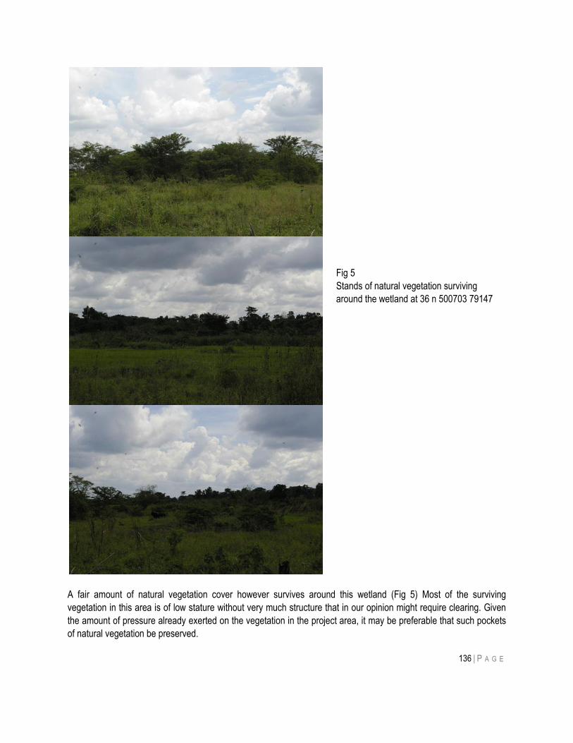
136 | P A G E
A fair amount of natural vegetation cover however survives around this wetland (Fig 5) Most of the surviving
vegetation in this area is of low stature without very much structure that in our opinion might require clearing. Given
the amount of pressure already exerted on the vegetation in the project area, it may be preferable that such pockets
of natural vegetation be preserved.
Fig 5
Stands of natural vegetation surviving
around the wetland at 36 n 500703 79147
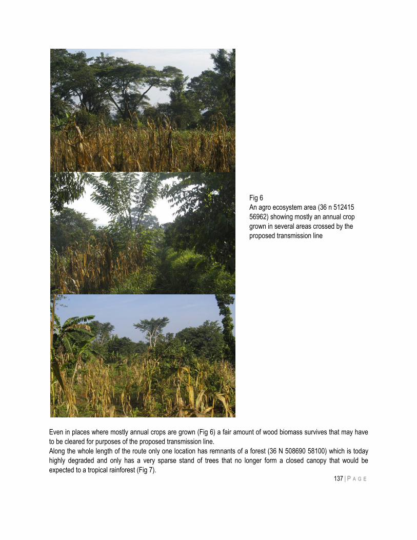
137 | P A G E
Even in places where mostly annual crops are grown (Fig 6) a fair amount of wood biomass survives that may have
to be cleared for purposes of the proposed transmission line.
Along the whole length of the route only one location has remnants of a forest (36 N 508690 58100) which is today
highly degraded and only has a very sparse stand of trees that no longer form a closed canopy that would be
expected to a tropical rainforest (Fig 7).
Fig 6
An agro ecosystem area (36 n 512415
56962) showing mostly an annual crop
grown in several areas crossed by the
proposed transmission line
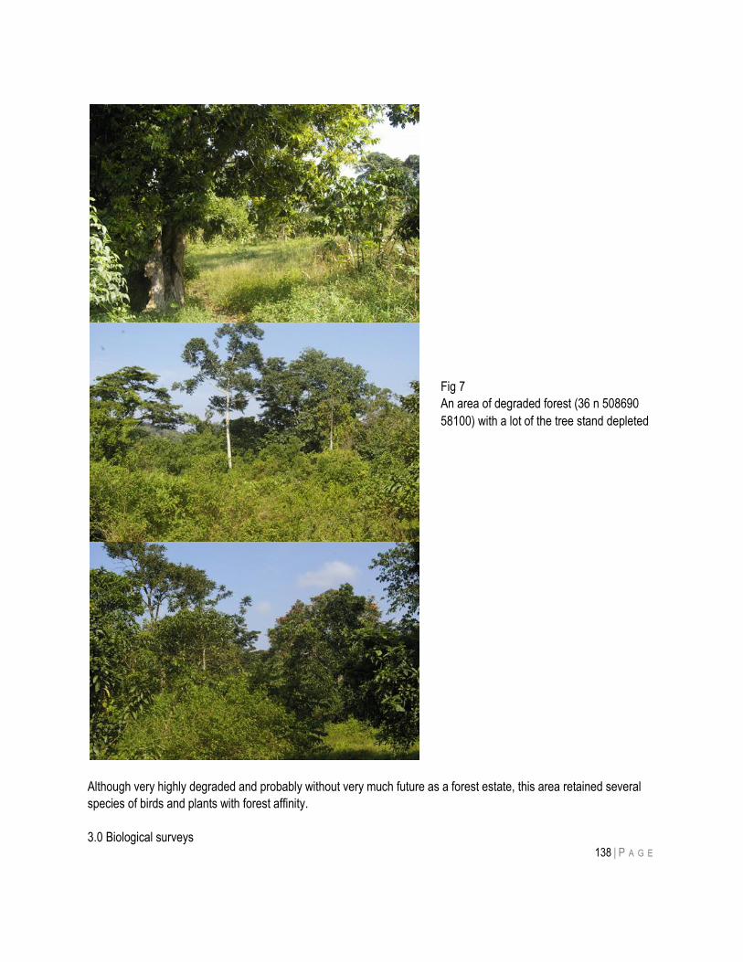
138 | P A G E
Although very highly degraded and probably without very much future as a forest estate, this area retained several
species of birds and plants with forest affinity.
3.0 Biological surveys
Fig 7
An area of degraded forest (36 n 508690
58100) with a lot of the tree stand depleted
139 | P A G E
For purposes of this study the flora and some groups of the fauna (birds and mammals) were surveyed for to use as
a basis for assessing the potential impacts of the proposed transmission line.
3.1 Flora
3.1.1. Methods
Literature about the vegetation, flora, and their conservation status was reviewed beforehand in order to identify the
unique, threatened, rare and other cases of conservation concern species and habitats known to occur in the areas
of the proposed transmission line. At each sample site, the zero point was taken as a central point and an area the
radius of c.100 m surveyed. All species of plants encountered were identified and recorded. The plants that could not
easily be identified in the field were collected as vouchers for subsequent identification and deposition in the
Makerere University Herbarium (MHU). Geographical coordinates and altitude were recorded at every point of
sampling.
3.2 Results
3.2.1 Vegetation Types
Langdale-Brown et al. (1964) and later van Breguel et al. (2011) mapped the area traversed by the proposed
interconnection route as Celtis-Chrysophyllum Semi-Deciduous Forest (Fig. 8). Most of the stretch proposed for
development is now dominated by areas of subsistence farming (Fig. 9) with very little of the natural vegetation
remaining. The cultivation areas are mainly coffee-banana farming systems. These are often intercropped systems
with other crops. They are also intercropped with trees especially Ficus natalensis, Markhamia lutea and Milicia
excelsa. Fig. 10 shows satellite images of some of the sites that were surveyed for the present study.
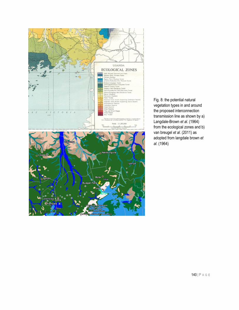
140 | P A G E
Fig. 8: the potential natural
vegetation types in and around
the proposed interconnection
transmission line as shown by a)
Langdale-Brown et al. (1964)
from the ecological zones and b)
van breugel et al. (2011) as
adopted from langdale brown et
al. (1964)
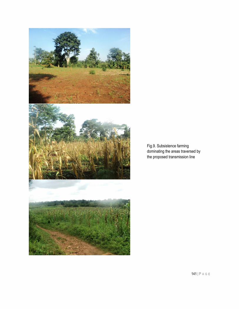
141 | P A G E
Fig.9. Subsistence farming
dominating the areas traversed by
the proposed transmission line
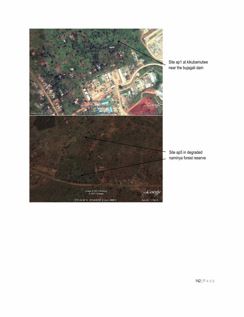
142 | P A G E
Site ap1 at kikubamutwe
near the bujagali dam
Site ap5 in degraded
naminya forest reserve
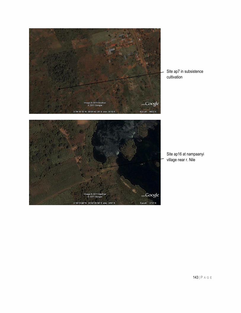
143 | P A G E
Site ap7 in subsistence
cultivation
Site ap16 at nampaanyi
village near r. Nile
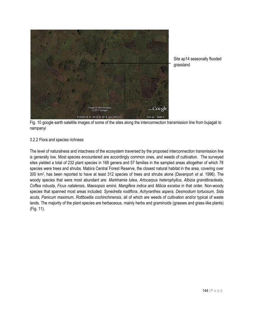
144 | P A G E
Fig. 10 google earth satellite images of some of the sites along the interconnection transmission line from bujagali to
nampanyi
3.2.2 Flora and species richness
The level of naturalness and intactness of the ecosystem traversed by the proposed interconnection transmission line
is generally low. Most species encountered are accordingly common ones, and weeds of cultivation. The surveyed
sites yielded a total of 232 plant species in 168 genera and 57 families in the sampled areas altogether of which 78
species were trees and shrubs. Mabira Central Forest Reserve, the closest natural habitat in the area, covering over
300 km2, has been reported to have at least 312 species of trees and shrubs alone (Davenport et al. 1996). The
woody species that were most abundant are: Markhamia lutea, Artocarpus heterophyllus, Albizia grandibracteata,
Coffea robusta, Ficus natalensis, Maesopsis eminii, Mangifera indica and Milicia excelsa in that order. Non-woody
species that spanned most areas included: Synedrella nodiflora, Achyranthes aspera, Desmodium tortuosum, Sida
acuta, Panicum maximum, Rottboellia cochinchinensis, all of which are weeds of cultivation and/or typical of waste
lands. The majority of the plant species are herbaceous, mainly herbs and graminoids (grasses and grass-like plants)
(Fig. 11).
Site ap14 seasonally flooded
grassland
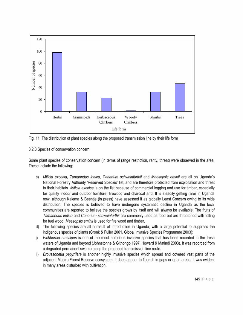
145 | P A G E
Fig. 11. The distribution of plant species along the proposed transmission line by their life form
3.2.3 Species of conservation concern
Some plant species of conservation concern (in terms of range restriction, rarity, threat) were observed in the area.
These include the following:
c) Milicia excelsa, Tamarindus indica, Canarium schweinfurthii and Maesopsis eminii are all on Uganda‟s
National Forestry Authority „Reserved Species‟ list, and are therefore protected from exploitation and threat
to their habitats. Milicia excelsa is on the list because of commercial logging and use for timber, especially
for quality indoor and outdoor furniture, firewood and charcoal and. It is steadily getting rarer in Uganda
now, although Kalema & Beentje (in press) have assessed it as globally Least Concern owing to its wide
distribution. The species is believed to have undergone systematic decline in Uganda as the local
communities are reported to believe the species grows by itself and will always be available. The fruits of
Tamarindus indica and Canarium schweinfurthii are commonly used as food but are threatened with felling
for fuel wood. Maesopsis eminii is used for fire wood and timber.
d) The following species are all a result of introduction in Uganda, with a large potential to suppress the
indigenous species of plants (Cronk & Fuller 2001, Global Invasive Species Programme 2003):
j) Eichhornia crassipes is one of the most notorious invasive species that has been recorded in the fresh
waters of Uganda and beyond (Johnstonne & Githongo 1997, Howard & Matindi 2003). It was recorded from
a degraded permanent swamp along the proposed transmission line route.
ii) Broussonetia papyrifera is another highly invasive species which spread and covered vast parts of the
adjacent Mabira Forest Reserve ecosystem. It does appear to flourish in gaps or open areas. It was evident
in many areas disturbed with cultivation.
0
20
40
60
80
100
120
Herbs Graminoids Herbaceous
Climbers
Woody
Climbers
Shrubs Trees
Life form
Nu
mb
er
of
specie
s
146 | P A G E
iii) Mimosa pigra is a moist ground invasive shrub capable of covering large parts of wetlands once
disturbances are chronic. It proliferates as grazing intensifies.
iv) Lantana camara invades areas that are drier than M. pigra. Both species thrive with disturbance (Cronk &
Fuller 2001). Their presence makes the indigenous flora in any given area susceptible to suppression
effects (Cronk & Fuller 2001, Global Invasive Species Programme 2003). Mimosa pigra is invading many
wetlands in Uganda including Sio-Siteko (Kalema 2008), Lutembe, Mabamba, Nabugabo, Bisina, Nakuwa
wetlands (Kalema 2005), all of which are now Ramsar Sites except Sio-Siteko. Wetland systems in some of
the protected areas have also been invaded by M. pigra, thus: Lake Mburo, Murchison Falls and Queen
Elizabeth National Parks, as well as Ajai, Kyambura and Semliki Wildlife Reserves (Kalema 2005).
v) Xanthium strumarium is another invasive alien steadily spreading, invading a number of places in Uganda. It
was recorded from the Doho Important Bird Area by Kalema (2005).
3.3 The Fauna
3.3.1 The Avifauna
3.3.1.1 Introduction and methods
Birds and other biodiversity have been extensively studied in what is sometimes referred to as the „coffee-banana
arc‟ north of Lake Victoria (Nalwanga, 2011). Although most of the area, including that to be followed by the
proposed transmission line, is cultivated, it retains much wildlife, including birds. Nalwanga recorded 218 species
across 26 sites and similar numbers have been recorded from the on-going Bird Population Monitoring programme,
co-ordinated by NatureUganda (unpubl data). The Uganda Bird Atlas (Carswell et al, 2005) and the Birds of
Kampala (Carswell, 19..) together reflect this diversity; the latter publication, which includes Mabira forest as well as
many wetlands, lists some 550 species for the area. About 200 of these are specialist waterbirds or forest birds, so
Nalwanga recorded just over 60% of the species that might be expected outside forests and wetlands.
Birds are mobile, and in this study were recorded up to half a kilometre from the transmission line route, although
only from habitats which the route passes over at some – or many – points.
The two main habitats – small-holder farms and valley bottoms – were both sampled by one-hour Timed Species
Counts (TSCs, Bibby et al 2000, Freeman et al 200.) This method, which has been widely used in Uganda (e.g,
Pomeroy and Asasira 2011 ) consists of making a list of all the species detected in a particular habitat within the one
hour. Those recorded – whether seen or heard – within the first ten minutes are scored 6, those in the next ten
minutes get 5, and so on. Over a series of counts, as in this case, common species are expected to be recorded in
every count, and often to score 6, whilst those present in only one or two counts, usually with low scores, can be
considered rare. In addition to these counts, made by DP, RK also noted bird species present in the area whilst
moving through similar habitats as DP, and these are noted in Appendix 2 , along with the TSC results, in order to
obtain a more complete picture of the bird communities in each of the two habitats.
In this study, we have made use of existing data from Bujagali [36 N 515383 55276] (National Biodiversity Data
Bank, unpubl), for comparison at a more local level. We averaged the TSC scores for ten counts made between
March 2006 and December 2010. However, this site, like seven of those in the current study, is predominantly
smallholder farms; we have no data for comparison with the three valley bottom sites,
Information on nocturnal species, mainly owls, and on the Grey Crowned Crane, were obtained by questioning local
residents; comparable data were not available for Bujagali.
147 | P A G E
The Scoping Report considered the impact of a new lake on birds of the River Nile and its banks, and made some
useful comments. We have nothing to add to these, but it is important that they be noted, particularly the potential
impact on Rock Pratincoles and the Kalagala Off-set forest (which, however, seems not to be regenerating as was
required under the mitigation measures for the Bujagali HPP project; indeed, there are no signs that it is even being
protected).
3.3.1.2 RESULTS
Including the counts from Bujagali, we recorded 130 species of birds, which are listed in Appendix 2. This compares
with the 218 species found in a much broader study of smallholder farms, as quoted above, and can be considered
an indication of the high species richness of these areas. In more detail, the seven farmland sites produced 94
species, of which 60 were also found at the single Bujagali site (and where a further 25 were recorded that were not
found in the current survey). The three valley bottom sites held 53 species, all but 11 of which were also in the
farmland. Since the valleys are almost completely cultivated, this is not surprising, but there were important
differences.
Farmland sites had numerous trees, including a big variety of native species, such as Markhamia, which was
particularly common, as well as fruit trees such as jackfruit. Many birds depend upon trees for roosting, nesting or
feeding (either because the trees provide food, such as fruits, or perches). As Table 2 shows, 55 species of „tree
birds‟ were recorded, mainly those that are termed „forest visitors‟. There was no real forest along the transmission
line route, but many forest generalist and visitor species are found outside forest in areas with plenty of trees. Thus
cutting of trees along the way-leave will have an adverse effect on these species, proportionate to the numbers
cut. Numbers of species in other categories were relatively small, and the four regionally-listed species are all
widespread – they are the Grey Parrot (R-NT), Spot-flanked Barbet, White-headed Saw-wing and Red-chested
Sunbird, all of regional responsibility). The small number of aerial species (swifts, bee-eaters, swallows) is surprising
but is part of a general trend. There were few open areas of grassland, hence few species of that speciality, and only
7 Afrotropical migrants (a further 5 migrants, from the Palearctic region, were recorded at Bujagali, and would be
expected in these areas too, between about October and March).
Valley bottom sites, of which there were only three, will originally have been seasonal swamps (see section
….) Many of the farmland species occurred here too, because most of the land was cultivated. However, there were
fewer trees and more open grassland (with a few more grassland species). There were also a few more species
associated with wetlands (w), but most of these are widespread and some, such as Tawny-flanked Prinia, were
equally common in farmland, although most were commoner in the valley bottoms. Nevertheless, there was an
overall difference in the species composition of the two communities. In the farmland, of the ten commonest species,
eight were also in the „top ten‟ for Bujagali, only four fell into the top ten for valley bottoms. Thus, whilst both habitats
are important for birds, they differ to a considerable extent in their relative importance for different species, as can be
seen from the mean TSC scores in table 2.
Table 2. Numbers o species of various categories of conservation concern in the two main habitats. In farmland.
A total of 94 species were recorded during 7 counts, whilst 53 species were recorded during three valley bottom
counts. Some species can occur in more than one category; thus, for example, wahlberg‟s eagle is an afrotropical
migrant which needs trees on which to perch and nest.
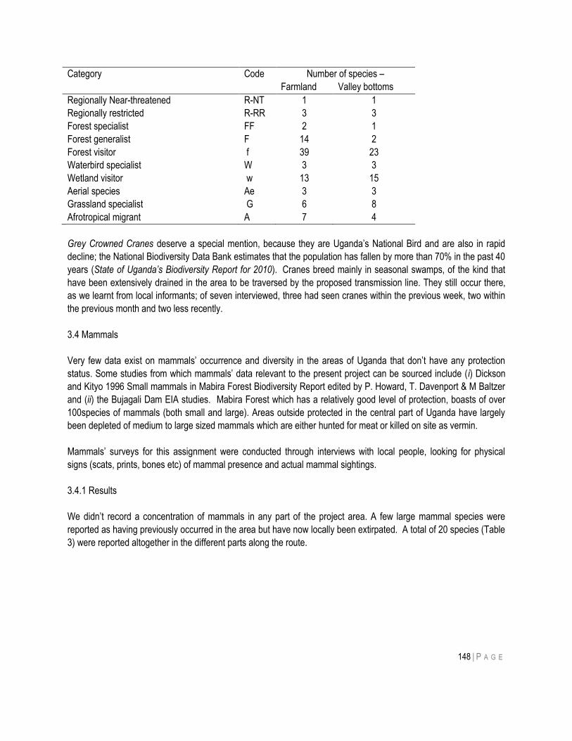
148 | P A G E
Category Code Number of species –
Farmland Valley bottoms
Regionally Near-threatened R-NT 1 1
Regionally restricted R-RR 3 3
Forest specialist FF 2 1
Forest generalist F 14 2
Forest visitor f 39 23
Waterbird specialist W 3 3
Wetland visitor w 13 15
Aerial species Ae 3 3
Grassland specialist G 6 8
Afrotropical migrant A 7 4
Grey Crowned Cranes deserve a special mention, because they are Uganda‟s National Bird and are also in rapid
decline; the National Biodiversity Data Bank estimates that the population has fallen by more than 70% in the past 40
years (State of Uganda’s Biodiversity Report for 2010). Cranes breed mainly in seasonal swamps, of the kind that
have been extensively drained in the area to be traversed by the proposed transmission line. They still occur there,
as we learnt from local informants; of seven interviewed, three had seen cranes within the previous week, two within
the previous month and two less recently.
3.4 Mammals
Very few data exist on mammals‟ occurrence and diversity in the areas of Uganda that don‟t have any protection
status. Some studies from which mammals‟ data relevant to the present project can be sourced include (i) Dickson
and Kityo 1996 Small mammals in Mabira Forest Biodiversity Report edited by P. Howard, T. Davenport & M Baltzer
and (ii) the Bujagali Dam EIA studies. Mabira Forest which has a relatively good level of protection, boasts of over
100species of mammals (both small and large). Areas outside protected in the central part of Uganda have largely
been depleted of medium to large sized mammals which are either hunted for meat or killed on site as vermin.
Mammals‟ surveys for this assignment were conducted through interviews with local people, looking for physical
signs (scats, prints, bones etc) of mammal presence and actual mammal sightings.
3.4.1 Results
We didn‟t record a concentration of mammals in any part of the project area. A few large mammal species were
reported as having previously occurred in the area but have now locally been extirpated. A total of 20 species (Table
3) were reported altogether in the different parts along the route.
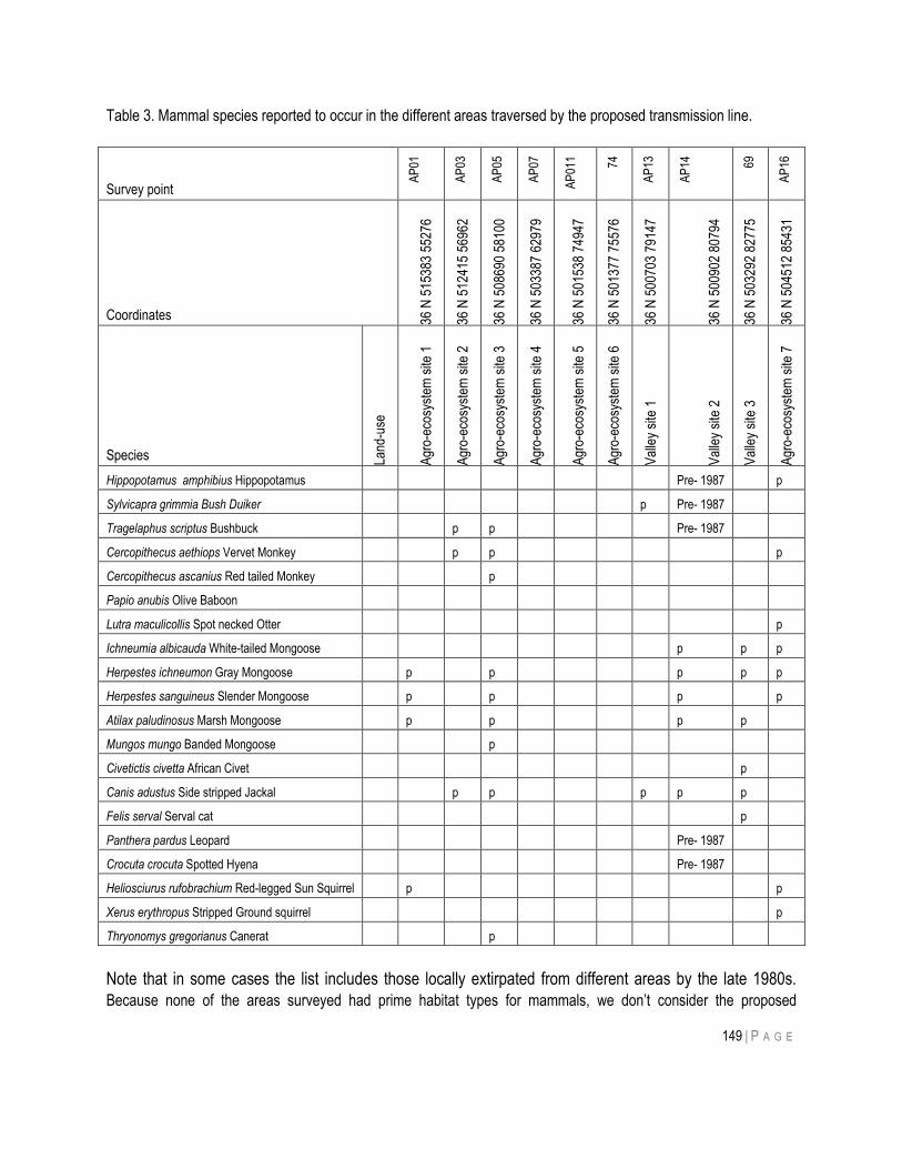
149 | P A G E
Table 3. Mammal species reported to occur in the different areas traversed by the proposed transmission line.
Survey point
AP
01
AP
03
AP
05
AP
07
AP
011 74
AP
13
AP
14
69
AP
16
Coordinates 36 N
515
383
5527
6
36 N
512
415
5696
2
36 N
508
690
5810
0
36 N
503
387
6297
9
36 N
501
538
7494
7
36 N
501
377
7557
6
36 N
500
703
7914
7
36 N
500
902
8079
4
36 N
503
292
8277
5
36 N
504
512
8543
1
Species Land
-use
Agr
o-ec
osys
tem
site
1
Agr
o-ec
osys
tem
site
2
Agr
o-ec
osys
tem
site
3
Agr
o-ec
osys
tem
site
4
Agr
o-ec
osys
tem
site
5
Agr
o-ec
osys
tem
site
6
Val
ley
site
1
Val
ley
site
2
Val
ley
site
3
Agr
o-ec
osys
tem
site
7
Hippopotamus amphibius Hippopotamus Pre- 1987 p
Sylvicapra grimmia Bush Duiker p Pre- 1987
Tragelaphus scriptus Bushbuck p p Pre- 1987
Cercopithecus aethiops Vervet Monkey p p p
Cercopithecus ascanius Red tailed Monkey p
Papio anubis Olive Baboon
Lutra maculicollis Spot necked Otter p
Ichneumia albicauda White-tailed Mongoose p p p
Herpestes ichneumon Gray Mongoose p p p p p
Herpestes sanguineus Slender Mongoose p p p p
Atilax paludinosus Marsh Mongoose p p p p
Mungos mungo Banded Mongoose p
Civetictis civetta African Civet p
Canis adustus Side stripped Jackal p p p p p
Felis serval Serval cat p
Panthera pardus Leopard Pre- 1987
Crocuta crocuta Spotted Hyena Pre- 1987
Heliosciurus rufobrachium Red-legged Sun Squirrel p p
Xerus erythropus Stripped Ground squirrel p
Thryonomys gregorianus Canerat p
Note that in some cases the list includes those locally extirpated from different areas by the late 1980s.
Because none of the areas surveyed had prime habitat types for mammals, we don‟t consider the proposed
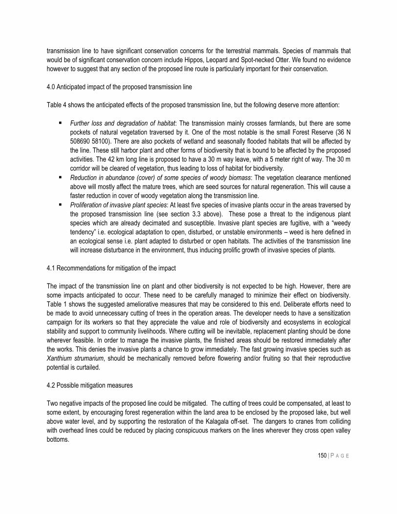
150 | P A G E
transmission line to have significant conservation concerns for the terrestrial mammals. Species of mammals that
would be of significant conservation concern include Hippos, Leopard and Spot-necked Otter. We found no evidence
however to suggest that any section of the proposed line route is particularly important for their conservation.
4.0 Anticipated impact of the proposed transmission line
Table 4 shows the anticipated effects of the proposed transmission line, but the following deserve more attention:
Further loss and degradation of habitat: The transmission mainly crosses farmlands, but there are some
pockets of natural vegetation traversed by it. One of the most notable is the small Forest Reserve (36 N
508690 58100). There are also pockets of wetland and seasonally flooded habitats that will be affected by
the line. These still harbor plant and other forms of biodiversity that is bound to be affected by the proposed
activities. The 42 km long line is proposed to have a 30 m way leave, with a 5 meter right of way. The 30 m
corridor will be cleared of vegetation, thus leading to loss of habitat for biodiversity.
Reduction in abundance (cover) of some species of woody biomass: The vegetation clearance mentioned
above will mostly affect the mature trees, which are seed sources for natural regeneration. This will cause a
faster reduction in cover of woody vegetation along the transmission line.
Proliferation of invasive plant species: At least five species of invasive plants occur in the areas traversed by
the proposed transmission line (see section 3.3 above). These pose a threat to the indigenous plant
species which are already decimated and susceptible. Invasive plant species are fugitive, with a “weedy
tendency” i.e. ecological adaptation to open, disturbed, or unstable environments – weed is here defined in
an ecological sense i.e. plant adapted to disturbed or open habitats. The activities of the transmission line
will increase disturbance in the environment, thus inducing prolific growth of invasive species of plants.
4.1 Recommendations for mitigation of the impact
The impact of the transmission line on plant and other biodiversity is not expected to be high. However, there are
some impacts anticipated to occur. These need to be carefully managed to minimize their effect on biodiversity.
Table 1 shows the suggested ameliorative measures that may be considered to this end. Deliberate efforts need to
be made to avoid unnecessary cutting of trees in the operation areas. The developer needs to have a sensitization
campaign for its workers so that they appreciate the value and role of biodiversity and ecosystems in ecological
stability and support to community livelihoods. Where cutting will be inevitable, replacement planting should be done
wherever feasible. In order to manage the invasive plants, the finished areas should be restored immediately after
the works. This denies the invasive plants a chance to grow immediately. The fast growing invasive species such as
Xanthium strumarium, should be mechanically removed before flowering and/or fruiting so that their reproductive
potential is curtailed.
4.2 Possible mitigation measures
Two negative impacts of the proposed line could be mitigated. The cutting of trees could be compensated, at least to
some extent, by encouraging forest regeneration within the land area to be enclosed by the proposed lake, but well
above water level, and by supporting the restoration of the Kalagala off-set. The dangers to cranes from colliding
with overhead lines could be reduced by placing conspicuous markers on the lines wherever they cross open valley
bottoms.
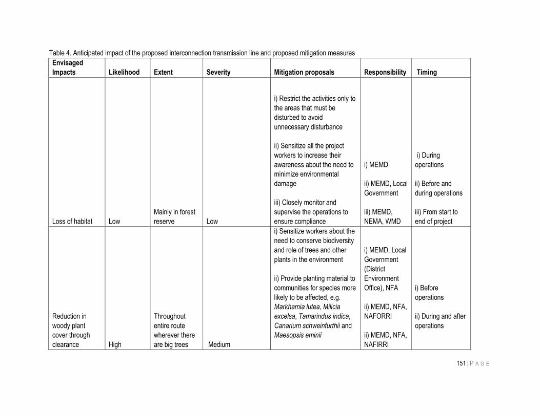
151 | P A G E
Table 4. Anticipated impact of the proposed interconnection transmission line and proposed mitigation measures
Envisaged
Impacts Likelihood Extent Severity Mitigation proposals Responsibility Timing
Loss of habitat Low
Mainly in forest
reserve Low
i) Restrict the activities only to
the areas that must be
disturbed to avoid
unnecessary disturbance
ii) Sensitize all the project
workers to increase their
awareness about the need to
minimize environmental
damage
iii) Closely monitor and
supervise the operations to
ensure compliance
i) MEMD
ii) MEMD, Local
Government
iii) MEMD,
NEMA, WMD
i) During
operations
ii) Before and
during operations
iii) From start to
end of project
Reduction in
woody plant
cover through
clearance High
Throughout
entire route
wherever there
are big trees Medium
i) Sensitize workers about the
need to conserve biodiversity
and role of trees and other
plants in the environment
ii) Provide planting material to
communities for species more
likely to be affected, e.g.
Markhamia lutea, Milicia
excelsa, Tamarindus indica,
Canarium schweinfurthii and
Maesopsis eminii
i) MEMD, Local
Government
(District
Environment
Office), NFA
ii) MEMD, NFA,
NAFORRI
ii) MEMD, NFA,
NAFIRRI
i) Before
operations
ii) During and after
operations
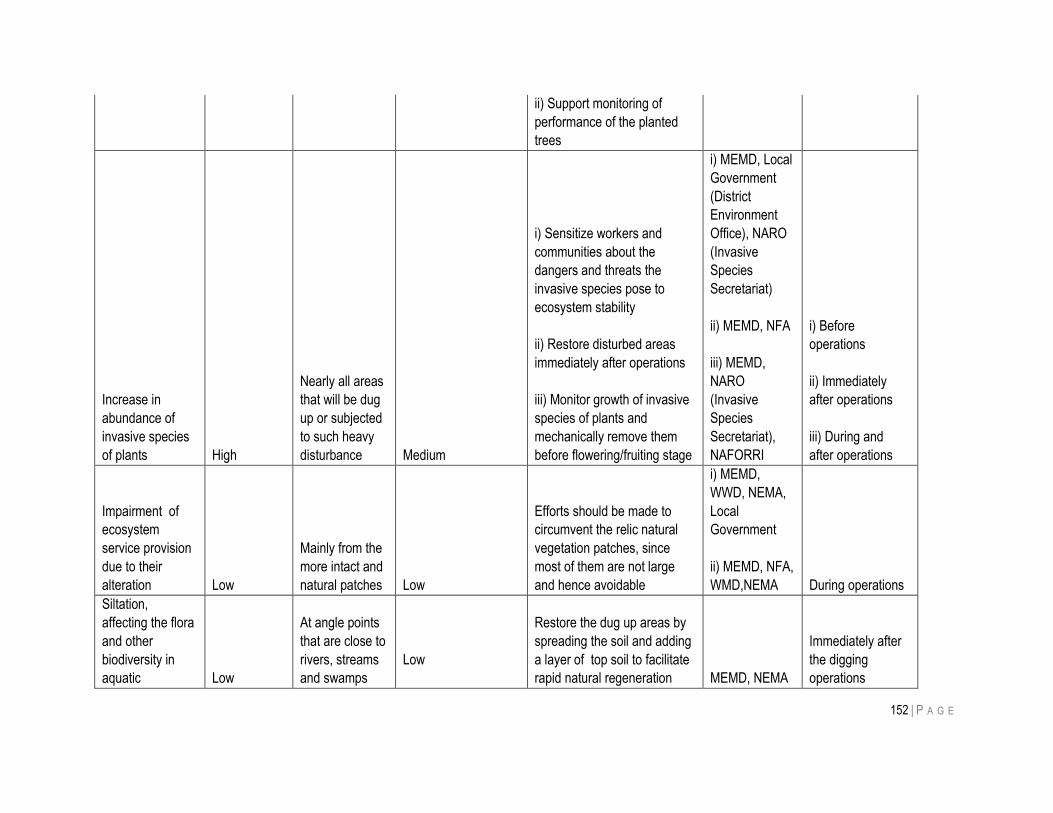
152 | P A G E
ii) Support monitoring of
performance of the planted
trees
Increase in
abundance of
invasive species
of plants High
Nearly all areas
that will be dug
up or subjected
to such heavy
disturbance Medium
i) Sensitize workers and
communities about the
dangers and threats the
invasive species pose to
ecosystem stability
ii) Restore disturbed areas
immediately after operations
iii) Monitor growth of invasive
species of plants and
mechanically remove them
before flowering/fruiting stage
i) MEMD, Local
Government
(District
Environment
Office), NARO
(Invasive
Species
Secretariat)
ii) MEMD, NFA
iii) MEMD,
NARO
(Invasive
Species
Secretariat),
NAFORRI
i) Before
operations
ii) Immediately
after operations
iii) During and
after operations
Impairment of
ecosystem
service provision
due to their
alteration Low
Mainly from the
more intact and
natural patches Low
Efforts should be made to
circumvent the relic natural
vegetation patches, since
most of them are not large
and hence avoidable
i) MEMD,
WWD, NEMA,
Local
Government
ii) MEMD, NFA,
WMD,NEMA During operations
Siltation,
affecting the flora
and other
biodiversity in
aquatic Low
At angle points
that are close to
rivers, streams
and swamps
Low
Restore the dug up areas by
spreading the soil and adding
a layer of top soil to facilitate
rapid natural regeneration MEMD, NEMA
Immediately after
the digging
operations
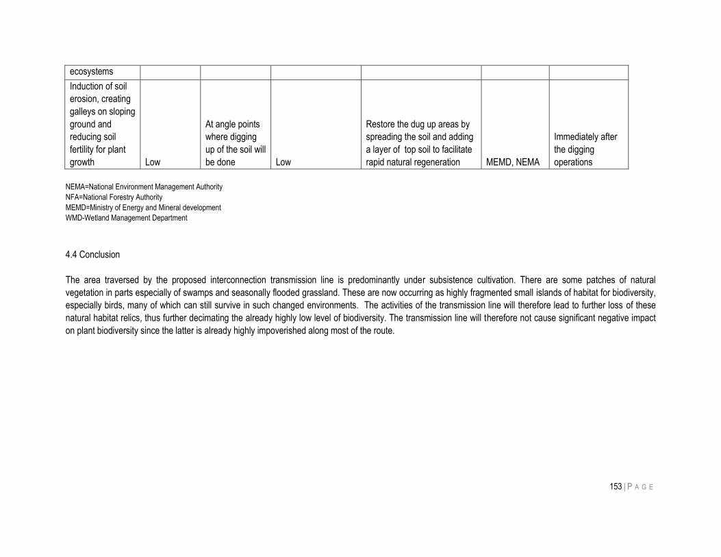
153 | P A G E
ecosystems
Induction of soil
erosion, creating
galleys on sloping
ground and
reducing soil
fertility for plant
growth Low
At angle points
where digging
up of the soil will
be done Low
Restore the dug up areas by
spreading the soil and adding
a layer of top soil to facilitate
rapid natural regeneration MEMD, NEMA
Immediately after
the digging
operations
NEMA=National Environment Management Authority
NFA=National Forestry Authority
MEMD=Ministry of Energy and Mineral development
WMD-Wetland Management Department
4.4 Conclusion
The area traversed by the proposed interconnection transmission line is predominantly under subsistence cultivation. There are some patches of natural
vegetation in parts especially of swamps and seasonally flooded grassland. These are now occurring as highly fragmented small islands of habitat for biodiversity,
especially birds, many of which can still survive in such changed environments. The activities of the transmission line will therefore lead to further loss of these
natural habitat relics, thus further decimating the already highly low level of biodiversity. The transmission line will therefore not cause significant negative impact
on plant biodiversity since the latter is already highly impoverished along most of the route.
154 | P A G E
References
Cronk, Q.C.B. & Fuller, J.L. 1995. Plant invaders. World Wide Fund for Nature (WWF International), Chapman & Hall, UK.
Cronk, C.B.Q & Fuller, J. 2001. Plant Invaders: The threat to natural ecosystems. Earthscan Publications, London, UK.
Davenport, T. Howard, P. & Baltzer, M. (Eds) 1996. Mabira Forest Reserve Biodiversity report. Forest Department, Kampala,
Uganda.
Duggin J.A. and Gentle C.B. (1998). Experimental evidence on the importance of disturbance intensity for invasion of Lantana
camara L. in dry rainforest–open forest ecotones in north-eastern NSW, Australia. Forest Ecology and Management,
109, 279–292.
Global Invasive Species Programme 2003. The IAS problem The Global Invasive Species Programme.
http://www.gisp.org/about/IAS.asp. Accessed 2010.
Howard, G. (2009). The invasive species context: general principles. Workshop on biofuel production and invasive species,
IUCN Wasaa, Nairobi, Kenya
Howard, G.W. & Matindi, S.E. 2003. Alien invasive species in Africa’s wetlands: some threats and solutions. IUCN Eastern Africa
Regional Programme, Nairobi, Kenya.
Johnstonne, F. & Githongo, J. 1997. Killer weed. SWARA, 20(4):28-29
Kalema, J. & Beentje, H.J. (in press). The trees of Uganda: conservation status and a checklist. Royal Botanic Gardens, Kew,
England
Kalema, J. 2005a. Diversity and distribution of vascular plants in the wetland and dryland Important Bird Areas of Uganda. Ph.D.
thesis, Makerere University, Kampala, Uganda.
Kalema, J. 2008. Assessment of plants of the Sio-Siteko wetland system, a trans-boundary ecosystem in the Busia Districts of
Uganda and Kenya. Unpublished report to the Nile Basin Initiative for Management planning of the Sio-Siteko Wetland
System.
Kalema, J., Namaganda, M., Ssegawa, P., Kabuye, C., Maganyi, O. & Muncuguzi, P. 2010. Status of higher plants in Uganda.
In: J.B. Kaddu & H. Busuulwa (Eds.) Baseline report on state of biodiversity in the Nile Uganda 2010. Wetlands and
Biodiversity Conservation Component of the Nile Transboundary Environmental Action Project. Nile Basin Initiative
Secretariat.
Langdale-Brown, I., Osmaston, H.A. & Wilson, J.G. 1964. The vegetation of Uganda and its bearing on land uses. Uganda
Government Printer, Entebbe.
National Environment Management Authority 2007. 2006/07State of Environment Report for Uganda, NEMA, Kampala. 332pp.
National Wetlands Conservation and Management Programme 1996. Wetland Status Report for Kampala, Ministry of Natural
Resources, Kampala.
Pomeroy, D. & Asasira, J. 2011. Monitoring bird populations in Uganda – the first 25 years. pp. 113–119. In: Harebottle, D.M.,
Craig, A.J.F.K., Anderson, M.D., Rakotomanana, H. & Muchai, M. (eds). Proceedings of the 12th Pan-African
Ornithological Congress, 2008. Cape Town, Animal Demography Unit. ISBN: 978-0-7992-2361-3.
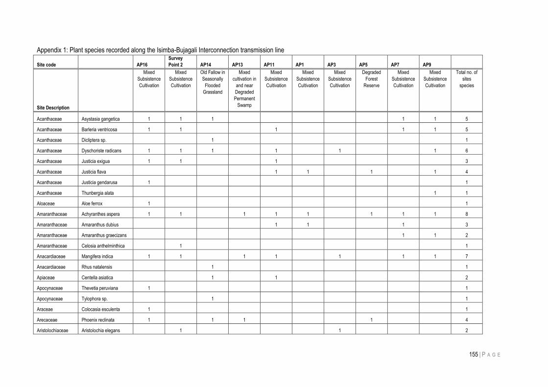
155 | P A G E
Appendix 1: Plant species recorded along the Isimba-Bujagali Interconnection transmission line
Site code AP16
Survey
Point 2 AP14 AP13 AP11 AP1 AP3 AP5 AP7 AP9
Site Description
Mixed
Subsistence
Cultivation
Mixed
Subsistence
Cultivation
Old Fallow in
Seasonally
Flooded
Grassland
Mixed
cultivation in
and near
Degraded
Permanent
Swamp
Mixed
Subsistence
Cultivation
Mixed
Subsistence
Cultivation
Mixed
Subsistence
Cultivation
Degraded
Forest
Reserve
Mixed
Subsistence
Cultivation
Mixed
Subsistence
Cultivation
Total no. of
sites
species
Acanthaceae Asystasia gangetica 1 1 1
1 1 5
Acanthaceae Barleria ventricosa 1 1
1
1 1 5
Acanthaceae Dicliptera sp.
1
1
Acanthaceae Dyschoriste radicans 1 1 1
1
1
1 6
Acanthaceae Justicia exigua 1 1
1
3
Acanthaceae Justicia flava
1 1
1
1 4
Acanthaceae Justicia gendarusa 1
1
Acanthaceae Thunbergia alata
1 1
Aloaceae Aloe ferrox 1
1
Amaranthaceae Achyranthes aspera 1 1
1 1 1
1 1 1 8
Amaranthaceae Amaranthus dubius
1 1
1
3
Amaranthaceae Amaranthus graecizans
1 1 2
Amaranthaceae Celosia anthelminthica
1
1
Anacardiaceae Mangifera indica 1 1
1 1
1
1 1 7
Anacardiaceae Rhus natalensis
1
1
Apiaceae Centella asiatica
1
1
2
Apocynaceae Thevetia peruviana 1
1
Apocynaceae Tylophora sp.
1
1
Araceae Colocasia esculenta 1
1
Arecaceae Phoenix reclinata 1
1 1
1
4
Aristolochiaceae Aristolochia elegans
1
1
2
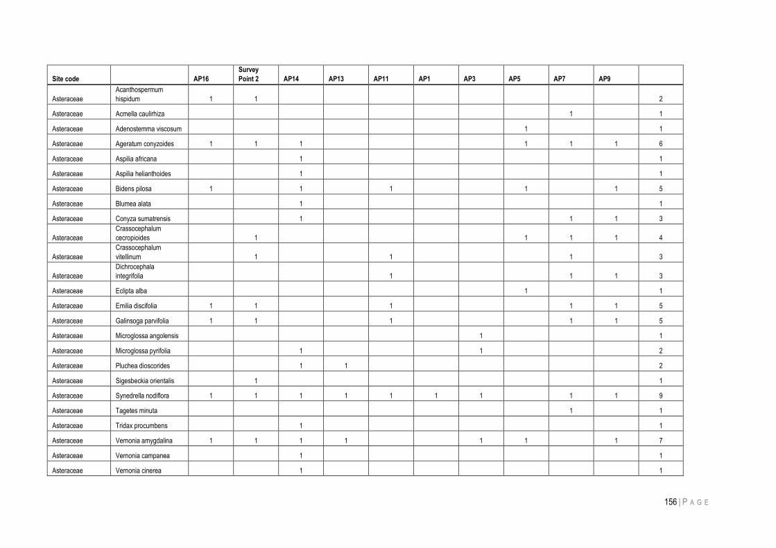
156 | P A G E
Site code AP16
Survey
Point 2 AP14 AP13 AP11 AP1 AP3 AP5 AP7 AP9
Asteraceae
Acanthospermum
hispidum 1 1
2
Asteraceae Acmella caulirhiza
1
1
Asteraceae Adenostemma viscosum
1
1
Asteraceae Ageratum conyzoides 1 1 1
1 1 1 6
Asteraceae Aspilia africana
1
1
Asteraceae Aspilia helianthoides
1
1
Asteraceae Bidens pilosa 1
1
1
1
1 5
Asteraceae Blumea alata
1
1
Asteraceae Conyza sumatrensis
1
1 1 3
Asteraceae
Crassocephalum
cecropioides
1
1 1 1 4
Asteraceae
Crassocephalum
vitellinum
1
1
1
3
Asteraceae
Dichrocephala
integrifolia
1
1 1 3
Asteraceae Eclipta alba
1
1
Asteraceae Emilia discifolia 1 1
1
1 1 5
Asteraceae Galinsoga parvifolia 1 1
1
1 1 5
Asteraceae Microglossa angolensis
1
1
Asteraceae Microglossa pyrifolia
1
1
2
Asteraceae Pluchea dioscorides
1 1
2
Asteraceae Sigesbeckia orientalis
1
1
Asteraceae Synedrella nodiflora 1 1 1 1 1 1 1
1 1 9
Asteraceae Tagetes minuta
1
1
Asteraceae Tridax procumbens
1
1
Asteraceae Vernonia amygdalina 1 1 1 1
1 1
1 7
Asteraceae Vernonia campanea
1
1
Asteraceae Vernonia cinerea
1
1
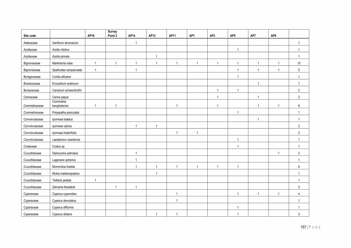
157 | P A G E
Site code AP16
Survey
Point 2 AP14 AP13 AP11 AP1 AP3 AP5 AP7 AP9
Asteraceae Xanthium strumarium
1
1
Azollaceae Azolla nilotica
1
1
Azollaceae Azolla pinnata
1
1
Bignoniaceae Markhamia lutea 1 1 1 1 1 1 1 1 1 1 10
Bignoniaceae Spathodea campanulata 1
1
1 1 1 5
Boraginaceae Cordia africana
1
1
Brassicaceae Erucastrum arabicum
1
1
Burseraceae Canarium schweinfurthii
1 1
2
Caricaceae Carica papya
1
1
2
Commelinaceae
Commelina
benghalensis 1 1
1
1
1 1 6
Commelinaceae Polyspatha paniculata
1
1
Convolvulaceae Ipomoea batatus
1
1
Convolvulaceae Ipomoea cairica
1 1
2
Convolvulaceae Ipomoea hederifolia
1 1
2
Convolvulaceae Lepistemon owariensis
1
1
Costaceae Costus sp.
1
1
Cucurbitaceae Diplocyclos palmatus
1
1 2
Cucurbitaceae Lagenaria spherica
1
1
Cucurbitaceae Momordica foetida
1 1 1 1 1 1
6
Cucurbitaceae Mukia maderaspatana
1
1
Cucurbitaceae Telfairia pedata 1
1
Cucurbitaceae Zehneria thwaitesii
1 1
2
Cyperaceae Cyperus cyperoides
1
1 1 1 4
Cyperaceae Cyperus denudatus
1
1
Cyperaceae Cyperus difformis
1
1
Cyperaceae Cyperus distans
1 1
1
3
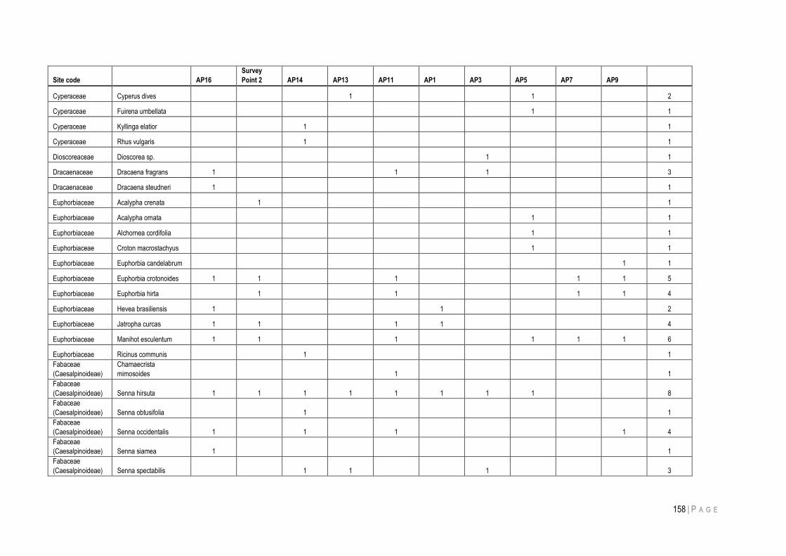
158 | P A G E
Site code AP16
Survey
Point 2 AP14 AP13 AP11 AP1 AP3 AP5 AP7 AP9
Cyperaceae Cyperus dives
1
1
2
Cyperaceae Fuirena umbellata
1
1
Cyperaceae Kyllinga elatior
1
1
Cyperaceae Rhus vulgaris
1
1
Dioscoreaceae Dioscorea sp.
1
1
Dracaenaceae Dracaena fragrans 1
1
1
3
Dracaenaceae Dracaena steudneri 1
1
Euphorbiaceae Acalypha crenata
1
1
Euphorbiaceae Acalypha ornata
1
1
Euphorbiaceae Alchornea cordifolia
1
1
Euphorbiaceae Croton macrostachyus
1
1
Euphorbiaceae Euphorbia candelabrum
1 1
Euphorbiaceae Euphorbia crotonoides 1 1
1
1 1 5
Euphorbiaceae Euphorbia hirta
1
1
1 1 4
Euphorbiaceae Hevea brasiliensis 1
1
2
Euphorbiaceae Jatropha curcas 1 1
1 1
4
Euphorbiaceae Manihot esculentum 1 1
1
1 1 1 6
Euphorbiaceae Ricinus communis
1
1
Fabaceae
(Caesalpinoideae)
Chamaecrista
mimosoides
1
1
Fabaceae
(Caesalpinoideae) Senna hirsuta 1 1 1 1 1 1 1 1
8
Fabaceae
(Caesalpinoideae) Senna obtusifolia
1
1
Fabaceae
(Caesalpinoideae) Senna occidentalis 1
1
1
1 4
Fabaceae
(Caesalpinoideae) Senna siamea 1
1
Fabaceae
(Caesalpinoideae) Senna spectabilis
1 1
1
3
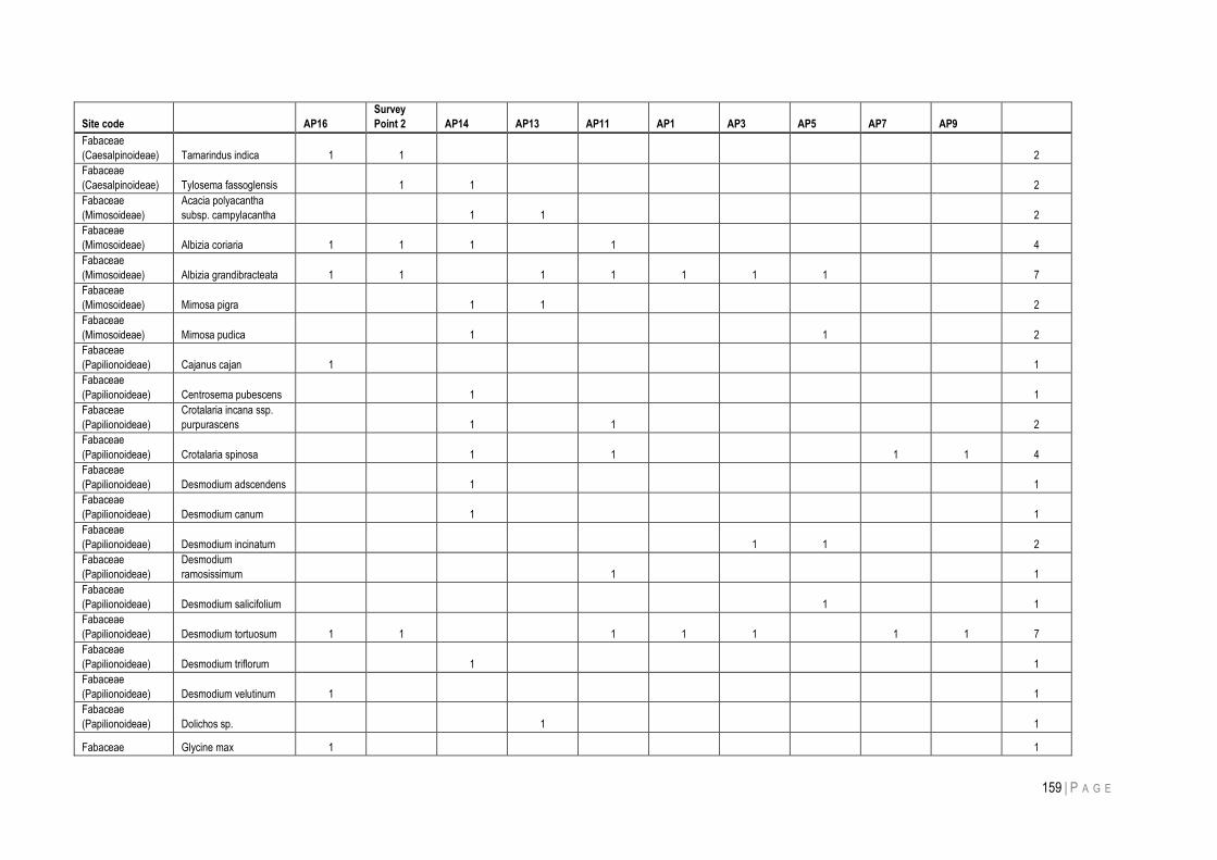
159 | P A G E
Site code AP16
Survey
Point 2 AP14 AP13 AP11 AP1 AP3 AP5 AP7 AP9
Fabaceae
(Caesalpinoideae) Tamarindus indica 1 1
2
Fabaceae
(Caesalpinoideae) Tylosema fassoglensis
1 1
2
Fabaceae
(Mimosoideae)
Acacia polyacantha
subsp. campylacantha
1 1
2
Fabaceae
(Mimosoideae) Albizia coriaria 1 1 1
1
4
Fabaceae
(Mimosoideae) Albizia grandibracteata 1 1
1 1 1 1 1
7
Fabaceae
(Mimosoideae) Mimosa pigra
1 1
2
Fabaceae
(Mimosoideae) Mimosa pudica
1
1
2
Fabaceae
(Papilionoideae) Cajanus cajan 1
1
Fabaceae
(Papilionoideae) Centrosema pubescens
1
1
Fabaceae
(Papilionoideae)
Crotalaria incana ssp.
purpurascens
1
1
2
Fabaceae
(Papilionoideae) Crotalaria spinosa
1
1
1 1 4
Fabaceae
(Papilionoideae) Desmodium adscendens
1
1
Fabaceae
(Papilionoideae) Desmodium canum
1
1
Fabaceae
(Papilionoideae) Desmodium incinatum
1 1
2
Fabaceae
(Papilionoideae)
Desmodium
ramosissimum
1
1
Fabaceae
(Papilionoideae) Desmodium salicifolium
1
1
Fabaceae
(Papilionoideae) Desmodium tortuosum 1 1
1 1 1
1 1 7
Fabaceae
(Papilionoideae) Desmodium triflorum
1
1
Fabaceae
(Papilionoideae) Desmodium velutinum 1
1
Fabaceae
(Papilionoideae) Dolichos sp.
1
1
Fabaceae Glycine max 1
1
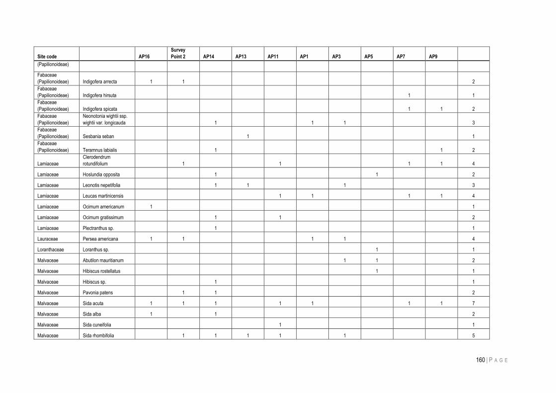
160 | P A G E
Site code AP16
Survey
Point 2 AP14 AP13 AP11 AP1 AP3 AP5 AP7 AP9
(Papilionoideae)
Fabaceae
(Papilionoideae) Indigofera arrecta 1 1
2
Fabaceae
(Papilionoideae) Indigofera hirsuta
1
1
Fabaceae
(Papilionoideae) Indigofera spicata
1 1 2
Fabaceae
(Papilionoideae)
Neonotonia wightii ssp.
wightii var. longicauda
1
1 1
3
Fabaceae
(Papilionoideae) Sesbania seban
1
1
Fabaceae
(Papilionoideae) Teramnus labialis
1
1 2
Lamiaceae
Clerodendrum
rotundifolium
1
1
1 1 4
Lamiaceae Hoslundia opposita
1
1
2
Lamiaceae Leonotis nepetifolia
1 1
1
3
Lamiaceae Leucas martinicensis
1 1
1 1 4
Lamiaceae Ocimum americanum 1
1
Lamiaceae Ocimum gratissimum
1
1
2
Lamiaceae Plectranthus sp.
1
1
Lauraceae Persea americana 1 1
1 1
4
Loranthaceae Loranthus sp.
1
1
Malvaceae Abutilon mauritianum
1 1
2
Malvaceae Hibiscus rostellatus
1
1
Malvaceae Hibiscus sp.
1
1
Malvaceae Pavonia patens
1 1
2
Malvaceae Sida acuta 1 1 1
1 1
1 1 7
Malvaceae Sida alba 1
1
2
Malvaceae Sida cuneifolia
1
1
Malvaceae Sida rhombifolia
1 1 1 1
1
5
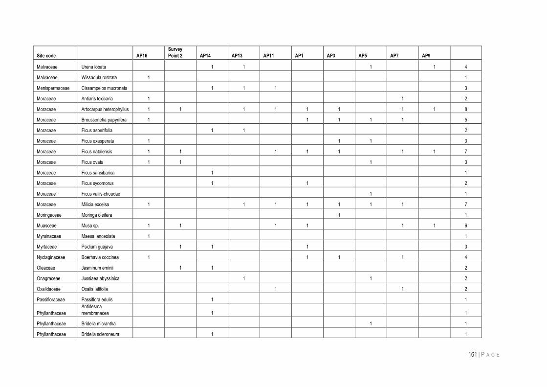
161 | P A G E
Site code AP16
Survey
Point 2 AP14 AP13 AP11 AP1 AP3 AP5 AP7 AP9
Malvaceae Urena lobata
1 1
1
1 4
Malvaceae Wissadula rostrata 1
1
Menispermaceae Cissampelos mucronata
1 1 1
3
Moraceae Antiaris toxicaria 1
1
2
Moraceae Artocarpus heterophyllus 1 1
1 1 1 1
1 1 8
Moraceae Broussonetia papyrifera 1
1 1 1 1
5
Moraceae Ficus asperifolia
1 1
2
Moraceae Ficus exasperata 1
1 1
3
Moraceae Ficus natalensis 1 1
1 1 1
1 1 7
Moraceae Ficus ovata 1 1
1
3
Moraceae Ficus sansibarica
1
1
Moraceae Ficus sycomorus
1
1
2
Moraceae Ficus vallis-choudae
1
1
Moraceae Milicia excelsa 1
1 1 1 1 1 1
7
Moringaceae Moringa oleifera
1
1
Muasceae Musa sp. 1 1
1 1
1 1 6
Myrsinaceae Maesa lanceolata 1
1
Myrtaceae Psidium guajava
1 1
1
3
Nyctaginaceae Boerhavia coccinea 1
1 1
1
4
Oleaceae Jasminum eminii
1 1
2
Onagraceae Jussiaea abyssinica
1
1
2
Oxalidaceae Oxalis latifolia
1
1
2
Passifloraceae Passiflora edulis
1
1
Phyllanthaceae
Antidesma
membranacea
1
1
Phyllanthaceae Bridelia micrantha
1
1
Phyllanthaceae Bridelia scleroneura
1
1
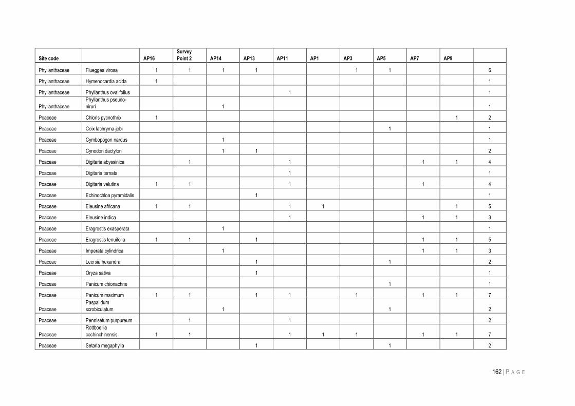
162 | P A G E
Site code AP16
Survey
Point 2 AP14 AP13 AP11 AP1 AP3 AP5 AP7 AP9
Phyllanthaceae Flueggea virosa 1 1 1 1
1 1
6
Phyllanthaceae Hymenocardia acida 1
1
Phyllanthaceae Phyllanthus ovalifolius
1
1
Phyllanthaceae
Phyllanthus pseudo-
niruri
1
1
Poaceae Chloris pycnothrix 1
1 2
Poaceae Coix lachryma-jobi
1
1
Poaceae Cymbopogon nardus
1
1
Poaceae Cynodon dactylon
1 1
2
Poaceae Digitaria abyssinica
1
1
1 1 4
Poaceae Digitaria ternata
1
1
Poaceae Digitaria velutina 1 1
1
1
4
Poaceae Echinochloa pyramidalis
1
1
Poaceae Eleusine africana 1 1
1 1
1 5
Poaceae Eleusine indica
1
1 1 3
Poaceae Eragrostis exasperata
1
1
Poaceae Eragrostis tenuifolia 1 1
1
1 1 5
Poaceae Imperata cylindrica
1
1 1 3
Poaceae Leersia hexandra
1
1
2
Poaceae Oryza sativa
1
1
Poaceae Panicum chionachne
1
1
Poaceae Panicum maximum 1 1
1 1
1
1 1 7
Poaceae
Paspalidum
scrobiculatum
1
1
2
Poaceae Pennisetum purpureum
1
1
2
Poaceae
Rottboellia
cochinchinensis 1 1
1 1 1
1 1 7
Poaceae Setaria megaphylla
1
1
2
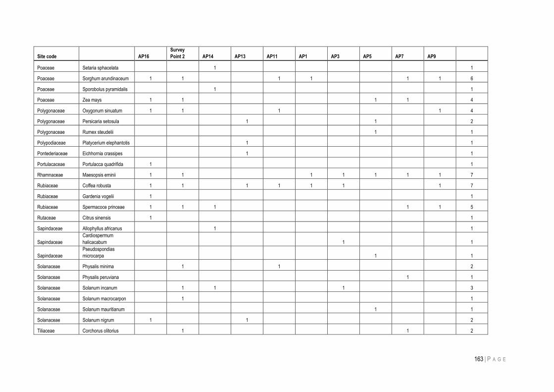
163 | P A G E
Site code AP16
Survey
Point 2 AP14 AP13 AP11 AP1 AP3 AP5 AP7 AP9
Poaceae Setaria sphacelata
1
1
Poaceae Sorghum arundinaceum 1 1
1 1
1 1 6
Poaceae Sporobolus pyramidalis
1
1
Poaceae Zea mays 1 1
1 1
4
Polygonaceae Oxygonum sinuatum 1 1
1
1 4
Polygonaceae Persicaria setosula
1
1
2
Polygonaceae Rumex steudelii
1
1
Polypodiaceae Platycerium elephantotis
1
1
Pontederiaceae Eichhornia crassipes
1
1
Portulacaceae Portulacca quadrifida 1
1
Rhamnaceae Maesopsis eminii 1 1
1 1 1 1 1 7
Rubiaceae Coffea robusta 1 1
1 1 1 1
1 7
Rubiaceae Gardenia vogelii 1
1
Rubiaceae Spermacoce princeae 1 1 1
1 1 5
Rutaceae Citrus sinensis 1
1
Sapindaceae Allophyllus africanus
1
1
Sapindaceae
Cardiospermum
halicacabum
1
1
Sapindaceae
Pseudospondias
microcarpa
1
1
Solanaceae Physalis minima
1
1
2
Solanaceae Physalis peruviana
1
1
Solanaceae Solanum incanum
1 1
1
3
Solanaceae Solanum macrocarpon
1
1
Solanaceae Solanum mauritianum
1
1
Solanaceae Solanum nigrum 1
1
2
Tiliaceae Corchorus olitorius
1
1
2
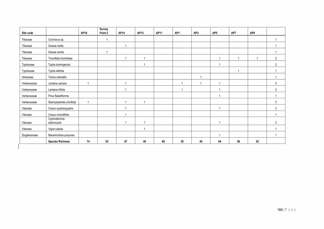
164 | P A G E
Site code AP16
Survey
Point 2 AP14 AP13 AP11 AP1 AP3 AP5 AP7 AP9
Tiliaceae Corchorus sp.
1
1
Tiliaceae Grewia mollis
1
1
Tiliaceae Grewia similis
1
1
Tiliaceae Triumfetta rhombidea
1 1
1 1 1 5
Typhaceae Typha domingensis
1
1
2
Typhaceae Typha latifolia
1
1
Ulmaceae Trema orientalis
1
1
Verbenaceae Lantana camara 1
1
1 1 1
5
Verbenaceae Lantana trifolia
1
1
1
3
Verbenaceae Priva flabelliformis
1
1
Verbenaceae Stachytarpheta urticifolia 1
1 1
3
Vitaceae Cissus quadrangularis
1
1
2
Vitaceae Cissus rotundifolia
1
1
Vitaceae
Cyphostemma
adenocaule
1 1
1
3
Vitaceae Vigna luteola
1
1
Zingiberaceae Marantochloa purpurea
1
1
Species Richness 74 63 87 46 60 30 40 64 56 52
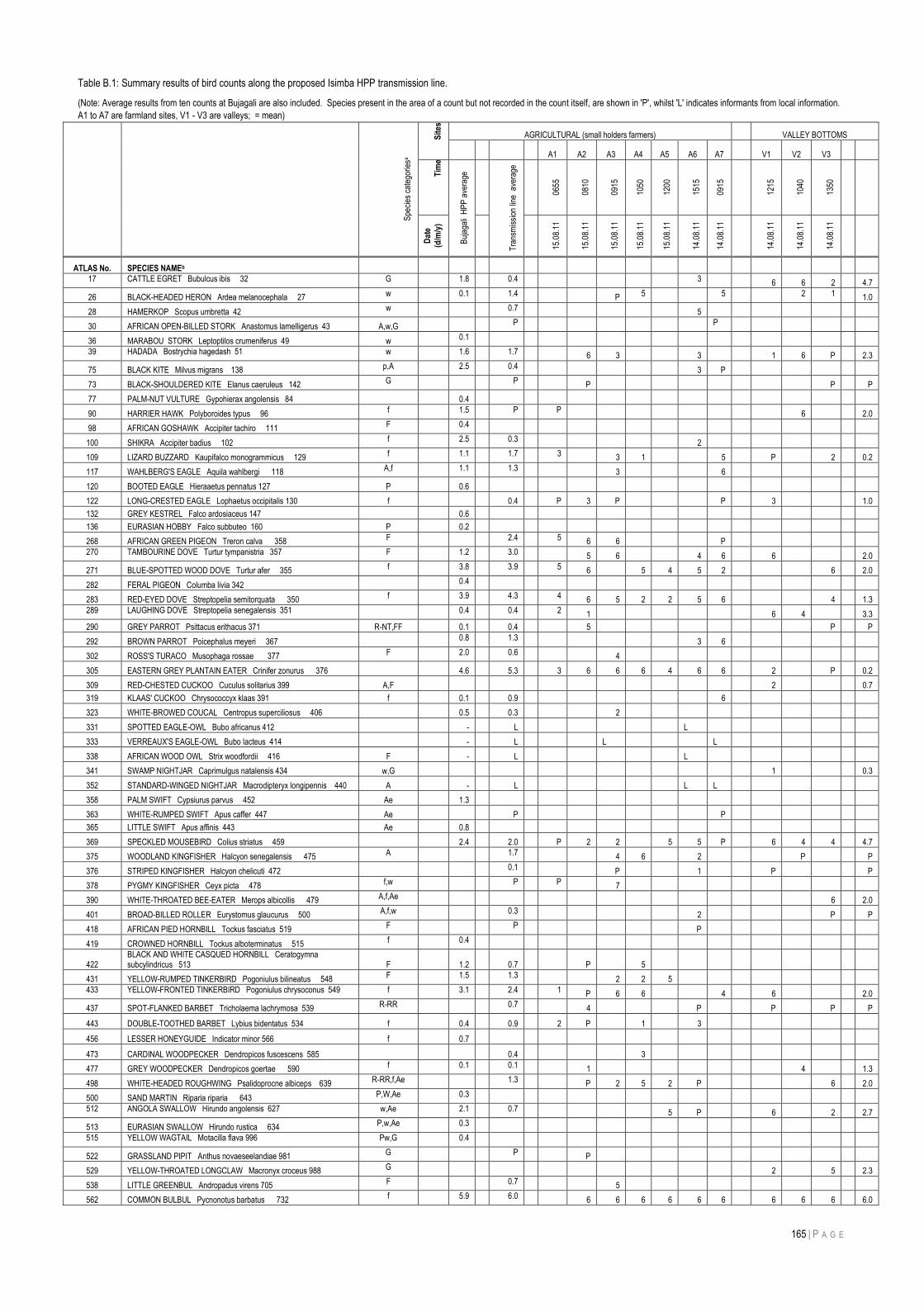
165 | P A G E
Table B.1: Summary results of bird counts along the proposed Isimba HPP transmission line.
(Note: Average results from ten counts at Bujagali are also included. Species present in the area of a count but not recorded in the count itself, are shown in 'P', whilst 'L' indicates informants from local information.
A1 to A7 are farmland sites, V1 - V3 are valleys; = mean)
Spe
cies
cat
egor
iesa
Sit
es
AGRICULTURAL (small holders farmers) VALLEY BOTTOMS
A1 A2 A3 A4 A5 A6 A7
V1 V2 V3
Tim
e
Buj
agal
i H
PP
ave
rage
Tra
nsm
issi
on li
ne a
vera
ge
0655
0810
0915
1050
1200
1515
0915
1215
1040
1350
Dat
e
(d/m
/y)
15.0
8.11
15.0
8.11
15.0
8.11
15.0
8.11
15.0
8.11
14.0
8.11
14.0
8.11
14.0
8.11
14.0
8.11
14.0
8.11
ATLAS No. SPECIES NAMEb
17 CATTLE EGRET Bubulcus ibis 32 G 1.8 0.4
3
6 6 2
4.7
26 BLACK-HEADED HERON Ardea melanocephala 27 w 0.1 1.4
P 5
5 2 1 1.0
28 HAMERKOP Scopus umbretta 42 w 0.7
5
30 AFRICAN OPEN-BILLED STORK Anastomus lamelligerus 43 A,w,G
P
P
36 MARABOU STORK Leptoptilos crumeniferus 49 w
0.1
39 HADADA Bostrychia hagedash 51 w 1.6 1.7 6 3
3
1 6 P
2.3
75 BLACK KITE Milvus migrans 138 p,A 2.5 0.4
3 P
73 BLACK-SHOULDERED KITE Elanus caeruleus 142 G P P
P
P
77 PALM-NUT VULTURE Gypohierax angolensis 84
0.4
90 HARRIER HAWK Polyboroides typus 96 f 1.5 P P
6
2.0
98 AFRICAN GOSHAWK Accipiter tachiro 111 F 0.4
100 SHIKRA Accipiter badius 102 f 2.5 0.3
2
109 LIZARD BUZZARD Kaupifalco monogrammicus 129 f 1.1 1.7 3
3 1
5 P
2
0.2
117 WAHLBERG'S EAGLE Aquila wahlbergi 118 A,f 1.1 1.3
3
6
120 BOOTED EAGLE Hieraaetus pennatus 127 P
0.6
122 LONG-CRESTED EAGLE Lophaetus occipitalis 130 f
0.4
P 3 P
P 3
1.0
132 GREY KESTREL Falco ardosiaceus 147
0.6
136 EURASIAN HOBBY Falco subbuteo 160 P
0.2
268 AFRICAN GREEN PIGEON Treron calva 358 F 2.4 5 6 6
P
270 TAMBOURINE DOVE Turtur tympanistria 357 F 1.2 3.0 5 6
4 6 6
2.0
271 BLUE-SPOTTED WOOD DOVE Turtur afer 355 f 3.8 3.9 5 6
5 4 5 2
6
2.0
282 FERAL PIGEON Columba livia 342 0.4
283 RED-EYED DOVE Streptopelia semitorquata 350 f 3.9 4.3 4 6 5 2 2 5 6
4
1.3
289 LAUGHING DOVE Streptopelia senegalensis 351 0.4 0.4 2 1
6 4
3.3
290 GREY PARROT Psittacus erithacus 371 R-NT,FF
0.1
0.4
5
P
P
292 BROWN PARROT Poicephalus meyeri 367 0.8 1.3
3 6
302 ROSS'S TURACO Musophaga rossae 377 F 2.0 0.6
4
305 EASTERN GREY PLANTAIN EATER Crinifer zonurus 376
4.6
5.3
3 6 6 6 4 6 6 2
P
0.2
309 RED-CHESTED CUCKOO Cuculus solitarius 399 A,F
2
0.7
319 KLAAS' CUCKOO Chrysococcyx klaas 391 f
0.1
0.9
6
323 WHITE-BROWED COUCAL Centropus superciliosus 406
0.5
0.3
2
331 SPOTTED EAGLE-OWL Bubo africanus 412
-
L
L
333 VERREAUX'S EAGLE-OWL Bubo lacteus 414
-
L
L
L
338 AFRICAN WOOD OWL Strix woodfordii 416 F
-
L
L
341 SWAMP NIGHTJAR Caprimulgus natalensis 434 w,G
1
0.3
352 STANDARD-WINGED NIGHTJAR Macrodipteryx longipennis 440 A
-
L
L L
358 PALM SWIFT Cypsiurus parvus 452 Ae
1.3
363 WHITE-RUMPED SWIFT Apus caffer 447 Ae
P
P
365 LITTLE SWIFT Apus affinis 443 Ae
0.8
369 SPECKLED MOUSEBIRD Colius striatus 459
2.4
2.0
P 2 2
5 5 P 6 4 4
4.7
375 WOODLAND KINGFISHER Halcyon senegalensis 475 A 1.7
4 6
2
P
P
376 STRIPED KINGFISHER Halcyon chelicuti 472 0.1
P
1
P
P
378 PYGMY KINGFISHER Ceyx picta 478 f,w P P
7
390 WHITE-THROATED BEE-EATER Merops albicollis 479 A,f,Ae
6
2.0
401 BROAD-BILLED ROLLER Eurystomus glaucurus 500 A,f,w 0.3
2
P
P
418 AFRICAN PIED HORNBILL Tockus fasciatus 519 F P
P
419 CROWNED HORNBILL Tockus alboterminatus 515 f 0.4
422 BLACK AND WHITE CASQUED HORNBILL Ceratogymna subcylindricus 513 F
1.2
0.7
P
5
431 YELLOW-RUMPED TINKERBIRD Pogoniulus bilineatus 548 F 1.5 1.3
2 2 5
433 YELLOW-FRONTED TINKERBIRD Pogoniulus chrysoconus 549 f 3.1 2.4 1 P 6 6
4 6
2.0
437 SPOT-FLANKED BARBET Tricholaema lachrymosa 539 R-RR 0.7 4
P
P
P
P
443 DOUBLE-TOOTHED BARBET Lybius bidentatus 534 f
0.4
0.9
2 P
1
3
456 LESSER HONEYGUIDE Indicator minor 566 f
0.7
473 CARDINAL WOODPECKER Dendropicos fuscescens 585
0.4
3
477 GREY WOODPECKER Dendropicos goertae 590 f 0.1 0.1 1
4
1.3
498 WHITE-HEADED ROUGHWING Psalidoprocne albiceps 639 R-RR,f,Ae 1.3 P 2 5 2 P
6
2.0
500 SAND MARTIN Riparia riparia 643 P,W,Ae 0.3
512 ANGOLA SWALLOW Hirundo angolensis 627 w,Ae 2.1 0.7
5 P
6
2
2.7
513 EURASIAN SWALLOW Hirundo rustica 634 P,w,Ae 0.3
515 YELLOW WAGTAIL Motacilla flava 996 Pw,G 0.4
522 GRASSLAND PIPIT Anthus novaeseelandiae 981 G P P
529 YELLOW-THROATED LONGCLAW Macronyx croceus 988 G
2
5
2.3
538 LITTLE GREENBUL Andropadus virens 705 F 0.7
5
562 COMMON BULBUL Pycnonotus barbatus 732 f 5.9 6.0 6 6 6 6 6 6 6 6 6
6.0
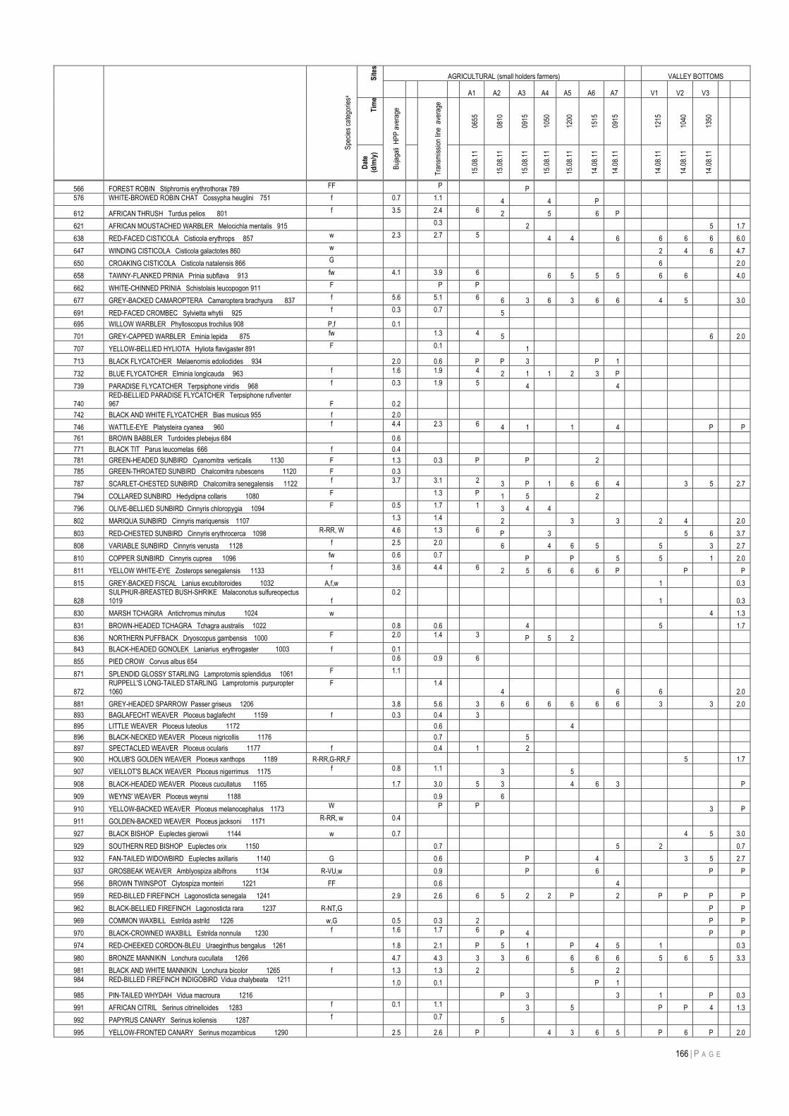
166 | P A G E
Spe
cies
cat
egor
iesa
Sit
es
AGRICULTURAL (small holders farmers) VALLEY BOTTOMS
A1 A2 A3 A4 A5 A6 A7
V1 V2 V3
Tim
e
Buj
agal
i H
PP
ave
rage
Tra
nsm
issi
on li
ne a
vera
ge
0655
0810
0915
1050
1200
1515
0915
1215
1040
1350
Dat
e
(d/m
/y)
15.0
8.11
15.0
8.11
15.0
8.11
15.0
8.11
15.0
8.11
14.0
8.11
14.0
8.11
14.0
8.11
14.0
8.11
14.0
8.11
566 FOREST ROBIN Stiphrornis erythrothorax 789 FF P
P
576 WHITE-BROWED ROBIN CHAT Cossypha heuglini 751 f 0.7 1.1 4
4
P
612 AFRICAN THRUSH Turdus pelios 801 f 3.5 2.4 6 2
5
6 P
621 AFRICAN MOUSTACHED WARBLER Melocichla mentalis 915 0.3
2
5
1.7
638 RED-FACED CISTICOLA Cisticola erythrops 857 w 2.3 2.7 5
4 4
6 6 6 6
6.0
647 WINDING CISTICOLA Cisticola galactotes 860 w
2 4 6
4.7
650 CROAKING CISTICOLA Cisticola natalensis 866 G
6
2.0
658 TAWNY-FLANKED PRINIA Prinia subflava 913 fw 4.1 3.9 6
6 5 5 5 6 6
4.0
662 WHITE-CHINNED PRINIA Schistolais leucopogon 911 F P P
677 GREY-BACKED CAMAROPTERA Camaroptera brachyura 837 f 5.6 5.1 6 6 3 6 3 6 6 4 5
3.0
691 RED-FACED CROMBEC Sylvietta whytii 925 f 0.3 0.7 5
695 WILLOW WARBLER Phylloscopus trochilus 908 P,f
0.1
701 GREY-CAPPED WARBLER Eminia lepida 875 fw 1.3 4 5
6
2.0
707 YELLOW-BELLIED HYLIOTA Hyliota flavigaster 891 F 0.1
1
713 BLACK FLYCATCHER Melaenornis edoliodides 934
2.0
0.6
P P 3
P 1
732 BLUE FLYCATCHER Elminia longicauda 963 f 1.6 1.9 4 2 1 1 2 3 P
739 PARADISE FLYCATCHER Terpsiphone viridis 968 f 0.3 1.9 5
4
4
740 RED-BELLIED PARADISE FLYCATCHER Terpsiphone rufiventer 967 F
0.2
742 BLACK AND WHITE FLYCATCHER Bias musicus 955 f
2.0
746 WATTLE-EYE Platysteira cyanea 960 f 4.4 2.3 6 4 1
1
4
P
P
761 BROWN BABBLER Turdoides plebejus 684
0.6
771 BLACK TIT Parus leucomelas 666 f
0.4
781 GREEN-HEADED SUNBIRD Cyanomitra verticalis 1130 F
1.3
0.3
P
P
2
785 GREEN-THROATED SUNBIRD Chalcomitra rubescens 1120 F
0.3
787 SCARLET-CHESTED SUNBIRD Chalcomitra senegalensis 1122 f 3.7 3.1 2 3 P 1 6 6 4
3 5
2.7
794 COLLARED SUNBIRD Hedydipna collaris 1080 F 1.3 P 1 5
2
796 OLIVE-BELLIED SUNBIRD Cinnyris chloropygia 1094 F 0.5 1.7 1 3 4 4
802 MARIQUA SUNBIRD Cinnyris mariquensis 1107 1.3 1.4 2
3
3 2 4
2.0
803 RED-CHESTED SUNBIRD Cinnyris erythrocerca 1098 R-RR, W 4.6 1.3 6 P
3
5 6
3.7
808 VARIABLE SUNBIRD Cinnyris venusta 1128 f 2.5 2.0 6
4 6 5
5
3
2.7
810 COPPER SUNBIRD Cinnyris cuprea 1096 fw 0.6 0.7
P
P
5 5
1
2.0
811 YELLOW WHITE-EYE Zosterops senegalensis 1133 f 3.6 4.4 6 2 5 6 6 6 P
P
P
815 GREY-BACKED FISCAL Lanius excubitoroides 1032 A,f,w
1
0.3
828 SULPHUR-BREASTED BUSH-SHRIKE Malaconotus sulfureopectus 1019 f
0.2
1
0.3
830 MARSH TCHAGRA Antichromus minutus 1024 w
4
1.3
831 BROWN-HEADED TCHAGRA Tchagra australis 1022
0.8
0.6
4
5
1.7
836 NORTHERN PUFFBACK Dryoscopus gambensis 1000 F 2.0 1.4 3
P 5 2
843 BLACK-HEADED GONOLEK Laniarius erythrogaster 1003 f
0.1
855 PIED CROW Corvus albus 654 0.6 0.9 6
871 SPLENDID GLOSSY STARLING Lamprotornis splendidus 1061 F 1.1
872 RUPPELL'S LONG-TAILED STARLING Lamprotornis purpuropter 1060
F 1.4 4
6 6
2.0
881 GREY-HEADED SPARROW Passer griseus 1206
3.8
5.6
3 6 6 6 6 6 6 3
3
2.0
893 BAGLAFECHT WEAVER Ploceus baglafecht 1159 f
0.3
0.4
3
895 LITTLE WEAVER Ploceus luteolus 1172
0.6
4
896 BLACK-NECKED WEAVER Ploceus nigricollis 1176
0.7
5
897 SPECTACLED WEAVER Ploceus ocularis 1177 f
0.4
1
2
900 HOLUB'S GOLDEN WEAVER Ploceus xanthops 1189 R-RR,G-RR,F
5
1.7
907 VIEILLOT'S BLACK WEAVER Ploceus nigerrimus 1175 f 0.8 1.1 3
5
908 BLACK-HEADED WEAVER Ploceus cucullatus 1165
1.7
3.0
5 3
4 6 3
P
909 WEYNS' WEAVER Ploceus weynsi 1188
0.9
6
910 YELLOW-BACKED WEAVER Ploceus melanocephalus 1173 W P P
3
P
911 GOLDEN-BACKED WEAVER Ploceus jacksoni 1171 R-RR, w 0.4
927 BLACK BISHOP Euplectes gierowii 1144 w
0.7
4 5
3.0
929 SOUTHERN RED BISHOP Euplectes orix 1150
0.7
5 2
0.7
932 FAN-TAILED WIDOWBIRD Euplectes axillaris 1140 G
0.6
P
4
3 5
2.7
937 GROSBEAK WEAVER Amblyospiza albifrons 1134 R-VU,w
0.9
P
6
P
P
956 BROWN TWINSPOT Clytospiza monteiri 1221 FF
0.6
4
959 RED-BILLED FIREFINCH Lagonosticta senegala 1241
2.9
2.6
6 5 2 2 P
2 P P P
P
962 BLACK-BELLIED FIREFINCH Lagonosticta rara 1237 R-NT,G
P
P
969 COMMON WAXBILL Estrilda astrild 1226 w,G
0.5
0.3
2
P
P
970 BLACK-CROWNED WAXBILL Estrilda nonnula 1230 f 1.6 1.7 6 P 4
P
P
974 RED-CHEEKED CORDON-BLEU Uraeginthus bengalus 1261
1.8
2.1
P 5 1
P 4 5 1
0.3
980 BRONZE MANNIKIN Lonchura cucullata 1266
4.7
4.3
3 3 6
6 6 6 5 6 5
3.3
981 BLACK AND WHITE MANNIKIN Lonchura bicolor 1265 f
1.3
1.3
2
5
2
984 RED-BILLED FIREFINCH INDIGOBIRD Vidua chalybeata 1211
1.0
0.1
P 1
985 PIN-TAILED WHYDAH Vidua macroura 1216
P 3
3 1
P
0.3
991 AFRICAN CITRIL Serinus citrinelloides 1283 f 0.1 1.1
3
5
P P 4
1.3
992 PAPYRUS CANARY Serinus koliensis 1287 f 0.7 5
995 YELLOW-FRONTED CANARY Serinus mozambicus 1290
2.5
2.6
P
4 3 6 5 P 6 P
2.0
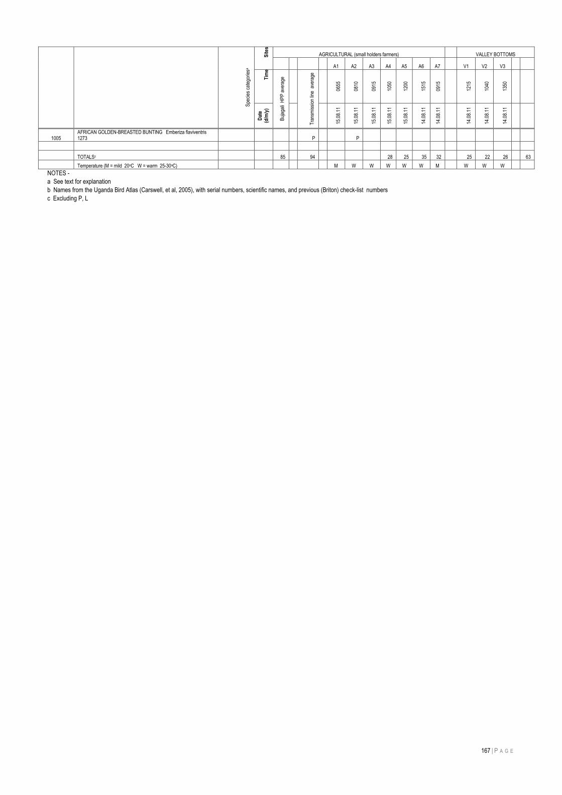
167 | P A G E
Spe
cies
cat
egor
iesa
Sit
es
AGRICULTURAL (small holders farmers) VALLEY BOTTOMS
A1 A2 A3 A4 A5 A6 A7
V1 V2 V3
Tim
e
Buj
agal
i H
PP
ave
rage
Tra
nsm
issi
on li
ne a
vera
ge
0655
0810
0915
1050
1200
1515
0915
1215
1040
1350
Dat
e
(d/m
/y)
15.0
8.11
15.0
8.11
15.0
8.11
15.0
8.11
15.0
8.11
14.0
8.11
14.0
8.11
14.0
8.11
14.0
8.11
14.0
8.11
1005 AFRICAN GOLDEN-BREASTED BUNTING Emberiza flaviventris 1273
P
P
TOTALSc
85
94
28 25 35 32 25 22 26
63
Temperature (M = mild 20oC W = warm 25-30oC)
M W W W W W M W W W
NOTES -
a See text for explanation
b Names from the Uganda Bird Atlas (Carswell, et al, 2005), with serial numbers, scientific names, and previous (Briton) check-list numbers
c Excluding P, L
168 | P A G E
REFERENCES
1. “Uganda Bujagali Hydro Power Project”. The World Bank Group. Washington, D.C. Accessed January 2010. 2. Acornley, R.M. and Sear, D.A. (1999). Sediment transport and sedimentation of Brown trout (Salmo trutta L) spawning
gravels in chalk streams. Hydrol. Process. 13: 447-458. 3. Elizabeth Kyomugisha 2008: Land Tenure and Agricultural productivity in Uganda.
http://www.ifpri.org/sites/default/files/publications/ussppb05.pdf. 4. Synellakis et al 2006: Uganda Energy Sector Policy Over view Paper. 5. Focus on Uganda 2009: the Power Sector Strategic Plan 1999. 6. Florence, N. (2010, August 27). Uganda‟s Districts since independence. Retrieved September 23, 2011, from New
Vision: http://www.newvision.co.ug/D/8/12/730140. 7. SYMPOSIUM: Uganda after Idi Amin and Milton Obote (Hamburg, Germany, 29th September 2008). “Investment
Opportunities in Power Generation in Uganda: Presented by Hon. Daudi Migereko Minister of Energy and Mineral Development, Uganda.
8. MEMD, 2003 (Ministry of Energy and Mineral Development): Ministry‟s Mandate. http://www.energyandminerals.go.ug/mission.php.
9. World Bank 2011: Social Safe Guard Policies. 10. Lawerence Shannon 2005: Reteat from the safeguard policies: Recent Trends undermining Social and Environmental
Accountability at the World Bank. http://www.edf.org/documents/4279_RetreatSafeguardPolicies_0105.pdf. 11. IDA, 2010: Uganda: Maintaining Growth-Moving Towards Structural Transformation. 12. Edward Mugabi 2004: Uganda‟s Decentralization Policy, Legal Framework, Local Government Structure and Service
Delivery (Paper prepared for the First Conference of Regional Assemblies of Africa and Europe organized by the Regional Assembly of Tuscany under the patronage of the Italian Presidency and the United Nations Department of Economic and Social Affairs (UNDESA), Florence, Italy.
13. Uganda Bureau of Statistics (UBOS), 2002: Population and Housing Census. 14. Cultural Survival 2010: Partnering with Indigenous Peoples to Defend their Lands, Languages and Cultures: Uganda
Country Profile. http://www.culturalsurvival.org/Uganda+Coutry+Profile?gclid=CPfv4em32KoCFRJc4QodI0dF7w. 15. GOU (1999): Uganda Participatory Poverty Assessment Process, Perspective of the poor. 16. Synellakis and Arudo, 2006: Education sector policy over view Paper.
http://chet.org.za/manual/media/files/chet_hernana_docs/Uganda/Other/Education_Policy_Overview_Uganda.pdf 17. Boseley Sarah, 2008: Health in Uganda.
http://www.guardian.co.uk/katine/2008/mar/06/katinegoalbackground.background. 18. Fountain Publishing, 2005 – Uganda Districts, Information Handbook. Expanded Ed.2005 – 2006. ISBN 9970 02 429 9. 19. IFAD 2003: Gender and Rural poverty. www.ruralpovertyportal.org/web/guest/topic/home/ tags/gender. 20. Ministry of Energy and Mineral Development, 2002: The Energy Policy for Uganda. MEMD 2002. 21. Ministry of Energy and Mineral Resources, 1994: State of Energy Report for Uganda. MEMD 1994. 22. Ministry of Energy and Mineral Development 2009: Ministry‟s Mandate.
http://www.energyandminerals.go.ug/mission.php 23. UBOS (Uganda Bureau of Statistics) 2009: Profiles of the Higher Local Governments. 24. UBOS (Uganda Bureau of Statistics) 2002: Population and Housing Census.
25. World Bank 2011: Social safeguard policies.
http://web.worldbank.org/WBSITE/EXTERNAL/COUNTRIES/LACEXT/EXTLACREGTOPSOCDEV/0,,contentMDK:20547266~menuPK:1308602~pagePK:34004173~piPK:34003707~theSitePK:847655,00.html
26. MEMD (2001): Rural Electrification Strategy and Plan Covering the Period 2001 to 2010. 27. Ministry of Energy and Mineral Development, Government of Uganda, Kampala, February 2001. 28. MEMD (2002): The Energy Policy for Uganda, Ministry of Energy and Mineral Development, Government of Uganda,
Kampala, September 2002. 29. MEMD (2007): The Renewable Energy Policy for Uganda, Ministry of Energy and Mineral Development, Government of
Uganda, Kampala, November 2007. 30. MEMD (2008): Annual Report, Ministry of Energy and Mineral Development, Kampala. 31. MEMD (2010): Inception Report for feasibility study for the development Of Isimba Hydro-Power Plant and associated
transmission line and sub-station inception report. 32. MoLG, 2009: Profiles of the higher Local Governments 2009. 33. Mukono District Population and Housing Census Analytical Report, 2007. 34. Mukono District Statistical Abstract, 2006.
169 | P A G E
35. National Biomass Study, Ministry of Water and Environment, Government of Uganda, Kampala, November 2003. 36. Poverty Eradication Action Plan 2004/5 – 2007/8, Ministry of Finance, Planning and Economic Development, Kampala,
December 2004. 37. R. Shiflett, and R. Tempchin, for presentation at 89th Annual Meeting & Exhibition, Air & Waste Management
Association, Nashville, Tenn., June. 38. The Electricity (Establishment and Management of the Rural Electrification Fund) Instrument, 2001, Uganda Gazette
No. 56 Vol. XCIV, Kampala 11th December 2001. 39. The Uganda Forestry Policy, Ministry of Water and Environment, Kampala: 2001.
40. NWDR (National Water Development Report), 2005: National Water Development Report: Uganda. Water a shared
responsibility (2006). Available on: http://unesdoc.unesco.org/images/0014/001467/146760e.pdf. 41. UBOS (2002): Uganda Population and Housing Census. Analytical Report, Abridged Version. 42. Uganda Bureau of Statistics, Kampala, June 2006. 43. UBOS (2009/10): Uganda Household Survey, Uganda Bureau of Statistics, Kampala. 44. UBOS (2010): Statistical Abstract, Uganda Bureau of Statistics, Kampala. 45. UNDP (2007) Millennium Development Goals: Uganda‟s Progress Report 2007, UNDP, Kampala, October 2007. 46. USAID: Water and Sanitation Profile. Available at: http://waterwiki.net/images/a/ab/USAIDUgandaWatSanProfile.pdf.
8th September 2011.