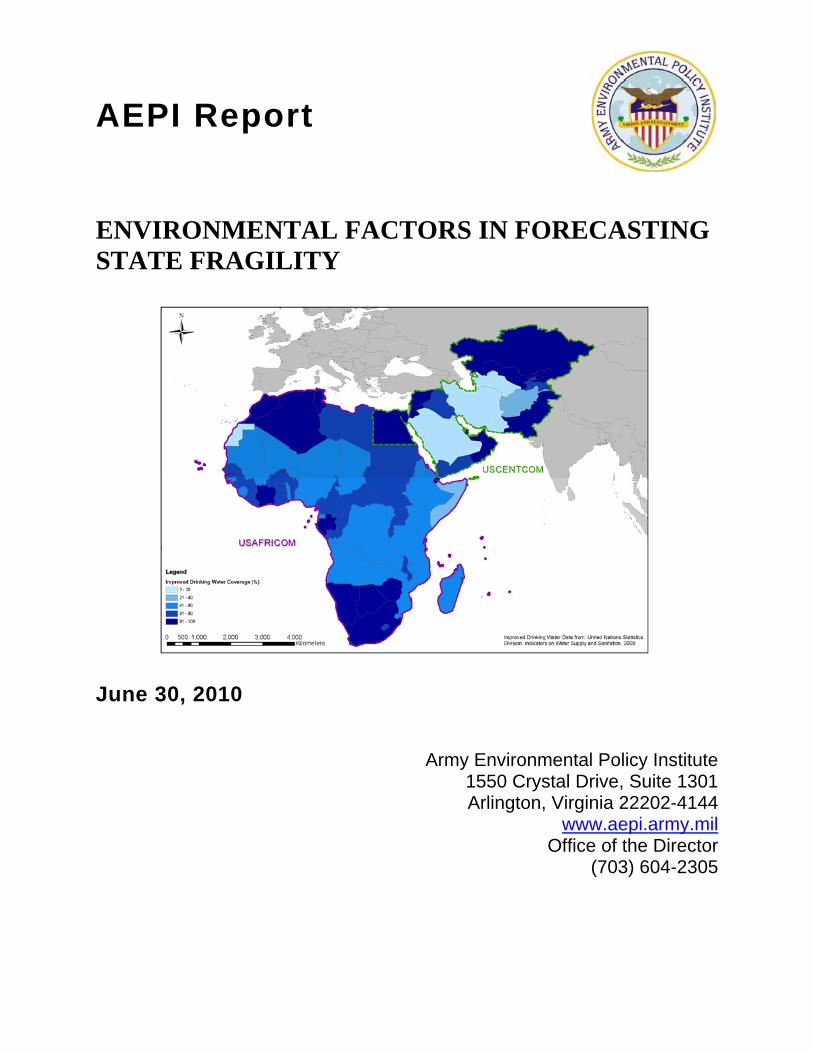
ENVIRONMENTAL FACTORS IN FORECASTING STATE FRAGILITY Factors and Fragility... · AEPI Report ....
42
AEPI Report ENVIRONMENTAL FACTORS IN FORECASTING STATE FRAGILITY June 30, 2010 Army Environmental Policy Institute 1550 Crystal Drive, Suite 1301 Arlington, Virginia 22202-4144 www.aepi.army.mil Office of the Director (703) 604-2305
Transcript of ENVIRONMENTAL FACTORS IN FORECASTING STATE FRAGILITY Factors and Fragility... · AEPI Report ....
AEPI Report
ENVIRONMENTAL FACTORS IN FORECASTING STATE FRAGILITY
June 30, 2010
Army Environmental Policy Institute 1550 Crystal Drive, Suite 1301 Arlington, Virginia 22202-4144
www.aepi.army.mil Office of the Director
(703) 604-2305
REPORT DOCUMENTATION PAGE Form Approved OMB No. 0704-0188
Public reporting burden for this collection of information is estimated to average 1 hour per response, including the time for reviewing instructions, searching existing data sources, gathering and maintaining the data needed, and completing and reviewing the collection of information. Send comments regarding this burden estimate or any other aspect of this collection of information, including suggestions for reducing this burden to Washington Headquarters Services, Directorate for information operations and Reports, 1215 Jefferson Davis Highway, Suite 1204, Arlington, VA 22202-4302, and to the Office of Management and Budget, Paperwork Reduction Project (0704-0188), Washington, DC 20503. 1. AGENCY USE ONLY (Leave blank)
2. REPORT DATE 30 April 2010
3. REPORT TYPE AND DATES COVERED Draft (4/27/09 – 6/30/10)
4. TITLE AND SUBTITLE Environmental Factors In Forecasting State Fragility
5. FUNDING NUMBERS Contract: W74V8H-04-D-0005
Task: 0560
6. AUTHOR(S) Jeremey Alcorn, Tom Vincent, Stephanie Clark, Elizabeth Keysar, Alan Moses
7. PERFORMING ORGANIZATION NAME(S) AND ADDRESS(ES) National Defense Center for Energy and Environment Operated by Concurrent Technologies Corporation 100 CTC Drive Johnstown, PA 15904
8. PERFORMING ORGANIZATION REPORT NUMBER
9. SPONSORING/MONITORING AGENCY NAME(S) AND ADDRESS(ES) NDCEE Program Office (Office of the Assistant Secretary of the Army for Installations and Envirionment) 1235 Clark Street, Suite 307 Arlington, VA 22202-3263 Program Manager, Mr. Hany Zaghloul, NDCEE Program Manager, 703-602-5500
10. SPONSORING/MONITORING AGENCY REPORT NUMBER
CTC-CR-2010-064
10 SUPPLEMENTARY NOTES
12a. DISTRIBUTION/AVAILABILITY STATEMENT Unclassified/Unlimited Distribution
12b. DISTRIBUTION CODE
13. ABSTRACT (Maximum 200 words) This task researched instability and fragility early warning systems, their capabilities to account for environmental factors, and recommend how to incorporate such factors into frameworks supportive of U.S. Army, defense, and national security missions. AEPI requested the study because Presidential and DoD directives (NSDP-44 & DODD 3000.5) and recent Army Field Manuals (FM 3-0 & 3-07) reflect a growing recognition and mandate to understand factors that influence state fragility and instability. The project researched approaches, frameworks, and technologies U.S. Army stakeholders can use to assess state or regional destabilizing environmental conditions or trends. Working with U.S. Army collaborators and civilian technical stakeholders, this effort researched existing quantitative analysis approaches to examine relationships between environmental factors, fragility, and instability. It also screened existing early warning architectures to enhance fragility assessment approaches. This report outlines recommendations for integrated, quantitative and qualitative hybrid approaches for developing actionable early warning capabilities. These findings provide the U.S. Army with options to better incorporate environmental factors, augment awareness of their destabilizing influences on state fragility and regional stability, and inform coordinated intervention in support of regional engagement and stability operations per Presidential and DoD directives.
14. SUBJECT TERMS
15. NUMBER OF PAGES 86
1) PRICE CODE
2) SECURITY CLASSIFICATION OF REPORT
Unclassified
3) SECURITY CLASSIFICATION OF THIS PAGE
Unclassified
4) SECURITY CLASSIFICATION OF ABSTRACT
Unclassified
5) LIMITATION OF ABSTRACT
None
NSN 7540-01-280-5500 Standard Form 298 Rev. 12/00 Prescribed by ANSI ST. 239-18 880922

THIS PAGE INTENTIONALLY LEFT BLANK
Environmental Factors In Forecasting State Fragility – Final Report i
PREFACE This report was prepared under contract for the Army Environmental Policy Institute (AEPI) by the National Defense Center for Energy and Environment (NDCEE), operated by Concurrent Technologies Corporation (CTC), with additional support from Booz Allen Hamilton (BAH). The views expressed do not necessarily reflect the official policy or position of the Department of Defense, Department of the Army, or the United States Government. The mission of AEPI is to assist the Army Secretariat in developing forward-looking policies and strategies to address environmental issues that may have significant future impacts on the Army. In the execution of this mission, AEPI is further tasked with identifying and assessing the potential impacts on the Army of emerging environmental issues and trends. This report discusses the efforts conducted under Contract Number W74V8H-04-D-0005, Task Number 0560, “Environmental Factors in Forecasting State Fragility and Regional Instability.” The purpose of the Task is to research instability and fragility early warning systems, their capabilities to account for environmental factors, and recommend how to incorporate such factors into meaningful frameworks supportive of U.S. Army, defense, and national security missions. AEPI requested the study because Presidential and DoD directives (NSDP-44 & DODD 3000.5) and recent Army Field Manuals (FM 3-0 & 3-07) reflect a growing recognition and mandate to understand factors that influence state fragility and regional instability. Please direct comments pertaining to this paper to: Director, Army Environmental Policy Institute 1550 Crystal Drive, Suite 1301 Arlington, Virginia 22202-4144
Environmental Factors In Forecasting State Fragility – Final Report ii
ACKNOWLEDGEMENTS The AEPI Project Manager and Technical Monitor on this task was Mr. Steven Hearne. The NDCEE/CTC Project Managers and Technical Leads for this task were Ms. Stephanie Clark and Mr. Jeremey Alcorn. The BAH Project Manager was Mr. Brian Smith. This report would not have been possible without the contributions and input provided by the following individuals or their organizations: Dr. David Carment, Carleton University, Country Indicators for Foreign Policy (CIFP) Mr. Sam Binkley, Center for Army Analysis (CAA) Dr. J. Joseph Hewitt, University of Maryland, Center for International Development and Conflict Management (CIDCM) Dr. Mathis Wackernagel, Mr. Bill Coleman, Mr. Brad Ewing, Mr. Anders Reed, Global Footprint Network (GFN) Dr. Molly Brown, NASA Goddard Space Flight Center (GSFC) Mr. Thomas M. Parris, iSciences, LLC. Dr. S. Tjip Walker, United States Agency for International Development (USAID) Mark Hainsey, United States Army Corps of Engineers (USACE) Mr. Bill Goran, USACE, Engineer Research and Development Center (ERDC) Stockholm International Peace Research Institute (SIPRI)
Environmental Factors In Forecasting State Fragility – Final Report iii
TABLE OF CONTENTS
Page
LIST OF ACRONYMS ................................................................................................................................. vi
EXECUTIVE SUMMARY ............................................................................................................................ vii
1 INTRODUCTION .............................................................................................................................. 1 1.1 Background ....................................................................................................................... 2 1.2 The Concept of Instability ................................................................................................ 4 1.3 The Concept of Fragility ................................................................................................... 5 1.4 Fragility, Stability and Conflict Synthesis ...................................................................... 7
2 METHODOLOGY AND APPROACH .............................................................................................. 7 2.1 Literature Review .............................................................................................................. 8 2.2 Stakeholder Identification and Engagement .................................................................. 8 2.3 Environmental Factors Quantitative Analysis ............................................................... 8
2.3.1 Fragility Index Deconstruction ........................................................................... 9 2.3.2 Environmental Data Identification and Compilation ........................................ 9 2.3.3 Data Assembly ................................................................................................... 10 2.3.4 Statistical Analysis ............................................................................................ 10
2.4 Alternative Architecture Identification .......................................................................... 11 2.5 Limitations ....................................................................................................................... 11
3 FINDINGS - LITERATURE REVIEW AND STAKEHOLDER ENGAGEMENT ............................ 12 3.1 Instability Indices ............................................................................................................ 12 3.2 Fragility Indices ............................................................................................................... 13
4 FINDINGS - QUANTITATIVE ANALYSIS ..................................................................................... 17
5 FINDINGS - ALTERNATIVE ARCHITECTURES.......................................................................... 20 5.1 Geospatial Tools ............................................................................................................. 20 5.2 Qualitative Opinion – Expert Surveys and National Polls .......................................... 23 5.3 Content Analysis ............................................................................................................. 24 5.4 Interactive Web 2.0 Applications ................................................................................... 24
6 HYBRID EARLY WARNING ARCHITECTURE GUIDANCE ........................................................ 25 6.1 Proposed Hybrid Early Warning Architecture Approach............................................ 26 6.2 Challenges and Integration Opportunities ................................................................... 27
7 CONCLUSIONS AND RECOMMENDATIONS ............................................................................. 28
8 LITERATURE CITED ..................................................................................................................... 29
LIST OF TABLES Table 1. Comparison of Security Approaches (Hearne 2009:50) Table 2. Fragility Indices Systemic Categories (Mata and Ziaja 2009:25) Table 3. Fragility Indices and Approaches Table 4. Results of Multivariate Analysis with EPI Levels 1 – 3
Environmental Factors In Forecasting State Fragility – Final Report iv
LIST OF FIGURES Figure 1. Emerging U.S. Human Security Paradigm Figure 2. Instability and Fragility vs. Spectrum of Conflict Figure 3. Components of the Environmental Performance Index Figure 4. Zambezi River Basin Geospatial Analysis Figure 5. DTWS Portal
Environmental Factors In Forecasting State Fragility – Final Report v
Environmental Factors In Forecasting State Fragility – Final Report vi
LIST OF ACRONYMS
ACTOR Analyzing Complex Threats for Operations and Readiness AEPI Army Environmental Policy Institute CAA CAST
Center for Army Analysis Conflict Assessment System Tool
CIDCM University of Maryland, Center for International Development and Conflict Management
CIFP Country Indicators for Foreign Policy CNA Center for Navy Analysis CPI Corruption Perceptions Index CTC Concurrent Technologies Corporation DASA-ESOH
Deputy Assistant Secretary of the Army for Environmental, Safety and Occupational Health
DCHA/CMM
Bureau for Democracy, Conflict, and Humanitarian Assistance/Office of Conflict Management and Mitigation
DoD Department of Defense DoDD Department of Defense Directive DTWS Defense Technology Warning System EPI Environmental Performance Index FACTIII FAL
Forecast and Analysis of Complex Threats III Fragility Alert List
FM Field Manual FEWS NET FfP FIRST FSI
Famine Early Warning Security Network Fund for Peace Facts on International Relations and Security Trends Failed State Index
GFN GHG
Global Footprint Network Geographic Information Systems
GMU George Mason University HQDA Headquarters, Department of the Army ISW Index of State Weakness MPICE Measuring Progress in Conflict Environments NASA National Aeronautics and Space Administration NDCEE NOAA
National Defense Center for Energy and Environment National Oceanic and Atmospheric Administration
NSPD National Security Presidential Directive OECD Organization for Economic Co-operation and Development PITF Political Instability Task Force PRIO Peace Research Institute Oslo QDR Quadrennial Defense Review SFI SIPRI
State Failure Index Stockholm International Peace Research Institute
SSTR Stability, Security, Transition, and Reconstruction UNDP United Nations Development Programme U.S. United States USACE United States Army Corps of Engineers USAID United States Agency for International Development USDA USGS
United States Department of Agriculture United States Geological Survey
EXECUTIVE SUMMARY The Army Environmental Policy Institute (AEPI) requested the National Defense Center for Energy and Environment (NDCEE) to research instability and fragility early warning systems and their capability to account for environmental factors. The AEPI initiated the study because of a growing mandate to understand factors that influence state fragility and regional instability. The changing focus in military engagement requires predictive tools that focus earlier in the conflict causal chain. Understanding the factors that influence state fragility can help predict the likelihood of a state becoming unstable and assist in planning military engagements under the “Whole of Government” approach. Unlike instability and conflict, early warning systems for fragility are still in development and it is not clear how they should be applied to military decision-making. Furthermore, there is little consensus on the impact of environmental factors on state fragility. The research reported in this document addressed two main questions: 1) what indices exist for measuring instability and fragility, and 2) can environmental factors or alternative analytical architectures help improve these indices? In order to answer these questions, the research involved an extensive review of the literature, engagement of subject matter experts and other relevant stakeholders, fragility index identification and evaluation, data collection, statistical analysis, and alternative architectures identification. The concept of instability enables national security practitioners to look further back on the conflict spectrum, but the simplicity of the instability models does not provide sufficient breadth of actionable forewarning. The conceptual discourse on fragility has recently expanded to address this shortcoming, and multiple fragility indices have been developed. State fragility is understood as a precursor to state instability, conflict and collapse. Unlike the instability indices, the longer timescale and disaggregated nature of the sector subcomponents of fragility indices are likely to be more compatible to the inclusion of environmental factors. The concept is still maturing, but fragility indices seem to offer a policy-useful and informative partner to instability approaches when used in a paired manner. The statistical analysis findings suggested that environmental factors do slightly improve the base model’s ability to predict fragility overall, though only those that measure health-related aspects of the environment had a measurable effect. However, those that fell into the ecosystem vitality realm typically had a lower effect on fragility, or even slightly decreased the predictability of the model. It is possible that environmental health factors are truly the most significant and that other environmental factors have little or no effect on fragility. However, given that the data used was publicly available nation-state data, which is often incomplete and not truly measuring the value of ecosystem services, it is difficult to deduce the true effect of non-health related environmental factors.
Alternative analytical architectures that do not rely on quantitative nation-state data are a key part of data acquisition, analysis, and decision making processes within the realm of defense, diplomacy, and development. The project team researched architectures that can be used to cross-reference with results gathered from national level statistical data. Useful qualitative approaches were found in the areas of geospatial data, expert surveys, national polls, content analysis, and interactive Web 2.0 applications. A hybrid approach that combines quantitative and qualitative methods can therefore increase the accuracy, explainability, and utility of a paired instability and fragility early warning system. Recommendations therefore focused on further development of a proposed hybrid early warning system that is transparent, involves cross-functional stakeholders, and incorporates environmental factors.
Environmental Factors In Forecasting State Fragility – Final Report vii
1 INTRODUCTION The Army Environmental Policy Institute (AEPI) requested the National Defense Center for Energy and Environment (NDCEE), operated by Concurrent Technologies Corporation (CTC), to research instability and fragility early warning systems and their capability to account for environmental factors. Based on this research, recommendations could be forwarded on how to incorporate such factors into decision frameworks supportive of United States (U.S.) Army, defense, and national security missions. The AEPI initiated the study because National Security Presidential Directive NSDP-44 (Bush 2005), Department of Defense Directive DoDD 3000.5 (DoD 2005), and recent Army Field Manuals FM 3-0 and FM 3-07 (HQDA 2008a; HQDA 2008b) reflect a growing mandate to understand factors that influence state fragility and regional instability. The changing focus in military engagement requires predictive tools that focus earlier in the conflict causal chain. State fragility is understood as a precursor to state instability, conflict and collapse. Understanding the factors that influence state fragility can help predict the likelihood of a state becoming unstable and assist in planning military engagements under the “Whole of Government” approach, which is defined as an integrated approach involving multiple agencies working in coordination. Unlike instability and conflict, early warning systems for fragility are still in development and it is not clear how they should be applied to military decision-making. Furthermore, there is little consensus on the impact of environmental factors on state fragility. To address these emerging needs, this task was developed to research instability and fragility indices and provide the AEPI and the Deputy Assistant Secretary of the Army for Environment, Safety and Occupational Health (DASA-ESOH) with recommendations on approaches, frameworks, and technologies that can be utilized by U.S. Army stakeholders to assess state destabilizing trends and to provide an analysis of how environmental factors play a role. The research therefore addressed two main questions: 1) what indices exist for measuring instability and fragility, and 2) can environmental factors or alternative analytical architectures help improve these indices? In order to answer these questions, the research involved an extensive review of the literature, engagement of subject matter experts and other relevant stakeholders, fragility index identification and evaluation, data collection, statistical analysis, and alternative architectures identification. This report presents the results of the research in the following manner. Section 1 presents the background of the emerging focus in military engagement as the justification for this research. Section 2 describes the research methodology. Sections 3, 4, and 5 present the findings and results. Section 6 reviews how alternative analytical architectures can be integrated with quantitative models. Section 7 presents the conclusions and recommendations. This research found that it is possible to improve the predictive capabilities of existing models by incorporating environmental variables. However, because there are significant problems with existing environmental datasets at the nation-state level, alternative methods that use other types of data should be incorporated into existing early warning systems to capture the impacts of environmental trends. This document synthesizes the literature research, deconstruction of fragility indices and statistical analysis conducted during this task. A companion document to this report, titled “Environmental Factors in Forecasting State Fragility: Supplemental Material,” has been assembled to present more of the data, background material, and methodology for those readers interested in more in-depth coverage of the topics researched.
Environmental Factors In Forecasting State Fragility – Final Report 1
Environmental Factors In Forecasting State Fragility – Final Report 2
1.1 Background Environmental factors increasingly impact U.S. national security interests and are particularly relevant in regional engagement and stability operations. These factors are recognized as core supporting elements for the maintenance of state stability because they play a critical role in human and societal welfare by providing the “foundation” for the most basic of physiological needs (e.g., water, food, shelter). Given this growing importance, AEPI determined that it is necessary to better understand the role of environmental factors in stability and fragility, particularly how they are (or are not) being considered in recognized instability and fragility indices. There are ongoing efforts to develop early warning systems to monitor environmental antecedents to instability and potential conflict. However, to date, these diverse efforts have not been able to adequately incorporate how environmental stress contributes to overall state fragility in combination with other social, political, and economic factors. Historically, U.S. national security policy has been nation-state centric and focused on defending against and responding to external threats (Hearne 2009). This “traditional security” approach is best epitomized by the nation-state competition and conflicts associated with the Cold War. Following the fall of the Soviet Union, U.S. national security policy and analysis communities started to examine the relationship between security, conflict, and environmental considerations (Dabelko and Simmons 1997). While this debate continues, the events of September 11, 2001, quickly focused on the critical relevance of failed states, non-state actors, and their challenges to U.S. national security interests. Recent U.S. policy drivers have made it clear that there is a subtle but noticeable shift by U.S. policymakers, thought leaders, and practitioners from a more “traditional” national security frame toward a more “human security” approach (see Table 1) (Beebe 2008; Pumphrey 2008; DoD 2008). Given the asymmetric threat environment since September 11, 2001, the importance of this shift has become even more apparent with the demands of counter-insurgency and Stability, Security, Transition, and Reconstruction (SSTR) operations in Iraq and Afghanistan. President Obama recently affirmed this continued shift toward human security with specific reference to a greater U.S. emphasis on supporting “Freedom from Want” (Obama 2009). The 2010 Quadrennial Defense Review (QDR) reinforces the “integrated use of diplomacy, development, and defense, along with intelligence, law enforcement, and economic tools of statecraft to help build the capacity of partners to maintain and promote stability” and thus prevents the “rise of threats to U.S. interests” (DoD 2010: 13). The 2010 National Security Strategy specifically addresses a “Whole of Government Approach” that will integrate “all of the tools of American power” to “enhance international capacity to prevent conflict, spur economic growth, improve security, combat climate change and address the challenges posed by weak and failing states” (Obama 2010: 13). The DoD’s and U.S. Army’s doctrine increasingly reflects this “Whole of Government” approach and focus on SSTR as evident in the recent update of Field Manual 3-07 (HQDA 2008b). The United Nations Development Programme (UNDP) introduced the “human security” paradigm in its “Human Development Report 1994: New Dimensions of Human Security” (UNDP 1994). Based upon sustainable development principles, this new policy paradigm sought to shift the focus of security toward individuals’ “freedom from fear” and “freedom from want” (UNDP 1994: 24; Beebe 2008). It also expands national security analysis “object of reference” from a nation-state (i.e., national government) focus to that of the spectrum between the government and individual citizens’ well-being.
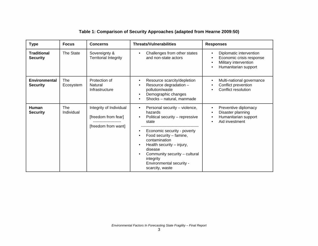
Table 1: Comparison of Security Approaches (adapted from Hearne 2009:50)
Type Focus Concerns Threats/Vulnerabilities Responses
Traditional Security
The State Sovereignty & Territorial Integrity
• Challenges from other states and non-state actors
• Diplomatic intervention • Economic crisis response • Military intervention • Humanitarian support
Environmental Security
The Ecosystem
Protection of Natural Infrastructure
• Resource scarcity/depletion • Resource degradation –
pollution/waste • Demographic changes • Shocks – natural, manmade
• Multi-national governance • Conflict prevention • Conflict resolution
Human Security
The Individual
Integrity of Individual [freedom from fear] --------------------- [freedom from want]
• Personal security – violence, hazards
• Political security – repressive state
------------------------------------------- • Economic security - poverty • Food security – famine,
contamination • Health security – injury,
disease • Community security – cultural
integrity Environmental security - scarcity, waste
• Preventive diplomacy • Disaster planning • Humanitarian support • Aid investment
Environmental Factors In Forecasting State Fragility – Final Report 3
While the human security paradigm adds analytical breadth, the National Security Strategy and U.S. Army doctrine are based upon the reality of “full-spectrum” missions and operations that “integrate skills and capabilities within our military and civilian institutions” (HQDA 2008a: 3-7; Obama 2010: 14). The U.S. Army operates across a Full Spectrum of conflict and its missions are a dynamic balance between Offensive, Defensive, Stability, and Civil Support Operations (HQDA 2008a). As such, U.S. Army missions can range from peacetime military engagement with stable national allies, SSTR missions in failing or failed states, or full-scale theater war. The Army’s Operations Manual, FM 3-0, mandated that SSTR operations are now equal in priority to Combat Operations, which reflects this significant shift in DoD policy. The human security paradigm’s focus on conflict prevention and broad applicability provide a pragmatic frame of analysis using seven sectors or categories that include:
• Personal security • Health security • Political security • Community security • Economic security • Environmental security • Food security
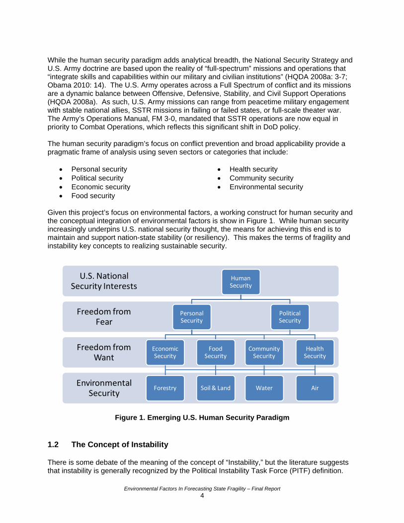
Given this project’s focus on environmental factors, a working construct for human security and the conceptual integration of environmental factors is show in Figure 1. While human security increasingly underpins U.S. national security thought, the means for achieving this end is to maintain and support nation-state stability (or resiliency). This makes the terms of fragility and instability key concepts to realizing sustainable security.
Environmental Security
Freedom from Want
Freedom from Fear
U.S. National Security Interests
Human Security
Personal Security
Economic Security
Forestry
Food Security
Soil & Land
Community Security
Water
Political Security
Health Security
Air
Figure 1. Emerging U.S. Human Security Paradigm 1.2 The Concept of Instability There is some debate of the meaning of the concept of “Instability,” but the literature suggests that instability is generally recognized by the Political Instability Task Force (PITF) definition.
Environmental Factors In Forecasting State Fragility – Final Report 4
PITF was formed to investigate “severe political conflicts and regime crises” (Marshall 2009). PITF proposed a strategic working definition that intrastate, political instability was indicated by the occurrence of events such as: Revolutionary Wars, Ethnic Wars, Adverse Regime Changes, Genocides and Politicides (Bates et al. 2003). Much of the instability efforts maintain a direct linkage to conflict research and risk analysis. ‘Failed states’ were clearly a key focus of post-Cold War national security thought in the 1990s. Following September 11, 2001, the resultant paradigm shift launched a debate over this status descriptor into the eventual development of the instability concept (Mata and Ziaja 2009). While instability enables national security practitioners to move further back on the conflict spectrum (depicted in Figure 2 in Section 1.4), the simplicity of the instability models does not provide sufficient breadth of actionable forewarning to understand the breakdown of not only the government but the relationship between a nation’s government and citizenry. The conceptual limitations of the stability concept and the increased adoption of a human security paradigm have spurred the rapid emergence of the complementary fragility concept, particularly within the U.S. national security community (i.e., defense, development and diplomacy). 1.3 The Concept of Fragility Fragility is a conceptual term of convergence among stovepipe disciplines of ‘international relations’ (i.e., security studies and conflict studies), ‘comparative politics’ (theories of state and democratization), and ‘development economics’ (Carment et al. 2008: 351; Carment et al. 2009: 9,11,12,14,16). The United States Agency for International Development (USAID) Fragile State Strategy makes a straightforward case of why fragility is highly policy relevant in the context of a U.S. “Whole of Government” and Full Spectrum Operations environment. Within the last two years, several key conceptual studies and practical resources on fragility and early warning have been released. As such, the conceptual discourse on fragility has been elaborated from the theoretical to the practical. As a result of this concept’s interdisciplinary nature and rapid emergence, the debate over the definition of fragility will likely continue into the future. While acknowledging this reality, its ability to integrate key concepts is likewise its strength. Like the broader concept of security, a core question is: Fragility of what? The definition of fragility first comes down to the key object of reference question. The recent German Development Institute’s and United Nation Development Programme’s “User’s Guide on Measuring Fragility” succinctly addresses this question.
“When fragility refers to the state, fragility is in fact a property of the political system. A ‘fragile state’ is incapable of fulfilling its responsibility as a provider of basic services and public goods, which in turn undermines its legitimacy.” “When fragility refers to society as a whole, violent conflict and other human-made crises constitute fragility itself. In this sense, fragility is a property of society and thus, being defined much more broadly, includes any kind of political, social or economic instability. This understanding of fragility is termed a ‘fragile social situation’.” (Mata and Ziaja 2009: 5)
From a nation-state perspective, the Organisation for Economic Co-operation and Development (OECD) developed a fragile state definition for its “Principles for Good International Engagement in Fragile States and Situations” report. It states that:
Environmental Factors In Forecasting State Fragility – Final Report 5
“States are fragile when state structures lack political will and/or capacity to provide the basic functions needed for poverty reduction, development and to safeguard the security and human rights of their populations.” (OECD 2007: 2)
Likewise, the Brookings Institution – creators of the Index for Index of State Weakness (ISW) in the Developing World – used the term state “weakness” that is analogous to state fragility. Based upon their literature review, they define weak states as:
“…countries lacking the capacity and/or will to foster an environment conducive to sustainable and equitable economic growth; to establish and maintain legitimate, transparent, and accountable political institutions; to secure their populations from violent conflict and to control their territory; and to meet the basic human needs of their population.” (Rice and Stewart 2008: 8)
Within the U.S. Government, USAID was an early adopter of the term fragility. USAID’s 2005 Fragile State Strategy suggests that “fragile states refer generally to a broad range of failing, failed, and recovering states”, “that are vulnerable,” and not “already in crisis” (i.e., instability is high) (USAID 2005a: 1). As a “Whole of Government” partner, the U.S. Army has adopted this understanding of state fragility into doctrine. For instance, FM 3-07’s Stability Operations Framework is based upon the “Fragile States Framework” which defines a fragile state as a:
“…country that suffers from institutional weaknesses serious enough to threaten the stability of the central government … aris[ing] from several root causes, including ineffective governance, criminalization of the state, economic failure, external aggression, and internal strife due to disenfranchisement of large sections of the population. Fragile states frequently fail to achieve any momentum toward development [and can] generate tremendous human suffering, create regional security challenges, and collapse into wide, ungoverned areas that can become safe havens for terrorists and criminal organizations.” (HQDA 2008b: 1-10)
While both USAID and the U.S. Army have clearly adopted definitions of state fragility, this project’s literature review suggested that they both implicitly utilize a definition of not only state fragility, but of social fragility. Given the recent and ongoing experiences in both Iraq and Afghanistan, this broader human security frame of fragility may seem most appropriate in dealing with realities on the ground. Based upon stakeholder conversations, USAID has already broadened its definition of fragility to a “relationship between the state and civil society, especially in terms of how that relationship is perceived by individuals and groups within that state” (USAID 2009: 8). This conceptual augmentation seems beneficial as it more precisely differentiates instability and fragility and greatly enhances a complementary, paired approach to inform policymaking and resource prioritization. The fragility literature views conflict as a symptom or consequence of state fragility, and Carment et al. (2008) found a statistically robust linkage between fragility, instability and conflict. This further supports the complementary use of instability and fragility approaches.
Environmental Factors In Forecasting State Fragility – Final Report 6
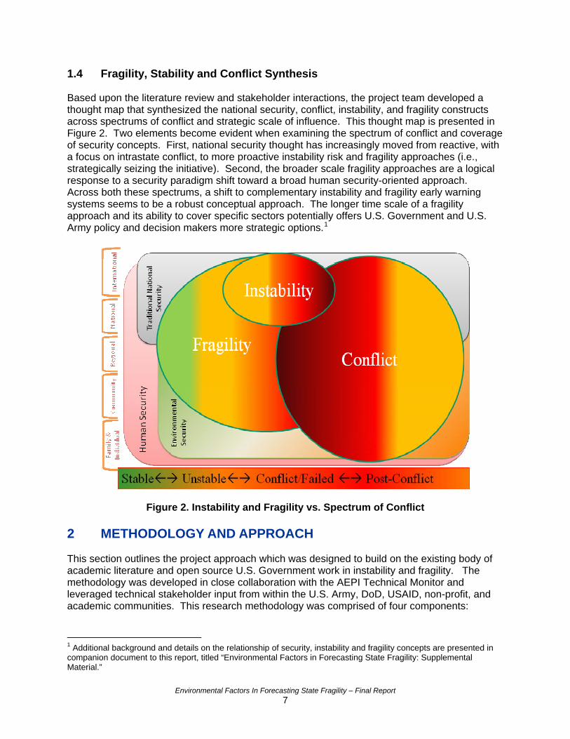
1.4 Fragility, Stability and Conflict Synthesis Based upon the literature review and stakeholder interactions, the project team developed a thought map that synthesized the national security, conflict, instability, and fragility constructs across spectrums of conflict and strategic scale of influence. This thought map is presented in Figure 2. Two elements become evident when examining the spectrum of conflict and coverage of security concepts. First, national security thought has increasingly moved from reactive, with a focus on intrastate conflict, to more proactive instability risk and fragility approaches (i.e., strategically seizing the initiative). Second, the broader scale fragility approaches are a logical response to a security paradigm shift toward a broad human security-oriented approach. Across both these spectrums, a shift to complementary instability and fragility early warning systems seems to be a robust conceptual approach. The longer time scale of a fragility approach and its ability to cover specific sectors potentially offers U.S. Government and U.S. Army policy and decision makers more strategic options.1
Figure 2. Instability and Fragility vs. Spectrum of Conflict 2 METHODOLOGY AND APPROACH This section outlines the project approach which was designed to build on the existing body of academic literature and open source U.S. Government work in instability and fragility. The methodology was developed in close collaboration with the AEPI Technical Monitor and leveraged technical stakeholder input from within the U.S. Army, DoD, USAID, non-profit, and academic communities. This research methodology was comprised of four components:
1 Additional background and details on the relationship of security, instability and fragility concepts are presented in companion document to this report, titled “Environmental Factors in Forecasting State Fragility: Supplemental Material.”
Environmental Factors In Forecasting State Fragility – Final Report 7
1) Literature Review of State Fragility, Regional Instability, and Environmental Factors 2) Stakeholder Identification and Engagement 3) Environmental Factors Quantitative Analysis 4) Early Warning Architecture Screening
2.1 Literature Review A literature review on the instability, fragility, and environmental security topical areas was conducted. The project team reviewed academic literature and conducted internet-based searches to compile information on historic and ongoing efforts. The intent was to develop a broad understanding of the current academic and practitioner landscape and also to focus on the details of promising data-driven instability and fragility indices. The research focused on identifying existing indices that do (or could) integrate environmental factors in a manner that may improve the ability of early warning systems to incorporate the impacts of destabilizing environmental conditions or trends. 2.2 Stakeholder Identification and Engagement The project team leveraged the literature review to identify appropriate DoD, U.S. Army, and civilian stakeholders. The stakeholder engagement method involved: 1) identification of key authors and thought leaders, 2) compilation of their contact information, and 3) sharing of background information on the Task. These efforts sought to identify new information on fragility by making direct requests to these stakeholders. The engagement also sought to help strengthen synergies with complementary government programs. Several workshops occurred early in the project that helped to identify potential academic, practitioner, and government stakeholders. For example, the Woodrow Wilson International Center for Scholars hosted a colloquium titled “Preventing and Rebuilding Failed States Amid Global Economic Crisis: What are Realistic Options for U.S. Policy?” that provided a unique opportunity to identify and meet several of the thought leaders in fragility. Likewise, the Center for Naval Analysis’s (CNA) “Climate Change, State Resiliency, and Global Security Conference” provided another opportunity to engage both military and civilian stakeholders. Such venues helped the project team to identify new stakeholders so later discussions could be coordinated. 2.3 Environmental Factors Quantitative Analysis The objective of the quantitative analysis was to develop a better understanding of the relationship of environmental factors to the national fragility indices. The quantitative analysis method consisted of the following elements:
1) Deconstruct fragility indices identified from the literature review and stakeholder engagement
2) Identify and compile the relevant environmental, development, and sustainability data utilized by these indices
3) Assemble dependent and independent variable datasets 4) Perform statistical analysis to explore relationships between environmental factors and
state fragility The methodology focused on leveraging existing quantitative approaches and datasets rather than generating new, original data or novel statistical analysis approaches. The strength of the
Environmental Factors In Forecasting State Fragility – Final Report 8
collaborative effort and the resulting methodology developed was that it truly built on the shoulders of key conceptual and practitioner leaders in these fields.2 From a methodology perspective, the project team sought to utilize quantitative analysis that would be conceptually grounded, statistically robust, and relevant to needs of the DoD, Army, and civilian agency stakeholders. The specific methods used for each step of the quantitative analysis are elaborated in Sections 2.3.1 thru 2.3.4. 2.3.1 Fragility Index Deconstruction The project team identified past and existing instability and fragility indices (open-source and unclassified only) from both the literature review and stakeholder engagement activities. Based upon preliminary literature review and stakeholder input, the project team determined that the quantitative analysis would yield more actionable results using fragility approaches given prior, extensive testing of environmental factors against conflict and instability such as that conducted by the PITF and Peace Research Institute Oslo (PRIO).3 Multiple fragility indices were identified and screened for viability and relevance. Four fragility indices were selected for further deconstruction based on the availability of the index results, availability of the underlying datasets, and index transparency. Transparency was particularly important for selection, as many methodologies are performed in a “black box” – restricting the ability of the project team to deconstruct and build upon these efforts. The selected indices were deconstructed to their base data elements and cross-walked to identify their common data element inputs. The four fragility indices were also further deconstructed to understand commonalities (and unique features) with their data classification and normalization processes. 2.3.2 Environmental Data Identification and Compilation Building on the literature review, the identification and compilation of environmental factor data was performed. This effort focused on identifying quantitatively-based statistical studies examining the link between environment and conflict.4 The project team classified the environmental issues and identified prospective environmental datasets. Targeted web searches were conducted using two different search engines (Bing.com and Google.com) to follow up on the identified environmental datasets and, where possible, obtain the original source datasets at the nation-state level. Where data was lacking, multiple keyword searches to find additional dataset sources in the respective category (i.e., agricultural degradation, deforestation, water and sanitation, etc.) were used. The environmental data identification also included a review of sustainability-focused indices because of the strong link this concept has to the U.S. Army’s sustainability program and the “Whole of Government” engagement approach
2 The quantitative methodology was directly influenced by the literature contributions and/or collaborative inputs of: Dr. Joseph Hewitt of Center for International Development and Conflict Management (CIDCM), University of Maryland; Dr. David Carment of Carleton University, Canada; Dr. Ted Miguel of University of California, Berkeley; Mr. Thomas Parris of iSciences, LLC; Dr. Mathis Wackernagel and Mr. Bill Coleman of Global Footprint Network (GFN); Dr. Monty Marshall of the George Mason University’s (GMU) Institute for Conflict Analysis; and Dr. Jack Goldstone of GMU’s Center for Global Policy and The Political Instability Task Force. Similar to PITF and other indices reviewed for this research, PRIO research focuses on identifying trends in global conflict. 3 PRIO is a non-profit peace research institute established in 1959 with an overarching purpose is to conduct research on the conditions for peaceful relations between states, groups and people. Similar to PITF and other indices reviewed for this research, PRIO research focuses on identifying trends in global conflict. National data sets are available at: http://www.prio.no/CSCW/Datasets/ 4 Authoritative articles that tested for evidence of a statistical relationship between instability and environmental factors include: Buhaug, Gleditsch & Theisen, 2008; Weider-Goodrich & Brecke, 2009; Hearne 2008.
Environmental Factors In Forecasting State Fragility – Final Report 9
elaborated in Field Manual 3-07 (HQDA, 2008b). There is also a significant overlap in variables and datasets.5 2.3.3 Data Assembly The identified and downloaded datasets were logged into an environmental factor data workbook. The individual data sets were assigned common sector classifications (i.e., security, political, economic, social, environmental) and analyzed to determine their commonality. Common datasets, shared by two or more of the fragility approaches, were identified for use as core datasets for fragility. 2.3.4 Statistical Analysis Preliminary environmental factor pathways yielded from the literature review provided the basis for the potential relationships with the identified environmental categories. 6 The project team identified potential environment-fragility relationships and developed these into an environment-fragility crosswalk spreadsheet.7 This crosswalk was then used to develop potential relationships that could represent environmental pressure points for fragility. These relationships guided the search for further environmental datasets and the quantitative analysis. The project team utilized both bivariate and multivariate statistical analysis approaches for examining the relationship between fragility and environmental factors. Fragility indices and their sub-components (i.e., governance, quality of life) were used as dependent variables and tested against independent variables using the environmental data collected (e.g., biocapacity, energy, and water). The bivariate analysis was not intended to identify causation, but to explore whether statistically significant relationships exist. A bivariate analysis is an examination of a single dependent and single independent variable to evaluate a statistical relationship between them. In this case, the bivariate analysis sought to identify any linear relationships between fragility (and its subcomponents) and environmental variables, as well as to examine the correlations between the environmental variables and other independent variables. This served to identify and remove variables that are too highly correlated to one another to be included in a robust fragility model. A multivariate linear regression approach was then utilized to model the environment-fragility relationship using the statistical software package JMP-8®.8 Multivariate linear regression considers the combined effects of multiple independent variables upon a dependent variable. Informed by the preliminary bivariate analysis results, the project team used fragility indices as dependent variables as the basis for the multivariate analysis, adding environmental variables one by one and also clustered together onto base models comprised of security, economic, political, and social factors. Environmental variables were time-lagged to reduce the effects of 5 Sustainability approaches and their constituent environment data were researched though academic literature review, subject matter expert resources, and web searches. The project team started with the review of journal articles, such as Singh et al. 2009, and reports gathered from well-known institutions and initiatives focused on sustainability indicators, such as the Institute for Sustainable Development and Balaton Working Group. Given the prolific thought on sustainability indicators, these initial resources provided broad and deep overview of a multitude of sustainability indicator approaches from the national level to local organizations. 6 Prior work by Homer-Dixon ,1994; Homer-Dixon, 1999; Lietzmann and Vest 1999; Miguel et al., 2004; Hearne, 2008; Buhaug et al., 2008; Wieder-Goodrich and Brecke, 2009; Burke et al 2009; and Alcorn, 2008; were all used to inform the relationship analysis between the fragility data and environmental factors. 7 The crosswalk spreadsheets are available in the companion document to this report, titled “Environmental Factors in Forecasting State Fragility: Supplemental Material.” 8 JMP-8® statistical software package is available from SAS Institute, Inc. http://www.jmp.com/software/jmp8/
Environmental Factors In Forecasting State Fragility – Final Report 10
reverse causality. In addition to testing composite fragility indices, this approach drew upon Miguel et al.’s (2004) and Burke et al.’s (2009) prior work using multivariate regression analysis to further explore more nuanced relationships between fragility and time-lagged environmental factors. 2.4 Alternative Architecture Identification To complement the nation-state statistical model approaches, the project team researched potential alternative methods of qualitative and quantitative data acquisition. Alternative architectures are approaches that could be used to triangulate data and strengthen the accuracy and utility of future instability and fragility early warning systems. This research sought to identify open source, network based, and technology architectures. The project team utilized a web-based literature review and stakeholder engagement to identify alternative architectures. Identified frameworks and technologies were reviewed for their feasibility, relevance, and potential value to U.S. Army stakeholders.9 2.5 Limitations The research conducted in this study was exploratory in nature. The project team sought to identify the latest in thought and analysis in the area of fragility and stability, and explore the possible role environmental factors can have in these types of analyses. The project team did not build a unique fragility model; rather, the team expanded on work done by others. Therefore, there are several limitations to the results reported here. Because the team relied on the work of others, the results reflect the conceptual foundation of these other modeling efforts. This area of research and analysis is relatively new and not without controversy. There is an ongoing academic debate about the role environmental factors may or may not have in assessing state fragility. Many existing models are inaccessible without special software or user permissions. The research therefore focused on a subset of all available fragility efforts. There were many issues with obtaining valid and reliable environmental datasets to test in the model runs. Nation-state environmental data was found to have many limitations in the following areas:
• Availability (open source vs. subscription, formats, and web accessible) • Coverage (global extent or specified groups only) • Accuracy (unintentional error or political adjustments) • Methodological Consistency (sampling, weighting, and aggregation) • Temporal Consistency (updated monthly, annually, or one time only) • Data Incompatibility (diverse or non-existing data standards)
Nation-state environmental data is often self-reported and potentially inaccurate. Many countries were missing certain pieces of data that were important for running the analyses, and the software used therefore was often forced to work with a smaller sample size rather than all of the more than 200 countries of the world. Furthermore, countries with the least accurate data or missing data are often likely to be those that are most fragile or have a history of conflict and poverty. The project team sought to use the best data available and many steps were taken to address issues with the data, such as ridding the model runs of variables that were highly
9 Additional background and details on the alternative analytical architectures are presented in companion document to this report, titled “Environmental Factors in Forecasting State Fragility: Supplemental Material.”
Environmental Factors In Forecasting State Fragility – Final Report 11

correlated with one another, but it was not possible to do so completely without also eliminating the very variables that are most statistically significant. 3 FINDINGS - LITERATURE REVIEW AND STAKEHOLDER
ENGAGEMENT This section presents the significant findings and results of the literature review and Stakeholder research effort. As a result of the literature review and stakeholder engagement, the project team was able to:
• Identify, understand, and assess the available instability and fragility frameworks • Crosswalk common environmental factors identified in conflict and instability literature
and thought • Identify compatible environmental, development, and sustainability data, indices, and
metrics • Synthesize potential environmental factor to instability and fragility pathways • Identify existing academic and government stakeholders
3.1 Instability Indices The project team compiled a list of indices used for predicting nation-state instability. While many of these indices are quantitative data driven, there are several approaches identified that are qualitative in nature, such as the Fund for Peace Failed State Index, further described in Section 5.3.10 This section presents significant findings from this compilation effort. Robust, data driven instability risk or early warning approaches were pioneered by the PITF efforts for U.S. Government policymakers over the last 15 years (Marshall 2009). After reviewing over 1300 available variables, PITF’s global and regional models have a well established instability early warning system, where 4-5 national datasets can reportedly generate instability risk forecasts pushing 80% accuracy out to about two years (Goldstone et al. 2000; Goldstone 2008). Building on this experience and foundation, others, such as the Center for International Development and Conflict Management (CIDCM) Peace and Conflict Instability Ledger, have continued to develop these approaches (e.g., USAID’s C/FACTS Instability Risk Matrix) (DCHA/CMM 2005; Hewitt et al. 2010). The project team also determined that the U.S. Army analysis community has likewise been developing and refining similar instability forewarning approaches, starting with Analyzing Complex Threats for Operations and Readiness (ACTOR) (O’Brien 2002), which has been further refined by the current day Forecast and Analysis of Complex Threats (FACTIII) system. ACTOR and FACTIII are unique in that their instability risk projections go out up to 15 years, which is significantly farther than the two-year norm. Both systems were developed by the Center for Army Analysis (CAA). Currently, the United States Army Corps of Engineers (USACE) is developing an analytical tool to measure outcomes during transitions from war to peace. The Measuring Progress in Conflict Environments (MPICE) system is designed to assist in formulating policy and implementing strategic plans by examining trends in conflict drivers and institutional performance. The overall goal is to enhance prospects for attaining enduring 10 Additional background and details on the compilation of instability indices are presented in companion document to this report, titled “Environmental Factors in Forecasting State Fragility: Supplemental Material.”
Environmental Factors In Forecasting State Fragility – Final Report 12
peace; therefore, many of the same variables are incorporated into this tool that are used in instability indices (Hainsey, 2010). After reviewing the available instability indices, the project team concluded that the instability risk approaches were relatively mature and that the addition of environmental factors would provide little or no added value; e.g., the PITF instability risk models are reportedly consistently generating ~80% accuracy with 4-5 national datasets (Goldstone et al. 2000; Goldstone 2008). The PITF had also previously attempted to increase this accuracy utilizing available environmental variable previous without a significant increase in statistical significance (Goldstone et al. 2000; Bates et al. 2003). These instability approaches are driven by a handful of direct factors, such as regime type, neighbors at war, and infant mortality, so is not surprising that environmental factors do not greatly increase accuracy because of the indirect nature of environmental pressures. CAA stakeholders indicated that FACTIII’s use of four national datasets was already surpassing the PITF level of accuracy using a new analysis algorithm. At 89%-91% success, this index provides a good instability assessment tool for the U.S. Army’s and U.S. Government’s early warning toolbox. As an instability approach, FACTIII was found to provide good predictability but, like its peers, assumes future conditions will mirror the past. This assumption is problematic in environmental security related climate change scenarios. These accurate but focused instability approaches are also limited in their ability to incorporate catalyzing events and rapidly changing conditions, but stakeholder discussions suggested that these weaknesses could be mitigated with qualitatively-based strategic approaches or operational early warning systems (Goldstone 2008). Given the preliminary findings on available instability approaches, such as PITF, USAID, and FACTIII, the project team determined that focusing on fragility approaches would best meet this project’s aims to better understand environmental factors’ influence. A review of Carment et al.’s (2008) work reinforced the conceptual and statistical linkage tethering fragility to instability and, as a result, conflict. This finding supports the complementary use of instability and fragility approaches by policymakers. USAID’s use of a paired instability and fragility approach reinforced this research direction. Furthermore, the expanded understanding of fragility also provided a more conceptually compatible approach with environmental factors and sustainability. 3.2 Fragility Indices Utilizing the definitions of fragility elaborated above, the project team compiled a list of indices used for predicting nation-state fragility. This section presents significant findings from this compilation effort.11 Fragility measurement and “early warning systems” have rapidly emerged amidst the academic and policymaker communities’ use of the term (Marshall 2008: 2). Many of these fragility indices and early warning systems seem to be a recent outgrowth of the instability approaches but differ in two ways. First, they utilize indicator clusters within the human security sectors, such as security, political, economic, and social. Second, these approaches also generally look at five-year clusters of national datasets and can provide longer early warning past the two-year outlook predominant with instability approaches. 11 Additional details on the compilation of fragility indices are presented in companion document to this report, titled “Environmental Factors in Forecasting State Fragility: Supplemental Material.”
Environmental Factors In Forecasting State Fragility – Final Report 13
“Fragility indices are used by donors, development practitioners and government officials to guide future action and evaluate past engagements; by researchers to investigate causes and consequences of state fragility; and by media and the public to keep track of risks to human wellbeing.” (Mata and Ziaja 2009; 9)
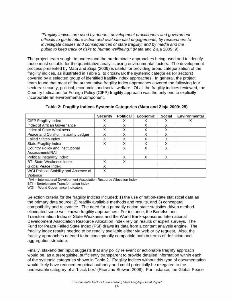
The project team sought to understand the predominate approaches being used and to identify those most suitable for the quantitative analysis using environmental factors. The development process presented by Mata and Ziaja (2009) is useful for providing broad categorization of the fragility indices, as illustrated in Table 2, to crosswalk the systemic categories (or sectors) covered by a selected group of identified fragility index approaches. In general, the project team found that most of the authoritative fragility index approaches covered the following four sectors: security, political, economic, and social welfare. Of all the fragility indices reviewed, the Country Indicators for Foreign Policy (CIFP) fragility approach was the only one to explicitly incorporate an environmental component.
Table 2: Fragility Indices Systemic Categories (Mata and Ziaja 2009: 25)
Security Political Economic Social Environmental CIFP Fragility Index X X X X X Index of African Governance X X X X Index of State Weakness X X X X Peace and Conflict Instability Ledger X X X X Failed States Index X X X X State Fragility Index X X X X Country Policy and Institutional Assessment/IRAI
X X X
Political Instability Index X X X BTI State Weakness Index X X Global Peace Index X WGI Political Stability and Absence of Violence
X
IRAI = International Development Association Resource Allocation Index BTI = Bertelsmann Transformation Index WGI = World Governance Indicators Selection criteria for the fragility indices included: 1) the use of nation-state statistical data as the primary data source; 2) readily available methods and results, and 3) conceptual compatibility and relevance. The need for a primarily nation-state statistics-driven method eliminated some well known fragility approaches. For instance, the Bertelsmann Transformation Index of State Weakness and the World Bank-sponsored International Development Association Resource Allocation Index rely on results of expert surveys. The Fund for Peace Failed State Index (FSI) draws its data from a content analysis engine. The fragility index results needed to be readily available either via web or by request. Also, the fragility approaches needed to be conceptually compatible both in terms of definition and aggregation structure. Finally, stakeholder input suggests that any policy relevant or actionable fragility approach would be, as a prerequisite, sufficiently transparent to provide detailed information within each of the systemic categories shown in Table 2. Fragility indices without this type of documentation would likely have reduced empirical authority and could potentially be relegated to the undesirable category of a “black box” (Rice and Stewart 2008). For instance, the Global Peace
Environmental Factors In Forecasting State Fragility – Final Report 14
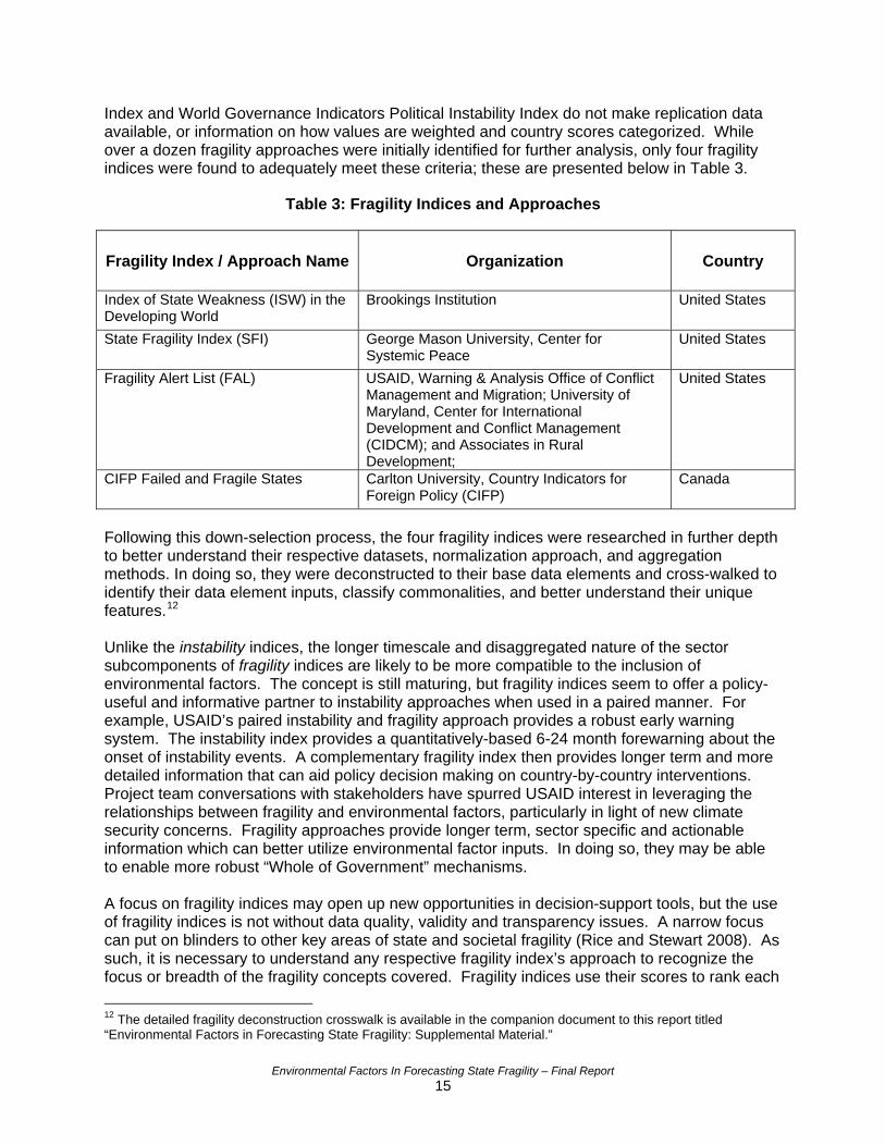
Index and World Governance Indicators Political Instability Index do not make replication data available, or information on how values are weighted and country scores categorized. While over a dozen fragility approaches were initially identified for further analysis, only four fragility indices were found to adequately meet these criteria; these are presented below in Table 3.
Table 3: Fragility Indices and Approaches
Fragility Index / Approach Name Organization Country
Index of State Weakness (ISW) in the Developing World
Brookings Institution United States
State Fragility Index (SFI) George Mason University, Center for Systemic Peace
United States
Fragility Alert List (FAL) USAID, Warning & Analysis Office of Conflict Management and Migration; University of Maryland, Center for International Development and Conflict Management (CIDCM); and Associates in Rural Development;
United States
CIFP Failed and Fragile States Carlton University, Country Indicators for Foreign Policy (CIFP)
Canada
Following this down-selection process, the four fragility indices were researched in further depth to better understand their respective datasets, normalization approach, and aggregation methods. In doing so, they were deconstructed to their base data elements and cross-walked to identify their data element inputs, classify commonalities, and better understand their unique features.12 Unlike the instability indices, the longer timescale and disaggregated nature of the sector subcomponents of fragility indices are likely to be more compatible to the inclusion of environmental factors. The concept is still maturing, but fragility indices seem to offer a policy-useful and informative partner to instability approaches when used in a paired manner. For example, USAID’s paired instability and fragility approach provides a robust early warning system. The instability index provides a quantitatively-based 6-24 month forewarning about the onset of instability events. A complementary fragility index then provides longer term and more detailed information that can aid policy decision making on country-by-country interventions. Project team conversations with stakeholders have spurred USAID interest in leveraging the relationships between fragility and environmental factors, particularly in light of new climate security concerns. Fragility approaches provide longer term, sector specific and actionable information which can better utilize environmental factor inputs. In doing so, they may be able to enable more robust “Whole of Government” mechanisms. A focus on fragility indices may open up new opportunities in decision-support tools, but the use of fragility indices is not without data quality, validity and transparency issues. A narrow focus can put on blinders to other key areas of state and societal fragility (Rice and Stewart 2008). As such, it is necessary to understand any respective fragility index’s approach to recognize the focus or breadth of the fragility concepts covered. Fragility indices use their scores to rank each 12 The detailed fragility deconstruction crosswalk is available in the companion document to this report titled “Environmental Factors in Forecasting State Fragility: Supplemental Material.”
Environmental Factors In Forecasting State Fragility – Final Report 15
state, and typically there are three main “tiers:” low, medium and high fragility (and thus low, medium and high risk for instability and eventual collapse). If the ranking methodologies focus users on the states with highest risk, this could minimize the attention on “middle tier” states – those that have a lower risk but could benefit from early and targeted foreign assistance interventions (Paris 2009; Rice and Stewart 2008). A focus on these “middle tier” states can potentially tease out additional contextual information as a result of the differing index data and analysis approaches (Paris 2009). There are transparency issues with the fragility indices that make it difficult to replicate the process and validate the results (Rice and Stewart 2008, Mata and Ziaja 2009). Only a few fragility index approaches explain issues related to data availability, data quality and levels of uncertainty by openly sharing the data sources and analytical methodology. Another shortcoming is that most of the fragility indices do not include an explicit environmental sector component, with the exception of the CIFP Failed and Fragile State Index, and this index could provide a more balanced treatment of environmental factors (i.e., analysis suggested that it heavily utilized energy, greenhouse gases, and ecological footprint indicators). The fragility indices seek to provide earlier forewarning of trouble areas and sectors, but many still focus on current status and do not capture other key data elements such as historical trends and volatility (CIFP 2010; Rice and Stewart 2008; Bossel 1999). Another finding of this research is that there are significant issues with data at the national scale: there is a time lag, environmental issues rarely conform to political boundaries, and few environmental indicators are tracked at this scale – much less at regular intervals over time.
“Fragility indices require significant maturation before they can satisfactorily inform policy. Fragility indices are highly aggregate and abstract representations of complex social systems, which makes them both hard to interpret and error prone. Furthermore, the indices measure at the national level while important differences and phenomena are not picked up at the sub-national level. All these characteristics make them highly unspecific. Complexity always needs to be reduced to display state fragility in numbers, but that same complexity has to be reconsidered from various angles to inform real action.” (Mata and Ziaja, p,.35)
Despite these limitations, this research found potential benefits of utilizing fragility indices that incorporate environmental factors. A paired instability and fragility approach is believed to be more conceptually robust and policy-useful. Every fragility index inherently has strengths and weakness, so the use of multiple indices can help bound uncertainty and increase the authority of the information provided, particularly when quantitative and qualitative data is triangulated. There are ongoing efforts to advance environmental data acquisition, spatial data technologies, and other collaborative architectures which represent an expanding toolbox for early warning capabilities. The ability to track real-time changes from open source satellite imagery and perform automated content analysis could help realize the promise of “multiple method” early warning options (Goldstone 2008: 1). Fragility index and sustainability indicator approaches share similar data and analysis architectures. As such, decision support frameworks from both communities of practice can yield improved approaches and aid in the incorporation of environmental factors.
Environmental Factors In Forecasting State Fragility – Final Report 16
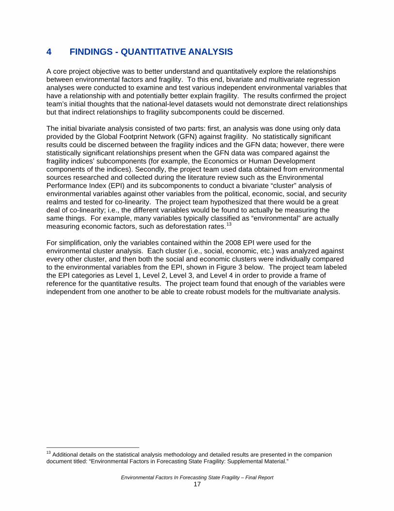
4 FINDINGS - QUANTITATIVE ANALYSIS A core project objective was to better understand and quantitatively explore the relationships between environmental factors and fragility. To this end, bivariate and multivariate regression analyses were conducted to examine and test various independent environmental variables that have a relationship with and potentially better explain fragility. The results confirmed the project team’s initial thoughts that the national-level datasets would not demonstrate direct relationships but that indirect relationships to fragility subcomponents could be discerned. The initial bivariate analysis consisted of two parts: first, an analysis was done using only data provided by the Global Footprint Network (GFN) against fragility. No statistically significant results could be discerned between the fragility indices and the GFN data; however, there were statistically significant relationships present when the GFN data was compared against the fragility indices’ subcomponents (for example, the Economics or Human Development components of the indices). Secondly, the project team used data obtained from environmental sources researched and collected during the literature review such as the Environmental Performance Index (EPI) and its subcomponents to conduct a bivariate “cluster” analysis of environmental variables against other variables from the political, economic, social, and security realms and tested for co-linearity. The project team hypothesized that there would be a great deal of co-linearity; i.e., the different variables would be found to actually be measuring the same things. For example, many variables typically classified as “environmental” are actually measuring economic factors, such as deforestation rates.13 For simplification, only the variables contained within the 2008 EPI were used for the environmental cluster analysis. Each cluster (i.e., social, economic, etc.) was analyzed against every other cluster, and then both the social and economic clusters were individually compared to the environmental variables from the EPI, shown in Figure 3 below. The project team labeled the EPI categories as Level 1, Level 2, Level 3, and Level 4 in order to provide a frame of reference for the quantitative results. The project team found that enough of the variables were independent from one another to be able to create robust models for the multivariate analysis.
13 Additional details on the statistical analysis methodology and detailed results are presented in the companion document titled: “Environmental Factors in Forecasting State Fragility: Supplemental Material.”
Environmental Factors In Forecasting State Fragility – Final Report 17
Index (Level 1)
Objectives (Level 2)
Subcategories (Level 3) Indicators (Level 4)
EPI Environmental Health
Environmental burden of disease
Environmental burden of disease (DALYs)
Water (effects on humans) Adequate sanitation Drinking water Air Pollution Urban particulates (effects on humans) Indoor air pollution Local ozone
Ecosystem Vitality
Air Pollution (effects on nature) Regional ozone
Sulfur dioxide emissions Water (effects on nature) Water quality Water stress Biodiversity & Habitat Conservation risk index Effective conservation Critical habitat protection* Marine Protected Areas*
Forestry Growing stock change
Fisheries Marine Trophic Index Trawling intensity Agriculture Irrigation Stress* Agricultural Subsidies Intensive cropland Burnt Land Area Pesticide Regulation Climate Change Emissions per capita
Emissions per electricity generation
Industrial carbon intensity
Figure 3. Components of the Environmental Performance Index14
Using the statistical software package JMP-8®, the project team conducted multivariate analysis by creating a base model for each fragility index comprised of one variable each from the political, security, economic, and social clusters: Exponential of the Polity Score, State Conflict Intensity, Gross Domestic Product Growth, and Kilo Calorie consumption/person/day. Then, using linear regression analysis, the project team added environmental factors (from both the EPI and from other sources collected in the literature review) to the base model to test for the significance of environmental factors and to determine whether the adjusted R2 value was
pi/
14This figure is adapted from the Yale Center for Environmental Law and Policy, the Columbia University Center for International Earth Science Information Network, the World Economic Forum, and the Joint Research Centre of the European Commission. 2008 Environmental Performance Index. Downloaded from http://sedac.ciesin.columbia.edu/es/e .
Environmental Factors In Forecasting State Fragility – Final Report 18
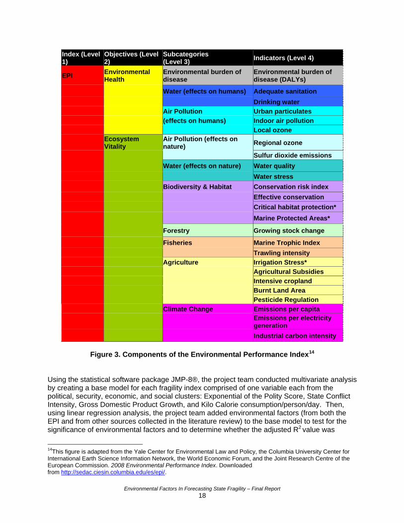
improved by the addition of environmental variables. This was done by adding the variables one at a time and also by adding clusters of environmental variables, such as the entire non-EPI dataset, to the base model. The findings suggested that environmental factors do slightly improve the base model’s ability to predict fragility overall, but a distinctive pattern emerged as to the types of environmental variables that had the most impact. Those that measure health-related aspects of the environment, such as improvement in sanitation, water, and air pollution, had a measurable effect on fragility (i.e., higher air pollution rates = higher fragility). However, those that fell into the Ecosystem Vitality realm (Level 2 of the EPI) typically had a lower effect on fragility, or even slightly decreased the predictability of the model. Table 4 provides the results with the EPI, using only levels 1 through 3, in which the EPI variables were added one at a time (not together) to the base model to test their effect on each fragility index. The resulting adjusted R2 values are shown in the table. The results could mean a variety of things. It is possible that environmental health factors are truly the most significant and that other environmental factors have little or no effect on fragility. However, given that the data used was publicly available nation-state data, which is often incomplete and not truly measuring the value of ecosystem services,15 it is difficult to deduce the true effect of non-health related environmental factors. However, the results provide sommeaningful insight into the value of environmental health factors and also expose the lack of quality data on ecosystem services.
e
Table 4: Results of Multivariate Analysis with EPI Levels 1 – 3
CIFP 2007 ISW 2008 SFI 2007 USAID 2008No. of countries 104 83 104 103Base Model 0.8216 0.7805 0.7547 0.8116EPI 2008 Value 0.8924 0.8552 0.8406 0.8793No. of countries 104 83 104 103Base Model 0.8216 0.7805 0.7547 0.8116Environmental Health 0.8728 0.8683 0.8591 0.8941Ecosystem Vitality 0.8384 0.7781 0.7528 0.8102No. of countries 76 57 76 75Base Model 0.8163 0.7621 0.7498 0.8023Environmental burden of disease 0.8658 0.8312 0.8313 0.8575Water (effects on humans) 0.8613 0.8264 0.8312 0.8917Air Pollution 0.8525 0.7865 0.7791 0.8505Air Pollution (effects on nature) 0.8189 0.7747 0.7516 0.8075Water (effects on nature) 0.8426 0.7579 0.7681 0.8147Biodiversity & Habitat 0.8205 0.7578 0.7464 0.7995Forestry 0.8164 0.7583 0.7472 0.8041Fisheries 0.8137 0.7581 0.7464 0.7998Agriculture 0.8376 0.7689 0.7601 0.8131Climate Change 0.8292 0.7592 0.7491 0.8001
Level 1
Level 2
Level 3
15 Ecosystem services are defined generally as benefits people receive from ecosystems such as supporting, provisioning, regulating and cultural benefits. These services are not fully valued in economic markets and the ability of ecosystems to continually provide benefits is not assessed. Refer to Millenium Ecosystem Assessment resources at: http://www.millenniumassessment.org/.
Environmental Factors In Forecasting State Fragility – Final Report 19
5 FINDINGS - ALTERNATIVE ARCHITECTURES The project team focused on fragility indices that utilized national- level statistical data to analyze state fragility and measure the relationship between environmental factors and fragility. However, initial research identified several fragility approaches that utilized or combined qualitative expert and/or content analysis approaches. Within the realm of defense, diplomacy, and development, these complementary qualitative approaches are a key part of data acquisition, analysis, and decision making processes already used within the U.S. Government. This led the project team to research complementary alternative data, analysis, and integration architectures that can be used to cross-reference with results gathered from national level statistical data. In the context of instability, Dr. Jack Goldstone makes a persuasive argument for the complementary usage of both quantitative (data driven) forecast models and qualitative (expert based) “structural analogs” (2008: 4). This complementary hybrid approach can increase the confidence of forewarning when the independent methods agree (i.e., data “triangulation”) and can provide red flags or contextual information when the results disagree (Goldstone 2008; Berg 2006: 5). The U.S. intelligence community already uses data triangulation as a foundational method in their information quality ratings. This method can help increase the accuracy of both instability and fragility models. The following alternative architectures are highlighted due to their applicability to the focus of this project, their maturity, and their ease of use. Many of the following can be used both on a local or a national/regional scale. It is important to note that users must be mindful of resources and feasibility when considering any of the following tools or methods.16 5.1 Geospatial Tools The National Aeronautics and Space Administration (NASA), National Oceanic and Atmospheric Administration (NOAA), and various other government agencies have been collecting geospatial data via remote sensing of the Earth’s surface for decades. Historically, however, remote sensing data has not been a popular source for social science, but social scientists and physical scientists are now beginning to realize the importance of collaboration (National Research Council, 1998). The concept has already been applied to map the spread of social networks and ideas, such as the spread of Islamic extremism, and it can be applied similarly to track environmental trends and conditions that may contribute to fragility in a given region. Geospatial data is extremely valuable as opposed to nation-state data because it is not subject to human error in gathering or reporting data, it ignores arbitrary political boundaries, and it can be presented spatially or in tabular format. Data on a sub-national basis, e.g., 100 by 100 kilometer grids, also provides a significantly larger population for statistical analysis compared to total number of nation states. Geographic Information Systems (GIS) are satellite-driven software tools for managing, analyzing, and visualizing geographically enabled information. An excellent example of the use of GIS is USAID’s Famine Early Warning System Network (FEWS NET).17 FEWS NET was developed in 1985 by USAID to monitor for signs of famine in vulnerable countries, particularly within sub-Saharan Africa. FEWS NET is an operational tool and network that uses GIS to integrate remote sensing data (e.g., rainfall), local calibrated analysis algorithms, and field 16 A full listing and description of alternative architectures found is included in the companion document to this report titled: “Environmental Factors in Forecasting State Fragility: Supplemental Material.” 17 Detailed information and links to data sources: http://www.fews.net/Pages/default.aspx
Environmental Factors In Forecasting State Fragility – Final Report 20
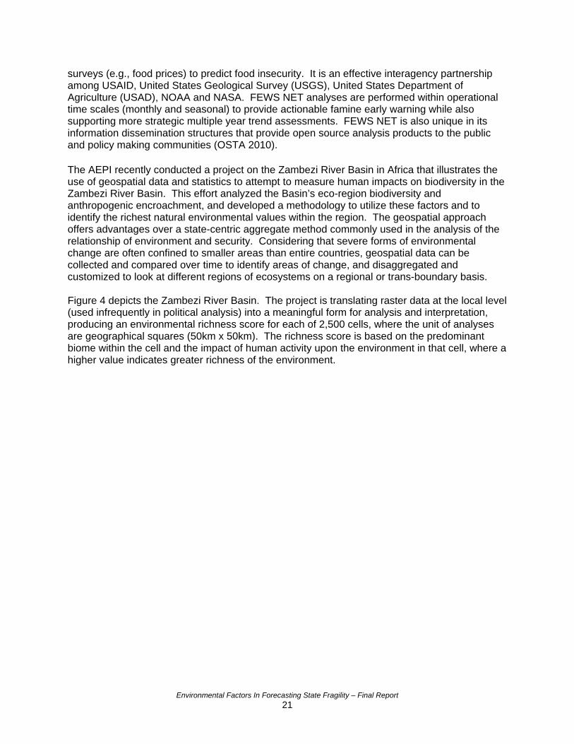
surveys (e.g., food prices) to predict food insecurity. It is an effective interagency partnership among USAID, United States Geological Survey (USGS), United States Department of Agriculture (USAD), NOAA and NASA. FEWS NET analyses are performed within operational time scales (monthly and seasonal) to provide actionable famine early warning while also supporting more strategic multiple year trend assessments. FEWS NET is also unique in its information dissemination structures that provide open source analysis products to the public and policy making communities (OSTA 2010). The AEPI recently conducted a project on the Zambezi River Basin in Africa that illustrates the use of geospatial data and statistics to attempt to measure human impacts on biodiversity in the Zambezi River Basin. This effort analyzed the Basin’s eco-region biodiversity and anthropogenic encroachment, and developed a methodology to utilize these factors and to identify the richest natural environmental values within the region. The geospatial approach offers advantages over a state-centric aggregate method commonly used in the analysis of the relationship of environment and security. Considering that severe forms of environmental change are often confined to smaller areas than entire countries, geospatial data can be collected and compared over time to identify areas of change, and disaggregated and customized to look at different regions of ecosystems on a regional or trans-boundary basis. Figure 4 depicts the Zambezi River Basin. The project is translating raster data at the local level (used infrequently in political analysis) into a meaningful form for analysis and interpretation, producing an environmental richness score for each of 2,500 cells, where the unit of analyses are geographical squares (50km x 50km). The richness score is based on the predominant biome within the cell and the impact of human activity upon the environment in that cell, where a higher value indicates greater richness of the environment.
Environmental Factors In Forecasting State Fragility – Final Report 21
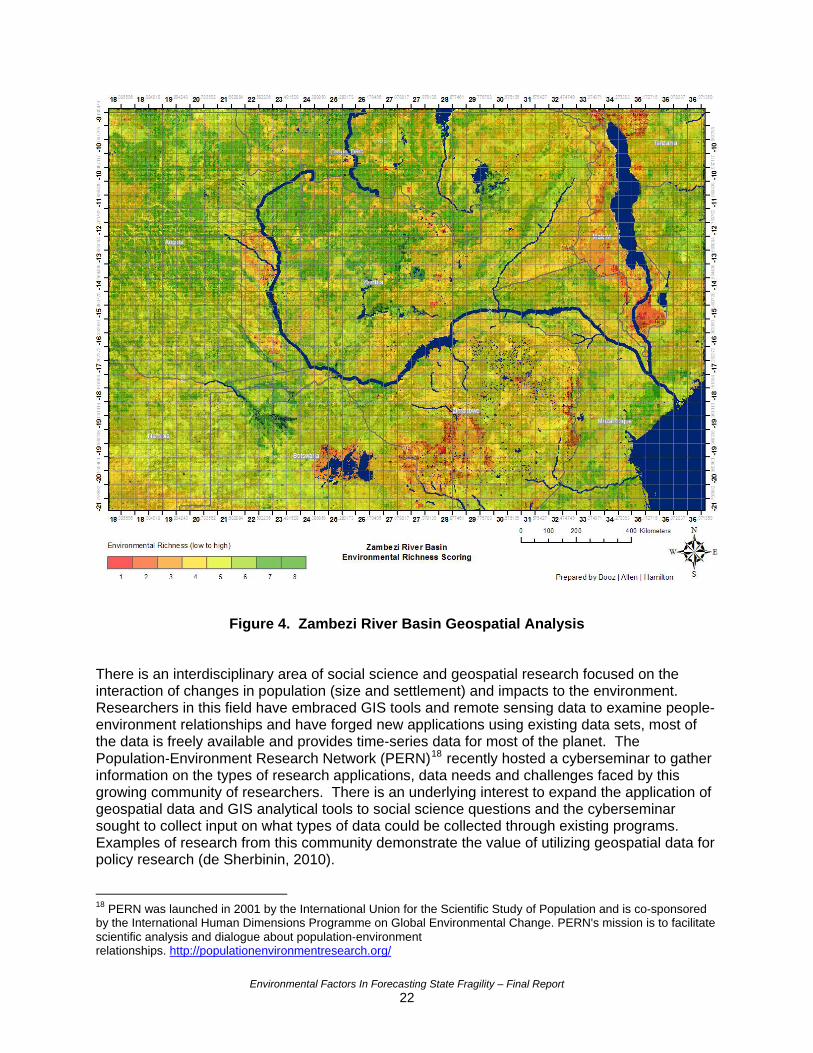
Figure 4. Zambezi River Basin Geospatial Analysis There is an interdisciplinary area of social science and geospatial research focused on the interaction of changes in population (size and settlement) and impacts to the environment. Researchers in this field have embraced GIS tools and remote sensing data to examine people-environment relationships and have forged new applications using existing data sets, most of the data is freely available and provides time-series data for most of the planet. The Population‐Environment Research Network (PERN)18 recently hosted a cyberseminar to gather information on the types of research applications, data needs and challenges faced by this growing community of researchers. There is an underlying interest to expand the application of geospatial data and GIS analytical tools to social science questions and the cyberseminar sought to collect input on what types of data could be collected through existing programs. Examples of research from this community demonstrate the value of utilizing geospatial data for policy research (de Sherbinin, 2010).
esearch.org/
18 PERN was launched in 2001 by the International Union for the Scientific Study of Population and is co‐sponsored by the International Human Dimensions Programme on Global Environmental Change. PERN's mission is to facilitate scientific analysis and dialogue about population‐environment relationships. http://populationenvironmentr
Environmental Factors In Forecasting State Fragility – Final Report 22
5.2 Qualitative Opinion – Expert Surveys and National Polls National polls and expert surveys can provide excellent sources of information on the trends and attitudes affecting the general populous and on issues affecting any given region as seen by subject matter experts. Movement and change in the attitudes of the people – when measured over time using consistent methods – is a powerful indicator in and of itself, depending on the nature of the questions asked. Three examples of data sources based on qualitative data and expert opinions are presented in this section. The Stockholm International Peace Research Institute (SIPRI) maintains a database of quantitative statistics and qualitative data collected from local experts on a regular basis. The Facts on International Relations and Security Trends (FIRST) website links multiple data sources in a format that allows for ease of search by topical area or by geographic location. The objective of FIRST is to “offer professionals in the field and in related sciences, such as researchers, politicians and the media, an organized authoritative and structured factual reference system in the form of country profiles” (SIPRI, 2010). In addition, SIPRI has been actively working on a project entitled “Early Warning Indicators for Preventive Policy” since 2002 that combines quantitative information from the FIRST database with monthly expert surveys and internet technology to create country and regional profiles that will be made available on the internet. This approach allows SIPRI to gather both short- and long-term data and incorporate monthly changes in political situations that are not necessarily captured by nation-state data that is gathered annually. Another example of the collection and synthesis of qualitative data on environmental security and other global issues is the Millennium Project. This organization is an independent, non-profit global research think tank of futurists, scholars, business planners, and policy makers who work for international organizations, governments, corporations, non-governmental organizations (NGO), and universities. “The Millennium Project manages a coherent and cumulative process that collects and assesses judgments from over 2,500 experts selected from its 33 nodes around the world” (Millennium Project, 2010). The organization distills data from multiple sources and prepares an annual "State of the Future" report, along with other series and special studies. The Emerging Environmental Security Issues Monthly Reports are a part of their special studies, and are housed on AEPI’s home page. These reports highlight emerging threats and any other relevant insights into emerging environmental security issues. A final example that illustrates the use of expert surveys in a recognized index is the Corruption Perceptions Index (CPI). This index focuses on corruption, not environmental security, but is relevant to issues of state fragility. The CPI is prepared by Transparency International, a global organization that fights corruption and its impacts around the world, raise awareness, and diminish apathy towards corruption. The CPI measures the perceived level of public-sector corruption in 180 countries and territories around the world. The CPI is a "survey of surveys," based on 13 different expert and business surveys (Transparency International, 2009). The results of the survey form an interesting parallel with fragility, where many of the most fragile countries are also the most corrupt. Transparency International also produces an annual publication called The Global Corruption Barometer, which is a survey that assesses general public attitudes toward and experience of corruption in dozens of countries around the world. Lastly, Transparency International provides a YouTube channel and a global discussion group on its website, providing another source of information in the form of social network analysis.
Environmental Factors In Forecasting State Fragility – Final Report 23
5.3 Content Analysis Content analysis is a research methodology that examines the words, phrases and concepts within written media. Researchers are looking for frequency of certain terms or relationships between concepts and use this to uncover significant patterns and meanings. Text is coded and content software can be used to perform the analysis. The Fund for Peace (FfP), in collaboration with Foreign Policy magazine, develops an annual ranking of 177 countries called the Failed States Index (FSI) utilizing content analysis. This index ranks countries by stability across 12 social, political, and economic indicators. The data is gathered from thousands of articles and reports and is processed by FfP’s Conflict Assessment System Tool (CAST) software using content analysis algorithms. FSI is a frequently cited and alternative source of information on the state of any particular country’s social, political, or economic climate. An identified weakness of this approach is the inherent difficulty of gleaning quantifiable information from media reports, which are the primary data source for CAST’s content analysis. In addition, the CAST software is patented by FfP and therefore the data used to develop the FSI is not replicable. Nonetheless, the FSI, though using a very different method to rank countries, typically develops results that are similar to other fragility and instability indices (FfP, 2010). 5.4 Interactive Web 2.0 Applications Web 2.0 is the name given to emerging web site capabilities that allow users to actively participate on the web. Users can contribute information to web sites, create links between related content and collaborate in communities of interest – all in an interactive fashion that was not possible in ‘Web 1.0.’ Web 1.0 refers to static web content where information flow is one-way; Web 2.0 is the next version, or ‘upgrade.’ Examples of these new capabilities include blogging, Really Simple Syndication (RSS) feeds, tagging and social bookmarking. This section presents two examples of how these tools are being used to enhance information collection and exchange. A relevant example of the use of Web 2.0 tools is the Defense Technology Warning System (DTWS). The DTWS presents real-time maps of technological updates that could pose a threat to worldwide peace and stability. The threats are color-coded using the stoplight system and link to media articles and data dashboards that discuss the particular technology issue at hand. The Defense Intelligence Agency’s Defense Technology Warning Office has led the development of DTWS. It was developed for DoD acquisition, policy and warfighting professionals who need reliable information regarding future technological developments. DTWS allows for collaboration through the use of tagging and social bookmarking. This web-based tool represents a potential integration platform for strategic and operational use of instability and fragility early warning information. Using the existing DTWS architecture, state instability, regional fragility, and environmental factors could be disseminated either as either classified products for U.S. Whole of Government users only or as open-source resources for partner and host country personnel. The open source version of this architecture can be accessed at: http://dtws.ad.ctcgsc.org/. A screen capture of the web tool is shown in Figure 5.
Environmental Factors In Forecasting State Fragility – Final Report 24
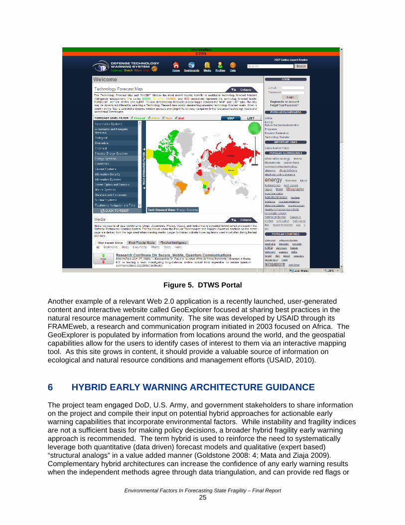
Figure 5. DTWS Portal
Another example of a relevant Web 2.0 application is a recently launched, user-generated content and interactive website called GeoExplorer focused at sharing best practices in the natural resource management community. The site was developed by USAID through its FRAMEweb, a research and communication program initiated in 2003 focused on Africa. The GeoExplorer is populated by information from locations around the world, and the geospatial capabilities allow for the users to identify cases of interest to them via an interactive mapping tool. As this site grows in content, it should provide a valuable source of information on ecological and natural resource conditions and management efforts (USAID, 2010). 6 HYBRID EARLY WARNING ARCHITECTURE GUIDANCE The project team engaged DoD, U.S. Army, and government stakeholders to share information on the project and compile their input on potential hybrid approaches for actionable early warning capabilities that incorporate environmental factors. While instability and fragility indices are not a sufficient basis for making policy decisions, a broader hybrid fragility early warning approach is recommended. The term hybrid is used to reinforce the need to systematically leverage both quantitative (data driven) forecast models and qualitative (expert based) “structural analogs” in a value added manner (Goldstone 2008: 4; Mata and Ziaja 2009). Complementary hybrid architectures can increase the confidence of any early warning results when the independent methods agree through data triangulation, and can provide red flags or
Environmental Factors In Forecasting State Fragility – Final Report 25
contextual information when the results disagree. Therefore, a thoughtful hybrid approach could greatly increase the accuracy, explainability, and utility of a paired instability and fragility early warning system. This section outlines principles of such an approach, some guidance on what the approach would encompass, and ends with a brief discussion of institutional and data challenges that would need to be overcome to implement a viable hybrid approach. 6.1 Proposed Hybrid Early Warning Architecture Approach This study greatly benefited from recent resources focused on fragility and early warning architectures (OECD 2009; Mata and Ziaja 2009). Building upon these resources and the project findings, a relevant and sustainable hybrid instability and fragility early warning system should:
• Maintain a clearly understood distinction from intelligence activities, personnel, and systems
• Match conceptually and integrate with its broader user communities’ missions • Utilize complementary top-down and bottom-up approaches that:
o Rely upon several instability and fragility structural approaches o Leverage field network to ground truth and refine methods
• Utilize open source methods and a transparent architecture • Leverage both quantitative and qualitative data and analysis methods • Constantly evaluate new data sources and tools • Communicate with information technology tools • Target capabilities to meet user group needs and processes • Generate and provide updates and products to its end users • Be directly linked and embedded with agencies and policy makers that can act on and
respond to findings
A preliminary hybrid instability and fragility early warning approach is proposed that seeks to meet these guiding principles. This section outlines some of the features and capabilities that should be considered in the development of a hybrid approach. The recommended approach would aim to utilize conceptually consistent definitions with both USAID, DoD and U.S. Department of State policies. It would also seek to develop coverage and information sharing mechanisms that could aid with meaningful action and “Whole of Government” coordination. The hybrid early warning system would need to clearly identify both the end users and technical contributors. Given a “Whole of Government approach”, active end users would include the U.S. Army, other Services, OSD, USAID, and Department of State personnel. The recommended hybrid system would utilize bottom-up architectures that could be adapted for compatibility with the aforementioned top-down early warning approaches. This paired approach should leverage the CAA FACTIII Instability Architecture. FACTIII is uniquely suited for a pairing with a fragility index approach as its time frame is longer than the approximately two years early warning provided by other instability approaches. The Measuring Progress in Conflict Environments (MPICE) architecture could be adapted to provide bottom-up fragility data and analysis that could be used in a conflict or post-conflict situation. This field data approach could be standardized and utilized by in country Department of State and USAID personnel.
Environmental Factors In Forecasting State Fragility – Final Report 26
A paired instability and fragility risk index approach would create some statistical linkages and overlap, but using these complementary conceptual approaches together is superior to either singular approach. For instance, USAID found that this unified approach would often uncover emergent fragility in middle tier countries – that is, countries with middle ranking compared to all other countries – that would not be flagged by the nearer term instability risk rating (USAID 2006). Furthermore, the fragility approach’s disaggregated structure provides more actionable information and can incorporate longer term environmental factors. These data acquisition and analysis architectures could be integrated using a similar model to FEWS NET. Other geospatial and web-based architectures could be used to generate hybrid early warning products for end users. This proposed hybrid architecture would need to be developed incrementally due to the level of effort required for developing new tools and engaging relevant stakeholders. 6.2 Challenges and Integration Opportunities There are challenges associated with developing a hybrid fragility and instability early warning architecture that is both valid and user-friendly. These challenges are in addition to resourcing the human capital needed to develop the analytical and information sharing tools. Two major challenges are discussed in this section: 1) institutional differences, and 2) data limitations. Institutional cultural and conceptual differences were identified during the course of this research that could impact the ability to develop an integrated hybrid approach. The project team noted some understandable differences between the institutional cultures of U.S. Department of State, USAID, and DoD. These agencies have very different missions and as a result have different data acquisition, analysis, and decision making traditions. Additionally, the project team identified some conceptual discord between conflict studies and environmental sustainability disciplines. There is a conceptual divergence that centers on conflict studies’ reliance on neo-classical economics versus the use of ecological economics by environmental and sustainability scientists. While certainly not “show stoppers,” these institutional and conceptual differences are compelling reasons to initiate greater interdisciplinary and interagency dialogs on instability and fragility hybrid early warning architectures. Agencies are performing analyses independently and could benefit from increased data collection efficiency and leveraging of efforts. With a renewed ”Whole of Government” mandate, these diverse institutional cultures can be a potential strength for future collaborative analysis that could positively impact the ability to garner resources. While coordination mechanisms will continue to evolve, a modular and interoperable hybrid early warning system could represent an opportunity to encourage collaboration, particularly leveraging the concept of fragility. The existing instability and fragility analysis approaches rely heavily on the quality and comprehensiveness of available datasets. Several data limitations must be considered when interpreting the outcomes of any instability and fragility results. These were found to include:
• Collection methodology, definitions and business rules • Completeness • Compatibility • Uncertainty • Transparency
Environmental Factors In Forecasting State Fragility – Final Report 27
Current fragility indices rely on statistical methods and, as such, the quality of the datasets utilized is key to ensuring valid outputs. The index results and findings are only as good as the quality and coverage of the data available. While the index developers have researched and leveraged the highest quality data available, it is important to note that the completeness of the available data could be made more robust, particularly with remote sensing and field network data. National-level environmental factor datasets were found to be particularly problematic and this should be taken into account when undertaking further analyses and interpreting results. For instance, there is a lack of consistent data standards making it difficult to standardize data entry and combine data sources. Also, many ecologically important indicators reflect natural features of the landscape, which do not necessarily correspond to political boundaries. There may be extreme variation within a single nation that a single indicator would “average” and thus provide misleading results. 7 CONCLUSIONS AND RECOMMENDATIONS The purpose of this project was to provide the U.S. Army with actionable forecasting approach options that can incorporate environmental factors, augment awareness of their destabilizing influences on state fragility and regional stability, and inform coordinated intervention in support of regional engagement and stability operations per Presidential and DoD directives. Current instability approaches are useful for their designed purpose of identifying those countries with a high risk of conflict, but they may need reinforcement to inform and support policy interventions at countries with middle- range risk for conflict. Fragility indices and environmental factor contributors can help provide more leading indicators and assessments that support specific policy and practical interventions. A hybrid early warning architecture with clear dataset linkages and complementary synergy between instability, fragility, and environmental antecedents could support U.S. Government efforts to mitigate the risks of natural and manmade hazards and fragility. Haiti’s exposure to natural hazards (i.e., hurricane and seismic) coupled with high fragility conspired to create the humanitarian disaster that occurred in January 2010. Likewise, the combination of the manmade hazard of Islamic extremism in Yemen and its chronic fragility are creating a new hotspot for the global war on terror that will likely require additional stopgap investment of U.S. defense dollars, and potentially, lives. This project found that there has been a great deal of recent activity to develop fragility indicators, and that these indices may benefit from incorporation of environmental factors. The research also found significant limitations in the availability and quality of nation-state environmental data. Because of these data limitations, the statistical models cannot capture the impacts of environmental stresses to an acceptable degree of accuracy. New or alternative measurement techniques are needed to track environmental trends over time, especially those that report on the conditions of ecosystems. Both instability and fragility indices can increase their accuracy if used in a combined, qualitative and quantitative approach that is based on solid scientific principles and is transparent in its methodology and data sets. Based on the findings of this project, the following recommendations are forwarded:
• When using fragility as an early warning tool, utilize a hybrid approach incorporating qualitative and quantitative data.
• Apply geospatial methods in state fragility analysis to address data challenges and
incorporate environmental conditions that do not reflect nation-state borders.
Environmental Factors In Forecasting State Fragility – Final Report 28
• Conduct additional research to more fully assess the effect environmental factors may
have on fragility using sub-national, temporal, and geospatial data.
• Promote the development of transparent fragility indices that utilize open source data. These indices and early warning systems should expand to include both current and future threats related to the environment, such as climate change.
• Engage stakeholders within Army and other activities to better document, share, and
leverage good practices. The 2010 Quadrennial Defense Review (QDR) and 2010 National Security Strategy reinforce the integrated use of diplomacy, development, and defense to prevent threats to U.S. interests through a “Whole of Government Approach.” The National Security Strategy recognizes threats posed by weak and failing states. DoD and U.S. Army doctrine increasingly reflect this approach and focus on SSTR as evident in the recent update of Field Manual 3-07. This shift in U.S. national security policy to more of a human security frame of reference suggests an emerging opportunity to integrate instability, fragility, and environmental factors in a conceptually ground and ultimately pragmatic hybrid early warning architecture. 8 LITERATURE CITED Alcorn, Jeremey. United States Environmental Security: Understanding and Enabling it to Matter. Arlington, VA: George Mason University. See at: http://envsec.gmu.edu/Documents/Alcorn_Env_Security_Thesis_Final.pdf (accessed 12/28/09).
. Jay
hase IV nal Corporation. See
t: http://globalpolicy.gmu.edu/pitf/
Bates, Robert H., David L. Epstein, Jack A. Goldstone, Ted Robert Gurr, Barbara Harff, Colin HKahl, Kristen Knight, Marc A. Levy, Michael Lustik, Monty G. Marshall, Thomas M. Parris,Ulfelder, and Mark R. Woodward. 2003. Political Instability Task Force Report: PFindings. McLean, VA: Science Applications Internatioa (accessed 12/29/09).
efense University and Forces Transformation and Resources Seminar ebruary 20, 2008).
litative Research Methods for the Social Sciences (Sixth Edition). oston, MA: Pearson.
ons: Balaton Group. Manitoba, Canada: International Institute for Sustainable
evelopment.
med Conflict. Washington, D.C.: World Bank Group, Social Development
Beebe, S.D. 2008. Solutions Not Yet Sought: The Human Security Paradigm: Environmental Security as an Engagement Tool. Transforming National Security: AFRICOM - An Emerging Command, National D(F Berg, Bruce. 2006. QuaB Bossel, Hartmut. 1999. Indicators for Sustainable Development: Theory, Method, ApplicatiA Report to theD Buhaug, Halvard, Niles Petter Gleditsch, and Ole Magnus Theisen. 2008. Implications of Climate Change for ArDepartment. See
Environmental Factors In Forecasting State Fragility – Final Report 29
at: http://siteresources.worldbank.org/INTRANETSOCIALDEVELOPMENT/Resources/SDCCWorkingPaper_Conflict.pdf Carment, David, Yiagadeesen Samy and Stewart Prest. 2008. State Fragility and Implications
r Aid Allocation: An Empirical Analysis. Conflict Management and Peace Science, 25: 349-
d the
niversity, Country Indicators for Foreign Policy. See at: http://www.carleton.ca/cifp/
fo373. Peace Science Society. Carment, David, Stewart Prest, and Yiagadeesen Samy. 2009. Security, Development anFragile State, Bridging the Gap between Theory and Policy. Ontario, Canada: CarltonU and http://www.carleton.ca/cifp/docs/CIFPCompareMEthods_AllIndicatorDescriptions.pdf CIFP (Country Indicators for Foreign Policy). 2010. CIFP Data and Methodology. Ontario,
anada: Carleton University. See at: http://www.carleton.ca/cifp/app/ffs_data_methodology.phpC
overnment Initiatives. SAIS Review, Vol. 17, No. 1, (Winter-Spring 1997). 127-146.
(accessed 01/14/10) Dabelko, G.D. and Simmons P.J. 1997. Environment and Security: Core Ideas and US GSee http://mutex.gmu.edu:2158/journals/sais_review/v017/17.1dabelko.html (accessed 12/29/09). DCHA/CMM (Bureau for Democracy, Conflict, and Humanitarian Assistance/Office of ConManageme
flict nt and Mitigation) 2005. Measuring Fragility Indicators and Methods for Rating State
erformance (PN-ADD-462). Washington, D.C.: United States Agency for International PDevelopment (USAID). See at: http://pdf.usaid.gov/pdf_docs/PNADD462.pdf (accessed12/30/09).
e Sherbinin, Alex. 2010. Summary of the Population‐Environment Research Network
oD (United States Department of Defense). 2005. Military Support for Stability, Security, 05.
d States Department of Defense). 2008. 2008 United States National Defense trategy. U.S. Department of Defense (DOD).
dCyberseminar: What are the Remote Sensing Data Needs of the Population‐Environment Research Community? New York, NY: Columbia University Earth Institute DTransition, and Reconstruction (SSTR) Operations. Department of Defense Directive 3000.Washington, DC: U.S. Department of Defense. DoD (UniteSSee http://www.defenselink.mil/news/2008%20National%20Defense%20Strategy.pdf (acce12/29/09).
ssed
fP (Fund for Peace). 2010. Failed States Index 2010. Washington, D.C: Fund for Peace. See
DoD (United States Department of Defense). 2010. Quadrennial Defense Review Report. Washington DC: U.S. Department of Defense. Fat: http://www.fundforpeace.org/web/index.php?option=com_content&task=view&id=99&Itemid=140 (accessed 6/24/10). Goldstone, Jack, Ted Robert Gurr, Barbara Harff, Marc A. Levy, Monty G. Marshall, RobeBates, David L. Epstein, Colin H. Kahl, Pamela T. Surko, John C. Ulfelder, and Alan N. UngIn consultat
rt H. er.
ion with Matthew Christenson, Geoffrey D. Dabelko, Daniel C. Esty, and Thomas M. arris. 2000. State Failure Task Force Report: Phase III Findings. McLean, VA: Science P
Environmental Factors In Forecasting State Fragility – Final Report 30
Applications International Corporation. See at: http://globalpolicy.gmu.edu/pitf/ (accessed 12/29/09). Goldstone, Jack. 2008. Special Report: Using Quantitative and Qualitative Models to FInstability. Washington, D.C.: United States Institute of Peace.
orecast
ainsey, Mark. 2010. Measuring Progress in Conflict Environments (MPICE) Briefing,
: Liotta, P.H., Mouat, D. A., Kepner, W.G. and Lancaster, J.M. 2008. Environmental Security
: The Security-Stability-Sustainability Nexus: Environmental hange and State Fragility. In: Collmer, S. 2009. From Fragile State To Functioning State,
ewitt, J. Joseph, Jonathan Wilkenfeld, and Ted Robert Gurr. 2010. Peace and Conflict 2010.
HWashington, D.C: Headquarters United States Army Corps of Engineers, Research and Development Directorate. Hearne, Steven. 2008. Approaching Environmental Security: From Stability to Sustainability. InEnvironmental Change and Human Security: Recognizing and Acting on Hazard Impacts. NATO Science for Peace and Security Series C. 217-252. New Port, RI: Springer. Hearne, Steven. 2009. Chapter 3CPathways to Democratic Transformation in a Comparative Perspective. 45-75. Berlin, Germany:LIT Verlag Academic Publishing. HCollege Park, MD: University of Maryland, Center for International Development and ConflictManagement. See at: http://www.cidcm.umd.edu/pc/ (accessed 12/18/09). Homer-Dixon, Thomas. 1994. Environmental Scarcities and Violent Conflict: Evidence from Cases. International Security,19(1): 5-40. See http://www.library.utoronto.ca/pcs/catalog.htm
sey:
s.
ietzmann, Kurt and Gary Vest. (eds.). 1999. North Atlantic Treaty Organization Final Report e
onty G. 2008. Working Paper, Fragility, Instability, and the Failure of States ssessing Sources of Systemic Risk. Washington, D.C.: Council on Foreign Relations, Center
(accessed 12/28/09). Homer-Dixon, Thomas. 1999. Environment, Scarcity, and Violence. Princeton, New JerPrinceton University Press. HQDA (Headquarters Department of the Army). 2008a. Field Manual 3-0, Operations. Washington, D.C.: U.S. Army. HQDA (Headquarters Department of the Army). 2008b. Field Manual 3-07, Stability OperationWashington, D.C.: U.S. Army LNo. 232. Brussels, Belgium: North Atlantic Treaty Organization (NATO) Committee on thChallenges of Modern Society, Environment and Security in an International Context. Marshall, MAfor Preventative Action. See at: http://www.systemicpeace.org/CPA1Oct08.pdf (accessed 12/18/09). Marshall, Monty G. 2009. Political Instability Task Force Fact Sheet. Arlington, VA: George Mason University, School of Public Policy, Center for Global Policy. See at: http://globalpolicy.gmu.edu/pitf/ (accessed 12/29/09).
Environmental Factors In Forecasting State Fragility – Final Report 31
Mata, Javier Fabra and Sebastian Ziaja. 2009. Users’ Guide on Measuring Fragility. Bonn,
t: http://www.carleton.ca/cifp/app/serve.php/1245.pdf
Germany: German Development Institute / Deutsches Institut für Entwicklungspolitik (DIE) andUnited Nation Development Programme (UNDP). See a (accessed 12/29/09).
s and Civil onflict: An Instrumental Variables Approach. Journal of Political Economy. 112(4).
at: ect.org/millennium/overview.html
Miguel, Edward, Shanker Satyanath, and Ernest Sergenti. 2004. Economic ShockC Millennium Project. 2010. Project Overview. Washington, D.C: The Millenium Project. Seehttp://www.millennium-proj (accessed 6/23/10).
’Brien, Sean. 2002. Analyzing Complex Threats for Operations and Readiness (ACTOR): A ty
16 – Special Operations/Operations Other Than War, 18-20 June
bama, Barrack. 2009. Nobel Peace Prize Acceptance Speech (December 10, 2009).
t: http://www.google.com/hostednews/ap/article/ALeqM5iRWjTDaT4JuS0nFj9APZAues8vjAD9
National Research Council and the Committee on the Human Dimensions of Global Change. 1998. People and Pixels: Linking Remote Sensing and Social Science. Washington, D.C.: National Academy Press. OMethodology for Forecasting Country Instability. 70th Military Operations Research SocieSymposium, Working Group2002. OAssociated Press. See aCGFID00 (accessed 12/29/09). Obama, Barrack. 2010. The National Security Strategy. Washington, DC: The White House.
Good
for Economic Co-operation and Development). 2009. Preventing iolence, War and State Collapse: The Future of Conflict Early Warning and Response. Paris,
OECD (Organization for Economic Co-operation and Development). 2007. Principles forInternational Engagement in Fragile States & Situations: Principles – April 2007. Paris, France: OECD. OECD (Organization VFrance: OECD Development Co-operation Directorate. See at: http://www.oecd.org/document/41/0,3343,en_2649_33693550_42233001_1_1_1_1,00.html (accessed 6/24/10). OSTA (Office of the Science and Technology Adviser). 2009. Geospatial Information Systems:
owerful Tools for Diplomacy and Development. Washington, D.C.: U.S. Department of State, POSTA. See at: http://www.state.gov/g/stas/2009/120150.htm (accessed 01/18/10). Paris, Thomas. 2009. Personal Communication (September 22, 2009). ISciences, LLC. Pumphrey, Carolyn (editor). 2008. Global Climate Change National Security Implications. Carlisle Barracks, PA: United States Army War CollegSee
e, Strategic Studies Institute. http://www.strategicstudiesinstitute.army.mil/pubs/display.cfm?pubID=862 (accessed
9/26/09).
loping World. ashington, D.C.: The Brookings Institution. See
at: http://www.brookings.edu/reports/2008/02_weak_states_index.aspx
Rice, Susan and Stewart Patrick. 2008. Index of State Weakness in the DeveW
(accessed 12/28/09)
Environmental Factors In Forecasting State Fragility – Final Report 32
Environmental Factors In Forecasting State Fragility – Final Report 33
ical Indicators 9. 189-212.
: SIPRI and International and Security Network.
Singh, Rajesh Kumar, Murty, H.R., Gupta, S.K., Dikshit, A.K. 2009. Review: An overview of sustainability assessment methodologies. Ecolog SIPRI (Stockholm International Peace Research Institute). 2010. Facts on International Relations and Security Trends. Solna, SwedenSee at: http://first.sipri.org/ (accessed 01/18/10). Transparency International. 2009. Results of the Corruption Perceptions Index 2009. Berlin, Germany: Transparency International. See at: http://www.transparency.org/policy_research/surveys_indices/cpi/2009 (accessed 6/23/10).
rt sity Press.
UNDP (United Nations Development Programme). 1994. UNDP Human Development Repo1994: New Dimensions of Human Security. New York, NY: Oxford UniverSee http://hdr.undp.org/en/reports/global/hdr1994/ (accessed 12-29-09). USAID (United States Agency for International Development). 2005. Fragile State Strategy, USAID report number PD-ACA-999. Washington, D.C.: USAID. See at: http://www.usaid.gov/policy/2005_fragile_states_strategy.pdf (accessed 12/30/09). USAID (United States Agency for International Development). 2006. Fragile States IndicatorA Supplement to the Country Analytical Template. USAID Report PN-ADG-262. WashingtoD.C: USAID. See at:
s: n,
http://pdf.usaid.gov/pdf_docs/PNADG262.pdf (accesse
d 12/30/09).
SAID (United States Agency for International Development). 2009. Alert Lists Fragility and
use Defense Web Page.
URisk For Instability: Worldwide Rankings. Washington, D.C.: The White House, Executive Branch, United States Government, White HoSee http://www.whitehouse.gov/issues/defense (accessed 12/29/09). USAID (United States Agency for International Development). 2010. FRAMEweb GeoExplorer website. Washington, D.C.: USAID. See at: http://www.frameweb.org/CommunityBrowser.aspx?view=geo (Accessed 6/24/10) Wieder-Goodrich, Jill and Peter Brecke. 2009. The Pathways From Environmental Change To Violent Conflict [UNPUBLISHED MANUSCRIPT]. Altanta, GA: Georgia Institute of Technology.