Reducing Transboundary Degradation in the Kura-Aras River ...

ENVIRONMENTAL DEGRADATION OF RIVER KRISHNAIN MAHARASHTRA – A GEOGRAPHICAL STUDY
THE PROJECT SUBMITTED
UNDER
MINOR RESEARCH SCHEME
INGEOGRAPHY
TO
UNIVERSITY GRANTS COMMISSION (W. ZONE)
BY
DR. B. N. GOPHANEM. A., Ph. D.
Associate Professor & Head
Department of Geography,
Venutai Chavan College, Karad,
Tal. Karad, DIst. Satara (Maharashtra) - 415124.
2013

DECLARATION
I, the undersigned Dr. B. N. Gophane, Associate Professor and Head of the
Department, Venutai Chavan College, Karad declare that the Minor Research Project entitled
“ Environmental Degradation of River Krishna in Maharashtra – A Geographical Study”
sanctioned by University Grants Commission (W. Zone) is carried out by me. The collection
of data, references and field observations are undertaken personally. To the best of my
knowledge this is the original work and it is not published wholley or partly in any kind.
Place: Karad
Date: Dr. B. N. Gophane
Principal Investigator.

ACKNOWLEDGEMENT
The Minor Research Project entitled “Environmental Degradation of River Krishna in
Maharashtra – A Geographical Study” has been completed by me. The present research
project is an outcome of an extensive field observations conducted by me since 1984, and
2007, when I was working on another research projects on different aspects but as little bit
same region. I would like to acknowledge number of personalities and institutes on this
occasion.
First of all I should owe my deep sense of gratitude to holy Krishna River who has
shared her emotions with me. I would like to offer my deep gratitude to the authorities of
University Grants Commission (W. Zone) for sanction and financial support. I am also
thankful to Director, BCUD and other authorities of Shivaji University, Kolhapur who
forwarded this proposal for financial consideration. I have a deep sense of gratitude with
Hon’ble Prakash Pandurang Patil (Bapu), Secretary of Shri Shivaji Shikshan Sanstha, Karad
for his full hand and moral support for this work. I am thankful to Principal B. N. Kalekar for
giving me opportunity for this work.
I should owe deep sense of gratitude to my friend Dr. Balasaheb S. Jadhav, Head,
Dept. of Geography, Shri Vijaysinha Yadav College, Peth Vadgaon for his full co-opration.
Thanks are due to Professor K. C. Ramotra, Head, Dept. of Geography, Shivaji University,
Kolhapur, Dr. Arun Patil, former BOS Chairman, Dr. C. U. Mane, Shri. S. J. Sakat, Shri
Ravindra Pawar, Mrs. Priyanka Pawar for their support. I am thankful to all the authorities,
officers to whom I have contacted for collection.
Lastly I should offer my deep emotions with my wife Devyani and my family Dr.
Dipti and Dr. Kailas Mane, Darshana and Dr. Dhairyashil who have given full inspirations to
complete this work.
Thank to all good wishers.
Dr. B. N. Gophane,
M. C. Member& BOS Chairman,Shivaji University Kolhapur
andAssociated Professor &
Head, Dept. of Geography,Venutai Chavan College,
Karad, Dist. Satara.

CONTENTS
Chapters Particulars Page No.
Acknowledgement
List of Tables
List of Figures
List of Plates
Chapter - 1 : INTRODUCTION: THE APPROACH
Chapter - 2 : GEOGRAPHICAL SETTING OF THE STUDY AREA
Chapter - 3 : ENVIRONMENTAL DEGRADATION OF RIVER BY
NATURE
Chapter - 4 : MAN IN DUCED ENVIRONMENTAL RIVER
DEGRADATION
Chapter - 5 : CONCLUSION AND SUGGESTIONS
Bibliography
CHAPTER – I
INTRODUCTION: THE APPROACH

CHAPTER – I
INTRODUCTION: THE APPROACH
1.0 INTRODUCTION
Everyone is closely associated with environment because environment provides
surroundings in which a person, animal or plant lives or operate. While, an environmental
hazard is a generic term for any situation of events which possess a threat to the surrounding.
The environmental issues are widely discussed on the platform which range from local to
Global. This issue remained not for a group of certain nation, continents, researcher,
philosopher, scientisest, discipline, society or religion. It has covered all the biotic
phenomena which are present the Earth.
We are concern the threat created in the environment by a number of factors which
are called agents. This threat can be called as hazards. The hazards can be classified into
following five categories:
a) Chemical hazards
b) Mechanical hazards
c) Physical hazards
d) Biological hazards
e) Psychological hazards
All above hazards can be grouped into following two categories by its origin:
a) Natural hazards
b) Anthropogenic hazards
Nature itself is a creature of hazards. The tornados, tsunamis, earthquake, volcanoes,
famines, torrential rains and severe floods, severe colds and tremendous deserted hot and all
kinds of pollutions are some examples. But if we see the occurrence and frequency of all
above events, it seems that these are very rare occurrences and cover only certain part of the
earth surface. But the anthropogenic origins of hazards are of more serious concern and can
be treated as world environmental challenge. The over whelming growth of population of the
world, general and certain countries in particular leads to exhaustive use and misuse oftenly
abuse of available resources to fulfil its unending expectations resulted into challenge of
survival of ‘Planet Earth’. This manmade hazard is continuous process and it is like slow
poisoning. It is not the matter to think upon population health or animal health but we must
pay our maximum attention on ‘Global Health’. Columbia university as its foundation, the
earth institute dravs upon the scientific regor and academic leadership interdisciplinary
research by undertaking hundreds of research projects on these issues.
The pollution is one of the hazardous phenomena and it has got special characteristics.
Firstly it is not sudden occurrence by nature and secondly the pollution is created both ways
by nature as well as by man. Thirdly it has long lasting effect and lastly it affect severely total
globe as such.
Pollution a comparatively recent phenomenon is a threat to our civilization.
Government, Scientist, researcher as well as common men of the different countries agree
that unless we stop abusing our vital life-supporting system, the whole civilization will be in
deep trouble. We must maintain the system or shall pay the penalty of either death on total
destruction. Broadly speaking environmental pollution is of four types, which are air, water,
land and noise pollution.
Water is an essential ingredient for our daily life. There are five major end uses of
water like a) Public supply, b) Recreation and aesthetic values, c) Fish and other biotic
resources, d) Agricultural use and e) industrial use.
Pollution of rivers in India has attracted wide attention even at the international level.
The issue of such pollution has been deep affected on human life as well as total
environment. The river water pollution is caused by natural as well as human activities. The
natural activities have very long history but the water pollution in severe strength is an
outcome of recent year. So, the main causes of water pollution are human activities,
encroachment in river bed, excavation of sand, brick manufacturing, swage from industries,
waste water from industries, agriculture and domestic sectors are main pollutant agents.
In this study an attempt has been made to study the water pollution and environmental
degradation made by the different agents through various incidences in the river Krishna. The
Krishna is one of the major rivers in the Maharashtra state (western part of the state).
1.1 THE STUDY REGION
The study region comprises south-western Maharashtra, particularly Krishna river
basin. The river Krishna one of the three great rivers of south India take its birth at a
internationally famous hill station Mahabaleshwar in Satara district of western Maharashtra.
The river flows through Satara and Sangli districts and lastly enters into Karnataka state. The
total length of river is nearly 243 kms and also the Krishna is perennial water bearing and the
result is that the total course region of river is dotted with dense population and its different
activities. The agriculture, industrialization and urbanization are the outcome of river water
supplys. Wai, Satara, Karad, and Sangli ate the big urban places in the basin while Satara,
Taswade, Kupawad and Madhavnagar etc. centres are the fragmented industrial estates are
important.
1.2 OBJECTIVES
1. To study the Krishna basin and its annual flow of water.
2. To make survey of pollution factors along the Krishna river course.
3. To find out the sources of degradation along the Krishna and its tributaries.
4. To access the pollution gravity and its effects.
5. To suggest environment friendly strategy for river resources.
1.3 SIGNIFICANCE OF THE STUDY
Global health is most important and should keep on the first priority for consideration.
The environmental degradation is a global phenomenon. The degradation in water bodies and
water driven bodies become an very serious matter because water is supposed a life for
everyone. The drinking water source in the study region is only surface water flow through
various rivers. The recent report from the Indian River Water Assessment Commission shows
that all the surface water comes through rivers and tributaries has become contaminated by
forcing bodies. The river environment is degradated by nature and man and the result of this
degradation is to be studies in various angles. So that some remedial planning can be
suggested. The degradatted water bank affects not only personal health but the social and
national health is also suffered. Such type of study can be conducted all over the region so
certain policy for rescue operation can laid down. This becomes path finder to parallel
studies.
1.3 REVIEW OF LITERATURE

The references like research articles, reference books, reviews, reports and news paper
clips are notable to Quote. There are national and international work which is taken for
reference. The review has been taken for the last decade only due to huge work on various
angles of environment. Trivedi R. K.(2000) has worked on river pollution in Indian context.
He was suggested some biomonitoring strategy for getting purified river environment. Karan
Sunilkumar (2001) has worked internationally corered surface water pollution with reference
to Nepal, India and Bangladesh. Khan T. A. et al (2005) has worked on physio-chemical
analys is of drains in Delhi. The Delhi water quality was analysed by the researcher in ground
reality manner while Patil A. M. et al (2007) has worked on physio-chemical analysis of
Panchmahal Dam back water of Godavari river of Maharashtra. Paliwal and Sati (2007) has
worked on physio-chemical and bacteriological analysis of Kosi river in central Himalaya.
Sinha D. K., N. Kumar (2008) were worked on levelof Gangan river water pollution in and
around Muradabad whereas Lokhande, Shinde et al (2008) were worked on Hydrobiological
studies of Ulhas river in Thane district. They have tested water by taking comples from
various locations. Mandal Prakash (2008) was analysed effects of pollution statues of Kawar
wet land of Bhihar on flora and fauna. Shukla (2009) was taken a topic for analysis entitled
Indian river system and pollution whereas Nagdeve (2010) has worked on population growth
and environmental degredation in India. Kedzion (2011) has taken a topic for research on
pollution knowledge and urban water politics in the Ganges River Basin. Trivedi M. P. and et
al (2012) has worked on sediment contamination due to toxic heavy metals in Mithi river of
Mimbai whereas Park (2012) stressed on needs information regarding dye-works and river
water pollution in Tirupur in Tamilnadu. The report on Yemuna, Jal Abhiyan (2012) was
remarkable to study. It is river Yemunadying by default or by design has clearly picturarised
on water quality degradation.
1.4 DATA COLLECTION
Present study is based on primary as well as secondary sources of data, which are as:
a) Primary Data
An extensive field work will be carried out from source to the boundary of Satara and
Sangli district to locate the source points of pollution, agents and agencies of
pollution. The field work to will become beneficial to udated base map preparation,
dialogue with affected sectors making photography and videos, measuring intensity
and observing effects.

b) Secondary Data
Gazetter of concern districts, socio-economics reports, district statistical abstructs,
district industrial centers, district pollution department, district food and drug
department, district environment department, WALME. The references can be
collected from main library of Shivaji University, Kolhapur and Pune University,
Pune for all this data collection the vast field work is undertaken in the course region
of river Krishna.
1.5 METHODOLOGY
The collected statistical information is tabulated in proper manner. Some
mathematical calculations are carried out. The results are interpreted by applying appropriate
cartographic techniques and maps. Researcher has collected photographically information
from the sources of degradation. These photographs are self explanatory of and evidences of
responsible factors. The subject itself has prime importance and very less work was done on
the same river so we have had related primary information. This information was collected by
undertaking vast field work. So, the fieldwork methodology, dialogue with stakeholders was
also applied.
1.6 ORGANIZATION OF WORK
The total research work has been divided into following five chapers:
Chapter One : Introduction – The Approach
Chapter Two : Introduction to Study Region
Chapter Three : Environmental Degradation of River by Nature
Chapter Four : Man Induced Environmental Degradation of River
Chapter Five : Conclusion and Recommendations
1.7 REFERENCES
Abhiyan, (2012): Yemuna River, Dying by default, Report.
De, (2008): Studies of Water Pollution in the Thermal Power Stations.
Gazetteer, (1885): Govt. of Maharashtra, Sangli District.
Gazetteer, (1885): Govt. of Maharashtra, Satara District.

Gophane B. N., (1981): ‘The Manjara Plateau – A Geographical Study in Rural Planning
and Development’, Unpublished Ph. D. Thesis, Submitted to Shivaji University,
Kolhapur.
Karan, (2001): Surface Water Pollution in Three Urban Territories Nepal, India and
Bangladesh.
Kedzior, (2011): Pollution Knowledge and Urban Water.
Khan, (2005): Physio-Chemical Analysis of Drains in Delhi.
Lokhande, (2008), Hydrobiological Study of Ulhas River Thane District.
Mandal, (2008): Pollution Status of Kawar Wetland North Bhihar.
Mishra, (2012): Sediment Contamination Due to Toxic Heavy Metal – Mumbi.
Nagdeve, (2010): Population Growth and Environmental Degradation in India.
Paliwal, (2007): Physio-chemical and Bacteriological Analysis of Kosi River.
Park, (2012): Need Information Regarding Dye-works and River Water Pollution.
Shukla, (2009): Indian River Systems and Pollution.
Sinha, (2008): Level of Gangan River Water Pollution in and Around Mordabad.

CHAPTER – II
GEOGRAPHICAL SETTING OF THE STUDY AREA
CHAPTER – II
GEOGRAPHICAL SETTING OF THE STUDY AREA
INTRODUCTION
India is a great country of great people. It had glorious past. It has good present
and a bright future. (Singh, 2001) India is India, No parallel example exists. Its
cultural eminence can be traced in its ancient literature. India has always been for
peace and has been spreading the message of tolerance and universal brotherhood.
India is vast country. It has lofty mountains, great rivers, rich fertile soil, vast mineral
resources, forests, and abundant of other natural resources.
The Republic of India is politically divided in to 28 states and 7 territories. The
vastness of its area has produced a corresponding variety in respect of the physical and
natural resources as well as the social conditions for which India has been described as
the “epitome of the world”. (Singh, 2001) India’s social variety is equally pronounced.
The immensity of the population of India embraces the widest variety in culture and
social life. (Socio – economic review, 2001) The ethological variety is accompanied
by a wider variety of languages in India.
In the scheme of geographical regionalization of India, Maharashtra State is
one of the important states of India. Maharashtra stands out as a large but fairly
homogeneous region. The homogeneity of the region manifests itself in both the
physical and cultural traits. Practically, the entire region rests on a basaltic base which
is, at places, tectonically disturbed, eroded and buried beneath a mantle of alluvium.
Maharashtra, also sometimes called, the land of Maratha, is a very distinct cultural
region because of the identity of language, a typical social organization based on the
village as an economic unit and the robust historical traditions for which the Marathas
are known. Irrespective of castes and professions the Maharashtrians are forged into a
society which speaks a common language, finds a unifying force in its recent history,
in the glory of the Maratha rule, and above all in Shivaji Maharaj who brought the
conflicting elements of the Maharashtrian society together welding them into a
formidable force. The entire Maharashtra state is drained by three principal river

systems, the Tapi, the Godavari and the Krishna. Except the Tapi basin, which is
drained to the Arabian sea, the rest of the region is drained to the Bay of Bengal. More
than half the area is covered by the Godavari basin, one fifth by the Tapi, and the
remaining by the Krishna. The principal component of the region, the plateau of
Maharasthra is drained by the Godavari in the north and the Krishna and its tributaries
in the south. Maharashtra state is divided in to 35 districts, Satara district is one of the
important districts of them.
LOCATION
Satara district lies at the western limit of the Deccan table and in southern
Maharashtra. It is situated in the river basins of the Bhima and Krishna but from the
point of view of the peninsular drainage, the entire land of the district belongs to the
larger drainage system of the Krishna River. The district extends between 1705' and
18011' north latitudes and 73033' and 74054' east longitude. It is surrounded by Pune
district to the north, Solapur to the east, Sangli to the south and Ratnagiri district to the
west. It is also has a small boundary of about 24km with Raigarh district in the north-
west. The district has an area of 10480 sq. km and a population 30, 03,922 as per the
2011 census. The density of population is 287 persons per sq.km as per the 2011
census. Amongst the 35 districts of the Maharashtra state, Satara ranks 12th in terms of
area and 13th interms of population. The headquarters of the district is located at
Satara town with a population of 108048 as per 2001 census. The distict is devided
into 11 tahsils administratively. These are Mahabaleshwar, Wai, Khandala, Phaltan,
Man, Khatav, Koregaon, Satara, Javoli, Patan and Karad.
PHYSIOGRAPHY
The relief of Satara district changes from place to place and these variations in
land are due to the geological complexity of the region and varied geomorphological
evolutions (Deshpande, 1971). The relief is an important element of the ecological
setting directly influencing on land use of the area. The affects of altitude are felt
directly and indirectly through climate, vegetation and soil etc.
I) SAHYADRIAN RANGE

The Sahyadrian is a main range within the Satara district along the western
side. Its entire length of 96.77 kms from north to sourth. The Sahyadris enters within
the Satara districts from about 12.90 kms north of Pratapgad pass south-west for about
32.26 kms. The crest then turns to the south-east, and in an irregular line, continues to
stretch south by east about 64.52 kms till it enters Kolhapur district near Prachitgad
about 24.19 kms south-west of Patan.
Wthin the Satara limits Sahyadris crest has major five forts. From the north
these are Pratapgad, Makarandgad, Jangli-Jaygad, Bhairavgad and Prachitgad. There
are eight passes which connect the Konkan with Deccan trap and these are FitzGerald
or Ambinali, Par, Hatlot, Ambli, North Tivra, Kumbharli, Mala and South Tivra
passes. Five spurs pass east and South-east from Sahyadris. Beginning from the north
these spurs may be named the Kamalgad, Vairatgad, Hatgegad-Arle, Bamnoli-
Gheradategad, and Bhairavgad-Kandur: the last two are large ranges each with three
minor spurs (Satara District Gazetteer, 1889).
Kamalgad spur starts about 8 kms north of Mahabaleshvar and passes about 16
kms east ending in the hill fort Kamalgad. It becomes a water divider between the
Valki river (in north) and Krishna river (in south). The second is Vairatgad spur which
is a part of Mahabaleshvar plateau. It is leaves close to Mahabaleshvar and stretches
south-east about 32 kms and ending the hill-fort of Vairatgad. It is water divider
between Krishna (north-east) and Kudali (south-west). The Hatgegad-Arle spur starts
like the Vairatgad and it is parallel to Vairatgad range. It is the water-parting between
the Kudali (north-east) and the Yenna or Vena (south-west). The Vamnoli-
Gheradategad is the major spurs of the Sahyadri. It has three major spurs extended
east and south-east across the plain. These spurs are Satara spur, Kelvali-Sonapur spur
and Jaln-Vasantgad spur. In the southern part of Satara district starting from the main
line of the Sahyadris near Bhairvgad about 64.52 kms south-west of Patan, a great belt
of hills stretches south-east. It has three major lines which are Gunvantgad, Kahir-
Kirpa and the Kalgaon- Jakinvadi spurs.
II) MAHADEV SYSTEM

The second system of Satara district is Mahadev system. The Mahadev hills
take place 16 kms away from north of Mahabaleshvar and it stretches east and south-
east across the hole portion of the district. The first 48 kms it runs east-west and after
crossing Khamatki pass it stretches south-east up to eastern part of the district. The
significant characteristic of this system is it stretch discontinuous and it is known by
various names. In western part it is known as Gandhardev hills, at central part of
Mhaskoba hills and eastern part its recognized as Seetabai hills as well as Mahade
system, it have chief three sub supers. The first is Chandan-Vandan and it runs about
half across the district. The second spur is Vardhangad-Machindragad spur begins
from Mol (Khatav) and cross the boundary between Satara and Sangli district. The
spur has some hills named as Uardhangad, Sadashivgad and Machindragad. The third
Machimangad spur begins from the Mahadev hills about 14.52 kms east of the starting
point of Vardhangad-Machindragad range and stretches sout-east.
PLATEAU AND PLAIN
The vast central and eastern portion of Satara district is come under this
category of topography. The central Krishna basin as well as area of Khandala,
Koregaon, Phalatan, Man and Khatav tahsils occupied major portion of undulating
relief. The height is varying, in northern part it shows more than 1000 m and in
southern part it recorded up to 450 m. The both central and eastern portion has
occupied nearly 70.01 per cent out of the total area of Satara district.
GEOLOGY
The entire area of the district is covered by basaltic lava flows of Upper
Cretaceous – Lower Eocene age. These flows are part of the Plateau Basalts of the
peninsular part of India and have been extruded by fissure type of volcanoes. The
basalts are capped by laterite, which is found in the plateau above 900m from Mean
Sea Level. Along the courses of the major rivers alluvium has been deposited in recent
times (Geological Survey of India, 1976).
CLIMATE

The climate of the Satara district can be divided into the following groups:
a) Rainy Season
Rainy season begins from mid June and lasts until the end of September. 95 per
cent of the total rainfall of the study area receives in the rainy season.
b) Winter Season
Before to begin winter season generally from October to mid-November the
season becomes again hot. But after mid-November up to January end, the
season is cold. However, from February to the end of the March the intensity of
cold season is high.
c) Summer Season
The summer season starts from April month and ends up to mid-June. In this
season climate is so hot.
DRAINAGE SYSTEMS
The Sahyadris and Mahadev ranges played significant role as a water divider. The
river Nira, Krishna, Yarala and Manganga are the major river systems within limits of
the Satara district.
1) Nira River
The Nira river separates Satara from Poona in the north. It rises on the Sahyadri
range at Pant Sachiv of Bhor and runs east along the northern boundary of Khandala
and Phaltan tahsils of Satara district. There after she enters in Solapur district. The
length of the Nira River within the study area is 209.67 kms. The study area has one
dam on this river, named Veer dam which is helpful to change the landscape. 76 kms
right bank canal of Veer dam is providing water for agricultural purpose. Irrigationaly
Nira River has more importance.
2) Krishna River
The Krishna river is one of the three great rivers of south India. The Krishna rises
on the eastern prow of the Mahabaleshvar plateau 06 km east of the village Jor. From
Jor to Wai it runs east and thereafter it runs south in hole district of Satara and entered

in Sangli district. The length of Krishna River within the Satara district is 176 kms and
this course it joins Kudali, Veena, Urmodi, Tarali and Koyana, which are the chief
tributaries of the Krishna system. These all tributaries rises in Western Ghats and runs
eastward and meets to Krishna river to its right bank as well as only Vasana river
flows southward and joins its left bank. Beside these some other small tributaries also
meets to this river. Within the Satara, after crossing 88 kms course it receives Urmode
03 km away south-west of Venegaon. The river Tarli and North Mand meets this river
in Karad tahsil near Umbraj. At Karad, the river Koyana meets Krishna from the right
side.
Within the limits of Satara district Krishna is not suitable for navigation. The
course of river is too rocky as well flow of water is too rapid. The banks are 06 to 10
m high from the water level and generally sloping earthy and broken. The river bed is
some places rocky and sandy. The water of the Krishna is little used for irrigation.
On this river dam Dhom was constructed in Wai tahsil. The Dhom dam has two
canals, which are right (59 km) and left canal (113 km). Due to these canals most of
the area comes under the irrigation.
3) Kudali River
The river Kudali is a small feeder of Krishna in the north. It rises near Kedamb
in Javli and flows 25.81 kms south-easterly direction and meets the Krishna from the
right about 1.60 km south of Panchvad in Wai tahsil.
4) Yenna River
The river Yenna is a chief feedrs of Krishna river. Ti rises on the Mahabaleshvar
plateau and falls into the Yenna valley and a south-easterly course of about 64.52 kms
through Javali and Satara tahsils and after it joins to Krishna River near Mahuli, 05
km east of Satara. In the summer season the stream stops but the water stands in the
form of pools. It is crossed by no ferries. It has one dam (Kanher) with right and left
bank canals respectively 58 kms and 21 kms. Beside this foot bridge at Medha and
Javli and also it have four road bridges at Varya, Kanhera, Kelghar and Vadha-Kheda.

5) Urmodi River
The Urmodi is a small feeder of Krishna. It rises near Kas in Javli tahsil and flows
south-east about 32 kms and joins Krishna near 03 km south-east of Venegaon. The
banks of the Urmodi are high and steep. In summer season its flow is stopped. It has
one bridge at Latna.
6) Tarli River
The Tarli is a small tributary of the Krishna, it rises in the north-west of Patan
about 16 kms above village of Tarli. It flow south-east nearly 32 kms and joins
Krishna on its right bank at Umbraj.
7) Koyana River
Within the limits of the Satara district Koyana is a largest feeder of the river
Krishna. It rises on the west of the Mahabaleshvar plateau near Elphinstone point. The
first 64 kms east direction. The chief feeders of the Koyana’s are Solashi, Kandali,
Kera, Morana and Wang etc. after all Koyana joins Krishna at Karad. In the first 64
kms the Koyana is seldom more than 30 m broad, and banks are broken and muddy as
well bed is of gravel. The next 64 kms course the bed is 90 to 150 ms broad. In the hot
months the stream often ceases, but the water stands in deep pools through the driest
years.
8) Vasna River
The Vasna rises in the Mahadev range near Solshi in the north of Korgaon. It flows
southward for about 32 kms and from the left falls into the Krishna nearly 1.5 km east
of Mangalpur in Koregaon tahsil.
9) Manganga River
The Manganga is the tributary of river Bhima. It rises in the Tita hill in the north of
Man. The total length of Manganga within the Satara district is only 64 kms. In Man it
runs south-east. It has water during the rains and almost dry in other times. The bed is
sandy and banks earthy and sloping.

FOREST
Satara district as endowed with natural vegetation. Distribution of vegetation
cover, vegetation types in study area is gets affected by the climatic variations, relief,
soil type, slope and human intervention. The total area of forested land of Satara
district is 1503.87 sq. km out of that reserved forest has 1349.44 sq. km, protected
forest only 47.77 sq. km and unclassified forest has 106.66 sq. km. The lands are
scattered over the whole district, and also found in broken form by private and
cultivated land.
The study area has chief three types of forest. These are as follows:
a) Evergreen Forest
b) Semi-Evergreen Forest
c) Dry or Arid Forest
a) Evergreen Forest
The distribution of evergreen forest in the study area as along the western Ghats in
9 to 21 kms broad north-south belt. Which is divided into five forest ranges (Wai,
Stara, Javali, Mahabaleshvar and Patan). Where annual rainfall is above 5000 mm.
these five forest ranges are fairly compact and have little cultivated land. The chief
species consist of Jambhul, Anjan, Ain, Umbar, Kenjal, Hirda, Phanas, Nana and
Bamboos. They contain many trees valuable both for timber and as fire wood.
b) Semi-Evergreen Forest
The semi-evergreen forest have considerable portion of the slopes of the spurs. In
the eastern part there are five ranges, Khandala, Karad, Man, Khatav and Koregaon,
which branch east from the Sahyadris is covered with teak mixed with brushwood.
The major species includes of Nimb, Mango, Karanj, Babhul and Palas etc. The
eastern ranges have more land under private and cultivated tracts.
c) Dry or Arid Forest
The remaning major portion of the study area belongs to this category of forest.
This area receives less rainfall as compare to other parts. The major species like
Babhul, Chinch, Grass and shrubs etc.

SOIL
The agricultural practices as well as some other occupations of human beaing,
mostly concern with soil. In the study area diversity of soil are vary from place to
place. The single village has different types of soil. But in general soil of Satara
district is classified into major three categories and these are as follows:
a) Lateright Soil
b) Sandy Soil
c) Clay Soil
a) Lateright Soil
The lateright soil locally known as red or tambad. It is commonly found at hills of
Mahabaleshvar and early course of Koyana river. Some places it mixed with black
soil. Along the hill slopes soil erosion is a major problem observed in the lateright soil
zone. Depths of these soil are varying from place to place i.e. 30 cm to 03 m. It is rich
with nitrogen but poor inorganic composition.
b) Sandy Soil
The sandy leading light coloured soil are the malran or murum mal a hard rocky
soil commonest at the base of the more eastern hills. The same soil mixed with red at
the foot of the Sahyadris. Maximum proportion of this soil are observed in Man and
Khatav tahsils. These soil content with lime and potassium followed that nitrogen as
well organic carbon etc.
c) Clay Soil
The clay soil are coloured in black. Which soil are generally found in belts lying
along the banks of the leading streams, the breadth of the belt varying with size of the
stream. In the Krishna valley is found the broadest of this rich soil (Govt. Gazetteers
Dept., 1884). It is very rich in nitrogen and carbon.
REFERANCES

1) Deshpande C. D., (1971): Geography of Maharashtra, National Book Trust of
India, New Delhi. pp. 10-43.
2) Govt. of India, Satara District, Gazetteers Department (1884).
3) Geology of the Satara District (1976): Maharashtra, Geological Survey of
India.
4) Census of India, 2001: District Census Handbook, Satara District.
5) http://www.censusindia.net/

CHAPTER – III
ENVIRONMENTAL DEGRADATION OF RIVER BY NATURE

CHAPTER – III
ENVIRONMENTAL DEGRADATION OF RIVER BY NATURE
3.0 INTRODUCTION
Major river systems of the World become the lifeline of the respective
countries due to their continuous and steady supply of fresh water. But in the recent
era, the quality of fresh water is too much deflected from their original state. The
quality of fresh water is varying from river to river. Land and water degradation
threaten food security for many of the poorest and most food insecure living in Asia,
Africa and Latin America (Kaiser, 2004).
The river degradation has been forming owing to natural and manmade causes.
Therefore, here attempt has been made to study the river degradation of Krishna River
within the limit of Satara and Sangli district (Maharashtra). In this chapter only natural
causes are considered, which are playing major role in river degradation. Physical
phenomenons are the common and lifelong agents of river degradation. The main
degradation types related to sediments quality and quantity include: excessive erosion
which leads to increase of sediment load in the river, chemical contamination
impacting sediment quality, extreme events as floods and organic matter like
vegetation.
3.1 COURSE REGION OF RIVER KRISHNA
The river Krishna rises at Mahabaleshvar (170 59’ N and 730 38’ E) at the
altitude of 1220 m from MSL. The Arebian sea is located 65 kms west away from the
origin point of Krishna river but it flows south-east ward along the Western Ghats
(Sahyadrian range) within the Satara distric. The entire course of Krishna river in
study area is 176 kms and in this course chief tributaries namely Kudali, Veena,
Urmodi, Tarali and Koyana. These all tributaries rises in Western Ghats and runs
eastward and meets to Krishna river to its right bank beside the only Vasana river
flows southward and joins its left bank. Beside these some other small tributaries also
meets to this river. Within the Satara, after crossing 88 kms course it receives Urmodi
03 km away south-west of Venegaon. The river Tarli and North Mand meets this river

in Karad tahsil near Umbraj. At Karad, the river Koyana meets Krishna from the right
side.
The Krishna river system falls in the Deccan trap. As in other parts of the West
Deccan the hills are layers of soft or amygdaloid trap separated by flows of hard basalt
and capped by laterite or iron clay (Gazetteers Department, 1884). Western Ghats is
the major water divider located in western part of Krishna basin due to such
physiographic condition number 1st and 2nd order streams are rises and flows eastward.
3rd to 6th Order Rivers flows to east and south-east direction. The early stage of
Krishna drainage system the slope of land is steep up to Dhom dam and there after
course gradient become gentle. An average slope of this system is 3.150. The western
part of the area receives more rainfall. Therefore, the rain is the major source of water
supply as well springs are other source. The discharge of water from three stations
(Dhom, Khodshi and Karad) observed that annual average discharge of water 23.0,
84.7 and 157.9 TMC. Fig. 3.1 shows the profile of the Krishna river. While flowing to
south and southeast the river at first 80 km comes very rapidly thereafter it becomes
gentle.
Fig. 3.1: Profile of the Krishna River

3.3 CHARACTERISTICS OF NATURE COURSE REGION
The course region of Krishna river is located at north-western part of Deccan
Trap. The total length of Krishna river within the limit of Satara district is 176 kms.
Generally, river flow tends to maintain a dynamic equilibrium. Sediment load and size
tend to balance stream discharge and slope (Tyagi, 1998). If one of these variables
alters, the adjustment in other variables is required to maintain the balance. The
complex Geological nature of the region reflects in the landscape. The landscapes are
molded due to various aspects like nature of rocks, structure and texture of rocks,
Hydro-meteorology, discharge of water, landslides, erosion and vegetation cover etc.
All these phenomenon’s are the major natural causes of river degradation. The river
Krishna is degraded through natural way. The detailed analysis of is as follows.
3.3.1 Nature of Landform
The Sahyadrian and its finger ranges with availing Krishna and his tributaries
combinally formed the typical type of topogaraphy of the basin. Eastern slope of
Western Ghats is having steep slope with number of streams. These streams are
developed their own gullies. Such gullies have formed various structural landforms.
The structural landforms are associated with volcanic eruption and work of running
water. Volcanic eruption concerned to formation of Western Ghats itself and its off-
KRISHNA RIVER BASIN IN SATARADISTRICT
Fig. 3.2

shoots, table lands and plateaus. On other hand river work responsible for the
formation of ‘V’ shaped valleys, rapids, waterfalls, cliffs, alluvial fans, river meanders
and flood plains etc.
It reveals that in the total runway of river Krishna, half of the portionis having
very undulating nature of physiography. It always happens due to hot summer and
cold winter in the Sahyadri top hills weathered rapidly due to sun heat, winds and
water from rains.
Above namely landforms are deeply concerned with sum total weathering and
erosion. Along the western slope of mountain, plateau, hills and foot hilly area always
come under the process of denudation. In the process of denudation rocks are
converted in to small pieces up to fine particles. These all material which comes under
the influence of running water, both rock material and water mixed up to certain level
cause the river degradation.

3.3.2 Nature of the Rocks
The Krishna river basin comes within the western part of the great Deccan Trap
fields. The major varieties of the rocks in this area are basalt, amygdaloid, vesicular
and clay and lime, which with some intertrappean sedimentary beds and numerous
highly ferruginous clays beds made up the great mass of the basin. The lower strata’s
are mostly basaltic in character, the medium strata’s are alternatively basaltic and
amygdaloid and upper are chiefly basaltic capped with clay and laterite.
Due to the insolation or variation in temperature exposed rocks of the basin
caused weathering, but weathering intensity is differing from rock to rock. The soft
rocks like clay, lime and sedimentary are disintegrated faster than the basalt. The
rocks are composed by various minerals with its physical and chemical properties.
When such rocks are braking or disintegrated into gravel, bolder, sands and clay etc.
forms as well rock like lime can easily dissolve in water. In this process rock content
element like calcium, iron, magnesium, aluminum, copper, zinc, nitrogen,
phosphorous, potassium, sulpher, sodium and chloride etc. mixed in river water.
Therefore, river water loses its quality.
3.3.3 Hydro-metrology
Yearly and monthly discharges recorded during 1969-1985 at Dhom, Khodshi,
Koyana and Karad stations are located in the north-west, western and southern part of
the Krishna watershed, were analysed. The yearly extreme average maximum
discharge varied between 735.59 and 10190.92 m3/s. The yearly extreme an average
minimum discharge remained below 22.9 m3/s. The monthly average maximum
discharge was greatest in August (38731 m3/s) at Karad and least in February (4 m3/s)
at Dhom during 1965-1985.
The maximum and minimum average yearly rainfall was respectively 500 mm
and 1200 mm during 1991-2011. Generally, June, July and August experienced high
rainfall. November, December and January experienced low rainfall. The total
monsoonal rainfall (1991-2011) was slowly increasing. Therefore, the discharge
should have also increased at present. Monthly means of maximum and minimum
temperatures recorded during 1991- 2011 exhibited somewhat constant range.

Averages of mean-maximum and mean minimum temperatures are 32.80C and
19.50C, respectively. June, July, August and September possessed high temperature
whereas December, January and February possessed low temperature.
Hydro-metrological phenomenons are the one cause of river degradation.
During the high discharge period severely erosion is happened. The discharge of water
is concerned to the rainfall. The Krishna water shade is having more rainfall. Though
in the rainy season surface area is washed and that washed sediments mixed in the
river water. Particularly at the time of flood muddy water is commonly observed in
river course and also such muddy water should be observed after flood up to one
week.
3.3.4 Land Sliding Events
The land sliding events are commonly occurs particularly first and second
stream orders. Losing earth material or debris towards downward along the sloppy
land is called land sliding. In Krishna water shade has occupied vast area by the first
and second orders flow and the same area has received more than 1200 mm rainfall.
Such condition is ideal for land sliding. The event of land sliding provides chemical
material to lowering the quality of Krishna River. The land sliding is every year
phenomena, particularly in the passes. Due to heavy weathering by sunlight, hot
temperature, chemical reaction, wind blowing and heavy rainfall the loosed, weakened
rocks and bolders to collapsed heavily and directly falls in the river flow creates dirty,
muddy and polluted water of the river.
3.3.5 Biodegradation
The western part of Krishna basin is rich in biodiversity. It has various plant
and animal species. Biodegradation is more taken place through the vegetation. The
dense forest has provided the different parts of plants like as leafs, roots, and branches
of trees. Such vegetation material is mixed in river water and decomposed. The river
bed is some places rocky and sandy. The rocky bad have number of ponds. Such
ponds have various species of plants but in summer season unavailability of fresh
water these are decomposed in the same ponds which water become degraded.
SUMMARY

The river Krishna flows from Mahabaleshwar up to end of the Sangli district
on tough bedrock, even though it gets depredated by the nature frequently. The source
region receives very heavy rains in the rainy season before a hottest summer prevails.
In hot summer the rock structure became weak due to denudation process. The slope
of the hills is very steep and naturally the land sliding takes place in rainy season. The
debrees always collapse in the river bed and river gets polluted. Most of the time the
water flows is come down very rashly resulted into very heavy erosion and the total
water become bloord.
The basin area in the Mahabaleshwar, Jaoli, and Wai talukas are having very
dense forests. The forest type is deciduous, so the leafs of the forest deepen into water
and the water gets polluted. This process continues throughout the year. The leaf is
followed with flowers and fruits.
The river itself is one of the causes of environmental degradation. What happen
in the first phase i.e. youth stage, the vertical erosional practices are strong which
results very deep valley of rivers. The erosional material comes down in the river bed
and the total scenario changed.
The founa in the water bodies are also have some effect on degradation.
References
Govt. of Maharashtra, (1984), Gazetteers Department, Satara District.
http://cgwb.gov.in/watershed/index.html
http://google earth imageKaiser, J., (2004): Wounding Earth’s Fragile Skin. Science 304, 1616-1618.
Mehta, S., S. Mundle, and U. Sankar (1994), Controlling Pollution: Incentives andRegulation, Sage Publications, New Delhi.
Parikh, J. (2004), ‘Environmentally Sustainable Development in India’, available atttp://scid.stanford.edu/events/ India2004/JParikh.pdf last accessed on 22 August2008.
Tyagi, S.K., Kamyotra J.S., Makhijani S.D., and Chakrabarthi S.P., (1998): “WaterResources management and Pollution Assessment: Indian Scenario”, JournalIAEM, Vol. 25, pp. 15-21.
CHAPTER – IV
MAN IN DUCED ENVIRONMENTAL RIVER
DEGRADATION

CHAPTER – IV
MAN IN DUCED ENVIRONMENTAL RIVER DEGRADATION
4.0 Introduction
In early days, water was primarily used for domestic needs like drinking, washing,
bathing and cooking etc. But due to industrial and urban development, requirement of water
for these activities has increased along with domestic purpose. Water of good quality is
required for living organisms. The quality of water is described by its physical, chemical and
microbial characteristics. But if, some correlations were possible among these parameters,
then significant ones would be fairly useful to indicate the quality of water (Dhembare et.al,
1997). The deterioration of quality, loss of biodiversity and fast depletion of water resources
are the main challenges, which need urgent attention.
The river Krishna is a well known for their civilization in western Maharashtra which
associated with number of saintly temples, settlements and religious structures are built up on
and along the right and left bank. In the recent decade’s construction of bridges, growing
population and urbanization, river sediments are excavated for different purposes. The speedy
industrialization and urbanization as well as rapid growth of settlements during the recent
past become the major causes of exploiting river resources has increased remarkably. On the
other side peoples of the basin largely depends on the rivers for domestic utility of water and
agricultural activities. Beside this vegetation clearing along the river banks, waste disposal in
rivers, intensive farming and overuse of fertilizers in agricultural productions are identified as
agents who are responsible for river degradation.
4.1 Human Elements and River Degradation
The quality of freshwater at any point on the landscape reflects the combined effects
of many processes along water pathways. Human activities on all spatial scales affect both
water quality and quantity. Alteration of the landscape and associated vegetation has not only
changed the water balance, but typically has altered processes that control water quality
(Peters and Meybeck, 2000).
4.1.1 Quarrying Activity

Human history itself proves the significance of quarrying activity. In ancient period
man dug caves for his shelter but in these days nature of quarrying was negligible but now a
day’s nature of shelter and its amalgamated activities are tremendously changed. Growth of
population itself expanded its need of shelter, roads, dams and other constructions directly
push the quarrying activity in the respect of building stone. Building stone is the major
resource of the study region particularly it is occurred Sahyadrian mountain and its finger
ranges. In Javali tahsil, Pasarni Ghats is a well known area for building stone. At the time of
obtaining building stone there is need of blasting as well as upper more than 1m over burden
is disposed which is drained into various channels of the river.
At the time of obtaining building stone blasting is unavoidable; similarly each mining
place having more number of trucks, due to the blasting different harmful chemical content
and truck oil beside that over burden which contain oxides and hydroxide of Aluminium
easily mixed in the water streams of rivers during Monsoon which create water pollution.
Therefore, such water is harmful to human being, animals and plants.
4.1.2 Deforestation
Loss of biodiversity is primarily due to degradation or alteration of ecosystems, in
particular the habitats of site specific species (Hughes, 2001). In the study region, vegetation
cover alters vary rapidly due to human interference. The forest land transpired into building
constructing, roads, quarrying activity, expansion of agricultural land and timber for different
purposes. Collectively all these human activities generate soil erosion as well its leaps and
branches fallown into river water, this condition perform change the chemical properties of
original water and decomposing of vegetational biomass cause the river degradation.
In rainy season soil erosion is common in whole region due to deforestation, and
decomposing of vegetational biomass cause the change the color, taste and smell which water
is not utilizable.
4.1.3 Cultivation
Agricultural activity is the main stay of study region. Therefore, intensive agriculture
is practiced for taken more and more production from limited land. The recent decades shows
that modern technology mostly applied for higher yielding of crops e.g. chemical fertilizers,
pesticides, insecticides, excess use of water, use of hybrid seeds and soil exercises
combinenally cased the river degradation.

The Krishna basin of Satara and Sangli district is well known for sugarcane
cultivation and for flowers, vegetables and other marketable agricultural products. For the
better production of crops farmers are intensively used chemical fertilizers, content of such
fertilizers mixed into artificial supply of water as well as rainwater which drain into river.
Similar happen down with the pesticides which become major threat of river degradation.
Four months rainy season and eight months are dry due to that condition crops needs to
artificial water supply but in the study region it is observed that each farmer used more than
requirement water for crops due to that lower salts come up at ground level and that salt
easily drain into river. All these factors of cultivation generate pollutants in water as well
these pollutants mixed into river water and its intensity in recent years are upgrading.
4.1.4 River Water Excavation
Growth of population in rural and urban areas, industrialization and urbanization
accelerates demand not only of river water but also the sand for building constructions. Both
lift of water and excavation of sand from river combinable generates the river degradation.
Particularly past few years the demand of water is increasing rapidly for domestic, industrial
and agricultural sectors, due to that the river water is lifted in enormous volume and it effect
prominently observed in dry season. At the same time the excavation of sand of Krishan river
has going on number of places. The river sand played significant role as a natural filter but
now a days this natural filter is losing rapidly from river course. The excavation of sand also
responsible for soil erosion in rainy season and it is observed after the flood condition at
number of places along the river course.

The natural filter like sand is lost form river and volume of water become very less or
it present in the form of ponds. Due this condition solid waste or liquid waste material
deposited in river water and decomposed in these respective places. Impact of this all process
found on river water which is cause the river degradation.
4.1.5 Waste Water of Settlements
The river Krishna is the major drainage system of western Maharashtra and this part
of Maharashtra state is leading in all sectors of human activities. The development of human
activities from the concrete base for urbanization with high population centres e.g. Wai,
Satara, Karad and Sangli. Beside that numbers of rural settlements are located along the
course of Krishna river. As per estimation, in India per man per day requirement of water for
urban population was 89 liters in 2010. Out of this 29 per cent water was only utilized for
bathing, 20 per cent for toilet, 35 per cent for house utilities (dishes and clothes washes) and
only 4 per cent needs to drinking purpose. All these figures reveals the 84 per cent water can
be known as waste water by per man per day in urban centres. Till date these urban
settlements did not implemented proper and adequate water treatment plants for waste water.
The number of rural settlements are located on the right and left bank of river Krishna. These
settlements also drained their waste water in the river but its proportion is less than the urban
settlements. Therefore, without treated waste water of these urban and rural settlements
drained the waste water in river Krishna and it is the chief cause of river degradation.
Fig. : Krishna River side Settlements Outlet Waste Water, 2012.

4.1.6 Industrial Waste
In the study region Satara, Karad and Sangli are the well-known industrial centres. It
has posses different types of plants as well as agrobaised industries. The industries required
more water for their without upheaval functioning but in that process abundant waste water is
outleted. The Krishna basin is known for sugar industries not only in Maharashtra but also in
India on the basis of sugarcane yield and its recovery which is the concern to total
production. Numbers of sugar industries are established in Krishna basin along with or its
tributaries bank. In the process of sugar production it needs enormous or more quantum water
for various purposes. But in study region only one sugar factory has avail proper waste water
treatment plant and other sugar industries have observed very poor performance in the respect
of waste water treatment plants. It is found that in upper Krishna basin the sugar industries
were discharge their waste water in respective rivers in the rainy season but from last few
years these industries were discharge their untreated water with molasis in rivers due to that
the aquatic life become in danger e.g. number of fish species are dead in Warana river in the
month of December, 2012 (Photo ) as well as the habituated population along these river
had been suffered by various diseases.
Such waste water has content various chemical components like carbons, oxides,
sulphur, zinc, iron, lead, oils, gris and colors etc. as well as solid wastes which dump without
treatment in river basin. Industrial waste is a major threat of river degradation as compare to
other threats of river degradation in study area.
Fig. : Industrial Waste Water Discharge in River Warana, 2012.
4.1.7 Brick Industries
The river Krishna and his tributaries are deposited fine or clay sediments on the both
right and left banks at the time of flood or optimum water level. Such fine soil is ideal for
brick manufacturing. In study region urbanization is going on vary rapidly as well as the
house construction with using bricks is common among the villagers. Due to this fact demand
of bricks are increasing tremendously from last two decades and its impact is shown on river

degradation. The brick manufacturing needs an abundant supply of fine radish fertile soils
which is only available along the banks of rivers. Therefore, the banks of the river or river
course are the ideal location for brick manufacturing.
The brick manufacturing activity permute two ways for river degradation. First is
excavation of soils cause for soil erosion which is discussed in last chapter, how soils erosion
generates river degradation. Secondly, in the brick forming process it needs valuable material
like coal and bagas. At the end of brick forming ash and unburned particles of coal, bagas and
radish burned soils particles remains which easily mixed in river water, though the quality of
water is changed up to some level.
Fig. : Brick Manufacturing at the Bank and in River Course of Krishna and Koyana Rriver, Jan.,2013.
4.1.8 Vehicle and Cloth Washing
The vehicle and cloth washing phenomenons are common among the rural habitats as
compare to urban population. But such activity continuously observed in river side
settlements. The both vehicle and cloth washing are the major causes of river degradation. At
the time of vehicle washing, oils, gris, iron particles, colour and detergent mixed in river
water. The thin layer of oil and gris formed on the surface water which become obstacle in
the path of natural purification of water. The cloth washing is a cause of water pollution, for
the washing of cloths it needs detergent. The chemical properties of detergents easily
dissolved in river water. Therefore, the phenomenons like vehicle and cloth washing and their
impact severally observed in dry season in study region.
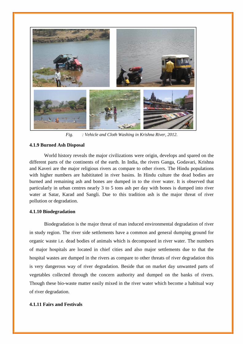
Fig. : Vehicle and Cloth Washing in Krishna River, 2012.
4.1.9 Burned Ash Disposal
World history reveals the major civilizations were origin, develops and spared on thedifferent parts of the continents of the earth. In India, the rivers Ganga, Godavari, Krishnaand Kaveri are the major religious rivers as compare to other rivers. The Hindu populationswith higher numbers are habititated in river basins. In Hindu culture the dead bodies areburned and remaining ash and bones are dumped in to the river water. It is observed thatparticularly in urban centres nearly 3 to 5 tons ash per day with bones is dumped into riverwater at Satar, Karad and Sangli. Due to this tradition ash is the major threat of riverpollution or degradation.
4.1.10 Biodegradation
Biodegradation is the major threat of man induced environmental degradation of river
in study region. The river side settlements have a common and general dumping ground for
organic waste i.e. dead bodies of animals which is decomposed in river water. The numbers
of major hospitals are located in chief cities and also major settlements due to that the
hospital wastes are dumped in the rivers as compare to other threats of river degradation this
is very dangerous way of river degradation. Beside that on market day unwanted parts of
vegetables collected through the concern authority and dumped on the banks of rivers.
Though these bio-waste matter easily mixed in the river water which become a habitual way
of river degradation.
4.1.11 Fairs and Festivals

River is the creedal of human civilizations. Therefore, various religious, cultural and
social activities of man intensely fasten with river. As per field observations Wai, Sangm
Mahuli (Satara), Karad, Audambar and Sangli are the religious centres in study region as well
as each river side settlement has major temple on river bank. Numbers of peoples are visited
to these temples with religious mind for adoration. Beside that in a year there are one fair is
celebrated by these settlements. In this course of action number of pious peoples are bring
with them rosary a necklace, coconut, red, yellow and black powder and oil etc. all are offer
in worship but it gathered in bulk. Bulky waste matter on one hand dumped in river and other
hand it drained into river water.
Festivals are the common fact dominantly observed in study region. The festivals of
god Ganesha, goddess Gouree and Durgamata (Navratry) are the common as well as the
festival like Parayan played fundamental role in river degradation through the offering
nirmalya and idols are dump into river water. The size of idols is different as well these idols
are having chemical colors and plaster of paris which is cause of river degradation. At the
time of Parayan, thousands of peoples are gathered together in river course.
4.1.12 DOMESTIC FESTIVALS
WATER ANAYESIS
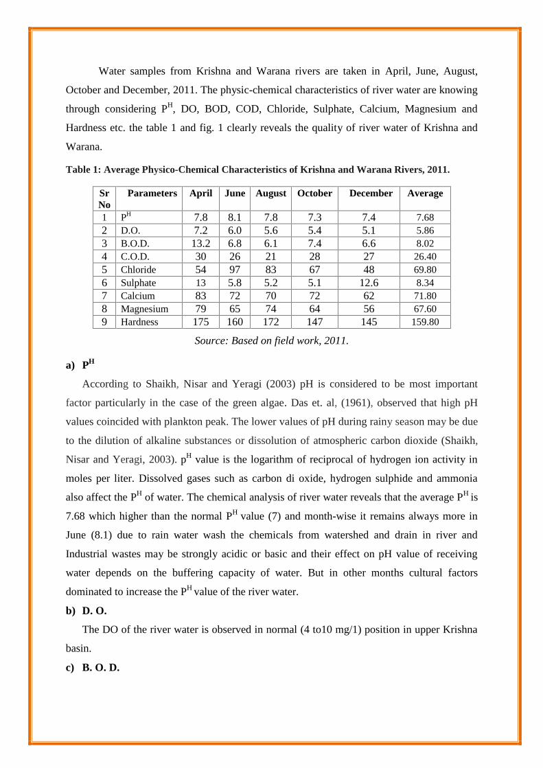
Water samples from Krishna and Warana rivers are taken in April, June, August,
October and December, 2011. The physic-chemical characteristics of river water are knowing
through considering PH, DO, BOD, COD, Chloride, Sulphate, Calcium, Magnesium and
Hardness etc. the table 1 and fig. 1 clearly reveals the quality of river water of Krishna and
Warana.
Table 1: Average Physico-Chemical Characteristics of Krishna and Warana Rivers, 2011.
SrNo
Parameters April June August October December Average
1 PH 7.8 8.1 7.8 7.3 7.4 7.682 D.O. 7.2 6.0 5.6 5.4 5.1 5.863 B.O.D. 13.2 6.8 6.1 7.4 6.6 8.024 C.O.D. 30 26 21 28 27 26.405 Chloride 54 97 83 67 48 69.806 Sulphate 13 5.8 5.2 5.1 12.6 8.347 Calcium 83 72 70 72 62 71.808 Magnesium 79 65 74 64 56 67.609 Hardness 175 160 172 147 145 159.80
Source: Based on field work, 2011.
a) PH
According to Shaikh, Nisar and Yeragi (2003) pH is considered to be most important
factor particularly in the case of the green algae. Das et. al, (1961), observed that high pH
values coincided with plankton peak. The lower values of pH during rainy season may be due
to the dilution of alkaline substances or dissolution of atmospheric carbon dioxide (Shaikh,
Nisar and Yeragi, 2003). pH value is the logarithm of reciprocal of hydrogen ion activity in
moles per liter. Dissolved gases such as carbon di oxide, hydrogen sulphide and ammonia
also affect the PH of water. The chemical analysis of river water reveals that the average PH is
7.68 which higher than the normal PH value (7) and month-wise it remains always more in
June (8.1) due to rain water wash the chemicals from watershed and drain in river and
Industrial wastes may be strongly acidic or basic and their effect on pH value of receiving
water depends on the buffering capacity of water. But in other months cultural factors
dominated to increase the PH value of the river water.
b) D. O.
The DO of the river water is observed in normal (4 to10 mg/1) position in upper Krishna
basin.
c) B. O. D.
BOD values are changing as per months, April it found 13.2 mg/1 which is highest but in
April, photo-transmutation caused to increase river pollution and in the month of August it
reveals low (6.1 mg/1). An average value of BOD is 8.02 mg/1.
d) C. O. D.
The normal COD value of water is 30 mg/1, but in only April month it found normal
position and in other month’s as well average condition remain below the normal value of
COD. For this happen human factors are more causal.
e) Chloride
The proportion of chloride is varied from 48 to 93 mg/l, the amount of chloride is
maximum permissible up to 500mg/1 for drinking water according to WHO. More
dominance of chlorides is observed near urban areas due to waste water, pesticides, grease
and oil, metals and other toxic materials.
f) Sulphate, Calcium and Magnesium
The Sulphate range observed is 5.1 to 13 mg/l in the entire examination. The maximum
amount observed is in the month of April 2006; which may be due to agricultural runoff. The
proportion of calcium is varying from 52 to 73 mg/1. The magnesium levels varied from 56
to 79 mg/1 and average level of magnesium is 67.60 mg/1. The average hardness is observed
159.80 mg/1 and it ranges from 145 to 175 mg/1. The maximum values are during monsoon
while minimum values are during winter season.
REFERANCES
Das S.M., (1961), Hydrogen ion concentration, Plankton and fish in fresh water eutropic
lakes of India Nature 20.
Dhembare, A.J. and Pondhe, G.M.(1997). Correlation of ground water parameters ofpravara
area, Maharashtra state,India.Vol.l2 (1 and 2): 32- 33.
Shaikh, Nisar and S.G. Yeragi (2003) Seasonal Temperature changes and their influence on
free carbondioxide, Dissolved (DO) and pH in Tansa river of Thane District,
Maharashtra. JAqua. Bioi., VoLl8 (1), p. 73-75.
Peters Norman E. & Meybeck M., (2000), Water Quality Degradation Effects on Freshwater
Availability: Impacts of Human Activities, International Water Resources
Association, Water International, Volume 25, Number 2, Pages 185–193.
CHAPTER – V
CONCLUSION AND SUGGESTIONS

CHAPTER – V
CONCLUSION AND SUGGESTIONS
The Satara district is to be found in the river basins of the Bhima and Krishna
but from the point of view of the peninsular drainage, the entire land of the district
belongs to the larger drainage system of the Krishna River. The district has
geographical area about 10480 sq. km, which avails a population 30, 03,922 as per the
2011 census. According to same census the density of population is 287 persons per
sq.km and the growth of population is 6.94per cent. Satara distict is one of the leading
districts on all fronts in the Maharashtra state. The district Satara ranks 12th in terms of
area and 13th in terms of population. It is devided into 11 tahsils administratively.
These tahsils are Mahabaleshwar, Wai, Khandala, Phaltan, Man, Khatav, Koregaon,
Satara, Javoli, Patan and Karad.
The study area is enjoying by major three seasons like rainy season, winter
season and summer season. Nearly 95 per cent rainfall occurred in rainy season, while
from October to mid-November the season becomes again hot. But after mid-
November up to January end, the season is cold and from April month and ends up to
mid-June the climate is hot.
The Satara district has complicated physiographic and geological structure
which reflects in drainage pattern. The Sahyadrian range and Mahadev range played
dominant role as a water divider. Therefore, The rivers Nira, Krishna, Yarala and
Manganga are the major river systems. The length of the Nira River within the study
area is 209.67 kms. It has one dam named Veer dam. 76 kms right bank canal of Veer
dam is providing water for agricultural purpose. Irrigationaly Nira River has more
importance. The Krishna river has its own dam which is named Dhom. The Dhom
dam has two canals, which are right (59 km) and left canal (113 km). Due to these
canals most of the area comes under the irrigation. Yenna has one dam (Kanher) with
right and left bank canals 58 kms and 21 kms respectively. Beside this foot bridge at

Medha and Javli and also it have four road bridges at Varya, Kanhera, Kelghar and
Vadha-Kheda.
The area under the forest land of Satara district is 1503.87 sq. km out of that
reserved forest has 1349.44 sq. km, unclassified forest occupied 106.66 sq. km and
protected forest has only 47.77 sq. km. The forest lands are scattered over the whole
district, and also found in broken appearance by private and cultivated land. The dense
forest cover occur at the hilly part of the district, particularly the Mahabaleshwar,
Pratapgad and Pachagani area. The dense forest are also occurred in the vallags of
Koyna, Krishna, Venna where the rivers are deepen the hillsides. Bamnoli, Jaoli,
Thosegrah, Navaji, Koyana are the ezamples of dense forested areas. As it observed
west to east the forest cover become scanty. Particularly the eastern dry climate area
reports only scrubs and dry deciduous vegetations. In the study area diversity of soil
are vary from place to place. The single village has different types of soil. But broadly
the soil of Satara district has been grouped into three categories namely laterite soil,
sandy soil and clay soil. Laterite soil is found in western part of the district where very
heavy rainfall receives. The wehills are made by the igneous and phospetic rocks
resultant into laterite due to leaching. Whereas the sandy type of soils are found in the
dry zone of the area. The clay soil is predominant in the basins of all the rivers.
Physical occurrences are the common and lifelong agents of river degradation.
The quality and quantity of sediments relates to excessive erosion leads to increase of
sediment load in the river, chemical contamination impacting sediment quality,
extreme events as floods and organic matter like vegetation decomposed in river
course etc. also major natural causes of river degradation have observed in study area.
The entire course of Krishna river in study area is 176 kms and in this course chief
tributaries namely Kudali, Veena, Urmodi, Tarali and Koyana. The early stage of
Krishna drainage system the slope of land is steep up to Dhom dam and there after
course gradient become gentle. An average slope of Krishna system is 3.150.
The western part of study area receiving high rainfall to compare with eastern
part of Satara district. It is observed that rainfall is major source of water supply and
springs are the subsidiary sources of water. The discharge of water from three stations

(Dhom, Khodshi and Karad) are exhibits that annual average discharge of water 23.0,
84.7 and 157.9 TMC. The river work responsible for the formation of ‘V’ shaped
valleys, rapids, waterfalls, cliffs, alluvial fans, river meanders and flood plains etc. all
these landforms are deeply connected with the weathering and erosion. It is observed
that western slope of mountain; plateau, hills and foot hilly area always come under
the process of denudation. Under this circumstances eroded material from bolder to
clay mixed into river water.
As per the field study it reveals that the soft rocks like clay, lime and
sedimentary are disintegrated faster than the basalt. When rocks are braking or
disintegrated into gravel, bolder, sands and clay etc. forms but the rock like lime can
easily dissolve in water. In this process rock content element like calcium, iron,
magnesium, aluminum, copper, zinc, nitrogen, phosphorous, potassium, sulpher,
sodium and chloride etc. mixed in river water in rainy season.
The maximum and minimum average yearly rainfall were respectively 500 mm
and 1200 mm during 1991-2011. The yearly extreme average maximum discharge
varied between 735.59 and 10190.92 m3/s. The yearly average minimum discharge
remained below 22.9 m3/s. The monthly average maximum discharge was greatest in
August (38731 m3/s) at Karad and least in February (4 m3/s) at Dhom during 1965-
1985. Hydro-metrological phenomenons are the one cause of river degradation.
Particularly at the time of flood muddy water is commonly observed in river course
and also such muddy water should be observed after flood up to one week. The land
sliding events are commonly occurs particularly first and second stream orders. The
event of land sliding provides chemical material to lowering the quality of Krishna
River.
Man induced factors are highly accountable than the natural factors in
relation with river degradation. The river environment of Krishan shows that the
number of saintly temples, religious structures, and settlements are built along the
right and left bank. In the recent decade’s construction of bridges, growing population
and urbanization, river sediments are excavated for different purposes. The speedy
industrialization and urbanization as well as rapid growth of settlements during the
recent past become the major causes of exploiting river resources has increased

remarkably. Intensive farming and overuse of fertilizers in agricultural productions are
identified as agents who are responsible for river degradation.
Western part of study area is rich in building stone. To obtaining such resource
blasting is unavoidable. In this process oxides and hydroxide of Aluminium easily
mixed in the streams of rivers during Monsoon which generate water pollution.
Deforestation caused both erosional and decomposition of vegetational biomass in
river which change the color, taste and smell of the water.
The Krishna basin within Satara district limit reveals that it is shimmering in
agriculture activity. The farmers are used unnecessary chemical fertilizers, pesticides,
high yielding verities of seeds and excess of water become the major threat of river
degradation. The excavation of sand of Krishan river has going on at number of
places. The river sand played significant role as a natural filter but now a days this
natural filter is losing rapidly from river course. The excavation of sand also
conscientious for soil erosion in rainy season and it is observed after the flood
condition at number of places along the river course.
The waste water from settlements (urban and rural) is generate vast river
pollution. It is observed that till date these urban settlements did not implemented
proper and adequate water treatment plants for waste water. As per estimation 2010,
urban centres drains waste water nearly 84 per cent per man per day. The industrial
waste water content various chemical components like carbons, oxides, sulphur, zinc,
iron, lead, oils, gris and colors etc. as well as solid wastes which dump without
treatment in river basin. Industrial waste is a major threat of river degradation as
compare to other threats of river degradation in study area. In the study region the
identified industrial estates are at Wai, Satara, Taswade, Karad, Kundal,
Kirloskarwadi, Madhavnagar and Sangli. The insustrial waste of many kinds merges
in the water. There are a number of sugar factories production units also contribute in
river water contaminated.
In the study area it is observed in the respect of vehicle and cloth washing. The
oils, gris, iron particles, colour and detergent mixed in river water. The thin layer of
oil and gris formed on the surface water which become obstacle in the path of natural
purification of water. Therefore, the occurrences like vehicle and cloth washing and

their impact severally observed in dry season in study area. It is observed that
particularly in urban centres nearly 3 to 5 tons ash per day with bones is dumped into
river water at Satar, Karad and Sangli.
As per field observations Wai, Sangm Mahuli (Satara), Karad, Audambar and
Sangli are the religious centres in study region as well as each river side settlement
has major temple on river bank. Each year these settlements celebrated one or two
religious function. In the celebration of function peoples are offered flowers, oil,
coconuts, read, yellow and black powder. This easily mixed in river water. The
festivals of God Ganesha, Goddess Gouree and Durgamata (Navratri) are the common
as well as the festival like Parayan played fundamental role in river degradation
through the offering nirmaly and idols are dump into river water. Beside these home
functions like Vastushanti, Shravanee Puja (Satyanarayan) and Margshirsh Guruvar
etc. the people offering variety of organic matter and next day it dump in water body.
Due to above all factors river water becomes degraded. The hindu religion observe
river as an praying and offering place. So, every ceremony is associate with river. A
number of day to dayreligion happenings at domestic level ultimately meet at river.
People use to dump all religion waste to river which resulted into degradation of river.
The chemical analysis of river water reveals that the average PH is 7.68 which
higher than the normal PH value (7) and month-wise it remains always more in June
(8.1). The DO of the river water is observed in normal (4 to10 mg/1) position in upper
Krishna basin. BOD values are changing as per months, April it found 13.2 mg/1
which is highest but in April and in the month of August it reveals low (6.1 mg/1). An
average value of BOD is 8.02 mg/1. COD value of water is except April month it
found below average limit of normal value these happen human factors are more
causal. More dominance of chlorides is observed near urban areas due to waste water
and other causes are pesticides, grease and oil, metals and other toxic materials.
SUGGESTIONS
1. The denudation is common phenomenon. Therefore, aforestation in study area is
put into action very seriously.

2. Excess excavation of sand should be controlled the artificial sand production
should be given more importance.
3. Government legislations should be followed very seriously in the respect of forest
and water use.
4. Local peoples movement is to be boosted in avoiding river degradation and river
purification.
5. Considerable precautions must be take when bridge and road construction.
6. Quarrying activity and any type of washing in river course or watershed area is
strictly prohibited.
7. Now a days agriculture is a major threat of river degradation. Though there is need
of proper system for awareness among the farmers in relation to chemical
fertilizers, pesticides, insecticides and how to provide water to crops?
8. Central and State Government should be provide sufficient grants to built the
proper and adequate water treatment plants for urban and rural settlements with
considering next 25 years.
9. No permission is to be given for new industry along with the river course. The
severe action is to be taken on those industries which direct drain waste water in
rivers.
10. Local people should aware about river degradation and its impact on human
health.
11. Offering materials to Gods and Goddess should be collected separately and
processing on it to be as fertilizer.
12. The Munciple Corporations and village Grampanchyats of concern settlements
who are located on the bank of river should observe and take care of river course
and for this special assistance should be given by the concern authority.
13. Priority should be given to the drinking water and it can be lifted without
disturbing water ecology.
14. There should be complete ban on to discharge biomedical waste, washing of
vehicles and installation of brick industries.

15. The alluvial soil which is deposited in the basin is now a days on demand and
thousands of tons of such soil is excavated by the people. It has resulted into
change in the river flow. It should be prohibited.
16. Last but not least one should get realized that the rivers are life lines of human
being as well as all biological aspects. So, the awareness of protection is to be
made through school education.