Environmental Assessmenta123.g.akamai.net/7/123/11558/abc123/forestservic...Hilton Lakes and Hilton...
47
Environmental Assessment Hilton Lakes and Hilton Creek Trail Project USDA Forest Service, Inyo National Forest White Mountain Ranger District Inyo and Mono Counties, California January, 2012
Transcript of Environmental Assessmenta123.g.akamai.net/7/123/11558/abc123/forestservic...Hilton Lakes and Hilton...

Environmental Assessment
Hilton Lakes and Hilton Creek Trail Project
USDA Forest Service, Inyo National Forest
White Mountain Ranger District
Inyo and Mono Counties, California
January, 2012


Hilton Lakes and Hilton Creek Trail Project Environmental Assessment
Table of contents
Chapter 1 Purpose and Need for Action .................................................................................................... 1
1.1 Summary of proposed action .......................................................................................... 1
1.2 Document Structure ........................................................................................................ 1
1.3 Description of project area .............................................................................................. 2
1.4 Purpose and need ............................................................................................................ 4
1.5 Decision to be made ........................................................................................................ 7
1.6 Public Involvement and Native American Consultation .................................................. 7
1.7 Lahontan Regional Water Quality Control Board Requirement ...................................... 7
Chapter 2 Description of Alternatives ........................................................................................................ 8
2.1 Introduction ..................................................................................................................... 8
2.2 Alternatives: No Action and Proposed Action ................................................................. 8
2.3 Comparison of Alternatives ........................................................................................... 15
Chapter 3 Environmental Consequences ................................................................................................. 17
3.1 Introduction ................................................................................................................... 17
3.2 Effects to Water Quality: No Action and Proposed Action ............................................ 22
3.3 Effects to Soils: No Action and Proposed Action ........................................................... 26
3.4 Effects to Wilderness Character: No Action and Proposed Action ................................ 27
3.5 Effects Relative to Significance Factors ......................................................................... 31
Chapter 4 List of Persons Consulted ........................................................................................................ 36
4.1 Environmental Assessment Preparers ........................................................................... 36
4.2 References cited ............................................................................................................ 36
Chapter 5 Appendices .............................................................................................................................. 38
Appendix A: Description of Trail Prescriptions.................................................................................. 38
Appendix B: Project Site Prescriptions ............................................................................................... 39

Hilton Lakes and Hilton Creek Trail Project Environmental Assessment
List of Tables
Table 1. Trail Fundamentals: The Proposed Action’s Trail Fundamentals: management
guidelines for trail design, construction, maintenance, and use.
Table 2. Comparison of Alternatives: The No Action’s and Proposed Action’s effectiveness at
meeting project objectives.
List of Figures
Figure 1. Project Area Map
Figure 2. Watershed Boundary Map
Figure 3. Hilton Lakes Trail: project sites 1-22
Figure 4. Hilton Creek Trail: project sites 23-27
Figure 5. Hilton Creek Trail: project sites 28-44; Hilton Lake #2 Spur Trail: project sites 45-47

Page 1 Hilton Lakes and Hilton Creek Trail Project Environmental Assessment
Chapter 1 Purpose and Need for Action
1.1 Summary of proposed action
The Inyo National Forest, White Mountain Ranger District, proposes to conduct a trails project
in the Hilton Creek and Rock Creek watersheds. The proposed project area encompasses the
trail corridor of four Forest System Trails: the Hilton Creek Trail (trail #2942); the Hilton Lakes
Trail (trail #2904); the Hilton Cut-off Trail (trail #2904B); and the Hilton Lake #2 Spur Trail
(trail #2942B). Most of the project area is located within the John Muir Wilderness, with a short
section of the Hilton Lakes Trail located outside of wilderness.
The Forest Service has determined that the wilderness character in the project area could be
enhanced by reducing trail-related impacts to natural resources. The project is intended to reduce
these impacts through five types of activities: 1) install stream channel protection treatments to
prevent trail erosion at stream crossings; 2) reroute a section of the Hilton Lakes Trail to a more
sustainable alignment and rehabilitate the abandoned section of trail; 3) install trail stabilizing
structures on incised or eroding sections of trail; 4) reconstruct deteriorating section of trail
causeway to protect meadows and seasonally wet areas; 5) reduce the width of over-widened
trail sections to protect vegetation and soils. Trail prescriptions are described in more detail in
Appendix A.
The proposed project is consistent with the trail management direction of the 2001 Ansel Adams,
John Muir, and Dinkey Lakes Wilderness Management Plan. The constructed trail features and
structures would be the minimum necessary to improve water drainage from trails, and protect
stream crossings and meadows from trail-related impacts. All aspects of this project would be
implemented with traditional (non-motorized) hand tools.
The Forest would have to secure funding before project implementation could begin. The
earliest starting date for the project would be July 2012. Depending on available funding, the
project would be completed over the course of several summer seasons.
1.2 Document Structure
This document is a project level Environmental Assessment. The Forest Service has prepared
this Environmental Assessment in compliance with the National Environmental Policy Act
(NEPA) and other relevant Federal and State laws and regulations. This Environmental
Assessment discloses the direct, indirect, and cumulative environmental impacts that would
result from the Proposed Action and No Action alternatives. The document is organized into four
Chapters:
1. Purpose and Need for Action: This section includes information on the project proposal, the
purpose of and need for the project, and the agency’s proposal for achieving that purpose and
need. This section also details how the Forest Service informed the public of the proposal and
how the public responded.

Page 2 Hilton Lakes and Hilton Creek Trail Project Environmental Assessment
2. Description of the Two Alternatives: This section provides a description of the agency’s
Proposed Action for achieving the project’s purpose, and the No Action Alternative. This
section also provides a table that summarizes how well each alternative meets project objectives.
3. Environmental Consequences: This section describes the environmental effects of
implementing the Proposed Action and No Action Alternatives. This analysis is organized by
the two alternatives, and discusses each alternative’s effects to water quality, soils, and
wilderness character. The existing conditions in the project area are summarized first, followed
by a description of the effects on the resource under each alternative.
4. List of Persons Consulted: This section provides a list of Forest Service staff who prepared
the environmental assessment.
There are two appendices. Appendix A describes the prescriptions or trail treatments that would
be used if the Proposed Action were selected. Appendix B summarizes the existing condition at
the forty seven project sites, and the prescription proposed for each project site.
Additional documentation, including more detailed analyses of project-area resources, may be
found in the project planning record located at the White Mountain Ranger District Office in
Bishop, California.
1.3 Description of project area
The Hilton Lakes and Hilton Creek Trail Project area is located approximately twenty miles
northwest of Bishop, California in the Sierra Nevada Mountains (see figure 1).
Figure 1. Project Area Map

Page 3 Hilton Lakes and Hilton Creek Trail Project Environmental Assessment
The project area includes portions of the Hilton Creek and Upper Rock Creek HUC 6 watersheds
(see Figure 2). The project area consists of forty seven separate sites or trail sections along 11.35
miles of four Forest System Trails: the Hilton Creek Trail (trail #2942); the Hilton Lakes Trail
(trail #2904); the Hilton Cut-off Trail (trail #2904B); and the Hilton Lake #2 Spur Trail (trail
#2942B). Most of the project sites (forty one) are within the Hilton Analysis Unit of the John
Muir Wilderness. Six project sites are in non-wilderness lands within the Rock Creek-Pine
Creek Management Area. In general, the project area boundary is a 150 feet wide corridor (75
feet on each side of the trail) at trail stream crossings or along trail sections proposed for project
work. The causeways and several of the perennial crossings would have a 600 feet wide corridor
because these treatments require a larger source area for materials.
Figure. 2 Hilton Creek and Upper Rock Creek Watersheds
This project area was chosen because the Forest would like to address trail-related effects to
watershed conditions throughout the Hilton Creek and the Upper Rock Creek watersheds. The
proposed project will address Forest System Trail conditions throughout the Hilton Analysis
Unit.

Page 4 Hilton Lakes and Hilton Creek Trail Project Environmental Assessment
1.4 Purpose and need
The overall goal of the project is to protect watershed conditions in the project area. The purpose
is to minimize the impacts of the wilderness visitor on the immediate environment to protect the
natural qualities of wilderness character. This project would not change the existing types and
level of use in the Hilton Analysis Unit.
1.4.1 Need
The need for this project was established through a Forest Service interdisciplinary team
evaluation of trail conditions in the two watersheds during 2009-2011. The interdisciplinary
team concluded there are four types of existing resource conditions that do not meet Forest
standards and guidelines for trails in wilderness.
1. Trails in the project area cross a perennial stream at ten locations and an intermittent stream
at nine locations. Each crossing has some degree of stream bank erosion, stream channel
widening, and diminished riparian vegetation. The trails currently lack the type of structures
that would protect the trail and stream banks from further erosion and widening.
2. Trail conditions are affecting hydrologic connectivity in three ways. First, there are four
sections of causeway over meadows and wet areas on the Hilton Creek Trail that are
deteriorating after a 30 year life span. The causeways, totaling 1,050 feet in length, require
replacement to maintain their effectiveness at allowing surface water to flow past the trail.
Second, between Lake #3 and Lake #4, a section of the Hilton Creek Trail 250 feet in length
is aligned through a wet meadow, which may disrupt natural water flow paths. Third, the
Hilton Lakes Trail is intercepting stream flows at three stream crossings.
3. Sections of the Hilton Lakes and Hilton Creek Trails totaling 9,750 feet have become over-
widened over time. The widening process has damaged vegetation along the trail corridor
margins, and the soils have become susceptible to erosion.
4. Sections of the Hilton Lakes, Hilton Creek and Hilton Lakes #2 Spur Trail totaling 7,000 feet
in length are either on steep grades or are incised. These sections, which lack trail stabilizing
structures, have had soils eroded from their tread and are susceptible to further erosion.
1.4.2 Project objectives
Objectives: The Forest has identified four project objectives that will serve as the criteria to
compare how well the two alternatives meet the overall project purposes. The management
direction that is the source for each objective is referenced as “Direction” below. For each
objective, an indicator has been chosen to measure how well the alternatives meet the project
objectives.

Page 5 Hilton Lakes and Hilton Creek Trail Project Environmental Assessment
Objective 1: Protect water quality by improving stream bank conditions at trail stream crossings.
Direction: Design (stream crossings) to maintain width:depth ratio of the stream (source: Inyo
National Forest Land and Resource Management Plan [LRMP], Watershed
Management Direction, pg.96).
Indicator: Over-widened stream banks at stream crossings.
Measure: Area of over-widened stream banks (width to depth ratio exceeds natural
conditions) at each project site.
Objective 2: Protect water quality by stabilizing eroding trail sections.
Direction: Stabilize all areas disturbed by management activities to minimize soil erosion.
(source: LRMP Watershed Management Direction, pg. 95).
Indicator: Trail sections susceptible to erosion of trail tread.
Measure: Proportion of trail sections with steeper grades (> 15%) that lack erosion control
structures or is incised.
Objective 3: Restore hydrologic connectivity in areas where the trail may be interrupting surface
and subsurface water flow.
Direction: Maintain and restore the hydrologic connectivity of streams, meadows, wetlands,
and other special aquatic features by identifying roads and trails that intercept,
divert, or disrupt natural surface and subsurface water flow paths. Implement
corrective actions where necessary to restore connectivity. (Source: Sierra Nevada
Framework Plan Amendment standard and guideline 100, pg. 63).
Indicator: Trail conditions that disrupt hydrologic connectivity.
Measure: 1) Proportion of causeways in watershed maintaining connectivity.
2) Proportion of trails in project area in a meadow.
3) Proportion of stream crossings that intercept stream flow.
4) Number of trail-related head cuts in riparian areas within the project area.
Objective 4: Reduce trail width in over-widened areas to meet design standards for Trail Class 3
trails in wilderness.
Direction: Maintain system trails to meet management objectives for visitor use and resource
protection (source: 2001 Wilderness Management Plan, Trail Management
Direction, pg. 11).
Indicator: Vegetation and soil disturbance outside a trail’s designed clearing width.
Measure: Proportion of trail in project area that exceeds design guidelines for trail width.

Page 6 Hilton Lakes and Hilton Creek Trail Project Environmental Assessment
1.4.3 Laws, Regulations, and Policies
The decision on this project will be made in accordance with a number of laws, regulations, and
Forest Service policies including:
The Wilderness Act of 1964 provides for the establishment of designated wilderness lands that
are to be protected for their ecological, geological, recreational, historic, scientific, education and
scenic values. Section 4(d) of the Wilderness Act states the Forest Service “shall be responsible
for preserving the wilderness character of the area and shall so administer such area for such
other purposes for which it may have been established as also to preserve its wilderness
character.”
The Endangered Species Act of 1973, as amended contains provisions to prevent the extinction
of any species that is in danger of extinction throughout all or a significant portion of its range.
Section 7 of the Act outlines procedures for interagency cooperation to conserve Federally listed
species and designated critical habitats.
The Clean Water Act of 1972, as amended contains provisions to restore and maintain the
chemical, physical, and biological integrity of the nation’s waters, and to protect beneficial use.
Executive Orders 11988 and 11990 direct federal agencies to avoid to the extent possible the
impacts associated with the destruction or modification of floodplains and wetlands. Agencies
are directed to avoid construction and development in floodplains and wetlands whenever there
are feasible alternatives.
The National Historic Preservation Act of 1966, as amended requires federal agencies to
identify and consider historic properties in Federal and federally assisted actions.
The Inyo National Forest Land and Resource Management Plan (1988) contains watershed
goals and wilderness management direction applicable to trail projects in wilderness.
The Sierra Nevada Forest Plan Amendment Record of Decision (2004) amended the Inyo
LRMP. The Record of Decision established Riparian Conservation Objectives, a set of six
objectives and their associated standards and guidelines that establish management direction for
Riparian Conservation Areas (defined as areas near water bodies and wetlands). The Riparian
Conservation Objectives were developed to protect water quality, aquatic and riparian habitats,
and stream, floodplain and watershed condition.
The 2004 Record of Decision also contains direction regarding the involvement of American
Indian Tribes, communities, and organizations in land management and for consideration of
traditional cultural values, uses and access.
The Sierra Nevada Management Indicator Species Amendment Record of Decision (2007)
requires the Forest to analyze the effects of proposed projects on management indicator species’
habitat.
Page 7 Hilton Lakes and Hilton Creek Trail Project Environmental Assessment
The Record of Decision for Management Direction for the Ansel Adams, John Muir, and
Dinkey Lakes Wildernesses (2001) established management direction, including trail
management direction, for the John Muir Wilderness. The Record of Decision also established
limits to the number of daily entries into wilderness by non-commercial and commercial
overnight visitors to the Hilton Analysis Unit. Commercial pack stock outfitters also have limits
placed on the amount of day use and annual use to the Hilton Analysis Unit.
Forest Service Manual Section 2323 provides policy for management of Forest System trails in
wilderness.
Forest Service Handbook Section 2309.18 provides guidelines for trail project planning.
1.5 Decision to be made
The deciding official will review the Proposed Action and No Action alternatives, and, given the
purpose and need for the project and environmental effects, decide whether or not to implement
the proposed trail management activities.
1.6 Public Involvement and Native American Consultation
The Hilton Lakes and Hilton Creek Trails Project has been listed on the Forest’s Schedule of
Proposed Actions since January 2011. A scoping letter describing the Proposed Action was
mailed to sixteen individuals or agencies on August 19, 2011. One comment letter was received
during scoping by the California Regional Water Quality Control Board, which indicated a
Section 401 Permit from the agency would be required because the project would include soil
disturbing activities in waterways. No other potential issues or effects on resources were
identified by either agencies or the public.
Native American Tribes that claim ancestral home lands within the project area were consulted
pursuant to the American Indian Religious Freedom Act of 1978, Executive Order 13007
(1996), and under Section 101(d)(6)(B) of the National Historic Preservation Act of 1966 as
amended. Official letters regarding the Hilton Lakes and Hilton Creek Trail project were mailed
to the following Paiute Tribes that claim ancestral lands within the project area:
Big Pine Tribe of Owens Valley, Big Pine, Ca.
Bishop Paiute Indian Tribal Council, Bishop, Ca.
Fort Independence Community of Paiute Indians, Independence, Ca.
Lone Pine Paiute-Shoshone Reservation, Lone Pine, Ca.
No issues or concerns have been brought forward by any of the four Tribes.
1.7 Lahontan Regional Water Quality Control Board Requirement
The Water Quality Control Plan for the Lahontan Region (Basin Plan) contains policies that area
used with other laws and regulations to protect water quality within the Lahontan Region. The

Page 8 Hilton Lakes and Hilton Creek Trail Project Environmental Assessment
Regional Water Quality Control Board indicated in their response to the scoping letter their
agency would require a Section 401 water quality certification for this project.
Chapter 2 Description of Alternatives
2.1 Introduction
Since no relevant environmental issues were raised by the public that would have been used to
develop additional alternatives to the Proposed Action, only two alternatives will be compared in
this environmental assessment: the No Action and the Proposed Action. The No Action
Alternative allows the existing trail conditions in the Hilton Analysis Unit to continue. The
Proposed Action was developed by an interdisciplinary team during 2009-2011. The team used
a problem assessment approach to evaluate trail conditions in the project area. The Proposed
Action is the Forest’s recommended action for addressing existing resource impacts related to
trail conditions. The management of visitors would remain the same with the selection of either
alternative. There would be no change to the amounts of commercial or non-commercial use
allowed in the area, and no change to the areas within the Hilton Analysis Unit where
commercial pack stock would be allowed to travel.
2.2 Alternatives: No Action and Proposed Action
2.2.1 No Action
If the No Action alternative is selected, no stream fords at perennial stream crossings or stream
bank stabilizing structures at intermittent stream crossings would be constructed. There would
be no additional trail stabilizing structures along incised or eroding sections of trail, and no
replacement of causeway structures.
Routine maintenance of the trails consistent with the trail Service Level listed in the 2001
Wilderness Management Plan could continue. Routine maintenance includes: cleaning and
repairing drainage structures; clearing the trail tread of obstacles such as rock, slough, fallen
trees, and brush; maintain trail tread width and removing berms from the outside edge of the
trail; and incidental replacement or repairs to existing trail structures such as steps and
causeways.
2.2.2 Proposed Action
Five types of project activities are proposed for the Hilton Lakes, Hilton Creek and Hilton Lakes
#2 Spur Trail:
1. Install stream channel protection treatments at twenty locations where a trail crosses a
stream. Three types of treatments are proposed, based on stream size and the existing trail
conditions:
□ Stream fords would be constructed at nine perennial stream crossings. The stream
channel width would be reduced from the existing over-widened condition to one more

Page 9 Hilton Lakes and Hilton Creek Trail Project Environmental Assessment
closely matching nearby natural conditions. The stream banks at the trail entries would be
protected from erosion by “armoring” the stream entries with rocks from local sources
within the project area.
□ To provide additional protection to riparian vegetation and soils, short trail re-routes or
rock causeways would be constructed at the approaches to four of the perennial crossings.
One of the stream crossings on the Hilton Lakes Trail would include a wooden deck log
bridge approximately twenty feet long.
□ Trail and stream bank stabilization structures would be installed at nine intermittent
stream crossings.
2. Construct a re-route of a section of the Hilton Lakes Trail approximately 4,000 feet in length
that follows the current alignment of the Hilton Bypass Trail. Abandon a section of the
Hilton Lakes Trail 3,000 feet in length, and apply restoration treatments to the abandoned
section. Apply rehabilitation treatments to a perennial stream channel at one stream crossing
on the abandoned trail section.
3. Install trail stabilizing structures to prevent soil erosion on approximately 7,000 feet of trail.
Trail stabilizing structures would be installed where necessary to remove flowing water from
the trail.
4. Reconstruct four segments of existing causeway totaling 1,050 feet in length. Replace an
existing wooden deck log bridge that is in the middle of one causeway.
5. Reduce the trail width along 6,800 feet of the Hilton Lakes and Hilton Creek Trails from its
existing over-widened condition to a width that meets the Forest Service design guidelines of
60-78 inches for trail clearing width. Use rocks or logs to reduce trail width. Apply
restoration treatments to naturalize the area beyond the trail that have been impacted by
visitors.
Project work is proposed for forty seven sites along the Hilton Lakes Trail, the Hilton Creek
Trail, the Hilton Lakes Bypass Trail, and the Hilton Lake #2 Spur Trail. The project sites
include twenty stream crossings and twenty six sections of trail in the project area (see figures 3-
5). The design of the protection treatment or prescription for each site is based on the soils,
hydrological conditions, use levels, and potential for erosion. Appendix A contains descriptions
of the seven types of trail treatments or prescriptions. Appendix B contains a list of project sites,
a summary of the existing conditions at each site, and the type of treatment prescribed for each
site.

Page 10 Hilton Lakes and Hilton Creek Trail Project Environmental Assessment
2.2.3 Proposed Action management requirements
The following management requirements were developed through the interdisciplinary team
process, and would apply to the Proposed Action:
1. The Forest Hydrologist identified four measures from Water Quality Management for Forest
System Lands in California - Best Management Practices (2000) that would be applied to the
project:
□ Erosion Control Plan (Practice 2-2): Forest watershed staff would develop and provide
oversight of this plan to minimize erosion and sedimentation during project
implementation.
□ Timing of Construction Activities (Practice 2-3): Project implementation would be
scheduled after the season of peak snowmelt runoff. The trail crew leader would also
cease project construction work during rain events.
□ Protection of Water Quality within Developed and Dispersed Recreation Areas (Practice
4-9). This BMP is a corollary of the Erosion Control Plan, and prohibits the placing of
sediment in or near a stream. Forest watershed staff would develop this control, which
would be implemented by the trail crew leader when working adjacent to streams.
□ Protection of Wetlands (Practice 7-3): Watershed staff would develop measures to
minimize impacts to wetlands during causeway replacement. Watershed staff would
provide oversight during bridge replacement at site 29 to minimize water quality impacts
at this site.
2. All borrow sites used as the source of rock or gravel for project sites would be rehabilitated.
Trail crews would re-contour borrow sites to match natural topography, and duff and woody
debris would be spread to promote revegetation.
3. Heritage protection measures: project site work and borrow pits would avoid disturbing any
trees with dendoglyphs/carvings; all project materials between project site 41 and site 44
would only be removed from the south side of the trail.
4. There would be a limited operating period for work on sites 29, 30, 32 to protect nesting
northern goshawks from disturbance by project activities. The limited operating period when
no project work can occur is February 15 through August 15 each year.
5. A Forest Botanist would be on site during project implementation at sites 35 and 37 to ensure
project work avoids disturbing sensitive plants near those sites.
6. Up to 30 trees would be felled to provide log stringers for causeway reconstruction. The trail
crew would utilize beetle-killed trees for the log stringers where possible. No more than
three snags per acre would be removed.
7. There would be post-project monitoring of treatment effectiveness by the Forest Hydrologist
one year after the completion of the project.

Page 11 Hilton Lakes and Hilton Creek Trail Project Environmental Assessment

Page 12 Hilton Lakes and Hilton Creek Trail Project Environmental Assessment

Page 13 Hilton Lakes and Hilton Creek Trail Project Environmental Assessment

Page 14 Hilton Lakes and Hilton Creek Trail Project Environmental Assessment
2.2.4 Trail management objectives
Forest Service Manual 2353.1, Administration of National Forest System Trails, indicates the
Forest identify Trail Management Objectives, including: 1) the five Trail Fundamentals; 2)
Recreation Opportunity Spectrum classifications; 3) trail design criteria; 4) travel management
strategies; and 5) maintenance criteria for system trails. The trail fundamentals for each trail are
indicated below in Table 1 and would not be changed by the Proposed Action. The 2001
Wilderness Management Plan utilized a “recreation category” classification instead of a
recreation opportunity spectrum classification; all project trail sections in wilderness are in
recreation category “2”. The 3,000 foot section of the Hilton Lakes Trail outside of wilderness is
within the Recreation Opportunity Spectrum classification of semi-primitive (1988 Inyo National
Forest LRMP). The trail design would follow the general criteria for Trail Class 2 and Trail
Class 3 Trails indicated in Forest Service Handbook Section 2309.18, Chapter 14.2, Exhibit 01.
The maintenance criteria for the trails would apply the considerations listed in FSH 2309.18,
Chapter 18, Exhibit 0.1.
The proposed action would not develop additional trails in the Hilton Analysis Unit, nor change
the level of development of the trails. The Trail Class for each trail would remain consistent
with the Service Levels contained in the 2001 Trails Inventory (2001 Ansel Adams, John Muir
and Dinkey Lakes Wildernesses Final Environmental Impact Statement, Appendix C). Project
work on the Hilton Creek Trail between Lake 3 and Lake 4, and on the Hilton Lake #2 Spur Trail
would be to protect water quality and hydrologic connectivity, and would not include
prescriptions to build the trails to stock standards.
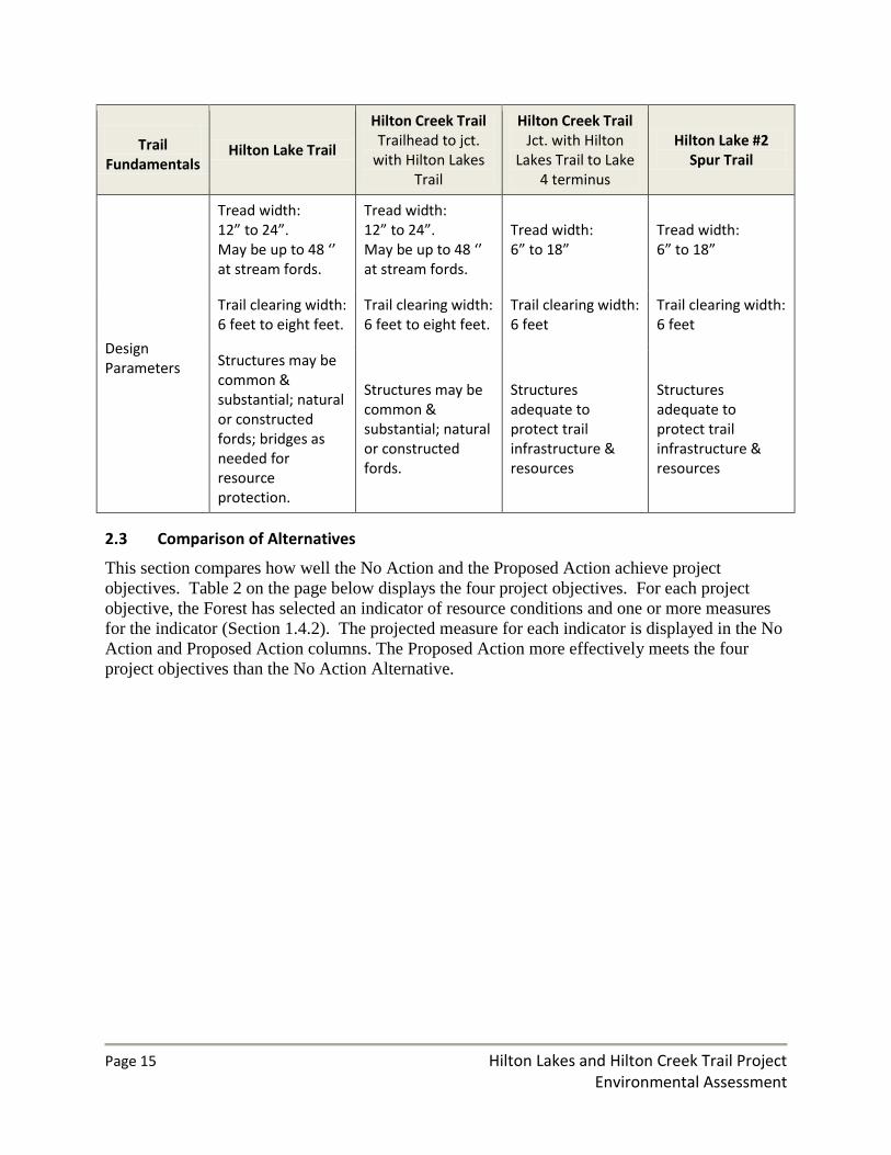
Table 1. Trail Fundamentals The Trail Fundamentals for trails in the project area are the management guidelines for trail design, construction, maintenance, and use.
Trail Fundamentals
Hilton Lake Trail
Hilton Creek Trail Trailhead to jct.
with Hilton Lakes Trail
Hilton Creek Trail Jct. with Hilton
Lakes Trail to Lake 4 terminus
Hilton Lake #2 Spur Trail
Trail Type Standard Terra Trail Standard Terra Trail Standard Terra Trail Standard Terra Trail
Trail Class Trail Class 3: Developed
Trail Class 3: Developed.
Trail Class 2: Moderately Developed
Trail Class 2: Moderately Developed
Managed Use Hiker, Pack and Saddle
Hiker, Pack and Saddle
Hiker, Pack and Saddle
Hiker, Pack and Saddle
Designed Use Pack and Saddle Pack and Saddle Hiker Hiker
Page 15 Hilton Lakes and Hilton Creek Trail Project Environmental Assessment
Trail Fundamentals
Hilton Lake Trail
Hilton Creek Trail Trailhead to jct.
with Hilton Lakes Trail
Hilton Creek Trail Jct. with Hilton
Lakes Trail to Lake 4 terminus
Hilton Lake #2 Spur Trail
Design Parameters
Tread width: 12” to 24”. May be up to 48 ‘’ at stream fords.
Tread width: 12” to 24”. May be up to 48 ‘’ at stream fords.
Tread width: 6” to 18”
Tread width: 6” to 18”
Trail clearing width: 6 feet to eight feet.
Trail clearing width: 6 feet to eight feet.
Trail clearing width: 6 feet
Trail clearing width: 6 feet
Structures may be common & substantial; natural or constructed fords; bridges as needed for resource protection.
Structures may be common & substantial; natural or constructed fords.
Structures adequate to protect trail infrastructure & resources
Structures adequate to protect trail infrastructure & resources
2.3 Comparison of Alternatives
This section compares how well the No Action and the Proposed Action achieve project
objectives. Table 2 on the page below displays the four project objectives. For each project
objective, the Forest has selected an indicator of resource conditions and one or more measures
for the indicator (Section 1.4.2). The projected measure for each indicator is displayed in the No
Action and Proposed Action columns. The Proposed Action more effectively meets the four
project objectives than the No Action Alternative.

Page 16 Hilton Lakes and Hilton Creek Trail Project Environmental Assessment
Table 2. Comparison of Alternatives The No Action’s and Proposed Action’s effectiveness at meeting project objectives.
Project Objective Indicator & Measure No action Proposed action
1: Protect water quality by improved structure and condition of stream banks.
Over-widened stream banks at stream crossings. Measure: Area of over-widened stream banks (width to depth ratio exceeds natural conditions) at each project site.
Currently about .10 acre at each crossing affected by over-widened stream banks & diminished vegetation. Would continue trend towards larger area of over-widened stream banks & diminished vegetation.
Would reduce over-widened area from .10 acre to approximately .02 acre at each stream crossing. Stream crossings would match more closely natural width to depth ratio; stabilized banks would promote revegetation.
2: Protect water quality by stabilizing eroding trail sections.
Trail sections that are susceptible to erosion. Measure: Proportion of trail sections with steeper grades (> 15%) that lack erosion control structures or is incised1.
12% of the total length of system trails in the project area would continue to be susceptible to erosion.
No trail sections with steeper grades would lack erosion control structures. In addition, the abandoned section of Hilton Lakes trail 3,000 feet in length would be stabilized.
3: Maintain or restore hydrologic connectivity of streams and meadows.
Trail conditions disrupting connectivity. Measure a: Proportion of causeways in watershed maintaining connectivity2.
Downward trend in connectivity along 87% of causeway length in project area, with the trail more likely to interrupt surface and subsurface water flows.
100% of total causeway length in project area would maintain hydrologic connectivity.
Measure b: Proportion of trails in project area in a meadow3.
3% of the total length of trails in the project area will remain aligned in seasonally wet meadows4.
2.6% of the total length of trails in the project area will remain aligned in seasonally wet meadows5.
Measure c: Proportion of stream crossings that intercept stream flow.
15% of stream crossings will continue to intercept stream flow.
No stream crossings will intercept stream flow.
Measure d: Number of head cuts that are associated with trails.
Three existing trail-related head cuts in project area remain untreated, with the potential to erode further.
Three existing head cuts in the project area stabilized.

Page 17 Hilton Lakes and Hilton Creek Trail Project Environmental Assessment
Project Objective Indicator & Measure No action Proposed action
4: Reduce trail width in over-widened areas to meet design guidelines for Trail Class 3.
Vegetation and soil disturbance outside the trail corridor. Measure: Proportion of trail in project area that exceeds design guidelines for trail width .
Seventeen percent of trail length (9,750 feet) in project area exceed design guidelines, with continued vegetation damage and soil disturbance.
One hundred percent of trail length in project area treated to meet design guidelines6.
1 Approximately 7,000 feet of trail in the project area are on steeper grades and lack erosion control
structures.
2 There are five sections of causeway in the project area, with a total length of 1,200 ft. Four sections,
totaling 1,050 feet in length, are in a deteriorating condition.
3 Approximately 850 feet of the Hilton Creek Trail is aligned through a seasonally wet meadow and does
not have a causeway structure. Approximately 1,000 feet of the Hilton Lake #2 Spur Trail is aligned
through a seasonally wet meadow; there are no causeways on this trail.
4 850 feet of the Hilton Creek Trail and 1,000 feet of Hilton Lake #2 Spur Trail are aligned in a seasonally
wet meadow.
5 Approximately 250 feet of the Hilton Creek Trail will be re-routed out of a meadow; 600 feet of trail
will remain aligned in a seasonally wet meadow. 1,000 feet of Hilton Lake #2 Spur Trail would remain
aligned in a seasonally wet meadow.
6 6,750 feet of the currently 9,750 feet of over-widened trail would be treated. In addition, the 3,000 feet
of Hilton Lakes Trail that would be abandoned would be treated with the trail rehabilitation prescription.
Chapter 3 Environmental Consequences
3.1 Introduction
This chapter is organized by the effects to water quality (section 3.2), soils (section 3.3), and
wilderness character (section 3.4) for the No Action and Proposed Action Alternatives. The
Forest Service has identified these three resources as the relevant resources for analysis based on
the project need and project objectives. Relevant resources are the resources that may be affected
by the implementation of either the No Action or Proposed Action. Effects to other resources
and the ten significance factors are disclosed in section 3.5.
Terminology: The effects on resources or wilderness character are described in terms of the type
(i.e. beneficial or adverse effect), context (the areal extent of effect), duration, and the intensity

Page 18 Hilton Lakes and Hilton Creek Trail Project Environmental Assessment
of effect. Beneficial effects would improve resource condition or wilderness quality. Adverse
effects are those that are unfavorable.
Intensity terminology
Negligible: There would be no detectable effect on a resource or a quality of wilderness
character.
Minor: Effects to a resource or one or more qualities of wilderness character would be
detectable; effects would be localized to the immediate area around project sites,
and would not be detectable elsewhere in a watershed.
Moderate: Effects on a resource or one or more qualities of wilderness character would be
appreciable; effects would extend beyond the immediate area around project sites;
and effects would occur in multiple areas within a watershed.
Major: Effects would substantially alter a resource or one or more qualities of wilderness
character; effects would be observed over a larger area (i.e. wilderness-wide).
Duration terminology
Temporary: Effects would occur only during implementation activities at a project site, and
would not persist for more than one day after construction is completed. The
expected duration of implementation activities at stream crossings is one to five
days at intermittent stream crossings, and up to twenty days at each of the four
largest perennial crossings in the project area.
Short term: Effects would occur during implementation and persist after construction is
completed. After project completion, the resulting effects would persist over a
time period from one month to one year.
Medium term: After project completion, the resulting effects would persist over a time period
from one year to ten years.
Long term: After project completion, the resulting effects would persist for more than 10
years.
3.1.1 Overview of existing conditions
The basic alignment of the trails in the project area has been in place for many years. Summer
grazing of livestock during the first half of the twentieth century probably established the general
alignment of the current trail system. Prior to wilderness designation, a mine operator in the
Hilton Creek drainage maintained an access road to the mine. A section of that access road is
now the current alignment of the Hilton Creek Trail in the northern portion of the project area.
The early trail system provided access to several resorts that operated in the Hilton Lakes area
prior to the designation of the John Muir Wilderness in 1964. At some point during the 1960s
and 1970s, sections of the trails were realigned to reduce trail grades and better protect resources.
Page 19 Hilton Lakes and Hilton Creek Trail Project Environmental Assessment
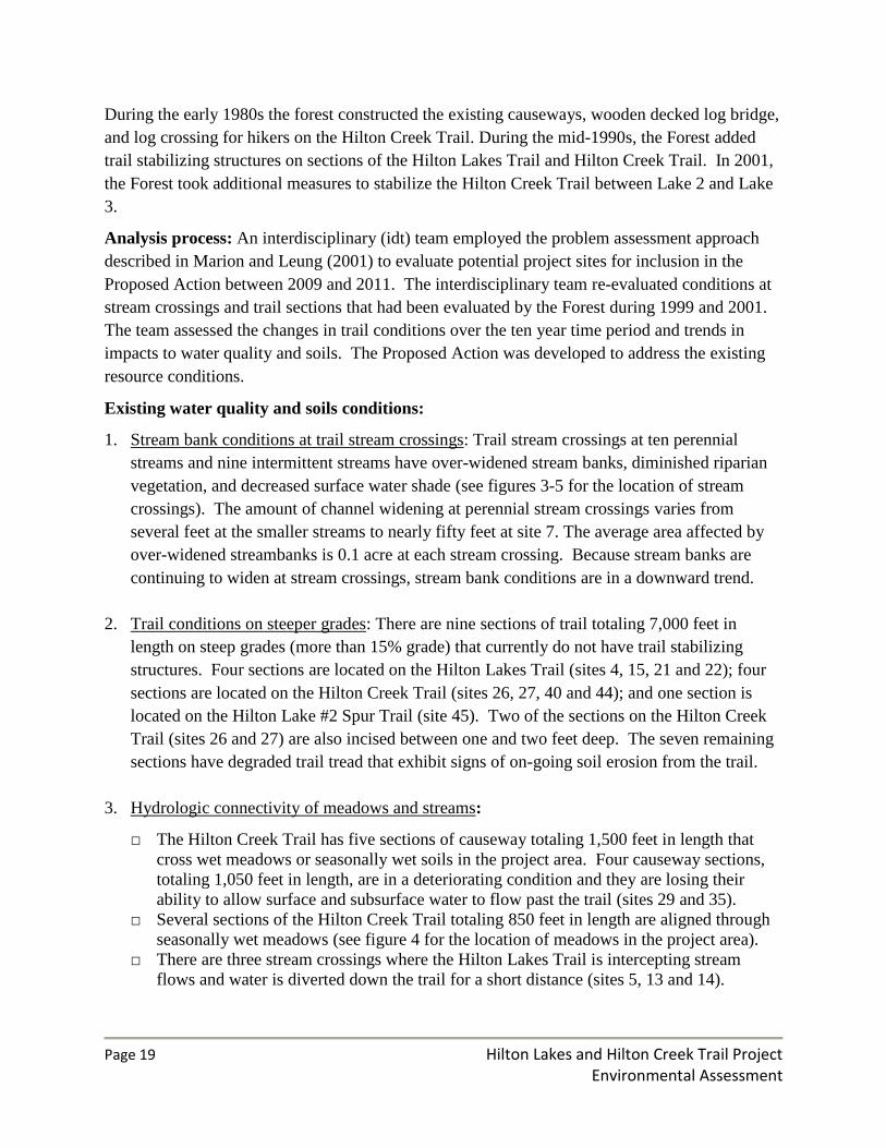
During the early 1980s the forest constructed the existing causeways, wooden decked log bridge,
and log crossing for hikers on the Hilton Creek Trail. During the mid-1990s, the Forest added
trail stabilizing structures on sections of the Hilton Lakes Trail and Hilton Creek Trail. In 2001,
the Forest took additional measures to stabilize the Hilton Creek Trail between Lake 2 and Lake
3.
Analysis process: An interdisciplinary (idt) team employed the problem assessment approach
described in Marion and Leung (2001) to evaluate potential project sites for inclusion in the
Proposed Action between 2009 and 2011. The interdisciplinary team re-evaluated conditions at
stream crossings and trail sections that had been evaluated by the Forest during 1999 and 2001.
The team assessed the changes in trail conditions over the ten year time period and trends in
impacts to water quality and soils. The Proposed Action was developed to address the existing
resource conditions.
Existing water quality and soils conditions:
1. Stream bank conditions at trail stream crossings: Trail stream crossings at ten perennial
streams and nine intermittent streams have over-widened stream banks, diminished riparian
vegetation, and decreased surface water shade (see figures 3-5 for the location of stream
crossings). The amount of channel widening at perennial stream crossings varies from
several feet at the smaller streams to nearly fifty feet at site 7. The average area affected by
over-widened streambanks is 0.1 acre at each stream crossing. Because stream banks are
continuing to widen at stream crossings, stream bank conditions are in a downward trend.
2. Trail conditions on steeper grades: There are nine sections of trail totaling 7,000 feet in
length on steep grades (more than 15% grade) that currently do not have trail stabilizing
structures. Four sections are located on the Hilton Lakes Trail (sites 4, 15, 21 and 22); four
sections are located on the Hilton Creek Trail (sites 26, 27, 40 and 44); and one section is
located on the Hilton Lake #2 Spur Trail (site 45). Two of the sections on the Hilton Creek
Trail (sites 26 and 27) are also incised between one and two feet deep. The seven remaining
sections have degraded trail tread that exhibit signs of on-going soil erosion from the trail.
3. Hydrologic connectivity of meadows and streams:
□ The Hilton Creek Trail has five sections of causeway totaling 1,500 feet in length that
cross wet meadows or seasonally wet soils in the project area. Four causeway sections,
totaling 1,050 feet in length, are in a deteriorating condition and they are losing their
ability to allow surface and subsurface water to flow past the trail (sites 29 and 35).
□ Several sections of the Hilton Creek Trail totaling 850 feet in length are aligned through
seasonally wet meadows (see figure 4 for the location of meadows in the project area).
□ There are three stream crossings where the Hilton Lakes Trail is intercepting stream
flows and water is diverted down the trail for a short distance (sites 5, 13 and 14).

Page 20 Hilton Lakes and Hilton Creek Trail Project Environmental Assessment
□ There are head cuts in meadows adjacent to the trail in two locations (two head cuts at
site 29, and site 41).
4. Over-widened trail sections: There is existing vegetation damage and disturbed soils along
9,700 feet of the Hilton Lakes and Hilton Creek Trails caused by visitors traveling outside
the trail tread. Four sections of the Hilton Lakes Trail (sites 2, 8, 11 and 20) and two sections
of the Hilton Creek Trail (sites 23 and 24) appreciably exceed the design guidelines for the
trail width of a Trail Class 3 trail (Table 1). The width of the area disturbed varies across the
project area. Sections of the Hilton Lakes Trail (sites 18 and 20) contain disturbed soils areas
more than twenty five feet in width. Most other sections of over-widened trail are ten to
fifteen feet in width. Forest design guidelines indicate an eight foot wide trail clearing for
Trail Class 3 trails, with occasional wider areas to allow stock parties to pass each other.
Existing conditions for wilderness character
Wilderness character is defined by four qualities: natural, untrammeled, undeveloped, and
opportunities for solitude or primitive and unconfined recreation.
Natural: The existing conditions for the indicators of the natural quality of wilderness character
applicable to this project are summarized by the existing conditions for water quality and soil
above.
Untrammeled and undeveloped: Neither the No Action nor Proposed Action alternatives would
affect the existing conditions for the untrammeled and undeveloped qualities, so they will not be
discussed in this document.
Opportunities for solitude or primitive and unconfined recreation: The indicators for this quality
applicable to the proposed project are: 1) trail crew presence; and 2) facilities that decrease self-
reliant recreation. Based on recent years’ trail maintenance funding levels, trail crews comprised
of four or five people camp and work in the project area for one to two weeks every third year.
The sight and sound of trail crews may affect some visitors’ perception of solitude. Trail crew
camping activities, however, do not affect the 2001 Wilderness Management Plan standards for
solitude, which have an indicator based on the number of occupied campsites within sight or
sound or a benchmark campsite. Because trail crews do not camp at the locations in the lakes
basin that are the typical destination for visitors, their camps are not within sight or sound of
other visitors’ camps.
There are existing causeway sections, a stock bridge, and a hiker log crossing on the Hilton
Creek Trail These trail facilities decrease self-reliant recreation to a degree because they reduce
the challenge of wilderness travel (although the primary purpose of the causeways and bridge is
to protect wetland areas, not to make travel easier). There are no facilities on the remaining nine
perennial stream crossings in the project area. There are a total of ten perennial stream crossings
in the project area.

Page 21 Hilton Lakes and Hilton Creek Trail Project Environmental Assessment
3.1.2 Discussion on cumulative effects
Cumulative impact is the impact on the environment which results from the incremental impact
of the action when added to other past, present, and reasonably foreseeable future actions
regardless of what agency (Federal or non-Federal) or person undertakes such other actions.
Cumulative impact can result from individually minor but collectively significant actions taking
place over a period of time (Council on Environmental Quality regulation 1508.7).
In order to understand the contribution of past actions to the cumulative effects of the proposed
action and alternatives, this analysis relies on current environmental conditions as a proxy for the
impacts of past actions. This is because existing conditions reflect the aggregate impact of all
prior human actions and natural events that have affected the environment and might contribute
to cumulative effects.
This cumulative effects analysis does not attempt to quantify the effects of past human actions by
adding up all prior actions on an action-by-action basis. There are several reasons for not taking
this approach. First, a catalog and analysis of all past actions would be impractical to compile
and unduly costly to obtain. Current conditions have been impacted by innumerable actions over
the last century (and beyond), and trying to isolate the individual actions that continue to have
residual impacts would be nearly impossible. Second, providing the details of past actions on an
individual basis would not be useful to predict the cumulative effects of the proposed action or
alternatives. In fact, focusing on individual actions would be less accurate than looking at
existing conditions, because there is limited information on the environmental impacts of
individual past actions, and one cannot reasonably identify each and every action over the last
century that has contributed to current conditions.
Additionally, focusing on the impacts of past human actions risks ignoring the important residual
effects of past natural events, which may contribute to cumulative effects just as much as human
actions. By looking at current conditions, we are sure to capture all the residual effects of past
human actions and natural events, regardless of which particular action or event contributed
those effects. Third, public scoping for this project did not identify any public interest or need
for detailed information on individual past actions. Finally, the Council on Environmental
Quality issued an interpretive memorandum on June 24, 2005 regarding analysis of past actions,
which states, “agencies can conduct an adequate cumulative effects analysis by focusing on the
current aggregate effects of past actions without delving into the historical details of individual
past actions.”
The cumulative effects analysis in this EA is also consistent with Forest Service National
Environmental Policy Act (NEPA) Regulations (36 CFR 220.4(f)) (July 24, 2008), which state:
“…With respect to past actions, during the scoping process and subsequent preparation of the
analysis, the agency must determine what information regarding past actions is useful and
relevant to the required analysis of cumulative effects….”

Page 22 Hilton Lakes and Hilton Creek Trail Project Environmental Assessment
Finally, previous analyses that relied on catalogs of past actions did not identify any significant
cumulative effects to water quality and soils in the Hilton Creek and Rock Creek watersheds.
The cumulative effects analyses in the Trail and Commercial Pack Stock Management in the
Ansel Adams and John Muir Wilderness Final Environmental Impact Statement, 2005 (2005
FEIS) (pp. IV 259-277 and IV 368-373) were based on a catalog of past, present, and reasonably
foreseeable actions overlaps the current Proposed Action in space and time. The 2005 FEIS
indicated that past and present actions have caused some local increases in compacted soil,
stream bank trampling, stream incision, and increased sedimentation into surface water that
would continue. However, the discussion on cumulative effects for that alternative concluded
there would be no cumulative impacts to water quality and soils in the Hilton Creek and Rock
Creek watersheds. For these reasons, the analysis of past actions in this EA is based on current
environmental conditions.
Cumulative Effects Analysis Areas
The Cumulative Effects Analysis Area for water quality, soils, and the natural quality of
wilderness would be same as the area of direct and indirect effects because any effects to water
quality or soils from the proposed action would be negligible beyond this area. Because there are
no other present or reasonably foreseeable actions that would affect the Cumulative Effects Area,
the direct and indirect effects of the No Action and Proposed Action will describe the full
increment of effects to water quality and soils. The Cumulative Effects Area for wilderness
character (opportunities for solitude and primitive and unconfined recreation) is the Hilton
Analysis Unit. The rationale for the Cumulative Effects Area for this quality of wilderness
character is that visitors’ experience of solitude or primitive and unconfined recreation in other
areas of the John Muir Wilderness outside of the Hilton Analysis Unit would not be affected by
any actions within the Hilton Analysis Unit.
3.2 Effects to Water Quality: No Action and Proposed Action
The effects to water quality will be discussed through indicators and measures associated with
the first three project objectives.
Indicator #1- Stream bank conditions at stream crossings: The measure of steam bank
conditions is the area of over-widened stream banks and diminished riparian vegetation as
compared to reference reaches upstream of each crossing.
Indicator #2- Trail tread sections that are susceptible to erosion: The measure of
susceptibility to erosion is the length of trail sections with steeper grades (more than 15% grade)
that lack erosion control structures or is currently incised.
Indicator #3- The hydrologic connectivity of streams and meadows: Four measures for this
indicator are applicable to this project. The measures provide a means of assessing the areal
extent that trails may be affecting the natural flow paths of water in project area.

Page 23 Hilton Lakes and Hilton Creek Trail Project Environmental Assessment
Measure a: Proportion of causeways in watershed maintaining connectivity.
Measure b: Proportion of trails in project area in a meadow.
Measure c: Proportion of stream crossings that intercept stream flow.
Measure d: Number of trail-related head cuts in riparian areas within the project area.
The analysis boundary for direct and indirect effects to water quality includes:
The average .10 acre area adjacent to trail stream crossings that is currently over-widened.
The rationale for this boundary is that the over-widened area of stream crossing is the source
of sediment to the streams.
The stream reach approximately 1,000 feet downstream from perennial and intermittent
stream crossings. The rationale for this boundary is that sediment entering a stream may
cause turbidity downstream for a distance up to 1,000 feet.
The meadows and wetlands through which the trails are aligned. The rational for this
boundary is that trails may cause localized impacts to a meadow’s connectivity with the
watershed, but these effects are not felt beyond the meadow through which the trail is
aligned.
3.2.1 Direct and Indirect Effects of No Action on Water Quality
There would be a minor adverse effect of long term duration in the project area to water quality.
Project area conditions would not meet the standards and guidelines for Riparian Conservation
Areas as measured by the following three indicators:
1. Area of over-widened stream banks (width to depth ratio exceeds natural conditions:
There would continue to be a downward trend in conditions at the twenty sites where a trail
crosses a stream. The area affected by stream bank widening currently averages .10 acre at each
of 20 stream crossings. Streambanks would continue to widen beyond natural conditions from
the combination of visitor use and scouring stream flows. Impacts to vegetation in riparian area
adjacent to trail stream crossings would continue, with gradually diminished shade cover over
the stream banks at the crossings. Soils would continue to erode from trails and streambanks,
and contribute excessive fine sediment to stream channels.
2. Trail sections susceptible to erosion:
There would continue to be a downward trend in the condition of the trail tread along eight
sections of trail totaling 6,000 feet in length. Soils would continue to erode from trail sections on
steep grades or sections where trail incision is already occurring. Along trail sections that are
incised, heavy rain or runoff events could channel eroded sediment down trails to reach stream
channels. A total of 12% of the total length of system trails in the project area would continue to
be susceptible to erosion.

Page 24 Hilton Lakes and Hilton Creek Trail Project Environmental Assessment
3. Hydrologic connectivity of streams and meadows:
Measure a - Proportion of causeways in watershed maintaining connectivity: The four sections of
causeway totaling 1,050 feet in length (87% of causeways in project area) would continue to
deteriorate and would eventually lose their ability to allow surface and subsurface water to flow
past the trail. Continued travel over the muddy trail tread on deteriorated structures would likely
cause additional sediment to reach waterways.
Measure b - Proportion of trails in project area in meadows: Sections of the Hilton Creek Trail
totaling 850 feet in length and 1,000 feet of the Hilton Lakes #2 Spur Trail (3% of the total
length of trails in the watershed) would continue to be aligned through seasonally wet meadows.
Trails in meadows have the potential to adversely affect connectivity by compacting soils,
channeling surface water flows, and creating head cuts. Muddy trail tread in meadows is also
more susceptible to erosion.
Measure c - Proportion of stream crossings that intercept flow: Three of twenty (15%) stream
crossings along the Hilton Lakes Trail would continue to intercept stream flows, which would be
a disruption of the connectivity of these streams to the watershed.
Measure d - Number of head cuts that are associated with trails: Three head cuts adjacent to the
Hilton Creek Trail would continue to pose of risk of eroding and contributing sediment to
streams.
3.2.2 Cumulative Effects of No Action on Water Quality
There would be no cumulative effects to water quality because there are no other existing
environmental conditions, ongoing projects, or reasonably foreseeable projects with effects to
water quality that would overlap in space and time and have the same type of effects as the No
Action Alternative.
3.2.3 Direct and Indirect Effects of Proposed Action on Water Quality
During project implementation, there would be minor adverse effects of temporary duration at
project sites to water quality. After project implementation, there would be minor beneficial
effects of long term duration in the project area to water quality.
1. Stream bank conditions at trail stream crossings:
During the construction of the perennial stream fords and during the stream bank rehabilitation
work, the trail crew would be working in the stream channels. These activities would disturb fine
sediments in the channel and adjacent stream banks. The result would be minor turbidity in the
stream, which would persist for up to day after work in the stream is completed. Sediment from
project activities would be transported downstream up to 150 feet, and the turbidity may be

Page 25 Hilton Lakes and Hilton Creek Trail Project Environmental Assessment
detectable up to 1,000 feet downstream during days there is in-stream activities. The project
activities at intermittent stream crossings would typically include the installation of a single row
of rock tread retainers at the crossings. Because the scale of work is much smaller and of shorter
duration than at perennial crossings, the adverse effects to water quality during construction
would be correspondingly lower. When possible (years with average or below average
precipitation), work at intermittent crossing would be conducted while the streams are not
carrying water.
After project implementation, stream banks would be stabilized at ten perennial and nine
intermittent stream crossing. An average of .08 acre of currently disturbed area of stream banks
at each crossing would be stabilized, with an estimated 85% decrease in the amount of sediment
entering stream channels. Over the long term, vegetation in riparian area adjacent to trail stream
crossings would recover and increase stream shade cover at crossings.
2. Trail sections susceptible to erosion:
During construction of trail stabilizing structures, there would be temporary periods when
disturbed soils could be eroded by sudden storm events. Trail stabilizing structures would be
installed on 100-200 foot sections of trail at one time, so the length of trail susceptible to erosion
would be confined to these short sections undergoing treatment. Best Management Practices
(BMP) 2-2 and 2-3 would minimize the risks of erosion. Any erosion would be localized and
temporary in duration.
After project implementation, soil erosion from the trail tread would be reduced compared to the
existing condition, and the trail structures would prevent sediment from reaching streams. No
trail sections with steeper grades would lack erosion control structures. In addition, the
abandoned section of Hilton Lakes trail 3,000 feet in length would be stabilized.
3. Hydrologic connectivity of streams and meadows:
Measure a - Proportion of causeways in watershed maintaining connectivity: There would be
minor adverse effects of short term duration (two to three weeks) from sedimentation and
turbidity while causeway stringers are replaced. After completion of the project, the four
sections of causeway totaling 1,050 feet in length (100% of causeways in project area) would
maintain connectivity by allowing surface and subsurface water to flow past the trail.
Measure b - Proportion of trail in project area in meadows: Approximately 250 feet of the Hilton
Creek Trail (.4% of all trails in watershed) would be re-routed from its current meadow location
to drier upland soils. The meadow proposed for the treatment was rated functional-at-risk in
2005, so there would be relatively greater benefits to this re-route, including moving the trail
away from the stream bank, which is the source of the risk for meadow degradation.
Approximately 600 feet of this trail would continue to be aligned through seasonally wet
meadows. These sections of trail in meadows would continue to have compacted soils in the
trail tread which could channel surface water flows down the trail and have the potential to create

Page 26 Hilton Lakes and Hilton Creek Trail Project Environmental Assessment
head cuts. The Forest is not proposing to realign these sections because there is no practical
alternative alignment for the trail in these meadows. They would be reconstructed in place and
existing head cuts would be treated (Measure d) to protect the hydrologic connectivity of streams
and meadows in this portion of the project area. Approximately 1,000 feet of the Hilton Lake #2
Spur Trail is aligned through a seasonally wet meadow adjacent to Davis Lake. The Forest is
not proposing to realign these sections because there is no practical alternative alignment for the
trail in these meadows.
Measure c - Proportion of stream crossings with intercepted flow: Connectivity of three
intermittent streams to the watershed would be reestablished. None of the twenty stream
crossings along the Hilton Lakes Trail would intercept stream flows.
Measure d - Number of head cuts that are associated with trails: The three head cuts adjacent to
the Hilton Creek Trail would be treated to minimize the risk of eroding and contributing
sediment to streams. During work on the head cut treatments, there would be minor turbidity in
the stream, which would persist for up to a day after work in the stream is completed. Sediment
from project activities would be transported downstream up to 150 feet, and the turbidity may be
detectable up to 1,000 feet downstream during days there is in-stream activities. After
completions of the treatments, there would likely be no further erosion at these sites.
3.2.4 Cumulative Effects of the Proposed Action on Water Quality
There would be no cumulative effects because there are no other existing environmental
conditions, ongoing projects, or reasonably foreseeable projects with effects to water quality that
would overlap in space and time with the direct and indirect effects of the Proposed Action.
3.3 Effects to Soils: No Action and Proposed Action
The effects to soils will be discussed through the indicator and measure associated with the
fourth project objective.
Indicator: vegetation and soils disturbance outside the trail corridor: The measure of
disturbance is the proportion of trail in the project area that exceeds the design guidelines for trail
width.
The analysis boundary for direct and indirect effects to soils is the area within over-widened trail
sections (see sections labeled “reduce trail width” in Figures 3-5).
3.3.1 Direct and Indirect Effects of No Action on Soils
There would be minor adverse effects of long term duration along over-widened trail sections. In
the project area, there are currently 9,750 feet of trail (17%) that exceed design guidelines, and
have disturbed soils and vegetation. The over-widened trail sections are primarily in dry upland
areas with granitic soils and widely spaced trees. There would continue to be a downward trend
in vegetation and soils conditions along trail corridors that are currently over-widened. The
downward trend has been caused by visitors traveling off the established trail tread, and this use

Page 27 Hilton Lakes and Hilton Creek Trail Project Environmental Assessment
is expected to continue. The interdisciplinary team documented the areas with disturbed soils
through its problem assessment approach during site visits. Site observations are consistent with
research into trampling disturbance of soils by visitors summarized by Monz CA and others
(2010). Monz concluded that trampled vegetation and disturbed soils along trails lead to
compacted soils, reduced soil productivity, and increase the likelihood of erosion.
3.3.3 Cumulative Effects of No Action on Soils
There would be no cumulative effects because there are no other existing environmental
conditions, ongoing projects, or reasonably foreseeable projects with effects to soils that would
overlap in space and time the direct and indirect effects of the No Action Alternative.
3.3.3 Direct and Indirect Effects of the Proposed Action on Soils
There would be minor beneficial effects of long term duration along currently over-widened trail
sections. The implementation prescriptions would minimize off-trail trampling along 6,750 feet
of currently over-widened trail. The prescription would allow vegetation to become re-
established. As vegetation becomes reestablished on the over-widened trail sections, soils would
stabilize and become less prone to erosion. An additional 3,000 feet of the existing Hilton Lakes
Trail that is over-widened would be abandoned and rehabilitated (site18). Without any further
visitor use, soil conditions on the rehabilitated section of trail are expected to stabilize and
ground vegetation reestablish in the medium term.
3.3.4 Cumulative Effects of the Proposed Action on Soils
There would be no cumulative effects because there are no other existing environmental
conditions, ongoing projects, or reasonably foreseeable projects with effects to soils that would
overlap in space and time the direct and indirect effects of the Proposed Action.
3.4 Effects to Wilderness Character: No Action and Proposed Action
Effects to wilderness character will be discussed in term of the four qualities of wilderness
character: natural; untrammeled; undeveloped; and opportunities for solitude or a primitive and
unconfined type of recreation. For each quality, indicators and measures applicable to this trails
project have been selected. The indicators and measures will be used to compare the effects of
the No Project alternative and the Proposed Project on the four qualities of wilderness character.
Natural Quality
This quality addresses both the intended and unintended effects of human actions on ecological
systems inside wilderness. Trail conditions may affect the local watershed conditions by
diverting water from natural channels, displacing soil, contributing sediment to surface water,
and lowering groundwater tables. Local watershed conditions are part of the hydrologic system,
which is an ecological system within wilderness. This analysis will utilize the three indicators,
measures, and analysis area from the Effects to Water Quality Section 3.2 to discuss the effects

Page 28 Hilton Lakes and Hilton Creek Trail Project Environmental Assessment
on the natural quality of wilderness. The indicators are: stream bank conditions at stream
crossings; trail tread sections that are susceptible to erosion; and the hydrologic connectivity of
streams and meadows.
Untrammeled Quality
The proposed project does not include any actions that would manipulate the biophysical
environment. Since there would not be any actions that manipulate the biophysical environment,
there would be no effects to the untrammeled quality, and this quality will not be discussed
further in this analysis.
Undeveloped Quality
This quality addresses the presence of structures, construction, habitations, and other evidence of
modern human presence or occupation that are not related to recreation in wilderness. The
proposed project does not include any actions that would develop non-recreational facilities in
wilderness. Since the proposed project does not include the development of any non-recreation
facilities, there would be no effect on this character of wilderness quality, and this quality will
not be discussed further in this analysis.
Opportunities for Solitude or Primitive and Unconfined Recreation
This quality addresses conditions that affect the opportunity for people to experience solitude or
a primitive and unconfined type of recreation in a wilderness setting.
Indicator -Trail crew presence in wilderness: The measure of trail crew presence is the
number of days of trail crew operations in the project area. The presence of a trail crew working
on the trails may affect visitors’ solitude, because the crew personnel would represent an
increase over the typical number of visitors to the Hilton Analysis Unit.
The analysis area for the opportunities for solitude is the Hilton Analysis Unit. Analysis Units
are areas within the John Muir Wilderness with similar resource conditions and recreation
settings, and provides the appropriate area for assessing effects on these qualities of wilderness
character. The analysis unit as the basis for the context of effects was developed for the
environmental analysis of the 2005 Trail and Commercial Pack Stock Management in the Ansel
Adams and John Muir Wildernesses Final Environmental Impact Statement.
Indicator: Facilities that decrease self-reliant recreation: The measure for this indicator is
facilities that decrease self-reliant recreation such as trail structures designed to make travel
easier. Trail structures, especially bridges, in wilderness are considered to have an adverse effect
on this quality because they reduce the challenge of travel, especially stream crossings, in
wilderness.
The analysis area for opportunities for a primitive and unconfined type of recreation is the Hilton
Analysis Unit.

Page 29 Hilton Lakes and Hilton Creek Trail Project Environmental Assessment
3.4.1 Direct and Indirect Effects of No Action on Wilderness Character
Natural quality
There would be a minor adverse effect of long term duration in the project area to water quality
for the same reasons discussed in the Effects on Water Quality Section 3.2.1 above. If the No
Action Alternative is selected, there would be a downward trend in three water quality
indicators: stream bank conditions at stream crossings; trail tread sections that are susceptible to
erosion; and the hydrologic connectivity of streams and meadows. The downward trends would
be a minor adverse effect on local watershed conditions. Watershed conditions are a component
of the hydrologic system, which is one of the ecological systems comprising the natural quality
of wilderness character.
Opportunities for solitude or primitive and unconfined type of recreation
There would be no effects on either the opportunities for solitude or opportunities for primitive
and unconfined recreation because there would be neither any trail crews nor additional trail
facilities under the No Action Alternative. Routine trail maintenance work would, however,
continue on a regular basis under the No Action Alternative. Trail crews comprised of four or
five people would camp and maintain trails in the project area for one to two weeks every third
year. The sight and sound of these trail crews may affect some visitors’ perception of solitude.
3.4.2 Cumulative Effects of No Action on Wilderness Character
There would be no cumulative effects to wilderness character because there are no other existing
environmental conditions, ongoing projects, or reasonably foreseeable projects with effects to the
natural quality, opportunities for solitude, or opportunities for a primitive and unconfined type of
recreation that would overlap in space and time with the direct and indirect effects of the No
Action Alternative.
3.4.3 Direct and Indirect Effects of the Proposed Action on Wilderness Character
Natural Quality
During project implementation, there would be minor adverse effects of temporary duration at
project sites to water quality. There would be minor adverse effects to the natural quality of
wilderness character because water quality is an indicator of watershed conditions. Watershed
conditions in turn are a component of the hydrologic system, which is one of the ecological
systems comprising the natural quality of wilderness character.
After project implementation, there would be minor beneficial effects of long term duration in
the project area to water quality. The rationale for these effects is the same as that discussed in
the Effects on Water Quality Section 3.2.3 above. There would be minor beneficial effects to the
natural quality of wilderness character because water quality is an indicator or watershed

Page 30 Hilton Lakes and Hilton Creek Trail Project Environmental Assessment
conditions. Watershed conditions in turn are a component of the hydrologic system, which is
one of the ecological systems comprising the natural quality of wilderness character.
Opportunities for solitude or primitive and unconfined type of recreation
There would be minor adverse effects of short term duration in the Hilton Analysis Unit to the
opportunities for solitude. The Forest Service estimates that the Proposed Action would be
implemented over the course of three summer seasons. Although the duration of work each year
would depend on available funding, each summer a trail crew (approximately 5-8 members)
would likely be working and camping within the Hilton Lakes Basin from early July to mid-
September. Trail crews would work at several smaller project sites such as the intermittent
stream crossings simultaneously. At the relatively larger project sites (perennial stream
crossings and trail stabilization sections), the entire crew would work on one project site.
Visitors may see and hear a trail crew while traveling along the trail corridors. Solitude at
campsites near the Davis Lake outlet, Lake 3 outlet and Lake 4 outlet would also be affected if
visitors were staying at a campsite when project work occurs nearby. Because trail crews would
not camp at the locations in the lakes basin that are the typical destinations for visitors, their
camp would not be within sight or sound of other visitors. This means that the trail crew camps
are not expected to affect opportunities for solitude.
There would be negligible effects in the Hilton Analysis Unit to the opportunities for a primitive
and unconfined type of recreation. A log stock bridge, which would make travel marginally
easier for both hikers and stock users, would be installed on one of the perennial stream
crossings along the Hilton Lakes Trail (site #7). The current crossing over this minor stream has
stepping stones that allow hikers to keep their feet dry. The change in type of crossing from
stepping stones to foot bridge would be a negligible change in the ease of the crossing for hikers.
Eight of ten perennial stream crossings in the project area would remain stream fords. Since the
addition of the footbridge is confined to one crossing over a minor stream that currently has
stepping stones for hikers, it would be a negligible effect to this quality.
3.4.4 Cumulative Effects of the Proposed Action on Wilderness Character
There would be no cumulative effects to wilderness character because there are no other existing
environmental conditions, ongoing projects, or reasonably foreseeable projects with effects to the
natural quality, opportunities for solitude, or opportunities for a primitive and unconfined type of
recreation that would overlap in space and time the direct and indirect effects of the Proposed
Action.

Page 31 Hilton Lakes and Hilton Creek Trail Project Environmental Assessment
3.5 Effects Relative to Significance Factors
1. Beneficial/adverse impacts.
The beneficial and adverse effects of the No Action and Proposed Action can be found in the
following Sections of the Environmental Analysis: Section 3. 2, Effects to Water Quality;
Section 3.3, Effects to Soils; and Section 3.4, Effects to Wilderness Character.
2. The degree to which the proposed action affects public health or safety.
Although the purpose of the project is to protect watershed conditions, one element of the
Proposed Action, the replacement of the wooden bridge at site 29, would also protect public
safety. The bridge stringers are decaying, and a failed bridge structure would affect public’s
ability to safely travel on that section of trail.
A second activity of the Proposed Action, the installation of trail stabilizing structures, would
primarily be undertaken to protect water quality. Stabilizing structures on currently degraded
sections of trail tread would make some sections of the trail safer to travel over because the
irregular surface of the degraded sections would be more stable.
There are no other foreseeable projects in the project area that would affect public safety, so
there would be no cumulative effects on public safety.
3. Unique characteristics of the geographic area such as proximity to historic or cultural resources, parklands, prime farmlands, wetlands, wild and scenic rivers, or ecologically critical areas.
Historic or cultural resources: Cultural Resources Report No. 2011-05-04-01686 has been
prepared by the Forest Archeologist. The Report’s Finding of Effect concluded there would be
no direct, indirect, or cumulative effects on historic or cultural resources. With implementation
of the standard protection measures and/or completion of this report, mandatory historic
preservation requirements for this undertaking have been met according to the Programmatic
Agreement among The U.S.D.A Forest Service, Pacific Southwest Region, California State
Historic Preservation Officer, and Advisory Council on Historic Preservation regarding the
identification, evaluation and treatment of historic properties managed by the National Forests of
the Sierra Nevada, California.
Parklands: There are no parklands in the project area, therefore there would be no direct,
indirect, or cumulative effects on parklands.
Prime farmlands: There are no prime farmlands in the project area, therefore there would be no
direct, indirect, or cumulative effects on prime farmlands.
Wetlands: During project implementation activities to reconstruct an existing causeway and log
bridge, the Proposed Action would have minor adverse effects of temporary duration to a wet
meadow (project site 29, meadow hil8). Project activities would likely create localized turbidity

Page 32 Hilton Lakes and Hilton Creek Trail Project Environmental Assessment
in the stream through the meadow at the bridge site. After project completion, the Proposed
Action would have minor beneficial effects of long term duration in the project area.
The Proposed Action is in compliance with Executive Orders 11988 and 11990 because the
project would not destroy or modify floodplains and wetlands. The interdisciplinary team
concluded there is no feasible alternative to the Hilton Creek Trail’s current alignment through
meadow hil8. Trail features would be reconstructed in place and existing head cuts would be
treated to protect the hydrologic connectivity of streams and meadows in this portion of the
project area. The Forest would implement three Best Management Practices described in Section
2.2.2 to protect wetlands during project implementation. Practice 7-3, Protection of Wetlands,
would minimize effects during reconstruction of the causeway.
The No Action Alternative would not include any activities in floodplains or wetlands.
Wild and Scenic Rivers: There are no Wild and Scenic Rivers in the project area, therefore
there would be no direct, indirect, or cumulative effects on Wild and Scenic Rivers.
Wilderness: The effects to Wilderness Character from the No Action and Proposed Action are
described in Section 3.4.
Ecologically critical areas: There are no ecologically critical areas identified by the Forest
Service in the project area, therefore there would be no direct, indirect, or cumulative effects on
ecologically critical areas.
4. The degree to which the effects on the human environment are likely to be highly
controversial.
No issues or controversy about the Proposed Action were brought forward by the public during
scoping or by Native American Tribes in response to official letters sent to tribal governments.
The implementation of the trail stream crossings and other project elements will utilize routine
construction techniques suitable for trails in wilderness. There is no known controversy about
the anticipated effects.
5. The degree to which the possible effects on the human environment are highly uncertain
or involve unique or unknown risks.
The Inyo National Forest has completed four similar trail projects on the White Mountain Ranger
District with similar resource conditions in the past ten years. All four projects met the projected
improvements to resource conditions, and none had any unanticipated effects to wilderness
character or other elements of the human environment.

Page 33 Hilton Lakes and Hilton Creek Trail Project Environmental Assessment
6. The degree to which the action may establish a precedent for future actions with
significant effects or represent a decision in principle about a future consideration.
The Inyo National Forest is disclosing in this Environmental Assessment the complete set of
proposed trail management actions for the project area. The Proposed Action includes all trail-
related activities that the Forest can foresee in the Hilton Analysis Unit. The environmental
analysis concludes there would be no significant effects resulting from the complete list of
identified trail actions in the project area. This is a site-specific project that does not set
precedence for future decisions with significant effects or present a decision in principle about
future considerations. If the need for additional trail actions in the Hilton Analysis Unit is
identified in the future, a separate site-specific environmental analysis would be completed prior
to proceeding with those actions.
7. Whether the action is related to other actions with individually insignificant but
cumulatively significant impacts.
The discussion of cumulative effects in Section 3.1.2 indicates the Proposed Action does not
overlap in time and space with other Forest Actions that would have similar effects in the project
area. Therefore there would not be any cumulatively significant impacts.
8. The degree to which the action may adversely affect districts, sites, highways, structures,
or objects listed in or eligible for listing in the national Register of Historic Places, or may
cause loss or destruction of significant scientific, cultural, or historic resources.
The Forest Archeologist prepared a Cultural Resources Report, dated December 1, 2011 and
incorporated by reference, pursuant to the Programmatic Agreement among the U.S.D.A Forest
Service, Pacific Southwest Region, California State Historic Preservation Officer, and Advisory
Council on Historic Preservation regarding the identification, evaluation and treatment of historic
properties managed by the national forests of the Sierra Nevada, California. The Forest
Archeologist found there would be no adverse effects to districts, sites, highways, structures, or
objectives listed in or eligible for listing in the National Register of Historic Places from the
Proposed Action.
9. The degree to which to action may adversely affect an endangered or threatened species
or its habitat that has been determined to be critical under the Endangered Species Act of
1973.
The Forest Service has complied with the Endangered Species Act requirements by completing:
1) a Biological Evaluation for Threatened, Endangered, Proposed, and Sensitive Plants for the
project; 2) a Terrestrial and Aquatic Wildlife Biological Evaluation/Assessment.
The Biological Evaluation for Threatened, Endangered, Proposed, and Sensitive Plants, dated
December 7, 2011 and incorporated by reference, has been prepared by the Forest Botanist. The

Page 34 Hilton Lakes and Hilton Creek Trail Project Environmental Assessment
evaluation concluded there is no potential habitat for any threatened, endangered, or proposed
plant species within or adjacent to the proposed project area. The proposed project area may
provide potential habitat for sensitive Botrychium species and two Forest Service sensitive
species, Epilobium howellii and Helodium blandowii. The Botanist’s determination is that due to
the lack of any sensitive Botrychium species in the project area, there would be no impact to
these species. The proposed project may impact individual Epilobium howellii and Helodium
blandowii plants, but is not likely to lead to a trend toward federal listing or loss of viability.
The Biological Evaluation/Assessment for Terrestrial and Aquatic Wildlife, dated December 2,
2011 and incorporated by reference, has been prepared by the Forest Wildlife and Forest
Fisheries Biologists. Through their evaluation, they made the determination that the Proposed
Action may impact individuals, but would not lead toward federal listing or loss of viability for
the following species: northern goshawks; bald eagles; American marten; Sierra Nevada red fox;
and wolverine. There would be no effect to Threatened, Endangered, Proposed, and Sensitive
aquatic species because there is no habitat for Threatened, Endangered, Proposed, and Sensitive
aquatic species in the project area.
10. Whether the action threatens a violation of Federal, State, or local law or other
requirements imposed for the protection of the environment.
Wilderness Act: The Proposed Action is consistent with the Wilderness Act Section 4(d)
because the project protects and preserves wilderness character while providing for use and
enjoyment of the area by visitors. Section 3.4.3 of the environmental assessment concludes the
Proposed Action would have a minor long term beneficial effect to the natural quality of
wilderness character, a minor short term adverse effect on the opportunities for solitude during
project implementation, and a negligible effect on the opportunities for a primitive and
unconfined typed of recreation.
Clean Water Act: The Proposed Action is consistent with the Clean Water Act through the
inclusion of Best Management Practices in the project design. The Forest Service has developed
Best Management Practice guidelines to prevent water degradation on National Forest lands as
part of the Management Agency Agreement between the Forest Service and the State Water
Resources Control Board. The Forest has included four Best Management Practices in the
Proposed Action Section 2.2.2 to protect water quality. The Forest Service will also obtain a
Section 401 water quality certification from the California Regional Water Quality Control
Board for potential streambed alteration and/or discharge of fill material to surface water
associated with the Proposed Action.
National Forest Management Act: The Proposed Action is consistent with the National Forest
Management Act, because neither alternative would threaten the viability of any sensitive
species (Murphy and Sims 2011 and Weis 2011).
Sierra Nevada Management Indicator Species Amendment Record of Decision (2007): A
Management Indicator Species Report, dated December 2, 2011 and incorporated by reference,

Page 35 Hilton Lakes and Hilton Creek Trail Project Environmental Assessment
has been prepared by Forest Wildlife and Fisheries Biologists (Murphy, Ettema, Sims 2011).
The effects of the Proposed Action on the habitat of two management indicator species were
evaluated:
Riverine habitat: There would be temporary adverse effects to riverine habitat from increased
sedimentation in streams at project sites during the Proposed Action’s implementation. There
would be, however, long term benefits to riverine habitat in the project area by reducing trail-
related sediment in streams and increasing water surface shade. The Proposed Project would not
alter existing trends in habitat or macro invertebrates across the Sierra Nevada bioregion.
Snags in green forest ecosystem: The Proposed Action would remove snags in a green forest
ecosystem. The removal would, however, stay within the Sierra Nevada Forest Plan Amendment
standard of three snags per acre. The Proposed Action would not alter the existing trend in this
ecosystem component, nor will it lead to a change in the distribution of hairy woodpecker across
the Sierra Nevada bioregion.
Inyo National Forest Land and Resource Management Plan (1988) (LRMP): The Proposed
Project is consistent with the watershed goals established in the LRMP: project activities would
be conducted to maintain or improve soil productivity, to maintain favorable conditions of water
flow, and to comply with state and federal water quality goals. The Proposed Action is
consistent with the wilderness goal for the LRMP: project activities would protect wilderness
character, provide opportunities for primitive recreation, maintain watershed values, and enhance
the quality of wilderness experiences (LRMP, pg 69).
Sierra Nevada Forest Plan Amendment Record of Decision (2004): The Hydrology and Soils
Specialist Report, dated December 2011 and incorporated by reference, indicates the Proposed
Project is consistent with the Riparian Conservation Objectives, standards and guidelines
applicable to this project.
The Forest has complied with the 2004 Record of Decision direction regarding the involvement
of American Indian Tribes by soliciting the Tribes’ opinions and concerns related to the
Proposed Action.
Record of Decision for Management Direction for the Ansel Adams, John Muir, and
Dinkey Lakes Wildernesses (2001): The Wilderness Specialists Report, dated December 19,
2011 and incorporated by reference, indicates the Proposed Action is consistent with the Trails
direction contained in the Ansel Adams, John Muir, and Dinkey Lakes Wilderness Management
Plan. The Proposed Action is also consistent with Forest Service Manual Section 2323 policies
for Forest System trails in wilderness, and Forest Service Handbook Section 2309.18 guidelines
for trail project planning.

Page 36 Hilton Lakes and Hilton Creek Trail Project Environmental Assessment
Chapter 4 List of Persons Consulted
4.1 Environmental Assessment Preparers
Nicholas Ettema, Fisheries Biologist
Carmen John, Recreation Special Use Administrator
Susan Joyce, NEPA Coordinator & Forest Planner
Leeann Murphy, Wildlife Biologist
Colleen Nicholas, South Zone Archeologist
Jeff Novak, Wilderness Manager & Project Leader
Casey Shannon, Hydrologist
Lisa Sims, Fisheries Biologist
Keith Waterfall, Wilderness Manager
Sue Weiss, Botanist
4.2 References cited
Marion and Leung. 2001. Trail Resource Impacts and An Examination of Alternative
Assessment Techniques. Journal of Park and Recreation Administration, volume 19, number 3,
pp. 26.
Monz CA and others. Sustaining Visitor Use in Protected Areas: Future Opportunities in
Recreation Ecology Research Based on the USA Experience. Environmental Management
(2010) pg 554.
Murphy, Sims. 2011. Terrestrial and Aquatic Wildlife Biological Evaluation/Assessment, Hilton
Lakes and Hilton Creek Trail Project, December 2, 2011. USDA, US Forest Service, Inyo
National Forest
Murphy, Ettema, Sims. 2011. Management Indicator Species Report, Hilton Lakes and Hilton
Creek Trail Project, December 2, 2011. USDA, US Forest Service, Inyo National Forest.
Nicholas. 2011. Cultural Resources Report, Hilton Lakes and Hilton Creek Trail Project,
December 1, 2011. USDA, US Forest Service, Inyo National Forest.
Novak. 2011. Wilderness Specialist Report, Hilton Lakes and Hilton Creek Trail Project,
December 19, 2011. USDA, US Forest Service, Inyo National Forest.
Olive and Marion. 2008. The influence of use-related, environmental, and managerial factors on
soil loss from recreational trails. Journal of Environmental Management, volume 90, pp. 1483-
1493.
Shannon. 2011. Hydrology and Soils Specialist Report, Hilton Lakes and Hilton Creek Trail
Project, December 2011. USDA, US Forest Service, Inyo National Forest.
USDA Forest Service. 1988. Inyo National Forest Land and Resource Management Plan.

Page 37 Hilton Lakes and Hilton Creek Trail Project Environmental Assessment
USDA Forest Service. 2001. Record of Decision, Ansel Adams, John Muir and Dinkey Lakes
Wilderness Management Plan, Final Environmental Impact Report.
USDA Forest Service. 2004. Record of Decision, Sierra Nevada Framework Plan Amendment,
Final Environmental Impact Statement.
USDA Forest Service. 2005. Trail and Commercial Pack Stock Management in the Ansel Adams
and John Muir Wildernesses, Final Environmental Impact Report.
Weis. 2011. Biological Evaluation for Threatened, Endangered, Proposed, and Sensitive Plants,
Hilton Lakes and Hilton Creek Trail Project, December 7, 2011. USDA, US Forest Service.

Page 38 Hilton Lakes and Hilton Creek Trail Project Environmental Assessment
Chapter 5 Appendices
Appendix A: Description of Trail Prescriptions
Head cut stabilization prescription
Stabilize with rock and coco-fiber filter cloth (rock chutes). Slope back head cuts to 30 degree
angle, lay filter cloth, then build rock armor chute to protect bare soil and arrest head cut
migration. Replant where practical any vegetation removed from slope.
Intermittent stream crossing prescription
Reduce where needed the trail width at stream crossings to Trail Class 3 design standards with
rock (see Forest Service Handbook Section 2309.18, Chapter 14.2). Install single course of
retaining rocks on stream bank to maintain stream channel width and prevent the trail from
capturing the stream flow. If necessary, armor stream outlet below trail crossing with rock
sufficient to prevent stream down cutting at the crossing. Rock sources would be within 75 feet
on either side of trail.
Over-widened trail prescription
Place rock or large logs to delineate trail at design standard width. Naturalize over-widened
areas with locally obtained duff, loose woody debris and rock. Add trail grade stabilizing
structures (rock checks or rock water bars) where trail tread is eroding or grade exceeds fifteen
percent. Rock and wood sources would be within 75 feet on either side of trail.
Perennial stream crossing prescription
Rebuild trail entries to stream to match as nearly as practical the reference stream bank’s width
and slope. Construct rock and fill entry steps to crossing suitable for use by pack stock. Stabilize
over-widened stream banks with rock or logs, and restore stream channel width to match
conditions of the stream channel unaffected by the trail (upstream or downstream). Rock sources
would be within 150 feet on either side of trail
Reconstruct log causeway prescription
Replace existing decaying log retainers on causeway with logs up to 18 inches in diameter
obtained from locally felled lodge pole trees. Add new rock crush fill. Trees and rock may be
obtained up to 300 feet on each side of the trail corridor
Rehabilitate abandoned trail section prescription
Naturalize over-widened areas with locally obtained (within 150 feet of trail) duff, loose woody
debris and rock. Add water bars in areas where trail tread had been eroding.
Trail stabilization prescription
Locate trail stabilizing and drainage structures where trail tread is eroding or grade exceeds
fifteen percent. The size and placement of structures is primarily to protect trail tread from
erosion caused by water flow on trail. Trail stabilizing and drainage structures include rock
steps, rock checks, and water bars. Rock sources would be within 75 feet on either side of trail.

Page 39 Hilton Lakes and Hilton Creek Trail Project Environmental Assessment
Appendix B: Project Site Prescriptions
Hilton Lakes Trail 1. Trail crosses an intermittent stream. Employ the intermittent stream crossing prescription
□ Existing condition: lack of rock retainers to prevent trail tread erosion; trail width at
crossing exceeds design guidelines.
2. Trail section 300 feet in length. Employ the reduce trail width prescription.
□ Existing condition: Trail is over-widened, with multiple trailing through dry upland soils.
3. Trail crosses a perennial stream. Employ the perennial stream crossing prescription, and
improve drainage function of the existing causeway.
□ Existing condition: trail causeway is intercepting stream flow, with standing water on
trail.
4. Trail section 400 feet in length. Employ the reduce trail width prescription.
□ Existing condition: Trail is over-widened, with multiple trailing through dry upland soils.
5. Trail crosses a perennial tributary to Rock Creek. Employ the perennial stream crossing
prescription.
□ Existing condition: lack of rock retainers to prevent trail tread erosion; stream channel is
over-widened.
6. Trail crosses an ephemeral stream. Employ the intermittent stream crossing prescription.
□ Existing condition: a wet and muddy section of trail in early summer.
7. Trail crosses a perennial tributary to Rock Creek. Construct 100 foot re-route on each side of
creek and new stream crossing with wooden deck bridge designed for pack stock use.
Employ the perennial stream crossing stabilization prescription and rehabilitate abandoned
section of trail and streambanks.
□ Existing condition: stream channel is over-widened, with multiple crossing points.
8. Trail section 200 feet in length. Employ the reduce trail width prescription.
□ Existing condition: trail is over-widened.
9. Trail crosses an intermittent stream. Employ the intermittent stream crossing prescription.
□ Existing condition: lack of rock retainers to prevent trail tread erosion; trail width at
crossing exceeds design guidelines.
10. Trail crosses an intermittent stream. Employ the intermittent stream crossing prescription.
□ Existing condition: lack of rock retainers to prevent trail tread erosion; trail width at
crossing exceeds design guidelines.
11. Trail section 250 feet in length. Employ the reduce trail width prescription.
□ Existing condition: trail is over-widened, with multiple trailing through dry upland soils.
12. Trail crosses an ephemeral stream. Employ the intermittent stream crossing prescription.

Page 40 Hilton Lakes and Hilton Creek Trail Project Environmental Assessment
□ Existing condition: lack of rock retainers to prevent trail tread erosion; trail width at
crossing exceeds design guidelines.
13. Trail crosses an intermittent stream. Employ the intermittent stream crossing prescription.
□ Existing condition: lack of rock retainers to prevent trail tread erosion; trail intercepts
flow from a spring.
14. Trail crosses an intermittent stream. Employ the intermittent stream crossing prescription
□ Existing condition: lack of rock retainers to prevent trail tread erosion; trail intercepts
flow from a spring.
15. Trail section 400 feet in length. Employ both the trail stabilization and reduce trail width
prescription.
□ Existing condition: trail section is steep, over-widened, and susceptible to erosion.
16. Hilton Lakes Trail re-route. Construct re-route of Hilton Lakes Trail with Trail Class 3
design on the current alignment of the Hilton Cut-off Trail. Length of re-route is
approximately 4,000 feet. Install rock checks or grade stabilizing structures in four locations,
totaling approximately 300 feet in length.
17. Trail crosses a perennial tributary to Rock Creek. Employ the perennial stream crossing
prescription to construct a stream crossing that is designed for use by pack stock.
18. Abandon a section of Hilton Lakes Trail 3,000 feet in length. Stabilize and rehabilitate
abandoned section.
□ Existing condition: majority of this section is over-widened, with braided trail tread and
disturbed soils up to 50 feet wide.
19. Trail crosses a perennial tributary to Rock Creek. This site is within the section of Hilton
Lakes Trail that will be abandoned. Stabilize and rehabilitate stream banks of perennial
stream.
□ Existing condition: stream channel is over-widened, with eroding stream banks.
20. Trail section 2,700 feet in length. Employ the reduce trail width prescription, and increase the
sinuosity of the trail on steeper slopes.
□ Existing condition: Trail section is over-widened with multiple trailing.
21. Trail section 400 feet in length. Employ the trail stabilization prescription
□ Existing condition: trail section is steep and eroding due to the lack of trail structures.
22. Trail section 800 feet in length. Reconstruct deteriorating rock checks and steps; add several
additional checks and steps at lower end of this section to reduce the height of existing steps.

Page 41 Hilton Lakes and Hilton Creek Trail Project Environmental Assessment
□ Existing condition: the rock fill used in a series of rock checks and steps has eroded from
trail.
End of Hilton Lakes Trail project sites
Hilton Creek Trail
23. Section of trail 1,700 feet in length. Reduce trail width to one track. Rehabilitate abandoned
track and install drainage structures.
□ Existing condition: trail section has a dual track (it is a remnant of a mine road).
24. Section of trail 1,200 feet in length. Reduce trail width to one track. Rehabilitate abandoned
track and install drainage structures.
□ Existing condition: trail section has a dual track (it is a remnant of a mine road).
25. Trail crosses a perennial Hilton Creek. Employ the perennial stream crossing prescription.
Rebuild and stabilize eroded stream banks on both entries to match natural stream bank
alignment. Build rock and fill check entry steps to the crossing.
□ Existing condition: stream channel is over-widened, with scoured stream banks.
26. Section of trail 700 feet in length. Decommission and rehabilitate the western trail in the
multiple trailing section. Employ the trail stabilization prescription on the eastern section of
trail.
□ Existing condition: The north end of the section has 200 feet of trail with multiple
trailing. South of the multiple trailing section, the trail steepens and is incised for 500
feet in length.
27. Section of trail 1,800 feet in length. Employ trail stabilization prescription
□ Existing condition: trail section is steep and incised.
28. Section of trail 300 feet in length. Employ trail stabilization prescription
□ Existing condition: trail section is steep and eroding.
29. Two log and rock fill causeways across wetland area totaling 500 feet in length. Reconstruct
the existing two log causeways with rock fill. Reconstruct existing bridge over small
perennial stream constructed of log stringers with plank deck over meadow (meadow id hil8).
Stabilize two head cuts in stream channel immediately upstream of bridge crossing.
□ Existing condition: 1) causeway log retainers are deteriorating due to age, and rock fill
has been lost from the causeway tread; 2) the log stringers for the bridge have decayed.
30. Section of trail 200 feet in length. Employ trail stabilization prescription to improve water
drainage from trail.
□ Existing condition: seasonally wet from overland flow during spring snowmelt.
31. Use trail crosses to campsites on north side of Davis Lake outlet from Davis Lake. Employ
the perennial stream crossing prescription. Rebuild and stabilize eroded stream banks on
both entries to match natural stream bank alignment.

Page 42 Hilton Lakes and Hilton Creek Trail Project Environmental Assessment
□ Existing condition: stream banks are scoured at trail entries to crossing.
32. Section of trail 175 feet in length. Employ trail stabilization prescription to improve water
drainage from trail.
□ Existing condition: water is channeled down the middle of the trail during spring
snowmelt.
33. Section of trail 300 feet in length. Employ trail stabilization prescription to improve water
drainage from trail.
□ Existing conditions: Seasonally wet section of trail.
34. Trail crosses an intermittent stream. Employ the intermittent stream crossing prescription
□ Existing condition: lack of rock retainers to prevent trail tread erosion; trail width at
crossing exceeds design guidelines.
35. Three log and rock fill causeways totaling 540 feet in length. Reconstruct the three
causeways with rock fill.
□ Existing condition: causeway log retainers are deteriorating due to age, and rock fill has
been lost from the causeway tread.
36. Section of trail approximately100 feet in length. Employ trail stabilization prescription and
also reduce trail width.
□ Existing condition: Trail section with wet soils.
37. Trail crosses an intermittent stream. Employ the intermittent stream crossing prescription.
Employ the trail stabilization prescription on 50 feet of trail on the north side of the stream
crossing.
□ Existing condition: lack of rock retainers to prevent trail tread erosion; trail on north side
of crossing has eroding tread.
38. Section of trail 1,000 feet in length. Employ trail stabilization prescription.
□ Existing condition: Portions of this steep section of trail are entrenched and, due to the
lack of trail stabilizing structures, continue to erode.
39. Trail crosses a perennial stream at outlet from Lake Three. Employ the perennial stream
crossing prescription and construct rock causeway 50 feet in length on west side of crossing
to protect wet soils.
□ Existing condition: stream banks are over-widened; the trail has two entries to the
crossing on the east side of the stream; the trail is over-widened on the west side of the
crossing, which contains wet soils.
40. Section of trail 300 feet in length. Employ trail stabilization prescription. Use Trail Class 2
design guidelines.
□ Existing conditions: the trail tread is eroding on a steep section of trail.
41. Trail crosses the perennial Hilton Creek. Employ the perennial stream crossing prescription.
Re-route 100 feet of trail east of Hilton Creek from existing alignment through a meadow to

Page 43 Hilton Lakes and Hilton Creek Trail Project Environmental Assessment
an alignment on upland soils. Use Trail Class 2 design guidelines. Rehabilitate abandoned
section of trail. Construct rock causeway 75 feet in length on west side of creek to protect
meadow adjacent to creek. Maintain existing hiker bridge across the creek.
□ Existing condition: trail crosses a meadow at the eastern approach to the crossing; stream
banks are over-widened, with several entry points to the crossing; the trail is incised on
the western approach to the crossing, which is on wet meadow soils.
42. Re-route 150 feet of trail to an alignment on upland soils. Stabilize head cut on upslope side
of existing trail through the meadow. Employ the intermittent stream crossing prescription
where flow from small seep crosses the trail west of re-route. Use Trail Class 2 design
guidelines for the re-route.
□ Existing condition: the trail alignment west of Hilton Creek is in a riparian area along the
stream bank.
43. Section of trail 200 feet in length. Employ trail stabilization prescription. Use Trail Class 2
design guidelines.
□ Existing condition: a steep section of trail that lacks trail stabilizing structures.
44. Trail crosses a perennial stream at outlet from Lake Four. Employ the perennial stream
crossing prescription. Construct rock causeway seventy five feet in length on east side of
crossing to protect wet soils. Construct entry to crossing on west side of creek with rock
checks and steps.
□ Existing condition: Trail crosses wet soils at eastern approach to crossing; there is an
abrupt stream bank on western site of the crossing.
End of Hilton Creek Trail project sites
Hilton Lake #2 Spur Trail
45. Section of trail 200 feet in length. Employ trail stabilization prescription. Use Trail Class 2
design guidelines.
□ Existing conditions: Trail descends steep embankment that lacks any stabilization
structures.
46. Trail crosses perennial Hilton Creek at inlet to Davis Lake. Employ the perennial stream
crossing prescription. Construct entry to crossing on east side of creek with rock checks and
rock fill retaining structures. Construct entry to crossing on west side of creek with rock
checks and steps.
□ Existing conditions: entry to crossing on the east side is steep, which stock riders are
attempting to ride around; entry to crossing on the west side is on a steep embankment,
which is scoured.
47. Section of trail 200 feet in length. Close and rehabilitate trail braids up steep embankment.
Remove fallen trees from existing trail alignment.
□ Existing condition: Trail has become braided immediately west of the crossing at inlet to
Davis Lake.