Environmental Assessment Study for the World Bank ...
167
Environmental Assessment Study for the World Bank Supported Rural Water Supply & Sanitation Project in Assam June 2013 FINAL REPORT VOLUME I Submitted To: Chief Engineer (PHE), Assam. World Bank Project, Hengrabari,Guwahati-781036 Submitted By: IPE Global Pvt. Ltd. (Formerly Infrastructure Professionals Enterprise (P) Ltd.) Address: IPE Towers, B-84, Defence Colony, Bhisham Pitamah Marg, New Delhi – 110024, India Tel: +91-11-40755920, 40755923; Fax: +91-11-24339534
Transcript of Environmental Assessment Study for the World Bank ...

Environmental Assessment Study for the World Bank Supported Rural Water Supply & Sanitation
Project in AssamJune 2013
FINAL REPORT
VOLUME I
Submitted To:
Chief Engineer (PHE), Assam.World Bank Project,
Hengrabari,Guwahati-781036
Submitted By:
IPE Global Pvt. Ltd. (Formerly Infrastructure Professionals Enterprise (P) Ltd.)
Address: IPE Towers, B-84, Defence Colony, Bhisham Pitamah Marg,
New Delhi – 110024, IndiaTel: +91-11-40755920, 40755923; Fax: +91-11-24339534

Environmental Assessment Study for the World Bank Supported Rural Water Supply & Sanitation Project in Assam Final Report
IPE Global (P) Ltd. 1
Table of Contents
Abbreviations and Acronyms............................................................................................................................10
Executive Summary...........................................................................................................................................14
Public Consultations and other Stakeholder Discussions.......................................................................17
1. INTRODUCTION .........................................................................................................................................23
1.1 Background........................................................................................................................................23
1.2 Present World Bank Assisted Rural Water Supply and Sanitation Project ...................................25
Components ..............................................................................................................................................25
1.3 Scope of the Project..........................................................................................................................26
1.4 Need for Environmental Assessment and Environment Management Framework....................27
1.5 Objectives of Environmental Assessment.......................................................................................27
1.6 Methodology Adopted for the Study ..............................................................................................27
1.6.1 Data Collection and Review.....................................................................................................28
1.6.1.1 Secondary Data Collection and Analysis.............................................................................28
1.6.1.2 Primary Data Collection and Analysis .................................................................................29
1.6.2 Sample Habitations for Pilot Study .........................................................................................30
1.6.3 Preliminary Site Visits...............................................................................................................30
1.6.4 Public Consultations and focus group discussions.................................................................31
1.7 Organisation of the Report ..............................................................................................................31
2 Regulatory Framework, Policies, Programmes and Projects .................................................................32
2.1 Rural Water Supply and Sanitation in the National Context .........................................................32
2.1.1 Rajiv Gandhi National Drinking Water Mission and the National Rural Drinking Water Programme................................................................................................................................................32
2.1.2 Sector Reforms Project ............................................................................................................33
2.1.3 Swajaladhara.............................................................................................................................33
2.1.4 Sub – Mission Project...............................................................................................................34
2.1.5 Total Sanitation Campaign.......................................................................................................34
2.1.6 Nirmal Bharat Abhiyan.............................................................................................................35
2.1.7 Bharat Nirman ..........................................................................................................................35
2.1.8 National Rural Drinking Water Programme............................................................................36
2.2 State Rural Water Supply and Sanitation Vision.............................................................................36

Environmental Assessment Study for the World Bank Supported Rural Water Supply & Sanitation Project in Assam Final Report
IPE Global (P) Ltd. 2
2.3 RWSS Coverage in State ...................................................................................................................36
2.3.1 Drinking Water..........................................................................................................................37
2.3.2 Sanitation ..................................................................................................................................37
2.4 Regulatory and Policy Framework...................................................................................................38
2.4.1 National and State Environmental Policies and Regulations ................................................38
2.4.1.1 Environmental Protection Act 1986 and EIA Notification 2006........................................38
2.4.1.2 The Water (Prevention and Control of Pollution) Act of 1974..........................................38
2.4.1.3 Water (Prevention and Control of Pollution) Act, 1974, its Rules and amendments .....39
2.4.1.4 The Biological Diversity Act, 2002.......................................................................................39
2.4.1.5 Biological Diversity Rules, 2004...........................................................................................40
2.4.1.6 The Wildlife (Protection) Act, 1972 and Its Amendments.................................................40
2.4.1.7 The Forest (Conservation) Act, 1980 ..................................................................................40
2.4.1.8 Assam Forest Policy, 2004 ...................................................................................................40
2.4.1.9 Assam Forest Regulation, 1891, Government of Assam ...................................................41
2.4.1.10 The Assam Ancient Monuments and Records Act, 1959 (Assam Act No. XXV of 1959)............................................................................................................................................42
2.4.1.11 The Ancient Monuments and Archaeological Sites and Remains Act 1958 ................42
2.4.1.12 Land Policy 1989, Revenue Department, Government of Assam.................................42
2.4.1.13 Manufacture, Storage and Import of Hazardous Chemical Rules, 1989......................43
2.4.1.14 The Hazardous Wastes (Management and Handling) Rules, 1989 ..............................43
2.4.1.15 Noise Pollution (Regulation and Control) Rules, 2000 ..................................................44
2.4.1.16 Air (Prevention and Control of Pollution) Act, 1981, its Rules and amendments .......44
2.4.1.17 Public Liability Insurance Act, 1991 ................................................................................45
2.4.1.18 The National Environment Tribunal Act, 1995...............................................................45
2.4.1.19 Insecticide Act, 1968........................................................................................................45
2.4.1.20 Wetlands (Management and Conservation) Rules, 2010 .............................................45
2.4.1.21 Draft Guidelines for Integrated Water Resource Development and Management, 2010, Central Water Commission........................................................................................................46
2.4.2 The World Bank Safeguard Policies.........................................................................................47
2.5 State Sector Institutions...................................................................................................................51
2.5.1 Environment .............................................................................................................................51
2.5.1.1 Department of Environment and Forests...........................................................................51

Environmental Assessment Study for the World Bank Supported Rural Water Supply & Sanitation Project in Assam Final Report
IPE Global (P) Ltd. 3
2.5.1.2 Assam Pollution Control Board ...........................................................................................52
2.5.2 Rural Water Supply and Sanitation .........................................................................................53
2.5.2.1 Assam Public Health Engineering Department ..................................................................53
2.5.3 Other Relevant Departments ..................................................................................................54
2.5.3.1 Central Ground Water Board ..............................................................................................54
2.5.3.2 Department of Water Resources, Assam ...........................................................................55
2.5.4 Other Organisations .................................................................................................................55
2.5.5 Ground Level RWSS Implementation......................................................................................55
2.5.6 Other Converging Departments and Ministries .....................................................................55
2.6 Implementation and Capacities for RWSS in Assam ......................................................................56
2.7 Proposed World Bank Assisted Project...........................................................................................58
3 Baseline Environmental Status.................................................................................................................62
3.1 Assam, Social and Economic Status.................................................................................................62
3.1.1 Administration..........................................................................................................................62
3.1.2 Demographic and Social Characteristics.................................................................................63
3.1.3 Health ........................................................................................................................................64
3.1.3.1 Water and Sanitation Related Health Concerns ................................................................64
3.1.4 Agriculture ................................................................................................................................66
3.1.5 Manufacturing and Minerals ...................................................................................................67
3.2 Infrastructure ....................................................................................................................................68
3.2.1 Irrigation....................................................................................................................................68
3.2.2 Water for Domestic Use...........................................................................................................68
3.2.2.1 Current Water Treatment Practices....................................................................................69
3.2.3 Household and Environmental Sanitation..............................................................................70
3.2.4 Drainage and Sewage...............................................................................................................71
3.2.5 Solid Waste Management........................................................................................................72
3.2.6 Energy........................................................................................................................................72
3.2.7 Transport...................................................................................................................................72
3.3 Physical Environmental ....................................................................................................................73
3.3.1 Location.....................................................................................................................................73
3.3.2 Climate and Rainfall..................................................................................................................74
3.3.3 Geomorphology........................................................................................................................75

Environmental Assessment Study for the World Bank Supported Rural Water Supply & Sanitation Project in Assam Final Report
IPE Global (P) Ltd. 4
3.3.4 Land Use Patterns.....................................................................................................................77
3.3.5 Water Resources ......................................................................................................................77
3.3.5.1 The Brahmaputra River System...........................................................................................77
3.3.5.2 The Barak River System........................................................................................................79
3.3.5.3 Surface Water bodies...........................................................................................................80
3.3.5.4 Groundwater Resources ......................................................................................................82
3.3.5.5 Surface Water Quality..........................................................................................................85
3.3.5.6 Groundwater Quality ...........................................................................................................87
3.3.6 Soils............................................................................................................................................90
3.4 Ecological Resources.........................................................................................................................91
3.4.1 Forest Resources ......................................................................................................................91
3.4.2 Terrestrial and Aquatic Fauna and Flora, Biodiversity...........................................................94
3.4.3 Protected Areas ........................................................................................................................95
3.5 Natural Disasters...............................................................................................................................98
Source: State of Environment Report, Assam...........................................................................................100
3.6 Climate Change ...............................................................................................................................100
4 Consultation and Public Disclosure........................................................................................................102
4.1 Consultation Schedule and Process...............................................................................................102
4.2 Type of Stakeholders ......................................................................................................................103
4.3 Consultation Outcomes..................................................................................................................103
4.3.1.1 Water Supply Concerns......................................................................................................103
4.3.1.2 Sanitation Concerns ...........................................................................................................104
4.3.1.3 Health related issues..........................................................................................................104
4.3.1.4 System Design and Management......................................................................................105
4.3.1.5 System Sustainability .........................................................................................................105
4.3.1.6 Environmental Degradation ..............................................................................................106
5 Environment Management Framework................................................................................................107
5.1 Environmental Assessment............................................................................................................107
5.1 Key Environmental Issues...............................................................................................................107
5.1.1 Water Availability ...................................................................................................................107
5.1.2 Water Quality..........................................................................................................................109
5.1.3 Water Treatment Practice .....................................................................................................111

Environmental Assessment Study for the World Bank Supported Rural Water Supply & Sanitation Project in Assam Final Report
IPE Global (P) Ltd. 5
5.1.4 Other Water Related Issues...................................................................................................112
5.1.5 Wastewater Disposal..............................................................................................................113
5.1.6 Solid Waste Disposal ..............................................................................................................113
5.1.7 Sanitation and Hygiene ..........................................................................................................114
5.1.8 Other Sanitation Related Issues ............................................................................................115
5.1.9 Topography and land use.......................................................................................................115
5.1.10 Floods and river bank erosion ...............................................................................................116
5.1.11 Earthquakes ............................................................................................................................116
5.1.12 Landslides................................................................................................................................116
5.1.13 Impact from wildlife corridors and impact on ecological resources ..................................116
5.1.14 Institutional Coordination......................................................................................................117
5.1.15 Convergence with Existing Schemes.....................................................................................117
5.1.16 Other Issues Identified during Field Visits ............................................................................117
5.2 Environmental Impacts...................................................................................................................120
5.2.1 Design Stage Impacts .............................................................................................................120
5.2.2 Construction Stage Environmental Impacts .........................................................................123
5.2.3 Operation and Maintenance Stage Environmental Impacts ...............................................127
5.3 Objectives of Environment Management Framework.................................................................128
5.4 Environmental Management Framework.....................................................................................129
5.4.1 Key Elements of the EMF .......................................................................................................129
5.4.2 Application of EMF to Project................................................................................................130
5.4.3 Screening Tool for Categorizing Schemes.............................................................................133
5.4.3.1 Exclusion List of Activities ..................................................................................................133
5.4.4 Environmental Supervision and Monitoring.........................................................................135
5.5 Institutional Arrangements ............................................................................................................135
5.5.1 Introduction ............................................................................................................................135
5.5.2 National Level .........................................................................................................................136
5.5.3 State Level...............................................................................................................................136
5.5.4 District Level ...........................................................................................................................137
5.5.5 Village Level ............................................................................................................................138
5.5.6 Support Organisations............................................................................................................140
5.5.7 Performance Indicators..........................................................................................................140

Environmental Assessment Study for the World Bank Supported Rural Water Supply & Sanitation Project in Assam Final Report
IPE Global (P) Ltd. 6
5.5.8 Monitoring Plan ......................................................................................................................140
5.5.8.1 Monitoring of Project Design ............................................................................................140
5.5.8.2 Construction Phase Monitoring ........................................................................................145
5.5.8.3 Operation and Monitoring Phase Monitoring..................................................................147
5.6 Training and Capacity Building.......................................................................................................150
5.6.1 Objectives................................................................................................................................150
5.6.2 Training Needs Assessment...................................................................................................151
5.6.3 Training Approach ..................................................................................................................151
5.6.4 Training Resources .................................................................................................................151
5.6.5 Training Programmes.............................................................................................................152
5.6.5.1 T1. Training on the Environmental Management Framework........................................152
5.6.5.2 T2. Training on Environmental Management ..................................................................152
5.6.5.3 T3. Environmental Awareness and Sensitization .............................................................153
5.6.5.4 T4. Quality Construction Practices for Artisans ...............................................................153
5.6.6 Budget for training on environmental management...........................................................153
5.6.7 Environmental Management Plan for Design and Location Impacts .................................155
5.6.8 Environmental Management Plan for Construction Stage Impacts ...................................158
5.6.9 Environmental Management Plan for Operation and Maintenance State Impacts..........163
5.6.10 Water Safety Planning and Guidelines..................................................................................165
5.7 Guidelines / Environmental Code of Practices .............................................................................165
List of TablesTable 1: Number of Gram Panchayats and Villages Selected for Survey in Planned Project Districts........30
Table 2: Piped Water Supply Schemes Status .................................................................................................37
Table 3: WSS Coverage in Assam......................................................................................................................37
Table 4: Distribution of Households by Sanitation Facilities ..........................................................................37
Table 5: Noise Standards for Various Zones....................................................................................................44
Table 6: Environmental Compliance Requirements Legislative Needs .........................................................46
Table 7: Environment Safeguard Requirements for the Project....................................................................48
Table 8: Key Responsibilities of PHED Officials ...............................................................................................53
Table 9: National Rural Water Supply Programme Norms.............................................................................54
Table 10: Institutional Structure and Technical Manpower of the PHED .....................................................56

Environmental Assessment Study for the World Bank Supported Rural Water Supply & Sanitation Project in Assam Final Report
IPE Global (P) Ltd. 7
Table 11: Details of Seven Schemes under the RWSS-LIS, World Bank funded project...............................60
Table 12: Demographic Profile of Assam State ...............................................................................................63
Table 13: Percent of Population below the Poverty Line ...............................................................................63
Table 14: Coverage of the Project in the Identified Districts in Assam .........................................................64
Table 15: Medical Facility Availability in Assam ..............................................................................................64
Table 16: Acute Diarrhoeal Disease and Bacterial Dysentery Caseload in Project Blocks, 2012.................65
Table 17: District Wise Agricultural Land Usage in Project Districts, 1990 ...................................................66
Table 18: Main Drinking Water Source in Rural Assam..................................................................................68
Table 19: Sanitation Facilities in Rural Assam, 2011.......................................................................................70
Table 20: Report Card Status of Nirmal Bharat Abhiyan on 29 /1/2013.......................................................71
Table 21: Bacteriological Contamination of Water Sources in Assam...........................................................71
Table 22: Average Electricity Availability in Rural Assam (hrs) ......................................................................72
Table 23: Schemes under the RWSS-LIS World Bank Project.........................................................................73
Table 24: Geographical Area under Different Altitude Zones........................................................................76
Table 25: Land use under Various Categories in Assam .................................................................................77
Table 26: Annual Discharge of Major Right Bank Tributaries of River Brahmaputra ...................................77
Table 27: Annual Discharge of Major Left Bank Tributaries of River Brahmaputra .....................................78
Table 28: Details of the Project Intake Point and Water Treatment Plant ...................................................79
Table 29: Project District wise Distribution of Water bodies in Assam.........................................................80
Table 30: Size wise Distribution of Wetlands in Assam..................................................................................81
Table 31: Groundwater Dynamics in Assam....................................................................................................83
Table 32: Details of Groundwater Resource in the Project Districts .............................................................84
Table 33: Number of Slipped Back Habitations in Project Districts ...............................................................84
Table 34: Average level of Ground Water Table in Project Districts .............................................................85
Table 35: Water Quality Testing Results at Identified Project Intake Points ................................................86
Table 36: Results of Arsenic Screening and Surveillance Programme in 76 Blocks of Assam......................88
Table 37: Quality Affected Habitations and Population in Project districts, 2012 .......................................89
Table 38: Soil Type in Project Areas .................................................................................................................91
Table 39: Area under Forest in Assam (ha), 31-3-2002 ..................................................................................92
Table 40: Assam’s Biodiversity .........................................................................................................................94
Table 41: Distance of Nearest Conservation Areas Project Sites...................................................................97
Table 44: Erosion and Deposition Trends along Brahmaputra, 1990 to 2008 ..............................................99

Environmental Assessment Study for the World Bank Supported Rural Water Supply & Sanitation Project in Assam Final Report
IPE Global (P) Ltd. 8
Table 45: List of Major Earthquakes in the North East.................................................................................100
Table 46: Total Surface Water Requirement under RWSS-LIS, Assam ........................................................108
Table 47: Total Groundwater Requirement under RWSS-LIS, Assam..........................................................108
Table 48: Major Design and Location Impacts from Project Activities........................................................120
Table 49: Major Construction Stage Impacts from Project Activities..........................................................123
Table 50: Major Operation and Maintenance Impacts from Project Activities ..........................................127
Table 51: Identified Roles and Responsibilities for Implementation of EMF..............................................132
Table 52: Screening Tools ...............................................................................................................................134
Table 53: Suggested Monitoring for Design Phase Activities .......................................................................140
Table 54: Suggested Monitoring for Construction Phase Activities ............................................................145
Table 55: Monitoring Suggested Monitoring for O&M Phase Activities .....................................................148
Table 56: Number of Training Programmes Suggested................................................................................153
Table 57: Estimated Cost for Training............................................................................................................154
Table 58: Budget for Environmental Management ......................................................................................154
List of FiguresFigure 1-1: Location of Project Areas in Assam...............................................................................................26
Figure 3.1: General Water Treatment Process Followed by APHED..................................................... ......68
Figure 3.2: Relief of Assam with Respect to Project Areas.................................................................. .......74
Figure 3.3: Location of Intake Points of Project Schemes...........................................................................77
Figure 3.4: Soils in Assam............................................................................................................................88
Figure 3.5: Vegetation Cover with Reference to Project Areas............................................................. .....91
Figure 3.6: Wildlife Sanctuaries/National Park and Reserve Forests near Project Areas....................... ....94
Figure 3.7: Elephant Reserves of Assam.............................................................................................. .......95
Figure 3.8: Erosion and Deposition Trend along Brahmaputra North Bank.......................................... .....96
Figure 3.9: Erosion and Deposition Trend along Brahmaputra South Bank.......................................... .....97
Figure 4.1: State Level Consultation on 22nd May 2013...................................................................... ......100
Figure 5.1: Iron Impacted Water Supply System Run by the PHED..................................................... .....108
Figure 5.2: Some Problems of Water Supply System Noted in the Field............................................. .....109
Figure 5.3: Some Water Management Concerns in the Rural Assam................................................. .....111
Figure 5.4: Some Solid Waste and Drainage photos from the Proposed Project Area......................... ....112
Figure 5.5: Photographs of Consultation Process............................................................................... ......117

Environmental Assessment Study for the World Bank Supported Rural Water Supply & Sanitation Project in Assam Final Report
IPE Global (P) Ltd. 9
List of GraphsGraph 3-1: Population growth trend in Assam................................................................................................63
Graph 3-2: Average Rainfall in the State of Assam .........................................................................................74
Graph 3-3: Rainfall Pattern in the project Area during Monsoon Months from 1995-2000 .......................75
Graph 3-4: Average Water Table between 200-2011 in the Project Area ....................................................85
Graph 3-5: Population Affected by Iron in Assam...........................................................................................87
Graph 3-6: Population Affected by Arsenic in Assam .....................................................................................88

Environmental Assessment Study for the World Bank Supported Rural Water Supply & Sanitation Project in Assam Final Report
IPE Global (P) Ltd. 10
ABBREVIATIONS AND ACRONYMS
AAE Assistant Executive EngineerAPHED Assam Public Health Engineering DepartmentAPL Above Poverty Line ARWSP Accelerated Rural Water Supply ProgrammeASHA Accredited Social Health Activists BDL Below Detectable LimitBIS Bureau of Indian StandardsBMC Billion Cubic Metres BPL Below Poverty LineBOD Biological Oxygen DemandCBO Community Based OrganisationCCDU Communication and Capacity Development UnitCGWB Central Ground Water Boardcm centimetre COD Chemical Oxygen DemandCRSP Central Rural Sanitation ProgrammeCSC Community Sanitary Complexescumec Cubic metres per seconddB Decibels DDL District Level LaboratoriesDFO Divisional Forest OfficerDWSC District Water and Sanitation CommitteeDDWS Department of Drinking Water SupplyDPR Detailed Project ReportDSR Detailed Scheme ReportDWSC District Water and Sanitation CommitteeDWSM District Water and Sanitation MissionEA Environmental AssessmentECoP Environmental Codes of PracticeEDS Environmental Data SheetEE Executive EngineerEIA Environmental Impact AssessmentEMF Environmental Management FrameworkEPA Environmental Protection ActESA Ecologically Sensitive AreasESCI Engineering staff college of IndiaFC Fully Coveredgms GramsGoI Government of IndiaGP Gram PanchayatGPWSC Gram Panchayat Water and Sanitation Committeeha Hectare hr HourHRD Human Resource Development

Environmental Assessment Study for the World Bank Supported Rural Water Supply & Sanitation Project in Assam Final Report
IPE Global (P) Ltd. 11
HQ HeadquartersICDS Integrated Child Development ServicesICR Implementation Completion ReportIDSP Integrated Disease Surveillance ProjectIEC Information, Education and CommunicationIHHL Individual Household LatrinesIIT Indian Institute of TechnologyINR Indian National RupeeKm Kilometre l LitreLMVS Large Multi Village Water Supply Schemelpcd Litres per capita per daym metre M-I Mark IM-II Mark 2masl metres above sea levelMCM million cubic metresM&E Monitoring and Evaluationmg Milligramsmha Million hectare MIS Management Information Systemsml millilitre MLD million litres a daymm millimetre MoDWS Ministry of Drinking Water SupplyMoEF Ministry of Environment and ForestsMoU Memorandum of UnderstandingMNREGA Mahatama Gandhi Rural Employment Guarantee SchemeMT Metric TonsMVS Multi Village SchemeNAC National Academy of ConstructionNBA Nirmal Bharat AbhiyanNC Not CoveredNGO Non-Governmental Organisation NGP Nirmal Gram PuraskarNPMU National Project Management UnitNRDWP National Rural Drinking Water ProgrammeNRHM National Rural Health MissionO&M Operation and MaintenanceODF Open Defecation FreeOP Operational PolicyPA Protected AreaPC Partially CoveredPHE Public Health EngineeringPHED Public Health and Engineering DepartmentPMGY– RWSP Pradhan Mantri Gramodaya Jojna Rural Water Supply ProgrammePMU Project Management Unitppb parts per billion

Environmental Assessment Study for the World Bank Supported Rural Water Supply & Sanitation Project in Assam Final Report
IPE Global (P) Ltd. 12
ppm parts per millionPRI Panchayati Raj InstituteQCBS Quality and Cost Based SelectionPWSS Piped Water Supply SchemeRF Reserve ForestRGNDWM Rajiv Gandhi National Drinking Water Mission RSM Rural Sanitary MartRWASI Rural Water and Sanitation InstitutesRW Rain waterRWH Rainwater HarvestingRWHS Rainwater Harvesting SystemRWSS Rural Water Supply and SanitationRWSS – LIS Rural Water Supply and Sanitation – Low Income StatesRWSS-LS Rural Water Supply and Sanitation – Laggard StatesSC Scheduled CasteSE Superintending EngineerSHG Self Help GroupsSHP Singrur handpumpSLUC State Level User CommitteeSLWM Solid and Liquid Waste ManagementSO Support OrganisationST Scheduled Tribe SRP Sector Reform ProjectSRPP Sector Reform Pilot ProjectsSPCB State Pollution Control BoardSPMU State Project Management UnitSSA Sarva Shiksha AbhiyanSSHE School Sanitation and Hygiene EducationSVS Single Village SchemeSWSM State Water and Sanitation MissionSq Square TA Technical AssistanceTAG Technical Advisory GroupTHP Tara handpumpTNA Training Needs AssessmentToR Terms of ReferenceTPIMA Third Party Inspection and Monitoring AgencyTPPFL Twin Pit Pour Flush LatrinesTSC Total Sanitation CampaignTSP Tribal Sub PlanUNESCO United Nations Educational, Scientific and Cultural Organisation UNICEF United Nations Children’s FundUS United StatesUT Union Territory VF Valley fillsVWSC Village Water and Sanitation CommitteeWASMARC Water and Sanitation Management and Resource CentreWATSAN Water and Sanitation

Environmental Assessment Study for the World Bank Supported Rural Water Supply & Sanitation Project in Assam Final Report
IPE Global (P) Ltd. 13
WHO World Health OrganisationWSC Water and Sanitation CommitteeWSS Water Supply and Sanitation WTP Water Treatment PlantWHO World Health OrganisationWASMO Water and Sanitation Management OrganisationWSSO Water and Sanitation Support Organisation

Environmental Assessment Study for the World Bank Supported Rural Water Supply & Sanitation Project in Assam Final Report
IPE Global (P) Ltd. 14
EXECUTIVE SUMMARY
The Background
Assam located in North Eastern India and has a total surface area of 78,438 km2. The two major river systems in Assam are the Brahmaputra and the Barak river valleys systems. Although, Assam receives abundant rainfall and has a large river network, complex environmental factors like geology, seismicity, precipitation variability, changing land use, and population pressures create constraints on the State’s water resources. This, together with insufficient and unreliable hydro meteorological data; creates tremendous challenges for planning and management of the State’s water resources.
According to the Government of India’s National Rural Drinking Water Programme, there are a number of Indian states with less than 10 % piped water supply coverage in rural areas. Many also lag behind in a number of water and sanitation related service parameters. To assist the laggard states, the Ministry of Drinking Water and Sanitation of the Government of India has developed a program for Rural Water Supply and Sanitation for Laggard States (RWSS-LS)1 with the World Bank’s assistance. In general, laggard states face constraints in institutional and technical capacity at the lower rungs of management – the block and gram panchayat levels, to implement sustainable rural water supply projects. These states also face constraints in involving communities and panchayats to plan, implement and managetheir drinking water supply schemes. Another major issue is the need to strengthen the capacities of the State Rural Water Supply Departments to support and implement decentralized programmes, and improve operation and maintenance of schemes. Some areas also face problems of access to safe watersources. Assam is one such laggard State. In Assam projects under the RWSSP-LS will include a few large multi-village water supply schemes, the provision of sanitary latrines at household level, improvements in water quality monitoring, and health and hygiene education.
There are four components envisaged under this project. These are, Component 1: Technical Assistance (TA) for States and Panchayati Raj Institutes (PRIs) to prepare detailed RWSS program. Component 2:Development of improved and sustainable piped water supply and sanitation systems. Component 3: Capacity building for RWSS institutions for improved governance, operations and finance. Component 4: Capacity building for Department of Drinking Water and Sanitation for increasing Ministry’s overall capacity for planning and managing the RWSS program. It will include strengthening the National Resource Centre, monitoring and evaluation and independent reviews of the sector program.
A total of 7 districts of Assam’s 27 districts will be covered under this project. There will be one project in each of the 7 project district, and will cover 16 blocks, either fully or partially, serving about 13,06,133people over 1275 villages. It is envisaged that all the projects will be multi-village schemes, using surface water - rivers, as sources. The seven districts are Bongaigaon, Morigaon, Kamrup, Sonitpur, Jorhat, Sibsagar and Hailakandi. The budget estimated for the water supply and sanitation schemes is INR 1422 crores (263.09 Million USD).
1 RWSS-LS now termed as Rural Water Supply and Sanitation – Low Income States (RWSS-LIS)

Environmental Assessment Study for the World Bank Supported Rural Water Supply & Sanitation Project in Assam Final Report
IPE Global (P) Ltd. 15
The Environmental Assessment and its Methodology
This Environmental Assessment (EA) has identified sector specific threats and issues associated with the planned RWSS schemes. Although, there are likely to be only a few and mainly insignificant impacts from the project activities, the EA is to ensure that all likely impacts are identified well in time with appropriate mitigation measures and adhere to National legislations and World Bank safeguard policies.
The Assessment has used both primary and secondary data. This includes primary surveys, village level discussions and consultations in all 7 project districts. A total of 188 villages were covered through various consultative processes. A primary survey covering 15 villages in each project area was done, with a sample size of 30-35 households or 5-10% of the village’s households. Preliminary field visits were made to all project districts. These visits covered 2-3 villages per project area and included site visits to proposed intake points. Secondary data analysis included water resources availability and utilization, water quality and quantity concerns, demographic, socio economic and health issues, water supply and sanitation coverage.
The Environmental Assessment has been divided into two volumes. Volume I consists of a chapter each on study background, objectives, approach and methodology; relevant state and national policies, World Bank safeguards and programmes and institutional systems; the environmental status and baseline for the State and an analysis of the primary data, and the consultation outcomes. The last chapter of this volume is the Environmental Management Framework, which identifies the key environmental issues and their mitigation and management actions. It explains environmental safeguard practices to be followed for the planned schemes; the institutional mechanism and capacity needs toimplement the EMF. This section also identifies the screening process and tools for subprojects. Volume II of the report is the annexures. This includes Environmental Code of Practices, project Terms of Reference, scheme details for each scheme under the project and detailed analysis s of the primary data and public consultations.
Status of Rural Water Supply and Sanitation in Assam
Assam is still dependent on water from rains, streams, ponds and shallow aquifers for drinking and other domestic purposes. Access to safe drinking water and the status of sanitation and hygiene in Assam is much below the national average. Comparisons indicate that the percent of rural population in Assam dependent on hand pumps and open wells for sourcing water for domestic needs is higher than the national average. However the proportion of population with access to treated water is much lower. An approximate 18.5% of the State’s population is covered with piped water supply schemes.
Environment Safeguard Requirements for the Project
From the Environment Perspective, the World Bank’s Operational Policies (OP) relevant for this project are (i) OP 4.01 Environmental Assessment, (ii) OP 4.04 Natural Habitats and (iii) OP 4.36 Forests. OP 4.01 – Environmental Assessment states that an EA are to be conducted for all projects that fall into either World Bank Category A or Category B. OP 4.04 - Natural Habitats states that conservation of natural habitat is essential and thus to ensure their protection during various project cycle, the Environment Management Plan (EMP) should be included for all project schemes. Appropriate mitigation measures are suggested under the Environment Management Framework to ensure safeguard and their compliance, and are supported by the Environmental Codes of Practice given in this report’s annexure.

Environmental Assessment Study for the World Bank Supported Rural Water Supply & Sanitation Project in Assam Final Report
IPE Global (P) Ltd. 16
World Bank Safeguard Requirements for the Project
Safeguard No Safeguard Description Application of Safeguard to ProjectOP 4.01 (Environmental Assessment).
EA to be conducted for all projects that fall into either World Bank Category A or Category B. Potential environmental consequences of projects identified early in project cycle. EAs and mitigation plans required for projects with significant environmental impacts. EAs should include analysis of alternative designs and sites, or consideration of "no option" Requires public participation and information disclosure before Board approval.
Triggered: The projects support the preparation of RWSS infrastructure, some of which may have adverse environmental impacts. The EMF will help identify these potential impacts, and propose practical ways of avoiding or mitigating them.
OP 4.04 (Natural Habitats)
The conservation of natural habitat is essential for long- term sustainable development. The Bank does not support projects that involve significant conversion or degradation of critical natural habitats.
Prohibits financing of projects involving "significant conversion of natural habitats unless there are no feasible alternatives". Requires environmental cost benefit analysis. Requires EA with mitigation measures.
Triggered: Assam has number of natural habitats in the reserved, national forests, wetlands and lakes, etc. However, none of the reserved forest or national parks, wetlands and lakes fall within a 5 km radius of the seven identified projects. Further, River itself is a big habitat for aquatic life and care must be taken at the time of water intake to safeguard especially the endangered species. A negative list is provided in the screening section to ensure exclusion of ecologically sensitive areas.
Also, all changes in project design right from the planning stage should identify any potential impacts of projects on natural habitats, reserves or protected areas, and to develop appropriate mitigation measures to minimize or avoid damage, or compensate for it under EMP prepared for Category II projects.
OP 4.36 (Forests).
World Bank’s lending operations in the forest sector are conditional on government commitment to undertake sustainable management and conservation-oriented forestry. Prohibits financing for commercial logging operations or acquisition of equipment for use in primary moist tropical forests.
Triggered: Given the present plan, no acquisition is expected from reserved or protected forests, wildlife sanctuaries or national park under all seven schemesAlso, the project is for the development of Rural Water Supply and Sanitation schemes; therefore it does not include any commercial logging. However, any future changes in project areas or design may also need to be reviewed for the application of the OP 4.36 given the high forest cover in the state. Under such circumstances, Government of India as well as state governments has well laid out rules and procedures for making use of forest lands for non-forest purposes, which are provided for, in the Environmental Codes of Practice.

Environmental Assessment Study for the World Bank Supported Rural Water Supply & Sanitation Project in Assam Final Report
IPE Global (P) Ltd. 17
Safeguard No Safeguard Description Application of Safeguard to ProjectAlso, any required felling of trees in the socialforest or non-forest areas is to be carried with the permission of the Forest Department and in accordance with guidelines for compensatoryafforestation.
A Few Project Related Background Issues
Assam has two major river systems – the Brahmaputra and Barak. Surface water sources include river, stream, lake, swamps and ponds. Groundwater is available at low to moderate depths almost in the entire State. Although, there is seasonal and regional variation in the availability of water resources, the annual availability of water resource over the past century has remained almost the same. However, in the last two decades, the use of groundwater has been growing rapidly. With an increase of the per capita consumption of water in domestic, agricultural and industrial sectors, there has been recorded reduction in the potential per capita availability of groundwater. Also, due to the geology of Ganga-Brahmaputra river basin, levels of arsenic have increased over the years in the State’s aquifers. Contamination from poor sanitary practices has also deteriorated the groundwater quality.
Assam is rich in biodiversity with a large number of forests, wetlands and wildlife. Manas National Park, Kaziranga National Park and Garbhanga Reserve Forest are close to the project areas, though it is unlikely that projects will be undertaken in these reserves. Assam has six protected areas of which two falls in the project district, Kamrup and Sonitpur. Suitable measures are identified under the EMF and recommended to be undertaken during project appraisal stage through comprehensive EMPs and ECoPs, to minimise impacts, if any.
Public Consultations and Others Stakeholder Discussions
District level public consultations for the project were held in February 2013. This included disclosure of project plans and probable environmental impacts. The key issues identified during these consultations were incorporated in the draft final report. A state level stakeholders workshop was again conducted on the 22nd of May 2013 in Guwahati which identify a few more issues, with reference to the project. The consultations are detailed in Annexure 1.12, with the major issues highlighted in section 4 of this report.
Stakeholders attending the consultations included village level beneficiaries, elected representatives of the GP, local NGOs, economically/ socially weaker sections, informed/ knowledgeable public and opinion leaders. Major issues identified during the consultation process are briefly highlighted below.
Access to domestic water: Some of the water supply systems have become dysfunctional due to the drying up of the groundwater, especially in Kamrup, Sonitpur and Morigaon. A large percent of the population is dependent upon community stand posts for domestic water. In some areas in Hailakandi, the situation is even worse with safe water sources at a distance of about 2 kms. The gaps in domestic water supply are fulfilled by using unsafe sources like shallow handpumps and ponds and other surface bodies.
Demand for water: Overall there is a demand for safe drinking water. Most people are willing to pay for it, though the amount varies, if available at the house, is reliable and available 24*7.
Sanitation: Most stakeholders see a need for improving sanitation coverage. This came across all project districts, regardless of existing sanitation coverage. Some villagers were relating health problems to poor

Environmental Assessment Study for the World Bank Supported Rural Water Supply & Sanitation Project in Assam Final Report
IPE Global (P) Ltd. 18
water quality and inadequate or poor sanitation infrastructure. The need to identify appropriate solid and liquid waste management alongside with other water supply and sanitation systems was also voiced.
Stakeholder involvement: Village and Gram Panchayat level stakeholders showed an interest in being involved with project design and the need to be informed and consulted about the project planned in their area. Guidelines and bylaws: PHED officials suggested that comprehensive bylaws be developed for the involvement of Scheme Level User Committees, penalties for defaulters and one time connection fee be included in existing bylaws, and guidelines for stakeholder involvement be developed.
Other suggestions on process included the need for identification of procedures for conversion of existing household connections to the new system, systems for coordination between PHED staff and the GPs, and coordination with other departments and agencies – such as the NRHM and ICDS.
Sustainability: The need for training for system management was voiced especially for ground level functionaries. It was also suggested that inbuilt monitoring and evaluation must be designed in the project.
Key Findings of the Environmental Assessment
▫ Water quality for both surface and ground water sources may be impacted due to existing economic activities, such as; oil refineries, agriculture, tea estates and sand mining, in the State.
▫ Floods and river bank erosion may impact water quality around intakes severely. However, floods can also impact other project infrastructure like (i) damage or destruction of the intakes along the rivers; (ii) flood waters entering toilets resulting in contamination of surface and groundwater systems; and (iii) damage hand pumps as well as water entering shallow aquifers through handpumps during floods may pollute these reserves.
▫ Water supply networks may be impacted by (i) erosion of land and landslides damaging the network, and (ii) landslides and other degradation of hills resulting in pump houses and other infrastructure being damaged or destroyed due to the degradation.
▫ Possible impact from wildlife corridors and impact on ecological resources during the construction phase of the project, and may need to be considered during the project design and construction activities.
▫ There are a number of vector and water borne diseases in the project area. These include diarrhoeal diseases, cholera and malaria. Cases of Japanese Encephalitis and Acute Encephalitis Syndrome have also been noted in a few of the project districts.
▫ Water Treatment Plants in some areas are poorly managed with leakages, poor drainage and inadequate waste disposal facilities. Poor management of the disinfection such as chlorine tablets or bleaching powder, results in inadequate treatment prior to distribution, as observed, for the existing Piped Water Supply Systems.
▫ Poor personal hygiene and environmental sanitation in all project villages visited required to be addressed more holistically.

Environmental Assessment Study for the World Bank Supported Rural Water Supply & Sanitation Project in Assam Final Report
IPE Global (P) Ltd. 19
▫ Overall, the incidence of open defecation is low except in Bongaigaon District. However, it was also observed that toilets are not always spaced at an appropriate distance from handpumps. This may have serious implication on the quality of water and diseases like diarrhoea, Japanese encephalitis, cholera.
▫ There is no systematic solid waste management system in the project areas, with waste either burnt or buried as a means of disposal.
▫ There is little evidence of a systematic wastewater disposal system in villages visited with many areas having mud roads without any drains constructed alongside.
Environmental Impacts
Overall there are expected to be a number of positive impacts from the project. However, a few adverse impacts were identified during the assessment. Major adverse impact during the design, construction and operation and maintenance phases are listed below.
Major Design Related Impacts
▫ Excess water in the project area with inadequate drainage provision and sanitation facilities resulting in water logging, soil toxicity and increased vector habitats.
▫ Inadequately identified waste disposal system resulting in spillage and unsanitary waste dumping.
▫ Damage to infrastructure due to landslides, flooding, etc., from poor location of infrastructure or poorly identified borrow sites.
▫ Poorly identified project sites – resulting in destruction or damage of natural habitats, either terrestrial or aquatic. Two important aquatic species exist near the project sites – the Gangetic Dolphin in River Brahmaputra at Jorhat and the Indian Gaharial in River Dikhow. Similarly, parts of Assam fall in two major biodiversity hotspots – the Indo-Burma hotspot and the Himalayan hotspot.
▫ Introduction of alien species due to project plantation activities may lead to degradation of the local environment.
▫ Poorly designed management plan, resulting in damage to locally significant cultural areas or archaeological sites.
Furthermore, adverse impacts on water quality, natural habitats, cultural or heritage sites, and other sensitive areas, may occur from poor site selection for the intake, Water Treatment Plant and the pipe network, including transmission lines.
Major Construction Related Impacts
▫ Poor site management at all construction and material procurement sites leading to waste dumping, toxicity and accidents.
▫ Health and safety of labour due to poor site management, lack of facilities and inadequate safety measures for labour.
▫ Disturbance to local population from construction sites – noise and air pollution, inadequate safetymeasures, excess traffic, competing resource needs for labour and local population, and use of local lands for construction material and labour camps.

Environmental Assessment Study for the World Bank Supported Rural Water Supply & Sanitation Project in Assam Final Report
IPE Global (P) Ltd. 20
▫ Disturbance to local fauna and flora due to excess removal of vegetation during site clearance. Furthermore, construction or procurement of material from ecologically sensitive areas may lead to disturbance to species both for migratory species and local inhabitants.
▫ Damage to existing infrastructure due to poorly planned and managed construction activities.
Major Operation and Maintenance Related Impacts
▫ Poor management of the Water Treatment Plant and Rain Water Harvesting Systems resulting in contamination of water, increase in waterlogging and vector habitats, as well as leading to damage of existing infrastructure and cultural property.
▫ Poor management of water treatment chemicals resulting in accidents, especially among workers at the Water Treatment Plant, intakes or floating barges.
▫ Inadequate finances or skills resulting in poor management of systems.
Based on the impact assessment, a number of Environmental Code of Practices has been identified in the migration plan. These Environmental Codes of Practice include guidelines for Sanitary Protection of Water Supply Sources, Sustainability of Ground water Sources, Selection of Safe Sanitation Technologies, Environmental Considerations in Location of Toilets, Construction Practice and Pollution Safeguards for Twin Pit Pour Flush Latrines, Guidelines for Safe Sullage Disposal at Household and Community Levels, Guidelines for Drainage Management in Villages, Guidelines for Community Solid Waste Management, Sullage and biodegradable waste be managed in a non-polluting manner, exclusion list and negative list of activities as well as the General building safety provisions are incorporated under the annexures1.19.1 to 1.19.15.
Environment Management Framework
The EMF essentially consists of Environmental Screening, EA, Environmental Management Planning and monitoring of compliance with the plan of actions recommended for mitigating environmental risks. It identified possible impacts from project activities with their mitigation measures and provides tools for ensuring appropriate environmental management for planned project schemes when the detailed designs are undertaken. The first of these tools is the screening matrix that identifies the environmental category of each planned project. Based on the outcome of screening appropriate environmental actions as listed in the EMF will need to be taken up. The Public Health Engineering Department will be responsible for carrying out the required EA and for ensuring required clearances are taken well well in time. Depending on the environmental category, the package would include one of the following: a) a full scale Environmental Impact Assessment and an EMP, b) an EMP, c) a simplified environmental assessment, or an EMP checklist, or d) a statement justifying why there is no need for an EA. To ensure that environmental management is an integral part of project activities, the EMF needs to be incorporated in the project and scheme’s management. Once the project’s impact on the environment has been assessed and recommendations incorporated into the sub-project, the project can be appraised and sanctioned. The major actions to assess environmental impacts and develop appropriate safeguard measures are briefly discussed below.
1. Collection of Basic Environmental Data: An Environmental Data Sheet has been developed to screen and identify possible environmental impacts. This data sheet will also serve to develop a baseline for

Environmental Assessment Study for the World Bank Supported Rural Water Supply & Sanitation Project in Assam Final Report
IPE Global (P) Ltd. 21
future monitoring needs of the project. The Assistant Executive Engineer/Executive Engineer in charge of the project area will fill the data sheet in consultation with the Gram Panchayat Water and Sanitation Committee, Gram Panchayat or other local civil society organisations involved with the project.
2. Environmental Classification of Schemes: The Environmental Data Sheet will be used to classify schemes as either Category I or II, depending upon possible impact, using the screening tools detailed in the EMP. The overall responsibility of this classification is of the district Executive Engineer for each scheme.
3. Environmental Appraisal and Approval: No further environmental assessment will be required for Category I schemes, though the completed Environmental Data Sheet will need to be included in the Detailed Scheme Report. For Category II schemes, a detailed environmental appraisal of the proposed scheme is required. This will be carried out by the Executive Engineer and his team in charge of the scheme, and may be supported by the Project’s state level environmental expert, as required. The environmental appraisal for Category II schemes must be completed in 30 days. The Detailed Project Report for Category II schemes will include the Environmental Data Sheet and the Category II environmental appraisal.
4. Environmental Compliance Monitoring during Implementation and Operation and Managementphases: Mitigation actions identified in each schemes Environmental Management Framework would need to be implemented. In the construction phase this will include contractors being awarded an Implementation Completion Report and an Environmental Compliance Certificate, from the Gram Panchayat Water and Sanitation Committee /Gram Panchayat or other identified appropriate authority. There will be periodic monitoring and supervision to ensure compliance to the Environmental Management Framework and to identify any additional concerns that may have risen since project design. Capacity building needs to be undertaken to ensure the proper execution of the Environmental Management Framework.
Implementation through Institutional System and Capacity Building
The Environmental Management Framework will be implemented through a series of different actors. At the state level the State Project Management Unit will have an environmental specialist with the overall responsibility to implement of the project’s Environmental Management Framework. At the scheme level the implementation will be the responsibility of the scheme Executive Engineer’s office. Day to day running of the scheme will be the responsibility of the Gram Panchayat Water and Sanitation Committee/ Village Water and Sanitation Committee or whoever is identified as the appropriate authority, depending upon the area. The Assistant Executive Engineers and Assistant Engineers will be overall in charge to fill the Environmental Data Sheets. A variety of other actors will also support this process. Considering the complexities of the processes and specific project needs a capacity building programme has been identified as a part of this project’s Environmental Management Framework. The major components of this capacity building plan are,
▫ Awareness on World Bank environmental procedures, monitoring and EMP needs and compliance to World Bank safeguards.
▫ Capacity enhancement for Operation and Maintenance of systems.

Environmental Assessment Study for the World Bank Supported Rural Water Supply & Sanitation Project in Assam Final Report
IPE Global (P) Ltd. 22
▫ Environmental Management and awareness on environmental sanitation, sanitation and hygiene.
▫ Environmental Awareness and Sensitization for project beneficiaries.
▫ Quality Construction Practices for Artisans.
▫ Training for Water quality monitoring and sanitary surveys.
The total budget for environmental management activities under the proposed RWSS project has been worked out as approximately INR 2.92 crore. This includes INR 6,220,000 for training and capacity building, INR 5,000,000 for internal supervision, INR 5,000,000 for environmental audits by external agencies, INR 4,300,000 for community awareness programmes, INR 5,000,000 for environmental assessments for Category II projects and INR 1,000,000 for external environmental monitoring activities. A total of 10% has been kept aside for any contingencies that may arise, and totals to INR 2,652,000.

Environmental Assessment Study for the World Bank Supported Rural Water Supply & Sanitation Project in Assam Final Report
IPE Global (P) Ltd. 23
1. INTRODUCTION1.1 BackgroundThe Government of India (GoI) and State Governments have together spent more than INR 1,50,000 crore over the last 20 years on water supply and sanitation (WSS) services in rural India. This has benefited more than 70 crore people in 15 lakh rural habitation. However, intrastate inequities still exist, as do emerging new demands. There also continues to be a need to improve cover to Scheduled Caste (SC)/Scheduled Tribe (ST) populations and peri-urban/rural areas. About 90% of surveyed households of the National Sample Survey Organization 65th survey in 2008-09 received water from improved sources. Yet, only 30% of rural households have tap connections and less than 10% of Gram Panchayats (GPs) have received the Nirmal Gram Puraskar (NGP) award for 100% sanitation coverage. However, even villages which have received the NGP slip back with about 30-40% of schemes that were fully or partially covered periodically slip back to “partially covered” or “not covered” status. Some of the major issues which result in this slippage are, deteriorating quality and quantity, poor Operations and Maintenance (O&M) standards and weak cost recovery of water supply systems; formidable constraints in achieving and maintaining full coverage. The lack of sufficient water availability also results in the breakdown of existing sanitation systems over time.
One of the reasons for the disconnect between high levels of investment and the subsequent lack of sustainability is limited institutional reforms in the sector. Emphasis remains on asset creation rather than asset management and sustainable operations. The bulk of Rural Water Supply and Sanitation (RWSS) investments are undertaken in a top down manner through state level entities. These state level agencies are neither equipped for the job nor have incentives to deliver sustainable services. Sustainability, demand responsive approaches, working with communities and local governments hasbeen demonstrated under the Sector Reform and Swajaldhara programmes. However, scaling up these approaches continues to be a challenge. This challenge becomes even more serious in states already suffering from poor piped water and sanitation coverage.
The challenge is not only increasing the piped water connections and sanitation facilities in states that are lagging behind; but implementing community-driven, panchayat led institutional models for improving sustainability of service delivery in the states. Along with the investment program, thesestates require huge capacity building, training, and Information, Education and Communication (IEC)programmes for establishing and making operational decentralized institutional arrangements. As part of its recent strategy to address concerns of these laggard states, the Department of Drinking Water Supply (DDWS) has placed special emphasis on piped water and sanitation coverage.
The laggard states on basis of water supply and sanitation services include Assam, Bihar, Jharkhand, and Uttar Pradesh. These states face constraints in institutional and technical capacity at the state, district, block and GP levels for implementing sustainable rural water supply projects. Apart from the need to improve community capacities to manage schemes, the technical capacity of the State Rural Water Supply Departments to support and implement a decentralization programme also needs strengthening.

Environmental Assessment Study for the World Bank Supported Rural Water Supply & Sanitation Project in Assam Final Report
IPE Global (P) Ltd. 24
Furthermore, the O&M of existing schemes is inadequate, resulting in schemes becoming dysfunctional. For some habitations, the problem of safe water sources near the settlement is also an issue.
Key Elements of the Rural Water Supply and Sanitation Program for Laggard States
The RWSS Program for laggard states is to be a separate component of National Rural Drinking Water Programme (NRDWP) with different allocation criteria and funding components. However, it will beimplemented within the framework of NRDWP. The key elements of the programme will be,
Placing GPs and communities in a central role, supported by higher levels of Panchayati Raj Institutes (PRIs), the State government and the local non-governmental and private sector, tofacilitate, plan, implement, monitor and provide a range of operation and maintenance (O&M) back-up services.
Using sustainable, community or local government managed models for intra-GP RWSS schemes and using State- PRI partnership models for multi-GP schemes.
Putting water resources security as a core theme of the new model, including increased community management of scarce resources.
Moving the RWSS sector to recovery of at least 50% of O&M and replacement costs and initiating contribution to capital costs, keeping affordability and inclusiveness in mind. .
Moving towards metered household connections, with 24*7 water supply where feasible, as a basic level of service.
Promoting professionalized service provision management models, and/or back-up support functions, for the different market segments (simple/small single village/GP schemes; large single village/GP schemes; multi village/GP schemes).
Integrating water supply and sanitation, with effective sanitation promotion programmes for achieving ‘clean villages’.
Establishing a monitoring and evaluation (M&E) systems with independent reviews and social audits.
Service delivery through the PRI system; as envisaged for the laggard states, fits well with the NRDWP of the Government of India. This is mainly as the NRDWP emphasises the involvement of the PRIs and communities in planning, implementing and managing drinking water supply schemes.
The main objective of the programme is to deliver sustainable water services and improved sanitation through appropriate decentralized institutional models. The program is to be funded by Department of Drinking Water Supply (DDWS) under the NRDWP for the laggard states. The management of these schemes is eventually to be handed over to the PRIs.
Recently, as part of the NRDWP, the state departments responsible for drinking water supply and sanitation has prepared their long term strategic plan (2011-2022) to ensure drinking water security to all rural households. The strategic plans aim to cover 90% of households with piped water and at least 80% of households with tap connections in this period. The strategy emphasizes achieving water
Environmental Assessment Study for the World Bank Supported Rural Water Supply & Sanitation Project in Assam Final Report
IPE Global (P) Ltd. 25
security through decentralized governance with oversight and regulation, participatory planning and implementation of sources and schemes. This forward looking strategy supports the creation of an enabling environment for the PRIs, Self Help Groups (SHG) and local communities to manage rural drinking water sources and systems. A separate component of support activities like IEC, Human Resources Development (HRD), Management Information Systems (MIS), Water Quality Monitoring and Surveillance has been introduced. Communities’ capacities will be built to help them monitor theprudent use of water resources. Sustainable service delivery mechanisms will be a central feature of the programme, with State institutions or Zilla Parishad (ZP) implementing and managing large multi-village schemes, delivering bulk water to villages in water stressed areas, and GPs implementing and managing in-village and intra-Panchayat schemes. The strategy highlights source sustainability measures, safety of water quality, monitoring and surveillance, service agreements with operators, convergence of different development programmes, and building professional capacity at all levels.
1.2 Present World Bank Supported Rural Water Supply and Sanitation ProjectThe Government of India had approached the World Bank for assistance on a National Project for the laggard states particularly Assam, Uttar Pradesh, Jharkhand and Bihar. The project is to include programmes related to improved water quality monitoring, health and hygiene education and ground water recharge for water supply source protection.
ComponentsPossible components of a World Bank supported DDWS NRDWP Component for laggard states are,
Component 1: Technical Assistance to States/Panchayati Raj Institutes: This component will finance Technical Assistance (TA) for participating States and PRIs, to prepare a detailed RWSS programmecovering all aspects of the investment needs, reform activities, institutional changes and operational capacity improvements (including human capacity, systems and equipment) necessary to deliver sustainable water supply and sanitation coverage.
Component 2: Rural Water Supply and Sanitation Investments: This component will finance activities aimed at achieving improved and sustainable piped water supply and sanitation coverage. These activities will include replacing and rehabilitating the existing RWSS infrastructure and developing new systems for water supply and sanitation coverage to customers.
Component 3: Capacity Building for Rural Water Supply and Sanitation Institutions: This will support improved performance in the sector and participating institutions through, (i) Improving Operations: professional service delivery models according to size and scale of operations (single/multi village schemes); (ii) Improving Finance: O&M cost recovery, financial management and reporting, etc.; (iii) Improving Governance: Policy development at the State level with clarity of roles and responsibilities at State, district, village levels; Public Private Partnership and regulatory arrangements; performance monitoring, independent assessments, etc. The component will also include a learning program that willinclude (a) knowledge exchanges; (b) structured learning; (c) training of practitioners to enhance capacity; and (d) strengthen Water Supply and Sanitation Organisations (WSSOs) on lines of Water and Sanitation Management Organisation (WASMO) and District Water and Sanitation Missions (DWSM)with infrastructural and other support

Environmental Assessment Study for the World Bank Supported Rural Water Supply & Sanitation Project in Assam Final Report
IPE Global (P) Ltd. 26
Component 4: Capacity Building for Department of Drinking Water and Sanitation: This component will provide technical assistance to the DDWS with a view to increasing the Ministry’s overall capacity for planning and managing the RWSS program, including strengthening the National Resource Centre, Monitoring and Evaluation (M&E) and independent reviews of the sector program.
Figure 1-1: Location of Project Areas in Assam
Base Map Source: Administrative boundary Map and Google Earth Satellite Map
The project is to be undertaken in identified areas in 7 districts of Assam. As seen from figure 1-1, the project includes upper, lower, central and southern Assam, thereby providing experience and understanding of the different aspects of all four regions of the State.
1.3 Scope of the ProjectThe key feature of the project will be to work with laggard states for scaling up sustainable RWSS services and establishing new benchmarks and good practice models that can be adopted by other states too. Within DDWS, the enhanced capacity due to project activities will allow it to lead the sector, advocate reforms, introduce higher quality of public policy debate, and more efficient allocation of resources, in the RWSS sector. Subsequently, the project also intends to take up the following activities

Environmental Assessment Study for the World Bank Supported Rural Water Supply & Sanitation Project in Assam Final Report
IPE Global (P) Ltd. 27
under waste management in the villages. This will include both solid and liquid waste management. While this project will look at solid and liquid waste management, it will not be addressing decontamination of sites and toxic areas.
It has been proposed that the segregation of solid waste at household level will be introduced through IEC and house-to-house awareness campaigns. To manage biodegradable waste, composting or vermi-composting at household or community level, as appropriate is proposed. Waste is to be segregated at the household level. Non-recyclable waste will be disposed at commonly identified places by the community, while methods to recycle all reusable waste will be identified. Drains connecting to soak pitswould be encouraged for grey water. If required, liquid waste will be collected and cleaned through waste stabilization ponds.
1.4 Need for Environmental Assessment and Environment Management FrameworkWhile overall the project is not expected to have any major adverse environmental impacts, the study is to ensure resource sustainability and minimise adverse environmental impact from project. The Environmental Assessment (EA) is also required according to the World Bank’s safeguards policies. Thisstudy, based on primary and secondary data, has identified probable environmental impacts and developed an Environmental Management Framework (EMF) to manage possible adverse impacts, and enhance the positive impacts expected from project activities. Actions identified in the EMF should be included in the project design.
1.5 Objectives of Environmental AssessmentThis study aims at preparing an Assam specific EA report which includes an EMF to manage identified adverse environmental impacts from project activities. To achieve this, the study has
Assessed Assam’s existing environmental status with possible threats and issues that may impact the RWSS sector
Identified environmental issues associated with RWSS schemes and developed environmental codes of practices to manage environmental impacts.
Identified generic environmental issues which may be beyond the scope of the present project, but important for the sector, with recommendations to address identified issues.
Identified good practices for management of water and liquid and solid waste, while also identifying possible reasons for low per capita consumption of water.
Identified household and environmental sanitation issues, assessed pollution due to water supply usages practices and proposed appropriate sanitation technological options.
Developed an EMF that includes performance indicators to address identified issues, and indicated a strategy for the implementation of the EMF.
1.6 Methodology Adopted for the StudyThe study analysis uses both primary and secondary data identify possible environmental impacts. Sources of primary data include village surveys, field visits and discussions with key stakeholders. Key stakeholders included officials from a number of government agencies like the Public Health and Engineering Department (PHED) – Water Supply, PHED-Sanitation, Central Ground Water Board, Health -

Environmental Assessment Study for the World Bank Supported Rural Water Supply & Sanitation Project in Assam Final Report
IPE Global (P) Ltd. 28
National Rural Health Mission – Integrated Disease Surveillance Project (NRHM – IDSP Cell), WSSO, and Irrigation Department; and field functionaries like the Panchayat President and ASHA workers. Secondary data includes published literature, grey literature and web searches, especially data on official websites of the state especially for state level baseline information. Further details of the data sources and collections are given in the subsections below.
RWSS schemes and possible issues with reference to these schemes is based on an analysis of the existing situation in the field, discussions with the PHED and key stakeholders both at the village, district and block levels, and other relevant departments, agencies and civil society groups working in the sector in Assam.
The team, with the help of PHED officials, undertook field visits and transact walks in few project villages, covering identified nine project areas. This preliminary assessment took place from December 2012 to end January 2013. It included discussions with stakeholders, field observations and secondary data collection. Since the PRI elections were running parallel to the study, discussions with some of the key stakeholders – members of the PRI were limited during the preliminary field visits. To make up this gap, all such stakeholders were undertaken after the election process was completed - 14th February2013. Stakeholder consultations in sample project villages were also held in the second half of February.
Discussions with NGO’s and civil society members, the World Bank and PHED staff were also used to inform the assessment. The assessment includes both impact of the project on the environment and also possible impacts of the environment on the project. Details of the primary and secondary data collection and analysis are detailed below.
1.6.1 Data Collection and Review
1.6.1.1 Secondary Data Collection and AnalysisThe main data sources included State Statistical Diaries; the Assam 11th Five Year Plan document;various projects and proposals of Assam on environment, water, sanitation and hygiene sectors; and annual progress reports and other relevant documents from the PHED, Department of Forests, Land Survey Directorate, Agriculture, Horticulture, Soil and Water Conservation, Animal Husbandry, Ground Water Survey, NRHM – IDSP, Pollution Control Board, Central Water Commission, Watershed Management Directorate, Botanical Survey of India, Zoological Survey of India mainly.
Bhuvan, a Geo-portal of Indian Space Research Organisation, Google Earth, Google Pro were the main mapping tools used for spatial analysis of the project area. This was used to identify issues related to the location of the schemes vis-à-vis features like, Reserved and Protected forest, wetlands, distances from the source, animal corridors, wildlife sanctuaries, cultural heritage buildings, etc.
All attempts were made to verify the quality of data collected from government statistics and published documents, research documents and grey literature available on the internet. Apart from the previously mentioned government agencies, data sources included research papers, books and monographs, annual reports and special study reports of various research organizations working in the North East. These include the Indian Council of Forestry Research and Education, Forest Survey of India, Wildlife

Environmental Assessment Study for the World Bank Supported Rural Water Supply & Sanitation Project in Assam Final Report
IPE Global (P) Ltd. 29
Institute of India, Survey of India, Geological Survey of India, Central Soil and Water Conservation Institute. Studies by NGOs on the RWSS and environment sector in Assam were also referred to.
Apart from available literature, to identify project background and baseline, a review of RWSS standards and water quality and environment related legislation was undertaken. This comprehensive review identified possible legal procedures that may be important for the project. Based on this, the EMF, detailed in the report advices on what may be required during, planning, implementation and O&M. Also identified are permission and clearances that may be required from various departments to implement the planned schemes under this project.
1.6.1.2 Primary Data Collection and AnalysisA combination of surveys, focus group discussions and consultations were undertaken to identify project and stakeholder concerns, environmental issues and possible project needs. Along with this a consultative process was also carried out in 120 villages. This resulted in an overall coverage of 188 villages as a part of the project design consultation. Of this 120 villages were visited as a part of the public consultation process, 53 villages was included in the household surveys and another 15 villages consulted during the preliminary field visits. This extensive consultative process resulted in covering about 15% of the project villages.
Primary data collection included qualitative and quantitative surveys at the GP, village and household level. The survey questions included parameters such as water availability, quality, piped water supply condition, sanitary surveys and health issues. Local survey teams were trained to undertake village level and household level filling of questionnaires. The draft survey formats were pre-tested in PanikhaitiVillage of Kamrup district prior to being finalised. The questionnaires for the GP and household are attached in annexure 1.3. Apart from the field surveys, water quality testing of all the intake points wereconducted to identify any possible water quality concerns in the project area. The tests report is also given in annexure 1.8.
The team of experts conducting the EA visited to all nine project areas. This was to undertake a rapid assessment of the existing scenario, possible location concerns and look at some of the existing water supply treatment systems and related infrastructure to identify major concerns and impacts on proposed project. The team also undertook transect walks in some of the villages and visited a few households and discussed their water and sanitation needs and concerns. The details of the villages visited and dates are given in annexure 1.2.
Sample Size: Village and GP selection for field survey was guided by a number of criteria. These were population, particularly the total population considered under the RWSS Project; environmental status such as water quality; health issues - dysentery and diarrhoeal cases reported in the block; groundwater status; soil degradation; and distance from sources. Based on these criteria, and in consultation with the PHED, fifty six villages are selected for the survey. Details of the number of villages selected in each project area along with number of GPs are given in annexure 1.2.

Environmental Assessment Study for the World Bank Supported Rural Water Supply & Sanitation Project in Assam Final Report
IPE Global (P) Ltd. 30
Public consultation and disclosure process were conducted in all seven districts under the project schemes, which were attended by representatives of key stakeholders of RWSS. The details of the villages visited and dates are given in Table 1.
1.6.2 Sample Habitations for Pilot StudyMinimum three GPs were selected in each project area. This was based on their distance from the intake point - head, middle and tail. A minimum of two villages were selected in each surveyed GP. The primary survey was conducted in 30 households, with a 5 to 10% representation for every surveyed village. The villages were also identified based on issues that could be relevant for the assessment, such as ground and surface water quality, waterborne disease outbreaks in the last five years and social status (SC/ST/general category). The village’s identification was based on a combination of secondary data analysis, preliminary field visits to project areas and respective consultation with the district Executive Engineer. Table 1 below gives details of surveyed areas and villages.
Table 1: Number of Gram Panchayats and Villages Selected for Survey in Planned Project Districts.
S.No District Project AreasSampling
No of GPs No of Villages
1 Kamrup
Composite Water Supply and Sanitation (WSS) at Chandrapur and Dimoria Development Block
32
2Composite WSS at Bezera 3 4
2 SibsagarAmguri Gaurisagar integrated WSS 4
33
Gr. Sibsagar integrated WSS 525
3 Jorhat Composite WSS at Jorhat, Jorhat Central and Jorhat North West Dev. Block 5
322
4 Sonitpur Composite WSS at Gohpur 644
5 Morigaon Gr Mayang WSS 533
6 Boigaingaon Gr Jogighopa WSS 6422
7 Hailakandi Gr. Hailakandi-Algapur WSS 542
1.6.3 Preliminary Site VisitsThe project team conducting the EA made field visits between the mid December, 2012 and end January, 2013. This rapid assessment included visits to the project villages, where discussions were undertake with the residents, meeting with Scheme Level User Committee (SLUC) members, GaonPanchayat Water and Sanitation Committee (GPWSC), and where possible discussions with members of the GP were also conducted.

Environmental Assessment Study for the World Bank Supported Rural Water Supply & Sanitation Project in Assam Final Report
IPE Global (P) Ltd. 31
The team also visited planned project intakes and sites under consideration for water treatment plants. Discussions with local officials that included PHED engineers, SLUC members, WTP employees, BlockPanchayat members, tea estate managers and workers and anganwardi workers were also held. The visits were facilitated by the PHED officials in charge of the project.
1.6.4 Public Consultations and Focus Group Discussions
Public consultations were concluded in all seven project districts. The consultations were held in the second half of February 2013, after the panchayat elections had been completed. The consultations were used to disclose the project plan and identify possible implications of the project on the environment, and understand their situation, needs and perspective with reference to water supply and sanitation. The details of the consultations are given in annexure 1.12 along with the field plan for the consultations.
1.7 Organisation of the Report
This report is divided into 2 volumes, with volume 1 being the main report and volume 2 the annexure to the main report. The division of the chapters of this report and its details are given below.
1. Chapter-1: Introductory chapter presents a brief of project, the methodology followed, criteria for selection of sample habitations for preliminary site visits, schedule and the procedure followed for public consultations.
2. Chapter-2: This chapter discusses existing rural water supply and sanitation policies, relevant state and national environmental regulations and existing programmes and projects in the RWSS sector. This chapter outlines existing rural water and sanitation institutional set up for the state. It also presents details of the proposed project for which the EA has been conducted.
3. Chapter-3: This section deals with the project baseline. Using primary and secondary data, this section provides a detailed description of the existing environmental status and identifies possible environmental concern.
4. Chapter-4: The Fourth chapter is Consultation and Public disclosure. Various stakeholderconsultations and disclosure of the planned project components and activities were undertaken at various stages both at the state and district level. The chapter provides the consultation schedule and process carried, key findings from the stakeholder feedback and stakeholder analysis. This analysis formed a baseline in addition to the primary and secondary data assessment which was used to develop Environmental Management Framework.
5. Chapter-5: The Fifth chapter is the EMF. This analyses potential environmental risk associated with the proposed project activities and possible mitigation measures for identified impacts. The institutional and capacity building arrangements, monitoring and supervision arrangements as well as the financial arrangements for the implementation of the EMF are presented in this chapter. Appropriate environmental performance indicators have been proposed which need to be integrated with other indicators as tools to assess the project performance.

Environmental Assessment Study for the World Bank Supported Rural Water Supply & Sanitation Project in Assam Final Report
IPE Global (P) Ltd. 32
2 REGULATORY FRAMEWORK, POLICIES, PROGRAMMES AND PROJECTS
2.1 Rural Water Supply and Sanitation in the National ContextThe recently formed Ministry of Drinking Water and Sanitation, Government of India was formerly under the Ministry of Rural Development, and was the Department of Drinking Water and Sanitation. The Ministry is headed by the Minster for Rural Development. The recently formed ministry began as the DDWS in 1999 under Ministry of Rural Development, but was accorded the ministerial position due to increasing importance given to the sector. The Ministry of Drinking Water and Sanitation is the nodal agency for the overall policy, planning, funding and coordination of programmes for drinking water and sanitation in the country.
At the national level a water supply and sanitation programme was introduced in the social sector in India in 1954. The Government of India assisted the states to establish special investigation divisions in the 4th Five Year Plan to identify problem villages. Taking into account the magnitude of the problem, and to accelerate the pace of coverage of problem villages, the Government of India introduced the ARWSP in 1972- 73 to assist States and Union Territories with 100% grants-in-aid to implement drinking water supply schemes in such villages. The entire programme was given a Mission approach when the Technology Mission on Drinking Water Management was introduced in 1986. This was called the National Drinking Water Mission (NDWM) and renamed the Rajiv Gandhi National Drinking Water Mission (RGNDWM) in 1991. In 2009 the revised guidelines for the RGNDWM came out, the NRDWP. The first major Sector Reform Project (SRP) was started in 1999.
During the International Water and Sanitation Decade in 1980s, Central Rural Sanitation Programme (CRSP) was launched (1986) by the Ministry of Rural Development. The CRSP was created to accelerate sanitation coverage in rural areas with the objective of improving quality of life of the rural people and to provide privacy and dignity to women. During the 9th Plan period, special initiative was taken to cover rural habitations with proper sanitation. The CRSP was restructured in 1999 with a provision for phasing out the allocation-based component by the end of the 10th Plan, 2001- 2002. The Total Sanitation Campaign (TSC), now named the Nirmal Bharat Abhiyan (NBA) was launched in 1999 under the CRSP.
2.1.1 Rajiv Gandhi National Drinking Water Mission and the National Rural Drinking Water Programme
In 1986, a Technology Mission that stressed on water quality, appropriate technology intervention, human resource development support and other related activities were introduced. This was renamed as the RGNDWM in 1991. The RGNDWM constituted a Technical Expert Group to examine various emerging issues in the water and sanitation sector and suggest measures to meet the challenges. Scaled up in 2002 this was renamed Swajaldhara. The Mission issued comprehensive guidelines for ARWSP (1986), helped formulate National Water Policies (1987 and 2002) and introduced the Sector Reform Project (SRP) in 1999. Finally, in 2009 the programme was revised and renamed the National Rural Drinking Water Programme.

Environmental Assessment Study for the World Bank Supported Rural Water Supply & Sanitation Project in Assam Final Report
IPE Global (P) Ltd. 33
2.1.2 Sector Reforms ProjectIn April 1999 the GoI moved from a supply driven to a demand based approach for water supply and sanitation, the Sector Reforms Project. Apart from demand-responsiveness, this approach stressed financial viability and sustainability of the schemes, through full cost recovery of operation and maintenance and replacement costs. These sector reforms were to be implemented on a pilot basis in selected villages in 67 districts spread over 26 states in the country, making it perhaps one of the world’s largest government programmes in the sector. The strategies of the sector reform programme were that people will be willing to maintain and operate water supply schemes only if they,
Owned the assets Had installed the hand pump themselves, or had been actively involved throughout Had been trained to do simple repairs Know the government will not maintain the asset Had sufficient funds for maintenance and Had to pay for operation and maintenance of the system.
2.1.3 SwajaladharaThe Government of India has emphasized the need for taking up community based rural water supply programmes which resulted in the Sector Reforms Pilot Project in 1999. Using experiences gained in the pilot project the Swajaldhara programme was launched on 25th December 2002. Continuing with the demand responsive approach, Swajaldhara further increased community participation in the WSS sector. It focused on empowerment of villages to ensure their full participation in the project through a decision making role in the choice of the drinking water scheme, planning, design, implementation, control of finances and management arrangements. The minimum community contribution was fixed at 10% of estimated project cost and water supply service level was identified as 40 lpcd. If better service level at 55 lpcd was desired, minimum community contribution was to increase to 20%. All O&M costs were the responsibility of the communities. This included complete ownership of assets by panchayats/communities, cost sharing by communities and resource conservation. The role of the government shifted from direct service delivery to that of planning, policy formulation, monitoring and evaluation, and partial financial support.
To support this decentralisation the District Water and Sanitation Committee (DWSC) as envisaged in the revised guidelines issued in June 2003. According to these guidelines Swajaldhara would have two Dharas. The first was the GP, or a group of GPs, or intermediate Panchayat (at block/Tehsil level). The second Dhara was the district as the project area.
Swajaldhara also developed a set of environmental safety guidelines. According to these guidelines,
States would need to enact and implement law on effective groundwater extraction control, regulation and recharge
State Government should integrate water conservation and rainwater harvesting schemes with drinking water supply schemes
Rural drinking water, sanitation, health and hygiene programmes need to be integrated at the State, District, Block and GP levels

Environmental Assessment Study for the World Bank Supported Rural Water Supply & Sanitation Project in Assam Final Report
IPE Global (P) Ltd. 34
PHED Assam should arrange for periodic monitoring and review of the functioning of completed water supply schemes by officers, experts, NGOs, Institutions etc.
Suitable monitoring mechanism and systems may be put in place in this regard by State Government
2.1.4 Sub – Mission ProjectSub-Mission projects (SMP) were focused in states with water quality problems like excess fluoride, arsenic, brackishness, iron, nitrate or a combination of these. Sub Mission projects were also to be taken ensure source sustainability through rain water harvesting, artificial recharge etc.
In 2006 the GoI brought about policy changes and decided to retain up to 20% of ARWSP funds for focus on states with drinking water quality problems. This ceiling could be exceeded in exceptional cases for providing focused funding to tackle severe contaminations of water. Fund allocation according to water quality was given a weightage whereby different water quality issues got a different weight for fund allocation. These were arsenic at 35%, fluoride at 35%, salinity at 15%, nitrate at 5%, iron at 5% and multiple problems at 5%. This weightage criterion was to be reviewed and revised as required.
Like in Swajaldhara community contribution was to be a minimum of 10% in all areas except in SC/ST habitations where it could b 2.5%, if required. The community contribution could be paid in cash, labour, land or material or a combination of these.
The GP or the Village Water and Sanitation Committees (GPWSC) would be responsible for community mobilisation. Completed schemes would be transferred in a phased manner along with funds transfer to the GPs or GPWSCs for O&M. The O&M costs would be borne by the community through payment of user charges. The State Government Department or the Board would maintain multi-village schemes and difficult single village schemes, particularly, in hilly/tribal/difficult areas. However, some of these schemes could eventually be handed over to the PRI, depending upon their technical capacity to manage the schemes. The Department, Board or PRI would maintain the main water supply system upto the village and could also charge the GPs/GPWSCs for bulk supply of water for drinking purposes.
2.1.5 Total Sanitation Campaign
The TSC was developed as a comprehensive programme to improve sanitation in rural areas and aimed at eradicate open defecation. The programme started in 1999 when CRSP was restructured and madedemand driven and people centred. It was based on a low to no low subsidy principle, where a nominal subsidy in the form of an incentive was given to rural poor households to construct toilets. TSC placed strong emphasis on IEC, Capacity Building and Hygiene Education for effective behaviour change with involvement of PRIs, Community Based Organisations (CBOs), and Non Governmental Organisations (NGOs) etc. The key intervention areas were Individual Household Latrines (IHHL), School Sanitation and Hygiene Education (SSHE), Community Sanitary Complex, Anganwadis toilets supported by Rural Sanitary Marts (RSMs) and Production Centres. The GoI also launched the Nirmal Gram Puraskar (NGP) as an incentive to create behaviour change in rural sanitation2. The NGP consisted of cash awards for 2 The GoI launched the NGP a cash award based incentive scheme to create clean villages or Nirmal Grams that are open defecation free and adequately managed all their other liquid and solid waste. The prize is to be given to GPs, Blocks, Districts and states that achieve this status.

Environmental Assessment Study for the World Bank Supported Rural Water Supply & Sanitation Project in Assam Final Report
IPE Global (P) Ltd. 35
fully covered GPs and individuals and institutions with significant contributions to ensure completesanitation coverage in their area of operation.
2.1.6 Nirmal Bharat Abhiyan Encouraged by the success of NGP, the TSC was renamed the NBA. The objective was to increase the pace of activities to achieve 100% and comprehensive sanitation coverage in rural India. The NBA identified a number of priority areas. These were provision of IHHL for Below Poverty Line (BPL) and identified Above Poverty Line (APL); GPs with all habitations covered by water supply, government schools and anganwadies, solid and liquid waste management (SLWM) for proposed and existing Nirmal Grams, capacity building for PRIs, GPWSCs and field functionaries and convergence with MNREGS. The NBA is also to involve corporate houses where possible, and create a more transparent system involving social audit and active people’s participation in the implementation process.
The overall aims of the NBA were to bring about an improvement in life in rural areas through accelerated sanitation coverage by achieving 100% sanitation coverage in all of rural India by 2022. This is to be done through motivation of communities and PRIs and awareness creation on health and hygiene. This will include intensive IEC campaigns involving PRIs, Co-operatives, ASHA, anganwadi workers, women groups, SHG, NGO’s etc. The NBA would also encourage cost effective and appropriate technologies that were ecologically safe and sustainable, and develop community managed environmental sanitation systems. The basic unit for the implementation of NBA is the GP. A state plan that is shared with the MoDWS consists of consolidated district plans, which are based upon GP needs. NBA is to be implemented with a district as the project.
NBA is to implemented in phases with start-up activities, with funds released for preliminary IEC work. The physical implementation is oriented towards satisfying the felt-needs of villagers. Therefore, individual households choose from identified options for their household latrines. Flexibilities in suggested options, gives the poor and the disadvantaged families opportunity for subsequent upgrade, if desired.
2.1.7 Bharat NirmanBharat Nirman, a programme to build rural infrastructure, was launched by the Government of India in 2005. Phase I of the programme was implemented in the period 2005- 06 to 2008-09. Phase II was between 2009- 10 to 2011-12. Rural drinking water was one of the six components of Bharat Nirman. No additional funds were provided under Bharat Nirman. The rural drinking water supply component of Bharat Nirman was implemented through the ARWSP/NRDWP. During the Bharat Nirman Phase – I period, 55,067 un-covered and about 3.31 lakh slipped-back habitations were to be covered with provisions of drinking water facilities and 2.17 lakh quality-affected habitations were to be addressed for water quality problem.
Priority was given to habitations with water quality problems like arsenic and fluoride, followed by those impacted with iron, salinity, nitrate and other contaminants. To ensure that habitations once provided with drinking water supply infrastructure did not slip back and face drinking water problems, sustainability of drinking water sources and systems was also focused upon. To achieve drinking water

Environmental Assessment Study for the World Bank Supported Rural Water Supply & Sanitation Project in Assam Final Report
IPE Global (P) Ltd. 36
security at village/ habitation level, conjunctive use of water i.e. judicious use of rainwater, surface water and ground water was promoted.
2.1.8 National Rural Drinking Water ProgrammeIn order to address the major issues like sustainability, water availability and supply, poor water qualitythe Rural Drinking Water Supply Guidelines were revised in 2009. This resulted in a new programme the NRDWP. The NRDWP, a centrally sponsored scheme aims at providing adequate and safe drinking water to the rural population of the country. The NRDWP also implements the rural water supply component of Bharat Nirman. The focus of the NRDWP has been placed on the provision of adequate resources to the sector and for creating an enabling environment for the development of infrastructure and capacities for the successful operation of water supply schemes.
The NRDWP emphasises the involvement of PRIs and communities in planning, implementing and managing drinking water supply schemes. States are given incentives to hand over management of their schemes to PRIs. The NRDWP supports the creation of an enabling environment for the Panchayati Raj Institutions and local communities to manage rural drinking water sources and systems. The programme emphasizes achieving water security through decentralized governance with oversight and regulation, participatory planning and implementation of sources and schemes. Sustainable service delivery mechanisms are a central feature of the programme, with State institutions or ZP implementing and managing large multi-village schemes, delivering bulk water to villages in water stressed areas, and GPs implementing and managing in-village and intra-Panchayat schemes. The strategy highlights source sustainability measures, water quality safety, monitoring and surveillance, service agreements with operators, convergence of different development programs, and building professional capacity at all levels.
The NDWM Plan gave the highest priority to Not Covered (NC) habitations with sustainable and stipulated supply of drinking water. It is envisaged to cover all the rural habitations including those, which might have been slipped back to NC or Partially Covered (PC) category by the end of NDWM Plan. The 10th Plan emphasised a participatory approach where PRIs would be key institutions for convergence of drinking water supply programmes at the ground level.
2.2 State Rural Water Supply and Sanitation Vision
The PHED envisages, “A clean and healthy Assam, in which each person individually and collectively owns and takes the responsibility to ensure an equitable and good quality of life through safe water supply, adequate sanitation facilities and best hygiene practices.”
2.3 RWSS Coverage in the State
The PHED in Assam is presently implementing three major GoI sponsored programmes in the RWSS sector. These are (i) Minimum Need Programme (MNP), (ii) ARWSP, and (III) Pradhan Mantri Gramodaya Jojna Rural Water Supply Programme (PMGY– RWSP), through MNP. Rural Water supply has been included under the MNP since the 5th Five Year Plan. Also, the Scheduled Caste Component Plan and theTribal Sub Plan (TSP) are integral component of MNP. Assam PHED focuses on sanitation through the CRSP. An approximate 18.5% of the state’s population is covered with piped water supply schemes. As

Environmental Assessment Study for the World Bank Supported Rural Water Supply & Sanitation Project in Assam Final Report
IPE Global (P) Ltd. 37
can be seen from table 2, while considerable progress has been made to cover rural population though water supply schemes, 26% is still considered uncovered.
2.3.1 Drinking Water
The Government of Assam identifies the provision of safe drinking water to rural habitations one of its tasks. The PHED is the nodal government department in Assam for rural water supply. There are approximately 5042 piped water supply schemes functioning in Assam3. As is seen in table 3, of the total piped water supply schemes completed in Assam most are functional, with only about 7% dysfunctional. Discussions with the PHED and in the field identified some of the reasons for schemes becoming defunct as poor sighting of source, sources drying up or inadequate O&M systems to manage schemes.
Under the 10th Finance Commission, 8819 Tara hand pumps were installed in schools in rural
Assam, including 3547 with UNICEF support. The hand pump O&M was handed over to the school committee after training them for the job.
2.3.2 SanitationAssam has a long way to still to achieve 100% sanitation in the state, as can be seen from
table 4. For rural Assam 60% of the population have toilets in the house, with the coverage falling even further for SC and ST households. Less than 11 % of GPs in Assam have received the NGP.
Table 4: Distribution of Households by Sanitation Facilities
Total number of households
Number of Households with latrine facilities in
premises (%)
Number of Households with closed drainage in
premises (%)
Number of Households with bathrooms in the
premises (%)
Total 6367295 4131931(64.89) 230025(3.61) 1558058 (24.47)
Rural 5374553 3201625(59.57) 76764(1.42) 846494(15.75)
ST Rural 814320 57674(7.08) 8243(1.01) 74530(9.15)SC Rural 539606 326395(60.48) 10114(1.87) 89156 (16.52)
Source: Census of India, 2011.
3 Status of PWSS as on Nov’2012, PHED Assam
Table 2: Piped Water Supply Schemes Status
Sanctioned PWSS
Completed PWSS
Functioning PWSS
Defunct PWSS
7811 5398 5042 356
Source: Assam, PHED, 2012
Table 3: WSS Coverage in Assam
• No of districts – 27• No. of blocks – 237• No. of GPs – 2580• No. of villages – 25964• No. of habitations – 86976• Total Population – 31169272• Rural Population –25036946 (80%)• No. of FC Habitation – 49093 (56.4%)• No. of Quality Affected
Habitations – 15230 (17.5%)• No. of Uncovered habitation – 22653 (26 %)• No of PWSS (01/04/12) – 6,211• No. of IHHL constructed – 2081442

Environmental Assessment Study for the World Bank Supported Rural Water Supply & Sanitation Project in Assam Final Report
IPE Global (P) Ltd. 38
2.4 Regulatory and Policy Framework At the national level the Ministry of Environment and Forests and the Central Pollution Control Board is responsible for setting standards and drafting regulations and policies. These standards, regulations and policies may be followed or new ones adapted to local needs developed at the state level. However, at the state level polices, standards and regulations need to have as high, if not a higher standard. Also, in case a state legislation or standard has been developed it will be followed instead of the nation one in the state where it is legislated.
2.4.1 National and State Environmental Policies and Regulations
2.4.1.1 Environmental Protection Act 1986 and EIA Notification 2006Enacted for the purpose of safeguarding and improving the environment, this legislation outlines standards for emission or discharge of pollutants form industries and other processes. It also lists a number of factors that may be taken into account for locating any industry or process. These include:
Environmental quality standards laid down for an area; Maximum allowed limits on various environmental pollutants for an area; Likely emission or discharge of environmental pollutants; Topography and climate of an area; Biological diversity of an area which needs to be preserved, based on the opinion of the central
government; Environmental compatible land use; Net adverse environmental impact to be caused by proximity to a protected area under the ancient
monuments and archaeological sites and remnants act, 1958, or notified areas under the Wildlife (Protection) Act, 1972, or a place protected under any treaty, agreement or convention or in perusal of any decision made in any international conference, association or other body;
Proximity to human settlement; Any other factor considered relevant to the protection of the environment in an area by the central
government.
This Act also lists 7 industrial processes along with the required emission standards in the Environmental (Protection) Rules, 1986. The project, prior to implementing any activity should refer to the act and its amendments in place in case it needs to take any permissions or may require changes in design.
2.4.1.2 The Water (Prevention and Control of Pollution) Act of 1974 This is one of the earliest environmental acts of the country. It has been drafted to prevent and control the pollution of water, and maintain and restore its wholeness. This law has also been responsible for the creation of the Central and State Pollution Control Boards which are in charge of setting standards and regulating the quality of water. The State level standards cannot however be more lenient than the Central standards.
The Water (Prevention and Control of Pollution) Amendment Act 1988 states that no person can discharge “establish or take any steps to establish any industry, operation or process, or any treatment and disposal system, or any extension or addition thereto, which is likely to discharge sewage or trade effluents into a stream or well or sewer or on land; bring into use any new or altered outlet for discharge

Environmental Assessment Study for the World Bank Supported Rural Water Supply & Sanitation Project in Assam Final Report
IPE Global (P) Ltd. 39
of sewage; or begin any new discharge of sewage” without the consent of the State Pollution Control Board.
Also, in case of any accident leading to the discharge of effluents or waste, the person in charge has the responsibility to advise the Board or the prescribed agency on the incident.
The Act also lists possible penalties that can be attracted for non-compliance with this Act. This Act empowers the State Pollution Control Board to regulate the sector and take action against those breaking the law.
2.4.1.3 Water (Prevention and Control of Pollution) Act, 1974, its Rules and amendmentsThis law is to control and prevent water pollution. This legislation also defines discharge standards and permit needs for any effluent/wastewater discharged. It includes surface and ground water and marine discharges. The Act also discusses possible water pollution, prevention and control areas for the application of this Act.
The most likely source of pollution of water is likely to be from construction activities, when there are likely to be discharges from cement concrete mixing and other activities. There could also be some discharges during the cleaning and backwashing processes. All these must follow required standards as defined by the CPCB. Also, if any discharges into rivers or water bodies are considered, permission from the State Pollution Board will be required and must be taken.
2.4.1.4 The Biological Diversity Act, 2002This Act is for ensuring the conservation, sustainable use, fair and equitable sharing of the benefits from the use and increased knowledge of the country’s biological diversity.
The Central Government has a number of duties to implement this Act. These include the following
The Central Government is supposed to develop national strategies, plans, etc. for the conservation and management of biodiversity. This is to include monitoring of areas with rich biological resources, promotion of in-situ and ex-situ conservation of biological resources, incentives for research, training and public education to increase awareness with respect to biodiversity.
In case the Central Government identifies biodiversity areas where habitats are threatened by overuse, neglect or mismanagement it is to issue directives to the concerned State Government to take immediate ameliorative measures. In such a case the Central Government will provide required technical and other assistance.
To the extent possible the Central Government is to integrate the conservation, promotion and sustainable use of biological diversity into relevant sector or cross-sector plans, programmes and policies.
If needed, the Central Government is to take measures to assess the environmental impact of projects that may have an impact on biodiversity, to minimise the negative impacts and include public participation in the assessment.
Furthermore, any area considered rich in biodiversity and under threat, the Central Government can give directives to the State Government to take amelioration measures to halt the activities identified as causing harm.

Environmental Assessment Study for the World Bank Supported Rural Water Supply & Sanitation Project in Assam Final Report
IPE Global (P) Ltd. 40
2.4.1.5 Biological Diversity Rules, 2004 The rules state that the National Biological Diversity Authority may take appropriate action to restrict access to biological resources for various reasons; including those that may create genetic erosion or have a negative impact on ecosystem functions.
The present project area is rich in biological diversity and the North East is one of the mega biodiversity hotspots. Therefore, developed design criteria for this project are going to address any issue identified through the analysis of data and discussions with experts in the area. Discussions in the field also highlighted that in some districts such as; Sonitpur, Sibsagar and Jorhat districts there are animal corridors and wildlife movement. At present, these areas are not included under the seven schemes but special considerations are made under EMF for all stages of the project cycle to ensure their safeguard. The animals found in the wildlife sanctuaries include elephants, leopards, pangolins, amongst others. Therefore, project design must ensure that neither are these animals disturbed nor the infrastructure damaged by them. Also, as needed the State Department of Environment and Forests must be consulted for required permissions and appropriate changes in the project design.
2.4.1.6 The Wildlife (Protection) Act, 1972 and Its Amendments This law discusses the protection of plants in forest areas and states that there should be no damage or destruction of plants or other vegetation on forest lands. Also, it mentions that there will be no destruction of wildlife areas and any activities that need to be carried out in sanctuaries, wildlife parks and other such protected areas will be with permission of the concerned authority in the area only, and in accordance to the local restrictions and procedures.
This law will be applicable for schemes which have forests or if the pipelines has to pass through any protected area. At present, according to PHED, the identified project areas do not include any designated forest areas. However, during field visits it was observed that there might be practice of social forestry in some of the project blocks and thus appropriate measure must be taken during project design and construction to ensure minimum tree cutting. Subsequently, discussions with the Forest Department would need to be undertaken to identify any project requirements under this law.
2.4.1.7 The Forest (Conservation) Act, 1980This Act is meant for the conservation of forests and related issues.
According to this Act any area within ‘reserved forests’ can be de-reserved, used for other than forest purposes, leased out or cleared, without the prior approval of the Central Government. The breaking of this law invites punitive action. This not only includes forest lands of the Forest Department but also private and village forests.
2.4.1.8 Assam Forest Policy, 2004There are a number of issues discussed in this policy; those that could be relevant to the present project include:
The objective to demarcate all forest lands, irrespective of ownership, for the purpose of scientific management through special measures;
Environmental Assessment Study for the World Bank Supported Rural Water Supply & Sanitation Project in Assam Final Report
IPE Global (P) Ltd. 41
The protection of and improved productivity of all forests, both classed and un-classed State and community forests;
Strengthening of elephant reserves and ensuring the peaceful co-existence of human beings and elephants, including the promotion of measures to mitigate human-elephant conflict in crucial areas;
Viable, small-size protected areas acting as buffer zones, dispersion corridors and other appropriate measures, may be identified in order to reduce human-animal conflict;
There should be no exotic species introduced without long term scientific trials undertaken by specialists, to ensure their suitability;
Wetlands have been considered areas supporting the highest level of biodiversity and are to be brought under the Protected Area Network for the development of efficient management plans; wetlands under heavy human use and important for biodiversity are to be covered by a separate agency;
Studies on ecological risks in important wildlife habitat, including protected areas, is likely to bemade mandatory;
Afforesting lands for non-forestry purposes shall be subject to careful examination of social and environmental costs and benefits, and development activities shall be consistent with the need to conserve forests and trees.
2.4.1.9 Assam Forest Regulation, 1891, Government of Assam
This law discusses forests, forest produce and duties on timber in Assam. The law also looks at ways to manage and safeguard the State’s forests. According to this law if any the State Government needs to acquire land under the Forest Department for other public purposes it needs to follow the procedures provided by the Land Acquisition Act, 1894. The law also states that, if required, the State Government can de-reserve any forest or a part of it through a notification in the official gazette.
This law also identified a number of trees which have been classified as ‘Reserved Trees’ regardless of the ownership of the property they are growing upon. For all unclassified State Forests of the Plain Districts of Assam the Settlement Rules of the Assam Land and Revenue Regulation, 1886 is applicable. These unclassified state forests include ‘any land at the disposal of the State and not included in a reserved or village forest.’
Notification dated 12.05.2001 in WP (Civil) No 202 of 1995 and under the Assam Forest Regulation, 1891 (Regulation VII of 1891) of Government of Assam for controlling the felling and removal of trees from non-forest lands.
The non-forest land includes all lands that are not under reserved and protected forests or deemed as forests under the Supreme Court Orders dated 12.12.96. This notification lists a few trees where there is no permission required from the Forest Department for felling of trees. These include aam, jamun, kathal, eucalyptus, poplar, all species of home brown bamboo, keteku, paniol and madhuraiam. Species can however be included or excluded to this list. For tree felling permission needs to be taken from the Principal Chief Conservation of Forests, Assam. In case of felling of trees for self-consumptionpermission is to be granted within 30 days of receipt of the application. Otherwise it is to be granted in 60 days. There is format for the application to fell trees and can be obtained from for office of the PPCF.

Environmental Assessment Study for the World Bank Supported Rural Water Supply & Sanitation Project in Assam Final Report
IPE Global (P) Ltd. 42
Therefore, the project must ensure that if any forest areas are going to be included in the project, they must not be done without prior permission of the Forest Department. Furthermore, to the extent possible all forest lands must be avoided to ensure least delays in project implementation. This would also reduce costs on compensation and other activities required under the act. This should be an important consideration as discussions with the field PHED officials highlighted that there were some village forests in the project area.
In areas where trees are to be cut, there will be first a need to discuss this with the local Forest Department representative – the Divisional Forest Official (DFO) responsible for the area. Based upon the DFO’s guidance and suggestions the compensation and procedures should be followed.
2.4.1.10 The Assam Ancient Monuments and Records Act, 1959 (Assam Act No. XXV of 1959). According to this Act an ancient monument is “any structure, erection or monument or any tumulus or place of internment, or any cave, rock sculpture, inscription or monolith which is of historical, archaeological or artistic interest and which has been in existence for no less than one hundred years and includes:
The remnants of ancient monuments; The site of an ancient monument; Such portion of land adjoining the site of an ancient monument as may be required for fencing or
covering in or otherwise preserving such monument, and The means to access to, and convenient inspection of any ancient monument.
2.4.1.11 The Ancient Monuments and Archaeological Sites and Remains Act 1958 The Central Act further states that nobody, including the owner or occupier of a protected area, is to construct any building within the protected area or carry on any mining, quarrying, excavating, blastingor any operation of a similar nature in the protected area, or use the whole or part of the area without prior permission of the Central Government.
This prohibited area has been further defined as an area near or adjoining a protected monument which the Central Government has, by notification in the Official Gazette, declared to be a prohibited area by the Ancient Monuments and Archaeological Sites and Remains Rules of 1959.
These laws are important for the project as field visits identified one area – in Bongaigaon where an Archaeological Survey of India protected Monument exists within 100 meters of the planned intake structure system. The design of the structure, its intake and raising main will need to ensure that it follows the distance as prescribed by the law and also takes permission from the State Archaeological Department for any construction activity. Other future activities and systems will also need to ensure that the law is adhered to during the designing of the project.
2.4.1.12 Land Policy 1989, Revenue Department, Government of Assam
According to this policy, under ordinary circumstances no agriculture land will be allocated or settled for the establishment of industries, construction of public institutions/offices, hospitals etc. The Policy also suggests that the State Government is to evolve a standard norm for the allocation of land for non-agriculture purposes. It also adds that the transfer of agriculture of land by cultivators for non-
Environmental Assessment Study for the World Bank Supported Rural Water Supply & Sanitation Project in Assam Final Report
IPE Global (P) Ltd. 43
agricultural purposes is to be according to the Executive Instructions No 6 of the Assam Land and Revenue Regulations, 1886.
Speaking on Ancient monuments and places of historical and archaeological importance the Policy states that sites should be preserved and not allocated to any individual or private organization. They should also be kept free from encroachment.
This Land Policy has also given guidelines on the amount of land to be settled in case private person’s lands are required for other activities to the individuals. The policy also identifies preferential categories among those eligible for land settlements.
Speaking on the issues of encroachment the policy states that encroachers on government land, including that acquired under various land ceiling acts are not entitled to settlement of land and are to be evicted if required.
2.4.1.13 Manufacture, Storage and Import of Hazardous Chemical Rules, 1989This Rule is for the management and transportation hazardous chemicals and substances – that include toxic and flammable substances, their use, processing and storage. Schedule 1 to 4 of this rule describes what is categorized as hazardous, their quantities and levels of toxicity. Equally, any hazardous chemicals stored or transported need to be labelled as specified in the rules and an updated safety data sheet to be kept.
It applies to any industrial activity in which hazardous chemicals and listed criteria as identified in Schedule I exist of are stored to above the threshold level identified for each chemical in Schedule II. Chlorine has been listed in Part II of Schedule I of this Rule under hazardous and toxic chemicals. The threshold quantity identified under Schedule II of the Rules for storage of the chemical are
Under this law there is a need by the management to;
Identify accident hazards Take steps to prevent identified hazards and/or limit their impact. Provide training, information and equipment for the safety of the plant’s workers. In case of an
accident there is a need to notify the appropriate authority.
The Rule also states no industrial activity is to start till a safety report is prepared for the activity and submitted as specified in Schedule 8 of the Rule.
This could be relevant to the project as there would be certain chemicals and fuel likely to be stored for various project needs. Some of these could be flammable or toxic. Prior to starting any activity the project would need to identify if there are any chemicals as identified in Schedule 3 of the project. If so, appropriate handling procedures and safety permits etc would need to be developed and submitted to the concerned authority.
2.4.1.14 The Hazardous Wastes (Management and Handling) Rules, 1989These rules apply to processes which are producing and handling hazardous waste. They outline processes for packaging, labelling, transporting and disposal of waste. Also given are instructions in case

Environmental Assessment Study for the World Bank Supported Rural Water Supply & Sanitation Project in Assam Final Report
IPE Global (P) Ltd. 44
of accidents at hazardous waste facilities and the import of such waste. The Rules also list different categories of hazardous waste, along with the allowable quantities of different substances.
While there is little likelihood that this Rule will apply to the current project, it shall been part of an environmental legislation filter of design options, as a safeguard. At present there is little treatment of wastewater or effluents in the city, leading to high level of contamination of the environment, mainly groundwater resources. This constitutes a hazard to be considered in the process of identifying drinking water sources. A detailed assessment and analysis of the water quality should give a more accurate picture and will be a part of the design process.
2.4.1.15 Noise Pollution (Regulation and Control) Rules, 2000This notification has identified Ambient Air Quality Standard for Noise Levels. These standards are given in the table 5 below:
Table 5: Noise Standards for Various ZonesArea Category/Zone Limit in dB (A) Leq
Day time Night timeIndustrial 75 70Commercial 65 55Residential 55 45Silence Zone 50 40
Note:
1. Day time is from 6.00 am to 10.00 pm2. Night time is from 10.00 pm to 6 am3. Silence zone is defined as an area comprising not less than 100 meters around hospitals,
educational institutes and courts. 4. Leq is the energy mean of the noise level over a specified period
Similarly there are also legal provisions for noise and air pollution for running generators of different capacities. In case the project design includes the use of diesel generators the appropriate legislation would need to be consulted accordingly.
This legislation will also be important for any construction work undertaken. Since the laying of pipelines would involve digging, drilling and other activities the noise levels must comply by the regulation. This could mean that construction in residential areas cannot take place at night hours unless the noise levels are within the permitted limit. Also, silence zones would need to be identified and the levels of noise during the construction phase kept well within these levels.
2.4.1.16 Air (Prevention and Control of Pollution) Act, 1981, its Rules and amendments
Under this Act, Boards (Central and State) for the prevention and control of air pollution have been set up to monitor and manage activities that would lead to air pollution in India, declare air pollution control areas. The act also sets ambient air quality standards for industrial, residential and ecologically sensitive areas.
This will be important during the construction phase, where there is likely to be use of diesel generators for provision of energy and other activities that may result in air pollution. Also, based upon the area the
Environmental Assessment Study for the World Bank Supported Rural Water Supply & Sanitation Project in Assam Final Report
IPE Global (P) Ltd. 45
project activities are underway, the standards, as defined by the Act are to be adhered to. In case diesel generators are used for provision of energy for management of the systems, standards as defined in the act must be adhered to.
2.4.1.17 Public Liability Insurance Act, 1991Under the Public Liability Insurance Act an industry needs to take out a policy to cover any risks arising from the handling of hazardous substances. In case of an accident causing death or injury the industry is liable to pay compensation, even those persons not classified as the industries workers and any property that has been damaged by the accident. According to the Ministry of Environment and Forests notification of 24 March 1992 there is a list of chemicals with quantities to identify what comes under this Act. This list specifies 10 tonnes as the quantity at which the Act is applicable in the case of chlorine.
2.4.1.18 The National Environment Tribunal Act, 1995This Act discusses compensation to any individual, property or the environment due to an accident or injury from any activity by the owner of the establishment or agency. It lays out procedures for the application of compensation and for the tribunal for providing relief and the governance of its own activities. The Act is limited to activities arising out of handling of hazardous substances. Hazardous substances according to the Government of India (GoI) have been listed in the schedule of the Manufacture, Storage and Import of Hazardous Chemical Rules, 1989.
This is important for the project in case any hazardous chemical is used in any process or project activity and includes the construction and day to day management of the planned systems. One of the listed hazardous chemicals according to the list is chlorine which is to be used during water purification. The list of hazardous chemicals should also be referred to for any other chemicals that might be used in any process and are a part of the list.
2.4.1.19 Insecticide Act, 1968This act provides a list of pesticides which are restricted or banned for use in India. There is a list of 34 pesticides and formulations banned for use in India. There are another seven withdrawn pesticide, eighteen refused registration and thirteen for restricted use in India.
No insecticide that is in this list should be used or stored during any of the processes in the project activities. Any cleaning or sanitation activities to be undertaken under this project should only include those chemicals that are not banned by the GoI.
2.4.1.20 Wetlands (Management and Conservation) Rules, 2010This rule defines a wetland – which according to the rule is ‘an area of marsh, fen, peat land or water; natural or artificial, permanent or temporary, with water that is static or flowing, fresh, brackish or salt, including areas of marine water, the depth of which at low tide does not exceed six meters and includes all inland waters such as lakes, reservoirs, tanks, backwaters, lagoons, creeks, estuaries and manmade wetlands and zones of direct influence of wetlands that is to say drainage areas or catchment areas of the wetlands as determined by the authority, but does not include main river channels, paddy fields and the coastal wetlands covered under the notification of the Government of India in the Ministry of

Environmental Assessment Study for the World Bank Supported Rural Water Supply & Sanitation Project in Assam Final Report
IPE Global (P) Ltd. 46
Environment and Forests, S.O. 114 (E) dated 19 February, 1991 published in the Gazette of India Extraordinary, Section 3, Sub-Section (ii) of dated the 20th of February, 1991. The rules also identifies various types of wetlands including those in UNESCO World Heritage sites, ecologically sensitive areas, below 2500 metres with an area of at least 500 ha, or other notified wetlands or those identified by the Wetland Authority.
Activities not permitted in such areas are identified and they include - reclamation, setting up of new or expansion of existing industries, dumping of waste or discharge of effluents, any activity that adversely impacts the wetland ecosystem, amongst others.
2.4.1.21 Draft Guidelines for Integrated Water Resource Development and Management, 2010, Central Water Commission
The Guidelines mention the need to consider ecological needs of water and therefore the maintenance of appropriate minimum flows of rivers for ecological needs, aesthetics and other requirements. The guidelines go further and mention the need for catchment treatment, integrated watershed projects, restoration of ecological balance. No thumb rules or calculations to assessing minimum flows are given in the guidelines.
This could become important once it is finalised and implemented. Most sources in the future, it is understood will be from river sources. With changes in climate, increasing demand for water from competing sources and expanding population the overall availability of water to use in the rivers is likely to be reduced. Therefore, water conservation measures such as increased efficiency of the system and increased awareness not to wastewater may also need to be considered.
All national and state legislation are summarised in the table 6 below.
Table 6: Environmental Compliance Requirements Legislative NeedsComponent Applicable
LegislationAction Required
Any component where there is a need to acquire forest land or access any produce from forest.
Trees cut during project activities.
Forest Act Since Assam has a significant cover of forest, during project implementation, in case there is any forest land encountered, apply for permission and undertake all necessary actions as directed by the Forest Department before project design4.
Any impact on biodiversity hotspots or sensitive areas due to project activities.
Biodiversity and Wildlife Protection Act.
Considering the location of the seven projects, and thetwo biodiversity hotspots - the Indo-Burma and Himalayan, both traversing the state of Assam, there is a need to work with caution. While, there is expected to be minimal impact from project activities, in case ofany conflict, the Biodiversity Board should be
4 Past experience of Rural Water Supply projects and as other projects implemented by other sector institutions indicate that a majority of schemes may not require more than 0.5 Ha (single village schemes) and 1-2 Ha (multi-village schemes). Based upon the requirements of individual projects, permission from the State and Regional office may be taken. However, prior discussion with the Forest Department would be required to identify permission needs.

Environmental Assessment Study for the World Bank Supported Rural Water Supply & Sanitation Project in Assam Final Report
IPE Global (P) Ltd. 47
Component Applicable Legislation
Action Required
consulted to identify sensitive areas and appropriate actions to minimize impact from project activities.Make appropriate changes in design to ensure minimum damage to wildlife area and also infrastructure. ECoPs, provided in the annexures, could be used for working in natural habitats and forests.
Especially during construction period, but pertaining to any activity that may result in noise beyond the acceptable levels under the Rules.
Noise Pollution (Regulation and Control) Rules, 2000
Ensure all activities to adhere to the prescribed noise limits.
Pollution due to vehicle and construction activities
Water (Prevention and Control of Pollution) Act, 1974
Ensure any activity undertaken is within the existing discharge standards, based upon the designated use of a water body.
At time of construction, there is maximum probability in theuse of diesel generators for energy as well as for the various vehicles and machinery at the site and during material transportation.
Air (Prevention and Control of Pollution) Act, 1981
Ensure that all activities comply with the prescribed air quality levels. Vehicles should have required pollutioncontrol certification from appropriate authorities.
Accidental Waste dumping in wetland during construction or in the O&M phaseAny draining, construction or other activities in or near wetlands that may result in the damage of degradation of wetlands.
Wetland (Management and Conservation) Rules, 2010
Assam has number of wetlands, though only one Ramsar site. There are also some wetlands in the project districts. However, no protected wetland is within a 5 km range of identified project areas5. Nonetheless, to ensure safety of all water bodies and wetlands in the area, appropriate mechanisms, as identified in the EMF, will be adopted to protect themduring the construction and O&M stages. This shouldbe addressed through the EMPs developed for all schemes.
2.4.2 The World Bank Safeguard PoliciesThe growing awareness of policymakers, in both the developing and industrialized worlds, that improving water and sanitation services is key to achieving broader poverty reduction goals has been accompanied by calls for more concerted efforts and additional resources from all stakeholders, including the World Bank Group. In this context, the Water Supply and Sanitation Sector Board has elaborated a business strategy which identifies key areas on which the Bank should focus, strategic priorities at the regional and sub-sectoral levels, and operational choices in terms of instruments, levels of future World Bank assistance, and associated resource implications. The strategy is a document intended to guide the Bank’s assistance to the water and sanitation sector over the Financial Year 03-07 period. 5 Based on the preliminary assessment of the schemes, there are no wetlands, lakes or any other significant natural habitats found in the seven project areas (16 blocks) identified under the RWSS project. However, since Assam is endowed with number of natural habitats, including natural forests, wetlands and lakes, their protection are mandatory if they are within 10 km radius and thus should be addressed in the EMP.

Environmental Assessment Study for the World Bank Supported Rural Water Supply & Sanitation Project in Assam Final Report
IPE Global (P) Ltd. 48
Over the past three decades, World Bank assistance has incorporated many of the lessons in WSS around the world, drawing on a combination of approaches in order to improve the affordability and sustainability of water supply and sanitation services. These include: (i) incorporating community preferences regarding service levels, delivery modalities, and management arrangements; (ii) building local capacities to support communities in expressing their needs and managing services; and (iii) broadening the scope for public-private partnerships in service delivery, to improve responsiveness to users and operating efficiency. The lessons have influenced the nature of World Bank assistance for WSS, for example in India, experience from several rural WSS projects is being brought to scale through local government initiatives to expand service coverage by adopting the principles of community development.
Based upon the discussions in the field possible implications of the World Bank’s safeguard policies are summarised in Table 5 below. From the Environment Perspective the safeguards that may be relevant for this project are (i) OP 4.01 Environmental Assessment, (ii) OP 4.04 Natural Habitats and (iii) OP 4.36 Forests.
The project is spread over seven different districts of Assam, which both has biodiversity hotspots and also a very diverse and sensitive ecosystem, where human being coexist with the natural environment. Although, the seven project areas identified in the seven districts do not encompass any reserve forest, wetland or lakes, it is possible that planned RWSS systems – such as intakes and rising mains may be near the identified as well as unidentified natural habitats. Therefore, it is important to fully understand the project coverage and analyse its impact on the existing natural systems and accordingly provide appropriate environmental management measures. Under the project three Operations Policies (OPs) as mentioned above, are important to be discussed to ensure they are not triggered or if triggered are appropriately addressed. Table 7 below provides an overview of all WB OPs and their applicability to the project.
Table 7: Environment Safeguard Requirements for the ProjectSafeguard No Safeguard Description Application of Safeguard to ProjectOP 4.01 (Environmental Assessment).
EA to be conducted for all projects that fall into either World Bank Category A or Category B. Potential environmental consequences of projects identified early in project cycle. EAs and mitigation plans required for projects with significant environmental impacts. EAs should include analysis of alternative designs and sites, or consideration of "no option" Requires public participation and information disclosure before Board approval.
Triggered: The projects support the preparation of RWSS infrastructure, some of which may have adverse environmental impacts.
The EMF will help identify these potential impacts, and propose practical ways of avoiding or mitigating them.

Environmental Assessment Study for the World Bank Supported Rural Water Supply & Sanitation Project in Assam Final Report
IPE Global (P) Ltd. 49
Safeguard No Safeguard Description Application of Safeguard to ProjectOP 4.04 (NaturalHabitats)
The conservation of natural habitat is essential for long- term sustainable development. The Bank does not support projects that involve significant conservation or degradation of critical natural habitats. Prohibits financing of projects involving "significant conversion of natural habitats unless there are no feasible alternatives". Requires environmental cost benefit analysis. Requires EA with mitigation measures.
Triggered: Assam has number of natural habitats in the reserved, national forests, wetlands and lakes, etc. However, none of the reserved forest or national parks, wetlands and lakes are falling within a ten km radius of the seven projects identified. Further, River itself is a big habitat for aquatic life and care must be taken at the time of water intake to safeguard wild life, especially the endangered species. A negative list is provided in the screening section to ensure exclusion of ecologically sensitive areas.
Also, all changes in project design right from the planning stage should identify any potential impacts of projects on natural habitats, reserves or protected areas, and to develop appropriate mitigation measures to minimize or avoid damage, or compensate for it under EMP prepared for Category II projects.
OP 4.09 (Pest Management).
Projects financing operations, pests are controlled through IPM approaches, such as biological control, cultural practices, and the development and use of crop varieties resistant or tolerant to the pest. The Bank may Finance the purchase of pesticides when their use is justified under an IPM approach. Supports environmentally sound pest management, including integrated pest management, but does not prohibit the use of highly hazardous pesticides. Pest management is the borrower's responsibility in the context of a project's EA.
Not Triggered: This is unlikely to be triggered given that the project is a Rural Water Supply and Sanitation project.
OP 4.11(Cultural Property)
The Bank supports the preservation of cultural properties which includes sites with archaeological, paleontological, historical, religious or unique natural values. It seeks to avoid impacts on such sites The Bank discourages financing of projects that will damage cultural property.
Not Triggered: There is a section which will deal with Chance finds.
OP 4.12 (Involuntary Resettlement).
People who have to be removed or who losetheir livelihood as a result of the project must be resettled, compensated for all of their losses and they must be provided with a situation that is at least as good as the one from which they came. Implemented in projects which displace people. Requires public participation in resettlement planning as part of EA for project. Intended to restore or improve income earning capacity of displaced populations.
Not Triggered: This would be addressed as a part of the social assessment for the project.

Environmental Assessment Study for the World Bank Supported Rural Water Supply & Sanitation Project in Assam Final Report
IPE Global (P) Ltd. 50
Safeguard No Safeguard Description Application of Safeguard to ProjectOP 4.20 (Indigenous Peoples)
This policy covers local indigenous people or distinct groups who are marginalized in society and who could be adversely affected by the project. The Bank does not support projects that negatively affect these peoples. Purpose is to ensure indigenous peoples benefit from Bank financed development and to avoid or mitigate adverse effects on indigenous peoples. Applies to projects that might adversely affect indigenous peoples or when they are targeted beneficiaries. Requires participation of indigenous peoples in creation of Indigenous Peoples Development Plans.
Not Triggered: However, this would be addressed as a part of the social assessment for the project.
OP 4.36 (Forests).
World Bank’s lending operations in the forest sector are conditional on government commitment to undertake sustainable management and conservation-oriented forestry. Prohibits financing for commercial logging operations or acquisition of equipment for use in primary moist tropical forests.
Triggered: This has been triggered both as a precautionary action, given the large number of and scattered forest and natural habitats in the area, and as in Bongaigaon there is likely to be some acquisition of Forest Department land, where social forestry is presently being undertaken. The project is for the development of RWSS schemes; therefore it does not include any commercial logging. However, any future changes in project areas or design may also need to be reviewed for the application of the OP 4.36 given the high forest cover in the state. Under such circumstances, Government of India (GoI) as well as state governments has well laid out rules and procedures for making use of forest lands for non-forest purposes, which are provided for in the ECoPs.Also, any required felling of trees in the socialforest or non-forest areas is to be carried with the permission of the Forest Department and in accordance with guidelines for compensatory afforestation.
OP 4.37 (Safety of Dams).
Bank financed new dams must be designed and built under the supervision of competent professionals. Dams over 15 m in height are of concern particularly if there is a large flood handling requirement or the dam is in a zone of high seismicity and /or where foundations and other design features are complex. The OP requires review by independent experts throughout project cycle. Requires preparation of EA and detailed plans for construction and operation, and periodic inspection by the Bank.
Not Triggered: No dams are planned as a part of the project.
OP 7.50 If a project has the potential to negatively Not Triggered. The proposed project seems

Environmental Assessment Study for the World Bank Supported Rural Water Supply & Sanitation Project in Assam Final Report
IPE Global (P) Ltd. 51
Safeguard No Safeguard Description Application of Safeguard to Project(Projects inInternational Waterways).
affect the quality or quantity of water of a waterway shared with other nations the Bank will need a negotiated agreement beestablished between riparian nations involved. Covers riparian waterways that form boundary between two or more states and bays, gulfs, straits or channels bordered by two or more states. Applies to dams, irrigation, flood control, navigation, water, sewage and industrial projects. Requires notification, agreement between states, detailed maps, and feasibility surveys.
to falls within the exceptions to the notification requirement under Para 7(a)6 of OP 7.50. The project components in the context and relation this OP will not adversely change the quality and quantity of water, either upstream or downstream and will not be adversely affected by the water use of the riparian countries. Therefore, this OP is not triggered.
OP 7.60 (Disputed areas)
Applies to projects where there are territorial disputes present. Projects in disputed areas could affect relations between the country within which the project is being developed and neighbouring countries. Disputes would be dealt with at the earliest opportunity. Allows Bank to proceed if governments agree to go forward without prejudice to claims. Requires early identification of territorial disputes and descriptions in all Bank documentation.
Not Triggered: It is unlikely that any disputed area will be involved or impacted by the project.
2.5 State Sector Institutions
2.5.1 EnvironmentAll environments related activities at the state level are largely divided between the Department of Environment and Forests and the Assam Pollution Control Board. A broad outline of the role of these departments is given below. Together these look at various aspects of environment for the State. However, they are governed by the Regional Centre for the Ministry of Environment and Forests at Shillong. Therefore any clearances and matters for guidance are referred to Shillong. This Regional Centre has two divisions within it – the environment division and the forest division. The environment department is largely involved in monitoring activities, along with the State Pollution Control Board (SPCB) based on directives it receives from the Central office. The forest division is in-charge of giving sanctions for forest clearances of up to 5 ha; and inspecting and processing clearances of areas between 5 and 40 ha before forwarding them to the Ministry in Delhi for further action. For areas between 40 and 100 ha the Central Ministry directly deals in the matters and for areas larger than 100 ha the Regional Office is supposed to provide its report before any clearance can be sanctioned.
2.5.1.1 Department of Environment and ForestsThe mission of the Department of Environment and Forests, Assam is to protect and improve the environment, to safeguard the forests and wildlife of the State, to preserve and add new dimensions to
6 According to para 7(a) of OP 7.50, the exception applies: “for any ongoing scheme, projects involving additions or alterations that require rehabilitation, construction or other changes that in the judgement of the bank (a) will not adversely change the quality and quantity of water flows to the other riparian’s; and (b) will not be adversely affected by the other riparian’s possible water use”.

Environmental Assessment Study for the World Bank Supported Rural Water Supply & Sanitation Project in Assam Final Report
IPE Global (P) Ltd. 52
the state’s culture, and to protect and improve the natural environment including forests, lakes, rivers and wildlife. The Department also works towards creating income generation activities though forestry in the state. The main functions and duties of the department are,
• To act as the Head Quarter of the Forest Department, Government of Assam;• To coordinates with the state Government and Government of India and also with different
agencies on matter related to Forest and wildlife of the state;• To suggest Government on policy matters relating to Forest and environment;• To oversee the management of Forest and wildlife of the state of Assam.
GoI as well as State Government has well laid out rules and procedures for making use of forest lands for non-forest purposes. Key principle underpinning the land transactions are:
i. Before awarding any work, an application will be made to the concerned DFO requesting lands specifying location and area required as well as purpose for which it will be used.
ii. DFO will examine and recommends to the state government which has powers to accord approval for lands up to five hectare and area beyond needs approval by GoI.
2.5.1.2 Assam Pollution Control BoardState Pollution Control Board, Assam is an autonomous statutory organization constituted to protecting the environment and preventing and controlling the pollution of water and air in Assam. The SPCB mainly regulates pollution control, advices the State Government on pollution related matters, inspects trade effluents and sewage treatment plant discharges, collects water cess, research and lays down standards for emission and effluent discharge. The major activities of the department are given below.
• Undertake comprehensive programme on water, air, land and other type of pollution and their control and management
• Advice and liaison with the State Government on any matter concerning environmental pollution.
• Collect and disseminate data and information and prepare reports on pollution and environmental problems
• Undertake investigation and research on pollution and environmental problems.• Collaborate with the programmes of the Central Pollution Control Board, Ministry of
Environment and Forests, State Government, NGOs and other organizations relating to pollution control and environment and organise Mass Education Programmes.
• Issue No Objection Certificates and consents to industries and other development projects.• Inspect sewage, trade effluent sites, industries, various industrial, plants and sewage treatment
plants.• Monitor industrial/trade effluents, water bodies, air and soil, and laboratory analysis. • Develop or modify effluent and emission standards.• Evolve economical and reliable methods of treatment of sewage and effluent.• Establish or recognize laboratories to perform functions under the Acts and Rules.• Assess and collect water cess.• Undertake environmental education for public, students and others, and publish mass-
education material.• Advise State Government on location of industries, etc.• Enforce the provisions of pollution control and other rules and monitor implementation.
Environmental Assessment Study for the World Bank Supported Rural Water Supply & Sanitation Project in Assam Final Report
IPE Global (P) Ltd. 53
2.5.2 Rural Water Supply and Sanitation
2.5.2.1 Assam Public Health Engineering Department
PHED is the implementing department for all the schemes under RWSS-LIS. The PHED was created in 1956 as Public Health Engineering Organization under the Directorate of Health services to manage the implementation of rural and urban water supply projects. The PHED was made a department in 1981, with a separate secretariat created in 1989. The main activities of the department are urban and rural water supply, sanitation and water quality testing and monitoring.
The APHED comprises an administrative and a directorate wing. The Department at the secretariat is headed by Commissioner and Secretary, who is assisted by one Deputy Secretary, two Under Secretaries and other officers and staff. At the directorate level, there are two Chief Engineers, Public Health Engineering (PHE) in the APHED-one is Chief Engineer (PHE), Assam and the other is Chief Engineer(PHE), Sanitation cum Cell Coordinator, Communication and Sanitation Cell. Chief Engineer (PHE), Assam is head of the APHED who looks after the Water Supply Sector while Chief Engineer (PHE), Sanitation basically looks after the Sanitation Sector. The major roles of department officers are given in table 8below.
Table 8: Key Responsibilities of PHED OfficialsPost Key responsibilitiesChief Engineer Preparation of the annual budget
Monitor progress of work and budget allotment utilized Overall functioning of the department and its employee
Chief Engineer Management of TSC, Swajaldhara Programme, Communication and Capacity Development Unit (CCDU), and National Rural Drinking Water Quality Monitoring and Surveillance Programme.
Additional Chief Engineer
Posted in the zonal office and assists the Chief Engineers, as needed Inspection of projects and progress of work, Submission of reports to the Chief Engineers
Superintending Engineer
Posted in Circle Office and primarily responsible to inspect works Compiles monthly progress reports and is responsible for the progress of work
Executive Engineer
Are the disbursing officers of a division The execution and management of all the work though ensuring appropriate
actions to preservation of all PHE assets Maintenance of records for all works carried under the EE’s jurisdiction
Assistant Executive Engineer
Execution and management of work Supervision of personnel in the sub division Other powers as delegated by Executive Engineer
Assistance Engineer
Primarily engaged in preparing plan and estimate of projects, DPR, tenders, design of water supply and sanitation schemes, departmental buildings, roads etc.
Junior Engineer Maintenance of work, preparation of plan, estimates etc.Sub Engineer and Section Assistant
Supervision of work and projects Assist the Assistance Engineer mainly for maintenance and supervision activities

Environmental Assessment Study for the World Bank Supported Rural Water Supply & Sanitation Project in Assam Final Report
IPE Global (P) Ltd. 54
There are a number of different water supply schemes that have been implemented by the PHED under schemes like the NRDWP and State Plan. These schemes include,
• PWSS for larger population and where water needs extensive treatment • Spot Sources (Singrur handpumps - SHP, Tara Handpumps - THP, India M-II / M-III, RW) for
smaller and scattered population with appropriate treatment• Rainwater Harvesting schemes
Under the NRWSP the basic amount of water to be available in rural areas is 40 lpcd. Therefore, this standard is also followed by the APHED. In addition, provision of 30 lpcd for animals in hot and cold desert/ecosystems in 227 blocks of 36 DDP districts are to be allowed. The actual amounts for each domestic activity are noted in the table 9 below.
Table 9: National Rural Water Supply Programme NormsPurpose Quantity (lpcd)Drinking 3Cooking 5
Bathing 15Washing utensils and house 7Ablution 10
The checklist for selection of blocks/villages/habitations followed by PHED in establishment of the new water supply and sanitations schemes has primarily three criteria’s:
1. Habitation with less than 250 persons having no potable source of drinking water should be provided with at least one handpump/standpost7.
2. A rural habitation not having any safe water source with a permanently settled population of 20 households or 100 persons, whichever is more, may be taken as the unit for coverage with funds under the NRWSP. However, the State Government could cover any habitation regardless of its size/population/number of households with funds under the State Plan.
3. SC/ST habitations with less than 100 persons can, however, be covered under the NRWSP.
2.5.3 Other Relevant Departments
2.5.3.1 Central Ground Water Board
Central Ground Water Board which is a part of the Ministry of Water Resources is the national apex agency in the area of groundwater in India. Its mandate includes scientific inputs for management, exploration, monitoring, assessment, augmentation and regulation of ground water resources of the country. Central Ground Water Board was established in 1970. The Central Ground Water Authority supports the Board to regulate and control development and management of ground water resources in the country. The Central Ground Water Board has an office in Guwahati.
7 Based on NRWSP Norms, one handpump or standpost with normal output of 12 litres per minute is estimated for every 250 persons.

Environmental Assessment Study for the World Bank Supported Rural Water Supply & Sanitation Project in Assam Final Report
IPE Global (P) Ltd. 55
2.5.3.2 Department of Water Resources, Assam
The Department of Water Resources is the department in Assam in charge of formulating the State’s water policy, fixing water rates, integrated Irrigation Bill and developing an integrated water resources development plan for Assam.
The Water Resources Department investigates, designs, constructs, operates and maintains minor, medium and major irrigation projects, flood control work along river banks, inland navigation, hydrological information system collection, drainage works, salinity extrusion and land reclamation works, engineering research, amongst others. It is also in-charge of preparing, executing and maintaining irrigation projects.
2.5.4 Other Organisations
UNICEF and IIT-Guwahati are presently focused on management of water quality, health and hygiene issues, which includes awareness programme, education in Assam, water quality testing and surveillance and training.
UNICEF also focuses on improving access to clean drinking water and sanitation through the promotion of sanitary toilets and water security. The TSC campaign of the State Government is also facilitated and supported by UNICEF, as is work on fluoride mitigation in two districts of Assam. UNICEF’s work on sanitation is largely focused through the School Sanitation and Health (SSHE) programme that was started in 1999. This programme co-sponsored by the State Government, has so far covered 748 schools and at present is working in another 1154 schools. Kamrup district was the first one to receive the benefits of SSHE.
UNICEF has also been working on disaster preparedness in Assam. As part of disaster preparednessactivities, UNICEF trains PHE officials and key representatives of major NGOs in the State
IIT Guwahati provides technical and academic support to the PHED, Government of Assam and UNICEF on Water Quality, Suitable designs for sustainable toilets, waste management practices, amongst other activities. Apart from this, IIT Guwahati is also involved in various research activities focusing on the state, such as flood hazards and risks and hydrological modelling of the Brahmaputra valley.
2.5.5 Ground Level RWSS Implementation
The 73rd Constitutional Amendment gives the responsibility of implementing rural water supply and sanitation projects and programmes to the local governance system - the PRIs. At the revenue village level the responsibility belongs to the GP.
In many villages of Assam GPWSCs co-exist with GPs, sometimes as sub-committees and otherwise independently. Women’s representation in GPWSCs varies between 10-50% of the total members. GPWSCs are user groups for the management of RWSS service that aim at maximising user involvement in water and sanitation activities.
2.5.6 Other Converging Departments and Ministries Department of Health Ministry of Environment and Forests Ministry of Agriculture Ministry of Water Resources
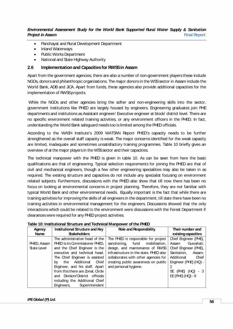
Environmental Assessment Study for the World Bank Supported Rural Water Supply & Sanitation Project in Assam Final Report
IPE Global (P) Ltd. 56
Panchayat and Rural Development Department Inland Waterways Public Works Department National and State Highway Authority
2.6 Implementation and Capacities for RWSS in Assam
Apart from the government agencies, there are also a number of non-government players these include NGOs, donors and philanthropic organisations. The major donors in the WSS sector in Assam include the World Bank, ADB and JICA. Apart from funds, these agencies also provide additional capacities for the implementation of RWSS projects.
While the NGOs and other agencies bring the softer and non-engineering skills into the sector, government institutions like PHED are largely housed by engineers. Engineering graduates join PHE departments and institutions as Assistant engineer/ Executive engineer at block/ district level. There are no specific environment related training activities, or any environment officers in the PHED. In fact, understanding the World Bank safeguard needs too is limited among the PHED officials.
According to the WASH Institute’s 2009 WATSAN Report PHED’s capacity needs to be further strengthened as the overall staff capacity is weak. The major concerns identified for the weak capacity are limited, inadequate and sometimes unsatisfactory training programmes. Table 10 briefly gives an overview of al the major players in the WSS sector and their capacities.
The technical manpower with the PHED is given in table 10. As can be seen from here the basic qualifications are that of engineering. Typical selection requirements for joining the PHED are that of civil and mechanical engineers, though a few other engineering specialities may also be taken in as required. The existing structure and capacities do not include any specialist focusing on environment related subjects. Furthermore, discussions with the PHED also show that till now there has been no focus on looking at environmental concerns in project planning. Therefore, they are not familiar with typical World Bank and other environmental needs. Equally important is the fact that while there are training activities for improving the skills of all engineers in the department, till date there have been no training activities in environmental management for the engineers. Discussions showed that the only interactions which could be related to the environment were discussions with the Forest Department if clearances were required for any PHED project activities.
Table 10: Institutional Structure and Technical Manpower of the PHEDAgency Name
Institutional Structure and Key Stakeholders
Role and Responsibility Their number and existing capacities
PHED, AssamState Level
The administrative head of the PHED is its Commissioner PHED, and the Chief Engineer is the executive and technical head. The Chief Engineer is assisted by the Additional Chief Engineer, and his staff. Apart from this there are Zonal, Circle and Division/District officials including the Additional Chief Engineers, Superintendent
The PHED is responsible for project sanctioning, fund mobilisation, design, and maintenance of RWSS infrastructure in the state. PHED also collaborates with other agencies for creating public awareness on public and personal hygiene.
Chief Engineer (PHE), Assam Guwahati; Chief Engineer (PHE), Sanitation, Assam; Additional Chief Engineer (PHE) (HQ) -2 SE (PHE) (HQ) - 3 EE (PHE) (HQ) - 9

Environmental Assessment Study for the World Bank Supported Rural Water Supply & Sanitation Project in Assam Final Report
IPE Global (P) Ltd. 57
Agency Name
Institutional Structure and Key Stakeholders
Role and Responsibility Their number and existing capacities
Engineers and Executive Engineers.
PHED, AssamDistrict Level
District Executive Engineer, Assistance Executive Engineers, Junior Engineer, and Field Officer
The district PHED Engineers are responsible for drilling tubewells, constructing and laying of pipelines, distribution network for providing safe drinking water and proper sanitary conditions, conserving water resources, etc, with the help of SULC and GPWSC.
EE (PHE) District : 9
PHED, AssamBlock Level
Assistant Engineer and other workers such as supervisors, surveyors, etc. at the grass-root level.
Support District and State PHED in project planning and implementation by identifying the gaps in demand and supply of WSS. They are responsible for grassroot planning and mobilisation,
About 4 AEE per district at the block level.
Gram/GP/ GPWSC
The Panchayati Raj Institutes have a three-tier system that includes the Gaon Panchayat, Anchalik Panchayat and ZP, that is the village, block and district levels. At the village level it is the GPs that are the implementers of all projects and activities. The GPs are having share in land revenue, local rates, revenue, fisheries, house taxes, fines, penalties etc. The GP has an elected president and vice president, who are elected directly by the villagers, and 10 more members, all of who are also elected representatives of the various hamlets and wards of the village. While in some cases the GPWSC is a part of the
GPs are responsible to seek project assistance, constitute GP level GPWSC that represents user communities, and empower the GPWSCs for project implementation on the GPs behalf.GPs undertake baseline surveys for village level development plans,develop action plans and undertake inter-sectoral coordination with various departments, train and build capacity for project implementation.Post-implementation, GPs monitor operation sustainability and ensure satisfactorily discharge of GPWSCs functions of O&M management, likelevying and collecting user charges. In multi-village schemes, GPs are responsible for paying bulk water charges to DWSS.Presently the GPWSC only look at the sanitation sector – the provision of Individual latrines in the villages.
They are largely trained by the State Government, which is to provide them with requiredtraining within a period of 6 months of their election.
Scheme Level User Committees – Commonly
SLUC comprises of 10-20 member committee depending on the type of scheme; hence in multi-village scheme the
User committees are the agencies usually responsible for village level O&M of systems, collection of user charges (usually about INR 40-50/
At the grass root level the challenge is more in terms of operations and

Environmental Assessment Study for the World Bank Supported Rural Water Supply & Sanitation Project in Assam Final Report
IPE Global (P) Ltd. 58
Agency Name
Institutional Structure and Key Stakeholders
Role and Responsibility Their number and existing capacities
known as User Group
committee could be larger. They are elected by the villagers. In most districts the user committee provide water without the GPs support.
month/household for individual connections), identifying water quality issue and reporting them to the PHED. In some Districts like Kamrup, they undertake water sample collection and testing. They also support construction of the hardware facility and monitoring.VWSSCs support assessing infrastructure status, prepare operation plans, and compiling list of technological options, mobilisation of O&M funds, and identify local mechanics and other requiredmanpower.
maintenance and its sustainability at the local level. Responsibility in this context is poorly defined, although it always includes O&M and only sometimes includes planning and implementation.
NGOs/ Independent bodies like UNICEF
NGO: Hopeline ; ARCH; Environ etc.
Local NGOs play a critical role in networking among various types of stakeholders mobilizing the manpower and helping the existing manpower of PHED/boards in their activities. NGO make valuable contribution to the sector, which includes the capacity to: (i) reach the rural poor and remote areas, (ii) promote local participation; (iii) operate at low costs; and (iv) adapt and be innovative when needed.
These organisations provide crucialsupport in the sector that includes both technical and social experts, community mobilisation and capacity building
2.7 Proposed World Bank Supported Project
The PHED originally identified nine project areas8 in the seven districts of Assam, Kamrup, Sibsagar, Jorhat, Sonitpur, Morigaon, Bongaigaon, Hailakandi for the World Bank supported Rural Water Supply and Sanitation project. A total 201 GPs were identified. This was based upon identification of demand and existing ground water quality will be supplied with surface water at 55 LPCD per household from nineteen blocks of the seven districts.
The main elements under the WB supported RWSS scheme will be,
Using sustainable, community or local government managed models to ensure efficiency and sustainability. Putting water resources security as a core theme of the new model, including increased community management of scarce resources
Moving the RWSS sector to recovery of at least 50% O&M and replacement costs and initiating contribution to capital costs keeping affordability and inclusiveness in mind. .
Moving towards metered household connections, with 24/7 water supply where feasible, as a basic level of service.
8 PHED, recently has changed the number of project areas considered under the World Bank funded RWSS project to seven in the seven districts of Assam.
Environmental Assessment Study for the World Bank Supported Rural Water Supply & Sanitation Project in Assam Final Report
IPE Global (P) Ltd. 59
Integrating water supply and sanitation, with effective sanitation promotion programs for achieving “clean villages”.
Establishing M&E systems with independent reviews and Environment as well as social audits.
Development of water sources which are to consider both surface and groundwater sources, depending upon availability of good quality water, sustainability and other technical feasibility issues. So far only surface water sources have been identified.
If no suitable surface source is identified in an area and where water is contaminated with arsenic, fluoride, iron or other similar contaminants shallow dug-wells, ring wells may be considered.
In areas of excess iron with no proper alternate sources a deep tube well with a submersible pump will be considered.
Where shallow sources are used, individual or small scale water supply systems would also be considered. In areas where the source is not a constraint, multi-village schemes may be considered.
For surface water sources the intakes considered will include, either an intake- well or a floating barge fitted with a centrifugal pump is used to lift raw water.
Depending upon the quality of the sourced water treatment will considered. Typically this will consist of pre-sedimentation, aeration, coagulation and flocculation, sedimentation, filtration and disinfection.
If the best available source is contaminated with iron beyond BIS permissible limits, the treatment process is likely to be a combination of - aeration, filtration and disinfection.
Water distributed will be at a minimum terminal head of 5.0metre and a residual chlorine content of 0.2mgl.
The project will also consider upgrading of existing schemes, where practicable.
All projects will be on a cost sharing basis where the community will pay part of the project costs. All completed schemes they will be handed over to the PRIs for the day-to-day management of the system.
Presently, all identified schemes are large multi village schemes sourcing surface water from perennial rivers. The project is to ensure 100% household connections with water charges based on individual household meters. Bulk water meters will also be installed at village entry points of all schemes. The schemes plan to supply water 24*7. In peri-urban areas, multistoried apartments will have shared connections with bulk meters.
All customers under this scheme will be charged a connection charge, which is is likely to be INR 2700. This connection charge is to include cost of meters, a ferrule, saddle, and 10 to 15 m. pipe length. A higher tariff shall be levied for commercial and institutional connection.
The material used for the rising main will be ductile iron pipes and the transmission network will use the ductile iron and galvanized iron pipes along with PVC high density pipelines. The implementation of the project will be in a phased manner, where batch one will be covering three schemes. The planned schemes are,
1. Chandrapur and Dimora block of Kamrup district
2. Jorhat, Jorhat Central and Jorhat North West blocks of Jorhat district, and

Environmental Assessment Study for the World Bank Supported Rural Water Supply & Sanitation Project in Assam Final Report
IPE Global (P) Ltd. 60
3. Hailakandi and Algapur blocks of Hailakandi district.
In total the project will cover 7 development blocks, 60 GPs, 407 villages consisting of 1962 habitations. The first phase will benefit about 36352 people. A total of 16 blocks will covered under this project, over three phases. A total of 5041 habitations and 1306133 people are to be covered by the project. Table 11 gives details of the 7 planned project schemes.

Environmental Assessment Study for the World Bank Supported Rural Water Supply & Sanitation Project in Assam Final Report
IPE Global (P) Ltd.
Table 11: Details of Seven Schemes under the RWSS-LIS, World Bank funded project
Source: PHED, Assam 2013
Sl. No
Name of District Name of Scheme Name of Block No. of GP to
be covered
No. of Villages to be covered
No. of Habitations
to be covered
No. of existing scheme
Population Treatment Plan Capacity
Present Initial Interim Ultimate Initial Interim Ultimate
1 Kamrup
Composite WSS for Sustainability and Quality in Chandrapur and Dimoria Dev. Block (B1)
(a) Chandrapur 4 45 192
130 235486 254325 330623 429809 20 27 35
(b) Dimoria 12 145 501
2 Jorhat
Composite WSS for Sustainability and Quality in Jorhat, Jorhat North West and Jorhat Central Dev. Block (B1)
(a) Jorhat 16 65 480
130 291068 314353 408659 531256 25 33 43(b)Jorhat Central 7 51 287
(c) Jorhat N. West
10 47 278
3Hailakan
diGreater Hailakandi -Algapur WSS (B1)
(a) Hailakandi 4 16 8918 84061 90786 118022 153429 7 10 12
(b) Algapur 10 37 147
4Morigao
nGreater Mayang WSS (B2)
(a) Mayang 14 121 40220 129334 139681 181585 236060 11 15 19
(b) Bhurbondha 2 20 60
5 Bongaigaon
Greater Jogighopa WSS (B2)
(a) Boitamari 12 131 51758 325378 351408 456831 593880 28 37 48(b) Tapatari 11 98 455
(c) Srijangram 13 113 565
6 Sonitpur Gohpur Composit WSS (B3)
(a) Chaiduar 17 108 25770 102641 110852 144108 187340 9 12 15
(b)Pub Chaiduar 16 113 182
7 Sibsagar Amguri - Gaurisagar Integrated WSS (B3)
(a) Amguri 12 78 32294 138165 149218 193984 252179 12 16 20
(b) Gaurisagar 13 87 307
Total7
(seven) District
7 (seven) Large Multi Village Schemes
(MVS)
16 (sixteen)Development
Block173 1275 5041 520 1306133 1410623 1833812 2383953 114 148 192
Environmental Assessment Study for the World Bank Supported Rural Water Supply & Sanitation Project in Assam Final Report
IPE Global (P) Ltd. 62
3 BASELINE ENVIRONMENTAL STATUS
Assam is a part of North East India. The capital of Assam is Dispur. With the Eastern or Lower Himalayas flanking its northern and eastern sides, the State has varied topography which includes a large network of rivers and waterbodies. Of these, the two most important river systems are the Brahamaputra and Barak, both of which form a part of international water systems. Assam is very rich in biodiversity and consists of tropical rainforests, deciduous forests, riverine grasslands, bamboo and wetland ecosystems. North East India; including Assam, is linked to the rest of the country by a narrow land corridor – the Siliguri Corridor.
3.1 Assam, Social and Economic Status
Geographically the State can be divided into three distinctive zones; the Brahmaputra valley, the Barak Valley and the Barail range and Karbi Plateau. The Brahmaputra or Assam valley is comparatively narrow and long with River Brahmaputra flowing mainly in a westward direction. It flows for a length of about 700 km within the State. The Barak Valley comprising of River Barak and its tributaries is located in southern Assam. The Barail range and Karbi Plateau separate these two river systems.
Located between longitudes 90 and 96 East and latitudes 24 and 28 North, towards the north Assam is bordered in the North and East by the Kingdom of Bhutan and Arunachal Pradesh. Along the south, lie Nagaland, Manipur and Mizoram. Meghalaya lies to the South-West, Bengal and Bangladesh to the west.
According to the 2011 census, Assam’s population is 31.169 million people, with a total 5.91 million households9. Approximately 87% of the State’s population is rural.
3.1.1 Administration
Assam has 27 administrative districts. Each district is further divided into Mohkuma Parishads10, with a total of 49 Mohukma Parashids in Assam. Districts in Assam are administered by the Deputy Commissioner, District Magistrate, Office of the District Panchayat and usually have a district court.Districts are mainly delineated on the basis of physical features like rivers, hills and forests.
The local governance system is organised under the District Panchayat for a district, Panchayat for group of or individual rural areas and under the urban local bodies for the towns and cities. There are a total of 2489 Gaon/Gram Panchayats and 26247 villages in Assam. In urban areas there are Town Committeesor Nagar Somiti for small towns, Municipal Boards or Pouro Sobha for medium towns and Municipal Corporations or Pouro Nigom for the cities.
For the revenue collection districts are divided into revenue circles or mouzas. Districts are divided into 219 development blocks for developmental activities. Law and order is managed through the civil police system, with the State divided into 206 police stations or thanas.
9 2011 Census of India.10 “Mohkuma Parishad” means a Mohkuma Parishad established under the Assam Panchayat Act, 1959. (Assam Act XXIV of 1959). They are equivalent to Sub Divisions, which comprises of few blocks, i.e. a district is divided into subdivisions or Mohkuma in the case of Assam which are further divided into Blocks.
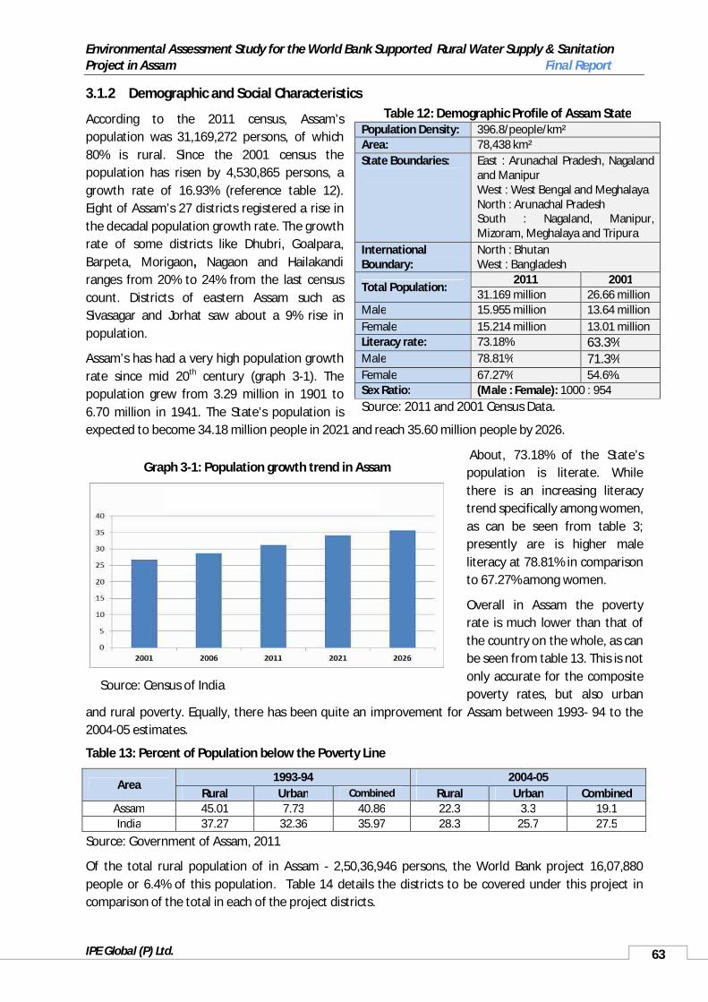
Environmental Assessment Study for the World Bank Supported Rural Water Supply & Sanitation Project in Assam Final Report
IPE Global (P) Ltd. 63
3.1.2 Demographic and Social Characteristics
According to the 2011 census, Assam’spopulation was 31,169,272 persons, of which 80% is rural. Since the 2001 census the population has risen by 4,530,865 persons, a growth rate of 16.93% (reference table 12).Eight of Assam’s 27 districts registered a rise in the decadal population growth rate. The growth rate of some districts like Dhubri, Goalpara, Barpeta, Morigaon, Nagaon and Hailakandiranges from 20% to 24% from the last census count. Districts of eastern Assam such asSivasagar and Jorhat saw about a 9% rise in population.
Assam’s has had a very high population growth rate since mid 20th century (graph 3-1). The population grew from 3.29 million in 1901 to 6.70 million in 1941. The State’s population is expected to become 34.18 million people in 2021 and reach 35.60 million people by 2026.
About, 73.18% of the State’spopulation is literate. While there is an increasing literacy trend specifically among women, as can be seen from table 3; presently are is higher male literacy at 78.81% in comparison to 67.27% among women.
Overall in Assam the poverty rate is much lower than that of the country on the whole, as can be seen from table 13. This is not only accurate for the composite poverty rates, but also urban
and rural poverty. Equally, there has been quite an improvement for Assam between 1993- 94 to the 2004-05 estimates.
Table 13: Percent of Population below the Poverty Line
Area1993-94 2004-05
Rural Urban Combined Rural Urban CombinedAssam 45.01 7.73 40.86 22.3 3.3 19.1India 37.27 32.36 35.97 28.3 25.7 27.5
Source: Government of Assam, 2011
Of the total rural population of in Assam - 2,50,36,946 persons, the World Bank project 16,07,880people or 6.4% of this population. Table 14 details the districts to be covered under this project in comparison of the total in each of the project districts.
Table 12: Demographic Profile of Assam StatePopulation Density: 396.8/people/km² Area: 78,438 km² State Boundaries: East : Arunachal Pradesh, Nagaland
and Manipur West : West Bengal and Meghalaya North : Arunachal Pradesh South : Nagaland, Manipur, Mizoram, Meghalaya and Tripura
International Boundary:
North : Bhutan West : Bangladesh
Total Population:2011 2001
31.169 million 26.66 millionMale 15.955 million 13.64 millionFemale 15.214 million 13.01 millionLiteracy rate: 73.18% 63.3%Male 78.81% 71.3%Female 67.27% 54.6%.Sex Ratio: (Male : Female): 1000 : 954Source: 2011 and 2001 Census Data.
Graph 3-1: Population growth trend in Assam
Source: Census of India

Environmental Assessment Study for the World Bank Supported Rural Water Supply & Sanitation Project in Assam Final Report
IPE Global (P) Ltd. 64
Table 14: Coverage of the Project in the Identified Districts in Assam
S.No
DistrictTotal Proposed to be Covered under the Project
Blocks Panchayats Village Habitation Blocks Panchayats Village Habitation
1 Kamrup 17 163 1276 5228 3 23 243 10032 Sibsagar 9 120 997 4919 4 41 299 13303 Jorhat 8 111 793 3578 3 41 299 13304 Sonitpur 14 159 1952 5298 2 33 221 4395 Marigaon 6 97 567 2192 2 16 85 4886 Bongaigaon 6 62 514 2313 3 36 342 15377 Hailakandi 5 62 398 1673 2 11 54 236
Total 65 774 6497 25201 19 201 1543 6363Source: NRDWP, Ministry of Drinking Water and Sanitation, 2012 (PHED, Assam for the figures under Proposed project)
3.1.3 Health According to the Economic Survey of Assam 2010-11 there has been a decline in the infant mortality rate over time, from 74/1000 live births in 2001 to 61 for every 1000 live births in Assam. This has been quite a remarkable achievement. However, even today Assam lags behind India’s average which is at 50 for every 1000 live births. Maternal mortality in 2004 – 05 stood at 450/1000 live births. There is also still a long way to go for improving coverage of health facilities in the State. As can be seen from table 15, there is still limited coverage of health facilities in the State. Not only is there still a need for hospitals in all districts, given the terrain and remoteness of some areas, access to facilities to all the state’s inhabitants may not be easy.
3.1.3.1 Water and Sanitation Related Health ConcernsAccording to the ENVIS 2009 Report at least 20,000 young people suffer from severe fluorosis in Assam. The areas where flourosis is a major concern are Tekelangjan, Dokmaka, Lungnit, Taradubi, Tuplem, Garampani, Ratiagaon, Haldiati, Parakhowa, the Neelbagan area of Nagaon district, and the south-eastern part of Hojai subdivision. Surveys in A preliminary random survey of the Hajai subdivision identified about 100 villages where the groundwater was contaminated with fluoride, with 350 water sources identified to be fluoride impacted. Similarly, a survey in Karbi Anglong and Nagaon identified about 800 water sources contaminated with fluoride.
Besides, fluorosis, waterborne diseases like, cholera, dysentery and diarrhoea are common in rural Assam. Data of the Integrated Disease Surveillance Project (IDSP) identify the occurrence of these three diseases to be the highest in summer and rainy seasons. In 2010, Assam experienced incessant rains which led to flooding of most of the districts and resulted in epidemics of cholera and other waterborne
Table 15: Medical Facility Availability in Assam
Type of Facility Number
Medical college hospitals 6State level hospitals 1 (in Guwahati)District hospitals 22Sub-divisional civil hospitals 13Primary health centres 103Community health centres 103Block primary health centres 149State dispensaries 261Subsidiary health centre 71Mini primary health centre 453Sub-centre 4592B.Sc. Nursing College 1
Source: Government of Assam, 2011
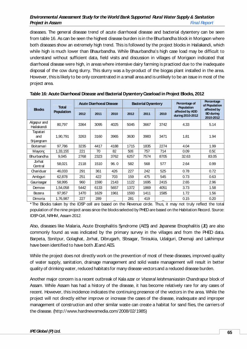
Environmental Assessment Study for the World Bank Supported Rural Water Supply & Sanitation Project in Assam Final Report
IPE Global (P) Ltd. 65
diseases. The general disease trend of acute diarrhoeal disease and bacterial dysentery can be seen from table 16. As can be seen the highest disease burden is in the Bhurbandha block in Morigaon where both diseases show an extremely high trend. This is followed by the project blocks in Hailakandi, which while high is much lower than Bhaurbandha. While Bhaurbandha’s high case load may be difficult to understand without sufficient data, field visits and discussion in villages of Morigaon indicated that diarrhoeal disease were high, in areas where intensive dairy farming is practiced due to the inadequate disposal of the cow dung slurry. This slurry was a by-product of the biogas plant installed in the area. However, this is likely to be only concentrated in a small area and is unlikely to be an issue in most of the project area.
Table 16: Acute Diarrhoeal Disease and Bacterial Dysentery Caseload in Project Blocks, 2012
Blocks Total Population
Acute Diarrhoeal Disease Bacterial Dysentery Percentage of Population
affected by ADD during 2010-2012
Percentage of Population
affected by BD during 2010-2012
2012 2011 2010 2012 2011 2010
Algapur andHailakandi 80,797 3364 3095 4025 5045 3667 3742 4.33 5.14
Tapatari and
Srijangram1,90,791 3263 3160 3965 3630 3983 3471 1.81 1.94
Boitamari 97,786 3235 4417 4188 1715 1835 2274 4.04 1.99Mayong 1,33,155 221 70 82 509 757 714 0.09 0.50
Bhurbandha 9,045 2768 2323 3762 6257 7574 8705 32.63 83.05Jorhat Central 58,021 2118 1510 96. 0 582 568 577 2.64 0.99
Chariduar 46,033 291 361 426 227 242 525 0.78 0.72Ambguri 62,878 251 422 703 159 475 545 0.73 0.63
Gaurisagar 58,995 960 1590 2143 1122 1695 2415 2.65 2.96Demow 1,54,058 5442 6133 5657 1372 1869 4051 3.73 1.58Bezera 97,957 1470 1629 1961 1593 1411 1585 1.72 1.56Dimoria 1,76,987 227 289 _ 281 419 _ 0.15 0.20
*The Blocks taken by the IDSP cell are based on the Revenue circle. Thus, it may not truly reflect the total population of the nine project areas since the blocks selected by PHED are based on the Habitation Record. Source: IDSP-Cell, NRHM, Assam 2012.
Also, diseases like Malaria, Acute Encephalitis Syndrome (AES) and Japanese Encephalitis (JE) are also commonly found as was indicated by the primary survey in the villages and from the PHED data.Barpeta, Sonitpur, Golaghat, Jorhat, Dibrugarh, Sibsagar, Tinisukia, Udalguri, Dhemaji and Lakhimpur have been identified to have both JE and AES.
While the project does not directly work on the prevention of most of these diseases, improved quality of water supply, sanitation, drainage management and solid waste management will result in better quality of drinking water, reduced habitats for many disease vectors and a reduced disease burden.
Another major concern is a recent outbreak of Kala azar or Visceral leishmaniasisin Chandrapur block of Assam. While Assam has had a history of the disease, it has become relatively rare for any cases of recent. However, this incidence indicates the continuing presence of the vectors in the area. While the project will not directly either improve or increase the cases of the disease, inadequate and improper management of construction and other similar waste can create a habitat for sand flies, the carriers of the disease. (http://www.hardnewsmedia.com/2008/02/1985)

Environmental Assessment Study for the World Bank Supported Rural Water Supply & Sanitation Project in Assam Final Report
IPE Global (P) Ltd. 66
3.1.4 AgricultureAgriculture is an important of livelihood in Assam with more than 80% of the State’s population dependent upon it. It account for about for about 54.11% of the total geographical area of the State. Apart from crops, another source of agriculture livelihoods in the State is tea. The net area sown as well as the gross cropped area increased significantly in the last few decades due to better access to newer technologies. According to the Assam Gazetteer, 2001 the increase in agriculture and plantation practices has decreased area under forest. Despite its importance as a livelihood in the State, the agriculture sector’s contribution to the State’s income has been falling sharply over time, from about 50% in early 1980s to about 35% by the end of 1990s.
The Assam State Development Report, 2002 identifies agriculture in Assam to be underdeveloped and backward due to the widespread practice of traditional farming techniques, low usage of modern farm inputs, low levels and low growth in productivity and incomes in the sector, large percent of subsistence cultivation and poor and inadequate agricultural infrastructure. Furthermore, yield levels of all the major crops in Assam are very low and well below their corresponding national average. Agriculture had grown only at 2.1% annually over the 1980s and 1990s and had slowed down in the 1990s to 1.6%. (Planning Commission, 2002)
Rice is the most important crop in Assam, with rapeseed and mustard, and tea being the next most important crops. The area under these crops has been fairly stable in time. Some of the other crops like wheat, pulses, jute, mesta (Hibiscus cannabinus), and sugarcane have had marginal decline in their land areas; while potato, banana, areca nut and chillies have gained importance over time. Some of the other important crops are sweet potato, banana, papaya, cabbage, cauliflower, aubergine, lemon, orange and pineapple and turmeric. (Planning Commission, 2002)
The agricultural land use pattern in the Project districts can be seen in table 17. As can be seen from the table, while in some districts like Bongaigaon and Hailakandi there is negligible rabi agriculture, plantation cropping is important for all districts other than Morigaon, where it only consists of 0.5% of the total area under agriculture in the district. Also, what is visible is the very intensive agriculture being followed in some areas with no fallow land kept aside at all.
Table 17: District Wise Agricultural Land Usage in Project Districts, 1990
DistrictAgricultural Land ( area in hectare)
Area Kharif Rabi Double crop
Net area sown Plantation Fallow land Total
Bongaigaon 31335 22099 -- 18277 3822 11389 -- 15211 Hailakandi 132293 98270 -- 1723 96547 38640 -- 135187 Jorhat 291470 21293 60998 43886 38405 61100 4815 104320 Kamrup 473380 235840 156516 145867 246489 25894 1939 274322 Morigaon 121966 67968 18972 33914 53026 646 9868 63540 Sibsagar 260290 105068 23278 15304 113042 100455 -- 213497 Sonitpur 525520 215966 51059 29498 237527 55682 3937 297146
Source: Assam Remote Sensing Application Centre
In Assam, fish is an important constituent of diet, with about 95% of the population consuming it. Based upon the Department of Fisheries, Assam estimates the per capita annual fish requirement in Assam is considered to be 11 kilogram. While there are a number of programmes to encourage fishing, presently Assam’s fish production can only meet about half this need, with the rest being met by fish imported from Andhra Pradesh.

Environmental Assessment Study for the World Bank Supported Rural Water Supply & Sanitation Project in Assam Final Report
IPE Global (P) Ltd. 67
While fishing is carried out either through formal or informal systems wherever there is potential, River Brahmaputra is rich in fish species. This includes a large variety of Indian major carps (labeo rohita, labeo calbasu, catla catla and cirrhinus mrigala); and another economically important specie the catfish (wallago attu, silondia silondia, pangasius pangasius, aorichthys seenghala, aorichthys aor, bagarious bagarious, and ompok bimaculatus). While there are no official fish catch statistics for river fish, the Central Inland Fisheries Research Institute indicates a declining catch trend due to habitat loss. Similarly, some beel fisheries have also shown a declining trend which has been attributed to degradation of habitation, siltation of river link channels and indiscriminate fishing including broods and juveniles. It is estimated that river fish catch is about 50 kgs per ha. (Planning Commission, 2002)
While it may not be possible to exactly estimate the causes of aquatic habitat degradation, issues like siltation indicate possible land use change and inadequate management of land based activities along with increased dumping of waste in waterbodies. Equally, the existing nature of many of the rivers systems which show a maturing trend in Assam resulting in the increased deposition of silt and bank cutting may result in some of the siltation concerns.
According to the Livestock Census of 1997 the total livestock population in Assam was 113.18 lakh in 1997. Of the total livestock in the State, cattle accounted for the largest number at 80.30 lakh heads in1997 followed by goats at 26.77 lakh. The pig population was 10.82 lakh and buffaloes added another 7.28 lakhs. The Livestock Census, 1997 has showed a positive growth in the population of certain species like cattle (3.2%), buffaloes (11.7%), goats (1.2%) and pigs (30.7%) over the population of previous census, whereas the population of horses and ponies showed a decline in growth (14.3%). (http://www.neportal.org/, accessed 29 March 2013)
The Livestock Census 1997 showed a significant increase - 29.03% in poultry population of the State over that of 1994 Census. During the year 1997, the State had 179.80 lakh poultry as against 139.34 lakh in 1994. The category-wise population of these species during 1997 were fowls 129.31 lakh and ducks 50.49 lakh. (http://www.neportal.org/, accessed 29 March 2013)
Much of the piggeries are informal backyard pig farming activities, as are some others like ducks and poultry in Assam. This however, especially with pigs poses problems such as Japanese Encephalitis, which is often spread though this informal pig farming where hygiene is low. Considering that Japanese Encephalitis is an issue in many parts of Assam, improved pig management and hygiene would go a long way in controlling the disease.
3.1.5 Manufacturing and MineralsAssam has 16 Industrial Estates, 17 Industrial Areas, 11 Growth Centres under the Industries and Commerce Department of Assam, 11 Integrated Infrastructure development projects, 4 Industrial Growth Centres, 6 Mini Industrial Estates, 1 Export Promotion Industrial Park and, 1 Food Processing Industrial Park. At the end of March 2010 there were an estimated 625 functioning Industrial unitsregistered. Apart from the large industrial units there are also a number of small and medium enterprises. Assam had an estimated 32984 such units employing about 167216 persons at the end of 2009-10. Assam’s industrial produce includes tea, wheat flour, coal, jute and jute products, crude oil, cement, leather, paper, engineering, chemicals, plastics, electronic, minerals, silk, handloom and fertilizers. (Government of Assam, 2011)

Environmental Assessment Study for the World Bank Supported Rural Water Supply & Sanitation Project in Assam Final Report
IPE Global (P) Ltd. 68
Minerals presently being mined in Assam include petroleum, natural gas, coal and limestone. During the year 2009-10, the volume production of coal in the State was 1203 thousand MT, crude oil 4738 thousand MT, natural gas 2476 MCM and limestone 402 thousand MT. While the production of three coal, crude oil and limestone increase by 4.95, 1.4% and 10.7% respectively during the year 2009-10 over 2008-09, the production of natural gas decreased by 5.1% in the same period. (Government of Assam, 2011)
Perhaps among minerals what is the most important is petroleum. Not only is the country’s oldest oil rig – Digboi is in Tunsukia, Assam. The others include Noonmati in Guwahati, Dhaligoan near Bongaigaon and Numaligarh of Golaghat district.
3.2 Infrastructure
3.2.1 IrrigationAgriculture constitutes the largest share of water consumption amongst various uses followed by the domestic and industrial uses. The Gross Irrigation Potential or annually irrigable area for 2009 – 10 wasestimated at about 27 lakh hectares, or 67.5% or Gross Cropped Area. Of this about 10 lakh hectares have been covered so far through various major and medium irrigation projects using surface water sources and another 17 lakh hectares by minor irrigation schemes dependent upon groundwater sources. (Government of Assam, 2011)
Three State departments have been working together to provide irrigation water. These are the Irrigation, Agriculture and Panchayat and Rural Development departments. Of these, the Irrigation Department is the nodal department for development of irrigation in Assam and executes and maintains major, medium and minor irrigation schemes. The other two departments mainly work for the development and management of minor irrigation schemes, such as shallow tubewells, low lift pints and temporary minor irrigation schemes only. (Government of Assam, 2011)
3.2.2 Water for Domestic UseGround water is the main source of domestic water for most of the rural population of the State. The per capita abstraction for domestic needs is estimated to be 25 litres a day. Alongside, Assam is still dependent on water from rain, streams and rivers for drinking and other domestic purposes, as can be seen from table 18. Many of these sources are considered to be unsafe. Access to safe drinking water and the status of sanitation and hygiene in Assam is substantially less than the national average. The population in Assam with access to safe drinking water is only 77.55% compared to the all India figure of 88% (the same is 84% in rural areas and 95% in urban areas) while the total sanitation coverage (rural plus urban) in India is 18% and in Assam 15.89%.
Table 18: Main Drinking Water Source in Rural Assam
Total number of households
Tap water from treated source
Tap water fromun-treated source
Covered well
Un-Covered well
Hand-pump
Tubewell / Borehole
Spring River / Canal
Tank / Pond / Lake
Other Sources
Total 5374553 310833 (5.78)
55852(1.03)
58923(1.09)
965961(17.97)
2866428(53.33)
439414(8.17)
70287(1.31)
208593(3.88)
282954(5.26)
115308(2.14)
Within the premises
2707213 100028 16469 24752 433151 1877505 255308 0 0 0 0

Environmental Assessment Study for the World Bank Supported Rural Water Supply & Sanitation Project in Assam Final Report
IPE Global (P) Ltd. 69
Total number of households
Tap water from treated source
Tap water fromun-treated source
Covered well
Un-Covered well
Hand-pump
Tubewell / Borehole
Spring River / Canal
Tank / Pond / Lake
Other Sources
Near the premises
1572643 140740 25875 18774 278979 643035 116299 18758 75258 220759 34166
Away 1094697 70605 13508 15397 253831 345888 67807 51529 133335 62195 81142Source: National Rurla Drinking Water Programme, 2012
Government led rural water supply schemes in Assam are either single village or multi village schemes, and use both ground water and surface water sources, depending upon the quality and availability of a reliable source. The PHED is the main government agency which is responsible for water supply. However, many private organisations, NGOs, CBOs and individuals who support rural water supply development and management are mainly dependent upon groundwater, using shallow tubewells, dug wells and hand pumps. In areas where arsenic, iron and fluoride has been detected in the groundwater, surface water sources are used for domestic, specifically drinking water instead.
The present norms adopted by PHED for coverage of Habitations in Assam are as follows:
40 litres of safe drinking water lpcd for human being.
A water source should exist within the habitation / within 1.60 km in the plains and within 100 m elevation in the hilly areas.
3.2.2.1 Current Water Treatment Practices In Assam every district has 25 District Level Laboratories which are to undertaken water quality analysis. Each laboratory is to analyse at least 150 physical and chemical water sample tests and 60 bacteriological analysis of water samples every month. To maintain the seasonal changes of the water quality different sources have been analysed at the interval of a week. After analysing the water sample, if any water quality parameters is found beyond the permissible limit necessary steps are to be taken to maintain the quality. The active performance of the laboratories has made the APHED capable of detecting various water quality problems. The APHED is equipped with five Ion-meter given by UNICEFand are used to detect fluoride in water, amongst other parameters. (Source: www.aphe.nic.in)
Water supplied by the PHED though single and multi-village projects is chlorination prior to distribution. At the household level the PHED advices that water taken from handpump water is disinfected by the consumers using chlorine tablets or through boiling. In piped water schemes where there the water has a high iron content, iron removal is conducted after filtration and prior to chlorination and distribution. The PHED mainly uses bleaching powder to disinfect water. For iron affected areas where water is supplied by handpumps, an iron removal system is attached to the handpump itself. Figure 3-1 shows the general water treatment practice followed by the PHED for its piped water supply systems. The following below indicates the treatment practice to remove Iron in general.

Environmental Assessment Study for the World Bank Supported Rural Water Supply & Sanitation Project in Assam Final Report
IPE Global (P) Ltd. 70
Figure 3-1: General Water Treatment Process followed by APHED
3.2.3 Household and Environmental Sanitation There are 3 million households in rural Assam, which do not have sanitary latrines. NBA aims at providing 93,000 latrines within 5 year in rural Assam to help bridge the gap. An estimated 23 million people in rural Assam do not have adequate knowledge about good hygiene practices.
According to the 2011 Census, the percent of ST population in Assam with toilet facilities in theirpremises is much lower in comparison to that of the State average and Assam’s SC population, refer table 19. Nonetheless, the situation of drainage facility is the same for all three populations in the State.
Table 19: Sanitation Facilities in Rural Assam, 2011
Total number of households
Households with latrine facilities in premises
Households with closed drainage in premises
Households with bathrooms in premises
Number Number % Number % Number %Total 6367295 4131931 64.89 230025 3.61 1558058 24.47Rural 5374553 3201625 59.57 76764 1.42 846494 15.75ST Rural 814320 57674 7.08 8243 1.01 74530 9.15SC Rural 539606 326395 60.48 10114 1.87 89156 16.52
Source: Census 2011
According to an impact assessment of the NGP awarded panchayats on sanitation and hygiene in Assam, (TARU 2008),
Of the 85% households with access to individual, community or shared toilets, only around 66% used them. Poor or unfinished installations, lack of super structure and reluctance to change behaviour resulted in this low usage.
Efforts of the NGP had resulted in only 70% people using toilets, with the remaining still practicing open defecation.
In case of toilets in schools, lack of gender considerations, poor functionality and inadequate number of toilets especially for peak hour usage reduced toilets usage among children.
More than half the GPs and households visited lacked mechanisms for solid and liquid waste disposal.
As can be seen from table 20, there is still a long way to go to achieve a 100% open defecation free State.
Tube WellRapid Gravity
FilterIron Removal Plant
Clear Water Reservoir
Pump House Consumer

Environmental Assessment Study for the World Bank Supported Rural Water Supply & Sanitation Project in Assam Final Report
IPE Global (P) Ltd. 71
Table 20: Report Card Status of Nirmal Bharat Abhiyan on 29 /1/2013
Component Project Targets Project Achievements Achievement (%)IHHL BPL 2220017 1650433 74.34IHHL APL 1161020 431009 37.12IHHL TOTAL 3381037 2081442 61.56School Toilets 34772 33736 97.02Sanitary Complex 211 63 29.86Anganwadi Toilets 16819 10997 65.38RSM/PC 115 183 159.13Source: http://tsc.gov.in/NBA/State.aspx
*The Block and GP Wise Data on Total Sanitation Coverage is available from the webiste: http://tsc.gov.in/NBA/State.aspx
3.2.4 Drainage and SewageRural Assam lacks comprehensive drainage and sewerage systems. Most of the liquid waste is going to either agricultural land or rains into local waterbodies and open fields. This is a major cause of concern as is indicated by water quality data of surface waterbodies. High levels of faecal coliform have been observed in some of the districts such as Dhubri, Cachar, Kamrup, Nagaon and Sonitpur while many others like Marigaon and Darrang also show a presence of faecal coliform, as is seen in table 21.
Table 21: Bacteriological Contamination of Water Sources in Assam
DistrictNo. of Sources with Bacteriological ContaminantsFaecal Coliform
1 Baksha 12 Barpeta 03 Bongaigaon 04 Cachar 1295 Chirang 06 Darrang 87 Dhemaji 08 Dhubri 2279 Dibrugarh 0
10 Goalpara 5411 Golaghat 012 Hailakandi 013 Jorhat 014 Kamrup 4415 Karbi Anglong 016 Karimganj 017 Kokrajhar 518 Lakhimpur 019 Marigaon 120 Nagaon 11021 Nalbari 022 Dima Hasao Hills 023 Sibsagar 024 Sonitpur 12525 Tinsukia 0

Environmental Assessment Study for the World Bank Supported Rural Water Supply & Sanitation Project in Assam Final Report
IPE Global (P) Ltd. 72
DistrictNo. of Sources with Bacteriological ContaminantsFaecal Coliform
26 Udalguri 0Source: Format E21- District Quality Profile For FTK Testing (National Rural Drinking Water Programme –Rajiv Gandhi National drinking Water Mission) )* Note: the bacterial content in water does not remain constant and thus the data presented above may not be true through out the year/month.
3.2.5 Solid Waste Management
There is no systematic solid waste management undertaken in the rural areas of Assam. The solid waste is either burnt or buried in most villages. Some waste like plastics are often burnt, which is likely to create major health hazardous for the local population. Under health and hygiene training activities of the PHED, NGO’s and UNICEF for the villagers, biodegradable waste management is being taught, though there is still a long way to go before composting etc are practiced comprehensively in Rural Assam.
3.2.6 Energy
The energy requirement in the State as estimated to be 5049 million units in 2009-10, with the availability at 4590 million units. The installed capacity for power generation in Assam at present is 401.50 MW. This includes both hydel and gas plants. Therefore much of this power has to be bought from other states. This gap in availability and demand is also visible in rural Assam, where the government has been implementing electrification schemes through a number of distribution companies. Based upon 2001 Census population figures, 67% villages in Assam had been electrified by 2010, though only 16.5% rural households had electricity connections. (Government of Assam 2011; Statistical Handbook 2011)
In order to create 100% rural electrification in Assam, as is planned in the National Rural Electrification Policy 2004 and Rural Electrification Policy of Government of Assam; a number of rural electrification projects, especially under Rajiv Gandhi Gramin Vidyutikaran Yojana scheme, have been taken up. Under this scheme all the census villages of Assam were proposed to be electrified by 2009, though this is still to be achieved. Electrification in 16 districts is to be implemented by Assam State Electricity Board and in 7 districts by the Power Grid Corporation of India. As can be seen from table 22, even where there is electricity available in villages, 24 hours supply is still to be achieved.
3.2.7 Transport
Assam has an estimated 37000 kms of road network. This includes 1635 kms of National Highways, 36003 kms of State Highways, major district roads, urban roads and rural roads. Of these 10979 kms is blacktopped, and include 558 km of intermediate lane and 132 Km double lane or above. The rest, 94%, of the blacktopped road length are single lane roads. (Government of Assam 2011)
Table 22: Average Electricity Availability in Rural Assam (hrs)
Maximum 14Minimum 10Average 12
Source: Statistical Handbook, 2011

Environmental Assessment Study for the World Bank Supported Rural Water Supply & Sanitation Project in Assam Final Report
IPE Global (P) Ltd. 73
The Northern Frontier Railway is headquartered in Maligaon at Guwahati. The total railway route length in Assam at the end of 2009-10 was 2433.34 kms. This comprised of 1376.22 kms of broad gauge and 1057.12 kms of metre gauge railroads. (Government of Assam 2011)
Assam has a large number of civil airports which include airports at Guwahati, Tezpur, Jorhat, Dibrugarh, North Lakhimpur and Silchar. In addition to these civil airports, a number of small private airstrips in the interior areas and tea gardens also exist.
River Brahmaputra’s navigable waterways are an estimated 891 km, from Sadiya to Dhubri. River Barak navigable waterways are 94 km in length. The Sadiya – Dhubri stretch has been declared as the 2nd
National waterway of India. The Government owned organisations, the Central Inland Waterways Corporation and Directorate of Inland Water Transport Assam, commercially operate water transport services on both rivers. These services are used for both passenger and goods transportation. Currently, the Directorate of Inland Water Transport is operating 74 ferry services, out of which 54 ferries are plying in the Brahmaputra valley and 24 in the Barak valley. The Inland Water Transport Department has introduced 61 cargo and passenger combined service in Assam, especially in remote areas without road networks. Besides these Government owned organisations, there are also a large number of privately owned ferries for goods and passenger transport. (Government of Assam 2011)
3.3 Physical Environmental
3.3.1 Location
Assam lies in the middle reaches of the Rivers Brahmaputra and Barak. The total area of the State is 78,438 km2, around 2.4% of India’s total geographical area. About 70,634 km2 of a total of 580,000 km2
of the Brahmaputra basin is in Assam. Of the 7 districts under this project Kamrup, Sibsagar, Jorhat, Sonitpur, Morigaon, Bongaigaon and Hailakandi, all but Hailakandi are in the Brahmaputra basin. Hailakandi is in the Barakh valley. The project covers 16 blocks (table 23). This is a total of 9 schemes, of which presently only 7 are being considered – excluding those in blocks Bezera, Sibsagar and Dimow.
Table 23: Schemes under the RWSS-LIS World Bank Project
S.No District Project Areas Name of Blocks
1 KamrupComposite WSS for sustainability and Quality at Chandrapur and Dimoria Dev. Block
ChandrapurDimoria
Composite WSS for sustainability and Quality at Bezera Bezera11
2 SibsagarAmguri Gaurisagar integrated WSS
AmguriGaurisagar
Greater Sibsagar integrated WSS for mitigation of Arsenic and Iron
SibsagarDimow
3 JorhatComposite WSS for sustainability and Quality at Jorhat and Jorhat Central and Jorhat N West Dev. Block
JorhatJorhat CentralJorhat North West
4 Sonitpur Composite WSS at GohpurChariduarPurb Chariduar
5 Morigaon Greater Mayang WSSMayongBhurbondha
6 Boigaingaon Greater Jogighopa WSSBoitamariTapatariSrijangram
11 Bezera, Sibsagar and Dimow are not included in the present RWSS-LIS Project.

Environmental Assessment Study for the World Bank Supported Rural Water Supply & Sanitation Project in Assam Final Report
IPE Global (P) Ltd. 74
S.No District Project Areas Name of Blocks
7 Hailakandi Greater Hailakandi-Algapur WSSAlgapurHailakandi
Source: PHED, Assam
3.3.2 Climate and Rainfall
The region receives rain from both the south-west monsoon and the north-east or retreating monsoon. While the region is characterized by high rainfall, analyses of long-term trends in annual rainfall indicatea slight decline in the total rainfall received by the region (Das, 2004; Mirza et al., 1998; Tiwari, 2006, ASTEC, 2011). As can be seen from graph 3-2 while Assam receives rainfall throughout the year, the highest rainfall is received between April and October. The average annual rainfall in the Brahmaputra valley and its surrounding areas are 3050 mm. (State profile, 2009)
The pre-monsoon and post-monsoon thundershowers are very dominant over this region, and are mainly orographic in nature. Assam also has high thunderstorm activity, especially during high rainfall months, with the North Eastern region having a higher propensity of thunderstorm being associated with rainfall in comparison to other regions of the country. (Kandalgaonkar et al 2005) Post-monsoon thunderstorms are usually of greater intensity than pre-monsoon ones. The two months preceding the monsoons have high cyclonic activity.
Graph 3-2: Average Rainfall in the State of Assam
Source: Statistical Handbook of Assam, 2011 (for the year 2010)
Within the project area in general the highest rainfall is seen in lower Assam and South Assam areas –Bongaigaon and Hailakandi, as is seen in graph 3-3. However interestingly, while overall Bongaigaon can be considered to have the highest rainfall, even comparatively drier districts like Morigaon in some years may receive nearly equally high rainfall in certain years; which may be comparatively poorer monsoon years for Bongaigaon.

Environmental Assessment Study for the World Bank Supported Rural Water Supply & Sanitation Project in Assam Final Report
IPE Global (P) Ltd. 75
Graph 3-3: Rainfall Pattern in the project Area during Monsoon Months from 1995-2000
(Source: Assam Gazetter, 2000)
3.3.3 GeomorphologyGiven the river basin areas Assam is mainly composed of plains and river valleys which are separated by hills – such as the hill districts of Karbi Anglong and Dima Hasao. Assam therefore can be divided intothree main physiographic regions,
1. The vast alluvial plains of the Brahmaputra valley in the north, comprising the districts of Goalpara, Kamrup, Darrang, Nagaon, Sibsagar, North Lakhimpur and Dibrugarh.
2. The Central Assam hills comprising Karbi Anglong and Dima Hasao12.
3. The hilly and alluvial terrain in the south covering the Cachar district (Barak valley).
The elevation of the Brahmaputra valley ranges from 50 to 120 masl the Brahmaputra valley. As can be seen from figure 3-2, northern parts of Assam mainly comprise of the elongated valley of River Brahmaputra, and a majority of the State’s population lives here.
The Brahmaputra valley is bounded by the foothills of the Himalayas to the north and another lower range of hills to the south. In general southern and lower Assam have slightly lower elevations as compared to the Brahmaputra valley with the highest elevation usually see along the Karbi, North Cachar and other hills and the Borail Range. The Barakh is bound by the by the Barail range in the north, the Naga and Lushai hills in the east and Bangladesh in the south and west. As can be seen from table 6, a majority of the area in Assam is at low elevations, with 92% of the land less than 500 mals. Equally, the hills of the Borail Range and other highland areas are of moderate height, not going beyond 2000 mals(table 24).
12 The district has been renamed in 2012, and was earlier known as the North Cachar Hill District

Environmental Assessment Study for the World Bank Supported Rural Water Supply & Sanitation Project in Assam Final Report
IPE Global (P) Ltd. 76
However in some areas the topography, especially in the river valleys, is rewritten regularly. During the monsoons the Brahmaputra and its tributaries break their banks and eat away the soils of the floodplains. The receding floods leave behind alluvial deposits and sandy islands within the river beds. In fact, the high silt content of the Brahmaputra has also resulted in a number of large and permanent
islands that form its braided stream as the river looses its velocity when entering the plains, with some islands being large enough for settlements and agriculture. (Assam Human Development Report, 2003)
Figure 3-2: Relief of Assam with Respect to Project Areas
Base Map Source: National Atlas and Thematic Mapping Organisation, 1988
Table 24: Geographical Area under Different Altitude Zones
Altitude Zone (mals) Geographical Area (km2)
Percent area
0 – 500 72,333 92.22501-1000 5,337 6.801001 – 2000 768 0.98
Source: Forest Survey of India, nd

Environmental Assessment Study for the World Bank Supported Rural Water Supply & Sanitation Project in Assam Final Report
IPE Global (P) Ltd. 77
3.3.4 Land Use Patterns
Land use patterns in Assam according to 2008-09 data show that more than a third of the total land area in Assam is under agriculture, with the second highest land use being the area under forests (table 25). However, there have been some changes since, with the latest State of Forest Report, 2011 reporting approximately 35% of area presently under forests. Fallow land and culturable waste lands are relatively low accounting for less than 4% of the total land area.
Table 25: Land use under Various Categories in AssamLand use Area (in ‘000 ha) Percent
Reporting area for land utilisation 7,850 100Forests 1,853 23.60Not available for cultivation 2,626 33.45Permanent pastures and other grazing land 160 2.04Land under miscellaneous tree crops and groves 196 2.40Culturable wasteland 77 0.98Fallow lands other than current fallow 59 0.75Current fallow 126 1.61Net area sown 2,753 35.07
Source: Forest Survey of India, 2011
3.3.5 Water Resources
Assam is divided into two major river valleys – the Brahmaputra and Barak and thus, Assam is endowed with enormous water resources. Apart from the river network of the Brahmaputra and Barakh, there are also a number of other water systems. The ground water is available at low to moderate depth almost in entire State. Although there is seasonal and regional variation in the availability of water resources, the annual availability of water resource remain almost same. In the last few decades the use of water has been growing at a fast rate, which is more than twice the rate of the increase of human population.
3.3.5.1 The Brahmaputra River SystemThe Brahmaputra is one of the biggest rivers of the world. The fourth largest river in the world in term of average water discharge, the Brahmaputra at the mouth discharges 19,830 cubic metres per second. The Brahmaputra basin covers an area of 5,80,000 km2 of which 1,94,413 km2 is in India. In India, the basin includes parts of Arunachal Pradesh, Assam, Nagaland, Meghalaya, Sikkim and West Bengal. River Brahmaputra is perennial and is feed by both snow and rain.
Table 26: Annual Discharge of Major Right Bank Tributaries of River Brahmaputra
S. No. Rivers Length (km) Average annual discharge(m 3 s -1)
1 Subansiri 442 7,55,7712 Ranganadi 150 74,3093 Baroi 64 20,8004 Bargang 42 16,0005 Jia Bharali 247 3,49,4876 Gabharu 61 8,4507 Balsiri 110 9,3008 Dhansiri 123 26,5779 Noa-Nadi 75 4,45010 Nanoi 105 10,28111 Barnadi 112 5,756

Environmental Assessment Study for the World Bank Supported Rural Water Supply & Sanitation Project in Assam Final Report
IPE Global (P) Ltd. 78
12 Puthimari 190 26,32413 Pagladiya 197 15,20114 Manas-Aye-Beki 215 3,07,94715 Champamati 135 3254816 Gaurang 98 2226317 Tipkai 108 6178618 Godadhar 50 7000
Source: Flood Control Department, Govt. of Assam.
River Brahmaputra flows through Assam largely east to west over a length of approximately 700kilometres. An antecedent river originating from the Tibetan plateau, River Brahmaputra flows west to east as the Tsangpo though the Tibetan Plateau; turning southwards as it enters Arunachal Pradesh as River Siang and later Dihang to enter Assam, where it is joined by a number of its other tributaries and becomes the Brahmaputra.
River Brahmaputra and its 33 major tributaries joining it in Assam, including the trans-Himalayan tributaries of Subansiri, Jia Bharali, and Manas, carry about 30% of the country’s total surface water. The hydrological characteristics of the Brahmaputra valley is defined by the monsoons, glacial melt waters, and the fluvial processes of the river and its tributaries. It is also influenced by the existing physical terrain and tectonic activities.
River Brahmaputra is joined by 40 tributaries on its north bank and 20 on its south bank. All the north bank tributaries originate in the sub - Himalayan ranges except Subansiri, Jiabharali and Manas, which are Trans Himalayan. Rivers Subansiri, Badeng- Pubnai, Kameng- Jiabharali, Dhansiri, Manas and Champamati are some of the important rivers of the north bank. Some of the south bank rivers includeRivers Dholai, Burhi Dihing, Disang, Dhansiri, Kopili -Kalang and Kulsi- Jinjiram rivers. South banktributaries originating from the Khasi Hills are generally not perennial in nature.
Most of the right bank tributaries of Brahmaputra are snow as well rain feed and are perennial. Although the left bank tributaries are mainly rain feed but perennial. The river carries 82% of its annual flow during the monsoons. The maximum discharge of the river at Pandu13 (in Guwahati) is 72794 m3s-1 and the minimum discharge at the same point on 20-02-68 was 1757 m3s-1. The mean annual flood discharge and dry season discharge of the river at Pandu is 51156 m3s-1and 4420 m3s-1 and respectively. The discharge per unit area of basin at Pandu is 0.03 m3s-1. The principal tributaries of Brahmaputra River and their annual discharge are given in table 27 and 28.
Table 27: Annual Discharge of Major Left Bank Tributaries of River Brahmaputra
S. No. Rivers Length (km) Average annual discharge (m 3 s -1)
1 Buridihing 360 1415392 Desang 230 551013 Dikhow 200 418924 Jhanji 108 87975 Bhogdoi 160 60726 Dhansiri 352 687467 Kopili 297 900468 Krishnai 81 224529 Kulsi 93 1164310 Jinari 60 7783
Source: Flood Control Department, Govt. of Assam. 13 Source: Flood Control Department, Govt. of Assam, on 23-08-62

Environmental Assessment Study for the World Bank Supported Rural Water Supply & Sanitation Project in Assam Final Report
IPE Global (P) Ltd. 79
3.3.5.2 The Barak River System Barak is the second largest river system in the North East India. The river with a total length of 900 km from source to mouth drains an area of 52,000 km2. In India and traverses a distance of 532 km up to the Indo-Bangla border. River Barak is a perennial river. The important north bank tributaries of Barak River are Jiri, Siri, Madhura, Jatinga and Larang, and the important south bank tributaries are Sonai, Ghagra, Katakhal, Dhaleswari, Singla and Longai. The flows of the rivers in Assam decrease considerably during the dry season. The river’s peak flow period is the monsoon months.
River Barak, also known as the Meghana, originates from the Japvo mountain of the Manipur Hills at an altitude of 3,015 mts. It enters Assam in the Cachar district and forms the border of Assam and Manipur till Jirimat where it starts to flow in a general westward direction through Lakhimpur district of Assam., entering Bangladesh near Bhanga. River Barakh flows a distance of about 130 kms through Assam. The major tributaries of River Barakh are Jirl, Dhaleshwari, Singla, Longai, Sonai and Katakhal. (NHC 2006 ; http://www.nih.ernet.in/rbis/rbis.htm 2013)
The drainage area of the Barak sub-basin lying in India is 41,157 sq. km about 1.38% of the total geographical area of India. It lies approximately between longitudes 90 and 95 East and latitudes 21 to 26 North. The bed gradient of the Barak River is very flat and varies from 1:10,000 in the upper reach to 1:20,000 in the lower reach. (http://www.nih.ernet.in/rbis/rbis.htm 2013)
All water sources in the planned projects so far are planned to be surface sources on these two river systems. Out of nine, eight intake points which will draw water for the RWSS Scheme in the project areas are on River Brahmaputra and its tributaries and the last one will draw water from a tributary of River Barak. The details of the planned intake points are given in table 28, with figure 3.3 showing their location along the river systems.
Table 28: Details of the Project Intake Point and Water Treatment Plant
S. No Name of District Proposed Intake point Location Source of water Proposed WTP Location
1 Sivsagar Amguri Gourijan Dikhow riverGP-Mumaitamuli, Vil-Phukanphodia, Habitation-Namdang Kalita
2 Jorhat Nimati Ghat Bramhaputra river Nimati Ghat
3 MorigaonTinikhutimukh Kopili river TinikhutimukhBihita Kopili river BihitaDharamtal Kopili river Dharamtal
4 Bongaigaon Jogighopa Bramhaputra river Jogighopa
5 KamrupChandrapur Bramhaputra river ChandrapurKolongpar Bramhaputra river Kolongpar
6 Hailakandi Katakhal Katakhal river Katakhal7 Sonitpur Dipora Bramhaputra river Dipora
Source: Executive Engineers, District, PHED, Assam

Environmental Assessment Study for the World Bank Supported Rural Water Supply & Sanitation Project in Assam Final Report
IPE Global (P) Ltd. 80
Figure 3-3: Location of Intake Points of Project Schemes
Source: Base Map – Google Maps, 2012
3.3.5.3 Surface Water bodies
There are about 3513 wetlands and water bodies Assam. The total area under different categories of surface water bodies in Assam is about 1012.32 km2 in the pre-monsoon period, constitutes 1.29% of the total geographical area of the State. Many of the water bodies have degraded due to aquatic weed invasion and siltation. Equally, large-scale encroachment, over fishing, filing up of wetlands for other uses and dumping of wastes, and agriculture are serious threatening wetland ecosystems. As can be seen from table 29 there is a large area in each of the project districts which is under water bodies.
Table 29: Project District wise Distribution of Water bodies in AssamDistrict Number Area (ha)
Bongaigaon 100 3158.50
Hailakandi 47 840.00
Jorhat 109 2108.50Kamrup 352 11407.00
Morigaon 183 11658.00
Sibsagar 109 2135.00
Sonitpur 206 3651.00
Source: Assam Remote Sensing Application Centre, Assam

Environmental Assessment Study for the World Bank Supported Rural Water Supply & Sanitation Project in Assam Final Report
IPE Global (P) Ltd. 81
Table 30 below reflects of the existing dimensions of wetlands according to area class. As can be seen the largest number of and area under wetlands is for wetlands less than 100 ha in size.
Table 30: Size wise Distribution of Wetlands in AssamArea Class
(ha)Total
NumberTotal Water spread
Area (ha)Total Vegetation
Area (ha)Total Wetland
Area (ha)1.0-100.0 3341 52878.1 1920.5 55821.5100.1-200.0 100 12921.5 947.5 13869.0200.1-300.0 36 7979.5 537.0 8527.0300.1-400.0 14 4505.0 328.0 4823.0400.1-500.0 4 1815.0 0.0 1815.0500.1-600.0 6 2625.0 602.5 3227.5>600.1 12 13068.0 70.0 13148.0TOTAL 3513 96818.10 4405.5 101231.6
Source: Assam Remote Sensing Application Centre, Assam.
Lakes / Ponds: In Assam, there are 690 lakes and ponds according to the Assam Remote Sensing Application Centre, covering an area of 15494.00 ha or 0.20% of the total geographical area of the State and 15.30% of the total area under surface waterbodies. The smallest of them measures 2.50 ha while the largest one is 882.50 ha. Majority of them are turbid by nature. Golaghat has the largest number oflakes / ponds at 113, followed by Dhubri at 73, and Nagaon at 68. According to area under lakes and ponds, the highest area is in Kamrup district with 15705.00 ha, Nagaon with 2175.50 ha, and Dhubri with 1816.50 ha. Some of the important lakes and ponds in Assam are Deepor beel in Kamrup district, Dhir beel in Dhubri district, Tamaranga beel and Dalani beel in Bongaigaon district. None of the project schemes identified so far these include full or part of any of these wetlands Nonetheless, their proximity to the project areas cannot be ignored during the Environmental Management Framework Design and Development. Of these Deepor Beel is a Ramsar site, and is at a distance of about 35-50 kms from the Kamrup Project area.
Deepor Beel, identified under the Ramsar Convention as site number 1207, has an area of 4,000 ha, with a midpoint at 26°08'N 091°39'E. It is also a bird sanctuary. It is a permanent freshwater lake located in a former channel of the Brahmaputra river. It is also an important reservoir receiving flood water during the monsoons near the city of Guwahati. The beel is a staging site on migratory flyways and some of the largest concentrations of aquatic birds in Assam. The beel supports, some globally threatened birds, including Spotbilled Pelican (Pelicanus philippensis), Lesser and Greater Adjutant Storks (Leptoptilos javanicus and dubius), and Baer's Pochard (Aythya baeri). There are an estimated 50 fish species, many of which are an important source of livelihood as are a number of other aquatic species like nymphaea nuts and flowers. The wetland is also home to a number of ornamental fish, medicinal plants, and seeds of the Giant water lily Euryale ferox, with commercially valuable orchids found in the neighbouring forest. Deepor Beel is also an important watering and feeding site for elephants in the neighbouring Rani Reserved Forest. Potential threats include over-fishing and hunting pressure upon water birds, pollution from pesticides and fertilizers, and infestation by water hyacinth Eichhornia crassipes. Further degredation to the Beel may occur if the proposed sewage canal that directly discharges into the waterbody from Guwahati is finally executed.
Ox-bow Lakes / Cut-off Meanders: There are approximately 861 number of ox-bow lakes/cut-off meanders in Assam, and an area of 15460.60 ha. This is 0.20 % of the total geographical area of the State and 15.27 % of the area under waterbodies. The smallest has an area of 5.0 ha while the largest is 582.50 ha in size. The largest number of ox-bow lakes / cut-off meanders are in Golaghat, which has a total of 104 followed by Nagaon at 71 and Dhubri with 68. In terms of area undr ox-bow lakes and cut

Environmental Assessment Study for the World Bank Supported Rural Water Supply & Sanitation Project in Assam Final Report
IPE Global (P) Ltd. 82
off meanders, Morigaon has the highest area with 2143 ha, followed by Nagaon with 1746 ha and Golaghat with 1563 ha. Some of the important ox bow lakes are Morikolong and Patoli beel in Nagaon district, Mer beel in Golaghat district and Guruajan in Morigaon district.
Waterlogged area: In Assam, 1125 areas have been identified as waterlogged. This covers an area of 23431.50 ha, or 0.30 % of the total geographical area of Assam and 23.15 % of the total area under waterbodies. The highest number of waterlogged areas are in Cachar district with 237 waterlogged areas, followed by Nagaon district with 138 and Sonitpur with 110. Area wise, the highest land area that is categorised as waterlogged once more is Cachar district with 4869.50, followed by Karimganj with 4667.00 ha and Nagaon with 2559.50 ha. Some of the important waterlogged areas are Son beel in Karimganj district and Raumari beel in Darrang.
Swampy/Marshy areas: Assam has 712 swamps and marshes. They cover an area of 43433.50 ha constituting 0.55 % of the total geographical area of the state and 42.91 % of the total area under water bodies. The smallest of them is 2.5 ha and the largest is 1350.00 ha in size. The largest numbers of swampy/marshy areas are in Kamrup district, which as 155 swamps and marshes; this is followed byNagaon with 92 and Goalpara with 68. Area wise the largest area of swamps and marshes is in Kamrup district with 8109.50 ha, followed by Morigaon with 7051.00 ha and Nagaon with 4764.50 ha. Some of the important swamps and marshes are Nandan-Sonai beel in Morigaon district, Batha beel in Darrang district and Urpad beel in Goalpara district.
Reservoirs: Assam has 10 reservoirs covering an area of 2662.5 ha, or 0.03% of the land area of Assam, and 2.63% of the area under waterbodies. These reservoirs have been created by artificial impoundingwater for hydro-power, irrigation etc. The smallest reservoir is 17.50 ha in size while the largest is 930.00 ha. The highest numbers of reservoirs are in Dima Hasao district, which has 4 reservoirs. This is followed by Golaghat and Nalbari districts with 2 each. Area wise too the highest area under reservoirs is in Dima Hasao Hills with 2365.00 ha, and is followed by Kamrup with 220.00 ha and Golaghat with 37.50 ha. Some of the important wetlands under this category are Garampani and Umrangsu in Dima Hasao district. In Morigaon District, on Kopili River there is a Hydro Power Plant and a reservoir upstream of the two blocks covered under the project, Mayang and Bhurbandha.
Tanks: In Assam most rural homesteads have tanks alongside their house. Therefore, enumerating these tanks is an impossible task. However, satellite data has identified 115 tanks, which are likely to be relatively larger tanks and not at the household level. These tanks occupy an area of 749.00 ha which constitutes 0.01 % of the total geographical area of the State and 0.74 % of the total area under water bodies. Highest number of tanks is in Sibsagar district, which has 20 tanks. This is followed by Kamrup with 18 tanks and Sonitpur with 16 tanks. Area wise, the highest area under tanks once again is in Sibsagar district with 267.00 ha under tank and is followed by Sonitpur with 83.50 ha and Kamrup with 80.00 ha. Some of the important tanks in Assam are Gaurisagar Pukhuri, Sibsagar Pukhuri and Joysagar Pukhuri in Sibsagar district. Another tank, the Borpukhuri in Sibsagar that covers an area of about 257 acres is an important local tourist attraction and was built in 1734. It is also used as a wintering destination for migratory ducks from Siberia.
3.3.5.4 Groundwater ResourcesAccording to Central Ground Water Board, there are three hydrogeological systems in Assam. These are (i) the consolidated formations, (ii) semi-consolidated formation, and (iii) the unconsolidated formation. More than 75% of Assam consists of unconsolidated formation comprising of clay, silt, sand, gravel,

Environmental Assessment Study for the World Bank Supported Rural Water Supply & Sanitation Project in Assam Final Report
IPE Global (P) Ltd. 83
pebble and boulders. The old alluvial belt14 is about 11 to 15 km wide; where tubewells yield 27 to 59 m3/hr. The new or young alluvial zone15 follows immediately down slope of the old alluvial zone with wells yields ranges between 80-240 m3/hr. The flood plains follow the new alluvial soil in Brahmaputra valley where the shallow tubewells yield between 20-50 m3/hr and deep tubewells between 150-240 m3/hr. In the semi consolidated formations of Cachar district, the yield of the tubewell ranges between 50 to 100 m3/hr. Most of the project area falls under the new alluvial Belt along the flood plain of Brahmaputra River. As can be see from table 31, the annual replenishable groundwater resource in Assam is 27.23 BCM, with 22% of the estimated harvestable resource developed so far, showing that there continues to be a potential to harvest the resource safely. There are also no semi-critical, critical or over exploited blocks in Assam so far. (Source: http://cgwb.gov.in/gw_profiles/st_assam.htm).
Table 31: Groundwater Dynamics in Assam
Annual Replenishable Groundwater Resource
27.23 BCM
Net Annual Ground Water Availability 24.89 BCMAnnual Ground Water Draft 5.44 BCMStage of Ground Water Development 22 %Ground Water Development and ManagementOver Exploited nilCritical nilSemi- critical nilArtificial Recharge to Ground Water (AR) Feasible AR structures:
250 Check Dams, 500 weirs, 1000 Gabion structures, 250 development of springs 600 RWH in Urban Areas
Source: Central Ground Water Board, India
Aquifers of the Barak valley are influenced by the areas physiography. Therefore, in the synclinal valleys of Silchar, Hailakandi and Karimganj the movement of groundwater is northwards. However, the master slope for aquifers in southern Assam is generally in a westerly direction. River Barak and its tributaries in lean summer seasons largely sustain their base flows from groundwater discharges into the river systems.
Groundwater development in Assam is generally undertaken in two zones; the shallow zone with depths of less than 50m and a deeper zone in the range of 50 to 200 m. Groundwater development in the shallow zone is generally privately undertaken and aided by institutional resources. The deeper zone is largely developed by the Irrigation Department and Corporation play an important role.
The potential of ground water resources throughout the entire Brahmaputra valley, covering more than 70% of the total area of the state, contains prolific aquifer system. Diverse geological formations require different types of structures for tapping ground water to meet the irrigation needs. As can be seen from table 32, the existing and utilised groundwater resources in the project districts shows that there is still plenty of scope to develop and use the resource. The highest development of existing potential of groundwater was in Morigaon according 1981 data, where it was about 16% of the existing potential has
14 Old alluvial belt is adjoining to the foothills of the Himalayas and comprises of boulders and pebbles which have been carried down by the river streams. The streams flow underground due to high porosity and have narrow width ranging from 7 to 15 km.15 New/young alluvial belt is found adjoining the old alluvial belt.

Environmental Assessment Study for the World Bank Supported Rural Water Supply & Sanitation Project in Assam Final Report
IPE Global (P) Ltd. 84
been developed so far. The development of groundwater resources in Hailakandi are largely considered difficult as most utilisable aquifers are deep and require rigs which are not easily available in the area.
Table 32: Details of Groundwater Resource in the Project Districts
District
Groundwater resource
(MCM)Dynamic
Utilisable Groundwater Resource for
Irrigation (MCM)
Utilisable Groundwater Resource for drinking andallied (MCM)
Gross Draft (MCM)
Balance Available
(MCM)
State of Groundwater Development
(%)
Kamrup 1229 1045 184 71 974 6.80 Sibsagar 1658 1409 249 35 1374 2.48 Jorhat 1461 1242 219 35 1207 2.81 Sonitpur 1615 1373 242 110 1263 8.01 Morigaon 321 273 48 43 230 15.75 Boigaingaon 591 502 89 25 477 4.98Hailakandi 98 83 15 3 80 3.61
Source: Central Ground Water Board, Report-1981*MCM: million cubic metres;
Looking at more recent data, such as the National Rural Drinking Water Programme’s assessment of status of drinking water sources in 2012 it is possible to see that the picture has changed quite drastically (table 33). While table 32 showed that except for Morigaon no district had even used 15% of its groundwater potential, this data shows that in Kamrup, Sontpur and Morigaon a few schemes have become dysfunctional as sources have dried out. This is attributed to extensive extraction and usage of groundwater for irrigation and other purposes and change in rainfall pattern amongst others.
Table 33: Number of Slipped Back Habitations in Project Districts
S.No. District Total Habitation
Total Slip Habitation
Population Migration
Drying Of Sources
Water Quality Poor O & M
Less Supply at Del Pt
Age Of Systems
Shortage Of Electricity
Total % Total % Total % Total % Total % Total % Total % Total % 1 Bongaigaon 2313 0 0.00 0 0.00 0 0.00 0 0.00 0 0.00 0 0.00 0 0.00 0 0.002 Kamrup 5228 600 11.48 4 0.08 58 1.11 150 2.87 0 0.00 38 0.73 349 6.68 1 0.023 Sonitpur 5298 242 4.57 54 1.02 32 0.60 136 2.57 1 0.02 5 0.09 13 0.24 0 0.004 Marigaon 2192 108 4.93 0 0.00 30 1.37 1 0.05 0 0.00 0 0.00 77 3.51 0 0.005 Jorhat 3578 46 1.29 0 0.00 1 0.03 8 0.22 0 0.00 10 0.28 27 0.76 0 0.006 Sibsagar 4919 2 0.04 0 0.00 0 0.00 2 0.04 0 0.00 0 0.00 0 0.00 0 0.007 Hailakandi 1673 0 0.00 0 0.00 0 0.00 0 0.00 0 0.00 0 0.00 0 0.00 0 0.00
Total 25201 998 22.31 58 1.1 121 3.11 297 5.75 1 0.02 53 1.1 466 11.19 1 0.02
Source: National Rural Drinking Water Programme, 2012.
This information is further supported by data from the Assam ENVIS Centre, which indicates an increasing pressure on the State’s aquifers. Groundwater abstraction in Assam has been increase many folds in last decade due to expansion of irrigation. Further reduction of utilisable resources has also taken place due to the unscientific disposal of municipal solid and industrial waste, resulting in leachates contaminating aquifers, and increased pressure for domestic water due to population rise. In fact in some areas, due to excessive pumping of groundwater in the drier winter months shallow and medium dug wells in some areas are reporting to be drying up. According to the Central Ground Water Board, Kamrup Metro has recorded excessive depletion of ground water especially in areas in and around Guwahati. Similar trends can also be seen in the project districts where all districts are showing a declining trend of the groundwater table (table 34).
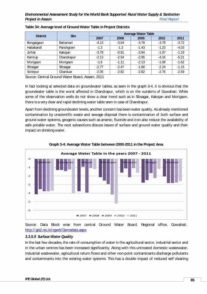
Environmental Assessment Study for the World Bank Supported Rural Water Supply & Sanitation Project in Assam Final Report
IPE Global (P) Ltd. 85
Table 34: Average level of Ground Water Table in Project Districts
District SiteAverage Water Table
2007 2008 2009 2010 2011Bongaigaon Baitamari -4.13 -3.54 -3.78 -3.78 -3.72Hailakandi Panchgram -1.3 -1.3 -1.43 -1.23 -4.03Jorhat Kakojan -3.78 -0.91 -3.94 -1.07 -1.19Kamrup Chandrapur -2.13 -2.54 -2.95 -4.16 -5.21Morigaon Morigaon -1.6 -1.11 -2.13 -1.08 -1.62Sibsagar Sibsagar -2.77 -2.47 -1.66 -2.24 -1.15Sonitpur Charduar -2.05 -2.82 -2.82 -2.76 -2.59
Source: Central Ground Water Board, Assam, 2011
In fact looking at selected data on groundwater tables, as seen in the graph 3-4, it is obvious that the groundeater table is the worst affected in Chandrapur, which is on the outskirts of Guwahati. While some of the observation wells do not show a clear trend such as in Sibsagar, Kakojan and Morigaon, there is a very clear and rapid declining water table seen in case of Chandrapur.
Apart from declining groundwater levels, another concern has been water quality. As already mentioned contamination by unscientific waste and sewage disposal there is contamination of both surface and ground water systems, geogenic causes such as arsenic, fluoride and iron also reduce the availability of safe potable water. The next subsections discuss issues of surface and ground water quality and their impact on drinking water.
Graph 3-4: Average Water Table between 2000-2011 in the Project Area
Source: Data Block wise from central Ground Water Board, Regional office, Guwahati. http://gis2.nic.in/cgwb/Gemsdata.aspx.
3.3.5.5 Surface Water QualityIn the last few decades, the rate of consumption of water in the agricultural sector, industrial sector and in the urban centres has been increased significantly. Along with this untreated domestic wastewater, industrial wastewater, agricultural return flows and other non-point contaminants discharge pollutants and contaminants into the existing water systems. This has a double impact of reduced self cleaning

Environmental Assessment Study for the World Bank Supported Rural Water Supply & Sanitation Project in Assam Final Report
IPE Global (P) Ltd. 86
properties of the water systems and increased pollution loads, resulting in increasing degradation of the existing water resources.
The testing of water quality for identified for the project area was carried out as a part of this assessment, with the results shown in table 35. As can be seen from the table the major concern is of high levels of faecal coliform and total coliform counts in the water. Being surface water, the possibility of contamination by coliform is high, especially if sanitation conditions are not good or open defecation is being practiced. This therefore indicates that, while many areas technically have toilet facilities, the contamination of surface water systems continues to exist. According to the Bureau of Indian Standards (BIS) drinking water standards 2005 for India, turbidity is within desirable limits only in Bongaigaon, Hailakandi and Sibsagar, with all other intake points showing turbidity to be even more than permissible limits by the BIS standards. The water’s pH in Hailakandi, Jorhat, Sibsagar and Sonitpur are within the BIS limits, while the rest are marginally acidic compared to Indian standards which at the lower end is 6.5. Although a few samples show presence of Iron, Arsenic and Fluoride, all are within the permissible limits. The high levels of BOD and COD – above 1, in most of the water samples show high level of contamination, especially from organic matter. Obviously these concerns will have to be taken into view while designing the water treatment systems for the project and with the high level of turbidity, if water is directly pumped from the river it may mean regular back wash needs, resulting in the need for disposal of silt regularly and higher maintenance needs and associated costs for the project.
Table 35: Water Quality Testing Results at Identified Project Intake Points
Inta
ke P
oint
Rive
r sam
ple
take
n fr
om
Tem
pera
ture
pH
Turb
idity
Tota
l Har
dnes
s
Iron
(mg/
l)
Arse
nic
Fluo
ride
5 D
ays B
OD
(mg/
l)
COD
(mg/
l)
Faec
al C
olifo
rm
(Nos
per
100
ml)
Colif
orm
Org
anis
m
(Nos
per
100
ml)
9
Bongaigaon, jogighopa
Brahmaputra 18.8 6.3 0.2 128 0.08 BDL BDL 2.8 4.2 4 9
Hailakandi Katakhal 16.9 7 2.4 104 0.08 0.009 BDL Nil 2.2 0 0Jorhat, Neamati Ghat
Brahmaputra19.3 6.9 11.8 144 0.11 0.009 BDL 3 5.2 13 31
Kamrup, Kolongpar
Brahmaputra17.8 6.3 12.6 64 0.22 BDL BDL 3.1 14.2 9 19
Kamrup, Chandrapur
Brahmaputra20.1 6.3 16.8 120 0.26 BDL BDL - 9.2 2 7
Morigaon, Tinikhutimukh
Kopili 18.1 6.2 80.8 144 0.28 BDL BDL 34 5.2 6 13
Morigaon, Dhramtul
Kopili 18.2 6.1 80.5 144 0.27 BDL BDL 34 5.5 7 12
Sibsagar, Amguri
Dikhow 19.9 6.8 4.4 144 0.13 0.008 0.09 35 51.2 23 35
Sonitpur, Dipora
Brahmaputra19.3 6.7 20.6 140 0.2 BDL BDL - 9.1 11 13
*Water Quality Testing was carried under the Environmental Assessment –RWSS, Assam Project. The Results are attached under Scheme details of all seven projects in annexure 1.8.

Environmental Assessment Study for the World Bank Supported Rural Water Supply & Sanitation Project in Assam Final Report
IPE Global (P) Ltd. 87
3.3.5.6 Groundwater QualityThe groundwater is Assam is mildly alkaline. Calcium, magnesium - alkaline earth metals and sodium, potassium - alkali metals, are the four important locations present in Assam’s groundwater. Sulphate, chloride, bicarbonate and carbonate are the major anions present in the groundwater. Magnesium, sodium and potassium content in groundwater is low. Among anions, sulphate is generally very low, with bicarbonates low in the Barak valley. Calcium bicarbonate is present in Assam’s groundwater, though mineralization is low. Salinity in the groundwater in Assam is generally low.
Iron is present in shallow aquifers along the northern bank of River Brahmaputra. In a large section of shallow aquifers of Brahmaputra and Barak river valleys iron content is greater than the maximum permissible limit of 1.0 ppm as set by the BIS for drinking water. As can be seen from the graph below, iron in groundwater is present in most districts of Assam.
The presence of arsenic in the groundwater in Assam seems to be an issue of increasing concern. Surveys of groundwater for Dhemaji and Karimganj districts show a presence of arsenic in the district’s aquifers. Similarly, GoI data from the NRDWP shows that there are a number of districts where there is arsenic contamination, as can be see from graph 3-6. Presently 16 districts in Assam show the presence of arsenic in the groundwater according to this data.
Graph 3-5: Population Affected by Iron in Assam
Source: www.indiawater.gov.in (National Rurla Drinking Water Programme – Rajiv Gandhi National drinking Water Mission).
The PHED, UNICEF and IIT Guwahati jointly conducted an arsenic screening and survillance programme in Assam16 to understanding the extent of arsenic contamination of public water sources. This assessment was carried out between 2005 – 2011. The study was carried out in 76 blocks spread across 23 Divisions (in 18 Districts) pre-identified through a rapid assessment. Out of a total of 56,180 water samples tested 16, 742 (around 30%) were identified to have arsenic above the national permissibility limits of 10 ppb. About 1970 habitations across 18 Districts were estimated to be exposed to the risk of arsenic contamination. As can be seen from the results presented in table 36, areas in and around the project districts and locations such as Bishwanath Chairali, Bongaigaon, Hailakandi, Jorhat, Morigaon and Sibsagar all show contamination of sources by Arsenic.
16 The information was shared by a UNICEF official as the study and the report is under publishing at present.

Environmental Assessment Study for the World Bank Supported Rural Water Supply & Sanitation Project in Assam Final Report
IPE Global (P) Ltd. 88
Table 36: Results of Arsenic Screening and Surveillance Programme in 76 Blocks of Assam
S.No PHED Divisions Source Tested Safe Sources Sources with arsenic concentration >10ppb (BIS permissible standards)
1 Biswanath Chairali 2163 1425 7382 Bongaigaon 1274 926 3483 Bokakhat 1075 901 1744 Belsor 2076 1055 10215 BTAD 321 105 2166 Barpeta 7987 6517 14707 Dhubri 4633 3947 6868 Darrang 3861 2502 13599 Goalpara 1096 884 212
10 Golaghat 2449 1201 124811 Ghilamara 2346 2076 27012 Hailakandi 2908 2490 41813 Jorhat 6278 2842 343614 Kaliabor 747 734 1315 Karimganj 2665 2024 64116 Morigaon 1233 1106 12717 North Lakhimpur 2247 1766 48118 Nalbari (Kamrup) 2236 594 164219 Rangia (Kamrup) 429 208 22120 Sibsagar 4243 3256 98721 Silchar I 2368 1602 76622 Silchar II 1017 823 19423 Tezpur 528 454 74
TOTAL 56180 39438 16742Source: Unpublished report on Arsenic Screening and Surveillance Programme in Assam, study jointly carried by PHED, UNICEF and IIT- G.
Graph 3-6: Population Affected by Arsenic in Assam
Source: www.indiawater.gov.in (National Rural Drinking Water Programme – Rajiv Gandhi National drinking Water Mission)

Environmental Assessment Study for the World Bank Supported Rural Water Supply & Sanitation Project in Assam Final Report
IPE Global (P) Ltd. 89
Groundwater contamination by fluoride is relatively low, as can be seen from graph 3-7. Only four districts, Jorhat, Kamrup, KArbi Anglong and Nagaon show populations affected by fluoride. Of these, only Jorahat seems to be affected by all three groundwater contaminants – iron, arsenic and fluoride.
In addition to these three contaminants, issues of microbiological contamination of water sources are also a major concern given the existing sanitation coverage in the State. Given the large population dependent upon agriculture, agrochemical contamination is also likely to be high. Equally, with a number of oil wells and refineries it is expected that pollution load from these industries will also add to the pollution load of the aquatic system. Out of the four oil17 refineries in Assam, one is at Dhaligoan in Bongaigaon District near the proposed project area, upstream of River Aye, a tributary River Brahmaputra. This however, is downstream of the project intake site.
Graph 3-7: Population affected by Fluoride in Assam
Source: www.indiawater.gov.in
Water Quality has been a major environmental issue all seven project districts. Presently, a majority of the existing projects are dependent upon groundwater in the project districts, resulting in concerns of chemical contamination due to the existence of iron, arsenic and fluoride, as the case might be. Table 37 shows the existing situation of groundwater contamination in the project districts. Considering this high level of contamination of groundwater, there is an obvious need for provision of alternate and safe sources of drinking water. The planned project therefore is to rely of surface water sources in the presently identified 7 schemes. As seen in table 35 the major concern at the identified sites is not of chemical contaminants but microbiological contamination and turbidity, which is likely to be easier to handle through conventional treatment systems proposed as a part of the project design.
Table 37: Quality Affected Habitations and Population in Project districts, 2012
S.No. District Contamination Wise Number Of Habitations and Population
Total Fluoride Arsenic Iron Habitation Population Habitation Population Habitation Population Habitation Population
1 BONGAIGAON 58 13174 0 0 47 10151 11 30232 HAILAKANDI 117 54627 0 0 3 2310 114 523173 JORHAT 1145 311887 1 171 448 127119 696 1845974 KAMRUP 1024 387379 1 338 0 0 1023 387041
17 First, Digboi in Tinsukia district; second at Noonmati in Guwahati under the public sector; third refinery at Dhaligoan near Bongaigaon and fourth refinery in the state was established at Numaligarh of Golaghat district.
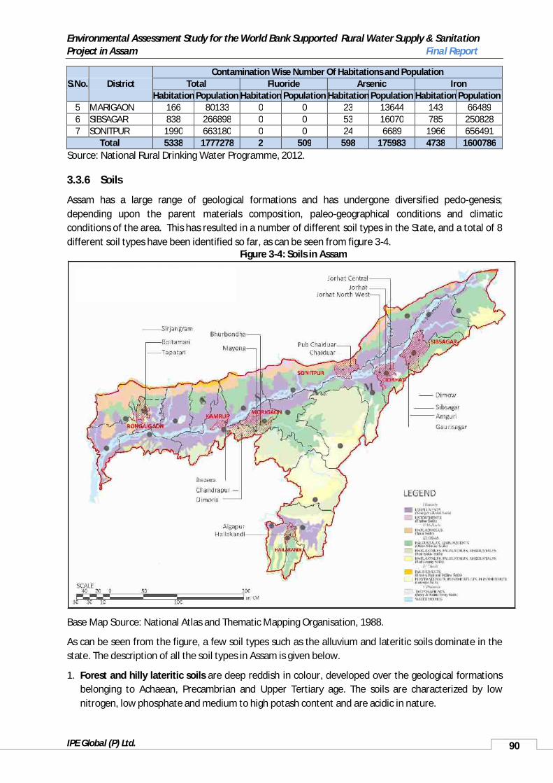
Environmental Assessment Study for the World Bank Supported Rural Water Supply & Sanitation Project in Assam Final Report
IPE Global (P) Ltd. 90
S.No. District Contamination Wise Number Of Habitations and Population
Total Fluoride Arsenic Iron Habitation Population Habitation Population Habitation Population Habitation Population
5 MARIGAON 166 80133 0 0 23 13644 143 664896 SIBSAGAR 838 266898 0 0 53 16070 785 2508287 SONITPUR 1990 663180 0 0 24 6689 1966 656491
Total 5338 1777278 2 509 598 175983 4738 1600786Source: National Rural Drinking Water Programme, 2012.
3.3.6 Soils
Assam has a large range of geological formations and has undergone diversified pedo-genesis;depending upon the parent materials composition, paleo-geographical conditions and climatic conditions of the area. This has resulted in a number of different soil types in the State, and a total of 8 different soil types have been identified so far, as can be seen from figure 3-4.
Figure 3-4: Soils in Assam
Base Map Source: National Atlas and Thematic Mapping Organisation, 1988.
As can be seen from the figure, a few soil types such as the alluvium and lateritic soils dominate in the state. The description of all the soil types in Assam is given below.
1. Forest and hilly lateritic soils are deep reddish in colour, developed over the geological formations belonging to Achaean, Precambrian and Upper Tertiary age. The soils are characterized by low nitrogen, low phosphate and medium to high potash content and are acidic in nature.

Environmental Assessment Study for the World Bank Supported Rural Water Supply & Sanitation Project in Assam Final Report
IPE Global (P) Ltd. 91
2. Low level terrace, red and yellow soils have been formed due to laterisation process of Upper Pleistocene fluvial sediments under favourable climatic conditions. Soil pH is acidic due to intensive leaching of bases and formation of clay minerals and ferric hydroxides. These soils may be poor in nutrients with contain aquifers high in iron.
3. Alluvial plain soils are light grey to dark grey of recent age occurring along the major river valleys. Based on the Russian system of classification, soils of Assam have been classified into zonal and azonal soils. Most of the Project areas have alluvial plain soil which has high water retention capacity and high water table.
4. Older alluvial soils are light grey to dark grey in colour. It is unaltered alluvium representing a broad spectrum of sand, silt and humus rich bog clay depending on land form component.
5. Red loamy soils are developed in the entire Karbi Anglong district, parts of Duma Hasao and a little fringe in the northern border of North Lakhimpur district. These are deep red loamy soils with clay rich latasol profile.
6. Red and yellow soils mainly comprise of red yellow to brick red soils, and are largely restricted to the northern border of the Dima Hasao is having clayey plastic latasol with sedimentary structures and texture totally obliterated in the solum. Mottling and incipient development ferruginous nodules at places are quite common.
7. Lateritic soils are brick red to brownish red in colour. They are developed in the vicinity of Haflong in Dima Hasao district, southern parts of Kamrup and Nagaon districts.
8. Alluvial soils have been developed along vast places of Brahmaputra basin. They are yellow to yellowish grey in colour and are unaltered alluvium representing sand, silt and humus rich bog clay depending on land form component. Mineral weathering and geochemical changes are nominal. Soil pH is generally feebly alkaline excepting bog soils.
Soil in the project area is either young alluvial soil or old alluvial soil. In Pub Chariduar however, new alluvial soil is found in the northern part of the block. Also, Chandrapur block, in Kamrup District is majority covered by red loamy soil, as is seen in table 38.
Table 38: Soil Type in Project AreasS.No District Major Type of Soil1 Kamrup Young alluvial soil in Bezera and Red Loamy in Chandrapur and Dimoria2 Bongaigaon Forest alluvial soil in the north along with red loamy and young alluvial
in the other parts3 Morigaon Younger alluvial in northern region and forest alluvial soil in the south4 Sibsagar Young alluvial soil and forest alluvial in the small portion of the southern
part5 Jorhat Young alluvial soil6 Sonitpur Young alluvial soils in the northern region and in the south 7 Hailakandi Younger alluvial in northern region and forest alluvial soil in the southSource: Assam Science Technology and Environmental Council
3.4 Ecological Resources
3.4.1 Forest ResourcesAccording to the State Forest Department, the total area under forests in Assam was 26,781.91 km2 at the end of March, 2003, out of which 15,492.33 km2 was under Reserved Forests and 2,860.94 km2

Environmental Assessment Study for the World Bank Supported Rural Water Supply & Sanitation Project in Assam Final Report
IPE Global (P) Ltd. 92
under Protected Forest Area. The State of Forest Report 2011 suggests about 35% of the area in Assam is under various types of forests, which also indicates a slight increase in the area under forests from the 2003 report from approximately 34%. The area under forests now stands at 27,826 km2. This is much higher than the national average of 21%. However, only about 2% of Assam’s forests are categorised asvery dense forests, and moderately dense forests accounting for another 15% of forest area. There has been a decline in area under moderately dense and very dense forests, while the area under open forests, scrub and non-forests has increased. This indicates a high percent of degradation of forest areas and opening up of canopies, even though there is an increase in the area categorised as forests. (Assam Forest Department 2012, Forest Survey of India, 2011)
The Forest Survey of India has identified 18 distinct types of forest types in Assam, based upon the Champion and Seth classification. These are the Assam Valley Tropical Wet Evergreen Forests, Kayea Forests, Mesua Forests, Cachar Evergreen Tropical Forests, Cachar Semi-Evergreen Forests, Pioneer Euphorbiaceous Scrub, Assam Alluvial Plain Semi-Evergreen Forest, Sub-Himalayan Light Alluvium Semi-Evergreen Forests, Eastern Alluvium Secondary Semi-Evergreen Forests, Secondary Moist Bamboo Breaks, Khasi Sal Hills Forests, App. Kamrup Sal, Eastern Himalayan Moist Mixed Deciduous Forest, Eastern Himalayan Upper Bhabbar Sal Forest, Northern Secondary Moist Mixed Deciduous Forest, Terminalia Lagerstroemia Forest, Khair Sisoo Forest, and Assam Sub-Tropical Pine Forest. Of the total forest cover in Assam about 40% come under the Cachar Tropical Semi-Evergreen Forest and another 18% under Eastern Himalayan Moist Mixed Deciduous Mixed forests. Assam Valley Tropical Wet Evergreen Forests account for another 7% of the total area under forests. The Mesua Forests account for less than 0.1% of total forest area, having the least area under forest in the state. The Khasi Sal Hill Forest type is the second lowest accounting for a little less than 2% of Assam’s forests. Plantations etc. which are also categorised as forests account for about 10% of the total area under forests in Assam. (Forest Survey of India, nd)
These 18 forest types in Assam can be identified under five basic forest types. These are the Tropical Wet Evergreen Forests, Tropical Semi-Evergreen Forests, Tropical Moist Deciduous Forests, Tropical Moist Dry Deciduous Forests and Sub Tropical Forests. Nearly 52% of Assam’s forests are Tropical Semi-Evergreen Forests, with another 26% being Tropical Moist Deciduous Forests. Tropical Dry DeciduousForests account for less than 1% of the total forest area in Assam. (Forest Survey of India, nd)
The forests in the plain districts are managed by the State Forest Department while the authorities for management of the forest in the two hill districts are their respective District Councils. Table 39 gives the area (in ha) under Forest in the scheme districts. Considering the high percent of area under forests, all project districts have Reserved Forests, with a few like Sonitpur, Hailakandi and Kamrup West also proposing new areas under Reserved Forests. However, this table only identified Reserved Forests, and therefore there may be other forest types like village forests which are not accounted for in this tableand would be relevant for the project and its design detailing.
Table 39: Area under Forest in Assam (ha), 31-3-2002
Forest Division Reserved Forest Proposed Reserved Forest
Total Forest (Excluding unclassified Forest)
ASSAM 1549232.943 267028.117 1816261.060Kamrup East 43108.065 Nil 43108.065Kamrup West 68241.150 507.072 68748.222North Kamrup 75014.484 Nil 75014.484
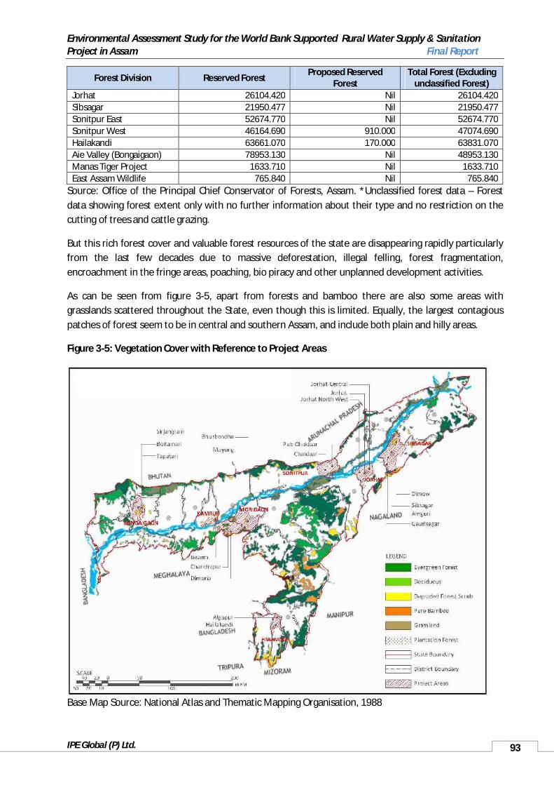
Environmental Assessment Study for the World Bank Supported Rural Water Supply & Sanitation Project in Assam Final Report
IPE Global (P) Ltd. 93
Forest Division Reserved ForestProposed Reserved
ForestTotal Forest (Excluding
unclassified Forest)Jorhat 26104.420 Nil 26104.420Sibsagar 21950.477 Nil 21950.477Sonitpur East 52674.770 Nil 52674.770Sonitpur West 46164.690 910.000 47074.690Hailakandi 63661.070 170.000 63831.070Aie Valley (Bongaigaon) 78953.130 Nil 48953.130Manas Tiger Project 1633.710 Nil 1633.710East Assam Wildlife 765.840 Nil 765.840
Source: Office of the Principal Chief Conservator of Forests, Assam. *Unclassified forest data – Forest data showing forest extent only with no further information about their type and no restriction on the cutting of trees and cattle grazing.
But this rich forest cover and valuable forest resources of the state are disappearing rapidly particularly from the last few decades due to massive deforestation, illegal felling, forest fragmentation, encroachment in the fringe areas, poaching, bio piracy and other unplanned development activities.
As can be seen from figure 3-5, apart from forests and bamboo there are also some areas with grasslands scattered throughout the State, even though this is limited. Equally, the largest contagious patches of forest seem to be in central and southern Assam, and include both plain and hilly areas.
Figure 3-5: Vegetation Cover with Reference to Project Areas
Base Map Source: National Atlas and Thematic Mapping Organisation, 1988

Environmental Assessment Study for the World Bank Supported Rural Water Supply & Sanitation Project in Assam Final Report
IPE Global (P) Ltd. 94
Social Forestry: The Social Forestry programme is an important programme being undertaken by the State Forest Department. The programme mainly aims at increasing area under Afforestation especially in Residential Area and otherwise Occupied Areas of the State. The achievement under Social Forestry scheme was 3871 hectares of area during 2001-2002. The number of seedlings planted under this scheme was 96.76 lakh during the year.
3.4.2 Terrestrial and Aquatic Fauna and Flora, Biodiversity
Given the large area under different forest types and the varied topography the biodiversity in Assam is also varied. The number of species under various class categories identified so far is given alongside, table 40. However, as can be see both in the table and with the recent discovery of the orchid Ornithochilus cacharensis in the Eastern Borial Wildlife Sanctuary of the Cachar District new species continue to be discovered and identified. (Assam Forest Department 2011-12, http://www.kew.org/accessed 15 May, 2013)
Equally, even among the already identified species there are a number of vulnerable and endangered species. The Brahmaputra river and several of its tributaries are home to the Indian gharial (Gavialis gangeticus), which is on the verge of extinction across its once-widespread habitat in South East Asia with a global population of less than 200. The species was considered to have become extinct in the Brahmaputra and Barak valleys but for a few recent sighting, including a couple of captures (in theUrpad lake and in the Manas river), in Dikhow river, Ghagar and Subansiri river, the Dehing-Brahmaputra confluence, Kareng Chapori of Dihingmukh – some of those occurring during the period 2004 to 2007.According to a recent survey conducted by a team of zoologists from Guwahati University, the distribution of the Gharial in the State is mainly concentrated in the Brahmaputra Valley. In eastern Assam, it is chiefly confined to the districts of undivided Lakhimpur and Sibsagar, while in western Assam, it is restricted to the Brahmaputra and its tributaries such as Manas, Jinjiram, and the Urpad Beel It has been classified to be critically endangered according to the IUCN Red List (2013, May 29 reference). The Indian gharial population recorded a decline of 96% in the past three decades. Since a few project areas, such as in Sibsagar, Sonitpur and Bongaigaon are near some of the identified habitats for the Indian gharial there is both a need to look at the project design with a cautionary approach to ensure minimum disturbance to the species and also create adequate protection for workers both during construction and regular working and O&M.
Another important aquatic species the Gangetic Dolphin (Platanista gangetica) is also sited in the Brahmaputra and its tributaries. Considered endangered by the IUCN Red List (2013, 29 March) this species has been noted in the Brahmaputra near Jorhat around the proposed project intake location, and is known to be present in the Brahmaputra near Guwahati. Various estimates put the number of dolphins in Assam to be between 200 and 300, with a number of projects and activities started to help protect and conserve the species in the State. (http://www.hindustantimes.com/accessed 27 May, 2013, http://www.indianexpress.com/ accessed 27 May, 2013)
There are two important hotspots of relevance to Assam. These are the Indo-Burma Hotspot and the Himalayan Hotspot. The Indo-Burma
Table 40: Assam’s Biodiversity
Class No of species identifiedFlowering Plants 7017Wild Orchids 193+Bamboo 42Cane 14Mammals 164+Primates 10Birds 800+Amphibian 60+Butterflies 1500Reptiles 116 approximate
Source: Assam Forest Department, 2011-12

Environmental Assessment Study for the World Bank Supported Rural Water Supply & Sanitation Project in Assam Final Report
IPE Global (P) Ltd. 95
hotspot encompasses 2,373,000 km² of tropical Asia east of the Ganges-Brahmaputra lowlands. Although earlier it included the Himalaya chain and the associated foothills in Nepal, Bhutan and India, the Indo-Burma hotspot has been redefined to include the Indo-Chinese subregion. Therefore, it begins in eastern Bangladesh and then extends across north-eastern India, south of the River Brahmaputra. This hotspot has a high level of endemism in freshwater turtle species, most of which are threatened with extinction, due to over-harvesting and extensive habitat loss. Bird life too is very diverse, holding almost 1,300 different bird species, including the threatened white-eared night-heron, the grey-crowned crocias, and the orange-necked partridge. While not all of these species may be noted in the Indian part of the Indo-Burma hotspot, the project areas that lie within this hotspot are those located in Morigaon, Sibsagar, Jorhat, parts of Kamrup and Hailakandi; all areas south of the Brahmaputra. (http://www.conservation.org/)
The other relevant hotspot is the Himalayan Hotspot. This hotspot has been subdivided into two – the Western and the Eastern Himalaya. The Eastern Himalaya section of the hotspot includes parts of Nepal, Bhutan, the northeast Indian states of West Bengal, Sikkim, Assam, and Arunachal Pradesh, southeast Tibet, and northern Myanmar. Much of this was originally included in the Indo-Burma hotspot; however it has been reclassified recently. The hotspot is home to important populations of numerous large birdsand mammals, including vultures, tigers, elephants, rhinoceroses and wild water buffalo. It would be relevant for all projects on the north bank of River Brahmaputra and therefore includes Bongaigaon, parts of Kamrup and Sonitpur. (http://www.conservation.org/ accessed 29 May, 2013)
3.4.3 Protected Areas
There is a large protected area network in Assam, which consists of wildlife sanctuaries and national parks. The total area under protected areas in Assam is 3925 km2. There are a total of 312 RFs, 18 national parks and wildlife and bird sanctuaries and another 3 proposed bird sanctuaries in the State. The wildlife sanctuaries in Assam are a heterogeneous mixture landscapes, plants, birds and animals.Some of the important species seen in Assam’s protected areas include the golden langur, the one horned rhinoceros, the hoolak gibbon, the royal Bengal tiger, the clouded leopard, the spectacled monkey, the Asiatic elephant and the eastern swamp deer. The list below gives the names of the important ecologically sensitive areas such as Wildlife Sanctuaries and National Parks in Assam.
Kaziranga National Park Manas National Park Dibru-Saikhowa National Park Orang (Rajib Gandhi) National Park Pobitora Wildlife Sanctuary Bura-Chapori Wildlife Sanctuary Sonai Rupai Wildlife Sanctuary Laokhowa Wildlife Sanctuary Pobha Or Milroy Sanctuary Chakrashila Wildlife Sanctuary Bornadi Wildlife Sanctuary Gorampani Wildlife Sanctuary, Golaghat Gibbon Wildlife Sanctuary Nambor Wildlife Sanctuary East Karbi Anglong Wildlife Sanctuary Karbi Anglong Wildlife Sanctuary Panidihing Bird Sanctuary, Sibsagar Deepor beel Bird Sanctuary, Guwahati(Proposed) Bordoibam Bilmukh Bird Sanctuary, Lakhimpur, Dhemaji (Proposed)
Of these; two protected areas, namely Kaziranga National Park and Manas National Park are both also UNESCO heritage sites, classified under natural heritage sites. Both these conservation areas were elected to be a part of the UNESCO list in 1985. Majuli is on the tentative list as a cultural site since 2004. Deepor Beel is a Ramsar site.

Environmental Assessment Study for the World Bank Supported Rural Water Supply & Sanitation Project in Assam Final Report
IPE Global (P) Ltd. 96
Figure 3-6: Wildlife Sanctuaries/National Park and Reserve Forests near Project Areas
Source: Base Map is from Google Maps, 2012
Of the various protected areas, three are within an estimated range of 3 to 10 kms from the project area (figure 3-6). These are Garbhanga Reserve Forest, Manas and Kaziranga National Parks are at a distance ranging from 3 to 10 kms from the project area. Therefore, there may be some concerns of conflict created from wildlife movement with project design. While at present tiger corridors are still to be identified, some of these conservation areas are populated by tigers, and therefore it will not be possible presently to identify if any changes in would be required if any project area is brought under a tiger/wildlife corridor. Perhaps for project design another important issue is that of elephant presence in the area. There are also a number of elephant areas, as can be seen in (figure 3-7), and are specifically close to Bongaigaon, Sibsagar and Sonitpur. Equally, according to a study of Indian elephant corridorsthere are a large number of pockets of elephants present both north and south of the Brahmaputra, with most elephant movements crossing state borders – such as those in northern Assam also distributed in West Bengal, southern Bhutan and Arunachal Pradesh. In fact, 88 elephant corridors have been surveyed in Assam so far, with 18 notified migratory routes already in place. Equally, while there are a number of protected elephant reserves, only 5,927 km2 or 15% of all elephant habitats in the North East are in protected areas. This needless to say is important, as not only it creates conflict with various activities, but also in important while identifying project design and location. (Menon, Vivek et al edt, 2005; http://www.tribuneindia.com/ accessed 19 May, 2013; http://www.elephantfamily.org/accessed 19 May, 2013)

Environmental Assessment Study for the World Bank Supported Rural Water Supply & Sanitation Project in Assam Final Report
IPE Global (P) Ltd. 97
Figure 3-7: Elephant Reserves of Assam
Source: Base map – Department of Environment and Forest, Government of Assam (http://assamforest.in/forestGlance/assamForest_glance.php)
While it has been mentioned that none of the project areas fall in the presently identified protected areas which is also seen in table 41, there are a few Forest Department lands, such as in Bongaigaon, where there would be a need to take permission prior to starting any work. Therefore, adequate time for required procedures must be considered as a part of the project design. However, it must be noted that none of the project areas fall within National Parks or the Ramsar site – Deepor Beel and therefore there is unlikely to be any need for permission to be taken for working in any of these areas. Nonetheless, there have been certain management actions identified in the EMP to ensure any unforeseen issue that may arise from project actions may be addressed adequately.
Table 41: Distance of Nearest Conservation Areas Project Sites
S.No Name of Conservation Area Project Areas and District Distance (Km)1 Manas National Park Sirjangram, Bongaigaon 6-102 Nameri National Park Chaiduar, Sonitpur 40-503 Garbangha Reserve Forest Dimoria, Kamrup Around 54 Kaziranga National Park Chaiduar, Sonitpur 5-105 Dibru Saikhowa Dimow, Sibsagar 55-606 Narpuh Reserve Forest Algapur, Hailakandi 20-257 Deepor Beel Chandrapur, Kamrup 45-50
*Based on desk review and Google maps.

Environmental Assessment Study for the World Bank Supported Rural Water Supply & Sanitation Project in Assam Final Report
IPE Global (P) Ltd. 98
3.5 Natural Disasters
The major natural disasters impacting Assam are floods, cyclonic storms, river bank erosion and earthquakes. Of these floods occur nearly every year and are usually coincide with the monsoon and till end October. River bank erosion is of two types, which occurs during the floods and the other during the lean flow periods of the river. Earthquakes on the other hand are less easy to predict, though there have been some very major earthquakes in the region with very serious impacts. The events of cyclonic storms have been observed to be more frequent in the western parts of Assam especially during monsoons and are largely seasonal in nature. Although landslides occur, these are largely localised and caused by human interventions such as development of settlements in hilly areas and hill denudation.
Floods: An estimated 92.6% of cultivated land or 3.15 million ha land is prone to floods in the Brahmaputra valley. Flood damages to crops, cattle, houses and utilities from 1953 to 1995 is estimated to have been INR 4400 crore, with a peak of INR 664 crore in a single year. An estimated 8,000 ha of riparian lands are destroyed annually due to river bank erosion. Sand deposition and sand casting have become more severe and devastating since the mid 1990’s, especially on the northern banks of the eastern Brahmaputra Valley. Apart from floods due to overflowing of banks during and post monsoons, Landslide Lake Outburst Floods are another issue; though relatively lower in number can have an equally disastrous impact. Most of these originate outside the State, but impact all areas downstream such as the Brahmaputra and its tributaries. Another concern is that of encroachment and silting up of wetlands. These wetlands serve as natural flood water reservoirs; and a decreased in their retention capacity, has also aggravates the impact of floods. (SNC, 2010; Staff College Report, 2005; ICIMOD, 2009)
River Bank Erosion: The morphology of River Brahmaputra is characterized by braiding and bar formation, resulting in the river having a very dynamic river bank line and bed configuration. Brahmaputra’s morphology shows a continuous shift of the thalweg (deep channel) within the unstable bank lines of the river. The morphology and behaviour of the river undergoes changes in response to a number of causes. These include variations in the flow regime, pattern of sediment transportation anddeposition in the river bed following the monsoon. A few other possible issues are excessive sediment load, large and variable flow, easily erodible bank materials, and aggradation of the channel are considered to be possible reasons for these possible changes. Figure 3-8 and 3-9 give a trend of the river erosion and deposition along the north and south banks of River Brahmaputra respectively. As can be see from these two figures and table 42, the river banks are extremely fluid in nature and also have an impact on bank side infrastructure. This is important for the any project intake location, which will need stable banks and protection from both floods and river bank erosion.
Figure 3-8: Erosion and Deposition Trend Along Brahmaputra North Bank
Figure 3-9: Erosion and Deposition Trend Along Brahmaputra South Bank

Environmental Assessment Study for the World Bank Supported Rural Water Supply & Sanitation Project in Assam Final Report
IPE Global (P) Ltd. 99
Source: RS-GIS Based Assessment of River Dynamics of Brahmaputra River in India, (Sarkar. A, 2011)
Since 1954, Assam’s 17 riverine districts have lost 7% of their land area to erosion. Some 8,000 ha of land (valued at $20 million) is lost annually, which is accompanied by the appearance of low-lying unproductive sandbars. About 10,000 families are displaced each year and those who become landless are forced to move to increasingly congested nearby riverbank lines and dikes. More critically, progressive river erosion continues to threaten existing flood embankments, which if breached would result in devastating inundation and associated damage.
Table 42: Erosion and Deposition Trends along Brahmaputra, 1990 to 2008
Reach Number Locations in Vicinity
South (Left) Bank North (Right) Bank
Total Erosion km2
Total Deposition
km2
Total Erosion km2
Total Deposition
km2
1 Dhubri 195.005 4.41 124.461 0.698
2 Goalpara 18.411 3.484 79.046 3.502
3 Palasbari 23.663 9.208 51.97 7.425
4 Guwahati 6.831 0.963 4.618 10.546
5 Morigaon (Near Mangaldai) 99.799 1.49 35.781 5.877
6 Morigaon (Near Dhing) 11.253 8.204 29.057 10.828
7 Tezpur 16.628 7.766 38.758 6.566
8 U/s of Tezpur (Near Gohpur) 26.098 16.616 32.831 1.053
9 Majuli (Near Bessamora) 32.788 9.068 25.562 13.851
10 U/s of Majuli (Near Sibsagar)
43.088 0.375 64.273 0.735
11 Dibrugarh 47.525 3.069 37.896 1.33
12 U/s of Dibrugarh 399.163 3.83 20.376 83.455
TOTAL 920.251 68.483 544.631 145.866
Earthquake: North East India is one of the most seismically active regions in the world. Part of the Indian Plate, the Himalayan Plate in the North and the Indo Burma Plate in the East form its borders. Pushing itself north-eastwards the Indian Plate is continuously moving against these two plates. The plate on the eastern front forms a subduction zone as it slips under the Indo-Burma Plate. Also, due to these intense tectonic movements there are a number of faults, folds and other tectonic features in the area. North East India has been classified as earthquake prone Zone V by the Government of India. The Brahmaputra valley itself is a tectonic-sedimentary basin, underlain by recent alluvium about 200–300 m thick consisting of clay, sand, and pebbles.

Environmental Assessment Study for the World Bank Supported Rural Water Supply & Sanitation Project in Assam Final Report
IPE Global (P) Ltd. 100
Impact wise, probably one of the worst recorded earthquakes in the North East was in 1950. The great earthquake created havoc, especially in the upper reaches of the Himalayas in and around the Siang and the Dibang river courses and in the upper Assam plains. There was considerable impact on the topography on both sides of the Brahmaputra Valley, and in the river ecology. The river Brahmaputra and its many tributaries in upper Assam badly suffered due to blockage caused by uprooted trees, boulders and soil erosion. It is estimated that landslides triggered by this earthquake was responsible for the deposition of detritus amounting to about 30 times the average annual load of the river. This has also impacted the nature of the river as it has once again started to cut its valley, creating higher levels of erosion along the banks. A list of major damaging earthquakes in the North East Region is given in table 43.
Table 43: List of Major Earthquakes in the North East
Year Location Region Magnitude1869 26 N, 92.4 E Cachar 7.51897 26 N, 91 E Shillong Plateau 8.71906 Sibsagar 7.51908 7.01918 24.5 N, 91 E Srimangal 7.61930 25.8 N, 90.2 E Dhubri 7.11943 26.8 N, 94 E Hajai Central Assam 7.2
1947 28.5 N, 94 E N W Dibrugarh 7.61950 28.7 N, 96.6 E Rima 8.71988 25.15 N, 93.13 E Indo-Myanmar 7.3
Source: State of Environment Report, Assam
3.6 Climate Change
Climate change impacts in North East India include a general trend of rising temperatures, with some areas like the eastern and southern areas facing reduced rainfall. There have also been drought-like situations in the years 2001, 2005, 2006, 2008, and 2009. Anecdotal references and grey literature recount identify other impacts like, increasing spells of intense pre-monsoon and monsoon seasons rainfall in some areas, and reduced post-monsoon and winter season rainfall in others. Both extreme rainfall episodes and rates of soil erosion are believed to have increased in upstream areas (Tibet and Arunachal Pradesh) of the Brahmaputra basin. The intensity, frequency, and duration of riverine floods have also changed. Sediment load in the rivers has increased due to denudation by intense rainfall of fragile and tectonically dynamic hill slopes, scaling up the effects of sand casting. (Das 2004, Mirza et.al.1998; IPCC 2007; ICIMOD 2008)
According to Assam – State Action Plan for Climate Change (SAPCC) 2012 – 2017, Assam is extremely vulnerable to climate change. Assam has a high reliance on agriculture, and with possible rising temperatures, there is an increased risk of heath stress and crop failure. Additionally, increased precipitation in some areas would increases the flooding and crop loss. Climate change is likely to have a negative impact on Assam’s water resources by increasing freshwater scarcity.
The SAPCC envisages a sustainable and climate resilient development pathway through a synergistic combination of adaptation and mitigation measures with focus on research, appropriate technology, capacity creation and governance. The six thrust areas identified under the Action Plan include (i) creation of sustainable livelihoods, (ii) natural disaster mitigation and management, (iii) management of health concerns arising from changing climate, (iv) climate resilient urban planning, (v) climate

Environmental Assessment Study for the World Bank Supported Rural Water Supply & Sanitation Project in Assam Final Report
IPE Global (P) Ltd. 101
mitigation through efficient and clean energy, and (vi) protection of bio-resources and sustainable management of forests and wildlife.
Studies by WWF and UNEP on Himalayan glaciers show that there is a melting trend of glaciers in the Himalayas, and includes the headwaters of the Brahmaputra. While an increase in the rainfall for part of the North East would result in reduced impact on the area, increased temperatures, and melting glaciers, both of which are predicted to be impacts of climate change are likely to result in increased overall water stress. Considering that Assam is largely dependent upon agriculture, this would result in increasing needs for irrigation, expansion of irrigation systems and may in the long run impact both the quality and availability of water resources. (http://na.unep.net/geas/ accessed 15 May, 2013; WWF Nepal 2005)

Environmental Assessment Study for the World Bank Supported Rural Water Supply & Sanitation Project in Assam Final Report
IPE Global (P) Ltd. 102
4 CONSULTATION AND PUBLIC DISCLOSURE
As a part of the Environmental Assessment discussions with various stakeholders and disclosure of the planned project components and activities were undertaken. This was done though the period from December 2012 to May 2013. Details of the outcomes are available in annexure 1.12.1, 1.12.2. This section sums up the major concerns identified and highlights stakeholder needs that came out though this consultation process.
4.1 Consultation Schedule and Process
Consultations took place in both informal and formal processes and were carried out throughout the EA design phase. The informal process was during field work carried out as a part of EA design and fact finding activities. Therefore, all issues identified during these field visits were incorporated in the EA design in the preliminary draft stage itself. These are also included in the key finding section of the EMF section. The formal processes included a questionnaires and surveys, district level consultations and state level consultations. The questionnaires and surveys were conducted in January and February 2013. The findings from these surveys and questionnaires were also incorporated in the project design. The details of the survey are available in annexure 1.12 and basic findings are incorporated in the key findings of the EMF section. The district level consultations took place in February 2013 and were largely lead by the PHED. During these consultations the planned project design and activities were disclosed by the PHED, opinions from all those attending the meetings were sought and discussions on critical issues identified during the discussions took place. A total of 120 villages were included and all project districts were covered in this consultation process. Of the two state level consultations one was in the first week of February, 2013 and the second took place on 22nd May 2013. The summary of the outcomes of thedistrict and state level consultations are given in this section, with details including who attended the meetings is given in annexure 1.14. Figure 4-1 below gives a few photographs of the consultation on the 22nd of May, 2013.
Figure 4.1: State Level Consultation on 22nd May, 2013

Environmental Assessment Study for the World Bank Supported Rural Water Supply & Sanitation Project in Assam Final Report
IPE Global (P) Ltd. 103
After disclosing the Draft Environmental Assessment Report on the website and copies distributed to project areas, one state level public consultation\ disclosure workshops was organized to invite suggestions/ inputs of the stakeholders to finalize the EMF document. he executive summary of EMF in Assamese and Bengali language was circulated to PRI representatives, SLUCs, NGOs, District and Gram Panchayat level PHED staff, Accredited Social Health Activists (ASHAs), etc., about two week before the consultation workshop held in Guwahati on 22nd May, 2013. Issues identified in the subsequent consultations have also been incorporated in the EA design.
4.2 Type of Stakeholders
While not possible to understand who all would have downloaded the online version of the report the other stakeholders who were consulted included villagers who will be a part of the project area and will receive water from the system, GP members, ASHA and other health workers, Government officials, NGOs and CBOs, tea estate owners and workers, Government officials both from the PHED and other departments, SLUC members and User Committee groups
4.3 Consultation Outcomes
4.3.1.1 Water Supply Concerns Water Availability: Some of the PWSS have become dysfunctional due to drying up of
groundwater sources, especially in Kamrup, Sonitpur and Morigaon. There are very few house hold connections and most of the villagers are forced to fill water from the stand post provided at the community level.
During one of the district consultations in Chiporsangan II a revenue village in Chiporsangan GP,Algapur block of Hailakandi district, about 18k.m from the district headquarters, it was noted that the villagers face acute crisis of water. The nearest source was PHED system at a distance ofalmost 2 km away from their habitation. Considering the distance they could only fetch water twice a week. Furthermore, the water was only supplied on alternate days. The resulting gap in availability and supply was fulfilled by using unsafe sources like neighbouring waterbodies for most purposes including cooking, despite the water being of poor quality.
In many areas such as Sibsagar, presently ponds and other surface waterbodies are being used for sourcing portable water. However, this is a major concern as the quality of water is poor and therefore can result in major health hazardous.

Environmental Assessment Study for the World Bank Supported Rural Water Supply & Sanitation Project in Assam Final Report
IPE Global (P) Ltd. 104
Groundwater quality is poor in many areas, such as in Sibsagar where arsenic and iron are major concerns. Therefore, there is a need for alternate sources of domestic water in such areas.
While overall there seems to be a demand for drinking water and in many cases people are willing to pay for it, in Jorhat district; since the existing systems are surface water schemes, there is no major demand for the planned project scheme. There was however no common census on the issue, as a few other stakeholders, who felt that if they got reliable, 24*7 water supply at their doorstep they would be willing to pay for it.
4.3.1.2 Sanitation Concerns Lack of sanitation facilities has led to the prevalence of waterborne diseases as reported during
many village discussions in the project districts. Accredited Social Health Activists (ASHA) and Integrated Child Development Services (ICDS) workers also expressed their dismay about the gap in awareness among the beneficiaries on issues related to water and sanitation. Even the basic hygiene practices are not practiced by the community.
In Sonitpur the PRI members were concerned about insufficient coverage of sanitation in scheduled tribe areas. Discussions suggested that there was a need to both increase sanitation coverage and ensure that the people are able to use and maintain them properly. In fact, even in districts like Morigaon, which were identified as having better sanitation coverage, it was felt that there is still a lot of work that needs to be done to improve sanitation coverage and improve the quality of existing sanitation systems.
In some villages such as in Hailakandi, the latrines were kuchcha with squatting plate placed ona pit with a temporary cover, due to lack of affordability. While the villagers were aware of the health hazards involved in this practice, they were unable to do anything. Furthermore, there were more than 20 people using a toilet, resulting in very poor hygiene and maintenance of the system.
It was suggested that solid and liquid waste management in the villages must get attention alongside with sanitation, and should not be left out of the project design.
4.3.1.3 Health Related Issues Health issues seem to be something that came out to be quite a concern at the district level
consultations, where people from the identified project villages were present. Shamima, a lady from Hailakandi, mentioned that the lack of sufficient potable water was resulting in alternate and less safe sources being used, and most children in the area suffered from skin diseases and frequent stomach upsets.
However, this problem is not just limited to Hailakandi. The major water related health problems highlighted at the district level discussions included diarrhoea, dysentery, skin problems and jaundice. The districts where these were identified as concerns included Bongaigaon, Sibsagar, Jorhat, Sonitpur and Hailakandi. Previous field visits had also identified waterborne diseases to be a concern in Morigaon district.

Environmental Assessment Study for the World Bank Supported Rural Water Supply & Sanitation Project in Assam Final Report
IPE Global (P) Ltd. 105
4.3.1.4 System Design and Management Stakeholders at the village level were interested in knowing more about how the raising mains
and distribution network would be laid, where the pump house would be and what the overall systems design would be. It was felt that there was a need for more consultation at the village level during the project planning and design to ensure census is there from the villagers.
While in districts like Sonitpur, Morigaon and Jorhat people are willing to pay for household connections if the supply is reliable and water is available 24*7, there are concerns of the upper limit that people will be able to afford. Stakeholders from district Morigaon felt that the monthly charges should be within INR 150.
The PHED officials at Sonitpur also suggested that there comprehensive bylaws be developed for SLUCs and existing bylaws should be revised to include penalties for defaulters. It was also suggested that the existing bylaws are amended to include the one time connection fee.
Other suggestions on process included the need for identification of procedures for conversion of existing household connections to the new system, systems for coordination between PHED staff and the GPs, and coordination with other departments and agencies – such as the NRHM and ICDS.
It was also felt that there was a need for clear set of guidelines for all project stakeholders, toensure that there is a clear understanding among all participants on their roles and responsibilities.
The PHED was of the view that the planned grievance redressal system should have a central control room at the state level so as monitor existing concerns and how they are being handled.
Suggestions on materials used for the pipes by a few stakeholders were also made. It was suggested that special attention be taken to ensure networks in flood affected areas do not break or get damaged due to floods. Therefore, galvanised iron pipes may be a better idea than concrete cement and other materials.
4.3.1.5 System Sustainability Discussions highlighted that there was a lack of capacity and co-ordination at all levels of project
implementation. Therefore, there was a need for appropriate trainings for all stakeholders especially at grass-root level to ensure better project implementation, operation and maintenance.
It was also suggested that there should be inbuilt M&E procedures and systems that can adequately address project needs to ensure its long term sustainability.
Stakeholders from Hailakandi also felt that and convergence with other schemes such as the MNERGA would be essential to meet gaps as this project alone would not be able to address all issues.
Many stakeholders, such as the GPs and the SLUCs do not have adequate capacity to undertake project management and maintenance. Therefore, any schemes handed over to them for

Environmental Assessment Study for the World Bank Supported Rural Water Supply & Sanitation Project in Assam Final Report
IPE Global (P) Ltd. 106
management may result in gradual degradation of the systems. It was therefore suggested that all stakeholders must be trained properly for their roles.
A suggestion was made by the GP President of Gaonpur Panchayat of Morigaon was that that the GPs could monitor the project’s construction activities and showed an interest in doing so.
Some concerns of capacity of GPs to handle more work was also raised. Some stakeholders from Jorhat felt that the GPs were already overburdened with various other governmental activities and schemes. Therefore, adding one more project for GPs to manage may be difficult.
4.3.1.6 Environmental Degradation Deforestation seems to be an issue of concern in all project districts except Jorhat, where it
perhaps is not seen as being such a major issue considering the proximity of the area to Kaziranga National Park. Estimates put deforestation to range from about 25% to as much as 50 % in Sonitpur.
All project districts also suggest that there is some decrease in overall rainfall, though the monsoon rains are largely unaffected. Without sufficient analysis of rainfall patterns however, it may not be possible to understand the actual trend and implications for the long term, especially for groundwater sources and small streams that may be recharged by them.
While most areas did not see the changing rainfall pattern as an issue, in Bongaigaon andMorigaon it was felt that the reduced rainfall was impacting the local aquifers which tended to dry up more. This was not only impacting local drinking water sources that used groundwater but also agriculture, according to the discussions.

Environmental Assessment Study for the World Bank Supported Rural Water Supply & Sanitation Project in Assam Final Report
IPE Global (P) Ltd. 107
5 ENVIRONMENT MANAGEMENT FRAMEWORK
5.1 Environmental AssessmentThe aim of this study is to conduct Environmental Assessment (EA) and provide an Environment Management Framework (EMF) based upon the impact assessment for the RWSSP in Assam. Appropriate management and mitigation measures have been given for all identified concerns as a part of the EMF. This section therefore looks at key RWSS related concerns as identified through discussions, review of literature, field work and primary surveys. This is followed by an analysis of impacts due to planned project activities and identified environmental concerns. Finally, mitigation and management measures are identified and are presented in the EMF along with suggested institutional arrangements to implement the actions. There are also a number of annexes that support the discussions of this section; these are referred to alongside the discussions.
5.1 Key Environmental Issues Given that the present project aims at supporting the provision of clean drinking water, improved drainage and environmental sanitation, it is likely to have a number of positive impacts from the project. The most important of these is improved health and wellbeing of those receiving improved services. Also, along with reliable and 24*7 household water supply, there will be efforts to improve drainage and solid waste management, increase awareness on use and management of appropriate sanitation options and systems. Presently, there are a number of issues with reference to water supply, sanitation and solid and liquid waste management in rural Assam. Also, there are a number of other issues that require to be addressed, both as a part of project design and other project related actions. The key issues based upon discussions and field work that are of relevance to the project are discussed here.
5.1.1 Water Availability An approximate 18.5% of the State’s population is covered with piped water supply schemes. Most are dependent upon handpumps, wells – mainly dug wells and PHED schemes with water available through stand posts. Water in the PHED schemes is available only for a few hours in a day, depending upon the scheme, with some like in Bongaigaon where there may be no treatment as water is pumped directly from the river and distributed though the local network. During discussions it was also noted that some schemes were defunct due to low level of maintenance or non-availability of parts. In some areas, such as Hailakandi, fetching water takes more than one hour usually for women or children of the household to collect from the nearest PHED source (spot source/stand post).
Source sustainability: This project plans mainly to utilise surface water sources. These are all from large and perennial river sources. Equally, the overall water demand for the projects, which are spread out over 7 districts, is relatively small. Therefore, it is unlikely that there will be any impact on source sustainability from the planned project. The actual quantum of water expected to be utilised in each scheme is given in table 44 and 45.

Environmental Assessment Study for the World Bank Supported Rural Water Supply & Sanitation Project in Assam Final Report
IPE Global (P) Ltd. 108
Table 44: Total Surface Water Requirement under RWSS-LIS, Assam
S.N SchemeDesign
Population - Ultimate
Total Daily Requiremen
tin MLD; (@70
lpcd)
Total Annual Requirement
in MCM;
Total Annual Requirement in Cubic Metre
per second (Cumec)
Source Name (Aquifer/
River)
Surface Water
Average Annual
Discharge (Cumec)
Total Requirement Cumec (6) as %
of Flow (8)
1 2 3 4 5 6 7 8 9
1
Composite WSS for Sustainability and Quality in Chandrapur and Dimoria Dev. Block (B1)
429809 34.6 13 0.4 River Brahmaputra 19820 0.002
2
Composite WSS for Sustainability and Quality in Jorhat and Jorhat Central Dev. Block (B1)
531256 42.8 16 0.5 River Brahmaputra 19820 0.002
3 Greater Hailakandi – Algapur WSS (B1) 153429 12.4 5 0.1 River Katakhal - `-
4 Greater Mayang WSS (B2) 236060 19.0 7 0.2 River Kopili 291 0.075
5 Greater Jogighopa WSS (B2) 593880 47.8 17 0.6
River Brahmaputra 19820 0.003
6 Gohpur Composit WSS (B3) 187340 15.1 6 0.2 River
Brahmaputra19820 0.001
7 Amguri - Gaurisagar Integrated WSS (B3) 252179 20.3 7 0.2 River Dikhow 118.9 0.198
* Note: It is the fourth largest river in the world in term of average water discharge at the mouth with a flow of 19,830 m3s-1. Percentage of Contribution of River Kopili and River Dikhow to River Brahmaputra is 1.47 and 0.60 respectively
Table 45: Total Groundwater Requirement under RWSS-LIS, Assam
S.No. SchemeDesign
Population - Ultimate
Total Daily Requirement in MLD; (@70
lpcd)
Total Annual
Requirement in MCM; (@70 lpcd)
Groundwater18
Annual Replenisha
ble Groundwater; MCM
Net Annual
Groundwater
Availability; MCM
Annual Groundwater
Draft; (Industrial and
Drinking)MCM
Total Requirem
ent Annually
(5) as % of Draft (9)
1 2 3 4 5 6 7 8 9
1
Composite WSS for Sustainability and Quality in Chandrapur and Dimoria Dev. Block (B1)
429809 34.6 13 1847 1662 71.21 0.00002
2
Composite WSS for Sustainability and Quality in Jorhat and Jorhat Central Dev. Block (B1)
531256 42.8 16 1340.75 1273.71 25.72 0.00006
3Greater Hailakandi –Algapur WSS (B1) 153429 12.4 5 342.79 308.51 14.21 0.00003
4 Greater Mayang WSS (B2) 236060 19.0 7 767.85 691.06 20.23 0.00003
5Greater Jogighopa WSS (B2) 593880 47.8 17 1430.21 1358.7 22.65 0.00008
6 Gohpur Composit WSS (B3)
187340 15.1 6 2457.88 2352.09 43.08 0.00001
7Amguri - Gaurisagar Integrated WSS (B3) 252179 20.3 7 1462.81 1316.53 26.77 0.00003
18 Source: Flood Control Department, Govt. of Assam, on 23-08-62

Environmental Assessment Study for the World Bank Supported Rural Water Supply & Sanitation Project in Assam Final Report
IPE Global (P) Ltd. 109
At present a mix of surface and groundwater sources are being used to source water for domestic purposes in the State. While data from the Central Ground Water Board suggests that there are so far no critically, semi-critical or overexploited blocks with reference to aquifer recharge, discussions in the field and with the Public Health Engineering Department (PHED) suggests that decreasing groundwater trends are seen in parts of Assam, such as has been indicated in Hailakandi.
Discussions with the PHED indicate that groundwater sources will continue to be used where feasible, including existing systems that depend upon groundwater. However, given that in many areas aquifers are contaminated with arsenic or fluoride, and in some areas like Hailakandi, a reliable water lens is only available at depths that need deep rigs for digging, surface water sources are considered under the project for water augmentation. Out of the planned intakes in the project, all nine are to be surface water intakes, located on River Brahmaputra and its tributaries or the Barak system.
Discussions in the field highlight concerns about existing water supply schemes based on spring sources. Small streams, currently being used to augment water, may have long term sustainability issues as during the preliminary assessment the existing Bonda water treatment plant in Kamrup district, a stream originating in the Amchang Wildlife Sanctuary bordering Guwahati towards the east is utilised as main source of water. However, encroachment of the wildlife sanctuary and the subsequent degradation of the catchment has become an issue for the source over the years. Degradation and encroachment upon forested areas, and cutting of hills to make space for agriculture, settlements etc., or even collection of firewood and other supplies from forests are some of the problems being facedpresently for the existing schemes.
Another concern is likely to be the changing availability of water in many of the catchments due toclimate change. While the exact understanding of how glacial melt will impact Brahmaputra is still not completely understood, some studies indicate that there is a general decrease in the flow of the Brahmaputra. Also, climate change predictions indicate higher rainfall in the eastern Himalayas, resulting in intense rainfall in Assam in the coming years. The river systems in Assam, including both the Brahmaputra and the Barak are prone to bank erosion and undercutting. Together all these factors are likely to have some impact on source quality. The major concerns would be (i) river bank erosion and undercutting over a longer time frame resulting in washing away of water supply infrastructure, (ii) flooding and rainfall resulting in degradation of the catchment, thereby resulting in damage to infrastructure, (iii) long term impact of glacial melt and changing rainfall patterns on existing and future infrastructure, especially when coupled with river bank erosion.
5.1.2 Water QualityGroundwater in a number of districts is impacted by fluoride, arsenic or/and iron. To tackle the issue, PHED has been identifying alternate sources in areas impacted by fluoride and arsenic and provides iron removal systems in selected handpumps or water treatment plants. However, where there is no treated water available through the PHED, the local population in iron affected areas is using the water for all their needs and treating the water with the help of a household makeshift arrangement for iron removal. It was also noted in Morigaon district, that the local population had developed their personal iron removal systems which were mainly charcoal and sand filters, to filter water for drinking. The filters were cleaned once the households felt they are becoming clogged. In case alternate sources are available, they are prioritised for drinking mainly, with the iron rich water being used for other domestic

Environmental Assessment Study for the World Bank Supported Rural Water Supply & Sanitation Project in Assam Final Report
IPE Global (P) Ltd. 110
purposes. Figure 5.1 below shows a few iron affected systems, this includes both PHED and private systems.
Figure 5.1: Iron Impacted Water Supply Systems Run by the PHED
A water treatment plan in Hailakandi showing signs of rust due to the high iron content of the groundwater
A typical iron removal plan attached to a PHED handpump.
A typical homemade filter used in rural Assam to remove iron. Largely dependent upon filtration.
A privately owned iron impacted handpump
Diarrhoea and bacterial dysentery are both reported in the project districts according to the Integrated Disease Surveillance Programme – National Rural Health Mission (IDSP – NRHM) data. Discussions with villagers also pointed to diarrhoeal diseases being present. While part of this could be due to poor hygiene, it was noted that in many areas the distance between the handpumps and toilets was only a few meters, with the handpumps also being the shallow TARA or Singrur. Equally, platforms of handpumps were often broken or missing and due to poor design they are likely to be the cause ofgroundwater contamination. Poor drainage around the handpumps is another issue of concern.
In areas where piped water supply is already available, taps/stand posts may also be poorly placed, resulting in the contamination of the water at point-of-use. Another possible concern is that, the pipes carrying water in many places are exposed or near the surface, and thus have risk of their breakage or damage. This is also likely to result in contamination and water leakage.

Environmental Assessment Study for the World Bank Supported Rural Water Supply & Sanitation Project in Assam Final Report
IPE Global (P) Ltd. 111
5.1.3 Water Treatment PracticeTreatment of water prior to distribution is being carried out in most of the Water Treatment Plants(WTPs) visited. While in some areas like one of the systems visited in Hailakandi due to inactive water user committees/ Gaon Panchayat Water and Sanitation Committees (GPWSC) the PHED is managing the system, in other areas like Bonda, in kamrup, where there is an active Village Water and Sanitation Committees (VWSC) the committee is managing the system. There are however some others, such as observed in Bongaigaon where there is no water treatment underway due to the lack of sufficient staff/VWSC to manage the system. Therefore water is being provided without treatment at present. Depending upon the needs and the system planned the treatment may include a combination of aeration, flocculation and disinfection and iron removal.
The overall management of the WTPs was found inadequate. While most WTPs had leakages, in some,like the one visited in Hailakandi, the treatment plant was in a state of degradation due to very high iron content of the water (figure 5.2), which gradually was corroding the system. Drainage at the WTPs to ensure that they were free from stagnant water was not necessarily present in all visited sites. Also, in many areas there was no clearly identified system for the disposal of sludge from the WTP.
Another possible concern is that of use and storage of chlorine or bleaching powder. Presently, most WTPs use bleaching powder and the bags are stored in the WTPs. In many of the WTPs the bleaching powder bags were not stored properly and therefore are not adequately protected from moisture or other elements. This is likely to degrade the quality of the bleaching powder, rendering the treatment ineffective. Furthermore, no protective gear was available for the operator to handle the bleaching powder and there was no identified method to dispose slurry. Figure 5.2 shows some of the issues identified in the field.
Figure 5.2: Some Problems of Water Supply Systems Noted in the Field
Need for improved management of the system –a water treatment plant at Bonda which has been handed over by the PHED for O&M
Storage of bleaching powder at a water treatment system. This bleaching powder is used for disinfecting water prior to distribution.

Environmental Assessment Study for the World Bank Supported Rural Water Supply & Sanitation Project in Assam Final Report
IPE Global (P) Ltd. 112
An exposed water supply pipeline Leakages in a water supply pipeline
Discussions at most treatment systems also noted that water testing, even for residual chlorination is unsystematically done with the water being tested about once a fortnight with no records being kept right now.
Discussions with members of the VWSC in some areas like Bongaigaon indicated that their capacity was weak and that they would be interested in more capacity building to manage their systems better. In other areas there are still no GPWSCs or VWSCs formed and will need to be formed and trained before they can be made in charge of the work.
5.1.4 Other Water Related IssuesIn many WTPs Rain Water Harvesting (RWH) systems were also noted. These are used to supplement the water supplied to the WTPs and in some places also recharge the groundwater. However, there seems to be no cleaning and management system noted for the RWH systems. Also, there were in some areas trees and other obstructions that could create contamination if adequate protection was not taken. Therefore in future, RWH system planned would need to follow relevant government guidelines and an adequate management system in place.
Household and point-of-use water management is limited. While a number of households visited were ensuring that drinking water was not stored on the floor, often it was close to the ground. Other concerns were also observed such as dipping hands and glasses in the water to fetch water from containers, unsanitary conditions of taps and hand pumps resulting in possible contamination of water. While there were some areas where the treatment was given to water prior to use, such as boiling or use of halogen tablets, this was limited to very few households. Halogen tablet distribution and use was only noted during discussions at a tea estate, where the tablets are distributed in the summer when diarrhoeal diseases cases are high. Another concern is the availability of energy to run the WTPs and pump water. Power availability is variable and could be as little as 6-7 hours and is not reliable. This may not be sufficient to run large multi-village systems.
In Assam, as most houses have a small waterbody located near them, it is likely that these waterbodies receive waste from the drainage system and perhaps also some toilet waste. This is also an issue as field observations in some areas like Morigaon noted that toilet were very close to the local water body.

Environmental Assessment Study for the World Bank Supported Rural Water Supply & Sanitation Project in Assam Final Report
IPE Global (P) Ltd. 113
Thus, contamination of both the surface and groundwater system can be largely attributed to poor sanitation. Furthermore, this water is often used for domestic purposes, though not drinking; but it includes washing utensils and vegetables. Therefore, this can be a very major health risk. Some of these concerns are highlighted in the photographs below.
Figure 5.3: Some Water Management Concerns in the Rural Assam
A poorly kept system with risk of contamination A handpump used for domestic water supply is located in the red circle, which faces a toilet in front and a waterbody just behind it.
A girl fetching water from a shallow open well next to an agriculture field
One of the better managed household water storage systems seen in the villages
5.1.5 Wastewater DisposalThere is little evidence of a systematic wastewater disposal system in villages visited in the project area. Within villages, many areas have mud roads, and any water would either run downhill if they had a slope or if there are natural drains would drain into the existing waterbodies or low lying areas. Roads in the area are largely devoid of drains alongside.
In most areas visited there the lack of a formal drainage systems was resulting in waterlogging the rainy season. The problems were more acute in areas near local rivers and waterbodies. However, small amounts of water largely drained into local waterbodies/ponds which can be seen attached to most houses. Main roads in many villages had drains along side, which drained water into local waterbodies. Figure 5.4 shows one such drain along households in a tea estate.
5.1.6 Solid Waste DisposalDuring field visits and preliminary assessment, there was little solid waste accumulation seen in the villages. This is mainly because most waste at present is wither buried, especially bio-degradable or

Environmental Assessment Study for the World Bank Supported Rural Water Supply & Sanitation Project in Assam Final Report
IPE Global (P) Ltd. 114
burnt as a means of disposal. In a village visited in Morigaon (Amlighat village in Mayang GP) where there was a dairying community, although the village was using dung to make energy, the slurry was disposed into the fields and open drains. However, it was also observed that the villagers had a good knowledge of slurry being dumped in open field could cause contamination of aquifers and is also the cause of presence of E-coli in the ground water systems. There are however some areas, such as a school seen in Hailakandi where litter was accumulating just outside the school building (figure 5.4).
In rural areas of Assam the amount of waste generated is less than 200 - 250 gms/day/person, wherein 25% is of this is non- biodegradable and 75% is biodegradable in nature. Out of the non-biodegradable waste about 75% is recyclable and the reaming 25% is non-recyclable. For an average village of about 1000 population, the total solid waste generated is about 250 kg per day; out of which 187.5 kg of bio-degradable waste and 62.5 kg of non-biodegradable waste. Out of this, 62.5 kg of non-biodegradable waste, 47 kg is recyclable and 15.5 kg is non-recyclable. This non-recyclable waste is mostly inert material.
Figure 5.4: Some Solid Waste and Drainage Photos from the Proposed Project Area
While drainage systems were largely absent from most villages, in a tea estate visited as a part of field work, there were well laid out drainage systems, as is seen above
In most villages waste is usually burnt or buried. However, at this school in Hailakandi waste was being thrown out of the window. Another issue that may need attention as a part of IEC activities
5.1.7 Sanitation and HygieneOverall there is low open defecation in the villages, with a combination of different systems and structures in place. However, sanitation coverage in Bongaigaon is very low, with some areas estimating it at 10% only. Coverage by Nirmal Bharat Abhiyan (NBA) has been low in this area and there are very few areas where individuals have constructed toilets on their own. While some toilets have twin pit latrines others have single pit latrines with or without options for a second connecting chamber.
Despite the relatively high coverage of most areas with toilets there continue to be risks. One major one was the location of toilets – with high risk of contamination of aquifers which seemed to be a problem seen in all areas. Also, in some areas, such as Hailakandi there were as many as 20 people using a single toilet, which in itself resulted in poor management of the system due to excessive pressure. Where

Environmental Assessment Study for the World Bank Supported Rural Water Supply & Sanitation Project in Assam Final Report
IPE Global (P) Ltd. 115
affordability was low, toilet superstructures were largely made of local material such as thatch, cloth or plastic.
In the present study household data shows that in all seven districts of Assam use of Kuchcha Toilet, is still in practice. Out of 1590 respondents nearly 90% have reported the practice of using Kuchcha latrine. 100% respondents in Sonitpur followed by 99.17% Bongaigaon, 96.11% in Jorhat and 93.89% in Hailakandi reported use of kuchcha latrine.
In general, respondents do not have toilets in their house. Moreover, those are having toilets do not have any sewerage connection. No presence of sewerage connection has been found among the respondents.
However, when they were asked about new sewerage connection most of the people showed interest. Moreover, majority of them also agreed for their contribution. However, while little more than 27% respondents could categorically share the nature of contribution they would make for improved sanitation, nearly 73% could not say anything.
Out of 1590 respondents, 8.3% have showed their willingness to contribute cash for improved sanitation facility. On the other hand, nearly 19% told that they would contribute in the form of putting labour. District wise data shows that in all the districts number of respondents wanted to contribute in form of labour is more than the people wanted to contribute in cash. In Bongaigaon, Jorhat, Sonitpur and Sibsagar districts, they opined of not having any idea about community contribution for construction of sewerage.
5.1.8 Other Sanitation Related IssuesWhile in a village in Morigaon- Amlighat village in Mayang Gaon Panchayat (GP) there is a big dairying community with an estimated 95% of villagers engaged in milk production. The animal dung here is used for producing biogas which is used for cooking and electrification. However, there is no disposal mechanism identified for the slurry from the biogas plant, and it is let to flow onto the adjoining lands. This, according to the villagers, is leading to the contamination of groundwater. Such dairying and cattle rearing is however limited to a few areas in Assam only. Pig rearing is more common with the pigs often being brought up in relatively unsanitary conditions, which may be a concern due to their role as intermediate hosts for the Japanese Encephalitis vector.
5.1.9 Topography and land useMost areas identified for the planned project are presently agriculture lands, where paddy is the main crop. In some districts like Bongaigaon, Hailakandi, Jorhat, Sonitpur and Sibsagar there are also large tea estates. All of these are likely to use a number of agrochemicals, both fertilizers and pesticides which will have an impact on the quality of surface and groundwater. While industrial development is limited to a few pockets, oil refineries, wells and paper mills exist in both upper and lower Assam. In fact, upstream of the identified probable intake at Bongaigaon, is on River Aye which has an oil refinery in its vicinity. Similarly, nearly on all rivers systems, upstream of the planned intakes there are identified sites for sand mining. Apart from possible impact on river morphology due to sand mining activities, there is also likely to be an impact from all these activities on water quality.
The topography of Assam generally consists of a combination of two major river valleys, hills and a number of inselbergs. In parts of Assam these hills and inselbergs are in a state of degradation. Water

Environmental Assessment Study for the World Bank Supported Rural Water Supply & Sanitation Project in Assam Final Report
IPE Global (P) Ltd. 116
supply networks may be impacted by this degradation due to (i) erosion of land and landslides damaging the network, and (ii) landslides and other degradation of hills resulting in pump houses and other infrastructure being damaged or destroyed due to the degradation. This could be further aggravated based upon climate change predictions that suggest increased rainfall in the eastern Himalayan region in the times to come.
5.1.10 Floods and river bank erosion Floods are one of the biggest disasters in Assam. This is further compounded by river bank erosion which results in undercutting of a number of rivers, including the two major rivers – the Brahmaputra and Barak, and also the shifting of the river course. Flooding may result in (i) damage or destruction of the intakes along the rivers; (ii) flood waters entering toilets resulting in contamination of surface and groundwater systems; and (iii) damage hand pumps and if water enters the aquifer through hand pumps during floods, also pollute aquifers.
River bank erosion is of greatest concern for river intake systems. Due to undercutting or river banks erosion resulting in bank collapse and changing of river courses, intake wells are likely to be most impacted. The other planned alternative, the floating barges, while may not be impacted to such an extent as they can be shifted, may result in the need for changed locations, and additional costs for on-land infrastructure or pipes.
5.1.11 Earthquakes Assam is categorised as Zone V in terms of seismic activity, according to Government of India’s categorisation for earthquakes. Therefore, there is a reasonable likelihood of high intensity earthquakes in the region. This can result in damage and destruction of infrastructure, including water supply infrastructure.
5.1.12 LandslidesDegradation of hills and inselbergs due to encroachment and deforestation has resulted in landslides and damage to infrastructure throughout North Eastern states. As the planned water supply infrastructure is to have a 100% coverage, those living in the hills would also be covered. This is likely to be an issue only in areas where there are people living in hilly areas, such as small pockets of Hailakandi.Nevertheless, to ensure a smoother supply and gravity based systems, wherever possible the water supply reservoirs are likely to be located on highlands. Therefore, as required appropriate design measures may be required for the management of the system.
Equally, landslides may also result in blocking of drainage systems planned or divert streams, which if used for procuring water would result in the need to abandon the system. Once again, these issues are likely to occur only in a small percent of the area considering most villages are located on flatlands.
5.1.13 Impact from Wildlife Corridors and Impact on Ecological ResourcesThere are a number of animal corridors for various species in Assam. Most relevant among these, perhaps from the perspective of infrastructure safety are the elephants. Although, it is unlikely thatthere are animal corridors in the project area, to ensure that planned infrastructure is not damaged, especially in case of an elephant corridor, mitigation measures for the same are given in the monitoring plan. Therefore, appropriate design changes may be required to assure the safety of the system. This could include ensuring all infrastructure underground, or identifying alternate sites which are outside

Environmental Assessment Study for the World Bank Supported Rural Water Supply & Sanitation Project in Assam Final Report
IPE Global (P) Ltd. 117
corridors. Also, during the migratory season – for any wildlife species, no construction activities should take place for both the safety and wellbeing of the construction site workers and the animals/birds.
5.1.14 Institutional Coordination
An issue highlighted during consultations has been the need for more coordination between various institutional systems, specifically the PHED with the PRIs and health agencies. These issues are important both for successful implementation of the project and proper monitoring and surveillance of the project once the construction and handing over of schemes takes place.
Inter departmental coordination can ensure the successful and complete coverage of RWSS in the State. Water and Sanitation needs to be addressed as an integrated component and convergence within theexisting framework of NBA. While existing resources can be used for improving infrastructure coverage if various programmes such as the MNREGA are also accessed, presently due to different departments handling these programmes in isolation, such coordination has not taken place.
Another area of improved coordination is on health and hygiene education, and surveillance. A key department in this area which must be considered is the Department of Health. Department field staff is already involved with a number of hygiene awareness activities, which can be further enhanced with the support of the ASHA programme. Furthermore, the mobilisation of NBA program functionaries can reach out to villages and promote individual sanitary latrines and creating awareness about health andhygiene.
5.1.15 Convergence with Existing SchemesConvergence of the Panchyati Raj Institutions (PRIs) with PHED is a primary mandate of the RWSS program. Hence Panchayat and Rural Development Department is the key Department in this context. However there is lack of strategic inter departmental coordination which is needed for effective use of resources. Water and Sanitation needs to be addressed as an integrated component and convergence with existing framework of Nirmal Bharat Abhiyan (NBA) in the State as a whole and effective dissemination to be done at the District, Block Gram Panchayat and Habitation level. Convergence of RWSS with MNREGS is inadequate which hampers added coverage
On the other hand, at the grass root level the effective communication media is the grass root functionaries. Health Department through the ASHA, ANM workers and the Social Welfare Department through ICDS workers reaches out to the community and are very well accepted. These interpersonal networks can be utilised for spreading awareness and inducing behaviour change on RWSS.
In general, integration and convergence among various programmes in the State as a whole is inadequate. Discussions are held with representatives of National Rural Health Mission (NRM), P&RD dept. SSA programme, NBA coordinators held on a regular basis. At various committees’ representation of members from all such stakeholders are also ensured but still actions aimed at effective convergence need to be strengthened.
5.1.16 Other Issues Identified During Field Visits
A variety of issues were identified by the team during the field visits. Those that have not already been discussed are briefly discussed below.

Environmental Assessment Study for the World Bank Supported Rural Water Supply & Sanitation Project in Assam Final Report
IPE Global (P) Ltd. 118
There is a clear need felt for domestic water. In many areas there is insufficient water to ensure adequate personal hygiene. The needs may differ a bit depending upon existing systems. Therefore, while in some areas like the villages visited in Hailakandi, there was adequate and good quality water available, but at a distance from the village while groundwater sources were often not viable due to limited yield of shallow aquifers. Therefore, the major concern was the labour and time consumed in getting water. On the other hand; in the tea estates, water is made available to the tea labourers, but it is not sufficient to fulfil all their needs. In certain areas there are shortages during certain months as yields from sources reduce, or in others water quality is an issue of concern –which is mainly in areas where there is a high iron content. The issues of inadequate water availability was highlighted by both men and women.
Many of those who are suffering from low water availability are willing to pay for water. However, a concern raised was on how much the water would cost. The ability to pay is perhaps an important factor in deciding on whether or not the different groups will be able to afford the planned services. It is therefore recommended that a survey that can assess the ability to pay be undertaken prior to fixing the prices for water in any area.
The overall understanding of contamination by faecal-oral route is low. There is also very little hygiene education material seen anywhere in the villages. Variable systems for point-of-use water treatment, water storage and handling, management of cleaning and disposal of septic tank waste, location of toilets vis-à-vis handpumps and backyard family ponds in some areas may result in contamination- are some of the issues identified in the field. There is therefore a need for more effective IEC to be undertaken to support the planning and management of the existing systems. In the case of point-of-use water management, while water in the houses is usually not kept on the ground, collection points are dirty and are likely to create contamination. Therefore, point-of-use water management needs strengthening.
Water quality management consisted of a variety of different methods, sand filters for iron removal, boiling and halogen or chlorine tablets. However, most of this is only done in a limited way, with a majority of people drinking water directly without any treatment. Even when the water is procured from wells it is not necessarily treated, as was noted during discussions with the Mishing people in Sonitpur district.
While in some areas villages are homogeneous with a single social group or tribe inhabiting them, in many areas it is not so with more than one social group present. In such cases the different groups were found living in different habitations. Each of these groups has its own identity, way of living and access to resources. Furthermore, not all of them have equal access to services and resources. This fact must be considered while planning a system and service delivery in an area.
There could be some areas where culturally or archaeologically important sites are there and must be considered during project design, both to work within the parameters of existing legislation and ensure that there is no damage to these sites. In the field a Tiwa community gathering site in Morigaon and an old temple site near the intake at Bongaigaon were noted. Similarly, other sites may also exist and must be considered while planning and designing the system
There are a number of animal corridors in Assam. During the present series of field visits, the team did not encounter any such corridors in the project areas. However, discussions identified that at least in Sibsgar and Sonitpur districts there are elephant movements, even if they are not within ten kilometres from the project areas. Such animal movements may also exist in other districts and must be clearly identified to ensure that neither do they disturb the wildlife using them and nor are they

Environmental Assessment Study for the World Bank Supported Rural Water Supply & Sanitation Project in Assam Final Report
IPE Global (P) Ltd. 119
damaged by wildlife movement. Discussions with the Forest Department and local population in any area can easily identify animal corridors or animal movements for an area. This would be an important consideration while planning the project.
Wildlife, forest and sensitive areas: Some of the project areas, such as in Bongaigaon, Jorhat andKamrup are near ecologically sensitive areas. This includes the Manas National Park, Kaziranga National Park and Garbangah Reserved Forest. The former two are also UNESCO heritage sites. All three of these sites are within 20 kms of the project area, with some estimated to be less than 10kms. Therefore, there will be a need to identify appropriate routes for transportation of material, routes which cause least damage to the forest and wildlife and forests for pipe laying, Operation and Maintenance (O&M) as appropriate for the area, systems that cause least danger to workers during construction and O&M.
The capacity of the SLUC and the GP to manage water supply systems is limited. Field visits also showed that some systems that had been handed over were leaking and poorly maintained and managed. Therefore, there will be a need to ensure appropriate capacity building and training, including refresher training activities to ensure the success of the planned project.
Figure 5.5 Village consultations
Discussions in Morigaon in the village Discussions with tea garden management
Understanding local villager needs on RWSS Site visit with PHED along with discussions
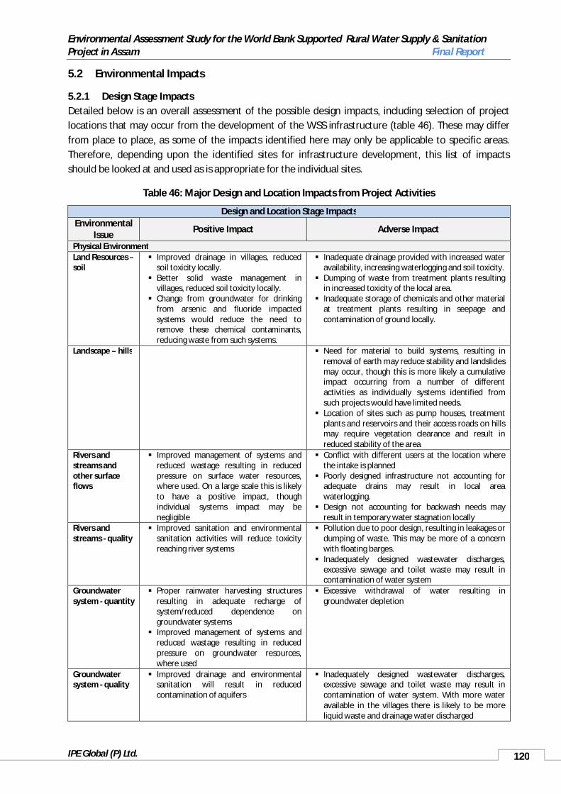
Environmental Assessment Study for the World Bank Supported Rural Water Supply & Sanitation Project in Assam Final Report
IPE Global (P) Ltd. 120
5.2 Environmental Impacts
5.2.1 Design Stage ImpactsDetailed below is an overall assessment of the possible design impacts, including selection of project locations that may occur from the development of the WSS infrastructure (table 46). These may differ from place to place, as some of the impacts identified here may only be applicable to specific areas. Therefore, depending upon the identified sites for infrastructure development, this list of impacts should be looked at and used as is appropriate for the individual sites.
Table 46: Major Design and Location Impacts from Project Activities
Design and Location Stage ImpactsEnvironmental
Issue Positive Impact Adverse Impact
Physical EnvironmentLand Resources –soil
Improved drainage in villages, reduced soil toxicity locally.
Better solid waste management in villages, reduced soil toxicity locally.
Change from groundwater for drinking from arsenic and fluoride impacted systems would reduce the need to remove these chemical contaminants, reducing waste from such systems.
Inadequate drainage provided with increased water availability, increasing waterlogging and soil toxicity.
Dumping of waste from treatment plants resulting in increased toxicity of the local area.
Inadequate storage of chemicals and other material at treatment plants resulting in seepage and contamination of ground locally.
Landscape – hills Need for material to build systems, resulting in removal of earth may reduce stability and landslides may occur, though this is more likely a cumulative impact occurring from a number of different activities as individually systems identified from such projects would have limited needs.
Location of sites such as pump houses, treatment plants and reservoirs and their access roads on hills may require vegetation clearance and result in reduced stability of the area
Rivers and streams and other surface flows
Improved management of systems and reduced wastage resulting in reduced pressure on surface water resources, where used. On a large scale this is likely to have a positive impact, though individual systems impact may be negligible
Conflict with different users at the location where the intake is planned
Poorly designed infrastructure not accounting for adequate drains may result in local area waterlogging.
Design not accounting for backwash needs may result in temporary water stagnation locally
Rivers and streams - quality
Improved sanitation and environmental sanitation activities will reduce toxicity reaching river systems
Pollution due to poor design, resulting in leakages or dumping of waste. This may be more of a concern with floating barges.
Inadequately designed wastewater discharges, excessive sewage and toilet waste may result in contamination of water system
Groundwater system - quantity
Proper rainwater harvesting structures resulting in adequate recharge of system/reduced dependence on groundwater systems
Improved management of systems and reduced wastage resulting in reduced pressure on groundwater resources, where used
Excessive withdrawal of water resulting in groundwater depletion
Groundwater system - quality
Improved drainage and environmental sanitation will result in reduced contamination of aquifers
Inadequately designed wastewater discharges, excessive sewage and toilet waste may result in contamination of water system. With more water available in the villages there is likely to be more liquid waste and drainage water discharged
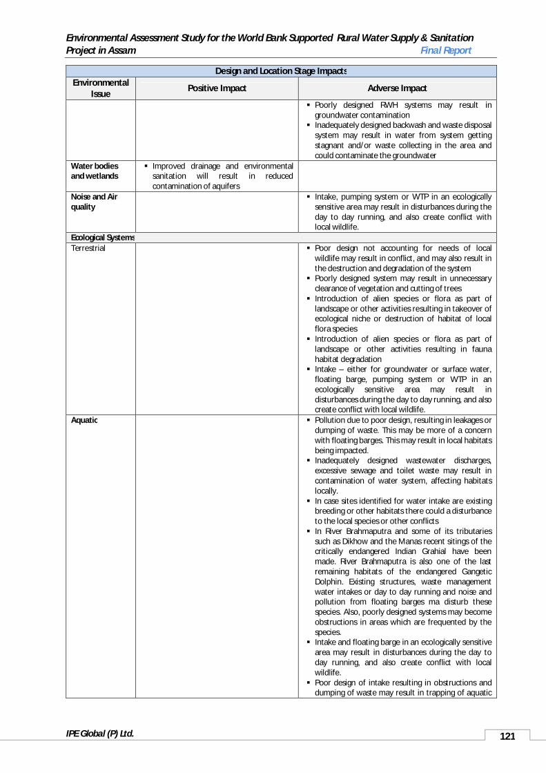
Environmental Assessment Study for the World Bank Supported Rural Water Supply & Sanitation Project in Assam Final Report
IPE Global (P) Ltd. 121
Design and Location Stage ImpactsEnvironmental
IssuePositive Impact Adverse Impact
Poorly designed RWH systems may result in groundwater contamination
Inadequately designed backwash and waste disposal system may result in water from system getting stagnant and/or waste collecting in the area and could contaminate the groundwater
Water bodies and wetlands
Improved drainage and environmental sanitation will result in reduced contamination of aquifers
Noise and Air quality
Intake, pumping system or WTP in an ecologically sensitive area may result in disturbances during the day to day running, and also create conflict with local wildlife.
Ecological SystemsTerrestrial Poor design not accounting for needs of local
wildlife may result in conflict, and may also result in the destruction and degradation of the system
Poorly designed system may result in unnecessary clearance of vegetation and cutting of trees
Introduction of alien species or flora as part of landscape or other activities resulting in takeover of ecological niche or destruction of habitat of local flora species
Introduction of alien species or flora as part of landscape or other activities resulting in fauna habitat degradation
Intake – either for groundwater or surface water, floating barge, pumping system or WTP in an ecologically sensitive area may result in disturbances during the day to day running, and also create conflict with local wildlife.
Aquatic Pollution due to poor design, resulting in leakages or dumping of waste. This may be more of a concern with floating barges. This may result in local habitats being impacted.
Inadequately designed wastewater discharges, excessive sewage and toilet waste may result in contamination of water system, affecting habitats locally.
In case sites identified for water intake are existing breeding or other habitats there could a disturbance to the local species or other conflicts
In River Brahmaputra and some of its tributaries such as Dikhow and the Manas recent sitings of the critically endangered Indian Grahial have been made. River Brahmaputra is also one of the last remaining habitats of the endangered Gangetic Dolphin. Existing structures, waste management water intakes or day to day running and noise and pollution from floating barges ma disturb these species. Also, poorly designed systems may become obstructions in areas which are frequented by the species.
Intake and floating barge in an ecologically sensitive area may result in disturbances during the day to day running, and also create conflict with local wildlife.
Poor design of intake resulting in obstructions and dumping of waste may result in trapping of aquatic

Environmental Assessment Study for the World Bank Supported Rural Water Supply & Sanitation Project in Assam Final Report
IPE Global (P) Ltd. 122
Design and Location Stage ImpactsEnvironmental
IssuePositive Impact Adverse Impact
species or injuries to themSensitive areas, corridors and migratory zones
Infrastructure in migratory routes and corridors, resulting in disturbance and destruction of route. It may also result in destruction and damage of infrastructure
Infrastructure sited in sensitive area, resulting in disturbance to species and could also result in damage and destruction to infrastructure
Forests Location of infrastructure in forest areas or pipes passing through forests may result in damage
Introduction of alien species or flora as part of landscape or other activities resulting in the degradation of the local forest areas where these species may take over, or due to such species being planted in animal corridors/migratory routes they may be transported into forest areas as species cross the area, carrying the plant seeds etc along with them
Socio-Economic SystemsHealth Better quality would improve health.
There are already many aquifers impacted by fluoride, arsenic and iron. Such areas will benefit from surface water schemes or use of iron removal systems to improve water quality
More water, and of good quality available would result in improved hygiene and improved health
Repeated diarrhoea/chronic diarrhoea impacts nutritional availability in the body and has an impact on mental health and growth for children. It also impacts unborn children if mother suffers from nutritional deficiencies while pregnant with her child. Better water quality will therefore improve nutrition absorption and health status
Reduced need to carry water from long distances will reduce risk of injuries etc
Improved drainage, reduced waterlogging and better solid waste management will result in better health, with reduction in contamination of local environment and habitat for disease vectors.
Inadequate drainage provision resulting in an increase in the habitat for various vector species
Inadequate drainage provision resulting in waterlogging and contamination of groundwater, which may also be used for domestic purposes
Poor design not considering protection of groundwater source like handpumps or standposts resulting in contamination of supplied water or groundwater and diarrhoeal diseases
In areas where the Indian grahial is found, if there are any intakes or floating barges, accidents of conflict of workers with the species could occur.
Poor design standards, not considering existing disasters – such as earthquakes and floods, resulting in contamination or breakages and subsequent health impacts
Poor design and waste management systems may also create habitats for certain disease vectors like the sand fly which results I Kala-Azar/black fever or Visceral leishmaniasis, a disease with a recent outbreak (2008) in Chandrapur and Panikheti, both of which are within the present project area.
Overall wellbeing of population
Reduced time taken to fetch water will result in greater time for other activities including leisure, economic activities and time spent with children and family.
Children fetching water will benefit from less time spent collecting water and more time for education, to play and other activities
Reduced health problems will reduce medical expenses, DALYs and care taker time which can be used for other activities.
Other WSS infrastructure
Competing for resources with other local infrastructure at source, resulting in impacting either or both infrastructure and overall resource

Environmental Assessment Study for the World Bank Supported Rural Water Supply & Sanitation Project in Assam Final Report
IPE Global (P) Ltd. 123
Design and Location Stage ImpactsEnvironmental
IssuePositive Impact Adverse Impact
sustainability Location of planned structures, obstructing or
creating other problems for existing WSS infrastructure
Waste from redundant systems – being upgraded. Other infrastructure
Improved drainage and waste management resulting in reduced water stagnation, reducing degradation of infrastructure
Need to cut across lines and roads laid down for other infrastructure, thereby resulting in disruption or damage
Disruption of navigation routes, piers (ghats) especially in smaller rivers and streams used for supplying water
Local economy and economic systems
Reduced ill health resulting in larger number of person-days to work in field and other activities
location of intake may interfere with local fish landing sites, access to river, cut across agriculture fields, or transport routes
Cultural property, aesthetics
Poor design resulting in structures reducing aesthetics in area
Structure and connected infrastructure cutting across archaeological and other culturally important sites
Waterlogging and drainage problems due to greater availability of water in area without adequate drainage management, destroying or damaging cultural property and archaeological sites
5.2.2 Construction Stage Environmental Impacts
A majority of project related impacts are likely to be due to the construction activities, with a number of short term impacts likely to be over once the construction is completed. Most of these would also be localised and only affect the immediate surroundings of the construction site, except for those areas identified for procurement of material. Therefore, most of the impacts can be easily contained and managed. However, if rehabilitation of sites as required is not carried out in time, permanent damage at some sites is possible. The major impacts identified so far are listed below – table 47.
Table 47: Major Construction Stage Impacts from Project Activities
Construction ImpactsEnvironmental
IssuePositive Impact Adverse Impact
Physical EnvironmentLand Resources –soil
Poor storage of chemicals and other material at construction sites resulting in toxicity to soil
Erosion from borrow sites Accumulation of water and increased soil
toxicity at borrow sites Accidents and spillage resulting in toxicity and
damage to the soil Compaction of soil/soil erosion for access to
various sites and to quarries by trucks Landscape – hills Material procurement from hills resulting in
hills caving in and landslides and scaring of landscape
Destruction and removal of vegetation for fuel for labour camps, resulting in denudation of hills resulting in mud/land slides and scaring of landscape
Rivers and Blockage of natural drains due to waste
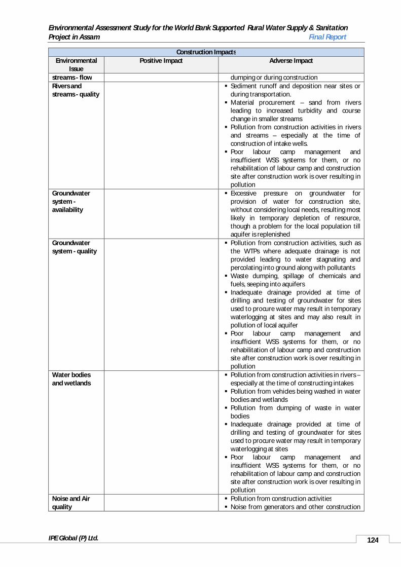
Environmental Assessment Study for the World Bank Supported Rural Water Supply & Sanitation Project in Assam Final Report
IPE Global (P) Ltd. 124
Construction ImpactsEnvironmental
IssuePositive Impact Adverse Impact
streams - flow dumping or during constructionRivers and streams - quality
Sediment runoff and deposition near sites or during transportation.
Material procurement – sand from rivers leading to increased turbidity and course change in smaller streams
Pollution from construction activities in rivers and streams – especially at the time of construction of intake wells.
Poor labour camp management and insufficient WSS systems for them, or no rehabilitation of labour camp and construction site after construction work is over resulting in pollution
Groundwater system -availability
Excessive pressure on groundwater for provision of water for construction site, without considering local needs, resulting most likely in temporary depletion of resource, though a problem for the local population till aquifer is replenished
Groundwater system - quality
Pollution from construction activities, such as the WTPs where adequate drainage is not provided leading to water stagnating and percolating into ground along with pollutants
Waste dumping, spillage of chemicals and fuels, seeping into aquifers
Inadequate drainage provided at time of drilling and testing of groundwater for sites used to procure water may result in temporary waterlogging at sites and may also result in pollution of local aquifer
Poor labour camp management and insufficient WSS systems for them, or no rehabilitation of labour camp and construction site after construction work is over resulting in pollution
Water bodies and wetlands
Pollution from construction activities in rivers –especially at the time of constructing intakes
Pollution from vehicles being washed in water bodies and wetlands
Pollution from dumping of waste in water bodies
Inadequate drainage provided at time of drilling and testing of groundwater for sites used to procure water may result in temporary waterlogging at sites
Poor labour camp management and insufficient WSS systems for them, or no rehabilitation of labour camp and construction site after construction work is over resulting in pollution
Noise and Air quality
Pollution from construction activities Noise from generators and other construction

Environmental Assessment Study for the World Bank Supported Rural Water Supply & Sanitation Project in Assam Final Report
IPE Global (P) Ltd. 125
Construction ImpactsEnvironmental
IssuePositive Impact Adverse Impact
activities like trucks etc., passing the area Dust and sand flying from trucks during
transportation Poorly maintained vehicles or heavy drilling
activities resulting in high level of noise or vibration
Air pollution from vehicles and machineryEcological SystemsTerrestrial Plantation activities resulting in alien species
introduction, degrading the local environment Construction at the time of animal migration
that disturbs the migratory routes and patterns Destruction of vegetation by vehicular
movement and clearance for paths, storage of construction material and for sourcing material
Aquatic Impact on local fisheries and fish spawning and aquatic fauna.
Gharail, dolphin and other species disturbed during construction activities if in the area
River sand – such as River Kulsi, damage to habitat of the dolphin
Increased turbidity mainly from sand mining though also construction in river, disturbing local habitats
Construction at the time of species migration disturbing the migratory area
Sensitive areas, corridors and migratory zones
Noise and disturbance from construction activity, transportation of material
Material procurement from sensitive sites, resulting in damage to site
Construction during migration leading to disturbance to species and conflicts
Forests Disturbance and degradation to forests due to vehicular movement carrying construction material
Degradation of forests as construction material is procured from them
Use of wood from forests for supply of firewood for construction camps
Waste generated from various project activities, but no adequate disposal system identified, resulting in being dumped in the village lands
Socio-Economic SystemsSettlement and local population
Disturbance to local population due to construction activities, movement of vehicles, noise or from labour
Conflict with local population on resources with labour camps
Conflict with local population due to restriction in construction sites and access to some sites for them
Accidents from vehicles and poor construction

Environmental Assessment Study for the World Bank Supported Rural Water Supply & Sanitation Project in Assam Final Report
IPE Global (P) Ltd. 126
Construction ImpactsEnvironmental
IssuePositive Impact Adverse Impact
site management Increase water stagnation and drainage
problems due to construction activities, poorly managed labour or construction sites and vehicles being cleaned and serviced in the area
Increased traffic at sites for material procurement or construction sites, disturbing population
Health Occupational Safety and construction hazards due to inadequate management of site, access to site for all people including local population not working at site, and inadequate protection gear and training to labour.
Workers/labour camps and facilities in sufficient, poorly managed or not existent resulting in health problems to them and the local population.
Health problems due to water stagnation at sites, resulting in breeding sites for disease vectors
Lack of water and sanitation services at labour camps resulting in health problems
Poor rehabilitation of sites – construction, labour, borrow sites, leading to habitats for disease vectors
Increase in disease due to influx of migrant labour
Poor design and waste management systems may also create habitats for certain disease vectors like the sand fly which results in Kala-Azar/black fever or Visceral leishmaniasis, a disease with a recent outbreak (2008) in Chandrapur and Panikheti, both of which are within the present project area.
Other WSS infrastructure
Damage to infrastructure due to vehicular movement, construction sites or labour camps
May increase pressure on the local infrastructure as water and sanitation needs of labour also to be accounted for
Other infrastructure
Damage to infrastructure, transportation of material, storage of material
Waste generated from various project activities, but no adequate disposal system identified, resulting in obstructing people pathways or degrading other infrastructure
Local economy and economic systems
May provide some local employment opportunities at the sites temporarily
Disturbance to local population due to temporary reduced access to sites as sites identified for labour camps and storage may be used by local population for various activities such as farming, storage or threshing or even firewood procurement
Sites like agriculture fields used for material storage

Environmental Assessment Study for the World Bank Supported Rural Water Supply & Sanitation Project in Assam Final Report
IPE Global (P) Ltd. 127
Construction ImpactsEnvironmental
IssuePositive Impact Adverse Impact
Waste generated from various project activities, but no adequate disposal system identified, resulting in being dumped in the village lands
Cultural property Chance findings – archaeological sites. Scaring of landscape due to borrow sites, such
as in hills or from firewood collection
5.2.3 Operation and Maintenance Stage Environmental ImpactsPossible impacts during operation and maintenance are identified in table 50.
Table 48: Major Operation and Maintenance Impacts from Project Activities
Operation and Maintenance ImpactsEnvironmental Issue Positive Impact Adverse ImpactPhysical EnvironmentLand Resources –soil
Poor management of WTP resulting in dumping of waste, backwash water with excessive chemicals and waste and sludge on land, resulting in degrading soil.
Pumping house for floating barges poorly maintained, resulting in leakages of fuel and other chemicals and dumping of waste on land, degrading soil.
Chemical spillage from WTP or during O&MRivers and streams – quality
Better sanitation facilities, with improved waste disposal will improve the river water quality which at present is getting polluted due to waste dumping.
Poor management of WTP resulting in dumping of waste, backwash water with excessive chemicals and waste and sludge in local water body.
Chemical spillage from WTP or during O&M Groundwater system – availability
Excessive pumping of groundwater, beyond planned resulting in depletion of resource
Development of other and competing groundwater systems which together with this system result in depleting of resource
Groundwater system – quality
Less dependency on ground water since the RWSS project will draw water from the River Brahmaputra and Barak and its tributaries for water augmentation.
Poor management of WTP resulting in dumping of waste, backwash water with excessive chemicals and waste and sludge on land and percolating into shallow aquifer
RWH system poorly maintained resulting in contamination of aquifer
Inadequate finances or skills to manage small or individual systems resulting in their degradation, accumulation of water around the system or breakage resulting in contamination of aquifer
Water bodies and wetlands
No disposal of wastewater in the neighbourhood water bodies, will improve its condition.
Poor management of WTP resulting in dumping of waste, backwash water with excessive chemicals and waste and sludge in local water body.
Noise and Air quality
Poor maintenance of WTP and pumping station and any diesel pump sets used as back up energy supply, resulting in high noise levels

Environmental Assessment Study for the World Bank Supported Rural Water Supply & Sanitation Project in Assam Final Report
IPE Global (P) Ltd. 128
Operation and Maintenance ImpactsEnvironmental Issue Positive Impact Adverse Impact
and air pollutionEcological SystemsAquatic Poor management of WTP resulting in
dumping of waste, backwash water with excessive chemicals and waste and sludge in local water body or river and streams.
Sensitive areas, corridors and migratory zones
In case of systems near sensitive areas, corridors or fly paths poor maintenance of systems or dumping of waste may result in disturbance to wildlife
Socio-Economic SystemsHealth Health conditions are likely to
increase due to abandonment of poor quality water sources such as Handpumps, stand post which are affected by iron, arsenic and fluoride. Also, installation of twin pit toilets in each household, will improve overall sanitation conditions of all villages covered under the project. Targeting hygiene practices through IEC measures will also reduce probabilities of disease.
Accidents, or injuries during maintenance or at the WTP or pumping station due to inadequate training or insufficient safety equipment or poor management
Poor maintenance of system, network and breakages and leaks not managed properly resulting in contamination of treated water and ill health
Poorly kept and managed or outdated chlorine/bleaching power, resulting in ineffective disinfection
Insufficient knowledge to manage the system resulting in inadequate disinfection,, cleaning of system or other management issues resulting in poor quality water being supplied
Unattended leakages from water supply system leading to vector habitats
Poorly managed drainage and solid waste systems leading to vector habitats
Inadequate finances or skills to manage small or individual systems resulting in their degradation.
Inadequate sanitation/ environmental sanitation management contaminating shallow aquifers in areas where dugwells or shallow rigs are used to procure water
Cultural property Poor maintenance of system resulting such as drainage and damage to any local cultural property.
5.3 Objectives of Environment Management Framework
The main objective of the Environment Management Framework is to identify management actions for any possible adverse environmental concerns arising from the project activities, or possible adverse impact of given environmental situation in the project. This is based upon identified concerns from the field, secondary data and discussions that have resulted in the development of impact matrices for environmental impact resulted in the design and location stage, construction stage and O&M stage of the project and though key observations. This EMF, through its various steps sets out environmental codes of practices that need to be followed during various stages such as planning, construction and operation and maintenance, to ensure sustainability of infrastructure and resource. Also, the EMF

Environmental Assessment Study for the World Bank Supported Rural Water Supply & Sanitation Project in Assam Final Report
IPE Global (P) Ltd. 129
suggests probable actors and stakeholders who need to be involved in the implementation of the planned actions.
5.4 Environmental Management Framework
5.4.1 Key Elements of the EMF
The key elements of the EMF that apply to the Assam RWSS project are detailed below.
1. Collection of Basic Environmental Data: To ensure adequate and proper identification of local needs and monitoring of project the EMF needs environmental data for each scheme. To do this and ensure a standard format for the project an Environmental Data Sheet (EDS) for schemes on water supply, sanitation, solid and liquid waste management, etc. is available in Annexure 1.18.
This data is to be completed simultaneously with the development of the Detailed Project Report (DPR). The Assistant Executive Engineer (AEE)/ Executive Engineer (EE) of the scheme fills up the EDS in consultation with the GPWSCs, the GP or other local civil society organisations who are involved in the project.
2. Environmental Classification of Schemes: At the Detailed Scheme Report (DSR) preparation stage, the available environmental information in the EDS will be evaluated and based on the level of expected environmental and public health impacts, the proposed scheme would be classified as either Category I (preliminary) or Category II (detailed environmental appraisal required).
The EDS formats are given in Annexure 1.18. The screening tool for the categorization of schemes is available in 1.4.3. The overall in charge for the identification of the environmental classification of schemes with the help of the screening tool is the EE of each scheme.
3. Environmental Appraisal and Approval: For all category I schemes, there shall be no separate environment appraisal other than filling up of EDS included in the Detailed Scheme Report (DSR).
For category II schemes, a detailed environmental appraisal of the proposed scheme is required. This will be done by the EE and his team who is in charge of the scheme. This team can be supported by the state level environmental expert attached to Project Management Unit (PMU), for any technical help required.
The environmental appraisal for category II schemes shall not take more than 30 days. The DPR of Category I schemes should be accompanied by the Environmental Data Sheet (EDS). The EE of the PHEDwill need to ensure this. The DPR for Category II schemes should be accompanied by the Environmental Data Sheet (EDS) and the Category II environmental appraisal. The EE of the PHED will ensure this. All documentation will be finally checked for consistency and quality by the PMU environmental specialist.
4. Environmental Compliance Monitoring during Implementation and Operation and Maintenancephases: The EMF will ensure that: 1) The prescribed environmental mitigation measures (including construction stage measures) as identified through the environmental appraisal process are adequately implemented. The Implementation Completion Report of each scheme will include an Environmental Compliance Certificate given by the GPWSC/GP or other identified appropriate authority, depending upon the planned local level management of the scheme for a completed scheme indicating that the mitigation measures identified in the appraisal have been implemented.
2) Monitoring and Supervision: There will be periodic supervision and monitoring conducted to ensure compliance to the EMF and identification of any additional concerns that may have risen since. The suggested monitoring plan is outlined in section 1.5.8 of this document titled the Monitoring Plan. In

Environmental Assessment Study for the World Bank Supported Rural Water Supply & Sanitation Project in Assam Final Report
IPE Global (P) Ltd. 130
case there is a need for any changes in the monitoring plan, this can be suggested to the state PMU, and based upon discussions this can be changed as required. There will also be an independent external audit, as a part of the overall project monitoring program at mid-term of the project to suggest any course correction, if required.
3) Capacity building needs to be undertaken to ensure the proper execution of the EMF. It has been noted that some issues of poor management of systems at the local level can be rectified by training and capacity building activities. Therefore, a capacity building and training plan has been developed as a part of the EMF and should be used to ensure proper implementation of the EMF. Section 1.6 includes the suggested training and capacity building plan.
4) IEC for the management of water, sanitation, environmental sanitation, drainage etc., will be needed at the local level. This is imperative to ensure proper management of village sanitation and reduce health burden from water and sanitation related diseases. Also, the IEC, in addition to water related issues, can be focused at increasing the demand for toilets and their improved management.
5.4.2 Application of EMF to Project
Environmental Management Framework essentially consists of Environmental Screening, Environmental Assessment (EA), Environmental Management Planning and monitoring of compliance with the plan of actions recommended for mitigating environmental risks. The environmental screening was carried out under this assessment to determine the appropriate environmental category for the proposed projects. Based on the outcome of screening, an Environmental Assessment (EA) respective to the attached environmental category will be applied for each proposals.

Environmental Assessment Study for the World Bank Supported Rural Water Supply & Sanitation Project in Assam Final Report
IPE Global (P) Ltd. 131
Baseline Data Collection and Analysis
Qualitative and Quantitative Survey
Impact Assessment
Screening Checklist for Scoping
Identification of Key Environmental Issues
CATEGORY II
Collect Baseline and fill EDS Collect Baseline and fill EDS
Generic Environment Management Plan
Environmental Appraisal & Impact Identification
Mitigation Measures & Approvals
Specific Environmental Management Plan
Monitoring Plan
GUIDELINES (ECoP)
ENVIRONMENTAL ASSESSMENT
ENVIRONMENTAL MANAGEMENT FRAMEWORK
GUIDELINES (ECoP)
Performance Indicators
Mitigation Measures
CATEGORY I
Supervision and Monitoring

Environmental Assessment Study for the World Bank Supported Rural Water Supply & Sanitation Project in Assam Final Report
IPE Global (P) Ltd. 132
The PHED as recommended in the Environment Data Sheets (EDS) will be responsible for carrying out the required EA and for confirming that any clearances necessary for the proposed RWSS projects are obtained from the relevant authorities as prescribed by the national and state legislations which should also meet with the World Bank procedures as described in the EA/EMF document. Once the EA is performed and recommendations incorporated into the sub-project, the project can be appraised and sanctioned.
Depending on the environmental category, the package would include one of the following: a) a full scale Environmental Impact Assessment (EIA) and an Environmental Management Plan (EMP), b) Environmental Management Plan (EMP), c) a simplified environmental assessment, so called EMP checklist, or d) a justified statement that no EA is required. To ensure that environmental management is an integral part of project activities, the EMF needs to be incorporated in the project and scheme’s management. The flow diagram above provides the steps involved in the EA/EMF Process. Also, A Plan of responsibility is suggested in the Table 49.
Table 49: Identified Roles and Responsibilities for Implementation of EMF
Phase EMF Activity Objectives Process Responsibility Result
Preplanning/Planning
Environmental Data Sheet
To collect basic information on environmental aspect of the proposed scheme.
Discuss scheme with community and identify environmental issues of concern.
GPWSC or local agency along with GP
EDS prepared and attached to DSR.
Fill EDS. IF required, provide additional information as supplementary notes
AEE/Assistant Engineer (AE)/ with support from GPWSC or local agency and Support Organisation (SO)
Environmental classification of the scheme
To ensure that schemes with potentially significant environmental or public health issues are identified at an early stage for detailed environmental appraisal.
Evaluate all the available information on environmental aspects as provided in the Environmental Data Sheet and, assess whether the proposed scheme is Category I or Category II by referring to the Screening Tool.
EE/PHED with District Level Environmental Expert, District Project Management Unit (DPMU) and the support of the SO.
Scheme classified as Category I or Category II using the screening tools.
Environmental appraisal and approval required
To ensure that relevant environmental issues have been identified and appropriate mitigation measures have been designed to address them.
For category I schemes, there shall be no separate environmental appraisal but environmental aspects shall be included in the normal appraisal and evaluation process for the proposed scheme, based on the EDS included in the DSR.
District level Environmental Expert, District Project Management Unit (DPMU).
Environmental appraisal of the scheme is made using the Checklist for Environmental Appraisal of Category II Schemes and approval of proposed scheme, with decision to (i) accept scheme as submitted, or (ii) accept scheme with modification suggested in the environmental appraisal.
For category II schemes, a detailed environmental appraisal of the proposed scheme is required, including evaluation of environmental and public health impacts, risk assessment if needed, and design of mitigation measures.
To ensure that mitigation measures and their cost are integrated
Technical Sanction for the scheme will not be accorded without Environmental Clearance from PMU
EE for Category I schemes.Category II schemes CE
Technical Sanction for scheme with environmental mitigation measures
Environmental Assessment Study for the World Bank Supported Rural Water Supply & Sanitation Project in Assam Final Report
IPE Global (P) Ltd. 133
Phase EMF Activity Objectives Process Responsibility Resultin scheme design and implementation plans
and accordingly its costs are integrated in scheme design and implementation plans.
Implementation
Implementation of Environmental mitigation measures.
To ensure that the prescribed environmental mitigation measures for all three project stages are implemented.
Implementation Completion Report (ICR) for scheme will need to include compliance certificate in case of construction phase For all stages regular monitoring reports to be developed
ICR to be given by GPWSC or local agency in charge in areaMonitoring reports as identified for various stages, which is mainly the EE of each scheme
ICR with environmental compliance information.Overall semi-annual monitoring report compiled at PMU and available for public scrutiny
O&M
Environmental supervision, monitoring, and evaluationIEC and capacity building on hygiene and environmental issues.
To ensure that environmental aspects are integrated in the O&M phase.
Water quality monitoring will be conducted as per project water quality monitoring protocol.Regular testing – such as the OT test reports will be available at the WTP.Internal supervision will be conducted for 20% of the schemes completed once in a year. Monitoring of external environmental parameters relevant to the project will be conducted once in a year. Environmental Audit through external agency will be undertaken at midterm and will include about 10% random samples of villages from completed schemesIEC improved drainage, environmental sanitation, safe water and hygiene
State Level Environmental Expert supported by District Level Monitoring officer
Hiring of external agency
Water quality monitoring reports.
Periodic environmental supervision, monitoring and audit reports.
Training and IEC activity reports.
5.4.3 Screening Tool for Categorizing SchemesFor each sub-project to be taken up by the PHED under this project, there will be a need to undertake the screening of the project to identify the category of the project and the environmental process required. This is given in Table 44. Equally important is the need to identify if the project is appropriate for funding. This would need to be done by the exclusion list of activities given below.
5.4.3.1 Exclusion List of ActivitiesGiven below are concerns that must be considered while developing projects or their design. Projects that fall under any of the criteria below should not be considered and as required redesigning undertaken
▫ Project or activities that destroy, encroach upon, degrade or damage or may risk the degradation ofany protected area or reserve forest, or any biodiversity conservation hotspots, such as wildlife sanctuaries or national parks, and other significant natural reserves and areas
▫ Any project that is not consistent with the State Forest Act▫ Project or activities that destroy or encroach upon wildlife migratory routes, corridors or fly paths▫ Activities that destroy or disturb any historical and culturally valuable sites, including archaeological
sites. In case there is no choice but to pass near such as site, relevant laws and departments must be

Environmental Assessment Study for the World Bank Supported Rural Water Supply & Sanitation Project in Assam Final Report
IPE Global (P) Ltd. 134
consulted for appropriate designing activities. For culturally valuable sites, consultation with the local population is a must.
▫ Projects that result in environmental/natural resource degradation, such as watershed degradation, create or trigger landslides or result in resource degradation
▫ Projects or activities involving the procurement of pesticides not allowable under Bank guidelines▫ Projects that are not consistent with the National, State or World Bank’s regulationsFor all remaining projects, those that qualify to be considered for implementation, the screening tools as identified in table 50 would be used to identify the type of impacts and possible assessment needs.
Table 50: Screening Tools
Category I Category IIA. Water Supply Schemes
Schemes with intakes in perennial rives and no identified environmental degradation issues such as major industry or polluter upstream
Schemes located in areas with depleting aquifers, critical or over exploitation zones of groundwater exploitation and deep groundwater source in semi-critical and over exploited zones
Schemes with source in aquifer in safe zones for groundwater sources
Schemes located in or passing through ecologically sensitive areas or within 1 kms of a natural habitat. Schemes in animal corridors/wildlife migratory routes, including village forests, unclassified and private forests and forest department forests
Single villages schemes which do not qualify under any criteria under Category II
Schemes with high risk of flooding or river erosion
Surface water schemes downstream of critically polluted zones, major industries/agricultural areas where risk of contamination is highGroundwater schemes where high risk of chemical or microbiological risk existsMulti village schemesSchemes where there is a high risk of catchment degradation, and may endanger the project
B. Artificial Recharge StructureAll types of rain water harvesting structures to improve water supply sources
E. Storm water / Sullage DrainsIf all the following conditions are satisfied:
Construction of drains where groundwater table is at depths > 3.0m
Subsoil is having sufficient bearing capacity
Length of drain is not more than 250 m
If any of the following conditions are satisfiedConstruction of drains where groundwater table is at
depths < 3.0m Soil bearing capacity is < 5 t/m2
Length of drain is more than 250mArea not prone to flooding
F. Solid Waste ManagementNo scheme 1. All types of solid waste management with source
segregation and installing vermi-composting / composting.

Environmental Assessment Study for the World Bank Supported Rural Water Supply & Sanitation Project in Assam Final Report
IPE Global (P) Ltd. 135
5.4.4 Environmental Supervision and Monitoring Environmental supervision: All schemes identified under the project will be visited at six monthly intervals by a team from the district level, which will include the monitoring expert with support from the state level environmental officer of the PMU. This will be to ensure that identified environmental safeguard requirements are met and to identify possible unforeseen environmental impacts.
Annual monitoring of environmental parameters: An annual report is to be prepared by the PMU environmental specialist on any identified external constraints to the project and update of environmental safeguard implementation. Any relevant changes in the legislation will also be included in this report. The EMF will be suitably revised annually on the basis of this document by the PSU.
Environmental audit: There will be a mid-term environmental audit study that will look at implementation of environmental safeguards, possible external or internal constraints for the proper implementation of the safeguards and mid-term course correction, if required. This will be an external and independent audit of the project. Annexure 1.22 gives details of external audit.
5.5 Institutional Arrangements
5.5.1 Introduction
Currently, Assam PHED (APHED) Technical Engineering Department is responsible for rural water supply activities. It is also responsible for policy making and overall monitoring and evaluation. Since, theearlier GoI programs such as Swajaldhara and Sector Reform Project have had little impact on the decentralization of RWSS services, it is envisaged that there is an immediate need to address the gaps and increase the roles of PRIs in the planning, implementation and O&M of schemes.
In the area of rural sanitation, there is not much integration between water and sanitation, not much focus on environmental sanitation, and very few Open Defecation Free (ODF) villages. APHED also handles rural sanitation.
The Project will aim for progressive decentralization, with increasing role of the PRIs (GP and GP-WSCs) in the planning, implementation and O&M of schemes, along with separation of governance and operational responsibilities. A stronger and more capacitated state level SWSM, with support from a newly established SPMU to carry out its work effectively, will oversee and guide the implementation.
District level DWSMs and District Water and Sanitation Committees (DWSC), strongly supported by the DPMUs will move towards a district-wide approach in adopting the key principles of decentralization and accountability. The State Technical Departments will be responsible for providing technical support and capacity building of the PRIs. The Technical Departments will also be involved in implementing large Multi- Village Schemes (MVS) where contract sizes and complexities may require higher capacities, which are presently not available with the PRIs.
A key design of the proposed Project is to provide strong support to the village level GP /GPWSC in the form of a local SO staffed with professionals with experience in social development, community mobilization and communication in rural developmental projects. Close supervision by district level agencies will ensure that there is adequate attention to capacity building and cross-learning activities. Following are the institutional and implementation arrangements agreed for the proposed project.

Environmental Assessment Study for the World Bank Supported Rural Water Supply & Sanitation Project in Assam Final Report
IPE Global (P) Ltd. 136
5.5.2 National Level
i. Ministry of Drinking Water and Sanitation (MoDWS): The Rural Water Supply and Sanitation Programme – Low Income States (RWSSP-LIS) will be implemented through a special window of assistance under the on-going NRDWP. A Steering Committee will be established at the MoDWS under the Chairmanship of the Secretary, MoDWS. The Steering Committee will provide guidance on sector policies and will be responsible for overall monitoring of the project. The Principal Secretaries of the four States and the Joint Secretary MoDWS (Sanitation) will be its Members, with Joint Secretary MoDWS (Water) as Member-Secretary. It is proposed that the Steering Committee meets at least once every quarter to review the project implementation progress.
ii. National Project Management Unit and Technical Advisory Group: The NPMU National Project Management Unit) will be established under the MoDWS for implementing the project. The NPMU will be staffed with experts in technical, social, financial, procurement, etc. for policy guidance to the states. The NPMU will also have a specially constituted Technical Advisory Group (TAG) with the primary responsibility for independently reviewing the design and implementation of the project in each of the four states and guiding the participating states in their project activities and capacity building and institutional strengthening programs. The TAG will also be responsible for preparing the implementation review documents, as required for review during Bank supervision missions.
iii. Water and Sanitation Management and Resource Centre: The Water and Sanitation Management and Resource Centre (WASMARC) will be set-up for managing RWSS programs and advising the MoDWS on technical and policy issues, including planning and implementation processes, monitoring and evaluation programs, independent reviews, etc. It is envisaged that the NPMU will converge with WASMARC during the project implementation period (end of year 3). Its initial mandate will be to focus on the target low income states, but will gradually expand its reach and coverage to other states.
iv. National Rural Water and Sanitation Institute: A national level training institute will be set up under MoDWS as a ‘state of the art’ training and research institute which will focus on capacity building of the RWSS sector institutions. It will have linkages to other national and international technical institutions.
5.5.3 State Level
i. State Water and Sanitation Mission: The State Water and Sanitation Mission (SWSM) under the RWSS Minister is currently responsible for overall policy guidance for the RWSS Sector Program. The Executive Committee of the SWSM, headed by the RWSS Secretary is assisting SWSM in all its responsibilities, including planning and policy formulation, capacity building, fund flow, approval of the annual plan and budget allocation, and monitoring and evaluation of the Sector and District Programs. The SWSMs are already established in all the four states, including Assam, though not functioning effectively due to capacity constraints and limited full time professional support.
ii. Water and Sanitation Management Organization: The project will strengthen the SWSM with the establishment of the Water and Sanitation Management Organisation (WASMO) as a dedicated unit for managing, monitoring and approval functions, and guiding the implementing agencies in all aspects of project design and implementation. The WASMO will comprise sector specialists for advising on policy and institutional aspects, social and community development programs,

Environmental Assessment Study for the World Bank Supported Rural Water Supply & Sanitation Project in Assam Final Report
IPE Global (P) Ltd. 137
communications, capacity building programs, sanitation programs, technical aspects, Monitoring and Evaluation (M&E) programs, procurement and financial management.
iii. State Technical Department: The State Technical Departments i.e., PHED, Assam will work primarily as the ‘facilitator’ for all aspects of the District Program, including technical support for small Single Village Schemes (SVS) and small Solid and Liquid Management (SLWM) activities, along with technical capacity building and technical backstopping. The Technical Departments will continue to plan and implement the large MVSs and large SLWM schemes, with involvement of participating GPs for intra-village works and operations. The Technical Department’s key roles will be: Preparation, planning, design and implementation of MVSs and large SLWM schemes. Technical support for planning and design of SVSs and small SLWM schemes. Technical appraisal and sanction of schemes based on the agreed delegation of powers. Monitoring support and technical guidance to DPMUs and DPMCs.
Technical backstopping to GPs for all activities, including water supply, sanitation and SLWM.
iv. State Rural Water and Sanitation Institutes: The project will set-up and/or strengthen the State Rural Water and Sanitation Institutes (RWASI) for training and research. The RWASIs will be the state institutions for carrying out training programs and building capacity of the sector institutions, PRIs, SOs, and other stakeholders.
v. State Project Management Units: The Project will substantially strengthen the SWSMs through the establishment of a State PMU, with sector specialists for policy and institutional aspects, social and community development, communication, capacity building, financial management, procurement, environmental sanitation, technical, and M&E. The SPMU will be responsible for assisting the SWSM in monitoring and approval functions as well as guiding the implementing agencies in all aspects of project implementation.
5.5.4 District Level
i. District Water and Sanitation Mission: The states have established District Water and Sanitation Mission (DWSM), headed by the Zilla Panchayat (ZP) Chairperson, as per the guidelines of the GoI NRDWP. However, many of these are not fully functional and do not have adequate capacity. The proposed Project will strengthen the DWSM, so that these can be responsible for the district RWSS program, including approval of schemes, fund flow, capacity building, IEC activities and M&E. The DWSM will receive policy guidance from the SWSM and will be assisted by the District Water and Sanitation Committee (DWSC).
ii. District Water and Sanitation Committee (DWSC): The DWSC headed by the District Collector, will be the executive arm of the DWSM for implementing the RWSS policies and program at the district level, with the following key responsibilities: Oversee formulation, management and monitoring of district-wide RWSS program. Provide administrative approvals of all SHS/ SGS/ SLWM schemes. Select Support Organisations / Non Governmental Organisations (NGOs) and enter into
agreements for social mobilization, capacity development, communication, project management and supervision, etc.
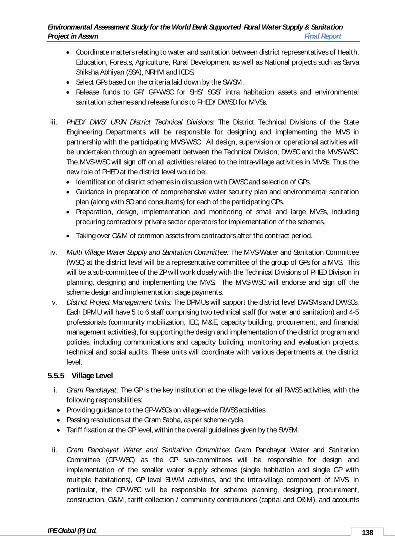
Environmental Assessment Study for the World Bank Supported Rural Water Supply & Sanitation Project in Assam Final Report
IPE Global (P) Ltd. 138
Coordinate matters relating to water and sanitation between district representatives of Health, Education, Forests, Agriculture, Rural Development as well as National projects such as Sarva Shiksha Abhiyan (SSA), NRHM and ICDS.
Select GPs based on the criteria laid down by the SWSM. Release funds to GP/ GP-WSC for SHS/ SGS/ intra habitation assets and environmental
sanitation schemes and release funds to PHED/ DWSD for MVSs.
iii. PHED/ DWS/ UPJN District Technical Divisions: The District Technical Divisions of the State Engineering Departments will be responsible for designing and implementing the MVS in partnership with the participating MVS-WSC. All design, supervision or operational activities will be undertaken through an agreement between the Technical Division, DWSC and the MVS-WSC. The MVS-WSC will sign off on all activities related to the intra-village activities in MVSs. Thus the new role of PHED at the district level would be: Identification of district schemes in discussion with DWSC and selection of GPs. Guidance in preparation of comprehensive water security plan and environmental sanitation
plan (along with SO and consultants) for each of the participating GPs. Preparation, design, implementation and monitoring of small and large MVSs, including
procuring contractors/ private sector operators for implementation of the schemes.
Taking over O&M of common assets from contractors after the contract period.
iv. Multi Village Water Supply and Sanitation Committee: The MVS-Water and Sanitation Committee (WSC) at the district level will be a representative committee of the group of GPs for a MVS. This will be a sub-committee of the ZP will work closely with the Technical Divisions of PHED Division in planning, designing and implementing the MVS. The MVS-WSC will endorse and sign off the scheme design and implementation stage payments.
v. District Project Management Units: The DPMUs will support the district level DWSMs and DWSCs. Each DPMU will have 5 to 6 staff comprising two technical staff (for water and sanitation) and 4-5 professionals (community mobilization, IEC, M&E, capacity building, procurement, and financial management activities), for supporting the design and implementation of the district program and policies, including communications and capacity building, monitoring and evaluation projects, technical and social audits. These units will coordinate with various departments at the district level.
5.5.5 Village Level
i. Gram Panchayat: The GP is the key institution at the village level for all RWSS activities, with the following responsibilities:
Providing guidance to the GP-WSCs on village-wide RWSS activities. Passing resolutions at the Gram Sabha, as per scheme cycle. Tariff fixation at the GP level, within the overall guidelines given by the SWSM.
ii. Gram Panchayat Water and Sanitation Committee: Gram Panchayat Water and Sanitation Committee (GP-WSC) as the GP sub-committees will be responsible for design and implementation of the smaller water supply schemes (single habitation and single GP with multiple habitations), GP level SLWM activities, and the intra-village component of MVS. In particular, the GP-WSC will be responsible for scheme planning, designing, procurement, construction, O&M, tariff collection / community contributions (capital and O&M), and accounts

Environmental Assessment Study for the World Bank Supported Rural Water Supply & Sanitation Project in Assam Final Report
IPE Global (P) Ltd. 139
management. It will be responsible for all IEC/BCC activities for water and sanitation programs. It will also be responsible for preparation of comprehensive water security plan and environmental sanitation plan with the help of SO and State Technical Agency.
iii. Support Organization: The GP / GP-WSC will work with SO / NGO for community mobilization and IEC/BCC activities at the village level. The SO will provide technical expertise in design, implementation and O&M of SHS/ SGS/ intra village MVS and SLWM activities, as required.
The Project will promote the convergence of water supply and sanitation schemes in Assam. A strong and dedicated DPMU along with SOs at the village level will ensure that the intended demand responsive community driven approaches are followed as per scheme cycle for planning, implementation and maintenance. Chart below presents the existing and proposed State level institutional and implementation arrangements under the Project. Institutional Arrangement for Implementing the RWSS-LIS Scheme
The project intervention will be at four different levels, National, State, District and Village. At the national and the State level each a Project Monitoring Unit, NPMU and SPMU respectively, will be established to monitor the progress of the Rural Water Supply and Sanitation projects. Besides
DPMUs
DPWSC and GPWSC
APWSC
SLUC
Chief Engineer (PHE) Assam, World Bank Project
NPMU
SPMU
ABC
SecretaryPHE, Assam
Dy. SecretaryPHE, Assam
Under SecretaryPHE, Assam
Addl. Chief Engineer
Suptd. Engineer
Executive Engineer (District)
Asst. E.E. Asst. Engineer
Sr. Jr. Engineer Junior Engineer
Sub. Engineer
PRI
ABC : Existing
KEY
: Proposed/Restructured
NGOs / SO

Environmental Assessment Study for the World Bank Supported Rural Water Supply & Sanitation Project in Assam Final Report
IPE Global (P) Ltd. 140
monitoring the State Project Management Unit (SPMU) is the set up for over all guidance in respect of policy, technical as well as financial aspects. It is a set up under the existing Apex Body of the State Water and Sanitation Mission (SWSM).
The details are given in the rest of the subsections of the institutional arrangement below.
5.5.6 Support OrganisationsMany NGOs are working in Assam in advocating and educating on health and hygiene issues at state, district and GP levels. NGOs such as Hopeline, Environ, Arch, etc., are involved in capacity building of local population as well as the panchayat representatives. Besides NGO’s, UNICEF, is also very active in carrying awareness drives on sanitation, health hygiene issues at village, district and state level. It liaises with PHED, officials and conducts trainings on water quality management, monitoring, etc., and also provides technical assistance in adopting correct technological options for the construction of Low-cost sanitary toilets.
5.5.7 Performance IndicatorsA list of environmental performance indicators which have been integrated with the overall project indicators for monitoring and evaluation of the project performance are given in Annexure 1.23.
5.5.8 Monitoring PlanIn order to ensure that the identified Environmental Management Framework is implemented properly and that the project EMP is in place, there is a need to undertake monitoring of activities for compliance. This monitoring will be undertaken during the design, construction and O&M phase of the project. The monitoring is to have two parts, i) the development of a baseline, and ii) the monitoring activity. The baseline needs to be developed prior to the commencing of the activity. Therefore, it is suggested that the baseline be developed before any project construction activity starts. All baselines activities should be included in the project DPR development phase, once infrastructure location is finalised and material sourcing sites identified.
Baseline data collection is to help ensure that project actions do not have an adverse impact on the environment. This is related mainly to the construction phase of the project – and includes all project sites – quarries, borrow pits and the construction site. This should include photographic records of sites, for rehabilitation, the number of trees etc., to be removed and any specific issues identified prior to construction, and during a consultation – as suggested in the public consultation section.
5.5.8.1 Monitoring of Project DesignGiven below (table 51)is suggested monitoring for the project. This should be used along with the findings of the EDS, which will tailor the monitoring to the individual project’s needs, the guidelines in the Annexure, and the environmental performance indicators listed in Annexure 1.23.
Table 51: Suggested Monitoring for Design Phase Activities
Monitoring Indicators Frequency Method of Verification
Suggested Responsible Authorities
Supervision
Housekeeping at WTPthat includes cleaning of the WTP, waste disposal, and worker safety. Storage of chemicals, waste management, and site specific management plan for each scheme
To be checked prior to approval of DPR
Physical verification of inclusion of required actions in DPR
The DPR consultant or PHED, depending on who is making the report to include parameters in DPRThe PMU environmental specialist to ensure inclusion of all activities in design. The PMU environmental specialist may also make site visits
GPWSC

Environmental Assessment Study for the World Bank Supported Rural Water Supply & Sanitation Project in Assam Final Report
IPE Global (P) Ltd. 141
Monitoring Indicators Frequency Method of Verification
Suggested Responsible Authorities
Supervision
identified through EDS in annexure 1.18. Some recommended annexure1.19.15 and 1.19.13
to verify if actions appropriate prior to finalisation
Design parameters to ensure safe water for hand pumps and standposts, where used. Please refer to guidelines in annexure 1.16, 1.17 , 1.19.1, To be done of a quarterly basis, and any flood.
To be checked prior to approval of DPR
Physical verification of inclusion of required actions in DPR
The DPR consultant or PHED, depending on who is making the report to include parameters in DPRThe PMU environmental specialist to ensure inclusion of all activities in design. The PMU environmental specialist may also make site visits to verify if actions appropriate prior to finalisation
Chief Engineer and EE (State and District wise)
Costing and other measures for site rehabilitation in place as identified through the EDS, annexure 1.18.
To be checked prior to approval of DPR
Physical verification of inclusion of required actions in DPR
The DPR consultant or PHED, depending on who is making the report to include parameters in DPRThe PMU environmental specialist to ensure inclusion of all activities in design. The PMU environmental specialist may also make site visits to verify if actions appropriate prior to finalisation
Chief Engineer and EE (State and District wise)
Design measures and cost for site stability includedas identified through theEDS, annexure 1.18.
To be checked prior to approval of DPR
Physical verification of inclusion of required actions in DPR
The DPR consultant or PHED, depending on who is making the report to include parameters in DPRThe PMU environmental specialist to ensure inclusion of all activities in design. The PMU environmental specialist may also make site visits to verify if actions appropriate prior to finalisation
Chief Engineer and EE (State and District wise)
Design measures and cost for drainage, including backwash water as identified through the EDS, annexure 1.18, 1.19.15
To be checked prior to approval of DPR
Physical verification of inclusion of required actions in DPR
The DPR consultant or PHED, depending on who is making the report to include parameters in DPRThe PMU environmental specialist to ensure inclusion of all activities in design. The PMU environmental specialist may also make site visits to verify if actions appropriate prior to finalisation
Chief Engineer and EE (State and District wise)
Waste and drainage management for village as well as WTP with its costing and recommended training needs. Recommended annexure 1.19.1 to 1.19.8
To be checked prior to approval of DPR
Physical verification of inclusion of required actions in DPR
The DPR consultant or PHED, depending on who is making the report to include parameters in DPRThe PMU environmental specialist to ensure inclusion of all activities in design. The PMU environmental specialist may also make site visits to verify if actions appropriate prior to finalisation
EE (State and District wise)
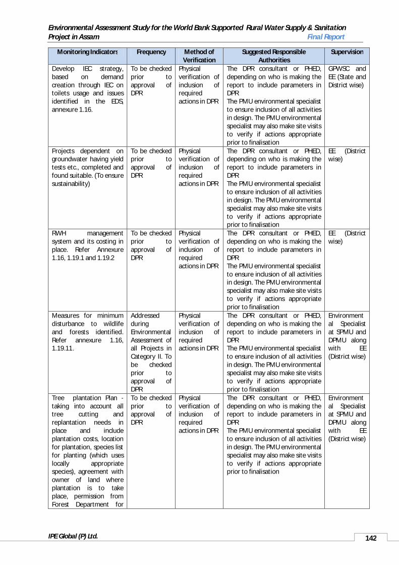
Environmental Assessment Study for the World Bank Supported Rural Water Supply & Sanitation Project in Assam Final Report
IPE Global (P) Ltd. 142
Monitoring Indicators Frequency Method of Verification
Suggested Responsible Authorities
Supervision
Develop IEC strategy, based on demand creation through IEC on toilets usage and issues identified in the EDS, annexure 1.16.
To be checked prior to approval of DPR
Physical verification of inclusion ofrequired actions in DPR
The DPR consultant or PHED, depending on who is making the report to include parameters in DPRThe PMU environmental specialist to ensure inclusion of all activities in design. The PMU environmental specialist may also make site visits to verify if actions appropriate prior to finalisation
GPWSC and EE (State and District wise)
Projects dependent on groundwater having yield tests etc., completed and found suitable. (To ensure sustainability)
To be checked prior to approval of DPR
Physical verification of inclusion of required actions in DPR
The DPR consultant or PHED, depending on who is making the report to include parameters in DPRThe PMU environmental specialist to ensure inclusion of all activities in design. The PMU environmental specialist may also make site visits to verify if actions appropriate prior to finalisation
EE (District wise)
RWH management system and its costing in place. Refer Annexure 1.16, 1.19.1 and 1.19.2
To be checked prior to approval of DPR
Physical verification of inclusion of required actions in DPR
The DPR consultant or PHED, depending on who is making the report to include parameters in DPRThe PMU environmental specialist to ensure inclusion of all activities in design. The PMU environmental specialist may also make site visits to verify if actions appropriate prior to finalisation
EE (District wise)
Measures for minimum disturbance to wildlife and forests identified.Refer annexure 1.16, 1.19.11.
Addressed duringEnvironmental Assessment of all Projects in Category II. To be checked prior to approval of DPR
Physical verification of inclusion of required actions in DPR
The DPR consultant or PHED, depending on who is making the report to include parameters in DPRThe PMU environmental specialist to ensure inclusion of all activities in design. The PMU environmental specialist may also make site visits to verify if actions appropriate prior to finalisation
Environmental Specialist at SPMU and DPMU along with EE (District wise)
Tree plantation Plan -taking into account all tree cutting and replantation needs in place and include plantation costs, location for plantation, species list for planting (which uses locally appropriate species), agreement with owner of land where plantation is to take place, permission from Forest Department for
To be checked prior to approval of DPR
Physical verification of inclusion of required actions in DPR
The DPR consultant or PHED, depending on who is making the report to include parameters in DPRThe PMU environmental specialist to ensure inclusion of all activities in design. The PMU environmental specialist may also make site visits to verify if actions appropriate prior to finalisation
Environmental Specialist at SPMU and DPMU along with EE (District wise)

Environmental Assessment Study for the World Bank Supported Rural Water Supply & Sanitation Project in Assam Final Report
IPE Global (P) Ltd. 143
Monitoring Indicators Frequency Method of Verification
Suggested Responsible Authorities
Supervision
clearance and other activities. Refer annexure 1.16 and 1.19. 11No structures in ecologically sensitive areas, ecologically significant area, or structures that may obstruct migratory paths or other routes of species like the endangered species – such as the Gharail in Dikhow. Refer annexure 1.16, 1.19.11 and list of exclusion/ negative list of projects.
To be checked prior to approval of DPR
Physical verification of inclusion of required actions in DPR, with appropriate design changes made
The DPR consultant or PHED, depending on who is making the report to include parameters in DPRThe PMU environmental specialist to ensure inclusion of all activities in design. The PMU environmental specialist may also make site visits to verify if actions appropriate prior to finalisation
Environmental Specialist at SPMU and DPMU along with EE (District wise)
Planning and design of unavoidable infrastructure takes into account cultural and natural habitats, local sensitivities and safety. Refer annexure 1.16, 1.19.11, 1.19.12, 1.19.13, 1.19.14
To be checked prior to approval of DPR
The DPR consultant or PHED, depending on who is making the report to include parameters in DPRThe PMU environmental specialist to ensure inclusion of all activities in design. The PMU environmental specialist may also make site visits to verify if actions appropriate prior to finalisation
EE (District wise)
Tree cutting undertaken to be only what is essential and in immediate way of infrastructure. Replanting plan to be reflective of any tree removal actions undertaken, with plantation actions ensuring a 1:3 ration of cut to replanted trees. DPR to include all compensation and permission required from the Forest Department for tree cutting.Refer annexure 1.16, 1.19.11, 1.19.14
To be checked prior to approval of DPR
Physical verification of inclusion of required actions in DPR. This must include documentation of permissions taken and costs for the plantation activities.
The DPR consultant or PHED, depending on who is making the report to include parameters in DPRThe PMU environmental specialist to ensure inclusion of all activities in design. The PMU environmental specialist may also make site visits to verify if actions appropriate prior to finalisation
Environmental Specialist at SPMU and DPMU along with EE (District wise)
Worker safety plan identified and safety gears etc., available and used at site during construction and for O&M. Refer annexure 1.19.1., 1.19.13, 1.19.15, 1.19.10
To be checked prior to approval of DPR
Physical verification of inclusion of required actions in DPR.
The DPR consultant or PHED, depending on who is making the report to include parameters in DPRThe PMU environmental specialist to ensure inclusion of all activities in design. The PMU environmental specialist may also make site visits to verify if actions appropriate prior to finalisation
Environmental Specialist at DPMU along with EE (District wise)

Environmental Assessment Study for the World Bank Supported Rural Water Supply & Sanitation Project in Assam Final Report
IPE Global (P) Ltd. 144
Monitoring Indicators Frequency Method of Verification
Suggested Responsible Authorities
Supervision
Structural Design of infrastructure followingBIS standards for identified disasters (Earthquake, Landslide). Refer annexure 1.16, 1.19.10
To be checked prior to approval of DPR
Physical verification of inclusion of required actions standards in DPR.
The DPR consultant or PHED, depending on who is making the report to include parameters in DPRThe PMU environmental specialist to ensure inclusion of all activities in design. The PMU environmental specialist may also make site visits to verify if actions appropriate prior to finalisation
Structural Engineers, EE at State and District Levels.
Permissions for digging and laying of infrastructure undertaken from all land owners, including Forest Department and other government agencies and certificate and permissions attached to the DPR.
To be checked prior to approval of DPR
Physical verification of inclusion of required permission needs and permission certificates in DPR
The DPR consultant or PHED, depending on who is making the report to include parameters in DPRThe PMU environmental specialist to ensure inclusion of all activities in design. The PMU environmental specialist may also make site visits to verify if actions appropriate prior to finalisation
Chief Engineer and EE (State)
Navigation routes, breeding sites for aquatic species mapped out and in DPR.In case intake is at a ghat, relocation plan and costin DPR. Refer annexure 1.16, 1.19.11, 1.19.12, 1.19.14
To be checked prior to approval of DPR
Physical verification of inclusion of required actions in DPR – the EDS should clearly identified any changes required
The DPR consultant or PHED, depending on who is making the report to include parameters in DPRThe PMU environmental specialist to ensure inclusion of all activities in design. The PMU environmental specialist may also make site visits to verify if actions appropriate prior to finalisation
Chief Engineer, PHED and Environmental Specialist from SPMU
Design of infrastructure and is surrounding to beaesthetics and cultural appropriate
To be checked prior to approval of DPR
EDS must clearly identify any changes in the design to ensure cultural appropriate
The DPR consultant or PHED, depending on who is making the report to include parameters in DPRThe PMU environmental specialist to ensure inclusion of all activities in design. The PMU environmental specialist may also make site visits to verify if actions appropriate prior to finalisation
EE (District and State)
Mapping of all cultural and archaeologically important sites with respect to Project sitesincluded in DPR and required changes in infrastructure design made, permissions taken and certificate attached to DPR. Refer annexure 1.16, 1.19.12
To be checked prior to approval of DPR
Physical verification of inclusion of required maps etc along with appropriate alignment and included in DPR
Design in DPR should not disrupt these sites and should follow rule, with Appropriate permissions. The DPR consultant or PHED, depending on who is making the report to include parameters in DPRThe PMU environmental specialist to ensure inclusion of all activities in design. The PMU environmental specialist may also make site visits to verify if actions appropriate prior to finalisation
Chief Engineer and EE (State)

Environmental Assessment Study for the World Bank Supported Rural Water Supply & Sanitation Project in Assam Final Report
IPE Global (P) Ltd. 145
5.5.8.2 Construction Phase MonitoringDuring selection of contractors through Quality and Cost Based Selection (QCBS) system, Environmental Management capacity should be within the selected company/contractor to ensure Environmental Management (Proposed under EMF) of the RWSS project. Thus, it should be pre-required qualification criteria at the EOI stage to select appropriate contracting firms. Table 52 gives the construction Phase monitoring indicators as well as specific responsibilities. The supervision is either carried by a third party or internally through SPMUs formed under PHED, Assam.
Table 52: Suggested Monitoring for Construction Phase Activities
Monitoring Indicators Frequency Method of Verification
Suggested Responsible Authorities
Supervision
Site plan identified in the DPR and agreed to by construction agency in place for all construction and borrow sites, including construction workers. The site plan to include vehicle movement and parking, waste temporary parking and final disposal site, labour camp and facilities.
Review site management plan in place and being followed properly. Monitoring at random at sites, butreport compiled on a monthly basis from before construction commences.
Ensure that construction contractor has required clauses in place through physical verification.
Construction contractor to ensure all required activities and plans are in place. Construction contract clauses to be in place before the construction takes place.The EE in charge of the scheme to oversee implementation with any required support from the PMU
SPMU/ Third Part Inspection and Monitoring Agency (TPIMA)
Mitigation actions as outlined in DPR in place to arrest soil erosion, waterlogging and landslides.
Review if identified mitigation actions in DPR are in place and being followed properly. Monitoring at random at sites, but report compiled on a monthly basis from before construction commences.
Check for actions being in place, ensure contractor clauses are in place
Construction contractor to ensure all required activities and plans are in place. Construction contract clauses to be in place before the construction takes place.The EE in charge of the scheme to oversee implementation with any required support from the PMU
SPMU/ TPIMA
Silt traps etc., in place to reduce turbidity in river, as suggested in EMP and suitable for area
Review if identified equipment etc., is in place and being usedMonitoring at random at sites, but report compiled on a monthly basis from before construction commences.
Check for actions being in place, ensure contractor clauses are in place
Construction contractor to ensure all required activities and plans are in place. Construction contract clauses to be in place before the construction takes place.The EE in charge of the scheme to oversee implementation with any required support from the PMU
SPMU/ TPIMA
All vehicles and machinery is properly maintained and silent, no excessive noise or
Pre-construction baseline.Day time measurement since
Check for actions being in place, ensure contractor
Construction contractor to ensure all required activities and plans are in place. Construction
SPMU/ TPIMA

Environmental Assessment Study for the World Bank Supported Rural Water Supply & Sanitation Project in Assam Final Report
IPE Global (P) Ltd. 146
Monitoring Indicators Frequency Method of Verification
Suggested Responsible Authorities
Supervision
vibrations, as required for each area and identified in DPR through the use of the EDS.
all activities are expected to be done in the day timeIf not possible to identify schedule –should be done for 3 different times: peak traffic, day quite hours and late evening Monitoring on a monthly basis, randomly taken from different sites
clauses are in place
contract clauses to be in place before the construction takes place.The EE in charge of the scheme to oversee implementation with any required support from the PMU
Routes for access to sitesidentified and agreed to between construction agency, PHED/DPMU and land owner, and followed
Fortnightly monitoring at random, based upon route plan
Check for actions being in place, ensure contractor clauses are inplace
Construction contractor to ensure all required activities and plans are in place. Construction contract clauses to be in place before the construction takes place.The EE in charge of the scheme to oversee implementation with any required support from the PMU
SPMU/ TPIMA
Vehicles are properly covered, not dripping waste and not overloaded
Fortnightly monitoring at random, based upon route plan
Check for actions being in place, ensure contractor clauses are in place
Construction contractor to ensure all required activities and plans are in place. Construction contract clauses to be in place before the construction takes place.The EE in charge of the scheme to oversee implementation with any required support from the PMU
All sites rehabilitated and plantation activities identified in the DPR and agreed to by the construction agency in the contract completed before the construction company leaves
Photographic baseline (pre-construction) for restoration of site after the construction activity is completedFor plantation activities, plantation done based upon identified need by DPRBefore work baseline and end of work prior to making final
Check for rehabilitation actions undertaken, ensure contractor clauses are in place
Construction contractor to ensure all required activities and plans are in place. Construction contract clauses to be in place before the construction takes place.The EE in charge of the scheme to oversee implementation with any required support from the PMU
SPMU/ TPIMA

Environmental Assessment Study for the World Bank Supported Rural Water Supply & Sanitation Project in Assam Final Report
IPE Global (P) Ltd. 147
Monitoring Indicators Frequency Method of Verification
Suggested Responsible Authorities
Supervision
payment for work to contractor ensure all rehabilitation and plantation completed.
Health and safety measures, as identified in the DPR are in place and functioning. Accident management and clean-up plan in place, and in case of accidents is followed.
Monthly monitoring of health reports and accident reports to be undertaken
Check for actions being in place, accidents if occurring are properly managed, ensure contractor clauses are in place
Construction contractor to ensure all required activities and plans are inplace. Construction contract clauses to be in place before the construction takes place.The EE in charge of the scheme to oversee implementation with any required support from the PMU
SPMU/ TPIMA
Signage and safety measures as identified in DPR in place and functional at all construction sites
Monthly monitoring for all construction sites
Check for actions being in place, ensure contractor clauses are in place
Construction contractor to ensure all required activities and plans are in place. Construction contract clauses to be in place before the construction takes place.The EE in charge of the scheme to oversee implementation with any required support from the PMU
SPMU/ TPIMA
Identified grievance redressal system in place, functional, and responsive if used. There are no repeated complaints
Monthly monitoring of grievance redressal system. System should also be possible to check online and not just available with local EE
Check for grievance redressal system in place
The EE in charge of the scheme to oversee implementation with any required support from the PMU
SPMU/ TPIMA
No destruction or damage to any culturally important or archaeological site from project activities
Fortnightly monitoring at any culturally or archaeologically important site
Check for actions being in place, ensure contractor clauses are in place
Construction contractor to ensure all required activities and plans are in place. Construction contract clauses to be in place before the construction takes place.The EE in charge of thescheme to oversee implementation with any required support from the PMU
SPMU/ TPIMA
5.5.8.3 Operation and Monitoring Phase MonitoringTable 53 suggests possible monitoring actions for the O&M phase of the project. This is based upon identified impacts of the project and their management actions.

Environmental Assessment Study for the World Bank Supported Rural Water Supply & Sanitation Project in Assam Final Report
IPE Global (P) Ltd. 148
Table 53: Monitoring Suggested Monitoring for O&M Phase Activities
Monitoring Indicators
Frequency Method of Verification
Suggested Responsible Authorities
Supervision
WTP and its surroundings and system including network clean, no water problems or drainage problems. Management plan identified in DPR in place and functional
Daily maintenance of WTP and monitoring of cleanliness and drainage for network and rest of system as requiredQuarterly monitoring of WTP
Physical verification O&M in place and training for system management has taken place as required
Identified management of system to maintain systemMonitoring by EE in charge of schemeReports to be submitted to PMU
GPWSC and DWSC
WTP housekeeping as identified in DPR in place and functional, with chemicals and equipment properly kept
Daily maintenance of system Quarterly month monitoring of WTP
Physical verification of O&M and chemical management system properly managed
Identified management of system to maintain systemMonitoring by EE in charge of schemeReports to be submitted to PMU
GPWSC and DWSC
Records at WTP properly maintained, as identified in DPR
Daily records kept Quarterly monitoring of records at WTP
Physical verificationof records
Identified management of system to maintain systemMonitoring by EE in charge of schemeReports to be submitted to PMU
GPWSC and DWSC
Accident management plan for WTP in place, known to the workers and operator
Quarterly monitoring of WTPIn case of accident immediate reporting to EE in charge of system and immediate action undertaken based upon plan
Physical verification to check system in place and functional
Identified management of system to maintain system and respond to emergencyMonitoring and support to be provided by EE in charge of schemeReports to be submitted to PMU
GPWSC and DWSC
Change in the percent of unaccounted forwater, resulting in reduced leakages. (Leak detection and management plan)
Daily maintenance of system including leak detection. Leaks must be repaired immediatelyRecords of leak detection and repair with dates to be kept, including complaints register from consumerQuarterly monitoring of registers and reports
Physical verification to check system in place and functional
Identified management of system to maintain systemMonitoring by EE in charge of schemeReports to be submitted to PMU
GPWSC and DWSC
Drinking water disinfection system in place, storage of bleaching powder and other chemicals for disinfection in place
Daily maintenance of system including record keepingQuarterly monitoring of records and system
Physical verification to check system in place and functional, including records being kept properly
Identified management of system to maintain systemMonitoring by EE in charge of schemeReports to be submitted to PMU
GPWSC and DWSC
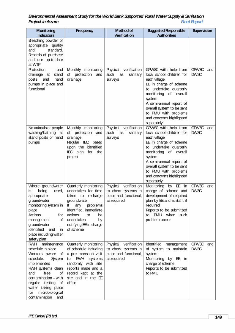
Environmental Assessment Study for the World Bank Supported Rural Water Supply & Sanitation Project in Assam Final Report
IPE Global (P) Ltd. 149
Monitoring Indicators
Frequency Method of Verification
Suggested Responsible Authorities
Supervision
Bleaching powder of appropriate quality and standard. Records of purchase and use up-to-dateat WTPProtection and drainage at standposts and handpumps in place and functional
Monthly monitoring of protection and drainage
Physical verification such as sanitary surveys
GPWSC with help from local school children for each villageEE in charge of scheme to undertake quarterly monitoring of overall systemA semi-annual report of overall system to be sent to PMU with problems and concerns highlighted separately
GPWSC and DWSC
No animals or people washing/bathing at stand posts or hand pumps
Monthly monitoring of protection and drainageRegular IEC, based upon the identified IEC plan for the project
Physical verification such as sanitary surveys
GPWSC with help from local school children for each villageEE in charge of scheme to undertake quarterly monitoring of overall systemA semi-annual report of overall system to be sent to PMU with problems and concerns highlighted separately
GPWSC and DWSC
Where groundwater is being used, appropriate groundwater monitoring system in placeActions for management of groundwater identified and in place including water safety plan
Quarterly monitoring undertaken for time taken to recharge groundwaterIf any problems identified, immediate actions to be undertaken by notifying EE in charge of scheme
Physical verification to check systems in place and functional, as required
Monitoring by EE in charge of scheme and development of required plan by EE and is staff, if requiredReports to be submitted to PMU when such problems occur
GPWSC and DWSC
RWH maintenance schedule in placeWorkers aware of schedule. System implementedRWH systems clean and free of contamination – with regular testing of water taking place for microbiological contamination and
Quarterly monitoring of schedule including a pre monsoon visit to RWH systems randomly with site reports made and a record kept at the site and in the EE office
Physical verification to check systems in place and functional, as required
Identified management of system to maintain systemMonitoring by EE in charge of schemeReports to be submitted to PMU
GPWSC and DWSC

Environmental Assessment Study for the World Bank Supported Rural Water Supply & Sanitation Project in Assam Final Report
IPE Global (P) Ltd. 150
Monitoring Indicators
Frequency Method of Verification
Suggested Responsible Authorities
Supervision
records maintained and up-to-dateAny small and individual schemesunder project are properly maintained and water provided is safe as identified in DPR.
Daily maintenance of systemQuarterly monitoring of schemes
Physical verification to check systems in place and functional, as required
Identified management of system to maintain systemMonitoring by EE in charge of schemeReports to be submitted to PMU
GPWSC and DWSC
Solid waste management in place and functioning as identified in DPR.
Quarterly monitoring of village with records kept, solid waste disposed as identified in village solid waste management strategy for each village
Physical verification to check systems in place and functional, as identified
Overall responsibility for individual wastewater and solid waste is with each household. Monitoring at village level with GPWSC or other identified management of system with help from local school children for each village
GPWSC and DWSC
Sanitation and environmental sanitation actions as identified in guidelines developed by DPR in place and functioning
Quarterly monitoring of village for identification of implementation of strategy – with reports submitted to EE in charge of area
Physical verification to check systems in place and functional
Overall responsibility for individual wastewater and solid waste is with each household. Monitoring at village level with GPWSC or other identified management of system with help from local school children for each villageMonitoring by EE in charge of schemeReports to be submitted to PMU
GPWSC and DWSC
5.6 Training and Capacity BuildingThe state currently has limited capacity for environmental management. The capacity building and IEC strategy has been outlined as part of the EMF program developed for the project aims at building environmental awareness and environmental management capacity in the project administration structure as well as in the intended target communities. Capacity building for environmental management will be integrated with overall capacity building component of the project.
5.6.1 ObjectivesThe objectives of the capacity building initiatives are:
To build and strengthen the capability of rural water and sanitation service delivery institutions (PRIs and PHED) and other partners (NGOs, contractors, consultants, SLUC) to ensure appropriate management of environmental concerns identified for sustainability of the planned water and sanitation service system.

Environmental Assessment Study for the World Bank Supported Rural Water Supply & Sanitation Project in Assam Final Report
IPE Global (P) Ltd. 151
To orient the service delivery staff and elected PRI representatives to the requirements of the project’s environmental management framework.
Create understanding on WB environmental safeguards
Ensure proper development of projects and schemes, considering environmental safeguards as identified in the EMF.
Ensure that monitoring of identified environmental safeguards is undertaken.
Ensure that any unforeseen impacts from project are addressed in time.
5.6.2 Training Needs Assessment
A specific training program for the key officials of the project, focused on the procedural and technicalaspects of environmental assessment and management shall be developed. This training would bemandatory for the SO personnel and GP personnel. The project shall fulfil (a) short-term training on EMFapplication in planning and implementing of schemes under the proposed project to all stakeholdersconcerned including the potential beneficiary communities (b) water quality monitoring and watershedconservation training to Department of Rural Development and regulating authorities. The training shallinvolve initial orientation, main training program and livener training programs.
Trainings to introduce, Environmental Management in Proposed RWSS project including EMF will include, Filling of EDS, procedural and technical aspects of Environmental Assessment. The main purpose of the training will be (i) To equip relevant officials with knowledge and skills necessary forundertaking environmental appraisal as per the requirements of the EMF; (ii) To undertake periodic supervision of environmental performance of schemes; (iii) To prepare for planning and monitoringimplementation of environmental mitigation measures identified through the appraisal process; (iv) To equip with skills necessary for water quality testing using the field testing kits under the Community based System for water quality Monitoring and Surveillance. Trainings towards EnvironmentalAwareness and Sensitization will be necessary to build awareness on safe drinking water, waterconservation, environmental sanitation and personal hygiene
5.6.3 Training ApproachSystematic capacity building initiatives will be introduced only after completion of training needs assessment. The training will be of cascade mode. All the trained staff and others will in turn conduct further trainings at state, district, block and GP levels, depending upon their roles. However, since capacity building goes beyond mere imparting training, institutionalization of best practices becomes a prerequisite for improved service delivery.
5.6.4 Training ResourcesIn view of the specialized training and capacity building envisaged under the EMF of the project, it is necessary to identify nodal training institutes that will work closely work with capacity building wing of PSU for conceptualizing, designing, conducting and managing training programs on the EMF. Some such specialized institutions are:
Engineering Staff College of India: Engineering Staff College of India (ESCI) is an autonomous organ of The Institution of Engineers, India. It is the country's premier professional organization, imparting continuing education for engineers and managers in the Engineering profession. ESCI provides trainings in Environmental Management as per MOEF guidelines, to government organisations.

Environmental Assessment Study for the World Bank Supported Rural Water Supply & Sanitation Project in Assam Final Report
IPE Global (P) Ltd. 152
National Academy of Construction: National Academy of Construction (NAC) provides technical guidance in Engineering and Construction.
UNICEF: UNICEF facilitated a pilot programme on Water Quality and Security in 9 districts of Assam in the 2011-12. These districts prepared Village Level Plans which were than advocated to be integrated in the district as well as State PIP.
5.6.5 Training Programmes
5.6.5.1 T1. Training on the Environmental Management Framework
Purpose of the training:
To equip with knowledge and skills necessary for undertaking environmental appraisal as per the requirements of the EMF
To prepare for undertaking periodic supervision of environmental performance of schemes To prepare for implementing Community Based System for Water Quality Monitoring and
Surveillance
Participants: Key officials of the project including AEE/AE, EE, Superintending Engineer (SE), State and District Level Environmental Experts and District Resource Persons and SLUCs– Environmental Management. The superintending Engineer of the district will be responsible for selection of suitable candidates for the training, and the expenses will be borne by the overall project capacity building budget.
Schedule: The training will include an initial orientation workshop, a main and annual refresher training workshops on environmental assessment. The main and refresher training programs will be for duration of 2-3 days each, whereas the initial orientation workshop will be of one day duration. Five Training programs will be conducted during the first year and 5 refresher programs per year will be conducted for the next 4 years. This will total to 25 programs.
5.6.5.2 T2. Training on Environmental Management
Purpose of the training:
To equip with knowledge and skills necessary for meaningful participation in the environmental appraisal as per the requirements of the EMF
To prepare for planning and monitoring implementation of environmental mitigation measures identified through the appraisal process
To equip with skills necessary for water quality testing using the field kits under the Community Based System for Water Quality Monitoring and Surveillance
Participants: SOs, members of VWSC and GPWSC – Environmental Management.
The Superintending Engineer of the district will be responsible for selection of suitable candidates for the training, and the expenses will be borne by the overall project capacity building budget.
Schedule: The training will include an initial orientation workshop, a main and annual refresher training workshops on environmental assessment. The main and refresher training programs will be for duration of 2-3 days each, whereas the initial orientation workshop will be of one day duration. There will be about 1000 GPWSCs and VWSC and about 100 SOs totalling to about 1,100. At about 50 per batch there will be about 22 training programs.

Environmental Assessment Study for the World Bank Supported Rural Water Supply & Sanitation Project in Assam Final Report
IPE Global (P) Ltd. 153
Considering that an equal number of refresher trainings will be conducted, the total T2 training programs will be about 44 for the project duration.
5.6.5.3 T3. Environmental Awareness and Sensitization
Purpose of the training:
To build awareness on safe drinking water, water conservation, environmental sanitation and personal hygiene.
Participants: AEEs/ AEs, SOs, Members of GPWSC and NGOs.
Schedule: The training will involve one day workshops at the VWSC level. There will also be one day refresher workshops organized annually. There will be about 1000 GPWSCs and VWSCs and about 100 SOs totalling to about 1100. At about 50 per batch there will be about 22 training programs. Considering that an equal number of refresher trainings will be conducted, the total T3 training programs will be about 44 for the project duration.
5.6.5.4 T4. Quality Construction Practices for Artisans
Purpose:
To equip with knowledge and skills for quality construction and maintenance of water and sanitation structures (including aspects of environmental conservation, human health and safety, etc.)
Participants: Masons, mechanics, electricians, plumbers etc., and for the contractors' workforce involved in the project.
Schedule: The training will involve one day workshops at the VWSC level. There will also be one day refresher workshops organized annually. There will be about 1000 artisans at one per GPWSCs and VWSCs and about 100 resource persons totalling to about 1100. At about 50 per batch there will be about 22 training programs. Considering that an equal number of refresher trainings will be conducted, the total T4 training programs will be about 44 for the project duration. The number of suggested training programs is presented in Table 54 below.
Table 54: Number of Training Programmes Suggested
About 40 to 50 trainees would participate in each of the training programs. It is intended that these trained persons will in turn provide onsite training to PHED staff, SOs, GPWSCs, VWSCs, NGOs, Contractor staff, etc. onsite at village level.
5.6.6 Budget for Training on Environmental Management
The total estimated cost of training on environmental management for members of GPWSCs, VWSC, NGOs/ SOs, Engineers of PHED, and artisans, under the proposed plan is presented in the Table 55below.
Sl No Training Topic Number of trainings1 T 1 - Environmental Management Framework 25
2 T2 - Environmental Management 443 T3 - Environmental Awareness and Sensitization 444 T4 - Quality Construction Practices for Artisans 445 Total 157

Environmental Assessment Study for the World Bank Supported Rural Water Supply & Sanitation Project in Assam Final Report
IPE Global (P) Ltd. 154
Table 55: Estimated Cost for Training
Sl No.
Training No. Of Programs
Estimated unit cost (INR)
Cost (INR)
1 T 1 - Environmental Management Framework
25 50,000 12,50,000
2 T2 - Environmental Management 44 50,000 22,00,000
3 T3 - Environmental Awareness and Sensitization
44 20,000 8,80,000
4 T4 - Quality Construction Practices for Artisans
44 20,000 8,80,000
5 Workshops (State) 5 50,000 2,50,0006 Workshops (District) 38 20,000 7,60,000
Total 62,20,000
The total budget for environmental management activities under the proposed RWSS project has been worked out as approximately INR 2.92 crore. The detailed break up of the budget is presented in Table 56 below.
Table 56: Budget for Environmental Management
Sl No Activity Amount (INR)1 Training and workshops (as estimated) 62,20,000
2 Internal supervision visits @ INR 10.0 lakhs per year for 5 years
50,00,000
3 Environmental Audit by the external agency once in a year (5 Nos) @INR 10.0 lakhs per year
50,00,000
4 Preparation of specific environment related community awareness materials @ 1 lakh per district and 5 lakh at state level
43,00,000
5 EA for Category II projects @ 10 lakhs per year for 5 years. 50,00,0006 External Environmental Monitoring @ INR 2.0 lakhs per year
for 5 years (Includes remuneration to MRPs, DRPs and other resource persons)
10,00,000
Sub Total 2,65,20,000Contingencies @, 10% 26,52,000Total 2,91,72,000

Environmental Assessment Study for the World Bank Supported Rural Water Supply & Sanitation Project in Assam Final Report
IPE Global (P) Ltd. 155
5.6.7 Environmental Management Plan for Design and Location Impacts
Environmental Issues Mitigation MeasuresInadequate drainage provided with increased water availability, or at infrastructure sites increasing waterlogging, soil toxicity, impacting habitats, archaeological etc.
Ensure DPR design includes drainage improvement measures that account for present drainage needs and needs based on extra water availability, and for planned infrastructure.
Dumping of waste from treatment plants resulting in increased toxicity of the local area.
Ensure proper waste management plan identified and implemented. Also refer annexure 1.19.1, 1.19.8 and 1.19.15
Inadequate storage of chemicals and other material at treatment plants resulting in seepage and contamination of ground locally
Ensure proper management plan for WTP in place with trained staff to manage WTP.
Poor design of handpumps, standposts resulting in risk of contamination of waterIn protection provided for system resulting in risk of contamination
Ensure that design has protection planned of hand pumps and stand posts, where usedIdentify appropriate design parameters for hand pumps and standposts, where used. Also refer annexure 1.19.1
Need for material to build systems, resulting in removal of earth may reduce stability and landslides may occur, though this is more likely a cumulative impact occurring from a number of different activities as individually systems identified from such projects would have limited needs.
Post construction site rehabilitation to be included in project cost and measures given in DPR. Also refer annexure 1.19.8 and 1.19.14
Location of sites such as pump houses, treatment plants and reservoirs and their access roads on hills may require vegetation clearance and result in reduced stability of the area
All identified sites must have rehabilitation, site stability and other measures taken into account while designing as a part of DPR. Also refer annexure 1.19.8 and 1.19.14
Conflict or competition with other users at the location where the intake and water abstraction structure is planned, Also may impact overall resource sustainability
Plan site after consultation with local population to ensure there is no conflict. Also refer annexure 1.19.13 and 1.19.14
Design not accounting for backwash needs may result in temporary water stagnation locally
WTP design must ensure that there is a proper drainage system in place for backwash water, accounting for local drainage patterns, slopes etc.
Pollution due to poor design, resulting in leakages or dumping of waste. This may be more of a concern with floating barges.
Need to identify an appropriate waste management system that includes waste collection and disposal from all infrastructure sites. Should be in project DPR. Also refer annexure 1.19.8
Inadequately designed wastewater discharges, excessive sewage and toilet waste may result in contamination of water system, or creation of disease vector habitats
Identification of wastewater and drainage system as part of DPR. Also, to identify appropriate IEC to increase awareness and demand for toilets and their better management. Also refer annexure 1.19.1 and 1.19.3 to 1.19.9

Environmental Assessment Study for the World Bank Supported Rural Water Supply & Sanitation Project in Assam Final Report
IPE Global (P) Ltd. 156
Environmental Issues Mitigation MeasuresExcessive withdrawal of water resulting in groundwater depletion Identify sustainable yield at time of project sitting, and consider other users prior to
finalising project. Have monitoring system for all groundwater systems in place, to ensure no unsustainable withdrawal of water.Augment source in case of excessive withdrawal with other sources or through RWH for distribution or recharge. Also refer 1.19.2
Poorly designed RWH systems may result in groundwater contamination
Identify RWH systems only where needed and appropriate. For example do not undertake RWH to recharge aquifers rich in arsenic. Identify appropriate RWH management systems as part of DPR and ensure its budgets and other needs are included in DPR. Also refer 1.19.2
Intake, pumping system or WTP in an ecologically sensitive area, areas with wildlife present or species breeding habitats may result in disturbances during the day to day running, and also create conflict with local wildlife.
To the extent possible do not construct infrastructure in ecologically sensitive area.In areas where no possibility for better siting, only intake should be within an ecologically sensitive area, but design must ensure (i) no disturbance to wildlife with system including sound proofing; (ii) ensure that minimal movement exists in the area; (iii) in case of animal corridors, no obstructions should exist and as required structures may be underground, also nothing other than pipes in corridors should be installed and that too only if there is no other option; (iv) no waste or waterlogging in the area should be allowed, with appropriate site management ensured; and appropriate planting and vegetative cover, as required for the area identified. Prior to finalising anything in such an area discusses with the Forest Department about the project needs. Also refer 1.19.11
Poorly designed system may result in unnecessary clearance of vegetation and cutting of trees
DPR should include minimal vegetation clearance and must be based upon site. To the extent possible plantation plans must also be made for the area. For all trees cut/removed, plantation should be at the ratio of for every 1 cut planting of 3 trees. Also refer 1.19.11
Introduction of alien species or flora as part of landscape or other activities resulting in take over of ecological niche or destruction of habitat of local flora species and forest areas, or due to such species being planted in animal corridors/migratory routes they may be transported into forest areas as species cross the area, carrying the plant seeds etc along with them
Ensure no alien species are planted as a part of project activities. In areas of animal corridors, ensure that planted species are appropriate for the overall ecosystem. For example, they should not result in the degradation of the forest and other ecosystems that the animals pass though as a part of their movement. Also refer 1.19.11
Pollution due to poor design, resulting in leakages or dumping of waste. This may be more of a concern with floating barges. This may result in local habitats being impacted.
Ensure appropriate waste management systems have been designed, the workers trained for it and the system is working properly.

Environmental Assessment Study for the World Bank Supported Rural Water Supply & Sanitation Project in Assam Final Report
IPE Global (P) Ltd. 157
Environmental Issues Mitigation MeasuresIn River Brahmaputra and some of its tributaries such as Dikhow and the Manas recent siting of the critically endangered Indian Grahial have been made. River Brahmaputra is also one of the last remaining habitats of the endangered Gangetic Dolphin. Existing structures, waste management water intakes or day to day running and noise and pollution from floating barges may disturb these species. Also, poorly designed systems may become obstructions in areas which are frequented by the species.
Ensure that there is no waste from the intake or other structures dumped in rivers or water bodies. Ensure that the systems are properly maintained and running well. Ensure that the machinery identified, including generators etc., have low noise emissions,Ensure that the identified location for intakes, floating barges etc., are not in important habitats of any species. Discuss with local population and the forest department prior to finalising intake points.Designs can be discussed with the Forest Department and appropriate wildlife experts, as required prior to finalising. Also refer 1.19.8 and 1.19.11
Poor design of intake resulting in obstructions and dumping of waste may result in trapping of aquatic species or injuries to them
Ensure that the intake pipes etc do not trap or injure any species,Identify with Forest Department probable species in an area and appropriate needs for identified species area and include them in the designEnsure that the design of the structures do not cause any injury or obstruction for any species, Also refer 1.19.11
Infrastructure in migratory routes and corridors, resulting in disturbance and destruction of route. It may also result in destruction and damage of infrastructure
Ensure no overland infrastructure is in corridors. In case of pipelines etc that cross corridors, they must be buried underground. All corridors and migratory routes must be brought to original condition after any construction work is completed. Also refer 1.19.11
Location of infrastructure in forest areas or pipes passing through forests may result in damage
Avoid locating infrastructure or laying pipes in forest areas. If unavoidable identify methods which result in least cutting of trees and clearance of vegetation.In case any work is undertaken in forest area, after completed restore forests to original condition. Any tree cutting should have a minimum compensation of 3 trees for every 1 cut. Also refer 1.19.11
In areas where the Indian grahial is found, if there are any intakes or floating barges, accidents of conflict of workers with the species could occur.
Ensure proper design to protect workers in areas where the gharial are found. Train and create awareness among workers to ensure minimum risk to them while working in the area.Provide any safety equipment required while working in the area. Also, project design in areas where species like the gharail are found should ensure minimum risk to workers, such as need to work in water or to take up any maintenance resulting in getting into water. These designs should be finalised along with wildlife experts and the Forest Department to ensure appropriate designs. Also refer 1.19. 13 and 1.19.11
Poor design standards, not considering existing disasters – such as Ensure appropriate BIS standards are used for design and construction.

Environmental Assessment Study for the World Bank Supported Rural Water Supply & Sanitation Project in Assam Final Report
IPE Global (P) Ltd. 158
Environmental Issues Mitigation Measuresearthquakes and floods, resulting in contamination or breakages and subsequent health impacts
All designs must consider existing flood risks and the High Flood Level (HFL) in the design.Also refer 1.19.10
Poor design and waste management systems may also create habitats for certain disease vectors like the sand fly which results I Kala-Azar/black fever or Visceral leishmaniasis, a disease with a recent outbreak (2008) in Chandrapur and Panikheti, both of which are within the present project area.
Ensure proper waste management systems are in place, drainage is properly addressed in the project and identify post construction waste disposal and site rehabilitation needs in DPR. Also refer 1.19.10
Location of planned structures, obstructing or creating other problems for existing WSS infrastructure
Prior to finalising the project design and location of infrastructure, discuss with local population residing in area to ensure that there are no obstructions or problems to other WSS infrastructure.
Waste from redundant systems – being upgraded. Where possible reuse material. What is not possible to reuse, dispose in an appropriate area. Also refer 1.19.8
Need to cut across lines and roads laid down for other infrastructure, thereby resulting in disruption or damage
Design to ensure minimum digging and disturbance of other infrastructure is undertaken. In case of need to cut across any infrastructure, identify appropriate time to undertake work and take permission. Discuss with local population to ensure minimum disturbance.
Disruption of navigation routes, piers (ghats) especially in smaller rivers and streams used for supplying water
Discuss with villagers location of ghats and navigation routes prior to finalising intake sites. In case it is not possible to avoid these locations, identify ways to relocate ghats etc., to other appropriate areas and include the design, cost etc., for relocation in DPR.
Location of intake may interfere with local fish landing sites, access to river, cut across agriculture fields, or transport routes
Discuss with farmers/fisher men etc., prior to locating infrastructure. Where possible avoid these sites, if not refer to social assessment for rehabilitation needs.
Poor design resulting in structures reducing aesthetics in area Ensure design of structures is appropriate for site, and ensure plantation or other activities as required as part of design.
Structure and connected infrastructure cutting across archaeological and other culturally important sites
Avoid all areas where there are archaeological or other important cultural sites. Also refer 1.19.12
5.6.8 Environmental Management Plan for Construction Stage ImpactsEnvironmental Issues Mitigation MeasuresPoor chemicals storage, spillage and waste dumping, waterlogging and accidents resulting in toxicity to environment
Storage of material needs to be considered carefully to ensure that all material is stored in the same placeEnsure appropriate containers and protection to reduce spillage and contamination of surface and groundwater. Identify appropriate spill and accident management plan and educate workers on it. Make required material available for clean up Ensure all vehicles are properly maintained and serviced – and they are not washed or

Environmental Assessment Study for the World Bank Supported Rural Water Supply & Sanitation Project in Assam Final Report
IPE Global (P) Ltd. 159
Environmental Issues Mitigation Measuresserviced in and around the quarries, rivers and other construction sitesAll sites should have a waste collection and disposal plan developed and executed.Ensure all waste is stored properly and required permission for the final disposal is done appropriately. All sites should be cleaned up and restored to their earlier position, as far as possible, before finishing the work. After construction work is completed dismantle all labour camps and other construction sites, and rehabilitate them – e.g., ensure all waste is properly disposed. Also refer 1.19.13
Compaction of soil/soil erosion for access to various sites and to quarries by trucks and from borrow sites
As far as possible use already identified roads and routes to access various sites and ensure all vehicles follow the same route.Rehabilitate the route after construction/quarrying activities are completed such as ploughing and plantation activities. Also refer 1.19.14
Material procurement from hills and removal of vegetation for fuel or to clear for material procurement resulting in hills caving in and land and mud slides and scaring of landscape
As far as possible use already identified roads and routes to access various sites and ensure all vehicles follow the same route.Plan site prior to starting excavation activities, including slope stabilization, identify and developing appropriate slope aspect during excavation and contouring to ensure slope stability after earth borrowing activities are completed. Undertake plantation, as required, once earth work is completed (both at the excavation and the construction sites)Only clear vegetation that must be for any construction or material sourcing work. Also refer 1.19.11
Blockage of natural drains due to waste dumping or during construction
Ensure proper waste management and disposal at all sites
Sediment runoff and deposition near sites or during transportation. Dust and sand flying from trucks during transportation and air pollution from vehicles and machinery
Use silt fences around areas used for excavation and storage of earthEnsure all vehicles carrying earth are covered and not overloadedDo not undertake any activity at high wind times, to the extent possibleDo not dump or deposit earth in the river or water bodiesPlan soil excavation keep slope aspect in mind, to ensure least possible disturbance to the slope and sediment runoff. This will also help reduce possibility of accidents at the site. Ensure all vehicles are properly serviced and emissions are within permissible GoI guidelinesFill fuel in vehicles from authorized dealers, to reduce possibility of contamination and increased emissionsTo the extent possible, ensure waste is not burnt as a means of disposal. Also refer 1.19.11and 1.19.13

Environmental Assessment Study for the World Bank Supported Rural Water Supply & Sanitation Project in Assam Final Report
IPE Global (P) Ltd. 160
Environmental Issues Mitigation MeasuresMaterial procurement – sand from rivers leading to increased turbidity and course change in smaller streamsImpact on local fisheries and fish spawning and aquatic fauna. Increased turbidity from sand mining or other activities may result in disturbance or degradation of local habitats
Ensure least possible disturbance to the river during the construction and quarrying activities. Ensure all work is done efficiently and as quickly as possible, to minimize disturbance to the area. Any work to be undertaken that needs working in the running waters should be completed within the shortest duration of time, and any identified critical biological cycles of fauna and flora identified (eg migration and spawning) should be avoided.In-stream work should be fenced off to reduce disturbance of sediments of moving watersEnsure all vehicles and machinery are properly maintained so as not to leave grease etc on river bedEnsure no waste is disposed in riverbedVehicles should not be wash or clean in water bodiesRehabilitation of borrow sites from the river should be considered. Also refer 1.19.11 and 1.19.14
Poor labour camp management and insufficient WSS systems for them, or no rehabilitation of labour camp and construction site after construction work is over resulting in pollution or accidents and other health risks to labour
Ensure all personnel working at the site have protective gear and are trained in using them; ensure safety equipment is available as required and in good condition. Since some of the sections of the project interventions there could be a risk to the workers and appropriate protective and safety measures need to be considered to avoid and reduce accidents and injuries to the workers. Ensure sites for storage of all construction material, vehicles etc., is properly identified, with appropriate signage and areas which are accident prone cordoned with restricted entry and adequate lighting.Restrict public entry to the area during construction, to avoid accidents.All construction personnel shall be subjected to routine vaccinations and other preventive/healthcare measures, as required. The work and campsites shall have suitable facilities for handling any emergency situation like fire, explosion, accidents etc. All areas intended for storage of hazardous materials shall be kept separately and out of reach of unauthorized personnel. Required permits will be needed and adequate safety and emergency facilities should be available. The personnel in charge of restricted areas shall be properly trained, licensed and with sufficient experience. Any labour brought from outside must be provided with appropriate shelter, toilets with appropriate sewage treatment and disposal systems and energy for cooking. Also refer 1.19.3 to 1.19.14
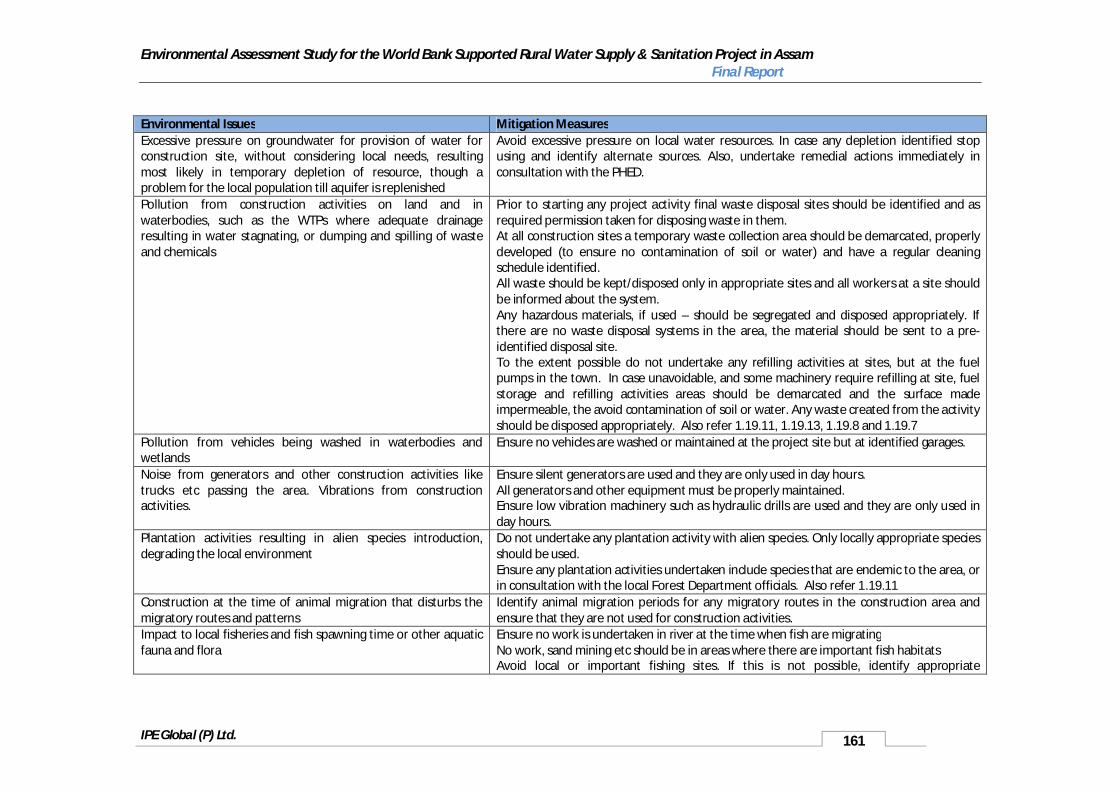
Environmental Assessment Study for the World Bank Supported Rural Water Supply & Sanitation Project in Assam Final Report
IPE Global (P) Ltd. 161
Environmental Issues Mitigation MeasuresExcessive pressure on groundwater for provision of water for construction site, without considering local needs, resulting most likely in temporary depletion of resource, though a problem for the local population till aquifer is replenished
Avoid excessive pressure on local water resources. In case any depletion identified stop using and identify alternate sources. Also, undertake remedial actions immediately in consultation with the PHED.
Pollution from construction activities on land and in waterbodies, such as the WTPs where adequate drainage resulting in water stagnating, or dumping and spilling of waste and chemicals
Prior to starting any project activity final waste disposal sites should be identified and as required permission taken for disposing waste in them.At all construction sites a temporary waste collection area should be demarcated, properly developed (to ensure no contamination of soil or water) and have a regular cleaning schedule identified.All waste should be kept/disposed only in appropriate sites and all workers at a site should be informed about the system.Any hazardous materials, if used – should be segregated and disposed appropriately. If there are no waste disposal systems in the area, the material should be sent to a pre-identified disposal site.To the extent possible do not undertake any refilling activities at sites, but at the fuel pumps in the town. In case unavoidable, and some machinery require refilling at site, fuel storage and refilling activities areas should be demarcated and the surface made impermeable, the avoid contamination of soil or water. Any waste created from the activity should be disposed appropriately. Also refer 1.19.11, 1.19.13, 1.19.8 and 1.19.7
Pollution from vehicles being washed in waterbodies and wetlands
Ensure no vehicles are washed or maintained at the project site but at identified garages.
Noise from generators and other construction activities like trucks etc passing the area. Vibrations from construction activities.
Ensure silent generators are used and they are only used in day hours. All generators and other equipment must be properly maintained.Ensure low vibration machinery such as hydraulic drills are used and they are only used in day hours.
Plantation activities resulting in alien species introduction, degrading the local environment
Do not undertake any plantation activity with alien species. Only locally appropriate species should be used. Ensure any plantation activities undertaken include species that are endemic to the area, or in consultation with the local Forest Department officials. Also refer 1.19.11
Construction at the time of animal migration that disturbs the migratory routes and patterns
Identify animal migration periods for any migratory routes in the construction area and ensure that they are not used for construction activities.
Impact to local fisheries and fish spawning time or other aquatic fauna and flora
Ensure no work is undertaken in river at the time when fish are migratingNo work, sand mining etc should be in areas where there are important fish habitatsAvoid local or important fishing sites. If this is not possible, identify appropriate
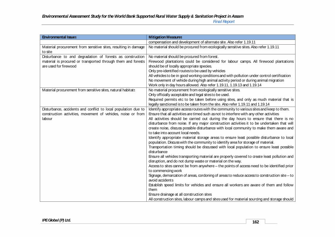
Environmental Assessment Study for the World Bank Supported Rural Water Supply & Sanitation Project in Assam Final Report
IPE Global (P) Ltd. 162
Environmental Issues Mitigation Measurescompensation and development of alternate site. Also refer 1.19.11
Material procurement from sensitive sites, resulting in damage to site
No material should be procured from ecologically sensitive sites. Also refer 1.19.11
Disturbance to and degradation of forests as construction material is procured or transported through them and forests are used for firewood
No material should be procured from forest. Firewood plantations could be considered for labour camps. All firewood plantations should be of locally appropriate species. Only pre-identified routes to be used by vehiclesAll vehicles to be in good working conditions and with pollution under control certificationNo movement of vehicle during high animal activity period or during animal migrationWork only in day hours allowed. Also refer 1.19.11, 1.19.13 and 1.19.14
Material procurement from sensitive sites, natural habitats No material procurement from ecologically sensitive sites. Only officially acceptable and legal sites to be used. Required permits etc to be taken before using sites, and only as much material that is legally sanctioned is to be taken from the site. Also refer 1.19.11 and 1.19.14
Disturbance, accidents and conflict to local population due to construction activities, movement of vehicles, noise or from labour
Identify appropriate access routes with the community to various sites and keep to them. Ensure that all activities are timed such as not to interfere with any other activities All activities should be carried out during the day hours to ensure that there is no disturbance from noise. If any major construction activities it to be undertaken that will create noise, discuss possible disturbance with local community to make them aware and to take into account local needs. Identify appropriate material storage areas to ensure least possible disturbance to local population. Discuss with the community to identify area for storage of material. Transportation timing should be discussed with local population to ensure least possible disturbanceEnsure all vehicles transporting material are properly covered to create least pollution and disruption, and do not dump waste or material on the way. Access to sites cannot be from anywhere – the points of access need to be identified prior to commencing work Signage, demarcation of areas, cordoning of areas to reduce access to construction site – to avoid accidentsEstablish speed limits for vehicles and ensure all workers are aware of them and follow themEnsure drainage at all construction sitesAll construction sites, labour camps and sites used for material sourcing and storage should

Environmental Assessment Study for the World Bank Supported Rural Water Supply & Sanitation Project in Assam Final Report
IPE Global (P) Ltd. 163
Environmental Issues Mitigation Measuresbe restored and cleaned as soon as the construction work for the site is completed. Also refer 1.19.7, 1.19.8, 1.19.13 and 1.19.14
Increase water stagnation and drainage problems due to construction activities, inadequate drainage from construction and yield testing, poorly managed labour or construction sites and vehicles being cleaned and serviced in the area
Identify drainage needs for all project sites including material procurement sites and ensure drainage in put in place. Also refer 1.19.17
Damage to infrastructure due to vehicular movement, construction sites or labour camps and during transportation of material, storage of material
Vehicles should take pre-identified routes as far as possible, and not try and develop new routes, to ensure least possible disturbance to the areaFor girder bridges, and other infrastructure, do not put drive vehicles with loads higher that what they can takeIf damage to infrastructure occurs, repair infrastructure immediately and bring to original condition. Also refer 1.19.11, 1.19.13 and 1.19.14
Chance findings – archaeological sites. Stop all work that may be underway or planned in the area and discuss with District Commissioner for further actionEnsure that the construction company and supervising consultants have an understanding of archaeological concerns in the areaEnsure that any important archaeological area is well identified and demarcated and required actions are demarcated in a detailed management and mitigation plan so that no damage takes place to it. Also refer 1.19.12
Scaring of landscape due to borrow sites, such as in hills or from firewood collection
Ensure all work is well organized and contained in a small area.Restore and clean area after work is over Also refer 1.19.14
5.6.9 Environmental Management Plan for Operation and Maintenance State ImpactsEnvironmental Issues Mitigation MeasuresPoor management of WTP, intakes and floating barges resulting in dumping of waste, backwash water with excessive chemicals and waste and sludge on land, resulting in pollution and disturbance to wildlifeChemical spillage from WTP or during O&MPoor maintenance of WTP and pumping station and any diesel pump sets used as back up energy supply, resulting in high noise levels and air pollutionAccidents and injuries due to poorly managed systems, or inadequate skills to manage system or safety equipment during
Train operators and the support staff on the management of the system and give appropriate refreshers training as neededIdentify appropriate management of system that includes chemical storage and waste management, including disposal of bleaching powder slurryEnsure regular monitoring of system to identify problems and rectify them, as needed.In case of any wildlife movement work with the Forest Department to ensure appropriate remedial measure to reduce disturbance to wildlife.Identify accident management plan, train workers on it and ensure required equipment etc., are available in case of accident/spillage of material.Identify an appropriate reporting mechanism for spillages and accidents to monitor all sites,

Environmental Assessment Study for the World Bank Supported Rural Water Supply & Sanitation Project in Assam Final Report
IPE Global (P) Ltd. 164
Environmental Issues Mitigation Measuresmaintenance or at the WTP or pumping stationPoor maintenance of system, network and breakages and leaks not managed properly resulting in contamination of treated water and ill healthNear sensitive areas - corridors or fly paths being disturbed due to poor maintenance of systems or dumping of waste
in case there are some prone to problems to help rectify problems.Ensure availability of spares etc., for timely repair.In case of breakages and leaks create awareness on need for disinfection at point-of-use to minimise risk till such time the leaks are meant. Also refer 1.19.7, 1.19.8, 1.19.9 and 1.19.15
Insufficient knowledge to manage the system resulting in inadequate disinfection, cleaning of system or other management issues resulting in poor quality water being suppliedPublic standposts and systems not protected resulting in animals accessing them or people washing and cleaning around them
Identify appropriate storage of disinfection. In case bleaching powder is used, ensure it is properly kept, not more than 3 months old and used based upon directions. Please refer to Annexure 1.19.15 on appropriate use and management of bleaching powder for disinfection.
Excessive pumping of groundwater, beyond planned resulting in depletion of resourceDevelopment of other and competing groundwater systems which together with this system result in depleting of resource
Any system dependent on groundwater should be monitored to ensure that there is no over abstraction. If over abstraction exists, based upon the water safety planning of the PHED identify appropriate management actions, such as aquifer recharge. Also refer 1.19.1 and 1.19.2
RWH system poorly maintained resulting in contamination of aquifer
Identify appropriate RWH maintenance schedule, train the operators and workers and ensure all required equipment is available and in good working condition.Monitor system to ensure system is managed properly. Also refer 1.19.2
Inadequate finances or skills to manage small or individual systems resulting in their degradation, accumulation of water around the system or breakage resulting in contamination of aquifer
Identify finances and skills for management of small schemes as a part of project design.
Unattended leakages from water supply system or poorly managed drainage and solid waste systems leading to vector habitats
Ensure all drainage systems are properly maintained.Ensure there is no waste dumping in and around the system.Monitor system regularly to ensure that system is properly maintained. Also refer 1.19.7, 1.19.8 and 1.19.9
Inadequate sanitation/ environmental sanitation management contaminating shallow aquifers in areas where dug wells or shallow rigs are used to procure water
Please refer guidelines on sanitation and environmental sanitation.Develop environmental and solid waste management strategy for village. Also refer 1.19.1 to 1.19.9
Poor maintenance of system resulting such as drainage and damage to any local cultural property.
Ensure all drainage systems are properly maintained.Ensure there is no waste dumping in and around the system.Monitor system regularly to ensure that system is properly maintained. Also refer 1.19.7, 1.19.8, 1.19.9 and 1.19.12

Environmental Assessment Study for the World Bank Supported Rural Water Supply & Sanitation Project in Assam Final Report
IPE Global (P) Ltd. 165
5.6.10 Water Safety Planning and Guidelines
The PHED has identified a water security and safety plan for the schemes to be taken up in the first phase of this project. These include Kamrup, Hailakandi and Jorhat. The water safety planning actions will cover access to drinking water at individual level a spatial baseline developed on a GIS platform mapping of baseline on GIS and regular and comprehensive water quality monitoring. Based upon BIS Drinking Water Quality norms (IS: 10500), 70 LPCD will need to be provided under this project, while also ensuring project sustainability. To ensure project sustainability water safety the planned actions by the PHED include,
Improvement in coverage status.
Addressing water quality concerns in problem areas.
Identify and managing source sustainability issues, as they arise.
Community involvement for ensuring water security.
Regular and constant monitoring of water quality.
5.7 Guidelines / Environmental Code of Practices
To ensure the proper implementation of the EMF a number of Guidelines/ Environmental Code of Practices (ECOP) have been developed. These are available in the annexure attached to this document. Given below are the ECOPs that have been developed to support the implementation of this project.
1. ECOP for sanitary protection of water supply sources: This is for the protection of taps, handpumps and other groundwater sources from contamination and is available in annexure1.19.1.
2. Guidelines for Sustainability of Ground Water Sources: To ensure sustainability of source, with a focus on groundwater and possible use of water harvesting is given in annexure 1.19.2.
3. Selection and installation of safe sanitation technologies; the checklist for choice of technology and selection of location is in annexure 1.19.3.
4. Recommended Construction Practice and Pollution Safeguards for Twin Pit Pour Flush toilets: These guidelines are to ensure that commonly adopted sanitation technology designs do not result in the contamination of water sources, and are described in annexure 1.19.5.
5. Appropriate Use and Management of Bleaching Powder for Disinfection: Since bleaching powder is commonly used for treating drinking water, these guidelines identify appropriate practices for disinfection and safe handling of the substance. The guidelines are in annexure 1.18.
6. Water Quality Monitoring and Surveillance: This annexure provides guidance on ways to undertake monitoring and surveillance to assure water quality – annexure 1.14.
7. Guidelines on Natural Habitat and Forests: Considering the location of the project in Assam, there is a need to use the precautionary approach while undertaking any activity in the State. These guidelines will help adopt this precautionary approach, and are available in annexure 1.19.11.

Environmental Assessment Study for the World Bank Supported Rural Water Supply & Sanitation Project in Assam Final Report
IPE Global (P) Ltd. 166
8. Guidelines on Cultural Property: This ECoP detailed out in annexure 1.19.12, has therefore been developed to ensure minimal impact on any cultural property identified during the detailed design or subsequently.
9. Guidelines on Public and worker’s health and safety: These guidelines safety measures to be taken to ensure the safety of both the public in the project area and workers executing the project’s activities. The Environmental Code of Practice is in annexure 1.19.13.
10. Development and Management of Borrow Pits: This ECoP; provided in annexure 1.19.14,identifies measures that need to be incorporated during borrow area location, material extraction and rehabilitation.