Environmental Assessment - riversimulator.org€¦ · Environmental Assessment ... APCD Air...
168
Transcript of Environmental Assessment - riversimulator.org€¦ · Environmental Assessment ... APCD Air...

1
Environmental Assessment
EGL Resources, Inc. Oil Shale Research, Development and Demonstration
Tract
CO-110-2006-118-EA
U.S. Department of the Interior Bureau of Land Management
White River Field Office 73544 Hwy 64
Meeker, CO 81641 July 2006
i
Table of Contents
ACRONYMS AND ABBREVIATIONS.................................................................................... iv BACKGROUND ............................................................................................................................1 PURPOSE AND NEED .................................................................................................................2 DESCRIPTION OF PROPOSED ACTION AND ALTERNATIVES .....................................3 PROPOSED ACTION...................................................................................................................5 SUBALTERNATIVES TO THE PROPOSED ACTION ........................................................10 NO ACTION ALTERNATIVE ..................................................................................................11 ALTERNATIVES CONSIDERED BUT NOT ANALYZED IN DETAIL ...........................11 PLAN CONFORMANCE REVIEW..........................................................................................12 AFFECTED ENVIRONMENT AND ENVIRONMENTAL CONSEQUENCES.................13 CRITICAL ELEMENTS ............................................................................................................13
Air Quality and Climate....................................................................................................... 13 Areas of Critical Environmental Concern............................................................................ 22 Cultural Resources ............................................................................................................... 23 Farmlands, Prime and Unique.............................................................................................. 26 Floodplains........................................................................................................................... 28 Invasive, Non-Native Species.............................................................................................. 28 Migratory Birds.................................................................................................................... 31 Native American Concerns .................................................................................................. 36 Threatened, Endangered, and Sensitive Animal Species..................................................... 36 Threatened, Endangered, and Sensitive Plant Species......................................................... 47 Wastes, Solid or Hazardous ................................................................................................. 50 Water Quality, Surface and Ground..................................................................................... 53 Wetlands and Riparian Zones .............................................................................................. 61 Critical Elements Not Affected or Not Present.................................................................... 62
NON-CRITICAL ELEMENTS ..................................................................................................62 Soils...................................................................................................................................... 62 Vegetation ............................................................................................................................ 66 Wildlife, Aquatic.................................................................................................................. 69 Wildlife, Terrestrial.............................................................................................................. 71
OTHER NON-CRITICAL ELEMENTS...................................................................................75 Access and Transportation................................................................................................... 75 Fire Management ................................................................................................................. 78 Forestry Management .......................................................................................................... 81 Geology and Minerals.......................................................................................................... 83 Hydrology and Water Rights ............................................................................................... 86 Noise .................................................................................................................................... 92 Paleontology ........................................................................................................................ 94 Rangeland Management....................................................................................................... 95 Realty Authorizations .......................................................................................................... 97 Recreation ............................................................................................................................ 99
ii
Socioeconomics ................................................................................................................. 101 Visual Resources................................................................................................................ 110 Wild Horses ....................................................................................................................... 112
CUMULATIVE IMPACTS ......................................................................................................112 Air Quality ......................................................................................................................... 116 Areas of Critical Environmental Concern.......................................................................... 118 Cultural Resources and Native American Religious Concerns ......................................... 118 Soils and Farmlands, Prime and Unique............................................................................ 119 Floodplains......................................................................................................................... 119 Water Resources, Surface and Ground .............................................................................. 119 Vegetation and Invasive, Non Native Species................................................................... 120 Migratory Birds.................................................................................................................. 120 Threatened, Endangered, and Sensitive Animal Species................................................... 121 Threatened, Endangered, and Sensitive Plant Species....................................................... 121 Wastes, Solid or Hazardous ............................................................................................... 121 Wetlands and Riparian Zones ............................................................................................ 122 Wilderness.......................................................................................................................... 122 Wildlife, Aquatic, and Terrestrial ...................................................................................... 122 Access and Transportation................................................................................................. 123 Fire Management ............................................................................................................... 123 Forestry Management ........................................................................................................ 124 Geology and Minerals........................................................................................................ 124 Hydrology and Water Rights ............................................................................................. 124 Noise .................................................................................................................................. 125 Paleontology ...................................................................................................................... 125 Rangeland Management..................................................................................................... 125 Realty Authorizations ........................................................................................................ 126 Recreation .......................................................................................................................... 126 Socioeconomics ................................................................................................................. 126 Visual Resources................................................................................................................ 128 Wild Horses ....................................................................................................................... 129
REFERENCES...........................................................................................................................130 CONSULTATION, PREPARATION, AND REVIEW .........................................................140 TABLES Table 1 Anticipated Annual Oil and Gas Production ..................................................................... 7 Table 2 Oil Shale Project Average Temperature and Annual Precipitation ................................. 14 Table 3 Assumed Background Concentrations of Regulated Air Pollutants................................ 15 Table 4 EGL Oil Shale RD&D Project Emissions Summary....................................................... 19 Table 5 Predicted Maximum Direct Air Quality Impacts during EGL RD&D Operations ......... 20 Table 6 ACECs Near the Project Area ......................................................................................... 22 Table 7 Cultural Resources Located Within the Proposed Tract.................................................. 24 Table 8 Cultural Resources Located Within the Proposed EGL Tract During the Class III Inventory ....................................................................................................................................... 25

iii
Table 9 Noxious Weed Species that May be Present in the White River Field Office and Rio Blanco County .............................................................................................................................. 29 Table 10 Partners in Flight Priority Birds Potentially in the Project Area ................................... 31 Table 11 Special Status Wildlife Species ..................................................................................... 37 Table 12 Water Quality Data for Black Sulphur Creek, 1975 – 1981.......................................... 54 Table 13 Soils at the EGL Tract ................................................................................................... 63 Table 14 Ecological Sites on the EGL Tract ................................................................................ 66 Table 15 Vegetative Disturbance Anticipated at the EGL Oil Shale RD&D Tract...................... 66 Table 16 Seed Mixes for Revegetation of the EGL Tract ............................................................ 68 Table 17 Big Game Population Data ............................................................................................ 72 Table 18 Big Game Range Data ................................................................................................... 72 Table 19 Other Non-Critical Elements ......................................................................................... 75 Table 20 Baseline Traffic Data for Project Area .......................................................................... 76 Table 21 Pinyon-Juniper Woodlands at the EGL Tract................................................................ 82 Table 22 Monthly Stream Flow Statistics..................................................................................... 87 Table 23 Aquifer Hydraulic Properties Near the EGL Tract....................................................... 89 Table 24 Sound Levels Associated With Noise Environments and Field Operations.................. 93 Table 25 COGCC Allowable Noise Levels .................................................................................. 93 Table 26 Grazing Allotments Crossed in the Project Area........................................................... 96 Table 27 Grazing Allotment Vegetation Association Disturbance for Proposed Action ............. 96 Table 28 County Employment Data for Years 2000-2005 ......................................................... 101 Table 29 Rio Blanco County Sheriff’s Office Piceance Creek Area Statistics .......................... 106 Table 30 Surface Disturbance Estimate for Past, Present, and Reasonably Foreseeable Future Projects in the WRRA................................................................................................................. 113 Table 31 Maximum Potential Cumulative Air Quality Impacts by Impact Region ................... 116
FIGURES Figure 1 Location of EGL Tract within the White River Resource Area Figure 2 Site Map with Facilities Figure 3 Access and Transportation Routes Figure 4 Schematic Diagram of the Surface Water-Groundwater Flow System in the Piceance Creek Area Figure 5 Description of Hydrostratigraphic Units – Shell Oil Test Site, Piceance Basin, Colorado APPENDICES Appendix A Proposed Action and Subalternative Mitigation Summary

iv
Acronyms and Abbreviations °F Degrees Fahrenheit ACEC Areas of Critical Environmental Concern AERMOD Atmospheric Dispersion Model APCD Air Pollution Control Division AQRV Air Quality Related Values AUM animal unit month B.P. Before Present BACT Best Available Control Technology BLM Bureau of Land Management BTU British Thermal Units CAA Clean Air Act CAAQS Colorado Ambient Air Quality Standard CDLE Colorado Department of Labor and Employment CDOT Colorado Department of Transportation CDOW Colorado Division of Wildlife CDPHE Colorado Department of Public Health and Environment CERCLA Comprehensive Environmental Response, Compensation, and Liability Act CFR Code of Federal Regulations CO Carbon Monoxide COGCC Colorado Oil and Gas Conservation Commission CPR Cardiopulmonary Resuscitation CR County Road DAU Data Analysis Unit dB Decibels dBA A-weighting Decibels DOLA Department of Local Affairs DRMP Draft Resource Management Plan EA Environmental Assessment EGL EGL Resources, Inc. EIS Environmental Impact Statement Enterprise Enterprise Products Operating, LP EO Executive Order EPA Environmental Protection Agency ERMA Extensive Recreation Management Area ESA Endangered Species Act Est. Estimate FC Candidate for federal listing FE Federally Endangered FLAG Federal Land Managers’ Air Quality Related Values Work Group FLPMA Federal Land Policy Management Act FMAP Fire Management Activity Plan

v
FONSI Finding of No Significant Impact FR Federal Register FS United States Department of Agriculture (USDA) Forest Service ft. foot FT Federally Threatened GMU Game Management Unit in. inch kg/ha-yr kilogram per hectare-year Ldn Day/Night Noise Level LLC Limited Liability Corporation MBTA The Migratory Bird Treaty Act mg/L milligram per liter MPH miles per hour MSL mean sea level MU Modified Urban NAAQS National Ambient Air Quality Standards NEPA National Environmental Policy Act NGL Natural Gas Liquid NOx oxides of nitrogen NO2 nitrogen dioxide NRCS Natural Resources Conservation Service NRHP National Register of Historic Places OHV Off-Highway Vehicle OST Oil Shale Test P Primitive PEIS Programmatic Environmental Impact Statement PIF Partners in Flight PM2.5 particulate matter less than 2.5 microns in effective diameter PM10 particulate matter less than 10 microns in effective diameter PSD Prevention of Significant Deterioration psig Pounds per square inch gauge R Rural RD&D Research, Development and Demonstration RCRA Resource Conservation and Recovery Act RMP Resource Management Plan RN Roaded Natural ROD Record of Decision ROW Right-of-Way ROS Recreation Opportunity Spectrum RV Recreational Vehicle SARA Superfund Amendments and Reauthorization Act SC State Special Concern SE State Endangered

vi
Shell Shell Frontier Oil, Inc SHPO Colorado State Historic Preservation Office SO2 sulfur dioxide SPCC Spill Prevention, Control and Countermeasure SPM Semi-Primitive Motorized SPNM Semi-Primitive Non-Motorized SSS Special Status Species ST State Threatened TDS Total Dissolved Solids USDI United States Department of the Interior USFWS U.S. Fish and Wildlife Service USGS United States Geological Survey USFWS U.S. Fish and Wildlife Service VOC volatile organic compounds VRM Visual Resource Management WRRA White River Resource Area WRCC Western Regional Climate Center WRFO White River Field Office WSA Wilderness Study Area µg/m3 micrograms per cubic meter μeq/l microequivalent per liter
1
U.S. Department of the Interior Bureau of Land Management
White River Field Office 73544 Hwy 64
Meeker, CO 81641
ENVIRONMENTAL ASSESSMENT NUMBER: CO-110-2006-118-EA
CASEFILE/PROJECT NUMBER (optional): COC-69169 PROJECT NAME: Oil Shale Research, Development and Demonstration (RD&D) Tract LEGAL DESCRIPTION: Sixth Principal Meridian, T. 2 S., R. 98 W., sec. 21, E1/2SW1/4, W1/2SE1/4 APPLICANT: EGL Resources, Inc.
BACKGROUND EGL Resources, Inc. (EGL) is proposing an oil shale research, development, and demonstration (RD&D) project on Bureau of Land Management (BLM) administered land in northwestern Colorado in accordance with BLM’s Oil Shale RD&D Program announced in the Federal Register (FR, June 9, 2005, Vol. 70, No. 110). Pursuant to Section 21 of the Minerals Leasing Act (1920, as amended, 30 USC 241), the BLM solicited RD&D proposals to demonstrate technologies for unlocking deposits of energy now trapped in oil shale deposits including, the nomination of lands to be leased for the RD&D project. In response to its FR announcement, BLM received 20 nominations for parcels of public land to be leased in Colorado, Utah, and Wyoming. The initiative was subsequently endorsed by Congress in the Energy Policy Act of 2005, Public Law 109-58 (H.R. 6). An interdisciplinary team, consisting of representatives from the three states (Colorado, Utah, and Wyoming), the Department of Energy, the Department of Defense, and BLM staff members from the affected states, considered the potential of each nomination based on the following criteria prior to recommending proposals for eligibility in the oil shale recovery RD&D program:
• The nomination’s potential to advance oil shale technology • The nomination’s economic viability • The nomination’s potential environmental effects.
2
Ultimately, of the 20 nominations received, 6 were accepted and 14 were rejected. Five potential RD&D projects and the corresponding leases are located in Colorado (including EGL’s proposal) and one in Utah. The RD&D site proposed by EGL encompasses a 160-acre tract and associated preference rights to an additional contiguous area of 4,960 acres as established in the FR notice. The larger area may be converted to commercial leases at a future time after additional BLM review and approval. Upon a company's successful demonstration of an environmentally sound and economically viable shale oil recovery technology, BLM will non-competitively convert the preference right acreage into a commercial oil shale lease for fair market value. Separate environmental review of the larger preference right acreage would occur at that time because the terms and conditions of the RD&D lease do not guarantee the issuance of the additional 4,960 acres or the conditions underwhich such lands would be leased. Leases will be issued with sufficient terms and conditions to allow BLM to monitor for and prevent unnecessary and undue degradation to public lands. This Environmental Assessment (EA) addresses only the 160-acre nominated lease site and the Plan of Operations for the RD&D project proposed by EGL and does not analyze additional impacts or development potential associated with the preference right acreage. In accordance with the National Environmental Policy Act (NEPA), the EGL proposal (Proposed Action) will be thoroughly analyzed in this EA. Based upon the results, BLM will decide whether a 160-acre lease will be issued to EGL for research, development and demonstration of oil shale recovery technology, and whether to authorize activities. If BLM exercises its discretion to issue an oil shale RD&D lease, the lease will be conditioned with sufficient terms to allow BLM to monitor for, and prevent unnecessary and undue degradation to public lands. The Energy Policy Act of 2005, Public Law 109-58 (H.R. 6), enacted August 8, 2005, also directs the Secretary of the Interior (the Secretary) to complete a programmatic environmental impact statement (PEIS) for a commercial leasing program for oil shale and tar sands resources on public lands with an emphasis on the most geologically prospective lands within each of the states of Colorado, Utah, and Wyoming. This program is being pursued by BLM in addition to the RD&D program. The scope of the PEIS will include an assessment of environmental, social, and economic impacts of leasing oil shale and tar sands resources, including foreseeable commercial development activities on BLM-administered lands located in Colorado, Utah, and Wyoming; discussion of relevant mitigation measures to address these impacts; and identification of appropriate programmatic policies and best management practices to be included in BLM land use plans. The PEIS will address land use plan amendments in the affected resource areas to consider designating lands as available for oil shale and tar sands leasing and subsequent development activities.
PURPOSE AND NEED The Piceance Basin of northwestern Colorado contains substantial oil shale resources on public lands. The Department of Interior has identified the need to research and demonstrate on a pilot scale, within the next ten years, the technical, economic and environmental feasibility of in-situ technology using gentle uniform heating as a means of extracting liquid energy fuels from oil

3
shale on public lands. The purpose of the proposed action is to lease 160 acres of public land for a research, development and demonstration project that will inform and advance knowledge of commercially viable production, development and recovery technologies consistent with sound environmental management. EGL has proposed a research project to evaluate the feasibility and commercial viability of developing oil shale resources in-situ. The intent of this proposal is to achieve a “proof of concept.” That is, while laboratory experiments and theoretical calculations indicate that various in-situ methodologies are viable commercial options, none have been thoroughly field tested to evaluate the practical application. The proposed action provides the opportunity to practically apply those specific technologies under field conditions. The project results will advance knowledge of these methodologies regardless of whether or not they prove commercially viable. EGL research will gather additional data on oil shale recovery using gentle, uniform heating of the shale to the desired temperature to convert kerogen to oil and gas. The intent of the EGL proposal is to prove an in-situ development and production method using drilling and fracturing technology to install conduit pipes into and beneath the target zone. A closed circulation system would circulate pressurized heating fluid. The methodology requires circulating various heating fluids through the system. EGL plans to test the sequential use of different heating fluids during different phases of the project. BLM has concluded that analyzing EGL’s proposed sequential recovery processes is warranted and may advance knowledge regarding the commercial viability of in-situ technologies for hydrocarbon recovery from oil shale.
DESCRIPTION OF PROPOSED ACTION AND ALTERNATIVES BLM proposes leasing a 160-acre tract located approximately 20 miles west-northwest of Rio Blanco, Colorado and authorizing a Plan of Operations for an oil shale research, development, and demonstration project. The RD&D program is the first phase of BLM’s oil shale program and is designed to test a variety of extractive technologies on a relatively small scale in a field environment, in order to learn more about the technical and economical feasibility and environmental management challenges associated with the technology. Applicants were directed to submit proposals with the potential to prove commercial feasibility within ten years to inform BLM’s decisions concerning authorization of commercial scale operations on public lands. EGL’s proposal is consistent with the Federal Register Notice published June 9, 2005. The lease will be issued with sufficient measures to allow BLM to monitor for and prevent unnecessary and undue degradation to public lands. To achieve the goals of the RD&D program to advance knowledge of effective technology, economic viability, and sound environmental management, the FR contained specific requirements for a complete application including:
• description of the lands, not to exceed 160 acres together with any rights-of-way required to support the development of the oil shale research, development and demonstration lease;

4
• narrative description of the proposed methodology for recovering oil from oil shale, including a description of all equipment and facilities needed to support the proposed technology;
• narrative description of the results of laboratory and/or field tests of the proposed technology;
• schedule of operations for the life of the project and proposed plan for processing, marketing and the delivery of the shale oil to the market;
o BLM has determined the RD&D leases will be issued for an initial term of 10 years with an option to extend for five additional years upon demonstration that a process leading to commercial production is being diligently pursued;
• map of existing land use authorizations on the nominated acreage;
• estimated oil and/or oil shale resources within the nominated acreage boundary;
• method of oil storage and/or spent oil shale disposal;
• description of any interim environmental mitigation and reclamation;
• method of final reclamation and abandonment and associated projected costs; and
• proof of investment capacity, and a statement from a surety qualified to furnish bonds
to the U.S. government for the amount the applicant qualifies for under the surety’s underwriting criteria.
Since there are no final regulations for commercial oil shale development, the concepts of the federal oil shale RD&D program will be reflected in the terms of the lease form. The lease will be the governing document for the oil shale RD&D project until the project succeeds and converts to a commercial lease, fails to meet the goals of the program, or the lease terms expire. BLM will incorporate lease terms addressing incentives for development, conditions for environmental protection, appropriate bonding, and a provision to convert a successful RD&D project into a commercial lease. The RD&D lease will be issued for 10 years with the option to extend for up to 5 years if diligence is demonstrated. Rental fees will be waived for 5 years and royalties will be waived as long as the project is in a RD&D status. The proposed site location was chosen by the applicant to maximize the potential to demonstrate proof of the concept and produce oil in an economically viable and environmentally sound manner. Based on these factors, EGL identified a site with physical and environmental attributes favoring in-situ extraction, including but not limited to:
Geology - the Green River Formation contains the oil-shale rich zones including the Mahogany and R-6 zones. Existing data (e.g. data extrapolated from Fischer Assay data obtained from existing coreholes) support the estimates of oil potential to provide the opportunity to successfully demonstrate the technology.
5
Topography – level surfaces reduce environmental impacts and enhance access, construction of roads, well pads, ponds, facilities, etc. Hydrologic characteristics – to minimize impacts to groundwater.
In accordance with the National Environmental Policy Act, the proposed action will be thoroughly analyzed against alternative actions. Based upon the results, BLM will decide whether a 160-acre lease will be issued to EGL for research, development and demonstration of oil shale recovery technology, and whether to authorize activities. Proposed Action BLM proposes leasing a 160-acre tract located approximately 27 miles west-northwest of Rio Blanco, Colorado and authorizing a Plan of Operations for an oil shale research, development, and demonstration project. The EGL tract is situated on a ridge between Ryan Gulch and Black Sulphur Creek at elevations ranging from 6,795 to 6,965 feet. Both streams are tributaries of Piceance Creek. Vegetation is 48 percent rolling loam sagebrush and 52 percent pinyon-juniper. Construction of the RD&D facilities would be accompanied by clearance of 28 acres of rolling loam vegetation and 8 acres of pinyon-juniper vegetation. The location of the EGL tract is shown in Figure 1. The proposed layout of the EGL tract is provided in Figure 2. EGL proposes to conduct an RD&D project at the nominated 160 acre tract. EGL has developed a Plan of Operation for the 160-acre parcels on land managed by BLM to demonstrate a technology to develop oil shale. The Plan of Operation is available under separate cover, and is summarized below. Some project design features may have the effect of mitigating environmental impacts. However, subalternative mitigation measures will be addressed specifically in subsequent sections. Oil Shale Resource The oil shale that would be tested by EGL at the nominated 160-acre tract is a 300-foot-thick section comprised of the Mahogany zone (R-7) and the R-6 zone of the Green River formation, the top of which is at a depth of approximately 1,000-feet. The affected geologic unit would be approximately 1,000 feet long and 100 feet wide. At an estimated richness of 26 gallons of oil per ton of shale, the potential amount of oil in the unit to be tested is over 560 thousand barrels per acre. For this test, the Mahogany and R-6 zones would be retorted to reduce costs and time, but the oil shale below the Mahogany and R-6 zones could still be retorted at a later date on the 160-acre tract. Deeper zones (R-5 through R-1) with an average richness of 15 gallons per ton could potentially yield an additional 1.2 million barrels per acre.

6
Process Overview In the EGL oil shale process, heat would be introduced near the bottom of the oil shale zones to be retorted. This would result in a gradual, relatively uniform, gentle heating of the shale to 650-750 ºF to convert kerogen to oil and gas. Once sufficient oil has been released to surround the heating elements, it is anticipated that a broad horizontal layer of boiling oil would continuously convect hot hydrocarbon vapors upward and transfer heat to oil shale above the heating elements. Energy Delivery System EGL’s technology would involve drilling 5 cased wells that would vertically penetrate nearly the full length of the oil shale deposit to be tested. Once near the bottom of the oil shale zone, the wells would be drilled horizontally for a distance of about 1,000 feet to the opposite side of the pattern. The wells would then be directed/connected vertically upward through the oil shale and overburden to the surface. These and other wells described below would be drilled using the flooded reverse circulation method which uses a combination of fresh water and air drilling. This would minimize lost circulation problems in the Uinta formation and avoid contaminating any aquifers encountered. Bentonite and polymer would be used to control viscosity and maintain the desired mud weight. Drilling would require about 80 barrels per day of fresh water which would likely be purchased from local sources. Fracture stimulation would be used to ensure that the parallel heat transfer lateral holes along the bottom of the shale column to be heated are in communication with each other. These laterals are designed to be only 20 feet apart so the fracture stimulations would be a series of very small fractures propped open with 20/40 Ottawa sand. The cased wells entering the conduit well would be joined together by a common injection manifold system. The return wells would also be connected to a collection manifold. In this fashion, the wells would form part of a closed system, through which a heating fluid would be circulated. The heating fluid would be raised to sufficient pressure for circulation through the entire system, heated to the necessary final retorting temperature by surface heat transfer equipment, injected into the wells entering the conduit, and pumped through the multiple wells to provide heat to the oil shale deposit. The heating fluid would be returned at the surface to the heat transfer equipment for recycling. A number of heating fluids could be used, and the system is designed for sequential use of different heating fluids during different stages of the project, if required. It is expected that steam would be used during the initial heating phase of the development. During the later stages of processing a high temperature hot oil heat transfer medium, such as Dowtherm, Syltherm, and/or Paratherm, might be used. For the RD&D phase of the project, a 25-million-BTU-per-hour trailer or skid-mounted, direct-fired, forced-circulation steam generation boiler would be used. The boiler would initially be
7
fired by natural gas or propane, and would be capable of generating superheated steam at approximately 2,000 pounds per square inch gauge (psig) and temperatures up to 750 degrees Fahrenheit (°F). After retorting of the oil shale has begun, the boiler could be fired by gas and oil produced by the retorting process. Makeup water would be required for the boiler to compensate for minor steam losses and to maintain dissolved solids in the boiler at an appropriate level. In addition to use of a circulating high-temperature heat transfer fluid, the system would also be designed such that electrical heaters could be lowered into the heating wells. Operated in this fashion, the oil shale formation could be heated to several hundred degrees Farenhite with steam or another fluid, with final heating accomplished with electrical resistance heaters. Product Recovery Systems The principal means of oil generation would be through kerogen decomposition in the high-temperature zone that would be developed by the multiple-pipe energy delivery system. Initially, temperatures would be highest at the point at which the injection pipes leave the large vertical conduit pipe. Heating would move downward along the injection pipe system, and then horizontally. As kerogen decomposition proceeds, oil, gas and water would then be generated. The light ends would be distilled from the oil fraction. Any water initially present in the formation or produced during shale oil generation would also be vaporized. The volatilized hydrocarbons and water would tend to move through the oil shale, reaching cooler portions of the reservoir where condensation and liberation of heat would occur. The various fluid phases would move toward the recovery zones where they would be collected and pumped or transported by pressure differential to the surface. In order to recover the product, four production wells would be drilled with the coiled tubing drilling system through a large-diameter, insulated conduit pipe. The wells would be drilled to the top of the oil shale zone and then extend from near the top of the oil shale zone to near the horizontal portion of the energy delivery wells. The amount of oil and gas produced would increase during the early stages of the project as the tested oil shale unit heats, reaching a level of sustained production in approximately three years as shown in Table 1.
Table 1 Anticipated Annual Oil and Gas Production Year Oil
(barrels) Gas
(million standard cubic feet) 1 5,000 8 2 40,000 67
3 Plus 107,000 180 During sustained operation, it is expected that the product would be about 30 percent gas and 70 percent light oil, based on heating value. A moderate amount of retort water (approximately 50 barrels per day) would also be produced during the retorting process.

8
Energy Recovery During the early stages of retorting a unit of oil shale, the energy input would be completely used to heat the deposit and retort the kerogen. If the EGL project were to proceed to commercial operation, the heating fluid leaving the energy delivery wells would be directed to an adjacent unit of oil shale in which operations are just beginning. This would make it possible to recover a substantial fraction of the energy in the initial unit to partially cool the initial unit and make the overall operation more efficient. Since there would be only one unit tested during the pilot program on the tract, this energy recovery process would be simulated by circulating cool fluids through the hot shale. Groundwater Management In order to reduce the amount of groundwater infiltrating into the oil shale zone that would be heated, EGL would establish a dewatered zone in the retorting zone. This would be accomplished with 4-8 pumping wells surrounding the subsurface retort area. Extracted groundwater would be re-injected down gradient into the equivalent aquifer intervals in order to maintain the regional water table and avoid disturbing baseflow to nearby streams. Up-gradient and down-gradient multi-level monitoring wells would be installed to characterize the structure and properties of local aquifers, establish pre-development baseline groundwater conditions, better define the geology of the oil shale resource, and monitor water quality. One hydrologic monitoring well (Hydrologic Well Pad Location 24-21-298, SE/4, SW/4, Sec 21, T2S, R98W) has been drilled on the EGL tract by Shell Frontier Oil, Inc (Shell). EGL expects to receive the test data from that well and use it to further its analysis of site conditions. In addition, the stream flow and water quality in nearby streams and springs would also be monitored. Test Completion Circulation of the heating fluid would continue after production activities have been completed in order to partially cool the shale. After the oil shale has adequately cooled, groundwater would be allowed to re-enter the dewatered zone and spent shale. Any groundwater that has contacted the spent shale and that does not meet Colorado groundwater standards would then be pumped to the surface using the dewatering wells, treated as needed, and re-injected into comparable strata. Pumping and treating of contaminated groundwater would continue until groundwater quality meets applicable regulatory standards. Produced Shale Oil and Gas Shale oil produced during test operations would be separated from the gas and water produced with it and stored in tanks at the test site. The shale oil would be trucked to markets in Colorado, Utah, and Wyoming. The gas produced from retorting would be burned as boiler fuel, if possible. Otherwise, the gas would be flared.
9
Waste Storage and Disposal Wastewater from the site, including retort water (up to 50 barrels per day), boiler blowdown, and drilling waste would be trucked to a licensed disposal facility. Trash would be collected in animal-proof containers and periodically hauled to a sanitary land fill in Rio Blanco County. All other wastes would be collected and disposed of in a manner consistent with existing laws and regulations. Water Requirements Little water would be required for the test facility. Start up, dust suppression, personnel requirements, and drilling operations would require limited amounts of water (approximately 80 barrels per day for drilling) that would be purchased and trucked to the site from local sources. Water needed for sustained operations, for instance boiler water feed and make-up, would likewise be so acquired or taken from wells on site if possible. The total volume of water required from outside sources for sustained operation would be approximately 27 barrels per day. Staffing It is estimated that a total of 10 to 40 employees would be required during test operations. Three shifts would be worked when required, but most employees would work during daylight hours. During construction of the test facilities and drilling of the test wells more workers would be needed, and their numbers would vary from 10 to 100 depending on the phase of construction. Workers and contractors would commute to the job site during the test phase. Most traffic would be from Rifle, Meeker, and Rangely on Piceance Creek Road and State Highways 13 and 64. A man camp is not contemplated for the test phase, but workers whose presence would be required for extended non-routine testing might be temporarily housed in trailers. Utilities A new powerline would interconnect an existing powerline southwest of the tract and project facilities. The powerline would extend approximately 1,760 feet from the southwest corner of the tract to the existing powerline and have a 25-foot-wide right-of-way (ROW). Construction of the powerline could disturb as much as 1.0 acres outside the 160-acre tract boundary. Schedule Site facilities would be constructed and test wells drilled and completed after all permits and authorizations have been obtained. It is anticipated that the design, permitting, surface facility construction, drilling, and well completion would take approximately two to three years to complete after lease award and completion of necessary off-site testing.
10
At that point the actual heating and shale oil production from the test site would begin. Initial production of gas, water, and shale oil would be expected within a few months after down-hole heating begins, but substantial production of shale oil would not begin for at least a year or more. The testing phase would likely continue for approximately three years before oil shale retorting is completed and/or sufficient data is acquired to confirm the technical, environmental, and economic viability of the EGL oil shale process. After heating has ended, the recovery of shale oil has been completed and all other tests have been completed the site would be reclaimed. Additional Project Design Features Surface facilities constructed during the field test would occupy approximately 5-15 acres of the 160-acre tract, excluding well pads, roads and utility corridors that could require an additional 5–20 acres of surface disturbance. During construction plastic barriers would be used to control runoff from the site. Dust would be mitigated through the use of water trucks and sprays. The test area facilities would be fenced to keep out wildlife and cattle. Drilling reserve pits, approximately 30-feet wide x 40-feet long x 12-feet deep, would be constructed at each well, if needed, to contain drilling fluids for up to one year before being closed. Reserve pits will be lined, fenced on all four sides with net-wire and covered with plastic barrier to exclude both large and small animals and netted to prevent birds from accessing these pits. Reserve pits would be reclaimed as soon as possible after use. Top soil would be preserved and stockpiled for use in final site reclamation and abandonment. Surface disturbance would be limited to only those areas needed for RD&D activities. After the recovery of shale oil is completed and all other tests have been completed the site would be reclaimed. Monitoring would continue as long as needed to determine that the site is acceptable for abandonment or inclusion in subsequent commercial operations. A summary of the mitigation measures included in the project design is provided in Appendix A.
Subalternatives to the Proposed Action In addition to the proposed action, BLM has analyzed the environmental impacts of the proposed action with appropriate mitigation measures applied to the project design. The subalternative mitigation actions are described and analyzed in context of the proposed action in the ‘Affected Environment and Environmental Consequences’ section. The analysis assesses the environmental consequences of the proposed action, enumerates alternative mitigation actions, and evaluates the consequences of the mitigation. The alternatives mitigation measures, in addition to the project design features described above are intended to reduce impacts to health and the human environment and minimize surface use conflicts. Where no alternatives are necessary to reduce or minimize impacts (i.e. no impacts are anticipated) to a critical element, none are analyzed.
11
A summary of the mitigation measures included in the project design and additional mitigations in the subalternatives is provided in Appendix A.
No Action Alternative Under the No Action Alternative, the application for lease of BLM-administered lands and approval of the proposed oil shale RD&D project would be denied. All other valid uses of public lands would continue under existing authorization or would be considered for approval under the existing White River Resource Management Plan (RMP). Implementation of the No Action Alternative would prevent or postpone the surface and subsurface environmental impacts associated with the construction and operation of oil shale RD&D facilities on the 160-acre test site. EGL would not move forward with its research and development proposal at this time on the proposed location, and construction would not occur on BLM-administered lands. None of the impacts associated with the proposed action would immediately occur under the No Action Alternative. Research into improving technology to develop this strategic domestic energy resource would be delayed. The Energy Policy Act of 2005, Public Law 109-58 (H.R. 6), enacted August 8, 2005, directs the Secretary of the Interior (the Secretary) to complete a programmatic environmental impact statement (PEIS) for a commercial leasing program for oil shale and tar sands resources on public lands with an emphasis on the most geologically prospective lands within each of the states of Colorado, Utah, and Wyoming. Development of the PEIS is occurring simultaneously to this EA and is a common action across all alternatives. The scope of the PEIS will include an assessment of environmental, social, and economic impacts of commercially leasing oil shale and tar sands resources, including foreseeable commercial development activities on BLM-administered lands located in Colorado, Utah, and Wyoming; discussion of relevant mitigation measures to address these impacts; and identification of appropriate programmatic policies and best management practices to be included in BLM land use plans. The PEIS will address land use plan amendments in the affected resource areas to consider designating lands as available for commercial oil shale and tar sands leasing and subsequent development activities. The technology described in the proposed action of this EA would not be field tested and refined for commercial application unless and until the PEIS is complete and EGL is successful in securing a commercial lease.
Alternatives Considered but not Analyzed in Detail BLM considered, but did not analyze in detail, the following alternatives with regard to the location and technology described in the proposed action:
A. Relocating the 160-acre RD&D Lease to another site within the Preference Lease Area;
The preference lease area consists of the contiguous 4,960 acres adjacent to the proposed 160-acre tract. This alternative was not carried forward for detailed analysis. The basis of the proposed action is to provide the opportunity to prove the concept that a specific new and untested extraction technology will demonstrate an economic, technically feasible and environmentally acceptable means of recovering potential oil shale energy fuel resources.
12
Oil shale resources in the Piceance Basin are non-uniform in nature. The applicant proposed the best site to demonstrate the proof of concept for their project based on many factors, including: resource potential, technological and environmental factors. Alternatives that would result in modifications to site location may diminish BLM’s ability to advance knowledge of viable recovery technologies, and are unnecessary since no undue environmental degradation will occur. Therefore, any alternative proposing site relocation was considered unreasonable. Further, site relocation within the preference area would have substantially similar effects to the analyzed alternatives and incorporated mitigation, and has been eliminated as a viable proof of concept because the analysis would be redundant. B. Modified technologies or methodologies
Alternatives using modified technologies were considered but not carried forward for detailed analysis. The basis for the RD&D project is to provide individual companies the opportunity to prove the concept through a pilot scale demonstration that their specific lab-tested extraction technology will advance our knowledge of economically recovering potential oil shale energy fuel resources. The BLM assumed the applicant proposed a promising methodology to demonstrate the proof of concept for their specific technology for advancing knowledge for recovering potential oil shale energy fuel resources. Alternatives that would result in modifications to the technology or methodology could introduce unknown factors that may affect the RD&D outcome and diminish BLM’s capacity to meet the purpose of testing this technology. Moreover, given the low level of impacts identified, there is no reason to believe that a substitute technology or methodology would reduce the impacts of the action. Accordingly, BLM can analyze a reasonable range of alternatives without analyzing in detail other methodologies or technologies.
Plan Conformance Review The proposed project is subject to and has been reviewed for conformance with the White River Field Office (WRFO) Resource Management Plan (RMP) (43 Code of Federal Regulations (CFR) 1610.5, BLM 1617.3).
Name of Plan: White River Record of Decision and Approved Resource Management Plan (ROD/RMP). Date Approved: July 1, 1997 Decision Number/Page: 2-6 Decision Language: “…At the discretion of the Secretary of the Interior, research scale
lease tracts would be considered within lands available for oil shale leasing. Approval of research tracts would be based on the merits of the technology proposed.”
AFFECTED ENVIRONMENT AND ENVIRONMENTAL CONSEQUENCES Standards for Public Land Health In February 1997, the Colorado Standards for Public Land Health became effective for all public lands in Colorado. These standards apply to five categories of resource values: (1) upland soils, (2) riparian systems, (3) plant and animal communities, (4) threatened and endangered species
13
including BLM sensitive species, and (5) water quality. Standards describe conditions needed to sustain public land health and relate to all uses of the public lands. These findings are located in specific elements listed below.
CRITICAL ELEMENTS
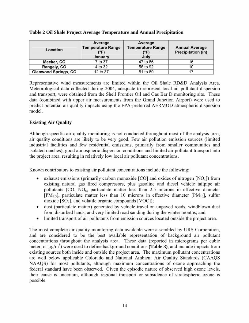
Air Quality and Climate Affected Environment The air quality of any region is controlled primarily by the magnitude and distribution of pollutant emissions and the regional climate. The transport of pollutants from specific source areas is strongly affected by local topography. In the mountainous western United States, topography is particularly important in channeling pollutants along valleys, creating upslope and down slope circulation that entrain airborne pollutants, and blocking the flow of pollutants toward certain areas. In general, local effects are superimposed on the general synoptic weather regime and are most important when the large-scale wind flow is weak. Topography The Oil Shale RD&D project area is located in the northern portion of the Piceance Basin, primarily within Rio Blanco County in northwestern Colorado. The Piceance Basin is bounded by the Cathedral Bluffs to the west, the Grand Hogback to the east, and the Roan Cliffs/Colorado River to the south. Further east is the Flattops Wilderness Area (a large elevated and flattened dome plateau ranging from nearly 9,000 to over 12,000 ft above mean sea level (msl)). The topography of the Piceance Basin varies from moderately steep mountains, canyons, and mesas in the north-central and south-central portions, to rolling hills and gently sloping river valleys in the eastern and western regions. Elevations range from about 6,000 to nearly 9,000 feet. Climate and Meteorology The Oil Shale RD&D project area is primarily pinion-juniper woodland at elevations from 6,000 to 7,200 feet with average annual precipitation between 13 to 17 inches, and pinyon-juniper/mountain browse at elevations from 6,100 to nearly 9,000 feet with average annual precipitation of 14 to 20 inches. Temperature and precipitation data obtained from the Western Regional Climate Center (WRCC, 2006) for Meeker, Rangely and Glenwood Springs, Colorado, are considered to be representative of climatic conditions within the project area. However, because elevation, slope, and aspect affect precipitation and temperatures, the complex terrain results in considerable climatic variability. Precipitation is typically well distributed throughout the year at nearly one inch per month, with mid-winter receiving the lowest average amounts (nearly 1 inch) and fall the highest levels (just under 2 inches). Average temperature and annual precipitation measurements are provided in Table 2.
14
Table 2 Oil Shale Project Average Temperature and Annual Precipitation
Representative wind measurements are limited within the Oil Shale RD&D Analysis Area. Meteorological data collected during 2004, adequate to represent local air pollutant dispersion and transport, were obtained from the Shell Frontier Oil and Gas Bar D monitoring site. These data (combined with upper air measurements from the Grand Junction Airport) were used to predict potential air quality impacts using the EPA-preferred AERMOD atmospheric dispersion model. Existing Air Quality Although specific air quality monitoring is not conducted throughout most of the analysis area, air quality conditions are likely to be very good. Few air pollution emission sources (limited industrial facilities and few residential emissions, primarily from smaller communities and isolated ranches), good atmospheric dispersion conditions and limited air pollutant transport into the project area, resulting in relatively low local air pollutant concentrations.
Known contributors to existing air pollutant concentrations include the following:
• exhaust emissions (primarily carbon monoxide [CO] and oxides of nitrogen [NOx]) from existing natural gas fired compressors, plus gasoline and diesel vehicle tailpipe air pollutants (CO, NOx, particulate matter less than 2.5 microns in effective diameter [PM2.5], particulate matter less than 10 microns in effective diameter [PM10], sulfur dioxide [SO2], and volatile organic compounds [VOC]);
• dust (particulate matter) generated by vehicle travel on unpaved roads, windblown dust from disturbed lands, and very limited road sanding during the winter months; and
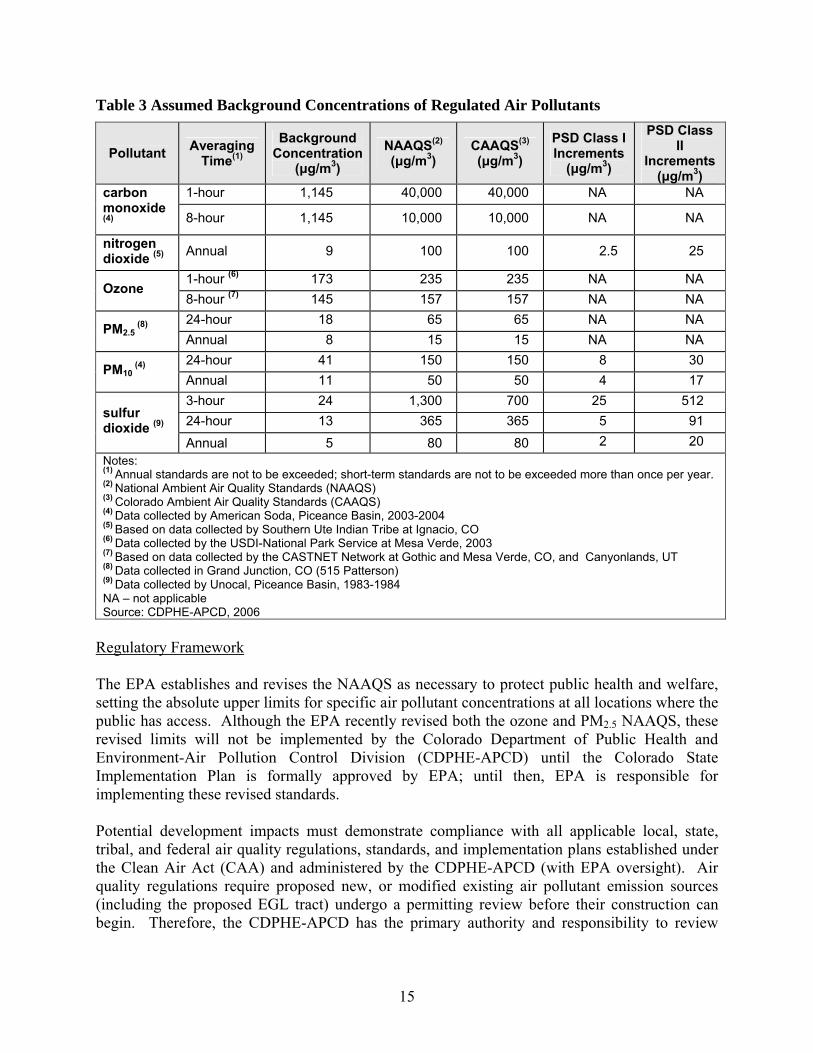
• limited transport of air pollutants from emission sources located outside the project area. The most complete air quality monitoring data available were assembled by URS Corporation, and are considered to be the best available representation of background air pollutant concentrations throughout the analysis area. These data (reported in micrograms per cubic meter, or µg/m3) were used to define background conditions (Table 3), and include impacts from existing sources both inside and outside the project area. The maximum pollutant concentrations are well below applicable Colorado and National Ambient Air Quality Standards (CAAQS NAAQS) for most pollutants, although maximum concentrations of ozone approaching the federal standard have been observed. Given the episodic nature of observed high ozone levels, their cause is uncertain, although regional transport or subsidence of stratospheric ozone is possible.
Location Average
Temperature Range (°F)
January
Average Temperature Range
(°F) July
Annual Average Precipitation (in)
Meeker, CO 7 to 37 47 to 86 16 Rangely, CO 4 to 32 56 to 92 10
Glenwood Springs, CO 12 to 37 51 to 89 17
15
Table 3 Assumed Background Concentrations of Regulated Air Pollutants
Pollutant Averaging Time(1)
Background Concentration
(μg/m3) NAAQS(2) (μg/m3)
CAAQS(3) (μg/m3)
PSD Class I Increments
(μg/m3)
PSD Class II
Increments (μg/m3)
1-hour 1,145 40,000 40,000 NA NA carbon monoxide (4) 8-hour 1,145 10,000 10,000 NA NA
nitrogen dioxide (5) Annual 9 100 100 2.5 25
1-hour (6) 173 235 235 NA NA Ozone
8-hour (7) 145 157 157 NA NA 24-hour 18 65 65 NA NA
PM2.5 (8)
Annual 8 15 15 NA NA 24-hour 41 150 150 8 30
PM10 (4)
Annual 11 50 50 4 17 3-hour 24 1,300 700 25 512 24-hour 13 365 365 5 91 sulfur
dioxide (9) Annual 5 80 80 2 20
Notes: (1) Annual standards are not to be exceeded; short-term standards are not to be exceeded more than once per year. (2) National Ambient Air Quality Standards (NAAQS) (3) Colorado Ambient Air Quality Standards (CAAQS) (4) Data collected by American Soda, Piceance Basin, 2003-2004 (5) Based on data collected by Southern Ute Indian Tribe at Ignacio, CO (6) Data collected by the USDI-National Park Service at Mesa Verde, 2003 (7) Based on data collected by the CASTNET Network at Gothic and Mesa Verde, CO, and Canyonlands, UT (8) Data collected in Grand Junction, CO (515 Patterson) (9) Data collected by Unocal, Piceance Basin, 1983-1984 NA – not applicable Source: CDPHE-APCD, 2006
Regulatory Framework The EPA establishes and revises the NAAQS as necessary to protect public health and welfare, setting the absolute upper limits for specific air pollutant concentrations at all locations where the public has access. Although the EPA recently revised both the ozone and PM2.5 NAAQS, these revised limits will not be implemented by the Colorado Department of Public Health and Environment-Air Pollution Control Division (CDPHE-APCD) until the Colorado State Implementation Plan is formally approved by EPA; until then, EPA is responsible for implementing these revised standards. Potential development impacts must demonstrate compliance with all applicable local, state, tribal, and federal air quality regulations, standards, and implementation plans established under the Clean Air Act (CAA) and administered by the CDPHE-APCD (with EPA oversight). Air quality regulations require proposed new, or modified existing air pollutant emission sources (including the proposed EGL tract) undergo a permitting review before their construction can begin. Therefore, the CDPHE-APCD has the primary authority and responsibility to review

16
permit applications and to require emission permits, fees and control devices, prior to construction and/or operation. In addition, the U.S. Congress (through the CAA Section 116) authorized local, state and tribal air quality regulatory agencies to establish air pollution control requirements more (but not less) stringent than federal requirements (such as Colorado’s 3-hour SO2 ambient air quality standard). Additional site-specific air quality analysis would be performed, and additional emission control measures (including emissions control technology analysis and determination) may be required by the applicable air quality regulatory agencies to ensure protection of air quality resources. In addition, under the federal CAA and the Federal Land Policy Management Act (FLPMA), BLM can not authorize any activity which does not conform to all applicable local, state, tribal and federal air quality laws, statues, regulations, standards, and implementation plans. The existing air quality of the Oil Shale RD&D project area is in attainment with all ambient air quality standards, as demonstrated by the relatively low concentration levels presented above. Given the EGL tracts current attainment status, future development projects which have the potential to emit more than 250 tons per year (or certain listed sources that have the potential to emit more than 100 tons per year) of any criteria pollutant would be required to submit a pre-construction Prevention of Significant Deterioration (PSD) Permit Application, including a regulatory PSD Increment Consumption Analysis under the federal New Source Review and permitting regulations. Development projects subject to the PSD regulations must also demonstrate the use of Best Available Control Technology (BACT) and show that the combined impacts of all applicable sources will not exceed the PSD increments for nitrogen dioxide (NO2), PM10, or SO2. The permit applicant must also demonstrate that cumulative impacts from all existing and proposed sources would comply with the applicable ambient air quality standards throughout the operational lifetime of the permit applicant’s project. In addition, a regulatory PSD Increment Consumption Analysis may be conducted at any time by the CDPHE-APCD or EPA, in order to demonstrate that the applicable PSD increment has not been exceeded by all applicable major or minor increment consuming emission sources. The determination of PSD increment consumption is a legal responsibility of the applicable air quality regulatory agency (with EPA oversight). Mandatory federal Class I areas were designated by the U.S. Congress on August 7, 1977, including those existing wilderness areas greater than 5,000 acres in size and national parks greater than 6,000 acres in size. All other locations in the country were ambient air quality is within the NAAQS (including attainment and unclassified areas) were designated as PSD Class II areas with less stringent requirements. Also, the CDPHE-APCD has designated Dinosaur National Monument as a State Category 1 Area, with the same SO2 increments as a federal PSD Class I area. In addition, sources subject to the PSD permit review procedures are required to demonstrate that impacts to Air Quality Related Values (AQRV) will be below Federal Land Managers’ Air Quality Related Values Work Group (FLAG) “Limits of Acceptable Change” (FLAG, 2000). The AQRVs to be evaluated include degradation of visibility, deposition of acidic compounds in mountain lakes, and effects on sensitive flora and fauna within the PSD Class I areas. For example, the USDA-Forest Service (FS) White River National Forest Supervisor and Rocky Mountain Regional Forester are the Federal Land Managers directly

17
responsible for the lands within the PSD Class I Flat Tops Wilderness area. Under the Clean Air Act, they are charged with “… an affirmative responsibility to protect the air quality related values (including visibility) of any such lands within a class I area…” Therefore, most of the Oil Shale RD&D Analysis Area is currently designated as PSD Class II, Dinosaur National Monument is a State Category 1 area, and the Flat Tops Wilderness Area is protected by more stringent NO2, PM10, and SO2 PSD Class I increment thresholds, as shown above. In addition, the CDPHE-APCD also requires various different pre-construction and operation permits, including: 1) any emission source with the potential to emit air pollutants in excess of 2 tons per year must submit an Air Pollution Emission Notice to CDPHE-APCD; 2) all emission sources with the potential to emit NOx or CO in excess of 10 tons per year, or 5 tons per year of PM10, are required to obtain a permit before construction can begin; 3) sources with potential emissions in excess of 100 tons per year of CO, 40 tons per year of NOx, or 15 tons per year of PM10, must also include a new source modeling analysis in their permit application. CDPHE-APCD modeling guidelines specify the requirements for conducting modeling, including cumulative analyses; 4) all sources with the potential to emit any “criteria” air pollutant in excess of 50 tons per year must also provide the opportunity for the public to comment on the permit application; and 5) a Title V (or part 70) operating permit is required for all sources with the potential to emit air pollutants in excess of 100 tons per year. Since these pre-construction and operating permit programs are part of the Colorado State Implementation Plan, they have been approved (and are therefore enforceable) by EPA. This NEPA analysis compares potential air quality impacts from the proposed EGL tract to applicable ambient air quality standards, PSD increments, and AQRV impact threshold levels, but it does not represent a regulatory air quality permit analysis. Comparisons to the PSD Class I and II increments are intended to evaluate a “threshold of concern” for potentially significant adverse impacts, but do not represent a regulatory PSD Increment Consumption Analysis.
Conformance to Existing Plans and Policies Both the CAA and FLPMA require all federal activities (whether conducted directly, or approved through use authorizations) to comply with all applicable local, state, tribal and federal air quality law, statutes, regulations, standards and implementation plans. Potential development would conform to these requirements, consistent with existing land use plans. Environmental Consequences of Proposed Action Impact Types and Criteria Potential air quality impacts from the proposed Oil Shale RD&D Project development were analyzed and reported solely under the requirements of NEPA, in order to assess and disclose reasonably foreseeable impacts to both the public and federal decision makers for consideration in determining if a Finding of No Significant Impact (FONSI) can be issued. Due to the state of knowledge of in-situ processes and the small scale of this project, it should be considered a
18
reasonable, but conservative upper estimate of predicted impacts. Actual impacts at the time of development (subject to air pollutant emission source permitting by CDPHE-APCD) are likely to be less. Atmospheric dispersion modeling files used to prepare this analysis are available upon request for review. The air quality impact assessment was based on the best available engineering data and assumptions, meteorological data, and EPA dispersion modeling procedures, as well as professional engineering and scientific judgment. However, where specific data or procedures were not available, reasonable, but conservative assumptions were incorporated. For example, the air quality impact assessment assumed that Project activities would operate at full production levels continuously (no “down time”). Therefore, this NEPA analysis assumes a development scenario which is not likely to actually occur. The air pollutant dispersion modeling was based on one-year of on-site meteorological data collected within the Piceance Basin (Bar D station), as well as regional upper atmosphere data collected at Grand Junction. The EPA preferred AERMOD atmospheric dispersion model was used to predict maximum potential near-field ambient air pollutant concentrations (in the vicinity of the proposed EGL Oil Shale RD&D Project) for comparison with applicable air quality standards and PSD Class II increments. In addition, similar model analyses for other Oil Shale Research Demonstration and Development projects, as well as current ExxonMobil Piceance Development Project activities, were combined to determine maximum far-field ambient air pollutant concentrations, atmospheric deposition (acid rain) and visibility impacts at the Flat Tops Wilderness Area. The criteria for determining the significance of potential air quality impacts include state, tribal and federally enforced legal requirements to ensure air pollutant concentrations will remain within specific allowable levels. These requirements include the NAAQS and CAAQS which set maximum limits for several air pollutant concentrations, and PSD increments which limit the incremental increase of specific air pollutants (including NO2, PM10, and SO2) above legally defined baseline concentration levels. Where legal limits have not been established, significance thresholds have been identified for potential atmospheric deposition impacts to sensitive lake water chemistry and terrestrial ecosystems, and a “just noticeable change” in potential visibility impacts. It is important to note that before actual development could occur, the applicable air quality regulatory agencies (including CDPHE-APCD and EPA) would review specific air pollutant emissions preconstruction permit applications which examine potential project-wide air quality impacts. As part of these permits (depending on source size), the air quality regulatory agencies could require additional air quality impacts analyses or mitigation measures. Thus, before development occurs, additional site-specific air quality analyses based on actual facility engineering data would be performed to ensure protection of air quality. Potential Direct Impacts from Proposed Project No violations of applicable state, tribal, or federal air quality regulations or standards are expected to occur as a result of direct or indirect air pollutant emissions (including construction
19
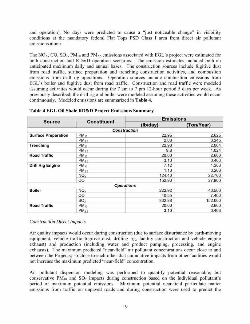
and operation). No days were predicted to cause a “just noticeable change” in visibility conditions at the mandatory federal Flat Tops PSD Class I area from direct air pollutant emissions alone. The NOX, CO, SO2, PM10 and PM2.5 emissions associated with EGL’s project were estimated for both construction and RD&D operation scenarios. The emission estimates included both an anticipated maximum daily and annual bases. The construction sources include fugitive dust from road traffic, surface preparation and trenching construction activities, and combustion emissions from drill rig operations. Operation sources include combustion emissions from EGL’s boiler and fugitive dust from road traffic. Construction and road traffic were modeled assuming activities would occur during the 7 am to 7 pm 12-hour period 5 days per week. As previously described, the drill rig and boiler were modeled assuming these activities would occur continuously. Modeled emissions are summarized in Table 4.
Table 4 EGL Oil Shale RD&D Project Emissions Summary
Emissions Source Constituent (lb/day) (Ton/Year) Construction
PM10 22.95 2.625Surface Preparation PM2.5 2.08 0.245PM10 22.90 2.004Trenching PM2.5 9.8 1.024PM10 20.00 2.600Road Traffic PM2.5 3.10 0.403PM10 7.12 1.300PM2.5 1.10 0.200NOx 124.40 22.700
Drill Rig Engine
CO 152.90 27.900Operations
NOx 222.92 40.500CO 40.55 7.400
Boiler
SO2 832.88 152.000PM10 20.00 2.600Road Traffic PM2.5 3.10 0.403
Construction Direct Impacts Air quality impacts would occur during construction (due to surface disturbance by earth-moving equipment, vehicle traffic fugitive dust, drilling rig, facility construction and vehicle engine exhaust) and production (including water and product pumping, processing, and engine exhausts). The maximum predicted “near-field” air pollutant concentrations occur close to and between the Projects; so close to each other that cumulative impacts from other facilities would not increase the maximum predicted “near-field” concentration. Air pollutant dispersion modeling was performed to quantify potential reasonable, but conservative PM10 and SO2 impacts during construction based on the individual pollutant’s period of maximum potential emissions. Maximum potential near-field particulate matter emissions from traffic on unpaved roads and during construction were used to predict the

20
maximum 24-hour and annual average PM10 concentrations. Maximum air pollutant emissions would be temporary (i.e., occurring only during construction period). The amount of air pollutant emissions during construction would be controlled by watering or applying chemical surfactants to disturbed soils, and by air pollutant emission limits imposed by applicable air quality regulatory agencies. Actual air quality impacts depend on the amount, duration, location, and characteristics of potential emissions sources, as well as meteorological conditions (wind speed and direction, precipitation, relative humidity, etc.) The maximum potential 24-hour PM2.5 and PM10 concentrations primarily from road emission sources and surface preparation (including a representative background value of 18 and 41 μg/m3, respectively), would be nearly 36 and 147 μg/m3, well below the applicable NAAQS of 65 μg/m3 and 150 μg/m3, respectively. In addition, predicted particulate matter concentrations would decrease rapidly away from the emission source. Since these PM10 construction emissions are temporary, PSD increments are not applicable. The maximum predicted long-term (annual) NO2, PM10, PM2.5, and SO2 impacts (including representative background concentrations) were all predicted during construction to be less than the applicable ambient air quality standards. The maximum predicted annual NO2 concentration of 12.6 μg/m3 (including a representative background value of 9 μg/m3) would be less than the CAAQS/NAAQS of 100 μg/m3. The maximum predicted annual PM2.5 and PM10 concentration of 8.8 and 13.1 μg/m3 (including representative background values of 8 μg/m3 and 11 μg/m3, respectively) would be less than the CAAQS/NAAQS of 15 μg/m3 and 50 μg/m3, respectively. RD&D Operation Direct Impacts Air pollutant dispersion modeling was also performed to quantify potential reasonable, but conservative NO2, PM10, PM2.5, and SO2 impacts during RD&D operations, based on the period of maximum potential emissions (Table 5). Operation emissions would occur primarily from boiler exhausts. Activities such as water pumping, processing, and treatment will be powered by electricity and will contribute minor emissions. To the extent electrical power would be required to operate the proposed EGL Project, it was assumed that existing power supplies and distribution could meet those needs. As demonstrated below, all other air pollutants and averaging times are also predicted to be well below applicable ambient air quality standards and PSD Class II increments, although maximum predicted direct annual NO2 impact of 9.14 μg/m3 is less than half the applicable annual PSD Class II increment of 25 μg/m3. As stated previously, all NEPA analysis comparisons to the PSD Class II increments are intended to evaluate a threshold of concern, and do not represent a regulatory PSD Increment Consumption Analysis.
Table 5 Predicted Maximum Direct Air Quality Impacts during EGL RD&D Operations
Pollutant Averaging Time
Direct Concentration(μg/m3)
Background Concentration(μg/m3)
Total Concentration(μg/m3)
nitrogen dioxide Annual 0.14 9 9.14
PM2.5 24-hour 9 18 27

21
Pollutant Averaging Time
Direct Concentration(μg/m3)
Background Concentration(μg/m3)
Total Concentration(μg/m3)
Annual 0.1 8 8.1 24-hour 58 41 99
PM10 Annual 1.6 11 12.6 3-hour 321.75 24 345.75 24-hour 134.20 13 147.20 sulfur
dioxide Annual 11.61 5 16.61
Unavoidable Adverse Effects Some decrease in air quality would occur through implementation of the proposed project; however, based on the reasonable, but conservative modeling assumptions, these direct impacts are predicted to be below applicable thresholds.
Irreversible and Irretrievable Effects Once disturbed lands are revegetated, potential air quality impacts from the proposed Project would cease after the life of the project. Therefore, there would be no irreversible or irretrievable effects on air quality. Subalternative - Proposed Action with Mitigation Under this alternative, in addition to the proposed action, BLM would require roads and well locations constructed on soils susceptible to wind erosion to be appropriately surfaced to reduce the amount of fugitive dust generated by traffic and construction activities. Dust inhibitors (surfacing materials, non-saline dust suppressants, water, etc.) would be used as necessary on unpaved collector, local and resource roads to prevent fugitive dust problems. To further reduce fugitive dust, the Operator would establish and enforce speed limits (15 to 30 mph) on all project-required roads in and adjacent to the project area. Monitoring BLM would require the operator to continue to cooperate with existing atmospheric deposition and visibility impact monitoring programs. The need for, and the design of, additional monitoring could include the involvement of the EPA Region 8 Federal Leadership Forum (EPA, 2001) and applicable air quality regulatory agencies. Based upon future recommendations, operators could be required to cooperate in the implementation of a coordinated air quality monitoring program. Environmental Consequences of the Subalternative No violations of applicable state, tribal, or federal air quality regulations or standards are expected to occur as a result of direct or indirect air pollutant emissions (including construction and operation). Fugitive dust impacts to air quality during construction and operation would be reduced as a result of the mitigation measures. Some increase in air quality would occur in
22
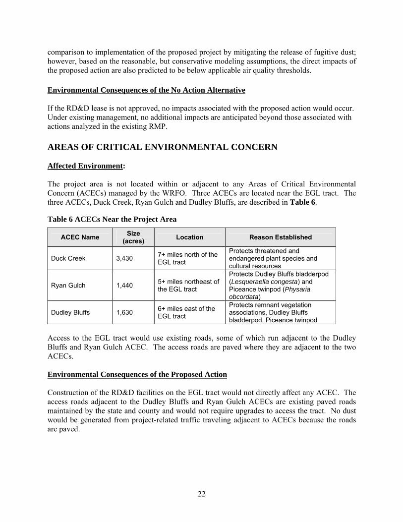
comparison to implementation of the proposed project by mitigating the release of fugitive dust; however, based on the reasonable, but conservative modeling assumptions, the direct impacts of the proposed action are also predicted to be below applicable air quality thresholds. Environmental Consequences of the No Action Alternative If the RD&D lease is not approved, no impacts associated with the proposed action would occur. Under existing management, no additional impacts are anticipated beyond those associated with actions analyzed in the existing RMP. AREAS OF CRITICAL ENVIRONMENTAL CONCERN Affected Environment: The project area is not located within or adjacent to any Areas of Critical Environmental Concern (ACECs) managed by the WRFO. Three ACECs are located near the EGL tract. The three ACECs, Duck Creek, Ryan Gulch and Dudley Bluffs, are described in Table 6.
Table 6 ACECs Near the Project Area
ACEC Name Size (acres) Location Reason Established
Duck Creek 3,430 7+ miles north of the EGL tract
Protects threatened and endangered plant species and cultural resources
Ryan Gulch 1,440 5+ miles northeast of the EGL tract
Protects Dudley Bluffs bladderpod (Lesqueraella congesta) and Piceance twinpod (Physaria obcordata)
Dudley Bluffs 1,630 6+ miles east of the EGL tract
Protects remnant vegetation associations, Dudley Bluffs bladderpod, Piceance twinpod
Access to the EGL tract would use existing roads, some of which run adjacent to the Dudley Bluffs and Ryan Gulch ACEC. The access roads are paved where they are adjacent to the two ACECs. Environmental Consequences of the Proposed Action Construction of the RD&D facilities on the EGL tract would not directly affect any ACEC. The access roads adjacent to the Dudley Bluffs and Ryan Gulch ACECs are existing paved roads maintained by the state and county and would not require upgrades to access the tract. No dust would be generated from project-related traffic traveling adjacent to ACECs because the roads are paved.
23
Subalternative - Proposed Action with Mitigation No mitigation measures are proposed or necessary to reduce impacts to ACECs from the proposed action. Environmental Consequences of the No Action Alternative If the RD&D lease is not approved, no impacts associated with the proposed action would occur. Under existing management, no additional impacts are anticipated beyond those associated with actions analyzed in the existing RMP. CULTURAL RESOURCES Affected Environment Local and regional archaeological studies suggest nearly continuous human occupation of northwestern and west-central Colorado for the past 12,000 years. Evidence of the Paleo-Indian, Archaic, Formative/Late Prehistoric, and Protohistoric periods has been found in northwestern Colorado. Detailed descriptions of these periods including subsistence and settlement information can be found in Reed and Metcalf, 1999. The proposed 160-acre tract is in an area that is primarily known archaeologically for the Late Prehistoric and the Protohistoric Numic (Ute) occupations. While earlier Paleoindian and Archaic sites have been found in the vicinity, later sites are the most common. Paleoindian (13,500 – 8,400 before present (B.P.)) sites are rare in northwestern Colorado, particularly Clovis and Folsom period occupations. In northwestern Colorado, Clovis and Folsom are represented only by surface finds (Reed and Metcalf, 1999). Late Paleoindian dated components, while not common, have also been found in Rio Blanco County (Baker, 1986). Later Archaic occupations (8,400 – 1,500 B.P.) are much more common in Rio Blanco County, and components have been documented spanning most of the Archaic (Reed and Metcalf, 1999; Hauck, 1997). The Formative and Late Prehistoric periods (1,500 – 400 B.P.) encompass Fremont occupations (Baker, 1997, 1998; Creasman, 1981; Creasman and Scott, 1987; Hauck, 1993) and Aspen Tradition occupations (Reed and Metcalf, 1999). The area along Douglas Creek approximately 15 miles west-northwest of the proposed tract has been designated the Canyon Pintado National Historic District, which is listed on the National Register of Historic Places (NRHP). This archaeological district contains archaeological sites dating back 11,000 years, but is primarily known for numerous Fremont sites including rock art, structures, and rock shelters. The proposed tract would not impact this district. Although Fremont occupation is suspected in the area of the oil shale lease, no undeniably Fremont sites have been located. Protohistoric period (1300 – 1881) Ute occupations have been recorded throughout Rio Blanco County. Ute sites generally consist of brush lodges, trails and open sites (Baker, 1996, 1998; LaPoint et. al., 1981; McPherson, 1983).

24
The historic period in the area began with the first entrance of Europeans into the region with the Dominguez-Escalante expedition in 1776 (Warner, 1995). Subsequently, use of the area by Euroamerican trappers, settlers, prospectors, miners, and ranchers has been well documented (Husband, 1984). The primary historic use of the area in the vicinity of the tract was ranching and hunting/recreation. Archaeological and historic cultural resources are protected and regulated by the National Environmental Policy Act of 1969, Executive Order 11593, the National Historic Preservation Act of 1966 as amended, the Federal Land Policy and Management Act of 1976, the Antiquities Act of 1906, the Historic Sites Act of 1935, the Archaeological and Historic Data Preservation Act of 1974, the American Indian Religious Freedom Act of 1978, and the Native American Graves Protection and Repatriation Act of 1990. Cultural resource inventories of public lands are mandated in order to meet provisions of these laws, which are concerned with the identification, evaluation, and protection of fragile, non-renewable evidences of human activity, occupation, and endeavor reflected in districts, sites, structures, artifacts, objects, ruins, and works of art, architecture, and natural features that were of importance in human events. These resources tend to be localized and highly sensitive to disturbance. A Class I inventory (literature and file search) was conducted for cultural resources at the WRFO and the Colorado State Historic Preservation Office (SHPO) for all cultural resources located within the section of the proposed tract, as well as the surrounding eight sections. Nine previous cultural resource investigations were conducted within the immediate vicinity of the proposed tract between 1977 and 2005. Portions of two of these surveys were located within the proposed tract and covered approximately 15.7 acres in linear swaths through the unit These investigations including cultural resource surveys for oil shale lease tracts (RB.LM.490 - Weber et. al., 1977), tree cutting tracts (RB.LM.R343 – Williams, 1979), oil/gas pipelines (RB.PA.R2 - Black and Zier, 1981; RB.LM.R730 – Born, 1984; RB.LM.R921 – Conner et. al., 2004; RB.LM.R919 – Conner et. al., 2005), seismic lines (RB.LM.R142 - Frizell and Frizell, 1991), sodium leases (RB.LM.R716 – Conner, 1985), and well pad drilling areas (RB.LM.R544 - Martin et. al., 2003). These surveys consist of both linear and block investigations. Two previously recorded cultural resource sites or isolates are located within the 160-acre tract (Table 7), and a total of twelve sites or isolates were located within the adjacent sections. Cultural resource sites encountered in and around the 160-acre tract during these previous investigations include prehistoric lithic scatters, habitation/open camp sites with standing wooden architectural remains and stone circles/tipi rings, and sites with historic features. 5RB413, a prehistoric lithic scatter, is listed as needs data, which is equivalent to potentially eligible, indicating that the site would require further investigation to determine its eligibility. 5RB2967, is an isolated fined and is officially not eligible.
Table 7 Cultural Resources Located Within the Proposed Tract
Site Eligibility Status Site Type 5RB413 Needs Data / Potentially Eligible Open Lithic Scatter
5RB2967 Officially Not Eligible Isolated Find – Lithic Tool

25
Environmental Consequences of the Proposed Action A Class III cultural resources inventory was conducted on April 3-5, 2006 and April 10, 2006 on the 160-acre EGL tract (Hoefer and Greenberg, 2006a). An additional inventory was conducted on May 25, 2006 of the proposed utility line route (Hoefer and Greenberg, 2006b).The inventory of the 160-acre tract resulted in the documentation of two prehistoric sites and two prehistoric isolated finds (Table 8). Inventory of the utility line route resulted in the documentation of two isolated finds. Three of the cultural resources are located to the south of the main road that runs through the parcel. One isolated find was found in a road bed and is probably not in its original location. 5RB413 is a prehistoric open camp containing a scatter of lithic debitage, stone tools, and possibly a fire hearth. This previously recorded site has been recommended as potentially eligible for nomination to the NRHP. When the site was reevaluated for this project, no materials or features were found on the site to support the potentially eligible recommendation. The site is now recommended as not eligible for nomination to the NRHP. Likewise, the remaining prehistoric site and both isolated finds are recommended as not eligible for nomination to the NRHP. The remaining cultural resources would not be impacted by the proposed action.
Table 8 Cultural Resources Located Within the Proposed EGL Tract During the Class III Inventory
Site Eligibility Status Site Type 5RB413 Not Eligible (Field Recommendation) Prehistoric Open Camp
5RB2967 Officially Not Eligible Prehistoric Open Lithic Scatter1
5RB5209 Not Eligible (Field Recommendation) Prehistoric Isolated Find (4 flakes)
5RB5210 Not Eligible (Field Recommendation) Prehistoric Isolated Find (1 flake in road bed)
5RB5305 Not Eligible (Field Recommendation) Historic Isolated Find (tin can)
5RB5306 Not Eligible (Field Recommendation) Historic Isolated Find (plate fragment) 1- Site 5RB2967 was found to be a site rather than an isolated find during the Class III inventory.
Subalternative - Proposed Action with Mitigation Two previously recorded cultural resource sites and four isolated finds are located within the project area (Table 8), and a total of twelve sites or isolates were located within the adjacent sections. No other known sites exist in the project area. Should important cultural resources not visible on the surface be encountered during the construction of the project facilities the following measures would be implemented to modify the proposed action to mitigate potential impacts to such resources:
• All persons associated with the project will be informed that they would be subject to prosecution for knowingly disturbing historic or archaeological sites, or for collecting artifacts. If historic or archaeological materials are uncovered during any project or construction activities, activities will stop in the immediate area of the find, and the BLM Authorized Officer will be immediately contacted. Within five working days, the BLM Authorized Officer would inform EGL as to:
- whether the materials appear eligible for the NRHP;
26
- mitigation measures EGL would likely have to undertake before the site can be used (assuming in situ preservation is not practicable); and
- timeframe for the BLM Authorized Officer to complete an expedited review under 36 CFR 800.11 to confirm, through the SHPO, that the findings of the BLM Authorized Officer are correct and that mitigation was appropriate.
• If the operator wishes, at any time, to relocate activities to avoid the expense of mitigation and/or the delays associated with this process, the Authorized Officer will assume responsibility for whatever recordation and stabilization of the exposed materials may be required. Otherwise, the operator will be responsible for mitigation cost. The Authorized Officer will provide technical and procedural guidelines for the conduct of mitigation. Upon verification from the Authorized Officer that the required mitigation has been completed, the operator will then be allowed to resume construction.
• The BLM Authorized Officer will be notified by telephone and with written confirmation, immediately upon discovery of human remains, funerary items, sacred objects, or objects of cultural patrimony. Activities will stop in the immediate area of the find, and the discovery will be protected for 30 days or until notified to proceed in writing by the BLM Authorized Officer.
Environmental Consequences of the Subalternative No important known cultural resources would be impacted by either the proposed action or the alternative mitigation. However, it is possible that important cultural resources not visible on the surface could be encountered during the construction of the project facilities. As a result of the alternative mitigation, potential impacts will be identified as soon as possible and the impacting action will be appropriately modified to avoid unnecessary or under degradation. Any potential unforeseen impacts to cultural resources would be reduced and minimized. Environmental Consequences of the No Action Alternative If the RD&D lease is not approved, no impacts associated with the proposed action would occur. Under existing management, no additional impacts are anticipated beyond those associated with actions analyzed in the existing RMP. FARMLANDS, PRIME AND UNIQUE Affected Environment Agricultural land which has the best combination of physical and chemical characteristics, making it productive for food, feed, forage, fiber, and oil seed crop production is designated prime farmland by the Natural Resources Conservation Service (NRCS, 2003). In the Colorado Plateau physiographic region, prime farmlands are typically located in riparian areas. On fee-lands in the project area, prime farmland is usually for hay production. On BLM lands, soils that meet the requirements for prime farmland are not irrigated and unlikely to be irrigated in the future. The EGL tract is on BLM land.

27
There are two areas of potential prime farmland mapped on the proposed EGL tract (Tripp et. al., 1982), both of which are Forelle loam, 3-8% slopes. One area is located in the northeastern quarter of the site and has an area of 11.7 acres. The other is located in the southwest quarter and has an area of 10.4 acres. These areas make up 13.8 percent of the total site acreage. Forelle loam, 3-8% slopes, is considered a prime farmland soil only when irrigated. The current use of these areas is for grazing, pedestrian traffic, and vehicular traffic on an existing unimproved road. They are not presently irrigated and are unlikely to be irrigated in the future. No designated “unique” farmlands are found in the project area. Environmental Consequences of the Proposed Action Construction at facilities would affect potential prime farmland soils through possible compaction, reduced fertility, poor revegetation, subsidence, and introduction of noxious weeds. Movement and operation of construction equipment could compact the soil and result in an increased erosion hazard and reduced revegetation potential. Clearing the existing vegetation would provide an opportunity for weed species to invade the site, and the movement and operation of construction vehicles and equipment could transport weed seed and plant parts from one location to another. Construction of facilities could cause mixing of the soil horizons and could result in reduced soil fertility and reduced revegetation potential. These prime farmland areas would be unavailable for agricultural use throughout the life of the project. Productivity of the soil may be permanently reduced as a result of construction and operation activities. The affected area comprises 13.8% of the proposed site, or approximately 24 acres of potentially prime farmland. The total acreage is a small portion of the entire Colorado River Basin. The total acreage of prime farmland disturbed may be less depending on final location of construction and facilities. Subalternative - Proposed Action with Mitigation In addition to the proposed action, BLM would require implementing measures for the proper handling of topsoil and spoil, erosion control, and reclamation procedures. These measures include the following:
• when excavating, the A soil horizon or the top 6 inches, whichever is deeper, will be separated and stored, and the stockpile locations would be marked or documented;
• when the soil horizons are too rocky or too thin to practicably segregate, the topsoil will be segregated to the extent possible and stored;
• the stockpiled soils will be protected from degradation due to contamination, compaction, and from wind and water erosion;
• drill pad locations will be designed and constructed to provide a safe working area while reasonably minimizing the total disturbed area. Prime farmland soils would be avoided when reasonably possible;
• all areas within prime farmland soils compacted by drilling and subsequent oil and gas operations which are no longer needed will be cross-ripped to a depth of 18 inches unless and to the extent bed rock is encountered at a shallower depth;

28
• topsoil will be returned to pre-construction depths and locations; • noxious weeds will be controlled; and • the potential for accidental spills or leaks will be minimized.
Environmental Consequences of the Subalternative Impacts to prime farmland soils from construction and operation of the proposed action may potentially affect 24 acres of prime farmland – a small proportion of the broader Colorado River Basin. The total acreage of prime farmland disturbed may be less depending on final location of construction and facilities. Impacts will be further minimized by implementing measures for the proper handling of topsoil and spoil, erosion control, weed management and reclamation procedures. Mitigation measures will ensure prime farmland soils are retained, replaced and recontoured toward preconstruction conditions. Surface impacts would be minimized, however, as in the proposed action, these prime farmland areas would continue to be unavailable for agricultural use throughout the life of the project until successful reclamation was achieved. Environmental Consequences of the No Action Alternative If the RD&D lease is not approved, no impacts associated with the proposed action would occur. Under existing management, no additional impacts are anticipated beyond those associated with actions analyzed in the existing RMP. FLOODPLAINS Affected Environment The closest floodplains to the EGL tract are those associated with Ryan Gulch, Black Sulphur Creek, and Piceance Creek. The EGL tract is located on a topographic high outside of these floodplains. Environmental Consequences of the Proposed Action None. Environmental Consequences of the No Action Alternative If the RD&D lease is not approved, no impacts associated with the proposed action would occur. Under existing management, no additional impacts are anticipated beyond those associated with actions analyzed in the existing RMP. INVASIVE, NON-NATIVE SPECIES Affected Environment Invasive plants include noxious weeds and other plants not native to the United States and plants introduced into an environment where they did not evolve. Invasive plants often invade and

29
persist in areas where native vegetation has been disturbed. An infestation of noxious weeds can reduce agricultural productivity or wildlife habitat, poison wildlife or livestock, decrease biodiversity, diminish aesthetics, impair wetland ability, and cause many other detrimental effects. Once established, noxious weeds can be very difficult to eradicate. Noxious weeds and their continued encroachment on both public and private lands represent a serious threat to the BLM objective to maintain healthy and diverse ecosystems and rangelands on BLM-administered lands. Table 9 identifies noxious weeds that may be present in Rio Blanco County and is based on consultations with the WRFO and published Rio Blanco County weed lists maintained by State of Colorado Department of Agriculture.
Table 9 Noxious Weed Species that May be Present in the White River Field Office and Rio Blanco County
Common Name Scientific Name Black henbane Hyoscyamus niger Black knapweed Centaurea nigra Bull Thistle Cirsium vulgare Canada thistle Cirsium arvense Common burdock Arctium minus Common mullein Verbascum thapsus Dalmatian toadflax Linaria dalmatica Diffuse knapweed Centaurea diffusa Field bindweed Convolvulus arvensis Halogeton Halogeton glomeratus Hoary cress Cardia draba Houndstongue Cynoglossum officinale Leafy spurge Euphorbia esula Musk thistle Carduus nutans Perennial pepperweed Lepidium latifolium
Plumeless thistle Carduus acanthoides Russian knapweed Acroptilion repens Scotch thistle Onopordum acanthium Spotted knapweed Centaurea maculosa Yellow toadflax Linaria vulgaris
There are no known noxious weeds at the project site. The noxious weeds mullein, hoary cress, houndstongue and bull thistle have been found within one mile of the project site. A weed survey was conducted of the EGL tract and powerline on March 28 and 29, 2006. No weed infestation areas were identified. The invasive alien cheatgrass is present on the site adjacent to roads and trails, primarily as a result of past, unrevegetated soil disturbances. Environmental Consequences of the Proposed Action Construction would result in cutting, clearing, and/or removal of existing vegetation within the construction areas. The construction area is anticipated to include disturbance to 35 acres or less, plus one acre for the utility line. The removal of approximately 35 acres of vegetation and the disturbance of soils during construction would create optimal conditions for the establishment of
30
invasive, non-native species that may continue for many years after the initial disturbance. Construction equipment traveling from weed-infested areas to weed-free areas could also facilitate the dispersal of invasive, non-native seeds and propagules and could result in the establishment of invasive, non-native plants in previously weed-free areas. The establishment of invasive, non-native plants could result in the reduction in the overall visual character of the area, competition with or elimination of native plants, reduction of wildlife habitats, increased soil erosion, and loss of forage for livestock and wildlife. Subalternative - Proposed Action with Mitigation In addition to the design features identified in the proposed action, negative impacts caused by invasive, non-native species would be further mitigated by implementing measures to treat existing infestations, prevent introduction/expansion of infestations during construction, and monitor and treat infestations after construction is complete. EGL will:
• revegetate disturbed areas as discussed in the ‘Subalternative’ portion of the Vegetation section;
• keep all disturbed areas as free of noxious weeds and undesirable species as practicable during drilling, production, and reclamation operations;
• conduct pre-construction field surveys each spring prior to construction, to identify existing noxious weed infestations within the project area;
• consult with BLM and local weed agencies to develop treatment strategies for noxious weed infestations identified during spring surveys;
• require vehicles and equipment to arrive at the work site clean, power-washed, and free of soil and vegetative debris capable of transporting weed seeds or other propagules;
• install wash stations at designated infestation areas if any are identified in Spring 2007. Equipment would be power-washed to remove soil and propagules prior to leaving the infested areas. Wash station locations will be determined in conjunction with the BLM and local weed agencies after spring surveys have been completed. Wash water will be contained and grease traps will be added as required;
• seed disturbed areas as discussed in the ‘Subalternative’ portion of Vegetation section; • use certified weed-free erosion control and reclamation materials (e.g., straw bales and
seed mixes); and • monitor the distribution and density of noxious weeds on the tract, and control and/or
eradicate any new or expanded populations for the life of the RD&D project and throughout final reclamation.
Environmental Consequences of the Subalternative Construction would result in cutting, clearing, and/or removal of existing vegetation within the construction areas. The construction area is anticipated to include disturbance to 35 acres or less, plus one acre for the utility line. The removal of approximately 35 acres of vegetation and the disturbance of soils during construction would create optimal conditions for the establishment of invasive, non-native species that may continue for many years after the initial disturbance. Impacts native vegetation, visual character, wildlife habitat, soil erodability, and available forage would be minimized by implementing preventative and remedial noxious weed management and
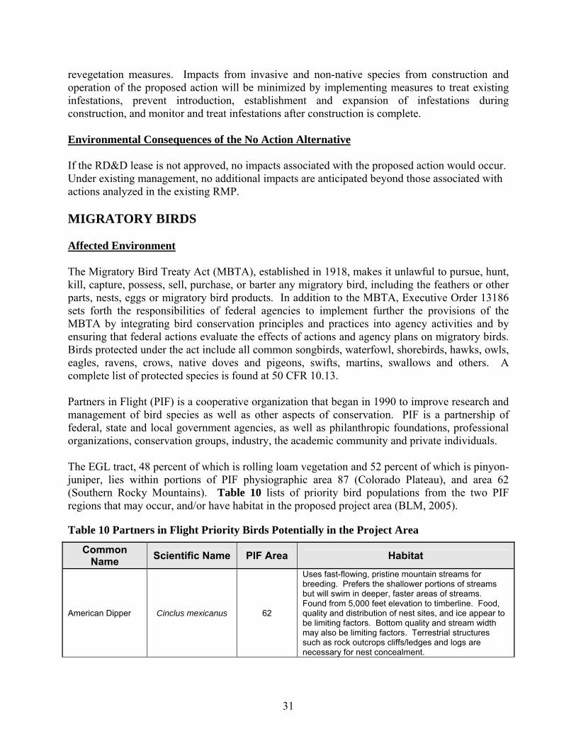
31
revegetation measures. Impacts from invasive and non-native species from construction and operation of the proposed action will be minimized by implementing measures to treat existing infestations, prevent introduction, establishment and expansion of infestations during construction, and monitor and treat infestations after construction is complete. Environmental Consequences of the No Action Alternative If the RD&D lease is not approved, no impacts associated with the proposed action would occur. Under existing management, no additional impacts are anticipated beyond those associated with actions analyzed in the existing RMP. MIGRATORY BIRDS Affected Environment The Migratory Bird Treaty Act (MBTA), established in 1918, makes it unlawful to pursue, hunt, kill, capture, possess, sell, purchase, or barter any migratory bird, including the feathers or other parts, nests, eggs or migratory bird products. In addition to the MBTA, Executive Order 13186 sets forth the responsibilities of federal agencies to implement further the provisions of the MBTA by integrating bird conservation principles and practices into agency activities and by ensuring that federal actions evaluate the effects of actions and agency plans on migratory birds. Birds protected under the act include all common songbirds, waterfowl, shorebirds, hawks, owls, eagles, ravens, crows, native doves and pigeons, swifts, martins, swallows and others. A complete list of protected species is found at 50 CFR 10.13. Partners in Flight (PIF) is a cooperative organization that began in 1990 to improve research and management of bird species as well as other aspects of conservation. PIF is a partnership of federal, state and local government agencies, as well as philanthropic foundations, professional organizations, conservation groups, industry, the academic community and private individuals. The EGL tract, 48 percent of which is rolling loam vegetation and 52 percent of which is pinyon-juniper, lies within portions of PIF physiographic area 87 (Colorado Plateau), and area 62 (Southern Rocky Mountains). Table 10 lists of priority bird populations from the two PIF regions that may occur, and/or have habitat in the proposed project area (BLM, 2005).
Table 10 Partners in Flight Priority Birds Potentially in the Project Area
Common Name Scientific Name PIF Area Habitat
American Dipper Cinclus mexicanus 62
Uses fast-flowing, pristine mountain streams for breeding. Prefers the shallower portions of streams but will swim in deeper, faster areas of streams. Found from 5,000 feet elevation to timberline. Food, quality and distribution of nest sites, and ice appear to be limiting factors. Bottom quality and stream width may also be limiting factors. Terrestrial structures such as rock outcrops cliffs/ledges and logs are necessary for nest concealment.

32
Common Name Scientific Name PIF Area Habitat
Bendire’s Thrasher Toxostoma bendirei 87 Inhabit microphyll shrubland, lowland (2,800-5,500 ft) and midland (5,000-7,500 ft) shrubland, and juniper woodland. Mostly found in desert environments.
Bell’s Vireo Vireo bellii 87
Woodlands, especially of cottonwoods, that occur where desert streams provide sufficient moisture for a narrow band of deciduous trees and shrubs along the margins. Dependent on shrub or vine cover below 9 feet for nesting. Generally the only vireo breeding along lowland stream sides.
Black Swift Cypseloides niger 62
High inaccessible cliffs near permanent fast moving water with little or no direct sunlight. Occurs at elevations where stream conditions provide sufficient permanent moisture for emergent plants, or for a narrow band of deciduous trees and shrubs.
Black-chinned Hummingbird
Archilochus alexandri 87
Apparently not found above about 9,000 feet. Prefers semi-wooded canyons and most often found near streams, lakes, and wetlands, especially in arid regions. Found in all vegetation succession stages.
Broad-tailed Hummingbird
Selasphorus platycercus 62
Breeding from plains to 10,000 feet, most common 7,000-8,000 feet, occasionally far above timberline in late summer after nesting. Found in a variety of riparian habitats, but prefers to forage in openings and clearings.
Brown-capped Rosy Finch Leucosticte australis 62
Winter resident. Forages on and around snowbanks and in herbaceous vegetation. Found in ponderosa pine forests after storms at higher elevations. Rarely found below 7,000 feet elevation in winter, and has been observed at over 13,000 feet in summer. In summer they can be found about deep snowbanks and drifts.
Cassin's Kingbird Tyrannus vociferans 87
Dry savanna, open scrub, riparian woodland, along creek washes, canyons along streams, and pinyon-juniper-oak woodland; in winter also in highland pine-oak association and dry scrub
Cordilleran Flycatcher
Empidonax occidentalis 62 River, riparian woodland, subalpine marsh; and
mountain and alpine meadows.
Ferruginous Hawk Buteo regalis 62
Occur in grasslands and other open habitats, primarily from lower (2,800 – 5,500 ft) to middle (5,000 – 7,500 ft) elevations. Nests in trees and bushes, ledges, large rocks, riverbanks, and hillsides. Also BLM and WRFO sensitive.
Flammulated Owl Otus flammeolus 62
Found in mountain forests, especially ponderosa pine forests with low growing bushes. Distributed in select locations west of the Rocky Mountains from southern British Columbia to Mexico. Migrates into Mexico during the winter.
Grace’s Warbler Dendroica graciae 87
Breeds in ponderosa pine, along rivers, in junipers. Inhabits only pine forest at elevations 6,000-8,000 feet. Has low tolerance to ecological change due to use of tall pines. Migrates to riparian lowland. Also uses gambel oak, dry mountain meadow and mountain shrub.
Gray Flycatcher Empidonax wrightii 87 Arid areas of sagebrush or pinyon-juniper woodlands.
Gray Vireo Vireo vicinior 87 Dry shrubby areas, chaparral, and sparse woodlands.

33
Common Name Scientific Name PIF Area Habitat
Greater Sage Grouse
Centrocercus urophasianus 87 and 62 Foothills, plains, and mountain slopes where
sagebrush is present. Also BLM and WRFO sensitive.
Gunnison Sage Grouse
Centrocercus minimus 87 and 62
Requires a variety of habitats such as large expanses of sage with a diversity of grasses and forbs and healthy riparian ecosystems. Historically found throughout the southwestern portion of Colorado and the southeastern Utah. Approximately 3,500 breeding grouse occur among 7 separate populations throughout SW Colorado and SE Utah. The largest population, about 2,500 birds, inhabits the Gunnison Basin. The separate populations in Colorado are: Pinion Mesa, Crawford, San Miguel Basin, Gunnison Basin, Dove Creek and Poncha Pass. The Utah population is near Monticello.
Juniper Titmouse Parus inornatus 87 Sparse pinyon-juniper and oak woodlands.
Lewis's Woodpecker Melanerpes lewis 87 and 62
Breeds in open forest and woodland, often logged or burned, including oak, coniferous forest, riparian woodland and orchards, less commonly in pinyon-juniper.
Mountain Plover Charadrius montanus 87 and 62
Prairie grasslands, arid plains and fields. Nests in shortgrass prairies grazed by prairie dogs, bison and cattle, and overgrazed tallgrass and fallow fields. Also BLM and WRFO sensitive
Pinyon Jay Gymnorhinus cyanocephalus 87 Semiarid foothills with pinyon-juniper woodlands.
Sage Sparrow Amphispiza belli 87 Dry sagebrush/scrublands with sparse vegetation.
Spotted Owl Strix occidentalis 87 and 62
Large, steep canyons with exposed cliffs and dense old-growth mixed forest of Douglas-fir, white fir, and ponderosa pine. Also canyons in pinyon-juniper areas with small and widely scattered patches of old Douglas-firs. Summer roost sites are in cool microclimates, generally with a closed canopy and/or on a north-facing slope. Very rare resident in foothills and mountains.
Virginia's Warbler Vermivora virginiae 87 and 62 Dry woodlands, scrub oak brushlands, canyons and ravines.
White-throated Swift Aeronautes saxatalis 87
Primarily mountainous country, especially near cliffs and canyons where breeding occurs. Forages over forest and open situations in a variety of habitats. Nests in rock crevices in cliffs and canyons.
Williamson’s Sapsucker
Sphyrapicus thyroideus 62 Lodgepole pine habitat type to 11,000 feet in the
Rocky Mountains. Uses pine and aspen most often.
These birds occupy various habitats that may occur on and in the vicinity of the EGL tract, including sage-brush steppe, rock cliffs, riparian areas, ponderosa pine forests, aspen groves, and pinyon-juniper stands. While not all these habitat types are present on the EGL tract, these species could be encountered within the tract boundaries. Raptors inhabit the project area on a year-round basis. Breeding raptors include the American kestrel, bald eagle, boreal owl, Cooper’s hawk, ferruginous hawk, golden eagle, great horned owl, northern goshawk, northern harrier, osprey, peregrine falcon, prairie falcon, red-tailed hawk, sharp-shinned hawk, Swainson’s hawk, turkey vulture, and western screech-owl (CDOW,

34
2005; NatureServe, 2005). The project area is within and near a diversity of vegetation and landscape types which may provide suitable nesting habitat for these species. Generally, raptors return to areas in which they have nested in the past, often using the same nest sites. Nesting activities are initiated in mid-February to late-April, and eggs are laid during March and April. Brooding of eggs continues until eggs hatch, at which point parental care of the nestlings occurs until the young fledge. Nest occupation continues until chicks are fledged, which usually occurs from early June to mid-August. Surveys for nesting birds were conducted by O&G Environmental Consulting, LLC at the EGL tract on March 28 and 29, 2006 using the Kennedy-Stahlecker method (Kennedy and Stahlecker, 1993), including use of tape recorded calls for goshawk and great horned owl. The surveys included the entire 160-acre tract, plus a one-half mile buffer around the tract (1,440 acres total). The surveys were accomplished using a combination of driving and walking, and all raptor sightings and nests (active and inactive) were documented. No nests were observed during the survey, and no responses were received to goshawk or great horned owl calls. Environmental Consequences of the Proposed Action Construction of the facilities would result in habitat loss of approximately 28 acres of rolling loam vegetation, largely sagebrush, and 8 acres of pinyon-juniper and displacement of migratory birds from areas on the tract. Construction could also disrupt the courting or nesting of birds on or adjacent to the tract and displace non-nesting birds. The proposed action may affect local populations of migratory birds as a result of removal of nesting and foraging habitat, although regional populations will most likely be unaffected because of the availability of suitable nesting habitat adjacent to the RD&D site. During operation of the facility, background noise and human activity may deter birds from nesting in the immediate vicinity of the operations. However after the site has been reclaimed, the 36 acres within the tract that had been disturbed would again become available to migratory birds. The construction of reserve pits on the RD&D site may be expected to attract waterfowl and other migratory birds for purposes of resting, foraging, or as a source of free water. Migratory waterfowl (e.g., teal and gadwall) have previously contacted oil-based drilling fluids stored in open reserve pits (no netting or bird deterrents present) during or after completion of drilling operations with the White River Field Office and have suffering mortality. Subalternative - Proposed Action with Mitigation Under this alternative, in addition to the proposed action, BLM would require the following mitigation to ensure impacts to migratory birds would be minimized by implementation:
• If the project initiation and construction are delayed until February 1, 2007, then a new
survey for nesting migratory birds, including raptors, will be needed before project initiation.

35
• No surface occupancy will be allowed within 1/2 mile of active nests of threatened, endangered, or BLM sensitive species of migratory birds, including raptors, from February 1 through August 15 (1/8 mile for all non-listed migratory bird species). The BLM will be contacted and USFWS will be consulted if any special status species nests are discovered on or adjacent to the project area.
• Timing Limitation stipulations would be applied to active, non-Special Status raptor nests (i.e., those species not classified as listed, proposed, or candidate species for listing under the Endangered Species Act and non-BLM sensitive species). No development or construction-related activities would be allowed within 1/4 mile of identified nest(s) from February 1 through August 15.
• Migratory bird access to, or contact with, reserve pit contents that possess toxic properties from ingestion or exposure or have the potential to compromise the water-repellent properties of birds’ plumage will be effectively precluded. Exclusion methods may include netting, the use of “bird-balls,” or other alternative methods that effectively eliminate migratory bird contact with pit contents and meet BLM’s approval. EGL will notify BLM of the method that will be used to eliminate migratory bird use two weeks prior to initiation of drilling activities. The BLM-approved method will be applied within 24 hours after drilling activities have begun. All lethal and non-lethal events that adversely affect migratory birds will be reported to a WRFO Petroleum Engineer Technician immediately.
Environmental Consequences of the Subalternative Construction of the facilities would result in temporary habitat loss of approximately 28 acres of rolling loam vegetation, largely sagebrush, and 8 acres of pinyon-juniper and displacement of migratory birds from areas on the tract. Vegetation and soil management discussed in the ‘Subalternative’ portion of the Vegetation and Soils sections will help ensure reclamation efforts are successful in restoring habitat toward preconstruction conditions. Mitigation measures described above will reduce potential impacts to nesting migratory birds, but may not limit impacts to unknown nest locations. If potential impacts to previously unknown nests are identified, additional mitigation measures may be required to avoid adverse impacts to threatened, endangered or BLM sensitive species. Adverse effects to birds resulting from accidental interaction with reserve pits will be reduced by measures employed to eliminate bird use in these areas. Migratory waterfowl (e.g., teal and gadwall) have previously contacted oil-based drilling fluids stored in open reserve pits (no netting or bird deterrents present) during or after completion of drilling operations with the White River Field Office and have suffering mortality. The extent and nature of the problem is not well defined, but is being actively investigated by the federal agencies and the affected operators. Until the vectors of mortality are better understood, management measures must be conservative and design to preventing bird contact with produced water and drilling and completion fluids that may pose a problem (e.g., acute or chronic toxicity, and compromised insulation). Environmental Consequences of the No Action Alternative
36
If the RD&D lease is not approved, no impacts associated with the proposed action would occur. Under existing management, no additional impacts are anticipated beyond those associated with actions analyzed in the existing RMP. NATIVE AMERICAN CONCERNS Affected Environment The American Indian Religious Freedom Act, established in 1978, and the Native American Graves Protection and Repatriation Act, established in 1990, protect and allow access by Native Americans to sites that Native Americans deem sacred or of traditional cultural use and require consultation with Native American groups concerning activities that may affect archaeological resources of importance to the Native American groups. No traditional cultural properties, sacred sites, or traditional use areas are known in the proposed project area. Letters informing Native American groups of the project were sent out by the WRFO on March 16, 2006. The WRFO received a reply to the letter, dated May 6, 2006, declining participation in the EA process. Another letter informing Native American groups of the survey findings will be compiled and sent to representative Native American groups by the BLM WRFO (BLM, 2006). Environmental Consequences of the Proposed Action There would be no impact unless previously-unknown sites are identified by the Native American groups. Subalternative - Proposed Action with Mitigation If traditional use areas or sacred sites are identified, mitigation measures will be determined in consultation with the appropriate tribe(s) to ensure protection of any sacred sites. Environmental Consequences of the Subalternative There would be no impact unless previously-unknown sites are identified by the Native American groups. However, the implementation of appropriate mitigation measures negotiated with the appropriate tribe(s) will reduce or minimize impacts to previously-unknown sites. Environmental Consequences of the No Action Alternative If the RD&D lease is not approved, no impacts associated with the proposed action would occur. Under existing management, no additional impacts are anticipated beyond those associated with actions analyzed in the existing RMP. THREATENED, ENDANGERED, AND SENSITIVE ANIMAL SPECIES Affected Environment

37
Special status species are those for which state or federal agencies afford an additional level of protection by law, regulation, or policy. Included in this category are federally listed and federally proposed species that are protected under the Endangered Species Act (ESA) of 1973 (as amended), species that are considered candidates by the USFWS, and BLM sensitive species. Thirty-one special status species (5 federally-listed endangered, 2 federally-listed threatened, 1 federally-listed candidate, and 23 BLM sensitive species) were identified by the USFWS and the BLM as potentially occurring within the project area. Species that may be present in the project area were identified from the Colorado list of federally threatened, endangered, or candidate species (USFWS, 2005), and through discussions with BLM. Table 11 describes the special status species considered for analysis in this EA. The Table identifies the species, their protection status, a summary of associated habitat, and a justification why the species is either (1) analyzed within the EA or (2) eliminated from detailed analysis.
Table 11 Special Status Wildlife Species Common
Name Scientific
Name Protection
Status1 Eliminated from
Detailed Analysis? Habitat
Mammals
Black-footed Ferret
Mustela nigripes
FE Rio Blanco, CDOW-SE
Yes, adequate prairie dog colonies do not exist in the
project areas. The Wolf Creek Management Area would not
be affected.
Limited to open habitat, the same habitat used by prairie dogs: grasslands, steppe, and shrub steppe.
Canada Lynx
Lynx lynx canadensis
FT Rio Blanco, CDOW-SE
Yes, suitable habitat does not exist within the project area.
Boreal and montane regions dominated by coniferous or mixed forest with thick undergrowth. Also sometimes enters open forest, rocky areas, and tundra to forage for abundant prey.
Fringed Myotis
Myotis thysanodes
BLM-S WRFO
No, potential roosting and foraging habitat exists in the
project area, but caves are not present.
Primarily at middle elevations of 3900 - 7000' in desert, grassland, and woodland habitats. Use mature pinion-juniper for roosting and foraging. Also roosts in caves, mines, rock crevices, buildings, and other protected sites. Nursery colonies occur in caves, mines, and sometimes buildings.
Townsend’s Big-eared Bat
Corynorhinus townsendii
BLM-S WRFO,
CDOW-SC
No, potential roosting and foraging habitat exists in the
project area, but caves are not present.
Day roosts are associated with sagebrush steppe, juniper woodlands, and mountain brush vegetation at lower available elevations. Maternity and hibernation colonies typically are in caves and mine tunnels.
White-tailed Prairie Dog
Cynomys leucurus
BLM-S WRFO
Yes, a habitat survey was conducted in the proposed project area. No prairie dog colonies exist at or within one-half mile of the project site.
Xeric sites with mixed stands of shrubs and grasses in plains, plateaus, and desert shrub habitat.

38
Common Name
Scientific Name
Protection Status1
Eliminated from Detailed Analysis? Habitat
Yuma Myotis Myotis yumanensis
BLM-S WRFO
No, potential roosting and foraging habitat exists in the
project area, but cliff sites are not impacted.
A variety of upland and lowland habitats, including riparian, desert scrub, moist woodlands and forests, but usually found near open water. Nursery colonies usually are in buildings, cliffs, caves and mines, and under bridges.
Birds
American peregrine falcon
Falco peregrinus
anatum CDOW-SC
Yes, a raptor survey was conducted in the project area during the appropriate time of year. No habitat is present at
the site.
Nests on cliffs, often near water, forages over adjacent habitats.
Bald Eagle Haliaeetus leucocephalus
FT Rio Blanco, CDOW-ST
Yes, a raptor survey was conducted in the project area during the appropriate time of year. No winter roost sites are known in the project area, and no bald eagles or nests were observed within the survey
area.
Roosts in conifers or other tall trees; typically selects the larger, more accessible trees. Often near water. Bald eagle habitat exists along the White River, approximately 18 miles to the north of the tract, and forage in the winter along the Ryan Gulch drainage (BLM, 2006)). Bald eagles tend to use traditional communal roosts located in mature trees
Barrow's Goldeneye
Bucephala islandica
BLM-S WRFO
Yes, the project area avoids streams, rivers and associated
riparian areas considered potential habitat. In addition, construction activities would
take place prior to the arrival of wintering populations.
In Colorado, winters on lakes, rivers, estuaries, and bays.
Black Tern Chlidonias niger
BLM-S WRFO
Yes, the proposed project area avoids streams, rivers and associated riparian areas
considered potential habitat.
Breeds in marshes, along sloughs, rivers, lakeshores, and impoundments, or in wet meadows, typically in sites with mixture of emergent vegetation and open water.
Burrowing Owl
Athene cunicularia
BLM-S WRFO,
CDOW-ST
Yes, a raptor survey was conducted in the project area during the appropriate time of
year. Burrowing owls can excavate their own burrows,
but usually depend on burrows that have been started by
colonial burrowing mammals, none of which exist on the project site. No burrowing
owls were observed during the raptor survey.
Grasslands and mountain parks, usually in or near prairie dog towns. Also uses well-drained, steppes, deserts, prairies, and agricultural lands.
Ferruginous Hawk Buteo regalis
BLM-S WRFO,
CDOW-SC
Yes, a raptor survey was conducted in the project area during the appropriate time of year. No ferruginous hawks or
nests were observed during the survey.
Open country, primarily prairies, plains and badlands; sagebrush, saltbush-greasewood shrubland, periphery of pinyon-juniper and other woodland, desert.
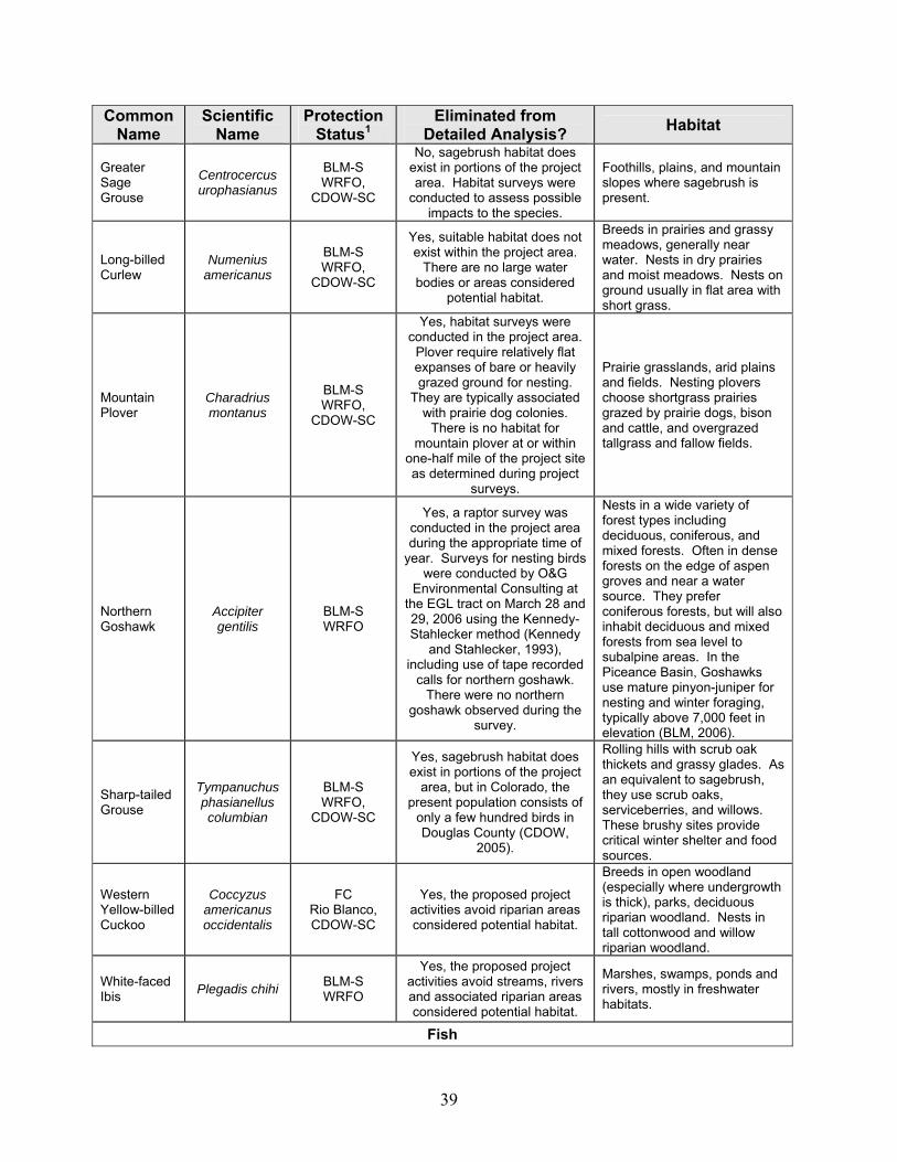
39
Common Name
Scientific Name
Protection Status1
Eliminated from Detailed Analysis? Habitat
Greater Sage Grouse
Centrocercus urophasianus
BLM-S WRFO,
CDOW-SC
No, sagebrush habitat does exist in portions of the project area. Habitat surveys were
conducted to assess possible impacts to the species.
Foothills, plains, and mountain slopes where sagebrush is present.
Long-billed Curlew
Numenius americanus
BLM-S WRFO,
CDOW-SC
Yes, suitable habitat does not exist within the project area.
There are no large water bodies or areas considered
potential habitat.
Breeds in prairies and grassy meadows, generally near water. Nests in dry prairies and moist meadows. Nests on ground usually in flat area with short grass.
Mountain Plover
Charadrius montanus
BLM-S WRFO,
CDOW-SC
Yes, habitat surveys were conducted in the project area.
Plover require relatively flat expanses of bare or heavily grazed ground for nesting.
They are typically associated with prairie dog colonies.
There is no habitat for mountain plover at or within
one-half mile of the project site as determined during project
surveys.
Prairie grasslands, arid plains and fields. Nesting plovers choose shortgrass prairies grazed by prairie dogs, bison and cattle, and overgrazed tallgrass and fallow fields.
Northern Goshawk
Accipiter gentilis
BLM-S WRFO
Yes, a raptor survey was conducted in the project area during the appropriate time of
year. Surveys for nesting birds were conducted by O&G
Environmental Consulting at the EGL tract on March 28 and 29, 2006 using the Kennedy-Stahlecker method (Kennedy
and Stahlecker, 1993), including use of tape recorded
calls for northern goshawk. There were no northern
goshawk observed during the survey.
Nests in a wide variety of forest types including deciduous, coniferous, and mixed forests. Often in dense forests on the edge of aspen groves and near a water source. They prefer coniferous forests, but will also inhabit deciduous and mixed forests from sea level to subalpine areas. In the Piceance Basin, Goshawks use mature pinyon-juniper for nesting and winter foraging, typically above 7,000 feet in elevation (BLM, 2006).
Sharp-tailed Grouse
Tympanuchus phasianellus columbian
BLM-S WRFO,
CDOW-SC
Yes, sagebrush habitat does exist in portions of the project
area, but in Colorado, the present population consists of
only a few hundred birds in Douglas County (CDOW,
2005).
Rolling hills with scrub oak thickets and grassy glades. As an equivalent to sagebrush, they use scrub oaks, serviceberries, and willows. These brushy sites provide critical winter shelter and food sources.
Western Yellow-billed Cuckoo
Coccyzus americanus occidentalis
FC Rio Blanco, CDOW-SC
Yes, the proposed project activities avoid riparian areas considered potential habitat.
Breeds in open woodland (especially where undergrowth is thick), parks, deciduous riparian woodland. Nests in tall cottonwood and willow riparian woodland.
White-faced Ibis Plegadis chihi BLM-S
WRFO
Yes, the proposed project activities avoid streams, rivers and associated riparian areas considered potential habitat.
Marshes, swamps, ponds and rivers, mostly in freshwater habitats.
Fish

40
Common Name
Scientific Name
Protection Status1
Eliminated from Detailed Analysis? Habitat
Bluehead Sucker
Catostomus discobolus
BLM-S WRFO
Yes, the project activities would not affect any perennial waterbodies or tributaries to
waters that could be possible habitat, including waters of the
Colorado River system.
Large rivers and mountain streams. Occupies a wide range of fluvial habitats including cold, clear mountain streams to warm, turbid streams. Adults almost always in moderate to fast flowing water above rubble-rock substrate; young prefer quiet shallow areas near shoreline.
Bonytail Chub Gila elegans
FE Rio Blanco, CDOW-SE
Yes, the project activities would not affect any perennial waterbodies or tributaries to
waters that could be possible habitat, including waters of the
Colorado River system.
Typically lives in large, fast-flowing waterways of the Colorado River system. Spawns in the spring and summer over gravel substrate.
Colorado Pikeminnow
Ptychocheilus lucius
FE Rio Blanco, CDOW-ST
Yes, the project activities would not affect any perennial waterbodies or tributaries to
waters that could be possible habitat, including waters of the
Colorado River system.
Swift flowing muddy rivers with quiet, warm backwaters.
Colorado River Cutthroat Trout
Oncorhynchus clarki
pleuriticus
BLM-S WRFO,
CDOW-SC
Yes, the project activities would not affect any perennial waterbodies or tributaries to
waters that could be possible habitat, including waters of the
Colorado River system.
Cool, clear water and well-vegetated streambanks for cover and bank stability; instream cover in the form of deep pools and boulders and logs; adapted to relatively cold water, thrives at high elevations.
Flannel-mouth Sucker
Catostomus latipinnis
BLM-S WRFO
Yes, the project activities would not affect any perennial waterbodies or tributaries to
waters that could be possible habitat, including waters of the
Colorado River system.
Moderate to large rivers, seldom in small creeks, absent from impoundments. Typical of pools and deeper runs and often entering mouths of small tributaries.
Humpback Chub Gila cypha
FE Rio Blanco, CDOW-ST
Yes, the project activities would not affect any perennial waterbodies or tributaries to
waters that could be possible habitat, including waters of the
Colorado River system.
Deep, fast-moving, turbid waters often associated with large boulders and steep cliffs.
Mountain Sucker
Catostomas platyrhynchus
BLM-S WRFO,
CDOW-SC
Yes, the project activities would not affect any perennial waterbodies or tributaries to
waters that could be possible habitat, including waters of the
Colorado River system.
Clear, cold creeks and small to medium rivers with clear rubble, gravel or sand substrate.
Plains Topminnow
Fundulus sciadicus
BLM-S WRFO
Yes, the project activities would not affect any perennial waterbodies or tributaries to
waters that could be possible habitat, including waters of the
Colorado River system.
Populations in Colorado are found in waters where there is abundant filamentous algal growths and still, clear water. Found in isolated colonies in cool, foothills streams, intermittent plains streams, and the lower mainstem South Platte River. Now present in the White River.
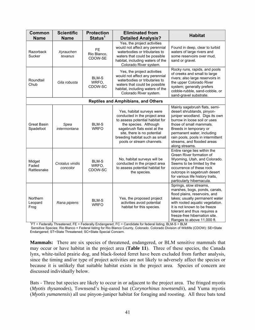
41
Common Name
Scientific Name
Protection Status1
Eliminated from Detailed Analysis? Habitat
Razorback Sucker
Xyrauchen texanus
FE Rio Blanco, CDOW-SE
Yes, the project activities would not affect any perennial waterbodies or tributaries to
waters that could be possible habitat, including waters of the
Colorado River system.
Found in deep, clear to turbid waters of large rivers and some reservoirs over mud, sand or gravel.
Roundtail Chub Gila robusta
BLM-S WRFO,
CDOW-SC
Yes, the project activities would not affect any perennial waterbodies or tributaries to
waters that could be possible habitat, including waters of the
Colorado River system.
Rocky runs, rapids, and pools of creeks and small to large rivers; also large reservoirs in the upper Colorado River system; generally prefers cobble-rubble, sand-cobble, or sand-gravel substrate.
Reptiles and Amphibians, and Others
Great Basin Spadefoot
Spea intermontana
BLM-S WRFO
Yes, habitat surveys were conducted in the project area to assess potential habitat for
the species. Although sagebrush flats exist at the site, there is no potential
breeding habitat such as small pools or stream channels.
Mainly sagebrush flats, semi-desert shrublands, pinyon-juniper woodland. Digs its own burrow in loose soil or uses those of small mammals. Breeds in temporary or permanent water, including rain pools, pools in intermittent streams, and flooded areas along streams.
Midget Faded Rattlesnake
Crotalus viridis concolor
BLM-S WRFO,
CDOW-SC
No, habitat surveys will be conducted in the project area to assess potential habitat for
the species.
Entire range lies within the Green River formation of Wyoming, Utah, and Colorado. Seems to be limited by the occurrence of these rock outcrops in sagebrush desert for various life history traits, particularly hibernacula.
Northern Leopard Frog
Rana pipiens BLM-S WRFO
Yes, the proposed project activities avoid potential habitat for this species.
Springs, slow streams, marshes, bogs, ponds, canals, flood plains, reservoirs, and lakes; usually permanent water with rooted aquatic vegetation. It is not known to be freeze tolerant and thus requires a freeze-free hibernation site. Ranges to above 11,000 ft.
1FT = Federally Threatened; FE = Federally Endangered; FC = Candidate for federal listing; BLM-S = BLM Sensitive Species; Rio Blanco = Federal listing for Rio Blanco County, Colorado. Colorado Division of Wildlife (CDOW): SE=State Endangered; ST=State Threatened; SC=State Special Concern. Mammals: There are six species of threatened, endangered, or BLM sensitive mammals that may occur or have habitat in the project area (Table 11). Three of these species, the Canada lynx, white-tailed prairie dog, and black-footed ferret have been excluded from further analysis, since the timing and/or type of project activities are not likely to adversely affect the species or because it is unlikely that suitable habitat exists in the project area. Species of concern are discussed individually below. Bats - Three bat species are likely to occur in or adjacent to the project area. The fringed myotis (Myotis thysanodes), Townsend’s big-eared bat (Corynorhinus townsendii), and Yuma myotis (Myotis yumanensis) all use pinyon-juniper habitat for foraging and roosting. All three bats tend
42
to use caves and crevices in rocks for hibernacula such as would be found along Black Sulphur Creek and Ryan Gulch. Project activities would not impact caves or cliffs, and adequate foraging and roosting habitat exists adjacent to the project area. The fringed myotis is insectivorous and beetles are a common prey item. Its wings have a high puncture strength, which is characteristic of bats that forage by gleaning from the ground or near thick or thorny vegetation. It often forages close to vegetative canopy. Townsend’s big-eared bat feeds on various flying insects near the foliage of trees and shrubs and may feed primarily on moths. Its activity usually begins well into the night, late relative to other bats, although activity prior to darkness has been observed in some areas. In late afternoon or evening, prior to emergence, it may move closer to the cave entrance. After an initial feeding period, it roosts and rests during the night, presumably before a later feeding bout. The Yuma myotis is insectivorous. Small moths are believed to be the primary food source in some areas, while dipterans and ground beetles are other common prey items. It often feeds over ponds and streams, flying just above the water surface. Birds: There are 12 species of threatened, endangered, candidate, or BLM sensitive birds that may occur or have habitat in the project area (Table 11). Six of these species (Barrow's goldeneye, black tern, long-billed curlew, sharp-tailed grouse, western yellow-billed cuckoo, and white-faced ibis) have been excluded from further analysis, since the timing and/or type of project activities are not likely to adversely affect the species, or because it is not likely that suitable habitat exists in the project area. The burrowing owl and mountain plover have also been eliminated from further analysis since surveys were conducted at the site and found no suitable habitat for these species, and no individuals were observed. The remaining four species are discussed individually below. Bald eagles are winter residents in most areas of Colorado and permanent residents in northern Colorado (Sibley, 2000). Areas of concentrated use are closely associated with larger bodies of water, as they mainly feed on fish and waterfowl. Bald eagle habitat exists along the White River, approximately 18 miles to the north of the tract, and forage in the winter along the Ryan Gulch drainage (BLM, 2006). Bald eagles tend to use traditional communal roosts located in mature trees. Even though the likelihood of bald eagles being found in the project area is low, they were included in the survey conducted in March 2006 and will be included in additional raptor survey to be completed prior to construction activities. Ferruginous hawks prefer open grasslands and shrub steppe areas. Their habitat includes sagebrush and greasewood-saltbrush shrub lands often on the periphery of pinyon-juniper habitat. Ferruginous hawks will nest on the ground, usually far from human activity. They will also use lone trees in grassland communities for nesting. Suitable habitat for the ferruginous hawk does exist within one mile of the project area. Ferruginous hawks were included in the survey conducted in March 2006 and will be included during subsequent raptor surveys to be completed prior to the start of construction activities.

43
Greater sage grouse habitat consists of large, woody sagebrush which they depend on for food and cover throughout the year. Sage grouse are polygamous and exhibit consistent breeding behavior each year on ancestral strutting grounds, referred to as leks. Leks are situated in relatively open areas with less herbaceous and shrub cover than surrounding areas. Leks are typically surrounded by potential nesting habitat, and are adjacent to relatively dense sagebrush stands. Nesting habitats are characterized by sagebrush communities with well-developed horizontal and vertical diversity. Active nesting sites tend to occur in higher sagebrush density, taller live and residual grasses, more live and residual grass cover, and less bare ground (Connelly et. al., 2000). Grouse are susceptible to sagebrush community disturbance and destruction, as well as construction of fences, aboveground power lines, and other aboveground structures (NatureServe, 2005; Connelly et al., 2000). Grouse avoid areas that may provide perching or roosting opportunities for raptors, such as fence posts and aboveground power lines. Human activities occurring during breeding season may disrupt normal use of leks and subsequently affect local breeding success. Although the project area is outside mapped sage grouse habitat, they were included during habitat assessments in the project area. Northern goshawk are found in mountainous areas around Colorado. They prefer coniferous forests, but will also inhabit deciduous and mixed forests from sea level to subalpine areas. In the Piceance Basin, Goshawks use mature pinyon-juniper for nesting and winter foraging, generally above 7,000 feet in elevation for nesting (BLM, 2006). These areas are also used as winter foraging habitat. Goshawks frequently reuse the same nest for many years. If they do not use the same nest, then they at least breed in the same area. This hawk is also habitual in the non-breeding season and will return to the same wintering location year after year. Suitable habitat does exist in portions of the project area. Surveys for nesting birds were conducted by O&G Environmental Consulting at the EGL tract on March 28 and 29, 2006 using the Kennedy-Stahlecker method (Kennedy and Stahlecker, 1993), including use of tape recorded calls for goshawk and great horned owl. The surveys included the entire 160-acre tract, plus a one-half mile buffer around the tract. The surveys were accomplished using a combination of driving and walking, and all raptor sightings and nests (active and inactive) were documented. No nests were observed during the survey, and no responses were received to goshawk or great horned owl calls (O&G Environmental Consulting, 2006). Construction of the project would result in the clearing of approximately 36 acres of winter forage and nesting habitat. Fish: The four federally listed endangered Colorado River fish species; bonytail chub, Colorado pikeminnow, humpback chub, and razorback sucker, and the six BLM Sensitive fish species; bluehead sucker, Colorado River cutthroat trout, flannelmouth sucker, mountain sucker, plains topminnow, and roundtail chub habitat includes waters of the Colorado River System. Any depletions to waters of the Colorado River System may affect the four endangered species. Water of the Colorado River System may be impacted by water depletions associated with drilling operations and facility operations. EGL proposes to obtain the water it needs for drilling and operations from local supplier, who in turn may obtain that water from shallow wells or surface water of the Colorado Basin. For drilling operations, a maximum estimated depletion of 3.9 acre-feet per year is estimated, and for facility operations, a maximum of 1.3 acre-feet per year. Groundwater withdrawn upgradient of the test tract would be reinjected in groundwater
44
downgradient of the tract, resulting in no net loss and no water depletion associated with dewatering of the retorted zone. The proposed activities avoid perennial rivers or streams. Reptiles and Amphibians: There are three species of BLM sensitive amphibians and reptiles that may occur or have habitat in the project area (Table 11). Two of these species, the northern leopard frog and Great Basin spadefoot have been excluded from further analysis since the timing and/or type of project activities are not likely to adversely affect the species, or because it is not likely that suitable habitat would be found in the project area. The remaining species is discussed below. Midget faded rattlesnakes occupy rocky outcrops of the Green River formation. They are also found in desert shrub, mountain shrub, and coniferous habitats. Little is known about this species. They hunt nocturnally and reproduce between March and September. The snake is endemic to western Colorado, Wyoming, and eastern Utah (NatureServe, 2005). Habitat is potentially present for the species within the project area. The species is fairly mobile and secretive, however, and noise and vibration from construction would likely temporarily displace the species from the area. Unless a den site was directly impacted by construction equipment, it would not likely be affected by project activities. Habitat surveys were conducted at the EGL tract in March and April 2006 to evaluate potential impact to species. Field data and all available wildlife information sources such as the USFWS, Colorado Division of Wildlife (CDOW), and the BLM were then compiled to determine which special status species will require detailed analysis and may need clearance surveys. Based on the data presented in Table 11 above, it is anticipated that the following wildlife species may occur in the project area:
• fringed myotis – (Myotis thysanodes) – BLM Sensitive • Townsend’s big-eared bat (Cornorhinus townsendii) – BLM Sensitive • Yuma myotis (Myotis yumanensis) – BLM Sensitive • bald eagle (Haliaeetus leucocephalus) – Federally Listed Threatened • ferruginous hawk (Buteo regalis) – BLM Sensitive • greater sage grouse (Centrocercus urophasianus) – BLM Sensitive • northern goshawk (Accipiter gentilis) – BLM Sensitive • midget faded rattlesnake (Crotalus viridis concolor) – BLM Sensitive
Environmental Consequences of the Proposed Action Construction of the project facilities and power line would temporarily remove approximately 36 acres of foraging habitat and 8 acres of roosting habitat for the fringed myotis, Townsend’s big-eared bat, Yuma myotis, bald eagle, ferruginous hawk, greater sage grouse, northern goshawk, and midget faded rattlesnake. The planned layout of facilities was designed, in part, to minimize the amount of pinyon-juniper vegetation (roosting habitat) that would be cleared. The surrounding area provides adequate foraging and roosting habitat, and species are likely to relocate to these surrounding areas. Habitat removal would be for 5 to 10 years until re-vegetation efforts were successful and native vegetation was restored. Re-establishment of

45
pinyon-juniper woodland and sagebrush shrubland would be expected within 20 to 300 years, depending on revegetation success. Construction would generally take place during daylight hours, at times when the fringed myotis, Townsend’s big-eared bats, and Yuma myotis would not be in the area. Some construction activities, however, may occur temporarily on a 24-hour basis. After it is constructed and operating, the facility would run 24 hours a day. Construction of the RD&D project would not affect the BLM Sensitive fish species since no major rivers or perennial streams will be affected by project activities. Any water depletions that are hydraulically connected to the Colorado River Basin are considered to adversely affect the four endangered Colorado River fish species. Subalternative - Proposed Action with Mitigation In addition to the proposed action, impacts to special status species would be minimized by implementing the following mitigation measures:
• conduct follow-up raptor surveys if construction activities do not begin prior to the 2007 raptor nesting season;
• conduct surveys prior to construction activities to determine which species will require clearance surveys in the project area if construction occurs in spring of 2007.
• enforce limitations on activities within a one-half mile radius of active nests of raptors that are threatened, endangered, or BLM sensitive between February 1 – August 15 (one-fourth mile for other raptors) and consulting with USFWS if any special status species nests are discovered on or adjacent to the project area;
• prevent vegetation clearing while migratory birds are nesting (February 1 through August 15); and
• ensure that reserve pits are lined, fenced on all four sides with net-wire and covered with plastic barrier to exclude both large and small animals and netted to prevent birds from accessing these pits, and reclaiming the pits as soon as possible after use.
• adhere to the requirements of a USFWS Biological Opinion and USFWS Colorado River Fish Species recovery program.
Environmental Consequences of the Subalternative Construction of the project facilities and power line would temporarily remove approximately 36 acres of foraging habitat and 8 acres of roosting habitat for the fringed myotis, Townsend’s big-eared bat, Yuma myotis, bald eagle, ferruginous hawk, greater sage grouse, northern goshawk, and midget faded rattlesnake. Activities would potentially disturb and dislocate individual animals. However, the broader landscape provides sufficient foraging and roosting habitat to conclude that removal of 36 acres is not likely to adversely impact any federally endangered or threatened species, or any BLM sensitive species. Disturbance to individual animals from construction and operation of the proposed action would be minimized by implementing the timing restrictions, surveys, and mitigation measures identified in this alternative.
46
Any water depletions that are hydraulically connected to the Colorado River Basin are considered to adversely affect the four endangered Colorado River fish species. The project would adhere to the requirements of the streamlined Biological Opinion and USFWS Colorado River Fish Species recovery program (see discussion of ESA Section 7 Consultation below). Environmental Consequences of the No Action Alternative If the RD&D lease is not approved, no impacts associated with the proposed action would occur. Under existing management, no additional impacts are anticipated beyond those associated with actions analyzed in the existing RMP. Endangered Species Act Section 7 Consultation A Biological Assessment (BA) was prepared in compliance with Section 7(c) of the Endangered Species Act (ESA) and submitted to the U.S. Fish and Wildlife Service (FWS). The FWS will review the BA to assess the potential impacts of the proposed action with Mitigation on federally-listed endangered, threatened, proposed for listing, and candidate species. The analysis, results, and conclusions presented in the BA are based on surveys and research conducted by biologists and botanists contracted by the preparer and the BLM. Based on the analyzed impacts of the sub-alternative (the proposed action with mitigation) BLM concluded there will be “no effect” on all but five federally-listed endangered, threatened, proposed for listing and candidate species. For the bald eagle, the BA described that increased activity from implementation of the proposed action with Mitigation may increase the incidence of vehicle accidents or disrupted feeding, resulting in a conclusion of “may affect, not likely to adversely affect”. For the four endangered Colorado River fish species, water depletions of up to 3.9 acre/feet per year from local water supply companies or wells “may affect, not likely to adversely affect” endangered Colorado River fish species. The water depletions constituting the 3.9 acre/feet per year are to be used during drilling and construction and from boiler makeup water during project operation. Aquifer dewatering and reinjection processes that are part of the proposed action do not constitute depletion. Based on the determination that implementing the sub-alternative (the proposed action with mitigation) “may affect, not likely to adversely affect” endangered Colorado River fish species, consultation between the BLM and USFWS could occur as agreed under the minor water depletions Programmatic Biological Opinion, which addresses water depletions less than 125 acre-feet/year. Upon review of the BA, the USFWS will prepare a streamlined Biological Opinion on the project. Finding on the Public Land Health Standard for Threatened and Endangered Species The proposed action would have no adverse effect on any federally listed species and would not jeopardize the viability of any animal population. The project would not adversely affect habitat condition, utility, or function, nor have any discernible effect on species abundance or distribution at any landscape scale. The public land health standard would continue to be met.

47
THREATENED, ENDANGERED, AND SENSITIVE PLANT SPECIES Affected Environment This section presents federally-listed threatened, endangered, and candidate plant species and plants listed as “sensitive” by BLM (BLM, 2005). Threatened, endangered, and BLM Sensitive plant species known to occur in northwest Colorado are described in paragraphs below. All of these species are considered rare by the Colorado Natural Heritage Program. The majority of species on this list are associated with the Green River formation. Others are known from the area but may not have such specific habitat requirements. An assessment of the potential for the occurrence of threatened, endangered, candidate, and sensitive plants was conducted in 2006 (WestWater Engineering, Inc., 2006). This assessment was based on tract geology, soil, vegetative cover, and proximity of known populations of rare plants. Conclusions of the assessment were verified in subsequent biological surveys. Federally-listed Threatened Plant Species:
• Dudley Bluffs bladderpod (Lesquerella congesta) – is endemic to the Piceance Basin, exhibiting a small cushion growth form. The only known occurrences are on barren, white shale outcrops of the Thirteen Mile Tongue of the Green River formation at elevations from 6,000 to 6,700 feet. This is an extremely small perennial plant flowering in late April and May. Its fruit mature in late May and June. Known occurrences of this plant are located in the Dudley Bluffs, Ryan Gulch, and Duck Creek ACECs, and many satellite populations occur outside the ACECs throughout the Piceance Basin.
• Dudley Bluffs twinpod (Physaria obcordata) - also is endemic to the Piceance basin. It
is perennial plant that flowers in May and June, with fruit set in July. This species occurs on barren white shale outcrops and steep colluvial slopes derived from the Thirteen Mile Tongue and the Parachute Creek member of the Green River formation at an elevation range of 5,900-7,500 feet. Known occurrences of this plant are located within the Dudley Bluffs, Ryan Gulch, and Yank’s Gulch ACECs and many satellite populations occur outside the ACECs throughout the Piceance Basin.
• Ute ladies’-tresses (Spiranthes diluvialis) - inhabits wet meadows and other riparian
habitats that are subject to fluvial erosion and deposition. It may also be found near springs, seeps, and lakeshores between 4,265 and 6,800 feet where there is sufficient groundwater. The plant blooms in July. This species has not been documented within the Piceance Basin.
Proposed Threatened Plant Species:
• Graham beardtongue (Penstemon grahamii) is limited to eastern Utah and one Colorado location west of Rangely within the Raven Ridge ACEC, where it occurs on talus slopes and knolls of the Green River formation at an elevation range of 5,800-6,000

48
feet. It blooms in May. No occurrences of this plant have been documented in the Piceance Basin.
Plants Candidate for ESA Listing
• Parachute penstemon (Penstemon debilis) is only known to occur in five locations in Garfield County. The plant grows on sparsely vegetated, south facing, steep, white shale talus in the Mahogany Zone of the Parachute Creek Member of the Green River formation between 7,800 and 9,000 feet elevation. No occurrences of this plant are known to occur in the WRFO.
• White River penstemon (Penstemon scariosus var. albifluvis) occurs on barren shale
outcrops of the Green River formation along the White River in eastern Utah. Like Penstemon grahamii, this species is known from one Colorado location within the Raven Ridge ACEC, west of Rangely. The preferred elevation range is 5,000-7,200 feet. No occurrences of this plant have been documented in the Piceance Basin.
BLM Sensitive Plant Species:
• Park rockcress (Boechera fernaldiana var. fernaldiana) is known to occur on Weber sandstone and limestone outcrops in Uintah County, Utah and extreme western Moffat County, Colorado, in and around Dinosaur National Monument. This species generally occurs at elevations between 5,800 and 6,000 feet. No occurrences of this plant have been documented in the Piceance Basin.
• Debris milkvetch (Astragalus detritalis) occurs from near Meeker into northeastern
Utah. There does not appear to be a geological substrate with which it is closely associated, as it occurs on rocky or sandy soils on alluvial terraces with cobbles. The elevation ranges between 5,400 and 7,200 feet. The plant flowers in May. No occurrences of this plant have been documented in the Piceance Basin.
• Ephedra buckwheat (Eriogonum ephedroides) occurs on the Green River formation
within the Raven Ridge ACEC west of Rangely at an elevation range of 5,800-6,000 feet. Flowering occurs in May. No occurrences of this plant have been documented in the Piceance Basin.
• Utah gentian (Gentianella tortuosa) has been found in Colorado along the crest of the
Cathedral Bluffs, where it occurs on barren shale outcrops of the Green River formation. Several other populations are known from Utah and Nevada. This species blooms in July or August, and occurs at elevations of 8,500-10,800 feet. The known occurrences of this plant are in the South Cathedral Bluffs ACEC.
• Narrow-stem gilia (Gilia stenothyrsa) is known from a few locations in Mesa and Rio
Blanco Counties, Colorado, and in the Uinta Basin of Utah. This species grows on silty or gravelly loam soils derived from the Green River or Uinta formations at elevations of
49
5,000 to 6,000 feet. Flowering occurs in late May and into June. The only known occurrence of this species in the Piceance Basin is within the Lower Greasewood ACEC.
• Piceance bladderpod (Lesquerella parviflora) is known only from Colorado, in Rio
Blanco, Garfield, and Mesa counties, Colorado. Its habitat is shale outcrops of the Parachute Creek Member of the Green River formation on ledges and slopes of canyons in open areas at elevations from 6,200 to 8,600 feet. Flowering occurs from May through July. Known occurrences of this plant are in the South Cathedral Bluffs ACEC.
• Narrow-leaf evening primrose (Oenothera acutissima) is limited to Daggett and Uintah
Counties, Utah, and Moffat County, Colorado. This species flowers in May and June at an elevation range of 5,300 to 8,500 feet. No populations are known as far south as the Piceance Basin.
• Rollins cryptanth (Oreocarya rollinsii) occurs in Colorado on white shale barren slopes
of the Green River formation in western Rio Blanco County in the Raven Ridge ACEC. Flowering occurs in May at 5,300 to 5,800 feet elevation. No occurrences of this plant have been documented in the Piceance Basin.
Special status species (SSS) plants expected to occur within the Piceance Basin most commonly occur on relative barren exposures of the Green River formation. The two SSS species most likely to be present in the project area are the Dudley Bluffs bladderpod and Dudley Bluffs twinpod. The EGL tract is located on the Uinta formation at an elevation of 6,820 to 6,960 feet. Soils derived from the Uinta formation do not provide potential habitat for any SSS plants. This parcel is also located at an elevation well above that of the nearest known SSS plant populations. No outcrops of the Green River formation or barren areas resembling potential habitat occur within the parcel. No SSS plants have been documented within this parcel. The nearest populations of SSS plants are located 5.5 miles northeast of the parcel in the Ryan Gulch ACEC along the lower valley slopes of Ryan Gulch and in the Dudley Bluffs ACEC along the lower slopes of Piceance Creek. Environmental Consequences of the Proposed Action Based upon the uniform vegetative cover of this parcel, the lack of any potential habitat detected within the parcel and the lack of any documented occurrences of SSS plants closer than 5.5 miles of the parcel, there is little potential for SSS species to be present on the EGL tract. If threatened, endangered, or BLM sensitive plant species or habitat are identified during construction or operation, EGL will coordinate with the BLM to determine conservation measures and the need for FWS consultation for threatened and endangered and BLM sensitive plant species.
50
Subalternative - Proposed Action with Mitigation Although there is little potential for special status plant species in the project area, pre-construction surveys would be conducted for special status plants during the flowering period to ensure potential individual plants are identified prior to construction activities. If threatened, endangered, or BLM sensitive plant species or habitat are identified during future field surveys, EGL will coordinate with the BLM to determine conservation measures and the need for FWS consultation for threatened and endangered and BLM sensitive plant species. EGL will also implement the following BLM mitigation measures in the event sensitive plant species are identified:
• avoiding plants that occur outside the project area and install exclusion fencing to prevent disturbance from construction activities;
• conducting source population surveys in areas where plants could not be avoided to determine the magnitude of impact on the entire population; and
• evaluating the potential for site design modifications in areas where plants occur. The potential for site design modifications would depend on feasibility and site-specific terrain conditions.
Environmental Consequences of the Subalternative Although there is little potential for SSS species to be present on the EGL tract, the proposed mitigation alternatives would ensure impacts to special status plant species are avoided by identifying individual plants prior to construction activities. Site design modification will help ensure impacts to individual plants are minimized or avoided. Environmental Consequences of the No Action Alternative If the RD&D lease is not approved, no impacts associated with the proposed action would occur. Under existing management, no additional impacts are anticipated beyond those associated with actions analyzed in the existing RMP. Finding on the Public Land Health Standard for Threatened and Endangered Species The proposed and alternative actions would not jeopardize the viability of any plant population. With implementation of mitigation measures, the project would have no discernible consequence on habitat condition, utility, or function, nor have any discernible effect on species abundance or distribution at any landscape scale. The public land health standard would continue to be met. WASTES, SOLID OR HAZARDOUS Affected Environment Hazardous materials are defined by the BLM as any substance, pollutant, or contaminant that is listed as hazardous under the Comprehensive Environmental Response, Compensation, and Liability Act (CERCLA) of 1980, as amended, 42 USC 9601 et seq., and its regulations. The
51
definition of hazardous substances under CERCLA includes any “hazardous waste” as defined in the Resource Conservation and Recovery Act (RCRA) of 1976, as amended 42 USC 9601 et seq., and its regulations. The term does not include petroleum, including crude oil or any fraction thereof, that is not otherwise specifically listed or designated as a hazardous substance under CERCLA Section 101(14), 42 USC 9601(14), nor does the term include natural gas. The affected environment for hazardous materials includes air, water, soil, and biological resources that may potentially be affected by an accidental release of hazardous materials during transportation to and from the project area, storage, and use in construction and operations. Sensitive areas for hazardous materials release includes areas adjacent to waterbodies, above aquifers, and areas where humans or wildlife would be directly impacted. The EGL tract does not contain any known hazardous or solid waste sites, and no hazardous substances are known to have been stored or disposed of within the project area. A small natural gas pipeline traverses the tract, and a groundwater monitoring well has been recently installed, but there are no known wastes associated with either of these projects on the EGL tract. A variety of materials typical of the oil and gas drilling and production operations prevalent in the Piceance Basin could be onsite during construction and operations including: lubricants, diesel fuel, gasoline, lubricating oils, solvents, and hydraulic fluid. Smaller quantities of other materials such as herbicides, paints, and other chemicals would be used during facility operation and maintenance. These materials would be used to control noxious weeds, facilitate revegetation on disturbed areas, and to operate and maintain the facility during the life of the project. Solid waste (human waste, garbage, etc.) would be generated during construction activities and during operation of the oil shale RD&D facility. Environmental Consequences of the Proposed Action Accidental spills or leaks associated with equipment failures; refueling and maintenance of equipment; and storage of fuel, oil, or other fluids could cause soil, surface water, and/or groundwater contamination during construction and operation of the oil shale RD&D facility. The project would increase contributions to solid waste landfills. Solid waste construction impacts would be temporary, while plant operation impacts would occur for the life of the project. The severity of potential impacts from an accidental hazardous material spill would depend upon the chemical released, the quantity released, and the proximity of the release to a waterbody or aquifer. Steam is anticipated to be used as the heat transfer liquid, although this research project may also consider using other heat transfer liquids that are hydrocarbon and/or silicone based. None of the heat transfer liquids that are anticipated to be used would be extremely hazardous or meet the criteria for an acutely hazardous material/substance. All heat transfer liquids would be handled in a closed system and not be exposed to the underground or surface environment. No spent shale would be produced from the in-situ operation, therefore there would be no generation of shale-related solid or hazardous waste.
52
Care would be taken to prevent leaks, and tanks with surrounding berms would be used to contain spills of liquid materials. Potentially harmful substances used in the construction or operation of the proposed oil shale research facility would be kept on site, in limited quantities, for short periods, and would be properly managed. Chemicals subject to reporting under Title III of the Superfund Amendments and Reauthorization Act (SARA) in quantities of 10,000 pounds or more would not be used, produced, stored, transported, or disposed of during the construction or operation of the facility. In addition, no extremely hazardous substance, as defined in 40 CFR 355, in amounts above the threshold planning quantities, would be used, produced, stored, transported, or disposed of from construction or operation of the RD&D facility. Subalternative - Proposed Action with Mitigation Under this alternative, in addition to the proposed action, BLM would require the following mitigation in addition to the actions described in the proposed action to ensure impacts from hazardous or solid wastes would be minimized by implementation:
• watching for signs of hazardous or solid wastes as EGL excavates operational and infrastructure sites, and if found taking appropriate reporting and mitigative measures to protect the public and workers;
• maintaining the project area in a sanitary condition at all times; • providing an adequate number of trash containers on-site; • disposing trash and nonflammable wastes at an appropriate waste disposal site; • providing portable toilets on-site, removing and disposing of contents in accordance with
applicable laws and regulations; • using storing, transporting, and/or disposing of hazardous materials in accordance with
applicable federal and state laws; and • implementing spill prevention measures, inspection and training requirements, and spill
response and notification procedures to minimize the potential for accidental spills or leak.
• EGL will also prepare and implement a Spill Prevention, Control and Countermeasures (SPCC) plan for BLM approval aimed at reducing the potential for adverse impacts associated with spills and leaks.
Environmental Consequences of the Subalternative Mitigation measures will reduce potential impacts from hazardous or solid wastes by implementing best management practices to ensure all wastes are properly handled and measures are in place to manage accidental releases. The project would still increase contributions to solid waste landfills. However, solid waste construction impacts would be temporary, while plant operation impacts would occur for the life of the project. Accidental spills or leaks associated with equipment failures, refueling, or maintenance of equipment, and storage of product, fuel, oil, or other fluids during construction and operation of the EGL facilities may occur. However,
53
the severity of potential impacts from an accidental hazardous material spill would depend upon the chemical released, the quantity released, and the proximity of the release to a waterbody or aquifer. A BLM-approved SPCC plan would reduce impacts to soils from accidental releases. Environmental Consequences of the No Action Alternative No hazardous or solid wastes would be generated or managed in the No Action Alternative. Potential impacts from hazardous or solid waste, beyond those associated with actions analyzed in the 1997 WRRA RMP would not occur if the proposed EGL project did not proceed. WATER QUALITY, SURFACE AND GROUND Affected Environment
The EGL tract is located between Ryan Gulch (an intermittent stream) and Black Sulphur Creek (a perennial stream) in the White River basin. Both streams flow northeastward about 5 miles before joining Piceance Creek. From its confluence with Ryan Gulch and Black Sulphur Creek, Piceance Creek flows northward about 10 miles before discharging into the White River west of Rio Blanco Lake. The White River is a tributary to the Green River in Utah which is a tributary to the Colorado River. Snow melt and precipitation in the project area run off into surface water and/or infiltrate into a thick unsaturated zone. Infiltrating water moves downward into alluvial and bedrock aquifers. Discharge from the aquifers then contributes to spring and stream recharge. It is estimated that approximately 80 percent of the base flows in Piceance Creek originates as discharge from alluvial and bedrock aquifers (Tobin, 1987). The EGL tract is outside areas of substantial natural recharge (Topper et. al., 2003). Figure 4 is a diagram of the surface-groundwater flow system in the area. The EGL project would not require the construction of produced water storage ponds. Boiler makeup water, drilling water, and water used by site personnel would be purchased from municipalities and trucked to the tract. Water purchased from local suppliers is likely to be withdrawn from private wells or surface water sources, and would constitute a depletion to the Colorado River Basin. During drilling operations, a maximum depletion of 3.9 acre-feet per year is estimated. During operations, a maximum depletion of 1.3 acre-feet per year is estimated for boiler makeup water and water used by site personnel. Surface Water Water quality data for Black Sulphur Creek (Table 12) indicate that total dissolved solids (TDS) range from 645 to 1,380 milligrams per Liter (mg/L), concentrations not suitable for human consumption but sufficient for livestock and irrigation. The water is a slightly alkaline sodium-magnesium-calcium bicarbonate-sulfate type. This type of water chemistry indicates the source of the water is a mixture of local recharge interacting with surface lithology, possibly with contributions from the upper bedrock aquifer. However, the upper aquifer contributions must be

54
limited, given the much higher concentrations of sodium, bicarbonate, chloride, and TDS in that aquifer (Czyzewski, 2000).
Table 12 Water Quality Data for Black Sulphur Creek, 1975 – 1981 Parameter
(all units mg/L unless otherwise indicated)
Minimum 25th Percentile Median 75th
Percentile Maximum
pH (standard units) 7.5 8 8.2 8.3 8.8 Sodium 62 140 150 170 200 Potassium 0.1 2 2.3 2.9 13 Calcium 47 93 100 100 120 Magnesium 41 90 96 100 120 Bicarbonate 150 533 560 610 820 Sulfate 170 433 470 510 610 Chloride 6 9 9 11 23 Total dissolved solids 645 1,080 1,140 1,195 1,380 Source: USGS, 2006 The Colorado Department of Public Health and Environment (CDPHE) has adopted basic standards and antidegradation rules for surface waters. These standards establish use classes, designate uses for each waterbody, and specify numeric or narrative water quality standards to protect the designated uses of individual stream segments. Water quality classifications and standards for drainages in the White River Basin are specified in Water Quality Control Commission Regulation No. 37 (CDPHE, 2006a). Ryan Gulch is located in water quality stream segment 16 of the White River Basin. Black Sulphur Creek is in water quality stream segment 20 of the White River Basin. Stream segment 16 of the White River Basin has been designated “Use Protected”. The antidegradation review requirements in the Antidegradation Rule are not applicable to waters designated as use-protected. For those waters, only the protection specified in each reach apply. The state has classified segment 16 as being beneficial for the following uses: Warm aquatic life 2, Recreation 2, and Agriculture. For stream segment 16 minimum standards for four parameters are listed as follows: dissolved oxygen = 5.0 mg/L, pH = 6.5 - 9.0, fecal coliform = 2000/100 mL, and E. coli = 630/100 mL. CDPHE has determined that stream segment 16 of the White River Basin is fully supporting all of its designated uses. Stream segment 20 of the White River Basin is defined as the mainstems of Black Sulphur and Hunter Creeks from their sources to their confluences with Piceance Creek. Segment 20 has not been designated use-protected. An intermediate level of water quality protection applies to waters that have not been designated outstanding waters or use-protected waters. For these waters, no degradation is allowed unless deemed appropriate following an antidegradation review. The state has classified segment 20 as being beneficial for the following uses: Cold aquatic life 1, Recreation 2, and Agriculture. CDPHE has determined that stream segment 20 of the White River Basin is fully supporting all of its designated uses except Recreation Class 2, which has not been assessed (CDPHE, 2006b). In addition, Black Sulphur Creek has minimum in-stream flow requirements for preservation of aquatic life and habitat.

55
CDPHE defines Aquatic Life Cold Class 1 waters as being capable or potentially capable of sustaining a wide variety of cold-water biota. Aquatic Life Warm Class 2 waters are not capable of sustaining a wide variety of warm-water biota due to physical habitat, water flows, or uncorrectable water quality conditions. Recreation Class 2 waters are suitable or intended to become suitable for recreational uses on or about the water, including fishing and other streamside recreation. Agriculture waters are suitable or intended to become suitable for irrigation of crops and that are not hazardous as drinking water for livestock. Neither Ryan Gulch nor Black Sulphur Creek is included in the 2006 Section 303(d) list of impaired waters (CDPHE, 2006c) nor the 2006 monitoring and evaluation list of water bodies with suspected water quality problems (CDPHE, 2006d). Groundwater The groundwater system in the project area consists of Quaternary alluvial deposits, an upper bedrock aquifer system, a lower bedrock aquifer system, and a confining layer that separates the two bedrock aquifers. Quaternary alluvial deposits between 0-200 feet thick are present along the surface drainages. These deposits supply shallow wells and serve as recharge or discharge points for the underlying sedimentary rock aquifers. The upper aquifer system consists of discontinuous silty sandstones of limited lateral extent, siltstones, and marlstones of the Uinta and Green River formations. The aquifer is characterized as semi-confined due to the discontinuous nature of the sandstones. The Uinta formation is saturated below the stream levels. The underlying Parachute Creek Member, the topmost member of the Green River formation, has the greatest effect on the local hydrology and water quality. Ranging in thickness from 500-1,800 feet, the Parachute Creek Member is primarily comprised of kerogenaceous dolomitic marlstone with thin pyroclastic beds (Coffin et. al., 1971). As discussed in the Hydrology and Water Rights section of this EA, ongoing hydrogeological investigations have produced data suggesting that within the upper Parachute Creek unit of the Green River formation, the R5 unit may be the unit that separates the upper and lower aquifers rather than the Mahogany zone as previously thought. The lower aquifer consists of the lower part of the Parachute Creek Member of the Green River formation. In general, the hydraulic conductivity of this zone is low with the exception of portions of the upper third where saline minerals have dissolved. In these areas, the nahcolite and halite sequences have been dissolved, leaving behind a brecciated “leached zone” (Saulnier, 1978). The permeability in this leached zone is greater than in the surrounding unleached rocks. It has been reported that a loss of drilling mud often occurs in the leached zone. The leached zone has higher flow volumes, but is thin (0.5-20 feet). Stratigraphic and hydrostratigraphic columns for the Shell Oil Shale Test (OST) Site are presented in Figure 5. Because the EGL tract is approximately four miles southeast of the Shell OST Site, the stratigraphy and hydrostratigraphy of the two sites should be similar. However,
56
local groundwater monitoring will be essential to gain an adequate understanding of aquifer characteristics at the EGL tract prior to implementation of the proposed action. EGL would produce shale oil from the Mahogany and R-6 zones. The lower aquifer is underlain by several thousand feet of a basal confining unit formed by the Douglas Creek, Garden Gulch, and Anvil Point Members of the Green River formation. Water in the Tertiary aquifers gains dissolved solids and shows changes in major-ion chemistry as it moves along the basin flow paths from upland recharge areas to the discharge areas (Topper et. al., 2003). In the upper aquifer unit, the dissolved solids concentration increases from 500 to 1,000 mg/L. Near the EGL tract, the water chemistry of the upper bedrock aquifers in dominated by dissolved sodium, magnesium, bicarbonate, and sulfate. Sodium and bicarbonate are the dominant dissolved constituents in the water from the upper Parachute Creek Member of the Green River formation near the base of the upper aquifers. Characteristic trace elements include strontium in concentrations of several mg/L in the Uinta formation, and fluoride in concentrations of greater than one mg/L in water samples from the lower part of the upper aquifers (Tobin, 1987). The principal dissolved constituents in water from the lower aquifer system are sodium and bicarbonate. In the lower aquifer system, the dissolved solids concentration increases from about 1,000 to 20,000 mg/L near the north-central part of the basin. These high concentrations are likely a result from contact of water with the ancient evaporate deposits of nahcolite, dawsonite, and halite in the Green River formation. The trace element fluoride also has been detected in unusually high concentrations, ranging from 10 to 30 mg/L in the lower aquifers. The trace elements barium, boron, and lithium are abundant in the lower aquifers where chloride concentrations also are greater than several hundred mg/L (Tobin, 1987). Waters with dissolved solids concentrations in excess of 1,000 mg/L are generally unsuitable for potable supply. Nahcolite is found primarily in the northern part of the basin in three forms: crystal rosettes inches to feet in diameter, disseminated crystals in the oil shale tenths of an inch in diameter, and lenses/thin beds up to five feet thick. EGL’s retorting operations would take place above the nahcolite layer. Dawsonite is found in the northern portion of the basin as disseminated, micron-sized crystals. Due to the low solubility of dawsonite, the presence of this mineral does not affect the water quality in the Parachute Creek member. Bedded halite up to five feet thick is found in the central portion of the Piceance Basin. Halite can have a very strong influence on the water quality of the aquifer (Saulnier, 1978).

57
Environmental Consequences of the Proposed Action Surface Water Quality Potential impacts to surface water quality in the project area could result from surface disturbance on the EGL tract, from spills onto the surface of the tract, and from changes to the groundwater flow regime and water quality in the upper aquifer. Surface disturbance (clearing, grading, trenching, and soil stockpiling activities) during construction and operation of EGL facilities could temporarily alter overland flow and groundwater recharge patterns. Near-surface soil compaction caused by construction equipment and vehicles could reduce the soil’s infiltration and permeability rates, increasing surface runoff, soil erosion, and the potential for ponding. The magnitude and duration of potential impacts to surface runoff is anticipated to be minimal based on the relatively low slope of the portion of the tract planned to be disturbed, vegetative cover, distance to surface water bodies, and semi-arid environment of the project area. Sediment migration from erosive soils onsite would be controlled by mitigation measures. The magnitude and duration of potential impacts to groundwater recharge is anticipated to be low based on the recharge areas being limited to discharge ponds associated with drilling operations. Additionally, surface runoff and erosion could increase sediment loads to Ryan Gulch and Black Sulphur Creek if highly erosive soils or intense precipitation events occur. Annual precipitation is 14 to 20 inches per year and occurs primarily as snow. Impacts would be greatest immediately following commencement of construction activities and would decrease thereafter due to soil stabilization and revegetation. Accidental spills or leaks associated with equipment failures, refueling, or maintenance of equipment, and storage of product, fuel, oil, or other fluids during construction and operation of the EGL facilities pose a risk to surface and groundwater resources. Spills or leaks of hazardous fluids could contaminate groundwater in alluvial and bedrock aquifers. The severity of potential impacts would depend upon the chemical released, the quantity released, and the proximity of the release to Ryan Gulch, Black Sulphur Creek, or groundwater aquifers. Surface water quality in nearby streams is determined in part by the relative quantities of water contributed by runoff from precipitation and from baseflow provided by the alluvial and upper aquifer systems. Any changes in the volume of groundwater recharge to the streams or in the quality of that recharge water have the potential to alter surface water quality. Substantial changes in surface water quality are not expected to take place, however, because the groundwater that would be extracted upgradient from the heated shale would be reinjected immediately downgradient from the heated shale, with little or no disruption to groundwater hydrology beyond the boundary of the site. In addition, substantial alteration of water quality in the upper aquifer is not expected (see below). Groundwater Quality The quantity of groundwater in the portion of the Mahogany and R-6 zones that would be retorted is likely small. While some fractures may exist in this zone, providing a potential conduit from the overlying and underlying aquifers, the overall porosity and permeability of this
58
fine-grained rock are low. Much of the groundwater that is present would be removed with extraction wells prior to and during the initial stages of retorting. During retorting, water would be excluded from the production zone as the temperature exceeds the steam curve. This steam drive would push any water outward from the zone and create a hydraulic barrier. In addition, as further heating and production of oil takes place, the conductive fractures and pores would become oil filled, further lowering hydraulic conductivity as a multiphase system is created. These processes would enhance the confining nature of the production zone. Retorting may also alter the rock mineralogy to some degree through loss of carbon dioxide from the carbonate minerals. The extent to which this and other mineral changes may occur is not known at this time. Because EGL’s retorting process will be above the nahcolite layer, there would be no release of this mineral. After processing has ceased, the retorted unit would be slowly cooled, hydraulic controls would be relaxed, and adjacent groundwater would be allowed to contact the treated shale. Post-production transmissivity is expected to be similar to or lower than pre-production. While there may be an enhancement of hydraulic conductivity due to the creation of micro-fractures, these fractures would be oil wet, creating a reduction in the relative permeability of the production zone for water. After the production zone is cooled and filled with water, pump tests would be conducted to determine the post-production hydraulic properties. Water that does enter the retorted shale would come into equilibrium with both the organic fractions that are present as well as the possibly altered minerals and other inorganic substances present in the rock matrix. Hydrocarbons resulting from the thermal cracking and in-situ hydrogenation of kerogen (a product similar to high API oil) would be present at low levels, presumably in the low-ppm range. Changes in rock mineralogy, with accompanying potential changes to water pH, may cause some cations and anions to be present at either higher or lower concentrations than in the pre-retorted groundwater. Any changes in Mahogany and R-6 zone water quality could induce changes in overlying or underlying aquifer water quality, but only to the extent that affected water moves from the Mahogany zone into the adjacent aquifer. As noted above, transmissivity in the retorted unit is not expected to be substantially altered, and the EGL plan is to leave a zone of un-reacted oil shale in place surrounding the production zone to provide hydraulic isolation. As noted above, recent data obtained by Shell indicate that the R5 zone is the primary confining unit separating the upper and lower aquifers. Because the Mahogany and R-6 zones that EGL would retort are above the R5, the integrity of the confining unit would not be compromised, and the process would not cause mixing of water from the upper and lower aquifers.

59
Finding on the Public Land Health Standard for Water Quality Available data indicate that the surface water quality of adjacent streams and the groundwater quality of underlying aquifers are within the criteria set by the state, thus meeting the land health standard. Given the small scale of the affected area, there would not be an impact affecting the public land health standard for water quality. Implementing the alternative mitigation measures combining site restoration techniques, sediment and erosion control measures, spill prevention practices, successful revegetation of disturbed areas, and control of groundwater quality in the upper aquifer system, would help ensure no changes to the land health status. Subalternative - Proposed Action with Mitigation The proposed action identifies potential impacts to surface and groundwater resources. In order to mitigate potential impacts, BLM would require alternative mitigation measures. Prior to construction of facilities and infrastructure, EGL would obtain a stormwater discharge permit authorizing the discharge of stormwater from the site. EGL would submit its approved stormwater management plan to the WRFO. EGL would obtain all necessary federal and state permits and would comply with all applicable water quality permitting requirements. EGL would also prepare and implement a spill prevention, control and countermeasure (SPCC) plan for BLM approval aimed at reducing the potential for adverse impacts associated with spills and leaks. All surface-disturbing activities would strictly adhere to BLM Gold Book (fourth edition) surface operating standards for oil and gas exploration and development. In order to reduce the amount of groundwater infiltrating into the oil shale zone that is being heated, EGL would establish a dewatered zone in the portion of the Mahogany and R-6 zones to be retorted. This will be accomplished with 4-8 pumping wells surrounding the subsurface retort area. Groundwater extracted during dewatering will be re-injected downgradient into the equivalent aquifer intervals in order to maintain regional water tables and avoid disturbing baseflow to nearby streams. Up-gradient and down-gradient multi-level monitoring wells will be installed along the edges of the site to characterize the structure and properties of local aquifers, establish pre-development baseline groundwater conditions, better define the geology of the oil shale resource, and monitor water quality. EGL will work with BLM to develop and implement a groundwater monitoring plan that will be consistent with the project design and environmental parameters. In addition, the stream flow and water quality in nearby streams and springs will also be monitored. Analytes that will be monitored include those regulated by Colorado surface and groundwater quality standards as well as those shown to be elevated or mobilized in bench-scale tests prior to retorting. After the oil shale has adequately cooled, the groundwater will be allowed to re-enter the retorted zone. Groundwater that has reacted with the spent shale will then be pumped to the surface using the dewatering wells, treated if necessary, and re-injected using the existing well system.
60
Pumping and treating of contaminated groundwater will continue until groundwater quality meets applicable regulatory standards. Monitoring will continue as long as needed to determine that the site is acceptable for abandonment. All hydrological and hydrogeological data collected during the life of the project will be provided to the BLM on a quarterly basis for review. To verify the effects of the proposed action on groundwater and surface water a water monitoring and response plan will be submitted and approved by the authorized officer prior to implementation the project.
Environmental Consequences of the Subalternative Potential impacts to surface and groundwater quality in the project area could result from surface disturbance on the EGL tract, from spills onto the surface of the tract, and from changes to the flow regime and water quality in the upper aquifer. The magnitude and duration of potential impacts to surface water is anticipated to be minimal based on the relatively low slope of the portion of the tract planned to be disturbed, vegetative cover, distance to surface water bodies, and semi-arid environment of the project area. Sediment migration from erosive soils onsite would be controlled by mitigation measures. The magnitude and duration of potential impacts to groundwater recharge is anticipated to be low based on the recharge areas being limited to discharge ponds associated with drilling operations. The alternative mitigation would further reduce or minimize impacts to surface and groundwater resources resulting to levels consistent with standards set by regulating agencies (as described in the Affected Environment portion of the Water Quality section). The Colorado Department of Public Health and Environment (CDPHE) has adopted basic standards and antidegradation rules for surface waters. The alternative mitigation will ensure impacts to surface water are within the thresholds proposed by CDPHE. Monitoring described above will ensure that CDPHE standards and rules are met. If the standards and rules are exceeded, the regulatory authority may require modifications to construction or operation activities. EGL’s approved stormwater management plan, SPCC, and adherence to the BLM Gold Book would reduce the potential for adverse impacts associated with stormwater runoff, erosion, spills, and leaks. Groundwater extracted during dewatering and re-injected downgradient into the equivalent aquifer intervals will reduce the amount of produced water and avoid disturbing baseflow to nearby streams. Monitoring will support an adaptive management that is required to mitigate identified impacts according to the approved response plan. Finding on the Public Land Health Standard for Water Quality Available data indicate that the surface water quality of adjacent streams and the groundwater quality of underlying aquifers are within the criteria set by the state, thus meeting the land health
61
standard. However, the lack of sufficient controls, mitigation measures and restoration techniques to reduce or minimize impacts to surface and groundwater impacts may change the land health status in the project area. Implementation of the proposed action with mitigation measures and monitoring would lessen the potential for impacts to the public land health standard for water quality for groundwater. The proposed action may adversely impact the public land health standard to protect riparian areas and wetlands in the proposed EGL tract, but area-wide would not have a large effect. Implementing the alternative mitigation and achieving successful reclamation would prevent exceeding the public land health standard for riparian systems. Environmental Consequences of the No Action Alternative If the RD&D lease is not approved, no impacts associated with the proposed action would occur. Under existing management, no additional impacts are anticipated beyond those associated with actions analyzed in the existing RMP. WETLANDS AND RIPARIAN ZONES Affected Environment Wetlands are areas that are inundated or saturated by surface or groundwater at a frequency and duration sufficient to support, and under normal circumstances, do support a prevalence of wetland vegetation typically adapted for life in saturated soil conditions. Wetlands and riparian areas are a source of substantial biodiversity and serve a variety of functions, including providing wildlife habitat, naturally improving water quality, and flood control. Wetland and riparian areas support higher population densities and greater diversity of species of both plants and animals than any other vegetation community in the project area. Riparian areas occur as narrow zones between stream and wetland areas and adjacent uplands. Wetlands in the project area are typically located along perennial streams. Riparian areas exist along Ryan Gulch approximately two miles from the EGL tract, and along Black Sulphur Creek approximately one mile from the EGL tract. Field surveys of the EGL tract were conducted in April 2006, and no wetlands were identified on the tract. Environmental Consequences of the Proposed Action No wetlands would be permanently filled or drained as a result of the proposed construction. The project would involve dewatering and reinjection of formation groundwater in the vicinity of the EGL tract along Ryan Gulch and Black Sulphur Creek. Potential interaction of withdrawn and reinjected groundwater with wetland or riparian areas along Ryan Gulch and Black Sulphur Creek, while not expected, would be evaluated if identified during the project. Riparian areas and wetlands could be indirectly impacted if groundwater fluctuations or surface water recharge were affected.
62
Subalternative - Proposed Action with Mitigation To minimize potential impacts to riparian areas and wetlands from the proposed action, BLM would require EGL to install monitoring wells on the tract and collect surface water data from Ryan Gulch and Black Sulphur Creek. Monitoring data would be used to identify any potential impacts. Environmental Consequences of the Subalternative No wetlands would be permanently filled or drained as a result of the proposed construction. Potential interaction of the withdrawn and reinjected groundwater with wetlands or riparian areas is not expected as a result of the proposed action. However, riparian areas and wetlands could be indirectly impacted if groundwater fluctuations or surface water recharge were unexpectedly affected by the proposed action. The alternative mitigation, if implemented, would reduce or minimize impacts resulting from hydrologic interactions between groundwater and any wetland or riparian areas. Monitoring data will help EGL determine if there would be any hydrologic interactions. Potential impacts would be mitigated consistent with the approved response plan (see ‘Subalternative’ portion Water Quality, Surface and Ground section). Environmental Consequences of the No Action Alternative If the RD&D lease is not approved, no impacts associated with the proposed action would occur. Under existing management, no additional impacts are anticipated beyond those associated with actions analyzed in the existing RMP. Finding on the Public Land Health Standard for Riparian Systems The proposed action may adversely impact the public land health standard to protect riparian areas and wetlands in the proposed EGL tract, but area-wide would not have a large effect. Implementing the alternative mitigation and achieving successful reclamation would not affect the public land health standard for riparian systems. CRITICAL ELEMENTS NOT AFFECTED OR NOT PRESENT No Wilderness or Wild and Scenic Rivers exist within the area affected by the proposed action. There are also no environmental justice concerns associated with the proposed action.
NON-CRITICAL ELEMENTS
SOILS Affected Environment Four soil units have been mapped by the Soil Conservation Service (SCS, now the Natural Resources Conservation Service) on the EGL tract (Tripp et. al., 1982). These soil map units are described in the following paragraphs.
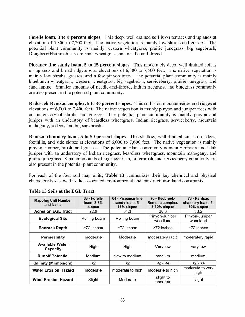
63
Forelle loam, 3 to 8 percent slopes. This deep, well drained soil is on terraces and uplands at elevation of 5,800 to 7,200 feet. The native vegetation is mainly low shrubs and grasses. The potential plant community is mainly western wheatgrass, prairie junegrass, big sagebrush, Douglas rabbitbrush, stream bank wheatgrass, and needle-and-thread. Piceance fine sandy loam, 5 to 15 percent slopes. This moderately deep, well drained soil is on uplands and broad ridgetops at elevations of 6,300 to 7,500 feet. The native vegetation is mainly low shrubs, grasses, and a few pinyon trees. The potential plant community is mainly bluebunch wheatgrass, western wheatgrass, big sagebrush, serviceberry, prairie junegrass, and sand lupine. Smaller amounts of needle-and-thread, Indian ricegrass, and bluegrass commonly are also present in the potential plant community. Redcreek-Rentsac complex, 5 to 30 percent slopes. This soil is on mountainsides and ridges at elevations of 6,000 to 7,400 feet. The native vegetation is mainly pinyon and juniper trees with an understory of shrubs and grasses. The potential plant community is mainly pinyon and juniper with an understory of beardless wheatgrass, Indian ricegrass, serviceberry, mountain mahogany, sedges, and big sagebrush. Rentsac channery loam, 5 to 50 percent slopes. This shallow, well drained soil is on ridges, foothills, and side slopes at elevations of 6,000 to 7,600 feet. The native vegetation is mainly pinyon, juniper, brush, and grasses. The potential plant community is mainly pinyon and Utah juniper with an understory of Indian ricegrass, beardless wheatgrass, mountain mahogany, and prairie junegrass. Smaller amounts of big sagebrush, bitterbrush, and serviceberry commonly are also present in the potential plant community. For each of the four soil map units, Table 13 summarizes their key chemical and physical characteristics as well as the associated environmental and construction-related constraints.
Table 13 Soils at the EGL Tract
Mapping Unit Number and Name
33 - Forelle loam, 3-8%
slopes
64 - Piceance fine sandy loam, 5-
15% slopes
70 - Redcreek-Rentsac complex,
5-30% slopes
73 - Rentsac channery loam, 5-
50% slopes Acres on EGL Tract 22.9 54.3 30.6 53.2
Ecological Site Rolling Loam Rolling Loam Pinyon-Juniper woodland
Pinyon-Juniper woodland
Bedrock Depth >72 inches >72 inches >72 inches >72 inches
Permeability moderate Moderate moderately rapid moderately rapid
Available Water Capacity High High Very low very low
Runoff Potential Medium slow to medium medium medium
Salinity (Mmhos/cm) <2 <2 <2 - <4 <2 - <4
Water Erosion Hazard moderate moderate to high moderate to high moderate to very high
Wind Erosion Hazard Slight Moderate slight to moderate slight

64
Mapping Unit Number and Name
33 - Forelle loam, 3-8%
slopes
64 - Piceance fine sandy loam, 5-
15% slopes
70 - Redcreek-Rentsac complex,
5-30% slopes
73 - Rentsac channery loam, 5-
50% slopes Revegetation Potential fair-poor fair-poor fair-very poor poor-very poor
Environmental Consequences of the Proposed Action More than 138 acres of the 160-acre EGL tract contains soils which have a high or very high water erosion hazard. Clearing, grading, and movement of construction equipment within the tract would remove the protective vegetation cover from these soils, potentially accelerating erosion on an estimated 35 acres. Water erosion of soils associated with construction would result in loss of valuable topsoil by sheet, rill, and gully erosion. Eroded topsoil and subsoil would also contribute to increased sedimentation of area streams and wetlands, adversely affecting water quality and aquatic life. During construction, stripping protective vegetation from soils which are moderately erodible by wind could disperse sandy soil into off-site areas where it could negatively impact vegetation and increase stream sedimentation. Improper road design would also accelerate erosion rates. Where soils have a depth to bedrock averaging less than 60 inches, excavations and construction of foundations for site facilities could encounter bedrock. Depending on hardness, blasting could be needed or excavation with a backhoe may be slowed considerably. Furthermore, there is the potential for mixing broken up rock with the thin layers of topsoil and subsoil. Portions of the site have soils with poor or very poor revegetation potential. As a result, revegetation in these areas following site abandonment would be challenging and could take several years and repeated seeding to achieve success. Spills of petroleum products, fuels, lubricants, and other chemicals used in facility construction, operation, and maintenance could reduce the productivity of soils and inhibit the germination and growth of plants. Subalternative - Proposed Action with Mitigation Potential impacts of the project on soil resources will be minimized by implementing measures for handling topsoil and subsoil, erosion control, compaction, and reclamation. These measures include:
• Topsoil will be stripped to a depth of 6 to 12 inches, depending on its depth. Any subsoil stripped during grading will be stored separately from topsoil to prevent mixing. Soil stockpiles will be seeded and covered with geotextile fabrics. During reclamation, soils will be returned to their pre-construction locations.
• Temporary erosion and sediment controls, including silt fences, straw bales, geotextile fabrics, and sedimentation basins (if needed), will be installed immediately following clearing and grading of the site to control erosion. These structures will be maintained and will be removed during reclamation, as appropriate.

65
• During site reclamation, compacted soils will be loosened using a tractor-pulled ripper or similar device. The site will be returned to its pre-construction contours. All disturbed areas will be seeded with BLM-recommended seed mixes. Permanent erosion control measures, such as mulch and geotextile fabrics will be installed where needed.
• EGL will also prepare and implement an SPCC plan for BLM approval aimed at reducing the potential for adverse impacts associated with spills and leaks.
Environmental Consequences of the Subalternative Water erosion of soils associated with construction could result in loss of valuable topsoil by and contribute to increased sedimentation of area streams and wetlands, adversely affecting water quality and aquatic life. More than 138 acres of the proposed 160-acre site are characterized as soils with a moderate to high water erosion hazard. The proposed action is estimated to remove vegetation and disturb soil on approximately 35 acres. Erosion control measures implemented throughout the proposed site until reclamation is initiated would minimize soil erosion impacts and increase the success of reclamation. Produced water will be disposed of properly to reduce the likelihood and impact of water erosion. Further, EGL does not anticipate sufficient produced water to require storage ponds, reducing the likelihood of water-based erosion. The proposed site is outside of natural water recharge areas. In areas where soils have poor revegetation potential, revegetation in these areas following site abandonment could take several years and repeated seeding to achieve success. Implementing the mitigation measures, would increase the potential for successful reclamation and decrease adverse, long-term impacts to soils at the project location. All surface-disturbing activities would strictly adhere to BLM Gold Book (fourth edition) surface operating standards for oil and gas exploration and development ensuring proper road design to minimize soil erosion. Spills of petroleum products, fuels, lubricants, and other chemicals used in facility construction, operation, and maintenance could reduce the productivity of soils and inhibit the germination and growth of plants. A BLM-approved SPCC plan would reduce likelihood and impacts to soils from accidental releases. Environmental Consequences of the No Action Alternative If the RD&D lease is not approved, no impacts associated with the proposed action would occur. Under existing management, no additional impacts are anticipated beyond those associated with actions analyzed in the existing RMP. Finding on the Public Land Health Standard for Upland Soils Soils at the EGL tract site predominantly meet the public land health standard. The proposed action may adversely impact the public land health standard to protect upland soils in the proposed EGL tract, but area-wide would not have a large effect. Implementing the alternative mitigation would maximize successful topsoil handling procedures, erosion control methods, and restoration measures during construction and reclamation, and the proposed project would continue to meet the standard.

66
VEGETATION Affected Environment The project area encompasses two ecological sites. An ecological site is the product of all the environmental factors responsible for its development. It has characteristic soils that have developed over time throughout the soil development process; a characteristic hydrology, particularly runoff and infiltration; and a characteristic plant community. Each is influenced by the others and influences the development of the others. The plant community on an ecological site is typed by an association of species that differs from that of other ecological sites in the kind and/or proportion of species or in total production (NRCS, 2003). Ecological site descriptions are provided in Table 14.
Table 14 Ecological Sites on the EGL Tract
Ecological Site Name Associated Soil Types found on site Predominant Plant Species
Pinyon-Juniper Red Creek-Rentsac Complex
and Rentsac Channery Loam
Pinyon pine, Utah juniper, Indian ricegrass, beardless wheatgrass,
mountain mahogany, prairie junegrass, with scattered
sagebrush and serviceberry
Rolling Loam Ferelle Loam
and Piceance Fine Sandy Loam
Western wheatgrass, prairie junegrass, big sagebrush, Douglas
rabbitbrush, streambank wheatgrass, and needleandthread
Environmental Consequences of the Proposed Action Construction would result in cutting, clearing, and/or removal of existing vegetation within the construction areas. The construction areas is anticipated to include a 5-15 acre area for facilities, and several pads of less than one acre each associated with groundwater dewatering and injection wells, heating wells, and spider hole/product recovery wells. The degree of impact to each vegetation association would depend on the location of groundwater monitoring wells throughout the tract and on the final placement for aboveground facilities, but are anticipated to be 35 acres or less, plus one acre for the utility line. The majority of these facilities are planned to be sited within the rolling loam ecological site near the center of the tract. Anticipated disturbance of each association is provided in Table 15.
Table 15 Vegetative Disturbance Anticipated at the EGL Oil Shale RD&D Tract
Ecological Site Acres Disturbed
Percent of Disturbance by Ecological Site
Pinyon-Juniper 8 22% Rolling Loam 28 78%
TOTAL 36

67
Disturbances to vegetation could also increase soil erosion, increase potential for the introduction and infestation of invasive non-native species, and reduce wildlife habitat. Impacts to vegetation would vary according to ecological site type and would be short- to long-term. Herbaceous vegetation would likely re-establish within 1 to 2 years, and big sagebrush-dominated communities would likely return to their pre-construction form within 20 to 75 years. Pinyon-juniper woodlands would take from 100 to 300 years to return to pre-construction conditions. However, the amount of pinyon-juniper disturbed is estimated to be 8 acres. Disturbed soils would have the highest probability of being revegetated by invasive, non-native species. The success (or failure) of revegetation would affect other resources including soils, surface water quality, wildlife, visual resources, and livestock grazing. Construction and operation of the tract and associated facilities would result in a loss of some pinyon-juniper woodland for the life of the project. Other vegetation types, mainly grasses and small shrub species would be allowed to reestablish within the project area during operation of the project. Subalternative - Proposed Action with Mitigation Potential impacts from the proposed action from disturbances to vegetation could include soil erosion, increased potential for invasive non-native species and indirect impacts to wildlife resulting from reduction of habitat. To minimize these effects the BLM would require EGL to implement the following measures:
• minimizing vegetation removal to the extent necessary to allow for safe and efficient construction activities;
• cutting trees with a chain saw and/or mechanical shears and cutting brush with a hydro-axe or similar equipment as close to the ground as possible;
• leaving stumps and root balls in place except in areas requiring topsoiling, or as necessary to create a safe and level workspace;
• shredding or chipping brush and salvage with topsoil; • salvaging and replacing topsoil, to preserve and replace existing seed banks and return
organic matter needed for seed establishment to the soil; • restoring pre-construction contours, drainage patterns, and topsoil; • preparing a seedbed (scarifying, tilling, harrowing, or roughening) prior to seeding where
needed to improve revegetation potential; • installing and maintaining erosion control measures until vegetation becomes established;
and • controlling noxious weeds.
EGL would seed disturbed areas with the goals of restoring suitable wildlife habitat and providing a vegetative cover that stabilizes soils to control erosion and sedimentation. Typical seed mixes would reflect environmental conditions and ecological range sites within the tract and emphasize the use of native species (Table 16). Certified weed-free seed purchased from and blended by qualified producers and dealers would be used and requirements met that are described in BLM Instruction Memorandum No. 2006-073 entitled Weed-Free Seed Use on Lands Administered by the BLM (1/20/2006).
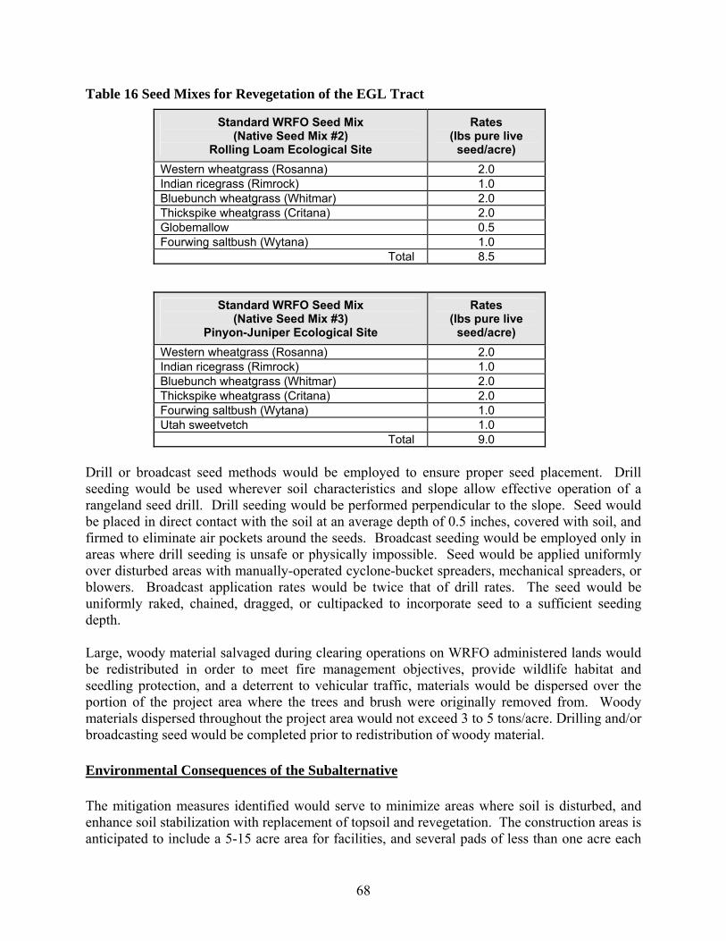
68
Table 16 Seed Mixes for Revegetation of the EGL Tract
Standard WRFO Seed Mix (Native Seed Mix #2)
Rolling Loam Ecological Site
Rates (lbs pure live
seed/acre) Western wheatgrass (Rosanna) 2.0 Indian ricegrass (Rimrock) 1.0 Bluebunch wheatgrass (Whitmar) 2.0 Thickspike wheatgrass (Critana) 2.0 Globemallow 0.5 Fourwing saltbush (Wytana) 1.0 Total 8.5
Standard WRFO Seed Mix (Native Seed Mix #3)
Pinyon-Juniper Ecological Site
Rates (lbs pure live
seed/acre) Western wheatgrass (Rosanna) 2.0 Indian ricegrass (Rimrock) 1.0 Bluebunch wheatgrass (Whitmar) 2.0 Thickspike wheatgrass (Critana) 2.0 Fourwing saltbush (Wytana) 1.0 Utah sweetvetch 1.0 Total 9.0
Drill or broadcast seed methods would be employed to ensure proper seed placement. Drill seeding would be used wherever soil characteristics and slope allow effective operation of a rangeland seed drill. Drill seeding would be performed perpendicular to the slope. Seed would be placed in direct contact with the soil at an average depth of 0.5 inches, covered with soil, and firmed to eliminate air pockets around the seeds. Broadcast seeding would be employed only in areas where drill seeding is unsafe or physically impossible. Seed would be applied uniformly over disturbed areas with manually-operated cyclone-bucket spreaders, mechanical spreaders, or blowers. Broadcast application rates would be twice that of drill rates. The seed would be uniformly raked, chained, dragged, or cultipacked to incorporate seed to a sufficient seeding depth. Large, woody material salvaged during clearing operations on WRFO administered lands would be redistributed in order to meet fire management objectives, provide wildlife habitat and seedling protection, and a deterrent to vehicular traffic, materials would be dispersed over the portion of the project area where the trees and brush were originally removed from. Woody materials dispersed throughout the project area would not exceed 3 to 5 tons/acre. Drilling and/or broadcasting seed would be completed prior to redistribution of woody material. Environmental Consequences of the Subalternative The mitigation measures identified would serve to minimize areas where soil is disturbed, and enhance soil stabilization with replacement of topsoil and revegetation. The construction areas is anticipated to include a 5-15 acre area for facilities, and several pads of less than one acre each

69
associated with groundwater dewatering and injection wells, heating wells, and spider hole/product recovery wells. The degree of impact to each vegetation association would depend on the location of groundwater monitoring wells throughout the tract and on the final placement for aboveground facilities, but are anticipated to be 35 acres or less, plus one acre for the utility line. BLM anticipates disturbance to 8 acres of pinyon-juniper ecological site type and 28 acres of herbaceous and shrub communities. The potential for successful reclamation of these vegetation types would increase by implementing mitigation measures that ensure soil retention, reseeding, and recontouring the site toward preconstruction conditions. The mitigation measures will help ensure herbaceous vegetation would likely re-establish within 1 to 2 years, and big sagebrush-dominated communities would likely return to their pre-construction form within 20 to 75 years. Pinyon-juniper woodlands would take from 100 to 300 years to return to pre-construction conditions. The amount of pinyon-juniper disturbed is estimated to be a small area of the larger landscape in which pinyon-juniper ecosystems are common. Long-term impacts to wildlife habitat would proportionally decrease as reclamation success increases. The use of native seed mixes and implementing the mitigation measures enhancing seeding would stabilize the soil, control erosion and increase the chances for successful reclamation of vegetation. Environmental Consequences of the No Action Alternative If the RD&D lease is not approved, no impacts associated with the proposed action would occur. Under existing management, no additional impacts are anticipated beyond those associated with actions analyzed in the existing RMP. Finding on the Public Land Health Standard for Plant and Animal Communities The EGL tract site predominantly meets the public land health standard and the proposed project would not change this status. The proposed action may adversely impact the public land health standard to protect plant and animal communities in the proposed EGL tract, but area-wide would not have a large effect. Implementing the alternative mitigation would maximize reclamation of native vegetation, enhance erosion control methods during construction and reclamation. Vegetation communities within the test tract have an appropriate age structure and diversity of species that meet the public land health standard. With successful reclamation, the project would not change this status. WILDLIFE, AQUATIC Affected Environment Surface water in the project area is limited to Ryan Gulch, approximately 2 miles north of the EGL tract; Black Sulphur Creek, approximately 1 mile south; Piceance Creek approximately 5 miles east; and associated ephemeral tributaries to these streams. Ryan Gulch is an intermittent stream that does not support fish. Black Sulphur Creek is a small perennial stream that does support some fish species. Piceance Creek has a median daily stream flow of 21 cubic feet per second below (north of) Ryan Gulch (USGS, 2006). During the winter, Piceance Creek flow is affected by ice. Wetland and riparian vegetation in and adjacent to these streams may provide

70
aquatic habitat. The EGL tract itself does not contain streams or provide any aquatic wildlife habitat, as it is comprised of upland vegetation such as pinyon-juniper and sagebrush. Environmental Consequences of the Proposed Action While preliminary calculations show that the area of hydraulic influence associated with de-watering/re-injection operations would be confined to the 160-acre tract, changes in upper aquifer hydrology could alter existing interactions between the upper aquifer, alluvial aquifers, and nearby surface waters if the lateral conductivity of the upper aquifer is greater than currently estimated. Construction of the proposed project could affect aquatic habitat and organisms in downstream water bodies as a result of increased sedimentation and turbidity, increased stream bank erosion, or contamination from accidental hazardous material spills or leaks. Clearing, grading, and movement of construction equipment and vehicles would remove approximately 36 acres of vegetative cover, exposing moderate to highly erodible soils to the effects of wind, rain, and runoff. The effects would accelerate erosion at the tract and, if left unmitigated, could potentially increase sediment loading to ephemeral tributaries of nearby streams. Spills or leaks of hazardous materials could contaminate surface waters and adversely affect aquatic organisms. The severity of such impacts would depend upon the chemical released, the quantity released, and the proximity of the release to a water body or aquifer. Subalternative - Proposed Action with Mitigation To mitigate potential impacts to aquatic wildlife, BLM would require EGL to:
• conduct a comprehensive groundwater monitoring program to evaluate the extent of any hydraulic connection between affected groundwater and surface water (see ‘Subalternative’ portion of the Water Quality Section);
• monitor stream flow and water quality in nearby streams and springs (see ‘Subalternative’ portion of the Wetlands and Riparian Zone section);
• install erosion and sediment control measures, to prevent the flow of spoil into any water bodies (see ‘Subalternative’ portion of the Soils and Vegetation sections);
• maintain erosion and sediment control measures at the project site (see ‘Subalternative’ portion of the Soils and Vegetation sections);
• prohibit storage of hazardous materials, chemicals, fuels and lubricating oils, and prohibit concrete coating and refueling activities within 200 feet of any waterbody or wetland; and
• minimize erosion from upland areas by restoring and seeding disturbed areas (see ‘Subalternative’ portion of the Soils and Vegetation sections).
Environmental Consequences of the Subalternative Surface water in the project area is limited to Ryan Gulch, approximately 2 miles north of the EGL tract; Black Sulphur Creek, approximately 1 mile south; Piceance Creek approximately 5 miles east; and associated ephemeral tributaries to these streams. Clearing, grading, and
71
movement of construction equipment and vehicles would remove approximately 36 acres of vegetative cover, exposing moderate to highly erodible soils to the effects of wind, rain, and runoff. Potential impacts to aquatic wildlife in streams near the project area could result from surface disturbance on the EGL tract, from spills onto the surface of the tract, and from changes to the flow regime and water quality in the upper aquifer. The alternative mitigation would improve soil stability, minimize erosion potential, minimize potential for accidental spills, and reduce impacts to surface and groundwater resources resulting from the proposed action. Finding on the Public Land Health Standard for Plant and Animal Communities The proposed action would not jeopardize the viability of any aquatic animal population, and would have minimal consequence on aquatic habitat condition, utility, or function. The proposed action would not have any discernible effect on aquatic animal abundance or distribution at any landscape scale. The public land health standard would remain unchanged. Environmental Consequences of the No Action Alternative If the RD&D lease is not approved, no impacts associated with the proposed action would occur. Under existing management, no additional impacts are anticipated beyond those associated with actions analyzed in the existing RMP. WILDLIFE, TERRESTRIAL Affected Environment The project encompasses two ecological sites that support a diversity of wildlife and wildlife habitats. Each of these ecological sites provides nesting, cover, and foraging habitat for a variety of mammal, bird, and reptile species common to northwest Colorado. Wildlife inhabiting the area, and upon which management emphasis is placed, includes big game (e.g., elk and mule deer) and non-game species (e.g., raptors). The Colorado Division of Wildlife (CDOW) manages two big game species in the vicinity of the proposed project: elk (Cervis elaphus) and mule deer (Odocoileus hemionus). These species are managed in game management units (GMUs), which are smaller parts of data analysis units (DAUs). These units represent geographic ranges which are typically several hundred thousand to several million acres in area and contain several hundred to tens of thousands of individual animals. The proposed project encompasses deer D-7 and elk E-10 (GMU 22 for both deer and elk). Elk are adaptable animals and occupy a wide variety of habitats, ranging from semi-desert areas to coniferous forests. Although they may use coniferous forests for cover, elk are commonly found in open areas, meadows, and along forest edges. The summer range typically provides a mixture of open brushy and grassy areas, water sources, and areas of dense forest cover. Elk eat mostly grasses when available. In summer, their diet may be 80 to 90 percent grasses. Bark and twigs of trees and shrubs may contribute half the winter diet (CDOW, 2005a). During winter, most elk move to winter ranges where cover and forage are more readily available. The project

72
area includes a diversity of landforms and vegetation types. Pinyon-juniper woodlands, sagebrush steppe, and open grasslands provide forage, hiding cover, and parturition habitats. Statistics on elk populations in the vicinity of the EGL tract are presented in Table 17. Mule deer occur throughout the project area. Suitable habitat, including pinyon-juniper and sagebrush habitats, provide mule deer with forage and cover for all seasons. Deer are browsers, feeding mostly on woody vegetation, including twigs and leaves of shrubs and trees. They also forage on crops, especially corn. Because they eat little grass, they tend not to compete seriously with livestock or elk (CDOW, 2005b). During summer months, the majority of deer can be found in the mountain shrub communities and pinyon-juniper woodlands. During winter months, after the fall migration from summer range, deer concentrate in pinyon-juniper and sagebrush ranges below 7,400 feet where snow depth and temperatures are more moderate (BLM, 1986). Statistics on mule deer populations in the vicinity of the EGL tract are presented in Table 17. Local migration routes in the project area are predominantly north-south, between the Roan Cliffs and the basin floor. Long-distance migration routes are east-west, from the forests east of Meeker and Hamilton.
Table 17 Big Game Population Data
Population Estimate (no.) Data
Analysis Unit Game Management Unit Species
Long- Term
Objective
2005 Projection (Post-hunt)
D-7 11, 211, 12, 13, 131, 231, 22, 23, 24 Mule Deer 67,500 91,980
E-10 21, 22, 30, 31, 32 Elk 3,000 9,170 The entire 160-acre tract area is located within both winter range and summer range for elk and mule deer, but only a portion of the tract is anticipated to be disturbed. The critical range data and associated restrictions established by the BLM and CDOW are provided in Table 18.
Table 18 Big Game Range Data
Habitat / Range Type Timing Stipulations (construction restrictions apply)
Area Disturbed
(Acres) Elk year-round range None 36 Elk summer range May 15 – August 15* 36 Elk winter range December 1 – April 30 36 Mule deer overall range None 36 Mule deer summer range May 15 – August 15* 36 Mule deer winter range December 1 – April 30 36
*development is allowed until 10 percent of the individual GMU summer habitat has been affected and then it is restricted to the given dates. Source: BLM, 1987; BLM, 1996; CDOW, 2004
73
Environmental Consequences of the Proposed Action Impacts on wildlife species and their habitats would vary depending on the requirements of each species and the existing habitat present in the project area. Construction activities could affect wildlife through disturbance, displacement, and mortality. The primary impact to wildlife would be the cutting, clearing, and/or removal of existing vegetation and the resulting loss of cover, nesting, and forage habitat. The degree of impact would depend on the type of habitat affected and the rate that vegetation would regenerate after construction and after final site reclamation. Herbaceous vegetation would be likely to reestablish within 1 to 2 years, and big sagebrush dominated communities would likely return to their pre-construction aspect within 20 to 75 years. Pinyon-juniper woodlands would take up from 100 to 300 years to return to pre-construction conditions. The loss of habitat could impact local and long-distance migratory patterns. Clearing, grading, and movement of construction equipment and vehicles would remove approximately 36 acres of vegetative cover. Clearing activities would result in the displacement of wildlife from areas in and adjacent to the EGL tract. This could cause crowding in adjacent habitat and result in reduced productivity and increased stress-related mortality. Reproductive success and nutritional condition could decrease due to increased energy expenditures that result from physical response to disturbance. Displaced animals may relocate into similar habitats nearby; however, the lack of adequate territorial space could increase intra- and inter-specific competition and could lower reproductive success and survival. Displacement would likely be a temporary impact and animals would likely return to the disturbance area after construction activities are complete. Increased interaction near humans and motor vehicles could result in mortalities from collisions with motor vehicles or poaching. Such impacts would exist for the life of the project. Increased traffic along highways from Meeker and Rifle, along Piceance Creek Road, and on county roads leading to the site would result from construction and operation of the proposed project. Reserve pits, could be constructed at each well, as necessary and could contain drilling fluids for up to one year before being closed. The pits could attract and threaten raptors, waterfowl, and other wildlife. Subalternative - Proposed Action with Mitigation The proposed action identifies potential impacts to terrestrial wildlife. In order to mitigate potential impacts, BLM would require alternative mitigation measures. EGL would implement the following mitigation measures to minimize impacts:
• prohibit construction activities in severe/critical mule deer and elk winter range between December 1st and April 30th;
• redistribute large, woody material salvaged during clearing operations so as not to exceed 3 to 5 tons/acre, and mulch excess woody materials;
74
• limit fencing on the tract to facilities that otherwise would present a hazard to humans and/or wildlife;
• seed disturbed areas according to BLM recommendations; • support carpooling and establish a policy of reduced vehicular speed, especially at night;
and • ensure that reserve pits are lined, fenced on all four sides with net-wire and covered with
plastic barrier to exclude both large and small animals and netted to prevent birds from accessing these pits, and reclaiming the pits as soon as possible after use.
Environmental Consequences of the Subalternative Construction activities could affect wildlife through disturbance, displacement, and mortality. Implementing seasonal restrictions would minimize these impacts during the time it is likely the largest populations would be present in the area. Impacts to wildlife from loss of 36 acres of cover, nesting, and forage habitat would be temporary with successful reclamation efforts. Mitigation measures (see ‘Subalternative’ portion of Vegetation section) will help ensure herbaceous vegetation would be likely to reestablish within 1 to 2 years, and big sagebrush dominated communities would likely return to their pre-construction aspect within 20 to 75 years. Pinyon-juniper woodlands would take up from 100 to 300 years to return to pre-construction conditions. The amount of pinyon-juniper woodlands disturbed (approximately 8 acres) is a small portion of the broader pinyon-juniper landscape surrounding the project area. Limiting fencing would assist in limiting displacement of wildlife from areas in and adjacent to the EGL tract. Displaced animals may relocate into similar habitats nearby; however, the lack of adequate territorial space could increase intra- and inter-specific competition and could lower reproductive success and survival. Displacement would likely be a temporary impact associated with construction and animals would likely return to the disturbance area after construction activities are complete. Efforts to minimize increased interaction near humans and motor vehicles could result in less mortality from collisions with motor vehicles or poaching. Such impacts would exist for the life of the project due to increased traffic along highways from Meeker and Rifle, along Piceance Creek Road, and on county roads leading to the site would result from construction and operation of the proposed project. Fencing and covering reserve pits would minimize impacts to raptors, waterfowl, and other wildlife that may be attracted to the pits. Environmental Consequences of the No Action Alternative If the RD&D lease is not approved, no impacts associated with the proposed action would occur. Under existing management, no additional impacts are anticipated beyond those associated with actions analyzed in the existing RMP.
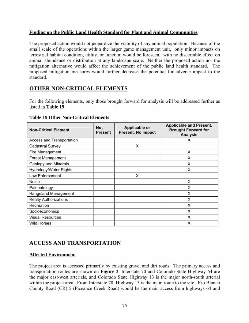
75
Finding on the Public Land Health Standard for Plant and Animal Communities The proposed action would not jeopardize the viability of any animal population. Because of the small scale of the operations within the larger game management unit, only minor impacts on terrestrial habitat condition, utility, or function would be foreseen, with no discernible effect on animal abundance or distribution at any landscape scale. Neither the proposed action nor the mitigation alternative would affect the achievement of the public land health standard. The proposed mitigation measures would further decrease the potential for adverse impact to the standard.
OTHER NON-CRITICAL ELEMENTS For the following elements, only those brought forward for analysis will be addressed further as listed in Table 19.
Table 19 Other Non-Critical Elements
Non-Critical Element Not Present
Applicable or Present, No Impact
Applicable and Present, Brought Forward for
Analysis Access and Transportation X Cadastral Survey X Fire Management X Forest Management X Geology and Minerals X Hydrology/Water Rights X Law Enforcement X Noise X Paleontology X Rangeland Management X Realty Authorizations X Recreation X Socioeconomics X Visual Resources X Wild Horses X
ACCESS AND TRANSPORTATION Affected Environment The project area is accessed primarily by existing gravel and dirt roads. The primary access and transportation routes are shown on Figure 3. Interstate 70 and Colorado State Highway 64 are the major east-west arterials, and Colorado State Highway 13 is the major north-south arterial within the project area. From Interstate 70, Highway 13 is the main route to the site. Rio Blanco County Road (CR) 5 (Piceance Creek Road) would be the main access from highways 64 and

76
CR 26 (Black Sulphur Creek Road), CR 85, and CR 144 also provide access to the tract site. (CR 144 is not shown in Figure 3. It crosses CR 85 and the EGL tract in a southwest-to-northeast direction.) CR 26 is paved for approximately 6 miles from CR 5. CR 85 and CR 144 are county-maintained dirt roads. The majority of these roads are used by recreationists, local ranchers, and oil and gas operators. Average daily traffic numbers compiled from the Colorado Department of Transportation (CDOT) and the Garfield and Rio Blanco Counties Road and Bridge Departments for major roads that would access the tract are presented in Table 20.
Table 20 Baseline Traffic Data for Project Area Road Baseline Average Daily Traffic
Colorado Highway 13 between Rifle and junction with south end of Rio Blanco County Road 5 (Piceance Creek Road)
2,3001
Colorado Highway 13 between south end of Rio Blanco County Road 5 and Colorado Highway 64 near Meeker
2,3001
Colorado Highway 64 between Meeker and north end of Rio Blanco County Road 5
8301
Colorado Highway 64 between north end of Rio Blanco County Road 5 and Colorado Highway 139
1,7001
I-70 from Rifle to Grand Junction 14,200-23,1001
Rio Blanco County Road 5 (Piceance Creek Road)
562-10762
1Colorado Department of Transportation. http://www.dot.state.co.us/App_DTD_DataAccess/Downloads/TrafficVolumeMaps/TVMap1.pdf 2Rio Blanco County Road and Bridge Department, 2005. Lower traffic range measured in May, high traffic range measured in late October/early November, coinciding with big game hunting season. Unless otherwise designated, off-highway vehicle use is limited to existing travel routes in the WRFO area between October 1 and April 30 each year (BLM, 1997). Environmental Consequences of the Proposed Action EGL estimates that 10 light and 6 heavy vehicles would travel to the tract each day for a 4- to 6-month duration. During the well drilling and facilities construction period, 16 light and 10 heavy vehicles per day are estimated for a duration of 12-18 months. During the 3 to 4 years that the facility is operating, approximately 15 light and 9 heavy vehicles per day are anticipated. During shale oil production, 3 tanker trucks would trans-load rail cars at Lacy Siding west of Rifle each day. During reclamation, 2 light vehicles and 1 heavy vehicle would travel to and from the site each day, for a duration of 3 to 4 years. Heavy vehicles include drill rigs, water trucks, and tanker trucks. Light vehicles include passenger vehicles, trucks, and vans. Equipment would be obtained locally, based on equipment/drill rig availability, and local services would be used whenever possible. Tankers would be of the standard weight, size, and axle arrangements normally used in the State of Colorado without special permits.
77
Workers and contractors would commute to the job site. Most traffic would be from Rifle, Meeker, and Rangely on Piceance Creek Road and State Highways 13 and 64. Estimation of the increase in traffic on the Piceance Creek Road and other roads in the vicinity of the site is made difficult by several variables, including the varying number of employees required during different phases of the project, the use of shifts that would avoid having the entire site staff arriving and leaving at the same time, and the different routes driven by employees traveling to and from different locations. During well drilling and operations, 8-hour shifts would be worked. The operating crews work around the clock, while the remainder (supervision, technical, and maintenance) would work 5 day shifts per week. The number of around-the-clock staff expected is 3 to 5, with an additional 5 to 10 during the day shift. During construction of the site and drilling of production and heating wells, the staff would vary widely based upon the activities going on, but would range from 10 to 100 at the peak. A man camp is not anticipated, but workers whose presence is required for extended non-routine testing may temporarily be housed in trailers. Despite these uncertainties, it is likely that the increase in traffic on area roads will not be appreciably greater than that associated with gas drilling operations analyzed in the existing RMP. The influx of construction workers and delivery of construction equipment and materials to the project area could result in local traffic congestion and roadside parking hazards. There would be a potential for damage to both surfaced and unsurfaced roads from the movement of heavy equipment and large increases in traffic volumes. Increased traffic on unsurfaced roads could increase dust. Subalternative - Proposed Action with Mitigation In order to minimize potential impacts, BLM would require alternative mitigation measures. EGL would implement the following mitigation measures to minimize transportation impacts:
• encouraging carpooling programs to minimize the number of vehicles traveling to the site and maintain access roads to the site;
• considering providing temporary overnight accommodations at the site to reduce round-trip travel to Meeker or Rifle during certain periods of the project;
• controlling dust along unsurfaced access roads and minimize tracking of soil onto paved roads;
• complying with county weight and load restrictions; • maintaining unsurfaced roads during construction and operations of the project; and • restoring unsurfaced roads to equal or better condition than pre-construction condition.
Environmental Consequences of the Subalternative Most impacts from the proposed action would be the result of increased traffic during construction and operation. Implementing the proposed mitigation would work to decrease the number of vehicles expected and decrease wear and tear on the roads and fugitive dust emissions from traffic.
78
EGL estimates that 10 light and 6 heavy vehicles would travel to the tract each day for a 4- to 6-month duration. During the well drilling and facilities construction period, 16 light and 10 heavy vehicles per day are estimated for duration of 12-18 months. During the 3 to 4 years that the facility is operating, approximately 15 light and 9 heavy vehicles per day are anticipated. During shale oil production, 3 tanker trucks would trans-load rail cars at Lacy Siding west of Rifle each day. During reclamation, 2 light vehicles and 1 heavy vehicle would travel to and from the site each day, for a duration of 3 to 4 years. Carpooling would reduce the number of light vehicles traveling on local roads and potentially contributing to local traffic congestion. It is difficult to quantify the total reduction in the number of light vehicles resulting from a voluntary program designed to encourage ride-sharing. Workers whose presence is required for extended non-routine testing may temporarily be housed in trailers, reducing the amount of light vehicle and heavy vehicle travel during those testing periods. Despite these uncertainties, it is likely that the increase in traffic on area roads will not be appreciably greater than that associated with gas drilling operations analyzed in the existing RMP. There would be a potential for damage to both surfaced and unsurfaced roads from the movement of heavy equipment and increases in traffic volumes. Impacts to roads would be minimized by limiting vehicles to State and County standard weight, size, and axle arrangements. Increased traffic on unsurfaced roads could increase dust, but impacts to air quality and erodible soils would be minimized as discussed in the ‘Subalternative’ portion of the Air Quality and Soils sections. Environmental Consequences of the No Action Alternative If the RD&D lease is not approved, no impacts associated with the proposed action would occur. Under existing management, no additional impacts are anticipated beyond those associated with actions analyzed in the existing RMP. FIRE MANAGEMENT Affected Environment The EGL tract is not within a Prescribed Natural Fire Area as shown on Map 2-28 of the White River Field Office Final ROD (BLM, 1997). The proposed action occurs in the C6 Lower Piceance Basin fire management unit, an area where fire is desired but where there are constraints that must be considered for the use of lightning-ignited wildland fire to achieve public land health objectives and perform its natural function within an ecosystem. Nearly all the plant communities in the project area are mature, with moderate to considerable fuel loads. Most of these communities are rejuvenated by fire to maintain healthy, diverse plant communities. The mature plant communities and relatively dry climate of the Piceance Basin make this area prone to fire, especially in the heat of summer when rains are infrequent and dry thunderstorms

79
are common. Human activities, such as construction and welding, can pose an extreme fire hazard during this time as well. Fires in this area are likely to move swiftly as they gain momentum from the considerable fuel loads associated with pinyon-juniper communities and cross ridge tops primarily vegetated with mature sagebrush vegetation. The proposed action would clear 28 acres of rolling loam vegetation and 7 acres of pinyon-juniper vegetation on the 160-acre tract, and 1 acre of pinyon-juniper vegetation along the proposed power ROW. The WRFO has the primary fire response and suppression responsibility for the northern end of the Piceance Basin. In the vicinity of the proposed action, the Meeker Volunteer Fire Department provides assistance as requested. Environmental Consequences of the Proposed Action The in-situ heating process is a closed and insulated system and not an ignition source for surface fire. Fires started accidentally from equipment or activities during installation of test wells, construction of the facility, or operations could adversely affect land or resource management objectives for the vegetation communities in and around the project area as well as damage facilities and worker safety. Development of an oil shale RD&D facility in the northern portion of Wagonroad Ridge, along with the oil and gas operations located along the ridge, would restrict BLM’s ability to use wildland fire to achieve public land health objectives for the plant communities along most of Wagonroad Ridge. This would likely be a long-term impact to fire management objectives, as the RD&D lease term is proposed to be up to 10 years, and oil and gas activities on the ridge may continue for a considerable time. Any naturally occurring fires in this area would likely be put out while they are small. Large areas of mature vegetation would continue a downward decline in diversity of plant species, especially herbaceous species. Higher costs per acre for fire management would be incurred by BLM for full suppression versus wildland fire use. Also, considerably higher costs can be expected for vegetation management by mechanical or prescribed fire means. These practices must be continued since BLM is mandated to manage for public land health, and declining vegetation communities commonly result in declines in overall land health standards. At the same time, fires started accidentally during construction could adversely affect land or resource management objectives for the vegetation communities in and around the project area. Vegetation removal and soil disturbance could provide an opportunity for noxious weeds and cheatgrass to invade the site and related ROW, which could result in a shift from the natural fire regime to an unnatural, more frequent, fire regime which could result in the loss of key ecosystem components. The cleared vegetation would be windrowed if reclamation were to occur immediately after construction, or chipped and scattered for long-term disturbances. This would represent a light dead fuel load, as the quantities would be relatively small.
80
Subalternative - Proposed Action with Mitigation BLM would require standards and practices that would minimize the risk of fire danger and, in case of fire, provide for immediate suppression if possible. Prior to beginning construction activities, EGL would be responsible for developing a fire management plan as an integral part of the overall safety plan that will include evacuation procedures and designate escape routes. This plan would be consistent with the WRFO fire management plan in relation to suppression tactics and accepted practices. Specifically, EGL will ensure that fire management objectives are achieved by:
• coordinating with the BLM and Rio Blanco County emergency response teams in developing fire suppression priorities, identifying management restrictions, and determining appropriate fire suppression strategies;
• equipping construction equipment operating with internal combustion engines with approved spark arresters;
• carrying fire-fighting equipment (long-handled, round-point shovel and dry chemical fire extinguisher) on motor vehicles and equipment;
• taking immediate action to suppress accidental fires; • controlling noxious weeds if fires do occur; • creating defensible space around the facilities in accordance with Colorado Firewise
guidelines and in an ecologically and aesthetically pleasing manner with thinning and mulching of trees and brush instead of removing all vegetation;
• testing, constructing and operating in accordance with BLM fire management requirements;
• controlling noxious weeds and cheatgrass as discussed in the ‘Subalternative’ portion of the Invasive, Non-Native Species section;
• seeding disturbed areas as discussed in the ‘Subalternative’ portion of Vegetation and Soils sections and continuing efforts to establish desired vegetation within disturbed areas if the initial revegetation efforts are not successful;
• redistributing large, woody material salvaged during clearing operations on WRFO-administered lands and dispersing materials over the portion of the tract from which they were originally removed to meet fire management objectives (not to exceed five tons/acre of evenly-distributed material) and to provide wildlife habitat, seedling protection, and deter vehicular traffic;
• referring to the BLM Fire Management Activity Plan (FMAP) for additional mitigation requirements; and
• providing all employees on site, as well as county and BLM officials, with a developed evacuation plan.
Environmental Consequences of the Subalternative Development of an oil shale RD&D facility would restrict BLM’s ability to use wildland fire to achieve public land health objectives and could be a long-term impact to fire management objectives. Large areas of mature vegetation would continue a downward decline in diversity of plant species, especially herbaceous species at the project location. Higher costs per acre for fire

81
management would be incurred by BLM for full suppression versus wildland fire use. Also, considerably higher costs can be expected for vegetation management by mechanical or prescribed fire means as is required by the BLM to meet public land health standards and fire management objectives. Implementing the proposed mitigation measures would decrease the potential for fire ignition, increase the ability for rapid response in the case of an accidental or natural ignition, and provide a framework fire management that would increase public safety in the event of a fire in the location of the proposed action. Fires started accidentally from equipment or activities during installation of test wells, construction of the facility, or operations could adversely affect land or resource management objectives as well as damage facilities and worker safety. Implementation of the mitigation measures will help reduce fire suppression response time and enable BLM to suppress fires while small. In turn this mitigation will help reduce overall suppression costs compared to suppressing large wildland fires. Development of an oil shale RD&D facility in the northern portion of Wagonroad Ridge, along with the oil and gas operations located along the ridge would restrict BLM’s ability to use wildland fire to achieve public land health objectives for the plant communities along most of Wagonroad Ridge. Implementation of the mitigation measures will redistribute fuels and woody materials to support fire management objectives. Vegetation removal and soil disturbance could provide an opportunity for noxious weeds and cheatgrass to invade the site and related ROW, which could result in a localized shift from the natural fire regime to an unnatural, more frequent, fire regime unless properly mitigated. The potential change would be limited to the 35-acre disturbed area, which in itself is small of the entire fire class of the region. Mitigation measures identified in the subalternative portions of the Soils, Vegetation and Invasive/Non-native species sections promote soil retention, restore vegetation and pre-construction contours to the extent possible, and manage invasive species in such a manner as to avoid any change to the fire regime. Environmental Consequences of the No Action Alternative If the RD&D lease is not approved, no impacts associated with the proposed action would occur. Under existing management, no additional impacts are anticipated beyond those associated with actions analyzed in the existing RMP. None of the benefits associated with fire management analyzed under the proposed action and mitigation alternatives would immediately occur. FORESTRY MANAGEMENT Affected Environment Forestry management in the WRFO is divided into Timberland Management and Woodland Management. No timberlands are found in the project area. Pinyon-juniper woodlands are common throughout the project area and comprise approximately 46 percent of the resource area.
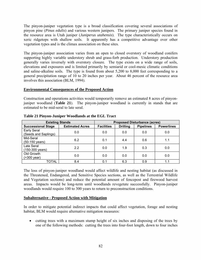
82
The pinyon-juniper vegetation type is a broad classification covering several associations of pinyon pine (Pinus edulis) and various western junipers. The primary juniper species found in the resource area is Utah juniper (Juniperus utahensis). The type characteristically occurs on xeric ridgetops with shallow soils. It apparently has a competitive advantage over other vegetation types and is the climax association on these sites. The pinyon-juniper association varies from an open to closed overstory of woodland conifers supporting highly variable understory shrub and grass-forb production. Understory production generally varies inversely with overstory closure. The type exists on a wide range of soils, elevations and exposures and is limited primarily by semiarid or cool-mesic climatic conditions and saline-alkaline soils. The type is found from about 5,200 to 8,000 feet corresponding to a general precipitation range of 10 to 20 inches per year. About 46 percent of the resource area involves this association (BLM, 1994). Environmental Consequences of the Proposed Action Construction and operations activities would temporarily remove an estimated 8 acres of pinyon-juniper woodland (Table 21). The pinyon-juniper woodland is currently in stands that are estimated to be mid-seral to late seral.
Table 21 Pinyon-Juniper Woodlands at the EGL Tract Existing Stands Proposed Disturbance (acres)
Successional Stage Estimated Acres Facilities Drilling Pipelines Powerlines Early Seral (Seeds and Saplings) 0.0 0.0 0.0 0.0 0.0
Mid-Seral (50-150 years) 6.2 0.1 4.4 0.6 1.1
Late Seral (150-300 years) 2.2 0.0 1.9 0.3 0.0
Old Growth (>300 year) 0.0 0.0 0.0 0.0 0.0
TOTAL 8.4 0.1 6.3 0.9 1.1 The loss of pinyon-juniper woodland would affect wildlife and nesting habitat (as discussed in the Threatened, Endangered, and Sensitive Species sections, as well as the Terrestrial Wildlife and Vegetation sections) and reduce the potential amount of fencepost and firewood harvest areas. Impacts would be long-term until woodlands revegetate successfully. Pinyon-juniper woodlands would require 100 to 300 years to return to preconstruction conditions. Subalternative - Proposed Action with Mitigation In order to mitigate potential indirect impacts that could affect vegetation, forage and nesting habitat, BLM would require alternative mitigation measures:
• cutting trees with a maximum stump height of six inches and disposing of the trees by one of the following methods: cutting the trees into four-foot length, down to four inches
83
in diameter, and placing the trees along the edge of the disturbance; removing the trees from federal land for resale or private use; or chipping and scattering the trees;
• seeding disturbed areas; • controlling noxious weeds; and • acquiring a fuel woods permit and compensating the BLM for trees.
Environmental Consequences of the Subalternative Alternative mitigation would not decrease the potential loss of 8 acres of pinyon-juniper woodland, but would decrease indirect impacts to soils, minimize impacts from invasive species, and would enhance reclamation success as discussed in previous sections. Environmental Consequences of the No Action Alternative If the RD&D lease is not approved, no impacts associated with the proposed action would occur. Under existing management, no additional impacts are anticipated beyond those associated with actions analyzed in the existing RMP. GEOLOGY AND MINERALS Affected Environment General Physiography and Geology: The nominated tracts are located within the Piceance Creek Basin which contains thick sequences of Eocene-age sedimentary bedrock. These deposits dip gently in a northeasterly, easterly, and southeasterly direction. The Piceance Creek Basin is located within the Colorado Plateaus physiographic province which is characterized by dissected plateaus with strong relief (Fenneman, 1931). A thin veneer of unconsolidated surficial deposits (including residual, aeolian, and alluvial deposits) overlie Uinta formation bedrock at the nominated tracts. Below the Uinta formation is found the Green River formation which includes the oil shale beds targeted by the project (Cashion, 1973). The Uinta formation is formed mainly from clastic fluvial-deltaic sediments prograding southward, inter-tonguing with the lacustrine Green River formation. It includes mostly sandstones and siltstones but also conglomerates, marlstones, tuff, and oil shale. The thickness of this formation varies among the nominated tracts.
The upper unit of the Green River formation is called the Parachute Creek member. It consists mostly of dolomitic marlstone and oil shale. It also contains some siltstones, sandstones and sparse algal limestone beds. The Parachute Creek member is divided into several zones of rich oil shale separated by relatively leaner zones (Young, 1995). The EGL tract is located in the central part of the Piceance Creek Basin at the northeastern end of Wagonroad Ridge. It is located near Black Sulphur Creek, about 6 miles to the west of Piceance Creek. Elevations range from approximately 6,795 feet near the northwest corner of
84
the tract to approximately 6,965 feet at the southwest corner of the site. Thus, total site relief is approximately 170 feet. Structurally, the EGL tract is located near the crest of the Black Sulphur anticlinal nose which plunges gradually to the east with a dip of approximately 1º (Hail and Smith, 1994). Geologic Hazards: The nominated tracts lie within Seismic Risk Zone 1 (on a scale of 0 to 3, with Zone 3 having the highest risk) (Algermissen, 1969). Within Zone 1, minor damage to structures from distant earthquakes may be expected. The National Earthquake Information Center data base (2006) was searched for the area within approximately 100 miles of the nominated tracts. Since 1950, the largest seismic event within the search area was magnitude 5.7 (Modified Mercalli Intensity VII) and was centered at approximately 39º 47’N, 108º 22’W. Significant faults are located about 0.5 miles to the southwest of the EGL tract. These faults are subparallel to the anticline crest with fault tips at Black Sulphur Creek showing vertical stratigraphic separation of several feet. They are not known to be active. There are no landslide deposits or other evidence of mass wasting at the EGL tract. Some areas of eolian deposits are found at the EGL tract (Whitney, 1981). These consist of wind deposited silty sand. Active erosion is common in eolian deposits where vegetation has been disturbed by animals, fire, or human activities. Mineral Resources: The nominated tract is located within or near active natural gas fields (Wray et al., 2002) in the Ryan Gulch exploratory oil and gas unit on federal oil and gas lease COC-062055. The nearest producing oil and gas well is approximately 0.4 miles south of the southern boundary of the proposed tract. A plugged and abandoned oil and gas well, Great Yellowstone Sulphur Creek #1, is located in the northeast quarter of the tract. Records indicate the well was drilled to a depth of 4,540 feet. A bisecting road provides access to gas development northeast of the tract. The tract area is identified in the ROD/RMP as available for oil shale and sodium leasing. High grade oil shale yielding more than 25 gallons per ton of shale is present beneath the nominated tracts (Bunger et al., 2004 and Cashion, 1973). The oil shale beds are found within the Parachute Creek Member of the Green River formation. The richest oil shale bed is the Mahogany zone with total thickness of up to 200 feet and an average content of 26 gallons of oil per ton. Below the Mahogany zone (separated by Groove B) lies the R-6 zone which is approximately 240 feet thick with an average richness of 25 gallons/ton (based on extrapolation from Sinclair Oil and Gas corehole 1, located in the center of Section 20 T1N., R99W). The EGL tract is crossed by an existing gas gathering line located southeast of and approximately parallel to the access road which runs northeast-southwest through the tract. Enterprise Products Operating, LP (Enterprise) filed an application on December 1, 2005 with the Bureau of Land Management (BLM) for a ROW grant for construction of a natural gas liquids line (16-inch or smaller) which would also parallel the existing access road through the EGL tract.
85
At the EGL tract, the Parachute Creek member is overlain by approximately 700 feet of the Uinta formation. The most significant oil shale beds at the EGL tract are the Mahogany and R-6 zones of the Parachute Creek member which are approximately 110 and 140 feet thick, respectively. The EGL tract is southwest of the designated ROD/RMP. Coal deposits beneath the nominated tract are at depths greater than 3,000 feet and are not considered recoverable using current technologies. There are no coal mines in the immediate area (Kirschbaum and Biewick, 2003). The formations beneath the nominated tracts do not contain locatable mineral deposits in significant concentrations. The nominated tracts are not located near any active sand and gravel quarry operations (Schwochow, 1981). Environmental Consequences of the Proposed Action Geologic Hazards: There are no geological hazards at the EGL tract which would have any impact on the proposed action and the proposed action at that site is not expected to create or exacerbate geologic hazards. Mineral Resources: The EGL project will extract oil shale resources at the project site in the Mahogany (R-7) and R-6 zones. This will result in the loss of a 1,000 foot by 100 foot by 300 foot volume of this resource for future use. Inadequate abandonment of well Sulphur Creek #1 could allow the flow of produced fluids and migration of gases between formations and into aquifers. The proposed action could interfere with transport by pipeline of natural gas and NGLs across the EGL tract. Subalternative - Proposed Action with Mitigation In order to minimize potential indirect impacts that could affect mineral resources, BLM would require alternative mitigation measures: Mineral Resources: EGL will coordinate construction activities with gas well and pipeline operators near the site and along access roads. EGL plans to relocate the gas gathering line which crosses their tract. EGL will meet with Enterprise to determine a mutually-agreeable location for the proposed NGL line which would cross the tract. EGL will contact the lease holder of federal of and gas lease COC-062055 and inform them of their proposed activities. Directional drilling to recover the oil and gas resources beneath the tract would be required to prevent interference with the RD&D development. EGL will determine the adequacy of plugging and abandonment of oil and gas well Sulphur Creek #1 prior to start of heating and recovery operations. EGL will re-enter and re-abandon the well if deemed necessary.

86
Environmental Consequences of the Subalternative The alternative mitigation would not decrease the direct impacts on the mineral resources in the proposed tract but would lead to the resolution of localized conflicts over mineral resources, including the use of the pipeline crossing the proposed tract. Proper abandonment and plugging, if deemed necessary, the well Sulphur Creek #1 would eliminate the potential for migration of gases between formations and into aquifers. Environmental Consequences of the No Action Alternative Under the No Action Alternative, oil shale resources which would have been extracted under the proposed action would remain. Site specific knowledge and information of the oil shale resources and proposed technology would not be obtained. If the RD&D lease is not approved, no impacts associated with the proposed action would occur. Under existing management, no additional impacts are anticipated beyond those associated with actions analyzed in the existing RMP. HYDROLOGY AND WATER RIGHTS Affected Environment
Surface Water Hydrology As noted in the water quality section of this EA, the EGL tract is located between Ryan Gulch (an intermittent stream) and Black Sulphur Creek (a perennial stream) in the White River basin. Both streams flow northeastward about 5 miles before joining Piceance Creek (HUC: 14050006). From its confluence with Ryan Gulch and Black Sulphur Creek, Piceance Creek flows northward about 10 miles before discharging into the White River west of Rio Blanco Lake. The White River is a tributary to the Green River in Utah which is a tributary to the Colorado River. The project area receives approximately 16.4 inches of precipitation each year, including 69.5 inches of snow (WRCC, 2006). The average maximum temperature ranges from 36.5°F in January to 85.7°F in July. The average monthly minimum temperature ranges from 6.9°F in January to 46.9°F in July. Most precipitation is lost to evapotranspiration; an estimated 98 percent of snowmelt and precipitation is lost to evapotranspiration. The remaining water runs off rapidly and replenishes stream flow or recharges the aquifers (Taylor, 1987). Approximately 80 percent of annual stream flows in Piceance Creek originates as discharge from alluvial and bedrock aquifers (Tobin, 1987). The EGL tract is outside areas of substantial natural recharge (Topper et. al., 2003). Peak runoff is primarily due to spring snowmelt and occurs in May and June. Table 22 summarizes average monthly flows in Black Sulphur Creek near its confluence with Piceance Creek and in Piceance Creek below Ryan Gulch. Streamflow data are not available for Ryan Gulch. A review of the water rights records of the Colorado State Engineer’s Office indicates that there are no recorded water rights on or within 0.25 miles of the EGL tract.

87
Table 22 Monthly Stream Flow Statistics
Black Sulphur Creek Piceance Creek Station Location: Above confluence with
Piceance Creek Below Ryan Gulch
Drainage Area: 103 square miles 506 square miles Period of Record: 1975-1983 1964-2005
Mean of Monthly Streamflow (cubic feet per second) January 5.57 20.6 February 6.48 23.7 March 6.50 32.3 April 5.54 43.3 May 18.5 60.9 June 14.8 29.8 July 7.69 22.2 August 7.90 28.1 September 5.69 20.3 October 6.15 20.2 November 6.53 24.3 December 5.52 23.0
Source: USGS, 2006a and USGS, 2006c. Groundwater Hydrology The upper aquifer is characterized as semi-confined due to the discontinuous nature of the sandstones. The Uinta formation is saturated below the stream levels. The underlying Parachute Creek Member, the topmost member of the Green River formation, has the greatest effect on the local hydrology. Hydraulic conductivity is highly variable due to the variation in lithology and local fracturing (Robson and Saulnier, 1980). Reported transmissivities in the upper aquifer range from 8-1,000 feet2/day (Czyzewski, 2000), but generally are in the range of 610-770 feet2/day (Topper et.al., 2003). Hydraulic conductivity in the Mahogany zone is low, and the zone is generally thought to act as a confining unit except where cut by fractures that allow vertical flow between the two aquifers (Coffin et.al., 1971; Czyzewski, 2000). The vertical conductivity has been estimated to be as large as 0.37 feet/day. The lower aquifer consists of the lower part of the Parachute Creek Member of the Green River formation. In general, the hydraulic conductivity of this zone is low with the exception of portions of the upper third where saline minerals have dissolved. In these areas, the nahcolite and halite sequences have been dissolved, leaving behind a brecciated “leached zone” (Saulnier, 1978). The permeability in this leached zone is greater than in the surrounding unleached rocks. It has been reported that a loss of drilling mud often occurs in the leached zone. The leached zone has higher flow volumes, but is thin (0.5-20 feet).

88
Recent hydrologic data collected by Shell show that the Mahogany zone may not constitute a major confining layer beneath the EGL tract. Rather, the underlying R5 oil shale interval appears to be the principal confining unit. Based on this data, Shell has proposed dividing the aquifer system into the Uinta unit, the upper Parachute Creek unit, and the lower Parachute Creek unit. The upper and lower Parachute Creek units are separated by the R5 oil shale interval. While there is a lithological break between the Uinta and Parachute Creek sections, the water levels in wells completed in each unit were very similar. Thus, the nature of the hydraulic boundary between the upper Parachute Creek unit and the Uinta unit was not well defined by the new data, and division into two hydrostratigraphic units may not be warranted. Hydrochemical data from the intervals, together with vertical pumps tests, will probably be required to justify separating the units. Stratigraphic and hydrostratigraphic columns are included in the water quality section of this EA. This modified hydrogeological model would have several important implications including the location of the principal confining unit and the division of the upper aquifer into two units rather the previous one unit. In the general hydrogeological model, the A and B groove sandstone units were recognized as the most prolific aquifer sections and were hydraulically separated by the Mahogany confining layer. The upper unit included the A groove and the overlying Uinta sediments. The lower aquifer included the B groove and the rocks below the Mahogany. In the modified model, the A and B groove sandstone units are grouped together in the upper Parachute Creek unit with the sandstone and siltstone units below the R5 layer, including the leached zone, forming the lower aquifer unit. In the general model, the vertical flow was downward from the upper aquifer into the lower aquifer in the western portion of the Piceance Basin with vertical groundwater gradients reversing nearer the confluence of the Ryan Gulch and Black Sulphur Creek with Piceance Creek. The new hydrologic data also show that the vertical gradient in the area is generally downward from the upper aquifer to the lower aquifer, however northwest of the EGL tract well data show local variability where the generally downward gradient reverses with upward vertical gradients. The water well data does not extend far enough east to clearly define where the vertical gradient reverses. This suggests that site-specific data will be required to verify which model is most applicable for the EGL tract. The nearest deep water wells were drilled northeast of the tract by the U.S. Geological Survey (USGS) in 1975-76 as part of a geohydrologic investigation (Welder and Saulnier, 1978). The reported hydrologic data of the test holes is summarized in Table 23, along with data from other cited sources.
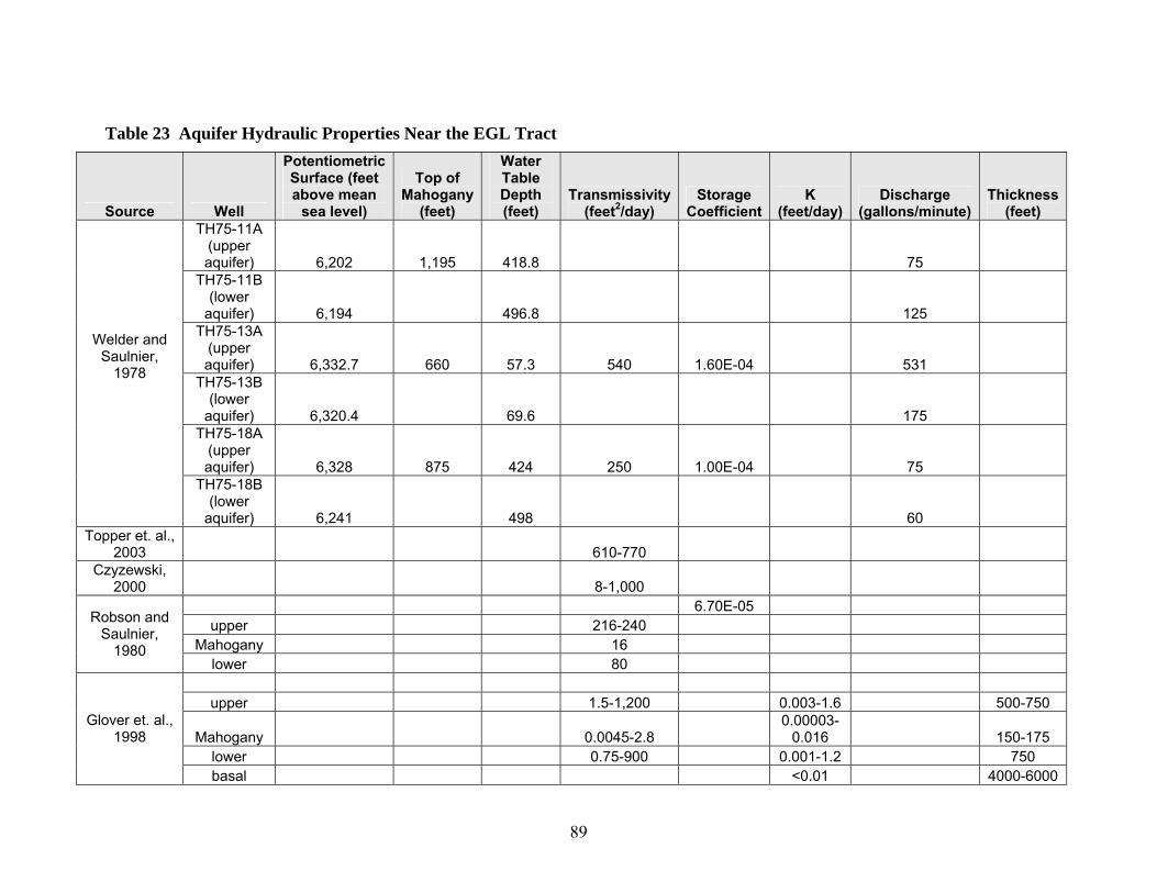
89
Table 23 Aquifer Hydraulic Properties Near the EGL Tract
Source Well
Potentiometric Surface (feet above mean
sea level)
Top of Mahogany
(feet)
Water Table Depth (feet)
Transmissivity (feet2/day)
Storage Coefficient
K (feet/day)
Discharge (gallons/minute)
Thickness (feet)
TH75-11A (upper aquifer) 6,202 1,195 418.8 75
TH75-11B (lower
aquifer) 6,194 496.8 125 TH75-13A
(upper aquifer) 6,332.7 660 57.3 540 1.60E-04 531
TH75-13B (lower
aquifer) 6,320.4 69.6 175 TH75-18A
(upper aquifer) 6,328 875 424 250 1.00E-04 75
Welder and Saulnier,
1978
TH75-18B (lower
aquifer) 6,241 498 60 Topper et. al.,
2003 610-770 Czyzewski,
2000 8-1,000 6.70E-05
upper 216-240 Mahogany 16
Robson and Saulnier,
1980 lower 80
upper 1.5-1,200 0.003-1.6 500-750
Mahogany 0.0045-2.8 0.00003-
0.016 150-175 lower 0.75-900 0.001-1.2 750
Glover et. al., 1998
basal <0.01 4000-6000
90
Environmental Consequences of the Proposed Action The EGL project could alter groundwater and surface water flows in several different ways: flows between the Mahogany and R-6 zones and adjacent aquifers could be altered; the withdrawal and injection wells could locally alter groundwater hydrology in the upper aquifer in the vicinity of the EGL tract; and changes in upper aquifer hydrology could alter interactions between the upper aquifer, alluvial aquifers, and surface waters. EGL intends to de-water only the portion of the oil shale that would be retorted. The proposed production zone includes the oil shale units above the R5 zone. Based on the hydrologic data presented by Shell, the R5 may be the most well-developed confining layer at the EGL site. Subsurface data obtained in the early phases of the project would establish how much of the aquifer system overlying the production might also have to be de-watered. If the hydraulic conductivity between the oil shale production zone and adjacent aquifers is greater than expected, EGL would establish a dewatered area into the overlying aquifer. As outlined in the proposed action, de-watering would be accomplished with 4-8 pumping wells surrounding the subsurface retort area. Water produced from the production area would be treated if necessary and re-injected into the upper aquifer downgradient from the retorted unit. The in-situ retorting process would not consume fresh water. All water removed during de-watering would be re-injected with no net loss in the aquifers. Water consumption would be limited to drilling activities, on-site heating, and personnel requirements. The projected volume of water (about 27 barrels/day) would be purchased from municipal sources and trucked to the tract. While the dewatering process would increase the hydraulic gradient between de-watered areas and the adjacent units, the very low hydraulic conductivity of the oil shale would likely limit flows into and out of the production zone. While de-watering operations could increase the hydraulic gradient across the R5 unit, the EGL process would not alter the integrity of the R5, and the process would not induce any movement of groundwater from the lower aquifer to the upper aquifer. In addition, EGL plans to leave an area of un-reacted oil shale around the production zone, maximizing hydraulic isolation from the adjacent aquifers. The hydraulic conductivity in the retorted portion of the production zone would be locally increased by hydraulic fracturing. This would provide an extensive fracture system to allow flow of fluids from the point of generation near the energy delivery system toward the product recovery wells. It is not known how far the hydraulic fracturing would extend from the retorted portion of the oil shale zone into adjacent aquifers, but it would not likely extend to the R5 unit. During retorting, water would be excluded from the production zone as the temperature exceeds the steam curve. This steam drive would push any water outward from the zone and create a hydraulic barrier. In addition, as further heating and production of oil take place, the conductive fractures and pores would become oil filled, further lowering hydraulic conductivity as a multiphase system is created.
91
Post-production transmissivity in the production zone is expected to be similar to or lower than pre-production transmissivity. While there may be an enhancement of hydraulic conductivity due to the creation of micro-fractures, these fractures would be oil wet, creating a reduction in the relative permeability of the production zone for water. After the production zone is cooled and filled with water, pump tests will be conducted to determine the post-production hydraulic properties. If the production zone is hydraulically connected to a high degree to the underlying and overlying aquifer, then there would be a short period of decreased down-gradient water table levels after retorting ceases while the production zone refills. However, given the relatively small volume of the test zone, this perturbation would be very small. If the production zone is not hydraulically isolated, the effect would be strictly local with a small zone of increased porosity and variable permeability surrounded by the normal Mahogany zone aquitard. Preliminary calculations show that the area of hydraulic influence associated with de-watering/re-injection operations would be confined to the 160-acre test site unless the lateral hydraulic conductivity is much higher than reported. Given of the low thermal conductivity of most rocks, the heating of rocks would likely not extend beyond the 160-acre tract. Because of the limited nature of impacts within and between groundwater system components, secondary impacts to surface water hydrology and water rights are not anticipated. Subalternative - Proposed Action with Mitigation In order to minimize potential indirect impacts that could affect hydrology, BLM would require alternative mitigation measures: Up-gradient and down-gradient multi-level monitoring wells will be installed along the edges of the tract to characterize the structure and properties of local aquifers, establish pre-development baseline groundwater conditions, better define the geology of the oil shale resource, and monitor water quality. In addition, the stream flow in nearby streams and springs will also be monitored. All monitoring data will be submitted to the BLM for further review. Using the hydraulic data obtained from the monitoring wells, a groundwater model will be constructed to design the de-watering and re-injection plans and to estimate the extent of the area of groundwater influence. Design of the de-watering and re-injection program will be submitted to the BLM and approved by the Authorizing Official. Groundwater extracted from the various aquifers during dewatering will be re-injected downgradient into the upper aquifer in order to maintain regional water tables and avoid disturbing baseflow to nearby streams. Shallow aquifers will be protected from hydrofracturing and produced shale oil by the installation and cementing of surface and intermediate casing. The objective of surface and

92
intermediate casing is specifically to isolate shallow aquifers. Any groundwater produced from the Mahogany and R-6 zones will be trucked off site and properly disposed of to prevent adverse impacts to surface and groundwater. For additional mitigation, refer to the Water Quality section of this document. Environmental Consequences of the Subalternative The EGL project could alter groundwater between the Mahogany and R-6 zones and adjacent aquifers could be altered and the withdrawal and injection wells could locally alter groundwater hydrology in the upper aquifer in. Up gradient and down-gradient monitoring wells would first establish baseline data to characterize the structure and properties of local aquifers and groundwater conditions and construct a groundwater model. These data would provide critical information on continuing water quality through the life of the proposed action, would be used to design the de-watering and reinjection necessary for the project. These measures would limit the potential for impacts to groundwater. Changes in upper aquifer hydrology could alter interactions between the upper aquifer, alluvial aquifers, and surface waters. Cementing surface and shallow casing would protect shallow waters from impacts from fracing. Surface water characterization and monitoring in nearby streams and springs would provide early identification of any surface water impacts that could potentially be associated with the proposed action. Given the relatively small volume of the oil shale RD&D zone and the potential for hydrologic isolation, any disturbance to down-gradient water table levels would be very small. If the production zone is not hydraulically isolated, the effect would be strictly local with a small zone of increased porosity and variable permeability surrounded by the normal Mahogany zone aquitard. Environmental Consequences of the No Action Alternative If the RD&D lease is not approved, no impacts associated with the proposed action would occur. Under existing management, no additional impacts are anticipated beyond those associated with actions analyzed in the existing RMP. NOISE Affected Environment Noise is defined as unwanted or annoying sound that is typically associated with human activities and that interferes with or disrupts normal activities. Sound and noise are measured as sound pressure levels in units of decibels (dB). Response to noise varies according to its type, its perceived importance, its appropriateness in the setting and time of day, and the sensitivity of the individual receptor. Human hearing is simulated by measurements in the A-weighting (dBA) network, which de-emphasizes lower frequency sounds to simulate the response of the human ear. Some typical sound levels from common noise sources are presented in Table 24.

93
Table 24 Sound Levels Associated With Noise Environments and Field Operations
Noise Source Scale of
A-weighted Sound Level (dBA)
Human Judgment of Noise Loudness (relative to a reference
loudness dB*) Typical construction site at 50 feet 85 *approximately 15 times as load Diesel truck, 40 mph at 50 feet 75 *approximately 8 times as loud Light traffic at 50 feet 56 *approximately 2 times as loud Rural area daytime 45+ Reference loudness Rural area at night 35+ Quiet - * ½ as loud Human voice whisper at 5 feet 20 Very quiet
* These values are logarithmic measurements (i.e., every 10-dBA increase is perceived by the human ear as approximately twice the previous noise level. Therefore, a rural area during the day is about twice as loud to the human ear as a rural area at night). Source: Compiled from EPA, 1974. + Corrected for high winds. Noise level surveys were performed at the proposed project site on March 28, 2006. Noise level measurements were performed at each of the four corners and the approximated middle of the site. In order to avoid collecting data that only reflected noise associated with wind, measurements were made with wind speeds well below 30 miles an hour. Actual wind speeds ranged from zero to 8 miles per hour. Wind direction was from the southwest. A Quest Model 2100 Sound Level Meter with wind screen was used to collect the data. Noise levels ranged from less than 30.0 dBA to 37.9 dBA. These readings confirmed what had been expected, that background noise levels in the EGL Oil Shale project area are typical of rural open areas, about 40-45 dBA average day/night noise level (Ldn). Environmental Consequences of the Proposed Action Colorado has established a Noise Statute that identifies the maximum permissible noise levels that may radiate from any source or activity. The Colorado Oil and Gas Conservation Commission (COGCC) has also established noise control regulations applicable to oil and gas facilities, consistent with the Colorado Noise Statute, that identify allowable noise levels. Table 25 identifies the allowable noise levels for Colorado based on time periods and zones. The EGL tract is located in a rural/agricultural setting, therefore it is likely that the allowable noise levels from the project will be 50-55 dbA.
Table 25 COGCC Allowable Noise Levels Zone 7:00 am-7:00 pm 7:00 pm – 7:00 am
Residential/Agricultural/Rural 55 dbA 50 dbA Commercial 60 dbA 55 dbA Light Industrial 70 dbA 65 dbA Industrial 80 dbA 75 dbA
There are no potential noise receptors or noise sensitive areas such as homes, schools, hospitals, or churches within one mile of the proposed site. A radio tower is located approximately one mile south of the site, but the associated building is not inhabited. Infrequent truck traffic causes noise along the County dirt road that cuts through a portion of the proposed site. This road is currently used for gas drilling related activities in the area.

94
Noise generated during the testing phase of the project will be from drill rigs installing monitoring wells and the heating/production wells. The noise generated will be typical of other smaller well drilling operations in the area, and no receptors are anticipated to be impacted. Equipment used in the facilities will be designed to meet COGCC noise levels as required. Noise readings will be taken at the site during operations to verify noise levels. Subalternative - Proposed Action with Mitigation In order to minimize potential impacts from noise and ensure the site attains COGCC standards consistent with Colorado law, BLM would require the following alternative mitigation measures:
• install and maintain appropriate mufflers and silencers on construction equipment and facility machinery; and
• house or cover noise producing sources with appropriate insulated facilities. Environmental Consequences of the Subalternative Noise impacts related to construction activities and operation of the facility would be minimized by implementing measures to reduce noise levels below the COGCC allowable noise level conditions. Environmental Consequences of the No Action Alternative If the RD&D lease is not approved, no impacts associated with the proposed action would occur. Under existing management, no additional impacts are anticipated beyond those associated with actions analyzed in the existing RMP. PALEONTOLOGY Affected Environment The BLM classes geologic formations into three categories according to the likelihood of important fossil occurrence (usually vertebrate fossils of scientific interest). Condition I formations are known to contain vertebrate fossils or noteworthy occurrences of invertebrate or plant fossils, Condition II formations are exposures of geologic units or settings that have high potential to contain vertebrate or noteworthy occurrences of invertebrate or plant fossils, and Condition III formations are very unlikely to produce vertebrate fossils or noteworthy occurrences of invertebrate or plant fossils. The EGL tract is underlain by the Uinta formation, a middle and upper Eocene unit that has produced a variety of vertebrate and plant fossils and is considered a BLM Class I paleontological formation. Class I formations are those known to contain vertebrate fossils or noteworthy occurrences of invertebrate or plant fossils. There are no bedrock exposures at the site to determine paleontological potential at the EGL tract specifically.
95
Environmental Consequences of the Proposed Action Soils are estimated to be 60 inches deep at the site as described in the Soils section and no outcrops occur at the site. Impacts to Class I geologic formations and associated paleontological resources could occur during drilling of test wells, clearing for construction of the site facilities, and drilling and installation of the heating and production wells. Ground disturbing operations may permanently damage or destroy paleontological resources. Subalternative - Proposed Action with Mitigation In order to mitigate potential impacts to Class I geologic formations and associated paleontological resources, BLM would require a paleontological monitor to be on site prior to any ground-disturbing activities that may intercept underlying rock and to spot check during surface clearing activities associated with the facility construction. The monitor would modify or halt activities that may potentially impact paleontological resources in order to mitigate the impact. EGL would also train construction and operation personnel that collection of paleontological specimens is not allowed. Environmental Consequences of the Subalternative A monitor would identify paleontological resources during surface disturbing activity, stop or modify the impacting activity, and reduce the potential for irretrievable losses of these resources. Some permanent loss of paleontological resources may still occur during ground-disturbing activities. However, the potential loss will be minimized and limited to a 1,000 foot by 100 foot by 300 foot volume of the Class I formation. Environmental Consequences of the No Action Alternative If the RD&D lease is not approved, no impacts associated with the proposed action would occur. Under existing management, no additional impacts are anticipated beyond those associated with actions analyzed in the existing RMP.
RANGELAND MANAGEMENT
Affected Environment The EGL tract overlaps two fenced BLM grazing allotments with permitted use outlined in Table 26. The allotment boundary fence between the Square S and Black Sulphur allotments runs through the tract from the SW1/4 up through the NE1/4. The ridge that the tract lies on is a major thoroughfare for Square S allotment livestock movement from spring/fall range to higher elevation pastures.
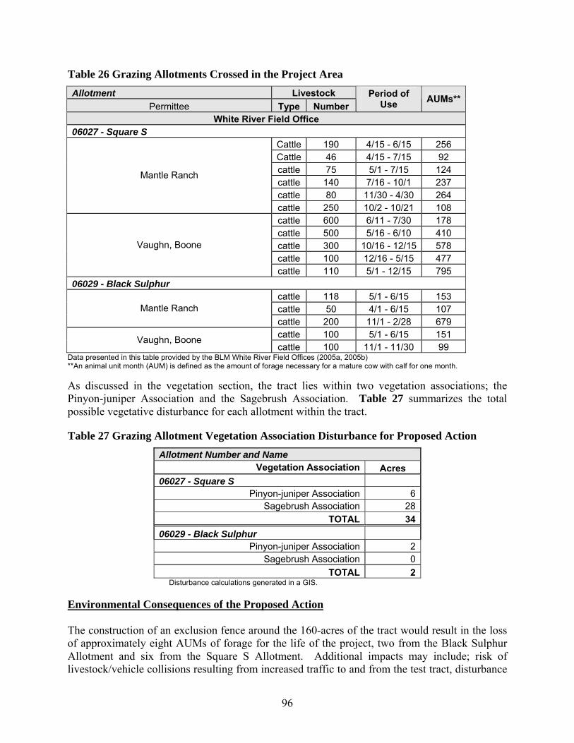
96
Table 26 Grazing Allotments Crossed in the Project Area
Allotment Livestock Permittee Type Number
Period of Use AUMs**
White River Field Office 06027 - Square S
Cattle 190 4/15 - 6/15 256 Cattle 46 4/15 - 7/15 92 cattle 75 5/1 - 7/15 124 cattle 140 7/16 - 10/1 237 cattle 80 11/30 - 4/30 264
Mantle Ranch
cattle 250 10/2 - 10/21 108 cattle 600 6/11 - 7/30 178 cattle 500 5/16 - 6/10 410 cattle 300 10/16 - 12/15 578 cattle 100 12/16 - 5/15 477
Vaughn, Boone
cattle 110 5/1 - 12/15 795 06029 - Black Sulphur
cattle 118 5/1 - 6/15 153 cattle 50 4/1 - 6/15 107 Mantle Ranch cattle 200 11/1 - 2/28 679 cattle 100 5/1 - 6/15 151 Vaughn, Boone cattle 100 11/1 - 11/30 99
Data presented in this table provided by the BLM White River Field Offices (2005a, 2005b) **An animal unit month (AUM) is defined as the amount of forage necessary for a mature cow with calf for one month. As discussed in the vegetation section, the tract lies within two vegetation associations; the Pinyon-juniper Association and the Sagebrush Association. Table 27 summarizes the total possible vegetative disturbance for each allotment within the tract.
Table 27 Grazing Allotment Vegetation Association Disturbance for Proposed Action Allotment Number and Name
Vegetation Association Acres 06027 - Square S
Pinyon-juniper Association 6 Sagebrush Association 28
TOTAL 34 06029 - Black Sulphur
Pinyon-juniper Association 2 Sagebrush Association 0
TOTAL 2 Disturbance calculations generated in a GIS.
Environmental Consequences of the Proposed Action The construction of an exclusion fence around the 160-acres of the tract would result in the loss of approximately eight AUMs of forage for the life of the project, two from the Black Sulphur Allotment and six from the Square S Allotment. Additional impacts may include; risk of livestock/vehicle collisions resulting from increased traffic to and from the test tract, disturbance
97
to livestock from project associated noise and fugitive dust, and the potential spread of invasive non-native species following on-site disturbance to existing vegetation. Subalternative - Proposed Action with Mitigation In order to minimize potential indirect impacts on rangelands, BLM would require alternative mitigation measures:
• consideration of limiting the area fenced to just the RD&D facility seed disturbed areas as discussed in the Vegetation section; and
• control noxious weeds as discussed in the Invasive, Non-Native Species section. EGL must ensure that integrity of the boundary fence between the two allotments is maintained such that interallotment livestock trespass does not occur. Wherever heavy traffic is expected it may be necessary to install cattleguards with adjacent gates. Cattleguards will be installed above the existing grade and all such cattleguard/fence work will conform to BLM specifications. If the entire tract is fenced, a minimum 16 foot wide wire or steel gate must be installed at the top of the NE1/4 of the tract and at the SW1/4 of the tract so that cattle can be trailed through the tract as they are gathered from the spring and fall range. Environmental Consequences of the Subalternative Alternative mitigation measures would reduce potential impacts to vegetation from the proposed action and indirectly reduce impacts to range. Adherence to requirements for cattleguards would maintain integrity of the allotment boundaries. A fence around just the test facilities (encompassing 35 acres), as is being considered, would result in the loss of two AUM. The loss of between two and eight AUMs is a negligible amount that does not warrant additional mitigation. Environmental Consequences of the No Action Alternative If the RD&D lease is not approved, no impacts associated with the proposed action would occur. Under existing management, no additional impacts are anticipated beyond those associated with actions analyzed in the existing RMP. REALTY AUTHORIZATIONS Affected Environment Existing realty authorizations at the site include: • COC24022, Riata Energy, is a small (4-inch or smaller diameter) buried gas gathering
pipeline located along the road that traverses the site COC23293, Public Service Company, is a 12-inch transmission line which crosses the site diagonally.
• COC68435, Shell Frontier, is a permit for a hydrological testing well site, which has been drilled and completed. This lease expires December 31, 2008 and is renewable at the
98
discretion of the BLM authorized officer. The data generated from this well have been requested of Shell, but have been reported to be confidential.
• COC67991, Bargath Inc, is for a buried 4-inch gas gathering line located along BLM Road 1019 in the southwest portion of the tract.
Access to wells and potential gathering lines from Riata Energy are also on the site, located south of the road that traverses the site. After receiving the January 14, 2006 letter notifying EGL of the successful proposal to conduct research on this tract, EGL learned that Enterprise Products Partners, LLC has submitted an application to the WRFO for a 12-inch Natural Gas Liquids (NGL) line traversing the RD&D research tract in the vicinity of the road. The Enterprise line has been serialized as COC69548. EGL envisions a potential conflict with the current route of that pipeline which was staked on the north side of the road, instead of the south side as originally conveyed and is concerned of the potentially severe safety hazard if the line is accidentally breached during testing, construction or operations. Any leases considered by the WRFO, or the authorization of the pipeline, may need to consider this potential conflict. Access to the parcel will be via BLM Road 1019 from Rio Blanco County 85. Corridors to bring in utilities from off-parcel may be required. Environmental Consequences of the Proposed Action The existing Riata gathering line at the site is proposed to be relocated to follow the road in the southern portion of the parcel. The existing Public Service Company transmission line will be accommodated in the development of the tract. The Bargath pipeline follows the road and will be accommodated in the development of the tract. A potential conflict with the proposed Enterprise Meeker Lateral pipeline may exist. During the testing and construction phase of the project, impacts to an existing Shell well are anticipated to be minimal and limited to potential surface damage to the wellhead from accidents caused by construction equipment. During the operation phase, groundwater will be dewatered and reinjected downgradient of the test area and may alter the data collected by Shell, depending on monitored formation. Access to the tract via BLM Road 1019 will require a ROW for that segment of the road from Rio Blanco County Road 85 to the lease boundary, approximately 1500 feet (1.2 acres) of existing roadway. Rights-of-way will be required for those utilities brought in from off-lease. Three existing and one proposed natural gas pipeline cross the parcel and could serve as a natural gas source. The taps and lines would be wholly on-lease and would not require a separate ROW. An existing 7.2 KV power line owned by White River Electric Association is located along Rio Blanco County Road 85. If used as a power source, White River would apply for a ROW for an extension of approximately 3700 feet (1.7 acres) to the facilities. Approximately 1,760 feet of that line would be off-lease and has been included in the description and analysis of this proposed action. If
99
needed, communication lines/cables would be applied for by the service provider at the appropriate stage in the project. Subalternative - Proposed Action with Mitigation Damage to existing utilities will be minimized by implementing the following measures:
• using the “One Call” system to locate and stake the centerline and limits of all underground facilities in the area of proposed excavation;
• providing 48-hour notification to the owner/operator of and foreign pipeline prior to performing any work within 10 feet of buried or aboveground-pressurized gas piping; and
• prohibiting machine excavation within 5 feet from any known or proposed existing pipeline encountered in the ROW unless authorized by the pipeline owners/operators.
The holder will apply for access ROW authorization. The holder or service providers will apply for off-lease utility ROWs at an appropriate interval before needed to allow sufficient time for site specific analysis. The applicants have agreed to address any potential conflicts with the proposed Enterprise Meeker Lateral pipeline during the pipeline approval process. Environmental Consequences of the Subalternative Potential conflicts with existing, pipelines, proposed pipelines and rights-of-way would be minimized by implementing the proposed mitigation measures and by commitments from the applicant to resolve potential conflicts prior to construction. The RD&D facilities are estimated to require 35 acres of total ground disturbance. There is sufficient room within the 160-acre tract to redesign facilities to minimize conflicts with existing utilities. Damage to existing utilities will be further minimized or avoided entirely by identifying locations prior to construction activities and by maintaining safe distances during construction. Environmental Consequences of the No Action Alternative If the RD&D lease is not approved, conflicts associated with existing pipelines and wells, and proposed pipelines would not occur and ROWs would not be required. If the RD&D lease is not approved, no impacts associated with the proposed action would occur. Under existing management, no additional impacts are anticipated beyond those associated with actions analyzed in the existing RMP. RECREATION Affected Environment The proposed project area is located within the White River Extensive Recreation Management Area (ERMA) on BLM lands administered by the WRFO. The WRFO manages the ERMA to provide for unstructured recreation activities, and a diversity of outdoor recreation opportunities, including hunting, dispersed camping, hiking, horseback riding, wildlife viewing, and off-

100
highway vehicle (OHV) use. There are no Special Recreation Management Areas identified within lands administered by the WRFO. On BLM-administered lands, the Recreation Opportunity Spectrum (ROS) is a classification system and a prescriptive tool for recreation planning and management. ROS classes include Primitive (P), Semi-Primitive Non-Motorized (SPNM), semi-primitive motorized (SPM), Roaded Natural (RN), Rural (R), and Modified Urban (MU). ROS classes within the WRFO ERMA are not specified within the proposed project area. However, the proposed project area most closely resembles a ROS class of SPM. The SPM physical and social recreation setting is typically characterized by a natural appearing environment with few administrative controls and low interaction between users (but evidence of other users may be present). SPM recreational experience is characterized by a high probability of isolation from the sights and sounds of humans within a setting that offers challenge and risk. The proposed project area will not be located within or near any developed recreation areas. Environmental Consequences of the Proposed Action During development, testing, and operation of the proposed facility, the public would lose some dispersed recreation potential. Traffic, noise, human activity, and dust would increase and could affect the quality of some users’ recreational experiences. Most interaction between recreationists and EGL personnel would occur on the access roads. Recreational users would most likely only use the access roads to travel to more desirable recreation areas. These dirt or gravel roads could be used by hunters during the fall game seasons. During construction of facilities, the public would most likely not recreate near the site and would disperse elsewhere. Construction activities during big game hunting seasons would likely temporarily displace wildlife to habitat away from the project area. Since hunting relies on the presence of game species and hunters generally prefer relatively quiet settings, it is likely that construction activities could disrupt hunting in localized areas within one mile of active construction. Although construction would generate disruptions to nearby recreation activities, it is likely that hunters could find relatively undisturbed settings on adjacent public lands. Subalternative - Proposed Action with Mitigation No mitigation measures are proposed or necessary to reduce impacts to recreation from the proposed action. Environmental Consequences of the No Action Alternative If the RD&D lease is not approved, no impacts associated with the proposed action would occur. Under existing management, no additional impacts are anticipated beyond those associated with actions analyzed in the existing RMP.

101
SOCIOECONOMICS
Affected Environment The assessment area for the potential effects of oil shale research and development on social and economic conditions is Rio Blanco County, including the towns of Meeker and Rangely, as well as the City of Rifle, located in Garfield County. Based on the standard elements of socio-economic assessment, conditions inventoried in this section include the following:
• local economy o Employment o Income and earnings o Oil and gas activity o Other important economic activities near the proposed project area (e.g., grazing,
hunting and possible oil shale development) • population • housing, including temporary and long-term housing resources • community facilities and services • roads • environmental justice
Socio-economic statistics are often subject to reporting delays of a year or two after the fact. Consequently, socio-economic effects of the recent increase in energy development that has occurred in Rio Blanco County and northwestern Colorado are not yet fully reflected in most published statistics. To augment the published data, this section includes information about recent socio-economic conditions obtained from interviews with local officials and service administrators. (Unless referenced otherwise, statistical information contained within this section have been derived, in part or in whole, from the ExxonMobil Piceance Development Project Socioeconomic Technical Report and all references therein (ExxonMobil, 2006). The complete report is on file with the White River Field Office BLM.) Local Economic Conditions: Employment, earnings, and income are common indicators of economic conditions. Employment data reported by the Colorado Department of Labor and Employment (CDLE) indicate a dramatic increase in employment associated with oil and gas exploration and development activity in the region. More than 500 energy production jobs were added between 2003 and 2004, with more than 1,500 added between 2004 and the third quarter of 2005 (Table 28). Gains have been registered across the region, with the largest occurring in Garfield and Mesa counties; the latter reflecting a sharp increase in oil and gas field services.
Table 28 County Employment Data for Years 2000-2005
County 2000 2001 2002 2003 2004 2005
(Est.) ** Pct.
Change Garfield 224 301 364 402 432 1,498 569% Mesa 345 364 389 453 809 1,152 234% Moffat 521 509 543 518 499 546 5% Rio Blanco 454 504 525 504 608 724 59%
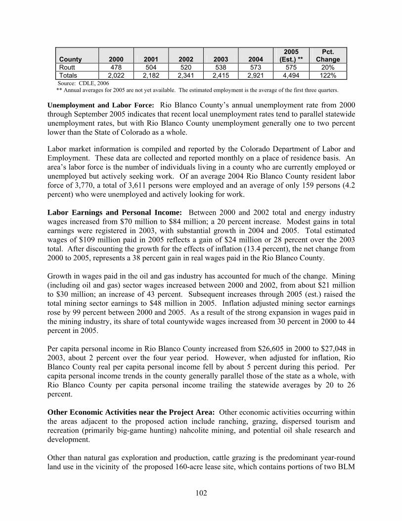
102
County 2000 2001 2002 2003 2004 2005
(Est.) ** Pct.
Change Routt 478 504 520 538 573 575 20% Totals 2,022 2,182 2,341 2,415 2,921 4,494 122%
Source: CDLE, 2006 ** Annual averages for 2005 are not yet available. The estimated employment is the average of the first three quarters. Unemployment and Labor Force: Rio Blanco County’s annual unemployment rate from 2000 through September 2005 indicates that recent local unemployment rates tend to parallel statewide unemployment rates, but with Rio Blanco County unemployment generally one to two percent lower than the State of Colorado as a whole. Labor market information is compiled and reported by the Colorado Department of Labor and Employment. These data are collected and reported monthly on a place of residence basis. An area’s labor force is the number of individuals living in a county who are currently employed or unemployed but actively seeking work. Of an average 2004 Rio Blanco County resident labor force of 3,770, a total of 3,611 persons were employed and an average of only 159 persons (4.2 percent) who were unemployed and actively looking for work. Labor Earnings and Personal Income: Between 2000 and 2002 total and energy industry wages increased from $70 million to $84 million; a 20 percent increase. Modest gains in total earnings were registered in 2003, with substantial growth in 2004 and 2005. Total estimated wages of $109 million paid in 2005 reflects a gain of $24 million or 28 percent over the 2003 total. After discounting the growth for the effects of inflation (13.4 percent), the net change from 2000 to 2005, represents a 38 percent gain in real wages paid in the Rio Blanco County. Growth in wages paid in the oil and gas industry has accounted for much of the change. Mining (including oil and gas) sector wages increased between 2000 and 2002, from about $21 million to $30 million; an increase of 43 percent. Subsequent increases through 2005 (est.) raised the total mining sector earnings to $48 million in 2005. Inflation adjusted mining sector earnings rose by 99 percent between 2000 and 2005. As a result of the strong expansion in wages paid in the mining industry, its share of total countywide wages increased from 30 percent in 2000 to 44 percent in 2005. Per capita personal income in Rio Blanco County increased from $26,605 in 2000 to $27,048 in 2003, about 2 percent over the four year period. However, when adjusted for inflation, Rio Blanco County real per capita personal income fell by about 5 percent during this period. Per capita personal income trends in the county generally parallel those of the state as a whole, with Rio Blanco County per capita personal income trailing the statewide averages by 20 to 26 percent. Other Economic Activities near the Project Area: Other economic activities occurring within the areas adjacent to the proposed action include ranching, grazing, dispersed tourism and recreation (primarily big-game hunting) nahcolite mining, and potential oil shale research and development. Other than natural gas exploration and production, cattle grazing is the predominant year-round land use in the vicinity of the proposed 160-acre lease site, which contains portions of two BLM

103
grazing allotments. The current permitted AUMs for the two combined allotments allow for a stocking ratio of about 7 acres per AUM. As discussed in the Recreation section, hunting is traditional for many local residents and tourist alike. The hunting and fishing industry is also a vital part of the economy in northwestern Colorado. According to a recent study prepared by the CDOW, direct sales in Rio Blanco County associated with wildlife-related recreation activities was approximately $16.3 million in 2002. Total economic impact to Rio Blanco County, including secondary spending by people who own or work for businesses related to fish and wildlife activities, was about $28.4 million. Fish and wildlife-related activities were responsible for 360 jobs, mostly in retail trade and services, in Rio Blanco County. Direct sales associated with wildlife-related activities in Garfield County were $30 million in 2002. Secondary spending was estimated near $53.1 million and employment related to wildlife activities was 690 jobs (BBC Research and Consulting, 2004). The CDOW collects hunting statistics for the Game Management Units that include the proposed action, but there are no estimates of hunting or other recreation use for the 160-acre site specifically. No licensed hunting and outfitting services are provided in the project area. There are also extensive deposits of nahcolite and oil shale in the area of the proposed project site. Nahcolite has recently been mined commercially, and the BLM recently approved five applications in Colorado for oil shale research, development and demonstration leases for further consideration. Population: Like much of northwestern Colorado, Rio Blanco County experienced rapid population growth during the 1970s. The county grew from 4,842 in 1970 to 6,255 in 1980, or thirty percent during the decade. By 1990 total county population had fallen to 6,051 and has remained around 6,000 through 2004. Population conditions in Rio Blanco County’s two population centers, the towns of Meeker and Rangely, have roughly paralleled that of the county. Meeker population grew from 1,597 in 1970 to 2,396 in 1980, a 50 percent increase, then decreased to 2,098 in 1990 and remained between 2,100 and 2,300 through 2004. Rangely population grew from 1,591 in 1970 to 2,278 in 1990, an increase of 41 percent, then peaked in 1996 at 2,361 and has since declined to 2,099 in 2004. In contrast population for the State of Colorado grew by 110 percent between 1970 and 2004. In 2004, 37.5 percent of total Rio Blanco County population was within the Town of Meeker and 34 percent was within the Town of Rangely; about 28.5 percent lived in unincorporated areas of the county. Unlike communities in Rio Blanco County, population for the City of Rifle in Garfield County has generally continued to trend upward since 1970, rising from 2,150 in 1970 to 6,784 in 2000, a 216 percent increase over the three decades. By 2004, Rifle’s population had increased by an additional estimated 976 persons to 7,760, a 14 percent increase in four years. The Colorado State Demography Office prepares population projections for counties within the state. Rio Blanco County population is projected to grow from 6,048 in 2005 to 8,384 in 2030,

104
about 39 percent during the 25 year period. For the same period, the State of Colorado is projected to grow by 55 percent. These projections do not fully reflect the short-term influences that the county is currently experiencing from energy development. Although the State Demography Office does not publish population estimates for municipalities, Rifle city officials anticipate average population growth of four percent over the next 20 years (Blankenship, 2006). Housing: The Colorado State Demography Office estimates that 20 percent of total Rio Blanco housing units were vacant during 2004, with 13 and 17 percent vacant in Meeker and Rangely respectively. Vacancy rates in Rifle were reported at 3.87 percent in 2004. A portion of the vacant units were second and seasonally occupied homes and the largest number of second homes in Rio Blanco County were located within the unincorporated portions of the county, which is consistent with many vacancies being attributable to second homes. In contrast to the 2004 State statistics, local officials reported almost no vacancies in rental housing during the fall of 2005. Rental housing in and around Meeker and the 81 pads in the town’s 5 mobile home parks were completely occupied during the fall of 2005. Many mobile home spaces were occupied by construction crews, drilling crews, and the long-established seasonal demand from hunters. Two temporary Recreational Vehicle (RV) parks have been developed near Meeker to house pipeline workers, one with 90 RV pads and one with 25 pads. These construction worker RV park facilities are operating under county temporary use permits and not intended for long-term use. The Town of Meeker has also approved the renting of rooms in private residences, as long as the activity does not impact residential (R1) zones. There has recently been some residential subdivision activity within the town, however, few houses have recently been offered for sale in Meeker and when houses come on the market they are quickly purchased for the full asking price and sometimes more. There were virtually no vacant rental units in Rangely during the fall of 2005 and many rental properties had waiting lists. There are 200 mobile home/RV spaces within the town and recent occupancy has averaged 30 to 40 percent. Rangely has three motels with a total of about 90 rooms. Recent motel occupancy has averaged an estimated 80 percent. Rifle had an estimated vacancy rate of about two percent across all types of units in the fall of 2005. With the opening of two new motels in 2006, Rifle will have 6 motels with 387 rooms and 2 RV parks with 57 pads; existing motels were typically full during fall of 2005. Local Government Facilities and Services: EGL’s proposed RD&D project would be located entirely within unincorporated Rio Blanco County. Although the proposed action would affect most county government services to some degree, those likely to be most affected would be law enforcement (Sheriff’s Department), emergency management and response (fire suppression and ambulance) and county road maintenance. Some Garfield County services would also be affected, primarily law enforcement and emergency response services along US Highway 13 north from Rifle to the Rio Blanco County line. Municipal services in Meeker, Rangely and Rifle could also be affected.

105
Most Rio Blanco County Services are headquartered in Meeker. Some services also maintain satellite offices in Rangely. Law Enforcement: The Rio Blanco County Sheriff’s Office provides law enforcement services to the unincorporated portion of Rio Blanco County. Current demand for law enforcement and emergency response services in the county is high, particularly in the areas adjacent to access from Rio Blanco County Road 5. According to the 2005 Rio Blanco County Sheriff’s Office Annual Report, traffic on the 42-mile stretch of County Road 5 increased more than 1200 percent and consequently, so did calls for service. The Piceance Creek area of the County incorporates a large land mass intersected by twenty-four County Roads. The incidents and calls for services in this area has risen two hundred twenty percent (220%) since 2004 and four hundred and two percent (402%) since 2003. Incidents in the east end of Rio Blanco County, which includes the Piceance Creek area, have gone up fifty-nine percent, where incidents in the west end of the county only rose by about two percent (Woodruff, 2005). About sixty-eight percent (68%) of all calls in 2005 were traffic or motor vehicle related. For the period from March 1 to March 31, 2006, nearly seventy percent (70%) of all calls were related to traffic incidents (Woodruff, 2006). The Sheriff’s Office has responded to an increasing number of accidents on the highways that provide access to the Piceance Creek area. Between 2003 and 2005, accident responses increased 142 percent on CO Highway 64 and 101 percent on CO Highway 13. These figures include property damage accidents resulting from collisions with deer and other animals. Colorado State Patrol Troopers have recently been reduced from four troopers to one in northwestern Colorado, which has placed additional demands on the Rio Blanco County Sheriff’s Office for accident response. The patrol sergeant and deputies based in Meeker and Rangely provide law enforcement coverage to the areas adjacent RBCR 5. Response times to the Piceance Creek area can run 45 minutes to an hour or more because of the distance from these population centers. Annual mileage driven by the Rio Blanco County Sheriff’s Office in response to service calls, investigations, detentions, and administration increased by seventy-nine percent (79%) from 2004 to 2005. This represents a substantial operational cost increase over the previous year. The Garfield County Sheriff’s Department provides law enforcement on the portion of CO Highway 13 from I-70 to the Rio Blanco County line. In the past several years, energy traffic has increased dramatically on the highway, resulting in a corresponding increase in complaints and calls for service. Although the Colorado State Highway Patrol provides patrol services on the rural portion of the highway from Rifle north to the Rio Blanco County line, the Garfield County Sheriff’s Department does respond to complaints, incidents and accidents in that area. Statistical information for all incidents that occurred on the twenty-four (24) Rio Blanco County Roads within the Piceance Creek area is provided in Table 29 below.

106
Table 29 Rio Blanco County Sheriff’s Office Piceance Creek Area Statistics
January 1st to December 31st January 1st to March 31st Classification
2003 2004 2005 2006 Abandoned Vehicles 1 3 3 1 Accidents 4 20 31 Property Damage Accidents 10 Injury Accidents 2 Animal Calls 13 9 38 4 Arson 1 0 0 0 Assault 0 0 1 0 Assist All Other Agencies 17 22 41 7 Assist Meeker Ambulance 5 Assist State Patrol 11 Auto Theft 0 0 1 0 Burglaries 0 0 1 0 Citizen Assist 3 3 7 1 Civil Situations 4 8 4 3 Criminal Mischief 6 2 3 3 Disturbance – Fight 1 0 1 0 Domestic Violence 0 1 1 0 D.U.I 0 0 3 2 Fires 4 6 10 1 Fraud/Forgery 7 0 0 0 Harassment 1 4 1 0 Homicide 0 0 1 0 Juvenile Problem 0 1 2 0 Motorist Assist 0 1 12 5 Narcotics Cases 1 0 3 0 911 Hang up calls 5 13 18 9 Property (Lost/Found) 3 1 5 0 Search and Rescue 2 2 2 0 Sexual Assault 0 0 1 0 Suspicious Incident 11 8 22 3 Thefts 2 5 10 0 Traffic Arrests 0 6 9 4 Traffic Complaints 0 10 17 4 Traffic Hazards 0 2 4 4 Traffic Contacts 39 70 410 69 Trespass 3 4 7 1 Truancy 0 0 1 0 Unattended Death 0 1 0 0 VIN Inspections 6 5 7 6 Warrant Arrests 1 1 1 3 Weapons Violation 0 1 0 0
Totals 135 209 678 158 Source: Woodruff, 2006. The Rio Blanco County Detention Center was constructed in 1937 and designed to hold 18 prisoners. During the year of 2005, the average daily inmate population for the year was over 18

107
for the first time in the Center’s history. An all-time high record of 31 inmates in detention was reached during the month of July, 2005. The average daily inmate population for the month of March, 2006 was 21 (Woodruff, 2006). In the not too distant past, the jail routinely had excess capacity and the county generated revenue by hosting prisoners from other counties. Over the last several years the situation has reversed, and Rio Blanco County must now often transport inmates and pay other counties to house inmates when the jail is full, resulting in increased costs for the county. Emergency Management and Response: Emergency response agencies in Rio Blanco County face a variety of issues in providing services, including:
• the large size of the county, • numerous backcountry roads, • the large number of recreation visitors, • the proliferation of energy exploration and development sites, • extensive communications dead spots, and • the constraints of mostly volunteer services.
Rio Blanco County does not have a dedicated hazardous materials response team and must rely on agencies in Glenwood Springs, Craig, or Grand Junction for assistance in dealing with accidents involving hazardous materials. Response times for hazardous materials incidents are typically two and one half hours. Fire suppression services in the area of the proposed action are provided by the Meeker Fire and Rescue District, and it takes an hour or more to assemble volunteers, mobilize equipment and respond to emergencies and incidents in the Piceance Creek area. Responding to the Piceance Creek area with equipment and volunteers reduces coverage for Meeker and the surrounding population areas for the duration of the response. Range and wild land fire response is also provided by the BLM White River Field Office in Meeker. Ambulance services for the eastern part of the county are also provided out of Meeker, with two four-wheel drive ambulances and about 15 volunteer emergency medical technicians. Air ambulance services are also available when weather conditions allow. Patients are transported to Pioneers Medical Center in Meeker or hospitals in Rifle, Grand Junction or Denver, depending on the type and severity of the injury and the location of the accident. Emergency management and response services (including fire suppression and ambulance) for the area that includes CO Highway 13 in Garfield County are provided by the Rifle Fire Department from their main fire station in Rifle. Hospital and Medical Services: Hospital and medical services for Meeker and the eastern portion of Rio Blanco County are provided by Pioneers Medical Center, which operates a 15 bed hospital and provides 24 hour emergency medical, pulmonary, laboratory, radiological, surgical, acute care and rehabilitative services. There are four resident physicians in Meeker who provide services through the Meeker Family Health Center and staff the hospital and emergency room. The physicians also provide medical direction to EMTs who staff the ambulance service and provide training to law enforcement and emergency response personnel in the county.
108
Roads: Repair and maintenance of county roads represent the single largest dollar impact to the County of Rio Blanco (Parsons, 2006). These county roads, originally designed for rural and agricultural uses, are experiencing increased traffic volume, frequency, and size. The considerable commuting workforce and over-sized loads typical of the oil and gas industry have largely contributed to the increased costs associated with repair and maintenance of these county roads, particularly in the Piceance Creek area. Environmental Justice: Executive Order (EO) 12898, "Federal Action to Address Environmental Justice in Minority Populations and Low-Income Populations" was published in the Federal Register (59 FR 7629) on February 11, 1994. EO 12898 requires federal agencies to identify and address disproportionately high and adverse human health or environmental effects of their programs, policies, and activities on minority populations and low-income populations (defined as those living below the poverty level). The percentage of minorities in Rio Blanco County overall is lower than the state average by 18.1 percentage points. According to the 2000 Census, persons in poverty are 10.7 percent of the Meeker CCD, the eastern half of the county, which includes the proposed action. This is 1.4 percentage points higher than the overall rates for Rio Blanco County and the State of Colorado. However, the area which excludes the Town of Meeker is closer to the county-wide average. Very few people live within the areas surrounding the proposed RD&D project. The rural, agricultural nature of the Piceance Creek area and the relatively limited amount of privately owned land within and immediately adjacent to the proposed lease site means that a limited number of residents, regardless of their minority or income status, would be directly affected by health and safety aspects of the project. Environmental Consequences of the Proposed Action The pilot scale and exploratory nature of the proposed Research, Development, and Demonstration project, along with the staged approach of its implementation, would preclude this action from having the adverse impacts to the socio-economics of the region as was experienced in the past. No commercial scale oil shale development would take place at this time. It is unlikely that there would be any notable increase in regional activity at this scale for the10-year term of the proposed oil shale leasing program. It is estimated that a total of 10 to 40 employees will be required during test operations. Three shifts will be worked when required, but most employees will work during daylight hours. During construction of the test facilities and drilling of the test wells more workers will be needed, and their numbers will vary from 10 to 100 depending on the phase of construction. During well drilling and operations 8-hour shifts will be worked. The minimum operating crews work around-the-clock while the remainder (supervision, technical and maintenance) work 5 day-shifts per week. The number of around-the-clock staff is expected to be 3 – 5 with an additional 5 to 10 during the day shift. During construction of the site and drilling of production

109
and heating wells the staff will very widely based upon the activities going on but will range from 10 – 100 (at peak). Workers and contractors will commute to the job site during the test phase of the program. Most traffic will be from Rifle, Meeker, and Rangely on Piceance Creek Road and State Highways 13 and 64. A man camp is not contemplated for the test phase, but workers whose presence is required for extended non-routine testing may temporarily be housed in trailers. Traffic would increase by 6 to 27 vehicles per day to the site, depending on the phase of construction or operation. When available, local workers would be employed for construction. Construction personnel hired from outside the project area would include facility construction specialists and supervisory personnel who would temporarily locate to the area. Given the duration of activities associated with the test and operation phases, additional families could move into the project area. Construction of the pipeline would result in a temporary increase of populations in communities within commuting distance of the project. Demand for temporary housing would rise depending on the number of local employees hired, and would increase not only due to hunting season in Rio Blanco County, but also due to increased development of oil and gas projects in the area. Housing for construction workers may be expensive and difficult to secure, but will also generate opportunities for new business owners to establish motel or rental properties. Construction workers may have to drive longer distances to locate accommodations. Other demands on local agencies would include increased enforcement activities associated with issuing permits for vehicle load and width limits (see Access and Transportation section for analysis of traffic increases), emergency medical services to treat injuries resulting from construction activities, and law enforcement services to respond to traffic violations and accidents, landowner complaints, and criminal activities. EGL will engage in conversations with Rio Blanco County to determine appropriate mitigation measures to offset demands on local services. Local businesses, including gas stations, laundromats, restaurants, liquor stores, and grocery stores would see an increase in revenue. Recreation, especially seasonal hunting, in the immediate vicinity of the proposed action would be temporarily disrupted by the construction and operation activities that may direct game animals away from the areas adjacent to the proposed RD&D site. The ongoing Colorado Local Government Energy Impact Program will be a source of future mitigation for socioeconomic costs that may be related to the proposed action. Federal royalties would be waived for the duration of the RD&D program, and rents would be waived for the first 5 years of the 10-year lease term, so the RD&D program would not make any substantial contribution to the distribution of funds associated with energy impacts at this time. This program, administered by the Colorado Department of Local Affairs (DOLA), provides direct distributions and grant funds to local governments in areas impacted by energy development, specifically including Mineral Lease activities. By statute, the Colorado Local Government Energy Impact Program consists of the following elements:

110
• CRS 34-63-104, the oil shale trust fund. All of the state share of federal mineral lease
royalties, bonuses, and rents from oil shale lands in Colorado are deposited in this fund. The legislature appropriates moneys from this fund to local governments impacted by oil shale activities.
• CRS 34-63-102. Fifteen percent of the state share of mineral leases from oil, gas, and coal activities are deposited in the DOLA fund for grants to local governments impacted by energy development activities.
• CRS 34-63-101. Approximately eighteen percent of the state share of mineral leasing funds from oil, gas, and coal activities are distributed directly to local governments in areas impacted by the activities.
• CRS 39-29-101 provides that fifty percent of the Colorado State Severance taxes on the extraction of minerals also goes into the Colorado Local Government Energy Impact Program (85% for grants to local governments and 15 % directly distributed to local governments.
Subalternative - Proposed Action with Mitigation No mitigation measures are proposed or necessary to reduce socio-economic impacts from the proposed action. Environmental Consequences of the No Action Alternative No exploration and future development of the oil shale resources to supply our future domestic energy needs would take place. No additional beneficial impacts, such as local job creation, would occur and no additional adverse demands on local services would be expected. No impact to livestock grazing, wildlife habitat, or recreational opportunities would occur. VISUAL RESOURCES Affected Environment The project area is located within lands that are classified as visual resource management (VRM) Class III. The objective of this class is to partially retain the existing character of the landscape. The level of change to the characteristic landscape should be moderate. Management activities may attract attention but should not dominate the view of the casual observer. Changes should repeat the basic elements found in the predominant natural features of the characteristic landscape. Natural features of the area landscape include rolling hills vegetated with pinyon-juniper and sagebrush vegetation, exposed cliffs in creek valleys and distant views from ridgetops. The area is rural with infrequent energy related facilities, power lines, and radio towers accessed by a network of unsurfaced roads. Environmental Consequences of the Proposed Action The EGL Oil Shale tract is in a relative remote location, generally obscured from view from the heaviest traveled roads in the Piceance Creek area. Impacts would occur to form, line, color and

111
texture of the landscape as a result of facility construction and operation. The EGL project proposes to disturb approximately 36 acres of the 160-acre tract, or 23 percent of the proposed tract resulting in change in all of the visual criteria as a result of the cleared acreage. Construction of above-ground facilities would be required as part of the project, generally contained within a 5 to 10 acre portion of the site, visible from the immediate area and from nearby ridgetops. Stacks may attain a height of 25 feet. In the vicinity of the project, the landscape would change from undeveloped to that typical of energy development. The site is relatively flat and little sitework would be required. Texture of the landscape would change from that of vegetation to square buildings, piping, stacks and fencing. Construction of the proposed facilities would cause some visual impacts by the removal of existing vegetation and temporarily increasing fugitive dust emissions. The degree of impact would depend on the type of vegetation affected and level of dirt work required. The majority of the disturbance occurs in sparsely populated pinyon-juniper and sagebrush vegetation communities. Subalternative - Proposed Action with Mitigation In order to minimize potential visual impacts, BLM would require alternative mitigation measures. Visual contrast impacts will be minimized by implementing the following mitigation measures:
• on an as needed basis, running water trucks through construction areas to minimize dust;
• seeding disturbed areas as discussed in the ‘Subalternative’ portion of the Vegetation section;
• painting all aboveground facilities in accordance with BLM-recommended color schemes;
• restoring disturbed portions of the tract to original contours to the degree possible after monitoring well installation, facility construction, and finally upon site restoration to restore natural drainage and runoff patterns;
• where feasible and necessary, siting of structures off ridge lines; • where feasible, use of low-profile structures; • siting of slash/debris piles in low visibility areas; • feathering and thinning edges of cleared areas outside the site buffer zone, and inside
the facility (where applicable and feasible); and • co-location of utility services in combined right-of-way; • encourage carpooling and other methods to reduce traffic, fugitive dust, parking, and
damage to roadsides.
Environmental Consequences of the Subalternative The EGL Oil Shale tract is in a relative remote location, generally obscured from view from the heaviest traveled roads in the Piceance Creek area. The total acreage disturbed, including operational facilities, is estimated to be 36 acres. Construction of the proposed facilities would cause some temporary and unavoidable visual impacts by the removal of existing vegetation and

112
increasing fugitive dust emissions. However, the visual impact of the facilities on form, line, color and texture will be minimized by implementing the mitigation measures. Facilities will be less visible and readily distinguishable from surrounding landscape to observers from key locations where impacts would otherwise be easily noticed. Fugitive dust will be minimized by the measures outlined in the ‘Subalternative’ portion of the Soils section. Environmental Consequences of the No Action Alternative If the RD&D lease is not approved, no impacts associated with the proposed action would occur. Under existing management, no additional impacts are anticipated beyond those associated with actions analyzed in the existing RMP. WILD HORSES Affected Environment Wild horses on public lands are protected under the Wild and Free Roaming Horse and Burro Act of 1971, and are managed by the BLM to provide healthy, viable breeding populations with a diverse age structure, such that a thriving ecological balance is maintained for all plant and animal species on that range (BLM, 1997). The BLM White River Resource Area (WRRA) contains wild horse management areas, however these areas are found to the north and east of the EGL tract. No wild horses are known to exist in the project area. Environmental Consequences of the Proposed Action Appropriate portions of the tract will be fenced to exclude large game, wild horses, livestock, and the public for safety purposes. Fencing would preclude harm to wild horses from interaction with facilities associated with the RD&D proposed action. No additional impacts to wild horse management beyond those analyzed in the existing RMP are anticipated. Subalternative - Proposed Action with Mitigation No mitigation measures are proposed or necessary to reduce impacts to wild horses from the proposed action. Environmental Consequences of the No Action Alternative If the RD&D lease is not approved, no impacts associated with the proposed action would occur. Under existing management, no additional impacts are anticipated beyond those associated with actions analyzed in the existing RMP.
CUMULATIVE IMPACTS This section provides an analysis of the cumulative impacts of the proposed action with mitigation and any past, present, or reasonably foreseeable future projects on various natural and
113
human resources. Cumulative impacts may result when the environmental impacts associated with a proposed project are added to temporary or permanent impacts associated with past, present, or reasonably foreseeable future projects. Although the individual impact of the proposed action with mitigation might not be significant, the additive impacts of multiple projects could be. Existing environmental conditions in the project area reflect changes based on past projects and activities. The project area is rural and relatively undeveloped but is experiencing growth related to energy development. A total of five proposed Oil Shale RD&D projects are located in the northern portion of the Piceance Basin, primarily on undeveloped land. The percentage of the five proposed tracts currently developed with pipelines, wells, research tracts, or roads was estimated by each of the consultants preparing the EA using aerial photography and site visits. The percentage ranged from 0 percent on Shell’s Site 3 tract to 34 percent on Shell’s Site 2 tract. The remaining Shell tract is estimated to be approximately 15.6 percent disturbed currently, with both the EGL and Chevron tracts estimated at less than 5 percent developed. The primary human influences on the project area are oil and gas development, historic oil shale and nahcolite mining, and livestock grazing. Estimates of the total past, present, and foreseeable future surface disturbance from oil and gas development and oil shale and nahcolite mining are presented in Table 30. Future developments are based on proposed EnCana and ExxonMobil oil and gas projects and future oil and gas development. The study area for cumulative impacts is the WRRA. The WRRA is managed by the WRFO. Of the 2.6 million acres of land within the WRRA, the surface of 1,455,900 million acres is managed by the BLM (BLM, 1997). For the purposes of this evaluation, the area is rounded to approximately 1.5 million acres. This is the analysis area because 100 percent of the five proposed actions occur within its borders, and the cumulative effects of nearby projects can be specifically evaluated in relation to the five proposed projects. To assist in quantifying cumulative impacts, the 800 acres associated with these five proposed actions equate to 2.3 percent of all past, present, and future proposed actions, and 0.06 percent of the WRRA managed by BLM. The total amount of disturbed acreage associated with all past, present, and future actions as listed in the following table equate to 2.4percent of the WRRA.
Table 30 Surface Disturbance Estimate for Past, Present, and Reasonably Foreseeable Future Projects in the WRRA
Activity Assumptions Disturbance (acres)
Future Oil Shale Research, Development, and Demonstration Tracts Shell Three 160-acre tracts (Shell estimates nearly all the
tracts will be disturbed.) 480
Chevron USA One 160-acre tract (Chevron estimates that approximately 100 acres of the 160 acre tract will be disturbed. For purposes of this tabulation, the entire 160 acres is included.)
160
EGL Resources Inc. One 160-acre tract (EGL estimates that only 36 acres of the 160 acre tract will be disturbed. For purposes of this tabulation, the entire 160 acres is included)
160
Existing Pipelines – all in reclamation process
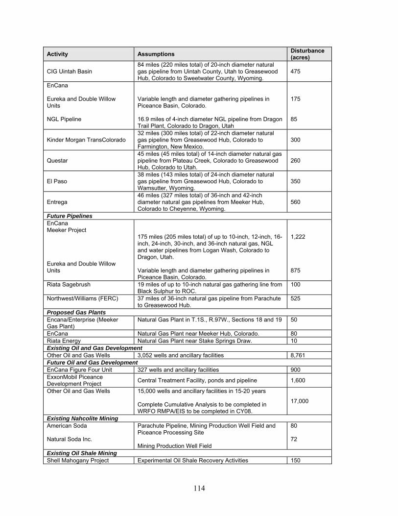
114
Activity Assumptions Disturbance (acres)
CIG Uintah Basin 84 miles (220 miles total) of 20-inch diameter natural gas pipeline from Uintah County, Utah to Greasewood Hub, Colorado to Sweetwater County, Wyoming.
475
EnCana Eureka and Double Willow Units NGL Pipeline
Variable length and diameter gathering pipelines in Piceance Basin, Colorado. 16.9 miles of 4-inch diameter NGL pipeline from Dragon Trail Plant, Colorado to Dragon, Utah
175 85
Kinder Morgan TransColorado 32 miles (300 miles total) of 22-inch diameter natural gas pipeline from Greasewood Hub, Colorado to Farmington, New Mexico.
300
Questar 45 miles (45 miles total) of 14-inch diameter natural gas pipeline from Plateau Creek, Colorado to Greasewood Hub, Colorado to Utah.
260
El Paso 38 miles (143 miles total) of 24-inch diameter natural gas pipeline from Greasewood Hub, Colorado to Wamsutter, Wyoming.
350
Entrega 46 miles (327 miles total) of 36-inch and 42-inch diameter natural gas pipelines from Meeker Hub, Colorado to Cheyenne, Wyoming.
560
Future Pipelines EnCana Meeker Project Eureka and Double Willow Units
175 miles (205 miles total) of up to 10-inch, 12-inch, 16-inch, 24-inch, 30-inch, and 36-inch natural gas, NGL and water pipelines from Logan Wash, Colorado to Dragon, Utah. Variable length and diameter gathering pipelines in Piceance Basin, Colorado.
1,222 875
Riata Sagebrush 19 miles of up to 10-inch natural gas gathering line from Black Sulphur to ROC.
100
Northwest/Williams (FERC) 37 miles of 36-inch natural gas pipeline from Parachute to Greasewood Hub.
525
Proposed Gas Plants Encana/Enterprise (Meeker Gas Plant)
Natural Gas Plant in T.1S., R.97W., Sections 18 and 19 50
EnCana Natural Gas Plant near Meeker Hub, Colorado. 80 Riata Energy Natural Gas Plant near Stake Springs Draw. 10 Existing Oil and Gas Development Other Oil and Gas Wells 3,052 wells and ancillary facilities 8,761 Future Oil and Gas Development EnCana Figure Four Unit 327 wells and ancillary facilities 900 ExxonMobil Piceance Development Project Central Treatment Facility, ponds and pipeline 1,600
Other Oil and Gas Wells 15,000 wells and ancillary facilities in 15-20 years Complete Cumulative Analysis to be completed in WRFO RMPA/EIS to be completed in CY08.
17,000
Existing Nahcolite Mining American Soda Natural Soda Inc.
Parachute Pipeline, Mining Production Well Field and Piceance Processing Site Mining Production Well Field
80 72
Existing Oil Shale Mining Shell Mahogany Project Experimental Oil Shale Recovery Activities 150

115
Activity Assumptions Disturbance (acres)
Future Utilities
White River Electric 138kV connection lines to substations in Piceance Basin.
184
Future Rio Blanco County Services
Waste Water Disposal Pond Sewer, Septic and waste disposal
Wray Gulch, Hwy 64 and County Road 5 2
Paving and Overlay County Road 5 Piceance Creek 0 Meeker Airport Expansion Runway expansion and/or extension TBD Rangely Airport Upgrade Update runway, aprons, facilities 0 Meeker Jail/Justice Center Pending study results and budget approval TBD Total 34,616
Sources: BLM, 2005. EnCana Meeker Pipeline and Gas Plant Project. March, 2005 as edited by the WRFO, 2006.
Direct, indirect, and cumulative effects of reasonably foreseeable oil and gas development were analyzed in the White River Draft Resource Management Plan (DRMP) and associated environmental impact statement (EIS). The DRMP/EIS, completed in 1997, addressed all reasonably foreseeable oil and gas development (including roads and pipelines) over a 20-year period. The developments proposed in the three EAs for Oil Shale RD&D, as well as cumulative impacts to the Resource Area, are tiered to the White River RMP/EIS and are within the scope and analysis of the existing RMP/EIS. Most of the proposed pipeline routes are ROW corridors designated in the White River RMP. As such, impacts including, direct, indirect, and cumulative, were addressed in the related EIS. The Energy Policy Act of 2005, Public Law 109-58 (H.R. 6), enacted August 8, 2005, directs the Secretary of the Interior (the Secretary) to complete a programmatic environmental impact statement (PEIS) for a commercial leasing program for oil shale and tar sands resources on public lands with an emphasis on the most geologically prospective lands within each of the states of Colorado, Utah, and Wyoming. The scope of the PEIS will include an assessment of the positive and negative environmental, social, and economic impacts of leasing oil shale and tar sands resources, including foreseeable commercial development activities on BLM-administered lands located in Colorado, Utah, and Wyoming; discussion of relevant mitigation measures to address these impacts; and identification of appropriate programmatic policies and best management practices to be included in BLM land use plans. The PEIS will address land use plan amendments in the affected resource areas to consider designating lands as available for oil shale and tar sands leasing and subsequent development activities. Although the WRRA is the analysis area, impacts on adjacent areas have not been ignored. Many of the past, present and future projects traverse the WRRA and cross into other adjacent Resource Areas. Impacts from reasonably foreseeable oil and gas development activities outside the WRRA have been analyzed in other resource area-specific resource management plans including, but not limited to, the Book Cliffs RMP, the Grand Junction RMP and ROD, and the Colorado Oil and Gas Leasing and Development Final EIS (covering the BLM Glenwood Springs, Kremmling, Little Snake, Northeast, and San Juan/San Miguel Field Offices) (BLM, 1991).

116
The potential cumulative impacts associated with each critical and non-critical element that must be addressed to meet the Public Land Health Standard are discussed below. Potential Cumulative Effects Air Quality Air pollutant dispersion modeling was performed to quantify potential NO2, PM10, PM2.5, and SO2 impacts during operation, based on the period of maximum potential emissions and other emission sources located within the Piceance Basin (including all five proposed Oil Shale RD&D projects, plus current ExxonMobil Piceance Development Project activities). Operation emissions would occur due to water and product pumping, processing, boiler exhausts, and engine exhausts. Potential maximum cumulative air quality concentrations throughout the Piceance Basin, SO2 impacts within Dinosaur National Monument (a CDPHE-APCD Category I area), as well as NO2, PM10, and SO2, atmospheric deposition (acid rain) and visibility impacts to the Flat Tops Wilderness PSD Class I areas are presented in Table 31. Most of the predicted impacts are below significance thresholds, although the visibility “Limit of Acceptable Change” of more than a single day above a “just noticeable change” (FLAG, 2000) from cumulative emission sources could be exceeded between 13 to 20 days per year. However, 10 to 14 days per year were predicted to occur in the months of November through January, when visitor use in the Flat Tops Wilderness Area is minimal. For the 3 to 6 days per year predicted to have more than a "just noticeable change" in visibility during February through October, 1 to 3 days per year also experienced precipitation events. Given the conservative nature of the modeling analysis (maximum emission rates, "straight line" pollutant transport, etc.) and considering the magnitude, frequency, duration and timing of the predicted impacts, it is unlikely that perceptible visibility impacts would actually occur from the proposed action when combined with other activities in the Piceance Basin. In addition, the State of Colorado will identify all mandatory mitigation measures necessary to achieve the National Visibility Goal of "the prevention of any future, and the remedying of any existing, impairment of visibility in mandatory Class I Federal areas which impairment results from man-made air pollution in response to EPA's Regional Haze Regulations. BLM requires the operators to comply with all applicable air quality regulations. Therefore, negligible adverse air quality impacts are likely to actually occur.
Table 31 Maximum Potential Cumulative Air Quality Impacts by Impact Region
Location Parameter Units Cumulative Impact
Impact Threshold
Nitrogen dioxide Annual (μg/m3) 4.3 25 24-hour (μg/m3) 1.4 65 PM2.5 Annual (μg/m3) 0.3 15 24-hour (μg/m3) 5.0 30 PM10 Annual (μg/m3) 0.6 17 3-hour (μg/m3) 124 512 24-hour (μg/m3) 17.1 91
Piceance Basin
Sulfur dioxide Annual (μg/m3) 2.8 20 3-hour (μg/m3) 10.7 25 24-hour (μg/m3) 1.6 5 Dinosaur
National Monument Sulfur dioxide Annual (μg/m3) 0.08 2

117
Location Parameter Units Cumulative Impact
Impact Threshold
Nitrogen dioxide Annual (μg/m3) <0.01 2.5 24-hour (μg/m3) <0.01 65 PM2.5 Annual (μg/m3) <0.01 15 24-hour (μg/m3) 0.01 8 PM10 Annual (μg/m3) <0.01 4 3-hour (μg/m3) 1.8 25 24-hour (μg/m3) 0.4 5 Sulfur dioxide Annual (μg/m3) <0.01 2 Maximum Total Nitrogen Deposition (kg/ha-yr) 0.265 3 Atmospheric
Deposition Maximum Total Sulfur Deposition (kg/ha-yr) 0.033 3
Ned Wilson Lake Chemistry (1) ANC Change (μeq/l) 0.75 1
Trappers Lake Chemistry ANC Change (percent) 2.7 10
Upper Ned Wilson Lake Chemistry (1) ANC Change (μeq/l) 0.80 1
Flat Tops Wilderness Area
Visibility Greater than 1.0 deciview (days/year) 13 to 20 More than 1
day/year (1) Because these lakes’ lowest (10th percentile) background ANC values are less than 25 μeq/l, the applicable impact threshold is no more than a 1 μeq/l change. kg/ha-yr = kilograms per hectare per year NA = Not applicable PM10 = particulate matter less than 10 microns in effective diameter PM2.5 = particulate matter less than 2.5 microns in effective diameter μeq/l = microequivalents per liter μg/m3 = micrograms per cubic meter
Potential direct atmospheric deposition (acid rain) impacts within the Flat Tops Wilderness Area were also calculated. The maximum direct total (wet and dry) nitrogen and sulfur deposition during operation were predicted to be nearly 0.265 and 0.033 kg/ha-yr, respectively; well below the 3 kg/ha-year threshold (Fox et. al., 1989). In addition, potential changes in Acid Neutralizing Capacity at three lakes within the Flat Tops Wilderness Area were all predicted to less than their significance thresholds (FS, 2000): a potential 2.7 percent change at Trappers Lake (compared to the 10 percent threshold), and nearly a 0.8 microequivalent per liter (μeq/l) change at the more sensitive Ned Wilson and Upper Ned Wilson lakes (also below a one μeq/l threshold for sensitive lakes). The Forest Service considers potential visibility impacts within their mandatory federal PSD Class I areas greater than a 1.0 deciview “just noticeable change” from cumulative air pollutant emission sources to be an adverse impact. Potential cumulative visibility impacts were calculated based on observed hourly relative humidity and speciated aerosol concentrations measured between 2001 and 2004, as specified in the FLAG Guidance (FLAG 2000). If the predicted air quality impacts had occurred during the observed visibility measurement period, a 1.0 deciview “just noticeable change” would have been exceeded between 13 and 20 days per year at the Flat Tops Wilderness Area. However, 10 to 14 days per year were predicted to occur in the months of November through January, when visitor use in the Flat Tops Wilderness Area is minimal. For the 3 to 6 days per year predicted to have more than a "just noticeable change" in visibility during February through October, 1 to 3 days per year also experienced precipitation events. Given the reasonable, but conservative assumptions incorporated into the cumulative visibility impact analysis, it is unlikely that perceptible visibility impacts would actually occur from the proposed action when combined with other activities in the Piceance Basin. BLM will

118
cooperate with the CDPHE-APCD to achieve the national visibility goal of “no man-made impairment of visibility within mandatory federal PSD Class I areas” by EPA’s specified date of 2064 AD. BLM is also preparing a less conservative cumulative modeling analysis (using the CALPUFF modeling system) in order to better quantify potential cumulative visibility impacts within the Flat Tops Wilderness Area. Finally, BLM requires the operators to comply with all applicable air quality regulations. Therefore, only negligible air quality impacts are likely to actually occur. BLM recognizes that if Oil Shale RD&D projects can successfully demonstrate that their technologies are adequate to proceed for commercial development, another more detailed air quality impact assessment will be prepared, using updated air pollutant emissions inventories, meteorological conditions, and dispersion modeling techniques. BLM will continue to cooperate with existing atmospheric deposition and visibility impact monitoring programs. The need for, and the design of, additional monitoring could include the involvement of the EPA Region 8 Federal Leadership Forum (EPA, 2001) and applicable air quality regulatory agencies. Based upon future recommendations, operators could be required to cooperate in the implementation of a coordinated air quality monitoring program. Areas of Critical Environmental Concern Construction and operation of the five proposed actions would not impact any ACEC in the WRFO. Construction of the reasonably foreseeable future projects would be limited to existing disturbance footprints within any ACEC as managed by the WRFO RMP. No cumulative impacts would occur. Cultural Resources and Native American Religious Concerns Past disturbances to cultural resources in the project area have been related to prior collection, disturbance by OHV users, intentional destruction or vandalism, and construction associated with roads and utilities. Construction of the five proposed actions will not affect any known eligible cultural sites. One of the sites requires additional data before eligibility can be determined, and, until such determination is made, the site would be avoided. Another site was listed as requiring additional data but during the survey for this project, was recommended as not eligible. Each of the five proposed actions and proposed reasonably foreseeable future projects would include mitigation measures designed to avoid additional direct impacts on cultural resources. Where direct disturbance cannot be avoided, mitigation (i.e., data recovery) would occur prior to construction. Pressure on nearby sites would likely continue; however, and would be at least slightly exacerbated by the addition of more cleared rights-of-way in the same general area, and by increased human presence from workers at the sites wandering from the sites during breaks, and by vibration from drilling or heavy equipment. Increased access by rights-of-way and access roads would increase the potential for trespass or vandalism at previously inaccessible sites in reasonably foreseeable future projects.

119
Soils and Farmlands, Prime and Unique Not all of the tract areas will be disturbed during construction. Construction of the five proposed actions is estimated to disturb approximately 595 acres of the 800 acres associated with the proposed actions. Disturbance would result in short- to long-term impacts on soils depending upon site stabilization and successful reclamation. There are no prime farmland soils impacted by any of the five proposed actions. Soil disturbance from the proposed actions would result in approximately 1.8 percent of all soils impacted from past, present, and reasonably foreseeable soil disturbance in the project area, and would disturb soils in 0.04 percent of the entire WRRA. Impacts would be highly localized and limited to the period of construction and reclamation. Cumulative impacts would be minimized by implementing measures for the proper handling of topsoil and spoil, erosion control, and reclamation procedures for each of the reasonably foreseeable future projects. Floodplains None of the five proposed actions would be constructed within floodplains. Construction of the five proposed actions would have no short or long-term impacts on floodplains. Cumulative impacts would be minimized by implementing streambank stabilization and restoration measures and engineering practices for foreseeable development projects within or impacting floodplains. Water Resources, Surface and Ground Construction of the five proposed actions would have impacts on surface and groundwater resources. Cumulative impacts on surface water bodies affected by the proposed actions would be limited primarily to water bodies that are affected by other projects within the same watersheds as each of the proposed actions. Direct in-stream impacts associated with construction runoff and increased sediment load during initial storm events following construction would have the greatest impacts on water resources. Runoff from construction activities at reasonably foreseeable projects near water bodies would also contribute to cumulative impacts. Cumulative impacts would be minimized with implementation of erosion control measures, development of Spill Prevention Control and Countermeasures Plans, and best management practices during project operation and reclamation for all reasonably foreseeable projects. The large geographical area in which the relatively small projects would occur would mitigate the conceivable impacts to water quality. Three of the five test sites are located within the Yellow Creek watershed. The volume of groundwater flow moving through a 10-mile long cross-section or vertical slice of the Yellow Creek watershed in the upper Parachute Creek Unit is over 7,000 gpm. The volume of groundwater flow moving through the combined three test sites in this watershed is approximately 50 gpm, or less than 1 percent of the total groundwater flow in the basin. The potential long term effects from the two sites in the Piceance Creek watershed are even smaller, considering the much larger size of this watershed and groundwater flow zone. The proposed actions would all perform suitable reclamation activities to meet Colorado Ground Water Quality Standards at compliance well locations, resulting in no

120
cumulative downgradient impacts. Groundwater monitoring programs will be established to allow verification of water quality standards. Reasonably foreseeable projects would also be required to meet or exceed these standards. Vegetation and Invasive, Non Native Species Construction of the RD&D proposed actions would have short-term to long-term impacts on vegetation. Removal of vegetation and the disturbance of up to 595 acres of the 800 acres of soils from the five RD&D sites would create optimal conditions for the invasion and establishment of invasive, non-native noxious weed species that could continue for many years after the initial disturbance. The impacts of the proposed actions would contribute to a cumulative impact on vegetation and invasive species and are part of the overall impacts of oil and gas vegetative disturbance in the area. These impacts would be greatest where other projects are constructed within the same time period and area as the RD&D sites. Vegetative loss from the proposed actions would result in approximately 1.8 percent of all vegetation impacted from past, present, and reasonably foreseeable soil disturbance in the project area, and would result in a temporary vegetation loss of 0.04 percent of the entire WRRA. Cumulative impacts would be minimized by implementing measures for the proper handling of topsoil and spoil, erosion control, preventative and remedial noxious weed management, and revegetation for each of the reasonably foreseeable future projects. Migratory Birds Construction of the RD&D proposed actions would contribute to cumulative habitat loss and displacement of migratory birds from oil and gas development and other activities. Impacts would result from construction, operation, and reclamation phases of the projects. Over the duration of the projects, loss of habitat would directly affect about 2.2 percent of bird habitat and would indirectly affect a large area due to displacement. Impacts would be long-term and adverse to migratory bird populations that are dependent on sagebrush or pinyon-juniper habitats. Habitat loss from all five proposed actions would be approximately 1.8 percent of habitat loss from past, present, and reasonably foreseeable soil disturbance in the project area, and would result in a temporary habitat loss of approximately 0.04 percent of the entire WRRA. After 20 years, the oil and gas development in the area could cumulatively result in an overall loss of habitat, resulting in reductions of population of migratory bird species from reduced carrying capacity and displacement from the area. Cumulative impacts may be minimized by imposing timing limitations and buffer zones around active nests or sensitive areas to preserve habitat for nesting birds and implementing measures for reclamation for each of the reasonably foreseeable future projects. Impacts would be minimized by co-locating reasonably foreseeable future projects in areas of existing development or disturbance, as well as limiting construction of new roads and ROWs.

121
Threatened, Endangered, and Sensitive Animal Species Construction of the RD&D proposed actions would not likely jeopardize the viability of any threatened, endangered, or sensitive animal species. Construction of the five proposed actions would result in a loss of up to 595 acres within the 800 acres of tracts, which could serve as habitat for threatened and endangered and BLM sensitive species. Impacts include nest abandonment, direct mortality, reproductive failure from stress, and loss of foraging and breeding habitat. The five proposed actions may contribute to a cumulative impact on northern goshawk habitat by temporary loss of approximately 161 acres of pinyon-juniper habitat. Approximately 364 acres of upland sage and bottomland sagebrush habitat would be lost, and approximately 70 acres of grassland habitat. Cumulative impacts would be greatest where other projects are constructed within the same time frame and area. Within the WRRA, BLM Sensitive species may cumulatively be impacted through habitat loss by future oil and gas development. Cumulative impacts would be minimized by implementing measures that prohibit construction during sensitive nesting seasons for each of the reasonable foreseeable future projects. Construction of the RD&D proposed actions would not likely jeopardize the viability of any threatened, endangered, or sensitive animal species. Reclamation activities would reestablish vegetation. Threatened, Endangered, and Sensitive Plant Species There is no habitat for threatened, endangered, and sensitive plant species on any of the five RD&D tracts. Construction of the RD&D proposed actions would not jeopardize the viability of any threatened, endangered, or sensitive plant species. Reasonably foreseeable future projects would be subject to pre-construction surveys, avoidance requirements, and mitigation measures if special status species plants cannot be avoided. Cumulative impacts are not anticipated. Wastes, Solid or Hazardous Accidental spills or leaks associated with equipment failures, refueling and maintenance of equipment, and storage of fuel, oil, or other fluids could cause soil, surface water, and/or groundwater contamination during construction of each of the RD&D proposed actions. The severity of potential impacts from an accidental hazardous material spill would depend upon the chemical released, the quantity released, and the proximity of the release to a waterbody or aquifer. The projects would increase contributions to solid waste landfills during construction, operation and upon closure and would contribute to cumulative impacts on solid waste. Reasonably foreseeable projects would be required to comply with all applicable federal, state, and local regulations. Hazardous waste cumulative impacts are not anticipated.
122
Wetlands and Riparian Zones No wetlands or riparian zones were directly impacted by any of the five RD&D tracts. One site would construct a utility and pipeline ROW across Hunter Creek, but no wetlands would be permanently filled or drained as a result of the construction. Cumulative impacts would occur where the reasonably foreseeable future projects are constructed adjacent to this corridor, but the impacts would be temporary until wetland vegetation returned to pre-construction levels. Cumulative impacts would be minimized by implementing measures to lessen the duration of disturbance, reduce the soil disturbance, and enhance restoration. Runoff from sites during construction could result in impacts to wetlands or riparian zones, but would be mitigated through storm water runoff control and best management practices. Reasonably foreseeable future projects would be subject to requirements for protection of wetlands and riparian areas under the Clean Water Act and BLM guidelines, including avoidance and mitigation of impacts, and compensatory mitigation of unavoidable wetland impacts. Cumulative effects are not anticipated. Wilderness No wilderness areas are impacted by the five proposed actions. Potential indirect impacts to wilderness areas caused by dust and air emissions from project construction and operation and from reasonably foreseeable development are described in the air emissions cumulative impact discussion. Wildlife, Aquatic, and Terrestrial Construction of the RD&D proposed actions would have some temporary and possibly long-term impacts on wildlife resources. Many woodland accipiters and owls nest extensively in pinyon-juniper woodland with the proposed action areas. These raptors can be sensitive to development and disturbance from industrial activity. Loss of approximately 161 acres of pinyon-juniper woodland wildlife habitat would displace wildlife species to other areas of suitable habitat due to the decreased carrying capacity of the land. While suitable habitat may be available in adjacent areas, loss of habitat would increase intra-and inter-specific competition. Wildlife populations would decrease as a result of the increased resource competition and mortality from stress, as well the reduction in reproductive success and health from the increased energy expenditures required to deal with disturbance. Vegetation removal would result in a loss of cover, nesting, and forage habitat. The degree of impact would depend on the type of habitat affected and the rate that vegetation would regenerate after reclamation. Impacts would occur during construction, operation, and reclamation of the sites. Loss of habitat for wildlife, including raptors and big game, would occur on approximately 595 of the 800 acres. Vegetative loss from the proposed actions would result in approximately 1.8 percent of all vegetation impacted from past, present, and reasonably foreseeable soil disturbance in the project area, and would result in a temporary vegetation loss of 0.04 percent of the entire WRRA.

123
Within the WRRA, habitat loss from oil and gas development and the proposed actions would influence the distribution of big game. The proposed actions are within important mule deer winter ranges in the WRRA. Local and long-distance migratory patterns may be adversely modified by cumulative effects of reasonably foreseeable projects, including the RD&D projects. Increased traffic and oil and gas development would result from changing areas of winter and summer range. The additional traffic and human activity in the region would likely contribute to an increase in poaching and vehicle collisions with wildlife, but would not likely cause a noticeable reduction in populations. Cumulative impacts would be minimized by implementing measures that prohibit construction activities during sensitive wildlife periods. Access and Transportation For transportation, the cumulative impact analysis area includes Rio Blanco CR 5 (Piceance Creek) and the associated local road network in the Piceance Creek area. These county roads were originally designed for rural and agricultural uses and were not intended for the repeated heavy loads associated with the current expansion in oil and gas production. The increasing traffic volume, frequency, and vehicle size on these rural roads has contributed to an increase in the costs associated with repair and maintenance of these county roads. Sustained high levels of traffic could have secondary impacts on wildlife, and on the quality of recreation in the region. Collectively, construction and operation of the five proposed oil shale RD&D projects would contribute to these traffic effects. Additionally, past, present, and reasonably foreseeable future developments have, and will continue to, create additional access onto BLM lands by constructing new roads into areas that were previously inaccessible by vehicle. Fire Management One of the five proposed actions is located within prescribed natural fire areas defined in the WRRA RMP. The other four sites are located in areas where fires can be suppressed as wildfires. The five proposed actions are estimated to result in removal of approximately 595 acres of pinyon-juniper woodland, sagebrush, and grasslands. This acreage anticipates removal that includes defensible space around project facilities, and to protect workers and facilities in the event of a wildfire. Of the 595 acres of disturbance, approximately 161 acres is estimated to be of pinyon-juniper woodland and approximately 364 acres is sagebrush which could create moderate to considerable dead fuel loads if left unmanaged upon removal. Utility lines through pinyon-juniper woodlands could create fire hazard potential. Accidental, human caused fires would likely increase in the vicinity of the five RD&D tracts and transportation routes accessing the five tracts due to the increased number of people in the areas where fire fuels are located. Increased activity resulting from the proposed actions and any reasonably foreseeable future actions could have a cumulative affect on the BLM’s ability to use wildfire to achieve public land health objectives in those areas, and additional accidental fires would increase demands on the WRFO fire response services. Cumulative impacts on fire management could be minimized by complying with mitigations outlined in the BLM Fire Activity Management Plan, and by developing fire suppression priorities, identifying management restrictions, and determining
124
appropriate fire suppression strategies in coordination with the BLM and Rio Blanco County emergency response teams. Forestry Management Construction of the RD&D proposed actions would result in the clearing of 161 acres of pinyon-juniper woodlands and would have short-term to long-term impacts on vegetation, terrestrial wildlife, and threatened and endangered species. The current WRFO RMP environmental impact statement anticipated that oil shale and sodium development would occur on 620 of the 632,800 acres of pinyon-juniper woodland on the WRRA (BLM, 1997). The RD&D proposed actions are within the range of previously-analyzed impacts and less than 0.03 percent of the pinyon-juniper woodland within the WRRA that is classified as non-commercial. Cumulative impacts would be minimized by seeding disturbed areas, controlling noxious weeds, and reclaiming the site at the conclusion of the RD&D programs. The woodlands estimated to be removed are not within the allowable harvest and are not managed for commercial firewood production. The cleared woodlands will be considered for benefits of other resources and will be appraised by BLM for value. Cumulatively, past, present and future development projects have resulted in temporary reductions in woodlands. Restoration methods would be applied as appropriate to meet forestry management objectives. Geology and Minerals The five proposed actions would each retort oil shale under a 160-acre tract. Each proposed action would, by virtue of the limited areal extent and thickness of the retorted zone, produce to the surface a small portion of the shale oil resource underlying the tract. The total amount of shale oil that would be produced would be extremely small relative to the 1,200 billion barrels of shale oil thought to be contained in the Green River formation in the Piceance Basin (BLM, 1994). A thick zone of sodium minerals, primarily nahcolite and dawsonite, is intermingled with oil shale in the depositional center of the Piceance Basin. Development of oil shale resources containing substantial deposits of nahcolite and/or dawsonite could preclude future development of the sodium minerals at those locations. The proposed actions would avoid such interference either by retorting oil shale zones lacking substantial deposits of sodium minerals recovering the minerals before recovering the oil resources, or by isolating the formations so as to avoid destruction of the nahcolite and dawsonite. The proposed actions would not adversely affect the future recovery of oil shale outside the retorted zones or of other minerals in the project area. Hydrology and Water Rights Groundwater extraction for on-site use as makeup and process water (1 to 20 gpm) at the Shell sites would result in minor impacts to groundwater flow in the upper Parachute Creek member at those sites. However, these impacts would last only through the completion of the oil recovery phase. The largest volume of groundwater would be required during reclamation to resaturate the

125
area where kerogen was heated and the oil was recovered. Resaturation or refilling of the pyrolyzed, or retorted, materials would require from 1 to 3 years using water derived from either natural inflow or extraction and injection wells completed in the upper Parachute Creek member. There would be the potential for minor depletions from Yellow Creek during the reclamation phase at each Shell site, caused by a reduction in groundwater discharge. Given the small size of each site and the relatively slow movement of groundwater in the subsurface, potential depletions would be limited to Shell's estimated 0.04 cfs flow reduction at Yellow Creek. Following the reclamation phase, groundwater flow directions and velocities would likely resemble pre-development patterns. Water rights for any depletion would be secured prior to use. Water depletions are not anticipated for the Chevron and EGL projects. Long-term, basin-wide, cumulative impacts are not anticipated given the scale of the RD&D proposals. Noise The five Proposed RD&D tracts are located several miles from each other in a rural setting. There are no noise receptors (homes, schools, businesses) within 0.5 mile of any of the tracts. Noise from each of the operations would not be cumulative due to distance and facilities dispersed in a rural setting. Cumulatively, noise increases are associated with foreseeable development. Noise mitigation will be applied as appropriate on a site-specific basis to mitigate impacts to receptors. Paleontology All of the proposed actions are on sites underlain by the Uinta formation. The Uinta formation is a BLM Class I paleontologic formation, one known to contain vertebrate fossils or noteworthy occurrences of invertebrates or plant fossils. Disturbance of bedrock could damage those fossil resources and contribute to the basin-wide degradation of paleontologic resources caused by construction activities. Sections of the proposed action area have been surveyed for fossils with negative results, although valuable plant fossils have been found in the vicinity of Shell Site 3. Cumulative impacts would be mitigated by having paleontologists monitor bedrock-disturbing activities and by training construction and operation personnel not to collect fossils. Rangeland Management Grazing leases exist on all of the five proposed RD&D tracts. Fences erected at the sites to protect health and safety would eliminate grazing on approximately 550 acres. Impacts to the total of 126,490 AUMs within the WRRA would be less than 1 percent. One watering facility on one of the tracts would need to be relocated. Grazing acreage losses may require the number of livestock to be grazed by permittees to be reduced, or replacement forage may need to be identified. Cumulatively, reasonably foreseeable projects may result in the reduction of available livestock forage.

126
Realty Authorizations The five RD&D tracts all have existing and proposed projects within or crossing them including wells, water and gas pipelines, utilities, roads, and vegetation research plots. Some of the existing facilities would need to be moved to accommodate safe construction and operation of the Oil Shale RD&D facilities. Some of the facilities would need to be moved off of the parcels and require acquisition of additional ROW, and additional disturbance to move existing facilities. Cumulatively, energy development has expanded to result in multiple project requests on parcels. More realty authorizations would be required to accommodate the increase in projects, with appropriate stipulations and increased management of the authorizations. Recreation The five RD&D tracts all occur within the White River Extensive Recreation Management Area (ERMA), which BLM has custodial management to provide for unstructured recreation activities. The primary recreational users in the area include hunters and OHV users. Development of the five proposed actions would result in potential loss of up to 800 acres of recreational lands for hunting and cycling. There are sufficient hunting areas and road systems available that are away from the RD&D tracts that recreationists would likely move onto other lands. Cumulatively, increased development in the WRRA will reduce lands available for recreation, and impact the recreational experience of those desiring an environment free of structures and facilities. Big game habitat will become more dispersed with increased roads and loss of habitat. The remote and relatively undisturbed nature of these areas is valued by local hunters and recreationists that seek a natural-appearing environment with few administrative controls and low interaction between users. The probability of isolation from the sights and sounds of human activity would be diminished over time. Development of the five RD&D operations would not create additional access onto BLM-administered lands, but would contribute to an increase in human activity in the region and would thereby become a factor in the diminished sense of isolation in these remote areas. Socioeconomics The cumulative impact assessment area for socioeconomics includes Rio Blanco, Garfield, and Mesa Counties since these counties would provide the workforce for the proposed actions, and would receive the tax and royalty income that would be generated by the reasonably foreseeable oil and gas projects within the White River Resource Area. The five proposed oil shale RD&D projects would contribute to the development of mineral resources in the Piceance Basin, and would be a factor in the ongoing socioeconomic change throughout the region. The five proposed projects, along with present and future oil and gas production activities in the Piceance Basin, would contribute to additional employment opportunities throughout the region and would expand the local tax base as workers move into the area and purchase homes, land, goods and services. Although federal royalties have been waived for the duration of the proposed RD&D program and rents have been waived for 5 years, reasonably foreseeable future
127
oil shale development would ultimately contribute to Colorado Local Government Energy Impact Programs, and increased oil and gas production in the WRRA will continue to contribute federal royalties, bonuses, rents, and severance tax revenues to the local governments impacted by energy development. These impacts would be considered beneficial to local communities in the region. The social infrastructure of the cities and counties affected have not been able to keep pace with the rapid growth in the oil and gas industry and demands upon law enforcement, emergency response, community services, and road and bridge maintenance have increased substantially. Aging facilities are at, or near, capacity, transportation networks and community services are in need of upgrading and/or repair, and current staffing is not adequate for managing the increased activity. This creates a financial and logistical burden on local governments attempting to maintain the level of service expected within the communities, while at the same time under increasing pressure to provide the needed services in more remote locations such as the Piceance Basin. The proposed oil shale RD&D projects would contribute to these demands on local services.
The surface disturbance resulting from construction of the proposed oil shale facilities, along with present, and future oil and gas activities could have an effect on the economic viability of the ranching and recreation industries in Rio Blanco County. The cumulative loss of forage for livestock and big game could result in a reduction in livestock numbers and the dispersal of deer and elk away from traditional hunting grounds in the area. Other recreational activities could be dispersed to more isolated locations as the Piceance Basin becomes more developed. The changes in the natural landscape of the White River Resource Area brought about by development could contribute to a decline in the economic benefits generated by these industries. Implementing reclamation activities as required to re-establish vegetation in disturbed areas, limiting new road and facility construction to existing corridors, and adhering to visual resource management stipulations to diminish the sights and sounds of human activities would minimize the cumulative impacts to these industries.
The White River RMP/ROD (BLM 1997) included oil shale research as reasonably foreseeable in its cumulative impact analysis. Current development in the WRRA, including the five proposed actions, has not exceeded the foreseeable development analyzed in the RMP/ROD. However, oil shale development beyond the proposed RD&D program together with the expansion of oil and gas development in the Piceance Basin could result in broad impacts to the communities of northwestern Colorado. Although the BLM has not made the decision to allow oil shale development on a commercial scale, the leasing of oil shale lands for this purpose is a reasonably foreseeable future prospect. Should the proposed RD&D projects prove to be successful in developing efficient methods for shale oil extraction, the processes would likely generate interest from other oil and gas producers and new development could expand quickly on both public and private lands in Colorado, as well as in Utah and Wyoming. Rapid development of oil shale and concurrent oil and gas operations in northwestern Colorado could change the rural/agricultural character of remote energy producing regions into a more industrial environment.

128
Construction of new roads, pipelines, utility corridors, and production facilities would introduce additional human activity to relatively undisturbed areas, and an increase in local populations would likely result from the promise of high-paying jobs in the energy industry. Traffic on local roads could be expected to grow and facility maintenance and service needs would insure that relatively high levels of traffic are sustained. The smaller communities in the region would experience the greatest impact resulting from sudden population growth. Meeker, Rangely, Parachute, DeBeque, and Rifle do not presently have sufficient housing, emergency response capabilities, community services, or correctional facilities to accommodate a substantial population increase, and city and county governments in the area are reluctant to increase spending on community services and housing requirements for energy production growth as a result of previous experience with the historic boom and bust cycles associated with the oil and gas industry. Other communities in the region, such as Grand Junction, are capable of meeting the social demands of a large workforce, but would be impacted to some degree by the problems associated with population growth, such as crime and drug use. On the other hand, managed growth is necessary to sustain local economies. Local governments benefit from the increase in tax revenues to support schools, hospitals, and community services. Sustained growth brings with it the addition of new businesses in the retail, service, and public sectors which provide jobs, lower unemployment rates, increase productivity, and maintain the health and vitality of a community.
The decision to allow commercial-scale oil shale development is contingent upon the assurance that today’s extractive technologies are able to operate economically, and at environmentally acceptable levels, before conversion to commercial operations is considered. The pilot RD&D program would be designed as a small-scale, carefully staged, research and development project that would enhance the collective knowledge of the oil shale resource and evaluate its potential as a future domestic energy supply. A Programmatic Environmental Impact Statement is currently being prepared by the BLM to address the foreseeable commercial-scale oil shale leasing, and in response to the increase in oil and gas drilling activity, the BLM will prepare a Resource Management Plan Amendment/EIS beginning later this year. The cumulative impacts of the industry on the social infrastructure in the WRRA, including the Piceance Basin, will be further analyzed in that RMPA/EIS.
Visual Resources All of the five proposed actions are within VRM Class 3 and have the objective to partially retain the existing character of the landscape. VRM Class 3 evaluations for each of the five RD&D projects will result in some change to the landscape from areas within the project area. The Chevron site is the most prominent, atop Hunter Ridge which is adjacent to CR69. CR69 is traveled heavily by oil and gas operators and, to a lesser degree, ranchers, hunters and other recreationists. The other tracts are less visible to the majority of workers, recreationists, or casual visitors in the project area. In all cases, surface disturbance would introduce linear features and color changes that would alter the viewsheds. To reduce visual impacts, permanent structures on the proposed RD&D sites would be painted to blend into the surrounding landscape, and unused disturbed areas would be revegetated to restore the natural landscape

129
character. Cumulatively, reasonably foreseeable development would cause increased disturbance that would be visible from more locations within the project area. Wild Horses Two of the five proposed actions are within the Piceance/East Douglas Herd Management Area (HMA) which encompasses 190,000 acres. Approximately 320 acres (0.02 percent) of the HMA would be fenced and no longer available as wild horse habitat. Horses may be disrupted by noise and fugitive dust associated with construction activities, particularly during foaling season. Cumulatively, reasonably foreseeable development within the Piceance/East Douglas Herd HMA would eliminate wild horse habitat. Prompt reseeding of disturbed areas upon completion would enhance habitat restoration.
130
REFERENCES General References Bureau of Land Management (BLM). 1997. White River Record of Decision and Approved Resource Management Plan (ROD/RMP). Critical Elements Air Quality and Climate References Colorado Department of Public Health and Environment – Air Pollution Control Division (CDPHE-APCD). 2006. Assumed Background Air Pollutant Concentrations. Personal letter from Nancy Chick (Environmental Protection Specialist, CDPHE-APCD) to Brian Mitchell (TRC - Laramie, Wyoming) dated January 18, 2006. Federal Land Managers’ Air Quality Related Values Work Group (FLAG). 2000. Federal Land Managers’ Air Quality Related Values Workgroup (FLAG) Phase I Report (December 2000). Retrieved from: http://www2.nature.nps.gov/air/Permits/flag/flagfreeindex.htm U.S. Environmental Protection Agency (EPA). 2001. The Rocky Mountain Federal Leadership Forum Framework for Regional Resource Assessments. February 2001. Retrieved from: http://www.epa.gov/region08/compliance/nepa/nepadocs/RRAFinal2_01.PDF Western Regional Climate Center (WRCC). 2006. Historical Climate Information Data Archive – Meeker, Rangely 1E, and Glenwood Springs #2, Colorado. Retrieved from: http://www.wrcc.dri.edu/summary/Climsmco.html Cultural Resources References Baker, Steven G. 1986. Initial Archaeological Monitoring and Energy Mitigation Procedures at Chevron USA’s Rangely Field CO² Injection Project: 1978 and 1979 Field Seasons. Centuries Research, Inc., Montrose Colorado. Submitted to the Gunnison National Forest, Delta, Colorado. Baker, Steven G. 1996. Numic Archaeology on the Douglas Creek Arch, Rio Blanco County, Colorado: Ute Rancherias and the Broken Blade Wickiup Village (5RB3182). Centuries Research, Inc., Montrose, Colorado. Prepared for the Bureau of Land Management, Meeker, Colorado. Baker, Steven G. 1997. Fremont Archaeology on the Douglas Creek Arch, Rio Blanco County, Colorado: Granaries and Rock Art in the Shavetail Basin (5RB3180, 3286, 3290, 3512). Centuries Research Inc., Montrose, Colorado. Submitted to Bureau of Land Management, White River Resource Area, Meeker, Colorado.
131
Baker, Steven G. 1998. Fremont Archaeology on the Douglas Creek Arch, Rio Blanco County, Colorado: The Rim Rock Hamlet Promontory (5RB2792). Centuries Research Inc., Montrose, Colorado. Submitted to the Bureau of Land Management, White River Resource Area, Meeker Colorado. Black, Kevin D. and Christian J. Zier. 1981. A Cultural Resource Clearance Survey of Approximately 28.8 Miles (46.7 Kilometers) of CIG Pipeline Routes in the Piceance Basin, Rio Blanco County, Colorado. Metcalf-Zier Archaeologists. Born, Philip L. 1984. Archaeological Survey for Rio Blanco Natural Gas, 2-98-16-#1, Rio Blanco County, Colorado (AAS #18-84). Archaeological Analysis, Bureau of Land Management (BLM). 1999. Final Environmental Impact Statement Yankee Gulch Sodium Minerals Project. White River Resource Area, Meeker, Colorado. Conner, Carl E. 1985. Cultural Resources Inventory Report in a Proposed New Access into the IRI Sodium Lease Area in Rio Blanco County, Colorado. Grand River Institute, Grand Junction, Colorado. Conner, Carl E, Barbara Davenport, Dan Archuleta, and Jim Conner. 2005. Class III Cultural Resource Inventory Report for Seven (7) Pipeline ROW’s in Rio Blanco County, Colorado for Bargath Inc. Prepared for the BLM White River Field Office. Grand River Institute, Grand Junction, Colorado. Conner, Carl E., Curtis Martin, Barbara Davenport, Nicole Darnell, and Jim Conner. 2004. A Class III Cultural Resource Inventory for the Proposed Ryan Gulch Gathering System and Compressor Station in Rio Blanco County, Colorado for Williams Production RMT Company (GRI No. 2449). Prepared for the BLM White River Field Office. Grand River Institute, Grand Junction, Colorado. Creasman, Steven D. 1981. Archaeological Investigations in the Canyon Pintado Historic District, Rio Blanco County, Colorado. Reports of the Laboratory of Public Archaeology No. 34. Colorado State University, Fort Collins. Creasman, Steven D., and Linda J. Scott. 1987. Texas Creek Overlook: Evidence for Late Fremont (Post A.D. 1200) Occupation in Northwest Colorado. Southwestern Lore 53 (4):1-16. Frizell, Elizabeth and Jon P. Frizell. 1991. Class III Cultural Resource Inventory of the Northern Geophysical Seismic Line 137, Rio Blanco County, Colorado. Prepared for BLM, Craig District. North Platte Archaeological Services. Hauck, Richard. 1993. Archaeological Excavations (1988-1992) in Douglas Creek-Texas Mountain Locality of Rio Blanco County, Colorado. Archaeological-Environmental Research Corporation, Bountiful, Utah. Submitted to Bureau of Land Management, Meeker, Colorado.
132
Hauck, Richard. 1997. Archaeological Excavations (1993-1996) in the Douglas-Texas Mountain Locality of Rio Blanco County, Colorado. Archaeological-Environmental Research Corporation, Bountiful, Utah. Submitted to Bureau of Land Management, Meeker, Colorado. Hoefer, Ted and Marc E. Greenberg. 2006a. A Class III Cultural resource Inventory of the Proposed EGL Oil Shale Development Tract, Rio Blanco County, Colorado. Report prepared for EGL and O & G Environmental. Report No. 06-002, Cultural Resource Analysts, Inc., Longmont, Colorado. Dated April 24, 2006, submitted to BLM May 2, 2006. Hoefer, Ted and Marc E. Greenberg. 2006b. A Class III Cultural resource Inventory of a Utility Line associated with the Proposed EGL Oil Shale Development Tract, Rio Blanco County, Colorado. Report prepared for EGL and O & G Environmental. Report No. 06-002, Cultural Resource Analysts, Inc., Longmont, Colorado. Dated June 01, 2006, submitted to the BLM June 02, 2006. Husband. M. 1984. Colorado Plateau Prehistoric Context. Colorado Historical Society, Denver, Colorado. LaPoint, Halcyon J., Howard M. Davidson, Steven D. Creasman, and Karen C. Schubert. 1981. Archaeological Investigations in the Canyon Pintado Historic District, Rio Blanco County, Colorado, Phase II --- Inventory and Test Excavations. Reports of the Laboratory of Public Archaeology No. 53. Colorado State University, Fort Collins, Colorado. McPherson, Penny J. 1983. Piceance Basin Archaeology: A Class III Cultural Resource Inventory of Federal Oil Shale Lease Tract C-A, Rio Blanco County, Colorado. Bureau of Land Management, Meeker, Colorado. Martin, Curtis, Carl E. Conner, Jim Conner, Nicole Darnell, and Barbara Davenport. 2003. 2003 Piceance Basin Study: A Class III Cultural Resource Inventory of Thirteen Drill Holes and Related Access Routes in Rio Blanco County, Colorado for Shell Frontier Oil and Gas (GRI 2324). Prepared for the BLM White River Field Office. Grand River Institute, Grand Junction, Colorado. Reed, A. and M. Metcalf. 1999. Colorado Prehistory: A Context for the Northern Colorado River Basin. Colorado Council of Professional Archaeologists. Denver, Colorado. Warner, Ted J. (editor). 1995. The Dominguez-Escalante Journal: Their Expedition through Colorado, Utah, Arizona and New Mexico in 1776. Translated by Fray Angelico Chavez. University of Utah Press, Salt Lake City. Weber, D., K. Jones, H. Rodriguez, C. Jennings, and D. Daugherty. 1977. Archaeological Reconnaissance of Nine In-situ oil Shale Lease Tracts, Colorado-Utah. Reports of the Laboratory of Public Archaeology Number 3. Laboratory of Public Archaeology, Colorado State University. Fort Collins, Colorado.

133
Williams, Gregory E. 1979. Proposed Buckley Christmas Tree Sale Area, Rio Blanco County, Colorado (4310-4133). BLM White River Resource Area. Farmlands References Tripp, W.P., L.W. Williams, D.K. Alstatt, J.J. Rawinski, and C.F. Spears. 1982. Soil Survey of Rio Blanco County Area, Colorado. USDA Soil Conservation Service. U.S. Natural Resources Conservation Service (NRCS). 2003. Soil Survey of Douglas Plateau Area, Colorado, Parts of Garfield and Mesa Counties. Migratory Birds References Bureau of Land Management (BLM). 2005. Partners in Flight Priority Bird Populations. Retrieved from: http://www.blm.gov/wildlife/plans.htm Colorado Division of Wildlife (CDOW). 2005. Natural Diversity Information Source. Retrieved from: http://ndis.nrel.colostate.edu/wildlife.asp. Kennedy,P.L. and D.W. Stahlecker. 1993. Responsiveness of nesting northern goshawks to taped broadcasts of 3 conspecific calls. Journal of Wildlife Management 57: 249-257. NatureServe. 2005. NatureServe Explorer: An online encyclopedia of life [web application]. Version 4.4. NatureServe, Arlington, Virginia. Retrieved from http://www.natureserve.org/explorer. Native American Concerns References Bureau of Land Management (BLM). 2006. Personal communications between O&G and Michael Selle, WRFO Cultural Resources Specialists. Threatened, Endangered, and Sensitive Animal References Bureau of Land Management (BLM). 2006. Personal communications between O&G and Brett Smithers, WRFO Natural Resources Specialists. Colorado Division of Wildlife (CDOW). 2005. Sharp-tailed grouse data. Retrieved from: http://wildlife.state.co.us/species_profiles/sharpgrouse.asp. Connelly, J.W., M.A. Schroeder, A.R. Sands, and C.E. Braun. 2000. Guidelines to manage sage grouse populations and their habitats. Wildlife Society Bulletin 28:967-985. Accessed online at http://www.gf.nd.gov/conservation/docs/sage-gr-attach-1.pdf Kennedy,P.L. and D.W. Stahlecker. 1993. Responsiveness of nesting northern goshawks to taped broadcasts of 3 conspecific calls. Journal of Wildlife Management 57: 249-257.
134
NatureServe. 2005. NatureServe Explorer: An online encyclopedia of life [web application]. Version 4.4. NatureServe, Arlington, Virginia. Retrieved from http://www.natureserve.org/explorer. O&G Environmental Consulting, LLC. 2006. Raptor Survey Report for EGL Oil Shale Research, Development and Demonstration Tract. May. Sibley, D.A. 2000. The Sibley guide to birds. The National Audubon Society. U.S. Fish and Wildlife Service (USFWS). 2005. Federally listed and Proposed (P), Endangered (E), Threatened (T), Experimental (X), and Candidate (C) species and habitat in Colorado by County (updated March 2005). Threatened, Endangered, and Sensitive Plant References Bureau of Land Management (BLM). 2005. State Director’s Sensitive Species List. Obtained from BLM White River Field Office via email from Brett Smithers on April 3, 2006. WestWater Engineering, Inc. 2006. Biological Assessment Report - Special Status Species of Plants. Oil Shale Demonstration Tracts. Rusty Roberts of WestWater Engineering in coordination with Cordilleran Compliance. Water Quality References Coffin, D. L., F. A. Welder, and R. K. Glanzman. 1971. Geohydrology of the Piceance Creek Structural Basin between the White and Colorado Rivers, Northwestern Colorado: U.S. Geological Survey Hydrologic Investigations Atlas HA-370. Colorado Department of Public Health and Environment (CDPHE). 2006a. Water Quality Control Commission Regulation 37. Classification and Numeric Standards for Lower Colorado River Basin. Colorado Department of Public Health and Environment (CDPHE). 2006b. Status of Water Quality in Colorado – 2006. The Update to the 2002 and 2004 305(b) Reports. Colorado Department of Pubic Health and Environment (CDPHE). 2006c. Water Quality Control Commission Regulation #94. Colorado’s Monitoring and Evaluation List. Colorado Department of Public Health and Environment (CDPHE). 2006d. Water Quality Control Commission Regulation #93. Section 303(d) List, Water-Quality-Limited Segments Requiring TMDLs. Czyzewski, G. 2000. The Piceance Creek Basin, Chapter 12 in Ground-Water Atlas, Aikin, A., Anderman, E., Harmon, E., Paschke, S., Plazak, Riemann, eds., Colorado Ground-Water Association.

135
Saulnier, G. J. 1978. Genesis of the Saline Waters of the Green River formation, Piceance Basin, Northwest Colorado: University of Nevada Reno, unpublished Ph.D. dissertation. Tobin, R. 1987. Water Quality in the Piceance Basin, in Taylor J., ed., Oil Shale, Water Resources, and Valuable Minerals of the Piceance Basin, Colorado: The Challenge and Choices of Development. U.S. Department of Interior US Geologic Survey Professional Paper 1310. U.S. Government Printing Office. Washington D.C. Topper, R., K. L. Spray, W. H. Bellis, J. L. Hamilton, and P. E. Barkmann. 2003 Groundwater Atlas of Colorado. Colorado Geological Survey Special Publication 53. U.S. Geological Survey. 2006. Water Quality Samples for Colorado. USGS 09306175, Black Sulphur Creek Near Rio Blanco, CO. Retrieved from. http://nwis.waterdata.usgs.gov/co/nwis/qwdata/?site_no=09306175&agency_cd=USGS. Non-Critical Elements Soils References Tripp, W.P., L.W. Williams, D.K. Alstatt, J.J. Rawinski, and C.F. Spears. 1982. Soil Survey of Rio Blanco County Area, Colorado. USDA Soil Conservation Service. Vegetation References U.S. Natural Resources Conservation Service (NRCS). Soil Survey of Douglas Plateau Area, Colorado, Parts of Garfield and Mesa Counties. Wildlife, Aquatic and Terrestrial References Bureau of Land Management (BLM). 1986. Draft Environmental Impact Statement. Mine Plan for a Nahcolite Solution Mine. White River Resource Area, Craig District Office, Craig, Colorado. Bureau of Land Management (BLM). 1987. Grand Junction Resource Management Plan and Record of Decision. Grand Junction Resource Area, Grand Junction District Office, Grand Junction, Colorado. Bureau of Land Management (BLM). 1996. White River Resource Area Draft Resource Management Plan and Environmental Impact Statement. White River Resource Area, Craig District Office, Craig, Colorado. Colorado Division of Wildlife (CDOW). 2004. CDOW GIS Data. Retrieved from: http://ndis.nrel.colostate.edu/ftp/ftp_response.asp. Colorado Division of Wildlife (CDOW). 2005a. Wapiti. Retrieved : http://wildlife.state.co.us/Education/mammalsguide/wapiti.asp.
136
Colorado Division of Wildlife (CDOW). 2005b. Deer. Retrieved from: http://wildlife.state.co.us/Education/mammalsguide/deer.asp. U.S. Geological Survey (USGS). 2006. Monthly Streamflow Statistics for Colorado. USGS 09306200, Piceance Creek below Ryan Gulch, near Rio Blanco, CO. Retrieved from http://nwis.waterdata.usgs.gov/co/nwis/monthly/?site_no=09306200&agency_cd=USGS. Other Non-Critical Elements Access and Transportation References Bureau of Land Management (BLM). 1997. White River Resource Area Draft Resource Management Plan and Environmental Impact Statement. White River Resource Area, Craig District Office, Craig, Colorado. Forestry Management References Bureau of Land Management (BLM). 1994. White River Resource Area Draft Resource Management Plan and Environmental Impact Statement. Geology and Minerals References Algermissen, S.T. 1969. Seismic Risk Studies in the United States. US Dept. of Commerce, Env. Science Services Admin., Coast & Geodetic Survey. Bunger, J.W., P.M. Crawford, and H.R. Johnson. 2004. Is Oil Shale America’s Answer to Peak-Oil Challenge? Oil & Gas Journal, August 9, 2004. Cashion, W.B. 1973. Geologic and structure map of the Grand Junction Quadrangle, Colorado and Utah: U.S. Geological Survey Miscellaneous Investigations Series Map, I-736. Fenneman, N.M. 1931. Physiography of the Western United States. Plate I. New York: McGraw-Hill. Hail, W. J. and M. C. Smith. 1994. Geologic Map of the Northern Part of the Piceance Creek Basin, Northwestern Colorado. US Geol. Surv. Map I-2400. Kirschbaum, M.A. and L.R.H. Biewick. 2003. A Summary of Coal Deposits of the Colorado Plateau: Arizona, Colorado, New Mexico, and Utah in National Coal Resource Assessment: Geologic Assessment of Coal in the Colorado Plateau: Arizona, Colorado, New Mexico, and Utah. USGS Prof. Paper 1625-B. Retrieved from: http://greenwood.cr.usgs.gov/energy/coal/PP1625B/Reports/Chapters/Chapter_B.pdf National Earthquake Information Center (NEIC). 2006. Earthquake Search. Retrieved from: http://neic.usgs.gov/neis/epic/epic.html.
137
Schwochow, S.D. 1981. Inventory of Nonmetallic Mining and Processing Operations in Colorado. CO Geol. Surv. MS 17. Whitney, J. W. 1981. Surficial Geologic Map of the Grand Junction 1° x 2° Quadrangle, Colorado and Utah. US Geol. Surv. Map I-1289. Wray, L.L., A.D. Apeland, H.T. Hemborg, and C.A. Brchan. 2002. Oil & Gas Fields Map of Colorado. CO Geol. Surv. MS-33. Hydrology and Water Rights References Coffin, D. L., F. A. Welder, and R. K. Glanzman. 1971. Geohydrology of the Piceance Creek Structural Basin between the White and Colorado Rivers, Northwestern Colorado: United States Geological Survey Hydrologic Investigations Atlas HA-370. Czyzewski, G. 2000. The Piceance Creek Basin, Chapter 12 in Ground-Water Atlas, Aikin, A., Anderman, E., Harmon, E., Paschke, S., Plazak, Riemann, eds., Colorado Ground-Water Association. Glover, K.C., D.L. Naftz, and L.J. Martin. 1998. Geohydrology of Tertiary Rocks in the Upper Colorado River Basin in Colorado, Utah ad Wyoming, excluding the San Juan Basin, Regional Aquifer-System Analysis, USGS WRI 96-4105. Robson, S. G. and G. J. Saulnier. 1980. Hydrogeochemistry and simulated solute transport, Piceance Basin, Northwestern Colorado, USGS OFR-80-72. Saulnier, G. J. 1978. Genesis of the Saline Waters of the Green River formation, Piceance Basin, Northwest Colorado: University of Nevada Reno, unpublished Ph.D. dissertation. Taylor, O. 1987. Hydrologic Systems of the Piceance Basin. Oil Shale, Water Resources, and Valuable Minerals of the Piceance Basin, Colorado: The Challenge and Choices of Development. U.S. Department of Interior U.S. Geological Survey Professional Paper 1310. U.S. Government Printing Office. Washington, D.C. Topper, R., K. L. Spray, W. H. Bellis, J. L. Hamilton, and P. E. Barkmann. 2003 Groundwater Atlas of Colorado. Colorado Geological Survey Special Publication 53. U.S. Geological Survey. 2006a. Monthly Streamflow Statistics for Colorado. USGS 09306175, Black Sulphur Creek Near Rio Blanco, CO. Retrieved from http://nwis.waterdata.usgs.gov/co/nwis/monthly/?site_no=09306175&agency_cd=USGS. U.S. Geological Survey. 2006b. Monthly Streamflow Statistics for Colorado. USGS 09306200, Piceance Creek below Ryan Gulch, near Rio Blanco, CO. Retrieved from http://nwis.waterdata.usgs.gov/co/nwis/monthly/?site_no=09306200&agency_cd=USGS.

138
Welder, F. A. and G. L. Saulnier. 1978. Geohydrologic data from twenty-four test holes drilled in the Piceance Basin, Rio Blanco County, Colorado, 1975-76. USGS Open-File Report 78-734. Western Regional Climate Center (WRCC). 2006. Retrieved from: http://www.wrcc.dri.edu/cgi-bin/cliRECtM.pl?co5484 Noise References Information on Levels of Environmental Noise Requisite to Protect Public Health and Welfare with an Adequate Margin of Safety. 1974. Retrieved from: http://www.nonoise.org/library/levels74/levels74.htm. Rangeland Management References
Bureau of Land Management (BLM). 2005a. Excel spreadsheet of intersected grazing allotments in the White River Resource Area. Provided by Jed Carling (BLM WRFO – Range Management Specialist) on January 5, 2006. Bureau of Land Management (BLM). 2005b. ESRI shapefile of grazing allotments in the White River Resource Area. Provided by Carol Hollowed (BLM WRFO – Environmental Coordinator) on January 3, 2006. Socioeconomics References: BBC Research and Consulting. 2004. Economic Impacts of Hunting, Fishing, and Wildlife Watching in Colorado (Draft). Blankenship Consulting, LLC. and Sammons/Dutton, LLC 2006. ExxonMobil Piceance Development Project Environmental Assessment Socioeconomic Technical Report. Colorado Department of Labor and Employment. 2006. Employment data. ExxonMobile. 2006. ExxonMobile Piceance Development Project Environmental Assessment. Socioeconomic Technical Report. Affected Environment. Prepared for WRFO. Parsons, Ken. 2006. Personal communication with Ken Parsons, Rio Blanco County and EA contractors. May 2, 2006. Woodruff, Si. 2005. Rio Blanco County Sheriff’s Office Annual Report. Woodruff, Si. 2006. Rio Blanco County Sheriff’s Office Monthly Statistical Report. March 2006.

139
Wild Horse References Bureau of Land Management. 1996. White River Resource Area Proposed Resource Management Plan and Final Environmental Impact Statement. Cumulative Impacts References Bureau of Land Management (BLM). 1991. Colorado Oil and Gas Leasing and Development Environmental Impact Statement. Bureau of Land Management (BLM). 1994. White River Resource Area Draft Resource Management Plan and Environmental Impact Statement. Bureau of Land Management (BLM). 1996. White River Resource Area Proposed Resource Management Plan and Final Environmental Impact Statement. Bureau of Land Management (BLM). 2005. EnCana Meeker Pipeline and Gas Plant Project Environmental Assessment. March 2005 as edited by the WRFO, 2006. Federal Land Managers’ Air Quality Related Values Work Group (FLAG). 2000. Federal Land Managers’ Air Quality Related Values Workgroup (FLAG) Phase I Report (December 2000). Retrieved from: http://www2.nature.nps.gov/air/Permits/flag/flagfreeindex.htm Fox, D. G., A. M. Bartuska, J. G. Byrne, E. Cowling, R. Fisher, G. E. Likens, S. E. Lindberg, R. A. Linthurst, J. Messer, and D. S. Nichols. 1989. A Screening Procedure to Evaluate Air Pollution Effects on Class I Wilderness Areas. General Technical Report RM-168. USDA-Forest Service, Rocky Mountain Forest and Range Experiment Station. Fort Collins, Colorado. Retrieved from: http://www.fs.fed.us/rm/pubs_rm/rm_gtr168.pdf U.S. Department of Agriculture, Forest Service (FS). 2000. Screening Methodology for Calculating ANC Change to High Elevation Lakes. Rocky Mountain Region. Lakewood, Colorado. Retrieved from: http://www.fs.fed.us/r6/aq/natarm/r2/ANC_Change_Screening_Guidance.PDF U.S. Environmental Protection Agency (EPA). 2001. The Rocky Mountain Federal Leadership Forum Framework for Regional Resource Assessments. Retrieved from: http://www.epa.gov/region08/compliance/nepa/nepadocs/RRAFinal2_01.PDF

140
CONSULTATION, PREPARATION, AND REVIEW AGENCY CONSULTATION
Bureau of Land Management
Colorado State Historic Preservation Office
Rio Blanco County
U.S. Fish and Wildlife Service
Ute Indian Tribe PREPARERS This Environmental Assessment was prepared by O&G Environmental Consulting, LLC (a third party contractor) with direction and independent review by BLM resource specialists in the White River Field Office. Preparers are listed below. BLM Project Manager: Jane Peterson Bureau of Land Management White River Field Office 73544 Highway 64 Meeker, Colorado 81641
Primary Contractor to BLM: Barb Neary Jack Sosebee O & G Environmental Consulting 11 Inverness Way South Englewood, Colorado 80112
JoDell Mizoue, Gary McFaddin (Compliance Partners) Jack Sosebee, Geoff Thyne (Science Based Solutions Inc.), Will Mahoney
Air Quality; Water Quality, Surface and Ground; Hydrology and Water Rights; Geology and Minerals; and Soils
Daniel Padilla, Ted Hoefer (Cultural Resource Analysts Inc.,) Barbara Neary
Areas of Critical Environmental Concern; Cultural Resources; Paleontological Resources; Wastes, Hazardous or Solid; Access and Transportation; Wilderness; Realty Authorizations; Recreation; and Visual Resources
Rusty Roberts (WestWater Engineering/Cordilleran), Dan Fillipi, Chris Hines
Threatened and Endangered Plant Species; Invasive, Non-Native Species; Wetlands and Riparian Zones; Vegetation; Fire Management; Rangeland Management; and Wild Horses
Patty Pipas Migratory Birds; Threatened, Endangered and Sensitive Animal Species; Wildlife, Terrestrial and Aquatic

141
Will Mahoney Forest Management
Technical Subcontractors to O&G Environmental Consulting, LLC Gary McFaddin Compliance Partners 4038 S Timberline Rd Fort Collins, CO 80525 - 6027
Ted Hoefer Marc Greenberg Cultural Resource Analysts, Inc. 421 21st Avenue, Suite 8 Longmont, Colorado 80501
Geoffrey Thyne Science Based Solutions Inc. 1920 Applewood Drive Lakewood, CO 80215
Other Third Party Contractors to BLM Providing Technical and Preparation Support Sean Norris - Senior Project Geologist Julie Justus - Technician Adam Berig - Project Engineer Cordilleran Compliance Services, Inc. 826 21 1/2 Road Grand Junction, Colorado 81505
Bill Killam Tricia Bernhardt URS Corporation 8181 E. Tufts Ave. Denver, CO 80237
Gary L. Holsan Gary L. Holsan Environmental Planning P.O. Box 275 Thayne, Wyoming 83127
George Blankenship Blankenship Consulting LLC 1820 E Cedar Ave. Denver, CO USA 80209-2626

142
INTERDISCIPLINARY REVIEW
Project Team Name Title Area of Responsibility
BLM Oversight
Chuck Romaniello Colorado State Office Socioeconomic Analysis
Brian St. George Colorado State Office NEPA Coordinator
Scott Archer National Science and Technology Center Air Quality and Air Modeling
Craig Nichols National Science and Technology Center Air Quality and Air Modeling
Paul Daggett Mining Engineer Geology and Minerals, Wastes, Hazardous or Solid
Brett Smithers Natural Resources Specialist Migratory Birds; Threatened, Endangered and Sensitive Animal Species; Wildlife; Wetlands and Riparian Zones
Tamara Meagley Natural Resource Specialist Areas of Critical Environmental Concern; Threatened and Endangered Plant Species
Chris Ham Outdoor Recreation Planner Recreation; Wilderness; Access and Transportation
Mark Hafkenschiel Rangeland Management Specialist Vegetation; Invasive, Non-Native Species; Rangeland Management
Michael Selle Archeologist Cultural and Paleontological Resources
Nate Dieterich Hydrologist Air Quality; Water Quality, Surface and Ground; Hydrology and Water Rights; and Soils
Linda Jones Realty Specialist Realty Authorizations
Ken Holsinger Natural Resource Specialist Fire Management
Robert Fowler Forester Forest Management
Marvin Hendricks Petroleum Engineer Wastes, Hazardous or Solid
Mary Taylor Natural Resource Specialist Riparian Vegetation

143
Figure 1 Location of EGL Tract within the White River Resource Area

144
Figure 2 Site Map with Facilities

145
Figure 3 Access and Transportation Routes

146
Figure 4 Schematic Diagram of the Surface Water-Groundwater Flow System in the Piceance Creek Area

147
Figure 5 Description of Hydrostratigraphic Units – Shell Oil Test Site, Piceance Basin, Colorado

148
Appendix A
Proposed Action and Subalternative Mitigation Summary
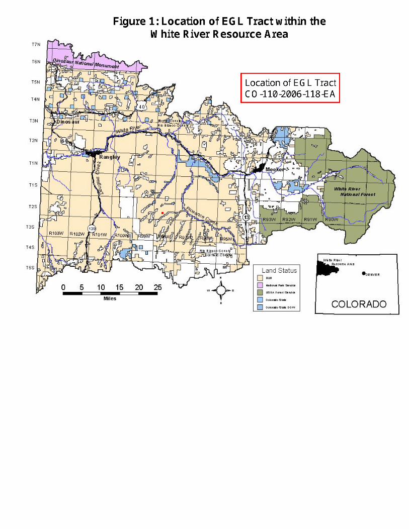
http://www.co.blm.gov/wrra/images/wr_detailmap.jpg
http://www.co.blm.gov/wrra/images/wr_detailmap.jpg 5/23/2006 2:41:03 PM
KClark
Line
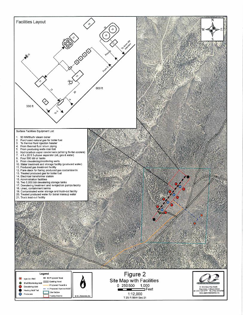

.
11 Inverness Way South Englewood, Colorado 80112
tel (720) 529-9777 fax (720) 529-9798 www.ogenvironmental.com
RangelyMeeker
Rifle
LegendEGL SiteCitiesHighwaysMajor RoadsLocal RoadsTownship Boundary
0 10 205 Miles
1:450,000
§̈¦I-70
£¤HWY64
£¤HWY139
£¤HWY13
RB76
RBC 85
RBC 24
RBC 69
RBC 26
RBC 26Black Sulpher
Creek Rd RBC 5Piceance Creek Rd
Figure 3Access and Transportation Routes
RBC 86
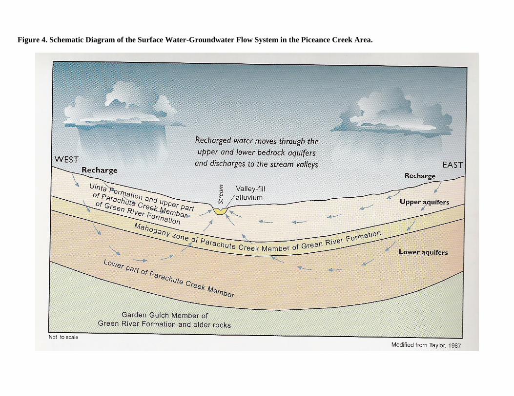
Figure 4. Schematic Diagram of the Surface Water-Groundwater Flow System in the Piceance Creek Area.
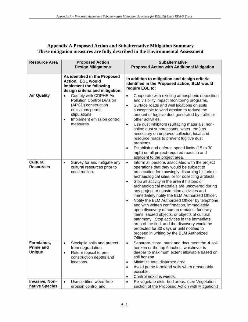
Appendix A – Proposed Action and Subalternative Mitigation Summary for EGL Oil Shale RD&D Tract
Appendix A Proposed Action and Subalternative Mitigation Summary These mitigation measures are fully described in the Environmental Assessment
Resource Area Proposed Action
Design Mitigations Subalternative
Proposed Action with Additional Mitigation
As identified in the Proposed Action, EGL would implement the following design criteria and mitigation:
In addition to mitigation and design criteria identified in the Proposed action, BLM would require EGL to:
Air Quality • Comply with CDPHE Air Pollution Control Division (APCD) construction emissions permit stipulations
• Implement emission control measures.
• Cooperate with existing atmospheric deposition and visibility impact monitoring programs.
• Surface roads and well locations on soils susceptible to wind erosion to reduce the amount of fugitive dust generated by traffic or other activities.
• Use dust inhibitors (surfacing materials, non-saline dust suppressants, water, etc.) as necessary on unpaved collector, local and resource roads to prevent fugitive dust problems.
• Establish and enforce speed limits (15 to 30 mph) on all project-required roads in and adjacent to the project area.
Cultural Resources
• Survey for and mitigate any cultural resources prior to construction.
• Inform all persons associated with the project operations that they would be subject to prosecution for knowingly disturbing historic or archaeological sites, or for collecting artifacts.
• Stop all activity in the area if historic or archaeological materials are uncovered during any project or construction activities and immediately notify the BLM Authorized Officer.
• Notify the BLM Authorized Officer by telephone and with written confirmation, immediately upon discovery of human remains, funerary items, sacred objects, or objects of cultural patrimony. Stop activities in the immediate area of the find, and the discovery would be protected for 30 days or until notified to proceed in writing by the BLM Authorized Officer.
Farmlands, Prime and Unique
• Stockpile soils and protect from degradation.
• Return topsoil to pre-construction depths and locations.
• Separate, store, mark and document the A soil horizon or the top 6 inches, whichever is deeper to maximum extent allowable based on soil horizon
• Minimize total disturbed area. • Avoid prime farmland soils when reasonably
possible. • Control noxious weeds.
Invasive, Non-native Species
• Use certified weed-free erosion control and
• Re-vegetate disturbed areas. (see Vegetation section of the Proposed Action with Mitigation.)
A-1
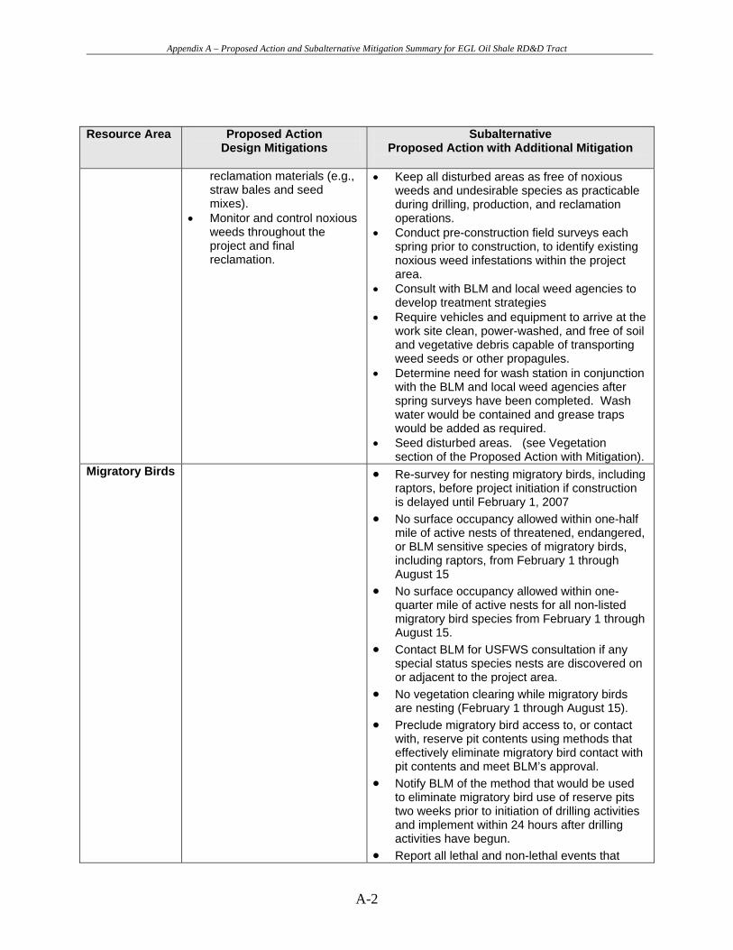
Appendix A – Proposed Action and Subalternative Mitigation Summary for EGL Oil Shale RD&D Tract
Resource Area Proposed Action Subalternative
Design Mitigations Proposed Action with Additional Mitigation
reclamation materials (e.g., straw bales and seed mixes).
• Monitor and control noxious weeds throughout the project and final reclamation.
• Keep all disturbed areas as free of noxious weeds and undesirable species as practicable during drilling, production, and reclamation operations.
• Conduct pre-construction field surveys each spring prior to construction, to identify existing noxious weed infestations within the project area.
• Consult with BLM and local weed agencies to develop treatment strategies
• Require vehicles and equipment to arrive at the work site clean, power-washed, and free of soil and vegetative debris capable of transporting weed seeds or other propagules.
• Determine need for wash station in conjunction with the BLM and local weed agencies after spring surveys have been completed. Wash water would be contained and grease traps would be added as required.
• Seed disturbed areas. (see Vegetation section of the Proposed Action with Mitigation).
Migratory Birds • Re-survey for nesting migratory birds, including raptors, before project initiation if construction is delayed until February 1, 2007
• No surface occupancy allowed within one-half mile of active nests of threatened, endangered, or BLM sensitive species of migratory birds, including raptors, from February 1 through August 15
• No surface occupancy allowed within one-quarter mile of active nests for all non-listed migratory bird species from February 1 through August 15.
• Contact BLM for USFWS consultation if any special status species nests are discovered on or adjacent to the project area.
• No vegetation clearing while migratory birds are nesting (February 1 through August 15).
• Preclude migratory bird access to, or contact with, reserve pit contents using methods that effectively eliminate migratory bird contact with pit contents and meet BLM’s approval.
• Notify BLM of the method that would be used to eliminate migratory bird use of reserve pits two weeks prior to initiation of drilling activities and implement within 24 hours after drilling activities have begun.
• Report all lethal and non-lethal events that
A-2
Appendix A – Proposed Action and Subalternative Mitigation Summary for EGL Oil Shale RD&D Tract
Resource Area Proposed Action Subalternative
Design Mitigations Proposed Action with Additional Mitigation
involve migratory birds to a WRFO Petroleum Engineer Technician immediately.
Threatened, Endangered, and Sensitive Animal Species
• To exclude animals line reserve pits, fence on all four sides with net-wire and cover with plastic barrier.
• Net pits to prevent bird access
• Reclaim pits as soon as possible after use.
• Re-survey for nesting migratory birds, including raptors, before project initiation if construction is delayed until February 1, 2007
• Conduct surveys prior to construction activities to determine which species would require clearance surveys in the project area if construction occurs in spring of 2007.
• No surface occupancy allowed within one-half mile of active nests of threatened, endangered, or BLM sensitive species of migratory birds, including raptors, from February 1 through August 15
• No surface occupancy allowed within one-quarter mile of active nests for all non-listed migratory bird species from February 1 through August 15.
• Contact BLM for USFWS consultation if any special status species nests are discovered on or adjacent to the project area.
• No vegetation clearing while migratory birds are nesting (February 1 through August 15).
• Limit activities within a one-half mile radius of active nests of raptors that are threatened, endangered, or BLM sensitive between February 1 – August 15 (one-fourth mile for other raptors) and consulting with USFWS if any special status species nests are discovered on or adjacent to the project area; and
• Prevent vegetation clearing while migratory birds are nesting (February 1 through August 15).
Threatened, Endangered, and Sensitive Plant Species
• Coordinate with the BLM if threatened, endangered, or BLM sensitive plant species or habitat are identified during future field surveys.
• Avoid plants that occur outside the project area and install exclusion fencing to prevent disturbance from construction activities;
• Conduct source population surveys in areas where plants could not be avoided to determine the magnitude of impact on the entire population; and
• Evaluate the potential for site design modifications in areas where plants occur. The potential for site design modifications would depend on feasibility and site-specific terrain conditions.
A-3
Appendix A – Proposed Action and Subalternative Mitigation Summary for EGL Oil Shale RD&D Tract
Resource Area Proposed Action Subalternative
Design Mitigations Proposed Action with Additional Mitigation
Wastes, Solid or Hazardous
• Comply with applicable laws and regulations.
• Maintain the project area in a sanitary condition.
• Provide trash containers on-site.
• Dispose of trash at an appropriate disposal site;
• Provide portable toilets on-site; properly dispose of contents.
• Use, store, transport, and/or dispose of hazardous materials in accordance with applicable federal and state laws.
• Implement spill prevention measures, inspection and training requirements, and spill response and notification procedures to minimize the potential for accidental spills or leak.
Water Quality, Surface and Ground
• Obtain and comply with necessary federal and state permits
• Corps of Engineers Nationwide Permit 12 conditions,
• CDPHE Water Quality Control Division (WQCD) Minimal Industry Discharge Permit conditions,
• Stormwater discharge permit, and
• all other applicable water quality requirements.
• Develop a groundwater monitoring and response plan consistent with the groundwater monitoring programs for all oil shale RD&D tracts.
• Continue groundwater monitoring as long as needed to determine that the site is acceptable for abandonment.
• Obtain a stormwater discharge permit and submit its stormwater management plan to the WRFO.
• Prepare and implement a spill prevention, control and countermeasure (SPCC) plan for BLM approval.
• Adhere to “Gold Book” fourth edition surface operating standards for oil and gas exploration and development for all surface disturbing activities.
• Submit a water monitoring and response plan to the Authorized Officer prior to project implementation.
Wetlands and Riparian Zones
• Obtain and comply with the Corps of Engineers Nationwide Permit 12 conditions.
• Install monitoring wells on the tract and collect surface water data from Ryan Gulch and Black Sulphur Creek to determine hydrologic interactions.
Soils • Strip to a depth of 6 to 12 inches, depending on
its depth. • Store any subsoil stripped during grading
separately from topsoil to prevent mixing. • Seed soil stockpiles and cover. • Return soils to their pre-construction locations
during reclamation. • Install and maintain temporary erosion and
sediment controls, immediately following
A-4
Appendix A – Proposed Action and Subalternative Mitigation Summary for EGL Oil Shale RD&D Tract
Resource Area Proposed Action Subalternative
Design Mitigations Proposed Action with Additional Mitigation
clearing and grading of the site to control erosion. Remove them during reclamation, as appropriate.
• Return the site to its pre-construction contours; loosen compacted soils using a tractor-pulled ripper or similar device.
• Seed all disturbed areas with BLM approved seed mixes.
• Install permanent erosion control measures, such as mulch and geotextile fabrics where needed.
• Prepare and implement an SPCC plan for BLM approval aimed at reducing the potential for adverse impacts associated with spills and leaks.
Vegetation • Minimize vegetation removal to the extent necessary to allow for safe and efficient construction activities.
• Install and maintain erosion control measures until vegetation becomes established.
• Restore pre-construction contours, drainage patterns, and topsoil.
• Cut trees with a chain saw and/or mechanical shears and cutting brush as close to the ground as possible.
• Leave stumps and root balls in place except in areas requiring topsoiling, or as necessary to create a safe and level workspace.
• Shred or chip brush and salvage with topsoil; • Salvage and replace topsoil. • Improve re-vegetation potential by preparing
seedbed prior to seeding. • Control noxious weeds. • Use certified weed-free seed purchased from
and blended by qualified producers and dealers.
• Comply with BLM Instruction Memorandum No. 2006-073 entitled Weed-Free Seed Use on Lands Administered by the BLM and as listed in the Table in the Vegetation Section.
• Redistribute large, woody material salvaged during clearing operations in order to meet fire management objectives, provide wildlife habitat and seedling protection.
Wildlife, Aquatic
• Develop and conduct a comprehensive groundwater monitoring program.
• Develop a response plan to implement in the event of evidence of any hydraulic connection between affected groundwater and surface water.
• Monitor stream flow and
• Comply with USFWS Recovery Implementation Program requirements for water depletions, if necessary.
• Prohibit storage of hazardous materials, chemicals, fuels and lubricating oils, and prohibit concrete coating and refueling activities within 200 feet of any water body or wetland.
• Minimize erosion from upland areas by restoring and seeding disturbed areas.
A-5

Appendix A – Proposed Action and Subalternative Mitigation Summary for EGL Oil Shale RD&D Tract
Resource Area Proposed Action Subalternative
Design Mitigations Proposed Action with Additional Mitigation
water quality in nearby streams and springs.
• Install erosion and sediment control measures.
• Maintain erosion and sediment control measures at the project site.
Wildlife, Terrestrial
• Support carpooling. • Establish a policy of
reduced vehicular speed. • Line reserve pits, fence on
all four sides with net-wire and covered with plastic barrier.
• Reclaim pits as soon as possible after use.
• Prohibit construction activities in severe/critical mule deer and elk winter range between December 1st and April 30th;
• Redistribute large, woody material salvaged during clearing operations so as not to exceed 3 to 5 tons/acre.
• Mulch excess woody materials. • Limit fencing on the tract to facilities. • Seed disturbed areas according to BLM
standard.
Access and Transportation
• Support carpooling. • Establish a policy of
reduced vehicular speed. • Maintain access roads. • Consider providing limited
temporary overnight accommodations in the area to reduce round-trip travel to Meeker or Rifle during certain periods of the project.
• Control dust. • Minimize tracking of soil
onto paved roads.
• Comply with county weight and load restrictions.
• Maintain unsurfaced roads during construction and operations of the project.
• Restore unsurfaced roads to equal or better condition than pre-construction condition.
Fire Management
• Control noxious weeds and cheatgrass (see Invasive, Non-Native Species section).
• Seed disturbed areas.
• Coordinate with the BLM and Rio Blanco County emergency response teams in developing fire suppression priorities, identifying management restrictions, and determining appropriate fire suppression strategies.
• Equip construction appropriate equipment with approved spark arresters.
• Carry fire-fighting equipment (long-handled, round-point shovel and dry chemical fire extinguisher) on motor vehicles and equipment.
• Take immediate action to suppress accidental fires.
• Create defensible space around the facilities. • Comply with BLM fire management
requirements in all activities. • Redistributing large, woody material salvaged
A-6
Appendix A – Proposed Action and Subalternative Mitigation Summary for EGL Oil Shale RD&D Tract
Resource Area Proposed Action Subalternative
Design Mitigations Proposed Action with Additional Mitigation
during clearing operations on WRFO-administered lands.
• Implement appropriate mitigation identified in the BLM Fire Management Activity Plan (FMAP).
• Develop and provide to all employees on site, county and BLM officials an evacuation plan.
Forestry Management
• Seed disturbed areas. • Control noxious weeds.
• Cut trees with a maximum stump height of six inches and dispose of the trees by one of the following methods:
o cutting the trees into four-foot length, down to four inches in diameter;
o place the trees along the edge of the disturbance;
o remove the trees from federal land for resale or private use; or
o chipping and scattering the trees. • Acquire a fuel woods permit to compensate the
BLM for trees.
Noise • Install and maintain appropriate mufflers and silencers on construction equipment and facility machinery.
• Housing or cover noise producing sources with appropriate insulated facilities.
Paleontology • Require a paleontologic monitor be on site prior
to any ground-disturbing activities. • Train construction and operation personnel that
collection of paleontological specimens is not allowed.
Rangeland Management
• Seed disturbed areas. • Control noxious weeds.
Realty Authorizations
• Use the “One Call” system to locate and stake the centerline and limits of all underground facilities in the area of proposed excavation.
• Provide 48-hour notification to the owner/operator of and foreign pipeline prior to performing any work within 10 feet of buried or aboveground-pressurized gas piping.
• Prohibit machine excavation within 5 feet from any known or proposed existing pipeline encountered in the ROW unless authorized by the pipeline owners/operators.
A-7

Appendix A – Proposed Action and Subalternative Mitigation Summary for EGL Oil Shale RD&D Tract
Resource Area Proposed Action Subalternative
Design Mitigations Proposed Action with Additional Mitigation
Socioeconomics • EGL would initiate discussions with Rio Blanco County to determine appropriate mitigation measures to offset the demands on local services.
Visual Resources
• Run water trucks through construction areas to minimize dust as needed.
• Seed disturbed areas as soon as possible (see Vegetation section).
• Encourage carpooling and other methods to reduce traffic, parking, and damage to roadsides.
• Paint all aboveground facilities in accordance with BLM-recommended color schemes.
• Restore disturbed portions of the tract to original contours to the degree possible after monitoring well installation, facility construction, and finally upon site restoration to restore natural drainage and runoff patterns.
• Where feasible: o site structures off ridge line; o use low-profile structures; o site slash/debris piles in low
visibility areas; o feather and thin edges of cleared
areas outside the site buffer zone, and inside the facility.
• Co-locate utility services in combined right-of-way.
A-8