Environment Committee Appendices - Modern...
39
Environment Committee Appendices 11 th January 2016 Title Highway Network Recovery Planned Maintenance Environment Committee - APPENDICES Enclosures A1 Proposed Carriageway Schemes – Resurfacing A2 Proposed Carriageway Schemes – Micro Asphalt Surfacing A3 Proposed Carriageway Schemes – Surface Dressing A4 Proposed Footway Schemes B Footway Programme Prioritisation Process Flow Chart C1 Structures Schemes C2 Structures Schemes D Drainage Schemes Officer Contact Details Chris Chrysostomou, [email protected]
Transcript of Environment Committee Appendices - Modern...

Environment Committee Appendices
11th
January 2016
Title Highway Network Recovery Planned Maintenance Environment Committee - APPENDICES
Enclosures A1 Proposed Carriageway Schemes – Resurfacing
A2 Proposed Carriageway Schemes – Micro Asphalt Surfacing
A3 Proposed Carriageway Schemes – Surface Dressing
A4 Proposed Footway Schemes
B Footway Programme Prioritisation Process Flow Chart
C1 Structures Schemes
C2 Structures Schemes
D Drainage Schemes
Officer Contact Details Chris Chrysostomou, [email protected]

Environment Committee Appendices
1
A1.1. - Proposed Carriageway Schemes – Resurfacing.
Proposed 2016/17 Works Cost: £2.07M; 24 Schemes.
Unique Reference
Road Name Ward Post Code Indicative Cost
C686 Hampden Way Brunswick Park N14 £ 80,000
C173 Dunstan Road Childs Hill NW2 £ 162,000
C680 Kara Way Childs Hill NW2 £ 26,000
C683 West Heath Road Childs Hill NW3 £ 105,000
C588 The Vale Childs Hill N3 £ 78,000
C673 Claremont Road Childs Hill/Golders Green NW2 £ 118,000
C133 Colindale Avenue Colindale NW9 £ 211,000
C674 Sycamore Close East Barnet EN4 £ 10,000
C678 Longmore Avenue East Barnet/Oakleigh EN5 £ 137,000
C076 Broadfields Avenue Edgware HA8 £ 50,000
C670 Wooton Grove Finchley Church End N3 £ 9,000
C084 Brunner Close Garden Suburb NW11 £ 21,000
C594 Tilling Road Golders Green NW2 £ 80,000
C085b Bunns Lane Hale NW7 £ 64,000
C677 Hendon Wood Lane Hale/Totteridge/Underhill NW7 £ 154,000
C684 Meadway High Barnet EN5 £ 113,000
C685 Potters Lane High Barnet EN5 £ 30,000
C090 Byng Road High Barnet EN5 £ 101,000
C676 Page Street Mill Hill NW7 £ 114,000
C671 Temple Avenue Oakleigh N20 £ 91,000
C353 Lullington Garth Totteridge N12 £ 163,000
Laurel View Totteridge N12 £ 51,000
C681 Cedar Lawn Avenue (Link) Underhill EN5 £ 8,000
C675 Moss Hall Grove West Finchley N12 £ 102,000
C489 Renters Avenue Roundabout West Hendon NW4 £ 46,000

Environment Committee Appendices
2
A1.2. - Proposed Carriageway Schemes – Resurfacing.
Reserve/ NRP Years 3, 4 & 5. Works Cost: £4.71M; 56 Schemes.
Unique Reference
Road Name Ward Post Code
Indicative Cost
C386 Monkfrith Way Brunswick Park N14 £ 125,000
C029 Back Lane Burnt Oak HA8 £ 35,000
C034 Barnfield Road Burnt Oak HA8 £ 36,000
C209 Fortescue Road Burnt Oak HA8 £ 59,000
C325 Langham Road Burnt Oak HA8 £ 22,000
C345 Littlefield Road Burnt Oak HA8 £ 91,000
C390 Montrose Avenue Burnt Oak HA8 £ 243,000
C067 Brent Terrace Childs Hill NW2 £ 125,000
C002 Finchley Road (A598) Childs Hill NW11 £ 120,000
C243 Granville Road Childs Hill NW2 £ 71,000
C289 Hocroft Avenue Childs Hill NW2 £ 57,000
C001 North End Road (A502) Childs Hill NW11 £ 56,000
C672 Claremont Road Childs Hill/ Golders Green £ 84,000
C689b Grahame Park Way Colindale £ 151,000
C473 Quakers Course Colindale NW9 £ 28,000
C689a Grahame Park Way Colindale/Hale £ 127,000
C134 Colney Hatch Lane Coppetts N10 £ 113,000
C460 Poplar Grove Coppetts N11 £ 116,000
C198 Fairfield Crescent Edgware HA8 £ 69,000
C225 Glendale Avenue Edgware HA8 £ 121,000
C286 Hillside Drive Edgware HA8 £ 57,000
C287 Hillside Gardens Edgware HA8 £ 44,000
C168 Dollis Avenue Finchley Church End N3 £ 90,000
C337b Lichfield Grove Finchley Church End N3 £ 123,000
C516 Salisbury Avenue Finchley Church End N3 £ 64,000
C360 Lytton Close Garden Suburb N2 £ 19,000
C505 Rotherwick Road Garden Suburb NW11 £ 72,000
C577 The Bishops Avenue Garden Suburb N2 £ 334,000
C220 Geron Way Slip Roads Golders Green NW2 £ 36,000
C575 Templehof Avenue Golders Green / West Hendon NW2 £ 102,000
C199 Fairmead Crescent Hale HA8 £ 171,000
C682 Woodcroft Avenue Hale NW7 £ 73,000
C313 Johns Avenue Hendon NW4 £ 43,000
C508 Rowley Lane High Barnet £ 53,000
C623 Wellhouse Lane High Barnet/Underhill £ 96,000
C027 Austell Gardens Mill Hill NW7 £ 32,000
C050 Bittacy Park Avenue Mill Hill NW7 £ 29,000
C079 Brookfield Avenue Mill Hill NW7 £ 68,000
C227 Glenmere Avenue Mill Hill NW7 £ 50,000

Environment Committee Appendices
3
A1.2. - Proposed Carriageway Schemes – Resurfacing.
Reserve/ NRP Years 3, 4 & 5. Works Cost: £4.71M; 56 Schemes.
Unique Reference
Road Name Ward Post Code
Indicative Cost
C369 Marion Road Mill Hill MW7 £ 42,000
C601 Tretawn Gardens Mill Hill NW7 £ 93,000
C579 The Fairway Oakleigh EN5 £ 64,000
PC07 Great North Road Oakleigh/High Barnet £ 108,000
C334 Leeside Underhill EN5 £ 102,000
C162 Derby Avenue West Finchley N12 £ 39,000
C266 Hamilton Way West Finchley N3 £ 35,000
C406 Nether Street West Finchley N3 £ 57,000
C484 Redbourne Avenue West Finchley N3 £ 78,000
C190 Endersleigh Gardens West Hendon NW4 £ 49,000
C194 Etheridge Road West Hendon NW4 £ 43,000
C233 Goldsmith Avenue West Hendon NW9 £ 33,000
C315 Kingsbury Road West Hendon NW9 £ 97,000
C441 Park Road West Hendon NW4 £ 185,000
C512 Russell Road West Hendon NW9 £ 49,000
C521 Sevington Road West Hendon NW4 £ 113,000
C619 Vivian Avenue West Hendon NW4 £ 145,000
Environment Committee Appendices
4
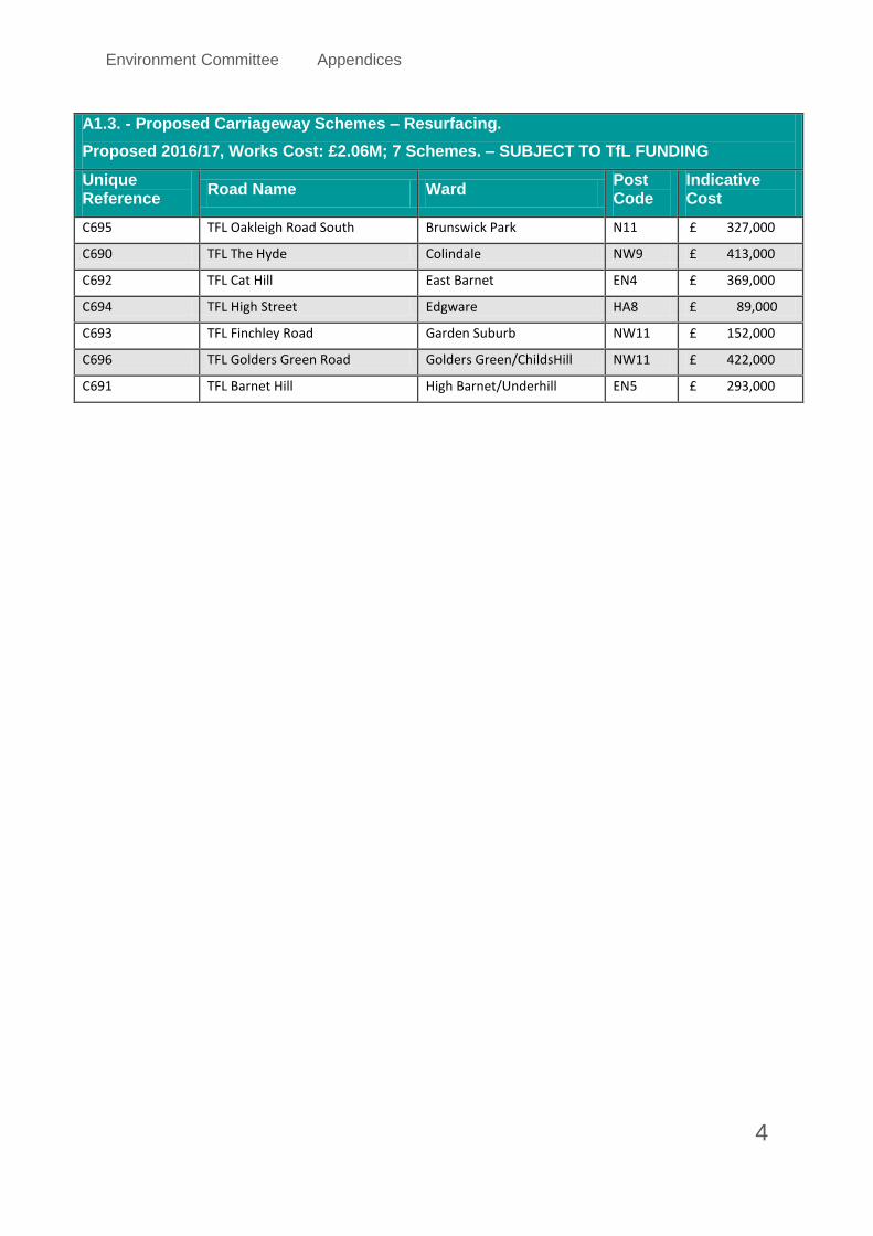
A1.3. - Proposed Carriageway Schemes – Resurfacing.
Proposed 2016/17, Works Cost: £2.06M; 7 Schemes. – SUBJECT TO TfL FUNDING
Unique Reference
Road Name Ward Post Code
Indicative Cost
C695 TFL Oakleigh Road South Brunswick Park N11 £ 327,000
C690 TFL The Hyde Colindale NW9 £ 413,000
C692 TFL Cat Hill East Barnet EN4 £ 369,000
C694 TFL High Street Edgware HA8 £ 89,000
C693 TFL Finchley Road Garden Suburb NW11 £ 152,000
C696 TFL Golders Green Road Golders Green/ChildsHill NW11 £ 422,000
C691 TFL Barnet Hill High Barnet/Underhill EN5 £ 293,000

Environment Committee Appendices
5
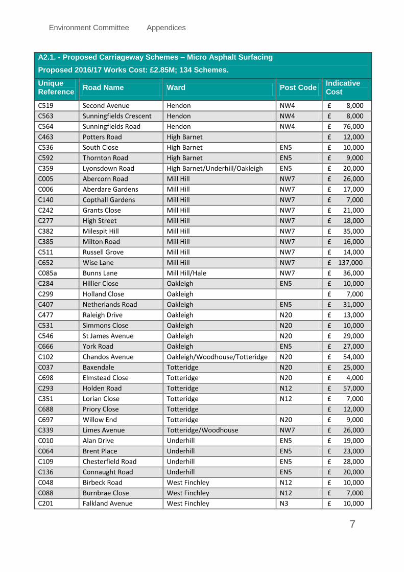
A2.1. - Proposed Carriageway Schemes – Micro Asphalt Surfacing
Proposed 2016/17 Works Cost: £2.85M; 134 Schemes.
Unique Reference
Road Name Ward Post Code Indicative Cost
C100 Cedar Rise Brunswick Park N14 £ 17,000
C307 Howard Close Brunswick Park N11 £ 14,000
C341 Linden Road Brunswick Park N11 £ 6,000
C363 Manor Drive Brunswick Park N14 £ 14,000
C466 Prevost Road Brunswick Park N11 £ 6,000
C576 The Avenue Brunswick Park N11 £ 7,000
C609 Uplands Road Brunswick Park EN4 £ 8,000
C008 Acklington Drive Burnt Oak NW9 £ 18,000
C176 East Road Burnt Oak HA8 £ 28,000
C411 North Acre Burnt Oak NW9 £ 14,000
C419 Norwich Walk Burnt Oak HA8 £ 5,000
C452 Pavillion Way Burnt Oak HA8 £ 33,000
C537 South Road Burnt Oak HA8 £ 22,000
C555 Storksmead Road Burnt Oak HA8 £ 9,000
C021 Armitage Road Childs Hill NW11 £ 47,000
C041 Beechworth Close Childs Hill NW3 £ 6,000
C165 Devonshire Place Childs Hill NW2 £ 7,000
C291 Hodford Road Childs Hill NW11 £ 21,000
C628 Wessex Gardens Childs Hill NW11 £ 25,000
C630 West Heath Close Childs Hill NW3 £ 17,000
C066 Brent Terrace Childs Hill/Golders Green NW2 £ 38,000
C009 Ajax Avenue Colindale NW9 £ 13,000
C143 Court Way Colindale NW9 £ 24,000
C283 Hillfield Avenue Colindale NW9 £ 23,000
C524 Sheaveshill Avenue Colindale NW9 £ 41,000
C620 Wardell Close Colindale NW7 £ 12,000
C014 Alexandra Road Coppetts N10 £ 49,000
C154 Crown Road Coppetts N10 £ 11,000
C263 Halliwick Road Coppetts N10 £ 31,000
C322 Laburnum Close Coppetts N11 £ 6,000
C476 Queens Parade Close Coppetts N11 £ 5,000
C641 Wetherhill Road Coppetts N10 £ 16,000
C023 Ashurst Road Coppetts/Woodhouse N12 £ 24,000
C072 Brim Hill East N2 £ 56,000
C017 Alverstone Avenue East Barnet EN4 £ 33,000
C529 Shurland East Barnet EN4 £ 20,000
C311 Ingram Road East Finchley N2 £ 9,000
C470 Prospect Ring East Finchley N2 £ 10,000
C471 Pulham Avenue East Finchley N2 £ 14,000

Environment Committee Appendices
6
A2.1. - Proposed Carriageway Schemes – Micro Asphalt Surfacing
Proposed 2016/17 Works Cost: £2.85M; 134 Schemes.
Unique Reference
Road Name Ward Post Code Indicative Cost
C570 Sylvester Road East Finchley N2 £ 16,000
C590 Thomas More Way East Finchley N2 £ 9,000
C187 Elmer Gardens Edgware HA8 £ 8,000
C287 Hillside Gardens Edgware HA8 £ 21,000
C398 Mowbray Road Edgware £ 40,000
C446 Parkfield Close Edgware £ 8,000
C016 Allandale Avenue Finchley Church End N3 £ 4,000
C114 Church Crescent Finchley Church End N3 £ 34,000
C168 Dollis Avenue Finchley Church End N3 £ 22,000
C319 Kinloss Gardens Finchley Church End N3 £ 11,000
C337a Lichfield Grove Finchley Church End N3 £ 10,000
C356 Lyndhurst Gardens Finchley Church End N3 £ 37,000
C617 Village Road Finchley Church End N3 £ 16,000
C025 Asmuns Place Garden Suburb NW11 £ 12,000
C075 Britten Close Garden Suburb NW11 £ 11,000
C142 Cornwood Close Garden Suburb N2 £ 9,000
C164 Devon Rise Garden Suburb N2 £ 10,000
C179 Eastholm Garden Suburb NW11 £ 9,000
C343 Litchfield Way Garden Suburb N2 £ 33,000
C380 Middleway Garden Suburb NW11 £ 6,000
C568 Sutcliffe Close Garden Suburb NW11 £ 7,000
C071 Bridge Lane Golders Green NW11 £ 65,000
C111 Cheviot Gardens Golders Green NW2 £ 46,000
C122 Claremont Way Golders Green NW2 £ 9,000
C238 Grampian Gardens Golders Green NW2 £ 16,000
C532 Sinclair Grove Golders Green NW11 £ 25,000
C643 Whitefield Avenue Golders Green NW2 £ 20,000
C144 Courtleigh Gardens Golders Green/Hendon/Finchley NW11 £ 10,000
C221 Gibbs Green Hale HA8 £ 41,000
C261 Hale Lane Hale NW7 £ 119,000
C400 Nan Clark's Lane Hale NW7 £ 20,000
C450 Parnell Close Hale HA8 £ 7,000
C638 Westfield Road Hale NW7 £ 12,000
C606 Upcroft Avenue Hale/Edgware £ 19,000
C013 Alexandra Road Hendon NW4 £ 12,000
C059 Boyne Avenue Hendon NW4 £ 24,000
C065 Brent Street (A502) Hendon NW4 £ 119,000
C314 Kings Close Hendon NW4 £ 27,000
C347 Lodge Road Hendon NW4 £ 10,000
Environment Committee Appendices
7
A2.1. - Proposed Carriageway Schemes – Micro Asphalt Surfacing
Proposed 2016/17 Works Cost: £2.85M; 134 Schemes.
Unique Reference
Road Name Ward Post Code Indicative Cost
C519 Second Avenue Hendon NW4 £ 8,000
C563 Sunningfields Crescent Hendon NW4 £ 8,000
C564 Sunningfields Road Hendon NW4 £ 76,000
C463 Potters Road High Barnet £ 12,000
C536 South Close High Barnet EN5 £ 10,000
C592 Thornton Road High Barnet EN5 £ 9,000
C359 Lyonsdown Road High Barnet/Underhill/Oakleigh EN5 £ 20,000
C005 Abercorn Road Mill Hill NW7 £ 26,000
C006 Aberdare Gardens Mill Hill NW7 £ 17,000
C140 Copthall Gardens Mill Hill NW7 £ 7,000
C242 Grants Close Mill Hill NW7 £ 21,000
C277 High Street Mill Hill NW7 £ 18,000
C382 Milespit Hill Mill Hill NW7 £ 35,000
C385 Milton Road Mill Hill NW7 £ 16,000
C511 Russell Grove Mill Hill NW7 £ 14,000
C652 Wise Lane Mill Hill NW7 £ 137,000
C085a Bunns Lane Mill Hill/Hale NW7 £ 36,000
C284 Hillier Close Oakleigh EN5 £ 10,000
C299 Holland Close Oakleigh £ 7,000
C407 Netherlands Road Oakleigh EN5 £ 31,000
C477 Raleigh Drive Oakleigh N20 £ 13,000
C531 Simmons Close Oakleigh N20 £ 10,000
C546 St James Avenue Oakleigh N20 £ 29,000
C666 York Road Oakleigh EN5 £ 27,000
C102 Chandos Avenue Oakleigh/Woodhouse/Totteridge N20 £ 54,000
C037 Baxendale Totteridge N20 £ 25,000
C698 Elmstead Close Totteridge N20 £ 4,000
C293 Holden Road Totteridge N12 £ 57,000
C351 Lorian Close Totteridge N12 £ 7,000
C688 Priory Close Totteridge £ 12,000
C697 Willow End Totteridge N20 £ 9,000
C339 Limes Avenue Totteridge/Woodhouse NW7 £ 26,000
C010 Alan Drive Underhill EN5 £ 19,000
C064 Brent Place Underhill EN5 £ 23,000
C109 Chesterfield Road Underhill EN5 £ 28,000
C136 Connaught Road Underhill EN5 £ 20,000
C048 Birbeck Road West Finchley N12 £ 10,000
C088 Burnbrae Close West Finchley N12 £ 7,000
C201 Falkland Avenue West Finchley N3 £ 10,000

Environment Committee Appendices
8
A2.1. - Proposed Carriageway Schemes – Micro Asphalt Surfacing
Proposed 2016/17 Works Cost: £2.85M; 134 Schemes.
Unique Reference
Road Name Ward Post Code Indicative Cost
C236 Gordon Road West Finchley N3 £ 16,000
C405 Nether Street West Finchley N12 £ 32,000
C448 Parkside West Finchley N3 £ 10,000
C584 The Ridgeway West Finchley N3 £ 17,000
C011 Alderton Crescent West Hendon NW4 £ 12,000
C012 Alderton Way West Hendon NW4 £ 9,000
C063 Brent Park Road West Hendon NW4/9 £ 30,000
C330 Layfield Close West Hendon NW4 £ 7,000
C332 Layfield Road West Hendon NW4 £ 18,000
C487 Reets Farm Close West Hendon NW9 £ 8,000
C513 Ruthin Close West Hendon NW9 £ 9,000
C074 Britannia Road Woodhouse N12 £ 9,000
C126 Clifton Road Woodhouse N3 £ 15,000
C212 Friary Way Woodhouse N12 £ 9,000
C679 Glenhurst Road Woodhouse N12 £ 8,000
C310 Ingleway Woodhouse N12 £ 23,000
C566 Sunny Way Woodhouse N12 £ 19,000

Environment Committee Appendices
9
A2.2. - Proposed Carriageway Schemes – Micro Asphalt Surfacing.
Reserve/ NRP Years 3, 4 & 5. Works Cost: £2.19M; 101 Schemes.
Unique Reference
Road Name Ward Post Code Indicative Cost
C156 Dale Green Road Brunswick Park N11 £ 21,000
C420 Nurserymans Road Brunswick Park N11 £ 21,000
C472 Pymmes Green Road Brunswick Park N11 £ 20,000
C514 Ryhope Road Brunswick Park N11 £ 8,000
C523 Shamrock Way Brunswick Park N14 £ 21,000
C548 St Mary's Road Brunswick Park £ 5,000
C087 Burlington Rise Brunswick Park / East Barnet EN4 £ 27,000
C229 Goldbeaters Grove Burnt Oak £ 14,000
C254 Greenway Gardens Burnt Oak NW9 £ 13,000
C276 Heywood Avenue Burnt Oak NW9 £ 14,000
C320 Kirton Walk Burnt Oak HA8 £ 3,000
C367 Maple Gardens Burnt Oak HA8 £ 10,000
C393 Mostyn Road Burnt Oak HA8 £ 10,000
C434 Orange Hill Road Burnt Oak HA8 £ 64,000
C602 Trevor Road Burnt Oak HA8 £ 12,000
C217 Galsworthy Road Childs Hill NW2 £ 15,000
C290 Hocroft Road Childs Hill NW2 £ 26,000
C350 Longberrys Childs Hill NW2 £ 22,000
C355 Lyndale Avenue Childs Hill NW2 £ 34,000
C374 Marnham Avenue Childs Hill NW2 £ 8,000
C665 Wycombe Gardens Childs Hill NW11 £ 18,000
C301 Hollyfield Avenue Coppets N11 £ 11,000
C149 Crescent Road Coppetts N11 £ 11,000
C219 George Crescent Coppetts N10 £ 25,000
C234 Goldsmith Road Coppetts N11 £ 28,000
C409 Newton Avenue Coppetts N10 £ 12,000
C558 Strode Close Coppetts N10 £ 9,000
C585 The Ridgeway Coppetts N11 £ 26,000
C648 Wilton Road Coppetts N10 £ 26,000
C115 Church Hill Road East Barnet EN4 £ 55,000
C395 Mount Pleasant East Barnet EN4 £ 64,000
C533 Somaford Grove East Barnet EN4 £ 4,000
C004 Abbots Gardens East Finchley N2 £ 47,000
C327 Lankaster Gardens East Finchley N2 £ 15,000
C370 Market Place East Finchley N2 £ 12,000
C553 Stanley Road East Finchley N2 £ 9,000
C603 Trinity Avenue East Finchley N2 £ 9,000
C070 Briarfield Avenue Finchley Church End N3 £ 22,000
C121 Claremont Park Finchley Church End N3 £ 25,000

Environment Committee Appendices
10
A2.2. - Proposed Carriageway Schemes – Micro Asphalt Surfacing.
Reserve/ NRP Years 3, 4 & 5. Works Cost: £2.19M; 101 Schemes.
Unique Reference
Road Name Ward Post Code Indicative Cost
C294 Holders Hill Avenue Finchley Church End NW4 £ 22,000
C300 Holly Park Finchley Church End N3 £ 23,000
C364 Manor Hall Drive Finchley Church End NW4 £ 10,000
C412 North Crescent Finchley Church End N3 £ 25,000
C447 Parklands Drive Finchley Church End N3 £ 16,000
C135 Connaught Drive Garden Suburb NW11 £ 28,000
C159 Deacons Rise Garden Suburb N2 £ 9,000
C161 Denman Drive Garden Suburb NW11 £ 9,000
C269 Hampstead Way Garden Suburb NW11 £ 72,000
C668 Kingsley Close Garden Suburb N2 £ 5,000
C317 Kingsley Way Garden Suburb N2 £ 8,000
C418 Northway Garden Suburb NW11 £ 27,000
C432 Oakwood Road Garden Suburb NW11 £ 38,000
C538 South Square Garden Suburb NW11 £ 15,000
C542 Southway Garden Suburb NW11 £ 18,000
C543 Spaniards Close Garden Suburb NW11 £ 8,000
C593 Thornton Way Garden Suburb NW11 £ 26,000
C622 Wellgarth Road Garden Suburb NW11 £ 19,000
C645 Wildwood Road Garden Suburb NW11 £ 67,000
C146 Cranbourne Gardens Golders Green NW11 £ 48,000
C180 Eastside Road Golders Green NW11 £ 22,000
C338 Limes Avenue Golders Green NW11 £ 16,000
C465 Prayle Grove Golders Green NW2 £ 36,000
C549 St Mary's Road Golders Green NW11 £ 9,000
C171 Dryfield Road Hale HA8 £ 34,000
C118 Church Terrace Hendon NW4 £ 13,000
C255 Greyhound Hill Hendon NW4 £ 14,000
C468 Prince of Wales Close Hendon NW4 £ 13,000
C547 St Josephs Grove Hendon NW4 £ 21,000
C565 Sunny Hill Hendon NW4 £ 12,000
C629 West Avenue Hendon N3 £ 20,000
C003 Abbey View Mill Hill NW7 £ 8,000
C226 Glendor Gardens Mill Hill NW7 £ 11,000
C687 Holcombe Hill Mill Hill £ 10,000
C333 Lee Road Mill Hill NW7 £ 10,000
C436 Osborn Gardens Mill Hill NW7 £ 10,000
C510 Rushden Gardens Mill Hill NW7 £ 10,000
C518 Scout Way Mill Hill NW7 £ 5,000
C567 Sunnyfield Mill Hill NW7 £ 36,000

Environment Committee Appendices
11
A2.2. - Proposed Carriageway Schemes – Micro Asphalt Surfacing.
Reserve/ NRP Years 3, 4 & 5. Works Cost: £2.19M; 101 Schemes.
Unique Reference
Road Name Ward Post Code Indicative Cost
C607 Uphill Grove Mill Hill NW7 £ 30,000
C640 Westside Mill Hill NW4 £ 20,000
C642 Weymouth Avenue Mill Hill NW7 £ 15,000
C246 Great North Road Oakleigh EN5 £ 12,000
C431 Oakleigh Park South Oakleigh N20 £ 42,000
C491 Richmond Road Oakleigh EN5 £ 18,000
C248 Green Bank Totteridge N12 £ 6,000
C669 Laurel View Totteridge N12 £ 16,000
C349 Long Lane West Finchley N2/N3 £ 27,000
C625 Wentworth Park West Finchley N3 £ 26,000
C137 Cool Oak Lane West Hendon NW9 £ 59,000
C150 Crespigny Road West Hendon NW4 £ 27,000
C158 Dartmouth Road West Hendon NW4 £ 22,000
C163 Derwent Rise West Hendon NW9 £ 10,000
C186 Elliot Road West Hendon NW4 £ 32,000
C210 Foscote Road West Hendon NW4 £ 28,000
C214 Fryent Grove West Hendon NW9 £ 26,000
C237 Graham Road West Hendon NW4 £ 9,000
C388 Montagu Road West Hendon NW4 £ 19,000
C444 Park View Gardens West Hendon NW4 £ 20,000
C528 Shirehall Park West Hendon NW4 £ 56,000
C560 Sturgess Avenue West Hendon NW4 £ 37,000
C659 Woodgrange Avenue Woodhouse N12 £ 32,000

Environment Committee Appendices
12
A3.1. - Proposed Carriageway Schemes – Surface Dressing
Proposed 2016/17 Works Cost: £0.89M; 35 Schemes.
Unique Reference
Road Name Ward Post Code Indicative Cost
C110 Chetwynd Avenue Brunswick Park EN4 £ 8,000
C271 Haslemere Avenue Brunswick Park EN4 £ 24,000
C591 Thorndene Avenue Brunswick Park N11 £ 10,000
C018 Angus Gardens Burnt Oak NW9 £ 10,000
C539 Southbourne Avenue Burnt Oak NW9 £ 14,000
C589 Thirleby Road Burnt Oak HA8 £ 19,000
C223 Gillingham Road Childs Hill NW2 £ 13,000
C492 Ridge Road Childs Hill NW2 £ 11,000
C626? Wentworth Road Childs Hill NW11 £ 15,000
C175 Eagle Drive Colindale NW9 £ 17,000
C200 Falcon Way Colindale/Burn Oak NW9 £ 7,000
C604 Trott Road Coppetts N10 £ 22,000
C488 Regal Drive Coppetts/Brunswick Park N11 £ 15,000
C599 Torrington Park Coppetts/Woodhouse N12 £ 87,000
C443 Park Road East Barnet EN4 £ 41,000
C148 Creighton Avenue East Finchley N2 £ 42,000
C365 Manor View Finchley Church N3 £ 17,000
C268 Hampstead Lane Garden Suburb NW3 £ 21,000
C651 Winnington Road Garden Suburb N2 £ 105,000
C368 Marble Drive Golders Green NW2 £ 36,000
C371 Marlborough Avenue Hale £ 7,000
C457 Pike Road Hale NW7 £ 5,000
C581 The Meads Hale HA8 £ 23,000
C270 Hartley Avenue Mill Hill NW7 £ 13,000
C197 Eversleigh Road Oakleigh EN5 £ 17,000
C430 Oakleigh Park North Oakleigh N20 £ 26,000
C379 Mays Lane Underhill £ 84,000
C193 Etchingham Park Road West Finchley N3 £ 57,000
C459 Popes Drive West Finchley N3 £ 13,000
C039 Beaufort Gardens West Hendon NW4 £ 8,000
C062 Brent Green West Hendon NW4 £ 10,000
C160 Denehurst Gardens West Hendon NW4 £ 8,000
C262 Haley Road West Hendon NW4 £ 9,000
C662 Woolmead Avenue West Hendon NW9 £ 29,000
C561 Summers Lane Woodhouse N12 £ 47,000

Environment Committee Appendices
13
A3.2. - Proposed Carriageway Schemes – Surface Dressing
Reserve/ NRP Years 3, 4 & 5. Works Cost: £1.97M; 138 Schemes.
Unique Reference
Road Name Ward Post Code
Indicative Cost
C060 Braemar Gardens Burnt Oak NW9 £ 8,000
C147 Cranfield Drive Burnt Oak NW9 £ 7,000
C185 Edwin Road Burnt Oak HA8 £ 6,000
C215 Fulbeck Drive Burnt Oak NW9 £ 21,000
C259 Gunter Grove Burnt Oak HA8 £ 4,000
C275 Hemswell Drive Burnt Oak NW9 £ 10,000
C530 Silksteam Road Burnt Oak HA8 £ 21,000
C573 Tangmere Way Burnt Oak NW9 £ 5,000
C091 Caddington Road Childs Hill NW2 £ 14,000
C232 Golders Way Childs Hill NW11 £ 9,000
C244 Gratton Terrace Childs Hill NW2 £ 14,000
C634 Westcroft Way Childs Hill NW2 £ 8,000
C195 Everglade Strand Colindale NW9 £ 6,000
C344 Little Strand Colindale NW9 £ 8,000
C348 Long Field Colindale NW9 £ 8,000
C204 Firs Avenue Coppetts N11 £ 5,000
C267 Hampden Road Coppetts N10 £ 13,000
C453 Pembroke Road Coppetts N10 £ 35,000
C478 Ramsden Road Coppetts N11 £ 12,000
C500 Roman Road Coppetts N10 £ 9,000
C551 Stanford Road Coppetts N11 £ 9,000
C120 Churchmead Close East Barnet EN4 £ 7,000
C044 Beresford Road East Finchley N2 £ 11,000
C083 Brownswell Road East Finchley N2 £ 14,000
C188 Elmfield Road East Finchley N2 £ 7,000
C336 Leopold Road East Finchley N2 £ 18,000
C401/ Neale Close East Finchley N2 £ 8,000
C408 New Trinity Road East Finchley N2 £ 6,000
C556 Strawberry Vale East Finchley N2 £ 19,000
C571 Talbot Avenue East Finchley N2 £ 7,000
C574 Tarling Road East Finchley N2 £ 32,000
C429 Oakleigh Gardens Edgware HA8 £ 14,000
C151 Crooked Usage Finchley Church N3 £ 18,000
C169 Dollis Park Finchley Church N3 £ 43,000
C503 Rosemary Avenue Finchley Church N3 £ 19,000
C552 Stanhope Avenue Finchley Church N3 £ 13,000
C595 Tillingbourne Gardens Finchley Church N3 £ 13,000
C172 Dudley Road Finchley Church End N3 £ 6,000
C272 Haslemere Gardens Finchley Church End N3 £ 13,000

Environment Committee Appendices
14
A3.2. - Proposed Carriageway Schemes – Surface Dressing
Reserve/ NRP Years 3, 4 & 5. Works Cost: £1.97M; 138 Schemes.
Unique Reference
Road Name Ward Post Code
Indicative Cost
C281 Hillcrest Gardens Finchley Church End N3 £ 11,000
C296 Holders Hill Crescent Finchley Church End NW4 £ 16,000
C297 Holders Hill Drive Finchley Church End NW4 £ 27,000
C298 Holders Hill Gardens Finchley Church End NW4 £ 16,000
C038 Beaufort Drive Garden Suburb NW11 £ 11,000
C047 Bigwood Road Garden Suburb NW11 £ 19,000
C049 Bishops Grove Garden Suburb N2 £ 8,000
C080 Brookland Hill Garden Suburb NW11 £ 13,000
C094 Canons Close Garden Suburb N2 £ 9,000
C104 Chandos Way Garden Suburb NW11 £ 17,000
C117 Church Mount Garden Suburb N2 £ 18,000
C125 Clifton Gardens Garden Suburb NW11 £ 10,000
C130 Coleridge Walk Garden Suburb NW11 £ 5,000
C170 Dorchester Gardens Garden Suburb NW11 £ 6,000
C252 Greenhalgh Walk Garden Suburb N2 £ 14,000
C302 Holyoake Walk Garden Suburb N2 £ 5,000
C316 Kingsley Way Garden Suburb N2 £ 35,000
C340 Linden Lea Garden Suburb N2 £ 24,000
C461 Portsdown Mews Garden Suburb NW11 £ 5,000
C545 St Edwards Close Garden Suburb NW11 £ 6,000
C663 Wordsworth Walk Garden Suburb NW11 £ 4,000
C113 Chiltern Gardens Golders Green NW2 £ 8,000
C124 Cleveland Gardens Golders Green NW2 £ 24,000
C127 Clitterhouse Crescent Golders Green NW2 £ 18,000
C128 Clitterhouse Road Golders Green NW2 £ 25,000
C155 Cumbrian Gardens Golders Green NW2 £ 24,000
C474 Quantock Gardens Golders Green NW2 £ 8,000
C240 Grange Hill Hale HA8 £ 14,000
C251 Greencroft Hale HA8 £ 7,000
C326 Langley Park Hale NW7 £ 10,000
C416 Northolm Hale £ 6,000
C028 Babington Road Hendon NW4 £ 14,000
C073 Brinsdale Road Hendon NW4 £ 12,000
C216 Fuller Street Hendon NW4 £ 12,000
C249 Green Lane Hendon NW4 £ 37,000
C481 Ravenshurst Avenue Hendon NW4 £ 9,000
C279 Highlands Road High Barnet EN5 £ 13,000
C280 Hillary Rise High Barnet EN5 £ 6,000
C433 Old Fold Lane High Barnet £ 13,000

Environment Committee Appendices
15
A3.2. - Proposed Carriageway Schemes – Surface Dressing
Reserve/ NRP Years 3, 4 & 5. Works Cost: £1.97M; 138 Schemes.
Unique Reference
Road Name Ward Post Code
Indicative Cost
C235 Goodwyn Avenue Mill Hill NW7 £ 20,000
C295 Holders Hill Circus Mill Hill NW4 £ 14,000
C392 Moorlands Avenue Mill Hill NW7 £ 6,000
C022 Ashley Lane Mill Hill/Hendon/Finchley Chur
NW4 £ 5,000
C499 Rodmell Slope Mill Hill/Totteridge NW7 £ 5,000
C655 Wolstonbury Mill Hill/Totteridge N12 £ 6,000
C040 Beech Avenue Oakleigh N20 £ 6,000
C107 Cherry Hill Oakleigh EN5 £ 14,000
C285 Hillside Oakleigh EN5 £ 9,000
C303 Holyrood Road Oakleigh £ 18,000
C352 Loring Road Oakleigh N20 £ 16,000
C372 Marlborough Gardens Oakleigh N20 £ 8,000
C381 Miles Way Oakleigh N20 £ 10,000
C428 Oakleigh Crescent Oakleigh N20 £ 29,000
C667 York Way Oakleigh N20 £ 11,000
C026 Athenaeum Road Oakleigh/ Woodhouse/ Totteridge
N20 £ 46,000
C292 Holden Avenue Totteridge N12 £ 10,000
C415 Northiam Totteridge N12 £ 21,000
C422 Oak Tree Drive Totteridge N20 £ 21,000
C515 Saddlescombe Way Totteridge N12 £ 6,000
C554 Steynings Way Totteridge N12 £ 5,000
C660 Woodside Grange Road Totteridge N12 £ 32,000
C517 Sampson Avenue Underhill EN5 £ 9,000
C541 Southfield Underhill £ 10,000
C611 Valley View Underhill EN5 £ 12,000
C637 Western Way Underhill EN5 £ 15,000
C445 Park View Road West ? N3 £ 12,000
C123 Claverley Grove West Finchley N3 £ 16,000
C129 Coleridge Road West Finchley N12 £ 12,000
C192 Essex Park West Finchley N3 £ 21,000
C256 Grosvenor Road West Finchley N3 £ 17,000
C257 Gruneisen Road West Finchley N3 £ 8,000
C424 Oakdene Park West Finchley N3 £ 12,000
C455 Percy Road West Finchley N12 £ 17,000
C469 Princes Avenue West Finchley N3 £ 16,000
C580 The Grove West Finchley N3 £ 25,000
C624 Wentworth Avenue West Finchley N3 £ 30,000
C657 Woodberry Grove West Finchley/Woodhouse N12 £ 20,000

Environment Committee Appendices
16
A3.2. - Proposed Carriageway Schemes – Surface Dressing
Reserve/ NRP Years 3, 4 & 5. Works Cost: £1.97M; 138 Schemes.
Unique Reference
Road Name Ward Post Code
Indicative Cost
C112 Cheyne Walk West Hendon NW4 £ 30,000
C213 Fryent Crescent West Hendon NW9 £ 8,000
C378 Mayfield Gardens West Hendon NW4 £ 13,000
C410 Nicoll Place West Hendon NW4 £ 6,000
C467 Prince Charles Drive West Hendon NW4 £ 33,000
C496 Riverside West Hendon NW4 £ 10,000
C526 Shirehall Gardens West Hendon NW4 £ 12,000
C559 Stuart Avenue West Hendon NW9 £ 13,000
C061 Bramber Road Woodhouse N12 £ 21,000
C095 Cardrew Avenue Woodhouse N12 £ 7,000
C097 Castle Road Woodhouse N12 £ 16,000
C153 Crossway Woodhouse N12 £ 7,000
C166 Dickens Avenue Woodhouse N3 £ 5,000
C203 Fallow Court Avenue Woodhouse N12 £ 42,000
C377 Mayfield Avenue Woodhouse N12 £ 38,000
C391 Montrose Crescent Woodhouse N12 £ 10,000
C456 Petworth Road Woodhouse N12 £ 25,000
C480 Ravensdale Avenue Woodhouse N12 £ 25,000
C598 Torrington Grove Woodhouse N12 £ 7,000
C610 Valley Avenue Woodhouse N12 £ 10,000
C656 Woodberry Gardens Woodhouse N12 £ 6,000
C658 Woodberry Way Woodhouse N12 £ 14,000
A4 - Proposed Footway Works.
2016/7 Priority. Works Cost: £7.8M; 256 Sections. Highest Priority (£3M) Shown Bold.
Unique Reference
Road Name - Section Ward Indicative Cost

Environment Committee Appendices
17
A4 - Proposed Footway Works.
2016/7 Priority. Works Cost: £7.8M; 256 Sections. Highest Priority (£3M) Shown Bold.
Unique Reference
Road Name - Section Ward Indicative Cost
5090U02080/00000
Back Lane - Barnfield Road To Blg No 124 (botc) Burnt Oak £ 42,000
5090U02080/00005
Back Lane - Barnfield Road To End (botc) Burnt Oak £ 15,000
5090U02080/00010
Back Lane - Watling Avenue To Cul De Sac (botc) Burnt Oak £ 21,000
5090U02080/00007
Barnfield Road - Burnt Oak Broadway To Watling Avenue (botc)
Burnt Oak £ 72,000
5090U02500/00000
Barnfield Road - Silkstream Road To Watling Avenue (botc)
Burnt Oak £ 24,000
5090A5____/00040
Burnt Oak Broadway - Deansbrook Road To Southbourne Avenue (botc)
Burnt Oak £ 374,000
5090U06200/00000
Burnt Oak Broadway - Spur Into Medical Centre (botc) Burnt Oak £ 19,000
5090U06210/00002
Burnt Oak Broadway Access Road To Nos 53 To 115 (botc)
Burnt Oak £ 61,000
5090U28500/00005
Market Lane - Barnfield Road To End (botc) Burnt Oak £ 27,000
5090U28500/00000
Market Lane - Gaskarth Road To Barnfield Road (botc) Burnt Oak £ 22,000
5090U44813/00002
Market Lane - Watling Avenue To Gaskarth Road (botc) Burnt Oak £ 28,000
5090U02501/00000
U02501 - Footpath No.16 -barnfield Road To Footpath No.212 (watling Market) (botc)
Burnt Oak £ 25,000
5090U44805/00000
Watling Avenue From Orange Hill Road To Burnt Oak Broadway (botc)
Burnt Oak £ 118,000
5090U01380/00010
Armitage Road - From Golders Green Road (a502) To Accommodation Road (ggtc)
Childs Hill £ 11,000
5090A407__/00035
Cricklewood Lane - A5 Cricklewood Broadway To Farm Avenue (crtc)
Childs Hill £ 32,000
5090A407__/00015
Cricklewood Lane - A5 Cricklewood Broadway To No162 Lisle Court (crtc)
Childs Hill £ 185,000
5090A407__/00012
Cricklewood Lane - Ridge Road To A598 Finchley Road (chtc)
Childs Hill £ 47,000
5090A598__/00041
Finchley Road - From Cricklewood Lane To Rodborough Road (chtc)
Childs Hill £ 246,000
5090A598__/00042
Finchley Road - Rodborough Road To North End Road (a502) (ggtc)
Childs Hill £ 31,000
£2M Finchley Road CHTC - Hermitage Lane to Hendon Way Ridge Road to Cricklewood Lane
Childs Hill £ 103,000
5090U17620/00010
Gillingham Road - From Cricklewood Lane A407 To R/o St Peters Church (crtc)
Childs Hill £ 9,000
5090A502__/00031
Golders Green Road - Finchley Road To The Riding (ggtc) Childs Hill £ 126,000

Environment Committee Appendices
18
A4 - Proposed Footway Works.
2016/7 Priority. Works Cost: £7.8M; 256 Sections. Highest Priority (£3M) Shown Bold.
Unique Reference
Road Name - Section Ward Indicative Cost
5090A502__/00032
Golders Green Road - The Riding To Gloucester Gardens Childs Hill £ 78,000
£2M Harman Drive - Whole Length Childs Hill £ 86,000
5090U27140/00010
Llanvanor Road - From Finchley Road To No5 (chtc) Childs Hill £ 15,000
5090U26720/00012
Lyndale Avenue - Wendover Court To Finchley Road (a598) (chtc)
Childs Hill £ 14,000
5090U32180/00010
Oak Grove - From Cricklewood Lane A407 To No6 (crtc) Childs Hill £ 15,000
5090U36560/00020
Ridge Road - From Finchley Road To The Bungalow (chtc)
Childs Hill £ 11,000
5090U23260/00015
Rodborough Road - From Finchley Road To R/o No867 Finchley Road (ggtc)
Childs Hill £ 24,000
5090U45400/00020
West Heath Road - From Portman Heights To Finchley Road (south) (chtc)
Childs Hill £ 9,000
5090U08380/00002
Clifton Gardens - Finchley Road S To Finchley Road (tftc) Childs Hill/Garden Suburb
£ 47,000
5090A598__/00045
Finchley Road - Finchley Road (a598 ) From Slip Finchley Road (a598 ) To North End Road (a502) (ggtc)
Childs Hill/Garden Suburb
£ 7,000
5090U20440/00000
Hallswelle Road - Gibbons Mews To Finchley Road (tftc) Childs Hill/Garden Suburb
£ 10,000
5090U24420/00000
Hurstwood Road - Finchley Road To Monks Way (tftc) Childs Hill/Garden Suburb
£ 12,000
5090A502__/00030
Golders Green Road - Slip From Finchley Road To Golders Green Road (ggtc)
Childs Hill/Golders Green
£ 21,000
5090A41___/00500
Hendon Way - Elliot Road To Graham Road North Bound (hctc)
Childs Hill/Golders Green/West
£ 26,000
5090A41___/00490
Hendon Way - Graham Road To Start Of Sli Proad Off To Queens Road (hctc)
Childs Hill/Golders Green/West
£ 48,000
5090A41___/00480
Hendon Way - Slip Road Off To Queens Road East (hctc) Childs Hill/Golders Green/West
£ 13,000
5090A41___/00425
Hendon Way - Vivian Avenue To Cheyne Walk (hctc) Childs Hill/Golders Green/West
£ 23,000
5090B551__/00035
Queens Road - End Of Splitter To Hendon Way (hctc) Childs Hill/Golders Green/West
£ 6,000
5090U09865/00005
Ajax Avenue - Colindale Avenue To First 30m (cotc) Colindale £ 8,000
5090U01040/00005
Annesley Avenue - Colindale Avenue To First 30m (cotc) Colindale £ 8,000
5090U07340/00005
Cecil Road - Colindale Avenue To First 30m (cotc) Colindale £ 8,000
5090U09860/00005
Colindale Avenue - Grahame Park Avenue Rbt To A5 (cotc)
Colindale £ 234,000
5090U22920/ Hillfield Avenue - No1 To The Hyde (a5) 48.7m (cotc) Colindale £ 13,000

Environment Committee Appendices
19
A4 - Proposed Footway Works.
2016/7 Priority. Works Cost: £7.8M; 256 Sections. Highest Priority (£3M) Shown Bold.
Unique Reference
Road Name - Section Ward Indicative Cost
00002
5090U24500/00007
Rushgrove Avenue - Hyde House To The Hyde A5 56.4m (cotc)
Colindale £ 15,000
5090U39200/00003
Sheaveshill Avenue - From Edgware Road A5 To Colin Close (cotc)
Colindale £ 22,000
5090U39580/00002
Silkfield Road - From No1 To A5 (cotc) Colindale £ 22,000
5090U47140/00001
Woodfield Avenue - From The Hyde A5 To No1-2 Varley Lodge (cotc)
Colindale £ 24,000
5090A5____/00085
The Hyde - End Of Splitter To Start Of Splitter At Hyde Estate Lights (cotc)
Colindale/ West Hendon/ Burnt Oak
£ 47,000
5090A5____/00340
The Hyde - Kingsbury Road To Start Of Splitter At Lights At Hyde Estate Supermarket Entrance (cotc)
Colindale/ West Hendon/ Burnt Oak
£ 53,000
5090A5____/00070
The Hyde - Sheaveshill Avenue To Kingsbury Road (cotc) Colindale/West Hendon/Burnt Oak
£ 136,000
5090A5____/00080
The Hyde - Start Of Splitter At Hyde Estate Lights To End Of Splitter (cotc)
Colindale/ West Hendon/ Burnt Oak
£ 48,000
5090B550__/00210
Colney Hatch Lane - Colney Hatch Lane Friern Barnet Road To Start Of Splitter (fbtc)
Coppetts £ 9,000
5090B550__/00205
Colney Hatch Lane - Colney Hatch Lane Queens Parade Close To Start Of Splitter
Coppetts £ 3,000
5090B550__/00030
Colney Hatch Lane - Colney Hatch Lane Wetherill Road To Halliwich Road
Coppetts £ 10,000
5090A1003_/00006
Friern Barnet Road - Colney Hatch Lane To Hartland Road (fbtc)
Coppetts £ 58,000
£2M Hemington Avenue - Whole Length Coppetts £ 80,000
5090U24140/00001
Horsham Avenue - From Woodhouse Road To No1 (fbtc) Coppetts £ 10,000
5090U18300/00020
Kennard Road - Bensley Close To Friern Barnet Road (fbtc)
Coppetts £ 9,000
5090U47180/00010
Lyndhurst Avenue - From Woodhouse Road To Halliwick Court Parade 78m (fbtc)
Coppetts £ 21,000
£2M Woodhouse Road FBTC - Ashurst Road to 233 Colney Hatch to Lyndhurst Avenue
Coppetts £ 89,000
5090U47320/00002
Woodleigh Avenue - From Hurstwood Court To Woodhouse Road (fbtc)
Coppetts £ 7,000
5090B550__/00220
Colney Hatch Lane - Colney Hatch Lane Start Of Splitter Spur Left To Woodhouse Road (fbtc)
Coppetts/ Woodhouse
£ 10,000
5090U47200/00015
Woodhouse Road - Service Road Lyndhurst Avenue To Woodhouse Road Rbt (fbtc)
Coppetts/ Woodhouse
£ 44,000
5090A1003_/00015
Woodhouse Road Rbt - Woodhouse Road From East Entrance To East Entrance (fbtc)
Coppetts/ Woodhouse
£ 15,000
5090U05600/ Brookside - B193 To No 7 (ebtc) East Barnet £ 24,000

Environment Committee Appendices
20
A4 - Proposed Footway Works.
2016/7 Priority. Works Cost: £7.8M; 256 Sections. Highest Priority (£3M) Shown Bold.
Unique Reference
Road Name - Section Ward Indicative Cost
00010
5090B193__/00005
Cat Hill - Cat Hill (east) To Start Of Splitter Cat Hill (ebtc) East Barnet £ 8,000
5090B193__/00010
Cat Hill - Start Of Splitter To Brookhill Road (ebtc) East Barnet £ 7,000
5090B193__/00015
Cat Hill - Start Of Splitter To East Barnet Road (ebtc) East Barnet £ 45,000
5090U10840/00000
Crescent Road - Crescent Road From Longmore Avenue To Brookhill Road (ebtc)
East Barnet £ 60,000
5090B193__/00030
East Barnet Road - Barons Gate To Middle Road (ebtc) East Barnet £ 13,000
5090B193__/00020
East Barnet Road - Cat Hill To Church Hill Road (ebtc) East Barnet £ 9,000
5090B193__/00025
East Barnet Road - Church Hill Road To Barons Gate (ebtc) East Barnet £ 14,000
5090U13385/00002
East Barnet Road - Longmore Avenue To Cat Hill (ebtc) East Barnet £ 88,000
5090U14820/00020
Eton Avenue - Brookside To R/o No1 (ebtc) East Barnet £ 21,000
5090B193__/00035
East Barnet Road - Middle Road To Welbeck Road (ebtc) East Barnet/ Oakleigh
£ 22,000
5090B193__/00040
Longmore Avenue - Welbeck Road To Trevor Close (ebtc) East Barnet/ Oakleigh
£ 25,000
5090U44920/00002
Welbeck Road - Ward Boundary To Longmore Ave (ebtc) East Barnet/ Oakleigh
£ 11,000
5090U02540/00020
Baronsmere Road - No1 To High Road (eftc) East Finchley £ 11,000
£2M Beresford Road (1) - No. 1 to A100 (eftc) East Finchley £ 9,000
5090A1000_/00185
High Road - Bedford Road To Hertford Road (eftc) East Finchley £ 22,000
5090A1000_/00235
High Road - Bridge Mid Point To Start Of Splitter (eftc) East Finchley £ 16,000
5090A1000_/00210
High Road - Fairlawn Avenue To Fortis Green (eftc) East Finchley £ 26,000
5090A1000_/00205
High Road - Fortis Green Road To Lincoln Road (eftc) East Finchley £ 25,000
5090A1000_/00180
High Road - Hertford Road To Creighton Avenue East Finchley £ 28,000
5090A1000_/00190
High Road - Huntingdon Road To Bedford Road (eftc) East Finchley £ 22,000
5090A1000_/00195
High Road - Leicester Road To Huntingdon Road (eftc) East Finchley £ 22,000
5090A1000_/00200
High Road - Lincoln Road To Leicester Road (eftc) East Finchley £ 22,000
5090A1000_/00220
High Road - Start Of Splitter Island To Diploma Avenue (eftc)
East Finchley £ 30,000

Environment Committee Appendices
21
A4 - Proposed Footway Works.
2016/7 Priority. Works Cost: £7.8M; 256 Sections. Highest Priority (£3M) Shown Bold.
Unique Reference
Road Name - Section Ward Indicative Cost
5090A1000_/00215
High Road -diploma Avenue To Fairlawn Avenue (eftc) East Finchley £ 8,000
5090U15160/00015
Huntingdon Road - S/o 156 High Road To High Road (a1000) (eftc)
East Finchley £ 9,000
5090U25460/00010
Kitchener Road - A1000 To No6-8 (eftc) East Finchley £ 12,000
5090U28080/00002
Garden City - Manns Road To Garden City (edtc) Edgware £ 15,000
5090A5100_/00051
Hale Lane - Edgewarebury Lane To Library (edtc) Edgware £ 26,000
5090A5____/00030
High Street - Start Of Splitter Garratt Road To Station Road (edtc)
Edgware £ 84,000
5090U22460/00020
High Street Edgware - Spur Off To End (edtc) Edgware £ 7,000
5090U28260/00001
Manor Park Crescent - A5100 Station Road To Old Rectory Gardens (edtc)
Edgware £ 16,000
5090U36200/00002
Rectory Lane - A5100 To Old Rectory Gardens (edtc) Edgware £ 65,000
5090A5____/00016
Stonegrove - Grove Road To Station Road A5100 (edtc) Edgware £ 65,000
5090U13060/00006
The Drive - From No1a To Hale Lane (edtc) Edgware £ 27,000
5090U01160/00010
Arcadia Avenue - A598 To S/o Gateway House (fcetc) Finchley Church End
£ 7,000
5090U09920/00000
College Terrace - A598 To Hendon Lane (fcetc) Finchley Church End
£ 23,000
5090U12820/00010
Dollis Park - A598 To No2 (fcetc) Finchley Church End
£ 13,000
£2M East End Road - No 2 to Windermere Avenue opp Holmwood Gardens to Manor View
Finchley Church End
£ 167,000
5090A504__/00027
Hendon Lane - College Terrace To A598 Regents Park Road (fcetc)
Finchley Church End
£ 51,000
5090U21800/00020
Hendon Lane - Spur Off To End (fcetc) Finchley Church End
£ 4,000
5090U30460/00020
Lichfield Grove - Hilary Court To A598 (fcetc) Finchley Church End
£ 10,000
£2M Regents Park Road - 188 to 104 North Crescent to Chessington Ave
Finchley Church End
£ 183,000
5090A598__/00010
Regents Park Road - A504 Hendon Lane To B1462 Nether Street (fcetc)
Finchley Church End
£ 52,000
5090A598__/00017
Regents Park Road - College Terrace To A504 Hendon Lane (fcetc)
Finchley Church End
£ 53,000
5090U40900/00010
Station Road N3- Regents Park Road To No1 (fcetc) Finchley Church End
£ 11,000

Environment Committee Appendices
22
A4 - Proposed Footway Works.
2016/7 Priority. Works Cost: £7.8M; 256 Sections. Highest Priority (£3M) Shown Bold.
Unique Reference
Road Name - Section Ward Indicative Cost
5090U00260/00002
Addison Way - No2 To Finchley Road (tftc) Garden Suburb £ 14,000
5090U00920/00007
Alyth Gardens - Finchley Road To No12 (tftc) Garden Suburb £ 2,000
5090U00920/00006
Alyth Gardens - Finchley Road To No12 (tftc) Garden Suburb £ 9,000
5090U12660/00001
Dingwall Gardens - Finchley Road To No12 (tftc) Garden Suburb £ 9,000
£2M Finchley Road CHTC - Alberon Gardens to Hayes Crescent, Childs Way to Willifield Way
Garden Suburb £ 105,000
5090U08380/00050
Forres Gardens - Finchley Road To No12 (tftc) Garden Suburb £ 11,000
5090U08380/00051
Hampstead Gardens - Finchley Road To No12 (tftc) Garden Suburb £ 11,000
5090U21340/00002
Hayes Crescent - Gibbons Mews To Finchley Road (tftc) Garden Suburb £ 10,000
5090A502__/00037
North End Road - Golders Green Road To West Heath Drive (ggtc)
Garden Suburb £ 45,000
5090U42300/00002
Temple Fortune Lane - Farm Walk To Finchley Road (tftc)
Garden Suburb £ 20,000
5090A598__/00047
Finchley Road - North End Road (a502) To Rotherwick Road (ggtc)
Garden Suburb / Childs Hill
£ 43,000
5090U04880/00006
Bridge Lane - Finchley Road To Leeside Crescent (tftc) Garden Suburb / Golders Green
£ 25,000
5090U00440/00000
Alberon Gardens - Finchley Road To End (tftc) Garden Suburb/Golders Green
£ 12,000
5090U01520/00005
Ashbourne Avenue - Finchley Road To Ashbourne Way (tftc)
Garden Suburb/Golders Green
£ 10,000
5090U29960/00000
Monkville Avenue - Finchley Road To Monks Way (tftc) Garden Suburb/Golders Green
£ 12,000
5090U42320/00000
Portsdown Mews - St Georges Road To Portsdown Avenue (tftc)
Garden Suburb/Golders Green
£ 39,000
5090U38020/00000
St Georges Road - Finchley Road To Portsdown Mews (tftc)
Garden Suburb/Golders Green
£ 16,000
5090U00920/00020
Willifield Way - No188 To Finchley Road (tftc) Garden Surburb £ 17,000
£2M
Golders Green Road - Powis Gds to Gainsborough Gds, Golders Gds to Woodstock Ave, Golders Manor Dr to Heather Gds, Golders Manor Dr to Heather Gds, Golders Manor Dr to NCRD to Roman
Golders Green
£ 108,000

Environment Committee Appendices
23
A4 - Proposed Footway Works.
2016/7 Priority. Works Cost: £7.8M; 256 Sections. Highest Priority (£3M) Shown Bold.
Unique Reference
Road Name - Section Ward Indicative Cost
5090U15860/00000
Finchley Road Access Road To Portsdown Mews (tftc) Golders Green/ Garden Suburb
£ 10,000
5090U34680/00010
Portsdown Avenue - Finchley Road To Portsdown Mews (tftc)
Golders Green/ Garden Suburb
£ 11,000
5090U06080/00010
Bunns Lane - Langley Park To Hale Lane (mhtc) Hale £ 42,000
5090A5100_/00085
Hale Lane - Hale Grove To Start Of Splitter (mhtc) Hale £ 18,000
5090A5100_/00025
Hale Lane - Hale Lane To Hawkins Close Hale £ 10,000
5090A5100_/00090
Hale Lane - Start Of Splitter To The Broadway (mhtc) Hale £ 12,000
5090A5100_/00095
The Broadway - Hale Lane To Centre Bridge M1 (mhtc) Hale £ 13,000
5090U03160/00007
Bell Lane - End Of Splitter Island East To Belle Vue Road (bstc)
Hendon £ 16,000
5090U03160/00010
Bell Lane - Start Of Splitter Island To Brent Street (bstc) Hendon £ 17,000
5090U04400/00005
Brampton Grove - Brent Street To Post Office (bstc) Hendon £ 14,000
5090A502__/00005
Brent Street - End Of Splitter To North End Road A504 (bstc)
Hendon £ 26,000
5090A502__/00028
Brent Street - Queens Road To Victoria Road (bstc) Hendon £ 122,000
5090U04595/00000
Brent Street Service Road - Victoria Road To Brent Street (bstc)
Hendon £ 10,000
5090U07840/00005
Chapel Walk - Footpath No.50 (part) - Brent Street To Lodge Road (bstc)
Hendon £ 19,000
5090A504__/00048
Church Road - Sunny Gardens Road To A502 Brent Street (bstc)
Hendon £ 39,000
5090A504__/00036
Finchley Lane - A502 Brent Street To Linfield Close (bstc) Hendon £ 42,000
5090U16420/00010
Foster Street - Brent Street To Short Street (bstc) Hendon £ 11,000
5090U27180/00010
Lodge Road - R/o159a To End (bstc) Hendon £ 27,000
5090B552__/00300
Parson Street - Finchley To Florence Street (bstc) Hendon £ 24,000
5090B552__/00295
Parson Street - Florence Street To Glebe Crescent (bstc) Hendon £ 7,000
5090U10960/00005
The Crest - Brent Street To Crest Cottage (bstc) Hendon £ 9,000
5090A41___/00386
Watford Way - Slip Rd From Rundell Crescent To Slip Rd Off To Vivian Avenue (hctc)
Hendon £ 58,000
5090B551__/00026
Queens Road - Wykeham Road To No4 (hctc) Hendon / West Hendon
£ 19,000

Environment Committee Appendices
24
A4 - Proposed Footway Works.
2016/7 Priority. Works Cost: £7.8M; 256 Sections. Highest Priority (£3M) Shown Bold.
Unique Reference
Road Name - Section Ward Indicative Cost
5090A1000_/00040
High Street - A411 Wood Street To A1081 Saint Albans Road (hbtc)
High Barnet £ 121,000
5090A1000_/00035
High Street - St Albans Road To Christ Church Lane (hbtc) High Barnet £ 74,000
5090U09680/00010
Salisbury Road - A1000 To No7 (hbtc) High Barnet £ 17,000
5090A1081_/00008
St Albans Road - A1000 To Stapylton Road (hbtc) High Barnet £ 36,000
5090A1081_/00015
St Albans Road - Stapylton Road To Speed Sign Just After Sunset View
High Barnet £ 104,000
5090U43580/00005
Union Street - A1000 To No5 (54m) (hbtc) High Barnet £ 14,000
5090A411__/00037
Wood Street - Church Passage To A1000 High Street (hbtc)
High Barnet / Underhill
£ 40,000
5090A110__/00013
Station Road En5 - Plantagenet Road To Lytton Road (ebtc)
High Barnet/ Oakleigh
£ 67,000
5090U40880/00000
Station Road En5- Lyonsdown Road To Station Road (ebtc)
High Barnet/ Oakleigh
£ 11,000
5090A1000_/00045
High Street - High Street (a1000 ) From Bedford Avenue To A411 Wood Street (hbtc)
High Barnet/ Underhill
£ 89,000
5090U05200/00035
Brockenhurst Gardens - Broadway House To The Broadway (mhtc)
Mill Hill £ 6,000
5090U29990/00010
Flower Lane - Church To The Broadway (mhtc) Mill Hill £ 20,000
5090U29760/00010
Goodwyn Avenue - Clarence Court To Mill Hill Circus (mhtc)
Mill Hill £ 10,000
5090U46850/00010
Hartley Avenue - Flower Lane To Car Park (mhtc) Mill Hill £ 32,000
5090U40960/00010
Station Road Nw7- Brockenhurst Gardens To The Broadway (mhtc)
Mill Hill £ 17,000
5090A5100_/00140
The Broadway - Flower Lane To Splitter (mhtc) Mill Hill £ 19,000
5090A5100_/00120
The Broadway - From M1 Bridge To Bunns Lane (mhtc) Mill Hill £ 23,000
5090A5100_/00135
The Broadway - Millway To Flower Lane (mhtc) Mill Hill £ 72,000
5090A5100_/00105
The Broadway - Section Under Bridge To End Of Splitter (mhtc)
Mill Hill £ 6,000
5090A5100_/00145
The Broadway - Splitter To A1 (mhtc) Mill Hill £ 11,000
5090A5100_/00130
The Broadway - Station Road To Millway (mhtc) Mill Hill £ 10,000
5090U23500/00010
Holders Hill Road - 50m North Of Regency Crescent To Turnberry Close
Mill Hill/ Finchley Church End
£ 1,000
5090A5100_/00150
Bunns Lane - Broadway To Bunns Lane (mhtc) Mill Hill/Hale £ 7,000

Environment Committee Appendices
25
A4 - Proposed Footway Works.
2016/7 Priority. Works Cost: £7.8M; 256 Sections. Highest Priority (£3M) Shown Bold.
Unique Reference
Road Name - Section Ward Indicative Cost
5090U01820/00040
Athenaeum Road - St Mary Magdelenes Church To A1000 (wtc)
Oakleigh £ 19,000
5090U01820/00060
Chandos Avenue - Grange View Road To A1000 (wtc) Oakleigh £ 14,000
5090U32580/00010
Oakleigh Road North - Slip Road Oakleigh Road North A109
Oakleigh £ 22,000
5090U40820/00000
Station Approach - From York Road To Lyonsdown Road (nbtc)
Oakleigh £ 51,000
5090A1000_/00078
High Road - A5109 Totteridge Lane To Buckingham Avenue (wtc)
Oakleigh / Totteridge
£ 182,000
5090B550__/00245
Friern Barnet Lane - Friern Barnet Lane Goldsmith Road To Hemington Avenue
Oakleigh/ Coppetts/ Totteridge
£ 22,000
5090A1000_/00080
High Road - Opposite A5109 Totteridge Lane To Oakleigh Road North (wtc)
Oakleigh/ Totteridge
£ 12,000
5090U01820/00026
High Road - Service Road From Oakleigh Road North (wtc) Oakleigh/ Woodhouse/ Totteridge
£ 15,000
5090U01820/00027
Green Road - A1000 To No3 (wtc) Totteridge £ 9,000
5090U22420/00050
High Road Service Road From Walfield Avenue To High Road
Totteridge £ 19,000
£2M Longlands Drive - Whole Length Totteridge £ 322,000
5090A109__/00006
Oakleigh Road North - A1000 High Road To No17 (wtc) Totteridge £ 16,000
£2M Oakleigh Road North - worst section on job sheet Totteridge £ 108,000
5090U00380/00015
Fitzjohn Avenue - A1000 To Pub Car Park (33m) Underhill / High Barnet
£ 10,000
5090U00460/00000
Albert Place - Nether Street To Popes Drive (fcetc) West Finchley £ 25,000
5090U02200/00020
Albert Place - Popes Drive To A598 (fcetc) West Finchley £ 12,000
£2M Alexandra Grove - Nether Street to Ballards Lane West Finchley £ 148,000
5090A598__/00006
Ballards Lane - B1462 Nether Street To Gruneisen Road (fcetc)
West Finchley £ 191,000
£2M Ballards Lane TC - Gruneisen Road to Essex Park o/s 223 to 259 Hutton Grove to Dale Grove
West Finchley £ 81,000
5090U09280/00020
Claverley Grove - Claverley Villas To A598 (fcetc) West Finchley £ 12,000
5090U10360/00010
Cornwall Avenue - A598 To Aston House (fcetc) West Finchley £ 14,000
5090U15280/00010
Falkland Avenue - Ballards Lane To R/o 87 (fcetc) West Finchley £ 6,000

Environment Committee Appendices
26
A4 - Proposed Footway Works.
2016/7 Priority. Works Cost: £7.8M; 256 Sections. Highest Priority (£3M) Shown Bold.
Unique Reference
Road Name - Section Ward Indicative Cost
5090U20400/00020
Hall Street - No1 To A598 (nftc) West Finchley £ 12,000
5090U22180/00010
Hervey Close - A598 To No1 (fcetc) West Finchley £ 12,000
5090U27220/00012
Long Lane - St Pauls Way To Ballards Lane (fcetc) West Finchley £ 19,000
5090U30910/00011
Nether Street - A598 Ballards Lane To Regent Close (nftc)
West Finchley £ 10,000
£2M Nether Street (1) - Ballards Lane to No. 393 West Finchley £ 17,000
5090U08003/00020
Princes Avenue - No1 To A598 (fcetc) West Finchley £ 12,000
5090U36220/00010
Redbourne Avenue - A598 To No1 (fcetc) West Finchley £ 18,000
5090U19800/00015
The Grove - From Ballards Lane To Popes Drive (fcetc) West Finchley £ 13,000
5090U36640/00010
The Ridgeway - Ballards Lane To No1 (fcetc) West Finchley £ 10,000
5090U45140/00010
Wentworth Park - A598 To R/o No163 (fcetc) West Finchley £ 6,000
5090A1000_/00115
Ballards Lane - A598 Ballards Lane To Nether Street (nftc) West Finchley/Woodhouse
£ 34,000
5090A1000_/00110
Ballards Lane - Nether Street To 50m North Of Hall Street (nftc)
West Finchley/Woodhouse
£ 65,000
5090A1000_/00105
High Road - Nether Street To A1003 Woodhouse Road (nftc)
West Finchley/ Woodhouse
£ 19,000
5090A1000_/00100
High Road - Opposite Percy Road To Nether Street (nftc) West Finchley/ Woodhouse
£ 75,000
5090U00640/00000
Alderton Way - Alderton Way From Rundell Crescent To Alderton Crescent (hctc)
West Hendon £ 45,000
5090U00800/00017
Allington Road - R/o Florence Mansions To Vivian Avenue (hctc)
West Hendon £ 7,000
5090U04120/00000
Borthwick Road - West Hendon Broadway To End (whtc) West Hendon £ 12,000
5090U04680/00010
Brent View Road - From West Hendon Broadway To No47 (whtc)
West Hendon £ 16,000
5090U08300/00020
Cheyne Walk - Cheyne Close To A41 (hctc) West Hendon £ 10,000
5090U10120/00010
Cool Oak Lane - Edgware Road To No2 (whtc) West Hendon £ 10,000
5090U10920/00002
Crespigny Road - Florence Mansions To Vivian Avenue (hctc)
West Hendon £ 7,000
5090A41___/00436
Hendon Way - Cheyne Walk To Start Of Slip Off To Graham Road (hctc)
West Hendon £ 34,000

Environment Committee Appendices
27
A4 - Proposed Footway Works.
2016/7 Priority. Works Cost: £7.8M; 256 Sections. Highest Priority (£3M) Shown Bold.
Unique Reference
Road Name - Section Ward Indicative Cost
5090A41___/00438
Hendon Way - Graham Road To Elliot Road South Bound (hctc)
West Hendon £ 26,000
5090A41___/00470
Hendon Way - Slip Road Off To Queens Road West (hctc) West Hendon £ 12,000
5090A504__/00076
Herbert Road - A5 The Broadway North Entry To No6 (whtc)
West Hendon £ 11,000
5090U33520/00011
Park Road - From West Hendon Broadway To No1b (whtc)
West Hendon £ 10,000
5090A504__/00085
Perryfield Way - A5 The Broadway South Entry To A5 The Broadway North Exit (whtc)
West Hendon £ 72,000
5090U40680/00000
Stanley Road - Stanley Road From West Hendon Broadway To End (whtc)
West Hendon £ 12,000
5090A504__/00080
Station Road Nw9 - Wilberforce Road To A5 The Broadway (whtc)
West Hendon £ 32,000
5090A504__/00071
Station Road Nw9 - Wilberforce Road To Algernon Road (whtc)
West Hendon £ 56,000
5090U42160/00002
Telford Road - Perryfield Way To End (whtc) West Hendon £ 23,000
5090U39060/00010
Vivian Avenue - A41 To Foscote Road (hctc) West Hendon £ 73,000
5090U01860/00006
Vivian Avenue - Vivian Avenue Spur East To West (hctc) West Hendon £ 9,000
5090A5____/00130
West Hendon Broadway - Dual Carriageway From Start Of Slip Entrance To End Of Slip Entrance (whtc)
West Hendon £ 20,000
5090A5____/00115
West Hendon Broadway - Dual Carriageway Start Of Splitter To Slip Road For North Circular (whtc)
West Hendon £ 67,000
5090A5____/00125
West Hendon Broadway - End Of Slip Road To End Of Splitter (whtc)
West Hendon £ 47,000
£2M
West Hendon Broadway - Perryfield Wy to Cool Oak Ln, Ramsey Close to opp Garrick Rd o/s petrol station Ramsey Close to Perryfield Wy, 162 to Park Rd and park Road to Brent View Rd
West Hendon
£ 181,000
5090A502__/00010
Brent Street - End Of Splitter To Victoria Road (bstc) West Hendon/Hendon
£ 25,000
5090A502__/00015
Brent Street - Victoria Road To End Of Splitter (bstc) West Hendon/ Hendon
£ 26,000
5090B551__/00030
Queens Road - End Of Splitter To Wykeham Road (hctc) West Hendon/ Hendon
£ 31,000
5090B551__/00040
Queens Road - Hendon Way To End Of Splitter (hctc) West Hendon/ Hendon
£ 6,000
5090A41___/00405
Watford Way - Slip Road Off To Vivian Way (hctc) West Hendon/ Hendon
£ 14,000
5090A41___/00395
Watford Way - Slip Road To Cline Vivian Avenue (hctc) West Hendon/ Hendon
£ 15,000

Environment Committee Appendices
28
A4 - Proposed Footway Works.
2016/7 Priority. Works Cost: £7.8M; 256 Sections. Highest Priority (£3M) Shown Bold.
Unique Reference
Road Name - Section Ward Indicative Cost
5090A41___/00460
Watford Way - Vivian Way To Rundell Crescent (hctc) West Hendon/ Hendon
£ 71,000
5090U01760/00006
Ashurst Road - From Woodhouse Road To No1 (fbtc) Woodhouse £ 16,000
5090U01960/00001
Avenue Road - A1000 To No2 (nftc) Woodhouse £ 11,000
5090U07140/00000
Castle Mews - Castle Mews (nftc) Woodhouse £ 19,000
5090U07160/00020
Castle Road - From No29 To A1000 (nftc) Woodhouse £ 47,000
5090U16800/00020
Friern Park - No1 To High Road (nftc) Woodhouse £ 15,000
5090U16820/00010
Friern Watch Avenue - From A1000 To No1 (nftc) Woodhouse £ 15,000
5090A1000_/00099
High Road - Friern Watch Avenue To Coniston Close Woodhouse £ 130,000
5090A1000_/00098
High Road - Percy Road To Friern Watch Avenue (nftc) Woodhouse £ 114,000
5090U34280/00001
Petworth Road - From Woodhouse Road To No1 (fbtc) Woodhouse £ 17,000
5090U40580/00010
Stanhope Road - From A1000 To College (nftc) Woodhouse £ 19,000
5090U07160/00021
Torrington Park - From No1 To High Road (nftc) Woodhouse £ 11,000
5090A1003_/00024
Woodhouse Road - A1000 High Road To Lambert Road (nftc)
Woodhouse £ 33,000
5090A1003_/00022
Woodhouse Road - Short Way To A1003 Woodhouse Road Roundabout (fbtc)
Woodhouse £ 32,000
5090U47440/00011
Woodside Park Road - A1000 To No1 (nftc) Woodhouse £ 12,000

Environment Committee Appendices
29
C1. – Structures Schemes List
Previous and Current Load Assessments (42 Structures)
Phase Structure Name Assessment findings
Phase 1 Abbotts Road over Burnt Oak Brook LBB No 5/12/9
18t flexure / 40t Shear (IB calc's) Intrusive Investigation not required - Information extracted from 277 Form
Bell Lane Bridge (ref: 5/6/1) Intrusive investigation not required - PI and load assessment from 1993
Brookland Rise over Mutton Brook, LBB No 5/5/10.
40t HA loading 45 units HB
Crossway/Hillfield Avenue over Silkstream LBB No 5/11/12.
Problematic Access
Deansbrook Road Culvert LBB No 5/12/8
Assessment from 1993 states 40t so no intrusive investigation required
Deansbrook Road by Railway (ref: 2/05) 40t HA loading 45 units HB
Hale Lane Bridge (1) LBB No 2/10 40t HA loading 40 units HB
Kingsley Way over Mutton Brook, LBB No. 5/5/5.
Assessment has been carried out and states 7.5t and Group 1 FE.
Lawton Road Culvert (ref 5/1/4) 40t HA loading 45 units HB
Margaret Road Barrel (ref 5/1/11) 40t HA loading 40 units HB
Hendon Wood Lane Culvert (ref: 5/4/1) No 277 Form available - Assessment to be undertaken
Argyle Road over Dollis Brook, (ref 5/4/18.)
277 Form with limited information
Colindeep Lane over Silkstream LBB No 2/08
Needs Intrusive inspection but form of structure may not be good for it.
Fursby Avenue over Dollis Brook,(ref : 5/4/20)
No 277 Form available
Laurel Way Bridge (ref:5/4/15) Intrusive Investigation Required Break out
Littlegrove Culvert (ref 5/1/15) No 277 Form available
Dollis Road over Dollis Brook, LBB No 5/4/25.
Problematic Access
Hale Lane by The Grove LBB No. 2/12 Problematic Access
Hendon Lane Bridge, LBB No 5/4/31. (Also Ref 2/04 ?)
Problematic Access

Environment Committee Appendices
30
C1. – Structures Schemes List
Previous and Current Load Assessments (42 Structures)
Phase Structure Name Assessment findings
High Street (A5) over Edgware Brook, LBB No 2/16.
Problematic Access
Phase 2 Brent Street over River Brent LBB No 2/09A & 2/09B
Bunns Lane over LBB No 5/15/3D (Has been filled)
N/A - buried structure (Filled in)
Hale Lane Culvert (2) LBB No 2/11 Problematic Access
Market Lane over Silk Stream LBB No 5/11/3
Montrose Avenue over Silk Stream LBB No 5/11/6
Mount Road Barrel (ref 5/1/12) 40t HA loading, 37.5 units HB
Northway over Mutton Brook, LBB No 5/5/7.
Osidge Lane Bridge (ref: 5/1/22)
Park Road Culvert-1 (ref 5/1/6) 40t HA loading, 35 units HB
Park Road Culvert-2 (ref 5/1/10)
Parkside Gardens Bridge (ref: 5/1/19)
Priestley Way over River Brent LBB No 5/6/12
Regents Park Road Culvert LBB No 2/02.
Sheaveshill Avenue over Silkstream LBB No 5/11/11
Silkstream Road over Silk Stream LBB No 5/11/4
Southover Bridge (ref: 5/3/10)
Tillingham Way over Dollis Brook. (ref 5/4/16 )
Uplands Road Bridge (ref: 5/1/21)
Waverley Grove over Dollis Brook, LBB No 5/4/30.
West Hendon Bridge(A5), LBB No 2/14 A & B.
Previously Deansbrook Road Bridge, LBB 2/03 Carriageway - 3T ALL plus group 2 Fire Engine

Environment Committee Appendices
31
C1. – Structures Schemes List
Previous and Current Load Assessments (42 Structures)
Phase Structure Name Assessment findings
assessed Footways - Not Assessed
Watling Avenue Bridge LBB 5/11/2 40/44 t

Environment Committee Appendices
32
C2. – Structures Schemes List
Structures for Load Assessment 2016/17 Works Cost: £820k.
Priority Structure Name Construction Form
Construction Material
Potential Structures to be assessed in 2016/17
Abercorn Road Bridge (ref:5/4/25) Beam / Girder (box beams)
Rc Concrete
Baring Road Culvert (ref:5/1/3) Beam / Girder (box beams)
Masonry or stone
Barnet Lane Bridge (ref:5/4/9) Slab Masonry or stone
Barnfield Road Bridge (ref:5/11/1) Slab Reinforced Concrete
Brookhill Road Bridge (ref:2/01) Circular Pipe Brickwork
Burnt Oak Car Park (embankment) Solid Slab Reinforced Concrete
Dryfield Road Culvert Slab Reinforced Concrete
Edgewarebury Lane culvert (ref 5/14/03) Box Culvert Reinforced Concrete
Eversleigh Road Footbridge Solid Slab Encased Steel
Fordham Road Culvert (ref 5/1/5) Beam / Girder (box beams)
Blockwork
Gold Hill Culvert Slab Reinforced Concrete
Gordon Road Bridge (ref 5/4/23) Not stated Not stated
Meads School Culvert ref 5/12/06 Slab Reinforced Concrete
Quakers Course Subway ref 2/S/LA/67 Slab Reinforced Concrete
Sanders Lane East Bridge ref 5/15/1D 3 span arch 5 ring brickwork
Shirehall Park bridge ref 5/6/3 Slab Reinforced Concrete
Station Road Hendon Lul Bridge Ref lbb1/03
Unknown Unknown
The Meads Culvert ref 5/12/04 Slab Reinforced Concrete
Totteridge Lane Bridge ref 2/06 Slab Blockwork / masonry
Non essential assessments
Cool Oak Lane Bridge (5/11/13) Arch Brickwork
Brookside Bridge (ref:5/1/13A) Solid Slab Masonry or stone
Graham Park subway (ref 5/15/2C) Box Culvert Reinforced Concrete
Kenley Avenue Subway (ref 5/15/10c) Box Culvert Reinforced Concrete
Lanacre Central Subway (ref 5/15/4C) Box Culvert Reinforced Concrete
Lanacre East Subway (ref 5/15/3C) Box Culvert Reinforced Concrete
Lanacre West Subway (ref 5/15/5C) Box Culvert Reinforced Concrete
Longmead subway Box Culvert Reinforced Concrete

Environment Committee Appendices
33
C2. – Structures Schemes List
Structures for Load Assessment 2016/17 Works Cost: £820k.
Priority Structure Name Construction Form
Construction Material
Farm Road / Brook Avenue Bridge (ref 5/9/8)
Slab Reinforced Concrete
Assessments not required
A406 Friern Barnet Bridge Arch Prestressed Concrete
Cat Hill Bridge (ref:5/1/13) Solid Slab Masonry or stone
Colindale Avenue Bridge (ref 5/11/10)
Beam/ Girder Steel & insitu concrete
Cornermead East Subway (ref 5/15/6C)
Unkown Unkown
Cornermead West Subway (ref 5/15/7C)
Unknown Unknown
Glendale Avenue Channel / Retaining Wall (ref 5/14/02)
Cantilever Wall Reinforced Concrete
Sanders Lane West Bridge 5/15/2D 3 span arch Widened 1950 with concrete beam and slab which was strengthened in 1999 with steel beams
5 ring brickwork Additional steel & concrete deck section

Environment Committee Appendices
34
D. – Drainage Schemes List
List of Barnet Critical Drainage Areas prioritised for a study in 2016/17: Top 10 £250k
Location SWMP Revised Priority
Watercourse present in CDA
Description
Golders Green
N/A - Already Investigated as part of Decoy Brook investigative work. Decoy Brook
Multiple areas of ponding in the Golders Green area. Ponding is affecting property and critical infrastructure. Critical infrastructure at risk: a police station, a school, Golders Green railway station, the A502, A598, A406, several sections of a railway line and 20 electricity installations. Surface water flow path predominantly follows the route of Decoy Brook. Main issue relates to culvert and trash screens on Decoy Brook becoming blocked with debris.
Friern Barnet 1 Pymmes Brook
Multiple areas of deep ponding in the Friern Barnet area. Ponding is affecting property and critical infrastructure. Critical infrastructure at risk: 5 electricity installations and a section of railway line.
Childs Hill 2 Clitterhouse Stream
Multiple areas of ponding near Childs Hill. Ponding is affecting property and critical infrastructure. Critical infrastructure at risk: 3 schools, the A41, A598, A407 and 12 electricity installations. There is a small brook running through this CDA which is the predominant flow path for surface water. There are two areas of deep ponding within the CDA both of which correspond with areas of the watercourse through embankments. The area of regeneration is at the downstream end of the CDA and poses a potential opportunity to implement green measures to minimise runoff from any new development, however this is not likely to improve the flooding elsewhere within this particular CDA.
Bittacy Park 3
Multiple surface water flow paths through this CDA with several areas of ponding at various depths. Ponding is affecting property and critical infrastructure. Critical infrastructure at risk: 1 school, Mill Hill East Railway Station and 12 electricity installations. Mill Hill East has been identified as an area for intensification.
Mill Hill Circus
N/A - Already Investigated as part of Mill Hill
investigative work.
Walting Ditch and Folly Brook
Several areas of flooding all converging at Mill Hill Circus. The roundabout is in a natural low point in the topography so water from the surrounding areas drains to this location. Ponding is affecting property and critical infrastructure. Critical infrastructure at risk: the A1, 4 schools and 4 electricity installation. Main
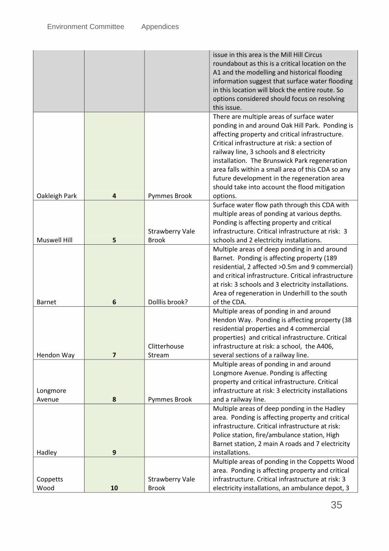
Environment Committee Appendices
35
issue in this area is the Mill Hill Circus roundabout as this is a critical location on the A1 and the modelling and historical flooding information suggest that surface water flooding in this location will block the entire route. So options considered should focus on resolving this issue.
Oakleigh Park 4 Pymmes Brook
There are multiple areas of surface water ponding in and around Oak Hill Park. Ponding is affecting property and critical infrastructure. Critical infrastructure at risk: a section of railway line, 3 schools and 8 electricity installation. The Brunswick Park regeneration area falls within a small area of this CDA so any future development in the regeneration area should take into account the flood mitigation options.
Muswell Hill 5 Strawberry Vale Brook
Surface water flow path through this CDA with multiple areas of ponding at various depths. Ponding is affecting property and critical infrastructure. Critical infrastructure at risk: 3 schools and 2 electricity installations.
Barnet 6 Dolllis brook?
Multiple areas of deep ponding in and around Barnet. Ponding is affecting property (189 residential, 2 affected >0.5m and 9 commercial) and critical infrastructure. Critical infrastructure at risk: 3 schools and 3 electricity installations. Area of regeneration in Underhill to the south of the CDA.
Hendon Way 7 Clitterhouse Stream
Multiple areas of ponding in and around Hendon Way. Ponding is affecting property (38 residential properties and 4 commercial properties) and critical infrastructure. Critical infrastructure at risk: a school, the A406, several sections of a railway line.
Longmore Avenue 8 Pymmes Brook
Multiple areas of ponding in and around Longmore Avenue. Ponding is affecting property and critical infrastructure. Critical infrastructure at risk: 3 electricity installations and a railway line.
Hadley 9
Multiple areas of deep ponding in the Hadley area. Ponding is affecting property and critical infrastructure. Critical infrastructure at risk: Police station, fire/ambulance station, High Barnet station, 2 main A roads and 7 electricity installations.
Coppetts Wood 10
Strawberry Vale Brook
Multiple areas of ponding in the Coppetts Wood area. Ponding is affecting property and critical infrastructure. Critical infrastructure at risk: 3 electricity installations, an ambulance depot, 3

Environment Committee Appendices
36
schools and the A1000.
Oakleigh Park 11
Multiple surface water flow paths through Oakleigh Park, ponding adjacent to Pymmes Brook. Flooding is affecting property and critical infrastructure. Critical infrastructure at risk: Oakleigh Park railway station, 2 schools, 3 electricity installations and sections of the railway line. Flooding is particularly extensive at the railway station and the flooding in the residential areas is relatively shallow and patchy.
Long Lane 12
Surface water flow path through this CDA with multiple areas of ponding at various depths. Ponding is affecting property and critical infrastructure. Critical infrastructure at risk: 2 schools, 2 electricity installations a small section of the railway line and the A1000.
Broadfields Ditch 13
Deep areas of ponding upstream of road culvert. Property affected upstream of the A41 culvert. This is a an overland flow issue, as surface water is following old open river valley. Surface water is affecting property and critical infrastructure. Critical infrastructure at risk: an electricity sub station, an electricity installation and a school. No regeneration area within this CDA.
Sunnyhill Park 14
Deep area of ponding alongside the railway embankment. Property is affected by this deep area of ponding. Surface water within this CDA is affecting property and critical infrastructure. Critical infrastructure at risk: A1, A41, a school and 5 electricity installations.
Victoria Road 15
Surface water flow path through this CDA with several areas of ponding at various depths. Ponding is affecting property and critical infrastructure. Critical infrastructure at risk: A502, A504, 2 schools, a telephone exchange, a government office and 6 electricity installations.
Church End Farm 16
Deep area of ponding to the east of the M1 where Aerodrome Road passes underneath the railway line and motorway. Property is affected by this deep area of ponding. Surface water within this CDA is affecting property and critical infrastructure. Critical infrastructure at risk: A41, a school and Middlesex University.
Lichfield Road 17
Large area of deep flooding on Lichfield Road. Ponding is affecting property and critical infrastructure. Critical infrastructure at risk: the A407, Cricklewood Railway Station and 2

Environment Committee Appendices
37
electricity installations. Predominant cause of ponding is the restriction on flow posed by a subway under the railway line.
Victoria Park 18
Multiple areas of ponding near to Victoria Park with one area of deep ponding to the SE of the CDA. Ponding is affecting property and critical infrastructure. Critical infrastructure at risk: a hospital, 3 schools, 2electricity installations and a small section of the A1000.
Creighton Avenue 19
Surface water flow path through this CDA with multiple areas of ponding at various depths. Ponding is affecting property and critical infrastructure. Critical infrastructure at risk: 1 electricity installations.
Brunswick Park 20
There are several surface water flow paths through Brundswick Park. Surface water is affecting property and critical infrastructure. Critical infrastructure at risk: a section of railway line and 6 electricity installation. The Brunswick Park regeneration area falls within this CDA so any future development in the regeneration area should take into account the flood mitigation options as outlined below.
Grahame Park 21
There are multiple areas of surface water ponding in and around Grahame Park. Ponding is affecting property and critical infrastructure. Critical infrastructure at risk: 2 schools, 2 police stations, 16 electricity installation. The Burnt Oak and several of the Colindale regeneration areas fall within this CDA so any future development in this area should take into account the flood mitigation options as outlined below.
Blondell Road 22 Walting Ditch
Surface water flow path along Blundell Road. Flow path is affecting property and critical infrastructure. Critical infrastructure at risk:1 electricity installation. There is a small area of the Burnt Oak regeneration area that falls within this CDA any future development in this area could benefit this CDA.
Mill Hill 23
Large area of deep flooding on Hale Road. Main flow pathway is along a culverted area of watercourse. Ponding is affecting property (49 residential, 6 >0.5m and 1 commercial property >0.5m) no critical infrastructure is at risk. There are critical infrastructure assets within this CDA (A5109, a school and 1 electricity installation) but they are not at risk of flooding.

Environment Committee Appendices
38
Westchester Drive 24
Surface water flow path through this CDA with several areas of ponding at various depths. Ponding is affecting property (86 residential properties, 7 >0.5m and 8 commercial properties) and critical infrastructure. Critical infrastructure at risk: A1, 1 school, 1 hospital and 2 electricity installations.
Duck Island 25
Multiple areas of deep ponding in the Ducks Island area. Ponding is affecting property (264 residential, 1 affected >0.5m and 24 commercial, 4 affected >0.5m) and critical infrastructure. Critical infrastructure at risk: Barnet Hospital, 2 schools and 1 hazardous waste site.
Pricklers Hill 26
Multiple areas of ponding with one area of particularly deep flooding in the Pricklers HIll area. Ponding is affecting property (54 residential properties, 6 >0.5m and 25 commercial properties, 1 >0.5m) and critical infrastructure. Critical infrastructure at risk: the A1000 and a section of railway line.
Brent Terrace 27
Multiple areas of ponding in Claremont Way Industrial Estate. Ponding is affecting several commercial properties but no critical infrastructure is at risk.
Edgware Station 28
Surface water ponding along the railway line at Edgware station. Ponding is affecting critical infrastructure. Critical infrastructure at risk: Edgware Station and the railway line to the south east of the station.
Scratchwood 29
Area of ponding shown on the railway line adjacent to Scratchwood. Ponding is affecting critical infrastructure. Critical infrastructure at risk: Railway line south of Elstree Tunnel. Flooding is from a combination of fluvial and surface water.
Arkley 30
Predominant flood risk in this area is from small field drains overtopping rather than from surface water. Flooding is affecting 34 residential properties, 9 commercial properties, no critical infrastructure is affected.
Claremont Way Industrial Estate 31
Multiple areas of ponding in Claremont Way Industrial Estate. Ponding is affecting several commercial properties but no critical infrastructure is at risk.