Enviro All-in-One...Enviro All-in-One Residential search report The enhanced Enviro All-in-One, is a...
2
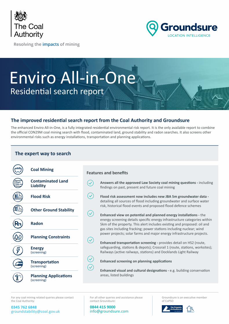
Enviro All-in-One Residenal search report The enhanced Enviro All-in-One, is a fully integrated residenal environmental risk report. It is the only available report to combine the official CON29M coal mining search with flood, contaminated land, ground stability and radon searches. It also screens other environmental risks such as energy installaons, transportaon and planning applicaons. The improved residenal search report from the Coal Authority and Groundsure The expert way to search Answers all the approved Law Society coal mining quesons - including findings on past, present and future coal mining Flood risk assessment now includes new JBA 5m groundwater data - detailing all sources of flood including groundwater and surface water risk, historical flood events and proposed flood defence schemes Enhanced view on potenal and planned energy installaons - the energy screening details specific energy infrastructure categories within 5km of the property. This alert includes exisng and proposed: oil and gas sites including fracking; power staons including nuclear; wind power projects; solar farms and major energy infrastructure projects. Enhanced transportaon screening - provides detail on HS2 (route, safeguarding, staons & depots); Crossrail 1 (route, staons, worksites); Railways (acve railways, staons) and Docklands Light Railway Enhanced screening on planning applicaons Enhanced visual and cultural designaons - e.g. building conservaon areas, listed buildings Features and benefits For any coal mining related queries please contact the Coal Authority: 0345 762 6848 [email protected] For all other queries and assistance please contact Groundsure: 0844 415 9000 [email protected] Coal Mining Contaminated Land Liability Flood Risk Other Ground Stability Radon Planning Constraints Energy (screening) Transportaon (screening) Planning Applicaons (screening) Groundsure is an execuve member of CoPSO Part 2A
Transcript of Enviro All-in-One...Enviro All-in-One Residential search report The enhanced Enviro All-in-One, is a...
Enviro All-in-OneResidential search report
The enhanced Enviro All-in-One, is a fully integrated residential environmental risk report. It is the only available report to combine the official CON29M coal mining search with flood, contaminated land, ground stability and radon searches. It also screens other environmental risks such as energy installations, transportation and planning applications.
The improved residential search report from the Coal Authority and Groundsure
The expert way to search
Answers all the approved Law Society coal mining questions - including findings on past, present and future coal mining Flood risk assessment now includes new JBA 5m groundwater data - detailing all sources of flood including groundwater and surface water risk, historical flood events and proposed flood defence schemes
Enhanced view on potential and planned energy installations - the energy screening details specific energy infrastructure categories within 5km of the property. This alert includes existing and proposed: oil and gas sites including fracking; power stations including nuclear; wind power projects; solar farms and major energy infrastructure projects.
Enhanced transportation screening - provides detail on HS2 (route, safeguarding, stations & depots); Crossrail 1 (route, stations, worksites); Railways (active railways, stations) and Docklands Light Railway
Enhanced screening on planning applications
Enhanced visual and cultural designations - e.g. building conservation areas, listed buildings
Features and benefits
For any coal mining related queries please contact the Coal Authority:
0345 762 6848 [email protected]
For all other queries and assistance please contact Groundsure:
0844 415 9000 [email protected]
The Lodge, 102 High Street, Maidstone, Aberdeenshire, GS45 6TH
Summary of risks identified
Coal Mining The area surrounding the property maybe affected by historic coal mining. Passed
Other Ground StabilityPage 12
Issues related to natural subsidence, othermining or infilled land may be present.
Contaminated Land The property is unlikely to be designatedas Contaminated Land. Passed
Flood Risk The property is considered to be at riskof flooding. Negligible
Radon No issues identified. Passed
EnergyPage 8
Identified
TransportationPage 9
Identified
Planning Applications
Full assessments for these risks areavailable in other Groundsure searchesincluding the Groundsure Avista 7 in 1report. Contact Groundsure or your searchprovider for further details.
It is important to be fully informed of all risks associated with a property before completing your purchase.Please read all the information in this report carefully.
Groundsure is an executivemember of CoPSO:
For any coal mining related issuesplease contact the Coal Authority:
For all other issues and assistanceplease contact Groundsure:
0345 762 [email protected]
0844 415 [email protected]
Coal Authority ref:ASTH2/MLR/574103/001/WORCESTERGroundsure ref: 51001617283001Your ref: test-clientGrid reference: 000102 000102Date: Jul 25, 2017
Passed
IdentifiedCoal Mining
Contaminated Land Liability
Flood Risk
Other Ground Stability
Radon
Planning Constraints
Energy (screening)
Transportation(screening)
Planning Applications(screening)
Groundsure is an executive member of CoPSO
Part2A

Groundsure’s Historical Land Use Database – with 7000+ land use classifications, one of the most comprehensive resources available dating back to 1840s with maps scanned in at over 500dpi - a new industry standard. The most accurate database for storage tanks, energy features and military installations
Environmental Permits, Incidents and Registers
Active and historical landfill data from authoritative sources, including the Environment Agency, British Geological Survey (BGS), Local Authorities and historical Ordnance Survey mapping
Current industrial site data
Enviro All-in-One: additional features
Improved accuracy • Uses Land Registry polygons - improving the accuracy of
site plans and associated detail• A buffer zone of 20m is included within the report for
recorded mine entries to satisfy what the Law Society, the Royal Institute of Chartered Surveyors, the Council of Mortgage Lenders and the Association of British Insurers deems an appropriate distance when evaluating risk
• The Coal Authority’s unique GIS database is updated every 24 hours by in-house experts as new hazards and cases of subsidence are reported
• Residential reports are measured 0-15 hectares (on coalfield only)
Plain English • All text written in plain English (jargon free)• Easier to read for the conveyancer• Easier to read and understand for the end-user• Clear recommendations and next steps outlined
Intuitive layout and page flow Colour coded risk ratings with a pass/next steps indicator on the first page. Risks are identified clearly and easily - enabling faster and smarter decisions. Improved page flow: 1st page overall rating and dashboard, 2nd page next steps, 3rd page section summaries
Site boundary on MasterMap The site boundary is overlaid onto MasterMap (featured on the 1st page), the most detailed, up-to-date and comprehensive map data available in the UK
Fewer pages • 70% fewer pages (15-20 pages vs. 50+ previously) with
clearer information• Time savings of 10-30 minutes per report• Up to 50% smaller file sizes and smaller email attachments• Lower printing and postage costs• Only the relevant data - no blank maps or pages, less
words, more facts
Ofcom mobile phone mast information - locations & planning applications relating to phone masts
Potentially infilled land
Historic military and ordnance sites
Designated environmentally sensitive sites including Green Belt, Local Nature Reserves and National Parks Ground stability assessment including non-coal mining and natural ground subsidence risks Detailed radon potential data
JBA Floodability Rating & Flood Re statement
Insurance An insurance policy is included in the Residential Enviro All-in-One covering £50,000 reduction in property value if there is a change in information. Insurance is covered by Liberty Legal Indemnities
Developed by the Coal Authority and GroundsureThe Coal Authority has been managing the effects of past coal mining to protect the public and the environment for over 20 years. Past coal mining activity can still cause problems for home owners, planners and developers as there are over 172,000 recorded mine entries on Britain’s coalfields and 130,000 properties lie within 20 metres of at least one mine entry. The Coal Authority’s award winning engineering solutions help to manage this long term legacy and their experts can provide an extensive range of products and services to help customers better understand mining risks. Groundsure is a leading provider of environmental search reports in the UK. Our specialist team is committed to producing information that informs better property decisions. Over 30 environmental professionals are focused on using our knowledge in new, innovative and accurate ways. The team is dedicated to our customers and making Groundsure data accessible, valuable and helpful.
For any coal mining related queries please contact the Coal Authority:
0345 762 6848 [email protected]
For all other queries and assistance please contact Groundsure:
0844 415 9000 [email protected]
Groundsure is an executive member of CoPSO
Why does Enviro All-in-One work harder for you and keep your transactions moving faster?