ENGINEERING CHARACTERISTICS OF EAST ANGLIAN …
13
Q. Jl Engng Geol. 1976 Vol. 9 pp. 145-157. 4 Figs. 1 Table. Printed in Northern Ireland ENGINEERING CHARACTERISTICS OF EAST ANGLIAN QUATERNARY DEPOSITS Brian Michael Funnell" & Peter FrancisWilkes t * School of Environmental Sciences, University of East Anglia, Norwich NR4 7TJ. t County Highways Department, Norfolk County Council, County Hall, Martineau Lane, Norwich NR1 2DH. SUMMARY Approximately 80 per cent of the surface of East Anglia is composed of Quaternary deposits, and even where it is made up of pre-Quaternary deposits these are highly likely to have been modified by glacial and periglacial processes. The initial Quaternary deposits consist of pre-glacial marine, estuarine and freshwater gravels, sands, clays and peats. Widespread glacial tills and outwash sands and gravels form the middle part of the succession. Later fluvioglacial and fluvial and marine interglacial sands and gravels occupy the major valleys and some coastal sites. Post-glacial deposits consist of extensive freshwater and marine alluvial peats and clays at lower elevations in the major valleys and in the coastal zone. This account briefly reviews some qualitative engineering characteristics of these East Anglian Quaternary deposits, and provides references to further sources of information on them. INTRODUCTION Quaternary deposits comprise about 80 per cent of the surface geology of East Anglia (Fig. 1), and the remaining pre-Quaternary deposits have been substantially affected by Quaternary processes, such as freeze-and-thaw, heave, and solifluction. In this region, therefore, Quaternary deposits are an almost ubiquitous element of all foundation problems. A major difficulty with these deposits is the problem of obtaining meaningful and representative quantitative data from them. In the first place truly undisturbed samples are not easy to obtain, and laboratory (e.g. triaxial) tests carried out on imperfect un- disturbed samples can be very misleading. In situ tests are to be preferred but, apart from simple vane tests, can be expensive to apply. Therefore results from them are not widely available. In the second place the engineering properties of the Quaternary deposits are very variable, not only from place to place, but also within individual sections, and sometimes even spatially within particular lithologies and in the same lithology at different times. Even if reliable measurements can be made therefore, it is still problematical as to how representative these are. For these reasons, which are not always fully appreciated by site investigation operators or engineering geologists working in the region for the first
Transcript of ENGINEERING CHARACTERISTICS OF EAST ANGLIAN …

Q. Jl Engng Geol. 1976 Vol. 9 pp. 145-157. 4 Figs. 1 Table. Printed in Northern Ireland
ENGINEERING CHARACTERISTICS OF EAST ANGLIAN QUATERNARY DEPOSITS
Brian Michael Funnell" & Peter Francis Wilkes t * School of Environmental Sciences, University of East Anglia, Norwich NR4 7TJ. t County Highways Department, Norfolk County Council, County Hall, Martineau Lane, Norwich NR1 2DH.
SUMMARY Approximately 80 per cent of the surface of East Anglia is composed of Quaternary deposits, and even where it is made up of pre-Quaternary deposits these are highly likely to have been modified by glacial and periglacial processes. The initial Quaternary deposits consist of pre-glacial marine, estuarine and freshwater gravels, sands, clays and peats. Widespread glacial tills and outwash sands and gravels form the middle part of the succession. Later fluvioglacial and fluvial and marine interglacial sands and gravels occupy the major valleys and some coastal sites. Post-glacial deposits consist of extensive freshwater and marine alluvial peats and clays at lower elevations in the major valleys and in the coastal zone. This account briefly reviews some qualitative engineering characteristics of these East Anglian Quaternary deposits, and provides references to further sources of information on them.
INTRODUCTION
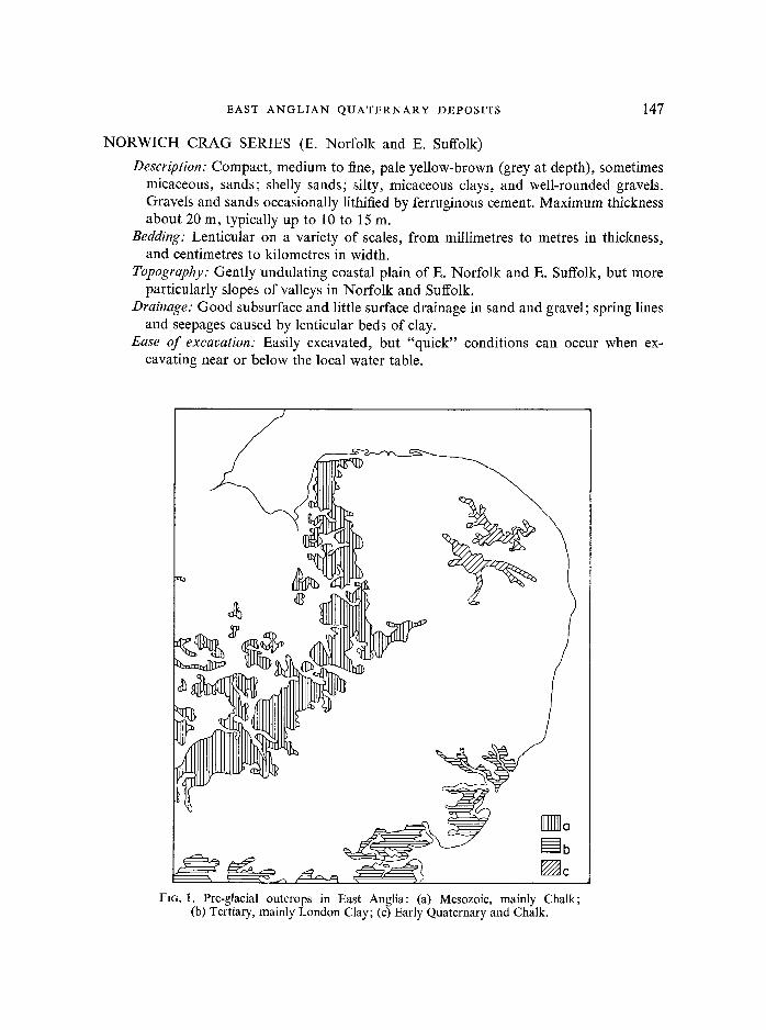
Quaternary deposits comprise about 80 per cent of the surface geology of East Anglia (Fig. 1), and the remaining pre-Quaternary deposits have been substantially affected by Quaternary processes, such as freeze-and-thaw, heave, and solifluction. In this region, therefore, Quaternary deposits are an almost ubiquitous element of all foundat ion problems.
A major difficulty with these deposits is the problem of obtaining meaningful and representative quanti tat ive data f rom them. In the first place truly undis turbed samples are not easy to obtain, and laboratory (e.g. triaxial) tests carried out on imperfect un- disturbed samples can be very misleading. In situ tests are to be preferred but, apar t f rom simple vane tests, can be expensive to apply. Therefore results f rom them are not widely available. In the second place the engineering properties of the Quaternary deposits are very variable, not only from place to place, but also within individual sections, and sometimes even spatially within part icular lithologies and in the same lithology at different times. Even if reliable measurements can be made therefore, it is still problematical as to how representative these are. For these reasons, which are not always fully appreciated by site investigation operators or engineering geologists working in the region for the first

146 B . M . F U N N E L L • P. F. W I L K E S
time, it is often not possible or even necessarily desirable to characterize the engineering properties of its Quaternary deposits solely in quantitative terms.
This account, therefore, is presented in qualitative terms, with the qualification that the descriptions are intended to provide a general guide and cannot be a substitute for detailed investigation of individual sites. The format used is close to that adopted in McGlade, Greyer & Wilshauser's "Engineering Characteristics of the rocks of Pennsyl- vania" (1972). In the introduction to that work the authors state: "This report is broad in scope and may not cover detailed, local variations in the characteristics of the individual rock formations. No attempt is made to provide the detailed local information that may be obtained from on-site sampling, investigation and laboratory analyses, which are normally performed as part of the design of any specific structure or prior to any final land-use decision". The present authors firmly re-iterate these reservations in connection with their own account.
Unless otherwise stated all the geological and engineering descriptions and generaliza- tions given in this paper are (often necessarily) based on the authors' own personal experience of the Quaternary deposits of East Anglia. Only a very few previous publications refer directly to the engineering characteristics of these deposits, and data from many of the somewhat larger number of unpublished reports could not be quoted here without heavy qualifications.
Pre-glacial formations The earliest deposits in East Anglia currently acknowledged as Quaternary (Table 1) are the marine sands, shelly sands, gravels and clays of the various Red Crag, Norwich Crag Series, Chillesford Crag and Weybourne Crag formations. Generally they underlie the eastern third of East Anglia and thicken to more than 100 metres at the coast. They are followed by a sequence of estuarine, freshwater and marine beds comprising sands, clays, gravels and thin peats, known as the Cromer Forest Bed Series. These overlie the Crag deposits in the immediate vicinity of the east and north coasts.
RED CRAG (S.E. Suffolk and N.E. Essex)
Description: Compact, occasionally lithified, red, iron-stained (grey-green at depth), usually coarse shelly sands which may be decalcified near ground surface. Maximum thickness about 25 m, typical thickness up to 10 m.
Bedding: Cross-bedded. Topography: Gently undulating, forming surface of coastal plain or slopes of valleys
in S.E. Suffolk and N.E. Essex. Drainage: Good subsurface, little surface drainage; spring-line at junction with
underlying London Clay. Ease of excavation: Easily excavated, usually unlithified. Cut-slope stability: Good; batter of 45 ~ or less acceptable; 2:1 generally satisfactory. Foundation stability: Adequate bearing capacity, no settlement problems. Construction materials: Good for farm tracks and bulk fill; not generally suitable for
aggregate.
EAST ANGLIAN QUATERNARY DEPOSITS 147
NORWICH CRAG SERIES (E. Norfolk and E. Suffolk)
Description: Compact, medium to fine, pale yellow-brown (grey at depth), sometimes micaceous, sands; shelly sands; silty, micaceous clays, and well-rounded gravels. Gravels and sands occasionally lithified by ferruginous cement. Maximum thickness about 20 m, typically up to 10 to 15 m.
Bedding: Lenticular on a variety of scales, from millimetres to metres in thickness, and centimetres to kilometres in width.
Topography: Gently undulating coastal plain of E. Norfolk and E. Suffolk, but more particularly slopes of valleys in Norfolk and Suffolk.
Drainage: Good subsurface and little surface drainage in sand and gravel; spring lines and seepages caused by lenticular beds of clay.
Ease of excavation: Easily excavated, but "quick" conditions can occur when ex- cavating near or below the local water table.
&
•m]] Cl
[]b V-Ac
FIG. 1. Pre-glacial outcrops in East Anglia: (a) Mesozoic, mainly Chalk; (b) Tertiary, mainly London Clay; (c) Early Quaternary and Chalk.

148 B . M . FUNNELL (~ P. F. WILKES
Cut-slope stability: Variable; good in gravels, less so in clayey sequences. Near vertical faces can be temporarily maintained in shallow cuts; 2:1 batter generally satisfactory, up to 3:1 may be necessary in some instances, for long term stability.
Foundation stability: Generally good, with adequate bearing capacity and no settlement problems.
Construction materials: Gravel near surface is worked for aggregate; coarser sands used for concrete, but finer sands may be too micaceous. Clay has been used for brick-making. Suitable as a bulk fill material for embankments, etc., especially when material from well-graded (i.e. mixed grade) sequences is available.
CHILLESFORD CRAG, CHILLESFORD CLAY & W E Y B O U R N E CRAG (E. Suffolk and N. Norfolk)
(respectively as for sandy, clayey and shelly facies of the Norwich Crag Series, q.v.).
CROMER FOREST BED SERIES (N. and E. Norfolk and E. Suffolk)
Description: Highly variable; silver-white, yellow-brown and grey, coarse to fine, sands and gravels, brown and grey clays, dark brown and black peats. Maximum thickness about 10 m.
F~G. 2. Tills of East Anglia:
(a) Tills of various lithologies and ages, but mostly chalky boulder clays of the Anglian Glaciation.
~7 0
%,
~ Q
EAST A N G L I A N Q U A T E R N A R Y D E P O S I T S 149
Bedding: Also highly variable; characterized by channelling on various scales, from millimetres to metres in thickness, and centimetres to tens of metres in width. Individual units may be cross-bedded or laminated.
Topography: Rarely forms the land surface. Typically crops out at or near the base of the sea cliffs from Weybourne to Kessingland.
Drainage: Very variable; relatively permeable sands and gravels, sandwiched between relatively impermeable clays, lead to numerous springs and seepages.
Ease of excavation: Generally easily excavated. However, "quick" conditions can be encountered in sands near or below the local water table (e.g. when working below beach level), and clays become intractable when moisture content increases under wet working conditions.
Cut-slope stability: Generally poor. Foundation stability: Generally poor. Construction materials: Not generally suitable for use as construction materials.
The glacial formations Glacial deposits of the upper Quaternary overlie the early Quaternary marine, estuarine and freshwater beds, and cover the whole of central East Anglia to a thickness exceeding 100 metres in parts of S. Norfolk and N. Suffolk. Deposits of three glaciations are present: the Anglian Glaciation, the Wolstonian Glaciation, and the Devensian Glaciation.
TABLE 1: The Quaternary succession in East Anglia
Stages
Flandrian (= Post-Glacial)
Devenstan
Ipswichian
Wolstonian
Hoxnian
Anglian
Wal toni an-
Cromeri an
(=pre-g I aci al )
Deposits
Contemporary beach, dune and tidal f lat
deposits
Clay alluvium of Fenland and Broadland
Peat all uvi um of Fenl and and Broadland Ringstead Down esker, and Hunstanton Ti l l
Valley Gravels (pars) Marine Gravels Valley Gravels (pars)
High-level Gravels (e.g. Kelling and Salthouse Heath outwash plains)
Valley Gravels (Broome and Homersfield
terraces )
Hoxne lake beds Nar valley clays
, , .
Lowestoft Ti l l
Cotton Beds Cromer Ti l l and Norwich Brickearth
Cromer Forest Bed Series Weybourne Crag
Chillesford Crag and Clay Norwich Crag Series
Red Crag

150 B . M . F U N N E L L & P. F. WILKES
The principal deposits of the Anglian Glaciation are the tills of the Cromer and Lowestoft Advances (Cromer Till, Norwich Brickearth and Lowestoft Till, Fig. 2) and intercalated sands and gravels (Corton Beds, Fig. 3). These cover the greater part of East Anglia. Distinctive deposits, likely to prove attributable to the Wolstonian Glaciation, are the outwash plains and kames of the N. Norfolk coast between Blakeney and Weybourne and possibly some of the chalky tills of Breckland, and some valley gravels in E. Norfolk and Suffolk. The final Devensian Glaciation left only a small amount of till and a solitary esker deposit near Hunstanton, but valley gravel trains were probably deposited throughout the region at this time, as well as during the previous Ipswichian Interglacial. On the whole, earlier interglacial deposits, although important for interpretation of the succession of glacial deposits, are insubstantial in volume and areal distribution. (For an alternative viewpoint on the stratigraphy of the principal glacial deposits of East Anglia see Bristow & Cox 1973).
CROMER TILL (N.E. Norfolk) Description: Mainly a grey silty clay (i.e. matrix-dominated till) containing a variable
clast content of flint and chalk stones, sometimes shell debris, and occasional larger erratics. Most flint and chalk stones are less than 500 mm intermediate diameter; the larger erratics range up to about 0.2 m diameter. Maximum thickness of Cromer Till complex about 30 m, individual till sheets typically up to c. 5 m thick.
Bedding, etc: Sometimes a homogenous till, sometimes banded, with more and less calcareous layers. A well-developed jointing system is usually present (Kazi & Knill 1973).
Topography: Does not normally form the present land surface except in the vicinity of Happisburgh where a gently undulating surface is formed.
Drainage: Subsurface drainage generally poor in spite of joint-development. Often the cause of spring lines (i.e. perched water tables) at junction with overlying permeable beds in cliff sections.
Ease of excavation: Easily excavated except under wet conditions, i.e. immediately beneath perched water table, beneath beach level, or during wet weather).
Cut-slope stability: Will stand as short-term vertical faces if moisture content low (e.g. as in natural cliffs), but flows freely if moisture content high (again, examples in natural cliffs). Long-term stability fair if properly drained; otherwise very poor.
Foundation stability: not investigated. Construction materials: No known use; probably as for Norwich Brickearth (q.v.).
NORWICH BRICKEARTH (N.E. Norfolk) Description: Brown, non-calcareous, sandy clay, containing flint stones and very
occasionally larger erratics (cf. Cromer Till). Not a true brickearth. Typically up to about 5 m thick.
Bedding: Usually massive, occasionally obscurely colour banded. Topography: Forms an extensive very gently undulating plain N.E. of Norwich. Drainage: Subsurface drainage generally good, but less so towards Aylsham where
the lower horizons become more like the Cromer Till (of which the Norwich Brickearth is probably a lateral equivalent).

EAST ANGLIAN QUATERNARY DEPOSITS 151
Ease of excavation: Generally easily excavated, but becomes intractable when moisture content increases under wet weather conditions (Wilkes 1976). Therefore a close watch needs to be kept on moisture content in relation to Plasticity Index.
Cut-slope stability: Good; 2:1 batter satisfactory under well-drained conditions. Foundation stability: Adequate bearing capacity, no settlement problems. Construction materials: Previously used for brickmaking; an excellent fill material
when dry, becoming intractable as moisture content increases.
CORTON BEDS (~Mid-Glacial Sands) (E. Norfolk and E. Suffolk)
Description: Compact, occasionally loose, yellow sands, often calcareous towards the top and gravelly towards the base; sometimes also a coarse gravel at the top. Occasional lithified layers, with calcareous cement, occur near the top of the succession. Shelly horizons occur near the coast. Maximum thickness about 30 m, typically up to about 5 to 10 m.
Bedding: Often horizontally bedded, sometimes cross-bedded. Topography: Either forming undulating plains near the coast, or forming the steeper
portion of valley slopes inland.
FIG. 3. Sands and Gravels of East Anglia:
(a) Corton Beds and High- level Gravels.
(b) Valley and Marine Gravels.
152 B . M . F U N N E L L t~ P. F. W I L K E S
Drainage: Subsurface drainage excellent, with little or no surface drainage. Ease of excavation: Easily excavated. Cut-slope stability: Excellent; often forms the natural steep sides of cuttings in which
older roads descend into inland valleys, but often cut back to a 2:1 batter in modern roadworks because of ease of working and use as fill.
Foundation stability: Good; adequate bearing capacity and no settlement problems. Construction materials: Most frequently worked for their gravel content, towards
either the top or bottom of the sequence. The high proportion of chalk grains at some horizons may make the sand unsuitable for concrete production.
LOWESTOFT TILL (in various facies all or most of Norfolk, Suffolk and Essex).
Description: Dark blue-grey clay (i.e. matrix-dominated till), with clasts of chalk and flint stones, up to about 500 mm intermediate diameter (but tending to be more frequent and on average larger than in the Cromer Till), and a variety of mainly sandstone and limestone erratics, up to 1 or even 2 m in diameter in case of Kim- meridgic septarian cementstone nodules. North of a line, running approximately E-W just S. of the Yare valley, the laterally equivalent facies is brown and has a more sandy and calcareous matrix than the principally Kimmeridgic clay to the south. In N.W. Norfolk an almost entirely calcareous facies, the Marly Drift, is developed. Maximum thickness over 60 m, typically up to 15 to 30 m.
Bedding: Usually massive. The Marly Drift may be banded. Topography: Extensive very gently undulating plains of till characterize the inland
areas of S. Norfolk and Suffolk E. of the Chalk escarpment. Only near river valleys such as the Yare and Gipping is the topography more diversified and this is in areas where the till is associated with gravel deposits.
Weathering: Occurs in two stages; first the oxidation of the blue-grey iron compounds to brown, and secondly decalcification, often by piping, so that the true nature of the underlying till may not be apparent from superficial excavations.
Drainage: Subsurface drainage is poor, leading to moisture retention in agricultural soils. Artesian conditions may be encountered in interbedded or underlying sands and silts.
Ease of excavation: Relatively easily excavated when dry, but intractable when wet. Cut-slope stability: Good if properly drained; otherwise poor. Near vertical faces can
be maintained in the short-term, but flatter slopes (2:1 batter generally) are necessary for long-term stability.
Foundation stability: Generally good; stability and settlement problems are not usually encountered with this material, but more clayey varieties will show signs of contraction and cracking in dry summers, and heave on excavation.
Constructional materials: Previously used as 'daub' in 'daub-and-wattle' buildings; currently used as clay component for cement manufacture; can also be used as fill for road foundations and embankments, but high fill densities should be expected.
HIGH-LEVEL GRAVELS (mainly N. and central Norfolk)
Description: Sometimes loose, usually compact, yellow-brown, often coarse flint gravels and sands. (A characteristic development comprises the Wolstonian outwash
EAST A N G L I A N Q U A T E R N A R Y DEPOSITS 153
deposits of Salthouse and Kelling Heaths). Lithologically quite similar to, and in the same topographical situation as some of the gravel beds occurring at the top of the Anglian Corton Beds (q.v.). Maximum thickness about 15 m.
Bedding." Massive, or in channels cut in sand. Topography: Gently inclined high-level plains, sometimes associated with steeply
sloping ice contact, kame and ice crevasse features of fresh appearance. Drainage: Very freely draining. Ease of excavation: Easily excavated. Cut-slope stability: Short-term stability good, but poor packing of different size
grades may lead to long-term production of loose gravelly or sandy screes. Foundation stability: Good; adequate bearing capacity, no settlement problems. Construction materials: A good source of aggregate for road construction and concrete
production.
VALLEY GRAVELS (all main river valleys)
Description: Compact, yellow-brown, often coarse, flint gravels and sands. Age ranging from Wolstonian (Broome and Homersfield terraces of Waveney valley), through Ipswichian (3rd terrace of the Cam), to Devensian (2nd and 1st terraces of the Cam). Typically up to 5, sometimes 10 m thick.
Bedding: Occasionally massive, more often lenticular channel infillings in sands. Topography: Low terraces, usually rising above the contemporary flood plain of the
main river valleys. The alluvium of the flood plains is often also underlain by similar deposits of sand and gravel.
Drainage: Good subsurface drainage and little surface drainage where deposits are above the local water table; otherwise water-logged.
Ease of excavation: Easily excavated. Cut-slope stability: Good above the local water table; poor when excavated below
that level. Foundation stability: Generally good; exceptions locally where gravel is thin and
resting on softer underlying deposits (e.g. Gault Clay). Construction materials: A favoured source of concrete aggregate and bulk fill (Wilkes
1976), worked in wet or semi-wet pits.
MARINE GRAVELS (N. Norfolk and Cambridgeshire)
Deposits of rounded marine flint gravel occur at March and Morston. They are generally attributed to the Ipswichian marine transgression. Engineering character- istics comparable with those of the sand and gravel facies of the Norwich Crag Series (q.v.).
Post-glacial formations Post-glacial deposits are very extensive in East Anglia and present some of the most difficult foundation problems. The inland and earlier post-glacial deposits near the coast are peats and other similar freshwater deposits laid down either before, or beyond the

154 B. M. F U N N E L L ~ P . F. W I L K E S
reach of, the post-glacial Flandrian marine transgression. These are here referred to as Alluvium (peat facies).
Marine or estuarine Alluvium (clay facies) has been deposited in the Wash embayment the major estuaries, and along certain protected stretches of coast since Neolithic times, with a major episode of sedimentation during the Romano-British period.
Contemporary coastal deposits complete the story of Quaternary sedimentation in East Anglia.
ALLUVIUM: peat facies (southern Fenland and flood plains of inland valleys). Description: Black, amorphous, fine-grained, friable, variably humified, often
alkaline peat. Silty clay lenses may occur within the main body of the peat. (The Lower and Upper Peats of Fenland pre- and post-date respectively the post-glacial Neolithic Flandrian transgression). Maximum thickness about 5 m, but can be substantially more (e.g. 15 m) in isolated instances.
Bedding: Generally structureless; often with an irregular base, and sometimes with an eroded top.
Topography: Usually underlies the contemporary flood plains of the inland river valleys. Also comprises the land surface of the southern part of Fenland and inner parts of the larger estuarine embayments. Towards the sea in both the Fenland and the east coast estuarine embayments it is generally overlain by Romano-British clays.
Drainage: Naturally marshland; usually artificially drained, on a large-scale in Fenland and Broadland.
Ease of excavation: Easily excavated, and nearly dry excavations can often be main- tained in the short term.
Cut-slope stability: Good; near vertical faces can often be maintained in the short term. Foundation stability: Very bad; always requires special treatment, with long-term
secondary settlement problems. Behaviour under loaded conditions generally similar to that of the alluvial clay facies, with comparable consolidation char- acteristics and pore-water pressure dissipation curves, although these features are not necessarily indicated by normal site investigation techniques.
Construction materials: No known use.
ALLUVIUM: clay facies (the Wash and coastal valleys) Description: Grey and grey-brown, clays and silty clays, usually of marine or estuarine
origin. (The main Fen Clay is of post-glacial Neolithic age; the upper silty clay of Fenland and Broadland is of Romano-British age with intervening peats). Engineer- ing parameters are usually found to be very variable and indicative generally of a low strength, highly compressible material. Rootlets within the material do not appear to improve the internal drainage characteristics. Maximum thickness about 5 m, except in centre of major valleys and near coast, where thicknesses in excess of 20 m may be found.
Bedding: Either structureless, in which case often soft, or laminated, with more or less sandy silty layers, and more cohesive. Erosion channels, infilled with re- deposited alluvium may also be found.
Topography: Either sub-surface, or forming flat surfaces at or near sea-level.

EAST ANGLIAN QUATERNARY DEPOSITS 155
Drainage: Impeded surface drainage, therefore usually artificially drained. Ease of excavation: Easily excavated, but excavations can fill with water. Cut-slope stability: Good in short term, except in soft conditions. Foundation stability: Poor, invariably requires special treatment. Long-term secondary
settlement problems commonplace. Construction materials: No known use.
C O N T E M P O R A R Y BEACHES, DUNES, and T IDAL FLATS
Tidalflats, except for the special case of the Wash bunds, are not usually required to act as foundations for permanent structures. Extensive areas are preserved as Nature Reserves, especially on the North Norfolk coast.
Dunes are also rarely required to act as foundations to permanent structures, although frame houses are common on them along the holiday coast. Again considerable tracts are preserved as Nature Reserves.
Beaches in the more spectacular forms of spits and offshore barriers are again exten- sively given over to Nature Reserves, but in places, such as Yarmouth Spit and Lowestoft Ness, where industrialization has occurred, the engineering characteristics
FIG. 4. Post-glacial deposits of East Anglia:
(a) Alluvium: peat facies. (b) Alluvium: clay facies, clay
and peat facies, and con- temporary coastal deposits.
~ a

156 B. M. FUNNELL & P. F. WILKES
of the deposits are essentially the same as for the sand and gravel facies of the Norwich Crag Series (q.v.).
Sources of further information
Details of the distr ibution of Quaternary deposits in East Anglia will be found on the 1:63360 Geological Maps of the Institute of Geological Sciences, most ly Old Series maps publ ished in the nineteenth century. Descriptions will be found in the accompanying Memoirs .
A general indicat ion of the distr ibution of these deposits can be obtained f rom the Drif t edition of the 1:253440 Geological Maps, and from the map of Superficial Deposits in the Oxford "Atlas of Great Br i ta in" , f rom which Figs. 1 to 4 are derived. 1:253440 and smaller scales are however only useful for giving general information. Only the largest and most detailed scales available are suitable for approaching foundat ion problems.
Some of the 1:25 000 Soil Survey Maps, published by the Soil Survey of England and Wales, and of the 1:25 000 Sand and Gravel Resource Sheets, publ ished by the Institute of Geological Sciences, may be helpful in this respect, and those currently available are listed amongst the References.
Details of part icular Quaternary deposits may be found by following up references in the Geological Society of London ' s Special Report No. 4 on the correlation of Quaternary deposits.
References ALLENDER, R. & HOLLYER, S. E., 1972. The sand and gravel resources of the area south and west of
Woodbridge, Suffolk. Description of 1:25 000 resource sheet TM 24. Rep. Inst. geoL Sci., 72/9, 1-128. , 1973. The sand and gravel resources of the country around Shotley and Felixstowe, Suffolk. Description of 1:25 000 resource sheet TM 23. Rep. Inst. geol. Sci., 73/13.
AMBROSE, J. D., 1973. The sand and gravel resources of the country around Maldon, Essex. Description of 1:25 000 resource sheet TL 80. Rep. Inst. geol. Sci., 73/1, 1-60. , 1973. The sand and gravel resources of the country around Layer Breton and Tolleshunt D'Arcy, Essex. Description of I : 25 000 resource sheet TL 91 and part of TL 90. Rep. Inst. geol. Sci., 73/8, 1-34.
~ , 1974. The sand and gravel resources of the country west of Colchester, Essex. Description of 1:25 000 resource sheet TL 92. Rep. Inst. geol. Sci., 74/6, 1-68.
BRISTOW, C. R. & Cox, F. C., 1973. The Gipping Till: a reappraisal of East Anglian glacial stratigraphy. Jl. geol. Soc., 129, 1-37.
CORBETT, W. M., 1973. Breckland Forest Soils. Soil Survey of England and Wales, Special Survey, 7, vii + 120 pp.
CORBETT, W. M. • TATLER, W., 1970. Soils in Norfolk--Sheet TM 49 (Beccles North). Soil Survey of England and Wales, Survey Record, 1, viii + 129 pp. ,1975. Soils in Norfolk--Sheet TG 13/14 (Barningham and Sheringham). Soil Survey of England and Wales, Survey Record, 2, vii + 135 pp.
Cox, F. C. & NICKLESS, E. F. P., 1972. Some aspects of the glacial history of Central Norfolk. Bull. geol. Surv. G.B., 42, 79-98.
EATON, C. H., 1973. The sand and gravel resources of the country around Terling, Essex. Description of 1:25 000 resource sheet TL 71. Rep. Inst. geol. Sci., 73/5, 1-120.
HAGGARD, H. J. E., 1972. The sand and gravel resources of the country around Witham, Essex. Description of 1 : 25 000 resource sheet TL 81. Rep. Inst. geol. Sci., 72/6, 1-90.

EAST ANGLIAN QUATERNARY DEPOSITS 157
HODGE, C. A. H. & SEALE, R. S., 1966. The Soils of the District around Cambridge (Sheet 188). Mere. Soil Surv. England and Wales, vii § 183 pp.
HOLLYER, S. E., 1974. The sand and gravel resources of the country around Tattingstone, Suffolk: Descrip- tion of 1:25 000 resource sheet TM 13. Rep. Inst. geoL Sci., 74/9, 1-86.
KAZI, A. & KNILL, J. L., 1969. The sedimentation and geotechnical properties of the Cromer Till between Happisburgh and Cromer, Norfolk. Q. Jl Engng Geol., 2, 63-86.
~ , 1973. Fissuring in glacial lake clays and tills on the Norfolk coast, United Kingdom. Engineering Geology, 7, 35-48.
McDOWELL, P. W., 1970. The advantages and limitations of geoelectrical methods in the foundation investigation of the tracked hovercraft experimental site in Cambridgeshire. Q. Jl Engng Geol., 3, 119-126.
MCGLADE, W. G., GEYER, A. R. • WILSHAUSEN, J. P., 1972. Engineering characteristics of the rocks of Pennsylvania. Pennsylvania Geological Survey, Bulletin EGll, 1-200.
MITCHELL, G. F., PENNY, L. F., SHOTTON, F. W. & WEST, R. G., 1973. A correlation of Quaternary deposits in the British Isles. Geol. Soc. Lond., Special Report, 4, 1-99.
NICKLESS, E. F. P., 1971. The sand and gravel resources of the country south-east of Norwich, Norfolk. Description of 1 : 25 000 resource sheet TG 11. Rep. Inst. geol. Sci., 71/20, 1-94. , 1973. The sand and gravel resources of the country around Hethersett, Norfolk. Description of 1:25 000 resource sheet TG 10. Rep. Inst. geol. Sci., 73/4. , 1973. The sand and gravel resources of the country around Attlebridge, Norfolk. Description of 1:25 000 resource sheet TG 11. Rep. Inst. geol. Sci., 73/15, 1-129.
SKEMPTON, A. W., 1945. A slip in the West Bank of the Eau Brink cut. Proc. Inst. Civil Engineers. SKEMPTON, A. W. & PETLEY, D. J., 1970. Ignition loss and other properties of peats and clays from Avon-
mouth, King's Lynn and Cranberry Moss. Geotechnique, 20, 343-356. SQUIRRELL, H. C., 1974. The sand and gravel resources of the country around Gerrards Cross, Buckingham-
shire. Description of parts of 1:25 000 resource sheets SU 98, SU 99, TQ 08 and TQ 09. Rep. Inst. geol. Sci., 74/14.
TI~OMASSON, A. J., 1969. Soils of the Saffron Walden District--a reconnaissance survey. Soil Survey of England and Wales, Special Survey, 2, iv + 51 pp.
WILKES, P. F., 1972. An induced failure at a trial embankment at King's Lynn, Norfolk, England. Proc. Amer. Soc. Cir. Engrs. Speciality Conf.: Performance of Earth and Earth-Supported Structures, 1, 29-63.
~ , 1974. ,4 geotechnical study of a trial embankment on alluvial deposits at King's Lynn. Ph.D. thesis: University of Surrey.
~ , 1976. The problems of the highway engineer in Norfolk. Bull. geoL Soc. Norfollc, 28, 29-48. WOODLAND, A. W., 1970. The buried tunnel-valleys of East Anglia. Proe. Yorks. geoL Soc., 37, 521-578.