Enchanted Hills Park Project
49
Enchanted Hills Park Project Cultural Resources Survey January 2020 | COP-04 Prepared for: City of Perris Community Service Department 5510 135 North D Street City of Perris, CA 92570 Prepared by: HELIX Environmental Planning, Inc. 7578 El Cajon Boulevard La Mesa, CA 91942 Stacie Wilson Senior Archaeologist
Transcript of Enchanted Hills Park Project

Enchanted Hills Park ProjectCultural Resources Survey
January 2020 | COP-04
Prepared for:
City of Perris Community Service Department
5510 135 North D StreetCity of Perris, CA 92570
Prepared by:
HELIX Environmental Planning, Inc.7578 El Cajon Boulevard
La Mesa, CA 91942Stacie WilsonSenior Archaeologist

This page intentionally left blank

Enchanted Hills Park Project
Cultural Resources Survey
Prepared for:
City of Perris
Community Service Department
135 North D Street
City of Perris, CA 92570
Prepared by:
HELIX Environmental Planning, Inc.
7578 El Cajon Boulevard
La Mesa, CA 91942
January 2020 | COP-04

National Archaeological Database Information
Authors: Stacie Wilson, M.S., RPA and Theodore G. Cooley, M.A. RPA, with
contributions by Annie McCausland, M.A. Firm: HELIX Environmental Planning, Inc. Client/Project: City of Perris / Enchanted Hills Park Project Report Date: January 2020 Report Title: Cultural Resources Survey for the Enchanted Hills Park Project, City of
Perris, Riverside County, California
Submitted to: City of Perris Type of Study: Cultural Resources Survey New Sites: None Updated Sites: None
USGS Quad: Steele Peak 7.5' Quadrangle
Acreage: Approximately 22.5 acres Key Words: Riverside County; Township 4 South, Range 4 West; City of Perris;
Weston Road, West Metz Road; granitic bedrock; negative survey

i
TABLE OF CONTENTS
Section Page
EXECUTIVE SUMMARY ............................................................................................................................. ES-1
1.0 INTRODUCTION ................................................................................................................................ 1
Project Location .................................................................................................................. 1 Project Description ............................................................................................................. 1 Regulatory Framework ....................................................................................................... 1
1.3.1 City of Perris General Plan ..................................................................................... 2 Project Personnel ................................................................................................................ 3
2.0 PROJECT SETTING ............................................................................................................................. 3
Natural Setting .................................................................................................................... 3 Prehistoric Context ............................................................................................................. 4
2.2.1 Early Prehistoric Period .......................................................................................... 5 2.2.2 Archaic Period ........................................................................................................ 6 2.2.3 Late Prehistoric Period ........................................................................................... 7
Ethnographic Context ......................................................................................................... 8 2.3.1 Cahuilla .................................................................................................................. 8 2.3.2 Luiseño ................................................................................................................... 8
Historical Background ......................................................................................................... 9 2.4.1 Spanish Period ....................................................................................................... 9 2.4.2 Mexican Period .................................................................................................... 10 2.4.3 American Period .................................................................................................. 10 2.4.4 City of Perris ......................................................................................................... 11
3.0 ARCHIVAL RESEARCH AND CONTACT PROGRAM .......................................................................... 13
Records Search .................................................................................................................. 13 3.1.1 Previous Surveys .................................................................................................. 14 3.1.2 Previously Recorded Resources ........................................................................... 15
Other Archival Research ................................................................................................... 16 Native American Contact Program ................................................................................... 16
4.0 FIELD SURVEY ................................................................................................................................. 17
Survey Methodology ......................................................................................................... 17 Survey Results ................................................................................................................... 20
5.0 RESULTS ......................................................................................................................................... 20
6.0 SUMMARY AND MANAGEMENT RECOMMENDATIONS ................................................................ 21
Management Recommendations ..................................................................................... 21
7.0 REFERENCES ................................................................................................................................... 24

ii
TABLE OF CONTENTS (cont.)
LIST OF APPENDICES A Resumes B Records Search Results (Confidential, bound separately) C Native American Correspondence (Confidential, bound separately)
LIST OF FIGURES No. Title Follows Page 1 Regional Location ............................................................................................................................. 2 2 USGS Topography ............................................................................................................................ 2 3 Aerial Photograph ............................................................................................................................ 2 4 Conceptual Site Plan ........................................................................................................................ 2
LIST OF TABLES No. Title Page 1 Previous Studies Within One Mile of the Project Area .................................................................. 14 2 Previously Recorded Resources Within One Mile of the Project Area .......................................... 15 3 Native American Contact Program Responses .............................................................................. 17
iii
ACRONYMS AND ABBREVIATIONS
AB Assembly Bill AMSL above mean sea level APN Assessor’s Parcel Number BMX bicycle motocross CCR California Code of Regulations CEQA California Environmental Quality Act CHRIS California Historical Resources Information System CRHR California Register of Historical Resources CSR California Southern Railway EIC Eastern Information Center HELIX HELIX Environmental Planning, Inc. MLD Most Likely Descendent NAHC Native American Heritage Commission NRHP National Register of Historic Places OHP Office of Historic Preservation PRC Public Resources Code SLF Sacred Lands File USGS U.S. Geological Survey

iv
This page intentionally left blank

Enchanted Hills Park Project Cultural Resources Survey | January 2020
ES-1
EXECUTIVE SUMMARY
HELIX Environmental Planning, Inc. (HELIX) was contracted by the City of Perris (City) to provide cultural resources services for the Enchanted Hills Park Project (project), located in the City of Perris, in northwestern Riverside County, California. The proposed project consists of a neighborhood park within an approximately 22.5-acre site. A cultural resources study including a records search, Sacred Lands File search, Native American outreach, a review of historic aerial photographs and maps, and a pedestrian survey was conducted for the project. This report details the methods and results of the cultural resources study and has been prepared to comply with the California Environmental Quality Act (CEQA).
The records search conducted at the Eastern Information Center (EIC) on November 12, 2019 indicated that 15 previous cultural resources studies have been conducted within one mile of the project area, none of which occurred within the project site. The records search results also indicated that a total of 19 cultural resources have been previously recorded within one mile of the project area; however, no sites have been recorded within the project site. The field investigations included intensive pedestrian survey of the project area by HELIX archaeologists and a Native American monitor on November 25, 2019. The survey did not result in the identification of any cultural resources within the project area.
Based on the results of the current study, no cultural resources will be affected by the project. However, due to the cultural sensitivity of the general project region and Tribal requests, it is recommended that an archaeological monitoring program be implemented for ground-altering activities related to the construction of the project.

Enchanted Hills Park Project Cultural Resources Survey | January 2020
ES-2
This page intentionally left blank

Enchanted Hills Park Project Cultural Resources Survey | January 2020
1
1.0 INTRODUCTION
HELIX Environmental Planning, Inc. (HELIX) was contracted by the City of Perris (City) to provide cultural resources services for the proposed Enchanted Hills Park Project (project), which would involve the development of a park within an approximately 22.5-acre area. A cultural resources study including a records search, Sacred Lands File search, Native American outreach, a review of historic aerial photographs and maps, and a pedestrian survey was conducted for the project property. This report details the methods and results of the cultural resources study and has been prepared to comply with the California Environmental Quality Act (CEQA).
1.1 PROJECT LOCATION
The project site is located in the City of Perris in northwestern Riverside County, in the northeast 1/4 of the southwest 1/4 of Section 25 of Township 4 South, Range 4 West, on the U.S. Geological Survey (USGS) 7.5' Steele Peak quadrangle (Figure 1 and 2, Regional Location and USGS Topography, respectively). The approximately 22.5-acre project site is bordered by Weston Road to the south and West Metz Road to the north, with Altura Drive adjacent to the east and Carter Drive to the west (Figure 3, Aerial Photograph). The project is within Assessor Parcel Numbers (APN) 326-062-017, 326-071-001, -002, 326-072-002, -003, -004, -005, and 326-073-001.
1.2 PROJECT DESCRIPTION
The proposed project consists of a neighborhood park. Currently the project site is largely undeveloped; however, there are several trails, a BMX (bicycle motocross) course, signs of disturbance, and man-made features. Through a series of community outreach efforts, the City prepared a conceptual plan for the project (Figure 4, Conceptual Site Plan). The plan includes a combination of passive and active recreational features; while many natural features of the site will be retained, park development would include the introduction of hardscape and impermeable surfaces, as well as turfed and landscaped areas. The park will include a multi-use field, a child play area, a toddler play area, restrooms, picnic shelters, hardscape, parking lots, bridges, trails, a basketball court, BMX course improvements, art rocks, a splash pad, a skating area, and a zip line. Additionally, the project would retain and incorporate some of the existing site features, such as Owl Rock, which is a painted boulder, and an existing BMX course that has been built by neighbors. The conceptual plan also identifies a detention basin near the Weston Road project entrance. There are three entrances to the site: one at the intersection of Weston Road and Diana Street, and two entrances that form a horse-shoe drive adjacent to and accessible from Metz Road. One parcel within the larger study area is not included as a part of the project, as the City has been unable to acquire it (APN 326-072-001).
1.3 REGULATORY FRAMEWORK
Cultural resources are defined as buildings, sites, structures, or objects, each of which may have historical, architectural, archaeological, cultural, and/or scientific importance. Significant resources are those resources which have been found eligible to the California Register of Historical Resources (CRHR).
CEQA Public Resources Code (PRC) 21084.1, and California Code of Regulations (CCR) Title 14 Section 15064.5, address determining the significance of impacts to archaeological and historic resources and discuss significant cultural resources as “historical resources,” which are defined as:

Enchanted Hills Park Project Cultural Resources Survey | January 2020
2
• resource(s) listed or determined eligible by the State Historical Resources Commission for listing in the CRHR (14 CCR Section 15064.5[a][1]);
• resource(s) either listed in the National Register of Historic Places (NRHP) or in a “local register of historical resources” or identified as significant in a historical resource survey meeting the requirements of Section 5024.1(g) of the PRC, unless “the preponderance of evidence demonstrates that it is not historically or culturally significant” (14 CCR Section 15064.5[a][2]);
• resources determined by the Lead Agency to meet the criteria for listing on the CRHR (14 CCR Section 15064.5[a][3]).
For listing in the CRHR, a historical resource must be significant at the local, state, or national level under one or more of the following four criteria:
A. It is associated with events that have made a significant contribution to the broad patterns of local or regional history, or the cultural heritage of California or the United States;
B. It is associated with the lives of persons important to local, California, or national history;
C. It embodies the distinctive characteristics of a type, period, region, or method of construction, or represents the work of a master or possesses high artistic values;
D. It has yielded or has the potential to yield information important to the prehistory or history of the local area, California, or the nation.
Under 14 CCR Section 15064.5(a)(4), a resource may also be considered a “historical resource” for the purposes of CEQA at the discretion of the lead agency.
All resources that are eligible for listing in the CRHR must have integrity, which is the authenticity of a historical resource’s physical identity evidenced by the survival of characteristics that existed during the resource’s period of significance. Resources, therefore, must retain enough of their historic character or appearance to be recognizable as historical resources and to convey the reasons for their significance. Integrity is evaluated with regard to the retention of location, design, setting, materials, workmanship, feeling, and association. In an archaeological deposit, integrity is assessed with reference to the preservation of material constituents and their culturally and historically meaningful spatial relationships. A resource must also be judged with reference to the particular criteria under which it is proposed for nomination.
California State Assembly Bill (AB) 52 revised PRC Section 21074 to include Tribal Cultural Resources as an area of CEQA environmental impact analysis. Further, per new PRC Section 21080.3, a CEQA lead agency must consult with any California Native American tribe that requests consultation and that is traditionally and culturally affiliated with the geographic area of a proposed project to identify resources of cultural or spiritual value to the tribe, even if such resources are already eligible as historical resources as a result of cultural resources studies.
1.3.1 City of Perris General Plan
The Conservation Element of the City’s General Plan (2005) includes a Cultural Resource Sensitivity map (Exhibit CN 6), with sensitive zones found in areas of exposed bedrock, at the center of the City, and

!
!!
!
!!
!!
!!
!
!!
!!
!!
!!
!
!!!
!
!
!!
!!
!!
!
!
!
!
!
!
!! !
!
!!
!!!!
!
!!
!!
!!
!
!!
!!
!
!
!
!
!! !!
!
!
!
!!
!!
!
!
!
!
!!
!!
!
!
!
!
!
!
!
!
!
!
!
!
!
!
!
!
!!
!
!
!
!
!
!!
!!
!!!!!!!!
!
!
!
!!!
!!
!
!
!!
!
!
!!
!!!
!!
!!
!!
!!
!
!!
!!
!
!!
!
!
!!!
!!!
!
!!
!!
!
!
!
!! !!
!
!
!!
!
!!
!!
!!
!
!
!
!!!
!
!!
!
!
!
!
!!
!!
!!
!
!
!!
!!
!!
!
!!
!!
!!
!
!!!!!
!
!!
!
!!
!!
!!
!!
!!
!
!!
!
!
!
!
!
!
!
!
! !!
!
!!
!!
!
!
!! !
!
!
!
!!
!
!
!!
!!!
!!
!!
!
!
!!
!
!
!
!
!!
!
!
!
!
!
!
!
!!
!!
!
!
!!
!!
!!
!!
!!
!
!
!!
!!
!!
!!
!!
!!
!
!!
!
!!
!
!
!!
!!
!
!
!!
!
!!
!
!
!
!!
!
!
!
!
!!
!!
!
!!
!!
!!
!!
!!
!
!!
!
!
!!!
!!
!!!!
!
!!
!
!
!!
!!
!!! !!
!!!!!!!
!
!!
!
!
!
!!!
!
!
!
!
!
! !!! !! !!
!!
!
!
!
!!
!!
!
!
!!
!
!
!
!
!
!!!
!
!!!!!
!
!
!
!
!!!!
!
!
!!
!!
!!
!!
!
!!
!!
!
!
!
!!
!
!!
!!
!!
!!
!!
!
!!
!
!
!
!!
!!
!
!
!!!!
!!
!!
!
!!!!
!!
!!
!!
!!
!!
!!
!!
!!
!!
!!!
!!
!!
!!!! !!!! !!! !!
!
!! !!!!!
!
!!
!!
!!
!
!
!
!
! !!!!!
!! !
!
!!
!
!
!! !!!!
!
!!
!
! !! !!
!! !!
!!
! !!
!!
!! !
!
!
!
!
!!!
!!
!
!!
!
!
?z
?Æ
!"a$
!"a$
%&h(
?±
!"a$
!"a$ ?¹
?¹
%&h(
?±
?z
?¹AÐ
!"$
Añ
?¡
AÙ
?± ?¿
A
?¿
AÙ
?±
?¹
!"$
!"$
?ø
!"a$
?a
?±
AÎ
!"$
?å
Añ
?¥%&h(
!"$
?¡
AÔ
?³
!Project Site
SAN BERNARDINO COUNTY
CAMPPENDLETON
MISSIONVIEJO
SANCLEMENTE
LAGUNABEACH
ONTARIO
RIVERSIDE
CORONA
LAKEELSINORE
SAN BERNARDINO
Santa Ana Mountains
San Bernardino Mountains
RIVERSIDE COUNTY
SAN DIEGO COUNTYRIVERSIDE COUNTY
ORANGE COUNTY
San Jacinto Mountains
Litt le San Bernardino Mountains
YUCCAVALLEYTWENTYNINEPALMS
TEMELCULA
MURRIETA
NORCO MORENOVALLEY
BANNING
BEAUMONT
PALM DESERTHEMET
SAN JACINTO
COACHELLA
PALMSPRINGSPERRIS
Pacific Ocean
Big Bear Lake MesquiteLake
CoyoteLake
LeeLake
AlvordPerris
ReservoirLake
Mathews
CanyonLake
HemetLake
LakeElsinore
LakeCahuilla
SkinnerReservoir
Salton SeaVailLake
Clark LakeO'NeillLake
DiamondValley Lake
Figure 1Regional Location
I:\PRO
JECTS\
C\COP
\COP-0
4_Ench
antedH
ills\M
ap\BI
O\Let
terRp
t\Fig1
_Regi
onal.m
xd CO
P-04 1
2/19/2
019 -D
Y
Source: Base Map Layers (ESRI, 2013)
K
Enchanted Hills Park
0 10 Miles

Figure 2USGS Topography
I:\PRO
JECTS\
C\COP
\COP-0
4_Ench
antedH
ills\M
ap\BI
O\Let
terRp
t\Fig2
_USG
S.mxdC
OP-04
12/19
/2019
-DY
Source: Steele Park 7.5' Quad (USGS)
Enchanted Hills Park
0 2,000 Feet K
Project Site

APN326072001- Not a Part
Metz Rd
Dian
a St
Tierney Dr
Cart
er D
r
Altu
ra D
r
Weston Rd
Figure 3Aerial Photograph
I:\PRO
JECTS\
C\COP
\COP-0
4_Ench
antedH
ills\M
ap\BI
O\Let
terRp
t\Fig3
_Aeri
al.mxd
COP-0
4 12/1
9/201
9 -DY
Source: Aerial (RCIT, 2016)
K
Enchanted Hills Park
0 170 Feet
Project Boundary

Perris- Enchanted Hills ParkI:\PR
OJECT
S\C\CO
P\CO
P-04
_Encha
nted
Hills\M
ap\BIO\Lett
erRp
t\Fig4
_Site
Plan
.indd
C
OP-
04 1
2/19
/201
9 - D
Y
Conceptual Site PlanFigure 4
Source: City of Perris 2019

Enchanted Hills Park Project Cultural Resources Survey | January 2020
3
along historic road alignments (City of Perris 2005). The Perris Valley Historical Association, along with the Riverside County Office of Historic Preservation, have identified historic sites and structures within the City of Perris, all of which occur in the downtown area of the City.
Within the project area, the cultural resources sensitivity is indicated as low on the Cultural Resource Sensitivity map, with a density of one or fewer sites being probable over a quarter-mile area. Cultural resources sensitivity levels are higher, however, within the Motte Rimrock Reserve located to the north of the project area, where a large area of medium density site probability exists (City of Perris 2005; Exhibit CN 6).
1.4 PROJECT PERSONNEL
Stacie Wilson, M.S., RPA served as principal investigator and is the primary author of this technical report. Ms. Wilson meets the qualifications of the Secretary of Interior’s Standards and Guidelines for archaeology and is a Riverside County Approved Cultural Resources Consultant. Theodore Cooley, M.A., RPA is coauthor of this technical report, Annie McCausland, M.A., contributed to the report, and Mary Robbins-Wade, M.A, RPA provided senior technical review. Julie Roy, B.A. and Mary Villalobos, B.A. conducted the field survey. Frank Morreo from the Soboba Band of Luiseño Indians participated in the pedestrian survey. Resumes for key project personnel are presented in Appendix A.
2.0 PROJECT SETTING
2.1 NATURAL SETTING
The project area is located within the Perris Valley, along the elevated northwestern part of the San Jacinto River watershed system. The San Jacinto River is approximately three miles to the southeast of the project area; Lake Elsinore, the terminus of the river, is approximately 9.5 miles to the southwest.
Site topography is relatively flat within the project area, with a slight slope from the north to the south. Elevation ranges from about 1,732 feet above mean sea level (AMSL) to approximately 1,690 feet AMSL, with shallow colluvial and alluvial sediments in the central area and rocky knolls throughout the remainder of the project area.
The project area is characterized by undeveloped land, the majority of which consists of natural, low rocky hill terrain with shallow alluvial and colluvial fan deposits in the central area of the property. Geologically, the rocky hill terrain of the project site is mapped as being underlain by the late Cretaceous era, Val Verde tonalite, a granitic rock of the Peninsular Ranges Batholith (Morton n.d.). Numerous bedrock outcrops are present within the project property, and Bissell and Morgan (1990:1) have noted in nearby areas containing similar geologic circumstances with numerous granitic boulder outcrops that “these outcrops were frequently used in the prehistoric past for shelter, as surfaces for rock art (both pictographs and petroglyphs) and as grinding surfaces on which to reduce hard seeds”. In addition to the processing of hard seeds, granitic outcrops were also used by native populations for the processing of multiple other vegetal and small mammal food resources, and were likely used for tanning hides, mixing pigments, and other uses.
Soil series mapped for the project area include the Cieneba and Hanford soil series (Natural Resources Conservation Service [NRCS] 2019). In the rocky hill areas on the western and eastern sides of the

Enchanted Hills Park Project Cultural Resources Survey | January 2020
4
property, the soil type is Cieneba rocky sandy loam, 8 to 15 percent slopes, eroded. Through the central area of the property the soil type is Hanford coarse sandy loam, 2 to 8 percent slopes. The Cieneba soils constitute roughly 80 percent of the property and the Hanford soils the remaining 20 percent. Cieneba soils form on granitic bedrock, while Hanford soils form on alluvial fan landforms (NRCS 2019).
While the rocky knoll areas currently contain mostly non-native grassland and weeds with intermittent areas of remnant sage scrub vegetation, prehistorically, the project vicinity would have likely supported coastal sage scrub habitat, which includes vegetation such as California sagebrush, California buckwheat, and purple sage, with intermittent areas of native grassland (California Native Plant Society 1997). Plants of these native vegetation communities and possibly other native vegetation supported by the soils on-site would have been used by the Luiseño people for food, medicine, tools, shelter, ceremonial and other uses (Bean and Shipek 1978; Sparkman 1908). Many of the animal species found living within this habitat (such as rabbits, deer, small mammals, and birds) would have been used by native populations as well.
2.2 PREHISTORIC CONTEXT
Moratto (1984) has previously defined eight archaeological regions and 16 subregions for California. The location of the project places it within the boundary of the San Diego subregion of the Southern Coast Region, but it is also located adjacent to the boundary with the Colorado River subregion of the Desert Region (Moratto 1984: 148, Figure 4.13). The following culture history outlines and briefly describes the known prehistoric cultural Traditions and chronology of archaeological sites in the vicinity of the project. The approximately 10,000 years of documented prehistory of the region has often been divided into three periods: Early Prehistoric Period (San Dieguito Tradition/complex), Archaic Period (Milling Stone Horizon, Encinitas Tradition, La Jolla and Pauma complexes), and Late Prehistoric Period (Cuyamaca and San Luis Rey complexes).
Prior to 1984, when Moratto defined the San Diego subregion, little archaeological investigation had occurred in the westernmost Riverside and San Bernardino counties portion of this subregion. This paucity of archaeological information limited the ability of researchers to assess the cultural and temporal associations for the archaeological resources in this part of the subregion. One of the few early studies to occur in this area prior to 1984 was conducted near Temecula in the early the 1950s at a site identified as the ethnohistoric village of Temeku (McCown 1955). The investigation produced a substantial, primarily Late Prehistoric Period, artifact assemblage, but with some possible late Archaic materials as well. Another study, conducted in the 1970s, for the construction of the nearby Perris Reservoir (O’Connell et al. 1974, eds.), consisted of investigations at several sites and was, perhaps, the most extensive study conducted in the area prior to 1984. The results, which included several radiocarbon dates, indicated a predominance of occupation at the sites during the Late Prehistoric Period, after AD 1500, but with some limited evidence for occupation as early 380 BC (Bettinger 1974:159-162). During the last approximately 35 years since 1984, several substantial archaeological studies have occurred that have served to substantially augment the archaeological record for the area (e.g., Grenda 1997; Applied Earth Works, Inc. 2001). Based on the information provided by these and other subsequent studies in the area, Sutton and Gardner (2010) and others have recently begun to define the prehistory of this area of the San Diego subregion and how it fits in with the previously better-known areas of the subregion. The three chronological periods defined for the prehistory of the San Diego subregion are described below.

Enchanted Hills Park Project Cultural Resources Survey | January 2020
5
2.2.1 Early Prehistoric Period
The Early Prehistoric Period represents the time of the entrance of the first known human inhabitants into California. In some areas of California, it is referred to as the Paleo-Indian period and is associated with the Big-Game-Hunting activities of the peoples of the last Ice Age occurring during the Terminal Pleistocene (pre-10,000 years ago) and the Early Holocene (beginning circa 10,000 years ago) (Erlandson 1994, 1997; Erlandson et al. 2007). In the western United States, the most substantial evidence for the Paleo-Indian or Big-Game-Hunting peoples, derives from finds of large fluted spear and projectile points (Fluted-Point Tradition) at sites in places such as Clovis and Folsom in the Great Basin and the Desert Southwest (Moratto 1984:79–88). In California, most of the evidence for the Fluted-Point Tradition derives principally from areas along the western margins of the Great Basin including the eastern Sierras and the Mojave Desert, and in the southern Central Valley (Dillon 2002; Rondeau et al. 2007). Elsewhere in California, with the exception of a site in the north coast ranges in northwestern California, CA-LAK-36, only isolated occurrences of fluted spear points have occurred, scattered around the state (Dillon 2002; Rondeau et al. 2007). These isolated occurrences have, however, included two fluted points or fluted point fragments recently discovered in, or in close proximity to, the San Diego subregion; one in the mountainous eastern area of San Diego County approximately 50 miles to the southeast of the project area (Kline and Kline 2007) and another along the coast approximately 36 miles to the southwest of the project area in adjacent Orange County (Fitzgerald and Rondeau 2012). Two examples have also been discovered to the south in Baja California (Des Lauriers 2008; Hyland and Gutierrez 1995). Despite these isolated occurrences of fluted points in the San Diego subregion and Baja California, none have been found to date in the western Riverside or San Bernardino counties area (Dillon 2002; Rondeau et al. 2007).
The earliest sites in the San Diego subregion, documented to be over 9,000 years old, belong to the San Dieguito Tradition (Warren et al. 1998; Warren and Ore 2011). The San Dieguito Tradition, with an artifact assemblage distinct from that of the Fluted Point Tradition, has been documented mostly in the coastal and near coastal areas in San Diego County (Carrico et al. 1993; Rogers 1966; True and Bouey 1990; Warren 1966; Warren and True 1961), as well as in the southeastern California deserts (Rogers 1939, 1966; Warren 1967). The content of the earliest component of the C.W. Harris site (CA-SDI-149/316/4935B), located along the San Dieguito River in San Diego County, formed the basis upon which Warren and others (Rogers 1966; Vaughan 1982; Warren 1966, 1967; Warren and True 1961) identified the “San Dieguito complex,” which Warren later reclassified as the San Dieguito Tradition (1968). This Tradition is characterized by an artifact inventory consisting almost entirely of flaked stone biface and scraping tools, but lacking the fluted points associated with the Fluted-Point Tradition. Diagnostic artifact types and categories associated with the San Dieguito Tradition include elongated bifacial knives; scraping tools; crescentics; and Silver Lake, Lake Mojave, and leaf-shaped projectile points (Rogers 1939; Warren 1967; Knell and Becker 2017). Some researchers interpret the San Dieguito Tradition/complex as having a primarily, but not exclusively, hunting subsistence orientation, but sufficiently hunting-oriented as to be distinct from the more gathering-oriented complexes of traits that were to follow in the Archaic Period (Warren 1968; Warren et al. 1998). Other researchers see the San Dieguito subsistence system as less focused on hunting and more diversified, and, therefore, possibly ancestral to or a developmental stage for the subsequent, predominantly gathering-oriented, Encinitas Tradition, denoted in the San Diego area as the “La Jolla/Pauma complex” (cf. Bull 1983; Ezell 1987; Gallegos 1985, 1987, 1991; Koerper et al. 1991). While little definite evidence for the San Dieguito Tradition has been discovered in other coastal and near-coastal areas of southern California outside of San Diego County, some evidence for it has been recently discovered in the eastern mountains of

Enchanted Hills Park Project Cultural Resources Survey | January 2020
6
San Diego County (Pigniolo 2005) and in a coastal area to the west in Los Angeles County (Sutton and Grenda 2012).
2.2.2 Archaic Period
During the subsequent Archaic Period, artifact assemblages of the Milling Stone Horizon/Encinitas Tradition occur at a range of coastal and adjacent inland sites and, in contrast to those of the previous Early Prehistoric Period, are relatively common in the study area region. These assemblages appear to indicate that a relatively stable, sedentary, predominantly gathering complex, possibly associated with one people, was present in the coastal and immediately inland areas of southern California for more than 7,000 years (Grenda 1997; Sutton and Gardner 2010; Warren 1968; Warren et al. 1998).
Warren has proposed that during the Archaic Period in the south coastal region, the Encinitas Tradition began circa 8,500 years ago and extended essentially unchanged until circa 1,500 years ago (Warren 1968:2; Warren et al. 1998). Also, during the Archaic Period in the coastal region, beginning somewhere north of San Diego and extending to Santa Barbara, a fourth cultural assemblage, variously described as the Intermediate Horizon (Wallace 1955) or Campbell Tradition (Warren 1968), has been delineated and distinguished, following the Milling Stone Horizon/Encinitas Tradition. This assemblage is distinguished from earlier Archaic assemblages by the presence of large projectile points and milling tools such as the mortar and pestle. The time period of this assemblage is viewed as beginning circa 4,800 years ago and continuing to as late as 1,300 years ago (Warren 1968). While still a matter of some debate, Warren and others (1998) have subsequently termed the time period encompassing the extent of the Intermediate/ Campbell cultural assemblage, in the southernmost coastal region, as the Final Archaic Period.
In the vicinity of the project area (approximately five miles to the northeast), archaeological investigations conducted in Perris Valley for the Perris Reservoir project produced a single radiocarbon date of circa 2200 years before present (BP) and a few diagnostic artifacts as the only evidence for a late Archaic Period occupation at the archaeological sites investigated (Bettinger 1974:159-162). More recently, the Eastside Reservoir (subsequently renamed Diamond Valley Lake) Project involved construction of a large new reservoir within the Domenigoni and Diamond valleys, located approximately 13.5 miles southeast of the study area. Prior to construction of the reservoir, large-scale archaeological investigations were conducted for the project (Goldberg 2001; Robinson 2001). Based on the results from this project, the researchers developed a local chronology specific to the Domenigoni and Diamond valleys based on projectile point style changes and associated radiocarbon dates (Robinson 2001). The terminology in this chronology resembles that already presented above with the period from 9,500 to 7,000 years ago designated as the Early Archaic period, the period from 7,000 to 4,000 years ago as the Middle Archaic, and the period from 4,000 to 1,500 years ago as the Late Archaic. In the Eastside Reservoir Project, only two components could be firmly dated to the Early Archaic, but sparse evidence of Early Archaic activity was noted in six other localities. One site did, however, produce two radiocarbon dates of 9190±50 and 9310±60 BP (McDougall 2001). For the Middle Archaic, firm evidence was documented in 14 locations, with other traces at four other sites. During the Late Archaic, a profusion of activity and occupation was evident, with 23 firmly dated site components and sparse evidence at eight other localities (Goldberg 2001:524).
Another archaeological investigation, conducted in proximity to the project area, has also produced evidence for prehistoric occupation in the western Riverside County region during the earliest part of the Archaic Period. This investigation occurred at Lake Elsinore, located approximately 10 miles to the southwest of the study area (Grenda 1997). This natural lake is situated in a fault-created basin whose

Enchanted Hills Park Project Cultural Resources Survey | January 2020
7
principal source of water in prehistoric times was the San Jacinto River (Grenda 1997:3). Archaeological investigations conducted at a site located along the old lake shoreline indicated occupation as early as 8,500 years ago (Grenda 1997). Thus, prehistoric occupation during the Archaic Period in the study area vicinity is documented to have occurred possibly as early as 9,300 years ago, and remained present to the end of the period, approximately 1,500 years ago. While this temporal extent correlates with Warren’s original proposed extent of the Encinitas Tradition, refinement of his characterization of the Tradition as being a relatively stable, sedentary, predominantly gathering complex, possibly associated with one people, and with an extent mostly restricted to the San Diego County area, may now, based on new information available, be subject to some revision (cf. Sutton and Gardner 2010).
2.2.3 Late Prehistoric Period
The beginning of the Late Prehistoric Period, circa 1,500 years ago, is seen as marked by a number of rather abrupt changes. The magnitude of these changes and the short period of time within which they took place are reflected in significant alteration of previous subsistence practices and the adoption of significant new technologies. As discussed further below, some of this change may have been as a result of significant variations in the climatic conditions. Subsistence and technological changes that occurred include a shift from hunting using atlatl and dart to the bow and arrow; a de-emphasizing of shellfish gathering along some areas of the coast (possibly due to silting-in of the coastal lagoons); and an increase in the storage of crops, such as acorns and pinyon nuts. Other new traits introduced during the Late Prehistoric Period include the production of pottery and cremation of the dead, and, in the western Riverside County area, a shift in settlement pattern is apparent (cf. Wilke 1974).
This shift in settlement is first noted during the early part of the period from 1,500 to 750 years ago, and is evidenced, locally, in the results from the Eastside Reservoir Project by a rather sudden decline in occupation in the local area during the initial part of the period. This 750-year period was termed by the Eastside Reservoir researchers as the Saratoga Springs Period, following Warren’s (1984) desert terminology. This period can also be seen to partially coincide with a warm and arid period known as the Medieval Warm Period, documented to have occurred between approximately 1,100 and 600 years ago (Jones et al. 1999; Kennett and Kennett 2000; Stine 1994). During this period, at least two episodes of severe drought have also been demonstrated, the first calibrated to between 1060 and 840 BP and the second between 740 and 650 BP (Goldberg 2001; Stine 1994). Goldberg (2001) hypothesized that the Medieval Warm Period could account for the decline in sites occurring in the Eastside Reservoir Project area during the Saratoga Springs Period (1500 to 750 BP), claiming that desert and inland areas of western Riverside County, such as where the Eastside Reservoir Project and the current study area are located, would no longer be suitable to support residential bases. Goldberg (2001) further hypothesized that settlements would possibly be clustered at more suitable water sources during this time, such as at the coast, Lake Cahuilla, or Lake Elsinore (cf. Wilke 1974). While a decline was noted during the initial part of the Saratoga Springs Period, subsequently, during the latter part of the period, during the time of the Medieval Warm Period, a reoccupation began to occur (Goldberg 2001:578). According to Goldberg, “When components dating to the Medieval Warm segment of the Saratoga Springs Period are segregated and combined with Medieval Warm components from the Late Prehistoric Period, it shows that the frequency of refuse deposits and artifact and toolstone caches during the Medieval Warm is slightly higher than during the Late Archaic and much higher than during the later portion of the Late Prehistoric Period (2001:578).
In the Eastside Reservoir Project, the Late Prehistoric Period was defined as extending from the end of the Saratoga Springs Period (750 BP) to 410 BP. A subsequent Protohistoric Period was also defined as

Enchanted Hills Park Project Cultural Resources Survey | January 2020
8
extending from 410 to 150 BP. The Late Prehistoric (750–410 BP) was characterized by the presence of Cottonwood points, although research indicated that Cottonwood points had actually begun to appear in the Eastside Reservoir Project study area as early as 950 BP. Ceramics and abundant obsidian begin to appear around the time of the Cabrillo exploration in AD 1542; thus this date (i.e., circa 410 BP) until the establishment of the mission system in the late 1700s was defined as the Protohistoric Period (Robinson 2001). It should also be noted that the end of the Saratoga Springs Period and the beginning of the Late Prehistoric Period, 750 BP, also coincides with the onset of the Little Ice Age, generally dated from 750 to 150 BP (Goldberg 2001; Sutton et al. 2007). During this period, the climate was cooler and moister, and the sites identified within the Eastside Reservoir Project study area reflected a substantial increase in number and diversity, longer occupation periods, and more sedentary land use. Similar intensification of land use also occurred during this time in neighboring San Gorgonio Pass (Bean et al. 1991) and Perris Valley (Wilke 1974).
2.3 ETHNOGRAPHIC CONTEXT
While some ethnographers place the area of the project within or adjacent to a transitional area between two related cultural groups, the Cahuilla and Luiseño (Bean 1972, 1978; Bean and Shipek 1978), Kroeber places it firmly within the traditional territory of the Luiseño people (1925: Plate 57). The Luiseño and Cahuilla, along with the nearby Gabrielino, Juaneño, and Cupeño people, comprise the Cupan group of the Takic subfamily of the Uto-Aztecan linguistic stock (Bean and Vane 1979; Miller 1986; Shipley 1978).
2.3.1 Cahuilla
The Cahuilla term ?ivi?lyu?atum (or īvīatim) refers to those who speak the Cahuilla language and is also a recognition of a commonly shared cultural tradition (Bean 1972; Strong 1929). Prehistorically, the Cahuilla territory was topographically diverse, occupying elevations from 11,000 feet in the San Bernardino Mountains to below sea level at the Salton Sea (Bean 1978). The Cahuilla are thought to have been in part distinguished from other Uto-Aztecan -speaking groups by mountain ranges and plains, but they are known to have interacted regularly with these and other groups through trade, intermarriage, ritual, and war. Cahuilla villages were commonly situated within canyons extending into mountain ranges or on nearby alluvial fans, typically near sources of water and food (Bean 1978; Bean et al. 1991). The diverse habitat of the Cahuilla enabled a wide variety of plant and animal species to be used for food, goods manufacture, and medicine (Bean 1978).
2.3.2 Luiseño
The name Luiseño derives from Mission San Luis Rey de Francia and has been used to refer to the Native people associated with the mission. The Luiseño followed a seasonal gathering cycle, with bands occupying a series of campsites within their territory (Bean and Shipek 1978; White 1963). The Luiseño lived in semi-sedentary villages usually located along major drainages, in valley bottoms, and also on the coastal strand, with each family controlling gathering areas (Bean and Shipek 1978; Sparkman 1908; White 1963). True (1990) has indicated that the predominant determining factor for placement of villages and campsites was locations where water was readily available, preferably on a year-round basis. While most of the major Luiseño villages known ethnographically were located closer to the coast along the Santa Margarita River Valley and the San Luis Rey River Valley (Bean and Shipek 1978; Kroeber 1925; White 1963), Kroeber (1925) does indicate general locations for three Luiseño villages in more inland areas. He places the village of Panache in proximity to Lake Elsinore and the confluence of the

Enchanted Hills Park Project Cultural Resources Survey | January 2020
9
San Jacinto River and Temescal Creek, approximately 10 miles to the southwest of the project area, and the villages of Temeku and Meha in the vicinity of the confluence of the upper Santa Margarita River and Temecula Creek, approximately 23 miles to the southeast of the project area (Kroeber 1925: Plate 57; McCown 1955:1). Kroeber also indicates a general location for the Gabrielino village of Pahav along Temescal Creek approximately 12 miles to the west of the project area (Kroeber 1925: Plate 57).
It must be noted that interpretation by archaeologists and linguistic anthropologists may differ from the beliefs and traditional knowledge of the Luiseño people. The Luiseño creation story indicates that the Luiseño people have always been here, not migrating from elsewhere. The creation story of the Pechanga Band of the Luiseño tells that the world was created at Temecula. “The Káamalam [first people] moved to a place called Nachíivo Pomíisavo, but it was too small, so they moved to a place called ‘exva Teméeku,’ this place you know now as Temeku. Here they settled while everything was still in darkness (DuBois 1908)” (Masiel-Zamora 2013:2). A traditional Luiseño story tells of a great flood, and the people went to higher ground, where they were saved. The San Luis Rey Band say that this higher ground where the people were saved is Morro Hill. Some Luiseño informants indicated the place in this story is a hill just east of Highway 395 in the San Luis Rey River Valley (Cupples and Hedges 1977).
2.4 HISTORICAL BACKGROUND
2.4.1 Spanish Period
While Juan Rodriguez Cabrillo visited San Diego briefly in 1542, the beginning of the historic period in the San Diego area is generally given as 1769. In the mid-18th century, Spain had escalated its involvement in California from exploration to colonization (Weber 1992), and in that year a Spanish expedition headed by Gaspar de Portolá and Junípero Serra established the Royal Presidio of San Diego. Portolá then traveled north from San Diego seeking suitable locations to establish military presidios and religious missions in order to extend the Spanish Empire into Alta California. Initially, both a mission and a military presidio were located on Presidio Hill overlooking the San Diego River. A small pueblo, now known as Old Town San Diego, developed below the presidio. The Mission San Diego de Alcalá was constructed in its current location five years later. The missions and presidios stood, literally and figuratively, as symbols of Spanish colonialism, importing new systems of labor, demographics, settlement, and economies to the area. Cattle ranching, animal husbandry, and agriculture were the main pursuits of the missions.
The first documented Spanish contact in what is now Riverside County was by Spanish military captain Juan Bautista de Anza who led expeditions in 1774 and 1775 from Sonora to Monterey (Bolton 1930). Anza embarked on the initial expedition to explore a land route northward through California from Sonora, with the second expedition bringing settlers across the land route to strengthen the colonization of San Francisco (Rolle 1963). Anza’s route led from the San Jacinto Mountains northwest through the San Jacinto Valley, which was named “San José” by Anza. Little documentation exists of Anza’s route being used after the two expeditions, although it was likely used to bring Spanish supplies into the newly colonized Alta California (Lech 2004). In 1781, the Spanish government closed the route due to uprisings by the Yuman Indians. However, by that time, the missions were established and self-sufficient; thus, the need for Spanish supplies from Sonora had begun to diminish.
Although Riverside County proved to be too far inland to include any missions within its limits, Missions San Juan Capistrano and San Luis Rey de Francia, established in 1776 and 1798 respectively, claimed a large part of southwestern Riverside County. Due to the inland geographical location of the Cahuilla

Enchanted Hills Park Project Cultural Resources Survey | January 2020
10
territory, the Spanish missions did not have as direct an effect on them as it did on the Luiseño who lived along the coast (Bean 1978). On the coast, the Luiseño were moved into the Mission environment, where living conditions and diseases promoted the decline of the Luiseño population (Bean and Shipek 1978). However, throughout the Spanish Period, the influence of the Spanish progressively spread further from the coast and into the inland areas of southern California as Missions San Luis Rey and San Gabriel extended their influence into the surrounding regions and used the lands for grazing cattle and other animals.
In the 1810s, ranchos and mission outposts called asistencias were established, increasing the amount of Spanish contact in the region. An asistencia was established in Pala in 1818 and in San Bernardino in 1819. Additionally, Rancho San Jacinto was established for cattle grazing in the San Jacinto Valley to the east of the project area (Brigandi 1999). In 1820, Father Payeras, a senior mission official, promoted the idea that the San Bernardino and Pala asistencias be developed into full missions in order to establish an inland mission system (Lech 2004). However, Mexico won its independence from Spain in 1821, bringing an end to the Spanish Period in California.
2.4.2 Mexican Period
Although Mexico gained its independence from Spain in 1821, Spanish patterns of culture and influence remained for a time. The missions continued to operate as they had in the past, and laws governing the distribution of land were also retained in the 1820s. Following secularization of the missions in 1834, large ranchos were granted to prominent and well-connected individuals, ushering in the Rancho Era, with the society making a transition from one dominated by the church and the military to a more civilian population, with people living on ranchos or in pueblos. With the numerous new ranchos in private hands, cattle ranching expanded and prevailed over agricultural activities.
In order to obtain a rancho, an applicant submitted a petition containing personal information and a land description and map (diseño). In 1835, Jose Antonio Estudillo of San Diego submitted a petition for the San Jacinto Rancho, located approximately three miles northeast of the project area. Although Estudillo’s petition was for four square leagues (approximately 30,000 acres), in 1842 he was granted close to the maximum size allowed of 11 square leagues (Lech 2004; State Lands Commission 1982). In 1845, Estudillo’s son-in-law, Miguel de Pedrorena filed a petition for half of the San Jacinto Viejo Rancho and a small additional portion of land two miles to the northeast in the hills east of Lamb Canyon (Lech 2004). This portion, the northern half of the San Jacinto Viejo Rancho, became known as the San Jacinto Nuevo y Potrero Rancho.
2.4.3 American Period
American governance began in 1848, when Mexico signed the Treaty of Guadalupe Hidalgo, ceding California to the United States at the conclusion of the Mexican–American War. A great influx of settlers to California occurred during the American Period, resulting from several factors, including the discovery of gold in the state in 1848, the end of the Civil War, the availability of free land through passage of the Homestead Act, and later, the importance of San Diego County as an agricultural area supported by roads, irrigation systems, and connecting railways. The increase in American and European populations quickly overwhelmed many of the Spanish and Mexican cultural traditions, and greatly increased the rate of population decline among Native American communities.

Enchanted Hills Park Project Cultural Resources Survey | January 2020
11
Initially southern California was divided into only two counties: Los Angeles and San Diego. In 1853, San Bernardino County was added, placing what is now Riverside County primarily within San Diego County and partially within San Bernardino County. Riverside County was formed in 1893.
2.4.4 City of Perris
Southern California was developed by Americans and other immigrants who migrated to the western frontier in pursuit of gold and other mining, agriculture, trade, and land speculation (Lech 2004). This population growth during the early years of the American Period brought a need for mail and freight travel.
Although the first transcontinental railroad was completed in 1869 to northern California, in the 1870s the Southern Pacific Railroad Company, incorporated in 1865 and consolidated in 1870, began to construct a southern route that would traverse the state (Fickewirth 1992). In the early 1880s, the California Southern Railway (CSR), a subsidiary of the Atchison, Topeka and Santa Fe Railway Company (Santa Fe), was completed and allowed for travel through the Cajon Pass to Barstow to a junction of the Atlantic and Pacific Railroad and down to San Diego through western Riverside County. New depots were needed along the CSR route; surveys for both the railway and depot locations were led by CSR chief engineer Fred Perris. CSR purchased land from Southern Pacific Railroad in the Pinacate Valley (Perris Valley) for one of the new depots and town site (Plates 1 and 2). Local citizens offered to erect a depot, dig a well, and donate a number of lots to the railroad in exchange for establishing a station at the new town site (City of Perris n.d.). The townsite and station were named after Mr. Perris.
Plate 1. Perris Depot, circa 1890s. Courtesy of the City of Perris.

Enchanted Hills Park Project Cultural Resources Survey | January 2020
12
Plate 2. Perris Township on the Official Map of San Diego County, 1890
by T.D. Beasley. Courtesy of the Library of Congress. In 1887, Santa Fe officials consolidated their family of railroads in southern California, forming the California Central Railway. Although the CSR remained an individual subsidiary at that time, it consolidated with the California Central Railway and the Redondo Beach Railway two years later, in 1889. The resulting corporation was the Southern California Railway Company, wholly owned by Santa Fe (Price 1988). In 1906, all of lines of Southern California Railway Company were deeded to the Atchison, Topeka and Santa Fe Railway Company.
On April 1, 1886 Perris became an official station along the ATSF transcontinental route. By 1887, six passenger trains and two freight trains stopped at Perris daily, and rapid growth followed for several years. In the 1890s the railway through Temecula gorge (south of Perris) to San Diego was discontinued due to repeated flood damage. This meant fewer people would be traveling through Perris. In response the town had to shift its economic growth towards agriculture (The Perris Valley Historical & Museum Association 2016).
In 1892 the Perris Indian school was founded in the town of Perris (Plate 3). This was the first Indian boarding school not located on a reservation. Students came from a variety of tribes from as far north as the Tule River agency. Students consisted of all ages between 5 and 20 years old. The 80-acre site was at the corner of today’s Perris Boulevard and Morgan Street. The main subjects taught were agricultural and domestic science. Due to an inadequate water supply to conduct these subjects at the school, a better location was sought. By 1901 a site in the City of Riverside was found on the corner of Magnolia and Jackson Streets. On July 19, 1901 the cornerstone was laid for the new school building of Sherman Institute. Perris Indian School remained in operation until December 1904 when the remaining students were transferred to the Riverside School site (Sherman Indian Museum n.d.).

Enchanted Hills Park Project Cultural Resources Survey | January 2020
13
Plate 3. Perris Indian School, circa 1890. Courtesy of the Sherman Indian Museum.
The lack of water prompted the need for local government in the unincorporated rural community. In early 1911, Perris residents submitted a petition to Riverside County supervisors seeking incorporation. On April 18, 1911, the community voted on the petition; 101 votes were cast, a majority for cityhood. On May 26, 1911, Perris became an officially incorporated city. It is estimated that the City’s population in 1911 was about 300 people. By 1920, the City had grown to 499 people (City of Perris n.d.).
In the early 1950s the Eastern Municipal Water district brought much needed water to Perris. Alfalfa, King potato, and sugar beets were the primary crops during the twentieth century. The annual Rods, Rails and Potato festival in June celebrates the valley’s agricultural past (City of Perris n.d.).
The construction of Lake Perris in the late 1960s and early 1970s made Perris a recreational destination for Riverside County residents. Hot air ballooning and skydiving are also popular recreational activities in the City (City of Perris n.d.).
3.0 ARCHIVAL RESEARCH AND CONTACT
PROGRAM
3.1 RECORDS SEARCH
HELIX staff conducted a record search of the California Historical Resources Information System (CHRIS) at the Eastern Information Center (EIC) on November 12, 2019. The records search covered a one-mile radius around the project area and included the identification of previously recorded cultural resources and locations and citations for previous cultural resources studies. A review of the California Historical Resources listings, the state Office of Historic Preservation (OHP) historic properties directories, and the NRHP was also conducted. The records search summary and map are included as Appendix B (Confidential Appendices, bound separately).
Enchanted Hills Park Project Cultural Resources Survey | January 2020
14
3.1.1 Previous Surveys
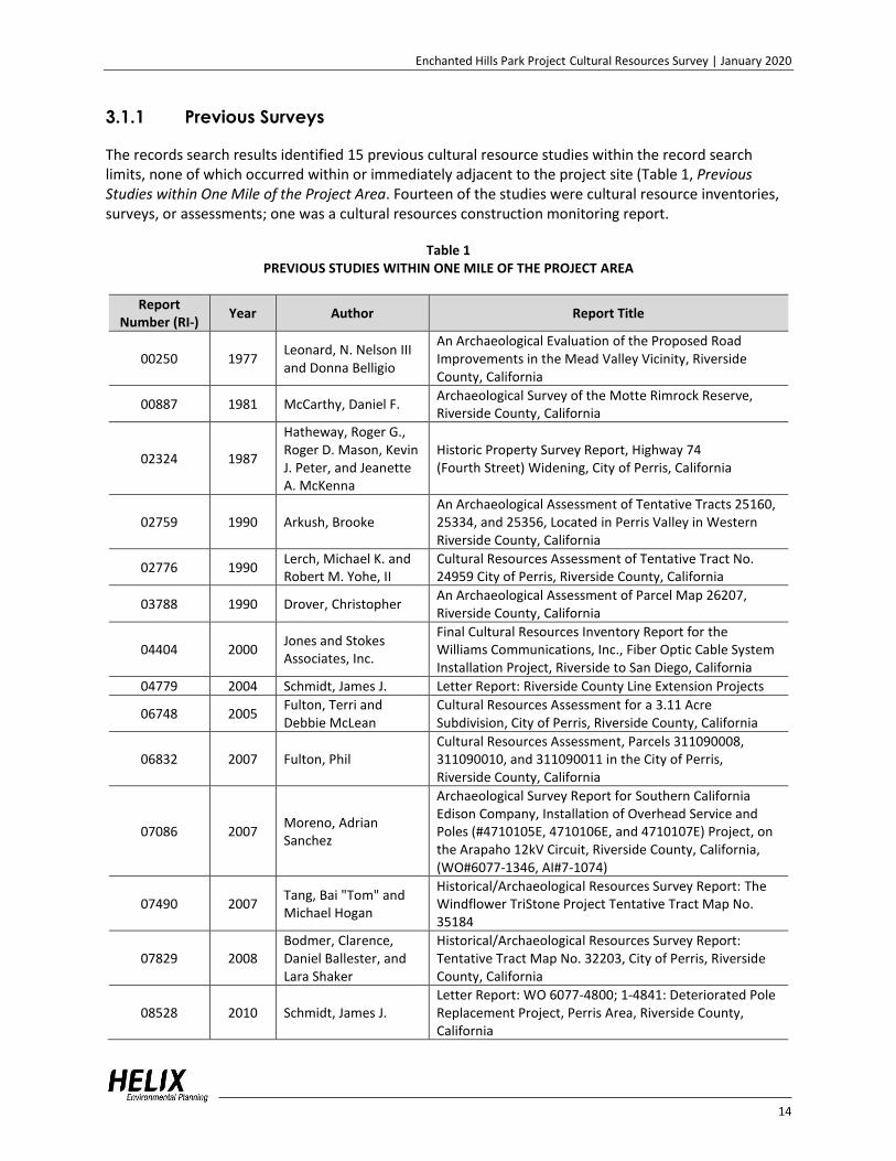
The records search results identified 15 previous cultural resource studies within the record search limits, none of which occurred within or immediately adjacent to the project site (Table 1, Previous Studies within One Mile of the Project Area. Fourteen of the studies were cultural resource inventories, surveys, or assessments; one was a cultural resources construction monitoring report.
Table 1 PREVIOUS STUDIES WITHIN ONE MILE OF THE PROJECT AREA
Report Number (RI-)
Year Author Report Title
00250 1977 Leonard, N. Nelson III and Donna Belligio
An Archaeological Evaluation of the Proposed Road Improvements in the Mead Valley Vicinity, Riverside County, California
00887 1981 McCarthy, Daniel F. Archaeological Survey of the Motte Rimrock Reserve, Riverside County, California
02324 1987
Hatheway, Roger G., Roger D. Mason, Kevin J. Peter, and Jeanette A. McKenna
Historic Property Survey Report, Highway 74 (Fourth Street) Widening, City of Perris, California
02759 1990 Arkush, Brooke An Archaeological Assessment of Tentative Tracts 25160, 25334, and 25356, Located in Perris Valley in Western Riverside County, California
02776 1990 Lerch, Michael K. and Robert M. Yohe, II
Cultural Resources Assessment of Tentative Tract No. 24959 City of Perris, Riverside County, California
03788 1990 Drover, Christopher An Archaeological Assessment of Parcel Map 26207, Riverside County, California
04404 2000 Jones and Stokes Associates, Inc.
Final Cultural Resources Inventory Report for the Williams Communications, Inc., Fiber Optic Cable System Installation Project, Riverside to San Diego, California
04779 2004 Schmidt, James J. Letter Report: Riverside County Line Extension Projects
06748 2005 Fulton, Terri and Debbie McLean
Cultural Resources Assessment for a 3.11 Acre Subdivision, City of Perris, Riverside County, California
06832 2007 Fulton, Phil Cultural Resources Assessment, Parcels 311090008, 311090010, and 311090011 in the City of Perris, Riverside County, California
07086 2007 Moreno, Adrian Sanchez
Archaeological Survey Report for Southern California Edison Company, Installation of Overhead Service and Poles (#4710105E, 4710106E, and 4710107E) Project, on the Arapaho 12kV Circuit, Riverside County, California, (WO#6077-1346, AI#7-1074)
07490 2007 Tang, Bai "Tom" and Michael Hogan
Historical/Archaeological Resources Survey Report: The Windflower TriStone Project Tentative Tract Map No. 35184
07829 2008 Bodmer, Clarence, Daniel Ballester, and Lara Shaker
Historical/Archaeological Resources Survey Report: Tentative Tract Map No. 32203, City of Perris, Riverside County, California
08528 2010 Schmidt, James J. Letter Report: WO 6077-4800; 1-4841: Deteriorated Pole Replacement Project, Perris Area, Riverside County, California

Enchanted Hills Park Project Cultural Resources Survey | January 2020
15
Table 1 (cont.) PREVIOUS STUDIES WITHIN ONE MILE OF THE PROJECT AREA
Report Number (RI-)
Year Author Report Title
08927 2013 Tang, Bai "Tom"
Archaeological Monitoring Program, Dollar General Project on Fourth Street near Park Avenue, APN 313-143-009; DPR 12-07-0011; GPA 12-07-0010, City of Perris, Riverside County, California
3.1.2 Previously Recorded Resources
The EIC has a record of 19 previously recorded cultural resources within a one-mile radius of the project, but none have been recorded within the project site (Table 2, Previously Recorded Resources within One Mile of the Project Area). The resources include 12 prehistoric archaeological sites, one multi-component site containing both a prehistoric component and a historic component, and six built environment historic buildings and/or structures. The prehistoric sites recorded within the records search limits consist of a habitation site with milling features, a rockshelter with a milling feature, and 10 bedrock milling feature sites. The multi-component site is recorded as a prehistoric habitation site with milling features and a historic component consisting of an abandoned quarry, a foundation, and an earthen dam. The six historic resources are historic addresses that include five private residences displaying varying types of architecture and dating to between circa 1900 and circa 1931, and one building complex described as the Palomar Military Academy, circa 1914, and then subsequently as the Perris Ranch.
Table 2 PREVIOUSLY RECORDED RESOURCES WITHIN ONE MILE OF THE PROJECT AREA
Primary Number (P-33-#)
Trinomial (CA-RIV-#)
Age Description Date, Recorder
000993 993 Prehistoric One milling slick on a low boulder 1980, McCarthy
000994 994 Prehistoric Two milling slicks on a low boulder 1980, McCarthy
001057 1057 Prehistoric/Historic Prehistoric habitation site with milling features; historic abandoned quarry, foundation, earthen dam, and trash
1976, Leonard; 1979, McIntyre and Foster; 1990, Wade, Bowden-Renna, and Collett
007620 - Historic Vernacular adobe residence, circa 1931 1982, Hedges
007636 - Historic Vernacular ranch house, circa 1900 1982, Harmon
007678 -
Historic Perris Ranch/Palomar Military Academy complex of vernacular and Spanish style structures, circa 1914
1982, Cross
012203 -
Historic Rural vernacular wood frame building circa 1931
1992, Lee
012204 -
Historic Mission style revival bungalow, circa 1930
1992, Lee
012206 - Historic Rural vernacular cottage, circa 1920 1992, Lee
015650 8207 Prehistoric One milling slick on a boulder, and quartz flake
2007, Fulton
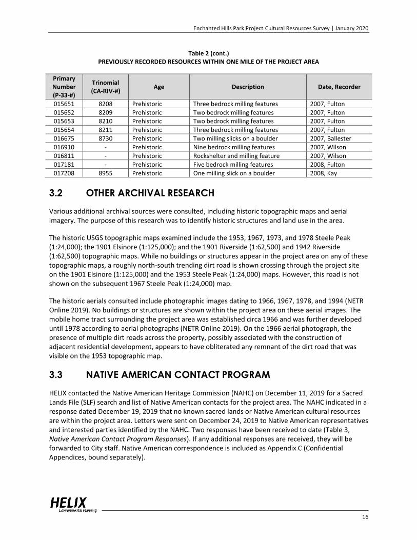
Enchanted Hills Park Project Cultural Resources Survey | January 2020
16
Table 2 (cont.) PREVIOUSLY RECORDED RESOURCES WITHIN ONE MILE OF THE PROJECT AREA
Primary Number (P-33-#)
Trinomial (CA-RIV-#)
Age Description Date, Recorder
015651 8208 Prehistoric Three bedrock milling features 2007, Fulton
015652 8209 Prehistoric Two bedrock milling features 2007, Fulton
015653 8210 Prehistoric Two bedrock milling features 2007, Fulton
015654 8211 Prehistoric Three bedrock milling features 2007, Fulton
016675 8730 Prehistoric Two milling slicks on a boulder 2007, Ballester
016910 - Prehistoric Nine bedrock milling features 2007, Wilson
016811 - Prehistoric Rockshelter and milling feature 2007, Wilson
017181 - Prehistoric Five bedrock milling features 2008, Fulton
017208 8955 Prehistoric One milling slick on a boulder 2008, Kay
3.2 OTHER ARCHIVAL RESEARCH
Various additional archival sources were consulted, including historic topographic maps and aerial imagery. The purpose of this research was to identify historic structures and land use in the area.
The historic USGS topographic maps examined include the 1953, 1967, 1973, and 1978 Steele Peak (1:24,000); the 1901 Elsinore (1:125,000); and the 1901 Riverside (1:62,500) and 1942 Riverside (1:62,500) topographic maps. While no buildings or structures appear in the project area on any of these topographic maps, a roughly north-south trending dirt road is shown crossing through the project site on the 1901 Elsinore (1:125,000) and the 1953 Steele Peak (1:24,000) maps. However, this road is not shown on the subsequent 1967 Steele Peak (1:24,000) map.
The historic aerials consulted include photographic images dating to 1966, 1967, 1978, and 1994 (NETR Online 2019). No buildings or structures are shown within the project area on these aerial images. The mobile home tract surrounding the project area was established circa 1966 and was further developed until 1978 according to aerial photographs (NETR Online 2019). On the 1966 aerial photograph, the presence of multiple dirt roads across the property, possibly associated with the construction of adjacent residential development, appears to have obliterated any remnant of the dirt road that was visible on the 1953 topographic map.
3.3 NATIVE AMERICAN CONTACT PROGRAM
HELIX contacted the Native American Heritage Commission (NAHC) on December 11, 2019 for a Sacred Lands File (SLF) search and list of Native American contacts for the project area. The NAHC indicated in a response dated December 19, 2019 that no known sacred lands or Native American cultural resources are within the project area. Letters were sent on December 24, 2019 to Native American representatives and interested parties identified by the NAHC. Two responses have been received to date (Table 3, Native American Contact Program Responses). If any additional responses are received, they will be forwarded to City staff. Native American correspondence is included as Appendix C (Confidential Appendices, bound separately).

Enchanted Hills Park Project Cultural Resources Survey | January 2020
17
Table 3 NATIVE AMERICAN CONTACT PROGRAM RESPONSES
Contact/Tribe Response
Agua Caliente Band of Cahuilla Indians (ACBCI)
Responded on January 9, 2020; the project area is not located within the boundaries of the ACBCI Reservation. However, it is within the Tribe’s Traditional Use Area. The ACBCI THPO requests the following:
*A copy of the records search with associated survey reports and site records from the information center. *A description of the proposed project. Please include information about any ground disturbing activities that may take place. *Copies of any cultural resource documentation (report and site records) generated in connection with this project.
Cahuilla Band of Indians
Responded on January 9, 2020; The Tribe does not have knowledge of any cultural resources within or near the project area. Although the project is located outside the Cahuilla reservation boundary, it is within the Cahuilla traditional land use area. Therefore, they do have an interest in this project. They believe that cultural resources may be unearthed during construction; they request tribal monitors from Cahuilla be present during all ground disturbing activities and to be notified of all updates with the project moving forward.
Per AB 52, a CEQA lead agency must consult with California Native American tribes that request consultation and that are traditionally and culturally affiliated with the geographic area of a proposed project to identify resources of cultural or spiritual value to the tribe, even if such resources are already eligible as historical resources as a result of cultural resources studies. The City has initiated consultation with the registered tribes, separate from this contact program; the consultation results will be addressed in the environmental document for the project.
4.0 FIELD SURVEY
4.1 SURVEY METHODOLOGY
An intensive pedestrian survey of the project site was conducted on November 25, 2019 by HELIX archaeologists Julie Roy and Mary Villalobos and Native American monitor Frank Morreo from the Soboba Band of Luiseño Indians. Where feasible, the project site was walked in transects spaced approximately 10 to 15 meters apart. Numerous granitic (tonalite) bedrock boulders are present in many areas of the property. Observed soils consisted of medium brown granitic sands.
Ground visibility was generally fair to good (ranging from 30 percent to 80 percent) throughout most of the project area (Plates 4 and 5); however the southeast portion of the project site exhibited poor visibility (less than 10 percent), where thick growths of grasses and weeds obscured the ground surface (Plate 6). Visibility was excellent (more than 80 percent) in portions of the project area that contained eroded soil and/or disturbed conditions (Plate 7). While the property is undeveloped, a considerable amount of ground disturbance is present from a variety of causes, including a BMX course in the southwest portion of the project area, where on-site soils and vehicle tires have been used to create ramps for jumping (see Plate 7). In addition, the south half of the project area is highly disturbed by modern dumping. Concrete piles, building material, domestic use items, mattresses, furniture, gravel, and other types of modern trash are scattered throughout this portion of the project area (Plate 8).

Enchanted Hills Park Project Cultural Resources Survey | January 2020
18
Plate 4. Overview from south end of project area (at Weston Road). View to the east.
Plate 5. Overview of central portion of project area. View to the west.

Enchanted Hills Park Project Cultural Resources Survey | January 2020
19
Plate 6. Area of dense vegetation in southeastern project area. View to the west.
Plate 7. Overview of bike ramps in southwest portion of survey area. View to the south.

Enchanted Hills Park Project Cultural Resources Survey | January 2020
20
Plate 8. Overview of modern trash in southern portion of project area. View to the north.
All bedrock outcrops and open ground were inspected for cultural modification and artifacts. Most of the bedrock in the project area is highly weathered. Many of the boulders appear to have been moved from their original position, and many appear to have been pushed into linear piles along the sides of Weston Road and West Metz Road, possibly during the creation of the roads.
4.2 SURVEY RESULTS
No cultural resources (prehistoric or historic) were observed within the project site during the field survey. While the project property is undeveloped, it was observed during the field survey to be disturbed by various modern activities, including the creation of several bike ramps, several dirt roads, and by the dumping of modern trash in some areas.
5.0 RESULTS
No cultural resources have been previously recorded within the project area, and no cultural material or features were observed within the project site during the field survey. Ground visibility varied, but overall was fair to good during the survey. The numerous bedrock outcrop surfaces were readily visible for examination for evidence of potential prehistoric milling features, and none were observed.

Enchanted Hills Park Project Cultural Resources Survey | January 2020
21
6.0 SUMMARY AND MANAGEMENT
RECOMMENDATIONS
A study was undertaken to identify cultural resources that are present in the Enchanted Hills Park Project site and to determine the possible effects of the project on cultural resources.
The results from the current study, including the records search and cultural resources field survey did not identify any cultural resources within the project area; therefore, no impacts to cultural resources are anticipated.
6.1 MANAGEMENT RECOMMENDATIONS
Based upon the findings of the cultural resources study, the project is expected to have no impacts to significant cultural resources. However, the general vicinity of the project has been occupied/used by the Luiseño, Cahuilla, and other native people for thousands of years, and there are numerous previously recorded cultural resources within the vicinity of the project; the potential remains for buried cultural resources to be present within the project area. In addition, two tribes have responded that the area is of interest to the Tribe, as it is located within the Cahuilla Traditional Use Area. Based on these factors, the following standard measures are recommended:
MM CR 1: A professional archaeologist shall be retained prior to the issuance of grading permits. The task of the archaeologist shall be to monitor the initial ground-altering activities at the subject site for the unearthing of previously unknown archaeological and/or cultural resources. Selection of the archaeologist shall be subject to the approval of the City of Perris Director of Development Services, and no grading activities shall occur at the site until the archaeologist has been approved by the City. The archaeological monitor shall be responsible for maintaining daily field notes and a photographic record, and for reporting all finds to the City of Perris in a timely manner. The archaeologist shall be equipped to record and salvage cultural resources that may be unearthed during grading activities. The archaeologist shall be empowered to temporarily halt or divert grading equipment to allow recording and removal of the unearthed resources.
In the event that archaeological resources are discovered at the project site, the handling of the discovered resources will differ. However, it is understood that all artifacts with the exception of human remains and related grave goods or sacred/ceremonial objects belong to the property owner. All artifacts discovered at the development site shall be inventoried and analyzed by the professional archaeologist.
If any artifacts of Native American origin are discovered, all activities in the immediate vicinity of the find (within a 50-foot radius) shall stop and the project archaeologist shall notify the City of Perris Planning Division, the Pechanga Band of Luiseño Indians, the Soboba Band of Luiseño Indians, and any other tribes identified by the California Native American Heritage Commission (NAHC) as being affiliated with the area. A designated Native American observer from one of the tribes identified by the NAHC as being affiliated with the area shall be retained to help analyze the Native American artifacts for identification as everyday life and/or religious or sacred items, cultural affiliation, temporal placement, and function, as deemed possible. The significance of Native American resources shall be evaluated in accordance with the provisions of CEQA and shall consider the religious beliefs, customs, and practices

Enchanted Hills Park Project Cultural Resources Survey | January 2020
22
of the Luiseño tribes. All items found in association with Native American human remains shall be considered grave goods or sacred in origin and subject to special handling.
Native American artifacts that are relocated/ reburied at the project site would be subject to a fully executed relocation/reburial agreement with the assisting Native American tribes or bands. This shall include measures and provisions to protect the reburial area from any future impacts. Relocation/ reburial shall not occur until all cataloging and basic recordation have been completed. Native American artifacts that cannot be avoided or relocated at the project site shall be prepared in a manner for curation at an accredited curation facility in Riverside County that meets federal standards per 36 CFR Part 79 and makes the artifacts available to other archaeologists/researchers for further study such as University of California, Riverside Archaeological Research Unit (UCR-ARU) or the Western Center for Archaeology and Paleontology (Western Science Center). If more than one Native American group is involved with the project and they cannot come to an agreement as to the disposition of Native American artifacts, they shall be curated at the Western Science Center by default. The archaeological consultant shall deliver the Native American artifacts, including title, to the accredited curation facility within a reasonable amount of time along with the fees necessary for permanent curation.
Non-Native American artifacts shall be inventoried, assessed, and analyzed for cultural affiliation, personal affiliation (prior ownership), function, and temporal placement. Subsequent to analysis and reporting, these artifacts will be subjected to curation or returned to the property owner, as deemed appropriate.
Once grading activities have ceased or the archaeologist, in consultation with the designated Native American observer, determines that monitoring is no longer necessary, monitoring activities can be discontinued following notification to the City of Perris Planning Division. A report of findings, including an itemized inventory of recovered artifacts, shall be prepared upon completion of the steps outlined above. The report shall include a discussion of the significance of all recovered artifacts. The report shall provide evidence that any Native American and non-Native American archaeological resources recovered during project development have been avoided, reburied, or curated at an accredited curation facility. A copy of the report shall also be filed with the EIC and submitted to the Pechanga Band of Luiseño Indians, the Soboba Band of Luiseño Indians, and any other Native American groups involved with the project.
MM CR 2: In the event that human remains (or remains that may be human) are discovered at the Project site during grading or earthmoving, the construction contractors, project archaeologist, and/or designated Native American observer shall immediately stop all activities within 100 feet of the find. The Project proponent shall then inform the Riverside County Coroner and the City of Perris Planning Division immediately, and the coroner shall be permitted to examine the remains as required by California Health and Safety Code Section 7050.5(b).
If the coroner determines that the remains are of Native American origin, the coroner would notify the Native American Heritage Commission (NAHC), which will identify the Most Likely Descendent (MLD). Despite the affiliation with any Native American representatives at the site, the NAHC’s identification of the MLD will stand. The MLD shall be granted access to inspect the site of the discovery of Native American human remains and may recommend to the Project proponent means for treatment or disposition, with appropriate dignity of the human remains and any associated grave goods. The MLD shall complete his or her inspection and make recommendations or preferences for treatment within 48 hours of being granted access to the site. The disposition of the remains will be determined in

Enchanted Hills Park Project Cultural Resources Survey | January 2020
23
consultation between the Project proponent and the MLD. In the event that the Project proponent and the MLD are in disagreement regarding the disposition of the remains, State law will apply and the mediation and decision process will occur with the NAHC (see Public Resources Code Section 5097.98(e) and 5097.94(k)).
The specific locations of Native American burials and reburials will be proprietary and not disclosed to the general public. The locations will be documented by the consulting archaeologist in conjunction with the various stakeholders and a report of findings will be filed with the EIC. If the human remains are determined to be other than Native American in origin, but still of archaeological value, the remains will be recovered for analysis and subject to curation or reburial at the expense of the project proponent. If deemed appropriate, the remains will be recovered by the Coroner and handled through the Coroner’s Office. Coordination with the Coroner’s Office would be through the City of Perris and in consultation with the various stakeholders.

Enchanted Hills Park Project Cultural Resources Survey | January 2020
24
7.0 REFERENCES
Applied Earth Works, Inc. 2001 Metropolitan Water District of Southern California, Eastside Reservoir Project, Final
Report of Archaeological Investigations. Volumes I to V. General editor, Susan K. Goldberg. Report prepared for the Metropolitan Water District of Southern California, Los Angeles.
Bean, Lowell J.
1972 Mukat's People. University of California Press, Berkeley.
1978 Cahuilla. In California, edited by Robert F. Heizer, pp. 575–587. Handbook of North American Indians, Vol. 8, William C. Sturtevant, general editor. Smithsonian Institution, Washington D.C.
Bean, Lowell J., and Florence C. Shipek
1978 Luiseño. In California, edited by Robert F. Heizer, pp. 550–563. Handbook of North American Indians, Vol. 8, William C. Sturtevant, general editor. Smithsonian Institution, Washington, D.C.
Bean, Lowell J., and Sylvia B. Vane (editors)
1979 Native Americans of Western Riverside County California and the Devers-Mira Loma 500 kV Transmission Line Route (Lamb-Canyon-Mira Loma Section). Prepared by Cultural Systems Research, Inc., Menlo Park, California, for Southern California Edison Company, Rosemead, CA.
Bean, Lowell J., Sylvia B. Vane, and Jackson Young
1991 The Cahuilla Landscape: The Santa Rosa and San Jacinto Mountains. Ballena Press, Menlo Park, CA.
Bettinger, Robert L.
1974 Dating the Perris Reservoir Assemblages. In Perris Reservoir Archaeology, edited by James F. O’Connell, Phillip J. Wilke, Thomas F. King, and Carol L. Mix, pp. 159–162. California Department of Parks and Recreation Reports No. 14. Sacramento.
Bissell, Ronald M., and Marilyn Morgan
1990 Cultural Resources Reconnaissance of the Winchester Hills Project Area, 2900 Acres in Riverside County, California. Prepared by RMW Paleo Associates, Inc. Prepared for Planning and Design Solutions. Report on file at the Eastern Information Center, University of California, Riverside.
Bolton, Herbert E.
1930 Anza's California Expeditions, Vols. I–IV. University of California Press, Berkeley.
Brigandi, Phil 1999 The Outposts of Mission San Luis Rey. Journal of San Diego History 45(2):106–112.

Enchanted Hills Park Project Cultural Resources Survey | January 2020
25
Bull, Charles S. 1983 Shaking the Foundations: The Evidence for San Diego Prehistory. Cultural Resource
Management Casual Papers 1:15–64. Department of Anthropology, San Diego State University.
California Native Plant Society
1997 Coastal scrubs – Holland Type and Status. Electronic document available at: http://davisherb.ucdavis.edu/cnpsActiveServer/holldetails.aspx?HOLLNAME=Coastal+scrubs, accessed on October 10, 2017.
Carrico, Richard L., Theodore G. Cooley, and Joyce M. Clevenger
1993 Archaeological Excavations at the Harris Site Complex, San Diego County, California. Report prepared by Ogden Environmental and Energy Services. Report on file at South Coastal Information Center, San Diego State University.
City of Perris
n.d. Perris History. Electronic document available at: http://www.cityofperris.org/about/history.html, accessed December 2019.
2005 Perris Comprehensive General Plan 2030, City of Perris, originally approved on April 26,
2005. Cupples, Sue Ann, and Ken Hedges
1977 San Luis Rey River Basin: Overview of Cultural Resources. San Diego State University Foundation. Prepared for US Army Corps of Engineers. Electronic document available at: http://www.dtic.mil/dtic/tr/fulltext/u2/a146300.pdf, accessed May 16, 2018.
Dillon, Brian D.
2002 California Paleo-Indians: Lack of Evidence, or Evidence of a Lack? In Essays in California Archaeology: A Memorial to Franklin Fenenga. Edited by William J. Wallace and Francis A. Riddell. Contributions of the University of California Archaeological Research Facility, No. 60. Berkeley, California.
Des Lauriers, Matthew R.
2008 A Paleoindian Fluted Point from Isla Cedros, Baja, California. Journal of Island & Coastal Archaeology 3:271–276.
DuBois, Constance
1908 The Religion of the Luiseño Indians of Southern California. University of California Publications in American Archaeology and Ethnology 8(3):69-186.
Erlandson, Jon M.
1994 Early Hunter-Gatherers of the California Coast. Plenum Press, New York.
1997 The Middle Holocene along the California Coast. In Archaeology of the California Coast during the Middle Holocene, edited by J.M. Erlandson and M.A. Glassow. pp. 61–72. Perspectives in California Archaeology, Vol. 4, J.E. Arnold, series editor. Institute of Archaeology, University of California, Los Angeles.

Enchanted Hills Park Project Cultural Resources Survey | January 2020
26
Erlandson, Jon M., Torben C. Rick, Terry L. Jones, and Judith F. Porcasi 2007 One If by Land, Two If by Sea: Who Were the First Californians? In California Prehistory:
Colonization, Culture, and Complexity, edited by Terry L. Jones and Kathryn A. Jones, pp. 53–62. Altamira Press, Lanham, Maryland.
Ezell, Paul 1987 The Harris Site: An Atypical San Dieguito Site, or Am I Beating a Dead Horse? In San
Dieguito-La Jolla: Chronology and Controversy, edited by Dennis Gallegos, pp. 15–22. San Diego County Archaeological Society Research Paper Number 1.
Fickewirth, A. A.
1992 California Railroads. Golden West Books, San Marino, California. Fitzgerald, Richard T., and Michael F. Rondeau
2012 A Fluted Projectile Point from Crystal Cove State Park, Orange County, Alta California. California Archaeology 4(2):247-256.
Gallegos, Dennis
1985 Batiquitos Lagoon Revisited. Cultural Resource Management Casual Papers 2(1). Department of Anthropology, San Diego State University.
1987 San Dieguito-La Jolla: Chronology and Controversy. San Diego County Archaeological
Society, Research Paper 1.
1991 Antiquity and Adaptation at Agua Hedionda, Carlsbad, California. In Hunter-Gatherers of Early Holocene Coastal California, edited by J. M. Erlandson and R. H. Colten, pp. 19–42. Perspectives in California Archaeology, Vol. 1, J. E. Arnold, series editor. Institute of Archaeology, University of California, Los Angeles.
Goldberg, Susan
2001 Land Use, Mobility, and Intensification Evaluation and Refinement of the Model. In Metropolitan Water District of Southern California, Eastside Reservoir Project, Final Report of Archaeological Investigations, Volume IV: Prehistoric Archaeology Synthesis of Findings, edited by S. K. Goldberg, Chap. 14. Report prepared by Applied Earthworks, Hemet, California for Metropolitan Water District of Southern California, Los Angeles.
Grenda, Donn R.
1997 Continuity & Change: 8,500 Years of Lacustrine Adaptation on the Shores of Lake Elsinore. Statistical Research Technical Series 59, Tucson.
Hyland, Justin R., and Maria De La Luz Gutierrez
1995 An Obsidian Fluted Point from Central Baja California. The Journal of California and Great Basin Anthropology 17(1): 126–128.
Jones, Terry L., Gary M. Brown, L. Mark Raab, Janet L. McVicker, W. Geoffrey Spaulding, Douglas J.
Kennett, Andrew York, and Phillip L. Walker 1999 Environmental Imperatives Reconsidered. Demographic Crisis in Western North America
during the Medieval Climatic Anomaly. Current Anthropology 40:137–170.

Enchanted Hills Park Project Cultural Resources Survey | January 2020
27
Kennett, Douglas J., and James P. Kennett 2000 Competitive and Cooperative Responses to Climatic Instability in Coastal Southern
California. American Antiquity 65:379–395. Kline, George E., and Victoria L. Kline
2007 Fluted Point Recovered from San Diego County Excavation. Proceedings of the Society for California Archaeology 20:55–59.
Knell, Edward J., and Mark S. Becker
2017 Early Holocene San Dieguito Complex Lithic Technological Strategies at the C.W. Harris Site, San Diego, California. Journal of California and Great Basin Anthropology 37(2):183-201.
Koerper, Henry C., Paul E. Langenwalter II, and Adella Schroth
1991 Early Holocene Adaptations and the Transition Phase Problem: Evidence from the Allan O. Kelly Site, Agua Hedionda Lagoon. In Hunter-Gatherers of Early Holocene Coastal California, edited by J. M. Erlandson and R. H. Colton, pp. 43–62. Perspectives in California Archaeology, vol. 1, J.E. Arnold, series editor. Institute of Archaeology, University of California, Los Angeles.
Kroeber, A. L.
1925 Handbook of the Indians of California. American Bureau of Ethnology Bulletin 78. Washington, D.C. Lithographed edition 1953, Third Printing 1970, California Book Company, LTD, Berkeley.
Lech, Steve
2004 Along the Old Roads: A History of the Portion of Southern California That Became Riverside County, 1772–1893. Steve Lech, Riverside, California.
Masiel-Zamora, Myra Ruth
2013 Analysis of ‘Éxva Teméeku, A Luiseño Indian Village Site Named Temeku, Located in Temecula, California. Master’s thesis, Department of Anthropology, San Diego State University.
McCown, B. E.
1955 Temeku. A Page from the History of the Luiseño Indians. Archaeological Survey Association of Southern California Paper No. 3.
McDougall Dennis P. 2001 CA-RIV-5086/H. In Metropolitan Water District of Southern California, Eastside Reservoir
Project, Final Report of Archaeological Investigations, Volume II: Archaic and Late Prehistoric Occupation Sites, edited by S. K. Goldberg, Chapt. 9. Prepared by Applied Earthworks, Hemet, California for Metropolitan Water District of Southern California, Los Angeles.

Enchanted Hills Park Project Cultural Resources Survey | January 2020
28
Miller, Wick R. 1986 Numic Languages. In Great Basin, edited by Warren L. D’Azevedo, pp. 98–112.
Handbook of the North American Indians, Vol. 11. William C. Sturtevant, general editor. Smithsonian Institution, Washington, D.C.
Moratto, Michael J.
1984 California Archaeology. Academic Press. Morton, Douglas M.
n.d. Geologic Map of the Steele Peak 7.5’ Quadrangle, Riverside County, California, version 1.0. Publicly available, but undated preliminary map. United States Geological Survey.
Natural Resources Conservation Service
2019 Web Soil Survey. United States Department of Agriculture. Electronic document available at: http://websoilsurvey.nrcs.usda.gov/app/WebSoilSurvey.aspx, accessed November 2019.
NETR Online
2019 Historic Aerials. Nationwide Environmental Title Research, LLC. Electronic document available at: http://www.historicaerials.com, accessed June 2019.
O’Connell, James F., Philip J. Wilke, Thomas F. King and Carol L. Mix, editors
1974 Perris Reservoir Archaeology: Late Prehistoric Demographic Change in Southeastern California. Report prepared by the Archaeological Research Unit, Department of Anthropology, University of California, Riverside, for the State of California Department of Parks and Recreation.
Pigniolo, Andrew R.
2005 A Different Context: San Dieguito in the Mountains of Southern California. Proceedings of the Society for California Archaeology 18:255-262.
Price, James N.
1988 The Railroad Stations of San Diego County. In The Journal of San Diego History, Spring 1988, Volume 34, Number 2. San Diego Historical Society Quarterly.
Robinson, Mark C.
2001 Units of Analysis. In Metropolitan Water District of Southern California, Eastside Reservoir Project, Final Report of Archaeological Investigations, Volume IV: Prehistoric Archaeology Synthesis of Findings, edited by S. K. Goldberg, Chapter 4. Prepared by Applied Earthworks, Hemet, California for Metropolitan Water District of Southern California, Los Angeles.

Enchanted Hills Park Project Cultural Resources Survey | January 2020
29
Rogers, Malcom 1939 Early Lithic Industries of the Lower Basin of the Colorado River and Adjacent Desert
Areas. San Diego Museum Papers No. 3.
1966 Ancient Hunters of the Far West, edited by Richard F. Pourade, pp. 21-108. Copley Press, La Jolla, California.
Rolle, Andrew F.
1963 California: A History. Thomas Y. Crowell Company, New York, New York. Rondeau, Michael F., James Cassidy, and Terry L. Jones
2007 Colonization Technologies: Fluted Projectile Points and the First Californians. In California Prehistory: Colonization, Culture, and Complexity, edited by Terry L. Jones and Kathryn A. Klar. AltaMira Press, Lanham, Maryland.
Sherman Indian Museum
n.d. “Perris Indian School.” Electronic document available at: http://www.shermanindianmuseum.org/perris.htm, accessed December 2019.
Shipley, William F.
1978 Native Languages of California. In California, edited by Robert F. Heizer, pp. 80-90. Handbook of North American Indians, Vol. 8, William C. Sturtevant, general editor, Smithsonian Institution, Washington, D.C.
Sparkman, Philip Stedman
1908 The Culture of the Luiseño Indians. University of California Publications in American Archaeology and Ethnology 8(4):187-234.
State Lands Commission
1982 Grants of Land in California Made by Spanish or Mexican Authorities. Boundary Determination Office, State Lands Commission, Boundary Investigation Unit.
Stine, Scott 1994 Extreme and Persistent Drought in California and Patagonia during Mediaeval Time.
Nature 369:546–549. Strong, William D.
1929 Aboriginal Society in Southern California. University of California Publications in American Archaeology and Ethnology 26(1):1–358. Berkeley.
Sutton, Mark Q., and Jill K. Gardner
2010 Reconceptualizing the Encinitas Tradition of Southern California. Pacific Coast Archaeological Society Quarterly, 42(4)1–64.
Sutton, Mark Q., and Donn R. Grenda
2012 Defining Level 1 at Malaga Cove (CA-LAN-138), Alta California. California Archaeology 4(1): 123–144.

Enchanted Hills Park Project Cultural Resources Survey | January 2020
30
Sutton, Mark Q., Mark E. Basgall, Jill K. Gardner, and Mark W. Allen 2007 Advances in Understanding Mojave Desert Prehistory. In California Prehistory:
Colonization, Culture, and Complexity, edited by Terry L. Jones and Kathryn A. Klar, pp. 229–245. Alta Mira Press, Lanham, Maryland.
The Perris Valley Historical & Museum Association
2016 Images of America: Perris Valley. Arcadia Publishing. Charleston, South Carolina. True, D. L.
1990 Site Locations and Water Supply: A Perspective from Northern San Diego County, California. Journal of New World Archaeology 7(4):37–60.
True, D. L., and Paul D. Bouey
1990 Gladishill: A Probable San Dieguito Camp Near Valley Center, California. Journal of New World Archaeology 7(4): 1-28.
Vaughan, Sheila J.
1982 A Replicative Systems Analysis of the San Dieguito Component at the C.W. Harris Site. Master’s thesis, Department of Anthropology, University of Nevada, Las Vegas.
Wallace, William J.
1955 Suggested Chronology for Southern California Coastal Archaeology. Southwestern Journal of Anthropology 11:214–230.
Warren, Claude N.
1966 The San Dieguito Type Site: M. J. Rogers’ 1938 Excavation on the San Dieguito River. San Diego Museum Paper No. 6, San Diego, California.
1967 The San Dieguito Complex: A Review and Hypothesis. American Antiquity 32(2):168-185.
1968 Cultural Tradition and Ecological Adaptation on the Southern California Coast. In Archaic
Prehistory in the Western United States, edited by C. Irwin-Williams, pp. 1–14. Eastern New Mexico University Contributions in Anthropology No. 1.
1984 The Desert Region. In California Archaeology, edited by Michael J. Moratto, pp. 339–
430. Academic Press, Orlando, Florida. Warren, Claude N., and H. T. Ore
2011 The Age of the San Dieguito Artifact Assemblage at the C. W. Harris Site. Journal of California and Great Basin Anthropology 31(1):81-97.
Warren, Claude N., Gretchen Siegler, and Frank Dittmer
1998 Paleo-Indian and Early Archaic Periods. In Prehistoric and Historic Archaeology of Metropolitan San Diego: A Historic Properties Background Study. Draft report prepared by ASM Affiliates and submitted to Metropolitan Wastewater, San Diego.

Enchanted Hills Park Project Cultural Resources Survey | January 2020
31
Warren, Claude N., and D. L. True 1961 The San Dieguito Complex and Its Place in San Diego County Prehistory. Archaeological
Survey Annual Report, 1960-1961, pp. 246-291. University of California, Los Angeles. Weber, David
1992 The Spanish Frontier in North America. Yale University Press. White, Raymond C.
1963 Luiseño Social Organization. University of California Publications in American Archaeology and Ethnology 48(2):91-194.
Wilke, Philip
1974 Settlement and Subsistence at Perris Reservoir: A Summary of Archaeological Investigations. In Perris Reservoir Archaeology, edited by James F. O’Connell, Philip J. Wilke, Thomas F. King, and Carol L. Mix, pp. 20–30. California Department of Parks and Recreation Reports No. 14. Sacramento.

Enchanted Hills Park Project Cultural Resources Survey | January 2020
32
This page intentionally left blank

Appendix AResumes

Stacie Wilson, MS, RPA Project Manager
Summary of Qualifications
Ms. Wilson has been professionally involved in CRM for 15 years and has
more than 17 years of unique experience in both archaeology and GIS. She
has served as principal investigator on numerous cultural resources
management projects, and regularly coordinates with local, state, and federal
agencies and Native American tribal representatives. She is skilled in project
management, archaeological inventories and excavation, and report
documentation and has broad experience on private, municipal, federal, utility,
and renewable energy projects. Her years of experience also encompass an
understanding of CEQA and NEPA compliance regulations. She is proficient
at creating, organizing, and analyzing GIS data; her technical skills include
ArcGIS 10.4, Spatial Analyst, Geostatistical Analyst, and working with
datasets in Microsoft Word and Excel. Ms. Wilson is detail oriented and has
strong organizational and coordination capabilities. She has managed large-
scale surveys and site evaluations and designed and implemented site
mitigation programs throughout southern California.
Selected Project Experience
Apple Valley Airport Detention Basin IS/MND (2017-2018). Project Manager for the preparation of an IS/MND for the acquisition of an approximately 18-acre property at the airport for construction of a detention basin to address stormwater runoff. Work performed for C&S Companies, with San Bernardino County as the lead agency. Roripaugh Ranch - Phase 2 Project (2018-2018). Principal Investigator for a records search and background research, Native American coordination and contacting the NAHC, field survey, coordination with USACE, and preparation of a report addressing the NHPA Section 106 compliance Cactus II Feeder Transmission Pipeline IS/MND (2017-2018). Senior Archaeologist overseeing cultural resources survey and report for this proposed pipeline project, including background research and Native American outreach. Assisted EMWD with Native American consultation under AB 52. The project will construct five miles of new transmission pipeline to serve planned development in Moreno Valley. Work performed for EMWD Southern California Edison (SCE) As-Needed Environmental Compliance Support (2015-2016). Principal Investigator and Field Director for various as-needed projects located within SCE territory throughout several counties. Duties included coordination of cultural records searches, surveys, and reporting efforts for Capital Improvement and Transmission Line Rating Remediation (TLRR) program projects. Valley South Subtransmission Project (2012- 015). Field Director and report author for a cultural resources inventory of the proposed Valley South Subtransmission Project located in
Education
Master of Science,
Applied Geographical
Information Science,
Northern Arizona
University, 2008
Bachelor of Arts,
Anthropology,
University of
California, San Diego,
2001
Bachelor of Science,
Biological
Psychology,
University of
California, San Diego,
2001
Registrations/
Certifications Register of
Professional
Archaeologists, The
Register of
Professional
Archaeologists
#16436, 2008,
Riverside County
Approved Cultural
Resources
Consultant, 2017
Professional
Affiliations
Society for California
Archaeology

Stacie Wilson, MS, RPA Project Manager
2
western Riverside County. Covering over 20 miles, the Phase I inventory and field survey project included compilation of record searches, a Native American contact program, field surveys, and completion of a Cultural Resources Survey Report and Proponent's Environmental Assessment section. Work performed for SCE, with the California Public Utilities Commission as the lead agency. Path 42 Transmission Line Project (2012-2013). Field Director for a cultural resources survey of the proposed Path 42 Transmission Line Project in Riverside County. Covering 233 acres, the Class III study included compilation of record searches, a Native American contact program, field surveys, and completion of a cultural resources Class III report. Work performed for Imperial Irrigation District (IID), with BLM as the lead agency. Antelope Valley Solar Project (2011-2012). Field Director, GIS Specialist, and report author for solar electric-generating facilities proposed on an approximately 5,000-acre site in Kern and Los Angeles counties. The project included the organization of a records search, Native American contact program, archaeological and built environment surveys, the recordation of cultural resources, and the preparation of cultural resources reports. Work performed for Renewable Resources Group, Inc., with the County of Kern as the lead agency. Bureau of Land Management National Historic Trails Inventory, AZ, CA, CO, NM, NV, UT, WY (2010-2012). GIS Task Lead for a multi-state initiative that focused on identifying, field inventorying, and assessing the cultural and visual resources of six National Historic Trails located on land owned by BLM. The inventory included examining high potential route segments and high potential historic sites of the Old Spanish, El Camino Real de Tierra Adentro, California, Oregon, Mormon Pioneer, and Pony Express National Historic Trails. Task lead duties included technical guidance, development of methodology, establishment of protocols and standards for field work, and reviewing of technical work for the GIS-related tasks. Mojave Solar Project and Lockhart Substation Connection & Communication Facilities (2010-2011). Project Manager, Field Director, and Class III report author for a cultural resources survey of the Lockhart Substation Connection & Communication Facilities for the proposed Mojave Solar Project. The project was located on private, BLM, and Edwards Air Force Base lands in San Bernardino County and included surveying 85 linear miles in the Mojave Desert region of California. Work performed for Mojave Solar, LLC, with BLM as the lead agency. Blythe and Palen Solar Power Projects (2009-2014). GIS Analyst and Field Archaeologist for concentrated solar electric-generating facilities proposed on approximately 2,000-acre and 7,000-acre sites. Proposed facilities were to be located on land in eastern Riverside County owned by the BLM. The projects, under a Fast-Track The American Recovery and Reinvestment Act of 2009 funding schedule, will use well-established parabolic trough solar thermal technology to produce electrical power using a steam turbine generator fed from a solar steam generator. Work included extensive resource and project GIS data management. Work performed for Solar Millennium, LCC, with the BLM as the lead agency.