Emily and Jessie Gaps Nature Park€¦ · Emily and Jessie Gaps Nature Park Plan of...
34
EMILY AND JESSIE GAPS NATURE PARK PLAN OF MANAGEMENT September 2000 PARKS AND WILDLIFE COMMISSION OF THE NORTHERN TERRITORY
Transcript of Emily and Jessie Gaps Nature Park€¦ · Emily and Jessie Gaps Nature Park Plan of...

EMILY AND JESSIE GAPSNATURE PARK
PLAN OF MANAGEMENT
September 2000
PARKS AND WILDLIFE COMMISSION OF THE NORTHERN TERRITORY

Emily and Jessie Gaps Nature Park Plan of ManagementSeptember 2000 i
Parks and Wildlife Commission of the Northern TerritoryP.O. Box 1046Alice Springs NT 0871
Emily and Jessie Gaps Nature ParkPlan of Management
September 2000
ISBN No. 0 724527788
Emily and Jessie Gaps Nature Park Plan of ManagementSeptember 2000 ii
Foreword
The Emily and Jessie Gaps Nature Park, a scenic area close to Alice Springs, is anexample of the Parks and Wildlife Commission’s commitment to the NorthernTerritory’s rich and diverse Aboriginal culture.
The Park protects sacred sites and galleries of rock painting significant to the ArrernteAboriginal people and associated with the Yeperenye (caterpillar) and other dreamings.
The Park was declared in 1980 following a request from one of the site’s Aboriginalcustodians with a specific request to keep the area low-key and intimate.
This Plan of Management recognises the importance of cultural values including sacredsites, rock art sites and native flora and fauna to the local Aboriginal people. It stipulatesmanagement measures required to ensure the integrity of the Park’s cultural and naturalvalues, while offering sensitive and low-key recreational opportunities for visitors.
Major management directions for the Park are summarised below.
• The continued protection and interpretation of Aboriginal cultural values, sitesand features of Aboriginal importance.
• The continued protection, conservation and management of the Park’s naturalresources and processes, including native flora and fauna, geological and waterresources.
• The encouragement of informed appreciation and enjoyment, and appropriatelow-key day-use by the public in an essentially undeveloped and naturalenvironment.
• To reduce the level of vandalism and inappropriate behaviour in the Park.
Acknowledgments
This Plan of Management has been prepared by the Parks and Wildlife Commission’sStrategic Planning & Development Unit, Southern Regional Office, Alice Springs.
Special acknowledgments for assistance in preparation of the Plan are due to the Aboriginalcustodians for the Park and the Aboriginal Areas Protection Authority, to ArchaeologistJune Ross for the Site Condition Report, Rock Art - Emily Gap and the Emily and JessieGaps Nature Park Planning Team.

Emily and Jessie Gaps Nature Park Plan of ManagementSeptember 2000 iii
CONTENTS Page
FOREWORD ii
ACKNOWLEDGEMENTS ii
CONTENTS iii
1. INTRODUCTION TO THE PLAN 11.1 Location and Values 11.2 The Concept of the Park and its Purposes 21.3 The Principal Purposes of the Plan 21.3 The Intent of this Plan 2
2. ZONING SCHEME 42.1 Outline of Zoning Scheme 42.2 Visitor Facilities Zone 42.3 Special Protection Zone 42.4 Rock climbing, Abseiling Zone 52.5 Natural Zone 5
3. MANAGEMENT OF THE PARK’S CULTURAL RESOURCES 83.1 Objectives 83.2 Aboriginal Cultural Resources 83.3 Potential Aboriginal Involvement 9
4. MANAGEMENT OF THE PARK’S NATURAL RESOURCES 114.1 Objectives 114.2 Geology, Landforms and Soils 114.3 Native Flora 124.4 Native Fauna 134.5 Introduced Plants and Animals 134.6 Use and Control of Fire 14
5. MANAGEMENT OF ABORIGINAL INTERESTS 155.1 Objectives 155.2 Scared and Significant Sites 15
6. MANAGEMENT OF VISITORS 166.1 Objectives 166.2 Regional Context 166.3 Visitor Access 166.4 Visitor Facilities 166.5 Information and Interpretation 176.6 Visitor Monitoring 196.7 Visitor Safety 19
Emily and Jessie Gaps Nature Park Plan of ManagementSeptember 2000 iv
7. PARK ADMINISTRATION 207.1 Objectives 207.2 Staffing and Management 207.3 Liaison with Neighbouring Landholders 217.4 Research and Monitoring 217.5 Legal Requirements 217.6 Vandalism and Inappropriate Behaviour 227.7 Performance Audit 23
8 FUTURE PARK EXTENSIONS 248.1 Management of Park Extension Areas 24
9. MANAGEMENT PROGRAMS 26
10. SOURCES AND REFERENCES 29
FIGURES
Figure 1 - The Park and Locality 3Figure 2 - Zoning Scheme 7Figure 3- Example of Visual Guide to monitor Aboriginal art 10Figure 4 - Heavitree Range extension to Park 25
TABLES
Table 1 - Summary of Zoning Scheme 6

Emily and Jessie Gaps Nature Park, Plan of Management September 2000
1
1. INTRODUCTION TO THE PLAN
1.1 Location and Values
Emily and Jessie Gaps Nature Park is located in the Heavitree Range (part of the EastMacDonnell Ranges) approximately 10 kilometres east of Alice Springs. The Park isapproximately 800 metres wide and 8.6 kilometres long and features two attractive Gaps withsemi permanent waterholes. Access from Alice Springs east to Emily and Jessie Gaps is via thesealed Ross Highway. The Park is popular with locals and visitors alike who visit the area briefly,usually before proceeding to other locations in the East MacDonnell Ranges.
The Park (NT Portion 775) covers an area of 695.2 hectares and is bordered on the northern sideby Undoolya Station, by the Arltunga Stock Route (NT Portion 4296) on the southern and easternsides and the town of Alice Springs on the western side (see figure 1.).
NT Portion 775 was proclaimed as Reserve No. 1159 under section 103 of the Crown Lands Acton 25 August 1965 (NTG 38). The Reserve was vested in the NT Reserves Board on 20 April1966 (NTG 21). The area remained a Reserve until 30 June 1978 when it was declared a Parkunder Section 12 of the Territory Parks and Wildlife Conservation Act (NTG 26A). On 21September 1979 the Reserve was renamed to Emily and Jessie Gaps Nature Park. A Reservationfrom Occupation, (R.O. 1127), covering all of NT Portion 775, was declared on 6 June 1985(Gazette S25) under section 178 (1) of the Mining Act.
The Central Land Council has submitted a Land Claim (LC 212) under the Aboriginal LandRights Act (Northern Territory) over the Park on behalf of Aborigines claiming to have atraditional claim to the area. The claim was lodged on 4 June 1997 and is in the early stages ofresolution. There has been no determination of native title over the Park and it is not presentlysubject to a native title claim however the NT Attorney General’s Department advised in August2000 that the PWCNT should assume that native title rights exist over the Park
The tourism and recreational values of the Park relate to the section of the Heavitree Rangecontaining Emily and Jessie Gaps. Both gaps have examples of Aboriginal art and contain semipermanent waterholes. The Park is easily accessible from Alice Springs and is a popular stop forvisitors venturing further into the East MacDonnell Ranges to destinations such as TrephinaGorge, Ross River and Arltunga. The Park offers visitors recreational activities such aspicnicking, bush walking, nature appreciation and Aboriginal culture appreciation. Areas withinthe Park are also used for rock climbing and abseiling, particularly by Emergency Services forthe instruction of school groups.
The Eastern Arrernte Aboriginal people have important cultural associations with the Park area.It contains several registered sacred sites related to the Yeperenye (Caterpillar) and otherdreaming trails-Atherrke (Jessie Gap) 5750-2 and Anthwerrke (Emily Gap) 5650-28. Anotherregistered sacred site Nthwerrke Utnerrengatye 5650-50 extends from Heavitree Gap along theHeavitree Range to the western side of Emily Gap and overlaps the Anthwerrke site. The Park’sAboriginal cultural significance relates to these sacred sites. The paintings at Emily Gap areamong the most spectacular examples of Aboriginal totemic art in central Australia and are ofmajor anthropological value. Aboriginal rock paintings are also located at Jessie Gap. Both sitesare registered with the Northern Territory Museum. The sacred site boundary covering theAnthwerrke and Atherrke sacred sites coincides with the Park boundary (NT Portion 775).
Emily and Jessie Gaps Nature Park, Plan of Management September 2000
2
The natural values of the Park are primarily related to a section of the Heavitree Rangecontaining Emily and Jessie Gaps and the native flora and fauna associated with this part of theRange.
1.2 The Concept of the Park and its Purposes
The main purpose of the Park is to protect and conserve the cultural and natural resources whilstallowing visitors the opportunity to visit and enjoy the Park.
Management will aim to retain the predominantly natural character of the Park and consequentlyall developments will be designed to facilitate visitor enjoyment without impairing the culturaland natural values of the Park.
1.3 The principal purposes of the Park are to;
• protect Aboriginal cultural values, sites and features of Aboriginal importance, inaccordance with the Northern Territory Aboriginal Sacred Sites Act,
• protect, conserve and manage the Park’s natural resources, including flora, fauna,geological and water resources,
• interpret the Park’s Aboriginal cultural and natural values enabling visitors the opportunityto appreciate and understand these values.
• provide low-key recreational opportunities consistent with the essentially undeveloped andnatural environment of the Park
1.4 The Intent of this Plan
The aim of this Plan is to ensure protection and conservation of the values stated above whilstproviding opportunities for people to enjoy the Park.
The Plan states the intent of the Parks and Wildlife Commission of the Northern Territory(PWCNT) with respect to the management and conservation of Emily and Jessie Gaps NaturePark. The Plan provides management objectives, addresses current management issues andproposes appropriate measures to guide future management and development on the Park.
This Plan has been prepared in pursuance of sections 18 and 19 of the Territory Parks andWildlife Conservation Act and will fulfil the function of a Plan of Management.
The PWCNT is obliged under section 21 of the Territory Parks and Wildlife Conservation Actto manage the Park in accordance with this Plan once it has come into operation. The Plan willbe in force for a minimum of five years and a maximum of ten years, unless revoked by a newplan, or amended in accordance with section 20 of the Territory Parks and Wildlife ConservationAct .

Emily and Jessie Gaps Nature Park, Plan of Management September 2000
3
Figure 1. The Park and Locality

Emily and Jessie Gaps Nature Park, Plan of Management September 2000
4
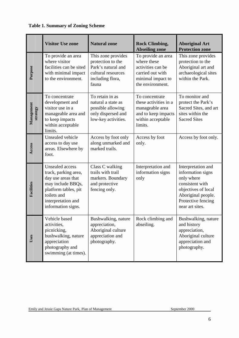
2. ZONING SCHEME
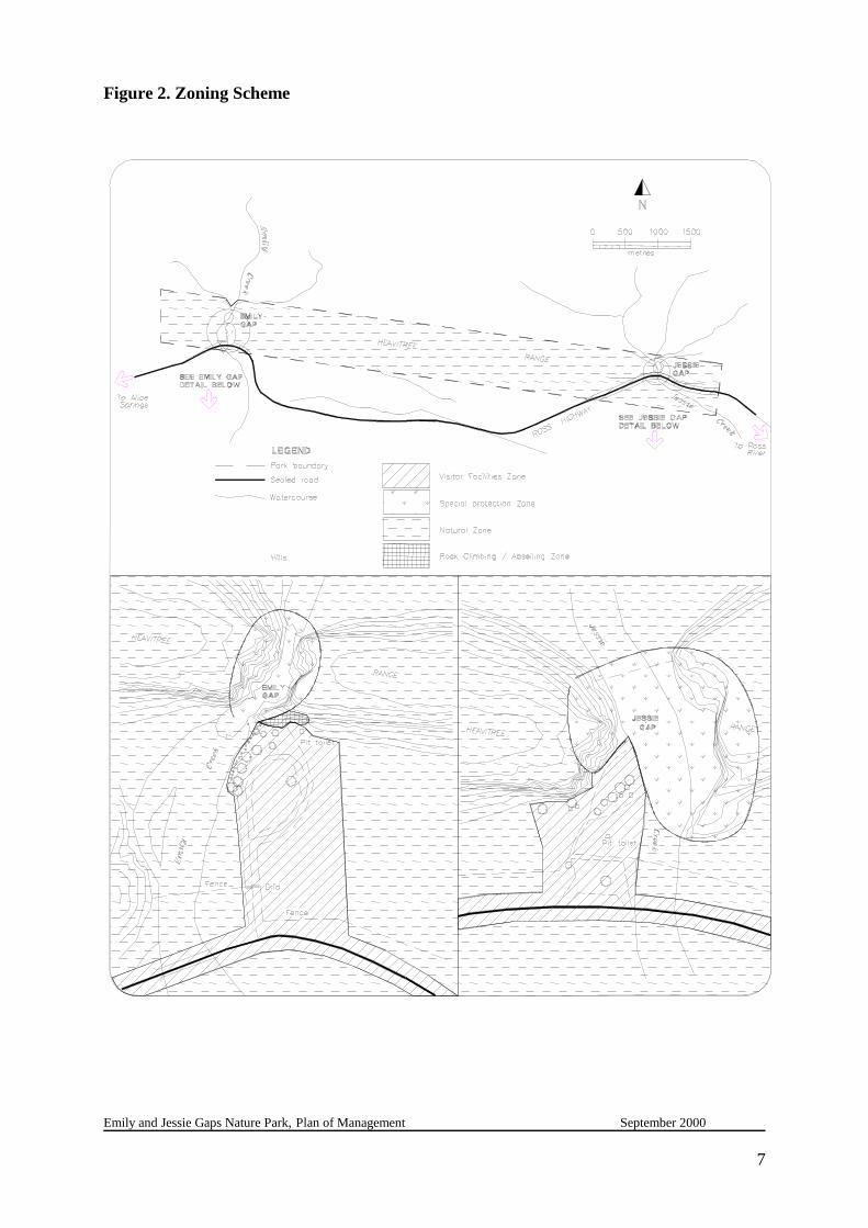
The Zoning Scheme (see Figure 2) is an important tool in pursuing the intent of this Plan. Thescheme provides the basis for regulating the activities of visitors and allowing for appropriatemanagement of the Park’s resources.
Visitor access to any of the zones may be restricted if it is seen to be having a deleterious effecton the values of the Park.
Any developments will be carried out with a minimum of interference to the natural environmentand according to the requirements of the Environmental Assessment Act, the Northern TerritoryAboriginal Sacred Sites Act, the Territory Parks and Wildlife Conservation Act, the HeritageConservation Act and other relevant legislation.
2.1 Outline of the Zoning Scheme
Four zones have been identified to regulate the use, development and management of the Park:
• Visitor Facilities Zone• Aboriginal Art Protection Zone• Rock Climbing, Abseiling Zone• Natural Zone
The purpose of each zone is outlined below having been determined on the basis of the valuesoccurring in the specified areas.
2.2 Visitor Facilities Zone
The purpose of this zone is to provide for a variety of day-use and recreational opportunities ina natural setting. Minimal disturbance to the natural resources will occur during the siting anddevelopment of facilities.
Facilities provided in the zone may include walking tracks, platform tables, BBQ’s, car parking,pit toilets and unobtrusive information and interpretive signs. Access in this zone will be byvehicle to car parking areas then by walking tracks to the main features of the Park.
2.3 Aboriginal Art Protection Zone
This zone provides protection to the Aboriginal art sites within the Park at Emily and Jessie Gaps.Management will aim to prevent damage to these sites by informing visitors in pre visitinformation and on site signage of the importance of such sites to Aboriginal people, the penaltiesimposed to anyone interfering or damaging such sites and of the need for appropriate behaviourwhile visiting such sites. Appropriate Management and protection strategies for the art sites willbe carried out following consultation with the Aboriginal areas Protection Authority (AAPA) andthe Aboriginal custodians.Facilities will be limited to carefully located information signs and barrier fencing at vulnerableAboriginal art sites. Visitor access through this Zone will be by foot only.

Emily and Jessie Gaps Nature Park, Plan of Management September 2000
5
The PWCNT has realised with experience that it is often difficult to provide complete protectionof any site or facility at an unstaffed park or reserve. The PWCNT however strives to achievemaximum protection to all sites and facilities on the PWCNT estate.
2.4 Rock Climbing, Abseiling Zone
Rock climbing and abseiling activities are currently conducted within the Reserve at Emily Gap.These activities are conducted at Emily Gap at the northern end of the car park. The main usersof this area are school groups under the guidance of Emergency Services instructors. TheAboriginal custodians for the site have approved the continuation of these activities within thePark providing that they are conducted at this site only.
Facilities within this zone will be limited to carefully located information and interpretive signsadvising climbers of the need for appropriate behaviour and safety. Visitor access through thiszone will be by foot only.
2.5 Natural Zone
The principal purpose of the Natural Zone is to protect the area’s natural resources including theflora and fauna within the different vegetation communities represented in the Park.
Only low-impact activities such as bushwalking will be permitted. To retain the natural characterof this zone the only developments permitted will be boundary and protective fencing and theprovision for a future class C walking trail. This trail could run from Jessie Gap along the Rangeto Emily Gap with the possibility of extending to Heavitree Gap.
Emily and Jessie Gaps Nature Park, Plan of Management September 2000
6
Table 1. Summary of Zoning Scheme
Visitor Use zone Natural zone Rock Climbing,Abseiling zone
Aboriginal ArtProtection zone
Purp
ose
To provide an areawhere visitorfacilities can be sitedwith minimal impactto the environment.
This zone providesprotection to thePark’s natural andcultural resourcesincluding flora,fauna
To provide an areawhere theseactivities can becarried out withminimal impact tothe environment.
This zone providesprotection to theAboriginal art andarchaeological siteswithin the Park.
Man
agem
ent
stra
tegy
To concentratedevelopment andvisitor use in amanageable area andto keep impactswithin acceptablelimits.
To retain in asnatural a state aspossible allowingonly dispersed andlow-key activities.
To concentratethese activities in amanageable areaand to keep impactswithin acceptablelimits.
To monitor andprotect the Park’sSacred Sites, and artsites within theSacred Sites
Acc
ess
Unsealed vehicleaccess to day useareas. Elsewhere byfoot.
Access by foot onlyalong unmarked andmarked trails.
Access by footonly.
Access by foot only.
Faci
litie
s
Unsealed accesstrack, parking area,day use areas thatmay include BBQs,platform tables, pittoilets andinterpretation andinformation signs.
Class C walkingtrails with trailmarkers. Boundaryand protectivefencing only.
Interpretation andinformation signsonly
Interpretation andinformation signsonly whereconsistent withobjectives of localAboriginal people.Protective fencingnear art sites.
Use
s
Vehicle basedactivities,picnicking,bushwalking, natureappreciationphotography andswimming (at times).
Bushwalking, natureappreciation,Aboriginal cultureappreciation andphotography.
Rock climbing andabseiling.
Bushwalking, natureand historyappreciation,Aboriginal cultureappreciation andphotography.
Emily and Jessie Gaps Nature Park, Plan of Management September 2000
7
Figure 2. Zoning Scheme

Emily and Jessie Gaps Nature Park, Plan of Management September 2000
8
3. MANAGEMENT OF THE PARKS CULTURAL RESOURCES
3.1 Objectives
• To conserve Aboriginal Sites through information and interpretation signs and in pre-visitinformation.
• To encourage further research into the Aboriginal culture and use of the area includingmethods to preserve and protect art sites.
3.2 Aboriginal Cultural Resources
The Aboriginal Areas Protection Authority have advised that the Park contains two registeredSacred Sites and has another overlapping the western end of the Park. Both sacred sites are relatedto the Yeperenye (Caterpillar) and other dreaming trails, Atherrke (Jessie Gap) 5750-2 andAnthwerrke (Emily Gap) 5650-28. Another registered sacred site Nthwerrke Utnerrengatye 5650-50 extends from Heavitree Gap along the Heavitree Range to the western side of Emily Gap andoverlaps the Anthwerrke site. The boundary of the Emily and Jessie Gap Sacred Sites have acommon boundary with NT Portion 775
Aboriginal rock paintings at Emily and Jessie Gaps are among the most spectacular examples ofAboriginal totemic art in central Australia and are of major anthropological value (Ginns 1993).Both sites are registered with the Northern Territory Museum. An extensive rock art reportcovering Emily, Jessie and Heavitree Gaps has been produced for the Traditional Owners to theAboriginal areas Protection Authority and the Australian Heritage Commission (R.G Gunn 1999).This comprehensive report covers the main art sites at the gaps as well as lesser known sites,archaeological sites and describes the significance of these sites to Aboriginal people. A sitecondition survey of the Emily Gap rock art was also conducted during 1999 by ArchaeologistJune Ross with visual guides produced to help PWCNT staff maintain and protect the rock artwithin Emily Gap.
Barrier fencing and interpretive signage near the paintings in Emily Gap were installed in 1999at the request of the Aboriginal custodians through AAPA. The custodians were concerned aboutvisitors touching and being too close to the paintings in the Gap.
Management actions
3.2.1 Local Aboriginal people and their representative organisations will continue to beconsulted over research into the Aboriginal cultural values and significance of the Parkand Aboriginal cultural information suitable for possible inclusion in the Park’s pre visitand on site interpretation.
3.2.2 All new developments in the Park require a certificate of clearance from the AboriginalAreas Protection Authority.

Emily and Jessie Gaps Nature Park, Plan of Management September 2000
9
3.2.3 Management will ensure that visitor use complies with conditions set down in clearance certificates.
3.2.4 Any Aboriginal sites/artefacts that may be in the Park are protected as “PrescribedArchaeological Places and Objects” under the Heritage Conservation Act.
3.2.5 Aboriginal artefacts found on the Park will be left in situ wherever practicable, unless theAboriginal custodians wish to determine alternative arrangements. Artefacts in dangerof being damaged or souvenired may be documented and collected for storage or display,in accordance with the wishes of the Aboriginal custodians and subject to approval bythe Minister for Lands Planning and Environment.
3.2.6 Pre visit information and on site signage will advise visitors on the correct behaviour inareas of Aboriginal significance and to be aware of their responsibilities.
3.2.7 PWCNT staff will use the Site Condition Report Rock Art – Emily Gap (J.Ross 1999) andthe visual guides in the report to manage and protect the art sites within Emily Gap.
3.2.8 PWCNT staff will continue to monitor the condition of the barrier fencing at the art sitein Emily Gap and immediately make good any damage.
3.3 Potential Aboriginal Involvement
There is a strong cultural attachment of the Aboriginal custodians to the land covered by the Parkand the surrounding area. It is the intention of the PWCNT to build a partnership with theAboriginal people responsible for the care of these sites. This will ensure that management takesproper account of Aboriginal perspectives and the conservation needs of cultural sites and areas.
This partnership has the potential to enhance the Park by providing opportunities for Aboriginalpeople to contribute to Park management. Aboriginal culture is an integral part of the Park’svalues through interpretation and will provide opportunities for Aboriginal people to operatecommercial concessions in association with the Park.
People of the Eastern Arrernte language group have had a long association with the areasurrounding the Park. Physical evidence of this are the art sites associated with the caterpillardreaming located at Emily and Jessie Gaps.
By Aboriginal Law, the Aboriginal custodians have responsibility to look after country and sites.The cultural associations are also of inherent interest to Park visitors.
The following approaches to management strategies apply to the Park:
• The Commission recognises that management, when developing the Park needs to takeaccount of Aboriginal perspectives and the conservation needs of cultural sites and areas. Thisadds to the intrinsic value of the Park from a visitor perspective. It enhances the Park’s valuewith the addition of a strong cultural element and provide opportunities for visitors to learnof contemporary Aboriginal culture.
• This will be achieved though consultation and discussion between the Aboriginal custodians,AAPA and the PWCNT.
• The outcomes would mean meeting common goals in relation to management particularly

Emily and Jessie Gaps Nature Park, Plan of Management September 2000
10
with respect to fire, weeds and feral animal control, biological surveys, cultural interpretationand visitor management.
• The Commission recognises that an important aspect of the future of the Park is that TheAboriginal custodians maintain their cultural responsibilities in relation to sites within thePark.
• Opportunities to engage in tourism industry ventures operating in or adjacent to the Parkcould provide for much needed viable economic base for local people. Providing that anysuch enterprise is sustainable and able to deliver a consistent high quality product.
Figure 3. Visual Guide from the Site Condition Report, Rock Art – Emily Gap
An example of one of the visual format guides produced by Archaeologist June Ross to provide Ranger staff withan accurate and efficient method of monitoring art panels in Emily Gap.
Emily and Jessie Gaps Nature Park, Plan of Management September 2000
11
4. MANAGEMENT OF THE PARKS’ NATURAL RESOURCES
4.1 Objectives
• To protect the natural landscape and scenic values of the Park.
• To protect the Park’s natural resources including native plants and animals, soils, geological and water resources.
• To minimise the effects of erosion in the Park and, where appropriate, rehabilitatedegraded areas.
• To minimise the impact of introduced plants and animals in the Park.
• To minimise the impacts of visitors in the Park.
4.2 Geology, Landforms and Soils
The area of the Emily and Jessie Gaps Nature Park is dominated by the Heavitree Range whichcomprises of steeply southward dipping Heavitree Quartzite. Emily and Jessie Creeks havewidened two north-south vertical joint planes through this Heavitree Quartzite to form Emily andJessie Gaps. Minor quartz veining and shiny striated fault surfaces suggest that faulting may haveaffected the quartzite when the attitude of the quartzite was changed from horizontal to a verysteep dip southwards. Heat developed when blocks under pressure slid against one other to forma shiny veneer of melted silica on striated slip surfaces. Quartz-filled tear and tension joints canbe seen on the water-polished sandstone near river level in the Gaps. Ripple marked beddingplanes can be seen on the Heavitree Quartzite to the west of the entrance of Jessie Gap(Thompson 1995).
The Park is within the Gillen Land System described as sandstone ranges and vales tending east-west through the centre of the system (Perry 1962) and is wholly contained within theMacDonnell Range Bioregion.
The main range which takes in most of the Park is described as being up to 200 metres high,steeply dipping, very thickly embedded hard rocks (quartzite, sandstone and conglomerate),moderately hard rocks (dolomite, limestone and shale) and soft rocks (shale and siltstone). Thereis very little, shallow and stony soil in this area. Vegetation in this area is generally described assparse shrubs and low trees over sparse forbs and grasses.
Foothills and spurs extend down from the main Range with soils and vegetation similar to themain Range
Gravel terraces and fans extend out from the range and consist of stony soils with fine-texturedred earths and locally, stony calcareous earths. This area is generally treeless with shrubs oversparse grasses and forbs.River channels (eg Emily and Jessie Creeks ) flow southwards from the main Range and are upto 65 metres wide and 3 metres deep. The dominant species here is the River Red Gum(Eucalyptus camaldulensis).
Emily and Jessie Gaps Nature Park, Plan of Management September 2000
12
Outside the Park boundary, flood-plains up to 1500 metres wide extend out from riverchannels with various soils, mainly coarse textured and red earths. Ironwood (Acaciaestrophiolata) and Corkwood (Hakea divaricata) is found growing close to river channelsreducing to sparse low trees over short grasses and forbs away from channels.
Management actions
4.2.1. Efforts will be made to prevent soil erosion through the following measures:- restriction of access to areas sensitive to erosion such as river banks.- stock and feral animal control.- sealing of Jessie Gap car park with drainage constructed into the design.- Address options to restrict vehicle access at Emily Gap by redesigning the carpark
and the visitor facilities area.
4.2.2 Further efforts will be made to rehabilitate any eroded areas that may occur within thePark. Vehicular and walking tracks that are not required will be closed and rehabilitated.
4.2.3 Any future developments should be undertaken with a minimum of soil disturbance.Erosion control measures will be employed as required under the advice of theDepartment of Lands, Planning and Environment’s Land Conservation Unit during theconstruction phase and rehabilitation measures undertaken if required followingcompletion of a project.
4.2.4 On site signage should show that visitor activities which cause excessive soil disturbancesuch as off road driving will not permitted. Visitor access to areas in the process ofrehabilitation will be regulated or restricted where necessary. Efforts to prevent vehicleaccess from the north via Emily and Jessie Creeks should continue.
4.3 Native Flora
PWCNT recently conducted a vegetation survey of the Heavitree Range and south of the Rangeto the Ross Highway, within the vicinity of the Park. A total of 215 plant species were identifiedand including 4 rare and 11 introduced species. Rare species identified were Eriochitonsclerolaenoides, Ophioglossum polphyllum, Osteocarpum acropterum var. acropterum andSedopsis filsonii, which is endemic to this area.
This area of the Heavitree Range including the Park is unique because it is dominated by variousshrubs with little or no spinifex. Rare communities (unlike species) are not yet classified incentral Australia, however this community will almost certainly be declared rare in the future(Latz 1999).
Management actions
4.3.1 Disturbance to any of the vegetation communities of the Park will be kept to the minimumnecessary to provide for public access, safety and fire protection.
4.3.2 Any disturbed or denuded sites that may occur within the Park will generally be left to berevegetated by colonisation from surrounding natural areas wherever possible. Activemanagement such as scarifying, seeding or planting disturbed areas may be employed

Emily and Jessie Gaps Nature Park, Plan of Management September 2000
13
where required. Priority areas for action will be high use locations, high erosion riskareas, old roads and tracks and development sites.
4.3.3 Park staff on their regular patrols will monitor the recovery of disturbed or denudedareas.
4.3.4 The plant species list will be updated as and when new species are found on the Park.
4.4 Native Fauna
No research has been undertaken into the native animal populations found within the Park. Nativespecies would be similar to most other central Australian parks and reserves located in theMacDonnell Ranges such as Trephina Gorge Nature Park.
Two land snails species have been identified as being unique to the Park, as their names suggestSemotrachia jessieana is unique to Jessie Gap and Semotrachia emilia to Emily Gap.
Management actions
4.4.1 Future fauna sightings at the Park will be recorded on the PWCNT’s Biological RecordsScheme and will be undertaken on an opportunistic basis coinciding with Ranger patrols.
4.4.2 Disturbance to habitats on the Park will be minimised as far as possible particularly bysensitive siting of new developments and in the use of good fire management practices.
4.4.3 General information may be included in the Park’s interpretation showing howpermanent and semi permanent waterholes in arid central Australia form small, butuseful refuges to native animals.
4.5 Introduced Plants & Animals
A total of 11 introduced plants have been identified in the vicinity of the Park. Introduced plantspecies observed growing within the Park are Mexican Poppy (Aregemone ochroleuca), RubyDock (Rumex vesicairus), Couch Grass (Cynodon dactylon) and Buffel Grass (Cenchrus ciliaris).Mexican Poppy has been temporarily removed from the Park area, unfortunately Jessie Creek,north of the Park boundary in Undoolya Station is infested with Mexican Poppy. The natural flowof Jessie Creek will bring seeds into the Park and reinfest that section of the Park with each flow.Mexican Poppy will have to be eliminated upstream from the Park before it can be totallyeliminated from the Park area.Feral cats, foxes, rabbits and mice are likely to occur within the Park. Cattle and horses grazedthe Park area prior to fencing however, since fencing they have been eliminated from within thePark area The fences across the gaps on the southern side of the Park will need to be maintainedto ensure the continued exclusion of cattle and horses. The Heavitree Range acts as a naturalnorthern boundary for the Park with the only fencing on this northern boundary across the creeksat Emily and Jessie Gaps.Since it’s release in 1996 the Rabbit Calicivirus Disease (RCD) has reduced rabbit numbers inthe central Australia area by about 60- 80% and together with the Myxoma virus these biologicalcontrol methods will keep numbers at a much lower level than in the past.

Emily and Jessie Gaps Nature Park, Plan of Management September 2000
14
Management actions
4.5.1. The susceptibility of the Park to the invasion and spread of introduced plants will beminimised by:- maintaining the majority of the area in a stable natural condition;- reducing the incidence and extent of disturbed areas;- rehabilitating or revegetating where necessary using local endemic species;- effective programs by Park staff to observe the occurrence of introduced plants and- keeping areas utilised by visitors to a minimum.
4.5.2 Periodic monitoring during Ranger patrols will be undertaken to determine thedistribution and status of introduced plant and animal species. Control measures will beimplemented as and when required.
4.5.3 Regular Ranger patrols will check the condition of boundary fencing, especially thefencing at the two gaps on the northern boundary of the Park and the fence south west ofEmily Gap off the Ross Highway. These areas are subject to continuous damage allowingunauthorised entry into the Park.
4.5.4 Dogs will only be permitted within the carpark in accordance with schedule 3 of the Parksand Wildlife Commission’s Pets in Parks Policy.
4.5.5 Horses, donkeys, mules and camels will only be permitted within the Park providing apermit or written permission has been obtained from the Commission in accordance withschedule 4 of the Parks and Wildlife Commission’s Pets in Parks Policy.
4.4.6 Rangers on routine patrols will check for the presence of rabbits indicated by activeburrows or warrens, faeces and diggings. Rabbit control will be undertaken as requiredand will include the fumigation of all active burrows, shooting and the destruction ofwarrens where possible.
4.6 Use and Control of Fire
Most of the Park is rocky range, gravel terraces or rocky foothills supporting only sparsevegetation making the potential for a wildfire extremely low.
Management actions
4.6.1 Regular fuel load monitoring during routine Ranger patrols will occur. Action will betaken to remove or burn off this fuel load if the level of vegetation becomes a fireproblem.
4.6.2 The Fire Action Plan for the Park will be further developed to include future Parkextension areas once extension areas have become part of the Park estate.

Emily and Jessie Gaps Nature Park, Plan of Management September 2000
15
5.0 MANAGEMENT OF ABORIGINAL INTERESTS
5.1 Objectives
• To take full account of the concerns of the Aboriginal custodians in the management of thePark.
• To manage and protect sites of spiritual or cultural significance, Aboriginal archaeologicalmaterial and Aboriginal tradition in the Park area.
• To assist with visitor appreciation of the Aboriginal significance and cultural resources of thePark through appropriate interpretive materials and programs in accordance with the wishesof the Aboriginal custodians.
5.2 Sacred and Significant Sites
The entire area of the Emily and Jessie Gaps Nature Park, (NT Portion 775) has been registeredunder the Northern Territory Aboriginal Sacred Sites Act and includes two previously recordedsites, one at Emily Gap and the other at Jessie Gap.
The PWCNT recognises the sensitivity regarding information on Sacred Sites, in particular thelocation, meaning and strict confidentiality regarding information for some sites.
The PWCNT will further consult the Aboriginal custodians in the protection and managementof Sacred Sites.
All archaeological sites and artefacts in the Northern Territory are protected under the HeritageConservation Act 1991 (administered by the Department of Lands, Planning and Environment,Darwin). All sites of significance according to Aboriginal tradition are protected under theCommonwealth Land Rights Act and the Northern Territory Sacred Sites Act 1989. At the requestof the Aboriginal Community, emergency protection can be offered to threatened sites throughthe Commonwealth Aboriginal and Torres Strait Islander Heritage Protection Act.
Management actions
5.2.1 PWCNT management staff will continue to work in close association with seniorAboriginal custodians, AAPA and other interested parties to manage and protect sacredor significant sites. Issues such as restriction of access, site monitoring and sitemaintenance and protection will be afforded special management attention.
5.2.2 Management of Sacred Sites within the Park will be in accordance with the provisions ofthe Aboriginal Sacred Sites Act especially in relation to park development and generalmanagement operations.

Emily and Jessie Gaps Nature Park, Plan of Management September 2000
16
6. MANAGEMENT OF VISITORS
6.1 Objectives
• To offer visitors recreational opportunities consistent with the Parks cultural and naturalvalues.
• To provide facilities in keeping with the character of the Park including day use facilitiesand unobtrusive information and interpretation signs.
• To manage and monitor the impacts of visitors on the Parks resources so they are withinacceptable limits.
6.2 Regional Context
Visitor numbers are strongly seasonal with a marked winter peak primarily due to interstatevisitors choosing to visit central Australia during the cooler months. Visitors to the Park generallypay a short visit to Emily and Jessie Gaps before driving further into the East MacDonnell Rangesto locations such as Trephina Gorge Nature Park or Arltunga Historical Reserve.
6.3 Visitor Access
Visitor access to the Park east of Alice Springs is via the Ross Highway. Unsealed car parkingfacilities are provided at both sites. Access to Emily and Jessie Gaps from the car parks is by amarked walking track at Jessie Gap and an unmarked walk at Emily Gap.
Management actions
6.3.1 Existing pre visit information should be continued advising visitors on the features andfacilities at these two scenic gaps.
6.3.2 Management will ensure that visitor entry and use complies with any conditions set downin the clearance certificate issued by AAPA.
6.3.3 Provision for a future walking track from Jessie Gap along the Heavitree Range to EmilyGap with the possibility of extending to Heavitree Gap has been incorporated into theplan.
6.4 Visitors Facilities
Visitor facilities provided at the Park are centred on the existing day use areas.
The Emily Gap day use area provides an unsealed parking area, barrier fencing, minimalinterpretation signage and a pit toilet. Most other facilities such as tables, interpretation signs andBBQ’s have been vandalised and removed. Vandalism and anti social behaviour toward visitorsis an ongoing problem at Emily Gap.
The Jessie Gap day use area provides an unsealed parking area, benches, platform tables, BBQ’s,
Emily and Jessie Gaps Nature Park, Plan of Management September 2000
17
minimal interpretation signage and a pit toilet.
The Park is currently used as a training site for abseiling and rock climbing. Groups using thePark for this purpose include Emergency Services, school groups and the YMCA. Commercialabseiling has been conducted at Emily Gap in the past.
Management actions
6.4.1 The provision of visitor facilities and recreational opportunities will be in accordancewith the Zoning Scheme (Section 2)
6.4.2 Prior to the commencement of any new developments all necessary environmental,heritage and sacred site clearances will be obtained.
6.4.3 Any facilities will be sited and designed to complement the Park’s natural setting.
6.4.4 Consideration will be given to removing barbeques in the day use area at Jessie Gap.Firewood supplies in the area are limited and the existing barbeque facilities rarely used.Most visitors briefly visit Jessie Gap on their way to more suitable picnic locations in theEast MacDonnell Ranges.
6.4.5 If facilities such as platform tables and barbeques are to be provided at Emily Gapconsideration should be given to designing all items of park furniture at Emily Gap tobe vandal and theft resistant.
6.4.6 A landscape and facilities plan should be prepared for Emily Gap by a Planning team following consultation with the Aboriginal custodians. This Plan may address suchissues as the need for BBQs, location of parking and toilet facilities at Emily Gap andbe used as a guide to the future development of Emily Gap.
6.5 Information and Interpretation
The Parks and Wildlife Commission of the NT will coordinate the development and maintenanceof an information and interpretation program for the Emily and Jessie Gaps Nature Park whichwill foster positive attitudes towards the different cultural values of the Reserve and encouragethe protection of these values.
Information and interpretation at the site will be developed in consultation with key stakeholdersand implemented in a fashion that is in keeping with the Park's character. The interpretation willorientate visitors to Parks and Reserves in the East MacDonnell ranges and highlight the principalcultural and natural values of the Park. Detailed interpretation will deal primarily with theArrernte significance of the site. The Communication and Interpretation program for the Park willbe reviewed and evaluated in association with the Plan of Management review.
Management actions
6.5.1 Key stakeholders including Aboriginal people associated with the site, NTGovernment Departments and the neighbouring pastoralists will be consulted in thedevelopment of communication and interpretation for the Park.

Emily and Jessie Gaps Nature Park, Plan of Management September 2000
18
6.5.2 Consultation with the Aboriginal custodians will determine the Aboriginal culturalvalues for the site and to what extent interpretation will be used as a management toolin the protection and interpretation of cultural resources and places of significance.
6.5.3 Pre-visit informationA Park Fact Sheet is available through the Central Australian Tourism IndustryAssociation (CATIA) office and the Parks and Wildlife office in Alice Springs. ThePark is promoted in PWCNT and CATIA pre-visit information.
6.5.4 Signage.Directional signs off the main highway exist. On Park signage will adhere to PWCNTstandards. All materials will be simple, durable and vandal resistant. Park orientationand interpretation will be located at Emily Gap and will be located adjacent to thecarpark area.
6.5.5 A new SH11 interpretation shelter may be constructed in the day use area at EmilyGap. The information will orientate visitors to the East MacDonnell Ranges andintroduce the Park’s information and interpretation theme. The focus for interpretivesigns will be associated with the Arrernte significance of the site. The interpretationpanels within the shelter should be designed to be as vandal resistant as possible.
6.5.6 ThemeThe theme for the Park’s communication and interpretation will focus on the naturaland cultural values, and of these, primarily the Arrernte significance of the site. Theprimary theme will be ‘Emily Gap is an important cultural site for local ArrernteAboriginal people’.
6.5.7 Key messages
The key messages for the Park’s communication and interpretation will include butnot be restricted to;
• Emily and Jessie Gaps Nature Park is the first of many Parks and Reserves in theEast MacDonnell Ranges.
• Emily and Jessie Gaps are registered Sacred Sites and as such have strongsignificance to local Arrernte Aboriginal people.
• For local Arrernte people, Emily Gap is where the major creative ancestors, thecaterpillar beings originated.
• The caterpillar species involved in this creation can be found in the region today.The use of this information in interpretation will be verified with the Aboriginalcustodians.
• Visitors are encouraged to respect and protect Aboriginal cultural values.
• Visitors are encouraged to adopt appropriate safety and behaviour codes inrelation to the protection of natural, cultural and aesthetic values.

Emily and Jessie Gaps Nature Park, Plan of Management September 2000
19
• The Northern Territory Government through the Parks and Wildlife Commissionof the NT are responsible for the management and development of the site inconjunction with Aboriginal people associated with the site.
6.6 Visitor Monitoring
Visitor numbers to Emily and Jessie Gaps are not consistently monitored however estimatessuggest that approximately 65,000 people visit the Park each year. Both gaps provide easilyaccessible sightseeing opportunities and a visitor’s length of stay is less than half-an-hour, withvery little use made of the picnic facilities at Jessie Gap.
Management actions
6.6.1 Visitor numbers will be monitored on an ongoing basis to ensure that management of thePark is in keeping with changing visitor needs and impacts. A traffic counter will monitorvehicle numbers entering the Park at the Emily Gap entrance road. A traffic counter willnot be located at Jessie Gap as the location of the car park makes the placement of a trafficcounter and traffic monitoring difficult to execute.
6.7 Visitor Safety
Visitors will be advised in pre visit information that drinking water is not provided at the Parkand of the need to carry water for drinking purposes.
On site signage should also warn of the dangers of rock climbing and abseiling and the need forquality equipment and safe practices while conducting these leisure activities. Signage should alsoadvise climbers not to install permanent anchor points.
Commercial operators need to apply for a permit before conducting abseiling or rock climbingadventure tours. Operators of these tours need to be suitably qualified and experienced and carryall necessary insurances.
Management actions
6.7.1 Visitors will be advised in pre visit information that drinking water is not provided at thePark and of the need to supply their own and to avoid drinking water from the waterholesat the Gaps.
6.7.2 A sign will be erected in the day use areas warning of the dangers of rock climbing andabseiling. The sign will advise of the need for quality equipment and safe practices whileconducting these activities and for climbers not to install permanent anchors into the rockfaces. Commercial operators will be advised that they should first obtain a PWCNTconcessionary operations permit before conducting rock climbing or abseiling tours.

Emily and Jessie Gaps Nature Park, Plan of Management September 2000
20
7. PARK ADMINISTRATION
7.1 Objectives
• To ensure that management procedures and practices achieve the objectives of this Planby adhering to the Management actions.
• To administer the Parks and Wildlife Conservation Act, its By-Laws and other relevantlegislation.
• To ensure developments or works on the Park meet environmental and heritagerequirements.
• To co-operate with neighbouring landholders regarding management of the Park.
• To provide sufficient resources for the efficient management and administration of thePark.
• To encourage appropriate research into the Park’s natural and cultural resources.
• To reduce vandalism and inappropriate behaviour in the Park.
7.2 Staffing and Management
The Park is currently patrolled by Parks and Wildlife Commission Ranger staff from the CentralDistrict Parks based at the Alice Springs Telegraph Station Historical Reserve. Frequency ofvisits vary from two times weekly during summer to three times weekly during peak visitorperiods.
Management actions
7.2.1 Ranger patrols should be maintained at their current frequency.
7.2.2 Options for contract cleaning of the Park should be examined. Factors to consider wouldbe cost and frequency of cleaning.
7.3 Liaison with Stakeholders
Emily and Jessie Gaps Nature Park is bordered on the north by Undoolya Station, N T Portion771, PPL 980. The owners of Undoolya Station should be consulted regarding any ongoingmanagement activities and issues at the Park that may affect the station. These would includefencing, weed control and management access to the Park from the north via station tracks.
Aboriginal people have skills in relation to resource management, environmental managementand cultural interpretation. The presence and involvement of the Aboriginal community in Parkmanagement and potential enterprises will enrich the Park.

Emily and Jessie Gaps Nature Park, Plan of Management September 2000
21
Management actions
7.3.1 The PWCNT will support and encourage the development of enterprises that complimentthe Park’s management actions and that are consistent with conservation of the Park’sresources.
7.4 Research and Monitoring
Periodic Ranger patrols to the Park have been the main source of information regarding thecondition of the rock art, fauna, erosion, feral animals and visitor behaviour
Management actions
7.4.1 Ranger patrols will continue to be used to determine the impacts of visitors, feral animals,erosion and visitor behaviour.
7.4.2 All research and monitoring activity proposed by persons or agencies external to theParks and Wildlife Commission requires the approval of the Director of Parks andWildlife in accordance with section 111 of the Territory Parks and Wildlife ConservationAct and consistent with the Parks & Wildlife Commission’s Scientific Licences Policy.
7.4.3 Research into the maintenance and protection of Aboriginal art sites should beencouraged and actively pursued.
7.5 Legal Requirements
Emily and Jessie Gaps Nature Park is covered by a registered sacred site covering the entire Park.This requires that the PWCNT obtain an Authority Clearance under section 20 of the NorthernTerritory Aboriginal Sacred Sites Act, providing clearance for any actions, works and visitationwithin this area.
Any development in the Park, or any other “act” for the purposes of the Native Title Act, done inthe Park, will comply with the requirements of the Native Title Act.
The Parks and Wildlife Commission is obliged, under section 21 of the Territory Parks andWildlife Conservation Act to manage the Park in accordance with this Plan once it has beengazetted and is operational.
The management of the Park will follow the guidelines outlined in this Plan. The Plan may beamended at any time in accordance with the Territory Parks and Wildlife Conservation Act.
Management actions
7.5.1 Clearance from AAPA will be obtained for any new works or major Management actionsproposed for the Park.
7.5.2 To prevent the necessity for repeated requests to the AAPA for clearances, they will beapproached to provide an Authority Certificate endorsing the proposed use, managementand development of the Park as set out in this Plan. This clearance would also enable
Emily and Jessie Gaps Nature Park, Plan of Management September 2000
22
visitors to enter the sacred site without first obtaining an Authority Certificate.
7.5.3 Management will ensure that use of the Park complies with any conditions set down inthe Authority Certificate.
7.5.4 The Park’s management will be annually reviewed to ensure that it complies with theguidelines of this Plan to ensure the most appropriate management is provided and therelevant issues are addressed.
7.6 Vandalism and Inappropriate Behaviour
The Emily Gap day use area has been a target for vandalism for many years with most visitorfacilities being destroyed or removed. Regular Ranger patrols often encounter graffiti on trees androcks and fences and barriers are consistently removed to allow illegal vehicle entry to EmilyCreek. Rubbish is often found mainly consisting of empty beer cans, wine casks and take awayfood containers.
Park furniture including benches, tables, barbeques and interpretation signage has been installedat the Emily Gap day use area in the past but all that remains today is the car park fencing and apit toilet. Pine log barriers and sign mounts last only months before being torn down and used forfirewood. Steel posts and strong metal signs last longer but are still susceptible to beingvandalised with graffiti or driven into by vehicles.
Reports have been received of insults and general anti social behaviour toward visitors atEmily Gap by groups of people using the Park as an area for consuming alcohol. Rangers havealso been subject to this same sort of abuse.
Management actions
7.6.1 The vandalism and inappropriate behaviour in the Park will need to be addressedbefore new facilities are installed at Emily Gap.
7.6.2 The existing day use area may need to be moved further away from the Gap with awalking trail of at least 200 metres to the Gap. A landscape and facilities plan shouldbe prepared by a Planning team following consultation with the Aboriginalcustodians. This Plan may address such issues as the need for barbeques, location anddesign of parking, roads and toilet facilities at Emily Gap.
7.6.3 If facilities such as platform tables and barbeques are to be provided at Emily Gapconsideration should be given to designing all items of park furniture at Emily Gap tobe vandal and theft resistant. The use of robust materials such as boulders mixed withsteel bollards should be used as vehicle barriers. Fencing should use wire cable inproblem areas to prevent unauthorised vehicle entry beyond designated parking areas.
7.6.4 If vandalism and inappropriate behaviour in the Park continues consideration may begiven to installing gates on the entry road to Emily Gap and closing the Park eachnight, re-opening each morning. Consideration should also be given to developing amaintenance agreement between PWCNT and the Aboriginal people at nearbyAmoonguna community to try and encourage greater respect for the Park and day use
Emily and Jessie Gaps Nature Park, Plan of Management September 2000
23
area facilities within the Park.
7.7 Performance Audit
This Plan of Management recognises the increasing tendency towards accountability in theplanning and management of parks and thus pays due attention to performance management.Indicators which are identified as Management actions below, are provided as a yardstick againstwhich progress in achieving the objectives of the Plan can be gauged. They are not a completemeasure of success, nor the only measure. Nevertheless, their constant monitoring will enablethe Parks and Wildlife Commission to monitor any difficulties or undesirable trends and to keepmanagement on track to achieve the key objectives of the Plan.
The aim in this Plan is to work towards a measurement system which satisfies the followingcriteria:
results-oriented - focuses primarily on outcomes and outputs;selective - concentrates on the most important indicators of performance;useful - provides information of value to the Commission;accessible - provides periodic information about results; andreliable - provides accurate, consistent information over time.
Management actions
7.7.1 All management actions in this Plan will be reviewed on at least an annual basis.
7.7.2 The proportion of management actions implemented will be reported.

Emily and Jessie Gaps Nature Park, Plan of Management September 2000
24
8. FUTURE PARK EXTENSIONS
The Northern Territory Government Cabinet, on 19 February 1999, endorsed that part of lots8110, 8111, 8112, and all of lot 8113 (approximately 600 hectares total) should become partof the park system and placed under the care and control of the PWCNT. This area of theHeavitree Range between the eastern side of Heavitree Gap and the western boundary of theEmily and Jessie Gaps Nature Park consists of the rocky escarpments and ridge tops(seefigure 4).
One of the major recommendations of both the NT Parks Masterplan and the NT TourismDevelopment Masterplan is the establishment of the Greater MacDonnell National Park. ThisGreater Park would combine the attractions of the West and East MacDonnell Ranges, haveoutstanding visitor values and contain major heritage and cultural values. It has the potential toenhance tourism within close proximity to Alice Springs and further enhance the MacDonnellRanges as a major tourist destination.
Transfer of this area to the PWCNT management would provide the opportunity to extendrecreational opportunities to this part of the Heavitree Range. Following obtaining all necessaryenvironmental, heritage and Aboriginal Sacred Sites approvals a walking trail similar to the awardwinning Larapinta Trail could be extended from Heavitree Gap along the Range to Emily andJessie Gaps ultimately extending to other parks and reserves in the East MacDonnell Ranges.Tourist accommodation in the area surrounding Heavitree Gap includes caravan parks, hotels andmotels. It is anticipated that many visitors staying at these establishments would be keen to accessa walking trail along the range from Heavitree Gap and take advantage of the spectacular viewsof the town and surrounding areas.
On 23 May 2000 the Federal Court determined that native title rights and interests existed overthis area. Recent amendments to the Territory Parks and Wildlife Conservation Act and proposedamendments to the Lands Acquisition Act allow declaration as a park.
The area is covered by a Registered Scared Site (5650-0050) associated with the caterpillar andother dreamings.
8.1 Management of Park Extension Areas.
Management of this added area of range would be minimal. A fire management plan will bedeveloped in conjunction with the Emily and Jessie Gaps Fire Action Plan. This is required tocontrol wildfire and maintain the natural appearance of the range. Management of the naturalresources in this area would be similar to, and managed in conjunction with the Emily and JessieGaps Nature Park’s natural resources (section 3).Fencing would not be necessary as the range’s steep slopes act as a natural barrier.
All park developments, including walking trails, are subject to detailed planning andenvironmental protection measures. This includes obtaining all necessary environmental,Aboriginal Sacred Sites and heritage approvals as part of the PWCNT’s standard parkdevelopment procedures.
The Plan recognises and acknowledges the native title rights and interests of the common law

Emily and Jessie Gaps Nature Park, Plan of Management September 2000
25
Arrernte native title owners for the area. Development and management of this area will be donein consultation with the Arrernte native title owners concerned.
This added area would be zoned as Natural zone (see Table 1).
The PWCNT will also liaise with the Department of Lands Planning and Environment to explorethe possibility to include vacant crown land, NT Portion 4296, a section of the Arltunga Stockroute, into the Park area. Part of this area has been recently surveyed and found to contain rarecommunities of plants.Portion 4296 could be managed following the guidelines set down in this Plan.
Both of these areas would be valuable contributions to the Greater MacDonnell National Park andvaluable additions to the PWCNT estate. It has the potential to enhance tourism within closeproximity to Alice Springs and further enhance the MacDonnell Ranges as a major touristdestination.
Management actions
8.1.1 Any development in this proposed extension to the Park, or any other “act” for thepurposes of the Native Title Act, done in this area, will comply with the requirements ofthe Native Title Act.
Figure 4. Heavitree Range Extension to Emily and Jessie Gaps Nature Park.

Emily and Jessie Gaps Nature Park, Plan of Management September 2000
26
9. MANAGEMENT PROGRAMS
Listed below are Management actions stated in earlier sections of the Plan which are to beimplemented systematically as Management Programs. Management actions are referred back toby page numbers.
Priorities are assigned as follows:
High - imperative to achieve the Plan’s stated objective;
Medium very important to achieve the Plan’s stated objectivesbut subject to the availability of resources;
Low desirable but will be undertaken only if necessaryresources are available or other conditions stated in theManagement actions are fulfilled; and
Ongoing must be implemented on an ongoing basis in order toachieve the objectives of the Plan.
Guideline Page Priority
3. Management of Cultural Resources
3.2 Aboriginal Cultural Resources
3.2.1 Consultation with traditional Aboriginal custodians 8 ongoing3.2.2 & 3 Certificate of clearance from AAPA for all new developments 8,9 ongoing3.2.4 & 5 Protection of Aboriginal artefacts 9 high3.2.6 Signage promoting correct behaviour 9 medium3.2.7 Use of visual guides to maintain rock art 9 high3.2.8 Monitor and repair art site barrier fencing 9 high
4. Management of the Park’s Natural Resources
4.2 Geology Landforms and Soils
4.2.1 Prevention of soil erosion 12 medium4.2.2 Rehabilitation of eroded areas 12 medium4.2.3 Siting of future developments 12 Low4.2.4 Regulation of visitors 12 medium

Emily and Jessie Gaps Nature Park, Plan of Management September 2000
27
4.3 Native Flora
4.3.1 Protection, re-establishment and monitoring 12 medium4.3.2 Rehabilitation of eroded areas 13 medium4.3.3 Monitor disturbed or denuded areas 13 medium4.3.4 Update plant species list 13 low
4.4 Native Fauna
4.4.1 Update Biological Record Scheme 13 ongoing4.4.3 Interpretation of the Park’s native fauna 13 Low
4.5 Introduced Plants and Animals
4.5.1 Maintain Park in stable condition 14 Ongoing4.5.2 Monitoring and control of introduced species 14 medium4.5.3 Monitor fencing 14 ongoing4.5.6 Monitor and control of rabbits 14 ongoing
4.6 Use and Control of Fires
4.6.1 Monitor fuel loads 14 Ongoing4.6.2 Develop a Fire Action Plan 14 ongoing
5. Management of Aboriginal Interests
5.2 Sacred and Significant Sites
5.2.1, 2 Management and protection of sites 15 high
6. Management of Visitors
6.3 Visitor Access6.3.1 Continue pre visit information 16 ongoing6.3.2 Ensure visitor use complies with AAPA certificate 16 high6.3.3 Provision for future walking track 16 ongoing
6.4 Visitor Facilities6.4.4 Consider removing barbeques at Jessie Gap 17 medium6.4.5 Design theft and vandal resistant park furniture 17,22 medium6.4.6 Prepare facilities plan for Emily Gap 17 medium

Emily and Jessie Gaps Nature Park, Plan of Management September 2000
28
6.5 Information and Interpretation6.5.1,2 Consult key stakeholders 17,18 high6.5.3,4 Interpretation promotion 18 ongoing6.5.5 Installation of SH11 interpretation shelter 18 Low6.5.6 Theme of interpretation 18 Low
6.6 Visitor Monitoring6.6.1 Continue monitoring of visitors 19 ongoing
6.7 Visitor Safety6.7.1 Pre visit information re drinking water 19 high6.7.2 Rock climbing, abseiling advisory signs 19 low
7. Park Administration
7.2 Staffing and Management7.2.1 Continue regular Ranger patrols 20 ongoing7.2.2 Examine options for contract cleaning 20 low7.3.1 PWCNT to encourage development of projects 21 ongoing
7.4 Research and monitoring7.4.1 Impact assessment of the Park’s resources 21 ongoing7.4.3 Research into protection of art sites 21 high
7.5 Legal Requirements7.5.1, 2, 3 Obtain AAPA clearance for all new work 21,22 ongoing7.5.4 Review of actions in plan and management 22 ongoing
7.6 Vandalism and Inappropriate Behaviour7.6.1 Address vandalism and inappropriate behaviour 22 high7.6.2 Prepare landscape plan, Emily Gap day use area 17,22 Low7.6.3 Design of theft and vandal resistant park furniture 17,22 Low7.6.4 Consider developing maintenance agreement 22 high
7.7 Performance Audit7.7.1 All management actions to be reviewed annually 23 Ongoing7.7.2 Management actions implemented to be reported 23 Ongoing
8.0 Future Park Extensions
8.1 Management of Park Extension Areas.8.1.1 Developments to comply with the Native Title Act 24 High.
Emily and Jessie Gaps Nature Park, Plan of Management September 2000
29
10. Sources and References
Ginns. A.J., 1993, East of Alice. A Parks, Tourism, Recreation and Conservation Strategy for theEast MacDonnell Ranges, Central Australia. A report for the Conservation Commission NT,Alice Springs.
Gunn.R.G., 1999, The Rock Art of Nthwerrke, Atherrke & Intriyapa (Emily Gap, Jessie Gap &Heavitree Gap)… A report for the Traditional Owners to the Aboriginal Areas ProtectionAuthority, Alice Springs and the Australian Heritage Commission, Canberra.
Perry et al, 1962, Lands of the Alice Springs Area. Land Research Series No. 6. CSIRO,.
Ross. J., 1999, Site Condition Report Rock Art – Emily Gap. Archaeology andPalaeoanthropology, University of New England Armidale, NSW. A report for the Parks andWildlife Commission NT, Alice Springs.
Solem. A., 1993, Camaenid Land Snails From Western and Central Australia…… WesternAustralian Museum. Perth.
Thompson. R.B., N.T. Geological Survey, 1995 A Guide to the Geology and Lanforms of CentalAustralia. Department of Mines and Energy publication Alice Springs.