Emerging LCLUC Science in Asia
3
The Earth Observer March - April 2009 Volume 21, Issue 2 22 featured articles Emerging Science Themes from the LCLUC Science Team Meeting on Land-Cover/Land-Use Change Pro- cesses in the Monsoon Asia Region Kelley O’Neal, University of Maryland, College Park, [email protected] Garik Gutman, NASA Headquarters, [email protected] Chris Justice, University of Maryland, College Park, [email protected] e Meeting Structure and Its Objectives e NASA Land-cover and Land-use Change (LCLUC) Program Science Team Joint Meeting with Monsoon Asia Integrated Regional Study (MAIRS), Global Observation of Forest and Land Cover Dynam- ics (GOFC-GOLD), and Southeast Asia SysTem for Analysis, Research and Training (SEA START) Pro- grams on Land-cover and Land-use Change Processes in the Monsoon Asia Region was held January 12-17, 2009, in Khon Kaen, located in northeastern ailand. e Mekong Institute of Khon Kaen University hosted the meeting. e Mekong Institute is an inter-govern- mental organization involved in the development of the region and coordinated with governments within the greater Mekong sub-region, including Cambodia, Lao People’s Democratic Republic (PDR), Myanmar (Bur- ma), ailand, Vietnam, and the Yunnan Province and the Guangxi Autonomous Region of China. Over 100 participants joined the meeting representing Cambo- dia, Canada, China, Finland, India, Indonesia, Japan, Lao PDR, Malaysia, Myanmar (Burma), Philippines, South Korea, Switzerland, ailand, United States, and Vietnam. e meeting also included a National Science Foundation (NSF)–Asia Pacific Network (APN) for Global Change Research working session on Carbon Dynamics and Forest Functioning. e objectives of this meeting were to provide an inter-agency and international forum for scientists to discuss recent research findings and methods in tropical regions, as well as to share information on programs and satellite and ground-based observing systems, with an emphasis on Southeast Asia. e education compo- nent is an important part of all the programs holding this joint meeting. On the last day of the meeting Ji- aguo Qi [Michigan State University], Mutlu Ozdogan [University of Wisconsin—Madison], Piyachat Ratana [University of Arizona], and Alfredo Huete [University of Arizona] gave a training session on LCLUC and climate change that included sessions on geospatial technologies, geospatial methods, and applications for forest mapping, change detection, biophysical retrievals and validation in tropical regions and hydrology. e agenda for this meeting, as well as presentations and posters, can be found at the LCLUC website at: lcluc. hq.nasa.gov. e following passages summarize the sci- entific issues presented and discussed at the meeting. LCLUC Drivers in Southeast Asia e meeting focused on the use of satellite data to study land-use change in Southeast Asia, with par- ticular emphasis on the human dimension, which is extremely important in this densely populated region. e meeting highlighted the need for increased col- laborative and cooperative research in order to better understand inter-connections within the region. e land-use science themes for the meeting included urban and agricultural expansion and the resultant deforesta- tion. Population growth in Southeast Asia drives rapid urban expansion in the region, which often occurs on rural and agricultural lands. Population increases paired with loss of agricultural lands to urban expansion lead to further deforestation in order to clear land for new fields to meet agricultural demand. A recent rise in the prices for commodity crops such as rubber and palm has further complicated this issue and led to reduced food production and increased food costs. Large-scale land-cover conversion for agriculture leads to altera- LCLUC Meeting participants pose for a group photo at a local-scale farm in Kham Muang village, Khao Suan Kwang district, Khon Kaen, ailand.
description
Emerging Science Themes from the LCLUC Science Team Meeting on Land-Cover/Land-Use Change Processes in the Monsoon Asia Region (The Earth Observer Vol 21 Issue 2)
Transcript of Emerging LCLUC Science in Asia

The Earth Observer March - April 2009 Volume 21, Issue 2 22fe
atur
ed a
rtic
les Emerging Science Themes from the LCLUC Science
Team Meeting on Land-Cover/Land-Use Change Pro-cesses in the Monsoon Asia RegionKelley O’Neal, University of Maryland, College Park, [email protected] Gutman, NASA Headquarters, [email protected] Justice, University of Maryland, College Park, [email protected]
The Meeting Structure and Its Objectives
The NASA Land-cover and Land-use Change (LCLUC) Program Science Team Joint Meeting with Monsoon Asia Integrated Regional Study (MAIRS), Global Observation of Forest and Land Cover Dynam-ics (GOFC-GOLD), and Southeast Asia SysTem for Analysis, Research and Training (SEA START) Pro-grams on Land-cover and Land-use Change Processes in the Monsoon Asia Region was held January 12-17, 2009, in Khon Kaen, located in northeastern Thailand. The Mekong Institute of Khon Kaen University hosted the meeting. The Mekong Institute is an inter-govern-mental organization involved in the development of the region and coordinated with governments within the greater Mekong sub-region, including Cambodia, Lao People’s Democratic Republic (PDR), Myanmar (Bur-ma), Thailand, Vietnam, and the Yunnan Province and the Guangxi Autonomous Region of China. Over 100 participants joined the meeting representing Cambo-dia, Canada, China, Finland, India, Indonesia, Japan, Lao PDR, Malaysia, Myanmar (Burma), Philippines, South Korea, Switzerland, Thailand, United States, and Vietnam. The meeting also included a National Science Foundation (NSF)–Asia Pacific Network (APN) for Global Change Research working session on Carbon Dynamics and Forest Functioning.
The objectives of this meeting were to provide an inter-agency and international forum for scientists to discuss recent research findings and methods in tropical regions, as well as to share information on programs and satellite and ground-based observing systems, with an emphasis on Southeast Asia. The education compo-nent is an important part of all the programs holding
this joint meeting. On the last day of the meeting Ji-aguo Qi [Michigan State University], Mutlu Ozdogan [University of Wisconsin—Madison], Piyachat Ratana [University of Arizona], and Alfredo Huete [University of Arizona] gave a training session on LCLUC and climate change that included sessions on geospatial technologies, geospatial methods, and applications for forest mapping, change detection, biophysical retrievals and validation in tropical regions and hydrology. The agenda for this meeting, as well as presentations and posters, can be found at the LCLUC website at: lcluc.hq.nasa.gov. The following passages summarize the sci-entific issues presented and discussed at the meeting.
LCLUC Drivers in Southeast Asia
The meeting focused on the use of satellite data to study land-use change in Southeast Asia, with par-ticular emphasis on the human dimension, which is extremely important in this densely populated region. The meeting highlighted the need for increased col-laborative and cooperative research in order to better understand inter-connections within the region. The land-use science themes for the meeting included urban and agricultural expansion and the resultant deforesta-tion. Population growth in Southeast Asia drives rapid urban expansion in the region, which often occurs on rural and agricultural lands. Population increases paired with loss of agricultural lands to urban expansion lead to further deforestation in order to clear land for new fields to meet agricultural demand. A recent rise in the prices for commodity crops such as rubber and palm has further complicated this issue and led to reduced food production and increased food costs. Large-scale land-cover conversion for agriculture leads to altera-
LCLUC Meeting participants pose for a group photo at a local-scale farm in Kham Muang village, Khao Suan Kwang district, Khon Kaen, Thailand.
The Earth Observer March - April 2009 Volume 21, Issue 2 23
feat
ured
art
icle
s
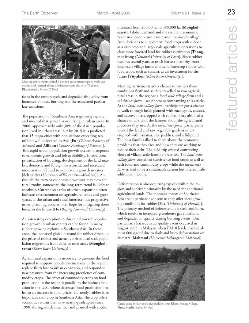
Meeting participants visited a banana grove intercropped with veg-etables and learned about subsistence agriculture in Thailand.Photo credit: Kelley O’Neal
tions in the carbon cycle and degraded air quality from increased biomass burning and the associated particu-late emissions.
The population of Southeast Asia is growing rapidly and most of that growth is occurring in urban areas. In 2000, approximately only 30% of the Asian popula-tion lived in urban areas, but by 2015 it is predicted that 15 mega-cities with populations exceeding ten million will be located in Asia [Fu (Chinese Academy of Sciences) and Ailikun (Chinese Academy of Sciences)]. This rapid urban population growth occurs in response to economic growth and job availability. In addition, privatization of housing, development of the land mar-ket, domestic and foreign investment, and increased motorization all lead to population growth in cities [Schneider (University of Wisconsin—Madison)]. Al-though the current economic downturn may slow the rural exodus somewhat, the long-term trend is likely to continue. Current scenarios of urban expansion often indicate encroachment on agricultural lands and green spaces at the urban and rural interface, but progressive urban planning policies offer hope for mitigating these losses in the future [He (Beijing Nor¬mal University)].
An interesting exception to this trend toward popula-tion growth in urban centers can be found in many rubber growing regions in Southeast Asia. In these areas, the increased global demand for rubber drives up the price of rubber and actually drives local-scale popu-lation migrations from cities to rural areas [Mongkol-sawat (Khon Kaen University)].
Agricultural expansion is necessary to generate the food required to support population increases in the region, replace fields lost to urban expansion, and respond to new pressures from the increasing prevalence of com-modity crops. The effect of commodity crops on food production in the region is parallel to the biofuels situ-ation in the U.S., where decreased food production has led to an increase in food prices. Currently, rubber is an important cash crop in Southeast Asia. The crop offers economic returns that have nearly quadrupled since 1998, during which time the land planted with rubber
increased from 20,000 ha to 380,000 ha [Mongkol-sawat]. Global demand and the resultant economic boost in rubber return have driven local-scale village farm decisions to supplement food crops with rubber as a cash crop and large-scale agriculture operations to clear more forested land for rubber cultivation [Thong-manivong (National University of Laos)]. Since rubber requires several years to reach harvest maturity, most local-scale village farms choose to intercrop rubber with food crops, such as cassava, as an investment for the future [Vityakon (Khon Kaen University)].
Meeting participants got a chance to witness these conditions firsthand as they travelled to two agricul-tural areas in the region: a local-scale village farm and a subsistence farm—see photos accompanying this article. At the local-scale village farm, participants got a chance to walk through fields planted with eucalyptus, cassava, and cassava intercropped with rubber. They also had a chance to talk with the farmers about the agricultural practices they use. At the subsistence farm, participants toured the land and saw vegetable gardens inter-cropped with bananas, rice paddies, and a fishpond. The host family talked to them about the economic problems that they face and how they are working to reduce their debt. The field trip offered contrasting views of village-scale farming practices. The local-scale village farm contained subsistence food crops as well as cash food and commodity crops while the subsistence farm strived to be a sustainable system but offered little additional income.
Deforestation is also occurring rapidly within the re-gion and is driven primarily by the need for additional agricultural lands. The montane forests of Southeast Asia are of particular concern as they offer ideal grow-ing conditions for rubber [Fox (University of Hawaii)]. The primary method of deforestation is slash and burn, which results in increased greenhouse gas emissions, and degrades air quality during burning events. One particularly hazardous air quality event occurred in August 2005 in Malaysia when PM10 levels reached al-most 600 µg/m3 due to slash and burn deforestation on Sumatra [Mahmud (Universiti Kebangsaan Malaysia)].
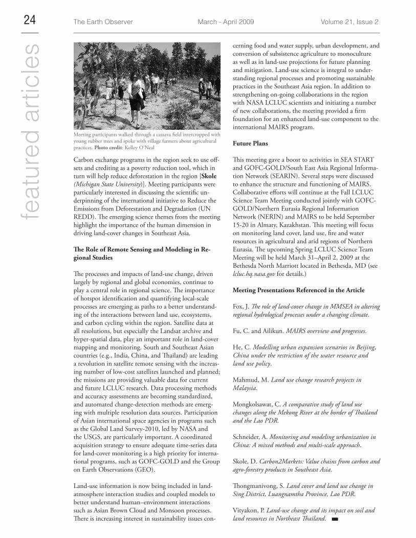
Cattle graze in harvested rice paddies near Kham Muang village.Photo credit: Kelley O’Neal
The Earth Observer March - April 2009 Volume 21, Issue 2 24fe
atur
ed a
rtic
les
Meeting participants walked through a cassava field intercropped with young rubber trees and spoke with village farmers about agricultural practices. Photo credit: Kelley O’Neal
Carbon exchange programs in the region seek to use off-sets and crediting as a poverty reduction tool, which in turn will help reduce deforestation in the region [Skole (Michigan State University)]. Meeting participants were particularly interested in discussing the scientific un-derpinning of the international initiative to Reduce the Emissions from Deforestation and Degradation (UN REDD). The emerging science themes from the meeting highlight the importance of the human dimension in driving land-cover changes in Southeast Asia.
The Role of Remote Sensing and Modeling in Re-gional Studies
The processes and impacts of land-use change, driven largely by regional and global economies, continue to play a central role in regional science. The importance of hotspot identification and quantifying local-scale processes are emerging as paths to a better understand-ing of the interactions between land use, ecosystems, and carbon cycling within the region. Satellite data at all resolutions, but especially the Landsat archive and hyper-spatial data, play an important role in land-cover mapping and monitoring. South and Southeast Asian countries (e.g., India, China, and Thailand) are leading a revolution in satellite remote sensing with the increas-ing number of low-cost satellites launched and planned; the missions are providing valuable data for current and future LCLUC research. Data processing methods and accuracy assessments are becoming standardized, and automated change-detection methods are emerg-ing with multiple resolution data sources. Participation of Asian international space agencies in programs such as the Global Land Survey-2010, led by NASA and the USGS, are particularly important. A coordinated acquisition strategy to ensure adequate time-series data for land-cover monitoring is a high priority for interna-tional programs, such as GOFC-GOLD and the Group on Earth Observations (GEO).
Land-use information is now being included in land-atmosphere interaction studies and coupled models to better understand human–environment interactions such as Asian Brown Cloud and Monsoon processes. There is increasing interest in sustainability issues con-
cerning food and water supply, urban development, and conversion of subsistence agriculture to monoculture as well as in land-use projections for future planning and mitigation. Land-use science is integral to under-standing regional processes and promoting sustainable practices in the Southeast Asia region. In addition to strengthening on-going collaborations in the region with NASA LCLUC scientists and initiating a number of new collaborations, the meeting provided a firm foundation for an enhanced land-use component to the international MAIRS program.
Future Plans
This meeting gave a boost to activities in SEA START and GOFC-GOLD/South East Asia Regional Informa-tion Network (SEARIN). Several steps were discussed to enhance the structure and functioning of MAIRS. Collaborative efforts will continue at the Fall LCLUC Science Team Meeting conducted jointly with GOFC-GOLD/Northern Eurasia Regional Information Network (NERIN) and MAIRS to be held September 15-20 in Almaty, Kazakhstan. This meeting will focus on monitoring land cover, land use, fire and water resources in agricultural and arid regions of Northern Eurasia. The upcoming Spring LCLUC Science Team Meeting will be held March 31–April 2, 2009 at the Bethesda North Marriott located in Bethesda, MD (see lcluc.hq.nasa.gov for details.)
Meeting Presentations Referenced in the Article
Fox, J. The role of land-cover change in MMSEA in altering regional hydrological processes under a changing climate.
Fu, C. and Ailikun. MAIRS overview and progresses.
He, C. Modelling urban expansion scenarios in Beijing, China under the restriction of the water resource and land use policy.
Mahmud, M. Land use change research projects in Malaysia.
Mongkolsawat, C. A comparative study of land use changes along the Mekong River at the border of Thailand and the Lao PDR.
Schneider, A. Monitoring and modeling urbanization in China: A mixed methods and multi-scale approach.
Skole, D. Carbon2Markets: Value chains from carbon and agro-forestry products in Southeast Asia.
Thongmanivong, S. Land cover and land use change in Sing District, Luangnamtha Province, Lao PDR.
Vityakon, P. Land-use change and its impact on soil and land resources in Northeast Thailand.