Academia, Emergency Management, and the Role of Geospatial Technologies
Upload
truongkietCategory
view
217download
0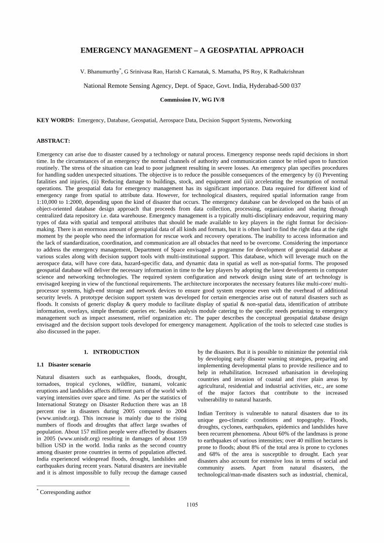
EMERGENCY MANAGEMENT – A GEOSPATIAL APPROACH
V. Bhanumurthy*, G Srinivasa Rao, Harish C Karnatak, S. Mamatha, PS Roy, K Radhakrishnan
National Remote Sensing Agency, Dept. of Space, Govt. India, Hyderabad-500 037
Commission IV, WG IV/8
KEY WORDS: Emergency, Database, Geospatial, Aerospace Data, Decision Support Systems, Networking ABSTRACT: Emergency can arise due to disaster caused by a technology or natural process. Emergency response needs rapid decisions in short time. In the circumstances of an emergency the normal channels of authority and communication cannot be relied upon to function routinely. The stress of the situation can lead to poor judgment resulting in severe losses. An emergency plan specifies procedures for handling sudden unexpected situations. The objective is to reduce the possible consequences of the emergency by (i) Preventing fatalities and injuries, (ii) Reducing damage to buildings, stock, and equipment and (iii) accelerating the resumption of normal operations. The geospatial data for emergency management has its significant importance. Data required for different kind of emergency range from spatial to attribute data. However, for technological disasters, required spatial information range from 1:10,000 to 1:2000, depending upon the kind of disaster that occurs. The emergency database can be developed on the basis of an object-oriented database design approach that proceeds from data collection, processing, organization and sharing through centralized data repository i.e. data warehouse. Emergency management is a typically multi-disciplinary endeavour, requiring many types of data with spatial and temporal attributes that should be made available to key players in the right format for decision-making. There is an enormous amount of geospatial data of all kinds and formats, but it is often hard to find the right data at the right moment by the people who need the information for rescue work and recovery operations. The inability to access information and the lack of standardization, coordination, and communication are all obstacles that need to be overcome. Considering the importance to address the emergency management, Department of Space envisaged a programme for development of geospatial database at various scales along with decision support tools with multi-institutional support. This database, which will leverage much on the aerospace data, will have core data, hazard-specific data, and dynamic data in spatial as well as non-spatial forms. The proposed geospatial database will deliver the necessary information in time to the key players by adopting the latest developments in computer science and networking technologies. The required system configuration and network design using state of art technology is envisaged keeping in view of the functional requirements. The architecture incorporates the necessary features like multi-core/ multi-processor systems, high-end storage and network devices to ensure good system response even with the overhead of additional security levels. A prototype decision support system was developed for certain emergencies arise out of natural disasters such as floods. It consists of generic display & query module to facilitate display of spatial & non-spatial data, identification of attribute information, overlays, simple thematic queries etc. besides analysis module catering to the specific needs pertaining to emergency management such as impact assessment, relief organization etc. The paper describes the conceptual geospatial database design envisaged and the decision support tools developed for emergency management. Application of the tools to selected case studies is also discussed in the paper.
* Corresponding author
1. INTRODUCTION
1.1 Disaster scenario
Natural disasters such as earthquakes, floods, drought, tornadoes, tropical cyclones, wildfire, tsunami, volcanic eruptions and landslides affects different parts of the world with varying intensities over space and time. As per the statistics of International Strategy on Disaster Reduction there was an 18 percent rise in disasters during 2005 compared to 2004
(www.unisdr.org). This increase is mainly due to the rising numbers of floods and droughts that affect large swathes of population. About 157 million people were affected by disasters in 2005 (www.unisdr.org) resulting in damages of about 159 billion USD in the world. India ranks as the second country among disaster prone countries in terms of population affected. India experienced widespread floods, drought, landslides and earthquakes during recent years. Natural disasters are inevitable and it is almost impossible to fully recoup the damage caused
by the disasters. But it is possible to minimize the potential risk by developing early disaster warning strategies, preparing and implementing developmental plans to provide resilience and to help in rehabilitation. Increased urbanisation in developing countries and invasion of coastal and river plain areas by agricultural, residential and industrial activities, etc., are some of the major factors that contribute to the increased vulnerability to natural hazards. Indian Territory is vulnerable to natural disasters due to its unique geo-climatic conditions and topography. Floods, droughts, cyclones, earthquakes, epidemics and landslides have been recurrent phenomena. About 60% of the landmass is prone to earthquakes of various intensities; over 40 million hectares is prone to floods; about 8% of the total area is prone to cyclones and 68% of the area is susceptible to drought. Each year disasters also account for extensive loss in terms of social and community assets. Apart from natural disasters, the technological/man-made disasters such as industrial, chemical,
1105
The International Archives of the Photogrammetry, Remote Sensing and Spatial Information Sciences. Vol. XXXVII. Part B4. Beijing 2008
biological, nuclear, fire, transport accidents, power failures, explosions, etc pose a serious threat to the nation’s economic growth and loss of lives Government of India has brought about a change in policy which emphasis mitigation, prevention and preparedness in the disaster management. The new approach proceeds from the conviction that development cannot be sustainable unless disaster mitigation and preparedness are built into the development process. Another corner stone of the approach is that mitigation, prevention and preparedness for emergency management has to be multi-disciplinary spanning across all sectors of development. The new policy also emanates from the belief that investments in mitigation, prevention and preparedness are much more cost effective than expenditure on relief and rehabilitation. This approach has been translated into a National Disaster Framework covering institutional mechanisms, disaster prevention strategy, early warning system, disaster mitigation, preparedness and response and human resource development. The expected inputs, areas of intervention and agencies to be involved at the National, State and district levels have been identified and listed in the roadmap. This roadmap has been shared with all the State Governments and Union Territory Administrations. Ministries and Departments of Government of India, and the State Governments/UT Administrations have been advised to develop their respective roadmaps taking the national roadmap as a broad guideline. Now, there is a common strategy underpinning the action being taken by all the participating organizations/stakeholders. It was strongly recommended that GIS/digital database of States/districts and urban centres with spatial and non-spatial data at appropriate scales has to be developed along with spatial decision support tools for emergency response. 1.2 Emergency Management Concept
Emergency can arise due to disaster caused by a technology or natural process. Emergency response needs rapid decisions in short time. Modern approaches to emergency management and response involve multidimensional efforts to reduce our vulnerability to hazards; to diminish the impact of disasters; and to prepare for, respond to, and recover from those that occur. The paramount goal of disaster management activities is to reduce, as much as possible, the degree to which a community’s condition is worsened by a disaster relative to its pre-disaster condition. There are many actions undertaken by participants in disaster management that support this goal both pre-disaster (to forestall or reduce potential damage) and post-disaster (to recover from actual damage), and ideally these activities would reduce the potential effects of a disaster. Disasters are uncertain with respect to both their occurrences and their outcomes. Disasters of rapid-onset type such as earthquakes harm a high percentage of the jurisdiction’s property or population, and damage occurs quickly relative to the jurisdiction’s ability to avert or avoid it. They may also directly impact the resources and personnel available to respond. As a result, response to disasters evokes a profound sense of urgency, and coping with them drains a jurisdiction’s human resources, equipment, supplies, and funds. All disasters have a temporal and geographic footprint that identifies the duration of impact and its extent on the Earth’s surface. The geospatial data for emergency management has its significant importance. Data required for different kind of emergency range from spatial to attribute data. However, for technological disasters, required
spatial information range from 1:10,000 to 1:2000, depending upon the kind of disaster that occurs. The emergency database can be developed on the basis of an object-oriented database design approach that proceeds from data collection, processing, organization and sharing through centralized data repository. There is an enormous amount of geospatial data of all kinds and often may hard to find the right data at the right moment by the people who needs the information for rescue work and recovery operations. Using geospatial tools, responders can determine where impacts are greatest, locate damaged buildings or injured residents so that they are able to act more quickly, especially during the critical period immediately after the event when there is the greatest possibility of saving lives (Committee on Planning for Catastrophe, 2007). If pre-incident data are available, geospatial analysis can provide important insight into the nature and extent of changes wrought by disasters. Geospatial models can help predict the locations, footprints, times, and durations of events, and the damage they may cause, so that jurisdictions can better prepare for them. Considering the importance to address the emergency management, Department of Space, Government of India envisaged a programme for development of geospatial database at various scales along with decision support tools with multi-institutional support. This database, which will leverage much on the aerospace data, will have core data, hazard-specific data, and dynamic data in spatial as well as non-spatial forms. The proposed geospatial database will deliver the necessary information in time to the key players by adopting the latest developments in computer science and networking technologies. The required system configuration and network design using state of art technology is envisaged keeping in view of the functional requirements. The architecture incorporates the necessary features like multi-core/ multi-processor systems, high-end storage and network devices to ensure good system response even with the overhead of additional security levels. A prototype decision support system was developed for certain emergencies arise out of natural disasters such as floods. It consists of generic display & query module to facilitate display of spatial & non-spatial data, identification of attribute information, overlays, simple thematic queries etc. besides analysis module catering to the specific needs pertaining to emergency management such as impact assessment, relief organization etc.
2. DEVELOPMENT OF GEOSPATIAL DATABASE
Much of the information that is required for emergency preparedness, response, recovery, and mitigation including resources allocation involve geospatial information. Different information technologies are appropriate in the various phases of the disaster management life cycle (Committee on Using Information Technology to Enhance Disaster Management, National Research Council, 2005) Imagine a world in which geospatial information is available to all who need it (and who have permission to use it) in a timely fashion, with a user friendly interface (Committee on Intersections Between Geospatial Information and Information Technology, National Research Council, 2003). More specifically, technologies should be devised that can help individuals and groups access information, visually explore, analyse and take appropriate decisions. It is clear that despite excellent efforts by many groups the approach to providing information for emergency management is not often effectively utilizing a wealth of data that resides, with various organizations. Available Information and capacity is not uniform, consistent and standardized for
1106
The International Archives of the Photogrammetry, Remote Sensing and Spatial Information Sciences. Vol. XXXVII. Part B4. Beijing 2008
emergency managers. Data standards are often inconsistent, and users are sometimes unaware of the limitations and uncertainties in data or are presented with conflicting interpretations of data without the means to assess the reliability of the sources. All of these issues reduce the efficacy of the decision-making process at an emergency situation. The need of the hour is organization of geospatial data and use location information to integrate varied data sources and make these data sets accessible for the decision makers. In the pursuit of institutionalizing, mitigation and preparedness to natural as well as manmade disasters more efficiently, emphasis has been made on development and organization of comprehensive Geospatial databases. In spatial domain, it is envisaged to have a number of digitized layers on 1:50000 scale for entire country, 1:10000 scale for multi-hazard prone districts and 1:2000 scale for mega cities, relating to hazard zonation, transportation networks, settlements, natural resources, hazardous industries, resource inventories, etc. Although an extensive amount of digital spatial data has been already developed by various government agencies, it needs to be collected and compiled. These spatial data are to be linked dynamically with corresponding non-spatial information such as socio-economic and infrastructure to enable decision making processes more efficient and objective. The integration of geospatial information from multiple sources, often with varied formats, semantics, precision, and coordinate systems is a key issue. It is also envisaged to analyze emergency trends, demographic patterns, economic profiles, infrastructure status, communication networks, public utilities etc so that the database could also be shared in coupling disaster reduction and economic development, especially in the vulnerable areas. For hazard/emergency management the data requirements can be grouped into two categories i.e. core data sets and hazard/emergency specific geospatial data. The geospatial data organization for emergency management include identification of data sets, its availability and gap areas, bringing the diverse data sets into a common platform with some standards and develop mechanism for data access and dissemination at the time emergency situation. Core data sets are those which are commonly required to handle most of the emergency situations. The core data sets may not be specific to a particular emergency. The creation and organization of this kind of data sets need unique standards. The required core data sets have to be created/ organized in three different scales i.e. 1:50,000, 1:10,000 and 1:2000. The data sets at 1:50,000 scale will be used for first cut assessments and preparation of overall mitigation/ relief planning. The data sets at 1:10,000 scale will be used in implementation of relief and rescue operations for multi-hazard prone areas. The data sets at 1:2000 scales will be used in implementation of relief and rescue operations for mega cities. Hazard specific data sets may be required to handle a particular emergency situation. The hazard specific geospatial data sets have been identified to handle the particular hazard/emergency, like cyclone, flood, landslide, earthquake, fire, structural collapse etc. Standardization and organization of hazard specific data play a vital role in damage assessments, relief, mitigation and rescue of life in the event of an emergency situation. An exhaustive list of database elements pertaining to both core and hazard specific data have been identified through brainstorming required for addressing emergencies arising out
of natural and man-made disasters. Figure-1 shows the core and hazard specific data sets.
Figure-1. Core and hazard specific data sets. Further it is also envisaged integration of real time of data from a variety of measuring stations from filed such as Automatic Weathering Stations, in situ sensors etc. besides remote-sensing data, aerial and lidar data. Some of the datasets such as location of medical facilities, relief shelters, civil supply godowns in spatial format is not available which needs to be generated using appropriate technologies. Further the amount of data to be organized is quite extensive and is difficult to collect physically from various sources and convert to the required format for organizing into database especially for a large country like India. Hence it is proposed to use web interface for data collection and organisation wherever applicable.
3. DECISION SUPPORT TOOLS
One of the most important elements in emergency management is the availability of information at right time for taking appropriate decisions. Whenever a flood / cyclone threat is sounded, necessary actions should be initiated to minimize the impact for which scientific inputs should be made available in a ready to use format to the district officials. The primary information will be on the likely impact of the event in terms of the extent of the area affected, location specific details, population affected, availability of resources for evacuation of the people & relief and quick assessment of damages. The process of collection of basic information at the time of the event may not be possible. Most of the times, the required information is not available in the required format due to various reasons, and decisions are being taken based on the knowledge and experience. Hence, there is a need to make available the required information to the key persons in the disaster management activity with appropriate tools to support the decision making process based on scientific inputs. Early warning, risk prediction, situational analysis, damage assessment, thematic hazard maps etc. are some of the major activities of the data management system of emergency data and information system configuration. To achieve these objectives there is a need to develop software applications to support decision-making using available data sets in centralized data server. Spatial Decision Support System (SDSS) is a class of computer systems that combine the technologies of GIS and Decision Support System to aid decision-makers with problems that have spatial dimensions. It is a central database, where data and information can be made available on-line. It is an intelligent system, to help planning activities. It is also an electronic-based correspondence system and report generator that can be modified according to the user. Emergency response applications will require not only real-time collection and
1107
The International Archives of the Photogrammetry, Remote Sensing and Spatial Information Sciences. Vol. XXXVII. Part B4. Beijing 2008
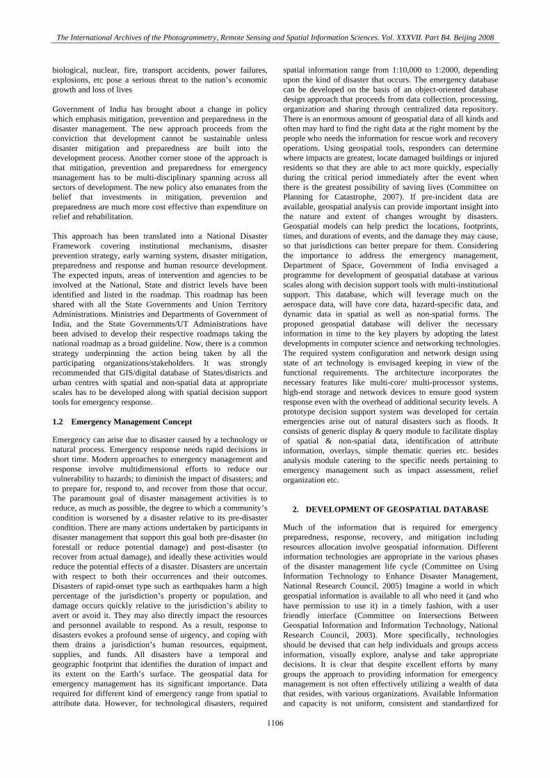
fusion of data but also ingestion of that data into process models that can prescribe actions to mitigate the effects of the evolving emergency such as simulating spatial flooding conditions for a given flood magnitude for better preparedness of evacuation and relief operations. Decision support tools can help incident managers to visualize the event over time, track the activities of responders, and predict the outcomes of various courses of actions. These tools consist of appropriate models and domain knowledge and capable of accessing and analysing the dynamic and static databases and provide information and options to the emergency manager for taking appropriate decisions. It also generate useful and actionable products such as maps showing area affected, images showing damages, simulated situations likely to follow etc. A few selected decision support tools developed have been described below. The conceptual plan of database organisation and service is shown in the figure -2
Figure-2 Conceptual plan of database organisation and service
4. SELECTED APPLICATIONS
4.1 Flood Management Information System
Bihar State in northern part of India is one of the most chronic flood affected states. With an objective to improve flood management, Government of Bihar constituted a Flood Management Information System Cell (FMISC) approached National Remote Sensing Agency (NRSA), Department of Space, for developing an information system that can aid in flood management activities. Accordingly NRSA has developed an operational Flood Management Information System (FIMS) using the available database as per the users requirement. The objectives of developing FMIS are to organize, secured access of data, view, query, analyze and generate outputs. It consists of user friendly Graphical User Interface (GUI) to visualize the Geo spatial database and generate specific flood data products with minimum technical expertise at user end. This application is developed using Arc Objects 9.1 in Visual Basic 6.0, which runs on Windows operating system. The FMIS is designed to have desktop architecture consists of various functionalities segregated into major modules include, Data Visualization, Update data, FMIS Data Products and Report Tool. The data visualization module is to load and access various data sets available with the application in the form of Metadata. This Metadata information is managed by an authorized administrator to add, delete or update, which are provided in the Update module. Standard data products such as Overview
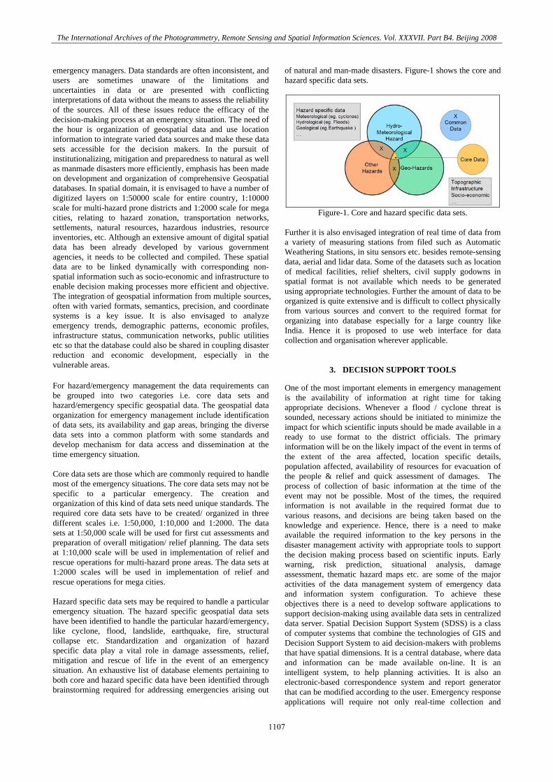
inundation map, Regional inundation map, Relief support map, Breach location map and flood frequency map can be created with necessary inputs required in the FMIS data products module. A report generation tool is also incorporated in the application in the Report tool module, which can create a report in html format based on the input (text, image, tabular Queries). Various data products created shall be displayed in a layout window, where the user can see the output before going to generate a Map in PDF or JPG formats. FMIS includes generation of its products and services which can be further disseminated through various ways. The FMIS provides its outputs in standards PDF, JPG, HTML etc. which can be disseminated through simple media or through internet platform. In the Customization of FMIS the desktop base GIS architecture has been adopted. The graphical representation of FMIS system architecture has been shown in the figure-3.
Figure-3 FMIS system architecture The system architecture of FMIS contains there major components i.e. Database organization and management, Application process and FMIS end user services. In the database server level the ESRI Geodatabase has been adopted as per user requirements. The Microsoft MS Access 2003 is taken as database management system (DBMS) where the spatial data is organized as ESRI personal Geodatabase. The non- spatial data along with metadata is also stored and organized in MS Access table format only. The FMIS system layout is based on desktop base architecture. It runs on standalone environment where the application needs to be installed in individual machine with complete copy of the database. After successful installation it will create a desktop shortcut and also a link menu in the Programs menu of windows operating system. The functional flow of the software is described in Figure 4 and GUI and product generation views are shown in 5 (a, b &c)
1108
The International Archives of the Photogrammetry, Remote Sensing and Spatial Information Sciences. Vol. XXXVII. Part B4. Beijing 2008
Figure-4 FMIS Functional flow chart
Figure-5 (a) FIMS data view
Figure-5 (b) Generate overview inundation Map
Figure-5 (c) Flood frequency map- sample output
4.2 Mobile based applications
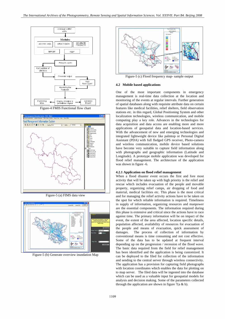
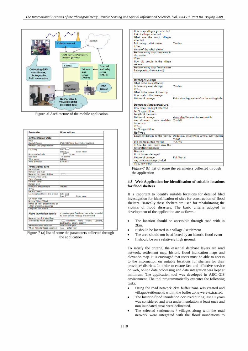
One of the most important components in emergency management is real-time data collection at the location and monitoring of the events at regular intervals. Further generation of spatial databases along with requisite attribute data on certain features like medical facilities, relief shelters, field observation stations etc. in this regard, Global Positioning System and other localization technologies, wireless communication, and mobile computing play a key role. Advances in the technologies for data acquisition and data access are enabling more and more applications of geospatial data and location-based services. With the advancement of new and emerging technologies and integrated lightweight device like palmtop or Personal Digital Assistant (PDA) with full fledged GPS receiver, Photo-camera and wireless communication, mobile device based solutions have become very suitable to capture field information along with photographs and geographic information (Latitude and Longitude). A prototype mobile application was developed for flood relief management. The architecture of the application was shown in figure -6. 4.2.1 Application on flood relief management When a flood disaster event occurs the first and fore most activity that will be taken up with high priority is the relief and rescue which includes evacuation of the people and movable property, organizing relief camps, air dropping of food and material, medical facilities etc. This phase is the most critical and for managing the relief activity actions have to be taken on the spot for which reliable information is required. Timeliness in supply of information, organizing resources and manpower are the essential components. The information required during this phase is extensive and critical since the actions have to race against time. The primary information will be on impact of the event, the extent of the area affected, location specific details, population affected, availability of resources for evacuation of the people and means of evacuation, quick assessment of damages. The process of collection of information by conventional means is time consuming and not cost effective. Some of the data has to be updated at frequent interval depending up on the progression / recession of the flood wave. The basic data required from the field for relief management has been identified and the application is being customized. It can be deployed to the filed for collection of the information and sending to the central server through wireless connectivity. The application has a provision for capturing field photographs with location coordinates which enables the data for plotting on to map server. The filed data will be ingested into the database which can be used as a valuable input for geospatial models for analysis and decision making. Some of the parameters collected through the application are shown in figure 7(a & b).
1109
The International Archives of the Photogrammetry, Remote Sensing and Spatial Information Sciences. Vol. XXXVII. Part B4. Beijing 2008
Figure -6 Architecture of the mobile application.
Figure-7 (a) list of some the parameters collected through
the application
Figure-7 (b) list of some the parameters collected through the application
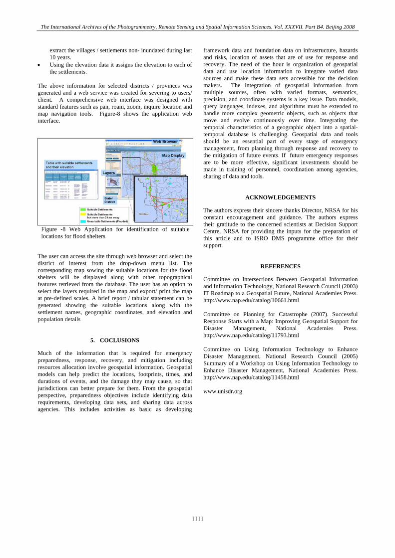
4.3 Web Application for identification of suitable locations for flood shelters
It is important to identify suitable locations for detailed filed investigation for identification of sites for construction of flood shelters. Basically these shelters are used for rehabilitating the victims of flood disasters. The basic criteria adopted in development of the application are as flows: • The location should be accessible through road with in
2km. • It should be located in a village / settlement • The area should not be affected by an historic flood event • It should be on a relatively high ground. To satisfy the criteria, the essential database layers are road network, settlement map, historic flood inundation maps and elevation map. It is envisaged that users must be able to access to the information on suitable locations for shelters for their province/ districts. In order to ensure fast and effective service on web, online data processing and data integration was kept at minimum. The application tool was developed in ARC GIS environment. The tool programmatically executes the following tasks: • Using the road network 2km buffer zone was created and
villages/settlements within the buffer zone were extracted. • The historic flood inundation occurred during last 10 years
was considered and area under inundation at least once and non inundated areas were delineated.
• The selected settlements / villages along with the road network were integrated with the flood inundations to
1110
The International Archives of the Photogrammetry, Remote Sensing and Spatial Information Sciences. Vol. XXXVII. Part B4. Beijing 2008
extract the villages / settlements non- inundated during last 10 years.
• Using the elevation data it assigns the elevation to each of the settlements.
The above information for selected districts / provinces was generated and a web service was created for severing to users/ client. A comprehensive web interface was designed with standard features such as pan, roam, zoom, inquire location and map navigation tools. Figure-8 shows the application web interface.
Figure -8 Web Application for identification of suitable locations for flood shelters
The user can access the site through web browser and select the district of interest from the drop-down menu list. The corresponding map sowing the suitable locations for the flood shelters will be displayed along with other topographical features retrieved from the database. The user has an option to select the layers required in the map and export/ print the map at pre-defined scales. A brief report / tabular statement can be generated showing the suitable locations along with the settlement names, geographic coordinates, and elevation and population details
5. COCLUSIONS
Much of the information that is required for emergency preparedness, response, recovery, and mitigation including resources allocation involve geospatial information. Geospatial models can help predict the locations, footprints, times, and durations of events, and the damage they may cause, so that jurisdictions can better prepare for them. From the geospatial perspective, preparedness objectives include identifying data requirements, developing data sets, and sharing data across agencies. This includes activities as basic as developing
framework data and foundation data on infrastructure, hazards and risks, location of assets that are of use for response and recovery. The need of the hour is organization of geospatial data and use location information to integrate varied data sources and make these data sets accessible for the decision makers. The integration of geospatial information from multiple sources, often with varied formats, semantics, precision, and coordinate systems is a key issue. Data models, query languages, indexes, and algorithms must be extended to handle more complex geometric objects, such as objects that move and evolve continuously over time. Integrating the temporal characteristics of a geographic object into a spatial-temporal database is challenging. Geospatial data and tools should be an essential part of every stage of emergency management, from planning through response and recovery to the mitigation of future events. If future emergency responses are to be more effective, significant investments should be made in training of personnel, coordination among agencies, sharing of data and tools.
ACKNOWLEDGEMENTS
The authors express their sincere thanks Director, NRSA for his constant encouragement and guidance. The authors express their gratitude to the concerned scientists at Decision Support Centre, NRSA for providing the inputs for the preparation of this article and to ISRO DMS programme office for their support.
REFERENCES
Committee on Intersections Between Geospatial Information and Information Technology, National Research Council (2003) IT Roadmap to a Geospatial Future, National Academies Press. http://www.nap.edu/catalog/10661.html Committee on Planning for Catastrophe (2007). Successful Response Starts with a Map: Improving Geospatial Support for Disaster Management, National Academies Press. http://www.nap.edu/catalog/11793.html Committee on Using Information Technology to Enhance Disaster Management, National Research Council (2005) Summary of a Workshop on Using Information Technology to Enhance Disaster Management, National Academies Press. http://www.nap.edu/catalog/11458.html www.unisdr.org
1111

The International Archives of the Photogrammetry, Remote Sensing and Spatial Information Sciences. Vol. XXXVII. Part B4. Beijing 2008
1112