Elvas and its Fortifications Brides of the Sea; Port ...
16
272 Elvas and its Fortifications (Portugal) No 1367 Official name as proposed by the State Party The Garrison Border Town of Elvas and its Fortifications Location District of Portalegre - Alentejo Portugal Brief description Guarding the key border crossing between Portugal’s capital Lisbon and Spain’s capital Madrid, in an undulating, riverine landscape the Garrison Town of Elvas was fortified extensively from the 17 th to the 19 th centuries to become the largest bulwarked dry ditch system in the world. The town was surrounded by outlying forts built on surrounding hills to accommodate the changing needs of defensive warfare, and supplied with water by the 7km long Amoreira Aqueduct. Within the walls, the town contains extensive barracks and other military buidlings as well as churches and monasteries. Category of property In terms of categories of cultural property set out in Article I of the 1972 World Heritage Convention, this is a group of buildings. 1 Basic data Included in the Tentative List 26 November 2004 International Assistance from the World Heritage Fund for preparing the Nomination None Date received by the World Heritage Centre 20 December 2010 Background This is a new nomination. Consultations ICOMOS has consulted its International Scientific Committee on Fortifications and Military Heritage and Historic Towns and Villages and several independent experts. Literature consulted (selection) Broeze, F. (ed.), Brides of the Sea; Port Cities of Asia from the 16 th -20 th Centuries, Kensington, NSW, Australia, New South Wales University Press, 1989. Hoppen, A., The Fortification of Malta by the Order of St. John 1530-1798, Malta, Mireva Publications, 1999. Technical Evaluation Mission An ICOMOS technical evaluation mission visited the property from 12 to 16 September 2011. Additional information requested and received from the State Party A letter was sent to the State Party on 13 September 2011 requesting clarification on the remnants of other elements of the Lines of Elvas, protection of views between the fortifications, the function of the Transition Zone, involvement of residents and risk preparedness. A response was received on 22 October 2011 and the information has been incorporated into the relevant sections below. A second letter was sent to the State Party on 12 December 2011 requesting extension of the nominated property boundary and buffer zone; timetable for the designation of the whole nominated property as a National Monument; extension of the management system to contain explicit controls; timetable for the setting up of the Office for the Fortifications of Elvas and implementation of the management plan. A response was received on 10 February 2012 and the information has been incorporated into the relevant sections below. Date of ICOMOS approval of this report 14 March 2012 2 The property Description The nominated property includes seven components: the Historic Centre (125.4311 ha), the Amoreira Aqueduct (0.8148 ha), the Fort of Santa Luzia (19.4216 ha) and the covered way linking it to the Historic Centre (0.29 ha), the Fort of Graça (11.2544 ha), and the Fortlets of São Mamede (7.9608ha), São Pedro (1.9843 ha) and São Domingos (12.1989 ha). Together these total 179.3559 ha and they are linked and surrounded by a buffer zone of 608 ha. Historic Centre: Stronghold of Elvas Castle and medieval walls Elvas developed within three successive consecutive walls, expanding to the south from the early medieval period to the 16 th century and contains churches and monasteries as well as military buildings. The Castle is located on the highest point in the north of the city. Remains of the first medieval Arab wall (c.10 th century) can be seen in various places. The second medieval wall extended the city in a broad arc to the south. The wall and four of its turrets abutting houses are visible at various points as one ascends Rua do Cano. The third
Transcript of Elvas and its Fortifications Brides of the Sea; Port ...

272
Elvas and its Fortifications (Portugal) No 1367 Official name as proposed by the State Party The Garrison Border Town of Elvas and its Fortifications Location District of Portalegre - Alentejo Portugal Brief description Guarding the key border crossing between Portugal’s capital Lisbon and Spain’s capital Madrid, in an undulating, riverine landscape the Garrison Town of Elvas was fortified extensively from the 17th to the 19th centuries to become the largest bulwarked dry ditch system in the world. The town was surrounded by outlying forts built on surrounding hills to accommodate the changing needs of defensive warfare, and supplied with water by the 7km long Amoreira Aqueduct. Within the walls, the town contains extensive barracks and other military buidlings as well as churches and monasteries. Category of property In terms of categories of cultural property set out in Article I of the 1972 World Heritage Convention, this is a group of buildings.
1 Basic data Included in the Tentative List 26 November 2004 International Assistance from the World Heritage Fund for preparing the Nomination None Date received by the World Heritage Centre 20 December 2010 Background This is a new nomination. Consultations ICOMOS has consulted its International Scientific Committee on Fortifications and Military Heritage and Historic Towns and Villages and several independent experts.
Literature consulted (selection) Broeze, F. (ed.), Brides of the Sea; Port Cities of Asia from the 16th-20th Centuries, Kensington, NSW, Australia, New South Wales University Press, 1989. Hoppen, A., The Fortification of Malta by the Order of St. John 1530-1798, Malta, Mireva Publications, 1999.
Technical Evaluation Mission An ICOMOS technical evaluation mission visited the property from 12 to 16 September 2011. Additional information requested and received from the State Party A letter was sent to the State Party on 13 September 2011 requesting clarification on the remnants of other elements of the Lines of Elvas, protection of views between the fortifications, the function of the Transition Zone, involvement of residents and risk preparedness. A response was received on 22 October 2011 and the information has been incorporated into the relevant sections below. A second letter was sent to the State Party on 12 December 2011 requesting extension of the nominated property boundary and buffer zone; timetable for the designation of the whole nominated property as a National Monument; extension of the management system to contain explicit controls; timetable for the setting up of the Office for the Fortifications of Elvas and implementation of the management plan. A response was received on 10 February 2012 and the information has been incorporated into the relevant sections below. Date of ICOMOS approval of this report 14 March 2012
2 The property Description The nominated property includes seven components: the Historic Centre (125.4311 ha), the Amoreira Aqueduct (0.8148 ha), the Fort of Santa Luzia (19.4216 ha) and the covered way linking it to the Historic Centre (0.29 ha), the Fort of Graça (11.2544 ha), and the Fortlets of São Mamede (7.9608ha), São Pedro (1.9843 ha) and São Domingos (12.1989 ha). Together these total 179.3559 ha and they are linked and surrounded by a buffer zone of 608 ha. Historic Centre: Stronghold of Elvas
Castle and medieval walls Elvas developed within three successive consecutive walls, expanding to the south from the early medieval period to the 16th century and contains churches and monasteries as well as military buildings. The Castle is located on the highest point in the north of the city. Remains of the first medieval Arab wall (c.10th century) can be seen in various places. The second medieval wall extended the city in a broad arc to the south. The wall and four of its turrets abutting houses are visible at various points as one ascends Rua do Cano. The third

273
wall, the Fernandina wall was built in the 14th century during the reigns of King Alphonso IV and King Fernando but little remains of this as it was mostly demolished and the materials reused to build the bulwarked fortifications more or less along the same line, in the major fortification works of the Portuguese War of Restoration period (1641-68). Bulwarked fortifications The bulwarked fortifications begun in 1643 as seen today comprise twelve fronts inserted in an irregular polygon, roughly describing a broad segment of a circle centred at the castle, with a maximum radius of 965 m. The bulwarks are battered, surrounded by a dry ditch and counterscarp and further protected by a number of ravelins. The fortifications were designed by the Dutch Jesuit Cosmander, based on the treatise of fortification engineer Samuel Marolois, whose work together with that of Simon Stevin and Adam Fritach launched the Dutch school of fortification worldwide. Cosmander applied the geometric theory of Marolois to the irregular topography of Elvas, to produce a defensive system considered a masterpiece of its time. Military buildings Many new buildings were constructed for military purposes and several existing buildings were adapted concurrently with the bulwarked fortification of the town. These included the barracks of São João da Corujeira (1695-7), today known as the Engineers’ Barracks; the Barracks of Rua dos Quartéis (1656) now used as craft workshops; the Barracks of the Artillerymen (post-1659) also known as the Veterans Barracks, and following the ‘Fantastic’ war the Casarão Barracks (1767). The Guildhall was also used as barracks. Convents adapted to house military regiments include São Domingos, which housed the Fortification School of the Jesuit College and São Paulo, which housed the Military Court and Detention Centre. The Military Hospital was constructed at the bulwark of São João de Deus. At the time of the Battle of the Lines of Elvas (1659) the hospital could receive up to 350 patients. It is now part of the Hotel São João de Deus together with the former Army Auditor-General’s Office. The Trem warehouse (1694-1715) was one of the main ordnance centres in Portugal, built to house repair, storage and manufacture of military equipment. The Military Prison was housed there in the 19th century. Today it is occupied by the Elvas Agricultural College. The former Military Bakery opened in 1869, one of two outside Lisbon, the other being at Porto. It housed four animal-powered mills and one windmill, six ovens, the chimneys of which are still visible on the roof; barracks and stables. An 18th century building in Rua dos Quartéis, which today houses the Municipal Market was originally the Pontoon Store where bridge making equipment for the Guadiana River crossing was kept. In the 19th century it was used as theatre and then a cinema. The 17th century War Council building in Rua Pereira de Abreu today houses educational services and the Portuguese Red Cross offices. The Command Headquarters building in Rua Martim Mendes retained its function until the last quarter of the 20th century when the last regiments left Elvas.
Powder magazines include the round Conceição, the rectangular Santa Barbara and the Round Powder-magazine near the Old Gate bulwark, as well as eleven that form part of the bulwarks. Religious buildings Enclosed within the line of the third wall are a number of important buildings described in Annex VII to the nomination dossier. These include churches that were formerly mosques prior to the Christian conquest of 1228 and the Church of S. Domingos, once part of a convent complex which was converted to barracks in the 19th century and altered many times. In the 16th century the urban layout of the town was modified and a new square created – the Praça Nova, now the Praça da República, on the edge of which was constructed the Guildhall. North of the Praça the cathedral, now known as Nossa Senhora da Assunção was begun in 1517 on the site of an earlier 14th century church. Later churches include the church and hospital of Misericordia, which now houses the Museum of Contemporary Art. The 18th century Church of Senhor Jesus da Piedade is located outside the gates of the city where the fair of S. Matthew is held, and is the destination of one of Alentejo’s major pilgrimages held 20-23 September each year. Amoreira Aqueduct
The aqueduct (built 1529-1622) is 7,504 m long and brought water from the Amoreira springs to the west of the town to the town fountain (Fonte da Vila) and later to the Fortress Cistern. Constructed in rendered brick and stone rubble masonry, the aqueduct consists largely of arches arranged in up to four tiers across the valley of São Francisco with an underground section reaching 6 m in depth. Fort of Santa Luzia and the covered way
This fort was built 1641-1648 on a prominence 410 m to the south-east of the stronghold of Elvas in order to pre-empt any siege. It was connected to the town by a covered way, the line of which is now crossed by the trunk road that connects Elvas to the border. The fort is essentially rectangular, with four projecting pointed bulwarks in each corner. There are two ravelins, one to the east and one to the south, a salient to the west, and all enclosed within the dry ditch and counterscarp. Mantraps are located outside the counterscarp glacis in the areas between the salients. The Military Museum is located in the former store and barracks. In the centre of the fort at the second level is the military governor’s house topped by a light and ventilation turret. From here can be viewed the whole surrounding area of the fort. Fort of Graça
By the second half of the 18th century the effective range of cannon had increased to the extent that it was necessary to build another pre-emptive fort on the prominence of Monte da Graça, 1,063 m to the north. Begun in 1763, this fort is a major piece of military architecture comprising three lines of defence with two

274
main ditches. The design is attributed to the Count of Lippe and based on the first Vauban system. The upper fort is essentially square in plan with four projecting pointed bulwarks in each corner. There are four redans, one to each side between the bulwarks. To the north is the tenaille with two bulwarks at its north-west and north-east corners and four ravelins. Built into these are barracks and powder magazines. North of the tenaille front is another ravelin. All are enclosed within the first main dry ditch and counterscarp. A long hornwork stretches beyond this with the Horneveque ravelin in front of it to the north on lower ground. Mantraps are located outside the counterscarp glacis. The octagonal military governor’s house is located in the centre of the upper fort within the second ditch. At the beginning of the 19th century, in anticipation of French invasions, four further pre-emptive fortlets were built at key commanding points, one of which (São Francisco) near the convent of São Francisco was subsequently demolished to make way for the town’s cemetery. A map of c.1661 of the 1659 Battle Lines of Elvas (Fig. 2.a.1.2.24, p.74) shows the bulwarked stronghold of Elvas, the Fort of Santa Luzia and the Amoreira Aqueduct enclosed within an outer fortified line including other forts at points along it, and a small fort or fortlet along the line of the aqueduct. This fortlet may have been an earlier version of the Fortlet of São Francisco. Fortlet of São Mamede
Built on a hillock to the south-east of the Fort of Santa Luzia, this Fortlet controlled the unseen hillside to the south-east. The enclosing wall had embrasures in the section facing Spain. It is surrounded by a ditch and contains a barrack or guardhouse, powder magazine and storage warehouse. Fortlet of São Pedro
This fortlet is located on a hillock to the south of the town and controlled the approach from that direction. It contains a powder magazine, the remains of a barrack, guardhouse and storage. The west flank is a rocky slope but the other sides are protected by a ditch. Fortlet of São Domingos
Also known as the Fortlet of Piedade, this fortlet was built to the west of the town near the Aqueduct of Amoreira to protect it from the western approach. It is surrounded by a ditch. Buffer Zone
The surrounding buffer zone comprises Protected Spaces included in the Urban Perimeter, the National Agricultural and Ecological Reserves and the Cultural Spaces (Planning Charter of the Municipal Master Plan). History and development During the Islamic period Elvas was part of Al-Garb al-Andalus, the main towns of which were Badajoz and Merida. It was not until its conquest by Don Sancho II in 1228 that it became important to the king of Portugal as a
frontier town. Located in a rich agricultural area, it received many Christian religious foundations during the 13th and 14th centuries. The Fernandina wall built to enclose the expansion of this period had an imposing assembly of 22 towers flanking eleven gates. The Convent of S. Paulo was founded in 1418; by 1422 the population of Elvas was 8,500. In 1437 Elvas had 14 inns and a hospice. Proposals for the Amoreira Aqueduct were promoted under Francisco Arruda in 1537. The 16th century was the great building period, when Elvas was elevated to the status of City and Bishopric and many new churches and convents were established. In 1527 the population was approximately 7,664 but by 1620 the population had reached between 15,000 and 20,000 inhabitants. However it was from the time of the restoration of Portuguese independence in 1640 that the great fortification scheme seen today began to take shape. Profound changes in systems of fortification were required to counter the developments in modern artillery and warfare from the 17th century onwards. The vertical Fernandina wall was now considered vulnerable to anticipated attacks from Spain and was consequently rebuilt to the latest and most sophisticated fortification design then available. Within the walls military establishments proliferated as described above, turning it into an enormous barrack. Consequently the importance of the Amoreira Aqueduct completed in 1622 as far as the Fonte da Vila had increased greatly, and it was extended to supply a new, extremely large cistern 58 m long, 5 m wide and 8 m high; the Fortress Cistern. New religious foundations were established. Others were rebuilt and many houses were built for the nobility. The new bulwarked fortification works and the Fort of Santa Luzia were sufficiently in place in time for the great Battle of the Lines of Elvas of 1659, which is regularly commemorated in Elvas today and recorded in the c.1661 map and illustrations. It is explained in the nomination dossier that in the context of the European political-military process which established Portuguese independence, the area in permanent conflict in the majority of the wars was the North Alentejo, where Elvas is situated. From 1166 to 1808 there were 16 major incidents of war of which the Battle of the Lines of Elvas, on 14 January 1659, during the War of Restoration (1641-1668), was the most important, because of the military resources involved – approximately 11,000 men on the Portuguese side and 14,000 on the Spanish – and also because of its significance in the country's independence vis-à-vis Spain. It was for these reasons that Elvas became known as the "key to the kingdom" in the 17th century, where it was necessary to build a "very strong gate" to protect the small country from enemy invasions. Subsequent developments in war technology of the 18th century resulting in longer range artillery required the building of the Fort of Graça to the north of the town. By 1798, the fortifications were being criticised due to a lack of protection to the west, and for the fact that its large size meant that Portugal would be hard put to provide a large enough garrison to man it adequately. Elvas received four new fortlets as described above in an attempt to remedy the criticisms. Further changes in military techniques, with siege warfare giving

275
way to open battle and more mobile artillery due to road building characterised the Peninsular War of the early 19th
Century. However by 1857 a Portuguese report considered the Elvas fortifications to be out of date. The city lost strategic importance, and population. The size of the garrison was reduced after the Peninsular War and by 1864 the population of Elvas was 10,271. The strategic importance of the town was further downgraded after World War I and one after another military units left Elvas, until the Command HQ was finally disbanded in the last quarter of the 20th century. Urban expansion began to take place outside the walls from the second half of the 20th century, with the construction of social housing at Boa-Fe and new houses and neighbourhoods to the south around the Fortlet of São Pedro. A luxury hotel, the Pousada, located between the town and the Fortlet of São Pedro, which was the first of its kind in Portugal, had opened in 1942 and a viaduct connecting the bulwark of São João de Deus and the Redan of Cascalho was constructed in 1949. During the period of the military regime of the Second Republic (1933-1974), repair and conservation works were carried out to almost the entire length of the bulwarked fortification, the forts, the Fortlet of São Pedro and the castle, including some conjectural restoration to earlier periods at the castle and Fort of Graça. Since then conservation works carried out by the Municipality have generally covered removal of vegetation, repointing, repair of plasterwork, consolidation of masonry, reconstruction of latrines and sentry boxes, and lighting installations. More extensive work was carried out at the forts of Santa Luzia and Graça. The nominated fortifications and the Amoreira Aqueduct have been classified as National Monuments by decree since 1906.
3 Outstanding Universal Value, integrity and authenticity
Comparative analysis Fortifications are a major theme in world history; a major feature of the ebb and flow of competition between peoples for land and resources and a symbol of the desire for autonomy by discrete communities since prehistoric times. Consequently there are already many examples on the World Heritage List and the Tentative Lists, most of which are in Europe. This nomination focuses on the importance of Elvas in the development of the science of fortifications as the bulwarked dry-ditched type, and its size and spread over the landscape as a fortified garrison town. These qualities can be easily perceived due to the lack of surrounding development. As an example in Europe, Elvas is considered in the context of the disruptions in the balance of power within the Holy Roman Empire of 17th century Europe, and Portugal’s struggle for independence. In the wider world, Elvas is considered in the context of the period of
European exploration and colonisation from the 16th century. With regard to comparisons within Portugal the nomination dossier refers to the survey of all the border castles undertaken during the reign of D. Manuel I (1495-1521) and the subsequent massive work carried out on the bulwarked fortifications at the main points of entry - Elvas, Almeida and Valença. The ranking of Elvas as the most important of these in terms of architectural importance is shown in Fig. 3.a.7 (p. 408 of the nomination dossier). Within the immediate region, Elvas was compared with examples in Spain and France in the extensive comparative study (Annex I to the nomination dossier) resulting from a World Summit conference of international experts on military bulwarked architecture (Elvas 2007). The characteristics considered for comparison purposes in the study were: a) fitting into the framework of the concept of the
architectonic typology in question; b) constituting a good and exceptional example of this
typology, with a degree of conceptual purity that fits the framework of any theoretically elaborated fortification system;
c) a degree of integrity that evidences the outstanding universal value inherent in criterion (iv);
d) a degree of authenticity that rebuts any scientific or ethical doubts;
e) the dimension of the fortifications are adequate for comparison in terms of the integrity and authenticity and to establish a starting scale as a basis for comparison;
f) possession of a noteworthy historic/ symbolic heritage, in consequence of its military and political function over time.
The fortified historic centre of Elvas was compared with fourteen examples considered comparable in terms of parameters such as scale (involving a similar perimeter and number of bulwarks), history and date, composition, type of fortification system, state of conservation and strategic function. These include examples on the World Heritage List, Tentative Lists, and others not listed, in Europe, America and Asia. It was found that there were no comparable fortifications in Africa and Oceania. ICOMOS notes that the World Heritage listed Portuguese forts in Africa such as Mazagan, Morocco (2004, criteria (ii), (iv)), and Fort Jesus, Mombasa, Kenya (2011, criteria (ii), (v)), do not compare in terms of the above parameters such as scale, composition and strategic function. ICOMOS also notes that examples of Portuguese or Spanish redevelopment or expansion of significant pre-existing (12th-13th C) Muslim fortifications such as at Granada and Badajoz in Spain and Lagos in southern Portugal do not compare in scale with that at Elvas or are less intact.

276
The examples considered in the comparative analysis include Komárno-Komárom (Slovakia and Hungary, Tentative List); San Fernando de Figueres (Spain); Suomenlinna (Finland, WH List 1991, criterion (iv)); Briançon (France, WH List 2008 as part of the Fortifications of Vauban, criteria (i), (ii), (iv)); Naarden (Netherlands); Fenestrelle (Italy); Valletta (Malta, WH List 1980, criteria (i), (vi)); Terezin (Czech Republic, Tentative List); Petrovaradin (Serbia); San Juan in Puerto Rico (USA, WH List 1983, criterion (vi)); Cartagena de Indias (Columbia, WH List 1984, criteria (iv), (vi)); Salvador de Bahia (Brazil, WH List 1985, criteria (iv), (vi)); Fort William (India) and Galle (Sri Lanka, WH List 1988, criterion (iv)). It was found that only Valletta has larger dimensions. In terms of being the best extant evidence of the Old Dutch method of fortification in the world, the property was compared with six examples (Naaden, Bourtange, Heusden, Hulst, Nieuwpoort and Willemstad), and Galle in Sri Lanka and concluded that none were as complete, authentic and on the same scale as the fortifications of the historic centre of Elvas. ICOMOS notes that in fact Elvas is a rare example of an inland field entrenchment. Valetta and Galle are located on peninsulas surrounded by sea and therefore not directly comparable with the dry ditch system necessary at Elvas. Others are mountain fortresses or located on riverine or sea peninsulas. Galle is considered the best example of a fortified town built by Europeans in South and South-East Asia (according to the World Heritage inscription). This would suggest that comparison with other Portuguese forts in India such as Fort S. Angelo at Cannanore, or Dutch forts such as Batavia in Indonesia is not required. However while the nomination dossier refers to the large number of fortifications that Portugal built around the world, it does not claim that these or any other European colonial forts derived from Elvas. The fortification system used depended on which engineers were involved, and that while the general type of system can be recognised in each case (such as Old Dutch, Italian or Vauban etc.), the routes of diffusion of the science and technology of fortifications and defence systems are not easy to trace. The State Party states that there are no similar examples to compare with the Fort of Santa Luzia because its design applied the fortification geometry to the topographical situation in such a way as to defend against attack from the enemy, while at the same time allowing, should the fort be taken, that it could in turn be overpowered by artillery fire from the bulwarks of the fortified town to its north. So it is designed as an outwork as much as a stand-alone fort. The design of the Fort of Graça had similarly to adapt to this strategic requirement, and the vertical arrangement of the functions of the central redoubt, with seven floors from the cistern to the roof terrace of the Governor’s house, was also extremely unusual. This arrangement further developed that of Santa Luzia, which also has a central redoubt and Governor’s house; a feature not found in any other major contemporary forts or citadels. Comparisons
supporting this conclusion are made with Spanish examples included in the Bulwarked Frontier Fortifications of Spain added to the Tentative List in 1998 such as San Fernando de Figueres, Ciudadela de Jaca, Ciudadela de Pamplona, Fuerte de la Concepcion; the 12 fort complexes in the World Heritage Listed Fortifications of Vauban (2008, criteria (i), (ii) and (iv)); Fort William, India and the US examples Fort Stanwix, Fort Ticonderoga and Fort Duquesne. The design had the objective of making the best use of the available space, protecting the cistern and the powder magazine and crowned by the Governor’s house, from where defensive operations could easily be overseen. Elvas was compared with ten other fortified cities of the 17th and 18th centuries in order to clarify its ‘garrison town’ aspect (Suomenlinna, San Fernando de Figueres, Petrovaradin, Fort William, Palmanova, Neuf-Brisach, Terezin, Arras, Besançon and Fenestrelle), and found to be the most completely blended civil and military town, wholly autonomous in logistical terms, whereas others had a military sector set apart or no relationship with the urban sector. In Elvas the inhabitants were considered part of the military. Overall it was concluded that besides the actual fortifications, the town of Elvas continues to exude the ambience of the enormous war fortress that it was in former times, due to the large number of buildings with a military function that have now been rehabilitated for their original or similar functions. In terms of the intact military landscape, Elvas was compared with the City of Luxembourg (World Heritage List 1994, criterion (iv)) and found to be far more intact, since there was a major dismantlement of casemate batteries, barracks and underground defences at Luxembourg following the Treaty of London in 1867. Comparison of Elvas with similar military landscapes within the 12 groups of fortified buildings and sites included in the Fortifications of Vauban World Heritage nomination showed that Besancon and Longwy are much less intact; the intramural spaces of Briançon, Mont-Louis and Villefranche-de-Conflent are not comparable in size; Neuf-Brisach was a purpose-built military town, and Saint-Martin-de-Ré is a coastal fortification. Le Quesnoy, outside the 12 is far less intact and the system is only partly the dry ditch type. The Elvas complex was also considered more intact than the World Heritage listed fortified towns of San Juan in Puerto Rico, Cartagena de las Indias and São Salvador da Bahia, and Petrovaradin in Serbia. It was concluded that in terms of the bulwarked enclosure, almost all sites have suffered substantial losses due to the need for urban expansion and modernisation and have usually retained only the citadels and forts. In contrast, the field entrenchment of Elvas is intact, including the ditches and glacis of the historic centre and with minimal encroachment in the areas between the historic centre, forts and fortlets. ICOMOS notes that the comparative analysis has been undertaken with properties bearing similar values to

277
those of the Garrison Border Town of Elvas and its Fortifications, inscribed or not on the World Heritage List and at national, regional and international level. ICOMOS considers that Elvas is an outstanding demonstration of Portugal’s desire for land and autonomy, representing the universal aspirations of European nation states in the 16th-17th centuries.
ICOMOS considers that the comparative analysis justifies consideration of this property for the World Heritage List.
Justification of Outstanding Universal Value The nominated property is considered by the State Party to be of Outstanding Universal Value as a cultural property for the following reasons: Elvas is the largest complex of dry-ditched
bulwarked land fortifications in the world still surviving to-day;
The bulwarked fortifications of the Historic Centre are the best extant evidence of the Old Dutch Method of fortification in the world;
The forts of Santa Luzia and Graça are outstanding examples of military architecture;
Elvas was designed as a frontier garrison town with the resulting architectural, urban and social consequences;
The design of the fortifications and defence system brought together military theory and practice from experts in different parts of Europe;
A thousand years of fortification created a whole landscape that remains intact and well conserved, even outside the ramparts, to an unparalleled extent, and has not been affected by urban expansion.
ICOMOS considers that this justification is appropriate but needs to be supplemented by reference to its stage in human history in relation to criterion (iv). Integrity and authenticity Integrity
The State Party states that the components of the nominated property were selected to convey the extent and significance of the nominated property. They are all part of the Elvas fortification system. Of the total number of bulwarked fortifications built, only one (São Francisco Fortlet) has disappeared, which was of similar size to the other three. Apart from the construction of the viaduct between the bulwark of São João de Deus and the redan of Cascalho which required removal of a small part of the curtain parapet, there has been no change. The three double gates remain in use. All the other units are intact and in a good general state of conservation, partly due to their continual use in the various functions they served until the present. Even the medieval fortifications still exist in part and can still be seen in many places. The property overall is dominant in the landscape and can still be seen as a strong and symbolic presence in the territory. In
response to ICOMOS’ request for clarification, the State Party provided a map and photographs showing positions of the elements marked on the c. 1661 map of the Battle of the Lines of Elvas which are well outside the property and buffer zone, and no longer exist in any perceptible form. The ruined fortlet of São Francisco was given to the Municipality by the Ministry of Defence for clearance and use as a cemetery from 1848. The municipal cemetery now completely covers the former site of the fortlet of São Francisco. ICOMOS considers that all elements necessary to express the Outstanding Universal Value of the property are included within the property boundary as documented in the State Party’s response received on 10 February 2012 to ICOMOS’ letter dated 12 December 2011. ICOMOS considers that there has been minimal impact from new construction either within the historic centre or outside the walls. A number of buildings are unoccupied and are closed up against squatters and vandalism, and are subject to encroachment by vegetation. In particular the Fort of Graça, being relatively isolated and unused is vulnerable to vandalism. However there are efforts underway to find new uses for these places. The visual integrity of the nominated property is retained overall, but a new commercial development blue in colour, while not impacting on views between elements of the property in terms of its height, is a very unfortunate intrusion in the urban landscape. It is outside the buffer zone, but is located in the area between the Fort of Santa Luzia and the bulwarked fortifications of the historic centre. A number of telecommunication and other similar antennas/masts are also unfortunate intrusions. In particular there is one near the castle, and one located between São Pedro and Santa Luzia which blocks the view between these forts. ICOMOS considers that views of the fortifications from a distance and between each other are extremely important to the overall integrity of the property and its setting. It is also extremely important to control the visual impact of any new development, such that it harmonises with the urban fabric. ICOMOS notes that the visual integrity of the property will be protected in future by the buffer zone as documented in the State Party’s response received on 10 February 2012 to ICOMOS’ letter dated 12 December 2011. Authenticity
The large collection of original plans and drawings, military reports, photographs and descriptions testify to the authenticity of the property. It is noted in the nomination dossier that before 1974 conservation works tended to involve reconstruction guided by tradition and the surviving remains, and is sometimes conjectural, with a number of mistakes made. It is stated that the works to the Castle can be seen as documenting a stage in the history of restoration in Portugal that was divorced from European standards at the time. An example is the

278
entrance (town) gate, considered to be a fanciful reconstruction and the 1971-2 work to the Fort of Graça involving a new parapet to the bridge over the inner ditch. However overall, the form and materials of the fortifications are still in virtually the same state as when they were rendered obsolete in the 19th century. The urban expansion of the 20th century did not encroach on the landscape setting of the field entrenchment. The military and religious buildings have largely retained their function or another appropriate use until the present. ICOMOS notes that the authenticity of the setting is impacted by the number of cars parked within the historic centre, in spite of the new underground car park recently constructed by the Municipality. Household and other television antennas are being replaced by cable currently being installed.
In conclusion, ICOMOS considers that the conditions of integrity and authenticity have been met but are fragile because of the impact of the new commercial development mentioned above and the large communication masts.
Criteria under which inscription is proposed The property is nominated on the basis of cultural criteria (i), (ii) and (iv). Criterion (i): represent a masterpiece of human creative genius;
This criterion is justified by the State Party on the grounds that the Dutch Jesuit Cosmander applied Samuel Marolois' maxims and fortification tables to an irregular hilly context to create the best example of the Dutch School of fortification worldwide still surviving today. The Fort of Santa Luzia is a functional adaption of geometric military architecture which maximized the military effectiveness of the territorial defensive system to which it belongs. The Fort of Graça perfected the overlay design enabling maximisation of location and available space. Its excellence of design and construction was recognised at the end of the 18th century by experienced European military men. ICOMOS considers that while the fortifications were recognised as a masterpiece of fortifications, they cannot be said to be a masterpiece of human creative genius. They are adaptations of existing systems, rather than a totally new creation.
ICOMOS considers that this criterion has not been justified.
Criterion (ii): exhibit an important interchange of human values, over a span of time or within a cultural area of the world, on developments in architecture or technology, monumental arts, town-planning or landscape design;
This criterion is justified by the State Party on the grounds that a thousand years of fortification created a whole
landscape that remains intact and well conserved, even outside the ramparts, to an unparalleled extent, and has not been affected by urban expansion. One of the most important peculiarities of Elvas is that it was designed as a frontier garrison town with the resulting architectural, urban and social consequences. ICOMOS considers that the military landscape of Elvas and its fortifications represent developments in military architecture and technology drawn from Dutch, Italian French and English military theory and practice over half a millennium, which led to the creation of an outstanding garrison town and defensive system. However the State Party does not claim that Elvas influenced the design of subsequent forts in Portuguese or other territories, so this criterion is not fully justified in that respect.
ICOMOS considers that this criterion has not been demonstrated.
Criterion (iv): be an outstanding example of a type of building, architectural or technological ensemble or landscape which illustrates (a) significant stage(s) in human history;
This criterion is justified by the State Party on the grounds that Elvas is the largest complex of dry-ditched bulwarked land fortifications in the world still surviving to-day. The bulwarked fortifications of the Historic Centre are the best extant evidence of the Old Dutch Method of fortification in the world. The Fort of Santa Luzia is a functional adaption of geometric military architecture which maximized the military effectiveness of the territorial defensive system to which it belongs. The Fort of Graça perfected the overlay design enabling maximisation of location and available space. Its excellence of design and construction was recognised at the end of the 18th century by experienced European military men. ICOMOS considers that except for the first sentence, the justification given repeats that given for criterion (i) and does not sufficiently address criterion (iv). ICOMOS considers that the justification needs to relate to a significant stage in human history: the War of the Restoration (1641-1668) which established Portuguese independent sovereignty in a power play deriving indirectly from the Thirty Years War, one of the most destructive conflicts in European history. ICOMOS considers that the justification could be stated as: Elvas is an outstanding example of the dry-ditched bulwarked defence system which developed in response to disruptions in the balance of power within the Holy Roman Empire of 17th century Europe. Elvas can thus be seen as representing the universal aspirations of European nation states in the 16th-17th centuries for autonomy and land.

279
ICOMOS considers that this criterion has been demonstrated.
ICOMOS considers that the nominated property meets criterion (iv) and conditions of authenticity and integrity, but these are under threat, and that Outstanding Universal Value has been demonstrated.
Description of the attributes The attributes carrying the Outstanding Universal Value of the property are: The historic centre, its castle; remnant walls; civil and
religious buildings which demonstrate the development of Elvas as three successive walled towns;
The bulwarked fortifications of the town and the outlying Fort of Santa Luzia, Fort of Graça and fortlets of São Mamede, Pedro and Domingos which demonstrate the evolution of the Old Dutch system of fortification into an outstanding dry-ditch defence system;
The military buildings demonstrating Elvas as a garrison town;
The Amoreira Aqueduct, a key feature enabling the stronghold to withstand lengthy siege;
The military landscape of Elvas and the visual and functional relationship between its fortifications, representing developments in military architecture and technology drawn from Dutch, Italian French and English military theory and practice over half a millennium.
4 Factors affecting the property Development pressures
The State party states that there are no projects planned that will impact on the property. In the past there has been pressure from population growth within the walls of the historic centre, and since the 1960s urban development has expanded outside them to the south and in pockets to the east and west. However this has not encroached on the glacis and ditches of the fortifications, and has not been built to such a height as to obscure the views between the fortifications. Development is controlled by the Urbanisation Plan. A consequence of urban expansion outside the walls has been the depopulation of the historic centre and consequent unoccupied dwellings and loss of vitality there. Agricultural use of the surrounding land continues for traditional crops including olives and cereals. There are no mining industries within the region. ICOMOS considers that attention is needed to use and maintenance of the unoccupied dwellings in the historic centre. ICOMOS notes that contrary to the information given above, a 5 storey commercial development located
between the Fort of Santa Luzia and the historic centre has a negative impact on the property. Tourism pressures
Tourism numbers have fluctuated in the years between 2000 and 2007, but records at the municipal tourist office indicate an increase over the past few years from 19,361 in 2005 to 28,875 in 2007. There were 5,049 visitors to the castle in 2007. Elvas has a large accommodation capacity in the regional context, with available hotels recording occupancy rates of 20% to 70%. There is extensive car-parking capacity within the town, with daily occupancy rates averaging 76% in free areas and 27.3% in paid spaces, and there is also adequate parking space at the Forts of Santa Luzia and Graça. The State Party considers there is little pressure from tourism, and dispersal of visitors has been achieved by the opening of new museums: the Military Museum opened in the former Casarão barracks in 2001, the Municipal Museum of Photography in 2003 and the Museum of Contemporary Art in 2007. ICOMOS notes that the Military Museum run by the army in the former Casarão barracks receives about 2,000 visitors. At present interpretative information is presented only in Portuguese but an English version is under consideration. The Military Museum run by the Municipality in the Fort of Santa Luzia presents the story of the fortified town of Elvas using collections owned by the army. Interpretation is trilingual. Environmental pressures
The State Party states that there are no known sources of deterioration of the environment in general or directly involving the fortifications, either at present or in the history of the region. Natural disasters
The State Party states that there are no known natural disasters that could threaten the property, either at present or in the history of the region. Impact of climate change
In response to ICOMOS’ request for information, the State party advised that no impacts from climate change are expected.
ICOMOS considers that the main threat to the property is depopulation of the historic centre and a lack of functions for unoccupied buildings including the Fort of Graça, creating potential for lack of maintenance and vandalism. There is also evidence of inadequate control on development between the Fort of Santa Luzia and the bulwarked fortifications of Elvas’ historic centre.

280
5 Protection, conservation and management
Boundaries of the nominated property and buffer zone The boundaries of the property cover the individually nominated components and include the entire glacis of the bulwarked town and the Fort of Santa Luzia as documented in the State Party’s response received on 10 February 2012 to ICOMOS’ letter dated 12 December 2011. They include the bulwarked fortifications of Elvas historic centre, the Amoreira Aqueduct, the Forts of Santa Lucia and Graça, and the fortlets of São Mamede, Pedro and Domingos. The buffer zone has been defined by the State Party as the boundary around the Protected Spaces in the Urban Perimeter, the National Agricultural and Ecological Reserves and the Cultural Spaces designated in the Planning Charter of the Municipal Master Plan. This provides a buffer zone that does not include any of the urban development outside the walls, except for the Pousada between Elvas and the fortlet of São Pedro. This total area is defined in the nomination dossier as SICA, meaning the Fortifications of Elvas and its surrounding area. ICOMOS notes that the map (Fig. 1.e.4a) shows that urban development intrudes between the Fort of Graça and Elvas to the north-east, and envelops the fortlet of São Pedro, intruding between São Pedro and São Domingos to the west and between São Pedro and Santa Luzia to the east. It is noted in the nomination dossier that there has been a tendency for scattered occupation with buildings and industry around the base of the hill of Fort Graça. ICOMOS also notes that a new commercial development of 7 storeys has been permitted in the area between Fort Santa Luzia and the bulwarks of Elvas’ historic centre, not covered by the buffer zone. The construction has currently reached 5 storeys and is partly blue in colour. The current construction does not impede the view between the fort and fortifications, but is incongruous in the urban context. Consideration needs to be given as to how it can be made to blend in. In response to ICOMOS’ letter of 12 December 2011 on this issue, the State Party has enlarged the buffer zone to encompass all the proposed property as documented in its response received on 10 February 2012. The buffer zone now covers the views between the various components, except for the direct view line between the Fortlet of São Domingos and the Fort of Graça.
ICOMOS considers that the property boundaries are adequate. Since the buffer zone does not cover the direct view line between the Fortlet of São Domingos and the Fort of Graça, it is important that there be explicit controls in the management system to protect this.
Ownership The main elements comprising the complex of the fortifications of Elvas are owned by the Portuguese Government and administered by the Ministry of National Defence, except for the Castle and Amoreira Aqueduct which are maintained by the Institute for the Management of Architectural and Archaeological Heritage (IGESPAR), and the Fort of Santa Luzia, now housing the Military Museum which is the responsibility of the Municipality of Elvas. The Municipality owns a number of notable buildings inside the walls, including the City Hall. Private owners include the Church, the Santa Casa da Misericordia, the Pousada chain company, educational institutions, social support institutions, and the owners of commercial business venues and private dwellings. Issues in relation to private owners concern the absence of owner occupiers and the high number of low-rental properties resulting in degradation and lack of maintenance. Within the walls there are 5,013 buildings containing 7,339 homes. Protection Legal Protection
All the nominated fortifications and the Amoreira Aqueduct are classified as National Monuments by decree (1906; 1910), with surrounding protection areas extending 75 m. The Aqueduct is also protected as a Special Protection Area, as are the Churches of Nossa Senhora da Assunção, S. Pedro, S. Dominic, and S. Francisco (SPAs are shown on the map Fig. 1.e.14). These places are further protected by Law No. 107/2001 which controls works and changes of land use and property rights and is administered by the Ministry of Culture through the Institute for the Management of Architectural and Archaeological Heritage (IGESPAR). It is stated in the nomination dossier that extensive intermediate areas are currently without legal protection. In Section 4.b.1 it is stated that the fortifications and associated military buildings should be classified in their entirety as a National Monument, and the whole intramural area should be designated at the very least as a “site of public interest”, because the fortifications themselves cannot be separated from the urban network of military sites and the valuable civil and religious architecture that so often served a military function. The nomination states that all ditches, the covered way and glacis of the bulwarked fortifications should be declared non aedificandi, and that this proposal will be presented by the Municipality as part of the present application (for World Heritage inscription). In addition, the area of the buffer zone is protected by various protection regimes arising from national polices. So while currently most of the property and part of the buffer zone are covered by the Municipal Master Plan which ensures that no new buildings are permitted, nor any physical modifications or changes of use without the necessary municipal license, it is proposed in the nomination dossier (Section 5.c) that the various bodies

281
involved in protection regimes will be formally coordinated through classifying the whole complex of fortifications including complementary elements dispersed within the intramural area as a national monument so as to become subject as an entirety to the National Law No. 107/2001 on Cultural Heritage. As well it is proposed that a Special Protection Area will be declared for the whole area within the nominated buffer zone boundary that is the Surrounding Integrated Protected Area (SICA). In its response received on 10 February 2012 to ICOMOS’ letter of 12 December 2011 requesting a timetable for the proposed designation of the whole nominated property as a National Monument, the State Party advised that this would occur by the end of 2012. As well it is proposed that the entire buffer zone will be declared a Special Protection Zone by the end of 2012. This whole area including the property will then be managed by the Municipality with input from the Ministry of Culture through IGESPAR. In response to ICOMOS’ request for clarification regarding the Transition Zone mentioned in the Management Plan, the State Party stated that in the current version of the Elvas Municipal Master Plan, the height limit in the area immediately surrounding the fortifications (outside the actual non aedificandi zone) is 10 m or 3 storeys. In areas where this doesn’t apply between the bulwarked fortifications of Elvas’ historic centre and the forts and fortlets, and between the forts and fortlets themselves, land use and height are controlled by regulations. Therefore in the Revised Municipal Master Plan, there will be a Transition Zone surrounding the buffer zone, in which the system of views will be studied and heights limited to 5 storeys in view corridors and 7 storeys elsewhere within the Transition Zone. In its response received on 10 February 2012, the State Party advised that within the buffer zone, the Municipal Master Plan will control land use transformation and the height of development at 7 to 10 metres (2 to 3 storeys), depending on location. Effectiveness of protection measures
ICOMOS considers that the current construction of the inappropriate development between the Fort of Santa Luzia and Elvas’ historic centre indicates that the protection measures in place at present are not sufficient to protect vulnerable areas.
ICOMOS considers that the legal protection in place is not sufficient. ICOMOS considers that legal protection will be adequate once it is covering the whole nominated property including the intramural area as a National Monument and the enlarged buffer zone as a Special Protection Area. Guidelines on appropriate design are required for the urban area both within and outside the walls and should be part of the Municipal Master Plan.
Conservation Inventories, recording, research
Military surveys and maps, drawing and reports record the fortifications of Elvas in detail. Notable military buildings are recorded on the plan (Fig. 1.e.8) in the nomination dossier and religious buildings are recorded on the plan (Fig. 1.e.14) in the nomination dossier. An article on the Civil and Religious Architectural Heritage of Elvas is appended as Annex VII to Volume II of the nomination dossier. There is no other evidence of an inventory of buildings and sites. A considerable number of research publications are listed in the Bibliography. Records relating to the site are held at the Urban Institute for Housing and Rehabilitation. ICOMOS considers that a detailed inventory of historic urban features and structures should form part of the Management Plan as a basis for conservation and monitoring, and be incorporated in the Elvas Municipal Master Plan. Present state of conservation
Conservation works since 1974 have followed the principle of minimal intervention and have largely involved cleaning and consolidation. At the Fort of Santa Luzia a major project was carried out by the Municipality in 1998-9. This included constructing a car park and the covered way was rehabilitated, allowing for the fort to again be circumambulated. The buildings of the second ditch were converted to a military museum covering the history of the Military at Elvas and including visitors’ facilities. The walls dividing the second floor of the Governor’s House into four parts were removed to make room for a bar. At the Castle, the reconstructions of the Second Republic period (1933-74) have been removed as part of more recent works (2001-3) which included installation of an interpretation centre, education and museum services in the Homage Tower, improvement of lighting and the restoration of existing buildings. The Ministry of Defence has continued to maintain the structures that it owns and has converted the barracks which were formerly part of the Convent of São Domingos to a national military museum. Detailed sheets are given in the nomination dossier for all elements of the property components, indicating user, function, tourist access, interpretation, and the current state of conservation graded as good, fair or poor. The general state of conservation of the castle, towers and gates of the medieval walls, bulwarked fortifications, Amoreira Aqueduct, Fort of Santa Luzia and Fort of Graça is said to be good. The three fortlets are said to be in a fair state of conservation; there is a lack of regular cleaning and removal of vegetation in the ditches. Military buildings including the Retired Men’s Barracks and others near the British Cemetery – Corujeira Barracks, the Powder Magazine of Santa Barbara and the General Command Building are listed as being in a poor state of conservation and are up for sale by the Ministry of Defence. New uses need to be found for these buildings.

282
ICOMOS notes that vegetation is encroaching on the Convent of St Paul and the church. However the window panes are intact. The barracks of São Joao da Corujeira are unoccupied except for one cell and the ground floor doors have been blocked up by the Municipality to prevent squatters gaining access. The Fort of Graça is open to the winds, unoccupied and at risk of vandalism. In particular, the governor’s residence needs to be made secure against undesirable visitors and funds need to be sought for a conservation program. To this end an agreement between the army (as owner) and the Municipality is in preparation. ICOMOS also notes that some features have been impacted by car parking and the installation of floodlighting, such as at the Fort of Santa Luzia, where the banquette has been removed. Active Conservation measures
There are no current projects underway beyond planning for tourist and cultural functions at Fort Graça. Maintenance
ICOMOS notes that a number of areas of the fortifications and the unoccupied buildings are in need of maintenance including removal of intrusive vegetation. Effectiveness of conservation measures
There is no doubt that much has been done by the Ministry of Defence, the Municipality, Ministry of Culture and other institutions to conserve structures and find new uses for them in this vast fortification complex. Overall, the nominated property is therefore well conserved.
ICOMOS considers that conservation measures are adequate overall. ICOMOS recommends that a detailed inventory of historic urban features and structures should form part of the Management Plan as a basis for conservation and monitoring of the property.
Management Management structures and processes, including traditional management processes
Several bodies are involved in the management of the components of the nominated property. The historic centre, the Fort of Santa Luzia, Fort of Graça, and the three fortlets are managed by the City of Elvas Council with input from the Ministry of Culture through IGESPAR. The part of the buffer zone designated in the Planning Charter of the Municipal Master Plan as within the urban perimeter is also managed by the City of Elvas. However the Fort of Graça is outside the designated urban perimeter. It is within a National Ecological Reserve and managed by the relevant national body through its regional body, the Regional Directorate of Environment and Land-use Planning of Alentejo. A small part of this Reserve to the south-east of the Fort is designated as a National Agricultural Reserve and managed by the
relevant national/regional body. The Ministry of Defence has input to the management of the bulwarked fortifications, forts, fortlets and buildings that it owns, including the Fort of Graça. Policy framework: management plans and arrangements, including visitor management and presentation
On the basis of the protection system described above, the State Party has developed the Integrated Management Plan for the Fortifications of Elvas (IMPFE). The IMPFE aims to bring all stakeholders together to ensure the integrity of the property and enhance its potential use. It aims to control the buffer zone area as well as the area of the property, focusing on institutional co-operation, involvement of private stakeholders, educational, scientific and cultural initiatives and dissemination of information. The Plan proposes an Office for the Fortifications of Elvas (OFE) which will be the executive body administering the Management Plan within the City of Elvas, appointed by the Mayor. It will be chaired by the Councillor for Culture and include municipal technical staff and specialists in all areas of cultural heritage and urban management, representatives of public bodies involved in the property and buffer zone and representatives of relevant local stakeholders. There will also be an Advisory Board which will include representatives from the public and private stakeholder bodies, experts and outside consultants. The Management Plan is appended as Annex II to Volume III of the nomination dossier. In its response received on 10 February 2012 to ICOMOS’s request for timelines on this, the State Party stated that the OFE will be legally established by the end of June 2012 and implementation of the Management Plan will begin as soon as the entity is then created and installed by the Municipality. ICOMOS considers that the need for controls in the management system over the area of urban development that intrudes between the fortifications and is not included in the protected area still needs to be addressed. Risk preparedness
In response to ICOMOS’ request for information, the State Party reiterated that the property is not under threat from natural disasters. The response included details of the Elvas Municipal Emergency Plan for Civil Protection. Among other matters this is designed to minimise loss of life and property, reduce or mitigate the effects of major accidents or disasters and to restore the minimum conditions of normality as soon as possible. Involvement of the local communities
In response to ICOMOS’ request for information, the State party stated that the residents of SICA (the buffer zone) will be represented in an organised manner via their associations both in the administration and the advisory body.

283
Resources, including staffing levels, expertise and training
Finance for the conservation and maintenance of the property comes from the European Union and matching national funding of national and regional programmes applicable to the various bodies involved in the property area and its buffer zone, and from community initiatives. Applications must be made in relation to specific projects and actions. In addition funds are available through government allocations to State and local authorities, in particular for the Programme of Rehabilitation of Degraded Urban Areas; and also for the protection of cultural heritage from the Ministry of Culture. Funds available through the Ministry of Public Works have recently financed the upgrading of Republic Square and construction of underground parking, and works to the Rossio of S. Francisco. The primary source of funds for conservation and maintenance is the Municipality, which invested more than fourteen million Euros in the period 2002-6. In the Management Plan it is proposed to set up a company/ foundation for the purpose of identifying and attracting funding for the property. The technical support unit of the OFE will comprise around 12 suitably qualified and trained staff including an urban specialist in historic centres, 2 architects, a historian, landscape architect, museologist, sociologist, 2 civil engineers, tourism expert and secretariat. Effectiveness of current management
ICOMOS considers that the various responsible authorities are working together in a co-ordinated manner. The key issue of concern relates to the Fort of Graça, which is open to the winds, unoccupied and at risk of vandalism. The Ministry of Defence has conserved the rampart and military buildings over the past 13 years, but the question remains as to how to utilise all the buildings now redundant to the army.
In conclusion, ICOMOS considers that immediate attention is required to identifying financial resources and new uses for the unoccupied buildings. The proposed ‘Fortifications of Elvas Company’ (SFE) needs to proceed as soon as possible. The Office for the Fortifications of Elvas should be set up and the Management Plan implemented as stated by the State Party in its response received on 10 February 2012. Furthermore the management system should be extended to include controls over development in the view line between the Fortlet of São Domingo and the Fort of Graça, and ICOMOS recommends that the Management Plan should include guidelines for new or infill buildings within the historic centre and outside the walls, and these should be incorporated in the Municipal Master Plan.
6 Monitoring The first monitoring programme was carried out in 2009 by the City of Elvas as the basis for the State of Conservation as reported in the nomination dossier. Specific indicators for monitoring all the elements of the components of the property have been set and are listed in the individual State of Conservation sheets. It is proposed to repeat this monitoring exercise every three years. ICOMOS notes that the monitoring system was applied to a limited number of nominated historic features and buildings. It needs to be extended to cover the full inventory, once it has been developed.
ICOMOS considers that the design of the monitoring system is adequate, but its scope needs to be extended.
7 Conclusions ICOMOS considers that the comparative analysis justifies consideration of this property for the World Heritage List. The nominated property meets criterion (iv), and conditions of authenticity and integrity but these are vulnerable. Outstanding Universal Value has been demonstrated. The main threat to the property is depopulation of the historic centre and a lack of functions for unoccupied buildings including the Fort of Graça, creating potential for lack of maintenance and vandalism. There is also evidence of inadequate control on development between the Fort of Santa Luzia and the bulwarked fortifications of Elvas’ historic centre. In its response received on 10 February 2012 to ICOMOS’ letter on this issue the State Party advised that the property boundary has been extended to cover the entire glacis of all the fortifications and the buffer zone has been enlarged to encompass the whole property and cover all the areas between the town bulwarks and the outlying forts and fortlets, and between the forts and fortlets themselves. However as shown on the accompanying map (Fig. 1.e.4) the view line between the Fortlet of São Domingos and the Fort of Graça is not covered and needs to be protected by explicit controls under the management system. The legal protection in place is not sufficient and will be expanded to cover the whole nominated property including the intramural area as a National Monument and the Buffer Zone as a Special Protection Area as documented in the State Party’s response received on 10 February 2012 to ICOMOS’ letter dated 12 December 2011. Conservation measures are adequate overall, but a detailed inventory of historic urban features and structures should form part of the Management Plan as a basis for conservation and monitoring, and be incorporated in the Elvas Municipal Master Plan. The various responsible authorities are working together in a co-ordinated manner. However immediate attention is required to identifying financial resources and new uses for the unoccupied buildings, particularly the Fort of

284
Graça. The proposed ‘Fortifications of Elvas Company’ needs to proceed as soon as possible. In its response received on 10 February 2012 to ICOMOS’ letter dated 12 December 2011 the State Party stated that the management system will be extended by the end of 2012 to include controls over development surrounding Elvas’ fortifications and the areas between them and the outlying forts and fortlets, and between the forts and fortlets themselves. But the map provided shows that it needs to be extended more to the west to protect the view line between the Fortlet of São Domingos and the Fort of Graça. Furthermore, ICOMOS recommends that the Management Plan should include design guidelines for new or infill buildings within the historic centre and outside the walls, and these should be incorporated in the Municipal Master Plan. The State Party advised in its letter received on 12 February 2012 that the Office for the Fortifications of Elvas and the Fortifications of Elvas Company will be legally established by the end of June 2012 and implementation of the Management Plan will begin soon after. Recommendations with respect to inscription ICOMOS recommends that the nomination of the Garrison Border Town of Elvas and its Fortifications, Portugal, be referred back to the State Party in order to allow it to: Designate the whole nominated property including
the intramural area as a national monument and the buffer zone as a Special Protection Area;
Extend the Management system to contain explicit controls to protect the view line between the Fortlet of São Domingo and the Fort of Graça;
Set up the Office for the Fortifications of Elvas and implement the Management Plan.
ICOMOS further recommends that the State Party give consideration to the following: Progressing as soon as possible the identification of
financial resources and new uses for the unoccupied buildings, particularly the Fort of Graça;
Establishing a full inventory of features and structures
for the property as a basis for conservation, and extending the monitoring system to cover this as part of the Management Plan. The inventory should be incorporated in the Municipal Master Plan;
Including guidelines in the Management Plan on
appropriate design for new or infill buildings within the historic centre and outside the walls and incorporating these in the Municipal Master Plan.
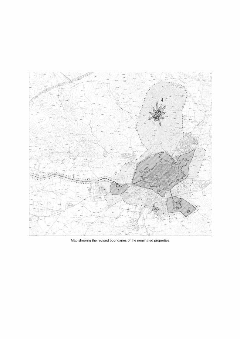
Map showing the revised boundaries of the nominated properties

Aerial view of the nominated property from east
The Castle of Elvas – aerial view

Fort of Santa Luzia – aerial view from north
Fort of Graça – inner gate and ditch