Elements,)Aids,)Techniques,)Methods,)and)Proceduresof ...knightlab.org/rscc/legacy/RSCC_EII.pdf ·...
24
Elements, Aids, Techniques, Methods, and Procedures of Airphoto Interpretation Definitions Photo Interpretation: The act of examining aerial photographs/images for the purpose of identifying objects and judging their significance. Photography: The art or process of producing images on a sensitized surface by the action of light or other radiant energy. Image: A reproduction or imitation of the form of a person or thing. The optical counterpart of an object produced by a lens or mirror or other optical system. Photogrammetry: The science or art of obtaining reliable measurements by means of photography. Activities of Airphoto/Image Interpretation Detection/Identification This is primarily a stimulus and response activity. The stimuli are the elements of image interpretation. The interpreter conveys his or her response to these stimuli with descriptions and labels that are expressed in qualitative terms e.g. likely, possible, or probable. Very rarely do interpreter use definite statements with regard to describing features identified on aerial photography. Measurement As opposed to detection and identification, the making of measurements is primarily quantitative. Techniques used by air photo interpreters typically are not as precise as those employed by photogrammetrists who use sophisticated instruments in making their measurements. Measurements made by photo interpreters will get you close; given high quality, high resolution, largescale aerial photographs and appropriate interpretation tools and equipment, you can expect to be within feet; whereas with photogrammetry if you employ the same type of photography and the appropriate equipment you could expect to be within inches. Problem Solving Interpreters are often required to identify objects from a study of associated objects that they can identify; or to identify object complexes from an analysis of their component objects. Analysts may also be asked to examine an image, which depicts the effects of some process, and suggest a possible or probable cause. A solution may not always consist of a positive identification. The answer may be expressed as a number of likely scenarios with statements of probability of
Transcript of Elements,)Aids,)Techniques,)Methods,)and)Proceduresof ...knightlab.org/rscc/legacy/RSCC_EII.pdf ·...
Elements, Aids, Techniques, Methods, and Procedures of Airphoto Interpretation
Definitions
Photo Interpretation: The act of examining aerial photographs/images for the purpose of identifying objects and judging their significance.
Photography: The art or process of producing images on a sensitized surface by the action of light or other radiant energy.
Image: A reproduction or imitation of the form of a person or thing. The optical counterpart of an object produced by a lens or mirror or other optical system.
Photogrammetry: The science or art of obtaining reliable measurements by means of photography.
Activities of Airphoto/Image Interpretation
Detection/Identification -‐ This is primarily a stimulus and response activity. The stimuli are the elements of image interpretation. The interpreter conveys his or her response to these stimuli with descriptions and labels that are expressed in qualitative terms e.g. likely, possible, or probable. Very rarely do interpreter use definite statements with regard to describing features identified on aerial photography.
Measurement -‐ As opposed to detection and identification, the making of measurements is primarily quantitative. Techniques used by air photo interpreters typically are not as precise as those employed by photogrammetrists who use sophisticated instruments in making their measurements. Measurements made by photo interpreters will get you close; given high quality, high resolution, large-‐scale aerial photographs and appropriate interpretation tools and equipment, you can expect to be within feet; whereas with photogrammetry if you employ the same type of photography and the appropriate equipment you could expect to be within inches.
Problem Solving -‐ Interpreters are often required to identify objects from a study of associated objects that they can identify; or to identify object complexes from an analysis of their component objects. Analysts may also be asked to examine an image, which depicts the effects of some process, and suggest a possible or probable cause. A solution may not always consist of a positive identification. The answer may be expressed as a number of likely scenarios with statements of probability of
correctness attached by the interpreter.
Air photo interpretation is to photogrammetry as statistics is to mathematics; one deals with precision the other with probability.
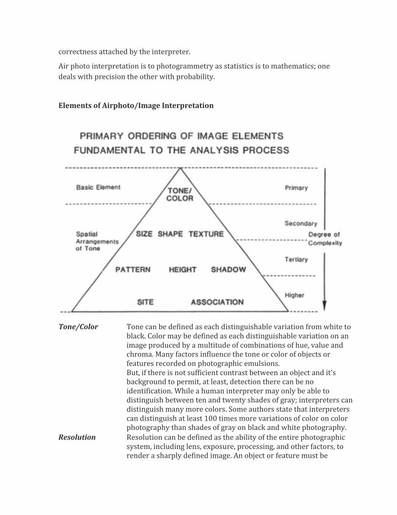
Elements of Airphoto/Image Interpretation
Tone/Color Tone can be defined as each distinguishable variation from white to black. Color may be defined as each distinguishable variation on an image produced by a multitude of combinations of hue, value and chroma. Many factors influence the tone or color of objects or features recorded on photographic emulsions. But, if there is not sufficient contrast between an object and it's background to permit, at least, detection there can be no identification. While a human interpreter may only be able to distinguish between ten and twenty shades of gray; interpreters can distinguish many more colors. Some authors state that interpreters can distinguish at least 100 times more variations of color on color photography than shades of gray on black and white photography.
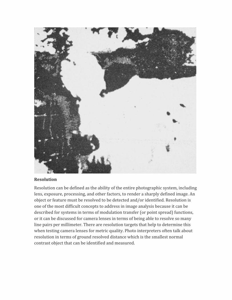
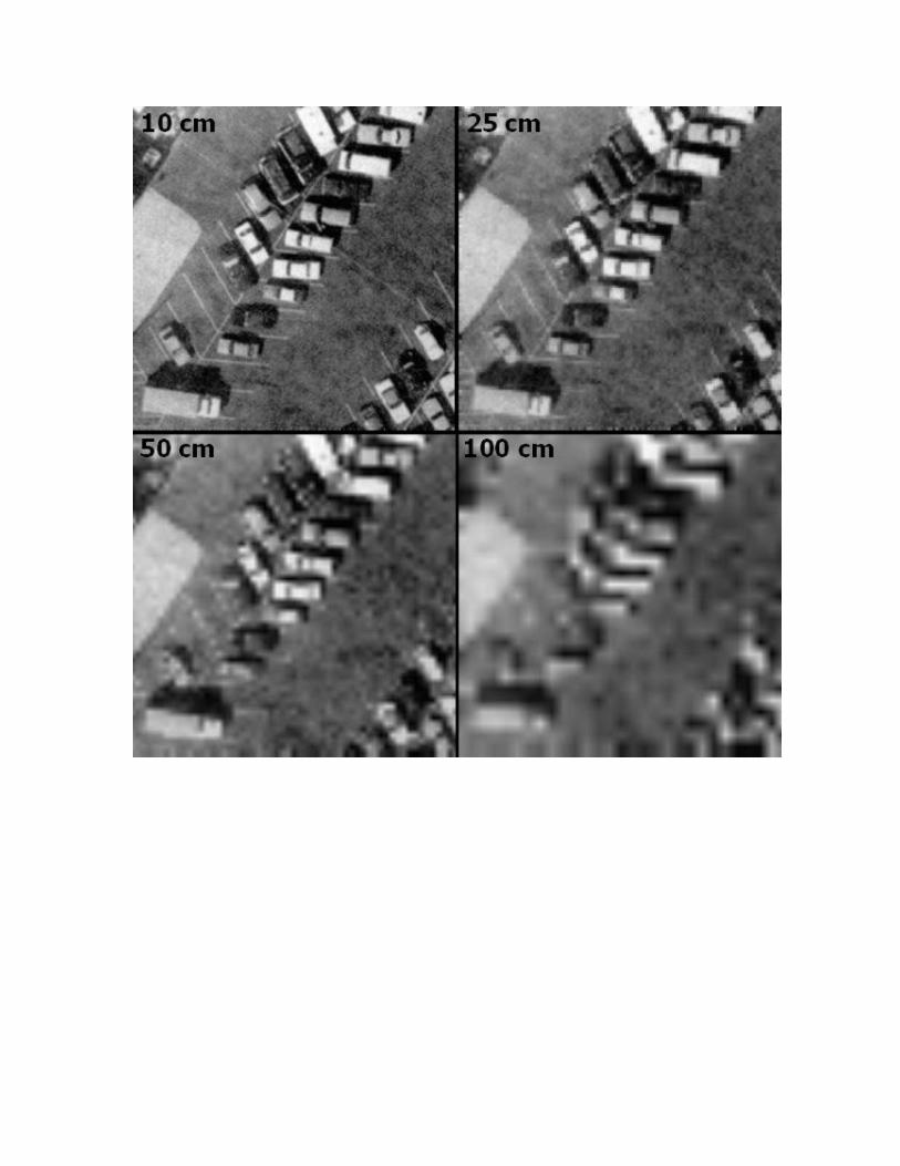
Resolution Resolution can be defined as the ability of the entire photographic system, including lens, exposure, processing, and other factors, to render a sharply defined image. An object or feature must be
resolved to be detected and/or identified. Resolution is one of the most difficult concepts to address in image analysis because it can be described for systems in terms of modulation transfer (or point spread) functions, or it can be discussed for camera lenses in terms of being able to resolve so many line pairs per millimeter. There are resolution targets that help to determine this when testing camera lenses for metric quality. Photo interpreters often talk about resolution in terms of ground resolved distance, which is the smallest normal contrast object that can be identified and measured.
Basic -‐ 1st Order Elements
Tone/Color
Tone can be defined as each distinguishable variation from white to black. Color may be defined as each distinguishable variation on an image produced by a multitude of combinations of hue, value and chroma. Many factors influence the tone or color of objects or features recorded on photographic emulsions. But, if there is not sufficient contrast between an object and it's background to permit, at least, detection there can be no identification. While a human interpreter may only be able to distinguish between ten and twenty shades of gray; interpreters can distinguish many more colors. Some authors state that interpreters can distinguish at least 100 times more variations of color on color photography than shades of gray on black and white photography.
Resolution
Resolution can be defined as the ability of the entire photographic system, including lens, exposure, processing, and other factors, to render a sharply defined image. An object or feature must be resolved to be detected and/or identified. Resolution is one of the most difficult concepts to address in image analysis because it can be described for systems in terms of modulation transfer (or point spread) functions, or it can be discussed for camera lenses in terms of being able to resolve so many line pairs per millimeter. There are resolution targets that help to determine this when testing camera lenses for metric quality. Photo interpreters often talk about resolution in terms of ground resolved distance which is the smallest normal contrast object that can be identified and measured.
2nd Order -‐ Geometric Arrangements of Tone/Color
Size
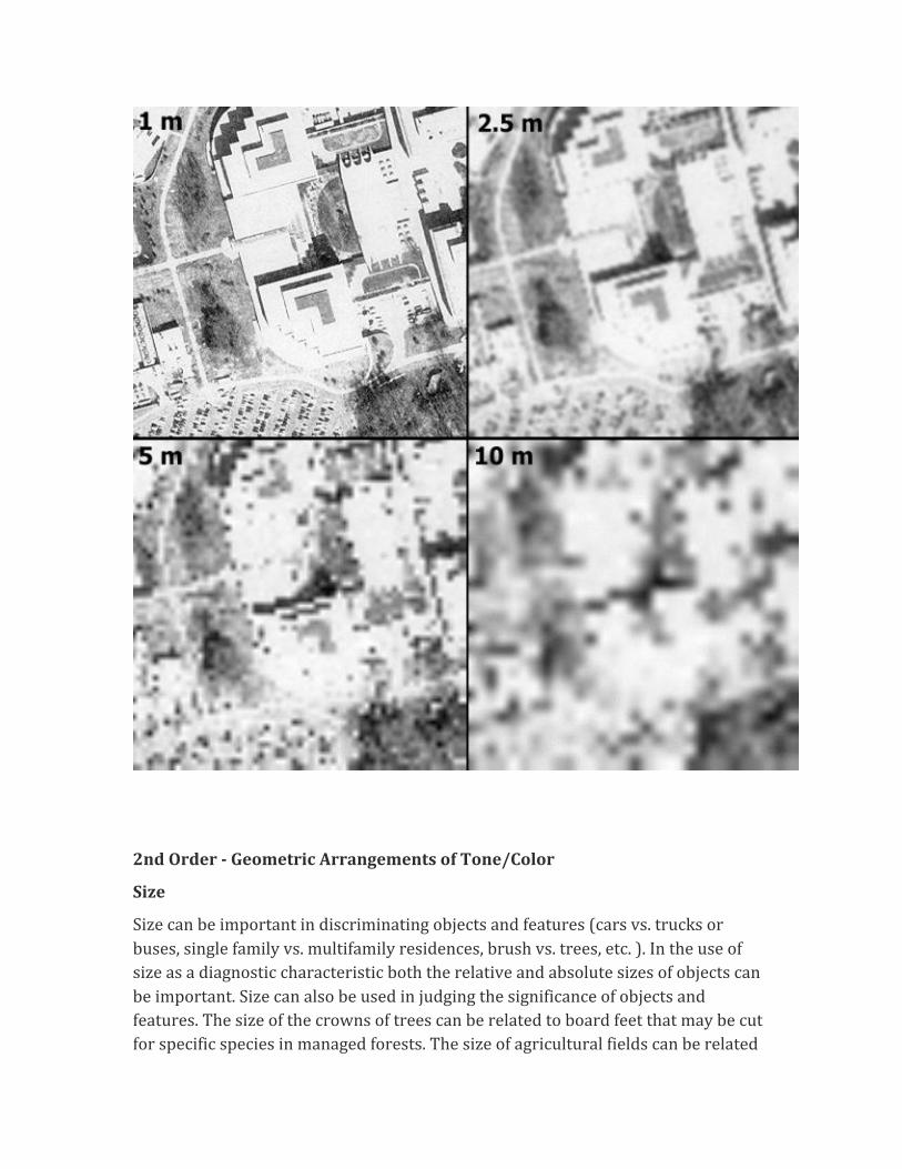
Size can be important in discriminating objects and features (cars vs. trucks or buses, single family vs. multifamily residences, brush vs. trees, etc. ). In the use of size as a diagnostic characteristic both the relative and absolute sizes of objects can be important. Size can also be used in judging the significance of objects and features. The size of the crowns of trees can be related to board feet that may be cut for specific species in managed forests. The size of agricultural fields can be related
to water use in arid areas, or the amount of fertilizers used. The size of runways gives an indication of the types of aircraft that can be accommodated.
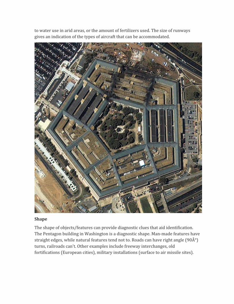
Shape
The shape of objects/features can provide diagnostic clues that aid identification. The Pentagon building in Washington is a diagnostic shape. Man-‐made features have straight edges, while natural features tend not to. Roads can have right angle (90°) turns, railroads can't. Other examples include freeway interchanges, old fortifications (European cities), military installations (surface to air missile sites).
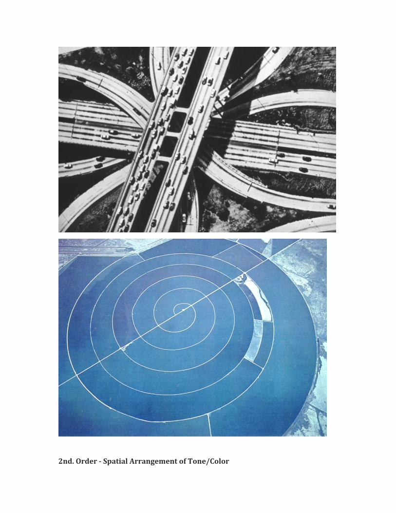
2nd. Order -‐ Spatial Arrangement of Tone/Color
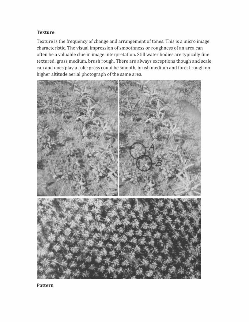
Texture
Texture is the frequency of change and arrangement of tones. This is a micro image characteristic. The visual impression of smoothness or roughness of an area can often be a valuable clue in image interpretation. Still water bodies are typically fine textured, grass medium, brush rough. There are always exceptions though and scale can and does play a role; grass could be smooth, brush medium and forest rough on higher altitude aerial photograph of the same area.
Pattern
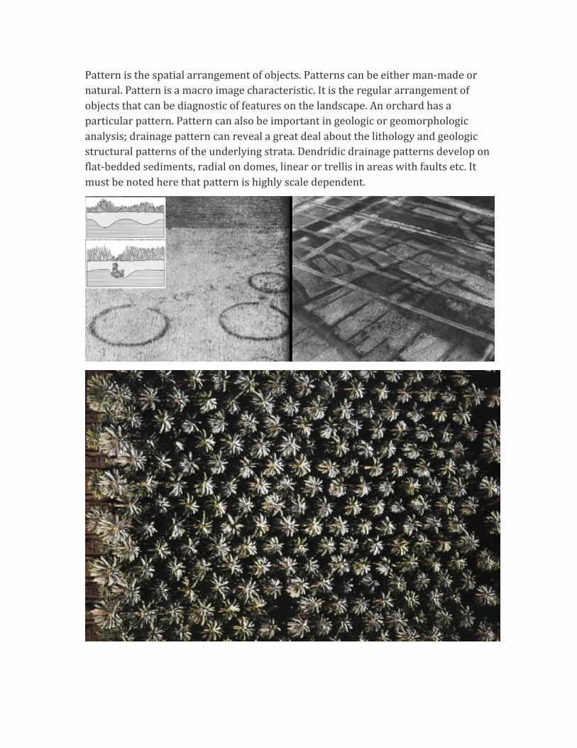
Pattern is the spatial arrangement of objects. Patterns can be either man-‐made or natural. Pattern is a macro image characteristic. It is the regular arrangement of objects that can be diagnostic of features on the landscape. An orchard has a particular pattern. Pattern can also be important in geologic or geomorphologic analysis; drainage pattern can reveal a great deal about the lithology and geologic structural patterns of the underlying strata. Dendridic drainage patterns develop on flat-‐bedded sediments, radial on domes, linear or trellis in areas with faults etc. It must be noted here that pattern is highly scale dependent.
3rd. Order -‐ Locational or Positional Elements
Site
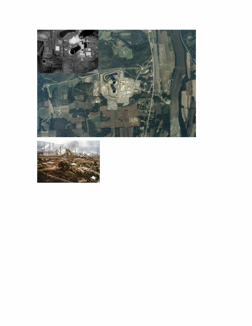
Site refers to how objects are arranged with respect to one another, or with respect to terrain features. Aspect, topography, geology, soil, vegetation and cultural features on the landscape are distinctive factors that the interpreter should be aware of when examining a site. The relative importance of each of these factors will vary with local conditions, but all are important. Just as some vegetation grows in swamps others grow on sandy ridges or on the sunny side vs. the shaded sides of hills. Crop types may prefer certain conditions (e.g. orchards on hillsides). Man made features may also be found on rivers (e.g. power plant) or on hilltops (e.g. observatory or radar facility).
Association
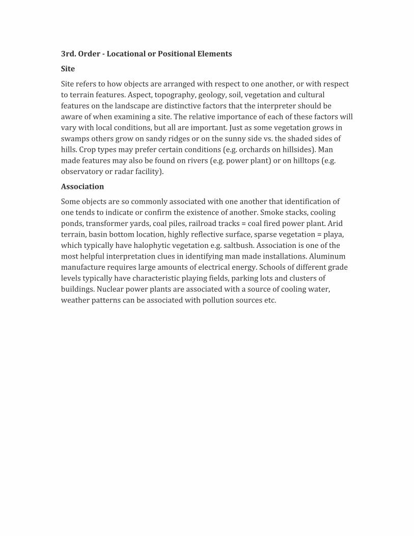
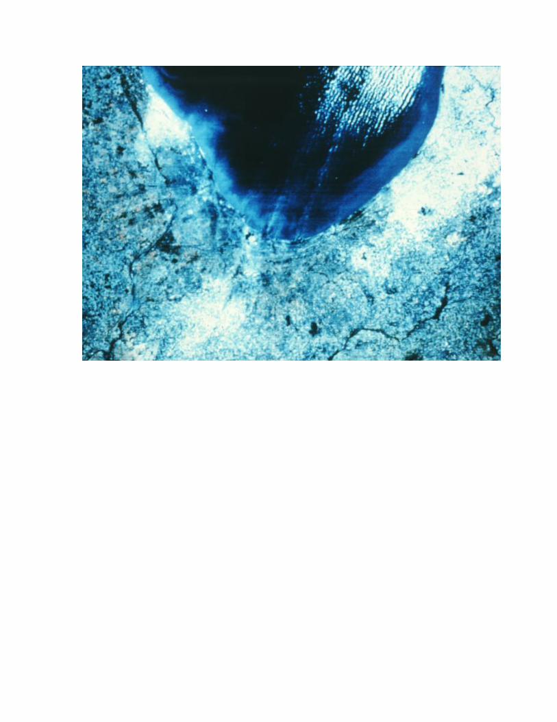
Some objects are so commonly associated with one another that identification of one tends to indicate or confirm the existence of another. Smoke stacks, cooling ponds, transformer yards, coal piles, railroad tracks = coal fired power plant. Arid terrain, basin bottom location, highly reflective surface, sparse vegetation = playa, which typically have halophytic vegetation e.g. saltbush. Association is one of the most helpful interpretation clues in identifying man made installations. Aluminum manufacture requires large amounts of electrical energy. Schools of different grade levels typically have characteristic playing fields, parking lots and clusters of buildings. Nuclear power plants are associated with a source of cooling water, weather patterns can be associated with pollution sources etc.
3rd. Order -‐ Interpreted from lower order elements
Height For some types of analysis e.g. land forms, forestry and some
intelligence applications, some interpreters believe that after tone/color height is the most important element for identification. This is a point of debate, but height can add significant information in many types of interpretation tasks, particularly those that deal with the analysis of man-‐made features and vegetation. How tall a tree is can tell something about the expected amount of board feet. How deep an excavation is can tell something about the amount of material that was removed (in some mining operations excavators are paid on the basis of material removed as determined by photogrammetric measurement of volume).
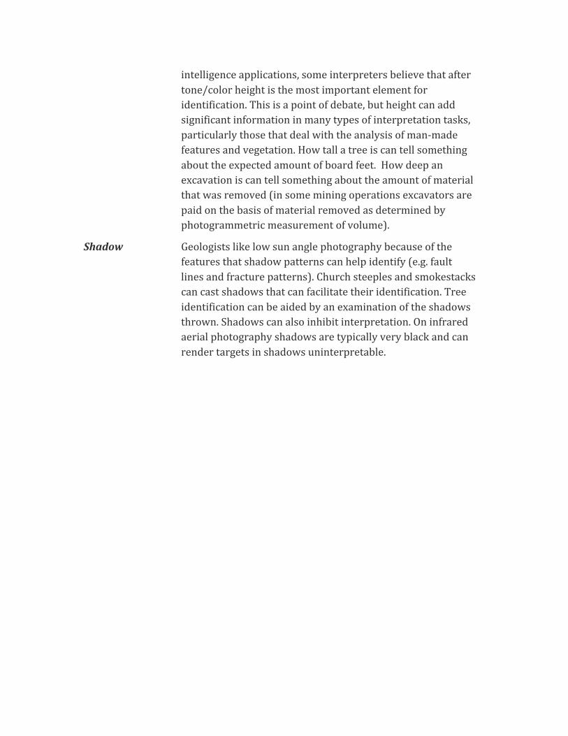
Shadow Geologists like low sun angle photography because of the features that shadow patterns can help identify (e.g. fault lines and fracture patterns). Church steeples and smokestacks can cast shadows that can facilitate their identification. Tree identification can be aided by an examination of the shadows thrown. Shadows can also inhibit interpretation. On infrared aerial photography shadows are typically very black and can render targets in shadows uninterpretable.
Techniques of Photographic/Image Interpretation
Collateral Material
A review of all existing source material that pertains to a given area, process, type of facility or object, can aid in the interpretation process. The use of collateral material may also result in a better definition of the scope, objectives and problems associated with a given project. Also called "ancillary data", collateral material may
come in the form of text, tables, maps, graphs, or image metadata. Census data, a map or description of the flora of a given area, a land use map, meteorological statistics, or agricultural crop reports can all be used in support of a given interpretation. Basically, collateral material represents data/information that an interpreter may use to aid in the interpretation process. Material contained within a Geographic Information System (GIS) that is used to assist an interpreter in an analysis task can be considered collateral data. Two classes of collateral materials deserve special mention: interpretation keys and field verification.
Interpretation Keys
An interpretation key is a set of guidelines used to assist interpreters in rapidly identifying features. Determination of the type of key and the method of presentation to be employed will depend upon, a) The number of objects or conditions to be identified; and, b) The variability typically encountered within each class of features or objects within the key.
Some authors say that as a general rule, keys are more easily constructed and used for the identification of man-‐made objects and features than for natural vegetation and landforms. For analysis of natural features, training and field experience are often essential to achieve consistent results. Basically, an interpretation key helps the interpreter organize the information present in image form and guides him/her to the correct identification of unknown objects. Keys can be used in conjunction with any type of remotely sensed data. Such keys can differ from those employed in other disciplines in that they can consist largely of illustrations, e.g. landforms, industrial facilities, military installations. Many types of keys are already available, if you can find or get your hands on them. This can often be very difficult and a reason why people develop their own keys.
Depending upon the manner in which the diagnostic features are organized, two types of keys are generally recognized. 1) Selective keys, and 2) Elimination keys. Selective keys are arranged in such a way that an interpreter simply selects that example that most closely corresponds to the object they are trying to identify, e.g. industries, landforms etc. Elimination Keys are arranged so that the interpreter follows a precise step-‐wise process that leads to the elimination of all items except the one(s) that they are is trying to identify. Dichotomous keys are essentially a class of elimination key. Most interpreters prefer to use elimination keys in their analyses.
Field Verification
Field verification can be considered a form of collateral material because it is typically conducted to assist in the analysis process. Essentially, this is the process
of familiarizing the interpreter with the area or type of feature. This type of verification is done prior to the interpretation to develop a visual "signature" of how the feature(s) of interest appear on the ground. After an interpretation is made field verification can be conducted to verify accuracy. Fieldwork is sometimes calculated as being three times as expensive as lab analysis. (This is why good interpreters can be so valuable). The nature, amount, timing, method of acquisition, and data integration procedures should be carefully thought out. Will you use windshield surveys, point or transect sampling? Will the sampling be random or systematic?
The amount and type of field work required for a given project may vary greatly and is generally dependent upon the,
a. Type of analysis involved.
b. Image quality, including scale resolution and information to be interpreted.
c. Accuracy requirements for both classification, and boundary delineation.
d. Experience of the interpreter and the knowledge of the sensor, area, and subject.
e. Terrain conditions, and the accessibility of the study area.
f. Personnel availability, access to ancillary material.
g. Cost considerations.
Handling of Imagery
Although a good deal of photo interpretation is still done using paper prints, the use of diapositive transparencies is increasing. Transparencies can be used either as single frames or as a roll. Care should be taken when handling transparencies so that they are not marred. An orderly procedure for the handling of either prints or transparencies should be developed and adhered to in any interpretation project. Airphotos are typically numbered with flight name and/or frame number, and should be kept in order in so far as practical. Different dates and flight lines should be kept separate, etc. Anytime transparencies are used surfaces should be as clean as possible and the interpreter should either wear cotton gloves or be sure not to touch the emulsion surface as skin oils can cause image deterioration.
Stereo Viewing
Binocular vision is natural to all of us, but to the trained interpreter the ability to perceive stereo is an incredibly valuable asset. Stereo viewing will be covered in detail later, but suffice it to say that viewing high quality stereo aerial photography though a mirror stereoscope is like seeing in another dimension. Although the identification and interpretation of many landscapes can be accomplished with
mono, stereo is required for certain types of studies. The following are some tips for using stereo effectively.
Basics for Stereo Viewing
1. Make certain that the photos are properly aligned, preferably with the shadows falling toward the viewer.
2. Keep the eye base and the long axis of the stereoscope parallel to the flight line.
3. Maintain an even glare free illumination on the prints or transparencies.
4. Arrange for comfortable sitting and sufficient illumination.
5. Keep the lenses of the stereoscope clean, properly focused and separated to your inter-‐pupillary distance.
6. The novice interpreter should not work with stereo more than 30 minutes out of any hour period. You have not had a headache until you've had one the comes from doing stereo interpretation for too long!
Trouble Shooting Stereo
1. Your eyes may be of unequal strength. If you normally wears glasses for reading or close-‐up work, you should also wear glasses when using the stereoscope.
2. Poorly illumination, misaligned prints or uncomfortable viewing positions may result in eye fatigue.
3. Illness or severe emotional distress may create sensations of dizziness in one using a stereoscope.
4. Reversal of prints may cause psuedo-‐stereo. A similar problem may occur if prints are aligned with the shadows falling away from rather than towards the interpreter.
5. Objects that change positions between exposures cannot be viewed in stereo.
6. In areas of steep topography, scale differences in adjacent photographs may make it difficult to obtain a three dimensional image.
7. Dark shadows or clouds may prohibit stereo viewing of an area by obscuring an object on one photo.
The Multi Concept Multi-‐Station The successive overlapping of images taken along a given flight
line as being flown by an aircraft or by a satellite along an orbit path. Think of it like "multi-‐position". Not to be confused with
multi-‐stage. Multi-‐Band Multi-‐band indicates individual spectral bands within a given
region of the EM spectrum (e.g. the red green and blue bands of the visible portion of the EM spectrum). Often seen to have an overlapping meaning with the next term, multi-‐spectral.
Multi-‐Spectral The use of images from various regions of the EM spectrum (e.g. ultra-‐violet, visible, infrared, thermal and microwave).
Multi-‐Date The use of multiple aerial photographs or remotely sensed images taken over time of a given area.
Multi-‐Stage This typically means using ground based photos, oblique low altitude photos and vertical photographs or remotely sensed images from platforms flying at different altitudes. Multi-‐stage has also been applied to sampling strategies; A multi-‐stage sampling scheme as used in statistics is one where progressively more information is obtained for progressively smaller sub-‐samples of the area being studied.
Multi-‐Direction
There are times when more information can be obtained using viewing angles other than vertical.
Multi-‐Disciplinary
Basically, no one interpreter can know everything about a system in question. By using teams of interpreters and experts with expertise in different disciplines more information may be gained for a given application. In the legal system this is most similar to the "convergence of evidence" idea; having different viewpoints and different information sources to prove a point adds validity.
Multi-‐Thematic
Remote sensing images are one-‐time write, many times read. Many different themes (e.g. hydrology, vegetation, transportation, urban areas, etc.) can be extracted from a single set of images.
Multi-‐Use Many potential users from environmental planners to resource managers to public policy decision-‐makers can use outputs derived from image analysis and interpretation.
Methods of Search
There are basically two techniques that people tend to follow when searching for imagery. One is logical search and the other can be termed the "fishing expedition". In the latter, the fishing expedition, the interpreter searches the imagery in a random fashion attempting to find recognizable features or object that will lead to whatever the interpretation goal happens to be. At some point even this type of interpretation begins to logically converge. Patterns of anomalous vegetation may lead to looking for water sources, which may lead to looking for transportation systems, illegal growing etc. Logical search is a more systematic method of analysis
most often used by interpreters.
The logical search involve these things:
1. The interpreter should always keep in mind the basic qualities of the imagery they are dealing with, e.g. film filter combination, the season and time of day of acquisition, and the image scale, etc. In addition the interpreter should always remember to examine all the titling information on an image.
2. Interpretation should begin with the general and proceed to the specific. After gaining an overall impression of the photograph the interpreter should begin to examine the physical features (e.g. water bodies, mountains, forests, etc.) and cultural features (e.g. urban areas, farms, road networks etc.). The interpreter should then move to more specific questions e.g. what type of trees make up the forest? What types of roads are present?
3. Interpretation should be conducted logically one step at a time. Following from 2 above it is good to go from a detailed examination of landforms to vegetation, to hydrology and so on. Then address cultural features in the same fashion. What types of urban features are present single family residences, multi-‐family residences, industries, retail districts and so on.
Convergence of Evidence
1. Image interpretation is basically a deductive process. Features that can be detected and identified lead the interpreter to the location and identification of other features. This is convergence, and for many applications of air photo interpretation this involves the activities of one or two individuals synthesizing a large amount of information.
2. Deductive interpretation requires either the conscious or unconscious consideration of all of the elements of image interpretation. The completeness and accuracy of an interpretation is in some measure proportional to the interpreters understanding of the "how and the why" of the elements, techniques and methods of interpretation.
* THE MORE IMAGES YOU INTERPRET THE BETTER INTERPRETER YOU BECOME.
References
Jensen, J.R. , 2000, Remote Sensing of the Environment: An Earth Resource Perspective, Upper Saddle River, NJ: Prentice Hall, 544 pages. [Ch 5 pages119-‐135]
Avery T. E. and G. L Berlin, 1992, Fundamentals of remote Sensing and Airphoto

Interpretation, Fifth Edition, New York, Macmillan Publishing Company, 472 p. [pages 51-‐67]
Estes, J.E. , E.J. Hajic, and L.R. Tinney (Author-‐editors), “Fundamentals of Image Analysis: Analysis of Visible and Thermal Infrared Dataâ€�, Chapter 24, in Manual of Remote Sensing, 2nd. ed. Falls Church, Va. American Society of Photogrammetry, pp. 987-‐1124.
Paine, D. E, 1981, Aerial Photography and Image Interpretation for Resource Management, New York, John Wiley and Sons, 571 p.