EL DORADO COUNTY ZONING MAPedcapps.edcgov.us/maplibrary/html/ImageFiles/gi005558a.pdf1969 Zoning...
1
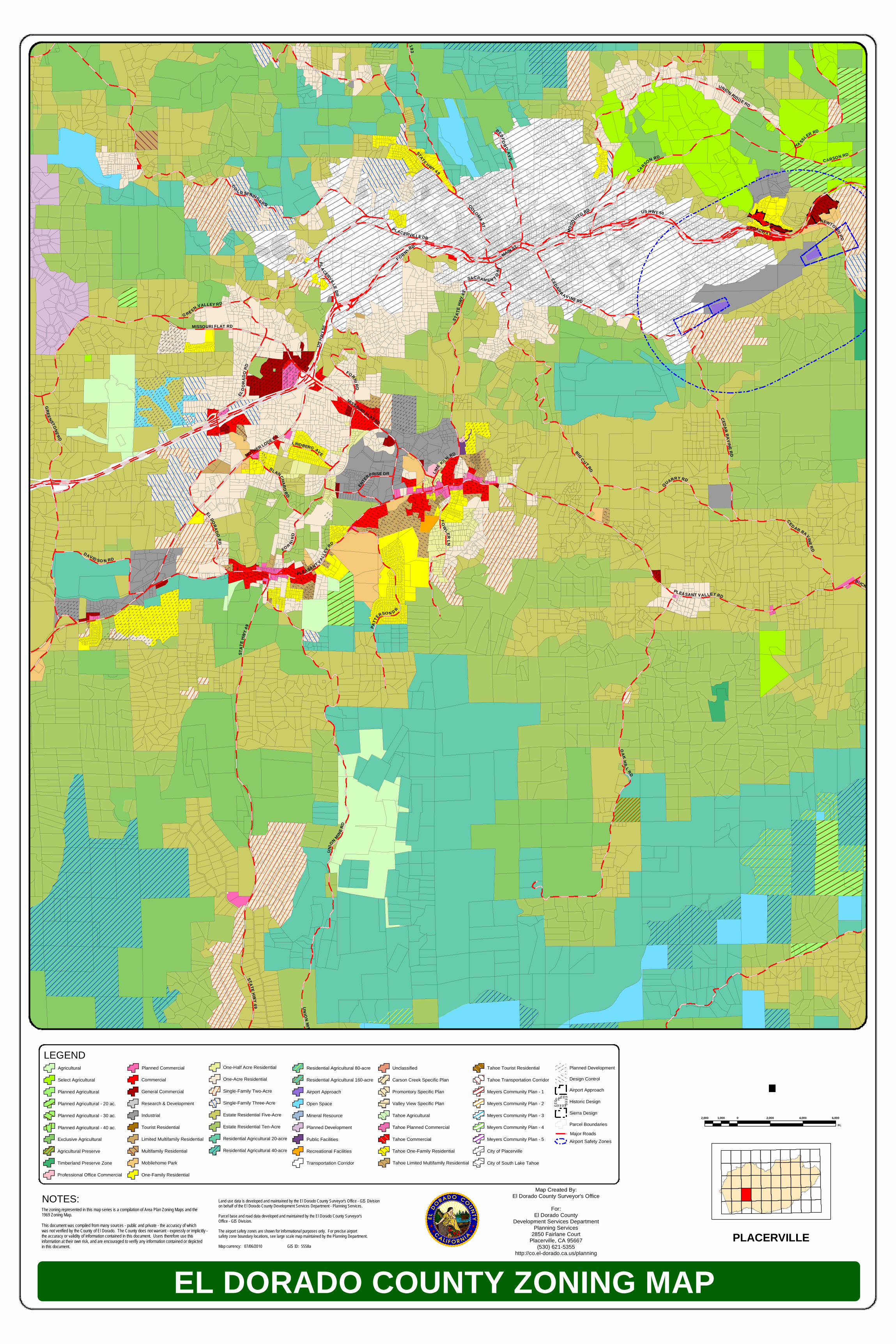
O A K H I L L R D U N I O N M I N C E D A R RA V I N E R D Q U A R R Y R D P A T T E R S O N D R D AV I D S O N R D C A R S O N RD F O W L E R L N C O L O M A S T B L A N C H A R D R D L IN DBER G A VE E N T E R P R I SE D R S A C R A M E N T O S T L I M E K I L N RD U N I O N R I D GE R D F O R N I R D P L A C E RV ILL E D R B E D F O R D A V E CA R S O N R D MISSOURI FLAT RD N E W T O W N R D U S H W Y 5 0 G R E E NS T O N E R D B UCK S B I G C U T R D B R O A DW A Y MAIN ST C O L D S P R IN G S R D G RE E N V A L L E Y R D MISSO URI FLAT RD EL D O R A D O R D F O R N I R D US HWY 50 S T A T E H W Y 4 9 ST AT E H W Y 4 9 U N I O N M IN E R D H A S S L E R RD E L DO R A DO R D P L E A S A NT V A L L E Y R D MOTHER LODE DR F OR N I R D CE D A R R A V I NE R D C E D A R R A V I N E R D P L A C E R V I L L E DR P LE A S A N T V A L L E Y R D M O S Q U ITO R D Y 1 9 3 S T A T E H W Y 4 9 S T A T E H W Y 4 9 EL DORADO COUNTY ZONING MAP 2,000 0 2,000 4,000 6,000 1,000 Ft. · PLACERVILLE Map Created By: El Dorado County Surveyor's Office For: El Dorado County Development Services Department Planning Services 2850 Fairlane Court Placerville, CA 95667 (530) 621-5355 http://co.el-dorado.ca.us/planning LEGEND Agricultural Select Agricultural Planned Agricultural Planned Agricultural - 20 ac. Planned Agricultural - 30 ac. One-Half Acre Residential One-Acre Residential Single-Family Two-Acre Single-Family Three-Acre Estate Residential Five-Acre Estate Residential Ten-Acre Residential Agricultural 20-acre Residential Agricultural 40-acre Residential Agricultural 80-acre Residential Agricultural 160-acre Airport Approach Open Space Mineral Resource Planned Development Public Facilities Recreational Facilities Transportation Corridor Unclassified Carson Creek Specific Plan Promontory Specific Plan Valley View Specific Plan Tahoe Agricultural Tahoe Planned Commercial Tahoe Commercial Tahoe One-Family Residential Tahoe Limited Multifamily Residential Tahoe Tourist Residential Tahoe Transportation Corridor Meyers Community Plan - 1 Meyers Community Plan - 2 Meyers Community Plan - 3 Meyers Community Plan - 4 Meyers Community Plan - 5 City of Placerville City of South Lake Tahoe Planned Development Design Control Airport Approach ÈÈÈ ÈÈ È ÈÈ ÈÈÈÈ ÈÈÈÈ Historic Design Sierra Design Parcel Boundaries Major Roads Airport Safety Zones Planned Agricultural - 40 ac. Commercial General Commercial Research & Development Industrial Tourist Residential Limited Multifamily Residential Multifamily Residential Mobilehome Park One-Family Residential Planned Commercial Timberland Preserve Zone Professional Office Commercial Agricultural Preserve Exclusive Agricultural The zoning represented in this map series is a compilation of Area Plan Zoning Maps and the 1969 Zoning Map. This document was compiled from many sources - public and private - the accuracy of which was not verified by the County of El Dorado. The County does not warrant - expressly or implicitly - the accuracy or validity of information contained in this document. Users therefore use this information at their own risk, and are encouraged to verify any information contained or depicted in this document. Land use data is developed and maintained by the El Dorado County Surveyor's Office - GIS Division on behalf of the El Dorado County Development Services Department - Planning Services. Parcel base and road data developed and maintained by the El Dorado County Surveyor's Office - GIS Division. The airport safety zones are shown for informational purposes only. For precise airport safety zone boundary locations, see large scale map maintained by the Planning Department. Map currency: 07/06/2010 GIS ID: 5558a NOTES:
Transcript of EL DORADO COUNTY ZONING MAPedcapps.edcgov.us/maplibrary/html/ImageFiles/gi005558a.pdf1969 Zoning...
OAK H IL L RD
UNION MI NE RD
CEDAR RAVINE RD
QUARRY RD
PATT
ERSON D R
DAVID SO N RD
CARSON RD
FOWLER LN
COLOMA ST
BL ANCHARD RD
LINDBERG AVE
ENTERPRISE DR
SACRAM E N T O ST
LIME KILN RD
UNION RIDGE RD
FORN I RD
PLACERVILLE DR
BEDFORD AVE
CARSON R D
MISSOURI FLAT RD
NEWTOWN RD
US HWY 50
GREENSTONE RD
MOTHER LODE DR
BUCKS BAR RD
BIG C UT RD
BROADWAY
MAIN ST
CO LD SPRINGS R D
G RE EN VALLEY R D
MISSOURI FLAT RD
EL D
ORAD
O RD F ORNI RD
US H
WY 50
STATE
HWY
49
STATE HWY 49
UNION MIN
E RD
HA SSLER RD
EL DORADO RD
PLEA SANT VA LLEY RD
MOTHER LODE DR
FOR NI RD
CEDAR RA V INE RD
CED AR RAVINE RD
PL ACERVILLE DR
PLEASANT VALLEY
RD
MOSQ
UITO RD
US HWY 50
STATE HWY 193
STATE HWY 4 9
STAT
E HWY
49
EL DORADO COUNTY ZONING MAP
2,000 0 2,000 4,000 6,0001,000
Ft.
·
PLACERVILLE
Map Created By:El Dorado County Surveyor's Office
For:El Dorado County
Development Services DepartmentPlanning Services
2850 Fairlane CourtPlacerville, CA 95667
(530) 621-5355http://co.el-dorado.ca.us/planning
LEGENDAgricultural
Select Agricultural
Planned Agricultural
Planned Agricultural - 20 ac.
Planned Agricultural - 30 ac.
One-Half Acre Residential
One-Acre Residential
Single-Family Two-Acre
Single-Family Three-Acre
Estate Residential Five-Acre
Estate Residential Ten-Acre
Residential Agricultural 20-acre
Residential Agricultural 40-acre
Residential Agricultural 80-acre
Residential Agricultural 160-acre
Airport Approach
Open Space
Mineral Resource
Planned Development
Public Facilities
Recreational Facilities
Transportation Corridor
Unclassified
Carson Creek Specific Plan
Promontory Specific Plan
Valley View Specific Plan
Tahoe Agricultural
Tahoe Planned Commercial
Tahoe Commercial
Tahoe One-Family Residential
Tahoe Limited Multifamily Residential
Tahoe Tourist Residential
Tahoe Transportation Corridor
Meyers Community Plan - 1
Meyers Community Plan - 2
Meyers Community Plan - 3
Meyers Community Plan - 4
Meyers Community Plan - 5
City of Placerville
City of South Lake Tahoe
Planned Development
Design Control
Airport Approach
ÈÈÈ
ÈÈ
ÈÈÈ
ÈÈÈÈ ÈÈÈÈ
Historic Design
Sierra Design
Parcel BoundariesMajor RoadsAirport Safety Zones
Planned Agricultural - 40 ac.
Commercial
General Commercial
Research & Development
Industrial
Tourist Residential
Limited Multifamily Residential
Multifamily Residential
Mobilehome Park
One-Family Residential
Planned Commercial
Timberland Preserve Zone
Professional Office Commercial
Agricultural Preserve
Exclusive Agricultural
The zoning represented in this map series is a compilation of Area Plan Zoning Maps and the1969 Zoning Map.This document was compiled from many sources - public and private - the accuracy of whichwas not verified by the County of El Dorado. The County does not warrant - expressly or implicitly -the accuracy or validity of information contained in this document. Users therefore use thisinformation at their own risk, and are encouraged to verify any information contained or depictedin this document.
Land use data is developed and maintained by the El Dorado County Surveyor's Office - GIS Divisionon behalf of the El Dorado County Development Services Department - Planning Services.Parcel base and road data developed and maintained by the El Dorado County Surveyor'sOffice - GIS Division.The airport safety zones are shown for informational purposes only. For precise airportsafety zone boundary locations, see large scale map maintained by the Planning Department.Map currency: 07/06/2010 GIS ID: 5558a
NOTES: