Effect of Land Use Change on Infrastructural Planning and ... · PDF fileEffect of Land Use...
13
European International Journal of Science and Technology ISSN: 2304-9693 www.eijst.org.uk 62 Effect of Land Use Change on Infrastructural Planning and Development in Ikwerre Local Government Area of Rivers State, Nigeria Gbenga Enisan 1* , Eniola Aluko 2 and Umanubueso Georgewill 3 1,2,3 Department of Urban and Regional Planning, Federal University of Technology, Akure, Ondo State, Nigeria *Corresponding Author Emails: [email protected] , [email protected] ABSTRACT The research focused on the effect of land use change on infrastructural planning and development in Ikwerre Local Government Area of Rivers State, Nigeria. This is to examine the effect of land use change on Infrastructural planning and also to ensure infrastructural sustainability and urban development in the study area. This was accomplished by the relevant information collected on the research problem with the use of questionnaire and analysed using Statistical Package for Social Scientist (SPSS). The formulated hypothesis for this study was tested based on the available dataset and the prescribed method, alternative hypothesis (H 1 ) was accepted and null hypothesis (H 0 ) was rejected. The conclusion was drawn in line with the recommendation; the sample size is derived from sample taken from the total projected population of the study with the number of household and units of building per compound. Information gathered from the research showed that there were Land use change and infrastructural development in the study area. Also, there is a continuous change in Land use over time as it is based on individual desire to develop, government land use planning and community land use at large. The various land use changes gave rise to different infrastructural development and brought in different uses which in one way or the other; alter a particular land use planning. However, different recommendation were proposed which includes, Revitalization, Land use and Infrastructural Sustainability, Development control, Use of Geographic Information System (GIS), Community and Stakeholder Participation and Public Awareness Participation. Keywords: Urban Planning, Land Use Change, Infrastructural Planning, Development 1 INTRODUCTION It has long been recognized that an adequate supply of infrastructure services is an essential ingredient for productivity and growth (World Bank, 1994).The planning system is a key component of infrastructure delivery, this was also emphasize in Infrastructure UK Cost Review Report (2010) which identified it as a major reason for excessive scheme costs compared to other European countries. In recent years, the role of infrastructure has received increased attention. Infrastructure planning and development has ever been an
Transcript of Effect of Land Use Change on Infrastructural Planning and ... · PDF fileEffect of Land Use...

European International Journal of Science and Technology ISSN: 2304-9693 www.eijst.org.uk
62
Effect of Land Use Change on Infrastructural Planning and Development in
Ikwerre Local Government Area of Rivers State, Nigeria
Gbenga Enisan 1*
, Eniola Aluko 2 and Umanubueso Georgewill
3
1,2,3
Department of Urban and Regional Planning, Federal University of Technology,
Akure, Ondo State, Nigeria
*Corresponding Author Emails: [email protected], [email protected]
ABSTRACT
The research focused on the effect of land use change on infrastructural planning and development in
Ikwerre Local Government Area of Rivers State, Nigeria. This is to examine the effect of land use change on
Infrastructural planning and also to ensure infrastructural sustainability and urban development in the
study area. This was accomplished by the relevant information collected on the research problem with the
use of questionnaire and analysed using Statistical Package for Social Scientist (SPSS). The formulated
hypothesis for this study was tested based on the available dataset and the prescribed method, alternative
hypothesis (H1) was accepted and null hypothesis (H0) was rejected. The conclusion was drawn in line with
the recommendation; the sample size is derived from sample taken from the total projected population of the
study with the number of household and units of building per compound. Information gathered from the
research showed that there were Land use change and infrastructural development in the study area. Also,
there is a continuous change in Land use over time as it is based on individual desire to develop,
government land use planning and community land use at large. The various land use changes gave rise to
different infrastructural development and brought in different uses which in one way or the other; alter a
particular land use planning. However, different recommendation were proposed which includes,
Revitalization, Land use and Infrastructural Sustainability, Development control, Use of Geographic
Information System (GIS), Community and Stakeholder Participation and Public Awareness Participation.
Keywords: Urban Planning, Land Use Change, Infrastructural Planning, Development
1 INTRODUCTION
It has long been recognized that an adequate supply of infrastructure services is an essential ingredient for
productivity and growth (World Bank, 1994).The planning system is a key component of infrastructure
delivery, this was also emphasize in Infrastructure UK Cost Review Report (2010) which identified it as a
major reason for excessive scheme costs compared to other European countries. In recent years, the role of
infrastructure has received increased attention. Infrastructure planning and development has ever been an
European International Journal of Science and Technology Vol. 4 No. 9 December, 2015
63
on-going, though with high need of attention especially in developing economy like Nigeria. With the ever
growing population, urbanization menace, the need for creating environments for business growth and
provision of a sustainable environment has called for the immediate attention to the state of infrastructure in
Nigeria and to the changes in land use. This is most important in the development of the economy and the
rural areas. And it has been noted that provision of infrastructure in many local government areas in Nigeria
is treated with levity. The intention of the Federal Government in creation of Local Governments is to
develop the rural areas (Oviasuyi, Idada and Isiraojie, (2010). Most infrastructures in Nigeria are said to be
in poor state owing to various factors like poor maintenance culture, poor or inadequate funding and also
neglects over a long period of time by government and its different agencies that are to provide and maintain
the infrastructure. In as much as Government Agencies and public private partnerships (PPP) are working in
force to ensure that various types of infrastructural services are provided for the functioning of the modern
environment, there are increase demands of land for adequate infrastructural planning.
Land use change occur as a result of the rapid rate of growth and development of our urban environment;
especially the, Ikwerre Local Government Area of Rivers State. The phenomenon is spreading throughout
the country at a fast rate, with an increase demand of attention on its rate of change over time and to this
present age. A number of metropolitan and regional areas are experiencing drastic changes in land use due to
the high rate of urbanization. But the most important is the growth of the services of Infrastructural planning
at all levels of the urban economy of the state. This study aims to contribute to the various aspect of
infrastructural planning research. There are four objectives of this study; which in long run, will
comprehensively review the infrastructural literatures from various aspects and applications, then, it will
review the effect of land use change on infrastructural planning in Rivers State, using Ikwerre Local
Government Area as a case study. The outcome will be helpful in improving general understanding of
infrastructural planning in Rivers State, Nigeria.
2 LITERATURE REVIEW
It is self-evident that there are symbolic relationship between land use and infrastructural planning. Land is
required for various uses in both the urban and rural areas of all society. As nations grow in size and rural
areas become urban centers and urban centers become large metropolitan areas, there is always increased
competition as well as demand for land for different purposes. This requires adequate planning and control
to ensure harmonious development and functional efficiency of these uses and settlements. Land is basically
the solid part of the earth surface and the natural resource of any nation or state on which human and
economic activities take place. It is humanity’s most valuable resource without which man could never have
existed and on which his continued existence and progress depend (Fabiyi, 2006). Land is said to be the
primary and permanent material for human existence. Land from time immemorial has been treated as a
measure of wealth, status and power all over the world (Aloks and Navedeep 2002). As a result of this, Land
has also been the source of bloody conflicts and disputes not only between nations, kings, but between
common people as this was the major source of livelihood. It has also been the cause of family rifts, turning
brothers into enemies. Hence land is used to meet a multiplicity and variety of human needs and to serve
numerous diverse purposes. The Analysis of land use change is essentially the analysis of the relationship
between man and land. This relationship between man and land can be traced to the Holy Bible where it was
clearly made known in several chapters that man cannot be detached from the land (Adeniyi, 2012). In
Nigeria todayand other parts of the world where land is perceived as essence of human self-definition and
socio- economic and cultural survival because the ability to own, control and use land is not only an

European International Journal of Science and Technology ISSN: 2304-9693 www.eijst.org.uk
64
important expression of both private and proprietary right but also a measure of economic wealth and power
(Adeniyi, 2012).
Land use is the term used to describe what goes on in the Land. It is the way in which and the purpose for
which human beings employ the land and its resources. The Natural Scientists define land use in terms of
syndromes of human activities such as Agriculture, Forestry and building construction that alter the Land
Surface. While the social scientists and land managers define land use as social and economic purposes and
contexts for and within which land is managed (Fred-Nwagwu, 2012). According to Akinyosoye (2013a),
infrastructures defined by social-economist are instruments considered as factors of production, increasing
aggregate output and driving economic growth. From a development stand point: they are seen to enhance
quality of life, improving average living standards. And also it contributes to economic development by
increasing productivity and provision of amenities which enhance the quality of life. The services generated
as a result of an adequate infrastructure base will translate to an increase in aggregate output and high
demand of land.
The Benefits of Infrastructure in National Development
The African Development Bank (ADB) has made infrastructure development a cornerstone in its
development agenda with regional member countries (TMSA, 2012). The Bank recognizes that lack of
adequate social and economic infrastructure is one of the key constraints to short- and medium term poverty
reduction in Africa, and has thus been a major force in private and public sector infrastructure development
through the provision of financial and technical resources. At the same time, the Bank recognises the
increasing importance of governance for infrastructure development and has made good governance an
imperative in its lending and non-lending operations. There have been considerable changes in the delivery
of national infrastructure services across Africa. While Nigeria has improved its telecommunication
infrastructural situation, it has not improved in other areas like health, education, airport infrastructures,
electricity, housing and transportation. However, performance in terms of infrastructure service delivery and
quality continue to vary across countries. Infrastructure is the medium of production of goods and services
and forms the national asset of any nation.
State of Infrastructure in Nigeria
To assess the readiness of Nigeria for the realization of Vision 20:2020, we would need to research into the
state of Nigerian infrastructure. Infrastructure in Nigeria is generally adjudged to be in a deplorable and
decaying state. To this the plan is in complete agreement. For power generation it notes that “only 40 per
cent of Nigerians, many urban centres have access to electricity. The installed available generation capacity
is currently 5200mw. In its epileptic performance, out of this 5200mw only 3700mw are actually generated
as at 2009, this has moved up to about 4000 mw with a per capita consumption of about 111 KWh (Olaseni
and Alade, 2011).
The Role of Infrastructure Planning in Economic Development
Infrastructure is an umbrella term for many activities usually referred to as “social overhead capital” by
development economists. Precisely, infrastructure refers to a network of transport, communication and
public (social) services, all functioning as a system or as a set of interrelated and mutually beneficial
services provided for the improvement of the general well-being of the population (Ogbuozobe, 1997).
Public or social services refer to those services or facilities meant for the common goods of the people. They
include water supply, health care delivery, education, postal and telecommunication facilities, electricity,
etc. Sufficient infrastructural services are indispensable for economic development. The adequacy of

European International Journal of Science and Technology Vol. 4 No. 9 December, 2015
65
infrastructure helps to determine a country’s success or failure in diversifying production, coping with
population growth, reducing poverty, improving environmental conditions, etc. Indeed, socio-economic
development can be facilitated and accelerated by the presence of infrastructure. If these facilities and
services are not in place, development will be very difficult and in fact can be likened to a very scarce
commodity that can only be secured at a very high price and cost. Adequate access to social welfare
services, such as medical services, education, potable water supply, roads, electricity, employment
opportunities etc, are strong indices of development (Adeyemo, 1989). In any discourse on infrastructure, it
is important to note that infrastructure can be broadly classified in two: physical (roads, electricity,
telecommunication, etc.) and social (education, health, recreation, housing etc.). In some clime, physical
infrastructure is often referred to as economic infrastructure. Thus, the role of infrastructure in economic
development will be discoursed along this line.
Land Use Planning in Ikwerre Local Government Areas of Rivers State.
The Greater Port Harcourt City is planned as a modern city for residential, commercial, industrial and
entertainment purposes for an estimated 2 million population. Infrastructural planning and development of
this City is based on phases. And phase 1A is focused in Ikwerre Local Government Area.
Land Use Planning: Phase 1 Layout spans from Port Harcourt International Airport junction across to
professor Tam David-West Boulevard and extends to part of Igwuruta. Phase 1A is located directly behind
the Port Harcourt international Airport Hotel and spans along professor Tam David-West Boulevard which
is opposite the Port Harcourt International Airport with a land mass of 685 Ha (6,850 Sq.km ). This layout
comprises of private neighbourhoods mixed used complexes and the Rivers State University of Science and
Technology land. The Planning and design of community layouts is borne out of the need to prevent
disorderly development in and around the New City, particularly the Phase 1A development areas. The
Greater Port Harcourt City Development Authority recognises the existence of community enclaves and
individuals that own land adjoining the phase 1 of the New City. These communities are expected to grow in
leaps and bounds as a result of the ancillary developmental activities such as the Sports Precinct, PTDF
Centre, Mega hospital etc.
� Igwuruta-ali Community Layout
The planning and design of the layouts is therefore intended:
1. To regulate the use of land;
2. To promote orderly development;
3. To provide for services-facilities and basic amenities;
4. To promote economic development, safe and healthy environment and
5. To curb urban sprawl, slums and scatterization in and around the new city.
Site description; the site is strip of land lying along the Ikwerre/Owerri road and bounded by the Sports
Precinct link road in the South and the existing Igwuruta-ali community in the South-East. The total area of
the land is 39.61 hectares, presently with few existing buildings and a number of fenced properties. Owners
of properties are both indigenes and non-indigenes (GPHCDA, 2013).
� Light Commercial and Industrial Layout.
Is an area zoned and planned for the purpose of industrial development to serve the Airport on the edges of
and outside the main residential area of phase 1A. Industries related to time-sensitive manufacturing, e-
commerce fulfilment, telecommunications and logistics/ warehouses will be located in the Layout.

European International Journal of Science and Technology ISSN: 2304-9693 www.eijst.org.uk
66
Infrastructural Development in Ikwerre Local Government Areas of Rivers State
� AdokiyeAmiesimaka Stadium and Sports Complex
Is the 40,000 sitting stadium, two Olympic sizes Swimming Pool, Basket Ball, Tennis Courts, Hockey Pitch,
Indoor Games, Hand Ball etc.
� The M10 Dual Carriage Road/Freeway:
The M10 freeway are planned to connect the Port Harcourt International Airport to the Onne Seaport and
several development nodes of the Greater Port Harcourt City.
� Water Supply Plant
To phase 1A portion of the New City. The estimated ultimate Average Daily Demand (ADD) for the Area to
be serviced is some 2.5 Ml/day, 500 kl low reservoir including chlorination for disinfection and the
abstraction and treatment facilities have accordingly been designed to treat 3.0 Ml/day. This facility will
serve the first 5,000 homes in phase 1A.
� 33KV Electricity Supply and Power Substation
The completed 2 Electricity supply from PHCN to the New City MVA standby generators and fuel system
have been installed to provide backup electricity street light supply to phase 1A.
� New Site for the Rivers State University of Science and Technology
The layout for the new site is ready and reticulation of the infrastructure services has been completed,
including road and drainage network. The architectural and other drawings for the buildings have been done
ready for commencement of construction.
� Central City District
Is regarded as a critical development area for the New City of Greater Port Harcourt.Being the economic
heartland and centre of new and modern development for the entire city.
� Prof Tam David-West Boulevard
This road connects Port Harcourt through ObiriIkwerre, Aluu Town, and Omagwa Town to the Omagwa
International Airport.
� The Golf Course and Estates
Garden City Golf Course and Estates is a world class championship standard 18-hole golf course,
surrounded by plots for premium homes with supporting infrastructure-road, sewage, water, electricity,
waste disposal services, conferencing, leisure and sports (GPHCDA, 2015).
3 LAND USE AND INFRASTRUCTURAL PLANNING
A principle of the South East Queensland Regional Plan 2005-2026 is to use infrastructure to lead and
support desired regional growth. A similar objective of the Far North Queensland Draft Regional Plan 2025
is for infrastructure to be planned, coordinated and provided to support desired regional growth in an
efficient and effective manner. Although it may appear that infrastructure comes first, the key words are “to
support desired regional growth”. The implication is that there is plan for regional growth that is desirable
before there is infrastructure design and delivery. The purpose of infrastructure is to support the desired
regional growth. Ideally, land use planning sets the strategic direction and the proper utilization of land use
European International Journal of Science and Technology Vol. 4 No. 9 December, 2015
67
intent as well as, infrastructural planning helps implement regional growth. That is the urban planners view.
In reality, planning rarely starts with a clean slate in an established urban environment. There are usually a
multitude of plans across a range of infrastructure classes completed or in progress. This means that land use
planning does not occur in a vacuum or necessarily come first. Planning is a cyclical process involving plan
making, implementation, monitoring, reporting and review. (Low Choy DC, Worrall RH, Gleeson J,
Mackay P and Robinson J 2002 Adaptive Management).
Land use for residential, commercial, industrial and other purposes has become of great concern as it is
usually the focus of urban research. This has been confirmed through the works of many urban researchers
like Burgess and McKenzie (1925) on American cities, particularly Chicago; Mabogunje (1968) on Lagos:
Ayeni (1968) on Jos; Frishman (1977) on Kano; Olaore (1981) on Kaduna; Okpala (1981) on Enugu and
Onitsha. Most of those studies show that urban areas are of enormous political, social, economic and cultural
importance in numerous places in which they are located. Infrastructural planning as the name implies can
be very broad or very narrow, comprehensive in focus, system oriented or problem oriented.
4 MATERIALS AND METHOD
The data sourced for this study were of two types, the primary and secondary data.The primary data are of
two categories; spatial and non-spatial. The spatial data was obtained through geographic information
system (GIS). While the non-spatial data through questionnaire approach and oral interview, photographs
and personal observations were also included. Secondary Data includes; maps, textbooks seminar papers etc.
and other relevant information that were required for the accomplishment of this study. These are the
information from official and non-official documents used. Aprojected population of 235974 with an
increase of 47044, in respect to 188,930 populations (National Population Commission, 2006) was used.
This serves as the base population or the research population for the study since issues on land use and
infrastructural planning bother on the generality of the community. The sampling population is derived from
the overall population of the study area. Due to the fact that the entire communities have several
homogeneous relationships and the population was more than 200,000. The house hold size usedwas seven
(7) (Standard household size), with 4 unit of building per compound. The total population derived for each
compound is 28 persons (4×7). Therefore, projected population (235,974/28= 8,428), 8428 is the target
population as derived from the total projected population 235974. 2.5 per cent of 8428 was used as the
sample size and 210 persons were finally selected. The simple random sampling techniques was used for the
different group of respondents which includes the residents of the area and the staff in Greater Port City
Development Authority (GPHCDA), in charge of the physical planning and development of the local
government area. The technique was employed in a random manner, giving priority to every individual in
the study area as to have met the research criteria.Two hundred and Ten (210) questionnaires were
administered; one hundred and eighty (180) were retrieved, Twenty (20) were not filled and Ten (10) were
not retrieved.
5 ANALYSIS AND PRESENTATION OF RESULTS
Social package for social science software (SPSS) was used in this dissertation to analyse the questionnaire.
Single factor analysis of variables, chart, tables with view of exploring their statistical potentials and student
t-test was used for the bivariate analysis comparing dataset in the analysis.
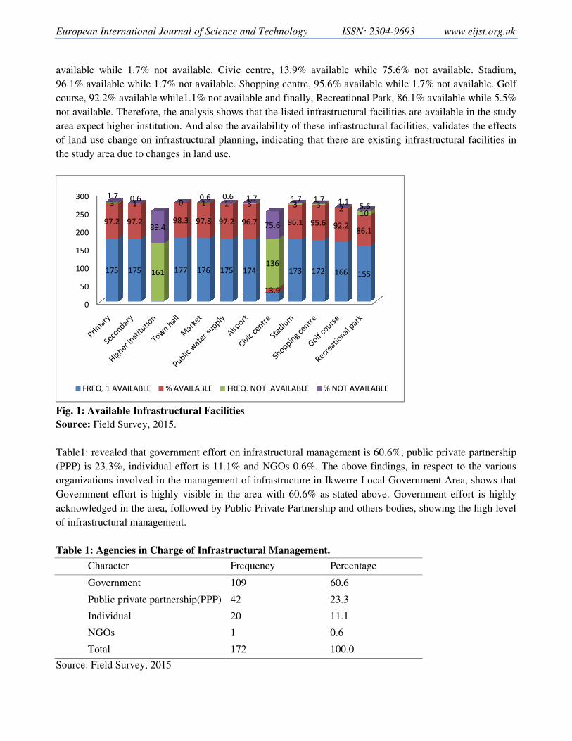
Most of the respondents identified the following infrastructural facilities as showed in Fig.1,which indicates
that for primary school; available 97.2%, not available 1.7%, Secondary school; 97.2% available, 0.6% not
available; higher institution, 89.4% not available. Town hall, 98.3% available, Market, 97.8% available
while 0.6% not available. Public water supply; 97.2% available while0.6% is not available. Airport, 96.7%
European International Journal of Scien
available while 1.7% not available. Ci
96.1% available while 1.7% not availabl
course, 92.2% available while1.1% not a
not available. Therefore, the analysis sho
area expect higher institution. And also t
of land use change on infrastructural pl
the study area due to changes in land use
Fig. 1: Available Infrastructural Facil
Source: Field Survey, 2015.
Table1: revealed that government effort
(PPP) is 23.3%, individual effort is 11.1
organizations involved in the manageme
Government effort is highly visible in
acknowledged in the area, followed by P
of infrastructural management.
Table 1: Agencies in Charge of Infrast
Character
Government
Public private partnership(PPP)
Individual
NGOs
Total
Source: Field Survey, 2015
0
50
100
150
200
250
300
175 175 177 176 175
97.2 97.2 98.3 97.8 97.2
3 1
161
0 1 11.7 0.6
89.4
00.6 0.6
FREQ. 1 AVAILABLE % AVAILABLE
nce and Technology ISSN: 2304-9693
Civic centre, 13.9% available while 75.6% not
able. Shopping centre, 95.6% available while 1.7%
t available and finally, Recreational Park, 86.1% a
shows that the listed infrastructural facilities are a
o the availability of these infrastructural facilities,
planning, indicating that there are existing infras
se.
cilities
rt on infrastructural management is 60.6%, publi
1.1% and NGOs 0.6%. The above findings, in re
ment of infrastructure in Ikwerre Local Governm
n the area with 60.6% as stated above. Governm
y Public Private Partnership and others bodies, sh
astructural Management.
Frequency Percentage
109 60.6
42 23.3
20 11.1
1 0.6
172 100.0
175 174 173 172 166 155
97.2 96.7
13.9
96.1 95.6 92.286.1
1 3
136
3 3 210
0.6 1.7
75.6
1.7 1.7 1.15.6
FREQ. NOT .AVAILABLE % NOT AVAILABLE
www.eijst.org.uk
ot available. Stadium,
.7% not available. Golf
available while 5.5%
e available in the study
es, validates the effects
astructural facilities in
blic private partnership
respect to the various
ment Area, shows that
nment effort is highly
howing the high level
User
Typewritten Text
68
European International Journal of Scien
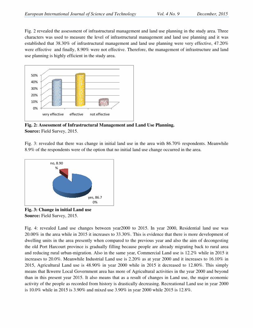
Fig. 2 revealed the assessment of infrast
characters was used to measure the lev
established that 38.30% of infrastructur
were effective and finally, 8.90% were
use planning is highly efficient in the stu
Fig. 2: Assessment of Infrastructural M
Source: Field Survey, 2015.
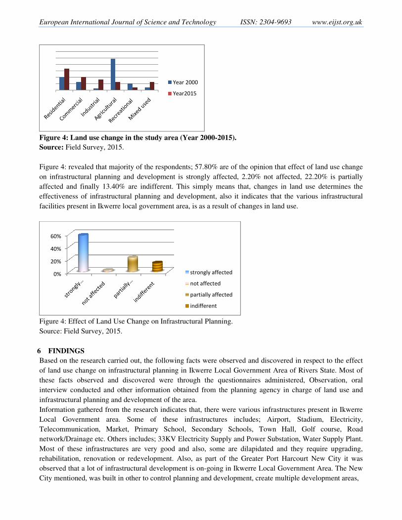
Fig. 3: revealed that there was change i
8.9% of the respondents were of the opti
Fig. 3: Change in initial Land use
Source: Field Survey, 2015.
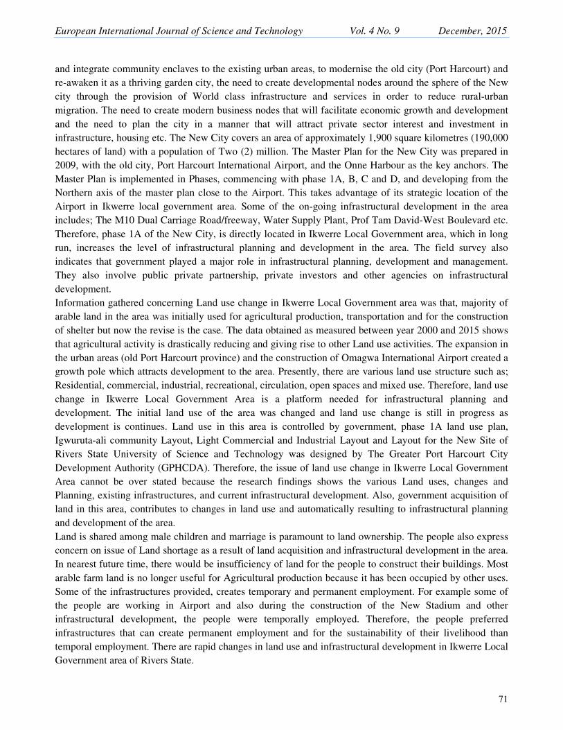
Fig. 4: revealed Land use changes bet
20.00% in the area while in 2015 it incre
dwelling units in the area presently whe
the old Port Harcourt province is gradu
and reducing rural urban-migration. Als
increases to 20.0%. Meanwhile Industri
2015, Agricultural Land use is 48.90%
means that Ikwerre Local Government a
than in this present year 2015. It also m
activity of the people as recorded from h
is 10.0% while in 2015 is 3.90% and mix
0%
10%
20%
30%
40%
50%
very effective effective not effe
yes, 86.7
0%
no, 8.90
%
ence and Technology Vol. 4 No. 9
structural management and land use planning in t
evel of infrastructural management and land use
ural management and land use planning were ve
re not effective. Therefore, the management of in
study area.
l Management and Land Use Planning.
e in initial land use in the area with 86.70% resp
ption that no initial land use change occurred in th
etween year2000 to 2015. In year 2000, Resid
creases to 33.30%. This is evidence that there is m
hen compared to the previous year and also the
dually filling because people are already migratin
lso in the same year, Commercial Land use is 12
trial Land use is 2.20% as at year 2000 and it inc
% in year 2000 while in 2015 it decreased to 1
t area has more of Agricultural activities in the ye
means that as a result of changes in Land use,
history is drastically decreasing. Recreational L
ixed use 3.90% in year 2000 while 2015 is 12.8%
effective
86.7
December, 2015
n the study area. Three
se planning and it was
very effective, 47.20%
infrastructure and land
spondents. Meanwhile
the area.
sidential land use was
s more development of
e aim of decongesting
ting back to rural area
12.2% while in 2015 it
increases to 16.10% in
12.80%. This simply
year 2000 and beyond
e, the major economic
Land use in year 2000
8%.
User
Typewritten Text
69
European International Journal of Scien
Figure 4: Land use change in the study
Source: Field Survey, 2015.
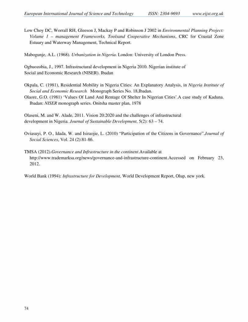
Figure 4: revealed that majority of the re
on infrastructural planning and develop
affected and finally 13.40% are indiffe
effectiveness of infrastructural planning
facilities present in Ikwerre local govern
Figure 4: Effect of Land Use Change on
Source: Field Survey, 2015.
6 FINDINGS
Based on the research carried out, the fo
of land use change on infrastructural pla
these facts observed and discovered
interview conducted and other informat
infrastructural planning and developmen
Information gathered from the research
Local Government area. Some of
Telecommunication, Market, Primary
network/Drainage etc. Others includes; 3
Most of these infrastructures are very
rehabilitation, renovation or redevelopm
observed that a lot of infrastructural dev
City mentioned, was built in other to con
0%
20%
40%
60%
nce and Technology ISSN: 2304-9693
dy area (Year 2000-2015).
respondents; 57.80% are of the opinion that effec
opment is strongly affected, 2.20% not affected
fferent. This simply means that, changes in land
ng and development, also it indicates that the va
rnment area, is as a result of changes in land use.
n Infrastructural Planning.
following facts were observed and discovered in
planning in Ikwerre Local Government Area of R
were through the questionnaires administered
ation obtained from the planning agency in cha
ent of the area.
h indicates that, there were various infrastructure
f these infrastructures includes; Airport, S
ry School, Secondary Schools, Town Hall,
; 33KV Electricity Supply and Power Substation,
y good and also, some are dilapidated and they
pment. Also, as part of the Greater Port Harcou
evelopment is on-going in Ikwerre Local Governm
ontrol planning and development, create multiple
Year 2000
Year2015
strongly affected
not affected
partially affected
indifferent
www.eijst.org.uk
fect of land use change
d, 22.20% is partially
nd use determines the
various infrastructural
in respect to the effect
f Rivers State. Most of
red, Observation, oral
harge of land use and
ures present in Ikwerre
Stadium, Electricity,
, Golf course, Road
n, Water Supply Plant.
ey require upgrading,
ourt New City it was
rnment Area. The New
le development areas,
User
Typewritten Text
70
European International Journal of Science and Technology Vol. 4 No. 9 December, 2015
71
and integrate community enclaves to the existing urban areas, to modernise the old city (Port Harcourt) and
re-awaken it as a thriving garden city, the need to create developmental nodes around the sphere of the New
city through the provision of World class infrastructure and services in order to reduce rural-urban
migration. The need to create modern business nodes that will facilitate economic growth and development
and the need to plan the city in a manner that will attract private sector interest and investment in
infrastructure, housing etc. The New City covers an area of approximately 1,900 square kilometres (190,000
hectares of land) with a population of Two (2) million. The Master Plan for the New City was prepared in
2009, with the old city, Port Harcourt International Airport, and the Onne Harbour as the key anchors. The
Master Plan is implemented in Phases, commencing with phase 1A, B, C and D, and developing from the
Northern axis of the master plan close to the Airport. This takes advantage of its strategic location of the
Airport in Ikwerre local government area. Some of the on-going infrastructural development in the area
includes; The M10 Dual Carriage Road/freeway, Water Supply Plant, Prof Tam David-West Boulevard etc.
Therefore, phase 1A of the New City, is directly located in Ikwerre Local Government area, which in long
run, increases the level of infrastructural planning and development in the area. The field survey also
indicates that government played a major role in infrastructural planning, development and management.
They also involve public private partnership, private investors and other agencies on infrastructural
development.
Information gathered concerning Land use change in Ikwerre Local Government area was that, majority of
arable land in the area was initially used for agricultural production, transportation and for the construction
of shelter but now the revise is the case. The data obtained as measured between year 2000 and 2015 shows
that agricultural activity is drastically reducing and giving rise to other Land use activities. The expansion in
the urban areas (old Port Harcourt province) and the construction of Omagwa International Airport created a
growth pole which attracts development to the area. Presently, there are various land use structure such as;
Residential, commercial, industrial, recreational, circulation, open spaces and mixed use. Therefore, land use
change in Ikwerre Local Government Area is a platform needed for infrastructural planning and
development. The initial land use of the area was changed and land use change is still in progress as
development is continues. Land use in this area is controlled by government, phase 1A land use plan,
Igwuruta-ali community Layout, Light Commercial and Industrial Layout and Layout for the New Site of
Rivers State University of Science and Technology was designed by The Greater Port Harcourt City
Development Authority (GPHCDA). Therefore, the issue of land use change in Ikwerre Local Government
Area cannot be over stated because the research findings shows the various Land uses, changes and
Planning, existing infrastructures, and current infrastructural development. Also, government acquisition of
land in this area, contributes to changes in land use and automatically resulting to infrastructural planning
and development of the area.
Land is shared among male children and marriage is paramount to land ownership. The people also express
concern on issue of Land shortage as a result of land acquisition and infrastructural development in the area.
In nearest future time, there would be insufficiency of land for the people to construct their buildings. Most
arable farm land is no longer useful for Agricultural production because it has been occupied by other uses.
Some of the infrastructures provided, creates temporary and permanent employment. For example some of
the people are working in Airport and also during the construction of the New Stadium and other
infrastructural development, the people were temporally employed. Therefore, the people preferred
infrastructures that can create permanent employment and for the sustainability of their livelihood than
temporal employment. There are rapid changes in land use and infrastructural development in Ikwerre Local
Government area of Rivers State.

European International Journal of Science and Technology ISSN: 2304-9693 www.eijst.org.uk
72
7 CONCLUSION AND RECOMMENDATION
Land use change and infrastructural planning are environmental planning issues that require serious global
attention because it determines the shape and pattern of our urban environment. In the developed nation,
Land use and Infrastructural planning are more effective than in developing nations. But Government
intervention on Land use and infrastructural planning, especially in Nigeria, has reshaped the physical
structure of most cities and urban environment in the country. Integrating communities’ enclaves to existing
urban areas, designing layout and providing adequate infrastructures is an evidence of government
intervention in controlling the use of land and the provision of adequate infrastructure. Therefore, there is
recognition that a number of metropolitan and regional areas have experienced drastic change in land use
due to the high rate of urbanization.
Precisely in Ikwerre Local Government Area of Rivers State, there is evidence of Land use change and
infrastructural planning. This research, has successfully examined the effect of the Land use change on
infrastructural planning. And has shown the various objectives used for the accomplishment of this research.
Besides, the research problems, justification of the study and research question are also used to obtain
information related to this study. The literature aspect of this study is very important because, it forms the
secondary source of data for this study. It contains adequate information about previous research that has be
carried out by scholars, planners and other professionals in the built environment at large.
In respect to the assessment of effect of Land use change on Infrastructural Planning, using Ikwerre Local
Government Area of Rivers State as a case study, the following recommendation were made to assist in the
improvement of Land use and Infrastructural Planning in the study area.
Revitalization: Revitalization, upgrading, rehabilitation, renovation or total clearance should be carried out
on the out-dated infrastructures present in the area. And also conservation and preservation of historical and
cultural aspect of the people is very important when planning with the people and carrying out physical
development.
Land use and Infrastructural Sustainability: There is need to consider sustainability concept on the use
of land and infrastructural planning. This will help to meet the three basic needs such as Economic, Social
and Environmental needs as required by the world sustainability concept.
Development control: Making improving in this aspect will go a long way in ensuring proper land use
management and adequate infrastructural planning. The layout designed, and infrastructures provided needs
proper control and monitoring in other to ensure that planning aim and objective for it, is attained.
Use of Geographic Information System (GIS): Geographic Information System is a computer base tool
that is used for collecting, analysing, interpreting and presenting information about a specific dataset
obtained from the earth surface. With the current global planning trend, it is important to use Geographic
Information system for effective Land use and infrastructural planning of the area.
Community and stakeholder participation: The community in question and stakeholders in the area
should be involved in decision making concerning Land use and infrastructural planning of the area. This
will enable greater understanding of existing conditions, local values, aspirations, and helps to create greater
ownership and investment in the planning process. Agencies, service providers, community organizations
and other stakeholders can help to identify existing gaps or inefficiencies, confirm future facility
requirements and identify opportunities for future provision through a process of working together.

European International Journal of Science and Technology Vol. 4 No. 9 December, 2015
73
Public Awareness Participation: The publication of issues relating to Land use change is important to
effective Land use planning and infrastructural development. Residents and users should be enlightened on
the benefit of proper control and use of land. Also, the benefit of the changes in land use resulting to
infrastructural planning and development. Involving the public makes land use and infrastructural planning
effective. Because detailed information about the people will be derived, they will be fully represented, and
as such, Government is already planning with the people and not for the people.
REFERENCE
Adeniyi P. O, Omojola A. (2012):Landuse/Landcover Change Evaluation in Sokoto-Rima Basin of N.W.
Nigeria Based on Archival Remote Sensing and GIS Techniques. African Association of Remote Sensing
of the Environment (AARSE) in Geo-information Technology Applications for Resource and
Environmental Management in African Vol. 1 (14): 143172.
Adeyemo, A. M. (1989). Spatial Variation in Accessibility to Secondary School Facilities in Oyo State,
Unpublished PhD Thesis, Geography Department, University of Ibadan, Nigeria.
Akinyosoye, M. (2013): “Infrastructure Development in Nigeria: Road Map to Sustainable Development”,
available at www.http://greenhillts.com/yahoo _site_admin/assets/docs/_ Nigeria _ Infrastructure_
Developmentin_Nigeria.317 15406.pdf. accessed November 23, 2013.
Aloks S, Navedeep K (2002): GIS, GPS and Land Information System. GIS Development.
Burgess, W. and Mckenzie, R. (1925).The city. Chicago: University of Chicago Press.
Fabiyi O. O. (2006): Urban Land Use Change Analysis of a Traditional City From Remote Sensing Data:
The case of Ibadan metropolitan Area, Nigeria. Humanity and Social Science Journal. 1 (1): 42-64.
Fred-Nwagwu (2012):Land use and Land cover Change in Port Harcourt and Environs using Remote
Sensing and GIS as Analytical tools. Unpublished M.Sc Thesis, University of Port Harcourt, Nigeria.
Frishman, O., (1977). The Spatial Growth and Residential Location Pattern of Kano, Unpublished Ph.D.
Thesis, North West University, Department of Economics Evanston Illinois.
Greater Port-Harcourt City Development Authority, (2013): Presentation on Development Control Activities
and Planning/ Design of Igwuruta-Ali Community Layout. Development Control and Physical Planning
Department, Rivers State Government.
Greater Port-Harcourt City Development Authority, (2015): The Unveiling Programme for Port Harcourt
City Master Plan.Development Control and Physical Planning Department, Rivers State Government.
Infrastructure Cost Review (2010), ‘An investigation into how to reduce civil engineering costs for major
infrastructural projects’, published 21 December 2010, Email: [email protected]
European International Journal of Science and Technology ISSN: 2304-9693 www.eijst.org.uk
74
Low Choy DC, Worrall RH, Gleeson J, Mackay P and Robinson J 2002 in Environmental Planning Project:
Volume 1 – management Frameworks, Toolsand Cooperative Mechanisms, CRC for Coastal Zone
Estuary and Waterway Management, Technical Report.
Mabogunje, A.L. (1968). Urbanization in Nigeria. London: University of London Press.
Ogbuozobia, J., 1997. Infrastructural development in Nigeria 2010. Nigerian institute of
Social and Economic Research (NISER). Ibadan
Okpala, C. (1981), Residential Mobility in Nigeria Cities: An Explanatory Analysis, in Nigeria Institute of
Social and Economic Research Monograph Series No. 18,Ibadan.
Olaore, G.O. (1981) ‘Values Of Land And Rentage Of Shelter In Nigerian Cities’.A case study of Kaduna.
Ibadan: NISER monograph series. Onitsha master plan, 1978
Olaseni, M. and W. Alade, 2011. Vision 20:2020 and the challenges of infrastructural
development in Nigeria. Journal of Sustainable Development, 5(2): 63 – 74.
Oviasuyi, P. O., Idada, W. and Isiraojie, L. (2010) “Participation of the Citizens in Governance”.Journal of
Social Sciences, Vol. 24 (2):81-86.
TMSA (2012).Governance and Infrastructure in the continent.Available at
http://www.trademarksa.org/news/governance-and-infrastructure-continent.Accessed on February 23,
2012.
World Bank (1994): Infrastructure for Development, World Development Report, Olup, new york.