Efficient estimation of effective hydraulic properties of ...
11
Hydrol. Earth Syst. Sci., 23, 3653–3663, 2019 https://doi.org/10.5194/hess-23-3653-2019 © Author(s) 2019. This work is distributed under the Creative Commons Attribution 4.0 License. Efficient estimation of effective hydraulic properties of stratal undulating surface layer using time-lapse multi-channel GPR Xicai Pan 1 , Stefan Jaumann 1 , Jiabao Zhang 1 , and Kurt Roth 2,3 1 Fengqiu Agro-ecological Experimental Station, State Key Laboratory of Soil and Sustainable Agriculture, Institute of Soil Science, Chinese Academy of Sciences, 71 East Beijing Road, 210008, Nanjing, China 2 Institute of Environmental Physics, Heidelberg University, Im Neuenheimer Feld 229, 69120 Heidelberg, Germany 3 Interdisciplinary Center for Scientific Computing (IWR), Heidelberg University, Im Neuenheimer Feld 205, 69120 Heidelberg, Germany Correspondence: Xicai Pan ([email protected]) Received: 10 January 2019 – Discussion started: 23 April 2019 Revised: 7 August 2019 – Accepted: 15 August 2019 – Published: 10 September 2019 Abstract. Multi-scale soil architectures in shallow subsur- face are widespread in natural and anthropogenic deposi- tional environments, and acquisition of the surface stratal structure and hydrological properties are essential in quan- tifying water cycling. Geophysical methods like ground- penetrating radar (GPR) can provide quantitative information like soil architecture and spatiotemporal soil water content distribution for the shallow layer. Concerning the informa- tive multi-dimensional water flow in the surface layer with an undulating bottom at the plot scale, this study assesses the feasibility of efficiently estimating soil hydraulic proper- ties using a few time-lapse multi-channel GPR observations, namely soil water storage and layer thickness of the surface layer, at reclamation land near an old river channel. We show that effective hydraulic properties of the surface layer can be obtained with a small number of time-lapse GPR measure- ments during a rainfall event. Additionally, we analyze the effect of some key factors controlling the informative lateral water redistribution on the results of the proposed approach using synthetic simulations. 1 Introduction The exchanges of water and energy fluxes between the land surface and the atmosphere are strongly influenced by geo- morphic features like landforms and soils (e.g., Corenblit et al., 2011). Surface morphometric features can be compara- tively conveniently obtained from remote sensing at the sub- meter scale via satellites or drones. In contrast, the acqui- sition of subsurface soil features like textural and structural information is not so efficient, although they are essential to quantify soil functions in various ecosystems (e.g., Rihani et al., 2010). Particularly, soils in fluvial depositional environ- ments exhibit a hierarchical stratal architecture at the scale of meters to hundreds of meters, and modeling subsurface wa- ter and mass transport is difficult due to large uncertainties in representation of the hydraulic properties (Huggenberger and Aigner, 1999). Apart from these natural depositional sys- tems, land reclamation also forms a surface layer overlying undulating landforms. The surface layer is usually character- ized by a flat surface and an undulating bottom, and the inter- nal lateral water flow can be non-negligible in wetting condi- tions. Model predictions of water flow and nutrient transport in the surface layer are essential to agriculture. However, it is challenging for the acquisition of such soil architecture infor- mation and soil hydraulic properties with the commonly used approaches using point measurements, as they are costly and time-consuming. For in situ estimation of hydraulic properties, inverse methods are commonly used at multiple scales, depending on observed state variables (Vrugt et al., 2008). For the one- dimensional (1-D) in situ monitoring profile, soil hydraulic parameters for each layer can be reasonably estimated based on a 1-D soil hydrological model and a time series of point observations. For larger-scale observations, e.g., from the field scale to catchment scale, a stronger assumption of pre- dominant vertical water flow is implicitly set from the 3- Published by Copernicus Publications on behalf of the European Geosciences Union.
Transcript of Efficient estimation of effective hydraulic properties of ...

Hydrol. Earth Syst. Sci., 23, 3653–3663, 2019https://doi.org/10.5194/hess-23-3653-2019© Author(s) 2019. This work is distributed underthe Creative Commons Attribution 4.0 License.
Efficient estimation of effective hydraulic properties of stratalundulating surface layer using time-lapse multi-channel GPRXicai Pan1, Stefan Jaumann1, Jiabao Zhang1, and Kurt Roth2,3
1Fengqiu Agro-ecological Experimental Station, State Key Laboratory of Soil and Sustainable Agriculture, Institute of SoilScience, Chinese Academy of Sciences, 71 East Beijing Road, 210008, Nanjing, China2Institute of Environmental Physics, Heidelberg University, Im Neuenheimer Feld 229, 69120 Heidelberg, Germany3Interdisciplinary Center for Scientific Computing (IWR), Heidelberg University, Im Neuenheimer Feld 205, 69120Heidelberg, Germany
Correspondence: Xicai Pan ([email protected])
Received: 10 January 2019 – Discussion started: 23 April 2019Revised: 7 August 2019 – Accepted: 15 August 2019 – Published: 10 September 2019
Abstract. Multi-scale soil architectures in shallow subsur-face are widespread in natural and anthropogenic deposi-tional environments, and acquisition of the surface stratalstructure and hydrological properties are essential in quan-tifying water cycling. Geophysical methods like ground-penetrating radar (GPR) can provide quantitative informationlike soil architecture and spatiotemporal soil water contentdistribution for the shallow layer. Concerning the informa-tive multi-dimensional water flow in the surface layer withan undulating bottom at the plot scale, this study assessesthe feasibility of efficiently estimating soil hydraulic proper-ties using a few time-lapse multi-channel GPR observations,namely soil water storage and layer thickness of the surfacelayer, at reclamation land near an old river channel. We showthat effective hydraulic properties of the surface layer can beobtained with a small number of time-lapse GPR measure-ments during a rainfall event. Additionally, we analyze theeffect of some key factors controlling the informative lateralwater redistribution on the results of the proposed approachusing synthetic simulations.
1 Introduction
The exchanges of water and energy fluxes between the landsurface and the atmosphere are strongly influenced by geo-morphic features like landforms and soils (e.g., Corenblit etal., 2011). Surface morphometric features can be compara-tively conveniently obtained from remote sensing at the sub-
meter scale via satellites or drones. In contrast, the acqui-sition of subsurface soil features like textural and structuralinformation is not so efficient, although they are essential toquantify soil functions in various ecosystems (e.g., Rihani etal., 2010). Particularly, soils in fluvial depositional environ-ments exhibit a hierarchical stratal architecture at the scale ofmeters to hundreds of meters, and modeling subsurface wa-ter and mass transport is difficult due to large uncertaintiesin representation of the hydraulic properties (Huggenbergerand Aigner, 1999). Apart from these natural depositional sys-tems, land reclamation also forms a surface layer overlyingundulating landforms. The surface layer is usually character-ized by a flat surface and an undulating bottom, and the inter-nal lateral water flow can be non-negligible in wetting condi-tions. Model predictions of water flow and nutrient transportin the surface layer are essential to agriculture. However, it ischallenging for the acquisition of such soil architecture infor-mation and soil hydraulic properties with the commonly usedapproaches using point measurements, as they are costly andtime-consuming.
For in situ estimation of hydraulic properties, inversemethods are commonly used at multiple scales, dependingon observed state variables (Vrugt et al., 2008). For the one-dimensional (1-D) in situ monitoring profile, soil hydraulicparameters for each layer can be reasonably estimated basedon a 1-D soil hydrological model and a time series of pointobservations. For larger-scale observations, e.g., from thefield scale to catchment scale, a stronger assumption of pre-dominant vertical water flow is implicitly set from the 3-
Published by Copernicus Publications on behalf of the European Geosciences Union.
3654 X. Pan et al.: Effective hydraulic properties of stratal undulating surface layer
D soil hydrological model. Alternatively, an assumption ofthe homogeneous soil column for the shallow measurementdepth (< 5 cm) is used for the satellite remote-sensing ob-servations (e.g., Mohanty, 2013). Overall, these methods ig-nore lateral water redistribution and usually suffer from in-sufficient data information concerning the soil architectureand the soil water dynamics. Yet this information is essentialto all inverse parameter estimation methods (Bandara et al.,2013).
Quantitative observations of soil architecture and soil wa-ter content have become viable during the past decade usinggeophysical methods. In particular, ground-penetrating radar(GPR) has been used for efficiently imaging the shallow soilwater content distribution (e.g., Huisman et al., 2003; Wei-hermüller, et al., 2007) together with soil architecture (Ger-hards et al., 2008; Bradford, 2008; Pan et al., 2012a; Klenket al., 2016). In view of informative multi-dimensional waterflow contained in the time-lapse spatial observations of GPRmeasurements, the common problem of insufficient data in-formation from 1-D observations is mitigated for inversemodeling of soil water dynamics in the vadose zone soils.This comes at the cost of increasing the complexity of inversemodeling and the need for spatial observations of the soil ar-chitecture as well as the soil water content. In addition, sincethe information of small-scale heterogeneities within the lay-ers cannot be quantified for the GPR measurements using thereflection approach, the inverse modeling approaches onlyfocus on the stratal soil properties and effective soil waterflow at the plot scale.
There are at least two popular approaches for using GPRmeasurements in the inverse estimation of soil hydraulicproperties. One approach is the coupled inverse modeling ofhydrological processes and GPR measurements. The modelfor the simulation of the propagation of the electromagneticwave in the soils is computationally expensive but neces-sary for full waveform inversion (e.g., Lambot et al., 2009;Busch et al., 2012; Jadoon et al., 2012) or other evaluationapproaches (e.g., Buchner et al., 2012; Jaumann and Roth,2018). The other approach directly uses the evaluated soilwater content and depth from GPR measurements in the in-verse hydrological modeling, similar to the above-mentioned1-D inversion using point observations, e.g., time-domain re-flectometer (TDR) measurements. In this study, we proposeusing pre-evaluated GPR data together with 2-D inverse hy-drological modeling to estimate soil hydraulic properties ofthe surface soil layer with underlying undulating structures.We use the optimization procedure described by Jaumannand Roth (2017) to estimate the effective hydraulic propertiesand demonstrate that this approach allows us to efficientlyestimate effective hydraulic properties of the surface layerat reclamation land. Controlling factors of this approach forpractical applications are discussed subsequently.
2 Scheme of the proposed hydraulic parameterestimation
2.1 Simulation model and setup
The muPhi model (Ippisch et al., 2006) is used for sim-ulating two-dimensional Darcian water flow in a variablysaturated isotropic medium. It employs the Richards equa-tion (Richards, 1931) and the soil hydraulic functions ofvan Genuchten (1980) and Mualem (1976) for the soil watercharacteristic θ (h), usually in terms of the water saturation2(–) and the hydraulic conductivity functionKw (h), as shownin Table 1.
In this work, the water dynamics in a two-layer vadosezone with an undulating interface during a rainfall event issimulated. The model domain is discretized with rectangulargrids, where the material for the top layer is characterizedby five parameters, p1 = {α,n,θr,θs,Ks}, as shown in Ta-ble 1. Since soil porosity of the top layer is relatively easyto obtain by soil coring, θs is assumed to be known before-hand in the evaluation of the GPR observations of the meansoil water content and reflector depth of the interface (e.g.,Pan et al., 2012a). With this assumption, there are four un-known parameters, p1 = {α,n,θr,Ks}, for the top layer. Ma-terial for the bottom layer is sand and the hydraulic param-eters, p2 =
{α′,n′,θ ′r,θ
′s,K′s}, are set to the values listed
in Table 2 for all studied cases. A Neumann no-flow bound-ary condition is implemented at both sides, and two typesof boundary conditions are applied at the upper boundary inconsideration of numerical convenience. For the period withstrong precipitation events, a Neumann condition is appliedfor the upper boundary, while a Dirichlet boundary conditionis applied for the left period with a time series of outflux. Forthe bottom boundary, a Dirichlet boundary condition is ap-plied with a fixed water pressure of −0.4 m. The equilibriumstate is assumed as an initial condition at the lower boundary.
2.2 Parameter estimation
Given a time series of multi-channel GPR measurements, thesurface soil structure and corresponding soil water dynamicswere obtained using the evaluation algorithm proposed byGerhards et al. (2008). Then, the effective hydraulic param-eters were estimated accordingly. The framework of the 2-Dinversion procedure is shown in Fig. 1.
The initial hydraulic parameters for each ensemble mem-ber were generated based on the Latin hypercube al-gorithm. The Richards equation solver (muPhi; Ippischet al., 2006) was used to simulate the spatiotemporalsoil water dynamics, and an optimization procedure isimplemented. Generally, the optimal soil hydraulic pa-rameters, p = {α,n,θr,Ks, (α
′,n′,θ ′r,θ′s,K′s)}, were deter-
mined with an objective function by minimizing the dif-ferences between observed and simulated water storages,
Hydrol. Earth Syst. Sci., 23, 3653–3663, 2019 www.hydrol-earth-syst-sci.net/23/3653/2019/

X. Pan et al.: Effective hydraulic properties of stratal undulating surface layer 3655
Table 1. Summary of the equations used in the muPhi model (Ippisch et al., 2006) for simulating two-dimensional Darcian water flow in avariably saturated isotropic medium.
Governing equation:1. ∂tθ(h)−∇ · [Kw (θ(h)) [∇h− 1]]= 0
Hydraulic functions:2. 2(h)= θ(h)−θr
θs−θr= (1+ |αh|n)−m
3. Kw(θ)=Ks2τ[1−
(1−2n/(n−1)
)m]2
θ , θs and θr: the unsaturated, saturated and residual soil water content,respectively (m3 m−3)h: the hydraulic head (m)Kw and Ks: the unsaturated and saturated hydraulic conductivity, respectively (m s−1)α, n and m (m= 1− 1/n): empirical parameters shaping the retention curveτ : the empirical parameter for shaping the hydraulic conductivity function (τ = 0.5)
Figure 1. The framework of efficient estimation of effective hy-draulic properties of the surface layer with an undulating interfacein a two-layer transect. Provided that the water dynamic range iscaptured by a small number of time-lapse multi-channel GPR ob-servations, final parameter sets are inversely estimated based onthe Levenberg–Marquardt algorithm and proper convergence cri-teria (see Sect. 2). Latin hypercube-sampled initial parameter setsfor each ensemble member are used in the 2-D inversion. The finalmedian parameter set is derived from the 68 % estimated ensembleparameter sets with minimal χ2.
lobs(x, t), lmod(x,p, t), at location x:
χ2(p)=12
N∑t
M∑x
[lobs(x, t)− lmod(p,x, t)]2
σobs, (1)
where M is the number of grid cells in the x directionand N is the number of time series of observations. TheLevenberg–Marquardt algorithm as implemented in Jaumannand Roth (2017) was used to minimize χ2(p). Convergencerequires 5 to 40 iterations, depending on the existence ofstructural representation errors in the GPR observations. De-pending on the data, two different criteria are used in thisstudy. For the synthetic data without considering structuralerrors, the “optimal stopping” criterion is applied with anumber of iterations of up to 40. In contrast, for the mea-
sured data with structural errors, the “early stopping” crite-rion is applied with only five iterations to avoid overfitting tothe structural errors. All the inversions were conducted in acluster via parallel computation. The final estimated parame-ter set was extracted from the ensemble members at the end.
3 Applications
In this section, we apply the approach introduced in Sect. 2to a field dataset (Sect. 3.1). Afterwards, two controlling fac-tors which can be used to improve the performance of theapproach are investigated with synthetic studies (Sect. 3.2).
3.1 Field study: Daheigang dataset
The field test site is located near the village of Daheigangat 35◦2.1′ N, 114◦33.8′ E, in Fengqiu County, China. As anaeolian–fluvial depositional environment in the Yellow Riverfloodplain, complex soil architecture is widespread in thisarea. After land reclamation in the middle of 1980s, aeolian–fluvial landforms are rarely seen except in nearby strippeddunes in the woods. The surface soils are dominated by theOchric Aquic Cambisol and Ustic Sandic Entisol (ResearchGroup of Chinese Soil Taxonomy System, 1995). This pro-vides a suitable test site for the proposed approach.
The GPR data used in this study were introduced in Panet al. (2012a) but are shortly described in the following forthe convenience of the reader. The GPR survey was con-ducted using an IDS (Ingegneria dei Sistemi S.p.A., Italy)multi-channel GPR system, where two antennas operating ata central frequency of 400 MHz were connected in tandem.The setup was employed using three different antenna sep-arations, S1=S2= 0.14 m, S3= 1.94 m and S4= 1.66 m.Given the investigated reflector depth around 1.0 m, thissetup has an accuracy of 0.05 m in depth (Pan et al., 2012b).Five two-dimensional GPR surveys with two antennas wererepeated along prefixed parallel lines with a 1.5 m intervalspacing on 22, 23, 25, 27 and 29 May 2011 after a heavy rain-fall event which followed 10 d without any rain. These GPRmeasurements were recorded with a resolution of 0.05 malong the acquisition line. The measuring wavelet data arethe result of stacking 12 scans. Each measurement point was
www.hydrol-earth-syst-sci.net/23/3653/2019/ Hydrol. Earth Syst. Sci., 23, 3653–3663, 2019
3656 X. Pan et al.: Effective hydraulic properties of stratal undulating surface layer
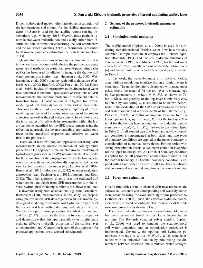
Figure 2. The underlying interface of soil architecture derived from GPR measurements (adapted from Pan et al., 2012) and the selectedtransect (magenta curve along the dashed cutting line) perpendicular to the longitudinal troughs. The bottom lines are a projection of the 25GPR survey lines.
recorded for a time window of 80 ns, discretized in 1024 sam-ples.
The GPR measurements were evaluated using the multi-channel GPR method (Gerhards et al., 2008). This approachhas been used in several studies (e.g., Wollschlager et al.,2010; Westermann et al., 2010; Pan et al., 2012a) and usesthe travel times from the four channels as a common mid-point (CMP) recorded during the measurement of each tracealong a survey line. To obtain absolute travel times forall channels, time-zero calibration was applied (Pan et al.,2012a). Wide-angle reflection–refraction (WARR) measure-ments were conducted in air to get the time zero of the cross-antenna channels; offsets of the two box-internal channelswere assumed to be equal to the travel time of the air-wavewavelet. Thus, reflector depth d (m) and the soil dielectricpermittivity number εr (–) can be obtained by inversion. Thesoil water content can be derived from a petrophysical rela-tionship between the depth-averaged volumetric water con-tent θ (–) and soil dielectric permittivity number (Roth et al.,1990). To mitigate the negative correlation between d and θ ,the total water storage l = d · θ (m) is used in this study (Panet al., 2012b).
3.1.1 Setup of the parameter estimation
Data analysis from Pan et al. (2012a) yields an interpolated3-D undulating architecture and water content observations.
A qualitative interpretation of the water content differencebetween the soil above the trough and hill indicates thatlateral flow could happen at the weather condition shownin Fig. 2a. To minimize computational effort, a 2-D modelof the water dynamics in a transect (magenta section alongthe dashed line in Fig. 2) perpendicular to the longitudinaltroughs is used so that the 2-D water flow could approxi-mate the actual 3-D water dynamics. Observations of reflec-tor depth and water storage over the transect are calculatedusing the original survey lines (parallel lines at the bottomin Fig. 2) via 3-D linear interpolation. Considering the reso-lution of 0.05 m along the GPR survey lines and a 1.5 m inbetween the survey lines, the spacing interval of the transectis set to 0.1 m. Given a 1 m top layer with a mean soil watercontent of 15 %, the uncertainties of the depth measurementand water storage are set to 0.05 and 0.0075 m, respectively.
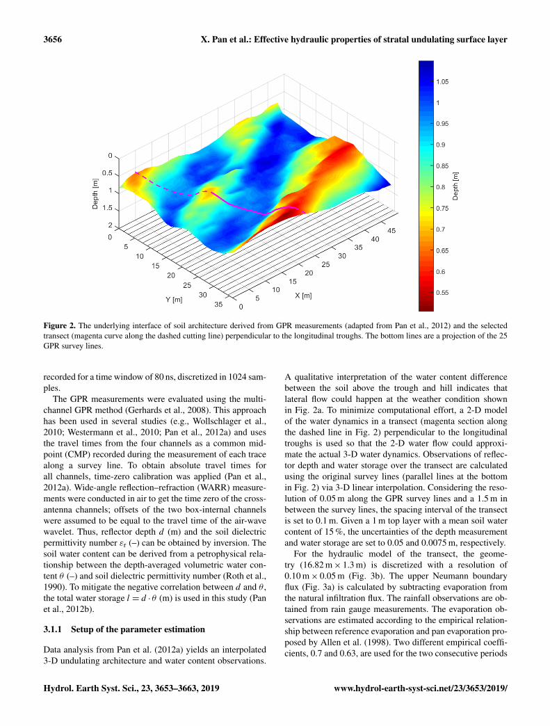
For the hydraulic model of the transect, the geome-try (16.82 m× 1.3 m) is discretized with a resolution of0.10 m× 0.05 m (Fig. 3b). The upper Neumann boundaryflux (Fig. 3a) is calculated by subtracting evaporation fromthe natural infiltration flux. The rainfall observations are ob-tained from rain gauge measurements. The evaporation ob-servations are estimated according to the empirical relation-ship between reference evaporation and pan evaporation pro-posed by Allen et al. (1998). Two different empirical coeffi-cients, 0.7 and 0.63, are used for the two consecutive periods
Hydrol. Earth Syst. Sci., 23, 3653–3663, 2019 www.hydrol-earth-syst-sci.net/23/3653/2019/
X. Pan et al.: Effective hydraulic properties of stratal undulating surface layer 3657
Figure 3. Setup for the inverse modeling. (a) Observed water fluxthrough the upper boundary. The colored dots (excluding the blackone) correspond to the timing of soil water storage observationsin (c). (b) The soil architecture of the transect. (c) Mean soil wa-ter content of the upper layer from time-lapse GPR observations on22, 23, 25, 27 and 29 May.
in view of the removal of land cover of wheat on the morningof 22 May 2011. The lower Dirichlet boundary is constantlyset to a pressure of −0.4 m with respect to a water table of1.7 m below the ground surface, inferred from drilling. Theinitial equilibrated condition is used due to a long precedingdry period. The soil water dynamics in the domain is simu-lated over a period of 18 d. Five time-lapse 2-D water storageobservations (Fig. 3c) are used for the inverse modeling.
Compared to 1-D inverse estimation of hydraulic proper-ties, one major advantage of the proposed 2-D approach isusing a small number of time-lapse 2-D GPR observations,which increases the available information about the soil wa-ter dynamics. However, apart from the measurement preci-sion, the proposed approach is sensitive to some structuralerrors presented in the field study. First, the conceptual errorcan also originate from the simplification of a 3-D flow toa 2-D flow. Second, the GPR-derived water storage observa-tions might contain some structural errors due to the varyingaccuracy of multi-channel GPR evaluation with different ra-tios of antenna separation to reflector depth, small-scale soilheterogeneity and the interpolation of unevenly spaced data.Our approach, not representing these structural errors, maylead to overfitting when the stopping criterion is too small,i.e., 1χ2
≤ 1, or χ2(p) < χ2(true). Hence, a two-step pro-cedure is applied in this study. Initially, we used the optimalstopping criterion, only considering measurement precision,
and it resulted in a large number of iterations as well as over-fitting. After an analysis of the convergence behavior of theparameter distribution, we identified that overfitting could beavoided by using the early stopping criterion and evaluatingthe output of the fifth iteration. Note that the optimal stop-ping criterion should be applied once the structural errors arealleviated in the field study.
To increase our understanding of the performance of theproposed approach in the field study, two additional syntheticstudies were set up. First, since the model is forced at thesurface, the inversion is more sensitive to the parameters ofthe first layer than to the parameters of the underlying layer.Thus, an initial synthetic study was conducted to investigatethe effect of the parameters of the bottom layer on that ofthe first layer. For this inversion we used the same settings asthe field study, but adding unknown hydraulic parameters forthe bottom layer. The required synthetic observations of soilwater storage were generated using the forward simulationsat the same time as field measurements and adding Gaussiandistributed random errors of GPR observations. Hence, theabove-mentioned structural errors were not included in theinversion and the optimal stopping criterion was used. Then,another synthetic study was conducted to investigate the ef-fect of the above-mentioned structural errors on the parame-ter estimation of the first layer. All the settings are the sameas the previous synthetic study, but using fixed parametersfor the bottom layer.
3.1.2 Results and discussion
In the previously described initial synthetic study(Sect. 3.1.1), the parameters for both layers are estimatedbased on the synthetic data of the first layer. The resultingparameters for the first layer match the true parameter well,but the resulting parameter set for the bottom layer is biaseddramatically. Here, we used a measure Sj =
∂χ2
∂pjto analyze
the sensitivity of the inversion to the specific parameters andfound that the sensitivity of the parameters of the first layertypically surpasses that of the bottom layer by 2 orders ofmagnitude. Therefore, we decided to reduce the computationcost by fixing the parameter of the bottom layer, althoughthis introduces a small structural error. Hereafter, all theinversions only estimate the parameters for the first layerand use the fixed parameters listed in Table 2.
Using the setup described in Sect. 3.1.1, the estimated hy-draulic properties for the upper layer from the field studyand the synthetic study are shown in Fig. 4. Figure 4a and bpresent the resulting water retention curves and hydraulicconductivity curves, respectively, using the estimated param-eters from the field study based on the early stopping crite-rion. We show those 68 best ensemble members with a min-imum χ2, accounting for 68 % of the 100 ensemble mem-bers. Given the observed water content range (18 %–27 %;histogram in Fig. 4a), the water retention curve is mainlyconstraint over a small water content range, and large uncer-
www.hydrol-earth-syst-sci.net/23/3653/2019/ Hydrol. Earth Syst. Sci., 23, 3653–3663, 2019

3658 X. Pan et al.: Effective hydraulic properties of stratal undulating surface layer
Table 2. Hydraulic parameters of the two-layer soil and their allowed ranges for parameter estimation. The true values for the upper layerare obtained from Rosetta (Schaap et al., 2001) based on measured soil texture information, and the values for the lower layer are cited fromCarsel and Parrish (1988).
Symbol Description (unit) True value Allowed range
α Inverse of air entry suction (m−1) −3.91 −30, . . . , −0.1n Measure of the pore-size distribution (–) 1.7778 1.1, . . . , 10.0
Upper layer θr Residual water content (m3 m−3) 0.0 0.0, . . . , 0.15θs Saturated water content (m3 m−3) 0.43 0.43 (known)log10(Ks) Ks: saturated hydraulic conductivity (m s−1) −4 −7, . . . , −3
a′ Inverse of air entry suction (m−1) −14.5 −30, . . . , −0.1n′ Measure of the pore-size distribution (–) 2.68 1.1, . . . , 10.0
Lower layer θ ′r Residual water content (m3 m−3) 0.045 0.0, . . . , 0.15θ ′s Saturated water content (m3 m−3) 0.43 0.3, . . . , 0.5log10(K
′s) K ′s: saturated hydraulic conductivity (m s−1) −4.08 −7, . . . , −3
Figure 4. Effective hydraulic properties estimated with the proposed approach for the field study (a, b) and the synthetic study (c, d). Thegrey curves in all subplots represent estimated hydraulic functions from ensemble members using the early stopping criterion. The blackcurves in (a) and (b) are derived from the median parameters of the best 68 members, while the black curves in (c) and (d) are the samemembers but using the optimal stopping criterion. The red curves in (c) and (d) are derived from the true parameter given in Table 2. Thehistograms in (a) and (c) (blue histogram; the same in Figs. 6 and 7) mark the covered range of the mean water content evaluated from theGPR observations.
Hydrol. Earth Syst. Sci., 23, 3653–3663, 2019 www.hydrol-earth-syst-sci.net/23/3653/2019/
X. Pan et al.: Effective hydraulic properties of stratal undulating surface layer 3659
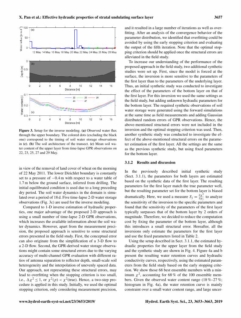
Figure 5. Impacts of errors on the inverse estimation in the fieldstudy and in the synthetic study. (a) Structural pattern of standard-ized residuals in the field study indicates notable structural errors,apart from Gaussian distributed error at each point. (b) Gaussiandistributed standardized residuals in the synthetic study.
tainties appear at both ends of the soil water retention curve,in particular at the dry end. Since we set the initial parame-ters with the Latin hypercube approach, the parameter spaceis equidistantly sampled. Due to the low sensitivity of thehydraulic conductivity and the limited iterations of the earlystopping criterion, the uncertainty of the resulting hydraulicconductivity is high. The overall uncertainty of the resultinghydraulic conductivity function is relatively high due to thesmall dynamic water range and measurement errors.
Apart from the influence of the water dynamic range, theignored structure errors also play an important role in theinversion for the field study. As shown in Fig. 5, the differ-ent structures of the standardized residuals in the field studyand in the synthetic study indicate that notable structural er-rors exist in the field study. Once excluding structural errorsin the synthetic study, the resulting hydraulic properties inFig. 4c and d are much better than the field study. The bandsof the resulting hydraulic curves based on the optimal stop-ping criterion are much more narrow than those based on theearly stopping criterion. The structural errors lead to differ-ent histograms in Fig. 4a and c and result in uncertainties ofthe resulting hydraulic parameters that are a little bit larger incomparison to the synthetic study when using the same crite-ria. This is also the reason why overfitting occurs when usingthe optimal stopping criterion in the field study.
In summary, the barely passable performance of the pro-posed approach in the field study is not only attributed tothe narrow observed water dynamic range but also the struc-tural errors. However, better performance can be achieved byimproving the experiment design. One solution is to deploy
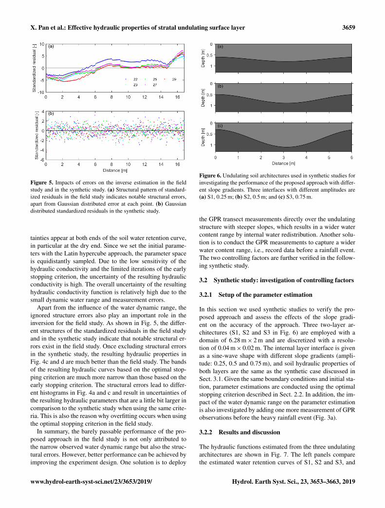
Figure 6. Undulating soil architectures used in synthetic studies forinvestigating the performance of the proposed approach with differ-ent slope gradients. Three interfaces with different amplitudes are(a) S1, 0.25 m; (b) S2, 0.5 m; and (c) S3, 0.75 m.
the GPR transect measurements directly over the undulatingstructure with steeper slopes, which results in a wider watercontent range by internal water redistribution. Another solu-tion is to conduct the GPR measurements to capture a widerwater content range, i.e., record data before a rainfall event.The two controlling factors are further verified in the follow-ing synthetic study.
3.2 Synthetic study: investigation of controlling factors
3.2.1 Setup of the parameter estimation
In this section we used synthetic studies to verify the pro-posed approach and assess the effects of the slope gradi-ent on the accuracy of the approach. Three two-layer ar-chitectures (S1, S2 and S3 in Fig. 6) are employed with adomain of 6.28 m× 2 m and are discretized with a resolu-tion of 0.04 m× 0.02 m. The internal layer interface is givenas a sine-wave shape with different slope gradients (ampli-tude: 0.25, 0.5 and 0.75 m), and soil hydraulic properties ofboth layers are the same as the synthetic case discussed inSect. 3.1. Given the same boundary conditions and initial sta-tion, parameter estimations are conducted using the optimalstopping criterion described in Sect. 2.2. In addition, the im-pact of the water dynamic range on the parameter estimationis also investigated by adding one more measurement of GPRobservations before the heavy rainfall event (Fig. 3a).
3.2.2 Results and discussion
The hydraulic functions estimated from the three undulatingarchitectures are shown in Fig. 7. The left panels comparethe estimated water retention curves of S1, S2 and S3, and
www.hydrol-earth-syst-sci.net/23/3653/2019/ Hydrol. Earth Syst. Sci., 23, 3653–3663, 2019

3660 X. Pan et al.: Effective hydraulic properties of stratal undulating surface layer
Figure 7. Effects of the slope gradient on the performance of the proposed approach. The top, middle and bottom panels compare the resultsfor the soil architectures in Fig. 6. Similar to the lower panel of Fig. 4 for the synthetic study, the true parameter set is shown together withthe 20 best ensemble members and the median of these parameter sets. The uncertainty of the resulting hydraulic properties decreases alongwith the sequentially increase in the slope gradient and water content range of the histograms from S1 to S3.
the right panels compare the estimated hydraulic conductiv-ity curves. In each plot, the curves represent the best 20 es-timates with minimal χ2, accounting for 67 % of the 30 en-semble members. Results from the panels show that the un-certainty band of the estimates decreases sequentially fromS1 to S3. In other words, the higher the slope gradient, thebetter the estimation. The histograms in Fig. 7a, c and e showan increase in water content range from top to bottom, wherethe ranges are 19 % to 25 %, 19 % to 26 % and 18 % to 30 %,respectively. This is mainly ascribed to the increasing inten-sity of lateral water redistribution, which results in a widerwater dynamic range.
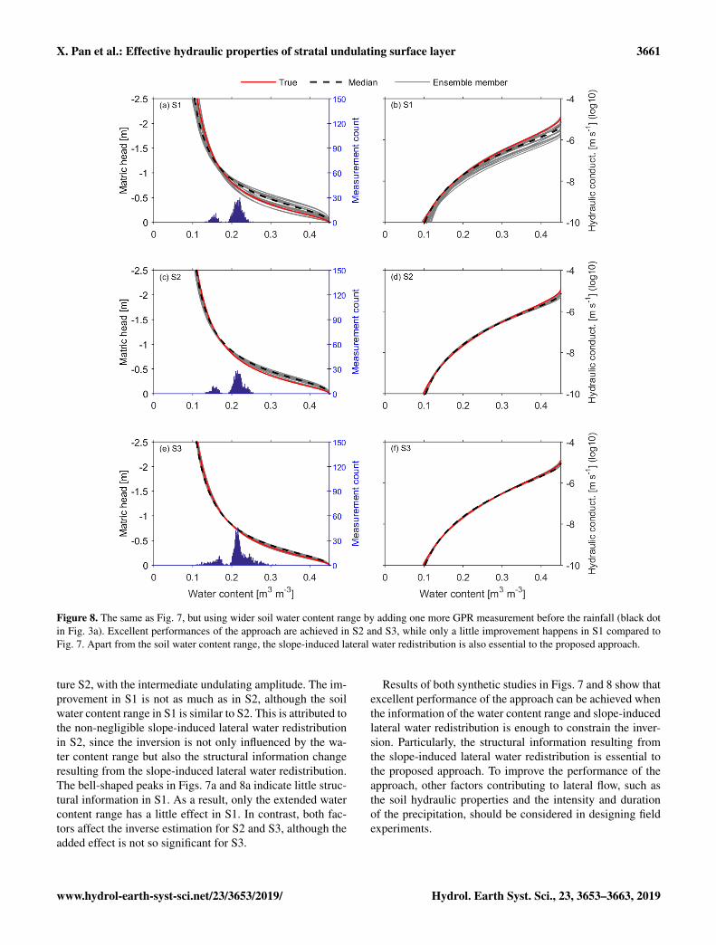
Figure 8 shows the results from the estimates, using thesame setup as Fig. 7 but extending the observed water dy-namic range by adding one more GPR observation. Com-pared to Fig. 7, performances of the approach in the threearchitectures are all improved. This is attributed to the ex-tended water content range, which controls the performanceof the inverse estimation. The histograms in Fig. 8a, c and epresent two peaks and a much wider water dynamic range incomparison to Fig. 7, and the ranges all increased from 13 %to 26 %, 13 % to 26 % and 11 % to 31 %, respectively. How-ever, the improvements of the three architectures are distinct.The most significant improvement happened in the architec-
Hydrol. Earth Syst. Sci., 23, 3653–3663, 2019 www.hydrol-earth-syst-sci.net/23/3653/2019/
X. Pan et al.: Effective hydraulic properties of stratal undulating surface layer 3661
Figure 8. The same as Fig. 7, but using wider soil water content range by adding one more GPR measurement before the rainfall (black dotin Fig. 3a). Excellent performances of the approach are achieved in S2 and S3, while only a little improvement happens in S1 compared toFig. 7. Apart from the soil water content range, the slope-induced lateral water redistribution is also essential to the proposed approach.
ture S2, with the intermediate undulating amplitude. The im-provement in S1 is not as much as in S2, although the soilwater content range in S1 is similar to S2. This is attributed tothe non-negligible slope-induced lateral water redistributionin S2, since the inversion is not only influenced by the wa-ter content range but also the structural information changeresulting from the slope-induced lateral water redistribution.The bell-shaped peaks in Figs. 7a and 8a indicate little struc-tural information in S1. As a result, only the extended watercontent range has a little effect in S1. In contrast, both fac-tors affect the inverse estimation for S2 and S3, although theadded effect is not so significant for S3.
Results of both synthetic studies in Figs. 7 and 8 show thatexcellent performance of the approach can be achieved whenthe information of the water content range and slope-inducedlateral water redistribution is enough to constrain the inver-sion. Particularly, the structural information resulting fromthe slope-induced lateral water redistribution is essential tothe proposed approach. To improve the performance of theapproach, other factors contributing to lateral flow, such asthe soil hydraulic properties and the intensity and durationof the precipitation, should be considered in designing fieldexperiments.
www.hydrol-earth-syst-sci.net/23/3653/2019/ Hydrol. Earth Syst. Sci., 23, 3653–3663, 2019

3662 X. Pan et al.: Effective hydraulic properties of stratal undulating surface layer
4 Discussion
For practical application, we describe some necessary con-ditions for this approach to work. First of all, a surface layerwith an undulating bottom is required, which leads to notablelateral water redistribution. Following this concept, applyingthis approach to a three-dimensional architecture could bepossible but needs further computational and experimentalefforts. Secondly, for rain-based cases, prerequisite condi-tions like large rainfall intensity and high soil permeabilityare necessary to ensure a proper water dynamic range forGPR data acquisition. But the wetting range of soils undernatural conditions typically regulated by precipitation con-trols the applicability of the inverse modeling approach (e.g.,Steenpass et al., 2011; Scharnagl et al., 2011). Finally, to cap-ture the lateral water redistribution, timing for the time-lapseGPR observations is essential.
Except for the measurement uncertainties in reflectordepth and water content, other errors which were ignoredin this study influence the application of this method. Threetypes of errors are summarized as follows. (1) The uncer-tainty in upper-boundary fluxes should be considered whenrelevant observations are not well conducted. (2) The struc-tural errors in GPR observations from the multi-channel GPRevaluation and the selection of the investigated transect canbe reduced with better GPR setup and survey design. (3) Seri-ous conceptual errors might arise when ignoring small-scaleheterogeneous soil properties within the layer. As pointed outin the Introduction, the proposed approach focuses on thestratal soil properties and effective soil water flow at the scaleof meters to tens of meters. The layer with strong small-scaleheterogeneities is unfavorable in this approach.
5 Conclusions
The surface layer with a flat surface and an undulatingbottom at the scale of meters to hundreds of meters iswidespread in naturally and anthropogenically affected flu-vial depositional environments. This study demonstrates anapproach for efficiently estimating effective stratal hydraulicproperties of the surface layer. It employs multi-channel GPRto capture soil architecture and time-lapse soil water con-tent, a 2-D simulation of soil hydrology, and an optimiza-tion procedure. The approach is applied to reclamation landwith a surface layer over buried undulating landforms. Asmall number of time-lapse GPR observations were con-ducted after a heavy rain event, and effective hydraulic pa-rameters were obtained using 2-D inverse modeling. The per-formance of the proposed approach for the given field data ismainly limited by the observed narrow water content rangeand structural errors. Further synthetic studies show that bet-ter performance can be achieved, e.g., by adding one moreGPR observation to extend the water dynamic range.
Application of the demonstrated approach mainly relieson the slope gradient of the undulating structure and the lat-eral water redistribution. Other factors contributing to lateralflow, such as soil hydraulic properties and the intensity andduration of the precipitation, also influence the performanceof this approach. Overall, the major advantages of this ap-proach include (i) non-destructive observations, (ii) a biggerscale of the effective soil hydraulic properties and (iii) effi-ciency in field applications.
Data availability. The observational water content and reflectordepth data from GPR measurements are available upon request.
Author contributions. XP and SJ jointly developed the concept andmethodology of the study. XP analyzed the measurement and simu-lated data. SJ set up the simulation approach. KR and JZ contributedwith guiding discussions. XP prepared the paper, with contributionsof all authors.
Competing interests. The authors declare that they have no conflictof interest.
Acknowledgements. We are grateful to the editor Bob Su and totwo anonymous referees, who helped in improving the paper signif-icantly.
Financial support. This research has been supported by the Na-tional Natural Science Foundation of China (grant no. 41771262).
Review statement. This paper was edited by Bob Su and reviewedby two anonymous referees.
References
Allen, R. G., Pereira, L. S., Raes, D., and Smith, M.: Crop Evapo-transpiration: guidelines for computing crop water requirements,FAO Irrigation and Drainage Paper No. 56, Rome, Italy, 1998.
Bandara, R., Walker, J. P., and Rüdiger, C.: Towards soil propertyretrieval from space: a one-dimensional twin-experiment, J. Hy-drol., 497, 198–207, 2013.
Bradford, J. H.: Measuring water content heterogeneity using mul-tifold GPR with Reflection tomography, Vadose Zone J., 7, 184–193, https://doi.org/10.2136/vzj2006.0160, 2008.
Buchner, J. S., Wollschläger, U., and Roth, K.: Inverting surfaceGPR data using FDTD simulation and automatic detection ofreflections to estimate subsurface water content and geome-try, Geophysics, 77, H45–H55, https://doi.org/10.1190/geo2011-0467.1, 2012.
Busch, S., van der Kruk, J., Bikowski, J., and Vereecken, H.: Quan-titative conductivity and permittivity estimation using fullwave-
Hydrol. Earth Syst. Sci., 23, 3653–3663, 2019 www.hydrol-earth-syst-sci.net/23/3653/2019/

X. Pan et al.: Effective hydraulic properties of stratal undulating surface layer 3663
form inversion of on-ground GPR data, Geophysics, 77, H79–H91, https://doi.org/10.1190/geo2012-0045.1, 2012.
Carsel, R. F. and Parrish, R. S.: Developing joint probability dis-tributions of soil water retention characteristics, Water Resour.Res., 24, 755–769, 1988.
Corenblit, D., Baas, A. C. W., Bornette, G., Darrozes, J., Del-motte, S., Francis, R. A., Gurnell, A. M., Julien, F., Naiman, andSteiger, J.: Feedbacks between geomorphology and biota con-trolling Earth surface processes and landforms: A review of foun-dation concepts and current understandings, Earth Sci. Rev., 106,307–331, 2011.
Gerhards, H., Wollschläger, U., Yu, Q., Schiwek, P., Pan, X.,and Roth, K.: Continuous and simultaneous measurement ofreflector depth and average soil-water content with multi-channel ground-penetrating radar, Geophysics, 73, J15–J23,https://doi.org/10.1190/1.2943669, 2008.
Huggenberger, P. and Aigner, T.: Introduction to the special issueon aquifer sedimentology: problems, perspectives and modernapproaches, Sediment. Geol., 129, 179–186, 1999.
Huisman, J. A., Hubbard, S. S., Redman, J. D., and Annan, A. P.:Measuring soil water content with ground penetrating radar: areview, Vadose Zone J., 2, 476–491, 2003.
Institute of Soil Science, Chinese Academy of Sciences: Physicaland Chemical Analysis of Soil, Shanghai Science TechnologyPublication, Shanghai, 1978.
Ippisch, O., Vogel, H., and Bastian, P.: Validity limits for the vanGenuchten-Mualem Model and implications for parameter esti-mation and numerical simulation, Adv. Water Resour., 29, 1780–1789, https://doi.org/10.1016/j.advwatres.2005.12.011, 2006.
Jadoon, K. Z., Weihermüller, L., Scharnagl, B., Kowalsky,M. B., Bechtold, M., Hubbard, S. S., Vereecken, H., andLambot, S.: Estimation of soil hydraulic parameters in thefield by integrated hydrogeophysical inversion of time-lapseground penetrating radar data, Vadose Zone J., 11, 1375–1379,https://doi.org/10.1190/1.3255105, 2012.
Jaumann, S. and Roth, K.: Effect of unrepresented model errors onestimated soil hydraulic material properties, Hydrol. Earth Syst.Sci., 21, 4301–4322, https://doi.org/10.5194/hess-21-4301-2017,2017.
Jaumann, S. and Roth, K.: Soil hydraulic material properties andlayered architecture from time-lapse GPR, Hydrol. Earth Syst.Sci., 22, 2551–2573, https://doi.org/10.5194/hess-22-2551-2018,2018.
Lambot, S., Slob, E., Rhebergen, J., Lopera, O., Jadoon, K. Z., andVereecken, H.: Remote estimation of the hydraulic properties of asand using full-waveform integrated hydrogeophysical inversionof time-lapse, off-ground GPR data, Vadose Zone J., 8, 743–754,https://doi.org/10.2136/vzj2008.0058, 2009.
Klenk, P., Jaumann, S., and Roth, K.: Quantitative high-resolutionobservations of soil water dynamics in a complicated architectureusing time-lapse ground-penetrating radar, Hydrol. Earth Syst.Sci., 19, 1125–1139, https://doi.org/10.5194/hess-19-1125-2015,2015.
Mohanty, B. P.: Soil hydraulic property estimation us-ing remote sensing: a review, Vadose Zone J., 12,https://doi.org/10.2136/vzj2013.06.0100, 2013.
Mualem, Y.: A new model for predicting the hydraulic conductivityof unsaturated porous media, Water Resour. Res., 12, 513–522,https://doi.org/10.1029/WR012i003p00513, 1976.
Pan, X., Zhang, J., Huang, P., and Roth, K.: Estimating field-scale soil water dynamics at a heterogeneous site usingmulti-channel GPR, Hydrol. Earth Syst. Sci., 16, 4361–4372,https://doi.org/10.5194/hess-16-4361-2012, 2012a.
Pan, X., Wollschläger, U., Gerhards, H., and Roth, K.: Optimiza-tion of multi-channel ground-penetrating radar for quantifyingfield-scale soil water dynamics, J. Appl. Geophys., 82, 101–109,2012b.
Richards, L. A.: Capillary conduction of liquidsthrough porous mediums, J. Appl. Phys., 1, 318–333,https://doi.org/10.1063/1.1745010, 1931.
Rihani, J. F., Maxwell, R. M., and Chow, F. K.: Couplinggroundwater and land surface processes: Idealized simulationsto identify effects of terrain and subsurface heterogeneity onland surface energy fluxes, Water Resour. Res., 46, W12523,https://doi.org/10.1029/2010WR009111, 2010.
Roth, K., Schulin, R., Fluhler, H., and Attinger, W.: Calibration oftime domain reflectometry for water-content measurement usinga composite dielectric approach, Water Resour. Res., 26, 2267–2273, 1990.
Schaap, M. G., Leij, F. J., and van Genuchten, M. T.: ROSETTA: acomputer program for estimating soil hydraulic parameters withhierarchical pedotransfer functions, J. Hydrol., 251, 163–176,2001.
Steenpass, C., Vanderborght, J., Herbst, M., Šimunek, J., andVereecken, H.: Estimating soil hydraulic properties from infraredmeasurements of soil surface temperatures and TDR data, Va-dose Zone J., 9, 910–924, https://doi.org/10.2136/vzj2009.0176,2011.
Van Genuchten, M.: A Closed-form Equation forPredicting the Hydraulic Conductivity of Unsatu-rated Soils, Soil Sci. Soc. Am. J., 44, 892–898,https://doi.org/10.2136/sssaj1980.03615995004400050002x,1980.
Vrugt, J. A., Stauffer, P. H., Wöhling, T., Robinson, B. A., and Ves-selinov, V. V.: Inverse modeling of subsurface flow and transportproperties: a review with new developments, Vadose Zone J., 7,843–864, https://doi.org/10.2136/vzj2007.0078, 2008.
Weihermüller, L., Huisman, J., Lambot, S., Herbst, M., andVereecken, H.: Mapping the spatial variation of soilwater content at the field scale with different groundpenetrating radar techniques, J. Hydrol., 340, 205–216,https://doi.org/10.1016/j.jhydrol.2007.04.013, 2007.
Westermann, S., Wollschläger, U., and Boike, J.: Monitoring of ac-tive layer dynamics at a permafrost site on Svalbard using multi-channel ground-penetrating radar, The Cryosphere, 4, 475–487,https://doi.org/10.5194/tc-4-475-2010, 2010.
www.hydrol-earth-syst-sci.net/23/3653/2019/ Hydrol. Earth Syst. Sci., 23, 3653–3663, 2019