04 Estimasi Produksi Kapal Keruk 2015 BAGIAN2 Compatibility Mode
90 PROCEEDINGS OF THE SOCIETY FOR CALIFORNIA ARCHAEOLOGY, VOL. 18, 2005
Jackson Underwood, EDAW, Inc., 1420 Kettner Boulevard, Suite 620, San Diego, California 92101
Proceedings of the Society for Cali fornia Archaeology, Volume 18, 2005, pp 90-94
EEEEETHNOHISTORICTHNOHISTORICTHNOHISTORICTHNOHISTORICTHNOHISTORIC ANDANDANDANDAND E E E E ETHNOGRAPHICTHNOGRAPHICTHNOGRAPHICTHNOGRAPHICTHNOGRAPHIC C C C C CONTEXTONTEXTONTEXTONTEXTONTEXT FORFORFORFORFOR THETHETHETHETHE N N N N NORTHORTHORTHORTHORTH B B B B BAJAAJAAJAAJAAJA P P P P PIPELINEIPELINEIPELINEIPELINEIPELINE
JACKSON UNDERWOOD
This brief paper reviews the published ethnohistoric and ethnographic literature of the area traversed by the North Baja Pipeline. Thisarea is on the west side of the Colorado River south of the community of Blythe, Riverside County, California. The Blythe area, or PaloVerde Valley, was in the traditional territory of the Matxalycadom or Halchidhoma from about A.D. 1700 to 1829. Prior to 1700, someother Yuman tribe probably occupied the area, but their identity is unknown. Between 1827 and 1829, the Halchidhoma pulled out ofthe Palo Verde Valley area under military pressure from the Quechan and Mohave. The Palo Verde Valley then became Quechanterritory and is considered so today. This review focuses on the traditional lifeways of the Halchidhoma and Quechan as they relate tothe archaeology of the region.
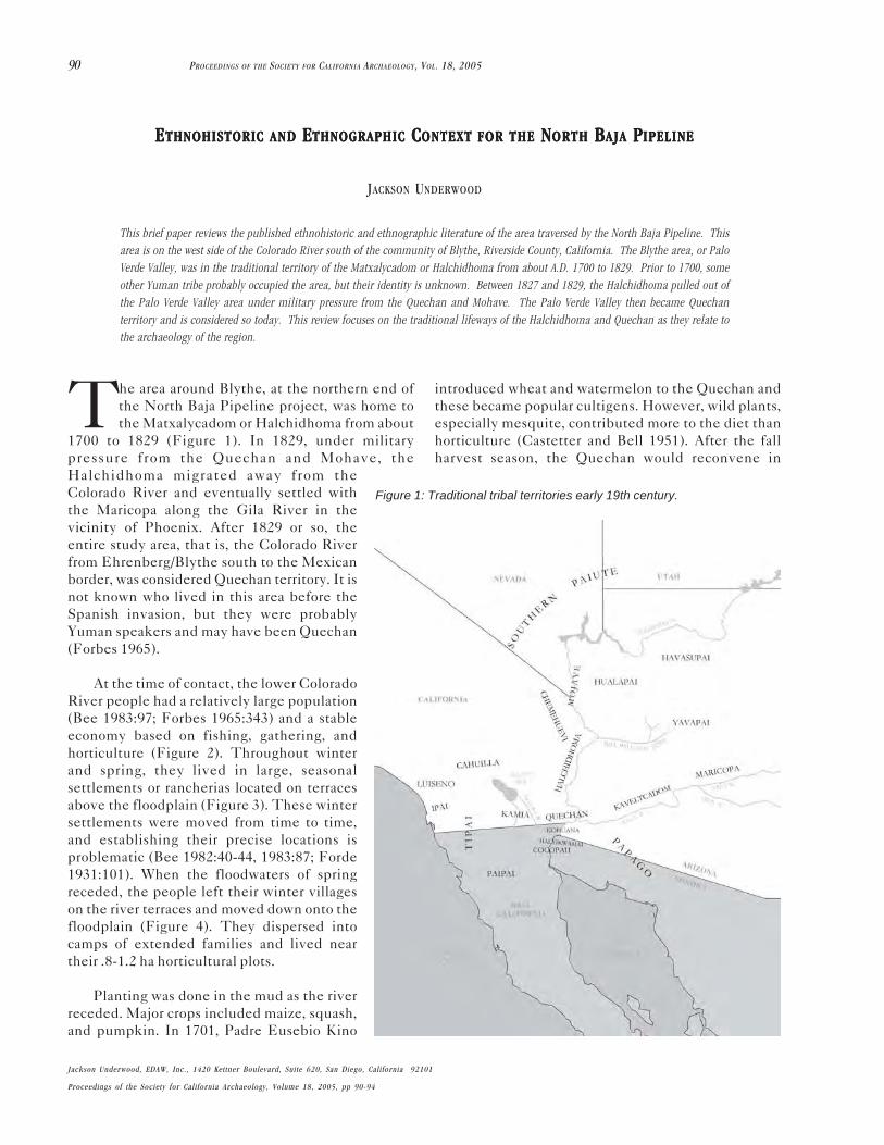
The area around Blythe, at the northern end ofthe North Baja Pipeline project, was home tothe Matxalycadom or Halchidhoma from about
1700 to 1829 (Figure 1). In 1829, under militarypressure from the Quechan and Mohave, theHalchidhoma migrated away from theColorado River and eventually settled withthe Maricopa along the Gila River in thevicinity of Phoenix. After 1829 or so, theentire study area, that is, the Colorado Riverfrom Ehrenberg/Blythe south to the Mexicanborder, was considered Quechan territory. It isnot known who lived in this area before theSpanish invasion, but they were probablyYuman speakers and may have been Quechan(Forbes 1965).
At the time of contact, the lower ColoradoRiver people had a relatively large population(Bee 1983:97; Forbes 1965:343) and a stableeconomy based on fishing, gathering, andhorticulture (Figure 2). Throughout winterand spring, they lived in large, seasonalsettlements or rancherias located on terracesabove the floodplain (Figure 3). These wintersettlements were moved from time to time,and establishing their precise locations isproblematic (Bee 1982:40-44, 1983:87; Forde1931:101). When the floodwaters of springreceded, the people left their winter villageson the river terraces and moved down onto thefloodplain (Figure 4). They dispersed intocamps of extended families and lived neartheir .8-1.2 ha horticultural plots.
Planting was done in the mud as the riverreceded. Major crops included maize, squash,and pumpkin. In 1701, Padre Eusebio Kino
introduced wheat and watermelon to the Quechan andthese became popular cultigens. However, wild plants,especially mesquite, contributed more to the diet thanhorticulture (Castetter and Bell 1951). After the fallharvest season, the Quechan would reconvene in
Figure 1: Traditional tribal territories early 19th century.

91SYMPOSIUM 4: A VIEW ACROSS THE CULTURAL LANDSCAPE OF THE LOWER COLORADO DESERT
villages on terraces above the river to avoid seasonalflooding (Bee 1983:88; Forde 1931:101).
The cultural landscape of the lower Colorado areais greatly influenced by the cosmology of the Pan-Yuman tribes. The Yumans believe in a plural reality:one is the “normal” material existence that everyoneunderstands, and the other is the spiritual-mysticalexistence. This spiritual level of reality is accessed bymeans of dreams (Bee 1982:49-50; Forbes 1965:63;Forde 1931:201-204; Kroeber 1925:754; Stewart1983:65).
Dreams figure prominently in legend and song andwere the major source of knowledge and power (Bee1982:49-50; Forbes 1965:63; Forde 1931:201-202;Kroeber 1925:754). The best and most significantdreams come unsolicited, during sleep at night, butintentional dreaming in pursuit of knowledge andinsight is also occasionally done. This is somewhatanalogous to meditation or prayer among otherreligious traditions, but no direct supplications todeities are made (Forde 1931:180-181, 202). Visionquesting for supernatural power, such as pursued amongthe plains tribes, was not done (Forde 1931:202).
Among the Pan-Yuman peoples, dreams are tiedclosely to the cultural landscape. Personal dreamsparallel Yuman religious myth and legend in the sensethat most are about journeys of spiritual discovery, oftenalong actual, physical trails leading to mountains ofreligious significance where important spirits reside.
Figure 3: Mohave winter house (Source: Ben Wittick, 1890s).
Figure 2: Mohave water carrier (Source: AmericanMemory Collection, Library of Congress, Edward S.Curtis’s The North American Indian, 1908).

92 PROCEEDINGS OF THE SOCIETY FOR CALIFORNIA ARCHAEOLOGY, VOL. 18, 2005
On these sacred peaks, one may be able to conferwith spirit beings to learn from them and gain wisdom.Various origin events took place on these mountains,and these events can be re-witnessed in dreams. Forthese reasons, mountains and the trail systems linkingthem hold vital spiritual significance to the traditionalPan-Yuman peoples.
The keruk ceremony was the most important anddeeply religious of all Pan-Yuman ceremonials. It is areenactment of the death of the creator god Kukumatand the procession carrying his body back toAvikwaame (Newberry Peak or Spirit Mountain)located some 16 km north of Laughlin, Nevada, inMohave territory.
The keruk was held typically in the fall to mourn thedeath of an important person or persons, but it was notnecessarily held every year. The keruk was also theoccasion for relatives and friends from considerabledistance to get together.
Pilot Knob (Avikwalal; no gloss) with its associatedsite of Avikwinur (inscribed rock), located some 18 kmwest of the present-day town of Yuma, was the startingplace for the traditional keruk ceremonial pilgrimage.The pilgrimage ended at Avikwaame some 360 kmnorth of Yuma. The Keruk Trail and other trails linkingvarious sacred mountains with each other and withvarious village areas were utilized for actual religiouspilgrimages associated with the keruk ceremony, andthey were also utilized for dream travel. Thesespiritually charged trails often have various trail
features evidently designed to help travelers deal withspiritual issues. These features include spirit breaks,which consist of cobbles aligned across or parallel to thetrail; spirit deflectors, which are short dead-end trails;parallel trails, which are used to avoid the use of old,haunted trails; and trail cairns or shrines, which are pilesof pebbles and pottery sherds accumulated as eachpassing traveler contributed one piece for good luck.
Spiritually significant trail segments sometimeshave geoglyphs associated with them. The largergeoglyph sites are thought to be places where kerukobservances once took place (Altschul and Ezzo1994:52-53; Forbes 1965:67; Johnson 1985:37).
Features one might find at a major keruk siteinclude anthropomorphic, zoomorphic, and abstractgeoglyphs; dance circles; winding, amorphous dancepaths; amorphous, tamped staging areas; and clearedcircles or sleeping circles (Figure 5). Minor ceremonialsites may lack many of these elements. Likewise, whilea ceremonial function and spiritual significance istypically ascribed to anthropomorphic, zoomorphic, andabstract geoglyphs, some smaller, isolated ones mayhave been associated with ceremonies other than thekeruk, such as initiation rites or harvest ceremonies(Altschul and Ezzo 1994:63).
Often one finds white quartz shatter associated withgeoglyphs along spiritually significant trails (Figure 6).The milky quartz was shattered as part of a personalpurification ritual as one approached a spirituallypowerful place. Other archaeological manifestations of
Figure 4: Cocopa summer house, jacal, and ramada with drying pumpkins strips (Source: Edward H. Davis, 1923).

93SYMPOSIUM 4: A VIEW ACROSS THE CULTURAL LANDSCAPE OF THE LOWER COLORADO DESERT
Figure 5: Sleeping circle.
Figure 6: Quartz shatter.
94 PROCEEDINGS OF THE SOCIETY FOR CALIFORNIA ARCHAEOLOGY, VOL. 18, 2005
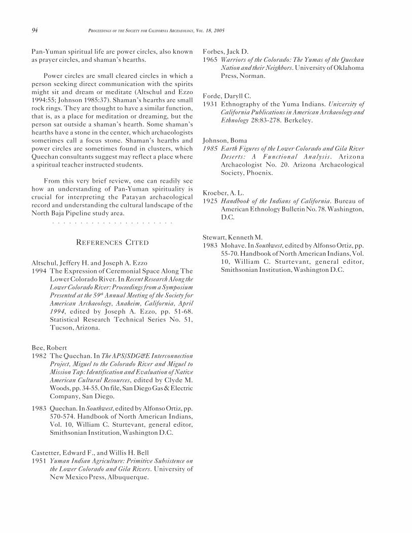
Pan-Yuman spiritual life are power circles, also knownas prayer circles, and shaman’s hearths.
Power circles are small cleared circles in which aperson seeking direct communication with the spiritsmight sit and dream or meditate (Altschul and Ezzo1994:55; Johnson 1985:37). Shaman’s hearths are smallrock rings. They are thought to have a similar function,that is, as a place for meditation or dreaming, but theperson sat outside a shaman’s hearth. Some shaman’shearths have a stone in the center, which archaeologistssometimes call a focus stone. Shaman’s hearths andpower circles are sometimes found in clusters, whichQuechan consultants suggest may reflect a place wherea spiritual teacher instructed students.
From this very brief review, one can readily seehow an understanding of Pan-Yuman spirituality iscrucial for interpreting the Patayan archaeologicalrecord and understanding the cultural landscape of the
○ ○ ○ ○ ○ ○ ○ ○ ○ ○ ○ ○ ○ ○ ○ ○ ○ ○ ○ ○ ○ ○
North Baja Pipeline study area.
REFERENCES CITED
Altschul, Jeffery H. and Joseph A. Ezzo1994 The Expression of Ceremonial Space Along The
Lower Colorado River. In Recent Research Along theLower Colorado River: Proceedings from a SymposiumPresented at the 59th Annual Meeting of the Society forAmerican Archaeology, Anaheim, California, April1994, edited by Joseph A. Ezzo, pp. 51-68.Statistical Research Technical Series No. 51,Tucson, Arizona.
Bee, Robert1982 The Quechan. In The APS/SDG&E Interconnection
Project, Miguel to the Colorado River and Miguel toMission Tap: Identification and Evaluation of NativeAmerican Cultural Resources, edited by Clyde M.Woods, pp. 34-55. On file, San Diego Gas & ElectricCompany, San Diego.
1983 Quechan. In Southwest, edited by Alfonso Ortiz, pp.570-574. Handbook of North American Indians,Vol. 10, William C. Sturtevant, general editor,Smithsonian Institution, Washington D.C.
Castetter, Edward F., and Willis H. Bell1951 Yuman Indian Agriculture: Primitive Subsistence on
the Lower Colorado and Gila Rivers. University ofNew Mexico Press, Albuquerque.
Forbes, Jack D.1965 Warriors of the Colorado: The Yumas of the Quechan
Nation and their Neighbors. University of OklahomaPress, Norman.
Forde, Daryll C.1931 Ethnography of the Yuma Indians. University of
California Publications in American Archaeology andEthnology 28:83-278. Berkeley.
Johnson, Boma1985 Earth Figures of the Lower Colorado and Gila River
Deserts: A Functional Analysis . ArizonaArchaeologist No. 20. Arizona ArchaeologicalSociety, Phoenix.
Kroeber, A. L.1925 Handbook of the Indians of California. Bureau of
American Ethnology Bulletin No. 78. Washington,D.C.
Stewart, Kenneth M.1983 Mohave. In Southwest, edited by Alfonso Ortiz, pp.
55-70. Handbook of North American Indians, Vol.10, William C. Sturtevant, general editor,Smithsonian Institution, Washington D.C.