Ecosystem-Based Marine Spatial Management
26
Issues and Prospects Ecosystem-Based Marine Spatial Management: An Evolving Paradigm for the Management of Coastal and Marine Places Fanny Douvere and Charles Ehler* Intergovernmental Oceanographic Commission and Man and the Biosphere Programme, UNESCO, Paris, France INTRODUCTION The development and industrialization of the world’s oceans has evolved rapidly since the 15th century. 1 Ongoing population growth, technological development, and growing consumer demand increased considerably the need for more food, energy, and trade. Future outlooks for offshore activities confirm that this evolution has not come to an end and is even likely to accelerate in the coming decades. The share of natural gas production derived from offshore exploitation, for example, is expected to grow to nearly 40 percent by 2030 (compared to 20–25 percent in 1990), as exploration and developments will shift to more lucrative offshore sites, a trend partly stimulated by high oil prices. A substantial contribution is expected from renewable energy (e.g., offshore wind farms and wave parks) by 2030, mainly because of decreasing exploitation costs. 2 Future global growth of the cruise ship industry is estimated at an annual rate of 8 percent, while eco-tourism has grown to a multi-million dollar business in nearly 25 years, on an average annual growth rate of 12 percent since 1990. 3 * The authors thank the Gordon and Betty Moore Foundation and the David and Lucile Packard Foundation for their substantial support to the UNESCO (Intergovernmental Oceanographic Commission and Man and the Biosphere Programme) initiative on Ecosystem-based Marine Spatial Management, available online: <http://ioc3.unesco.org/marinesp>. Email: [email protected]. 1. H. Smith, ‘‘The Industrialisation of the World Ocean,’’ Ocean and Coastal Management 44 (2001): 563–566. 2. World Energy Outlook 2004. OECD/IEA International Energy Agency (IEA), 2004. 3. Worldwide Cruise Ship Activity. World Tourism Organization, 2003, pp. 9; F. Kanji, A Global Perspective on the Challenges of Coastal Tourism (Bangkok, Thailand: Coastal Development Centre, Kasetsart University, 16 November 2006). Ocean Yearbook 23: 1–26. 1
Transcript of Ecosystem-Based Marine Spatial Management
Issues and Prospects
Ecosystem-Based Marine Spatial Management: AnEvolving Paradigm for the Management of Coastaland Marine PlacesFanny Douvere and Charles Ehler*Intergovernmental Oceanographic Commission and Man and theBiosphere Programme, UNESCO, Paris, France
INTRODUCTION
The development and industrialization of the world’s oceans has evolvedrapidly since the 15th century.1 Ongoing population growth, technologicaldevelopment, and growing consumer demand increased considerably theneed for more food, energy, and trade. Future outlooks for offshoreactivities confirm that this evolution has not come to an end and is evenlikely to accelerate in the coming decades. The share of natural gasproduction derived from offshore exploitation, for example, is expected togrow to nearly 40 percent by 2030 (compared to 20–25 percent in 1990), asexploration and developments will shift to more lucrative offshore sites, atrend partly stimulated by high oil prices. A substantial contribution isexpected from renewable energy (e.g., offshore wind farms and wave parks)by 2030, mainly because of decreasing exploitation costs.2 Future globalgrowth of the cruise ship industry is estimated at an annual rate of 8percent, while eco-tourism has grown to a multi-million dollar business innearly 25 years, on an average annual growth rate of 12 percent since 1990.3
* The authors thank the Gordon and Betty Moore Foundation and the Davidand Lucile Packard Foundation for their substantial support to the UNESCO(Intergovernmental Oceanographic Commission and Man and the BiosphereProgramme) initiative on Ecosystem-based Marine Spatial Management, availableonline: <http://ioc3.unesco.org/marinesp>. Email: [email protected].
1. H. Smith, ‘‘The Industrialisation of the World Ocean,’’ Ocean and CoastalManagement 44 (2001): 563–566.
2. World Energy Outlook 2004. OECD/IEA International Energy Agency (IEA),2004.
3. Worldwide Cruise Ship Activity. World Tourism Organization, 2003, pp. 9; F.Kanji, A Global Perspective on the Challenges of Coastal Tourism (Bangkok, Thailand:Coastal Development Centre, Kasetsart University, 16 November 2006).
Ocean Yearbook 23: 1–26.
1
2 Issues and Prospects
Aquaculture is expanding and intensifying in almost all regions of the worldand has grown to about 43 percent of current global fish consumption (incomparison to only 9 percent in 1980).4 An inevitable question arises: howcan development be sustained, keeping marine industries economicallyviable, while conserving places that are critical for the health of the marineenvironment and its biodiversity?
While in the past, industrialization of ocean use has been mostprominent in fisheries, maritime transport, communications, oil and gasexploitation, marine recreation, and coastal engineering, it is particularlythe rise of new uses, such as renewable energy and nature conservationinitiatives, which has made decision-makers recognize the need to developand implement an integrated and more rational use of ocean space. In mostcases it has been because of growing and interactive pressures, often drivenby incompatible demands for ocean space, which have forced governancesystems to face complex, multi-sectoral issues. In New Zealand, for example,the issues of Maori rights and marine conservation came into sharp politicalfocus at the same time. In European examples, the cumulative crush ofshipping, fisheries, renewable energy, recreation, land-based pollutionsources, and conservation requirements could no longer be ignored. In thecase of the Australian Great Barrier Reef, the pressures of mineralexploitation, developing tourism, and national pride in an iconic ecosystemdrove the process toward an adaptive, integrated marine spatial manage-ment process.
Ocean resources are limited both in space and abundance and thepressure on the marine environment, resulting from an expansion ofexisting use and the rise of new ones, has been devastating to many places.Essentially, increased activity in the marine environment has led to twoimportant types of conflict. First, not all uses are compatible with oneanother and are competing for ocean space or have adverse effects on eachother (user vs. user conflicts). Numerous examples exist of conflicts betweenocean users both globally and locally and include, for example, incompati-bilities between the fast-growing, billion-dollar submarine cable industry andfisheries, causing damage to, or loss of, fishing gear or huge repair costs andlost revenues for cable disruptions.5 Other user conflicts include wind farmslocated near shipping routes or traffic separation schemes, causing highrisks of collisions and loss of cargo. In New Zealand, spatial conflicts have
4. C. Delgado, W. Nikolas, M. Rosegrant, S. Meijer and M. Ahmed, Fish to 2020,Supply and Demand in Changing Global Markets, International Food Policy ResearchInstitute and World Fish Center, 2003, p. 81; See also The State of World Fisheries andAquaculture (Rome: Food and Agriculture Organization of the United Nations,2004).
5. S. Coffen-Smout and G. Herbert, ‘‘Submarine Cables: A Challenge forOcean Management,’’ Marine Policy 24 (2000): 441–448.
Ecosystem-Based Marine Spatial Management 3
arisen from legislative obligations to uphold the historic and indigenousrights of fishers with more recent obligations toward nature conservation.6
Spatial use conflicts also occur within one particular use and refer, forexample, to the use of different gear types for fisheries in certain areas, orthe competition over use of space between commercial and recreationalfisheries. Studies in California have illustrated that new commercial oceanactivities will only exacerbate conflicts between users.7
Second, not all uses are compatible with the needs of a healthy andsustainable environment and cause conflicts between users and theenvironment (user vs. environment conflicts). Too often, ocean uses arelocated in sensitive biological and ecological areas without much consider-ation of their impact. Many scientific studies document the degradation ofthe world’s oceans, the decline of marine ecosystems, and the collapse ofimportant fish species, illustrating that this is increasingly impairing theocean’s ability to produce the goods and services essential for life on Earth.8
Recent research measured the cumulative impacts of human offshoreactivities on the marine environment at a global scale and concluded thatalmost half (41 percent) of the world’s oceans is strongly affected bymultiple stresses. Highly affected regions include the Eastern Caribbean,the North Sea, and Japanese waters. Only a few areas around the North andSouth poles remain relatively unaffected by human activities. Negativecumulative impacts of human activities on coastal and marine ecosystemswould probably be higher if historical effects, unreported extraction,recreational use (including fishing), disease, and point-source pollutionwere incorporated in future measurements.9
Many of the conflicts described above can and have been avoided orreduced through marine spatial management by influencing the location ofhuman activities in space and time. During recent years, marine spatialmanagement (which includes marine spatial planning) has become increas-
6. R. Bess and R. Rallapudi, ‘‘Spatial Conflicts in New Zealand Fisheries: TheRights of Fishers and Protection of the Marine Environment,’’ Marine Policy 31(2007): 719–729.
7. D. Sivas and M. Caldwell, ‘‘A New Vision for Californian Ocean Governance:Comprehensive Ecosystem-Based Marine Zoning,’’ Stanford Environmental LawJournal 27 (2008): 209–270.
8. B. Worm, E. Barbier, N. Beaumont, J. Duffy, C. Folke, B. Halpern, J. Jackson,H. Lotze, F. Micheli, S. Palumbi, E. Sala, K. Selkoe, J. Stachowicz, and R. Watson,‘‘Impacts of Biodiversity Loss on Ocean Ecosystem Services,’’ Science 314 (2006):787–790.
9. B. Halpern, S. Walbridge, K. Selkoe, C. Kappel, F. Micheli, C. Agrosa, J.Bruno, K. Casey, C. Ebert, H. Fox, R. Fujita, D. Heinemann, H. Lenihan, E. Madin,M. Perry, E. Selig, M. Spalding, R. Steneck, R. Watson, ‘‘A Global Map of HumanImpact on Marine Ecosystems,’’ Science 319 (2008): 948–952.
4 Issues and Prospects
ingly important as a way to make ecosystem-based management10 a reality incoastal and marine environments.11 While concepts regarding ecosystem-based management are often considered too broad, too abstract and toocomplex to enable effective implementation,12 marine spatial managementproves to be a way to make this process more tangible.13 Innovative andsuccessful initiatives toward the development and implementation ofecosystem-based marine spatial management have been taken in bothhighly-used marine areas such as the North Sea, the Baltic Sea, the coastalarea around China, and in large ocean areas such as Canada, Australia andNew Zealand. A key characteristic of these marine spatial managementinitiatives is their ability to provide integration across multiple uses andsectors, to minimize conflicts, to maximize sustainable economic develop-ment, and to protect important habitat and biodiversity areas.14
10. The Convention on Biological Diversity describes ecosystem-based manage-ment as ‘‘a strategy for integrated management of land, water and living resourcesthat promotes conservation and sustainable use in an equitable way. The ecosystemapproach is based on the application of appropriate scientific methodologiesfocused on levels of biological organization, which encompass the essentialprocesses, functions and interactions among organisms and their environment. Itrecognizes that humans, with their cultural diversity, are an integral component ofecosystems.’’ (Convention on Biological Diversity. Decision V/6 of the Conferenceof the Parties to the Convention on Biological Diversity. Ecosystem Approach,available online: <http://www.biodiv.org>.
11. L. Crowder, G. Osherenko, O. Young, S. Airame, E. Norse, N. Baron, J. Day,F. Douvere, C. Ehler, B. Halpern, S. Langdon, K. McLeod, J. Ogden, R. Peach, A.Rosenberg, and J. Wilson, ‘‘Resolving Mismatches in U.S. Ocean Governance,’’Science 313 (2006): 617–618. See also C. Ehler and F. Douvere, ‘‘Visions for a SeaChange. Report of the First International Workshop on Marine Spatial Planning,’’Intergovernmental Oceanographic Commission and Man and the BiosphereProgramme. IOC Manual and Guides No. 48, IOCAM Dossier No. 4 (Paris:UNESCO, 2007); and F. Douvere, ‘‘The Importance of Marine Spatial Planning inAdvancing Ecosystem-based Sea Use Management,’’ Marine Policy 32, no. 5(September 2008).
12. K. Arkema, S. Abramson and B. Dewsbury, ‘‘Marine Ecosystem-BasedManagement: From Characterization to Implementation,’’ Frontiers in Ecology and theEnvironment 4 (2006): 525–532.
13. O. Young, G. Osherenko, J. Ekstrom, L. Crowder, J. Ogden, J. Wilson, J.Day, F. Douvere, C. Ehler, K. McLeod, B. Halpern, and R. Peach, ‘‘Solving the Crisisin Ocean Governance: Place-Based Management of Marine Ecosystems,’’ Environ-ment 49 (2007): 21–30.
14. Ehler and Douvere, n. 11 above.
Ecosystem-Based Marine Spatial Management 5
ECOSYSTEM-BASED MARINE SPATIAL MANAGEMENT:CHALLENGES AND OPPORTUNITIES
Most coastal countries already allocate ocean space. Among the mostobvious are concession zones for resource exploitation (offshore oil and gasand development areas), designation of dumping sites, delineation ofshipping routes and traffic separation schemes, and the designation of areasfor nature protection.
Several of these allocations of ocean space result from internationaland regional agreements. At the global scale, the United Nations Conven-tion on the Law of the Sea (UNCLOS) provides an overarching frameworkfor the allocation of ocean space to national states through the codificationof concepts such as the territorial sea of 12 nautical miles, the exclusiveeconomic zone of 200 nautical miles, the contiguous zone, the continentalshelf, and the high seas.15 Others include agreements on the delineation ofspecial areas for the prevention of sea pollution introduced by theInternational Maritime Organization (IMO),16 the protection of culturaland natural world heritage (World Heritage Convention),17 or the designa-tion of areas for the conservation of birds and habitat under the EuropeanUnion directives18 and OSPAR Convention.
The problem with current practice, however, is that the designation ofareas for both economic activities and nature protection is done on a single-sector basis.19 Current practice has no plan-based approach and has little orno consideration of the policies and plans of other uses or sectors orconservation requirements that may be conflicting or incompatible. Forexample, as nations move progressively toward establishing networks ofmarine protected areas as an alternative to individual sites, the managementof ocean spaces outside the protected area becomes increasingly more
15. United Nations Convention on the Law of the Sea (1982), available online:<http://www.un.org/Depts/los/index.htm>.
16. International Convention for the Prevention of Pollution from Ships, 1973,as modified by the Protocol of 1978 relating thereto (MARPOL 73/78), availableonline: <www.imo.org>
17. Convention Concerning the Protection of the World Cultural and NaturalHeritage. United Nations Educational, Scientific and Cultural Organization, Paris(1972), available online: <http://whc.unesco.org/en/conventiontext>.
18. Council of the European Communities Directive 79/409/EEC of 2 April1979 on the Conservation of Wild Birds, OJ L 103, 24 March 1979 (as amended) andCouncil of the European Communities Directive 92/43/EEC of 21 May 1992 on theConservation of Natural Habitats and of Wild Fauna and Flora, OJ L 206, 22 July1992.
19. B. Halpern, ‘‘Managing for Cumulative Impacts in Ecosystem-basedManagement through Ocean Zoning,’’ Ocean and Coastal Management 51 (2008):203–211.
6 Issues and Prospects
important. Establishing boundaries for management and planning effortsare also most often based on political considerations and not necessarilymeaningful from an ecological perspective.
Triggered by the consequences of the industrial revolution, a similarsituation was found on land about 100 years ago. Today, comprehensiveland use planning is commonly used as a central component of develop-mental and environmental planning of land areas in both North Americaand Europe. The traditional project-by-project, permit-by-permit approachis now often guided by a comprehensive planning process that lays out avision for the future development, growth, use, and protection of terrestrialareas. Today, this approach has become the standard for land-use planningand management. With only a few exceptions, no clearly articulated spatialvision for the future use of marine areas exists. In most cases, oceanmanagement policies have not been translated into integrated, strategic andcomprehensive spatial planning of all activities taking place in marine areas.The lack of such planning often translates into:20
1. Spatial and temporal overlap of human activities and theirobjectives, causing user vs. user and user vs. environment conflictsin the marine environment;
2. Lack of connection between the various authorities responsible forindividual activities or the protection and management of theenvironment as a whole;
3. Lack of connection between offshore activities and resource useand onshore communities that are dependent on them;
4. Lack of conservation of biologically and ecologically sensitivemarine areas; and
5. Lack of investment certainty for marine developers and users ofocean resources.
Marine spatial planning is not radically different from spatial planningon land. Although the context and outcomes are different because of thedynamic and three-dimensional nature of marine environments, land useplanning concepts and methodologies can rather easily be translated to themarine environment. As on land, spatial planning in the marine environ-ment is a means to:
Create and establish a more rational organization of the use of marinespace and the interactions between its uses, to balance demands for
20. Douvere, n. 11 above.
Ecosystem-Based Marine Spatial Management 7
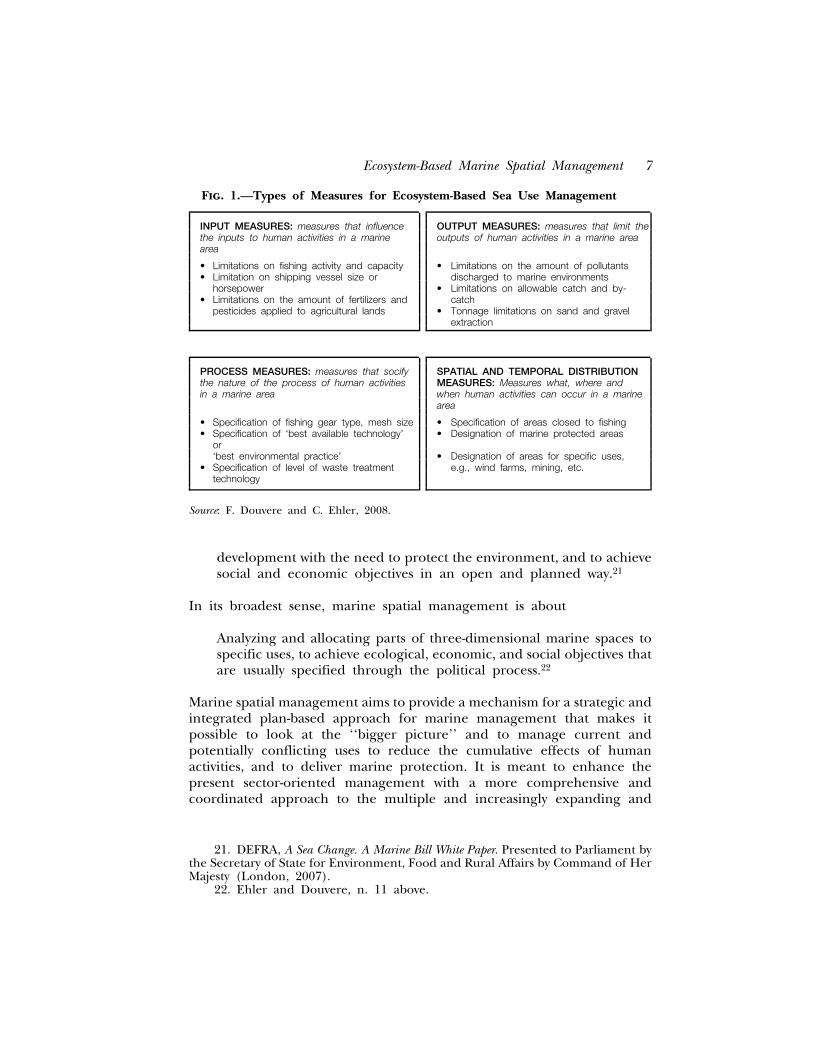
Fig. 1.—Types of Measures for Ecosystem-Based Sea Use Management
INPUT MEASURES: measures that influence OUTPUT MEASURES: measures that limit thethe inputs to human activities in a marine outputs of human activities in a marine areaarea
• Limitations on fishing activity and capacity • Limitations on the amount of pollutants• Limitation on shipping vessel size or discharged to marine environments
horsepower • Limitations on allowable catch and by-• Limitations on the amount of fertilizers and catch
pesticides applied to agricultural lands • Tonnage limitations on sand and gravelextraction
PROCESS MEASURES: measures that socify SPATIAL AND TEMPORAL DISTRIBUTIONthe nature of the process of human activities MEASURES: Measures what, where andin a marine area when human activities can occur in a marine
area
• Specification of fishing gear type, mesh size • Specification of areas closed to fishing• Specification of ‘best available technology’ • Designation of marine protected areas
or‘best environmental practice’ • Designation of areas for specific uses,
• Specification of level of waste treatment e.g., wind farms, mining, etc.technology
Source: F. Douvere and C. Ehler, 2008.
development with the need to protect the environment, and to achievesocial and economic objectives in an open and planned way.21
In its broadest sense, marine spatial management is about
Analyzing and allocating parts of three-dimensional marine spaces tospecific uses, to achieve ecological, economic, and social objectives thatare usually specified through the political process.22
Marine spatial management aims to provide a mechanism for a strategic andintegrated plan-based approach for marine management that makes itpossible to look at the ‘‘bigger picture’’ and to manage current andpotentially conflicting uses to reduce the cumulative effects of humanactivities, and to deliver marine protection. It is meant to enhance thepresent sector-oriented management with a more comprehensive andcoordinated approach to the multiple and increasingly expanding and
21. DEFRA, A Sea Change. A Marine Bill White Paper. Presented to Parliament bythe Secretary of State for Environment, Food and Rural Affairs by Command of HerMajesty (London, 2007).
22. Ehler and Douvere, n. 11 above.
8 Issues and Prospects
conflicting uses of the sea.23 It provides an opportunity not only to bettermanage and understand the marine environment, but also allows long-termplanning so that processes become more transparent with greater certaintyin permitting, planning, and allocation for both developers and environ-mental managers.24 In doing so, it can replace the current piecemeal viewand make sure that commitments made in international and nationalmarine policy and legislation, including commitments to apply an ecosystemapproach, can be fulfilled.25
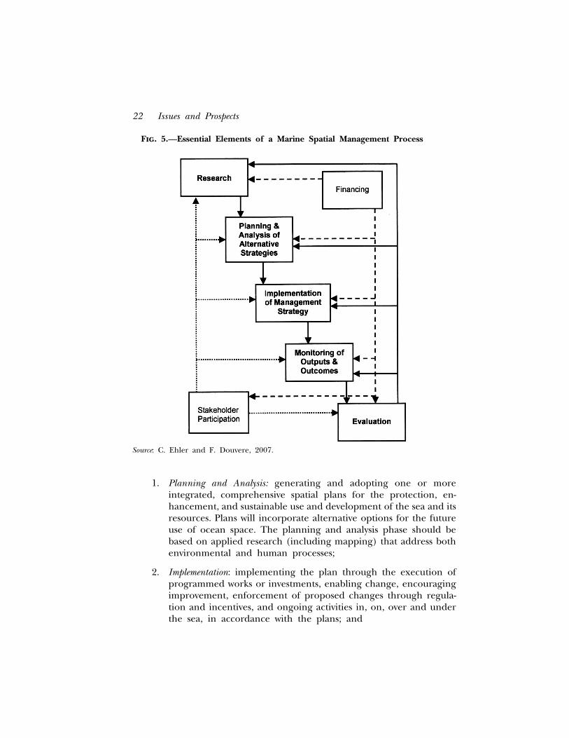
It is important, however, to recognize that marine spatial managementcan only influence the spatial and temporal distribution of human activities.To implement the multiple objectives of an ecosystem-based managementapproach, a range of tools will be needed including measures that influencethe input, the output, and the processes of human activities (Figure 1).
A focus on the spatial and temporal aspects of ecosystem-basedmanagement is one way to make this approach more tangible. Marinespatial management (including planning) does this by:
• Defining the boundaries of the ecosystem to be managed;• Defining ocean spaces with special ecological or biological value
within the ecosystem;• Defining ocean spaces with special economic value and potential;• Defining ocean spaces where the effects of human activities interact
positively or negatively with ecological functions and processes; and• Defining where conflicts are occurring or might occur (user vs. user
and user vs. environment conflicts).
Through this process of defining spaces, marine spatial management:
• Addresses the heterogeneity of marine ecosystems in a practical manner. MSPtakes into account that some things only occur in certain places.Important ecological areas, for example, are located in areas of highdiversity, endemism or productivity, spawning and nursery areas, andmigration stopover points. At the same time, economic activity will(and can) only take place where the resources are located, as forexample, oil and gas deposits, sand and gravel deposits, and areas ofsustained winds or waves;
23. D. Degnbol and D. Wilson, ‘‘Spatial Planning on the North Sea: A Case ofCross-scale Linkages,’’ Marine Policy 32 (2008): 189–200.
24. CoastNET, Spatial Planning in the Coastal and Marine Environment: Next Stepsto Action. Report of a CoastNET Conference (London: University of London, 2003).
25. F. Douvere and C. Ehler, ‘‘New Perspectives on Sea Use Management:Initial Findings from European Experience with Marine Spatial Planning,’’ Journalfor Environmental Management (forthcoming February 2009).
Ecosystem-Based Marine Spatial Management 9
• Focuses on influencing the behavior of humans and their activities over time.Although goals and objectives for a certain area are usually set forboth ecosystem or natural processes and human activities, it is onlythe human component (human activities and resource use) that canbe managed (not the ecosystem itself), e.g., through managementmeasures (incentives) that change behavior of humans and theiractivities over time;
• Provides a management framework for new and previously inaccessiblescientific information. Through remote sensing, tracking technologies,and global positioning technologies, science is making visible whathad previously been hidden or inaccessible and increases the needfor a management framework that allows the effective integrationand use of new scientific information in decision-making processes;
• Makes conflicts and compatibilities among human uses visible, and thereforetangible. Through the mapping of ecosystems, their characteristics,and human activities affecting it one can see where conflicts are orwill be located; and
• Guides single-sector management toward integrated decision-making. Thedevelopment of a marine spatial plan for an entire region visualizesalternative scenarios (drawn from a specified set of sectoral objec-tives) for ecosystem-based management, which in turn can provideguidance to a range of decision-makers, each responsible for only aparticular sector or activity of the entire area (e.g., fisheries managerswill see what conflicts and compatibilities their management planswill have with plans for the offshore development of wind farms).26
THE PRACTICE OF ECOSYSTEM-BASED MARINE SPATIALMANAGEMENT
During the last decade, marine spatial management has gained consider-able importance in establishing ecosystem-based management in the marineenvironment. Several countries have begun to move the conceptual workforward and have started implementing, or at least experimenting with,spatial management in the marine and coastal environment. Analysis ofmarine spatial management initiatives in various countries shows a clearevolution from early spatial plans designed to establish and manage marineprotected areas (Australia and USA), to multiple-use marine spatialmanagement (Northwest Europe and China), to more recent, systematicefforts to underpin the design of multiple-use marine spatial managementwith an ecosystem approach (Australia, New Zealand and Canada).
26. Id.
10 Issues and Prospects
Marine Spatial Management for Nature Protection
Early marine spatial plans were first used to manage marine protectedareas.27 The focus of these plans has mainly been to ensure thatconservation objectives were not impaired by human activity. One of thebest-known examples is Australia’s Great Barrier Reef Marine Park(GBRMP). Spatial planning and zoning, largely considered as the corner-stone of the management strategy for the protection of the Great BarrierReef, permit various human activities, including fisheries and tourism, whilesimultaneously providing a high level of protection for specific areas. Spatialmanagement in the GBRMP is based on eight zones, ranging from the leastrestrictive ‘‘general use zone’’ in which shipping and most commercialfishing is allowed, to the most restrictive ‘‘preservation zone’’ where virtuallyno use is permitted.28 The spatial plan, first developed in 1981, has evolvedand changed considerably in response to the dynamic nature of both themarine environment and perceived effectiveness of the first zoning plan.29
When monitoring results showed that ecosystem protection goals were notbeing achieved, preservation zones were increased, up to about a third ofthe entire area.30
Marine spatial planning is also an important element in the manage-ment of the Trilateral Wadden Sea Cooperation Area. The Wadden SeaPlan, developed as a trans-boundary initiative between the Netherlands,Germany and Denmark to protect and manage a shared coastal wetlandsystem, is an interesting example of the use of spatial management in aninternational context. While spatial differentiation of functions and activi-ties are used according to national legislation, the various national zoningsystems have similar structures. Essentially, they consist of no-use zones,high-level protection zones, and general access zones.31
Another well-known example of marine spatial management as a meansto conserve nature is the Florida Keys National Marine Sanctuary in theUnited States. Similar to the GBRMP, spatial management has beenimplemented through temporal and geographic zoning to ensure theprotection of the Sanctuary and its resources and lessen the concentrated
27. Degnbol and Wilson, n. 23 above.28. Great Barrier Reef Marine Park Authority, Great Barrier Reef Marine Park
Zoning Plan 2003, available online: <http://www.gbrmpa.gov.au/ data/assets/pdf file/0016/10591/Zoning Plan.pdf>.
29. J. Day, ‘‘The Need and Practice of Monitoring, Evaluating and AdaptingMarine Planning and Management: Lessons from the Great Barrier Reef MarinePark,’’ Marine Policy 32, no. 5 (September 2008).
30. Id.31. J. Enemark, Secretary of the Common Wadden Sea Secretariat, pers.
comm. (February 2007).
Ecosystem-Based Marine Spatial Management 11
impact to marine organisms on heavily used reefs. In addition to theexisting management areas, four new zone types were implementedthroughout the Sanctuary, including: Wildlife Management Areas focusingon sensitive wildlife populations and ranging from no-access buffer zones toclosed zones; Ecological Reserves focusing on large, contiguous diversehabitats, allowing activities that are compatible with resource protection;Sanctuary Preservation Areas focusing on heavily used reefs, prohibiting allconsumptive activities; and, Special-use Areas reserved for scientific re-search, education, restoration and monitoring, only allowing specific usesand limited in their length of duration.32
While the long-standing experience of the GBRMP and Florida KeysNational Marine Sanctuary provides valuable lessons about the elements of asuccessful marine spatial management process (see below), it is important torealize that their context and associated challenges (each of them is oficonic value and implemented in large, relatively low impact areas) issubstantially different from the highly-used and industrialized marine areasin most other places around the world.
Marine Spatial Management for Multiple-Use Objectives
More recent attention has been placed on managing the multiple use(which includes nature protection) of marine space. This is especially thecase in densely used areas such as the North Sea (North-West Europe)where conflicts among users and the environment are already clear. Here,marine spatial management has developed quickly, although often on an adhoc basis. The main drivers for the implementation of marine spatialmanagement in these areas come from both the demand for new oceanuses, such as offshore wind energy generation and aquaculture, andinternational requirements for the protection and conservation of ecologi-cally and biologically valuable areas. The Netherlands and Belgium haveboth implemented marine spatial planning. Marine spatial planning is alsounderway in Germany and the United Kingdom, but both countries havechosen to first establish a strong legal basis for marine spatial planningbefore starting to develop spatial plans and initiatives.
In 2005, The Netherlands developed an overarching spatial planningframework for the Dutch area of the North Sea, with the primary objectiveto ‘‘enhance the economic importance of the North Sea and maintain anddevelop the international ecological and landscape features by developingand harmonizing sustainable spatial-economic activities in the North Sea,
32. See the Zoning Action Plan of the Florida Keys National Marine Sanctuary,available online: <http://floridakeys.noaa.gov/regs/zoning.html>.
12 Issues and Prospects
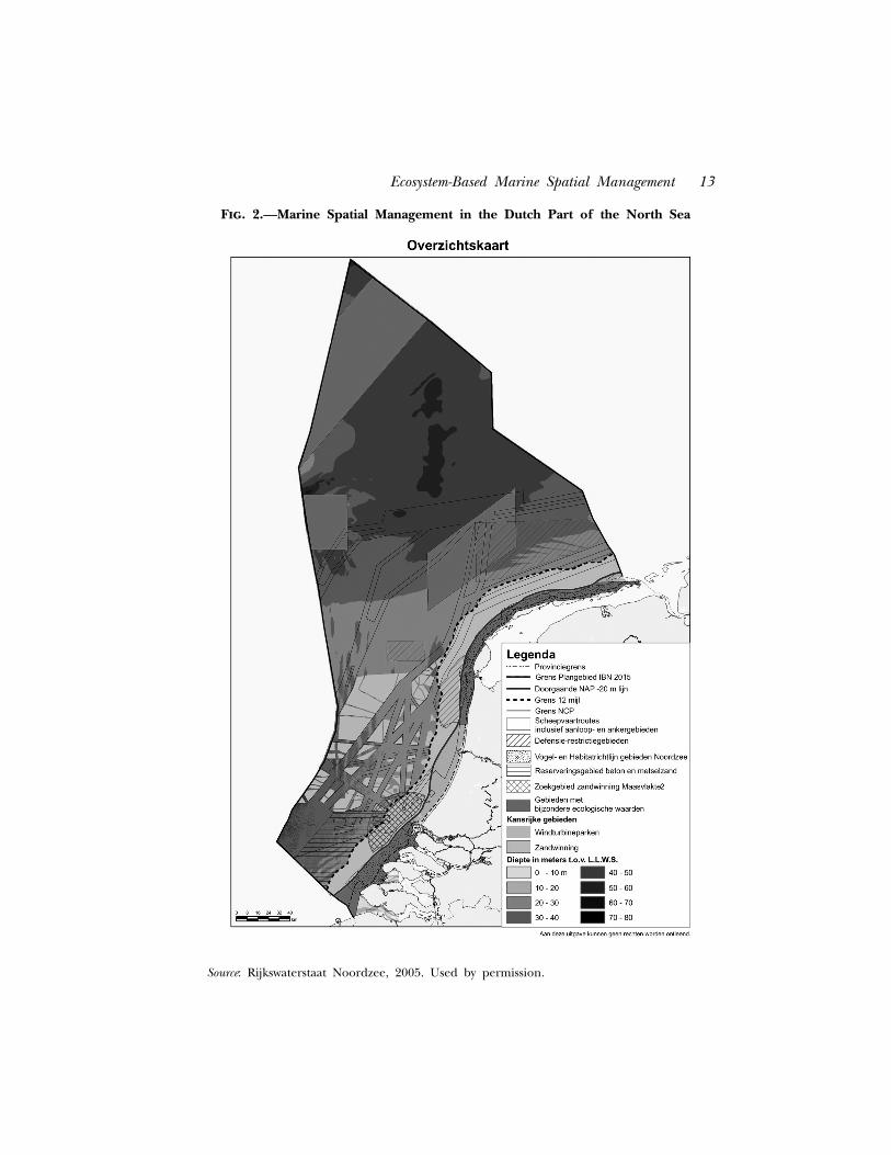
taking into account the ecological landscape features.’’33 Implementation ofthe spatial policy is described in the Integrated Management Plan for theNorth Sea 2015 (IMPNS 2015),34 in which the overall objective for spatialplanning is translated into the need for a healthy, safe and profitable sea.The Dutch marine spatial policy provides the private sector flexibility todevelop offshore initiatives and projects. To limit the risks involved incomplete market freedom, the spatial policy provides a guiding spatialmanagement framework in which location-based uses (usage zones), azoning scheme for growth options, and several exclusion policies, aredefined. Central to the Dutch marine spatial management framework is asystem of permits for the regulation of offshore activities. Additionally, a setof other tools has been developed to provide insight into spatial develop-ments and potential problems and to facilitate managing the use of oceanspace. These new tools include ‘‘opportunity maps’’ that show where a use ispermitted in the current framework and is most likely to develop in thefuture; a spatial monitoring and permit tracking system; an integrated,spatial, assessment framework for issuing permits; exploratory spatial studiesfor specific functions; a compensation possibility for users harmed byanother legal ocean use; and a system to support joint initiatives in whichparties combine the use of ocean space (Figure 2). The Dutch spatialplanning initiative is designed for the period 2005–2015 and will bereviewed after its first five years. Current experiences, especially with regardto the offshore wind industry, tend to stimulate a bigger role for spatialplanning (e.g., more zones and accompanying criteria for specific uses) infuture sea use management in The Netherlands.
Belgium recently implemented an operational, multiple-use planningsystem covering its territorial sea and exclusive economic zone.35 The coreobjectives of the Belgian spatial planning policy framework include thedevelopment of offshore wind farms, the delimitation of marine protectedareas, a policy plan for sustainable sand and gravel extraction, the mappingof marine habitats, protection of wrecks valuable for biodiversity, and themanagement of land-based activities affecting the marine environment.Together, these objectives provided the basis for a Master Plan that has beenimplemented incrementally since 2003. The spatial plan has led to a morediverse zoning system for sand and gravel extraction that includes newmanagement zones with sequential rotation for the most intensive exploita-tion areas, seasonally closed zones in which extraction is prohibited during
33. Integrated Management Plan for the North Sea 2015 (IMPNS 2015),Interdepartmental Directors Consultative Committee (The Netherlands, 2005).
34. Id.35. C. Plasman and U. Van Hessche, ‘‘Duurzaam beheer van de Noordzee,’’
Argus Milieumagazine 3 (2004): 4–7.
Ecosystem-Based Marine Spatial Management 13
Fig. 2.—Marine Spatial Management in the Dutch Part of the North Sea
Source: Rijkswaterstaat Noordzee, 2005. Used by permission.
14 Issues and Prospects
fish spawning seasons, and an exploration zone where potential future use isexamined. The zones defined for wind farms now allow companies tosubmit proposals without the former risks of denial of permit or compensa-tion costs to other marine resource users (e.g., fisheries) resulting from thelack of a spatial framework for the area as a whole. Future initiativesconcerning spatial planning in Belgium will focus on the protection ofmarine shipwrecks for archeological, biodiversity, and ecological interests,development of a marine component for existing terrestrial protected areas,and the allocation of a research zone for alternative fishing methods.36
Marine spatial management is also underway in the United Kingdomand Germany. In March 2007, the United Kingdom government released itsMarine Bill White Paper.37 A key element of the Marine Bill is theintroduction of a new system of marine spatial management for the entireU.K. marine area that will allow a strategic, plan-led approach to the use ofmarine space and the interactions between its uses. Marine spatialmanagement in the United Kingdom aims to ‘‘look more strategically at thewhole of the marine environment, the way that we use and protect ourresources and the interactions between different activities that affectthem.’’38 A spatial planning system will encompass all activities and will bedirected to deliver sustainable development by facilitating proactive deci-sion-making. Marine plans will be developed by a newly established ‘‘MarineManagement Organization’’, that will guide decisions on license applica-tions and other issues, and provide users of the sea with more certainty. Thepotential and ability of spatial management to judge the combined effects ofmany activities over time is one of the key considerations toward implemen-tation of spatial management in the United Kingdom. The feasibility andpracticality of developing and applying marine spatial management in thewaters of the United Kingdom have been extensively researched and testedthrough a pilot project conducted in the Irish Sea, concluded in 2004.39 TheMarine Bill has been introduced to the Parliament of the United Kingdomand is likely to come into effect in late 2009.
Finally, Germany extended its Federal Spatial Planning Act to the EEZ in2004. The spatial planning initiative for the EEZ started with the develop-ment of a set of goals and principles for spatial planning in the frameworkof UNCLOS. In 2007, the Federal Maritime and Hydrographic Agencycompleted a draft spatial plan and an associated environmental report for
36. F. Douvere, F. Maes, A. Vanhulle and J. Schrijvers, ‘‘The Role of SpatialPlanning in Sea Use Management: The Belgian Case,’’ Marine Policy 31 (2007):182–191.
37. DEFRA, n. 21 above.38. Id.39. The Irish Sea Pilot, Report to DEFRA by the Joint Nature Conservation
Committee (United Kingdom, 2004).
Ecosystem-Based Marine Spatial Management 15
the German EEZ in both the North Sea and the Baltic Sea. The aim of thespatial plan is ‘‘to establish sustainable development of ocean space, inwhich social and economic demands for space are consistent with theecological functions of space.’’40 The associated environmental report aimsto identify and evaluate the likely significant effects on the environment thatcould result from implementing the spatial plan. The German spatialmanagement approach includes the possible designation of ‘‘priority areas’’and ‘‘reservation areas,’’ reserved for defined use in which other conflictinguses are excluded, and ‘‘suitable areas’’ in which defined uses are allowedinside, but excluded outside, the designated areas. A final plan waspublished in June 2008.41 In the German territorial sea, the Lander (states)are responsible for spatial management, including planning. Mecklenburg-Vorpommern (Baltic Sea) and Niedersachsen (Lower Saxony; North Sea)expanded their existing spatial plans from the landside to the coast area. In2005, Mecklenburg-Vorpommern extended its Spatial Development Pro-gramme to ‘‘ensure conflict management between the demands of newtechnologies, tourism and nature protection and traditional sectors likeshipping, fishing and defense at an early stage.’’42
Of considerable importance in the examples of The Netherlands,Belgium, Germany, and the United Kingdom, is their use and application ofmarine spatial management to govern multiple-uses in the entire marinearea under their jurisdiction. While marine protected areas in all countrieswill be part of the tools used for marine conservation, they are considered inthe wider context of a marine spatial management strategy for the entirearea that balances them with the need to ensure economic growth andstability for infrastructure investments (e.g., port extensions, aquaculturefacilities, and wind farms).
A major challenge in all four of the countries, however, is the need tounderpin marine spatial planning efforts with an ecosystem approach. TheNorth Sea is a dynamic and interconnected ecosystem that should beconsidered as a whole. The interconnectedness of adjacent ocean spaces,the cross-boundary impact of ocean uses, and the broader scale needed tobe ecologically meaningful, require that marine spatial plans developed atthe national level are embedded in a broader, international context andintegrate, or at least address, the dynamics of the system as a whole. None of
40. N. Nolte. Head Spatial Planning Unit, Bundesamt fur Seeschifffahrt undHydrographie, pers. comm. (August 2007).
41. Federal Maritime and Hydrographic Agency, available online:<http://www.bsh.de/en/The BSH/Notifications/Spatial Planning in the Ger-man EEZ.jsp>.
42. Landesraumentwicklungsprogramm Mecklenburg-Vorpommern, Ministeri-umfurArbeit, Bau und Landesentwicklung Mecklenburg-Vorpommern (Germany,2005).
16 Issues and Prospects
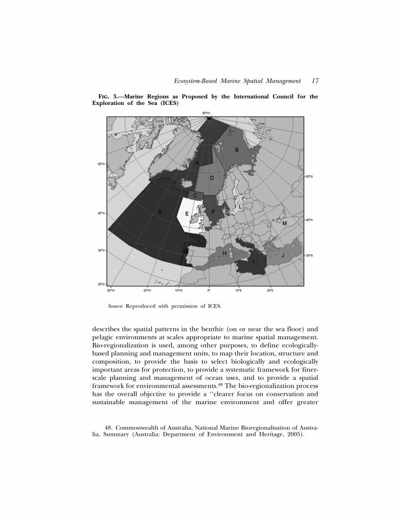
the spatial planning initiatives described above have integrated or addressedthis broader international context, nor do they have a framework in placethat might allow cooperation in the future.43 However, the new turn thatEuropean marine management is taking is very promising. The 2007 EUGreen Paper ‘‘Towards a Future Maritime Policy for the Union: A EuropeanVision for the Oceans and Seas’’44 (Maritime Policy) and the MarineStrategy45 introduced the principle of ecosystem-based marine spatialplanning and initiated the concept of ‘‘marine regions’’ as larger,ecologically meaningful, management units that can stimulate cooperationbetween Member States in achieving the EU objectives for the marineenvironment, including ecosystem-based marine spatial management (Fig-ure 3).46
Similar efforts toward multiple-use marine spatial management are alsounderway in China. In January 2002, the Law on the Management of SeaUse came into force, establishing an initial regional planning system and anintegrated management framework for marine development and conserva-tion in China. Starting in 2000, under the overall supervision of the StateCouncil, along with other relevant ministries and coastal provinces,autonomous regions and municipalities formulated a nation-wide MarineFunctional Zoning Scheme. Over two-thirds of the zoning schemes of the 11coastal provinces, autonomous regions, and municipalities of China havebeen completed and approved by their respective provincial or localgovernments for implementation.47
Marine Spatial Planning Based on an Ecosystem Approach
More systematic approaches toward the establishment of ecosystem-basedmarine spatial management have started to emerge in Australia (outside theGBRMP), New Zealand and Canada. For example, Australia has used theconcept of ‘‘marine bio-regionalization’’ as a platform for the developmentof marine spatial management since the late 1990s. Bio-regionalization
43. Douvere and Ehler, n. 25 above.44. Commission of the European Communities. Green Paper: Towards a Future
Maritime Policy for the Union: A Vision for the Oceans and Seas, COM(2006)275 final(Brussels, 2006).
45. Thematic Strategy on the protection and conservation of the marineenvironment. Communication from the Commission to the Council and theEuropean Parliament. COM(2005)504 final (Brussels, 2005).
46. European Commission, EU Marine Strategy. The Story Behind the Strategy(Brussels, 2006).
47. H. Li, ‘‘The Impacts and Implications of the Legal Framework for Sea UsePlanning and Management in China,’’ Ocean and Coastal Management 49 (2006):717–726.
Ecosystem-Based Marine Spatial Management 17
Fig. 3.—Marine Regions as Proposed by the International Council for theExploration of the Sea (ICES)
Source: Reproduced with permission of ICES.
describes the spatial patterns in the benthic (on or near the sea floor) andpelagic environments at scales appropriate to marine spatial management.Bio-regionalization is used, among other purposes, to define ecologically-based planning and management units, to map their location, structure andcomposition, to provide the basis to select biologically and ecologicallyimportant areas for protection, to provide a systematic framework for finer-scale planning and management of ocean uses, and to provide a spatialframework for environmental assessments.48 The bio-regionalization processhas the overall objective to provide a ‘‘clearer focus on conservation andsustainable management of the marine environment and offer greater
48. Commonwealth of Australia, National Marine Bioregionalisation of Austra-lia, Summary (Australia: Department of Environment and Heritage, 2005).
18 Issues and Prospects
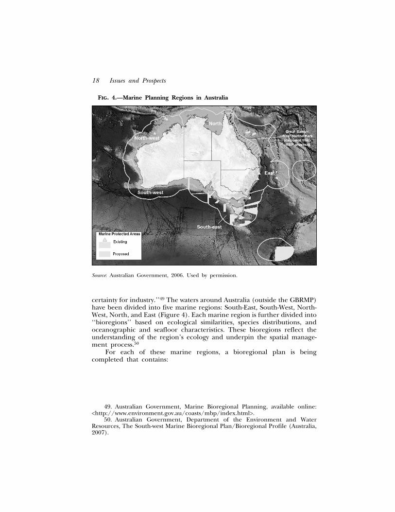
Fig. 4.—Marine Planning Regions in Australia
Source: Australian Government, 2006. Used by permission.
certainty for industry.’’49 The waters around Australia (outside the GBRMP)have been divided into five marine regions: South-East, South-West, North-West, North, and East (Figure 4). Each marine region is further divided into‘‘bioregions’’ based on ecological similarities, species distributions, andoceanographic and seafloor characteristics. These bioregions reflect theunderstanding of the region’s ecology and underpin the spatial manage-ment process.50
For each of these marine regions, a bioregional plan is beingcompleted that contains:
49. Australian Government, Marine Bioregional Planning, available online:<http://www.environment.gov.au/coasts/mbp/index.html>.
50. Australian Government, Department of the Environment and WaterResources, The South-west Marine Bioregional Plan/Bioregional Profile (Australia,2007).
Ecosystem-Based Marine Spatial Management 19
• A description of the regions’ key habitats, plants and animals, naturalprocesses, human uses and benefits, and threats to the long-termecological sustainability of the region;
• Detailed description of the various statutory obligations that apply tothe region;
• Identification of regional priorities for protection of conservationvalues, based on an appreciation of threats; and
• Identification of how environmental quality and condition of thearea will be monitored in the future.
The development of marine bioregional plans is comprised of threemain stages. The first stage of the planning process involves developing a‘‘regional profile’’ for each marine region. The regional profile gives detailsabout the various statutory obligations with regard to nature protection andother marine spatial management measures. It also sets out the objectivesfor the identification of a network of marine protected areas in the region.The second stage involves development of a ‘‘draft plan’’ that contains astrategic regional assessment of conservation values and current andemerging pressures on the marine environment. The assessment of thedraft plan identifies key conservation and heritage priorities for eachmarine region and the range of legislative and administrative tools availableto manage them. The third and final stage involves the development of the‘‘bioregional plan,’’ which is completed after public consultation of thedraft plan. It identifies conservation values in the region, priorities andmeasures for the protection of these values, a network of marine protectedareas, and a set of sustainability indicators that will be used to assess thehealth of the marine environment into the future.51 A plan for the South-East Marine Region52 has been completed and a bioregional profile hasbeen completed for the South-West Marine Region.53 The other four plansare in development and will be completed by 2012.
Similar efforts are underway in New Zealand where coastal anddeepwater classification systems have been developed to identify bio-geo-graphic regions that will underpin the management of ocean spaces.
51. Australian Government, Department of the Environment and Heritage.Marine Bioregional Planning, A new focus for Australia’s marine planning(Australia, 2006).
52. Australian Government, National Oceans Office, South-East RegionalMarine Plan: Implementing Australia’s Oceans Policy in the South-East MarineRegion (Australia, 2004).
53. Australian Government, Department of the Environment and WaterResources. The South-West Marine Bioregional Plan. Bioregional Profile, ADescription of the Ecosystems, Conservation Values and Uses of the South-WestMarine Region (Australia, 2007).
20 Issues and Prospects
Thirteen coastal bio-geographic regions have been identified on thepremise that similar physical habitats and ecosystems, if separated byenough space, will contain different biological communities due to acombination of broad-scale factors, including oceanography, current dy-namics, large-scale latitudinal gradients, climate, or barriers to dispersal. AMarine Environment Classification (MEC) with 20 class levels has beendeveloped as a primary tool for classification in the deepwater environmentsof New Zealand’s EEZ.54
Although in an earlier stage, a similar approach toward marine spatialmanagement is taken in Canada. Five Large Ocean Management Areas(LOMAs)55 have been identified to address large-scale ocean space issuesand provide the context for future spatial management. Canada’s marinespatial framework is further developed around 19 ecological units (marineeco-regions) based on scientific criteria delineated to ensure that manage-ment areas capture ecosystem-scale features, patterns and trends.56 Marinespatial management is furthest developed for the Eastern Scotian Shelfwhere a strategic plan for integrated ocean management has beendeveloped and released.57 As part of the plan, human uses have beenidentified and mapped and objectives have been set for future managementof ocean space.58
Finally, although marine spatial management initiatives in Europe aredeveloping within national boundaries, it is promising that the EuropeanCommission’s approach attempts to focus future efforts on the concept ofmarine regions and sub-regions. Similar to Australia’s and Canada’sexperiences, these marine regions are defined on the basis of physical andecosystem characteristics, including hydrologic, oceanographic, and bio-geographic features, rather than simply on the consideration of politicalboundaries.59
54. Department of Conservation, Marine Protected Areas: Classification, Pro-tection Standard and Implementation Guidelines (New Zealand, 2008).
55. The LOMAs identified include Placentia Bay/Grand Banks, the ScotianShelf, the Gulf of St. Lawrence, the Beaufort Sea, and the Pacific North Coast.
56. Fisheries and Oceans Canada,‘‘Workshop Report: Bringing InternationalLessons Learned and Good Practices to Bear on Canada’s MPA NetworksFramework’’ (unpublished report, Ottawa, 9–10 January 2008).
57. Fisheries and Oceans Canada, Oceans and Habitat Branch. Eastern ScotianShelf Integrated Ocean Management Plan (Government of Canada: Dartmouth,Nova Scotia, 2007), available online: <http://www.mar.dfo-mpo.gc.ca/oceans/e/essim/essim-intro-e.html>.
58. J. Walmsley, S. Coffen-Smout, T. Hall, G. Herbert, ‘‘Development of aHuman Use Objectives Framework for Integrated Management of the EasternScotian Shelf,’’ Coastal Management 35 (2007): 23–50.
59. L. Juda, ‘‘The European Union and Ocean Use Management: The MarineStrategy and the Maritime Policy,’’ Ocean Development and International Law 38(2007): 259–282.
Ecosystem-Based Marine Spatial Management 21
THE PROCESS OF ECOSYSTEM-BASED MARINE SPATIALMANAGEMENT
There is not one model of practical experience that shows how to bestdevelop spatial management in the marine environment. One way to extractlessons learned from experiences is to look at one (or more) element of theprocess that has been done successfully in a particular place. Stakeholderinvolvement and the incorporation of ecological criteria tend to be furtherdeveloped in Australia and Canada, while methods toward conflict resolu-tion and user-compatibilities within multiple-use environments are generallymore evolved in Europe. The latter also illustrates the pros and cons ofdifferent approaches to establish legal authority for marine spatial manage-ment, and reveals the weakness of not cooperating across internationalboundaries. Academic exercises in Europe have studied the benefits ofdeveloping alternative scenarios for the future use of ocean space as a waytoward more systematic planning for sustainable development.60 China, onthe other hand, illustrates ways to sustain financial sources for spatialmanagement by introducing a user fee system.61
The need for a continuous, iterative, and adaptive approach to marinespatial management is well illustrated in the substantial experience ofAustralia’s GBRMP. Despite its principal focus on marine protection, asopposed to balancing economic, social, and ecological objectives in Europe,spatial management has been the cornerstone of the management of theGBRMP for over 30 years, and illustrates clearly the need for evaluation,monitoring and adaptation of marine spatial plans.62 European examplesillustrate that spatial management should include sufficient flexibility toadapt to changing circumstances that result from technological develop-ments, shifting priorities, or the need to expand existing infrastructure.
Practices around the world, as well as academic literature on thesubject, demonstrate that marine spatial management should not be limitedto a one-time plan. Spatial management, as any other type of management,is a process that is futile if it is not matched by a long-term commitment ofpeople, equipment, and financing.63 Generally, marine spatial managementwill consist of at least three ongoing phases (Figure 5):64
60. F. Maes, J. Schrijvers, and A. Vanhulle, A Flood of Space. Towards a SpatialStructure Plan for Sustainable Management of the North Sea (Ghent: Belgian SciencePolicy, 2005).
61. Li, n. 47 above.62. J. Day, ‘‘Zoning Lessons from the Great Barrier Reef Marine Park,’’ Ocean
and Coastal Management 45 (2002): 139–156.63. R. Kenchington, honorary fellow, Center for Marine Policy, University of
Wollongong, Australia, pers. comm. (May 2008).64. Ehler and Douvere, n. 11 above.
22 Issues and Prospects
Fig. 5.—Essential Elements of a Marine Spatial Management Process
Source: C. Ehler and F. Douvere, 2007.
1. Planning and Analysis: generating and adopting one or moreintegrated, comprehensive spatial plans for the protection, en-hancement, and sustainable use and development of the sea and itsresources. Plans will incorporate alternative options for the futureuse of ocean space. The planning and analysis phase should bebased on applied research (including mapping) that address bothenvironmental and human processes;
2. Implementation: implementing the plan through the execution ofprogrammed works or investments, enabling change, encouragingimprovement, enforcement of proposed changes through regula-tion and incentives, and ongoing activities in, on, over and underthe sea, in accordance with the plans; and
Ecosystem-Based Marine Spatial Management 23
3. Monitoring and Evaluation: assessing the effectiveness of the plans,their time scales and implementation mechanisms, consideringways in which they need to be improved and establishing review andadaptation procedures. Results of evaluation are fed back into theplanning and analysis element of management, and the processbegins again.
The planning and analysis for marine spatial management should bebased on the results of directed research and data collection. While most ofthe examples discussed above focus on the use of ecological and biologicaldata, it is indispensable for successful spatial management to give an equallyimportant weight to the human dimension.65 Research and data informa-tion needed for ecosystem-based marine spatial management should focuson:
• Biological and ecological research and data collection to identifyareas of ecological and biological significance (the ecologicaldimension); and
• Social and economic research and data collection to connectoffshore activities with onshore communities, cultures, and socio-economic factors (the human dimension).66
Finally, the management of the marine environment involves themanagement of people.67 As spatial management attempts to establish anintegrated approach across sectors, it is crucial that stakeholders areinvolved throughout the process. Several types of involvement exist, rangingfrom communication, where there is no actual participation, to negotiation,where decision-making power is shared among various stakeholders.68
65. Id.66. K. St. Martin, ‘‘Making Space for Community Resource Management in
Fisheries,’’ The Annuals of the American Association of Geographers 91: 122–142; see alsoK. St. Martin and M. Hall-Arber, ‘‘The Missing Layer: Geo-technologies, Communi-ties, and Implications for Marine Spatial Planning,’’ Marine Policy 32, no. 5(September 2008).
67. R. Kenchington, Managing Marine Environments (New York: Taylor &Francis, 1990).
68. Other types of stakeholder involvement include information, consultation,dialogue or concertation. Concertation is a form of stakeholder participationintroduced in the context of managing biosphere reserves and refers to a form ofstakeholder involvement whereby the goal is to develop a common and shared visionamong the stakeholders regarding the management of resources with a view toacting, deciding or defending collectively before decision makers. See M. Bouam-rane, Biodiversity and Stakeholders: Concertation Itineraries, Biosphere Reserves,Technical Notes (Paris: UNESCO, 2006). See also R. Pomeroy and F. Douvere, ‘‘TheEngagement of Stakeholders in the Marine Spatial Planning Process,’’ Marine Policy32, no. 5 (September 2008).
24 Issues and Prospects
THE FUTURE OF ECOSYSTEM-BASED MARINE SPATIALMANAGEMENT
Although critical voices about the potential, nature and scope of spatialmanagement exist,69 the fact that ecosystem-based management is place-based and needs a more systematic spatial and temporal approach isgenerally accepted.70 What is missing, however, is a clear demonstration ofhow it can be implemented. As no single, readily applicable best practiceexists, many have expressed the need for better-defined tools, procedures,and guidelines that support the implementation of ecosystem-based, marinespatial management.71
This assumption has been the main conclusion of the two years of workof the Ocean Zoning Working Group of the National Center for EcologicalAnalysis and Synthesis (NCEAS), University of California, Santa Barbara.72 Asimilar conclusion was drawn from the first UNESCO InternationalWorkshop on the use of marine spatial planning as a tool to implementecosystem-based, sea use management.73 In its latest communication, theEuropean Commission confirmed that integrated marine spatial manage-ment is fundamental and announced its plans to develop a system for theexchange of good practices and guidance to facilitate and encourageimplementation of ecosystem-based marine spatial management.74
Under the auspices of UNESCO’s Intergovernmental OceanographicCommission (IOC) and Man and the Biosphere Programme (MAB), acomprehensive set of guidelines and principles for the implementation ofecosystem-based marine spatial management is under development. In thefirst phase, at least ten international examples of marine spatial manage-ment, at different stages of development, will be analyzed and documentedwith the objective of providing necessary and fundamental information forapplications of ecosystem-based marine spatial management. The analysis
69. See, for example, D. Peel and M. Lloyd, ‘‘The Social Reconstruction of theMarine Environment: Towards Marine Spatial Planning?’’ Town Planning Review 75(2004): 359–378.
70. Crowder et al., n. 11 above.71. Ehler and Douvere, n. 11 above.72. National Center for Ecological Analysis and Synthesis (NCEAS), University
of California, Santa Barbara. Further information available online:<http://www.nceas.ucsb.edu>.
73. F. Douvere and C. Ehler, ‘‘International Workshop on Marine SpatialPlanning, UNESCO, Paris, 8–10 November 2006. Conference Report,’’ Marine Policy31 (2007): 582–583.
74. Commission Staff Working Document, Accompanying document to thecommunication from the Commission, An Integrated Maritime Policy for theEuropean Union, Commission of the European Communities, SEC(2007)1278/2provisional version (Brussels, 10 October 2007).
Ecosystem-Based Marine Spatial Management 25
and documentation of international examples focus on steps taken duringthe marine spatial management process that have led to successfulimplementation and desired outcomes. An indication of crucial steps willallow decision-makers and resource managers to better determine theirpriorities in implementing ecosystem-based marine spatial management. Ina second stage, a draft of the guidelines and principles manual will betested, fine-tuned, and adapted to the context of specific marine ecosystemsthrough regional meetings and workshops. Two regional meetings areplanned in places that are ready for marine spatial management. The finalguidelines will be published in May 2009.75
CONCLUSION
Ocean resources are limited both in space and abundance. The ongoingindustrialization and expansion of ocean uses and the rise of new uses haveincreased considerably the demand for ocean space. In some areas,combined demand for ocean space exceeds already more then three timesthe available space. Today, this trend has led to two important types ofconflict; conflicts among users as a result of incompatible demands forocean space, and conflicts between users and the environment resultingfrom the impact of uses on sensitive ecological areas. During recent years,marine spatial management, underpinned by an ecosystem approach, hasbeen brought forward as a way to deal with these conflicts and to apply anecosystem approach to the management of the marine environment.Marine spatial management can do this by (a) addressing the heterogeneityof marine ecosystems in a practical manner; (b) focusing on influencingbehavior of humans and their activities over time; (c) providing amanagement framework for new and previously inaccessible scientificinformation; (d) making conflicts and compatibilities among human usesvisible, and therefore, tangible; and (e) guiding single-sector managementtoward integrated decision-making.
Throughout the world, several countries have begun to move theconceptual work forward and have started to implement marine spatialmanagement successfully. While early plans such as Australia’s GBRMPspatial plan or the Florida Keys National Marine Sanctuary managementplan were brought forward to establish and manage marine protected areas,more recent attention has been placed on multiple-use of marine space.The Netherlands and Belgium have implemented marine spatial manage-
75. Intergovernmental Oceanographic Commission and Man and the Bio-sphere Programme, UNESCO. Ecosystem-based, Marine Spatial Management, availableonline: <http://ioc3.unesco.org/marinesp>.
26 Issues and Prospects
ment through which nature conservation requirements and new demandsfor ocean use were merged successfully. Germany, the United Kingdom andChina also have similar multiple-use marine spatial management underway.A major challenge in Europe is the need to undertake marine spatialmanagement in broader areas, with boundaries drawn on the basis ofecological considerations rather than political ones. This challenge is greatlystimulated by the European Union as part of its newly released MaritimePolicy and the introduction of ‘‘marine regions’’ in the context of theMarine Strategy. More systematic attempts to underpin marine spatialmanagement with an ecosystem approach have been taken in Australia,Canada and New Zealand.
Although no parallel can be drawn between the contexts and associatedchallenges of the GBRMP and the densely-used areas in Europe or China,some very important lessons can be learned about the process of ecosystem-based marine spatial management. The long-standing experience of theGBRMP illustrates the need to conduct marine spatial management in acontinuous manner, one that allows monitoring and evaluating initial plansand adapting them to changing circumstances. It also illustrates thatstakeholder involvement and sustainable financing are critical to a success-ful outcome of marine spatial management. The more recent spatialmanagement initiatives in Europe focus more on resolving conflicts amongusers and a shared use of ocean space. Finally, ecosystem-based marinespatial plans should be based on sound research and data that addresses theecological and human dimension of marine spatial management in anequally important way. While biological and ecological information canenable the identification of areas of ecological and biological significance—the ecological dimension, social and economic information should establishthe connection of offshore activities with onshore communities, cultures,economies, and constituencies—e.g., the human dimension.