
Economic Development Queensland - dsdmip.qld.gov.au...know rather than try something new or...
56
Economic Development Queensland PDA guideline no. 01 May 2015 Residential 30
Transcript of Economic Development Queensland - dsdmip.qld.gov.au...know rather than try something new or...

Economic Development Queensland
PDA guideline no. 01 May 2015
Residential 30

© State of Queensland, April 2015. Published by the Department of Infrastructure, Local Government and Planning, 100 George Street, Brisbane Qld 4000, Australia.
Licence: This work is licensed under the Creative Commons CC BY 3.0 Australia licence. To view a copy of this licence, visit www.creativecommons.org/licenses/by/3.0/au/deed.en. Enquiries about this licence or any copyright issues can be directed to the Senior Advisor, Governance on telephone (07) 3224 2085 or in writing to PO Box 15009, City East, Queensland 4002.
Attribution: The State of Queensland, Department of Infrastructure, Local Government and Planning.
The Queensland Government supports and encourages the dissemination and exchange of information. However, copyright protects this publication. The State of Queensland has no objection to this material being reproduced, made available online or electronically but only if it is recognised as the owner of the copyright and this material remains unaltered.
The Queensland Government is committed to providing accessible services to Queenslanders of all cultural and linguistic backgrounds. If you have difficulty understanding this publication and need a translator, please call the Translating and Interpreting Service (TIS National) on 131 450 and ask them to telephone the Queensland Department of Infrastructure, Local Government, and Planning on 13 QGOV
(13 74 68).
Disclaimer: While every care has been taken in preparing this publication, the State of Queensland accepts no responsibility for decisions or actions taken as a result of any data, information, statement or advice, expressed or implied, contained within. To the best of our knowledge, the content was correct at the time of publishing.
Any references to legislation are not an interpretation of the law. They are to be used as a guide only. The information in this publication is general and does not take into account individual circumstances or situations. Where appropriate, independent legal advice should be sought.
An electronic copy of this report is available on the Department of Infrastructure, Local Government and Planning’s website at www.dilgp.qld.gov.au

Contents
Introduction ............................................................................................................1
Goals ..........................................................................................................................2
Planning and design process ............................................................................4
Design elements ..................................................................................................12
Neighbourhood design ....................................................................................12
» Lot design ..................................................................................................................................14
» Block design .............................................................................................................................20
» Street design ............................................................................................................................24
» Park design ................................................................................................................................30
» Building design........................................................................................................................34
Design checklist ...................................................................................................42
Case studies ...........................................................................................................51
» 15 dwellings per hectare ......................................................................................................51
» 20 dwellings per hectare ......................................................................................................52
» 25 dwellings per hectare ......................................................................................................53
» 30 dwellings per hectare ......................................................................................................54
References ..............................................................................................................55
Glossary ..................................................................................................................56
Acknowledgements ...........................................................................................57

Introduction
The need for this guideline
A range of social, environmental and economic factors are driving the need for greater diversity and more innovative design of residential communities.
However, most planning schemes perpetuate past subdivision and engineering design practices and many developers and builders are inclined to stick with what they know rather than try something new or different. These circumstances and attitudes tend to discourage the delivery of the diversity now needed and stifle the innovation that is essential in designing for emerging household types.
The Minister for Economic Development Queensland (MEDQ) is committed to delivering high quality, diverse and affordable communities. This guideline outlines approaches and techniques that will assist with the delivery of these outcomes in Priority Development Areas (PDAs) throughout Queensland.
The guideline acknowledges that quality residential design and development is a complex process requiring input from experienced multi-disciplinary professional teams. The practical design tips contained in this document are drawn from extensive development experience and should assist designers and practitioners to deliver quality, diverse residential communities.
The guideline also advocates an approach to development assessment that aims to facilitate innovation and flexibility in the design and delivery of diverse residential development outcomes.
The purpose of this guideline
This guideline has been prepared to guide the planning and design of mixed residential development within PDAs in Queensland. Through this guideline, the MEDQ aims to achieve:
» the use of sound processes and techniques by planners and designers
» consistently high quality urban design outcomes
» commercially viable, diverse and affordable housing within PDAs.
Who this guideline is for
This guideline has been specifically prepared for use by planners, urban designers, development managers and developers working in PDAs.
All development within PDAs is regulated by development schemes prepared by the MEDQ and approved by the State Government. These development schemes will contain regulatory provisions that reference this guideline. Consequently, it is recommended that all designers working on projects in PDAs (whether for the MEDQ or otherwise) have regard to this guideline when preparing designs and associated development applications.
Scope of the guideline
This guideline outlines principles and provisions for the planning, design and delivery of mixed residential development, typically no more than 3-storeys in height and with a net residential density of up to 30 dwellings per hectare (dw/ha) in PDAs. For the purpose of this guideline, net residential density is as defined in the glossary.
Structure of the guideline
The guideline outlines the MEDQ's overarching goals for residential development and advocates a preferred process to be followed in preparing development applications. The guideline is structured under six design elements: neighbourhood, lot, block, street, park and building. Each design element discusses key issues to be addressed and key principles and provisions considered by the MEDQ to be best practice in achieving the goals of this guideline. The guideline also includes a number of schematic case studies illustrating examples of housing diversity at a range of densities up to 30 dw/ha. A design checklist is also included to assist designers in reviewing design proposals prior to finalising development applications.
1 Residential 30

2Residential 30
This guideline is intended to help achieve the following goals:
Create diverse and affordable communities
By 2026 less than 40 per cent of households in Queensland will be comprised of a couple with children. Our population is ageing rapidly, contributing to an accelerating rate of more but smaller households. One and two-person households are rapidly becoming the norm.
The current residential product mix tends not to reflect nor provide for the demographic changes occurring in our communities.
In response to housing affordability concerns and these demographic changes, the MEDQ is committed to offering a diverse and affordable range of housing options through a mix of designs, price points and tenures. Diversity of housing options provides households with more home ownership and rental opportunities and contributes to healthy and vibrant communities.
Promote planning and design excellence
The MEDQ is committed to promoting best practice urban design and residential development, that is, development which accommodates contemporary lifestyles and suits household needs while delivering connectivity, safety and accessibility, and recognising local values and aspirations.
Protect ecological values and optimise resource use
The guideline reflects the MEDQ's goal to sustainably manage natural systems, habitats and biodiversity. It also promotes the MEDQ's commitment to innovative and efficient use and management of resources such as construction materials, water and energy in order to minimise impacts on climate as well as development cost.
Provide economic benefits
Delivering more diverse and well designed communities generates a range of economic benefits including:
» more efficient use of land which realises cost efficiencies in the provision of services and infrastructure, helping reduce the cost of house and land packages
» streamlined development approval processes which help bring land quickly to the market, reducing development financing charges, which further lowers the final price of housing
» providing product mix and diversity which extends market reach for developments and can enhance commercial viability
» providing increased density in areas serviced by public transport, and shops and facilities which reduce the need for lengthy travel by private vehicles.
Goals

3 Residential 30
Planning and design process
Planning context
The MEDQ's development assessment process reflects the provisions of the Economic Development Act 2012. Development applications are assessed against the relevant PDA Interim Land Use Plan (ILUP) or development scheme. The content of this guideline will typically form the basis for the requirements of the land use plan component of a PDA development scheme.
Development schemes will typically contain a vision and structure plan for the PDA which will have appropriately positioned the proposed development site in the larger strategic context. Depending on the level of detail of the particular development scheme structure plan, some elements contained in the planning and design section and the neighbourhood design element of this guideline may already have been incorporated in the scheme.
Development proposals requiring assessment under an ILUP will be required to demonstrate particular attention to the planning and design section and the neighbourhood design element of this guideline.
È researchÈ analysisÈ synthesis
È factorsÈ forcesÈ features
site
È capacityÈ driversÈ objectives
È lifestyleÈ benefitÈ need
insight
È roadsÈ streetsÈ parks
È waterÈ sewerÈ WSUD
structure
È lotsÈ sectionsÈ civils
È dimensionsÈ areasÈ numbers
design
È subdivisionÈ servicesÈ setbacks
È densityÈ designÈ development
controls
brief visionstructure
planreconfiguring
a lotplan
plan ofdevelopment
general specific
neighbourhood lot, blocks, streets, parks, buildinggoals
È reconfiguring a lotÈ development application
Outputs, inputs, design elements
The planning and design process is characterised by a necessity for a range of inputs and an intention to produce appropriate outputs. Some elements of the guideline are more relevant and applicable at certain points during the process. The accompanying flow chart illustrates how the inputs, outputs and elements work together.
The flow chart also illustrates the process involved in preparing development applications (typically including a plan of development) in accordance with an ILUP and development scheme for each PDA. The flow chart indicates:
» that inputs, outputs and elements can overlap and feed into each other
» an increasing level of detail occurs, from preparation of the brief through to the plan of development
» at each stage, the outputs are tested against the elements.

4Residential 30
The process demands a flow of information from the general to the specific with checks and balances as the process progresses through the production of the key outputs.
Collaborative workshops that harness the expertise of a range of disciplines are an extremely effective means of producing creative results at each phase of the process. These disciplines typically include design, marketing, finance, engineering and planning professionals.
Brief
The brief establishes the background context and provides guidance and direction for any new development proposal. The brief should examine the strategic setting and the experiences of the site and surrounding area, and address the full range of physical and economic factors that affect the site including geography, topography, geology, ecology and demography. The brief will also include:
» key requirements for the site contained in the development scheme
» housing affordability, density or diversity targets as set by the MEDQ in relevant development scheme.
Vision
Workshop participants collaborate in the planning and design process
The vision can take many forms but will typically address the site's environmental capacity, economic drivers and social objectives, usually expressed in terms of lifestyle benefits and ecological, social and economic outcomes. The vision will include a description of the desired character and identity for the development and present the key elements and characteristics that are to be the focus of the planning and design process.
Typical site analysis plan prepared for a brief

5 Residential 30
Structure plan
The structure plan graphically illustrates the key structural elements of the development and how the site connects to the surrounding locality.
The typical elements of a structure plan are:
» the arrangement of key land uses
» the layout of the primary movement network including roads and public transport, cycle and pedestrian routes
» the open space network including the main parks, sporting fields and environmental reserves
» the main connections to surrounding areas
» important view corridors that should be preserved or utilised
» the location of primary infrastructure networks including energy easements, drainage corridors, sewer and water mains and telecommunication services.
LEGEND
Mixed use centre
Mixed use
Residential medium intensity
Residential high intensity
Potential CityCat / boat terminal
Potential heavy rail + station corridor
Rapid transit
Regional road connections
Medium impact employment
Royal Queensland Golf Course
Civic and open space
Activity nodes
Key connections
Key linkages
Key intersections
Typical structure plan
For detail on how to prepare a structure plan, refer to the neighbourhood design element provisions of this guideline.

6Residential 30
Reconfiguring a lot plan
The preparation of the reconfiguring a lot plan is a key step in the production of a plan of development and the delivery of a successful on the ground outcome. The preparation of the reconfiguring a lot plan should:
» be a collaborative and iterative outcome reflecting the inputs of various planning, design and development professionals
» be responsive to the site's topography to minimise the reshaping of sites
» take into account marketing and community development priorities.
The reconfiguring a lot plan will incorporate a detailed subdivision pattern including lot layout and cross sections for streets and parks as well as details on the location and arrangement of the main infrastructure services. Specifically the reconfiguring a lot plan should identify:
» lot boundaries
» lot dimensions, area and number
» a contour overlay
» key infrastructure items (e.g. pump stations, electrical substations and traffic management devices)
» the proposed sequencing and staging of development.
The reconfiguring a lot plan is prepared using a cadastral base showing existing property boundaries with all proposed street alignments and lot boundaries accurately located to ensure the proposed layout is achievable on the site.
Typical reconfiguring a lot plan
For detail on how to prepare a reconfiguring a lot plan refer to neighbourhood, lot, block, street, park and building design elements provisions of this guideline.

7 Residential 30
For detail on how to prepare a plan of development refer to lot, block, street, park and building design elements provisions of this guideline.
Plan of Development
Some PDA development applications are required to be accompanied by a Plan of Development (PoD).
A PoD may contain site plans, graphics and text and once approved becomes the primary document for the ongoing regulation of certain subsequent PDA self assessable and assessable development (permissible).
A PoD must detail:
» the street pattern, including street pavement widths, the location of footpaths and any provision for car parking
» public open space areas
» the subdivision pattern including lot areas and dimensions
» building setbacks on each lot, including built-to-boundary wall locations, setbacks and building heights
» lots on which more than one dwelling may be built, including the maximum number of dwellings on the site
» staging of development
» typical house plans (for lots between 250 and 450 sqm in area)
» detailed concept house plans (for lots less than 250 sqm in area).
Depending on the development density and complexity of the design, a PoD may also need to detail:
» primary and secondary streets
» street cross-sections, planting and landscaping areas
» service infrastructure connection points to each lot
» any access restriction arrangements
» private open space areas
» pavement and verge widths
» kerb types
» tree retention requirements
» neighbourhood signage
» slope controls (e.g. elevated construction, slab on ground requirements)
» driveway locations.
To ensure an appropriate level of integration, the PoD should be prepared having due regard to the 'first cut' design of civil works and detail how:
» gully pits, water meters, power pillars and communications pits do not interfere with driveways of narrow frontage lots
» sewers and stormwater do not clash with walls that are built to boundary (sometimes referred to as the zero lot line)
» overland stormwater flows are not concentrated through narrow lots
» slopes of small lots are not excessive
» infrastructure items do not detract from the urban amenity
» any filling does not adversely impact on tree protection and driveway slope.

8Residential 30
The following table outlines the dwelling information required to be submitted with the Development Application.
Development Application Proposed development Dwelling information required with Development Application
Initial ROL / MCU for whole stage Dwelling on lots > 450 sqm Nil
Dwelling on lots 250-450 sqm » typical house plans
» special construction techniques (if any)
Dwelling on lots < 250 sqm » proposed house plans
» building staging and construction techniques
Multiple residential Nil - nominate lots subject to multiple residential, including proposed number of dwellings
ROL subsequent to initial ROL/MCU (i.e. re-subdivision)
Dwelling on lots > 450 sqm » satisfaction of PDA wide criteria (includes reference/compliance with PDA Guideline Design Checklist)
Dwelling on lots ≤ 450 sqm » satisfaction of PDA wide criteria (includes reference/compliance with Residential 30 Design Checklist)
» proposed house plans
» building staging and construction techniques
The MEDQ may endorse the house and concept plans as part of the approved PoD.
On lots between 250 and 450 sqm in area, the subsequent house or multiple residential will be conditioned to comply with both the PoD and the building design provisions of the Design Checklist contained in this guideline.

9 Residential 30
Typical plan of development extracts
Particular attention will be given to the preparation of the plan of development. The detail on a plan of development plays a major role in development regulation and streamlining the development process. Houses and multiple residential dwellings complying with an approved plan of development are intended to be self assessable under an ILUP and development scheme.

10Residential 30
Neighbourhood design
Integrating new neighbourhoods with existing neighbourhoods
All sites need to be designed in a way which recognises the existing neighbourhood pattern, if any, and the creation of new neighbourhoods. This consideration should be initially assessed as part of the preparation of the brief and incorporated into the vision for the project.
There are no absolute rules for the size, shape and design of a neighbourhood. However, it is at the local level where the sense of 'neighbourliness' has the greatest potential to emerge. The neighbourhood is often defined by how far you want to take a short stroll or cycle, whether it is to visit friends, buy a loaf of bread or go to the local park. It takes some time for a neighbourhood community to emerge, and respect should be given to the quality of life in existing neighbourhoods where new neighbourhoods are proposed.
Where possible, all new development will be planned, designed and delivered to facilitate the creation of new neighbourhoods and contribute to the enhancement of existing neighbourhoods.
Respecting local conditions in the neighbourhood plan
The neighbourhood layout and design should respect and respond appropriately to local conditions, including:
» the local market and need for housing and business
» physical features such as topography, natural drainage systems and vegetation
» places of cultural heritage significance
» opportunities for views and vistas and other elements that will clearly identify, and from a commercial perspective, 'brand' the neighbourhood
» providing connections to existing facilities, services and movement networks in the surrounding area.
Neighbourhood design fundamentals
Pocket park » provides small-scale public
landscape setting and focus for clusters of small lots and integrated housing
Neighbourhood park » establishes community
identity and brand » provides for multiple purposes
(e.g. stormwater management, play, barbeques, kick-around)
Streets and paths » layout and design of streets
and paths support walking and cycling
Connections » lineal parks, streets and paths
link to regional open space and district sports grounds
Local streets » highly connected and
permeable street network » connects to adjoining street
network
Connector streets » identified public transport route » connects to surrounding
neighbourhoods and centres
Entry » establishes community
identity and brand
Display village » demonstrates product mix and
innovation » overlooks entry and park amenity
Connections » streets and paths provide
connections to existing local, district and regional facilities, services and movement networks

11 Residential 30
Making the neighbourhood work as a community
To help achieve a healthy community, a neighbourhood will typically be created with:
» defined entries and legible neighbourhood boundaries to foster a sense of identity
» a highly permeable, legible street pattern
» a variety of multi-use parks
» a safe, attractive and efficient pedestrian and cycle network
» distribution of land uses, layout of streets and building densities that support public transport use
» a mix of lot sizes providing wide choice in affordable and accessible housing
» lots of a size to allow small-scale, compatible land uses such as child care, aged care, retirement living, local shops and home-based businesses.
A neighbourhood with high housing diversity focused around a local pocket park

12Residential 30
2-storey terraces with vehicular access off a rear laneway
Standardised and dispersed lot types deliver streetscape variety and housing diversity within neighbourhoods
Creating lots to suit delivery method
Successful residential projects around Australia have demonstrated that small and medium sized lots can be developed in all regions and markets. One of the purposes of the MEDQ is to increase housing diversity and all of the MEDQ's projects will seek to maximise lot variety to suit the community's needs.
Choice of lot sizes and dimensions are a fundamental determinant of the design of a site, impacting on the street framework and block dimensions.
The MEDQ's underlying design philosophy is to:
» generally use 'standard' lot dimensions to suit proven dwelling designs
» deliver street patterns that are rectilinear to maximise the creation of rectangular lots
» disperse different lot sizes to achieve streetscape variety and avoid large concentrations of similar housing types in any one area.
Lot design
Successful detached dwelling designs have been developed for projects in Queensland and elsewhere, for lots as low as 125 sqm in area. However, typically this product needs to be marketed and sold as a completed product, constructed by the one builder in an integrated manner, with titling upon substantial completion.
Attached housing products, by their very nature, are built in an integrated manner.

13 Residential 30
Standardising lot shape and dimensions
A regular shaped lot and consistent lot dimensions lead to efficiency in lot layout which contributes to cost savings in civil engineering and building construction and in turn, housing affordability.
In addition, standardised lot dimensions facilitate flexibility in redesigning layouts to respond to market demand. For these reasons, a limited number of standard lot shapes and dimensions should therefore be used in the neighbourhood design.
In the past, subdivision patterns have been produced with a lot depth of 30.0 metres or greater and widths of 20.0 metres and greater.
More recently, smaller lot sizes in Queensland have been successfully produced with depths of 32.0 metres or 25.0 metres, and widths typically 10.0 to 20.0 metres.
There is no definitive 'correct' lot dimension however, for reasons of flexibility in design/redesign and to maximise the use of existing builders designs, the MEDQ's preference is for:
» consistent lot depth(s) and widths to be applied in any one precinct
» standard depths of 25.0 metres and 32.0 metres and widths, generally in multiples of 2.5 metres and 5.0 metres, to be adopted.
Typical lot shapes and dimensions - 32.0 metres deep
Typical lot shapes and dimensions - 25.0 metres deep
width (metres)type
area (sqm)
20.0traditional640
variablemulti-familyvariable
15.0courtyard480
10.0villa320
10.0villa + loft320
7.5terrace240
7.5terrace + loft240
5.0row160
dept
h (m
etre
s)32
.0
laneway laneway
narrow/small lots (less than 15.0 metres frontage)
width (metres)type
area (sqm)
20.0traditional500
variablemulti-familyvariable
15.0courtyard375
10.0villa250
10.0villa + loft250
7.5terrace187.5
7.5terrace + loft187.5
5.0row125
dept
h (m
etre
s)25
.0
laneway laneway
narrow/small lots (less than 15.0 metres frontage)

14Residential 30
Traditional lot
A traditional lot caters for large detached family housing, typically on lots with a frontage of 20.0 metres and depth of 30.0-32.0 metres. This frontage has decreased slightly as housing design has become more efficient. With 2-storey designs, the traditional lot depth can also be reduced to around 25.0 metres.
Courtyard lot
A courtyard lot comfortably accommodates a smaller detached family home and has contributed to the diversity of housing required for changing household types. Downsizing retirees and couples with few or no children are major users of housing on courtyard lots.
Villa lot
A villa lot is suited to the housing needs of an increasing number of one and two person households. A house on a villa lot is detached but usually built to one side boundary of the lot. For example, a typical 10.0 metres wide villa housing lot accommodates the dimensions of:
» bedroom - 3.3 metres
» hallway - 1.2 metres
» garage - 3.8 metres wide
» thickness of all walls - 0.4 metre
» eave - 0.45 metre
» setback to a built-to-boundary wall on one side boundary - 0.1 metre
» setback from the other side boundary - 0.75 metre.
The frontage of a villa lot should be increased to around 12.5 metres if a double garage is proposed so that garage doors do not dominate the streetscape.
Terrace lot
A terrace lot will typically accommodate attached housing or housing built to both side boundaries on lots with a frontage of 7.5 metres. Housing on a standard 7.5 metres terrace lot will generally be two habitable rooms wide and 2-storeys in height. A terrace lot is also capable of development with a narrow (4.0 metres wide), single-storey detached house where one wall is built up to, and along most of the length of one side boundary. Housing on narrow terrace lots is usually built as an integrated development and typically requires frontage to both a street and laneway to accommodate on-site car parking that does not interfere with the safe and efficient functioning of the street.
2-storey house on 25.0 metres deep courtyard lot with vehicular access from the street
Terrace housing with frontages greater than 7.5 metres can successfully accommodate front garages and on-street parking
Single-storey house on 25.0 metres deep villa lot with vehicular access from the street
© Ausbuild

15 Residential 30
Row lot
A row lot almost always provides for narrow attached housing or housing built to both side boundaries. A 5.0 metres wide row housing lot, where the dwelling is built up to both side boundaries, accommodates the dimensions of:
» bedroom - 3.3 metres
» hallway - 1.2 metres
» thickness of all walls - 0.4 metre
A row lot typically requires rear lane access for car parking so the street frontage is free of driveways. A row lot will not generally provide for loft apartments with a front door to a laneway.
Lots for loft apartments
Villa or terrace lots that are serviced by a rear lane can also provide for loft apartments built above double garages which provide a single lock up car space for the main dwelling as well as the loft apartment. Front door access to the loft apartment is also provided from the lane.
The villa or terrace and the loft can be delivered as two dwellings on one lot or separately titled under the Community Titles Scheme. Volumetric titling to provide freehold tenure is possible but requires specific design responses to ensure compliance with different building classifications.
As no visitor parking is generally provided in lanes, loft apartments will require care in their location to ensure sufficient on-street visitor parking is available close by. This is addressed in more detail in the street design section of this guideline.
Lots for multi-family dwellings
A multi-family lot allows for small groups (typically 4-6) of attached dwelling units. Multi-family dwellings can contribute significantly to diversity within a neighbourhood. To maximise the efficiency of a multi-family lot, its size should be as close as possible to a multiple of the minimum per dwelling site area allowed under the development scheme. Multi-family lots will typically be provided on-street corners to reduce the negative impact of rows of garage doors.
3-storey terrace houses create a more urban streetscape character
Multi-family dwellings on corner lots can present as large single dwellings with driveways and garages off both street frontages
Typical loft apartment over a double garage
© Conics

16Residential 30
Dividing walls of terrace houses act as retaining walls to accommodate the slope of the land
Built-to-boundary wall on low side of a sloping lot
Accommodating the slope of the land in the design of the lot
The slope on a lot impacts significantly on civil engineering and building design. Careful consideration should be given to the slope to be created on a finished lot, particularly where slab-on-ground construction is intended.
In general, lots on sloping land will be wider to accommodate areas required for cut and fill and to maintain adequate building setbacks. A wider and larger lot, over 450 sqm in area, can usually be cut and filled to enable detached slab-on-ground construction with appropriate building setbacks from all boundaries.
Cutting and filling of a lot may not be required where a lightweight platform construction on piers or stumps is proposed. Platform construction can provide for car parking underneath where slope approaches 16 per cent.
As the lot gets narrower and smaller, greater attention to design detail is required to accommodate housing on sloping land.
An integrated or attached building solution can be used to accommodate steeply sloping sites while enabling lots to be as narrow as 7.5 metres wide and 25.0 metres deep. Detached housing can also be built on narrow lots on sloping land, notably where built-to-boundary walls are used as retaining walls for the adjoining lot. In this circumstance, the built-to-boundary wall must be on the low side of the lot to avoid drainage issues.
Unless the dwellings are to be constructed in an integrated or attached development, the slope on a lot less than 450 sqm in area should not exceed:
» 10 per cent side slope
» 5 per cent lengthwise slope
» less, if both these figures approach the maximum together.

17 Residential 30
Block design
Creating blocks to enable diversity in housing and an efficient street layout
Blocks should be of a size and dimension that, when arranged, facilitate:
» an efficient neighbourhood pattern, scale and area
» high levels of pedestrian connectivity throughout the neighbourhood
» safe and direct pedestrian, cycle and vehicle access to destinations such as a local shop, neighbourhood centre, public transport stop or station, neighbourhood park and nearby district and regional sport facilities
» choice in the type of housing
» rear lanes that maintain standard lot types and dimensions.
In many instances the block design is influenced by the adjoining road pattern.
However, where these constraints do not apply, a rectilinear or modified grid pattern is necessary to achieve densities of 20-30 dw/ha.
The shape and dimensions of the block can facilitate additional diversity in housing as well as efficiency in street layout by:
» using lots with different depths backing onto each other
» adopting a block length that is equal to two block depths plus a street reserve width.
Typical block arrangement
32 m
etre
s25
met
res
57 m
etre
s
137
met
res
32 m
etre
s25
met
res
32 metres
130 metres
» mid block lane shortens all laneways » short laneways enable ease of visitor
access to houses which front laneway
» standard lot depths on each side of laneway » deeper lots provide more room for additional
loft apartments that front laneway
» two block depths plus one street creates standard block length
» modified grid pattern and short block length contribute to legible way-finding and convenient moving around
» different lot depths in standard block depth

18Residential 30
Balancing the mix of lots throughout the block
To achieve densities up to 30 dw/ha, the lot mix will generally have a high percentage of narrow or small lots and multi-family dwellings as well as some attached housing and loft apartments accessed from laneways.
Different lot types can be grouped within blocks to achieve diversity while still contributing to an attractive streetscape. This requires balancing the 'clustering' of lots with similar frontages and accompanying front setbacks, while avoiding an area being dominated by a particular lot type.
Preferably, lots should be arranged so that:
» the highest densities should be located around open space, amenity features or other focal points
» there are between four and six adjoining terrace or row housing lots in a group (to enable group housing construction and an integrated streetscape solution)
» there are no more than eight narrow frontage lots in a row
» there are no more that four lots, with a width of 7.5 metres or less, in a row unless serviced by a rear lane
» there are no minor mismatches (e.g. less than 1.0 metre) in the rear corner lot boundaries of adjoining lots (to minimise the risk of setout error)
» multi-family housing lots are preferred on highly accessible:
- block ends
- corner lots
- lots with dual road frontage.
Small lots should be minimised at the:
» end of a T-intersection (to minimise number of driveways into an intersection)
» entrance to a precinct if not rear lane accessed (to minimise traffic congestion due to turning movements at the entrance at peak times).
Typical lot arrangement within typical blocks facing north
Greater housing choice through variety in lot widths along each street
Narrow lots » no more than 8 in a row » located off laneway to get cars off the street » suit 2-storey construction » suit mid block for grouped housing
construction » long axis north-south for optimal solar access
Small lots » where more than one dwelling is provided,
locate close to laneway entrance for ease of visitor access to houses which front laneway
Lot boundaries » no mismatch of lot boundaries on the
rear or side boundaries of other lots (i.e. any mismatch is greater than 1.0 metre)
Large lots » at end of T-intersection » to balance lot mix
Integrated housing lots » on block ends and corner lots for ease
of access
Small lots » minimum 7.5 metres wide with long
axis east-west

19 Residential 30
Orientating for climate
Large lots, greater than 450 sqm, have sufficient inherent flexibility to allow for a building design to satisfactorily address solar access and prevailing breezes. Hence they are not constrained in their location within the block.
Smaller lots with a narrow frontage (less than 14.0 metres) have less flexibility in their design for climate.
However, block orientation at a broad level is driven by street alignments which in turn, are driven primarily by factors such as:
» adjoining street pattern
» topography
» open space location
» critical views and vistas.
In addition, topography is a major determining factor to the location of the built-to-boundary wall.
For these reasons, achieving higher densities will result in a range of lot orientations, some more suited to designing for the climate, some less so.
In the Queensland context in:
» tropical and sub-tropical areas, designing for the prevailing breeze and minimising exposure to the northern and western summer sun is paramount
» cooler areas, designing for the prevailing breeze and avoidance of the northern and western summer sun is also paramount but consideration of access to the winter sun in living areas is also important.
Unless otherwise constrained, the following approaches should be considered to maximise the number of lots suitably oriented for design for climate:
» Where the design for the prevailing summer breeze is paramount, the long road leg length should be oriented perpendicular to the prevailing breeze. Location of the majority of narrow frontage lots on these streets will maximise the opportunities for cross flow ventilation through the dwelling.
» Where the design for access to winter sun is paramount, then the long road leg length should be oriented in an east-west direction. Location of the majority of narrow frontage lots on these streets will maximise the opportunities for solar access to the living areas.
However:
- different dwelling designs will be required for lots on the south and north sides of the streets to ensure the living areas receive the winter sun
- for larger lots on the western end of the block, it will be beneficial to avoid the long western wall of the narrow lot receiving the western summer sun.
» To avoid the western summer sun:
- wide lots are not preferred on the north-south streets
- built-to-boundary walls, unless constrained by topography, should be located on the west-southwest boundary.
Substantial overhangs shade walls of buildings and enhance useability of balconies
3-storey attached dwellings on small lots designed to maximise cross flow ventilation and solar access

20Residential 30
Street design
Providing a diversity of street functions and experiences that prioritise use by pedestrians and cyclists
Streets provide a diversity of functions and experiences including:
» provision of routes for vehicles and public transport
» accommodation of utility services and drainage systems
» provision of pedestrian and cyclist movement
» street tree planting and water sensitive features.
In low to medium density residential development the movement network should be designed to encourage walking and cycling by:
» ensuring a highly interconnected and permeable street network
» establishing good linkages to surrounding development and features
» providing a well located, legible and convenient to use pathway network.
A dedicated cycleway on a local street
A street providing a diversity of functions and experiences A street providing for pedestrians and cyclists and on-street car parking between driveways

21 Residential 30
Creating a highly legible and well connected street pattern
The development of new areas should provide a high level of connectivity within and to surrounding areas. Connected neighbourhoods should continue existing desire lines and provide access for existing and new residents through neighbourhoods. The street pattern and design should prioritise walking and cycling opportunities.
To achieve legibility and connectivity and encourage walking and cycling:
» connect new streets with existing street systems where appropriate
» provide clearly defined cycle and pedestrian connections
» provide for potential bus routes and ensure that these routes can be comfortably accessed by foot from most dwellings
» minimise culs-de-sac, and where they are used:
- limit their length so the end point is visible from the access point to prevent drivers inadvertently turning into a dead-end
- provide access to a maximum of 10 houses
- ensure turning heads are capable of accommodating a three point turn by a medium-rigid vehicle (e.g. garbage and fire trucks)
- ensure pedestrian and cyclist connections through to other streets are provided.
» avoid roundabouts, particularly on local streets
» ensure the design indicates the presence of the intersection on all approaches
» use traffic signals, street markings and signs where required
» use tight kerb radii at intersections to shorten pedestrian crossing distances and reduce vehicle speeds
» avoid splitter islands wherever possible
» ensure driveways are kept to a minimum width
» use rear laneways to minimise driveways on high order streets.
Retaining existing trees in street reserves creates instant amenity and character in new developments
Pedestrian friendly streetscape with indented parking bays, shady street trees and footpath
© Conics

22Residential 30
Creating comfortable, safe, convenient and accessible streets
Streets in low to medium density residential developments should provide comfort and safety and be conveniently accessible to all potential users, especially pedestrians and cyclists. To achieve a pedestrian and cyclist friendly neighbourhood, particular attention needs to be given to design for low vehicle speed, priority pedestrian and cycle routes and street reserves and gently sloping pedestrian and cycle paths.
Street design fundamentals
Vehicle speed
Streets should be designed to reduce traffic speeds for the safety of pedestrians, cyclists and all vehicle users. Vehicle speeds can be reduced by:
» using short block lengths (less than 100 metres)
» using narrowed carriageways in select locations
» extending verges to narrow the carriageway at the intersection (creating 'pinch-points')
» using appropriate street markings and signage
» using differently textured materials on the carriageway across the throat of intersections.
Pedestrian and bicycle routes and paths
Pedestrian and bicycle routes should be:
» direct, continuous and well lit, and provide appropriate street crossings
» if separate, cycle paths should be indicated with street markings or by clearly displayed and well-designed signage.
Pattern » efficient, pedestrian
and cyclist priority » modified grid or
rectilinear pattern » minimal culs-de-sac
4-way intersection » 4-way intersection to
local streets
Carriageway and intersections » intersection spacing and carriageway
treatment limit vehicle speeds
Paths » footpath provided on at
least one side of every street
» footpath on both sides of the street where high demand or priority pedestrian route
Connector street » connection to existing surrounding street
network » accommodates bus route » higher order street establishes legible hierarchy
Laneways » functional laneways providing good
visibility and maneuverability » short to provide ease of visitor access
to houses which front laneway
Cul-de-sac » short cul-de-sac with
visible end point and pedestrian and cyclist connectivity
Streets and paths » highly connected
network supports movement choices
Streets » connection to existing
surrounding street network

23 Residential 30
Footpaths and complementary street trees on at least one side of every street
Footpaths
Footpaths should be:
» provided on at least one side of every street, including in culs-de-sac that provide through routes for pedestrians and cyclists
» provided on both sides of:
- connector or collector streets
- every street to and from key focal points and destinations
- every street when the neighbourhood density approaches 30 dw/ha.
» generally 1.2 metres wide
» 1.5 metres wide where demand requires. Typically to allow pedestrians, including those with prams and ambulant people with disabilities, to walk two abreast or to comfortably pass each other.
Street carriageways
Street carriageways should be a minimum comfortable width to allow vehicles to pass safely and sufficient lane width and corner splays should be provided on streets that are to be used for bus routes.
For neighbourhoods with dwelling densities up to 20 dw/ha, carriageway widths of 5.5 metres are acceptable for the lowest order streets.
However, for neighbourhoods with higher densities (e.g. 20-30 dw/ha) a wider carriageway width of 7.5 metres is preferred to account for the greater incidence of on-street parking likely to occur.
Topography
Streets should be shaped in response to topography and natural features to celebrate desirable views, help to enhance the character of the neighbourhood and assist in wayfinding throughout the neighbourhood.
Where land slopes at a grade of six per cent or more, the predominant street alignment should be perpendicular to contours.
Avoid street layouts that result in lots being considerably higher or lower than the street level.
Terminate streets with views that make the most of the special features of a site (such as a park, a stand of mature trees, distant hills, water or significant building).
Higher order street with water sensitive urban design central median
© Conics

24Residential 30
Use of rear lanes
Rear lanes play a pivotal role in achieving diverse housing at densities of 20 or more dw/ha. Rear lanes deliver highly attractive streetscapes through relocating driveways and garages to the rear of narrow and small lots. Rear lanes can be cost-effective to provide and also assist in housing diversity by providing loft apartments over lane-accessed garages.
In general terms, two functional types of rear lanes are typically provided. Those that are primarily to provide access to garages and those that also provide front door access to loft apartments built over garages. For the most part, the design requirements for both types of lanes are identical, however those providing front door access should also consider providing a higher level of amenity and landscaping.
The level of convenience, safety and security experienced by laneway users is also dependent on the length of the laneway and the nature and number of dwellings to be accessed from it. Through their detailing and cross-section, rear lanes should be read and used as a lane and not be confused as a street.
All rear lanes should:
» be wide enough to enable safe and efficient vehicle movement, including service vehicles, but not be overly wide (maximum 6.5 metres wide recommended)
» be straight or in a T-configuration (rather than H-lanes, dog-leg lanes or tightly curved lanes)
» not be longer than 140 metres without a mid-lane link
» be detailed to enable easy and safe access into and out of garages, but without using tilt-panel or other doors that open into the lane
» not create a more direct through-route alternative for vehicles, cyclists or pedestrians than the adjoining street network
» be designed to ensure rear yards of properties can be fenced for security
» ensure that any rear boundary treatment or tree planting does not create concealed recesses or provide uninvited access opportunities into rear yards
» not be dead ends or culs-de-sac
» not provide for visitor parking within the lane, unless in specifically designated areas.
Attractive streetscapes with no driveways or garages can be provided when terraces and other types of
small lot housing are serviced by rear lanes
6.0 metres wide rear lanes with good passive surveillance and amenity for loft apartments
Attention to details are important in rear lanes e.g. stylish wheelie bin enclosures contribute to high levels of amenity and presentation
© Conics
© Conics

25 Residential 30
Rear lane fundamentals
Rear lanes that provide front door access to loft apartments also need to provide:
» good passive surveillance into, along and through lanes
» reasonable level of amenity and landscaping
» easy access from street visitor car parking accommodated on surrounding streets
» a minimum of space for metered services and other facilities requiring recesses
Rear lanes can also function as informal recreation spaces
Mid block loft lots » where a loft lot is
proposed mid block, the lot should be 7.5 metres wide and preferably 30.0 metres deep
Loft lots » where more than one dwelling is provided, locate
lofts close to laneway entrance or along short blocks for ease of visitor access to houses which front laneway
Row lots » no more than six in row » located off laneway to get cars off the street » suit 2-storey construction » suit mid block for grouped housing construction
T-lane » creates short laneways » promotes cross-block vehicle
and pedestrian movement » lofts fronting laneway located
close to laneway entrance for ease of visitor access
Mid block crossing » creates short laneways » promotes cross-block
pedestrian movement » lofts fronting laneway located
close to block crossing for ease of visitor access
© Conics
0.5 metre verge
5.5 metre pavement
6.5 metre road reserve
Loft
Garage Garage
0.5 metre vergegully pit
» pavement treatment and materials to enable ease of access to, and maintenance of, underground services (power, telecom, water, sewer)
» public lighting, located so that poles are outside reversing vehicle paths
» adequate sightlines for both pedestrians and cars at junctions.
Rear lane cross section

26Residential 30
Multi-purpose neighbourhood park overlooked by dwellings and providing active recreation and stormwater management functions
Park design
Creating parks that provide a variety of functions and experiences
Parks play an important role in the recreational needs of communities. Parks can also contribute to the ecological and civil engineering functions necessary in building communities that work. Efficiencies gained in the design and creation of effective, easily managed parks can also help housing affordability.
The traditional approach to park provision and design has included elements such as 10 per cent land area, 400 metres walking distance and single use parks. However, this has typically not provided the diversity and quality of recreation functions and experiences that is demanded in low to medium density residential development.
Quality low to medium density residential neighbourhoods should be provided with a network of parks and open space that:
» provides for multiple purpose parks
» provides for smaller 'pocket' parks
» retains as much existing significant vegetation as possible
» is distributed throughout the neighbourhood.
To make the most of a valuable land resource, some parks may fulfill a multi-functional role for community recreation, retention of significant environmental values and stormwater management.
Where the density approaches 30 dw/ha, the total amount of parks and open space can comprise between 12 to 15 per cent of the neighbourhood area.
Tree and vegetation retention
Where possible, existing trees and other vegetation should be retained within all parks.
Consideration should be given to using pocket parks to assist in retaining significant vegetation. These small but high quality parks contribute to a sense of identity and can provide amenity for higher density housing.
Special attention also needs to be given to the location of existing trees and vegetation to assist in their protection during development and building construction.
Providing sustainable, safe and secure parks
To provide sustainable, safe and secure open space experiences, parks should be planned and designed with:
» respect to existing natural elements (e.g. trees, rocks, streams, creeks), sites of natural or cultural value and linkages of habitats and wildlife corridors
» a clear relationship between public open space and adjoining land uses established by appropriate treatment including alignment, fencing, landscaping and addressing issues of security and surveillance
» avoidance of solid fencing along park and open space areas for security, surveillance, aesthetic and maintenance reasons
» landscaping that contributes to the park character and to flora and fauna habitat and fauna movement.
For the safety and security of dwelling occupants and park users, the majority of the park should be overlooked. Where possible, at least 50 per cent of the perimeter of the park should be bounded by a street.
© Conics

27 Residential 30
Providing a balanced variety of park types
There is a basic range of parks and public open space that can be used in neighbourhood design. These are local pocket parks, neighbourhood parks, lineal or corridor parks and natural parkland areas.
Pocket parks should provide a small open space setting for adjoining dwellings, incorporate existing natural features where possible and be landscaped to assist in creating neighbourhood identity and wayfinding.
Neighbourhood parks should be centrally located, support the local community's recreational needs and provide opportunities for community and special events.
Lineal or corridor parks should connect with existing or planned open space in the locality, incorporate pedestrian and cycle paths, protect significant natural features, convey stormwater and provide for other recreational needs when not flooded.
Where available and possible, natural parkland areas should provide:
» for retention of locally significant wetlands, remnant vegetation and habitat for fauna
» continued ecological corridors and linkages to areas outside the neighbourhood
» important landscape and visual quality values
» opportunities for habitat improvement arising from development in other localities through the provision of vegetation and habitat offsets to improve existing remnant vegetation and habitat areas
» opportunities for appropriate sustainable nature based recreation
» temporary management areas for stormwater prior to its release
» enhancement of wetland communities as part of stormwater management.
Neighbourhood park providing amenity for adjacent and overlooking terrace housing
Centrally located and accessible neighbourhood park
Pocket park retaining existing trees provides amenity for surrounding small lot dwellings

28Residential 30
Park design fundamentals
Lineal park » associated with existing or planned watercourses,
creeks, rivers and harbour foreshores, and bushland
» provide for priority pedestrian and cycle paths and links through the neighbourhood
» provide natural habitat or other open space links as a setting and/or edge to the neighbourhood
Tree retention » where possible trees
and other vegetation retained within all parks and streets
Park interface » 50 per cent street frontage » 50 per cent pedestrian path
and/or cycleway located close to the park edge
Pocket parks » small scale visual points of interest » passive recreational opportunities,
including landmark planting, street signage, public transport shelters and seating
Neighbourhood park » centrally located » offers a range of recreation opportunities such as
children's play and kick around, picnicking and barbeque facilities and shaded seating and gathering areas
» lots overlooking park provide passive surveillance

29 Residential 30
Building design
Making the most of the lot
The design of buildings becomes critical as dwelling diversity and density increases. Attention to detail is paramount to ensure visual and aural privacy is achieved for occupants of buildings on small and narrow lots, particularly in row or terrace arrangements. Building on small and narrow lots and accommodating more than one dwelling on a lot also challenges traditional approaches to building setbacks, site coverage and accommodation of on-site and on-street visitor car parking.
Building up to a boundary is often the norm when other needs such as garden, private open space and car parking areas are being met. Generally front building setbacks reduce as the width of the lot reduces. As the building setback decreases, so the need for careful building design increases.
Special consideration needs to be given to fences and other building elements to ensure a safe and attractive situation for occupants and passers by. See-through fencing may be required on local streets, and sound proof fencing may be required where the lot backs on to a major connector or collector street.
The location of service connection points, provision of water tanks, and providing easily accessible storage for recycling and rubbish bins can also be challenging on small and integrated housing lots.
A dwelling that makes the most of it's 10.0 metres wide terrace lot
A dwelling built up to both side boundaries and 1.0 metre from the front boundary on a 10.0 metres wide villa lot
Innovative building siting and design is needed in challenging situations. Make the most of the lot by building up to boundaries, effectively accommodating the slope of the lot, overlapping different uses and experiences in the same building and private open space areas, designing open floor plan arrangements and creating connected indoor and outdoor living rooms.
© Gabriel and Elizabeth Poole Design Company
© Gabriel and Elizabeth Poole Design Company

30Residential 30
Creating a distinctive streetscape character
Great streets are renowned for their distinctive character. The design and construction of buildings, including front facades, fencing, carports, and garages contribute significantly to the final streetscape character. In addition, aesthetic aspirations need to be balanced with functional requirements. All buildings should be designed and constructed to a high aesthetic standard to complement or enhance the character of the local neighbourhood and to contribute to the creation of attractive, safe residential environments with recognisable identity.
Minimum 4.5 metres setback to garage doors accommodates an on-site tandem parking space
Building setbacks
When not constrained by factors such as slope, integrated design and construction buildings may be built up to all boundaries. Typically, however the following building setbacks apply:
Terrace, row and loft housing lots:
» front: minimum 2.4 metres
» park: minimum 0.0 metre to verandah/balcony and 2.4 metres to wall
» side and rear: minimum 0.0 metre.
Traditional, courtyard, villa and multi-family housing lots in accordance with the following table:
Width of lot frontage
10.0m - 12.4m 12.5m - 14.9m 15.0m - 19.9m 20m +
Ground floor
First floor Ground floor
First floor Ground floor
First floor Ground floor
First floor
Lots without lane
Front 2.4* 2.4 2.4* 2.4 2.4* 2.4 2.4* 2.4
Side
» build-to-boundary line
» not build-to-boundary line
0.0
0.9
1.0
0.9
0.0
1.0
1.0
1.0
0.0
1.0
1.0
1.5
0.0
1.2
1.0
2.0
Rear 0.9 1.0 0.9 1.0 0.9 1.0 1.0 2.0
Secondary frontage 1.5
Park
» side / rear of lot 1.0 metre or minimum 0.0 metre to verandah / balcony and 2.4 metres to wall
Lots with lane
Front to street 2.4
Side / rear to lane 0.0
Side / rear to park 1.0 metre or minimum 0.0 metre to verandah / balcony and 1.2 metres to wall
Secondary frontage 1.2
* 4.5m to garage or carport door

31 Residential 30
Car parking and driveways
Sufficient car parking should be provided to meet the needs of the residents, employees and visitors for each development in a convenient and safe location.
Generally, one covered on-site car parking space with minimum clear dimensions of 2.7 metres by 5.5 metres, should be provided for each dwelling.
On traditional, courtyard, villa and multi-family housing lots that are not serviced by a laneway, an additional on-site visitor car parking space should be provided for each dwelling. This space may be in tandem with the covered space and with minimum clear dimensions of 2.5 metres by 4.5 metres.
Where not serviced by a rear lane, all garage and car park structures on premises adjoining a street and driveways to on-site car parking spaces should be designed so that they do not dominate the streetscape, do not interfere with the efficient functioning of the street, and enable on-street car parking. Generally, the following applies:
» car parking areas including garages and car park structures are located so that they do not occupy more than 40 per cent of the lot frontage
» there is a maximum of one driveway per dwelling
» driveways avoid on-street works such as dedicated parking bays, drainage pits and service pillars
» the minimum distance of a driveway from an intersection of one street with another street is 6.0 metres
» the minimum distance between driveways on the same lot is 3.0 metres at the boundary
» driveways are no more than 3.0 metres wide at the lot boundary where providing access to only a single garage or carport
» a double garage is generally not permitted on a lot that is 7.5 metres or less in width
» one on-street car parking space with a minimum length of 5.0 metres clear of driveways is provided per dwelling, except either
- in the case of terrace and row lots where the minimum length between driveways is 4.0 metres, and there are no more than four of these lots in a row, or
- where on-street car parking is provided in accordance with a parking management plan.
Site coverage
The total site coverage for a house on a lot should not exceed 60 per cent of the lot area, except in the case of 'row' and 'terrace' style buildings where the total site coverage should not exceed 75 per cent of the lot area.
The site coverage for multi-family dwellings should not exceed 75 per cent of the lot area.
Front entry
The front entry to all dwellings should be clearly defined, with elements such as a direct path and separate covered area at the front door. All dwellings should have a habitable room with windows facing onto the street to improve passive surveillance. This can include provision of a sidelight window at the front door.
Driveways which respect other street functions

32Residential 30
Wide buildings
All buildings with a width of more than 10 metres that are visible from a street or a park should be articulated to reduce the mass of the building by one or more of the following:
» windows are recessed into the facade
» balconies, porches or verandahs are provided
» window hoods are provided
» shadow lines are created on the building through minor changes in the facade (100 millimetres minimum).
Building articulation
All detached dwellings should have a porch, alcove or verandah providing an entry to the building which is visible from the street.
Carports and garages should be compatible with the main building design in terms of height, roof form, detailing, materials and colours.
All buildings should incorporate two or more of the following design elements which provide diversity in building form as well as respond to the climate:
» verandahs
» roof overhangs
» window hoods/screens
» awnings and shade structures.
Buildings facing a park or more than one street
For buildings that have more than one street frontage or adjoin a park, the building design should ensure an attractive appearance is presented to the street frontages and, if applicable, the park.
Buildings should address each street frontage or park frontage through the inclusion of, but not necessarily limited to, the following design elements:
» verandahs
» porches
» awning and shade structures
» variation to roof and building lines
» inclusion of window openings
» use of varying building materials.
A private courtyard to the front of a narrow house on a sloping lot
Privacy
For other than detached dwellings, buildings should be designed to ensure that the privacy of occupants of nearby residential properties are adequately protected from visual intrusion. This can be achieved by ensuring that:
» the outlook from the first or second storey windows, terraces and decks and other private, communal or public areas is obscured or screened where a direct view at a distance closer than 9.0 metres would otherwise be available into the private open space or a living room of an existing dwelling
» where screening is required, it is provided by solid opaque screens or perforated panels or trellises that are permanent and have a maximum of 50 per cent openings, windows have a minimum sill height of 1.5 metres, or opaque glass is utilised.
Slope
Buildings on sloping sites, in particular narrow detached housing lots (less than 15.0 metres wide) should be built to the boundary on the low side of the lot and be founded deep enough to allow an adjoining lot to be cut to an appropriate depth.

33 Residential 30
Corner small lot dwelling with integrated front fencing and landscaping balancing privacy and street presentation
Integrate fencing into the building, street and park design
Where the minimum front setback is used, ground floor private open space should have fencing, screening or level changes to provide privacy but still allow for overlooking of the street and park to promote casual surveillance.
Front fences and walls, where provided, should be aesthetically pleasing while not reducing surveillance of the street. One of the following provisions should apply:
» solid front fences and walls should be no more than 1.2 metres high
» if containing openings that make it more than 50 per cent transparent, the maximum fence height should be 1.8 metres, and be solid to a maximum height of 1.2 metres
» if the dwelling has a frontage to a street with traffic volumes in excess of, or projected to exceed, 10,000 vehicles per day, or where the main private open space is in front of the dwelling, the maximum height for solid front fences and walls should be 1.8 metres.
Helping to create and sustain comfort and character in building design
The form, type and arrangement of buildings should, where possible, help create and sustain affordable, comfortable, climatically responsive and energy efficient living through encouragement of an informal and relaxed lifestyle and the extensive use of seamless indoor/outdoor living including large verandahs, shaded decks, screened outdoor rooms and open plan arrangements.
Ensure that basic needs are met, including:
» adequate visual and noise privacy, balcony and verandah size, storage space and room sizes
» functional room relationships, attractive outlooks and the provision of useable and well connected common outdoor spaces.
All fencing interfacing with a park should allow for surveillance of the park by being:
» no more than 1.5 metres high
» predominantly open in nature.
Fences on laneways can be 1800 millimetres high and completely screen private open space, car parking and service areas.
Fences on corner lots should be designed as front fences addressing both streets, rather than a front and a side fence.
Fences in key locations should be constructed by the developer to ensure consistency in appearance such as fencing:
» to non-access roads
» high visibility open space areas
» where integrated housing construction is proposed on multi-family and grouped terrace and row housing lots.

34Residential 30
Celebrating an outdoor lifestyle
Private open space
Verandahs, balconies and other private open space should be provided to help celebrate an outdoor lifestyle and to meet the reasonable recreational needs of residents.
Dwellings with their main living areas located at ground level should have a minimum area of private open space consisting of at least 12.0 sqm with a minimum width of 2.4 metres, preferably accessible from a living room, and with adequate space to accommodate a table, chair, planting, barbeque and shade. This open space area should have a maximum gradient not exceeding one in ten.
Dwellings with their main living areas located above ground floor level should have a minimum area of private open space consisting of a balcony or roof area open to the sky, with a minimum area of 5.0 sqm, and a minimum dimension of 1.2 metres, directly accessible from a living room.
For sites containing more than six attached dwellings or apartments, a communal open space area should be provided that is a minimum of 25 per cent of the area of the site and:
» is provided in addition to the private open space areas
» has a minimum dimension of 4.0 metres
» has a maximum gradient not exceeding one in ten
» is designed and located so that it is subject to informal surveillance from dwellings on the site
» is separated from any private areas by a fence or landscaping.
2-storey dwellings on small lots minimise site cover and maximise useable outdoor open space
© Ausbuild
Helping to deliver diversity and affordability with small dwellings
Loft-style apartments on villa or terrace lots and other small detached and/or attached dwellings can contribute significantly to the diversity and affordability of housing in the neighbourhood. Special attention to the planning and design of small dwellings is required in order to efficiently and effectively accommodate the anticipated needs of the household occupants. Small dwellings under 60 sqm in floor area will typically accommodate all the uses provided in larger dwellings. These basic uses include kitchen, bathroom, living/dining area/s, bedroom/s, and areas of private open space (including decks and verandahs). An onsite car parking space should also be provided for each dwelling regardless of its size.
Loft apartments
Loft apartments are typically built above double garages which provide a single lock up car space for the main dwelling as well as the loft apartment, with front door access provided from a lane. The main dwelling can often be a single level structure separated from the garage and loft apartment by private open space dedicated to the main dwelling.
These factors require the planning and design of the loft apartment to balance consideration of:
» overlooking into adjoining private open space that is not dedicated to the loft apartment users
» cross ventilation through most habitable rooms
» building construction and materials and colours that contribute to the amenity of users of the main dwelling
» a clearly identifiable and addressed front door and covered entry point to the loft apartment
» sufficient private open space areas including a balcony or veranda for loft apartment users.
Generally loft apartments will:
» be a maximum of 2-storeys in height, including garage level
» have a clearly identifiable and addressed front door and undercover point of entry
» incorporate in all walls adjoining the main dwelling and private open space areas of the main dwelling:
- windows with a minimum sill height of 1500 millimetres or which have privacy screening

35 Residential 30
Outdoor living rooms and good indoor/outdoor relationships in a terrace house
- low maintenance building materials and non-reflective finishes
- no external drainage or other pipes.
» incorporate an area of private open space such as a balcony or verandah with a minimum depth of 1.2 metres and a minimum area of 5.0 sqm, preferably overlooking the lane, and including a screened drying area
» incorporate at least two openings to all habitable rooms, including internal and louvred windows to facilitate cross ventilation.
Multi family and other small dwellings
Small groups (typically 4-6) of attached dwelling units can be built on multi-family lots with a land area of typically 150 sqm per dwelling unit. As single level construction, the attached dwelling units can have a floor area of around 80 sqm including a single car garage, and living areas of around 60 sqm.
A small detached dwelling may also be built on a small lot that is less than 125 sqm in area.
Whether attached or detached, a key principle in the effective delivery of small dwellings is to use the same spaces within the dwelling for different uses at different times. This tends to open plan arrangements, and use of planning and design approaches similar to those used in contemporary hotel/motel-style room design. These approaches include use of sliding walls to bedroom/sleeping areas, galley kitchens, 'breakfast bar' eating/dining arrangements, open loft-style sleeping and home office and study areas, as well as use of opaque internal windows and/or louvres to bathroom and other service areas to ensure effective light and ventilation throughout the dwelling.
In addition to other relevant provisions, small dwellings of less than 60 sqm in area, or dwellings on a multi-family lot will generally:
» be a maximum of two storeys in height
» have a clearly identifiable and addressed front door and undercover point of entry
» incorporate an area of private open space such as a balcony or verandah with a minimum depth of 1.2 metres and a minimum area of 5.0 sqm, preferably overlooking the street or an area of public open space
» have screened drying and rubbish bin areas behind the main face of the dwelling
» incorporate at least two openings to all habitable rooms, including internal and louvred windows to facilitate
Loft apartments with balconies overlooking rear lane

36Residential 30
Design checklist
Neighbourhood design
Neighbourhood layout and design
Does the neighbourhood layout and design respect and respond appropriately to local conditions, including:
� the local market and need for housing and business
� physical features such as topography, natural drainage systems and vegetation
� places of cultural heritage significance
� opportunities for views and vistas and other elements that will clearly identify and, from a commercial perspective, 'brand' the neighbourhood
� providing connections to existing facilities, services and movement networks in the surrounding area
Does the neighbourhood have:
� defined entries and legible neighbourhood boundaries to foster a sense of identity
� a highly permeable, legible street pattern
� a variety of multi-use parks
� a safe, attractive and efficient pedestrian and cycle network
� distribution of land uses, layout of streets and building densities that support public transport use
� a mix of lot sizes providing wide choice in affordable and accessible housing
� lots of a size to allow small-scale, compatible land uses such as child care, aged care, retirement living, local shops and home-based business
Lot design
Lot shape and dimensions
Are the lots of a regular shape and standard dimensions:
� to contribute to delivery of street patterns that are rectilinear
� to contribute to cost savings in engineering and building construction
� to suit proven dwelling designs
� consistent in lot depth(s) and widths
� of a standard depth of 25.0 metres and 32.0 metres and widths generally in multiples of 2.5 metres and 5.0 metres
Slope
Unless the dwellings are to be constructed in an integrated or attached development, is the slope on a lot less than 450 sqm in area no more than:
� 10 per cent side slope
� 5 per cent lengthwise slope
� less, if both these figures approach the maximum together

37 Residential 30
Block design
Block shape and dimensions
Are the blocks of a size and dimension that, when arranged, facilitate:
� an efficient neighbourhood pattern, scale and area
� high levels of pedestrian connectivity throughout the neighbourhood
� safe and direct pedestrian, cycle and vehicle access to destinations such as local shops, neighbourhood centre, public transport stop or station, neighbourhood park and nearby district and regional sport facilities
� choice in the type of housing
� rear lanes that maintain standard lot types and dimensions
Laneway lots
If more than one dwelling is proposed, are the laneway lots:
� at least 7.5 metres wide
� at least 30.0 metres deep on at least one side of the laneway
To enable ease of visitor access to houses which front the laneway has:
� the block length been shortened
� a mid block lane and/or pedestrian link been provided
Orientation for climate
Where the design for the prevailing summer breeze is paramount, is the long road leg length:
� oriented perpendicular to the prevailing breeze
Where the design for access to winter sun is paramount, is the long road length:
� oriented in an east-west direction
To avoid the western summer sun are:
� wide lots minimised on the north-south streets
� built-to-boundary walls, unless constrained by topography, located on the west to southern walls
Lot arrangement
Are lots within the block arranged so that:
� the highest densities are located around open space, amenity features or other focal points
� there are between four and six adjoining terrace or row housing lots in a group (to enable group housing construction and integrated streetscape solution)
� there are no more than eight narrow frontage lots in a row
� there are no more than four lots with a width of 7.5 metres or less in a row unless serviced by a rear lane
� there are no minor mismatches (e.g. less than 1.0 metre) in the rear corner lot boundaries of adjoining lots (to minimise the risk of set out error)
� multi-family housing lots are preferred on highly accessible:
- block ends
- corner lots
- lots with dual road frontage
Are small lots minimised:
� at the end of a T-intersection
� at the entrance to a precinct if not rear lane accessed
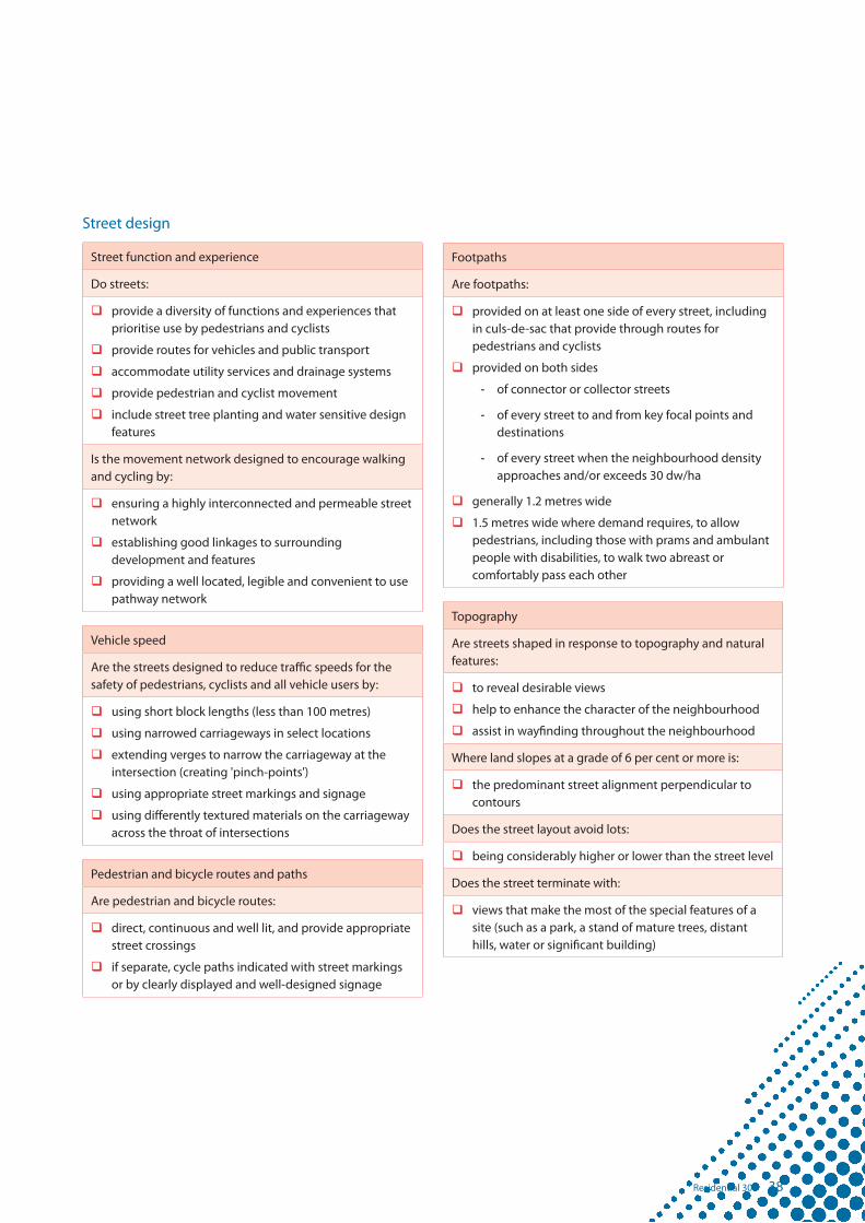
38Residential 30
Street design
Street function and experience
Do streets:
� provide a diversity of functions and experiences that prioritise use by pedestrians and cyclists
� provide routes for vehicles and public transport
� accommodate utility services and drainage systems
� provide pedestrian and cyclist movement
� include street tree planting and water sensitive design features
Is the movement network designed to encourage walking and cycling by:
� ensuring a highly interconnected and permeable street network
� establishing good linkages to surrounding development and features
� providing a well located, legible and convenient to use pathway network
Vehicle speed
Are the streets designed to reduce traffic speeds for the safety of pedestrians, cyclists and all vehicle users by:
� using short block lengths (less than 100 metres)
� using narrowed carriageways in select locations
� extending verges to narrow the carriageway at the intersection (creating 'pinch-points')
� using appropriate street markings and signage
� using differently textured materials on the carriageway across the throat of intersections
Pedestrian and bicycle routes and paths
Are pedestrian and bicycle routes:
� direct, continuous and well lit, and provide appropriate street crossings
� if separate, cycle paths indicated with street markings or by clearly displayed and well-designed signage
Footpaths
Are footpaths:
� provided on at least one side of every street, including in culs-de-sac that provide through routes for pedestrians and cyclists
� provided on both sides
- of connector or collector streets
- of every street to and from key focal points and destinations
- of every street when the neighbourhood density approaches and/or exceeds 30 dw/ha
� generally 1.2 metres wide
� 1.5 metres wide where demand requires, to allow pedestrians, including those with prams and ambulant people with disabilities, to walk two abreast or comfortably pass each other
Topography
Are streets shaped in response to topography and natural features:
� to reveal desirable views
� help to enhance the character of the neighbourhood
� assist in wayfinding throughout the neighbourhood
Where land slopes at a grade of 6 per cent or more is:
� the predominant street alignment perpendicular to contours
Does the street layout avoid lots:
� being considerably higher or lower than the street level
Does the street terminate with:
� views that make the most of the special features of a site (such as a park, a stand of mature trees, distant hills, water or significant building)

39 Residential 30
Street carriageways
Are street carriageways:
� wide enough to allow vehicles to pass safely
� of sufficient lane width and comprise corner splays when used for bus routes
For neighbourhoods with dwelling densities up to 20 dw/ha) are:
� the carriageway widths of lower order street 5.5 metres
For neighbourhoods with higher densities (e.g. 20-30 dw/ha) are:
� the carriageway widths of lower order street 7.5 metres
Legibility and connectivity
To achieve legibility and connectivity and encourage walking and cycling does the street layout:
� connect new streets with existing street systems where appropriate
� provide clearly defined cycle and pedestrian connections
� provide for potential bus routes and ensure that these routes can be comfortably accessed by foot from most dwellings
� minimise culs-de-sac, or where they are used:
- limit their length so the end point is visible from the access point to prevent drivers inadvertently turning into a dead-end
- provide access to a maximum of 10 houses
- ensure turning heads are capable of accommodating a three point turn by a medium rigid vehicle (e.g. garbage and fire trucks)
- ensure pedestrian and cyclist connections through to other streets are provided.
� avoid roundabouts, particularly on local streets
� ensure the design indicates the presence of the intersection on all approaches
� use traffic signals, street markings and signs where required
� use tight kerb radii at intersections to shorten pedestrian crossing distances and reduce vehicle speeds
� avoid splitter islands wherever possible
� ensure driveways are kept to a minimum width
� use rear laneways to minimise driveways on high order streets
Rear lanes
Are rear lanes:
� providing enough width to enable safe and efficient vehicle movement, including service vehicles a maximum 6.5 metres wide
� either in straight or T configurations
� no longer than 140 metres without a mid-lane link
� detailed to enable easy and safe access into and out of garages, but without using tilt-panel or other doors that open into the lane
� not creating a more direct through-route alternative for vehicles, cyclists or pedestrians than the adjoining street network
� designed to ensure rear yards of properties can be fenced for security
� ensuring that any rear boundary treatment or tree planting does not create concealed recesses or provide uninvited access opportunities into rear yards
� not dead ends or culs-de-sac
� not providing for visitor parking within the lane unless in specifically designated areas
Do rear lanes that provide front door access to lofts/apartments also provide:
� good passive surveillance into, along and through lanes
� a reasonable level of amenity/landscaping
� clearly identifiable and addressed front doors
� easy access from on-street visitor car parking areas
� a minimum of space for metered services and other facilities requiring recesses
� public lighting, located so that poles are outside reversing vehicle paths
� adequate sightlines for both pedestrians and cars at junctions

40Residential 30
Park design
Park functions and experience
Does the network of parks and open space:
� provide for multiple purpose parks
� provide for smaller 'pocket' parks
� distribute parks and open space throughout the neighbourhood
Do parks:
� contribute to the ecological and civil engineering functions of the neighbourhood
� provide for a diversity of recreation functions and experiences for anticipated users
Park diversity
To provide sustainable, safe and secure open space experiences, are parks planned and designed with:
� respect to existing natural elements (e.g. trees, rocks, streams, creeks), sites of natural or cultural value and linkage of habitats and wildlife corridors
� a clear relationship between public open space and adjoining land uses established by appropriate treatment including alignment, fencing, landscaping, and addressing issues of security and surveillance
� avoidance of solid fencing along park and open space areas for security, surveillance, aesthetic and maintenance reasons
� landscaping that contributes to the park character and to flora and fauna habitat and fauna movement
For the safety and security of dwelling occupants and park users, is:
� the majority of the park overlooked
� at least 50 per cent of the perimeter of the park bounded by a street
Trees and vegetation
Are existing trees and other vegetation:
� retained within all parks
� located to assist in their protection during development and building construction
Pocket parks
Do pocket parks:
� provide a small open space setting for adjoining dwellings
� incorporate existing natural features
� incorporate landscaping to assist in creating neighbourhood identity and wayfinding
Neighbourhood parks
Are neighbourhood parks:
� centrally located
� supporting the local communities recreational needs
� providing opportunities for community and special events
Lineal or corridor parks
Do lineal or corridor parks:
� connect with existing or planned open space in the locality
� incorporate pedestrian and cycle paths
� protect significant natural features
� convey stormwater
� provide for other recreational needs when not flooded
Natural parkland areas
Do natural parkland areas provide:
� for retention of locally significant wetlands, remnant vegetation and habitat for fauna
� continued ecological corridors and linkages to areas outside of the neighbourhood
� important landscape and visual quality values
� opportunities for habitat improvement arising from development in other localities through the provision of vegetation and habitat offsets to improve existing remnant vegetation and habitat areas
� opportunities for appropriate sustainable nature based recreation
� temporary management areas for stormwater prior to its release
� enhancement of wetland communities as part of stormwater management

41 Residential 30
Building design
Building setbacks
Terrace, row and loft housing lots:
� front minimum 2.4 metres
� park minimum 0.0 metres to veranda and 2.4 metres to wall
� side and rear minimum 0.0 metres
Traditional, courtyard, villa and multi-family housing lots:
� In accordance with the following table
Width of lot frontage
10.0m - 12.4m 12.5m - 14.9m 15.0m - 19.9m 20m +
Ground floor
First floor Ground floor
First floor Ground floor
First floor Ground floor
First floor
Lots without lane
Front 2.4* 2.4 2.4* 2.4 2.4* 2.4 2.4* 2.4
Side
» build-to-boundary line
» not build-to-boundary line
0.0
0.9
1.0
0.9
0.0
1.0
1.0
1.0
0.0
1.0
1.0
1.5
0.0
1.2
1.0
2.0
Rear 0.9 1.0 0.9 1.0 0.9 1.0 1.0 2.0
Secondary frontage 1.5
Park
» side / rear of lot 1.0 or minimum 0.0 metre to verandah / balcony and 2.4 metres to wall
Lots with lane
Front to street 2.4
Side / rear to lane 0.0
Side / rear to park 1.0 or minimum 0.0 metre to verandah / balcony and 1.2 metres to wall
Secondary frontage 1.2
* 4.5m to garage or carport door

42Residential 30
Car parking and driveways
Is one covered on-site car parking space:
� with minimum clear dimensions of 2.7 metres by 5.5 metres, provided for each dwelling
Are tandem parking spaces provided to allow for:
� one on-site visitor parking on traditional, courtyard, villa and multi-family lots not serviced by a laneway
Is visitor parking for loft homes provided:
� other than within laneways
Is the space between a garage and street front property boundary to be utilised for visitor car parking:
� a minimum dimension of 4.5 metres by 2.5 metres
Where not serviced by a rear lane, are all garage and car park structures on premises adjoining a street and driveways to on-site car parking spaces should be designed so that they do not dominate the streetscape, do not interfere with the efficient functioning of the street, and enable on street car parking, so that:
� car parking areas including garages and car park structures are located so that they do not occupy more than 40 per cent of the lot frontage
� there is a maximum of one driveway per dwelling
� driveways avoid on-street works such as dedicated parking bays, drainage pits and service pillars
� the minimum distance of a driveway from an intersection of one street with another street is 6.0 metres
� the minimum distance between driveways on the same lot is 3.0 metres at the boundary
� driveways are no more than 3.0 metres wide at the lot boundary where providing access to only a single garage or carport
� a double garage is generally not permitted on a lot that is 7.5 metres or less in width
� one on-street car parking space with a minimum length of 5.0 metres clear of driveways is provided per dwelling, except either:
- in the case of terrace and row lots where the minimum length between driveways is 4.0 metres, and there are no more than four of these lots in a row, or
- where on-street car parking is provided in accordance with a parking management plan.
Buildings facing a park or more than one street
Do buildings address each street frontage or park frontage through:
� verandahs
� porches
� awning and shade structures
� variation to root and building lines
� inclusion of window openings
� use of varying building materials
Site coverage
Does the total site coverage of development of a lot:
� not exceed 60 per cent of the lot area
� in the case of 'row' and 'terrace' style buildings the total site coverage does not exceed 75 per cent of the lot area
� for multi-family dwellings not exceed 75 per cent of the lot area
Front entry
Is the front entry to all dwellings:
� clearly defined, with elements such as a direct path and separate covered area at the front door
Do all dwellings have:
� a habitable room with windows facing onto the street
� a sidelight window at the front door
Slope
Are buildings on narrow sloping lots (less than 15.0 metres wide) built to the boundary:
� on the low side of the lot
Wide buildings
Are all buildings with a width of more than 10 metres that are visible from a street or a park articulated to reduce the mass of the building by:
� windows recessed into the facade
� balconies, porches or verandahs provided
� window hoods provided
� shadow lines created on the building through minor changes in the facade (100 millimetres minimum)

43 Residential 30
Building articulation
Do all buildings incorporate two or more, of the following design elements to provide diversity in building form as well as respond to the climate:
� verandahs
� roof overhangs
� window hoods/screens
� awnings and shade structures
Privacy
On other than a lot for a house, is the privacy of occupants of nearby residential properties adequately protected from visual intrusion by:
� the outlook from the first or second storey windows, terraces and decks and other private communal or public areas being obscured or screened where a direct view at a distance closer than 9.0 metres would otherwise be available into the private open space or a living room of an existing dwelling; and
� where screening is required, it is provided by solid opaque screens or perforated panels or trellises that are permanent and have a maximum of 50 per cent openings or windows have a minimum sill height of 1.7 metres or opaque glass is utilised.
Fences
Are front fences and walls, where required, one of the following:
� solid front fences and walls no more than 1.2 metres high
� if containing openings that make it more than 50 per cent transparent, a maximum fence height of 1.8 metres, and solid to a maximum height of 1.2 metres
� if the dwelling has a frontage to a street with traffic volumes in excess of, or projected to exceed, 10,000 vehicles per day, or where the main private open space is in front of the dwelling, the maximum height for solid front fences and walls 1.8 metres.
Is all fencing interfacing with a park:
� no more than 1.5 metres high
� predominantly open in nature.
Are fences on laneways:
� 1800 millimetres high and completely screen private open space, car parking and service areas
Are fences on corner lots:
� designed as front fences addressing both streets (rather than a front and a side fence)
Are fences in key locations proposed to be constructed by the developer to ensure consistency in appearance, such as fencing:
� to non-access roads
� high visibility open space areas
� where integrated housing construction is proposed on multi-family and grouped terrace and row housing lots
Private open space
Do dwellings with their main living areas located at ground level have private open space with:
� a minimum of 12 sqm in area per dwelling unit
� a minimum dimension of 2.4 metres and/or have adequate space to accommodate a table, chair, planting, barbeque and shade
Do dwellings with their main living areas located above ground level have private open space with:
� a minimum area of 5.0 sqm, and
� a minimum dimension of 1.2 metres, directly accessible from a living room.
Do sites containing more than 6 attached dwellings or apartments include a communal open space area that:
� has a minimum of 25 per cent of the area of the site
� is provided in addition to the private open space areas
� has a minimum dimension of 4.0 metres
� has a maximum gradient not exceeding one in ten
� is designed and located so that it is subject to informal surveillance from dwellings on the site
� is separated from any private areas by a fence or landscaping.

44Residential 30
Loft apartments
Do loft apartments:
� have a maximum of two storeys in height, including garage level
� have a clearly identifiable and addressed front door and undercover point of entry
� incorporate in all walls adjoining the main dwelling and private open space areas of the main dwelling:
- windows with a minimum sill height of 1500 millimetres or privacy screening
- low maintenance building materials and non-reflective finishes
- no external drainage or other pipes
� incorporate an area of private open space such as a balcony or veranda with a minimum depth of 1.2 metres and a minimum area of 5.0 sqm, preferably overlooking the lane, and including a screened drying area
� incorporate at least two openings to all habitable rooms, including internal windows and louvred windows to facilitate cross ventilation
Multi family and other small dwellings
Do multi family and other small dwellings:
� have a maximum of two storeys in height
� have a clearly identifiable and addressed front door and undercover point of entry
� incorporate an area of private open space such as a balcony or veranda with a minimum depth of 1.2 metres and a minimum area of 5.0 sqm, preferably overlooking the street or an area of public open space
� have screened drying and rubbish bin areas behind the main face of the dwelling
� incorporate at least two openings to all habitable rooms, including internal windows and louvred windows to facilitate cross ventilation

45 Residential 30
Case study - 15 dwellings per hectare
Diversity
Traditional = 40 / 45%
Courtyard = 34 / 37%
Villa = 16 / 18%
Total = 90 / 100%
Density
» area = 6.4 hectares
» 90 dwellings
» 15 dw/ha
Design
» many large lots
» few small lots
» basic finish to parks and streets
» footpath on one side of most streets

46Residential 30
Case study - 20 dwellings per hectare
Diversity
Traditional = 10 / 8%
Courtyard = 34 / 27%
Villa = 34 / 27%
Terrace = 46 / 38%
Total = 124 / 100%
Density
» area = 6.4 hectares
» 124 dwellings
» 20 dw/ha
Design
» many small lots
» few large lots
» basic finish to parks and streets
» footpath on one side of every street

47 Residential 30
Case study - 25 dwellings per hectare
Diversity
Traditional = 8 / 5%
Courtyard = 27 / 18%
Villa = 31 / 20%
Terrace = 49 / 32%
Row = 24 / 16%
Loft = 6 / 4%
Multi-family = 8 / 5%
Total = 153 / 100%
Density
» area = 6.4 hectares
» 153 dwellings
» 25 dw/ha
Design
» many small lots
» few lofts
» few multi-family lots
» lanes where appropriate
» civic finish to parks and streets
» footpath on one side of every street and both sides of some streets

48Residential 30
Case study - 30 dwellings per hectare
Diversity
Courtyard = 27 / 14%
Villa = 31 / 16%
Terrace = 49 / 24%
Row = 24 / 12%
Loft = 28 / 14%
Multi-family = 40 / 20%
Total = 199 / 100%
Density
» area = 6.4 hectares
» 199 dwellings
» 30 dw/ha
Design
» many small lots
» many lofts
» many lanes
» many multi-family lots
» civic finish to parks and streets
» footpath on both sides of most streets

To learn more about design of low to medium density residential development, refer to the following publications.
Queensland Department of Public Works 'Smart and Sustainable Housing Design Objectives'
http://www.hpw.qld.gov.au/SiteCollectionDocuments/SmartHousingDesignObjectives08.pdf
Housing Industry Association Greensmart Program
http://hia.com.au/hia/channel/Builder/region/National/classification/Greensmart.aspx
Urban Development Institute of Australia 'EnviroDevelopment Standards'
http://www.envirodevelopment.com.au/_dbase_upl/Version%202.0.pdf
Department of the Environment, Water, Heritage and the Arts - 'Your Home - Technical Manual'
http://www.yourhome.gov.au/technical
NSW Landcom
http://www.landcom.com.au/publications/TheLandcomGuidelines.aspx
Smart Housing Website
http://www.build.qld.gov.au/smart_housing/
References
49 Residential 30

In this guideline terms have the following meanings:
brief establishes the background context and provides guidance and direction for any new development proposal. A brief should analyse and synthesise the full range of physical and economic factors that affect the site. The brief should be expressed in words and drawings and address factors such as geography, topography, topology, geology, biology, ecology, demography, economy and policy, and features such as sounds, scents and scenes of, and surrounding, the site. The brief will also include:
» key requirements for the site contained with the development scheme
» housing affordability, density or diversity targets as set by the MEDQ in the relevant development scheme.
built-to-boundary wall refers to a wall that is built up to the boundary of an adjoining lot. The term built-to-boundary is sometimes referred to as the 'zero lot line', as the building setback approaches zero. However, typically the actual setback is 50.0 metres to 200.0 metres to allow for construction tolerance and storm water gutters.
business case refers to a commercial assessment of a design plan which compares the commercial viability of a project against preliminary feasibilities.
dwelling or dwelling unit is a building being a self-contained place of residence, for the use of a household. Dwelling includes a house and a unit or apartment in a 'multiple residential' development. A dwelling typically
contains a kitchen, bathroom, living/dining areas, bedrooms, and areas of private open space (including decks and verandah's) designed for the anticipated needs of it's users. A dwelling can be attached to or detached from other dwellings. A dwelling is typically capable of separate titling under freehold title in fee simple or in a Community Title Scheme.
house means premises used for residential purposes where on its own lot used as one self contained dwelling.
multiple residential means premises used for residential purposes if there are two (2) or more dwelling units on any one (1) lot. Multiple residential dwelling units may be contained on one lot or each dwelling unit may be contained on its own lot subject to Community Title Schemes. The term multiple residential does not include a house, as defined herein.
net residential density applies to the area of residential lots, local roads and local parks and the number of dwellings in that area. The density is calculated by adding the area of residential lots to the area of local roads and local parks, and then dividing by the number of dwellings or residential lots created. The calculations exclude higher and middle order roads (freeways through to trunk collector), all other types of open space and non-residential land uses, but includes mixed use containing residential.
parking management plan is a plan indicating the location of all on-street car parking spaces.
plan of development is a detailed plan, including graphics, text and tables that collectively accompanies a development application. A plan of
development details lot layout, the form and density of development, landscape intent and building control requirements.
structure plan illustrates the planning and design framework for development in the locality, and is likely to be included in the land use plan component of the development scheme for the PDA in which the site is located. The structure plan graphically illustrates the key structural elements for the PDA/neighbourhood, including the significant environmental features of the locality and a conceptual layout of future land uses, open space, vegetation and general landscape treatment, as well as movement networks, drainage and other infrastructure for the locality. The structure plan should illustrate how the site connects into the surrounding locality.
For the purposes of this guideline the term structure plan is meant generally, and does not have the meaning per the Integrated Planning Act.
vision includes a rationale or principles to be held during the planning and design process and in preparing the structure plan, design plan and plan of development.
Glossary
50Residential 30

Acknowledgements
Thank you to the people who have provided valuable assistance and advice in the preparation of this guideline.
Primary consultant
» Malcolm Holz - HOLZink
Government assistance
» Department of Infrastructure and Planning
Additional consultants
» Peter Egerton and Cliff Keys - Conics
Photography
» AVJennings
» Ausbuild
» Conics
» Gabriel and Elizabeth Poole Design Company
» Mike McKeown
51 Residential 30


For more information contact us on:Economic Development QueenslandGPO Box 2202 Brisbane Qld 4001Telephone: (07) 3452 7880Email: [email protected]: www.edq.qld.gov.au