
Economic Development Queensland...7 Bowen Hills PDA Development Scheme - June 2019 2.1.1 Vision The...
76
Economic Development Queensland Bowen Hills Priority Development Area Development Scheme Effective 3 July 2009 Last amended 21 June 2019
Transcript of Economic Development Queensland...7 Bowen Hills PDA Development Scheme - June 2019 2.1.1 Vision The...

Economic Development Queensland
Bowen HillsPriority Development AreaDevelopment Scheme
Effective 3 July 2009Last amended 21 June 2019

The Department of State Development, Manufacturing, Infrastructure and Planning is responsible for driving the economic development program for Queensland by creating a diverse and thriving economy, and generating new jobs.
Copyright
This publication is protected by the Copyright Act 1968.
Licence
This work, except as identified below, is licensed by the Department of State Development, Manufacturing, Infrastructure and Planning under a Creative Commons Attribution (CC BY) 4.0 Australia licence. To view a copy of this licence, visit: http://creativecommons.org.au/ You are free to copy, communicate and adapt this publication, as long as you attribute it as follows:
© State of Queensland, The Department of State Development, Manufacturing, Infrastructure and Planning, June 2019.
Third party material that is not licensed under a Creative Commons licence is referenced within this document. All content not licensed under a Creative Commons licence is all rights reserved. Please contact the Department of State Development, Manufacturing, Infrastructure and Planning /the copyright owner if you wish to use this material.
The Queensland Government is committed to providing accessible services to Queenslanders of all cultural and linguistic backgrounds. If you have difficulty understanding this publication and need a translator, please call the Translating and Interpreting Service (TIS National) on 13 14 50 and ask them to contact the Queensland Department of State Development, Manufacturing, Infrastructure and Planning on 07 3452 7100
Disclaimer
While every care has been taken in preparing this publication, to the extent permitted by law, the State of Queensland accepts no responsibility and disclaims all liability (including without limitation, liability in negligence) for all expenses, losses (including direct and indirect loss), damages and costs incurred as a result of decisions or actions taken as a result of any data, information, statement or advice, expressed or implied, contained within. To the best of our knowledge, the content was correct at the time of publishing.
Any references to legislation are not an interpretation of the law. They are to be used as a guide only. The information in this publication is general and does not take into account individual circumstances or situations. Where appropriate, independent legal advice should be sought.
Copies of this publication are available on our website at www.dsdmip.qld.gov.au and further copies are available upon request to:
Economic Development Queensland
Department of State Development, Manufacturing, Infrastructure and PlanningGPO Box 2202, Brisbane Queensland 4002.
1 William Street Brisbane Qld 4000 (Australia)
Phone: 13 QGOV (13 7468)
Email: [email protected]
Web: www.edq.qld.gov.au

1 Bowen Hills PDA Development Scheme - June 2019
Contents 1 Introduction ................................................................................................. 4
1.1 Economic Development Act........................................................................ 4
1.2 Priority Development Area .......................................................................... 4
1.3 Application of the development scheme ..................................................... 4
1.4 Content of the development scheme .......................................................... 4
2 Land use plan ............................................................................................. 6
2.1 Components of the Land use plan .............................................................. 6
2.1.1 Vision ................................................................................................ 7
2.1.2 PDA development requirements ........................................................ 7
2.1.3 Schedules ......................................................................................... 7
2.1.4 Guidance material ............................................................................. 7
2.2 Development assessment .......................................................................... 7
2.2.1 Interpretation ..................................................................................... 7
2.2.2 Categories of development ................................................................ 7
2.2.3 Development consistent with the Land use plan ................................ 8
2.2.4 Development inconsistent with the Land use plan ............................. 8
2.2.5 Notice of applications ........................................................................ 8
2.2.6 State interests ................................................................................... 8
2.2.7 Relationship with other legislation ..................................................... 8
2.2.8 Relationship with local government planning scheme ........................ 9
2.2.9 Interim use ........................................................................................ 9
2.2.10 Value uplift charges....................................................................... 9
2.3 Vision ....................................................................................................... 10
2.3.1 Land uses ....................................................................................... 10
2.3.2 Transport and connectivity .............................................................. 10
2.3.3 Urban design and public realm ........................................................ 10
2.4 Structural elements .................................................................................. 11
2.5 PDA-wide criteria ...................................................................................... 13
2.5.1 Urban design and public realm ........................................................ 13
2.5.2 Connectivity..................................................................................... 14
2.5.3 Housing diversity ............................................................................. 14
2.5.4 Sustainable developments .............................................................. 15
2.5.5 Infrastructure planning and delivery ................................................. 16
2.5.6 Heritage places ............................................................................... 16
2.5.7 Environment .................................................................................... 17
2.5.8 Flood ............................................................................................... 18

2 Bowen Hills PDA Development Scheme - June 2019
2.5.9 Managing the impacts of infrastructure ............................................ 18
2.6 Zone provisions ........................................................................................ 23
2.6.1 Medium density residential zone ..................................................... 25
2.6.2 High density residential zone ........................................................... 27
2.6.3 Mixed use zone ............................................................................... 30
2.6.4 Industrial zone ................................................................................. 38
2.6.5 Mixed industry and business zone ................................................... 40
2.6.6 Sport and recreation zone ............................................................... 43
2.6.7 Open space zone ............................................................................ 45
2.6.8 Special purpose (transport) zone ..................................................... 45
2.6.9 Specialised centre (entertainment) zone ......................................... 46
2.6.10 Levels of assessment for zones .................................................. 48
2.7 Precinct provisions ................................................................................... 50
2.7.1 Precinct 1 ........................................................................................ 52
2.7.2 Precinct 2 ........................................................................................ 55
3 Infrastructure plan ..................................................................................... 58
3.1 Purpose .................................................................................................... 58
3.2 Infrastructure networks ............................................................................. 58
3.3 Infrastructure categories ........................................................................... 58
3.3.1 Trunk infrastructure ......................................................................... 58
3.3.2 Non-trunk infrastructure ................................................................... 58
3.3.3 Other infrastructure ......................................................................... 59
3.4 Infrastructure charges, funding and conditions ......................................... 61
3.5 Infrastructure agreements ........................................................................ 61
3.6 Infrastructure standards ............................................................................ 61
4 Implementation strategy ........................................................................... 62
4.1 Place management .................................................................................. 62
4.2 Urban design and public realm ................................................................. 62
4.3 Connectivity .............................................................................................. 63
4.4 Housing diversity ...................................................................................... 63
4.5 Sustainability ............................................................................................ 64
4.6 Infrastructure planning and delivery .......................................................... 64
4.7 Conservation and adaptive re-use of heritage buildings and places ......... 65
5 Schedules ................................................................................................. 67
Schedule 1: Definitions ...................................................................................... 67
Schedule 2: PDA accepted development ........................................................... 69
Schedule 3: Transport, access, parking and servicing ....................................... 71
Schedule 4: Heritage places .............................................................................. 72
Schedule 5: Amendments.................................................................................. 73
3 Bowen Hills PDA Development Scheme - June 2019
List of maps Map 1: PDA boundary .................................................................................................................................. 5 Map 2: Structure plan ................................................................................................................................. 12 Map 3: Heritage places ............................................................................................................................... 20 Map 4: Sub-surface transport infrastructure ................................................................................................ 21 Map 5: Point source pollutants .................................................................................................................... 22 Map 6:Zone plan......................................................................................................................................... 24 Map 7: Precinct boundaries ........................................................................................................................ 51 Map 8: Precinct 1 plan ................................................................................................................................ 54 Map 9: Precinct 2 plan ................................................................................................................................ 57
List of Tables Table 1: Land use plan components and relationships ................................................................................. 6 Table 2: Levels of assessment ................................................................................................................... 48 Table 3: Infrastructure catalogue for the Bowen Hills PDA .......................................................................... 59
List of Figures Figure 1: Built form provisions – Medium density residential zone .............................................................. 25 Figure 2: Built form provisions – High density residential zone ................................................................... 27 Figure 3: Built height and envelope provisions – Mixed use zone ............................................................... 31 Figure 4: Options for the placement of communal open space and facilities ............................................... 32 Figure 5: Building form, scale, bulk and articulation .................................................................................... 33 Figure 6: Ground level treatment for non-residential uses ........................................................................... 34 Figure 7: Ground level treatment for residential uses .................................................................................. 35 Figure 8: Podium treatment for non-residential uses ................................................................................... 36 Figure 9: Podium treatment for residential uses .......................................................................................... 37 Figure 10: Built form provisions - Industrial zone ........................................................................................ 38 Figure 11: Built form provisions – Mixed industry and business zone ......................................................... 40

4 Bowen Hills PDA Development Scheme - June 2019
1 Introduction 1.1 Economic Development Act The Economic Development Act 2012 (the ED Act)1 establishes the Minister for Economic Development Queensland (MEDQ) as a corporation sole to exercise the functions and powers of the ED Act. The main purpose of the ED Act2 is to facilitate economic development, and development for community purposes, in the state. The ED Act3 seeks to achieve this by establishing the MEDQ and providing for a streamlined planning and development framework for particular parts of the state declared as priority development areas (PDAs).
1.2 Priority Development Area The Bowen Hills PDA was declared by regulation4 on 28 March 2008. The PDA is approximately 108 hectares bound by Bowen Bridge Road and Enoggera Creek to the west, the Mayne Rail Yards and Breakfast Creek to the north, Water Street and St Pauls Terrace to the south and Breakfast Creek, Cintra Road and Markwell Street to the east. The boundaries of the PDA are shown on map 1.
1.3 Application of the development scheme The Bowen Hills PDA Development Scheme (the development scheme) is applicable to all development on land and water5 within the boundaries of the PDA. The development scheme became effective on 3 July 2009 and was amended on 1 April 2010 and 21 June 2019.
1.4 Content of the development scheme The development scheme consists of the following:
i. the Land use plan that regulates development in the PDA (section 2) ii. the Infrastructure plan that describes infrastructure required to support achievement of the Land use
plan and states applicable infrastructure charges (section 3), and iii. the Implementation strategy that describes actions that complement the Land use plan and
Infrastructure plan to achieve the main purpose of the ED Act (section 4).
1 See section 8 of the ED Act. 2 See section 3 of the ED Act. 3 See section 4 of the ED Act. 4 See section 37 of the ED Act. 5 See section 47A of the Act Interpretation Act 1954.

5 Bowen Hills PDA Development Scheme - June 2019
Map 1: PDA boundary

6 Bowen Hills PDA Development Scheme - June 2019
2 Land use plan 2.1 Components of the Land use plan The Land use plan establishes a hierarchy of provisions through the:
i. vision for the PDA and ii. the PDA development requirements, which are organised in a hierarchy where:
a. the structural elements and PDA-wide criteria establish outcomes and quantitative measures to achieve the vision, and
b. the zone and precinct provisions establish outcomes and quantitative measures, to achieve the structural elements and PDA-wide criteria (refer to table 1).
Table 1: Land use plan components and relationships
Vision
PDA development requirements
Structural elements PDA-wide criteria Urban design and public realm Connectivity Housing diversity Sustainable developments Infrastructure planning and delivery Heritage places Environment Flood Managing the impacts of infrastructure
Zone provisions Medium density residential zone High density residential zone Mixed use zone Industrial zone Mixed industry and business zone Sport and recreation zone Open space zone Special purpose (transport) zone Specialised centre (entertainment) zone Categories of development
Precinct provisions Precinct 1 Precinct 2
Components referenced by Vision and PDA development requirements
Schedules Schedule 1: Definitions Schedule 2: PDA accepted development Schedule 3: Transport, access, parking and servicing Schedule 4: Heritage places Schedule 5: Amendments
Guidance material6

7 Bowen Hills PDA Development Scheme - June 2019
2.1.1 Vision The Vision identifies the overall outcomes to be achieved in the PDA, that:
i. seek to achieve the purpose of the ED Act for the PDA, and ii. provide the basis for the PDA development requirements.
2.1.2 PDA development requirements The PDA development requirements apply to all PDA assessable development and include:
i. structural elements ii. PDA-wide criteria iii. zone provisions, and iv. precinct provisions.
2.1.3 Schedules Schedule 1: Definitions – provides the use and administrative definitions required to interpret and apply the development scheme. Schedule 2: PDA accepted development – identifies development that is accepted development for the whole of the PDA. Schedule 3: Transport, access, parking and servicing – establishes the transport, access, parking and servicing requirements applicable to all development within the PDA. Schedule 4: Heritage places – catalogues all heritage places presently listed on the Queensland Heritage Register and Brisbane City Plan Heritage overlay within the Bowen Hills PDA. Schedule 5: Amendments – lists out the amendments that have occurred to the development scheme since it came into effect.
2.1.4 Guidance material Guidance material includes Economic Development Queensland (EDQ) guidelines6 and any other documents or guidelines referenced in the development scheme.
2.2 Development assessment 2.2.1 Interpretation The interpretation of terms and definitions will rely on:
i. Section 33 of the ED Act which defines ‘development’, and ii. Schedule 1 of this development scheme which provides the definitions required to interpret and
apply the development scheme with reference to the ED Act and the Brisbane City Council Planning Scheme 2014 (Brisbane City Plan).
2.2.2 Categories of development PDA accepted development: Table 2 identifies PDA accepted development, and includes schedule 2. PDA assessable development7:
i. Column 2A in table 2 identifies PDA assessable development that is permissible development. ii. Column 2B in table 2 identifies PDA assessable development that is prohibited development.
6 Refer to the EDQ guidelines and practice notes available at https://www.dsdmip.qld.gov.au/edq/guidelines-and-practice-notes.html. Guidelines should be read in conjunction with the Land use plan, Infrastructure plan and Implementation strategy and any other document or guideline called up by the development scheme. 7 Under section 73 of the ED Act, PDA assessable development cannot be carried out without a PDA development permit.

8 Bowen Hills PDA Development Scheme - June 2019
2.2.3 Development consistent with the Land use plan PDA assessable development is consistent with the Land use plan if it is consistent with all outcomes of the relevant PDA development requirements8. However, development that is inconsistent with any of the outcomes of the relevant PDA development requirements, may be consistent with the Land use plan if the development is consistent with the vision, and:
i. the development is an interim use; or ii. there are sufficient grounds to justify the approval of the development despite any inconsistency
with the relevant PDA development requirements. In this section ‘grounds’ means matters of public interest, which include the matters specified as the main purposes of the ED Act as well as:
i. superior design outcomes9, and ii. overwhelming community need.
'Grounds' does not include the personal circumstances of an applicant, owner or interested third party.
2.2.4 Development inconsistent with the Land use plan Despite section 2.2.3 development in the Medium density residential zone or High density residential zone that does not comply with the maximum building height for the relevant zone is inconsistent with the development scheme. PDA assessable development identified in column 2B of Table 2 as prohibited development is inconsistent with the development scheme. Development that is inconsistent with the development scheme cannot be granted a PDA development approval 10.
2.2.5 Notice of applications A PDA development application will require public notification if, in the opinion of the MEDQ, the development:
i. may have adverse impacts on the amenity or development potential of adjoining land under separate ownership, or
ii. is for a use or of a size or nature which warrants public notification.
2.2.6 State interests Relevant matters of state interest have been considered in the preparation of this development scheme and will be considered further as part of the assessment of a PDA development application11.
2.2.7 Relationship with other legislation In addition to assessment against the development scheme, development may require assessment against other legislation including, but not limited to, the Nature Conservation Act 1992, Environmental Protection
8 Refer to the hierarchy of provisions described under section 2.1 of the scheme for further guidance. 9 A design review panel will provide guidance on the assessment and acceptance of superior design outcomes. Refer to Implementation strategy.
10 See section 86 of the ED Act. 11 Section 87 of the ED Act states that any relevant state interest must be considered in deciding a development application. For the purposes of addressing state interests in development assessment, the State Planning Policy (SPP) and State Development Assessment Provisions (SDAP), provide guidance in identifying if a state interest is relevant to the assessment of a PDA development application. For further advice on the consideration of state interests refer to the EDQ Practice note 14: State interests in development assessment in priority development areas, available at www.edq.qld.gov.au/priority-development-areas-guidelines-and-practice-notes.html

9 Bowen Hills PDA Development Scheme - June 2019
Act 1994, Plumbing and Drainage Act 2002, Building Act 1975 and the Planning Act 2016 including subordinate legislation12. Relevant local laws made under the City of Brisbane Act 2010 apply in the PDA to the extent they are not replaced by a by-law made under the ED Act.
2.2.8 Relationship with local government planning scheme Schedule 6 of the Planning Regulation 2017 prohibits Brisbane City Plan 2014 from making PDA-related development assessable under the Planning Act 2016. However, schedule 2 adopts definitions from Brisbane City Plan 2014 and the development scheme calls up various other parts of the Brisbane City Plan 2014 as guidance. Under section 71 of the ED Act, if there is a conflict between the development scheme and a planning instrument or assessment benchmarks prescribed by regulation under another Act, the development scheme prevails to the extent of any inconsistency.
2.2.9 Interim use An interim use is a land use that, because of its nature, scale, form or intensity, is not an appropriate long-term use of the land, but may be appropriate for a short or medium-term period as the PDA develops. A PDA development application for an interim use must demonstrate that the use will not prejudice or delay:
i. appropriate long-term uses(s) ii. an appropriate intensity of development, or iii. infrastructure delivery envisaged by the Vision for the PDA.
Relevant PDA development requirements also apply to all PDA assessable development that is an interim use. An interim use will only be approved if it can be demonstrated that the use will not preclude or delay an appropriate long-term use; or intensity of development; or infrastructure delivery. The MEDQ may impose conditions of approval related to the interim use including, for example, limiting the duration of an interim use. Information to support a PDA development application for an interim use may include:
i. a suitability assessment; and ii. plans showing how the development could transition from the proposed interim use to an
appropriate longer-term use.
2.2.10 Value uplift charges A PDA development approval will include conditions to pay value uplift charges where the approved development provides for a plot ratio yield that exceeds the plot ratio yield which was proposed for the property under the superseded Brisbane City Plan 2000 and prior to the declaration of the PDA. Value uplift charges apply only to gross floor area (GFA) that represents the proportion of the approved plot ratio that exceeds the yield potential established under the superseded Brisbane City Plan 2000.
12 For further advice on what other legislation may apply refer to Appendices 1 and 2 of the EDQ Practice note 14: State interests in development assessment in priority development areas, available at www.edq.qld.gov.au/priority-development-areas-guidelines-and-practice-notes.html

10 Bowen Hills PDA Development Scheme - June 2019
2.3 Vision 2.3.1 Land uses The Bowen Hills PDA is a vibrant urban area which has preserved its heritage places and accommodates a diverse, integrated and balanced range of uses that are connected by a high quality public realm. This range of uses and the intensity of development contribute to the activation of places and streets at different times of the day and throughout the week. The greatest diversity of uses and intensity of development is located in the Mixed-use zone around high frequency public transport stations. These mixed-use areas play an important role in Brisbane’s future growth and development by accommodating a sub-regionally significant concentration of housing and employment opportunities which supports vibrant all day activity and economy. Retail high streets are located along King Street and on Mayne Road and Hudd Street leading to the Bowen Hills Railway Station. Development in these activity nodes provide local residents with services, facilities and opportunities for enterprise and employment. The activity nodes function all day and provide a diversity of retail, commercial, community and entertainment uses, and feature inviting public realm with access to quality pedestrian, cyclist and parking facilities. The Bowen Hills PDA is an important events district with the Old Queensland Museum, Brisbane Showgrounds and other venues hosting cultural, entertainment, recreation and special events. The Brisbane Showgrounds operates as a major events venue year round and is a focal point for the surrounding community. The Brisbane Showgrounds provide pedestrian access between O’Connell Terrace and Gregory Terrace and public open spaces that are freely accessible outside of event times. A range of housing options are available within the Bowen Hills PDA delivering choice, adaptability and diversity through a mix of densities, types, designs, tenures and levels of affordability that cater to a range of lifestyles, incomes and lifecycle needs. High-rise apartment buildings characterise mixed-use areas, mid-rise apartments up to 8 storeys characterise the High density residential zone east of Abbotsford Road, while houses, townhouses and low-rise apartments up to 4 storeys characterise Cintra Road. Residential and accommodation uses are also located adjacent to Perry Park providing residential amenity and passive surveillance of the public realm. A mixed business and industry area is established north of Perry Park and south of Allison Street. This area accommodates a mix of building forms with business frontages activating streets. North of Allison Street, strategically significant industrial land accommodates a range of industrial and commercial services to inner city residents and businesses.
2.3.2 Transport and connectivity The Bowen Hills PDA is integrated with citywide transport networks and is well connected, accessible and permeable to a full range of pedestrian, cyclist, public transport and private vehicle movements. A network of active transport links including walkways and designated on-street cycle lanes supports the movement of people throughout the PDA. Pedestrian connectivity radiates from public transport stations ensuring movement to surrounding areas is direct and efficient. Public transport in the Bowen Hills PDA is highly accessible and offers regular bus and rail services. Delivery of the Cross River Rail project including upgrades to Exhibition Railway Station and increased service frequency will further enhance public transport accessibility within the Bowen Hills PDA. Development maximises public transport infrastructure investment by focusing land uses that generate high pedestrian traffic near public transport stations. Development integrates with public transport stations by delivering a high-quality pedestrian experience in proximity to the station and ensuring pedestrian access points and connections to the station from the road and public realm are well-defined and legible. Streets are designed to cater for anticipated vehicle, cyclist and pedestrian movements as well as streetscaping and car parking requirements. Intersections are designed to facilitate safe movement of vehicles, cyclists and pedestrians. Where required new streets or upgrades will be delivered to improve connectivity and permeability within the PDA.
2.3.3 Urban design and public realm Public open spaces and areas with high quality public realm provide for community recreation and a visual break from the built landscape in Bowen Hills. Bowen Park and Perry Park are the most significant

11 Bowen Hills PDA Development Scheme - June 2019
recreational spaces in Bowen Hills with a network of new and upgraded smaller parks located amongst development and within the Brisbane Showgrounds providing diverse, multi-purpose outdoor landscapes and community spaces. The relationship between public spaces, streets and buildings in the PDA creates an urban environment that is human-scale, attractive, safe and activated. Development addresses street frontages and public spaces, creating an interface that is integrated and activated with human movement and passive surveillance. Open spaces, streetscapes and other public realms are designed to cater for universal access and improved with quality landscape and features that create an inviting place with a strong urban identity. Streetscaping along key pedestrian and cycling linkages contributes to the visual appeal of the public realm and reinforces connections between key destinations in the PDA. These public spaces provide safe and secure access throughout the PDA and connect the surrounding urban areas. Buildings within the PDA are designed and developed in consideration of the principles of sub-tropical urban design which ensures that neighbouring properties, open spaces and the public realm receive optimal levels of solar access, and buildings achieve a high standard of environmental performance and responsiveness. Building occupants are provided with high quality living environments designed to achieve best practice levels of natural light, thermal comfort, privacy, amenity and cross ventilation.
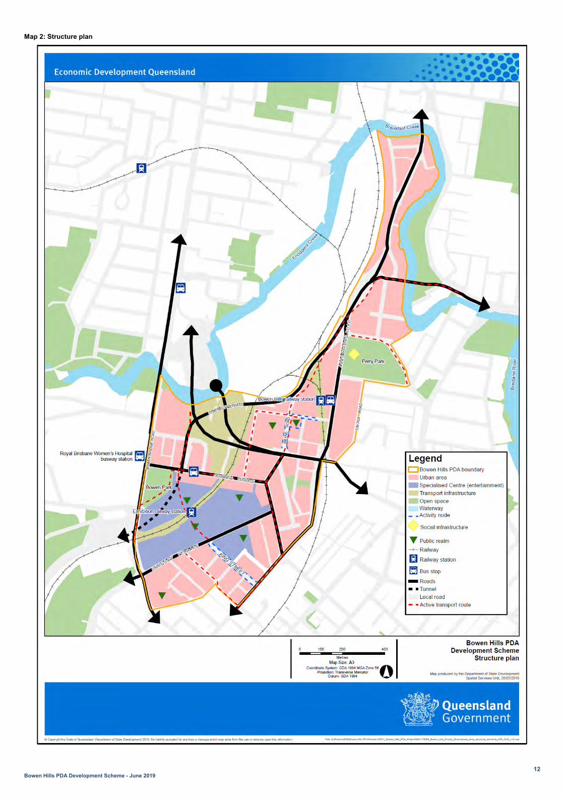
2.4 Structural elements The Structural elements identified in map 2 - Structure plan are a spatially indicative depiction of the highest order physical elements described in the vision statement. The structural elements support the delivery of the vision and PDA-wide criteria and should be read in conjunction with these sections. To the extent that the structural elements are relevant, they are to be taken into account in the preparation of PDA development applications and the assessment of those applications.
12 Bowen Hills PDA Development Scheme - June 2019
Map 2: Structure plan

13 Bowen Hills PDA Development Scheme - June 2019
2.5 PDA-wide criteria 2.5.1 Urban design and public realm
2.5.1.1 Urban design Development ensures the form, type and arrangement of buildings, streets and the public realm are designed to collectively contribute to the creation of a sense of place by:
i. catering for the diverse needs of all community members, including children, elderly and people with disabilities, by applying principles of universal, adaptable and inclusive design
ii. creating an attractive and functional relationship between buildings, private spaces and the public realm
iii. providing a ground plane that is connected, legible, permeable, inclusive and safe iv. contributing positively to conditions of the urban environment and the visual experience of a place v. allowing for innovative and temporary use of public realm vi. applying Crime Prevention through Environmental Design (CPTED) principles13, and vii. promoting identity and distinctive character, by working with the landscape, heritage and cultural
features to create places with a strong relationship to their context.
2.5.1.2 Sub-tropical design14 Development ensures the form, type and arrangement of buildings, streets and the public realm are designed to positively respond to the local climate and improve the urban amenity of Bowen Hills by:
i. applying design strategies that maximise natural light and air flow in the public realm and private spaces to reduce energy demand for artificial lighting and mechanical temperature control
ii. applying design strategies to reduce the extremes of temperature and direct solar heating in buildings, streets and public spaces
iii. orientating buildings to optimise seasonal solar gain and loss, and iv. using appropriate landscape, vegetation and large trees to provide shade and shelter for
pedestrians and cyclists.
2.5.1.3 Building form Development delivers high-quality built form outcomes by:
i. creating human-scale relationships between buildings, streets and the public realm ii. using setbacks and landscape to integrate with, complement and articulate streetscapes iii. using the ground floor of buildings to define the adjacent street or space, deliver a sense of safety,
community ownership and promote activation iv. for mid-rise and high-rise buildings, providing tower separations to deliver access to light, promote
air circulation, minimise overshadowing and maximise amenity and privacy for both occupants and neighbours, and
v. responding to the cultural heritage significance of heritage places.
13 Refer to Crime Prevention through Environmental Design, Guidelines (Queensland Government, 2007). 14 Refer to the guidance provided in Brisbane City Council’s New World City Design Guide: Buildings that Breathe.

14 Bowen Hills PDA Development Scheme - June 2019
2.5.1.4 Streets and public realm Development delivers high-quality streets and public realm spaces that are:
i. attractive spaces embellished with landscape and street furniture to encourage social interaction, healthy active lifestyle15 and community-based activity
ii. human-scale spaces that are designed to contribute positively to the environmental and visual experience of Bowen Hills, and
iii. universally designed and provide legible, permeable and safe movement for all members of the community.
2.5.2 Connectivity Development:
ii. delivers a high quality street and movement network and related infrastructure which enhances connectivity for pedestrians, cyclists and vehicles
iii. provides car parking, access and servicing facilities to meet the necessary functional requirements of development as detailed in schedule 3
iv. ensures universal design principles are applied to access, safety, transport and connectivity within the PDA to ensure that the needs of pedestrians, cyclists and motorists are met
v. ensures the layout of streets and the public realm prioritise pedestrian and cycle movements and the use of public transport over private vehicles by:
a. creating attractive, direct, permeable, legible and connected network of streets, pedestrian and cycle paths and safe crossings points
b. giving high priority to equitable pedestrian connectivity, directness of route and facilities for all members of the community
c. providing convenient through-site connections and cross-block links for pedestrians and cyclists, offering a choice of routes throughout the PDA
d. connecting directly to existing footpaths, cycleways, streets and public transport in surrounding areas, and
e. managing potential conflicts between pedestrians, cyclists and other users through appropriate and safe design.
2.5.3 Housing diversity Development for residential uses (including residential components of a mixed-use development) provides:
i. diverse housing choice to suit a variety of households by offering universal design16 and variety in dwelling size, configuration and adaptability
ii. a minimum of 10 per cent of total residential GFA as dwellings with 3 or more bedrooms iii. a minimum of 5 per cent of total residential GFA as either or a mix of public housing, social housing
or affordable housing, and iv. dwellings that are for public housing, social housing and affordable housing are integrated and
distributed throughout residential and mixed-use developments and present high-quality design outcomes to avoid identifying them or setting them apart in the community.
15 Refer to Healthy by design Guidelines (National Heart Foundation, Victoria, 2004). 16 PDA Guideline no.2 outlines standards for planning and design of accessible housing in PDAs.
15 Bowen Hills PDA Development Scheme - June 2019
2.5.4 Sustainable developments
2.5.4.1 Sustainable buildings Development provides the design, construction and operation of sustainable buildings by achieving either:
i. a minimum 6 leaf EnviroDevelopment certification ii. a minimum 4 star Green Star: Design and as Built certification, or iii. an equivalent rating under an alternative rating system.
2.5.4.2 Self sufficiency Development enables communities to be more resilient and self-sufficient by providing opportunities for:
i. food to be grown in private, communal or public spaces ii. water to be locally sourced for appropriate uses, and iii. energy to be locally generated and sourced.
2.5.4.3 Sustainability of infrastructure Development ensures:
i. all infrastructure is appropriately designed and delivered to support the needs of development, and ii. existing infrastructure is well used and land that is required for future infrastructure is preserved.
2.5.4.4 Water management Development provides a stormwater management system17 designed to deliver the principles of Water Sensitive Urban Design (WSUD) and Integrated Water Cycle Management (IWCM) for buildings, streets and public spaces. This can include working with established topography to sustainably manage surface water run-off at the source and deliver improved biodiversity, landscape amenity and recreational resources.
2.5.4.5 Energy efficiency Development promotes energy efficiency through:
i. site layout, building orientation and thermal design that reduces the need for mechanical cooling and heating
ii. the use of natural light and energy efficient lighting, plant and equipment and at least one of the following:
iii. integration of solar generation technology within the built form or public realm, or iv. integration of green roofs, green walls or other sustainable landscape elements within the built form
and the public realm, or v. integration of smart technology which passively controls the use of electricity.
17 Stormwater management infrastructure and systems are designed in compliance with the Brisbane City Plan Infrastructure design planning scheme policy.

16 Bowen Hills PDA Development Scheme - June 2019
2.5.4.6 Waste management Development:
i. provides facilities for recycling, composting and waste reduction, in addition to the provision of facilities for the removal of waste. Where possible, waste management facilities are centrally located on the site, and
ii. ensures that no liquid or solid wastes, other than stormwater, are discharged to neighbouring land or waters to prevent contamination of natural waterways.
2.5.4.7 Transport efficiency Development:
i. integrates with public transport and active transport infrastructure ii. supports a reduction in car ownership and vehicle trips by providing car share facilities, ride share
access, cycle access, cycle storage facilities and pedestrian permeability, and iii. provides facilities to support the charging of electric vehicles including at least one Destination AC
charger18 and the electrical capacity for Basic AC charging19 on all non-visitor parking.
2.5.5 Infrastructure planning and delivery Development ensures:
i. planned future infrastructure is provided or that its future provision is not constrained, and ii. Infrastructure networks are designed and delivered to meet relevant standards, in a timely and
coordinated way which facilitates ongoing development in the PDA.
2.5.6 Heritage places Development promotes the historic identity of the Bowen Hills PDA, by conserving the cultural significance of heritage places20 and sensitively managing any development and adaptive reuse opportunities by:
i. avoiding significant adverse impacts on the cultural heritage significance of the place21 by protecting the fabric, features and setting of a heritage place when providing for its continued use, interpretation and management
ii. where adverse impacts cannot be avoided, minimising and mitigating unavoidable adverse impacts on the cultural heritage significance of the place or area, by adapting a heritage place to a new use in a way that is compatible and sympathetic to its heritage significance22, and
iii. minimising the detrimental impact of the form, bulk and proximity of adjoining development on heritage places.
18 Destination AC charging requires three phase 415V, 16-32A, supplying11-22kW of power. If three phase power is unavailable, single phase 40A may be acceptable. 19 Basic AC charging requires supply of a dedicated AC circuit of 240 volts, 10-15amps, supplying 2.4-3.7kW of power. 20 Heritage places listed on the Queensland Heritage Register and Brisbane City Plan Heritage overlay within the Bowen Hills PDA are identified on map 3 and listed in schedule 4. 21 Refer to the relevant Queensland Heritages Register statement of significance or Brisbane City Plan Heritage overlay citation. 22 To understand how to fulfil these requirements, development applicants should refer to:
• Developing Heritage Places: Using the development criteria document, a guideline prepared by Department of Environment and Science, and available at https://www.qld.gov.au/environment/land/heritage/publications/.
• The Burra Charter: The Australia ICOMOS Charter for Places of Cultural heritage significance 2013, available at http://australia.icomos.org/publications/charters/ along with a number of useful Practice Notes.

17 Bowen Hills PDA Development Scheme - June 2019
2.5.7 Environment
2.5.7.1 Significant vegetation Development:
i. avoids impacts on significant vegetation, or ii. minimises and mitigates impacts on significant vegetation after demonstrating avoidance is not
reasonably possible23, and iii. provides an offset if, after demonstrating all reasonable avoidance, minimisation and mitigation
measures are undertaken, the development results in significant residual impact on a prescribed environmental matter24.
2.5.7.2 Waterways and riparian areas Development:
i. ensures that land along Breakfast Creek within 10m of the high water mark is transferred to Brisbane City Council as publicly accessible open space
ii. is located, designed, constructed and operated to avoid, or where avoidance is not reasonably possible, minimises and mitigates adverse impacts on:
a. the hydraulic capacity of the waterway25 b. the environmental values of receiving waters26, and
iii. protects environmental values of receiving waters by delivering appropriate solutions that achieve an equivalent or improved water quality outcome.
2.5.7.3 Acid sulfate soils Development:
i. ensures acid sulfate soils (ASS) will be treated in accordance with current best practice in Queensland
ii. ensures the disturbance of ASS is avoided to the greatest extent practical, then managed to reduce risks posed to the natural and built environments from the release of acid and metal contaminants, and
iii. that is operational work will require an ASS investigation if the work involves: a. the disturbance of greater than 100m3 of soil below 5m Australian Height Datum (AHD), or b. the placement of greater than or equal to 500m3 of fill material in layer of greater than or
equal to 0.5m in average depth below 5m AHD.
23 Consideration should be given to circumstances where the removal of significant vegetation is necessary for public safety 24 Refer to the Department of Environment and Science environmental offsets framework available at www.ehp.qld.gov.au 25 Refer to Brisbane City Plan Compensatory earth works planning scheme policy where development involves filling or excavation (> 100mm in depth) on land identified on the Brisbane City Plan Waterways corridor overlay map as a Local waterway corridor. 26 Consideration should be given to State Planning Policy (SPP) in particular the State interest of water quality.

18 Bowen Hills PDA Development Scheme - June 2019
2.5.8 Flood Development in a flood hazard area or coastal hazard area27:
i. is designed and located to avoid, or where avoidance is not reasonably possible, minimise and mitigate the susceptibility to and the potential impacts of inundation
ii. ensures underground car parks are designed to prevent the intrusion of storm tide waters or flood waters by the incorporation of a bund or similar barrier with a minimum height of 300mm above the defined flood level
iii. provides measures to ensure critical services28 remain operational in an inundation event. Essential electrical services including substation equipment and switchboards must be located above the defined flood level, and
iv. ensures any hazardous material manufactured or stored on site is not susceptible to risk of inundation.
2.5.9 Managing the impacts of infrastructure
2.5.9.1 Railway environment Development29:
i. does not create a safety hazard for users of a railway, by increasing the likelihood or frequency of loss of life or serious injury
ii. does not compromise the structural integrity of railways, rail transport infrastructure, other rail infrastructure or railway works
iii. does not result in a worsening of the physical condition or operating performance of railways and the rail network
iv. does not compromise the state’s ability to construct railways and future railways, or significantly increase the cost to construct railways and future railways
v. does not compromise the state’s ability to maintain and operate railways, or significantly increase the cost to maintain and operate railways, and
vi. ensures the community is protected from significant adverse impacts resulting from environmental emissions generated by a railway.
2.5.9.2 Sub-surface transport infrastructure Development does not adversely impact the structural integrity or ongoing operation and maintenance of sub-surface transport infrastructure that is an existing or endorsed proposed tunnel30.
2.5.9.3 Noise – Transport noise corridors and entertainment venues Development is oriented, designed and constructed to:
i. reduce exposure to noise impacts from designated transport noise corridors31, and
27 Refer to Brisbane City Plan Flood overlay map and Coastal hazard overlay map. Assessment against the Brisbane City Plan 2014 Flood overlay code should be provided for development in a flood hazard area. Assessment against the Brisbane City Plan 2014 Coastal hazard overlay code should be provided for development in a coastal hazard overlay area 28 Critical electrical services include any area or room used for fire control panel, telephone PABX, sensitive substation equipment including transformers, low voltage switch gear, high voltage switch gear, battery chargers, protection control and communication equipment, low voltage cables, high voltage cables, and lift or pump controls. 29 Refer to the Queensland Government Development Assessment Mapping System and the State Development Assessment Provisions – State Code 2: Development in a railway environment 30 Development located in proximity to sub-surface transport infrastructure is to be supported by the submission of engineering and geological reports and certification or consent provided by the relevant infrastructure owner. Exisiting sub-surface transport infrastructure within the PDA is identified on map 4. 31 Refer to Brisbane City Plan Transport Noise overlay map.

19 Bowen Hills PDA Development Scheme - June 2019
ii. reduce the exposure of residential uses to noise impacts from lawfully operating entertainment venues32.
2.5.9.4 Procedures for air navigation services Development does not create a permanent or temporary obstruction or hazard to operational airspace of the Procedures for Air Navigation Services – Aircraft Operational Surfaces (PANS-OPS)33 for the Brisbane Airport as identified on the Brisbane City Plan Airport Environs overlay mapping.
2.5.9.5 Air quality Development must limit exposure and risk associated with pollutants that could have an adverse effect on human health34. Development in a transport air quality overlay is designed to35:
i. minimise the impacts of air pollution from vehicle traffic on the health and wellbeing of uses of a childcare centre, multiple dwelling, residential care facility or retirement facility, and
ii. maximise wind movement around buildings and the dispersion of traffic air pollutants. Development within 100m of the Clem Jones Tunnel north ventilation outlet36 and above RL+45m AHD must be designed and oriented to:
i. avoid unreasonable impacts on the performance of the ventilation outlet, and ii. mitigate potential air quality impacts on occupants resulting from the ventilation outputs.
Development within 150m of the Queensland Urban Utilities odour control device37 must be designed and oriented to mitigate:
i. unreasonable impacts on the performance of the odour control device ii. potential air quality impacts on occupants resulting from the odour control device iii. the intrusion of air pollution from the odour control device, and iv. reverse amenity impacts on the lawful operation of the odour control device38.
Development for a sensitive use within 500m of an existing High impact industry identified on Brisbane City Plan Industrial amenity overlay map is designed and constructed to achieve acceptable air quality, odour and health risk standards39.
32 A building is designed and constructed to achieve a minimum reduction in sound pressure level between the exterior of the building and the bedroom or living room, of LLeq,T 20dB at 63Hz where near a lawfully operating entertainment venue. Residents living near lawfully operating entertainment venues also need to be aware that noise levels will be relatively higher both inside and outside of residences. 33 Refer to Brisbane City Plan Airport Environs overlay code. Where development intrudes into Brisbane Airport’s PANS-OPS, advice from the Civil Aviation Safety Authority will be provided as part of a PDA development application. 34 Refer to Brisbane City Council's Air Quality Planning Scheme Policy and the Queensland EPA Guidelines on Odour Impact Assessment from Developments. 35 Refer to Brisbane City Council’s Transport air quality corridor overlay and the Transport air quality overlay code. 36 Refer to map 5 to identify the location of the Clem Jones Tunnel north ventilation outlet and property within 100m of it. 37 Refer to map 5 to identify the location of the Queensland Urban Utilities Odour Control Device and property within 150m of it. 38 All proposed development within the 150m buffer and above RL65m AHD will be required to submit an air quality impact report prepared in accordance with the Brisbane City Plan Air Quality Planning Scheme Policy. This report will be referred to Queensland Urban Utilities through development assessment processes. 39 Refer to Brisbane City Plan Industrial amenity overlay code.

20 Bowen Hills PDA Development Scheme - June 2019
Map 3: Heritage places

21 Bowen Hills PDA Development Scheme - June 2019
Map 4: Sub-surface transport infrastructure

22 Bowen Hills PDA Development Scheme - June 2019
Map 5: Point source pollutants

23 Bowen Hills PDA Development Scheme - June 2019
2.6 Zone provisions All land in the Bowen Hills PDA is included in a zone. The spatial arrangement of zones is shown on map 6. The levels of assessment for development in zones are established in table 2.

24 Bowen Hills PDA Development Scheme - June 2019
Map 6:Zone plan
25 Bowen Hills PDA Development Scheme - June 2019
2.6.1 Medium density residential zone
2.6.1.1 Preferred development intent Development provides for a range of residential types including dwelling houses, multiple residential and other accommodation types in a low-rise built form (including community residence, residential care facilities, rooming accommodation, retirement facilities and short-term accommodation). Development can include detached and attached building forms that are compatible with the residential character of the street and surrounding buildings.
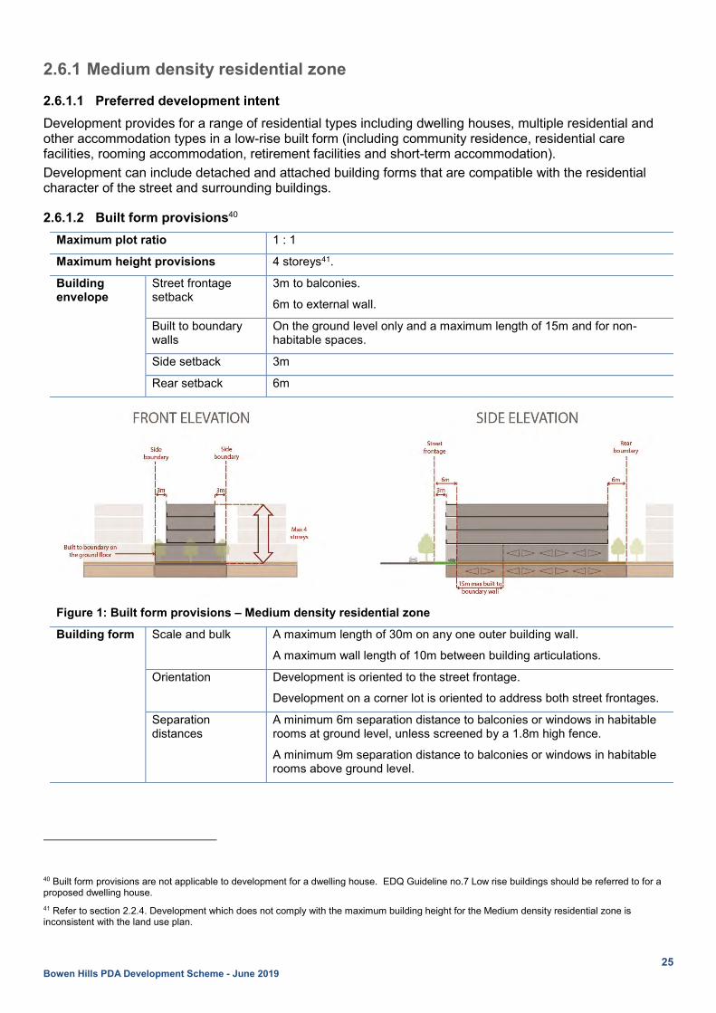
2.6.1.2 Built form provisions40 Maximum plot ratio 1 : 1
Maximum height provisions 4 storeys41.
Building envelope
Street frontage setback
3m to balconies.
6m to external wall.
Built to boundary walls
On the ground level only and a maximum length of 15m and for non-habitable spaces.
Side setback 3m
Rear setback 6m
Figure 1: Built form provisions – Medium density residential zone
Building form Scale and bulk A maximum length of 30m on any one outer building wall.
A maximum wall length of 10m between building articulations.
Orientation Development is oriented to the street frontage.
Development on a corner lot is oriented to address both street frontages.
Separation distances
A minimum 6m separation distance to balconies or windows in habitable rooms at ground level, unless screened by a 1.8m high fence.
A minimum 9m separation distance to balconies or windows in habitable rooms above ground level.
40 Built form provisions are not applicable to development for a dwelling house. EDQ Guideline no.7 Low rise buildings should be referred to for a proposed dwelling house. 41 Refer to section 2.2.4. Development which does not comply with the maximum building height for the Medium density residential zone is inconsistent with the land use plan.

26 Bowen Hills PDA Development Scheme - June 2019
Fences Front fences or walls to ground floor dwellings are 50% visually permeable and no higher than 1.5m.
Side and rear boundary fencing is a minimum of 1.8m in height, if buildings are not built to boundary.
Rooftops Roofs are designed to ensure plant and equipment are screened or otherwise integrated with the overall roof design.
Varied roof forms are incorporated to contribute to the architectural distinction of the building.
Roof top areas may be utilised for communal open space and other passive recreation uses.
Communal open space and facilities
Development of 6 or more dwellings provides universally accessible communal open space as follows:
i. a minimum 15% of the site area
ii. a minimum area of 40m2 and a minimum dimension of 4m
iii. a combination of ground level, vertically integrated or roof top settings
iv. respects the privacy of both users and those overlooking from neighbouring properties
v. includes landscape and deep planting shade trees or structures suited to the subtropical environment
vi. positioned for good solar orientation and minimises water use, and
vii. excludes driveways, storage or turning areas.
Private open space All dwellings have private open space or balconies, with a minimum area of 12m2 and minimum dimension of 3m.
Balconies are appropriately screened to maximise privacy between buildings and the public realm, without compromising CPTED principles.
Ground floor private open space provides privacy but also allows overlooking of the street to promote passive surveillance.
2.6.1.3 Urban design Building elements and appearance
Buildings are well articulated with varied materials and design details, external balconies, verandas, terraces, recessed doors and doorways, windows, shade and screening devices, and outdoor planting.
Residential building design ensures visual and noise privacy, adequate storage space, adequate room sizes, functional room relationship and the provision of useable and well connected common outdoor spaces.
Development provides a well-defined entry point for pedestrians.
Ground level dwellings have direct street access.
Building form allows for cross ventilation and supports a naturally ventilated and comfortable environment.
Landscape On-site landscape and shade trees contribute to the area’s streetscape and residential character.
A minimum of 50% of the street frontage is landscaped.
Public realm Development addresses and provides passive surveillance of its interface with the street and other adjoining public spaces.
Streetscape treatments facilitate pedestrian and cycle amenity and safety.

27 Bowen Hills PDA Development Scheme - June 2019
2.6.2 High density residential zone
2.6.2.1 Preferred development intent Development provides for a range of residential types including multiple residential and other accommodation types in a mid-rise built form (including community residences, residential care facilities, rooming accommodation, retirement facilities and short-term accommodation). Development is predominantly in attached building forms that are compatible with the residential character of the street and surrounding buildings. Shops or community facilities not exceeding 250m2 of GFA are appropriate on the ground level to provide services and support to the residential community.
2.6.2.2 Built form provisions42 Maximum plot ratio 2 : 1
Maximum height provisions 8 storeys43.
Building envelope
Street frontage setback
Ground level 3m to non-residential uses
6m to residential uses
Up to 4 storeys 3m to balconies.
6m to external walls.
Above 4 storeys 9m
Side setback Up to 4 storeys 0m - On the ground level only for non-habitable spaces and a maximum length 15m.
Otherwise 3m.
Above 4 storeys 6m to habitable rooms.
4m to balconies, non-habitable rooms.
Rear setback Up to 4 storeys 6m
Above 4 storeys 9m
Figure 2: Built form provisions – High density residential zone
42 Built form provisions are not applicable to development for a dwelling house. PDA Guideline no.7 Low rise Buildings should be referred to for a proposed dwelling house.
43 Refer to section 2.2.4. Development which does not comply with the maximum building height for the High density residential zone is inconsistent with the land use plan

28 Bowen Hills PDA Development Scheme - June 2019
Building form Scale and bulk Maximum building footprint of 1,200m2.
Any part of a building above a podium has a maximum site coverage of 60%, and a maximum horizontal dimension of 50m.
A maximum length of 30m on any one outer building wall.
A maximum wall length of 10m between building articulations.
Orientation Development is oriented to the street frontage.
Development on a corner lot is oriented to address both street frontages.
Separation distances A minimum 6m separation distance to balconies or windows in habitable rooms at ground level, unless screened by a 1.8m high fence.
A minimum 8m separation distance to balconies above the ground level.
A minimum 12m separation distance to windows in habitable rooms above the ground level.
Fences Front fences or walls to ground floor dwellings are 50% visually permeable and no higher than 1.5m.
Side and rear boundary fencing is 1.8m in height, if buildings are not built to boundary.
Rooftops Roofs are designed to ensure plant and equipment are screened or otherwise integrated with the overall roof design.
Varied roof forms are incorporated to contribute to the architectural distinction of the building.
Roof top areas may be utilised for communal open space and other passive recreation uses.
Communal open space and facilities Development provides universally accessible communal open space as follows:
i. a minimum 25% of the site area
ii. a minimum area of 40m2 and a minimum dimension of 4m
iii. a combination of ground level, vertically integrated or roof top settings
iv. respects the privacy of both users and those overlooking from neighbouring properties
v. includes landscape and deep planting shade trees or structures suited to the subtropical environment
vi. positioned for good solar orientation and minimises water use, and
vii. excludes driveways, storage or turning areas.
Private open space Development provides all dwellings with private open space or balconies, which is equal to a minimum 12m2, having a minimum dimension of 3m.
Balconies are appropriately screened to maximise privacy between buildings and the public realm, without compromising CPTED principles.
Ground floor private open space must provide privacy but still allow overlooking of the street to promote passive surveillance.
2.6.2.3 Urban design

29 Bowen Hills PDA Development Scheme - June 2019
Building elements and appearance
Buildings are to be well articulated with varied materials and design details, external balconies, verandas, terraces, recessed doors and doorways, windows, shade and screening devices and outdoor planting.
Residential building design ensures visual and noise privacy, adequate storage space, adequate room sizes, functional room relationship and the provision of useable and well connected common outdoor spaces.
Development provides a well-defined entry point for pedestrians.
Building form allows for cross ventilation and supports a naturally ventilated and comfortable environment.
Buildings incorporate appropriate weather protection, eaves and overhangs, screening, and shading structures on the building facades to channel breezes, filter sunlight, block out night lighting and provide rain protection.
Ground level treatment Development activates street frontages and encourages pedestrian activity by providing a high frequency of front entries or doors to dwellings, non-residential tenancies or communal spaces which are emphasised through architectural and landscape treatment, pedestrian paths and awnings.
Ground level building elements introduce a variety of details and finishes.
Development involving non-residential tenancies or communal uses on the ground floor provides continuous 2m wide awnings with integrated lighting to provide shelter and protection from the elements.
Ground level dwellings have direct street access.
For development that is set back from the street frontage or for residential use and without awnings, street trees are provided and give protection from climatic conditions and separate pedestrians from traffic movement.
Podium treatment Podiums are designed to address, activate and provide a visual appeal to street frontages.
Podiums include articulations in building facades and landscape treatments to reduce the visual bulk of the building and provide an appropriate transition between the ground floor and upper storeys.
Podiums maintain a strong relationship with the street by framing and activating the public realm and entrance spaces while reinforcing the street hierarchy.
Podium tops provide space for communal open spaces and roof gardens.
Tower treatment Towers provide for balconies to be offset and avoid visual access to habitable rooms or outdoor spaces and to provide visual diversity in the built form.
Towers include articulation and varied design details to create visual appeal.
Residential towers include balconies and other external protrusions which separate the core from direct solar heating.
Landscape Development provides on-site landscape and shade trees that contributes to the area’s streetscape and residential character.
Development provides landscaped areas, including deep planting, along a minimum length of 50% of street frontages.
Public realm Development addresses and provides passive surveillance of its interface with the street and other adjoining public spaces.
Streetscape treatments facilitate pedestrian and cycle amenity and safety.

30 Bowen Hills PDA Development Scheme - June 2019
2.6.3 Mixed use zone
2.6.3.1 Preferred development intent Development provides a wide range and intensity of commercial, retail, health and medical, community, entertainment, cultural activities and residential uses in a predominantly high-rise built form. Development comprises a tower and podium typology which addresses the street, within a range of building heights, dependent on site area. The greatest development yields and heights in the zone are achieved on larger lots, development on larger sites reduces visual bulk and shade impacts by providing appropriate setbacks and tower separations. Building form improves streetscape and pedestrian outcomes by providing spaces for human movement and informal activation at ground level. Podiums are human scale and encourage passive surveillance of the public realm. Residential amenity is maximised through creation of generous, high quality, private and communal open spaces which improve occupant lifestyles suited to the sub-tropical environment. Development surrounding the public transport stations provides for concentrations of commercial uses that capitalise on the area’s proximity to high frequency public transport.
2.6.3.2 Built form provisions Maximum plot ratio Excluding areas of communal open space.
Sites 800 m2
or greater but less than 1,200m2
Sites 1,200m2 or greater but less than 1,600m2
Sites 1,600m2 or greater but less than 3,000m2
Sites 3,000m2 or greater but less than 10,000m2
Sites 10,000m2 or greater
2 : 1 4 : 1 6 : 1 8 : 1 9 : 1
Minimum site area 800m2
Minimum frontage 20m
Maximum height provisions Excluding a space on top of a building used primarily as communal open space whether roofed or not.
Sites 800 m2
or greater but less than 1,200m2
Sites 1,200m2 or greater but less than 1,600m2
Sites 1,600m2 or greater but less than 3,000m2
Sites 3,000m2 or greater
8 storeys 16 storeys 24 storeys 30 storeys
Building envelope
Street frontage setback
Ground level 3m
Up to 4 storeys
0m to balconies.
3m to external walls.
Above 4 storeys
6m
Side setback44 Development in the mixed use zone on sites >800m2 but <1,200m2 are to be assessed against the side setback provisions specified in the High Density Residential zone.
Up to 4 storeys
0m where a podium.
6m to habitable rooms.
4m to balconies.
3m to non-habitable rooms.
Above 4 storeys
9m
44 Setbacks enable existing and future buildings to be well separated from each other and to avoid affecting the potential development of an adjoining site.

31 Bowen Hills PDA Development Scheme - June 2019
Rear setback Up to 4 storeys
0m where a podium.
6m to habitable rooms.
4m to balconies.
3m to non-habitable rooms.
Above 4 storeys
9m
Figure 3: Built height and envelope provisions – Mixed use zone
Building form
Scale and bulk Maximum tower footprint45 of 1,200m2.
Any part of a building above the podium has a maximum site coverage of 60%, and a maximum horizontal dimension of 50m.
A maximum length of 30m on any one outer building wall.
A maximum wall length of 10m between building articulations.
Orientation Development is oriented to the street frontage and activates the public realm.
Development on a corner lot is oriented to address both street frontages.
Development optimises seasonal solar gain and loss, taking into consideration major site views and vistas.
Development is located and designed to minimise impacts from surrounding uses an infrastructure and maintain reasonable levels of amenity.
Separation distances
A minimum 12m separation distance between balconies or windows in habitable rooms up to level 4.
A minimum 18m building separation above level 4.
Fences Side and rear boundary fencing is 1.8m in height, if buildings are not built to boundary.
45 Larger tower footprints proposed for commercial development can be considered in context of potential impacts upon neighbouring property and compliance with building envelope and building separation provisions.

32 Bowen Hills PDA Development Scheme - June 2019
Rooftops Roofs are designed to ensure plant and equipment are screened or otherwise integrated with the overall roof design.
Varied roof forms are incorporated to contribute to the architectural distinction of the building.
Roof top areas may be utilised for communal open space and other passive recreation uses.
Communal open space and facilities
Development provides universally accessible communal open space as follows:
i. Development which includes a multiple residential component provides communal open space equivalent to a minimum of:
a. 80% of the site area, or
b. 15% of the multiple residential Gross Floor Area.
ii. a minimum of 10% of the site area for non-residential developments
iii. a minimum of 60m2, having a minimum dimension of 6m
iv. as a mix of ground level, vertically integrated or roof top settings
v. respects the privacy of both users and those overlooking from neighbouring properties
vi. includes landscape and deep planting shade trees or structures suited to the subtropical environment
vii. is positioned for good solar orientation and minimises water use, and
viii. does not include driveways, storage or turning areas.
Figure 4: Options for the placement of communal open space and facilities

33 Bowen Hills PDA Development Scheme - June 2019
Private open space Development provides all dwellings with private open space or balconies at the following rates:
i. 1 bedroom dwellings - 9m2 with a minimum dimension of 3m, or
ii. 2 or 3 bedroom dwellings - 12m2 with a minimum dimension of 3m.
Balconies are appropriately screened to maximise privacy between buildings and the public realm, without compromising CPTED principles.
Ground floor private open space must provide privacy but still allow overlooking of the street to promote passive surveillance.
2.6.3.3 Urban design Building elements and appearance High-rise buildings must have distinct lower, middle and upper sections, including
the ground floor, podium and tower levels, providing for variation in the built form.
Buildings are to be well articulated with varied materials and design details, external balconies, verandas, terraces, recessed doors and doorways, windows, shade and screening devices and outdoor planting.
Residential building design ensures visual and noise privacy, adequate storage space, adequate room sizes, functional room relationship and the provision of useable and well connected common outdoor spaces.
Development provides a well-defined entry point for pedestrians.
Building form allows for cross ventilation and supports a naturally ventilated and comfortable environment.
Buildings incorporate appropriate weather protection, eaves and overhangs, screening, and shading structures on the building facades to channel breezes, filter sunlight, block out night lighting and provide rain protection.
Figure 5: Building form, scale, bulk and articulation

34 Bowen Hills PDA Development Scheme - June 2019
Basements Basements are within property boundaries.
Basement level 1 is clear of street alignments to allow areas for deep planting at the street level.
Ground level treatment Street activation is achieved through a variety of measures, including varied design concepts and providing a high frequency of foyers, front entries, windows or doors to commercial, retail, community, communal and residential uses.
Mixed-use developments provide a predominantly commercial and retail character at the ground floor level, which activate the street.
Front entries to all buildings are emphasised through architectural and landscape treatment, pedestrian paths, appropriate lighting and the provision of continuous awnings.
Foyers open toward the public realm and contain active spaces that engage people, such as reception desks, seating areas, cafes and display spaces.
Non-residential uses at ground level provide:
i. a minimum 4.5m ground level ceiling height
ii. continuous 3m wide awnings46 over the footpath with integrated lighting to provide shelter and protection from the elements
iii. a variety of building elements, details, finishes and setbacks on the ground floor to create plazas, outdoor dining areas, landscape spaces or open vistas, and
iv. places for a wide range and rich variety of activities and uses, formal and informal gathering and interaction.
Figure 6: Ground level treatment for non-residential uses Residential uses at ground level provide:
v. direct street access to each ground level dwelling
vi. landscaping, including deep planting, along a minimum length of 50% of street frontages
vii. front fences or walls to which are at minimum 50% visually permeable and no higher than 1.5m, and
viii. a minimum 4.5m ground level ceiling height.
46 Where verge widths do not permit full size awnings, a reduction to 2m will be acceptable.

35 Bowen Hills PDA Development Scheme - June 2019
Figure 7: Ground level treatment for residential uses
36 Bowen Hills PDA Development Scheme - June 2019
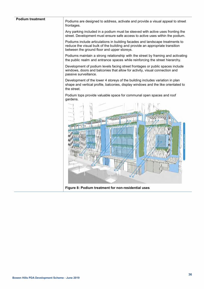
Podium treatment Podiums are designed to address, activate and provide a visual appeal to street frontages.
Any parking included in a podium must be sleeved with active uses fronting the street. Development must ensure safe access to active uses within the podium.
Podiums include articulations in building facades and landscape treatments to reduce the visual bulk of the building and provide an appropriate transition between the ground floor and upper storeys.
Podiums maintain a strong relationship with the street by framing and activating the public realm and entrance spaces while reinforcing the street hierarchy.
Development of podium levels facing street frontages or public spaces include windows, doors and balconies that allow for activity, visual connection and passive surveillance.
Development of the lower 4 storeys of the building includes variation in plan shape and vertical profile, balconies, display windows and the like orientated to the street.
Podium tops provide valuable space for communal open spaces and roof gardens.
Figure 8: Podium treatment for non-residential uses

37 Bowen Hills PDA Development Scheme - June 2019
Figure 9: Podium treatment for residential uses
Tower treatment Towers include articulations and varied design details to create visual appeal.
Residential towers include balconies and other external protrusions which separate the core from direct solar heating.
Balconies on towers are offset so that they maintain privacy of habitable rooms or outdoor spaces and provide visual variety and articulation in the built form.
Landscape Development provides consistent and cohesive landscape and streetscape treatments, including deep planted feature trees, seating and public art, that contributes to the area’s streetscape and urban character.
Public realm Mixed-use developments provide privately owned plazas and public spaces for social connectivity, meeting points and other temporary uses and displays.
Development addresses and provides passive surveillance of its interface with the street and other adjoining public spaces.
Streetscape treatments facilitate pedestrian and cycle amenity and safety.

38 Bowen Hills PDA Development Scheme - June 2019
2.6.4 Industrial zone
2.6.4.1 Preferred development intent Development provides for a range of industrial and commercial activities such as service industry, low impact industry, limited medium impact industry, warehouses and ancillary showrooms and small scale offices. Other uses that complement the intended industrial-commercial character of the locality may also occur, such as service station, shop (not exceeding 250m2 GFA) and indoor sport and recreation.
2.6.4.2 Built form provisions Maximum plot ratio 2 : 1
Maximum height provisions 4 storeys
Building envelope
Front setback 6m
Side setback Up to 2 storeys 0m
Above 2 storeys 4m
Rear setback 0m
Figure 10: Built form provisions - Industrial zone
Building form
Scale and bulk A maximum length of 30m on any one outer building wall on the street frontage.
A maximum wall length of 10m between building articulations.
Orientation Development is oriented to the street frontage.
Development on a corner lot is oriented to address both street frontages.
Lots are oriented so that buildings can be sited to maximise passive solar design, including generally east-west orientation lots along Abbotsford Road and north-south orientation along all other streets.
Site Cover Maximum site cover 75%, not including hardstand areas.
Fences Front fences or walls must be 50% visually permeable and no higher than 1.5m.
Rooftops Rooftops of large span buildings incorporate natural lighting fixtures.
Roofs are designed to ensure plant and equipment are screened or otherwise integrated with the overall roof design.
Varied roof forms are incorporated to contribute to the architectural distinction of the building.
Roof top areas can be utilised for employee recreation, solar energy, cool roof and green roof uses.
2.6.4.3 Urban design Building elements and appearance Buildings are to be well articulated with varied materials and design details,
signage, recessed doors and doorways, windows, shade and screening devices

39 Bowen Hills PDA Development Scheme - June 2019
and outdoor planting that provides a distinctively industrial-commercial appearance.
Building form allows for cross ventilation and supports a naturally ventilated and comfortable environment.
Landscape Development provides landscaped areas along a minimum length of 50% of street frontages.
Ground level treatment Ground level building elements are to introduce a variety of details and finishes.
Front entries to all buildings are to be emphasised through architectural and landscape treatment, pedestrian paths and awnings so as to be obvious without the need for signage and address requirements for active frontages.
Buildings incorporate appropriate weather protection, screening and shading structures on the building facades to channel breezes, filter sunlight and provide rain protection.
Buildings with a width of greater than 30m should be set back from both side boundaries in order to minimise the impact of a continuous built form along the street frontage.
Pedestrian generating uses including showroom and office components are located at the street frontage to provide visual interest to the street, create a more activated environment and promote in passive surveillance.
Buildings should be designed to address car parking areas with windows and entrances providing passive surveillance.
Public realm Development addresses and provides passive surveillance of its interface with the street and other adjoining public spaces.
Streetscape treatments facilitate pedestrian and cycle amenity and safety.

40 Bowen Hills PDA Development Scheme - June 2019
2.6.5 Mixed industry and business zone
2.6.5.1 Preferred development intent Development provides for a range of commercial, showroom, service industry, low impact industry and warehouse uses on large parcels of land in a business park environment. Uses are focused on knowledge creation and entrepreneurial activities along with complementary uses such as shop (not exceeding 250m2
GFA), food and drink outlet, short term accommodation and indoor sport and recreation.
2.6.5.2 Built form Maximum plot ratio 3 : 1
Minimum site area 800m2
Minimum frontage 20m
Maximum height provisions 8 storeys
Building envelope
Front setback Ground level 3m
Up to 4 storeys 0m
Above 4 storeys 6m
Side setback Up to 4 storeys 0m where podium car parking.
Otherwise 3m
Above 4 storeys 6m
Rear setback Up to 4 storeys 0m where podium car parking
Otherwise 6m
Above 4 storeys 9m
Figure 11: Built form provisions – Mixed industry and business zone
Building form Scale and bulk Any part of a building above the podium has a maximum site coverage of 60%, and a maximum horizontal dimension of 50m.
A maximum length of 30m on any one outer building wall on the street frontage.
A maximum wall length of 10m between building articulations.
Orientation Development is oriented to address Thompson Street and Murray Street frontages.
Development on a corner lot is oriented to address both street frontages.

41 Bowen Hills PDA Development Scheme - June 2019
Building separations Above 4 storeys:
i. minimum 12m separation distance between commercial buildings, or
ii. minimum 18m separation distance from any residential building.
Fences Front fences or walls must be 50% visually permeable and no higher than 1.5m.
Rooftops Roofs are designed to ensure plant and equipment are screened or otherwise integrated with the overall roof design.
Varied roof forms are incorporated to contribute to the architectural distinction of the building.
Roof top areas can be utilised for employee recreation, solar energy, cool roof and green roof uses.
Communal open space and facilities Development of provides universally accessible communal open space:
i. a minimum of 10% of the site area
ii. a minimum of 40m2, having a minimum dimension of 4m
iii. as a mix of ground level, vertically integrated or roof top settings
iv. respects the privacy of both users and those overlooking from neighbouring properties
v. includes landscape and deep planting shade trees or structures suited to the subtropical environment
vi. is positioned for good solar orientation and minimises water use, and
vii. does not include driveways, storage or turning areas.
2.6.5.3 Urban design Building elements and appearance
Development addresses the street with commercial showrooms, retail and industrial tenancies and well defined entries for pedestrians on the ground floor.
Buildings are to be well articulated with external facades treatments, varied material and design detail, balconies, recessed doors and doorways, windows, shade and screening devices and outdoor planting that provides a distinctively commercial appearance.
Buildings incorporate appropriate weather protection, screening, and shading structures on the building facades to channel breezes, filter sunlight and provide rain protection.
Ground level treatment Development along Thompson Street and Murray Street activates street frontages through a variety of measures, including varied design concepts and providing a high frequency of front entries or doors to commercial, industrial, retail, community and communal uses.
Front entries to all buildings active street frontages and are emphasised through architectural and landscape treatment, pedestrian paths and the provision of continuous awnings.
Pedestrian generating uses including showrooms and commercial uses, should be located at the street frontage to provide visual interest to the street, create a more pedestrianised scale and assist in passive surveillance of the public realm.
Buildings should be designed to address car parking areas with windows and entrances providing passive surveillance.

42 Bowen Hills PDA Development Scheme - June 2019
Podium treatment Podiums are designed to address, activate and provide a visual appeal to street frontages.
Podiums include articulations in building facades and landscape treatments to reduce the visual bulk of the building and provide an appropriate transition between the ground floor and upper storeys.
Podiums maintain a strong relationship with the street by framing and activating the public realm and entrance spaces while reinforcing the street hierarchy.
Podium tops provide valuable space for communal open spaces and roof gardens.
Tower treatment Towers include articulations and varied design details to create visual appeal.
Landscape Development provides on-site landscape and shade trees that contribute to the area’s streetscape and commercial character.
Development provides landscaped areas, areas, including deep planting, along a minimum length of 50% of street frontages.
Public realm Development contributes to an active and safe ground level public realm along Thompson Street and Murray Street.
Development addresses and provides passive surveillance of its interface with the street and other adjoining public spaces, including land along Breakfast Creek.
Streetscape treatments facilitate pedestrian and cycle amenity and safety.
Development provides good pedestrian linkages to Perry Park.

43 Bowen Hills PDA Development Scheme - June 2019
2.6.6 Sport and recreation zone
2.6.6.1 Preferred development intent Development provides large-scale premises for community facilities, sporting events and occasional recreation and entertainment activities and special events associated with public and community group gatherings, including venues for conferences, private functions, clubs, indoor and outdoor sport and recreation (this could also incorporate ancillary catering, administrative office functions and sale of merchandise and tickets). Development will consolidate formal sporting facilities within Perry Park and provide enhanced opportunities for more informal recreational facilities and accessible open space. Development for a complementary use directly related to the core functions of the Sport and recreation zone, including shop (not exceeding 250m2 GFA), food and drink outlet, office, health care services or telecommunications facility, may also be accommodated.
2.6.6.2 Built form Maximum height provisions 3 storeys
Building envelope
Setbacks Development is setback a minimum 3m from street frontages.
Site cover Sporting fields or open space areas equal approximately 70% of the total site area.
Any built structures comprise a small component of the total site and must be ancillary and directly associated with the primary use of the site for a major sport and recreation facility.
Building form
Scale and bulk A maximum length of 30m on any one outer building wall.
A maximum wall length of 10m between building articulations.
Orientation Development is oriented to the street frontage.
Sporting fields are orientated north-south where possible.
Pavilions and viewing areas are sited on the western side of the playing field to avoid spectators looking into the afternoon sun.
Public open space is located on street edges to maximise accessibility and safety.
Rooftops Roofs are designed to ensure plant and equipment are screened or otherwise integrated with the overall roof design.
Varied roof forms are incorporated to contribute to the architectural distinction of the building.
Roof top areas can be utilised for employee recreation, solar energy, cool roof and green roof uses.
Lighting Development provides outdoor lighting which is in compliance with:
i. AS 4282-1997 Control of the obtrusive effects of outdoor lighting
ii. AS 2560-2007 Sports lighting Part 2.3: Specific applications—Lighting for football (all codes), and
iii. AS/NZS 1158 Set: 2010 Lighting for streets and public spaces.

44 Bowen Hills PDA Development Scheme - June 2019
2.6.6.3 Urban design Building elements and appearance
Development provides distinctive form and appearance at the corner of Abbotsford Road and Folkestone Street and addresses both frontages.
Buildings are well articulated with external facades treatments, varied material and design detail, balconies, recessed doors and doorways, windows, shade and screening devices and outdoor planting to reduce the visual bulk of the building.
Development provides a well-defined entry point for pedestrians.
Building form allows for cross ventilation and supports a naturally ventilated and comfortable environment.
Buildings incorporate appropriate weather protection, screening and shading structures on the building facades to channel breezes, filter sunlight and provide rain protection.
As far as possible, shadows from buildings or evergreen tree canopy shall not encroach upon the playing field between the hours of 9.00am and 3.00pm, as determined by the winter solstice sun angle.
Ground level treatment Front entries to all buildings activate street frontages and are emphasised through architectural and landscape treatment, pedestrian paths and awnings to offer shelter and protection from the elements.
Pedestrian generating uses including showroom and office uses, should be located at the street frontage to provide visual interest to the street, create a more pedestrianised scale and assist in passive surveillance of the public realm.
Amenity Development does not impose unreasonable adverse amenity impacts on the surrounding residential area in terms of its location of buildings, vehicle access areas, lighting or operations.
Landscape Existing on-site vegetation (trees) is retained.
Development provides on-site landscape and shade trees that contributes to the area’s streetscape.
Development provides landscaped areas along a minimum length of 50% of street frontages.
Public realm Development contributes to an active and safe public realm by addressing the ground level along Edmonstone Road and Abbotsford Road.
Streetscape treatments facilitate pedestrian and cycle amenity and safety.
Development facilitates passive surveillance and provides good sightlines to publicly accessible areas such as car parks, pathways, public toilets and communal areas.
Development provides good pedestrian linkages to Perry Park.
Development includes way-finding cues and minimises predictable routes and entrapment locations near public spaces.

45 Bowen Hills PDA Development Scheme - June 2019
2.6.7 Open space zone
2.6.7.1 Preferred development intent Land in the open space zone caters for a full range of publicly accessible outdoor recreation, informal sport or events on a casual basis and the facilities and embellishments associated with these such as picnic amenities, playground, shade trees and landscaped areas. Physical structures within the Open space zone occupy only a small part of any site and may include pedestrian and cycle pathways, shelters, facilities for spectators, club buildings and associated off-street parking facilities. Development ensures that any buildings, structures and ancillary facilities support the primary intent of the zone for recreation and informal sporting uses and are compatible in scale, bulk, design and character of a park.
2.6.8 Special purpose (transport) zone
2.6.8.1 Preferred development intent Development provides for infrastructure, activities and associated facilities that support the effective functioning of the transport system including:
i. rail lines, stations and associated facilities ii. major road tunnels, bridges and intersections and infrastructure not otherwise included in a road
reserve. In addition to providing for this infrastructure, the zone caters for a range of activities and facilities for recreational and community purposes including pedestrian and cycle paths, landscaped areas and incidental open space. Opportunities for building over infrastructure within the Special purpose (transport) zone are facilitated, where compliance with the provisions of the zone immediately adjoining the Special purpose (transport) zone can be demonstrated.
2.6.8.2 Development provisions Development does not unreasonably constrain the future provision of public transport infrastructure (including rail, light rail, road, busway and cycle infrastructure) and does not adversely impact on the function or operation of existing or future public transport corridors including rail, light rail or busway corridors. Where building over infrastructure is proposed, appropriate clearances must be maintained to ensure the safety of the operation of both the infrastructure and development.
Development may provide opportunities for building over infrastructure corridors and providing air rights above these corridors. Development that integrates with the Bowen Hills Railway Station must provide substantial improvements to the station itself, station access and the station’s interface with the public realm.
Development may experience a reduced level of amenity due to emissions (e.g. vibration, noise, light and odour) from the transport infrastructure within in the zone, including the ICB, rail lines, Clem Jones Tunnel (including ventilation outlet), Airport Link and arterial roads. Development that would be sensitive to these impacts is designed, sited and constructed to achieve acceptable levels of amenity.

46 Bowen Hills PDA Development Scheme - June 2019
2.6.9 Specialised centre (entertainment) zone
2.6.9.1 Preferred development intent Development supports the use of the Old Museum and Brisbane Showgrounds, providing areas and large-format facilities for library, museum or gallery, exhibition, event, festival, concert, conference, showground, public or community group gatherings, indoor and outdoor sport and recreation, private functions, trade exhibitions and displays, plus ancillary office, catering, light refreshments and sale of merchandise. Other uses that complement the core functions of the Old Museum and Brisbane Showgrounds, including short term accommodation, shop (not exceeding 250m2 GFA), food and drink outlet, office, health care services or telecommunications facility, may also be accommodated. Development builds upon the long standing historic role of the Old Museum and the Brisbane Showgrounds in their contribution to the overall character and identity of Bowen Hills. Outside the times of year that the Royal Queensland Show operates, the Brisbane Showgrounds is used as an events and exhibition precinct. It is also used to provide car parking for Royal Brisbane and Women’s Hospital employees. Development provides enhanced pedestrian permeability through the sites acting as a connector between surrounding development and the Royal Brisbane and Women’s Hospital, the Exhibition Railway Station and Fortitude Valley. The heritage values of individual sites and the zone as a whole are protected and enhanced.
2.6.9.2 Built form Maximum height provisions 5 storeys
Scale and bulk Development:
i. ensures that all buildings, structures and ancillary facilities support the preferred development intent of the zone and are compatible in scale, bulk, design and character with the surrounding area
ii. is strategically and logically located on site incorporating a range of heights and materials that are highly characteristic of the site’s location and identity, and
iii. improves aesthetics and local amenity of the surrounding public realm.
2.6.9.3 Urban design Building elements and appearance
Development retains or adapts the heritage, character, cultural features and history of the site and surrounding area. New buildings and works adjacent to retained and adapted heritage buildings, spaces and elements will have an appropriate interface respecting their heritage significance.
Where the Brisbane Showgrounds interface with the Old Queensland Museum the detailed design of the buildings and works will create a positive visual and functional relationship.
Development maintains the presence, legibility and sense of entry to the Brisbane Showgrounds.
Development promotes safety and minimises opportunities for graffiti and vandalism through exterior building design, orientation of buildings and the use of active frontages.
Development provides outdoor lighting which is in compliance with:
i. AS 4282-1997 Control of the obtrusive effects of outdoor lighting
ii. AS 2560-2007 Sports lighting Part 2.3: Specific applications—Lighting for football (all codes), and
iii. AS/NZS 1158 Set: 2010 Lighting for roads and public spaces.

47 Bowen Hills PDA Development Scheme - June 2019
The built form is supported by legible and permeable circulation networks which build and enhance the existing patterns and fabric of the site, including the EKKA walk which meanders through the site as the primary pedestrian circulation route.
Amenity Development does not impose unreasonable adverse amenity impacts on the surrounding residential area in terms of its location of buildings, vehicle access areas, lighting or operational matters.
Development ensures that the views and vistas of important places, spaces and buildings are retained and enhanced.
Landscape Existing on-site vegetation (trees) is retained.
Development provides on-site landscape and shade trees and vertical greenery that provides shading and local cooling, contributes to the area’s streetscape and creates opportunities for relaxation and recreation.
Public realm Development must contribute to a vibrant and safe public realm by activating the street at the ground level for extended hours of the day, where possible. This is particularly important during those times of the year when the annual EKKA event does not operate.
Streetscape treatments facilitate pedestrian and cycle amenity and safety.
Development facilitates passive surveillance and provides good sightlines to publicly accessible areas such as car parks, pathways, public toilets and communal areas.
Development provides good pedestrian linkages throughout the Brisbane Showgrounds.
Development includes way-finding cues and minimises predictable routes and entrapment locations near public spaces.
Development promotes legible active pedestrian entrances, minimising the number and size of vehicle access points and using appropriate street treatments.

48 Bowen Hills PDA Development Scheme - June 2019
2.6.10 Categories of development for zones The following categories of development apply to all development within the PDA. Table 2: Categories of development
Column 1 – PDA accepted development Column 2 – PDA assessable development Column 2A - Permissible development Column 2B - Prohibited
development
All development specified in Schedule 2.
Material change of use for a home-based business if complying with all acceptable outcomes in Brisbane City Council’s home-based business code.
Material change of use, where a change of an existing premises, for an Appropriate use for a zone listed in Table 2A column 1, where:
• not involving building work (other than minor building or demolition work) • not on a heritage place, and • not a sensitive use located on property that is identified on:
o Brisbane City Plan Waterways corridor overlay map o Brisbane City Plan Coastal hazard overlay map o Brisbane City Plan Flood overlay map o Brisbane City Plan Industrial amenity overlay map, or o Map 5 Point source pollutants.
All development (other than development specified as PDA accepted development or Prohibited development) carried out on a heritage place, or a premises adjoining a heritage place.
All other development not specified as PDA accepted development or PDA assessable development - Prohibited development.
Material change of use for:
• extractive industry • high impact industry47 • relocatable home park • special industry • tourist park Material change of use for a prohibited use for a zone listed in Table 2A column 2.
Table 2A: Appropriate and prohibited uses for particular zones
Column 1 - Appropriate uses Column 2 - Prohibited uses Medium density residential zone Appropriate uses: • caretaker’s accommodation • community facilities • community residence • dual occupancy • dwelling house • multiple dwelling • retirement facility • short-term accommodation
Prohibited uses: • adult store • low impact industry • medium impact industry • shopping centre • showroom • transport depot • warehouse
High density residential zone Appropriate uses: • caretaker’s accommodation • community facilities • community residence • dual occupancy • dwelling house • multiple dwelling • retirement facility • short-term accommodation
Prohibited uses: • adult store • low impact industry • medium impact industry • shopping centre • showroom • transport depot • warehouse
Mixed use zone Appropriate uses: • caretaker’s accommodation • community residence • dual occupancy • dwelling house • food and drink outlet where located at ground level and not exceeding 250m2
of GFA per tenancy • indoor sport and recreation • multiple dwelling • office • retirement facility • research and technology industry where located at ground level and not
exceeding 250m2 of GFA per tenancy • rooming accommodation • service industry not exceeding 250m2 of GFA per tenancy • shop where located at ground level and not exceeding 250m2 of GFA per
tenancy • short-term accommodation
Prohibited uses: • medium impact industry • transport depot • warehouse
Industrial zone Appropriate uses: • food and drink outlet where located at ground level and not exceeding 250m2
of GFA per tenancy • low impact industry and service industry • office • research and technology industry • shop where located at ground level and not exceeding 250m2 of GFA per
tenancy • showroom • warehouse
Prohibited uses: • accommodation activities • child care centre • shopping centre (>500m2)
Column 1 – Appropriate use Column 2 - Prohibited uses 47 Except for fuel burning for power generation with an installed capacity of more than 0.1 MW, if:
i. less than 10 MW, and
ii. not involving coal combustion.

49 Bowen Hills PDA Development Scheme - June 2019
Mixed industry and business zone Appropriate uses: • food and drink outlet where located at ground level and not exceeding 250m2
of GFA per tenancy • low impact industry • office • research and technology industry • service industry • shop where located at ground level and not exceeding 250m2 of GFA per
tenancy • showroom • warehouse
Prohibited uses: • accommodation activities except:
o caretakers accommodation (<70m2) o dwelling unit (<70m2) o short term accommodation
• shopping centre (>500m2)
Sport and recreation zone Appropriate uses: • Club • Community use • Indoor sport and recreation • Outdoor sport and recreation • Park where not provided by public sector entity • shop where located at ground level and not exceeding 250m2 of GFA per
tenancy
Prohibited uses: • adult store • accommodation activities • low impact industry • medium impact industry • shopping centre (>500m2) • showroom • transport depot • warehouse
Open space zone Appropriate uses: • club • community use • park where not provided by public sector entity
Prohibited uses: • accommodation activities • business activities • low impact industry • medium impact industry • transport depot • warehouse
Special purpose (transport) zone Nil Prohibited uses:
• low impact industry • medium impact industry • transport depot • warehouse
Specialised centre (entertainment) zone Appropriate uses: • community use • indoor sport and recreation • office • outdoor sport and recreation • park where not provided by public sector entity • shop where located at ground level and not exceeding 250m2 of GFA per
tenancy
Prohibited uses: • shopping centre (>500m2) • medium impact industry • warehouse

50 Bowen Hills PDA Development Scheme - June 2019
2.7 Precinct provisions Select land in the Bowen Hills PDA is included in a precinct. The boundaries of precincts are shown on Map 7. As applicable, development is required to meet and will be assessed against the provisions for each precinct as detailed below. Precinct provisions prevail where there is a conflict with a Zone provision.

51 Bowen Hills PDA Development Scheme - June 2019
Map 7: Precinct boundaries

52 Bowen Hills PDA Development Scheme - June 2019
2.7.1 Precinct 1 Planned outcomes for Precinct 1 are shown on map 8 and detailed below. Precinct 1 includes all land located in the area bound by Abbotsford Road, Markwell Street, St Pauls Terrace, Brookes Street, O’Connell Terrace, Tufton Street and the Inner City Bypass.
Preferred development intent
Development incorporates active frontages along Mayne Road and Hudd Street delivering a mix of retail, commercial and community uses along the ground plane.
Development adjoining the Bowen Hills Railway Station provides new access points and improved connectivity and integration with the station.
Built form Shop frontages, articulated building access points and continuous awnings over the footpath activate the ground plane of Hudd Street and Mayne Road, which form major activity spines and become the focus of retail shopping and social life.
Showroom windows address the northern side of the Airport Link ramp to Campbell Street presenting the retail character of the area to passing vehicles.
Large floor plate retail is sleeved by small scale (i.e. less than 250m2) shops, food and drink outlets, community uses and other similar uses, which will activate the precinct day and night.
Buildings are able to span across the railway corridor creating opportunities for additional development, public plazas and a new access to the Bowen Hills Railway Station. Any development within, over or under a rail station or corridor must protect the station and corridor’s function and operation.
Urban design Attractive streetscape treatments including awnings over wide footpaths, street furniture, pavement treatments, parallel on-street parking, public art installations and landscaped verges are established along Mayne Road and Hudd Street, contributing to their setting as community and economic focal points for the PDA.
Landscaped verges, street furniture, public art installations and pavement treatments are established at Streetscape treatment locations identified on map 8.
Retail tenancies have a visible presence and interaction with the street and open on to the park at the intersection of Mayne Road and Hudd Street.
Parks are developed as attractive community focal points with spaces and facilities for recreation, pathways, landscape and park furniture.
Ground level building and landscape design contributes to the identification of Bowen Hills as a distinct destination at Significant corner locations.
Infrastructure Parks and plazas
A new park is located on the southern side of the Mayne Road and Hudd Street intersection. The park collocates with activated retail frontages, cycling routes and streetscape treatments along Mayne Road and Hudd Street.
Parks are located at Jeays Street and Hurworth Street.
A major new civic plaza west of Mayne Road will deliver a multi-purpose community and cultural hub providing space for social interaction, community and group activities, information, art and cultural activities and events.
Community facility
Development provides a multi-purpose community hub within proximity of the Bowen Hills Railway Station.
Community facilities are provided as an integrated component of mixed-use developments.
Community facilities are accessed directly from street frontages and are clearly signed and identifiable to visitors.
53 Bowen Hills PDA Development Scheme - June 2019
Connectivity Development provides publicly accessible cross block links providing pedestrian connection:
i. between Brookes Street and the Jeays Street park
ii. between Mayne Road and the Tufton Street extension
iii. to the Bowen Hills railway station from Abbotsford Road
iv. between Hudd Street and Edgar Street, and
v. between Mayne Road and Edgar Street.
The precinct will accommodate a new local street network which will include:
i. widening of Mayne Road (western side) to accommodate vehicular and cycle traffic
ii. widening of Hudd Street (southern side) to accommodate vehicular traffic
iii. a two way vehicle and pedestrian bridge spanning the railway corridor between Hudd Street and Abbotsford Road, providing improved connectivity across the railway corridor
iv. a new street linking Hudd Street and Mayne Road through to O'Connell Terrace, via Tufton Street. This street will be a principal means of access into the precinct from the area south of Campbell Street
v. Hazelmount Street extended through to Hudd Street
vi. Edgar Street extended through to Mayne Road
vii. Closure of Jamison Street between Hudd Street and Edgar Street48, and
viii. cycle infrastructure that provides safe and efficient cycle connection through the precinct.
Public transport
Development is coordinated to provide:
i. pedestrian concourse delivering safe and improved access to the Bowen Hills Railway Station between Hudd Street and Abbotsford Road
ii. upgrades to the Bowen Hills Railway Station including improved platform access and potential corridor widening, and
iii. a rail and bus interchange is located adjacent to the Bowen Hills Railway Station on Abbotsford Road.
48 The closure of Jamison Street will occur, fully or in part, when the bridge spanning the railway corridor between Hudd Street and Abbotsford Road is constructed. This closure occurs due to a difference in road levels when the bridge is constructed, resulting in Jamison Street no longer being connected to Hudd Street.

54 Bowen Hills PDA Development Scheme - June 2019
Map 8: Precinct 1 plan

55 Bowen Hills PDA Development Scheme - June 2019
2.7.2 Precinct 2 Planned outcomes for Precinct 2 are shown on map 9 and detailed below. Precinct 2 includes all land located in the area bound by O’Connell Terrace, Brookes Street, St Pauls Terrace, Costin Street, Water Street and Bowen Bridge Road.
Preferred development intent
Development of active frontages along the ground plane of King Street, O’Connell Terrace and Brookes Street delivers a mix of retail, commercial and community uses.
Built form Shop frontages, articulated building access points and continuous awnings over the footpath activates the ground plane of King Street, O’Connell Terrace and Brookes Street.
Large floor plate retail is sleeved by small scale (i.e. less than 250m2) shops, food and drink outlets, community uses and other similar uses, which will activate the precinct day and night.
Development adjoining Bowen Park and the Old Queensland Museum must respect their heritage values and be designed and oriented to enhance their amenity, safety, activation and surveillance.
Increased building heights can be considered for new buildings on the northern boundary of the Old Museum site, where being developed as part of an overarching rehabilitation and renewal of the State heritage place by the state, or an entity acting for the state.
Development along O’Connell Terrace, Brookes Street and Exhibition Street must address both street frontages and publicly accessibly spaces within the Brisbane Showgrounds.
Innovative building design contributes to the identification of Bowen Hills at major entrance points to the precinct, including at the southern side of the intersection of Brunswick Street and Gregory Terrace and the intersection of Brookes Street and O’Connell Terrace.
Development along the southern side of O’Connell Terrace provides a 4m setback on the ground floor to provide space for pedestrian movement, outdoor dining, retail display and embellishments such as landscape treatment and public art installations which improve amenity and activate the ground plane.
Urban design Attractive streetscape treatments including awnings over wide footpaths, street furniture, pavement treatments, parallel on-street parking, public art installations, landscaped verges are established along King Street and O’Connell Terrace contributing to their setting as community and economic focal points.
Landscaped verges, street furniture, public art installations and pavement treatments are established at Streetscape treatment locations identified on map 9.
Ground level building and landscape design contributes to the identification of Bowen Hills as a distinct destination at significant corner locations.
Important views and vistas to and from the Old Museum and Brisbane Showgrounds will be maintained including:
i. to Show Ring 2 & John Macdonald Stand from Bowen Park and Royal Brisbane Women’s Hospital
ii. into Side Show Alley from Bowen Bridge Road
iii. Gregory Terrace Streetscape views towards Show Ring 1 (north)
iv. Gregory Terrace Streetscape Views Towards Show Ring 1 (South)
v. along Alexandria Street Towards Show Ring 1 and John Macdonald Stand, and
vi. to Stockagents Building from Stockman’s Rest.
Infrastructure Parks and plazas
Open spaces located within the Brisbane Showgrounds are publicly accessible during non-event periods.
Civic plazas provide space for social interaction, community and group activities, information, art and cultural activities and events at:
i. the Brisbane Showgrounds between the Exhibition Railway Station and Gregory Terrace, and
ii. between Diggles Close and Bowen Bridge Road.

56 Bowen Hills PDA Development Scheme - June 2019
Connectivity Development provides publicly accessible cross block links providing pedestrian connections:
i. through the Brisbane Showgrounds between O’Connell Terrace and Gregory Terrace
ii. through the Brisbane Showgrounds between Exhibition Railway Station and Bowen Bridge Road
iii. between King street and Alexandria Street
iv. between Anderson Street and Costin Street near and linking to Carriage Street
v. between Water Street and Gregory Terrace, and
vi. between Diggles Close and Bowen Bridge Road.
The precinct will accommodate key upgrades to the street network as follows:
i. widening of O’Connell Terrace to accommodate two lanes of vehicular traffic and separated cycle way, and
ii. widening of Brookes Street to accommodate upgraded footpaths, separated cycle way.
New controlled intersections at:
i. Tufton Street and O’Connell Terrace, and
ii. King Street and St Pauls Terrace.
Public transport
Upgrades to the Exhibition Railway Station and associated railway corridor are delivered as part of the Cross River Rail project.
Access to Exhibition Railway Station will be clearly signed and identifiable to visitors on O’Connell Terrace, Gregory Terrace, Brookes Street and Bowen Bridge Road.
A bus stop is located adjacent to the Exhibition Railway Station access point on O’Connell Terrace. Providing a rail and bus interchange function.
Upgrades to the Exhibition Railway Station include improved platform access for pedestrian movements to the Old Museum.

57 Bowen Hills PDA Development Scheme - June 2019
Map 9: Precinct 2 plan
58 Bowen Hills PDA Development Scheme - June 2019
3 Infrastructure plan 3.1 Purpose The purpose of this Infrastructure plan is to ensure that the vision is achieved through:
i. integrating infrastructure planning with land use planning identified in this development scheme ii. identifying the infrastructure requirements to be delivered by the local government, state
government, water supply and sewer provider or developers, and iii. providing a basis for imposing conditions on development approvals responding to the increased
demand on the relevant infrastructure networks. The infrastructure plan supplements the outcomes sought by the land use plan. It does not regulate development. The MEDQ may adopt an alternative approach to that outlined in the infrastructure plan where it is appropriate and reasonable to do so.
3.2 Infrastructure networks The following infrastructure networks require additional infrastructure provision or upgrades to support growth in the PDA:
i. transport (roads, intersections, pedestrian and cycle paths) ii. public realm iii. community facilities iv. stormwater (quantity and quality) v. water supply vi. sewerage.
Table 3 below identifies key infrastructure that will be provided to enable the Vision to be delivered.
3.3 Infrastructure categories The infrastructure planned to be delivered within the PDA will fall into one of the following categories:
i. trunk infrastructure ii. non-trunk infrastructure iii. other infrastructure.
Table 3 includes infrastructure which is trunk infrastructure, non-trunk infrastructure and other infrastructure. As such, the inclusion of infrastructure in table 3 does not make it eligible for an infrastructure charges offset. To determine if infrastructure is eligible for an offset, refer to the Development Charges and Offset Plan (DCOP).
3.3.1 Trunk infrastructure Trunk infrastructure is the high order shared infrastructure that is planned to service the wider catchments in the PDA, rather than individual development sites. Trunk infrastructure may be delivered by the relevant infrastructure provider such as Brisbane City Council, Queensland Urban Utilities (QUU) or EDQ, or by developers if required by a condition of a PDA development approval.
3.3.2 Non-trunk infrastructure Non-trunk infrastructure is the lower order infrastructure which generally services a single development site, is internal to a development site, or connects the development site to trunk infrastructure. Non-trunk infrastructure will be provided by the applicant, in accordance with the relevant responsible entity’s requirements and as specified in a condition of a PDA development approval. Non-trunk infrastructure will not be eligible for a charges offset.

59 Bowen Hills PDA Development Scheme - June 2019
3.3.3 Other infrastructure Other infrastructure includes infrastructure which is not part of Brisbane City Council or QUU’s infrastructure networks. Other infrastructure may include necessary development infrastructure or provision for upgrades to the electricity, gas, telecommunications or state transport networks. Other infrastructure may be delivered by the local or state government, other infrastructure providers or by developers who may be required to deliver or preserve the ability to provide this infrastructure by a condition of a PDA development approval. Table 3: Infrastructure catalogue for the Bowen Hills PDA
Infrastructure category
Details
Transport Streets, intersections and active transport
As required to service the PDA and may include upgrades to: • Abbotsford Road –street improvements and active transport improvements • Brookes Street – street improvements and active transport improvements • Brookes Street, Hamilton Place and O’Connell Terrace – intersection works • Burrows Street – street improvements and active transport improvements • Campbell Street – street improvements • Campbell Street and Hazelmount Street – intersection works • Campbell Street and Hurworth Street – intersection works • Carriage Way – street improvement • Edgar Street – Edgar Street extended through to Mayne Road • Edmonstone Road – street improvements and active transport improvements • Exhibition Street – street improvements • Hamilton Place – street improvements and active transport improvements • Hazelmount Street - street improvements and extension of street to Hudd Street • Tufton Street – street improvements and active transport infrastructure • New Street – new street linking Hudd Street and Mayne Road through to
O'Connell Terrace, via Tufton Street • Hudd Street – street improvements • Hudd Street bridge – vehicle and pedestrian bridge spanning the railway corridor • Machinery Street – new street • Mayne Road – street improvements and active transport improvements • Mayne Road and Edgar Street – intersection works • O'Connell Terrace – street improvements and active transport improvements • Thompson Street – street improvements and active transport improvements • Thompson Street and Murray Street – intersection works • Thompson Street and Edmonstone Road – intersection works • Gregory Terrace and Brookes Street – intersection works • St Pauls Terrace and Constance Street – intersection works • King Street and St Pauls Terrace – intersection works • Costin Street and Gregory Terrace – intersection works • Costin Street – street improvements • Gregory Terrace – street improvements • St Pauls Terrace – street improvements.
In addition to the items listed above, all other streets in the Bowen Hills PDA may require upgrades, improvements or widening to deliver the carriageway, parking or verge width specifications for its functional design.

60 Bowen Hills PDA Development Scheme - June 2019
Infrastructure category
Details
Public transport As required to service the PDA and may include: • widening of railway corridors • upgrades to the Bowen Hills Railway Station including improved platform access,
potential corridor widening and pedestrian concourse delivering safe and improved access to the Bowen Hills Railway Station between Hudd Street and Abbotsford Road
• upgrades to the Exhibition Railway Station and associated railway corridor delivered as part of the Cross River Rail project
• a new rail and bus interchange to service the Exhibition Railway Station • a new rail and bus interchange on Abbotsford Road to service the Bowen Hills
Railway Station. Parks, public realm and community facility Parks As required to manage the impacts of development within the PDA and may include:
• Jeays Street Park improvements • Perry Park improvements • Hurworth Street Park improvements • Alexandria Street Park improvements • a new park on Mayne Road.
Public realm As required to manage the impacts of development within the PDA and may include: • streetscape improvements on Hudd Street • streetscape improvements on Mayne Road • streetscape treatments on O'Connell Terrace • landscape and pavement treatments on Gregory Terrace.
Community facilities As required to manage the impacts of development within the PDA and may include: • a branch library • a pedestrian concourse adjacent to the railway corridor near the Bowen Hills
Railway Station • a multi-purpose community hub.
Stormwater Detention and treatment
As required to manage the impacts of the PDA.
Water supply and sewer Potable water As required to service the PDA and may include augmentations to:
• internal water supply reticulation • main at Campbell Street • main at Montpelier Road • main at Jordan Terrace • main at Herston Road • main at Gregory Terrace.
Sewer As required to service the PDA and may include augmentations to: • Bowen Hills by-pass – main to by-pass upstream flows to the S1 tunnel • gravity main at Brookes Street • gravity main at St Pauls Terrace between Brookes Street and King Street • gravity main at Markwell Street • local trunk sewer to connect to the Best Street odour facility and S1 tunnel
(Markwell Street catchment) • gravity main at Water Street • gravity main at Thompson Street.
Electricity and Electrical network As required to service the PDA. Telecommunications Telecommunications network
As required to service the PDA.

61 Bowen Hills PDA Development Scheme - June 2019
3.4 Infrastructure charges, funding and conditions Trunk infrastructure identified as necessary to service the PDA is included in the DCOP which sets out the following:
i. development charges for the provision of trunk infrastructure ii. trunk infrastructure plans and schedules of works identifying trunk infrastructure for which an offset
against infrastructure charges shall be available, and iii. matters relevant to calculating an offset or refund for the provision of trunk infrastructure.
The requirement to pay development charges set out in the DCOP, or to deliver the trunk infrastructure identified in the DCOP, will be through a condition of a PDA development approval. Infrastructure may be required to be delivered in accordance with a detailed Infrastructure Master Plan that is prepared to support a development application or required by condition. The infrastructure identified in table 3 will be funded from a combination of development charges and other revenue sources. State infrastructure funding may be provided through Federal Government grants. State expenditure on trunk infrastructure will be subject to consideration through normal state budgetary processes and will be part of an approved state agency capital works program. Not all the works identified in table 3 will be delivered through conditions of approval. Some infrastructure may be delivered by other entities such as local government, state government or other infrastructure providers. The infrastructure identified in table 3 reflect current understanding at the time of publication. However, further detailed infrastructure investigations will occur as development progresses. Infrastructure requirements and delivery responsibilities will be reviewed and may be amended over time to reflect the outcomes of these investigations and changing circumstances. Infrastructure requirements established in the conditions of a PDA development approval must be delivered at the time of development occurring unless otherwise agreed with EDQ.
3.5 Infrastructure agreements An infrastructure agreement may be negotiated and entered into with MEDQ and other relevant infrastructure providers to address the provisions and requirements of the infrastructure plan.
To the extent an infrastructure agreement is inconsistent with a PDA development approval, the infrastructure agreement prevails49.
3.6 Infrastructure standards Infrastructure will be delivered in accordance with the standards of EDQ50 or the applicable local or state government, or relevant infrastructure providers at the time a PDA development application or Infrastructure Master Plan is approved.
49 See section 120 of the ED Act. 50 Refer to the Bowen Hills PDA Infrastructure Planning Background Report.
62 Bowen Hills PDA Development Scheme - June 2019
4 Implementation strategy The ED Act51 requires a development scheme to include an implementation strategy to ‘achieve the main purposes of the ED Act for this area, to the extent that they are not achieved by the Land use plan or the plan for infrastructure’. The Implementation strategy for the development scheme fulfils this requirement by identifying a suite of actions that support the achievement of the Vision and support the delivery of economic development and development for community purposes within the PDA. The Implementation strategy includes projects and actions that may require involvement from a range of stakeholders including private interests and departments from across various levels of government.
4.1 Place management Objective
Manage the progressive renewal of private and state government land and enabling infrastructure and services within the Bowen Hills PDA.
Actions
i. Plan making – Economic Development Queensland is the delegated planning authority for the Bowen Hills PDA and has prepared the development scheme and Development Charges Offset Plan which establishes the land use and infrastructure plans regulatory instruments to manage growth and development.
ii. Development assessment – Economic Development Queensland is the delegated development assessment authority for the Bowen Hills PDA and is responsible for the assessment and approval of new development proposals in the PDA.
iii. Infrastructure delivery – Economic Development Queensland will progressively fund and deliver new infrastructure and upgrades to existing infrastructure to catalyse investment in property development and business enterprise.
4.2 Urban design and public realm Objective
Oversee the design, form, type and arrangement of buildings, streets and the public realm to enhance the appearance and contribute to the creation of place.
Actions
i. Development assessment process – develop and operate a virtual 3D analytical model of the Bowen Hills PDA including detailed representations of existing and approved built form. In consultation with applicants, the assessment manager may request the provision of a 3D model in a specified compatible format which can be used to assist in the assessment and communication of proposals. Specific analytics could include built form impacts upon building separations, privacy, view sheds, overshadowing and Crime Prevention through Environmental Design.
ii. Design Review Panel – utilise members of the Design Review Panel during the pre-application and assessment processes to provide assessment managers and applicants qualified professional expert advice in landscape, architecture, development, engineering, heritage and urban design matters.
51 See section 57 of the ED Act.

63 Bowen Hills PDA Development Scheme - June 2019
iii. Public realm – EDQ will seek to establish partnerships with Brisbane City Council and developers to establish and deliver a programme of public realm upgrades at identified streetscape treatment locations identified on maps 8 and 9.
4.3 Connectivity Objective
Facilitate the delivery of streets, pathways and public spaces in Bowen Hills which provide permeability and connectivity to destinations within and surrounding the PDA.
Actions
i. Infrastructure planning – ensure that the opportunity for the PDA to host a Cross River Rail or alternate subway system station is not compromised in the development of the area.
ii. Infrastructure delivery – EDQ will seek to establish partnerships with Brisbane City Council to facilitate the timely delivery of planned street, pedestrian and cycling infrastructure.
iii. Infrastructure delivery – work with the Department of Transport and Main Roads, Translink and Queensland Rail to facilitate the timely delivery of planned public transport infrastructure and services.
iv. Development assessment process – where necessary, land required for infrastructure will be secured through conditions of approval.
v. Cross block links – EDQ will seek to facilitate the delivery of cross block links as part of an integrated design solution for suitably sized developments proximate to the locations identified in the precinct plans.
4.4 Housing diversity Objective
Facilitate the delivery of a broad range of accommodation choices to suit a variety of households that support a socially diverse community in the Bowen Hills PDA. Facilitate the delivery of housing that provides universal design and variety in size, configuration, cost, adaptability and tenure. Actions
i. Information – EDQ will develop, manage, monitor and report on a database of existing, approved and proposed dwellings within the Bowen Hills PDA. The database will hold information on the number of dwellings and number of bedrooms that profile existing housing and future pipeline supply. This information should be used by government, the development industry and the community to inform decisions which may lead to greater housing diversity.
ii. Incentives – examine options that incentivise the delivery of social housing, community housing, affordable housing, innovative housing concepts and 3+ bedroom dwellings.
iii. Affordable housing – EDQ is seeking to maximise affordable housing outcomes in the PDA over the long term. Affordable housing product delivered through a PDA development approval can be supported with mechanisms to ensure product is not resold at market rates and it remains affordable rental product to the target group for a significant period of time. There are a number of ways of achieving this outcome:
• Formal agreements may be made with either the Department of Housing and Public Works or a registered community housing organisation.
• Establishment of a shared equity arrangement with an approved equity partner.

64 Bowen Hills PDA Development Scheme - June 2019
• Limiting the trading of a dwelling to a particular target and income group through a title covenant. This means that affordable owner occupied units are only on-sold to other eligible buyers, with transfer of ownership occurring through a controlled process which excludes wills, private sales or bequests.
• Placing a covenant and management plan on the title of a property which ensures it is rented at affordable levels of rent to an identified target group for 15 years or more and managed by a registered community housing organisation.
• The preferred mechanism will be determined on a project by project basis between EDQ and the development proponent at the time of development approval and will be set out in the development agreement.
4.5 Sustainability Objective
Support the quality, diversity and productivity of social, ecological and economic systems in the Bowen Hills PDA.
Actions i. Infrastructure Delivery – facilitate the delivery of community facilities identified in the DCOP that will
provide spaces for residents and visitors to meet, access services and participate in social and cultural activities.
ii. Infrastructure Delivery – facilitate the delivery of infrastructure identified in the DCOP that will support future private sector investment in property development and business enterprise.
iii. Service delivery – maintain working relationships with service providers to identify and, where possible, support the delivery of projects and programs that cater to community needs.
iv. Electric vehicles – development provides parking spaces and facilities to support the charging of electric vehicles. This can include providing wiring dedicated AC circuits to parking spaces during construction and terminating with a standard General Purpose Outlet which can be readily replaced with a dedicated electric vehicle charger at a later date.
v. Expenditure – EDQ to utilise funds collected from the uplift of land value component on projects within the PDA that support ecological sustainability.
vi. Information – establishment of a close working relationship with tertiary institutions and private industry to identify projects demonstrating ecological sustainable outcomes to be instituted in the PDA.
vii. Information – documentation and promotion of examples of ecological sustainability developed within the PDA.
viii. Information – preparation of additional guidelines to promote and facilitate incorporation of ecological sustainable principles in projects within the PDA.
ix. Sustainable buildings – compliance with the Star rating (or equivalent rating system) criteria will generally be demonstrated by a Design certified rating to be provided at the time of assessment and an As Built certified rating to be provided upon completion as a condition of development.
4.6 Infrastructure planning and delivery Objective
Facilitate the delivery of all necessary urban infrastructures required to support ongoing community growth and development.

65 Bowen Hills PDA Development Scheme - June 2019
Actions i. Infrastructure delivery – EDQ will seek to form partnerships with other state government entities,
Brisbane City Council, Queensland Urban Utilities and Energex to invest in the delivery of state and trunk infrastructure network items where they are required to facilitate ongoing investment and economic development in the PDA.
ii. Infrastructure delivery – Energex to be notified of any works occurring within an electricity easement.
iii. Financing – trunk infrastructure will be financed through the collection of infrastructure charges. Investment facilitating the delivery of trunk infrastructure may be subject to coordinated decisions across private interests and various levels of government. The prioritisation and feasibility of trunk infrastructure delivery will be determined on a case-by-case basis at the time they are proposed for commencement.
iv. Partnerships – Community Hubs and Partnerships, Department of State Development, Manufacturing, Infrastructure and Planning to facilitate collaboration across agencies to analyse requirements for comprehensive social services provision in the PDA and surrounding networks to identify opportunities for innovation, co-location and integration of state and local government community facilities. A whole-of-life approach to social service provision, encompassing health, education, child and family and sport and recreation services will be taken to contribute to the vision for the PDA and the development of an engaged, healthy and active community.
4.7 Conservation and adaptive re-use of heritage buildings and places
Objective
The adaptive re-use of heritage places within the PDA will continue to promote the rich history and unique identity of Bowen Hills. Actions
i. Respond to the cultural significance of the place in accordance with the principles of the Burra Charter52 and Department of Environment and Science Guideline: Developing Heritage Places.
ii. Implement conservation management plans to manage the construction and operational impacts on heritage places, and to provide guidance for their ongoing care and maintenance 53.
iii. EDQ will consult with the Department of Environment and Science and the Queensland Heritage Council to obtain advice regarding all significant heritage matters for development on or adjacent to State heritage places.
iv. EDQ will consult with Brisbane City Council to obtain advice regarding all significant heritage matters for development on or adjacent to local heritage places.
v. Ensure Department of Environment and Science are notified of any archaeological artefacts discovered during site works and relevant requirements are met in accordance with the provisions of the Queensland Heritage Act 1992.
52 The Australian International Council on Monuments and Sites Burra Charter: The Australia ICOMOS Charter for Places of Cultural Significance 2013 document as amended and replaced from time to time. 53 Development demonstrates practical conformance with the requirements, standards and guidance identified in the Department of Environment and Science Guideline: Conservation Management Plans document, as amended and replaced from time to time. A conservation management plan may be required as a condition of a PDA development approval.

66 Bowen Hills PDA Development Scheme - June 2019
vi. In those circumstances where approval is given to remove or demolish part of a heritage place, it is to be appropriately documented prior to removal or demolition and submitted to the assessment manager54.
vii. Conservation, revitalisation and adaptive re-use of the Old Museum may involve new development on the site and adjacent rail corridor by the state. New development will form part of an overarching strategy to rehabilitate and re-use the Old Museum through innovative site design which delivers improved pedestrian permeability and integration with the Brisbane Showgrounds and Exhibition Railway Station.
54 Refer to the Department of Environment and Science guideline about archival recording available at http://www.ehp.qld.gov.au/assets/documents/land/heritage/archival-recording-heritage-places.pdf.

67 Bowen Hills PDA Development Scheme - June 2019
5 Schedules Schedule 1: Definitions Unless defined below or in the Economic Development Act 2012, activity groups, use and administrative definitions from the Brisbane City Plan apply to all development in the Bowen Hills PDA. Affordable housing Housing that is appropriate to the needs of households with low to moderate incomes. A guide to what EDQ considers to be affordable housing is available in EDQ Guideline 16. Brisbane City Plan Means the Brisbane City Council Planning Scheme 2014, as amended and replaced from time to time. Community housing Community housing is a form of social housing assistance, delivered by community organisations and local governments and funded by the State under the Housing Act 2003. Cross block link Means a publicly accessible connection between two streets that may be covered or uncovered and may include an arcade or shared lane. Heritage place Means a place listed on either or both the Queensland Heritage Register or Brisbane City Plan Heritage Overlay, as amended and replaced from time to time. High-water mark Means high-water mark as defined by the Coastal Protection and Management Act 1995. Interim use An interim use is a land use that, because of its nature, scale, form or intensity, may not be an appropriate long term use of the land, but may be appropriate for a short or medium term period as the PDA develops. Public housing Means housing:
i. provided by or for, the state or a statutory body representing the state, and ii. for short or long term residential use, and iii. totally or partly subsidies by the state or a statutory body representing the state.
It includes services provided for residents of the housing, if the services are totally or partly subsidised by the state or a statutory body representing the state. Significant vegetation Means all vegetation, except those listed as pest vegetation by state or local government, whether living or dead, including its root zone55 that:
i. is significant in its ecological value at local, state or national levels ii. maintains biodiversity iii. preserves natural landforms iv. contributes to the character of a landscape v. has cultural or historical value, or
55 The zone of the soil and roots described by the vertical projection of the foliage limit of the tree, to the depth of 1m and including buttress roots on and above the soil surface

68 Bowen Hills PDA Development Scheme - June 2019
vi. has amenity value. Known significant vegetation within the Bowen Hills PDA includes:
i. all vegetation including marine plants along Breakfast / Enoggera Creek ii. all trees in Bowen Park iii. all trees in Perry Park iv. all trees in the RNA grounds v. street trees, and vi. all significant landscape trees as defined by Brisbane City Plan.
Social housing Social housing refers to housing for a residential use, other than crisis accommodation, that is either provided by:
i. the state as public housing, as defined in the Planning Regulation 2017, or ii. an entity other than the state (e.g. a not-for-profit organization or local government) as community
housing.

69 Bowen Hills PDA Development Scheme - June 2019
Schedule 2: PDA accepted development Schedule 2 identifies development that is accepted in accordance with table 2 Column 1
Building work Minor building work, where not on a heritage place
Building work associated with an approved or accepted material change of use not on a heritage place.
Building work for demolishing a building or other structure where: i. not on a heritage place, and ii. not within 10m of a heritage building on a heritage place.
Material change of use of premises Making a material change of use of premises for:
i. Sales office and display home ii. Park or Utility installation – if provided by a public sector entity, and iii. Telecommunications facility – if underground cabling for broadband purposes.
Reconfiguring a lot Reconfiguring a lot involving street widening and truncations required as a condition of PDA development approval.
Operational work Operational work for filling or excavation (other than on a heritage place):
i. to a depth of one vertical metre or less from ground level on land to that is not referred to in Brisbane City Plan's Potential and Actual Acid Sulphate Soil Overlay Code, Wetlands Overlay Code and/or Waterway Corridors Overlay Code and where the site is not listed on the Contaminated Land Register or Environmental Management Register, or
ii. where top dressing to a depth of less than 100 vertical millimetres from ground level on land that is not referred to in Brisbane City Plan’s Wetlands Overlay Code and/or Waterway Corridors Overlay Code.
Operational work in accordance with the conditions of a PDA development approval.
Operational work associated with a material change of use that is PDA accepted development.
Operational work associated with the decontamination of land.
Operational work that is clearing of vegetation:
i. other than Significant vegetation, or ii. Significant vegetation where:
a. carried out by, or on behalf of Brisbane City Council or a public sector entity where the works being undertaken are authorised under a state law, or
b. in accordance with the conditions of a PDA development approval for a material change of use or reconfiguring a lot.
Erecting no more than one (1) satellite dish, where the satellite dish has no dimension greater than 1.8m, other than on a heritage place.
Placing an advertising device on premises.

70 Bowen Hills PDA Development Scheme - June 2019
Plumbing or drainage work Carrying out plumbing or drainage work.
All aspects of development Development prescribed in Schedule 6 of the Planning Regulation 2017 other than part 3, section 18 and part 5, section 28.
Development prescribed in Schedule 7 of the Planning Regulation 2017.
Development for which a General Exemption Certificate or Exemption Certificate has been issued under the Queensland Heritage Act 1992.
All aspects of development including maintenance that are incidental to and necessarily associated with a park carried out by or on behalf of Brisbane City Council.
All aspects of development including maintenance that are incidental to and necessarily associated with the operation of the Royal Queensland Show.
All aspects of development for a utility installation or telecommunications facility of any development required for the purpose of that undertaking by way of:
i. development of any description at or below the surface of the ground ii. the installation of any plant inside a building or the installation or erection within the premises of a
generating station of any plant or other structures or erections required in connection with the station
iii. the installation or erection of an electricity distribution or supply network (and any components of such a network) which operates at voltages up to and including 33 kilovolts, excluding new substations
iv. the installation or erection of a new electrical transmission line on land on which such a line has already been erected and which is identified as a future line on Plan No: A4H303666-
v. Powerlink Electricity Network and Plan No: 7775-A4/A-Energex 110kV Feeder Network vi. the augmentation of a Powerlink substation identified on Plan No: A4-H-303666-Powerlink
Electricity Network and of any Energex substation existing as at the date this clause took effect vii. the placing of pipes above the surface of the ground for the supply of water, the installation in a
water distribution system of booster stations and meter or switchgear houses - any other development not specifically referred to above except where it involves erection of new buildings or reconstruction or alteration of existing buildings that would materially affect their design or external appearance, and
viii. any other development not specifically referred to above except where it involves erection of new buildings or reconstruction or alteration of existing buildings that would materially affect their design or external appearance.
Development involving a utility installation, is not accepted development where it involves: i. the erection of new buildings ii. power generation plant where burning 100kg or more of fuel an hour iii. reconstruction or alteration of existing buildings that would materially affect their design or
external appearance iv. waste handling, treatment and disposal facility, and v. development on a heritage place.

71 Bowen Hills PDA Development Scheme - June 2019
Schedule 3: Transport, access, parking and servicing Schedule 3 is applicable to all development in the Bowen Hills PDA.
Parking Development provides sufficient parking for residents, employees, customers and visitors on site and does not negatively impact on adjoining sites or the quality and amenity of the streetscape.
All parking is located internally to the site, is preferably located in basements and where basement parking is visible from the street frontage, it is appropriately screened by densely planted landscape.
Vertically integrated parking is sleeved by active uses.
Where parking on a secondary frontage cannot be sleeved with active uses, it must be screened through a combination of innovative architecture and densely planted landscape.
All car parking areas are designed in accordance with the relevant requirements set out in Brisbane City Plan, Transport, Access, Parking and Servicing Planning Scheme Policy.
Parking rates Multiple dwellings provide an average of 0.75 spaces per dwelling plus 0.15 visitor parking space per dwelling.
All other development provides car parking consistent with the rates set in Brisbane City Plan, Transport, Access, Parking and Servicing Planning Scheme Policy, as amended and replaced from time to time.
Driveways and access
Development provides driveway crossovers and site access that is located and designed in accordance with the relevant requirements set out in Brisbane City Plan, Transport, Access, Parking and Servicing Planning Scheme Policy.
Servicing Storage and refuse areas
Building design and external storage and refuse areas must facilitate the efficient sorting and disposal of waste to maximise recycling opportunities.
Development ensures that all storage and refuse areas:
i. are contained within the building footprint: or ii. not visible from the public realm (appropriately screened with landscape, fencing or similar),
and iii. do not impact on the amenity of residents within or adjoining the development.
Loading and servicing areas
Development ensures that all loading and servicing areas:
i. are located to the rear or side of the property away from the street frontage ii. are integrated into the design of the building so that loading occurs internally, where practical iii. are screened with landscape or articulated built form, where visible from the street or from
adjoining properties iv. are designed to enable all vehicles to exit loading and servicing areas in forward gear v. occur with the vehicle completely contained within the site. No part of the vehicle should
extend into the public road reserve vi. should be designed to service a range of vehicle types in order to provide for flexibility, and vii. are of sufficient size and dimensions to avoid the use of car parks for temporary storage of
goods. Circulation Development provides vehicle circulation that is designed in compliance with the relevant
requirements set in Brisbane City Plan, Transport, Access, Parking and Servicing Planning Scheme Policy.
Pedestrian permeability
Development provides a well-defined entry point for pedestrians that is separated from vehicle entry and access to any dwelling’s entrance.
Cycle access and parking facilities
Development delivers the cycle parking spaces at the rates set in Brisbane City Plan, Transport, Access, Parking and Servicing Planning Scheme Policy, as amended and replaced from time to time.
All non-residential development and residential development of 6 or more dwellings provides cycle access and parking facilities in accordance with Australian Standards AS2890.3.

72 Bowen Hills PDA Development Scheme - June 2019
Schedule 4: Heritage places Map 3 ref.
Heritage place name Address State listed heritage
Local listed heritage
1 Former Exhibition Building 480 Gregory Terrace, Bowen Hills
2 Brisbane Exhibition Grounds & Railway Station
574 Gregory Terrace, Bowen Hills
3 Bowen Park O’Connell Terrace & Bowen Bridge Road, Bowen Hills
4 Drill Shed, Caretaker's cottage and Orderly room, Water Street
342 Water Street, Fortitude Valley
5 Jubilee Hotel 464-468 St Pauls Terrace, Fortitude Valley
6 Waiting shed (Bowen Park) Bowen Bridge Road between
O’Connell St & Herston Road, Bowen Hills
7 Brisbane Manor Hotel Tourist Private Hotel Motel
555 Gregory Terrace, Fortitude Valley
8 Sneyd Street Drain 67 Campbell to Alexandria Street,
Street, Bowen Hills
9 Ardrossan Hall 33 Brookes Street, Bowen Hills
10 KM Smith - former Methodist parsonage
53 Brookes Street, Bowen Hills
11 ‘Kalmia’ 5 Hamilton Place, Bowen Hills
12 7 Hamilton Pl 7 Hamilton Place, Bowen Hills
13 ‘Kings Lynn’ 37 Jeays Street, Bowen Hills
14 36 Jeays St 36 Jeays Street, Bowen Hills
15 ‘Wyeverne’ 34 Jeays Street, Bowen Hills
16 ‘Pymore’ 19 Mallon Street, Bowen Hills
17 ‘Tufton House’ 8 Tufton Street, Bowen Hills
18 ‘Abbotsleigh’ 11-13 Abbotsford Road, Bowen Hills
19 ‘Abbotsford’ 25 Abbotsford Road, Bowen Hills
20 ‘Merindah’ 22 Cintra Road, Bowen Hills

73 Bowen Hills PDA Development Scheme - June 2019
Schedule 5: Amendments Amendment 1: 1 April 2010 page 19 - Conduits for future electricity cables are to be installed within all new streets, street widenings and upgrades. page 727 - map 9(a): Precinct 2 building heights
page 31 - As per map 9(a)
page 60 - (vi) State infrastructure funding will be sought through the normal budgetary processes and will be part of approved State agency capital programs
Amendment 2: 21 June 2019 An overall restructure of the development scheme.
Amendments to PDA wide criteria.
Restructure and redraft of the PDA zones and Precinct provisions.
Redraft of Infrastructure Plan, including reference to DCOP.
Redraft of Implementation Strategy.
Adoption of Brisbane City Plan definitions.
Redraft of Levels of assessment tables.
Redraft of exempt development provisions.
Adoption of Brisbane City Plan car parking standards.
Revision of development scheme mapping.
Industrial zone replaces the Medium impact employment zone.
Merging of into the Mixed use zone, Mixed use centre zone and Mixed use residential zone into a single Mixed use zone.
Introduction of the Mixed industry and business zone on select land in place of Mixed use zone and Industrial zone.
Introduction of the Sport and recreation zone, on select land in place of Civic and open space zone.
Open space zone replaces Civic and open space zone.
Special purpose (Transport) zone on select land in place of Complementary land zone, Mixed use zone and Mixed use centre zone.
Introduction of the Specialised centre (entertainment) zone in place of Mixed use zone.
Removal of the Residential very high intensity zone, Mixed use centre zone, Mixed use residential zone, Civic and open space zone and Complementary land zone.
Refinement of local area planning outcome sought for Precinct 1, 2, 3, 4, 5 and 6. Refinements include locations and alignments of road, cycle, pedestrian and public transport network items, locations for open spaces, plazas and public realm landscaping treatments.
To reflect changes made by the Economic Development and Other Legislation Amendment Act 2019, PDA self-assessable development and PDA exempt development have been changed to PDA accepted development.

Economic Development Queensland
Contact UsVisit our website at: www.edq.qld.gov.au Write to us at:Economic Development Queensland GPO Box 2202Brisbane QLD 4001Telephone us: 13 QGOVEmail us: [email protected]


