ECOLOGICAL MONITORING PLAN - oregonmarinereserves.com · This ecological monitoring plan describes...
30
2015 ECOLOGICAL MONITORING PLAN
Transcript of ECOLOGICAL MONITORING PLAN - oregonmarinereserves.com · This ecological monitoring plan describes...

2015
ECOLOGICAL MONITORING PLAN

Convening Lead Authors Brittany Huntington (Oregon Department of Fish and Wildlife) Jessica Watson (Oregon State University, PISCO)
Program Director Cristen Don (Oregon Department of Fish and Wildlife)
Contributing Authors Kirsten Grorud-Colvert (Oregon State University), David Fox (Oregon Department of Fish and Wildlife), Scott Heppell (Oregon State University), Scott Marion (Oregon Department of Fish and Wildlife)
Please cite this document as : Oregon Department of Fish and Wildlife. 2015. Marine Reserves: Ecological Monitoring Plan. www.oregonocean.info/marinereserves. 30 pp.
Oregon Department of Fish and Wildlife Marine Reserve Program
Ecological Research Project
2040 Marine Science Dr. Newport, OR
97365 © 2015

HOW TO USE THIS DOCUMENT This ecological monitoring plan describes the Marine Reserve Program’s primary monitoring tools as well as collaborations that expand ODFW-led efforts. Individual monitoring plans for each marine reserve describe the unique attributes of each site. These were considered when developing sampling tools and intervals best suited for long-term monitoring of the marine communities at each site.
Table of Contents I. OREGON’S MARINE RESERVE PROGRAM
Marine Reserves Goals & Objectives Programmatic Themes Unique Attributes of the Reserves Reserve Sites Map
II. ECOLOGICAL MONITORINGComparison Areas Ecological Study Design ODFW’s Primary Monitoring Efforts Collaborative Monitoring Efforts
III. SITE SPECIFIC MONITORING PLANSRedfish Rocks Otter Rock Cascade Head Cape Perpetua Cape Falcon

Bringing Deeper Understanding to the Surface In Oregon, marine reserves are areas within the state’s coastal waters dedicated to conservation and scientific research. In 2012, Oregon completed designation of five marine reserve sites with help from community groups working together with state officials. All removal of marine life is prohibited in these marine reserves, as is ocean development. Marine Protected Areas (MPAs), that allow certain specified extractive activities, are also included in Oregon’s limited system of reserves. The Oregon Department of Fish and Wildlife (ODFW) Marine Reserves Program is responsible for overseeing the management and scientific monitoring of Oregon’s system of five marine reserves. Here we provide an overview of the ecological monitoring underway for each of the five sites. This plan reflects the ongoing, adaptive management in the Marine Reserves Program, and therefore replaces the original ecological monitoring plan from 2012. WHERE WE ARE NOW Currently, ODFW’s Marine Reserves Program is focused on collecting robust and reliable data that characterize the marine communities present in the reserves and comparison areas (nearby monitoring sites open to fishing). Meeting this goal entails refining sampling methods and tools, evaluating alternative study designs, increasing data collection over space and time, and working with partners to expand monitoring efforts. This learning and adapting process has led to a redesign of the Ecological Monitoring Plan. We no longer adopt a one-size-fits-all approach to monitoring the five reserves in Oregon. Instead, the Marine Reserves Program acknowledges the unique attributes of each reserve, and has developed individual ecological monitoring plans for each reserve tailored to that reserve’s characteristics. The five monitoring plans presented here serve to reflect the adaptive management process ODFW is taking to manage Oregon’s marine reserves. EVALUATION IN 2023 In 2023, the Oregon Legislature will evaluate the Marine Reserves Program. At this point in time, the state will consider all aspects of marine reserve implementation, and evaluate whether and how Oregon's marine reserves will continue to be used as a nearshore resource management tool into the future. There is general agreement from the scientific community that this evaluation timeframe is too brief to detect substantive ecological changes due to marine reserve protection. With Oregon’s cold-water, temperate, marine ecosystem, scientists project a minimum of 10-15 years after extractive activities (e.g., fishing) have ceased before we might begin to scientifically detect any ecological changes. However, this duration will allow time to establish a monitoring program, expand research activities, and begin a multi-year data series that will inform marine resource management here in Oregon.
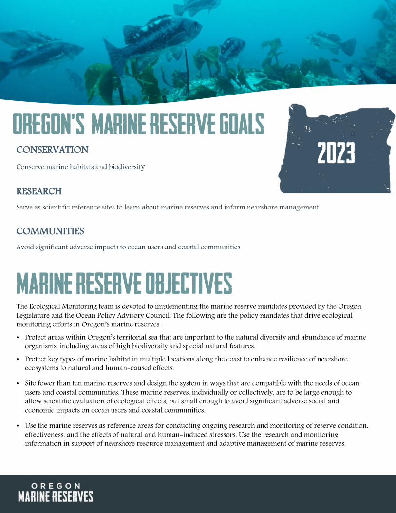
CONSERVATION Conserve marine habitats and biodiversity
RESEARCH Serve as scientific reference sites to learn about marine reserves and inform nearshore management
COMMUNITIES Avoid significant adverse impacts to ocean users and coastal communities
MARINE RESERVE Objectives The Ecological Monitoring team is devoted to implementing the marine reserve mandates provided by the Oregon Legislature and the Ocean Policy Advisory Council. The following are the policy mandates that drive ecological monitoring efforts in Oregon’s marine reserves: • Protect areas within Oregon’s territorial sea that are important to the natural diversity and abundance of marine
organisms, including areas of high biodiversity and special natural features. • Protect key types of marine habitat in multiple locations along the coast to enhance resilience of nearshore
ecosystems to natural and human-caused effects.
• Site fewer than ten marine reserves and design the system in ways that are compatible with the needs of ocean users and coastal communities. These marine reserves, individually or collectively, are to be large enough to allow scientific evaluation of ecological effects, but small enough to avoid significant adverse social and economic impacts on ocean users and coastal communities.
• Use the marine reserves as reference areas for conducting ongoing research and monitoring of reserve condition, effectiveness, and the effects of natural and human-induced stressors. Use the research and monitoring information in support of nearshore resource management and adaptive management of marine reserves.
Oregon’s Marine Reserve Goals 2023

ODFW’s Approach to Marine Reserves EACH SITE IS UNIQUE - FIVE CASE STUDIES The five marine reserve sites in Oregon are unique. They differ in their spatial configurations, habitat attributes, and the demographics of the coastal communities tied to each site. The uniqueness of each marine reserve presents us with an opportunity to use each of Oregon’s marine reserves as a case study. Because of these unique characteristics, reserve effects will likely differ at each site and therefore these reserves will offer differing conservation value. By studying these unique cases over time, we can better understand if, where, and how different marine reserve designs and placements align with Oregon’s programmatic goals, as well as inform how marine reserves might continue beyond the year 2023. DESIGN AND PLACEMENT MATTER Oregon’s marine reserves vary in size, depth range, habitats present, and past fishing pressure – important attributes that can influence ecological responses to reserve protection. Where possible, we collect comparable datasets using identical survey tools among all reserves to allow for comparisons across the entire reserve system. However, the unique attributes of each reserve dictate the need for different study designs as well as survey tools to sample the communities present in each site. As such, there is no one-size-fits-all monitoring strategy that can be universally applied to Oregon’s marine reserves. While we strive to use similar sampling methods where possible, we recognize the need to tailor the monitoring strategy to each site, resulting in five individual ecological monitoring plans. These plans consider the unique habitats, placement, and research potential of each reserve to develop both the tools and sampling intervals best suited for sampling the marine communities found within that particular reserve.

LIVING LABORATORIES Marine reserves enable ODFW and collaborators to both research the effects of protection (i.e. cessation of fishing) on underwater ecosystems and learn about Oregon’s nearshore ocean environment. We conduct robust, long-term monitoring and novel research in these living laboratories to provide information that enhances our understanding of marine reserves science and nearshore management. RESEARCH PARTNERS We are working in collaboration with a variety of research partners to scientifically monitor Oregon’s marine reserves. Our research partners provide expertise, tools, methods, and personnel to supplement and expand ODFW’s monitoring efforts. Partners currently include university scientists and students, non-government organizations such as the Oregon Coast Aquarium, consultants, governmental agencies, the fishing industry, and volunteers. LEARNING AND ADAPTING Marine reserves are a new management tool in Oregon. Based on what we learn, our long-term monitoring strategies will evolve over time to produce the best possible data. We will continue to ask questions about the ability of our monitoring methods to generate robust, valid, and unbiased data about the marine ecosystems in the reserves. We will explore what environmental, habitat, or oceanographic features could confound or influence our datasets. Our goal is to constantly improve our monitoring methods based on the best available science and our experiences. Ultimately, we aim to develop and innovate monitoring approaches that will be used through time to determine the effects of marine reserve protection in Oregon and, more generally, for managing Oregon's nearshore ecosystems. SHARING WHAT WE LEARN An important component of ODFW’s Marine Reserves Program is sharing what we learn along the way. Our monitoring plans will be reviewed and updated at least every five years, to reflect the adaptations as our monitoring evolves. We will provide monitoring reports every other year, to keep people apprised of our monitoring efforts and what we are learning. We will also regularly share stories on our website and list-serve about the research that we and our partners are conducting.
Bringing deeper understanding to the surface
Habitat Placement
Larg
e Size
Broa
d Dep
th
Rang
e
Dive
rsity
of
Habi
tats
Larg
e Roc
ky
Habi
tats
Suita
ble
Com
paris
on
Area
Easil
y Enf
orce
d
High
Prev
ious
Grou
ndfis
h Fis
hing
Effo
rt
High
Prev
ious
Urch
in/ C
rab
Fish
ing E
ffort
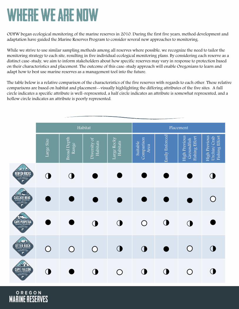
Where we are Now ODFW began ecological monitoring of the marine reserves in 2010. During the first five years, method development and adaptation have guided the Marine Reserves Program to consider several new approaches to monitoring. While we strive to use similar sampling methods among all reserves where possible, we recognize the need to tailor the monitoring strategy to each site, resulting in five individual ecological monitoring plans. By considering each reserve as a distinct case-study, we aim to inform stakeholders about how specific reserves may vary in response to protection based on their characteristics and placement. The outcome of this case-study approach will enable Oregonians to learn and adapt how to best use marine reserves as a management tool into the future. The table below is a relative comparison of the characteristics of the five reserves with regards to each other. These relative comparisons are based on habitat and placement--visually highlighting the differing attributes of the five sites. A full circle indicates a specific attribute is well-represented, a half circle indicates an attribute is somewhat represented, and a hollow circle indicates an attribute is poorly represented.
◑
◑
◑ ◑
◑
◑
◑
◑
◑
◑
◑
◑
◑
◑
◑

There’s More beneath the surface
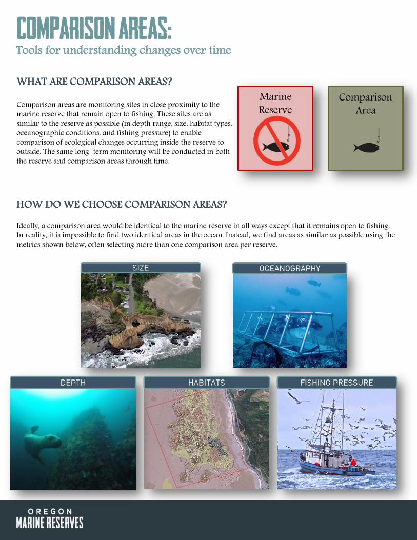
HOW DO WE CHOOSE COMPARISON AREAS? Ideally, a comparison area would be identical to the marine reserve in all ways except that it remains open to fishing. In reality, it is impossible to find two identical areas in the ocean. Instead, we find areas as similar as possible using the metrics shown below, often selecting more than one comparison area per reserve.
Comparison areas:
WHAT ARE COMPARISON AREAS? Comparison areas are monitoring sites in close proximity to the marine reserve that remain open to fishing. These sites are as similar to the reserve as possible (in depth range, size, habitat types, oceanographic conditions, and fishing pressure) to enable comparison of ecological changes occurring inside the reserve to outside. The same long–term monitoring will be conducted in both the reserve and comparison areas through time.
Tools for understanding changes over time

WHAT ECOSYSTEM COMPONENTS DO WE MONITOR? In order to detect ecological changes over time, we use several monitoring tools to collect data on five main components of the marine ecosystem. These five areas include fish and invertebrate species, algal community composition, habitat characteristics, and oceanographic conditions. We track the changes over time in organism size, organism abundance, and community composition. We then compare the magnitude and direction of any observed changes between the reserve and comparison areas to separately identify changes that are due to marine reserve management and those due to natural variations in the ocean.
DETECTING CHANGE OVER TIME Prior to the prohibition of fishing, we sampled in the reserve (red) and the comparison areas (green) to quantify the initial conditions of these areas. This allows us to identify differences that already exist between the marine reserves and comparison areas and track how these differences in trajectories change over time. We use multiple comparison areas when possible across a broad range of fishing gradients in order to account for the impact of fishing effort on marine reserve performance.
Understanding changes over time
Marine Reserve
Comparison Area
Year 1 Year 2 Year 3
Fish
size o
r abu
ndan
ce
Reserve closed
We compare the magnitude of change over time in both the
reserve and comparison area

PRIMARY Ecological Monitoring Tools ODFW’s ecological monitoring in Oregon’s marine reserves began in 2010. During the past five years of baseline data collection, ODFW and partners experimented with sampling tools, study designs, and approaches to best establish a robust baseline of the marine communities found within Oregon’s marine reserves.
The Marine Reserves Program focuses monitoring efforts on four sampling tools: video lander surveys, remotely-operated video (ROV) surveys, fishery-independent hook and line surveys, and subtidal SCUBA surveys. These four sampling efforts build upon the existing capacity and expertise at ODFW to survey the habitats, fish, invertebrate, and macroalgal communities of Oregon’s nearshore.

Hook and Line Surveys
We collect fish data through the help of volunteer anglers aboard chartered fishing boats to catch and release fish. We divide the study area into 500m x 500m grid cells. Local fishing knowledge helps ensure grid cells are placed in locations where fish are commonly caught in rocky habitats. On a survey day, five cells are randomly selected and anglers fish using standardized gear for a fixed amount of time. All fish caught by the volunteers are measured and released. Hook-and-line surveys enable us to have fish in hand to take accurate length measurements. We will look at differences in average fish length before and after the reserve is closed to fishing, both inside the reserve and outside in the comparison areas (monitoring sites open to fishing). By sampling over time, we can determine whether fish sizes as well as catch rates (catch per unit effort) are changing due to cessation of fishing.
Tool Usage
Depth Range 10-40m
Habitats Rocky reefs
Sampling Limitations
Calm sea states, availability of volunteer anglers
Data collected:

SCUBA Visual Surveys We use diver based underwater visual census (UVC) methods to identify and count macroalgal, invertebrate, and fish communities. SCUBA divers conduct surveys in rocky reef habitats at depths of 5m, 12.5m and 20m. Divers work in pairs for safety. SCUBA divers survey a 60m2 transect counting observed organisms and noting the type of habitat and topographic relief of the substrate encountered. Invertebrate and macroalgal surveys occur along the bottom only. Fish transects occur both along the bottom and mid-way up in the water column. In addition to fish counts by species, each individual’s size is estimated to the nearest cm, and species densities are calculated. These methods are based on those developed by the Partnership for Interdisciplinary Studies of Coastal Oceans (PISCO) and are currently being used to survey subtidal communities in California’s marine reserves.
Tool Usage
Depth Range 10-20m
Habitats Shallow rocky reefs
Sampling Limitations
Calm sea states and a minimum of 3m visibility
Data collected:

Video Lander Surveys
The video lander is a stationary, underwater camera system. This platform is used in rocky habitats as the high-definition GoPro™ cameras and metal frame are built to withstand being dropped into complex rocky habitats. The video lander is deployed for approximately eight minutes of video collection at a time. We then review the video to estimate relative abundance for select invertebrates species and all fishes observed. The habitat characteristics, which include the depth, geologic substrate, topographic relief, and biogenic habitat (including macroalgae and sessile invertebrates) present, are recorded. The lander can be deployed across a wide range of depths. The affordable lander design and ability to use several landers simultaneously to survey an area, make this tool a cost-effective way to generate large amounts of video data. Future directions, include adding stereo-video cameras to the lander fleet to enable estimation of individual fish sizes during video review.
Tool Usage
Depth Range 5-20m
Habitats All habitat types
Sampling Limitations
Calm sea states and a minimum of 3m visibility
Data collected:

Data collected:
Remotely Operated Vehicle Survey The remotely operated vehicle (ROV) is our most complex video tool. It is driven by an operator from a boat, controlled via an umbilical cable. The ROV can swim up, down, and around obstacles and follow along a transect line, like a SCUBA diver. The high-definition video is later analyzed for fish, invertebrates, and habitat type. We measure the abundance of select invertebrates and each species of fish observed. We also estimate the size of fish when possible using paired lasers spaced 10cm apart as a size reference. Biogenic habitat such as macroalgae, sponges, deep water corals, and gorgonians are quantified as living habitat that may play a role in structuring the observed fish community. The ROV is perfect for surveying rocky habitats all the way out to the deepest parts of the reserves.
Tool Usage
Depth Range 20-50m
Habitats All habitat types
Sampling Limitations
Calm sea states and a minimum of 3m visibility

Collaborative monitoring efforts The four previous primary sampling efforts build upon the existing capacity and expertise at ODFW to survey the habitats, fish, invertebrate, and macroalgal communities of Oregon’s nearshore. However, we recognize that several other sampling approaches would complement these Marine Reserves Program efforts. Hence, ODFW’s monitoring strategy is to encourage expanded research and monitoring efforts through partnerships and collaborations. Currently, these collaborations include: intertidal surveys, oceanographic monitoring, and fish recruitment studies. These collaborations help fill in where ODFW’s limited team and budget cannot reach. We aim to continue to build collaborative partnerships, seek creative funding sources, and consider citizen science efforts as part of a well-rounded, inclusive framework to monitor the ecological conditions in Oregon’s marine reserves.
OCEANOGRAPHIC SURVEYS Oceanographic parameters such as water temperature affect the growth rate of fish species such as rockfish. So, quantifying any potential differences in oceanographic conditions between our reserves and associated comparison areas will help us isolate reserve effects, such as increase in fish size, from oceanographic effects. To do this ODFW partners with PISCO. PISCO deploys oceanographic moorings in multiple areas along the Oregon coast.

SMURF SAMPLING To maximize marine reserve conservation benefits, it is important to protect both juvenile and adult habitats from extractive activity. In 2013, ODFW began a partnership with Dr. Kirsten Grorud-Colvert at Oregon State University (OSU) in an ongoing study to quantify abundance and diversity of pelagic juveniles fishes settling into the nearshore habitats. SMURF (Standard Monitoring Units for the Recruitment of Fishes) devices attached to moorings are currently in use in two marine reserves to sample these juvenile fishes. While monitoring fish settlement is still in its infancy along the Oregon coast, eventually this information can be used to inform managers how to best design, place, and manage these reserves into the future.
INTERTIDAL SURVEYS ODFW has partnered with the two largest rocky intertidal monitoring programs on the west coast - PISCO and Multi-Agency Rocky Intertidal Network (MARINe). These programs have long-term data sets that in some cases span more than 20 years. These groups monitor community structure of target assemblages, as well as quantify abundances and sizes of key species. They also record biodiversity hotspots, species – habitat associations, invertebrate larval recruitment, and effect of oceanographic factors on intertidal communities. With this baseline data, these scientists may be able to detect changes in intertidal areas associated with marine reserves.

Five Ecological Monitoring Plans CAPE FALCON • CASCADE HEAD • OTTER ROCK • CAPE PERPETUA • REDFISH ROCKS
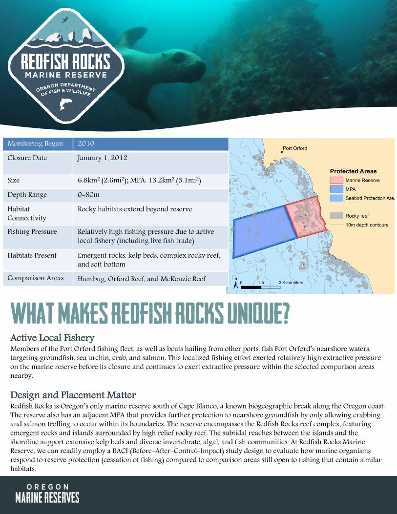
Monitoring Began 2010
Closure Date January 1, 2012
Size 6.8km2 (2.6mi2); MPA: 13.2km2 (5.1mi2)
Depth Range 0-80m
Habitat Connectivity
Rocky habitats extend beyond reserve
Fishing Pressure Relatively high fishing pressure due to active local fishery (including live fish trade)
Habitats Present Emergent rocks, kelp beds, complex rocky reef, and soft bottom
Comparison Areas Humbug, Orford Reef, and McKenzie Reef
What Makes Redfish Rocks Unique? Active Local Fishery Members of the Port Orford fishing fleet, as well as boats hailing from other ports, fish Port Orford’s nearshore waters, targeting groundfish, sea urchin, crab, and salmon. This localized fishing effort exerted relatively high extractive pressure on the marine reserve before its closure and continues to exert extractive pressure within the selected comparison areas nearby. Design and Placement Matter Redfish Rocks is Oregon’s only marine reserve south of Cape Blanco, a known biogeographic break along the Oregon coast. The reserve also has an adjacent MPA that provides further protection to nearshore groundfish by only allowing crabbing and salmon trolling to occur within its boundaries. The reserve encompasses the Redfish Rocks reef complex, featuring emergent rocks and islands surrounded by high relief rocky reef. The subtidal reaches between the islands and the shoreline support extensive kelp beds and diverse invertebrate, algal, and fish communities. At Redfish Rocks Marine Reserve, we can readily employ a BACI (Before-After-Control-Impact) study design to evaluate how marine organisms respond to reserve protection (cessation of fishing) compared to comparison areas still open to fishing that contain similar habitats.
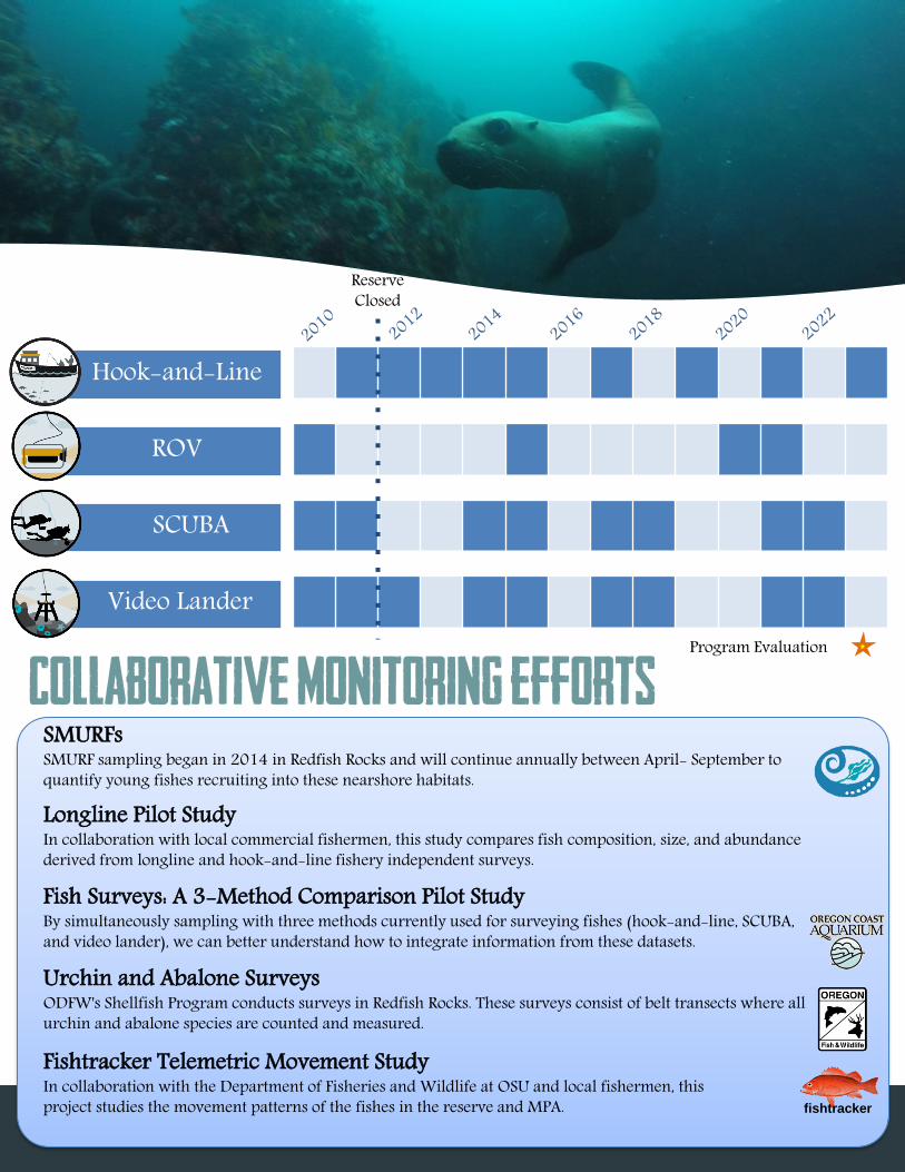
SMURFs SMURF sampling began in 2014 in Redfish Rocks and will continue annually between April- September to quantify young fishes recruiting into these nearshore habitats.
Longline Pilot Study In collaboration with local commercial fishermen, this study compares fish composition, size, and abundance derived from longline and hook-and-line fishery independent surveys.
Fish Surveys: A 3-Method Comparison Pilot Study By simultaneously sampling with three methods currently used for surveying fishes (hook-and-line, SCUBA, and video lander), we can better understand how to integrate information from these datasets.
Urchin and Abalone Surveys ODFW's Shellfish Program conducts surveys in Redfish Rocks. These surveys consist of belt transects where all urchin and abalone species are counted and measured.
Fishtracker Telemetric Movement Study In collaboration with the Department of Fisheries and Wildlife at OSU and local fishermen, this project studies the movement patterns of the fishes in the reserve and MPA.
Hook-and-Line
ROV
SCUBA
Video Lander Program Evaluation
fishtracker
Reserve Closed
Collaborative monitoring efforts

What Makes Otter Rock Unique? Scientific Training Ground The Otter Rock Marine Reserve provides local scientists with the perfect training ground to try out new approaches, hone skills, and learn more about coastal ecosystems in general. Volunteer science divers train in this area, the Marine Reserves Ecological Monitoring team conducts method refinement pilot studies here, and Oregon State University conducts juvenile rockfish settlement studies in this reserve. Design and Placement Matter Otter Rock Marine Reserve is the smallest of the five marine reserves. This small, shallow, reserve can be viewed easily from shore. However, its small size, shallow depth, and limited rocky habitat make a reserve effect unlikely due to the limited fishing activity that occurred in this area prior to closure. Although we may anticipate minimal changes in the reserve compared to open fished areas, this area is an important site for long-term data collection to track how this community changes through time in a before-after comparison and to track changes in the nearshore environments of Oregon at large.
Monitoring Began 2010 Closure Date January 1, 2012
Size 3.0km2 (1.2mi2) Depth Range 0-18m Habitat Connectivity Rocky habitats extend beyond reserve
Fishing Pressure Relatively low fishing pressure due limited rocky reef and shallow depths
Habitats Present Emergent rocks, bedrock and boulders, patches of kelp beds, extensive areas of soft bottom, and bands of sand dollar beds
Comparison Area(s) Cape Foulweather
Hook-and-Line
ROV
SCUBA
Video Lander Program Evaluation
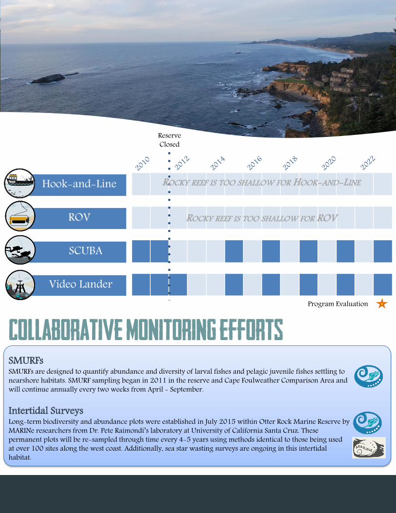
ROCKY REEF IS TOO SHALLOW FOR HOOK-AND-LINE
ROCKY REEF IS TOO SHALLOW FOR ROV
SMURFs SMURFs are designed to quantify abundance and diversity of larval fishes and pelagic juvenile fishes settling to nearshore habitats. SMURF sampling began in 2011 in the reserve and Cape Foulweather Comparison Area and will continue annually every two weeks from April - September. Intertidal Surveys Long-term biodiversity and abundance plots were established in July 2015 within Otter Rock Marine Reserve by MARINe researchers from Dr. Pete Raimondi’s laboratory at University of California Santa Cruz. These permanent plots will be re-sampled through time every 4-5 years using methods identical to those being used at over 100 sites along the west coast. Additionally, sea star wasting surveys are ongoing in this intertidal habitat.
Reserve Closed
Collaborative monitoring efforts
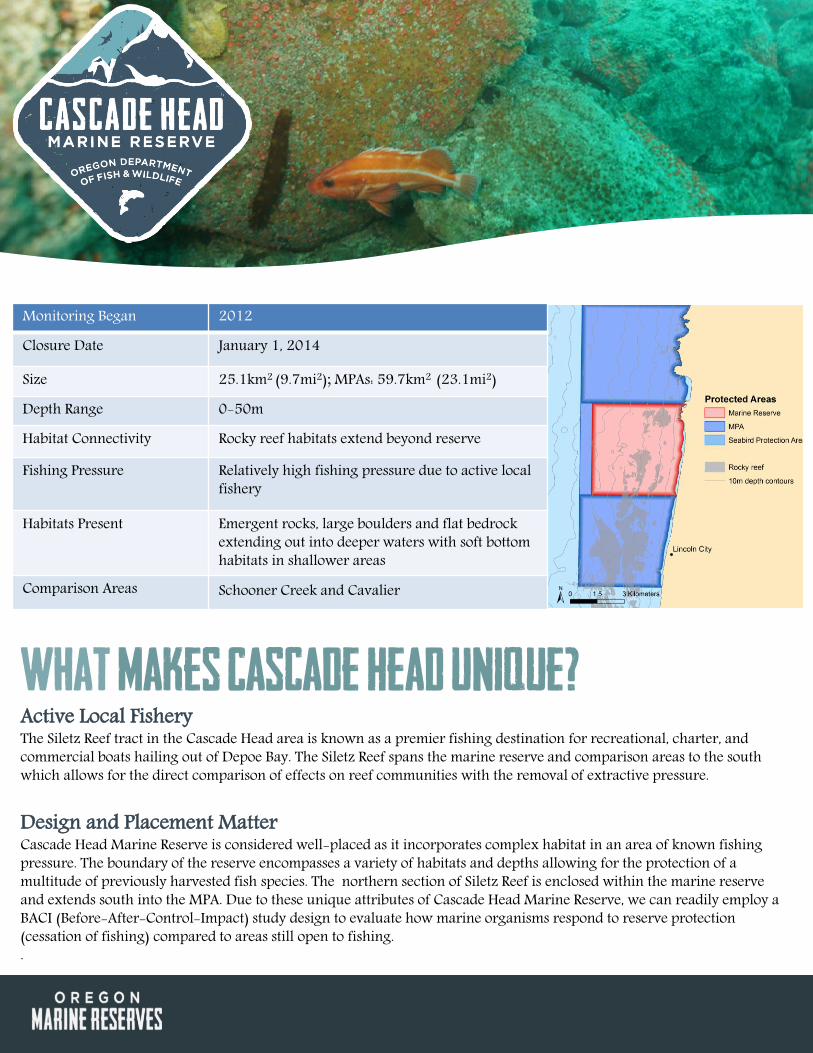
What Makes Cascade Head Unique? Active Local Fishery The Siletz Reef tract in the Cascade Head area is known as a premier fishing destination for recreational, charter, and commercial boats hailing out of Depoe Bay. The Siletz Reef spans the marine reserve and comparison areas to the south which allows for the direct comparison of effects on reef communities with the removal of extractive pressure. Design and Placement Matter Cascade Head Marine Reserve is considered well-placed as it incorporates complex habitat in an area of known fishing pressure. The boundary of the reserve encompasses a variety of habitats and depths allowing for the protection of a multitude of previously harvested fish species. The northern section of Siletz Reef is enclosed within the marine reserve and extends south into the MPA. Due to these unique attributes of Cascade Head Marine Reserve, we can readily employ a BACI (Before-After-Control-Impact) study design to evaluate how marine organisms respond to reserve protection (cessation of fishing) compared to areas still open to fishing. .
Monitoring Began 2012
Closure Date January 1, 2014
Size 25.1km2 (9.7mi2); MPAs: 59.7km2 (23.1mi2)
Depth Range 0-50m
Habitat Connectivity Rocky reef habitats extend beyond reserve
Fishing Pressure Relatively high fishing pressure due to active local fishery
Habitats Present Emergent rocks, large boulders and flat bedrock extending out into deeper waters with soft bottom habitats in shallower areas
Comparison Areas Schooner Creek and Cavalier

Program Evaluation
Intertidal Surveys Long-term biodiversity and abundance plots were established in July 2015 within Cascade Head Marine Reserve by MARINe researchers from Dr. Pete Raimondi’s laboratory at University of California Santa Cruz. These permanent plots will be re-sampled through time every 4-5 years using methods identical to those being used in over 100 sites along the west coast. Additionally, sea star wasting surveys are ongoing in this intertidal habitat.
Hook-and-Line
ROV
SCUBA
Video Lander
Reserve Closed
Collaborative monitoring efforts

What Makes Cape Perpetua Unique? Long-term Research Hotspot Compared to other areas along the Oregon coast, the rocky intertidal habitats in Cape Perpetua Marine Reserve are a hotspot of biodiversity. Researchers have been monitoring the dynamics and species of this intertidal habitat for decades. The waters around Cape Perpetua experience episodic hypoxia (low oxygen) and acidification (low pH) associated with strong summer upwelling activity. These oceanographic events are considered indicators of climate change and make this an extremely unique research site to investigate how changes in seawater chemistry can impact marine life. Design and Placement Matter Cape Perpetua Marine Reserve contains a deep, isolated rocky reef unique to the area. Since there is no nearby rocky reef habitat that is at a similar depth with comparable oceanographic conditions and fishing pressure, we will explore how this isolated community changes through time in a before-after comparison. Additionally, we will determine how these trajectories of change compare to other, albeit shallower, rocky habitats in the surrounding area.
Monitoring Began 2012 Closure Date January 1, 2014
Size 36.5km2 (14.1mi2); MPAs 48.7km2 (18.8mi2) Depth Range 0-55m Habitats Present Mostly soft sediments with a small, low-relief rocky reef
in deeper water Habitat Connectivity
Isolated rocky reef entirely contained within reserve
Fishing Pressure Low fishing pressure on reef due to distance from port and limited habitat; popular crabbing grounds on soft sediments
Comparison Areas Seal Rock and Tokatee

Hook-and-Line
ROV
SCUBA
Video Lander Program Evaluation
ROCKY REEF IS TOO DEEP FOR SCUBA
Hypoxia-Ecology Study Since 2002, ODFW scientists using their ROV and oceanographers from Oregon State University (OSU) have been investigating the impacts of hypoxia on the rocky reef communities in this area. Oceanographic Surveys Oceanographic surveys have been conducted at Cape Perpetua since early 2000s and will continue to be conducted based on funding. Intertidal Surveys Since the early 1990’s PISCO researchers from Bruce Menge’s laboratory at OSU have conducted intertidal surveys in this area at sites like Strawberry Hill and Bob Creek. These ongoing surveys provide long-term datasets that inform our monitoring of the rocky intertidal.
Reserve Closed
Collaborative monitoring efforts

What Makes Cape Falcon Unique? Design and Placement Matter Due to these unique attributes, the sampling approach for Cape Falcon entails surveying numerous small reefs along a gradient of fishing pressure. The reefs within the reserve represent light fishing pressure, while the patch reef immediately north and south of the reserve boundaries as well as reefs closer to the port of Garibaldi experience higher levels of extraction. We will evaluate change over time along this gradient to explore how levels of extractive pressure influence rates of change in rocky reef marine communities. Fishing Pressure Cape Falcon Marine Reserve is located north of the port of Garibaldi. The Cape Falcon Marine Reserve is not a highly fished area historically for rocky reef fish. Three Arch Rocks, located south of Cape Mears, has had the highest fishing pressure for the area. Light crabbing occurs in the sandy habitats of the reserve. As total extractive pressure on this marine reserve is considered light, we anticipate little change over time in the marine communities due to the cessation of fishing.
Monitoring Began 2014 Closure Date January 1, 2016
Size 32.0km2 (12.4mi2); MPAs 19.7km2 (7.6mi2) Depth Range 0-55m Habitat Connectivity Small, isolated, low-relief rocky reef
Fishing Pressure Relatively low fishing pressure due to distance from port and habitats present
Habitats Present Mostly soft sediments with isolated rocky reef
Comparison Area(s) No area with comparable habitat and fishing pressure

Currently there are no supplemental monitoring efforts being conducted in this area. Future research and monitoring activities are currently being explored to sample the soft sediment habitats within Cape Falcon Marine Reserve.
Hook-and-Line
ROV
SCUBA
Video Lander Program Evaluation
ROCKY REEF IS TOO SHALLOW FOR ROV
Reserve Closed
Collaborative monitoring efforts
2015