Ecography ECOG-03378
34
Ecography ECOG-03378 Parks, S. A., Holsinger, L. M., Miller, C. and Parisien, M.-A. 2017. Analog-based fire regime and vegetation shifts in mountainous regions of the western US. – Ecography doi: 10.1111/ecog.03378 Supplementary material
Transcript of Ecography ECOG-03378

Ecography ECOG-03378Parks, S. A., Holsinger, L. M., Miller, C. and Parisien, M.-A. 2017. Analog-based fire regime and vegetation shifts in mountainous regions of the western US. – Ecography doi: 10.1111/ecog.03378
Supplementary material

Appendix A. Crosswalk between Landfire Biophysical setting (BpS) and the broad vegetation groups
analyzed in this study.
BpS Name Vegetation type
California Coastal Redwood Forest mesic forest
East Cascades Mesic Montane Mixed-Conifer Forest and Woodland mesic forest
Klamath-Siskiyou Lower Montane Serpentine Mixed Conifer Woodland mesic forest
Klamath-Siskiyou Upper Montane Serpentine Mixed Conifer Woodland mesic forest
Madrean Upper Montane Conifer-Oak Forest and Woodland mesic forest
Mediterranean California Mesic Mixed Conifer Forest and Woodland mesic forest
North Pacific Hypermaritime Sitka Spruce Forest mesic forest
North Pacific Maritime Dry-Mesic Douglas-fir-Western Hemlock Forest mesic forest
North Pacific Maritime Mesic Subalpine Parkland mesic forest
North Pacific Maritime Mesic-Wet Douglas-fir-Western Hemlock Forest mesic forest
North Pacific Mountain Hemlock Forest - Wet mesic forest
North Pacific Mountain Hemlock Forest - Xeric mesic forest
North Pacific Mesic Western Hemlock-Silver Fir Forest mesic forest
Northern California Mesic Subalpine Woodland mesic forest
Northern Rocky Mountain Dry-Mesic Montane Mixed Conifer Forest - Larch mesic forest
Northern Rocky Mountain Dry-Mesic Montane Mixed Conifer Forest - Grand Fir mesic forest
Northern Rocky Mountain Mesic Montane Mixed Conifer Forest mesic forest
Northern Rocky Mountain Mesic Montane Mixed Conifer Forest mesic forest
Northern Rocky Mountain Mesic Montane Mixed Conifer Forest - Cedar Groves mesic forest
Southern Rocky Mountain Mesic Montane Mixed Conifer Forest and Woodland mesic forest
North Pacific Swamp Systems mesic forest
North Pacific Montane Riparian Woodland and Shrubland - Wet mesic forest
North Pacific Dry-Mesic Silver Fir-Western Hemlock-Douglas-fir Forest mesic forest
California Coastal Closed-Cone Conifer Forest and Woodland mesic forest
North Pacific Hypermaritime Western Red-cedar-Western Hemlock Forest mesic forest
Inter-Mountain Basins Subalpine Limber-Bristlecone Pine Woodland cold forest
Mediterranean California Red Fir Forest cold forest
Mediterranean California Red Fir Forest - Cascades cold forest
Mediterranean California Red Fir Forest - Southern Sierra cold forest
Mediterranean California Subalpine Woodland cold forest
Northern Rocky Mountain Dry-Mesic Montane Mixed Conifer Forest - Lodgepole Pine cold forest
Northern Rocky Mountain Subalpine Woodland and Parkland cold forest
Northwestern Great Plains Highland White Spruce Woodland cold forest
Rocky Mountain Lodgepole Pine Forest cold forest
Rocky Mountain Subalpine Dry-Mesic Spruce-Fir Forest and Woodland cold forest
Rocky Mountain Subalpine Mesic-Wet Spruce-Fir Forest and Woodland cold forest
Rocky Mountain Subalpine-Montane Limber-Bristlecone Pine Woodland cold forest
Sierra Nevada Subalpine Lodgepole Pine Forest and Woodland cold forest
Sierra Nevada Subalpine Lodgepole Pine Forest and Woodland - Wet cold forest
Sierra Nevada Subalpine Lodgepole Pine Forest and Woodland - Dry cold forest
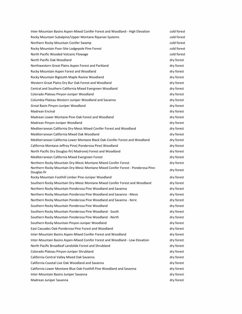
Inter-Mountain Basins Aspen-Mixed Conifer Forest and Woodland - High Elevation cold forest
Rocky Mountain Subalpine/Upper Montane Riparian Systems cold forest
Northern Rocky Mountain Conifer Swamp cold forest
Rocky Mountain Poor-Site Lodgepole Pine Forest cold forest
North Pacific Wooded Volcanic Flowage cold forest
North Pacific Oak Woodland dry forest
Northwestern Great Plains Aspen Forest and Parkland dry forest
Rocky Mountain Aspen Forest and Woodland dry forest
Rocky Mountain Bigtooth Maple Ravine Woodland dry forest
Western Great Plains Dry Bur Oak Forest and Woodland dry forest
Central and Southern California Mixed Evergreen Woodland dry forest
Colorado Plateau Pinyon-Juniper Woodland dry forest
Columbia Plateau Western Juniper Woodland and Savanna dry forest
Great Basin Pinyon-Juniper Woodland dry forest
Madrean Encinal dry forest
Madrean Lower Montane Pine-Oak Forest and Woodland dry forest
Madrean Pinyon-Juniper Woodland dry forest
Mediterranean California Dry-Mesic Mixed Conifer Forest and Woodland dry forest
Mediterranean California Mixed Oak Woodland dry forest
Mediterranean California Lower Montane Black Oak-Conifer Forest and Woodland dry forest
California Montane Jeffrey Pine(-Ponderosa Pine) Woodland dry forest
North Pacific Dry Douglas-fir(-Madrone) Forest and Woodland dry forest
Mediterranean California Mixed Evergreen Forest dry forest
Northern Rocky Mountain Dry-Mesic Montane Mixed Conifer Forest dry forest
Northern Rocky Mountain Dry-Mesic Montane Mixed Conifer Forest - Ponderosa Pine-Douglas-fir
dry forest
Rocky Mountain Foothill Limber Pine-Juniper Woodland dry forest
Southern Rocky Mountain Dry-Mesic Montane Mixed Conifer Forest and Woodland dry forest
Northern Rocky Mountain Ponderosa Pine Woodland and Savanna dry forest
Northern Rocky Mountain Ponderosa Pine Woodland and Savanna - Mesic dry forest
Northern Rocky Mountain Ponderosa Pine Woodland and Savanna - Xeric dry forest
Southern Rocky Mountain Ponderosa Pine Woodland dry forest
Southern Rocky Mountain Ponderosa Pine Woodland - South dry forest
Southern Rocky Mountain Ponderosa Pine Woodland - North dry forest
Southern Rocky Mountain Pinyon-Juniper Woodland dry forest
East Cascades Oak-Ponderosa Pine Forest and Woodland dry forest
Inter-Mountain Basins Aspen-Mixed Conifer Forest and Woodland dry forest
Inter-Mountain Basins Aspen-Mixed Conifer Forest and Woodland - Low Elevation dry forest
North Pacific Broadleaf Landslide Forest and Shrubland dry forest
Colorado Plateau Pinyon-Juniper Shrubland dry forest
California Central Valley Mixed Oak Savanna dry forest
California Coastal Live Oak Woodland and Savanna dry forest
California Lower Montane Blue Oak-Foothill Pine Woodland and Savanna dry forest
Inter-Mountain Basins Juniper Savanna dry forest
Madrean Juniper Savanna dry forest

Southern Rocky Mountain Ponderosa Pine Savanna dry forest
Southern Rocky Mountain Ponderosa Pine Savanna - South dry forest
Southern Rocky Mountain Ponderosa Pine Savanna - North dry forest
Southern California Oak Woodland and Savanna dry forest
Southern Rocky Mountain Juniper Woodland and Savanna dry forest
Willamette Valley Upland Prairie and Savanna dry forest
California Central Valley Riparian Woodland and Shrubland dry forest
California Montane Riparian Systems dry forest
Inter-Mountain Basins Montane Riparian Systems dry forest
North American Warm Desert Riparian Systems dry forest
North American Warm Desert Riparian Systems dry forest
North American Warm Desert Riparian Systems - Stringers dry forest
North Pacific Lowland Riparian Forest and Shrubland dry forest
North Pacific Montane Riparian Woodland and Shrubland - Dry dry forest
Rocky Mountain Montane Riparian Systems dry forest
Western Great Plains Floodplain Systems dry forest
Northern Rocky Mountain Foothill Conifer Wooded Steppe dry forest
Middle Rocky Mountain Montane Douglas-fir Forest and Woodland dry forest
Middle Rocky Mountain Montane Douglas-fir Forest and Woodland dry forest
Middle Rocky Mountain Montane Douglas-fir Forest and Woodland - Fire-maintained Savanna
dry forest
Klamath-Siskiyou Xeromorphic Serpentine Savanna and Chaparral dry forest
Sierran-Intermontane Desert Western White Pine-White Fir Woodland dry forest
Northwestern Great Plains-Black Hills Ponderosa Pine Woodland and Savanna dry forest
Northwestern Great Plains-Black Hills Ponderosa Pine Woodland and Savanna - Low Elevation Woodland
dry forest
Northwestern Great Plains-Black Hills Ponderosa Pine Woodland and Savanna - Savanna dry forest
Edwards Plateau Limestone Shrubland dry forest
Apacherian-Chihuahuan Semi-Desert Grassland and Steppe shrubland/grassland
Chihuahuan Gypsophilous Grassland and Steppe shrubland/grassland
Columbia Plateau Steppe and Grassland shrubland/grassland
California Central Valley and Southern Coastal Grassland shrubland/grassland
California Mesic Serpentine Grassland shrubland/grassland
California Northern Coastal Grassland shrubland/grassland
Central Mixedgrass Prairie shrubland/grassland
Chihuahuan Sandy Plains Semi-Desert Grassland shrubland/grassland
Columbia Basin Foothill and Canyon Dry Grassland shrubland/grassland
Inter-Mountain Basins Semi-Desert Grassland shrubland/grassland
Mediterranean California Alpine Dry Tundra shrubland/grassland
Mediterranean California Subalpine Meadow shrubland/grassland
North Pacific Montane Grassland shrubland/grassland
Northern Rocky Mountain Lower Montane-Foothill-Valley Grassland shrubland/grassland
Northern Rocky Mountain Subalpine-Upper Montane Grassland shrubland/grassland
Northwestern Great Plains Mixedgrass Prairie shrubland/grassland
Columbia Basin Palouse Prairie shrubland/grassland
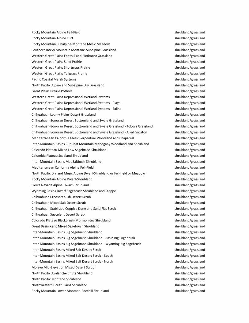
Rocky Mountain Alpine Fell-Field shrubland/grassland
Rocky Mountain Alpine Turf shrubland/grassland
Rocky Mountain Subalpine-Montane Mesic Meadow shrubland/grassland
Southern Rocky Mountain Montane-Subalpine Grassland shrubland/grassland
Western Great Plains Foothill and Piedmont Grassland shrubland/grassland
Western Great Plains Sand Prairie shrubland/grassland
Western Great Plains Shortgrass Prairie shrubland/grassland
Western Great Plains Tallgrass Prairie shrubland/grassland
Pacific Coastal Marsh Systems shrubland/grassland
North Pacific Alpine and Subalpine Dry Grassland shrubland/grassland
Great Plains Prairie Pothole shrubland/grassland
Western Great Plains Depressional Wetland Systems shrubland/grassland
Western Great Plains Depressional Wetland Systems - Playa shrubland/grassland
Western Great Plains Depressional Wetland Systems - Saline shrubland/grassland
Chihuahuan Loamy Plains Desert Grassland shrubland/grassland
Chihuahuan-Sonoran Desert Bottomland and Swale Grassland shrubland/grassland
Chihuahuan-Sonoran Desert Bottomland and Swale Grassland - Tobosa Grassland shrubland/grassland
Chihuahuan-Sonoran Desert Bottomland and Swale Grassland - Alkali Sacaton shrubland/grassland
Mediterranean California Mesic Serpentine Woodland and Chaparral shrubland/grassland
Inter-Mountain Basins Curl-leaf Mountain Mahogany Woodland and Shrubland shrubland/grassland
Colorado Plateau Mixed Low Sagebrush Shrubland shrubland/grassland
Columbia Plateau Scabland Shrubland shrubland/grassland
Inter-Mountain Basins Mat Saltbush Shrubland shrubland/grassland
Mediterranean California Alpine Fell-Field shrubland/grassland
North Pacific Dry and Mesic Alpine Dwarf-Shrubland or Fell-field or Meadow shrubland/grassland
Rocky Mountain Alpine Dwarf-Shrubland shrubland/grassland
Sierra Nevada Alpine Dwarf-Shrubland shrubland/grassland
Wyoming Basins Dwarf Sagebrush Shrubland and Steppe shrubland/grassland
Chihuahuan Creosotebush Desert Scrub shrubland/grassland
Chihuahuan Mixed Salt Desert Scrub shrubland/grassland
Chihuahuan Stabilized Coppice Dune and Sand Flat Scrub shrubland/grassland
Chihuahuan Succulent Desert Scrub shrubland/grassland
Colorado Plateau Blackbrush-Mormon-tea Shrubland shrubland/grassland
Great Basin Xeric Mixed Sagebrush Shrubland shrubland/grassland
Inter-Mountain Basins Big Sagebrush Shrubland shrubland/grassland
Inter-Mountain Basins Big Sagebrush Shrubland - Basin Big Sagebrush shrubland/grassland
Inter-Mountain Basins Big Sagebrush Shrubland - Wyoming Big Sagebrush shrubland/grassland
Inter-Mountain Basins Mixed Salt Desert Scrub shrubland/grassland
Inter-Mountain Basins Mixed Salt Desert Scrub - South shrubland/grassland
Inter-Mountain Basins Mixed Salt Desert Scrub - North shrubland/grassland
Mojave Mid-Elevation Mixed Desert Scrub shrubland/grassland
North Pacific Avalanche Chute Shrubland shrubland/grassland
North Pacific Montane Shrubland shrubland/grassland
Northwestern Great Plains Shrubland shrubland/grassland
Rocky Mountain Lower Montane-Foothill Shrubland shrubland/grassland

Rocky Mountain Lower Montane-Foothill Shrubland - No True Mountain Mahogany shrubland/grassland
Rocky Mountain Lower Montane-Foothill Shrubland - True Mountain Mahogany shrubland/grassland
Sonora-Mojave Creosotebush-White Bursage Desert Scrub shrubland/grassland
Sonora-Mojave Mixed Salt Desert Scrub shrubland/grassland
Sonoran Granite Outcrop Desert Scrub shrubland/grassland
Sonoran Mid-Elevation Desert Scrub shrubland/grassland
Southern California Coastal Scrub shrubland/grassland
Southern Colorado Plateau Sand Shrubland shrubland/grassland
Western Great Plains Sandhill Steppe shrubland/grassland
Apacherian-Chihuahuan Mesquite Upland Scrub shrubland/grassland
California Maritime Chaparral shrubland/grassland
California Mesic Chaparral shrubland/grassland
California Montane Woodland and Chaparral shrubland/grassland
California Xeric Serpentine Chaparral shrubland/grassland
Chihuahuan Mixed Desert and Thorn Scrub shrubland/grassland
Chihuahuan Mixed Desert Shrubland shrubland/grassland
Chihuahuan Grama Grass-Creosote Steppe shrubland/grassland
Madrean Oriental Chaparral shrubland/grassland
Great Basin Semi-Desert Chaparral shrubland/grassland
Mogollon Chaparral shrubland/grassland
Northern and Central California Dry-Mesic Chaparral shrubland/grassland
Northern Rocky Mountain Montane-Foothill Deciduous Shrubland shrubland/grassland
Rocky Mountain Gambel Oak-Mixed Montane Shrubland shrubland/grassland
Rocky Mountain Gambel Oak-Mixed Montane Shrubland - Continuous shrubland/grassland
Rocky Mountain Gambel Oak-Mixed Montane Shrubland - Patchy shrubland/grassland
Sonora-Mojave Semi-Desert Chaparral shrubland/grassland
Sonoran Paloverde-Mixed Cacti Desert Scrub shrubland/grassland
Southern California Dry-Mesic Chaparral shrubland/grassland
Western Great Plains Mesquite Woodland and Shrubland shrubland/grassland
Columbia Plateau Low Sagebrush Steppe shrubland/grassland
Inter-Mountain Basins Big Sagebrush Steppe shrubland/grassland
Inter-Mountain Basins Montane Sagebrush Steppe shrubland/grassland
Inter-Mountain Basins Montane Sagebrush Steppe - Mountain Big Sagebrush shrubland/grassland
Inter-Mountain Basins Montane Sagebrush Steppe - Low Sagebrush shrubland/grassland
Inter-Mountain Basins Semi-Desert Shrub-Steppe shrubland/grassland
Northern California Coastal Scrub shrubland/grassland
Inter-Mountain Basins Greasewood Flat shrubland/grassland
Western Great Plains Wooded Draw and Ravine shrubland/grassland
Perennial Ice/Snow sparse/barren
Barren-Rock/Sand/Clay sparse/barren
Inter-Mountain Basins Sparsely Vegetated Systems sparse/barren
Mediterranean California Sparsely Vegetated Systems sparse/barren
North Pacific Sparsely Vegetated Systems sparse/barren
North American Warm Desert Sparsely Vegetated Systems sparse/barren
Rocky Mountain Alpine/Montane Sparsely Vegetated Systems sparse/barren

Western Great Plains Sparsely Vegetated Systems sparse/barren
Northwestern Great Plains Canyon sparse/barren

Appendix B. As an illustration of our methods, the red box in panel a shows the reference period climate
space representing climate analogs for the pixel of interest mapped in panel b. The pixel of interest (b) is
projected to have the following values in a future time period (scaled; see Methods): climatic moisture
deficit (CMD)=30 and evapotranspiration (ET)=37. Consequently, the red box in panel a represents
±3.125 scaled units from the climate values for the pixel of interest (see Methods). The map in panel b
also shows the locations of the three nearest neighbor pixels which have reference climate values
equivalent to the future climate values for the pixel of interest; these represent the three closest pixels
(geographic distance) of all climate analogs residing in the domain outlined by the red box in panel a.
Fire return interval and percent replacement severity values for the three nearest neighbors are
averaged and used to define the analog fire regime characteristics for the pixel of interest. The most
common vegetation type among the three nearest climate analogs was used to quantify potential
changes to vegetation (see Methods). The background in panel b represents CMD (cooler colors
represent wetter pixels and warmer colors represent drier pixels).

Appendix C. Sensitivity analysis
Figure C1. Varying numbers of climate analogs (1, 3, 9, and 27) were used to characterize future fire
regime characteristics along the climatic moisture deficit. Fitted splines of the fire return interval (a) and
percent replacement severity (b) for the reference period, 2025, 2055, and 2085. We used the three
nearest analogs to characterize future fire regime characteristics in the main paper.

Figure C2. Varying numbers of climate analogs were used to characterize reverence period and future
vegetation: one climate analog (a), three climate analogs (b), none climate analogs (c), and 27 climate
analogs (d). We used the three nearest analogs to characterize future fire regime characteristics in the
main paper. The color black represents sparse/barren vegetation.

Figure C3. Varying bin widths were used to identify climate analogs in order to characterize future fire
regime characteristics along a gradient represented by the climatic moisture deficit. These bin widths
include 1/10th (a), 1/16th (b), 1/20th (c), and 1/25th (d) of the data range for CMD and ET. We used a bin
width of 1/16 of the data range in the main paper.

Figure C4. Varying bin widths were used to identify climate analogs and characterize potential
vegetation shifts in mountainous regions of the western US. These bin widths include 1/10th (a), 1/16th
(b), 1/20th (c), and 1/25th (d) of the data range for CMD and ET. We used a bin width of 1/16 of the data
range in the main paper.

Figure C5. Comparison of results using two different approaches to identify climate analogs and
characterize future fire regime characteristics along the climatic moisture deficit. Climate analogs were
identified using the climatic moisture deficit and evapotranspiration (a) and using the first and second
principal components of a PCA analysis (b). We identified climate analogs using the climatic moisture
deficit and evapotranspiration (a) in the main paper.
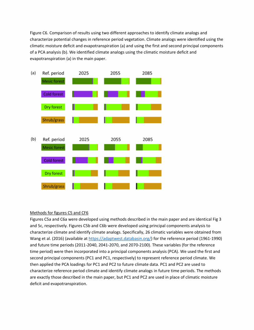
Figure C6. Comparison of results using two different approaches to identify climate analogs and
characterize potential changes in reference period vegetation. Climate analogs were identified using the
climatic moisture deficit and evapotranspiration (a) and using the first and second principal components
of a PCA analysis (b). We identified climate analogs using the climatic moisture deficit and
evapotranspiration (a) in the main paper.
Methods for figures C5 and CF6
Figures C5a and C6a were developed using methods described in the main paper and are identical Fig 3
and 5c, respectively. Figures C5b and C6b were developed using principal components analysis to
characterize climate and identify climate analogs. Specifically, 26 climatic variables were obtained from
Wang et al. (2016) (available at https://adaptwest.databasin.org/) for the reference period (1961-1990)
and future time periods (2011-2040, 2041-2070, and 2070-2100). These variables (for the reference
time period) were then incorporated into a principal components analysis (PCA). We used the first and
second principal components (PC1 and PC1, respectively) to represent reference period climate. We
then applied the PCA loadings for PC1 and PC2 to future climate data. PC1 and PC2 are used to
characterize reference period climate and identify climate analogs in future time periods. The methods
are exactly those described in the main paper, but PC1 and PC2 are used in place of climatic moisture
deficit and evapotranspiration.

Appendix D. Table showing an example of how we incorporated ‘overlapping climate bins’. In this
example, the range of CMD values (i.e. the climate bin) for the reference time period (i.e. the climate
analog) overlap even though the source pixel CMD values are different (compare among rows). This
reduces boundary effects because pixels with incremental differences in climate values will never be
associated with discretely different climate bins. This approach mimics that of Dobrowski and Parks
(2016).
CMD† of source
pixel for future
time period
ET† of source
pixel for future
time period
CMD† range of climate
analog for reference
time period
ET† range of climate
analog for reference
time period
22 50 18.875 – 25.125 46.875 – 53.125
23 50 19.875 – 26.125 46.875 – 53.125
24 50 20.875 – 26.125 46.875 – 53.125 †Original CMD values are scaled from 1-100 (see Methods).

Appendix E. Maps of fire regime and vegetation shifts for 17 ecoregions in the western US.
Figure E1. Ecoregions in the western US for which we evaluated shifts to fire regimes and vegetation in
response to climate change.

Figure E2. Maps depicting reference fire return interval and predicted changes through time (a),
reference percent replacement severity and predicted changes through time (b), and reference period
vegetation and potential distribution over time for the Pacific Northwest Coast ecoregion. See Fig D1 to
reference the location of this ecoregion.

Figure E3. Maps depicting reference fire return interval and predicted changes through time (a),
reference percent replacement severity and predicted changes through time (b), and reference period
vegetation and potential distribution over time for the West Cascades ecoregion. See Fig D1 to
reference the location of this ecoregion.

Figure E4. Maps depicting reference fire return interval and predicted changes through time (a),
reference percent replacement severity and predicted changes through time (b), and reference period
vegetation and potential distribution over time for the North Cascades ecoregion. See Fig D1 to
reference the location of this ecoregion.
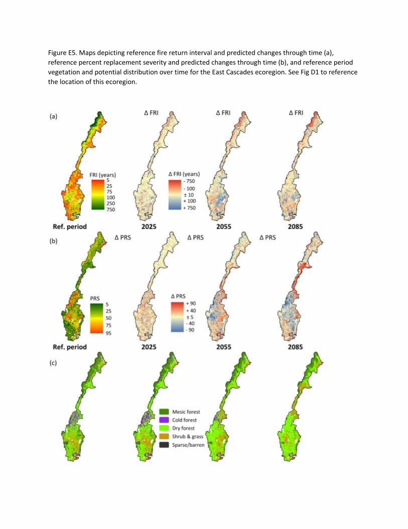
Figure E5. Maps depicting reference fire return interval and predicted changes through time (a),
reference percent replacement severity and predicted changes through time (b), and reference period
vegetation and potential distribution over time for the East Cascades ecoregion. See Fig D1 to reference
the location of this ecoregion.

Figure E6. Maps depicting reference fire return interval and predicted changes through time (a),
reference percent replacement severity and predicted changes through time (b), and reference period
vegetation and potential distribution over time for the Okanagan ecoregion. See Fig D1 to reference the
location of this ecoregion.

Figure E7. Maps depicting reference fire return interval and predicted changes through time (a),
reference percent replacement severity and predicted changes through time (b), and reference period
vegetation and potential distribution over time for the Canadian Rockies ecoregion. See Fig D1 to
reference the location of this ecoregion.
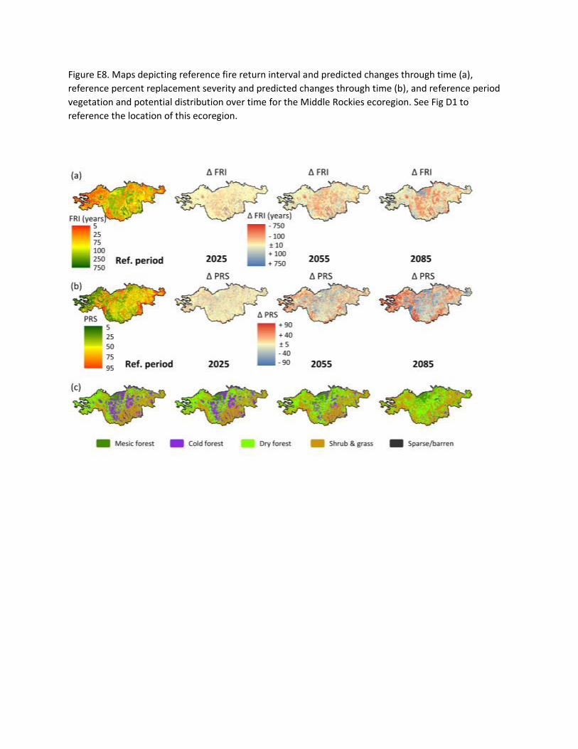
Figure E8. Maps depicting reference fire return interval and predicted changes through time (a),
reference percent replacement severity and predicted changes through time (b), and reference period
vegetation and potential distribution over time for the Middle Rockies ecoregion. See Fig D1 to
reference the location of this ecoregion.

Figure E9. Maps depicting reference fire return interval and predicted changes through time (a),
reference percent replacement severity and predicted changes through time (b), and reference period
vegetation and potential distribution over time for the Utah-Wyoming Rockies ecoregion. See Fig D1 to
reference the location of this ecoregion.

Figure E10. Maps depicting reference fire return interval and predicted changes through time (a),
reference percent replacement severity and predicted changes through time (b), and reference period
vegetation and potential distribution over time for the Utah High Plateaus ecoregion. See Fig D1 to
reference the location of this ecoregion.

Figure E11. Maps depicting reference fire return interval and predicted changes through time (a),
reference percent replacement severity and predicted changes through time (b), and reference period
vegetation and potential distribution over time for the Southern Rockies ecoregion. See Fig D1 to
reference the location of this ecoregion.

Figure E12. Maps depicting reference fire return interval and predicted changes through time (a),
reference percent replacement severity and predicted changes through time (b), and reference period
vegetation and potential distribution over time for the AZ-NM Mountains ecoregion. See Fig D1 to
reference the location of this ecoregion.

Figure E13. Maps depicting reference fire return interval and predicted changes through time (a),
reference percent replacement severity and predicted changes through time (b), and reference period
vegetation and potential distribution over time for the Apache Highlands ecoregion. See Fig D1 to
reference the location of this ecoregion.

Figure E14. Maps depicting reference fire return interval and predicted changes through time (a),
reference percent replacement severity and predicted changes through time (b), and reference period
vegetation and potential distribution over time for the California South Coast ecoregion. See Fig D1 to
reference the location of this ecoregion.

Figure E15. Maps depicting reference fire return interval and predicted changes through time (a),
reference percent replacement severity and predicted changes through time (b), and reference period
vegetation and potential distribution over time for the California Central Coast ecoregion. See Fig D1 to
reference the location of this ecoregion.

Figure E16. Maps depicting reference fire return interval and predicted changes through time (a),
reference percent replacement severity and predicted changes through time (b), and reference period
vegetation and potential distribution over time for the Sierra Nevada ecoregion. See Fig D1 to reference
the location of this ecoregion.

Figure E17. Maps depicting reference fire return interval and predicted changes through time (a),
reference percent replacement severity and predicted changes through time (b), and reference period
vegetation and potential distribution over time for the California North Coast ecoregion. See Fig D1 to
reference the location of this ecoregion.

Figure E18. Maps depicting reference fire return interval and predicted changes through time (a),
reference percent replacement severity and predicted changes through time (b), and reference period
vegetation and potential distribution over time for the Klamath Mountains ecoregion. See Fig D1 to
reference the location of this ecoregion.

Appendix F. Results indicating the total projected area (km2) of each vegetation group.
Vegetation class Reference
period 2025 2055 2085
Sparse/barren 8,635 8,071 5,902 6,991
Mesic forest 187,361 177,112 174,322 178,384
Cold forest 177,508 171,289 99,469 39,132
Dry forest 439,240 468,484 488,558 492,281
Shrubland/grassland 364,961 352,749 409,454 460,717