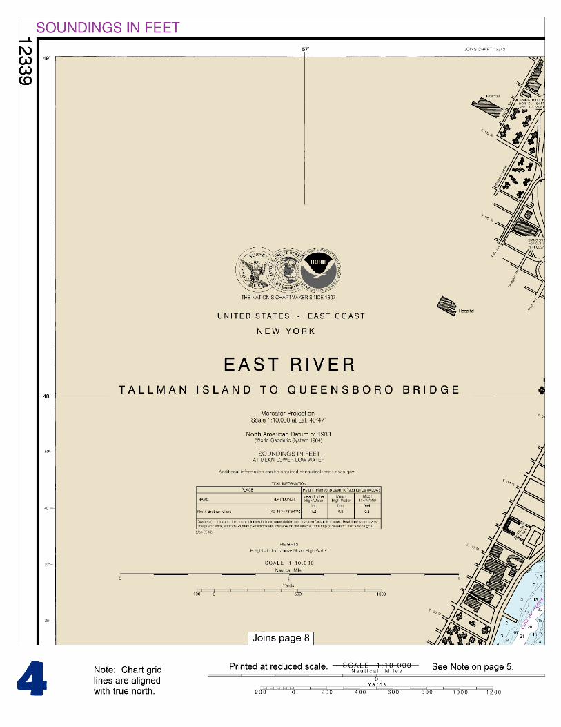
East River Tallman Island to Queensboro Bridge - … · East River Tallman Island to Queensboro...
16
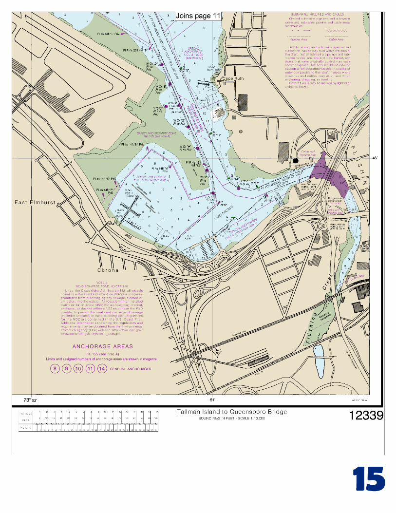
BookletChart ™ East River – Tallman Island to Queensboro Bridge NOAA Chart 12339 A reduced-scale NOAA nautical chart for small boaters When possible, use the full-size NOAA chart for navigation.
Transcript of East River Tallman Island to Queensboro Bridge - … · East River Tallman Island to Queensboro...
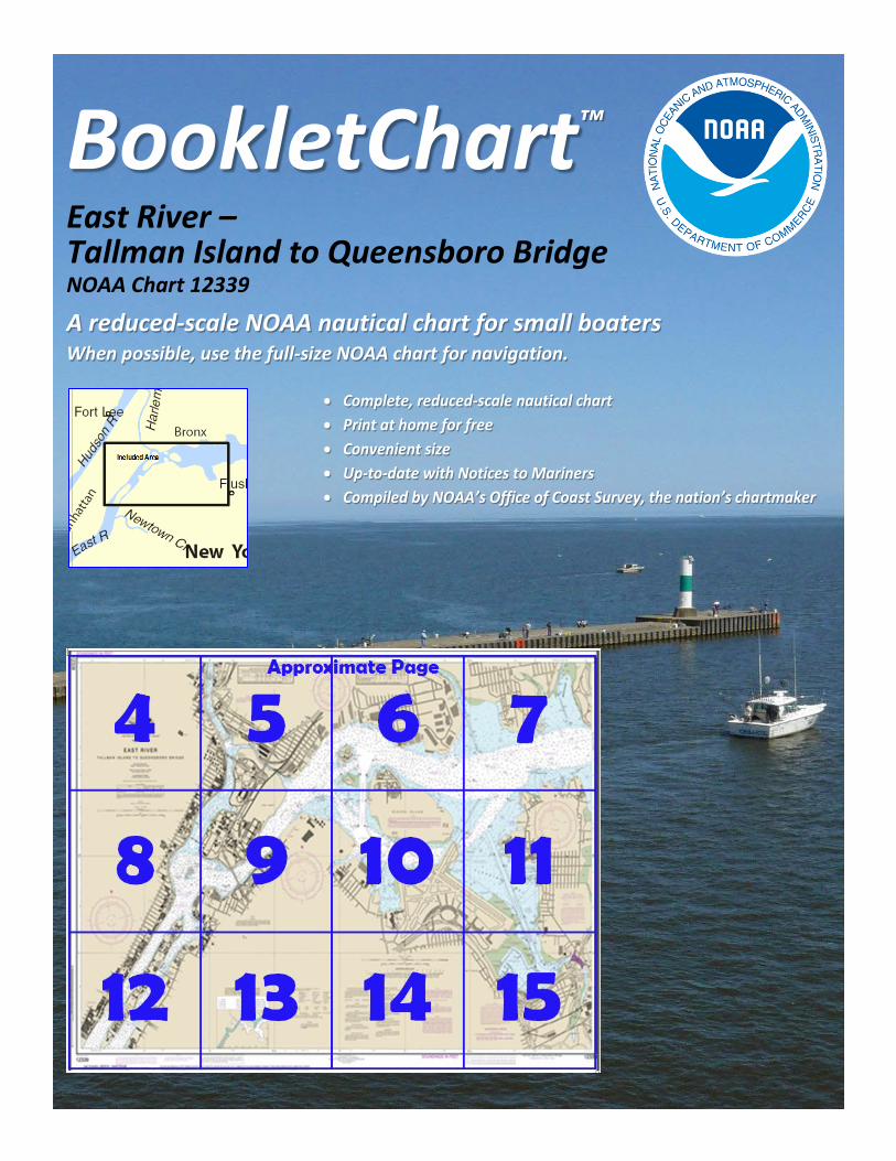
BookletChart™ East River – Tallman Island to Queensboro Bridge NOAA Chart 12339
A reduced-scale NOAA nautical chart for small boaters When possible, use the full-size NOAA chart for navigation.
2
Published by the National Oceanic and Atmospheric Administration
National Ocean Service Office of Coast Survey
www.NauticalCharts.NOAA.gov 888-990-NOAA
What are Nautical Charts?
Nautical charts are a fundamental tool of marine navigation. They show water depths, obstructions, buoys, other aids to navigation, and much more. The information is shown in a way that promotes safe and efficient navigation. Chart carriage is mandatory on the commercial ships that carry America’s commerce. They are also used on every Navy and Coast Guard ship, fishing and passenger vessels, and are widely carried by recreational boaters.
What is a BookletChart?
This BookletChart is made to help recreational boaters locate themselves on the water. It has been reduced in scale for convenience, but otherwise contains all the information of the full-scale nautical chart. The bar scales have also been reduced, and are accurate when used to measure distances in this BookletChart. See the Note at the bottom of page 5 for the reduction in scale applied to this chart.
Whenever possible, use the official, full scale NOAA nautical chart for navigation. Nautical chart sales agents are listed on the Internet at http://www.NauticalCharts.NOAA.gov.
This BookletChart does NOT fulfill chart carriage requirements for regulated commercial vessels under Titles 33 and 44 of the Code of Federal Regulations.
Notice to Mariners Correction Status
This BookletChart has been updated for chart corrections published in the U.S. Coast Guard Local Notice to Mariners, the National Geospatial Intelligence Agency Weekly Notice to Mariners, and, where applicable, the Canadian Coast Guard Notice to Mariners. Additional chart corrections have been made by NOAA in advance of their publication in a Notice to Mariners. The last Notices to Mariners applied to this chart are listed in the Note at the bottom of page 7. Coast Pilot excerpts are not being corrected.
For latest Coast Pilot excerpt visit the Office of Coast Survey website at http://www.nauticalcharts.noaa.gov/nsd/searchbychart.php?chart=12339
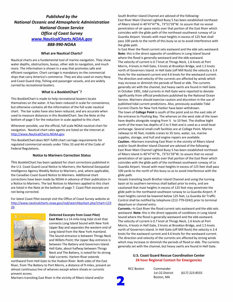
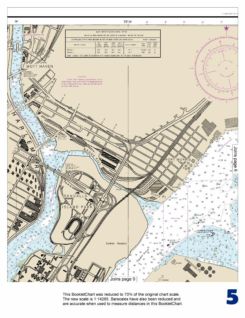
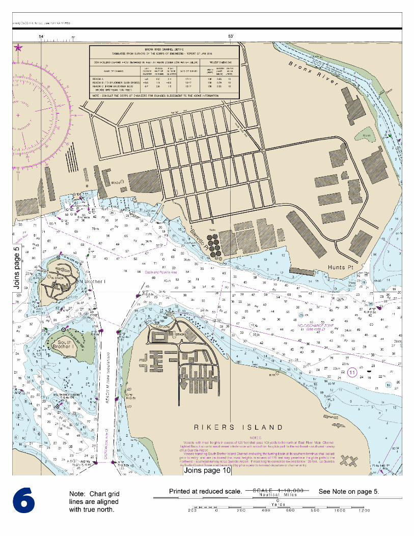
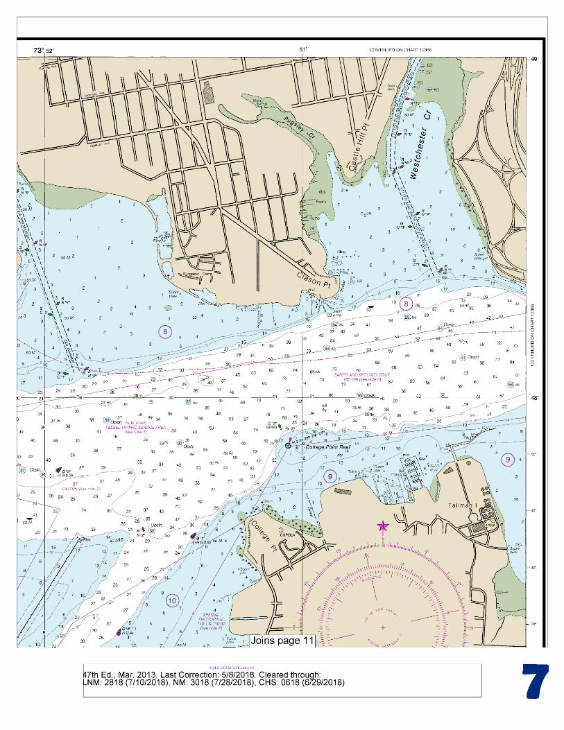
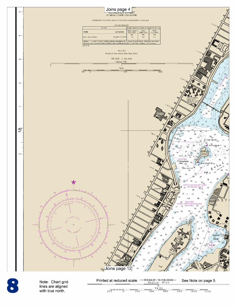
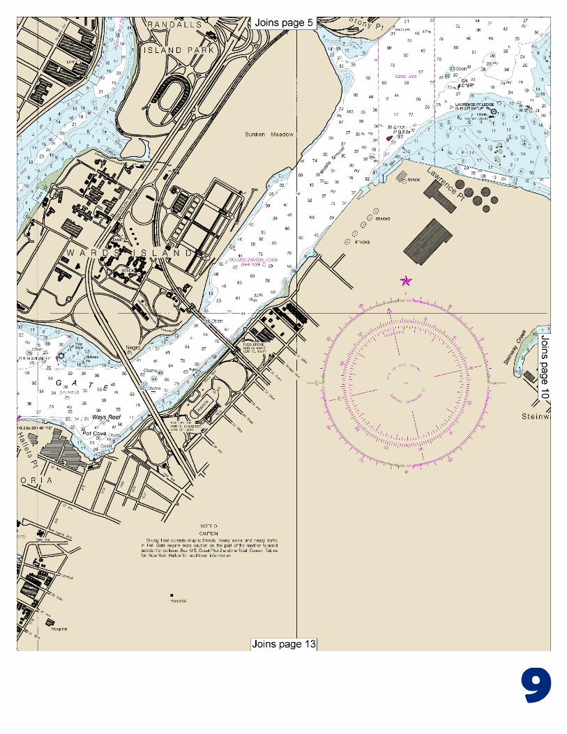
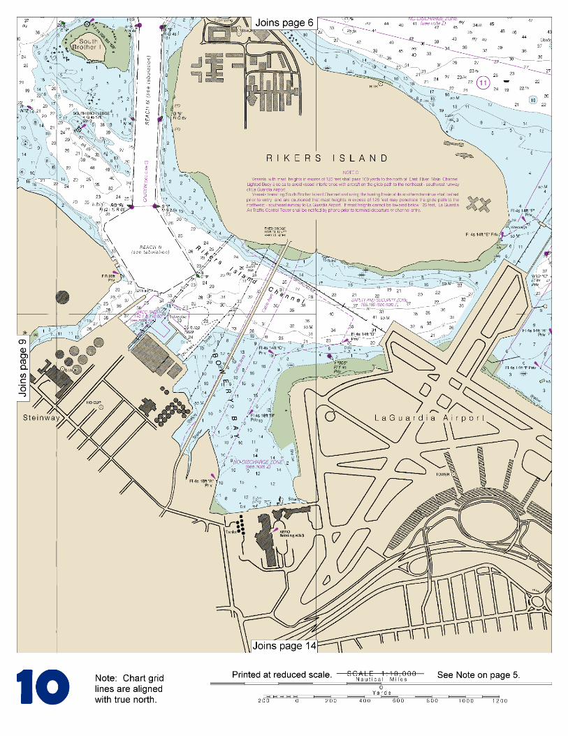
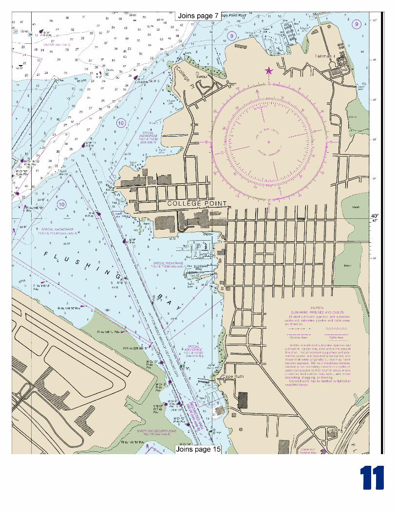
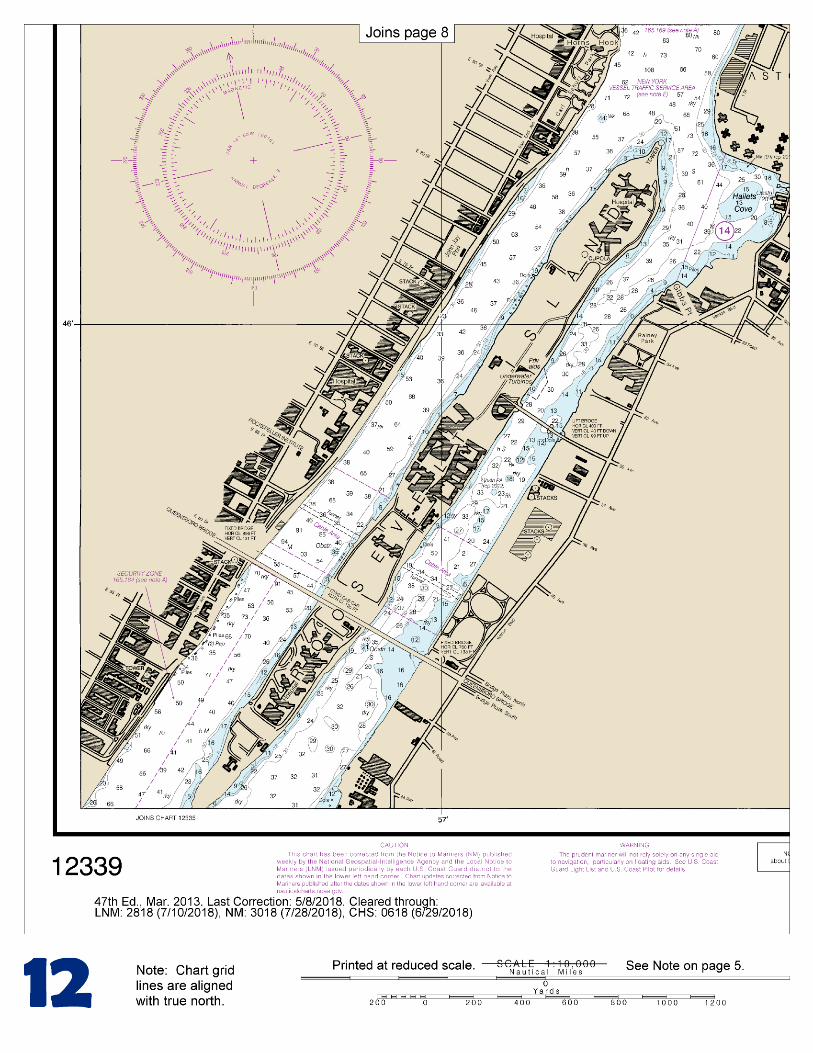
(Selected Excerpts from Coast Pilot) East River is a 14-mile-long tidal strait that connects Long Island Sound with New York Upper Bay and separates the western end of Long Island from the New York mainland. The Sound entrance is between Throgs Neck and Willets Point; the Upper Bay entrance is between The Battery and Governors Island. Hell Gate, about halfway between Throgs Neck and The Battery, is noted for its strong tidal currents. Harlem River extends
northward from Hell Gate to the Hudson River. Both sides of the East River, from The Battery to Port Morris, a distance of 9 miles, present an almost continuous line of wharves except where shoals or currents prevent access. Mariners transiting East River in the vicinity of Rikers Island and/or
South Brother Island Channel are advised of the following: East River Main Channel Lighted Buoy 5 has been established northeast of Rikers Island in 40°47'47"N., 73°51'59"W. to assure that no vessel penetration of air space exists over that portion of the East River which coincides with the glide path of the northeast-southwest runway of La Guardia Airport. Vessels with mast heights in excess of 125 feet shall pass 100 yards to the north of this buoy so as to avoid interference with the glide path. In East River the flood current sets eastward and the ebb sets westward. Note: this is the direct opposite of conditions in Long Island Sound where the flood is generally westward and the ebb eastward. The velocity of current is 0.7 knot at Throgs Neck, 1.6 knots at Port Morris, 4 knots in Hell Gate, 3 knots at Brooklyn Bridge, and 1.5 knots north of Governors Island. In Hell Gate (off Mill Rock) the velocity is 3.4 knots for the eastward current and 4.6 knots for the westward current. The direction and velocity of the currents are affected by winds which may increase or diminish the periods of flood or ebb. The currents generally set with the channel, but heavy swirls are found in Hell Gate. In October 1991, tidal currents in Hell Gate were reported to deviate significantly from official predictions published by the National Ocean Service. Mariners should exercise caution and discretion in the use of published tidal current predictions. Also, previously available Tidal Current Charts for New York Harbor have been withdrawn. The town of College Point is south of the point and on the east side of the entrance to Flushing Bay. The wharves on the west side of the town have depths alongside ranging from ½ to 10 feet. The shallow bight north of the town has depths of 2 to 5 feet and is used as a small-boat anchorage. Several small-craft facilities are at College Point. Marine railways to 45 feet, mobile cranes to 35 tons, water, ice, marine supplies, storage, and hull and engine repairs are available. Caution.–Mariners transiting East River in the vicinity of Rikers Island and/or South Brother Island Channel are advised of the following: East River Main Channel Lighted Buoy 5 has been established northeast of Rikers Island in 40°47’47”N., 73°51’59”W. to assure that no vessel penetration of air space exists over that portion of the East River which coincides with the glide path of the northeast-southwest runway of La Guardia Airport. Vessel with mast heights in excess of 125 feet shall pass 100 yards to the north of this buoy so as to avoid interference with the glide path. Vessels transiting South Brother Island Channel and using the turning basin at its southern terminus shall ballast prior to entry, and are cautioned that mast heights in excess of 125 feet may penetrate the glide path to the northwest-southeast runway to La Guardia Airport. If mast heights cannot be lowered below 125 feet, La Guardia Air Traffic Control shall be notified by telephone (212-779-0242) prior to terminal departure or channel entry. Currents.–In East River the flood current sets eastward and the ebb sets westward. Note: this is the direct opposite of conditions in Long Island Sound where the flood is generally westward and the ebb eastward. The velocity of current is 0.7 knot at Throgs Neck, 1.6 knots at Port Morris, 4 knots in Hell Gate, 3 knots at Brooklyn Bridge, and 1.5 knots north of Governors Island. In Hell Gate (off Mill Rock) the velocity is 3.4 knots for the eastward current and 4.6 knots for the westward current. The direction and velocity of the currents are affected by strong winds which may increase or diminish the periods of flood or ebb. The currents generally set with the channel, but heavy swirls are found in Hell Gate.
U.S. Coast Guard Rescue Coordination Center
24 hour Regional Contact for Emergencies RCC Boston Commander
1st CG District (617) 223-8555 Boston, MA
G
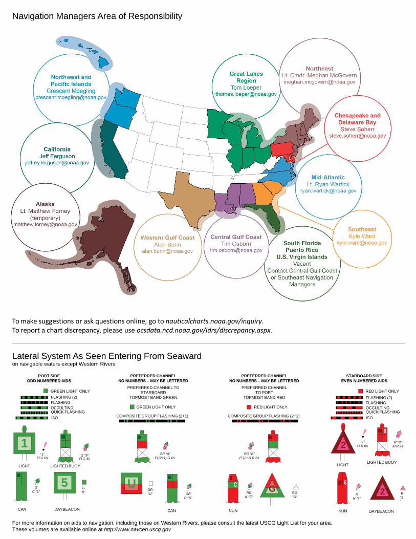
NOAA’s navigation managers serve as ambassadors to the maritime community. They help identify navigational challenges facing professional and recreational mariners, and provide NOAA resources and information for safe navigation. For additional information, please visit nauticalcharts.noaa.gov/service/navmanagers
To make suggestions or ask questions online, go to nauticalcharts.noaa.gov/inquiry. To report a chart discrepancy, please use ocsdata.ncd.noaa.gov/idrs/discrepancy.aspx.
Lateral System As Seen Entering From Seaward on navigable waters except Western Rivers
PORT SIDE
ODD NUMBERED AIDS
GREEN LIGHT ONLY
FLASHING (2)
PREFERRED CHANNEL
NO NUMBERS – MAY BE LETTERED
PREFERRED CHANNEL TO
STARBOARD
TOPMOST BAND GREEN
PREFERRED CHANNEL
NO NUMBERS – MAY BE LETTERED
PREFERRED CHANNEL
TO PORT
TOPMOST BAND RED
STARBOARD SIDE
EVEN NUMBERED AIDS
RED LIGHT ONLY
FLASHING (2)
FLASHING FLASHING
OCCULTING GREEN LIGHT ONLY RED LIGHT ONLY OCCULTING QUICK FLASHING QUICK FLASHING
ISO COMPOSITE GROUP FLASHING (2+1) COMPOSITE GROUP FLASHING (2+1) ISO
"1"
Fl G 6s
G "9"
Fl G 4s
GR "A"
Fl (2+1) G 6s
RG "B"
Fl (2+1) R 6s
"2"
Fl R 6s
8
R "8"
Fl R 4s
LIGHT
G
C "1"
LIGHTED BUOY
G
"5"
GR
"U"
GR
C "S"
RG
N "C"
RG
"G"
LIGHT
6
R
N "6"
LIGHTED BUOY
R
"2
"
CAN DAYBEACON
CAN NUN NUN
DAYBEACON
For more information on aids to navigation, including those on Western Rivers, please consult the latest USCG Light List for your area.
These volumes are available online at http://www.navcen.uscg.gov
Navigation Managers Area of Responsibility
Northeast
Lt. Meghan McGovern
Northwest and
Pacific Islands
Crescent Moegling
Great Lakes Region
Tom Loeper
Chesapeake and
Delaware Bay
Steve Soherr
California
Jeff Ferguson
[email protected] Mid-Atlantic
Lt. Ryan Wartick
Alaska
Lt. Timothy M. Smith
Western Gulf Coast
Alan Bunn
Central Gulf Coast
Tim Osborn
[email protected] South Florida
Puerto Rico
U.S. Virgin Islands
Michael Henderson
Southeast
Kyle Ward
2
2 C U 5
1
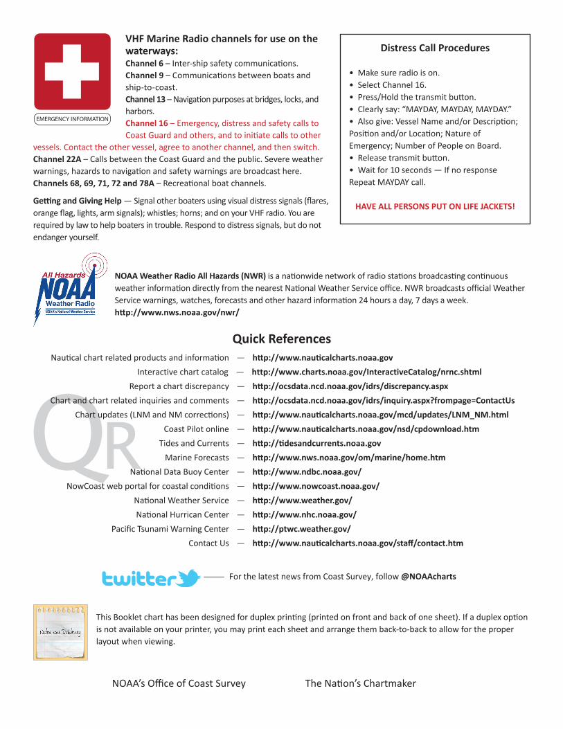
VHF Marine Radio channels for use on the waterways:Channel 6 – Inter-ship safety communications.Channel 9 – Communications between boats and ship-to-coast.Channel 13 – Navigation purposes at bridges, locks, and harbors.Channel 16 – Emergency, distress and safety calls to Coast Guard and others, and to initiate calls to other
vessels. Contact the other vessel, agree to another channel, and then switch.Channel 22A – Calls between the Coast Guard and the public. Severe weather warnings, hazards to navigation and safety warnings are broadcast here.Channels 68, 69, 71, 72 and 78A – Recreational boat channels.
Getting and Giving Help — Signal other boaters using visual distress signals (flares, orange flag, lights, arm signals); whistles; horns; and on your VHF radio. You are required by law to help boaters in trouble. Respond to distress signals, but do not endanger yourself.
EMERGENCY INFORMATION
Distress Call Procedures
• Make sure radio is on.• Select Channel 16.• Press/Hold the transmit button.• Clearly say: “MAYDAY, MAYDAY, MAYDAY.”• Also give: Vessel Name and/or Description;Position and/or Location; Nature of Emergency; Number of People on Board.• Release transmit button.• Wait for 10 seconds — If no responseRepeat MAYDAY call.
HAVE ALL PERSONS PUT ON LIFE JACKETS!
This Booklet chart has been designed for duplex printing (printed on front and back of one sheet). If a duplex option is not available on your printer, you may print each sheet and arrange them back-to-back to allow for the proper layout when viewing.
QR
Quick ReferencesNautical chart related products and information - http://www.nauticalcharts.noaa.gov
Interactive chart catalog - http://www.charts.noaa.gov/InteractiveCatalog/nrnc.shtmlReport a chart discrepancy - http://ocsdata.ncd.noaa.gov/idrs/discrepancy.aspx
Chart and chart related inquiries and comments - http://ocsdata.ncd.noaa.gov/idrs/inquiry.aspx?frompage=ContactUs
Chart updates (LNM and NM corrections) - http://www.nauticalcharts.noaa.gov/mcd/updates/LNM_NM.html
Coast Pilot online - http://www.nauticalcharts.noaa.gov/nsd/cpdownload.htm
Tides and Currents - http://tidesandcurrents.noaa.gov
Marine Forecasts - http://www.nws.noaa.gov/om/marine/home.htm
National Data Buoy Center - http://www.ndbc.noaa.gov/
NowCoast web portal for coastal conditions - http://www.nowcoast.noaa.gov/
National Weather Service - http://www.weather.gov/
National Hurrican Center - http://www.nhc.noaa.gov/
Pacific Tsunami Warning Center - http://ptwc.weather.gov/
Contact Us - http://www.nauticalcharts.noaa.gov/staff/contact.htm
NOAA’s Office of Coast Survey The Nation’s Chartmaker
For the latest news from Coast Survey, follow @NOAAcharts
NOAA Weather Radio All Hazards (NWR) is a nationwide network of radio stations broadcasting continuous weather information directly from the nearest National Weather Service office. NWR broadcasts official Weather Service warnings, watches, forecasts and other hazard information 24 hours a day, 7 days a week. http://www.nws.noaa.gov/nwr/