Earthquake seismology
8
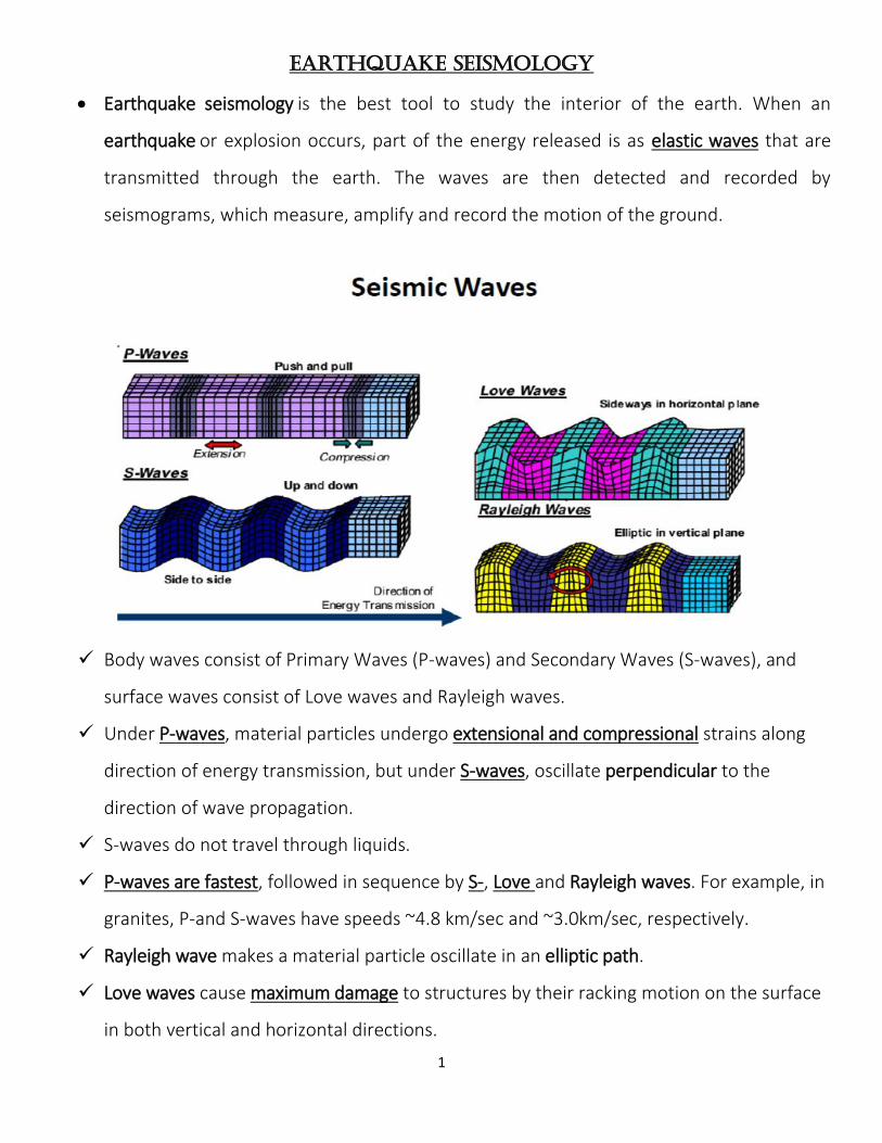
1 Earthquake Seismology Earthquake seismology is the best tool to study the interior of the earth. When an earthquake or explosion occurs, part of the energy released is as elastic waves that are transmitted through the earth. The waves are then detected and recorded by seismograms, which measure, amplify and record the motion of the ground. Body waves consist of Primary Waves (P-waves) and Secondary Waves (S-waves), and surface waves consist of Love waves and Rayleigh waves. Under P-waves, material particles undergo extensional and compressional strains along direction of energy transmission, but under S-waves, oscillate perpendicular to the direction of wave propagation. S-waves do not travel through liquids. P-waves are fastest, followed in sequence by S-, Love and Rayleigh waves. For example, in granites, P-and S-waves have speeds ~4.8 km/sec and ~3.0km/sec, respectively. Rayleigh wave makes a material particle oscillate in an elliptic path. Love waves cause maximum damage to structures by their racking motion on the surface in both vertical and horizontal directions.
-
Upload
amir-i-abdelaziz -
Category
Science
-
view
71 -
download
0
Transcript of Earthquake seismology
1
Earthquake Seismology
Earthquake seismology is the best tool to study the interior of the earth. When an
earthquake or explosion occurs, part of the energy released is as elastic waves that are
transmitted through the earth. The waves are then detected and recorded by
seismograms, which measure, amplify and record the motion of the ground.
Body waves consist of Primary Waves (P-waves) and Secondary Waves (S-waves), and
surface waves consist of Love waves and Rayleigh waves.
Under P-waves, material particles undergo extensional and compressional strains along
direction of energy transmission, but under S-waves, oscillate perpendicular to the
direction of wave propagation.
S-waves do not travel through liquids.
P-waves are fastest, followed in sequence by S-, Love and Rayleigh waves. For example, in
granites, P-and S-waves have speeds ~4.8 km/sec and ~3.0km/sec, respectively.
Rayleigh wave makes a material particle oscillate in an elliptic path.
Love waves cause maximum damage to structures by their racking motion on the surface
in both vertical and horizontal directions.
2
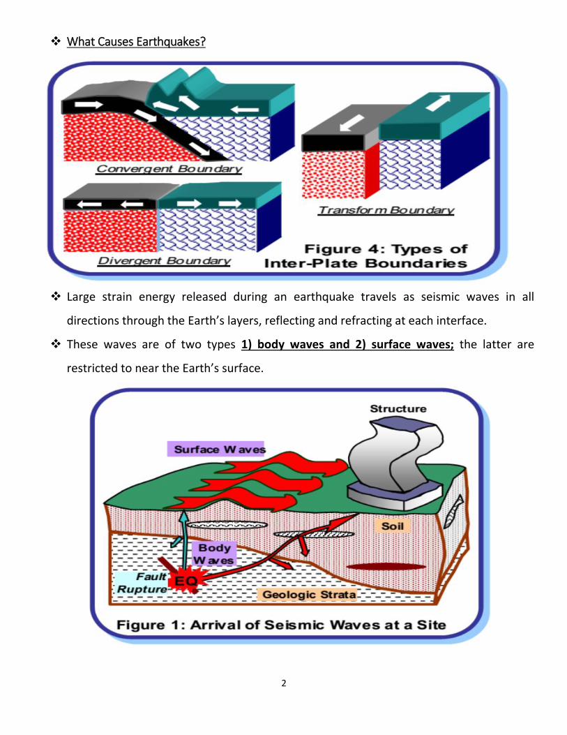
What Causes Earthquakes?
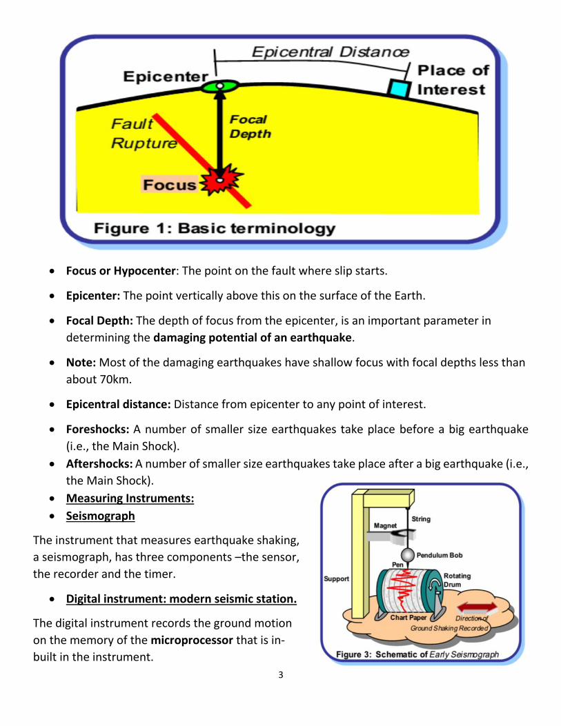
Large strain energy released during an earthquake travels as seismic waves in all
directions through the Earth’s layers, reflecting and refracting at each interface.
These waves are of two types 1) body waves and 2) surface waves; the latter are
restricted to near the Earth’s surface.
3
Focus or Hypocenter: The point on the fault where slip starts.
Epicenter: The point vertically above this on the surface of the Earth.
Focal Depth: The depth of focus from the epicenter, is an important parameter in
determining the damaging potential of an earthquake.
Note: Most of the damaging earthquakes have shallow focus with focal depths less than
about 70km.
Epicentral distance: Distance from epicenter to any point of interest.
Foreshocks: A number of smaller size earthquakes take place before a big earthquake
(i.e., the Main Shock).
Aftershocks: A number of smaller size earthquakes take place after a big earthquake (i.e.,
the Main Shock).
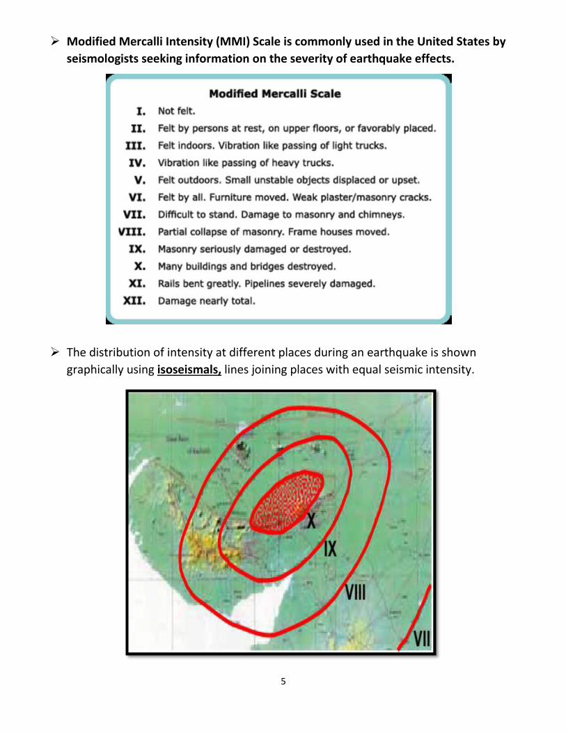
Measuring Instruments:
Seismograph
The instrument that measures earthquake shaking,
a seismograph, has three components –the sensor,
the recorder and the timer.
Digital instrument: modern seismic station.
The digital instrument records the ground motion
on the memory of the microprocessor that is in-
built in the instrument.
4
Magnitude: is a quantitative measure of the actual size of the earthquake. This means
that the magnitude of the earthquake is a single value for a given earthquake.
Professor Charles Richter noticed that:
a) at the same distance, seismograms (records of earthquake ground vibration) of larger
earthquakes have bigger wave amplitude than those of smaller earthquakes;
b) For a given earthquake, seismograms at farther distances have smaller wave amplitude
than those at close distances.
o These prompted him to propose the now commonly used magnitude scale, the Richter
Scale, which is obtained from the seismograms and accounts for the dependence of
waveform amplitude on epicentral distance. This scale is also called Local Magnitude
scale (ML).
o An increasing in magnitude (M) by 1.0 implies 10 times higher wave form amplitude and
about 31 time higher energy released.
For instance, energy released in a M 7.7 earthquake is about 31 times that released in a
M 6.7 earthquake, and is about 1000 (≈31×31) times that released in a M 5.7 earthquake.
o Note: Did you know? The energy released by a M6.3 earthquake is equivalent to that
released by the 1945 Atom Bomb dropped on Hiroshima!!).
Two most commonly used intensity scales are the
1-Modified Mercalli Intensity (MMI) Scale
2-MSK Scale.
Both scales are quite similar and range from I (least perceptive) to XII (most severe). The
intensity scales are based on three features:
1-Shaking –perception by people and animals,
2-Performance of buildings,
3-Changes to natural surroundings.
5
Modified Mercalli Intensity (MMI) Scale is commonly used in the United States by
seismologists seeking information on the severity of earthquake effects.
The distribution of intensity at different places during an earthquake is shown
graphically using isoseismals, lines joining places with equal seismic intensity.
6
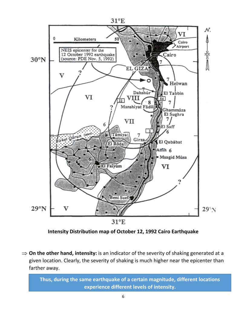
Intensity Distribution map of October 12, 1992 Cairo Earthquake
On the other hand, intensity: is an indicator of the severity of shaking generated at a
given location. Clearly, the severity of shaking is much higher near the epicenter than
farther away.
Thus, during the same earthquake of a certain magnitude, different locations
experience different levels of intensity.
7
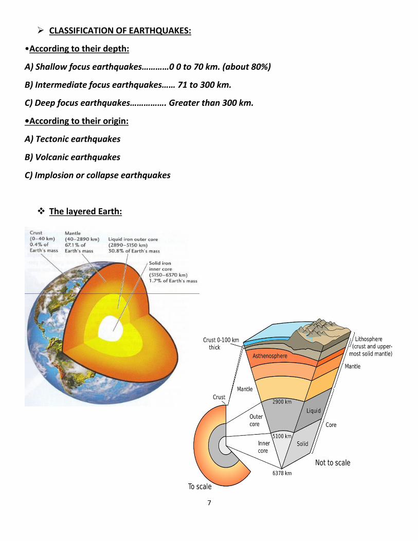
CLASSIFICATION OF EARTHQUAKES:
•According to their depth:
A) Shallow focus earthquakes…………0 0 to 70 km. (about 80%)
B) Intermediate focus earthquakes…… 71 to 300 km.
C) Deep focus earthquakes……………. Greater than 300 km.
•According to their origin:
A) Tectonic earthquakes
B) Volcanic earthquakes
C) Implosion or collapse earthquakes
The layered Earth:
8
Theories of Earth formation:
1. Geosyclinal theory:
Geosyclinal theory can be divided into two main stages. The first involves major
sediment deposition. Following this is an event called the mountain making “crisis,”
which is very quick relative to the first stage.
Dana described the crustal down-warp area as the “geosynclinal region,” and the product
of the process as the “mountain chain-synclinorium”. Dana also reinstated that the trend
of the mountain range follows the deepest part of the geosyclinal trough.
Geosynclines are further classified into miogeosynclines, eugeosynclines, and
orthogeosynclines; dependent on rock strata, location, and nature of the mountain
system.
A miogeosyncline is comprised of sandstones, limestones, and shales (Continental Drift).
Eugeosynclines are composed of thick sequences of deep marine sediments; they are
often more deformed and metamorphosed.
Orthogeosynclines are lie between continental and oceanic terrains.
2. The theory of plate tectonics: Fig. (2)
THE MOSAIC OF PLATES:
According to the plate tectonic theory the crust is not a continuous shell but, consists of
more than 12 main plates and a number of small ones. These are in a continuous motion
relative to each others.
The three main ideal types of plate boundary:
1) Divergent plate boundary, where plates moves apart and new lithosphere is formed
(plate area increase).
2) Convergent plate boundary, where plates come together and one is recycled back to the
mantle (plate area decrease).
3) Transform-fault boundary, where plates slide horizontally past each other (plate area
remain constant).