earth2 art ppt ch19 - University of Notre Damecneal/PlanetEarth/Chapt-19-Marshak.pdf · Saturated...
29
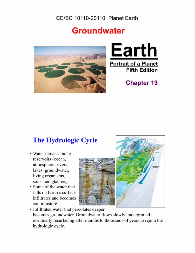
Earth Portrait of a Planet Fifth Edition Chapter 19 Groundwater CE/SC 10110-20110: Planet Earth The Hydrologic Cycle • Water moves among reservoirs (ocean, atmosphere, rivers, lakes, groundwater, living organisms, soils, and glaciers). • Some of the water that falls on Earth’s surface infiltrates and becomes soil moisture. • Infiltrated water that percolates deeper becomes groundwater. Groundwater flows slowly underground, eventually resurfacing after months to thousands of years to rejoin the hydrologic cycle.
Transcript of earth2 art ppt ch19 - University of Notre Damecneal/PlanetEarth/Chapt-19-Marshak.pdf · Saturated...
Earth Portrait of a Planet
Fifth Edition
Chapter 19
Groundwater CE/SC 10110-20110: Planet Earth
The Hydrologic Cycle
• Water moves among reservoirs (ocean, atmosphere, rivers, lakes, groundwater, living organisms, soils, and glaciers).
• Some of the water that falls on Earth’s surface infiltrates and becomes soil moisture.
• Infiltrated water that percolates deeper becomes groundwater. Groundwater flows slowly underground, eventually resurfacing after months to thousands of years to rejoin the hydrologic cycle.
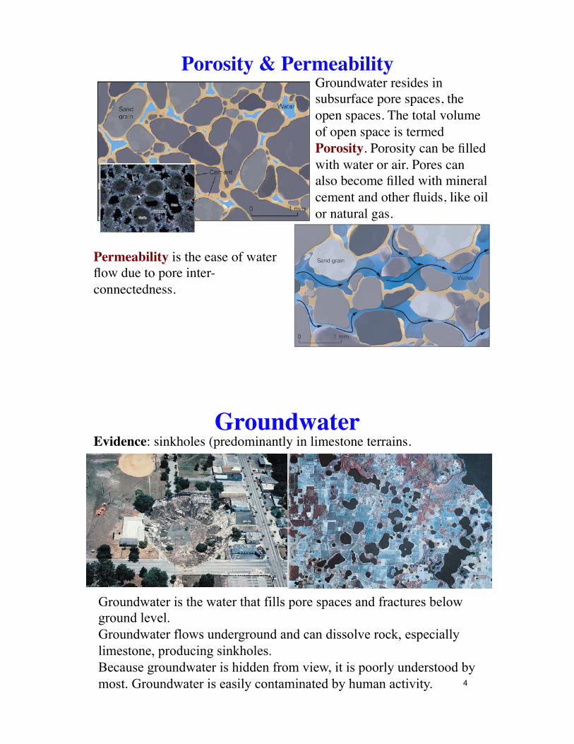
Porosity & PermeabilityGroundwater resides in subsurface pore spaces, the open spaces. The total volume of open space is termed Porosity. Porosity can be filled with water or air. Pores can also become filled with mineral cement and other fluids, like oil or natural gas.
Permeability is the ease of water flow due to pore inter-connectedness.
GroundwaterEvidence: sinkholes (predominantly in limestone terrains.
Groundwater is the water that fills pore spaces and fractures below ground level. Groundwater flows underground and can dissolve rock, especially limestone, producing sinkholes. Because groundwater is hidden from view, it is poorly understood by most. Groundwater is easily contaminated by human activity. 4
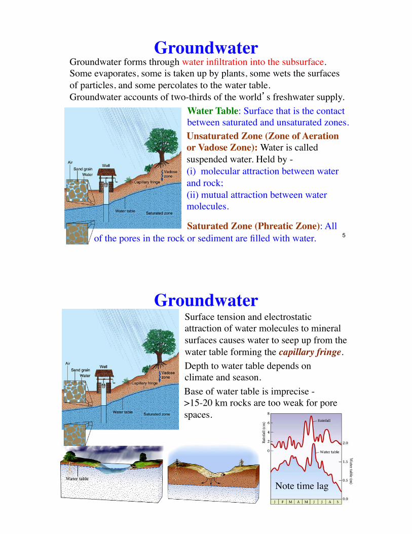
GroundwaterGroundwater forms through water infiltration into the subsurface.Some evaporates, some is taken up by plants, some wets the surfaces of particles, and some percolates to the water table.Groundwater accounts of two-thirds of the world�s freshwater supply.
Water Table: Surface that is the contact between saturated and unsaturated zones.Unsaturated Zone (Zone of Aeration or Vadose Zone): Water is called suspended water. Held by -(i) molecular attraction between water and rock;(ii) mutual attraction between water molecules.
Saturated Zone (Phreatic Zone): Allof the pores in the rock or sediment are filled with water. 5
GroundwaterSurface tension and electrostatic attraction of water molecules to mineral surfaces causes water to seep up from the water table forming the capillary fringe.Depth to water table depends on climate and season.Base of water table is imprecise - >15-20 km rocks are too weak for pore spaces.
Note time lag
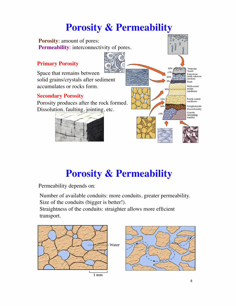
Porosity & PermeabilityPorosity: amount of pores; !Permeability: interconnectivity of pores.
Primary PorositySpace that remains between !solid grains/crystals after sediment accumulates or rocks form.Secondary PorosityPorosity produces after the rock formed.Dissolution, faulting, jointing, etc.
Porosity & PermeabilityPermeability depends on:
Number of available conduits: more conduits, greater permeability.Size of the conduits (bigger is better!).Straightness of the conduits: straighter allows more efficient transport.
8
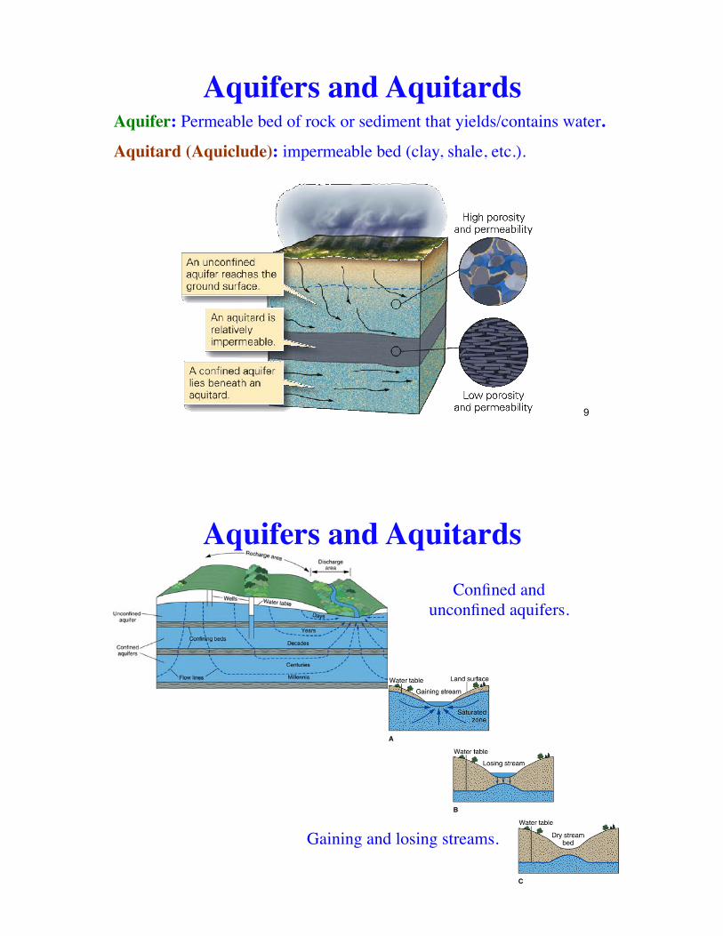
Aquifers and AquitardsAquifer: Permeable bed of rock or sediment that yields/contains water.
Aquitard (Aquiclude): impermeable bed (clay, shale, etc.).
9
Confined and unconfined aquifers.
Aquifers and Aquitards
Gaining and losing streams.
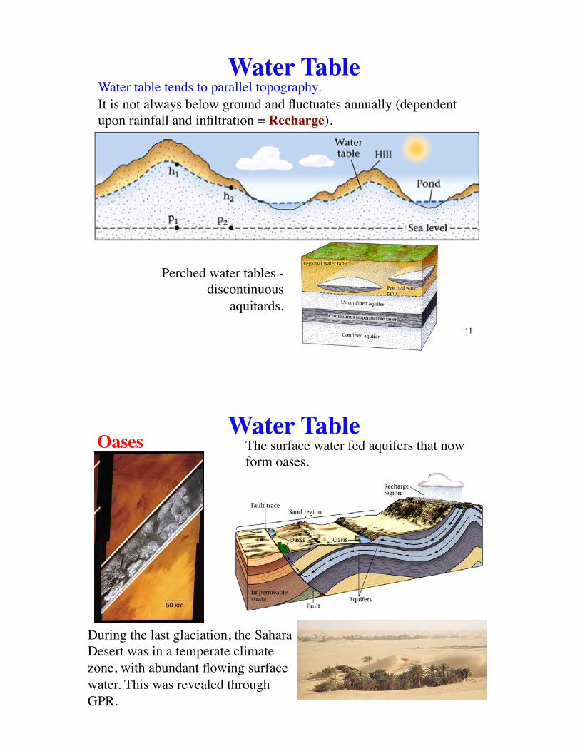
Water TableWater table tends to parallel topography.It is not always below ground and fluctuates annually (dependent upon rainfall and infiltration = Recharge).
Perched water tables - discontinuous
aquitards.
11
Water TableOases
During the last glaciation, the Sahara Desert was in a temperate climate zone, with abundant flowing surface water. This was revealed through GPR.
The surface water fed aquifers that now form oases.
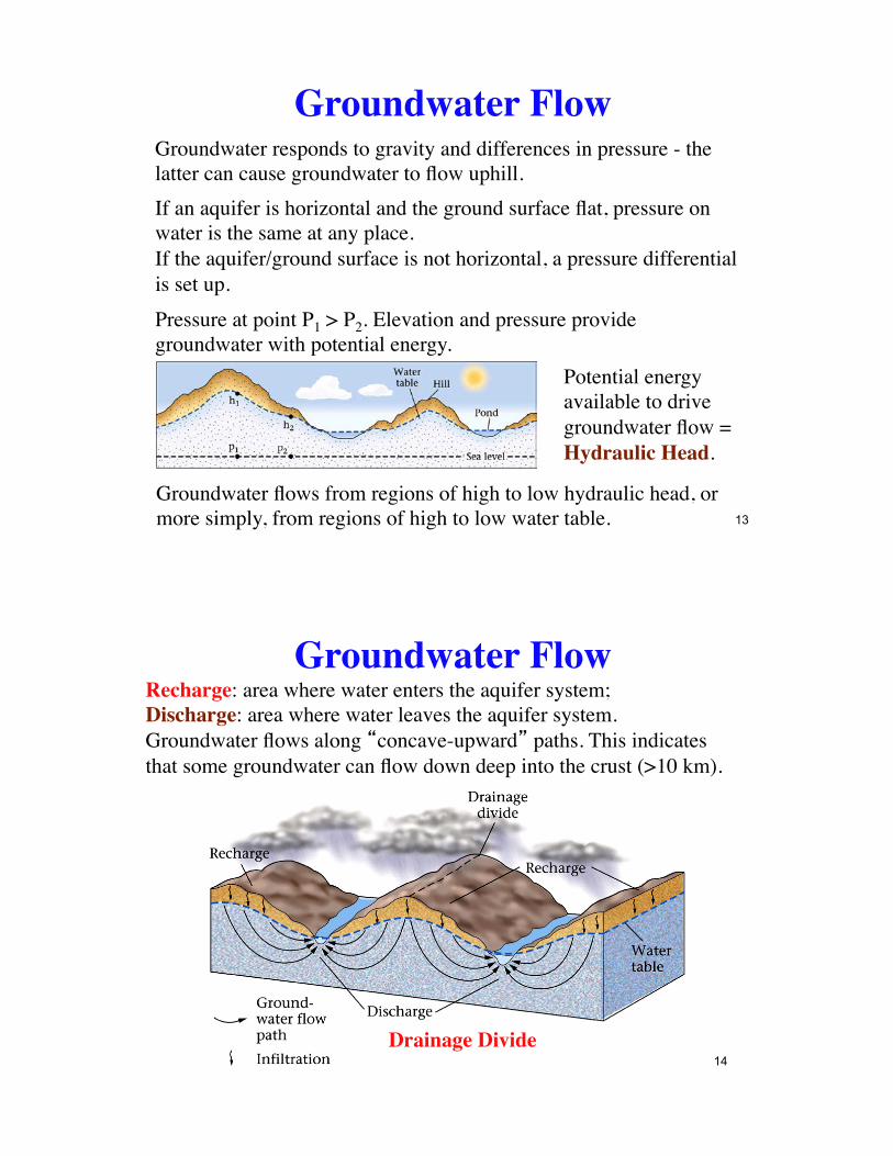
Groundwater FlowGroundwater responds to gravity and differences in pressure - the latter can cause groundwater to flow uphill.If an aquifer is horizontal and the ground surface flat, pressure on water is the same at any place.If the aquifer/ground surface is not horizontal, a pressure differential is set up.Pressure at point P1 > P2. Elevation and pressure provide groundwater with potential energy.
Potential energy available to drive groundwater flow = Hydraulic Head.
Groundwater flows from regions of high to low hydraulic head, or more simply, from regions of high to low water table. 13
Groundwater FlowRecharge: area where water enters the aquifer system;Discharge: area where water leaves the aquifer system.Groundwater flows along �concave-upward� paths. This indicates that some groundwater can flow down deep into the crust (>10 km).
Drainage Divide14
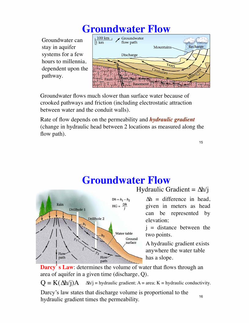
Groundwater FlowGroundwater can stay in aquifer systems for a few hours to millennia, dependent upon the pathway.
Groundwater flows much slower than surface water because of crooked pathways and friction (including electrostatic attraction between water and the conduit walls).Rate of flow depends on the permeability and hydraulic gradient (change in hydraulic head between 2 locations as measured along the flow path).
15
Groundwater Flow∆h = difference in head, given in meters as head can be represented by elevation;j = distance between the two points.
Hydraulic Gradient = ∆h/j
A hydraulic gradient exists anywhere the water table has a slope.
Darcy�s Law: determines the volume of water that flows through an area of aquifer in a given time (discharge, Q).Q = K(∆h/j)A ∆h/j = hydraulic gradient; A = area; K = hydraulic conductivity.
16 Darcy’s law states that discharge volume is proportional to the hydraulic gradient times the permeability.
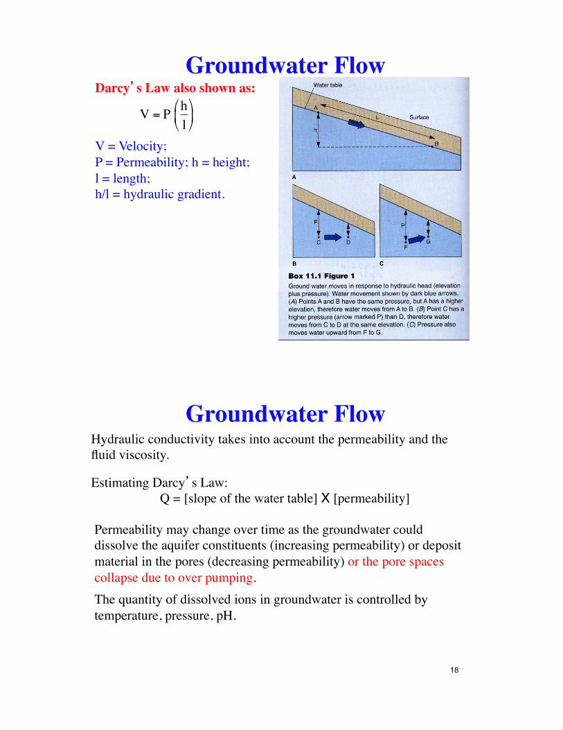
Darcy�s Law also shown as:
V = Velocity; !P = Permeability; h = height; !l = length; !h/l = hydraulic gradient.
€
V = P hl
"
# $ %
& '
Groundwater Flow
Groundwater FlowHydraulic conductivity takes into account the permeability and the fluid viscosity.
Estimating Darcy�s Law: Q = [slope of the water table] X [permeability]
Permeability may change over time as the groundwater could dissolve the aquifer constituents (increasing permeability) or deposit material in the pores (decreasing permeability) or the pore spaces collapse due to over pumping.The quantity of dissolved ions in groundwater is controlled by temperature, pressure, pH.
18
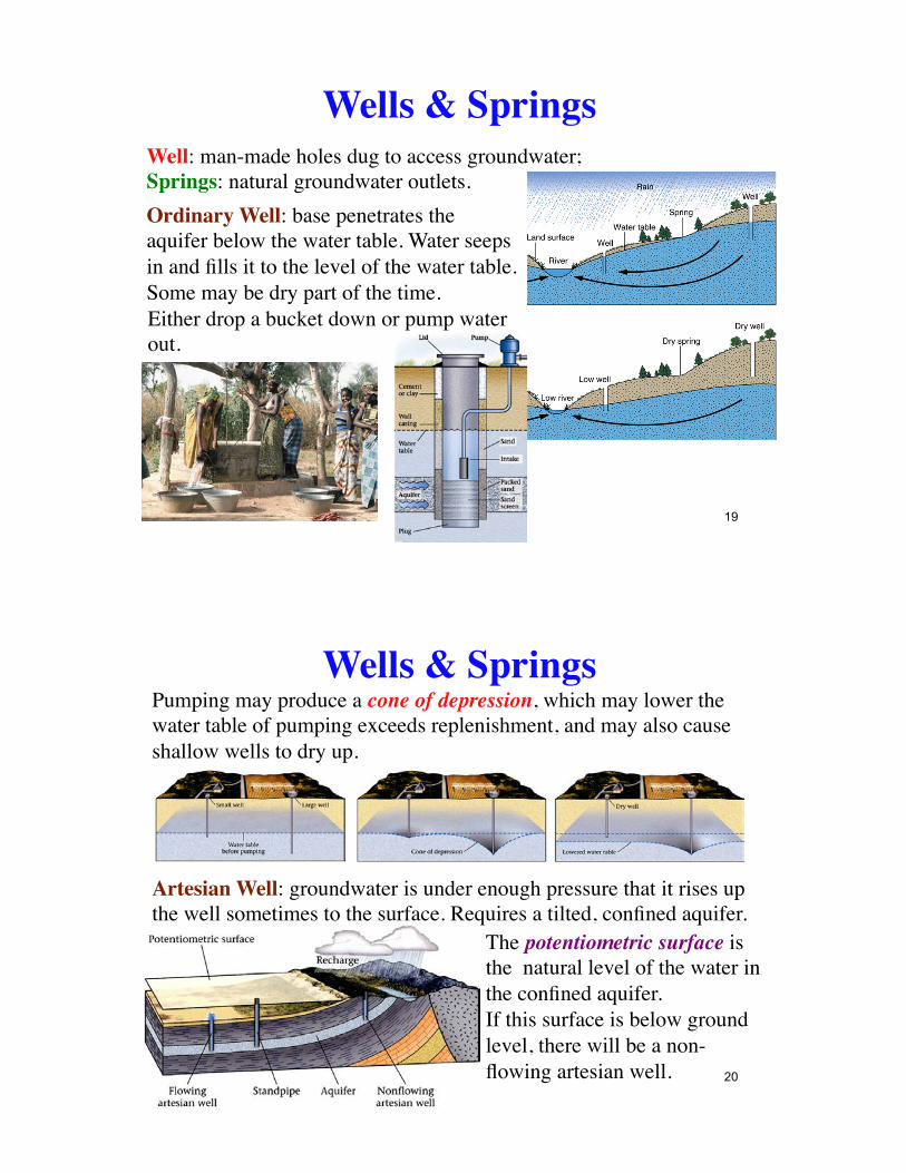
Wells & SpringsWell: man-made holes dug to access groundwater;Springs: natural groundwater outlets.Ordinary Well: base penetrates the aquifer below the water table. Water seeps in and fills it to the level of the water table. Some may be dry part of the time.Either drop a bucket down or pump water out.
19
Wells & SpringsPumping may produce a cone of depression, which may lower the water table of pumping exceeds replenishment, and may also cause shallow wells to dry up.
Artesian Well: groundwater is under enough pressure that it rises up the well sometimes to the surface. Requires a tilted, confined aquifer.
The potentiometric surface is the natural level of the water in the confined aquifer.If this surface is below ground level, there will be a non-flowing artesian well. 20
Wells & SpringsThe same principle is used for domestic water tanks.
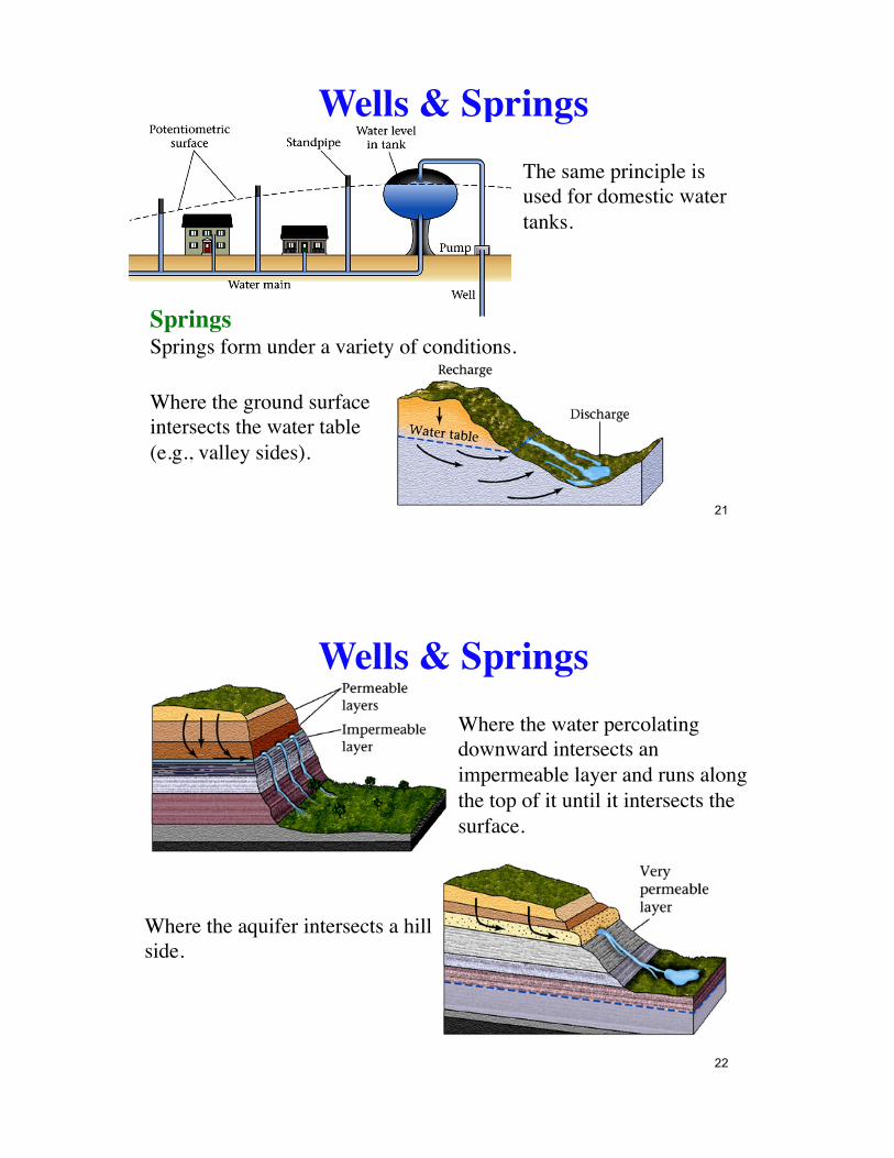
SpringsSprings form under a variety of conditions.
Where the ground surface intersects the water table (e.g., valley sides).
21
Wells & SpringsWhere the water percolating downward intersects an impermeable layer and runs along the top of it until it intersects the surface.
Where the aquifer intersects a hill side.
22
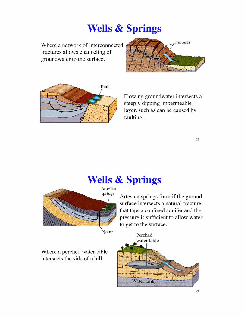
Wells & SpringsWhere a network of interconnected fractures allows channeling of groundwater to the surface.
Flowing groundwater intersects a steeply dipping impermeable layer, such as can be caused by faulting.
23
Wells & SpringsArtesian springs form if the ground surface intersects a natural fracture that taps a confined aquifer and the pressure is sufficient to allow water to get to the surface.
Where a perched water table intersects the side of a hill.
24
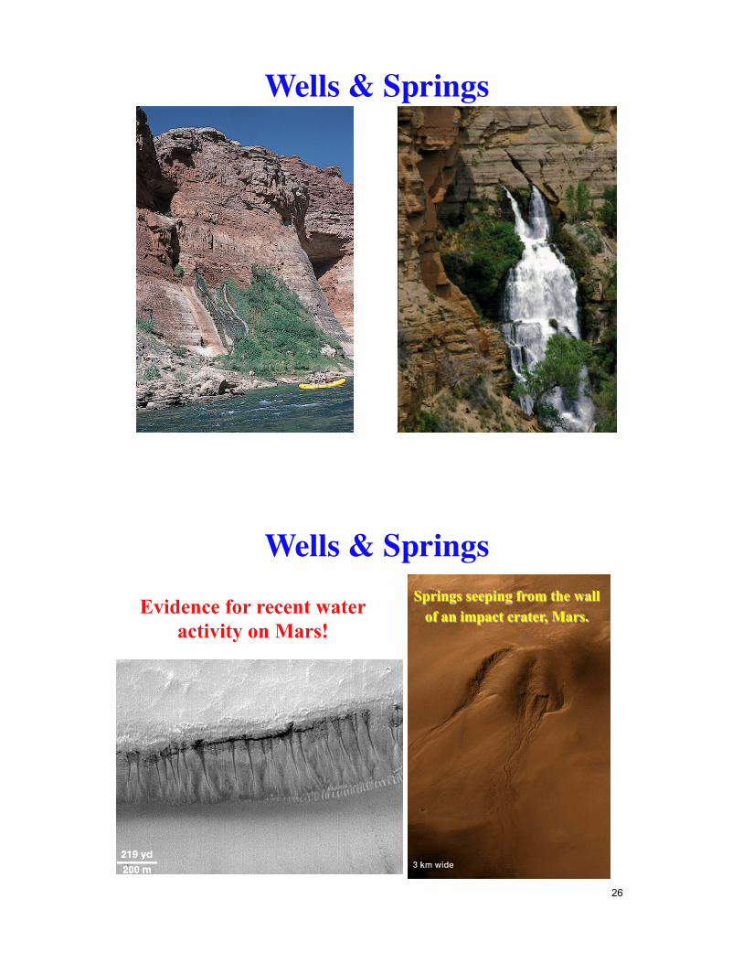
Wells & Springs
Springs seeping from the wall of an impact crater, Mars. Evidence for recent water
activity on Mars!
Wells & Springs
26
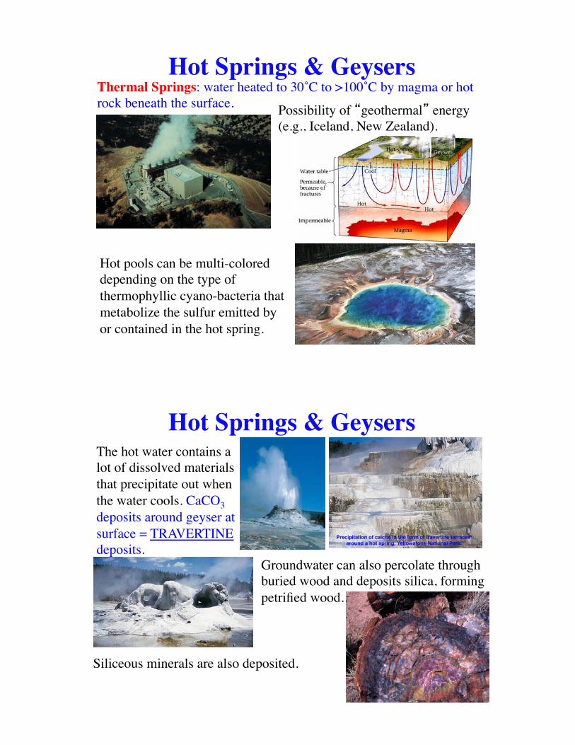
Thermal Springs: water heated to 30˚C to >100˚C by magma or hot rock beneath the surface. Possibility of �geothermal� energy
(e.g., Iceland, New Zealand).
Hot Springs & Geysers
Hot pools can be multi-colored depending on the type of thermophyllic cyano-bacteria that metabolize the sulfur emitted by or contained in the hot spring.
Hot Springs & GeysersThe hot water contains a lot of dissolved materials that precipitate out when the water cools. CaCO3 deposits around geyser at surface = TRAVERTINE deposits.
Groundwater can also percolate through buried wood and deposits silica, forming petrified wood.
Siliceous minerals are also deposited.
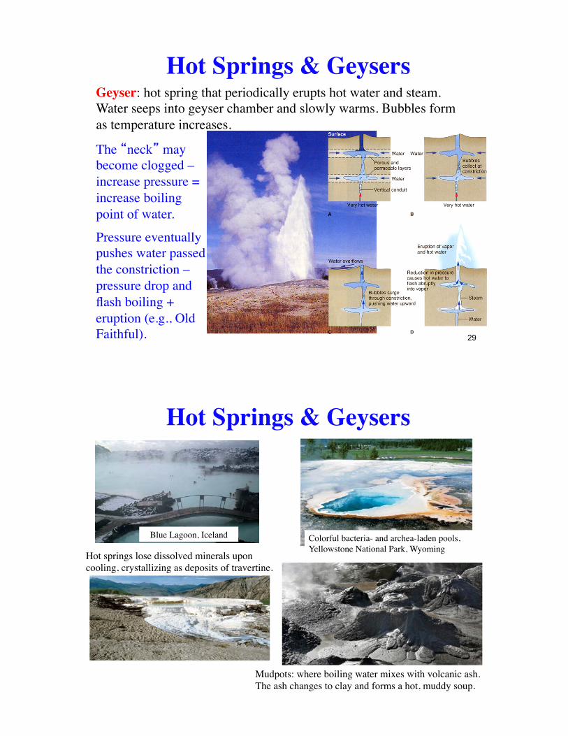
Pressure eventually pushes water passed the constriction – pressure drop and flash boiling + eruption (e.g., Old Faithful).
Geyser: hot spring that periodically erupts hot water and steam. Water seeps into geyser chamber and slowly warms. Bubbles form as temperature increases.
The �neck� may become clogged – increase pressure = increase boiling point of water.
Hot Springs & Geysers
29
Blue Lagoon, Iceland
Hot Springs & Geysers
Colorful bacteria- and archea-laden pools, Yellowstone National Park, Wyoming
Mudpots: where boiling water mixes with volcanic ash. The ash changes to clay and forms a hot, muddy soup.
Hot springs lose dissolved minerals upon cooling, crystallizing as deposits of travertine.
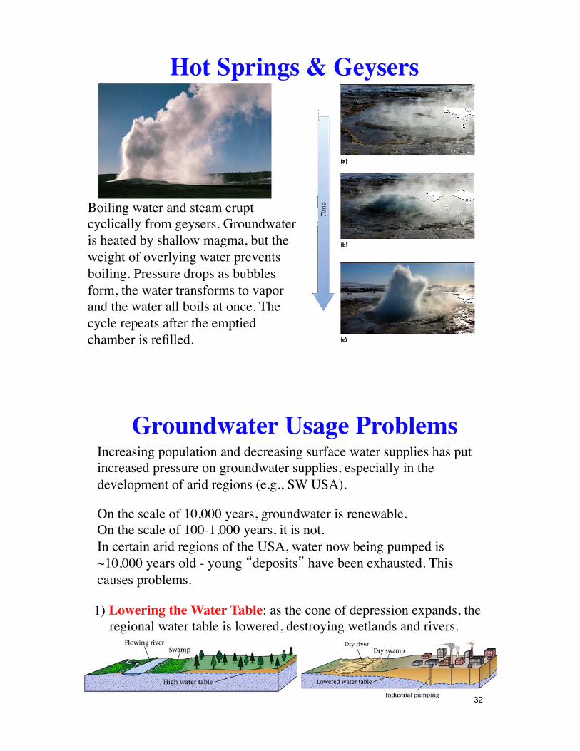
Boiling water and steam erupt cyclically from geysers. Groundwater is heated by shallow magma, but the weight of overlying water prevents boiling. Pressure drops as bubbles form, the water transforms to vapor and the water all boils at once. The cycle repeats after the emptied chamber is refilled.
Hot Springs & Geysers
Groundwater Usage ProblemsIncreasing population and decreasing surface water supplies has put increased pressure on groundwater supplies, especially in the development of arid regions (e.g., SW USA).
On the scale of 10,000 years, groundwater is renewable.On the scale of 100-1,000 years, it is not.In certain arid regions of the USA, water now being pumped is ~10,000 years old - young �deposits� have been exhausted. This causes problems.
1) Lowering the Water Table: as the cone of depression expands, the regional water table is lowered, destroying wetlands and rivers.
32
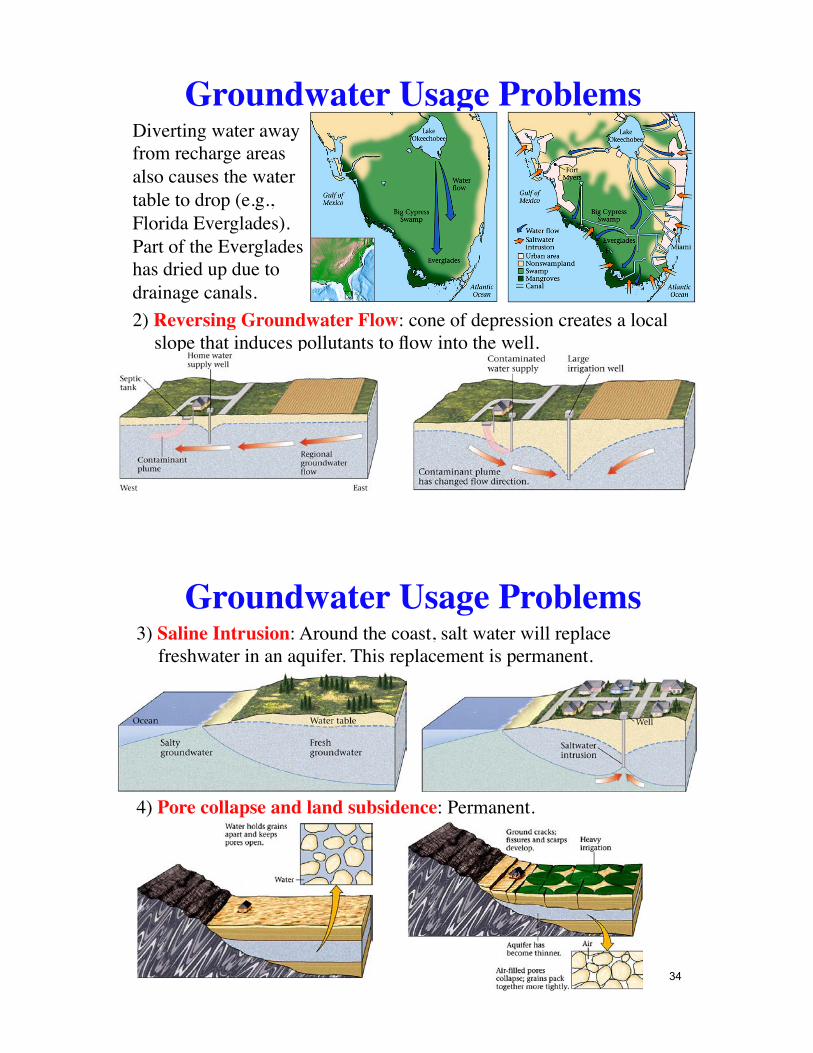
Groundwater Usage ProblemsDiverting water away from recharge areas also causes the water table to drop (e.g., Florida Everglades). Part of the Everglades has dried up due to drainage canals.2) Reversing Groundwater Flow: cone of depression creates a local
slope that induces pollutants to flow into the well.
Groundwater Usage Problems3) Saline Intrusion: Around the coast, salt water will replace
freshwater in an aquifer. This replacement is permanent.
4) Pore collapse and land subsidence: Permanent.
34

Groundwater Usage Problems
Groundwater Problems: Depletion
Excessive groundwater removal has created depletion problems in California and India
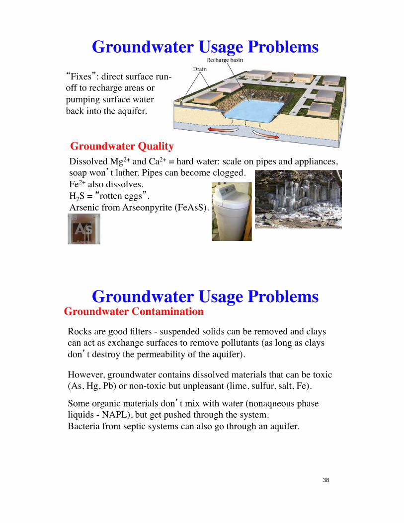
Groundwater Usage Problems�Fixes�: direct surface run-off to recharge areas or pumping surface water back into the aquifer.
Groundwater QualityDissolved Mg2+ and Ca2+ = hard water: scale on pipes and appliances, soap won�t lather. Pipes can become clogged.Fe2+ also dissolves.H2S = �rotten eggs�.Arsenic from Arseonpyrite (FeAsS).
Groundwater Usage ProblemsGroundwater Contamination
Rocks are good filters - suspended solids can be removed and clays can act as exchange surfaces to remove pollutants (as long as clays don�t destroy the permeability of the aquifer).
However, groundwater contains dissolved materials that can be toxic (As, Hg, Pb) or non-toxic but unpleasant (lime, sulfur, salt, Fe).
Some organic materials don�t mix with water (nonaqueous phase liquids - NAPL), but get pushed through the system.Bacteria from septic systems can also go through an aquifer.
38
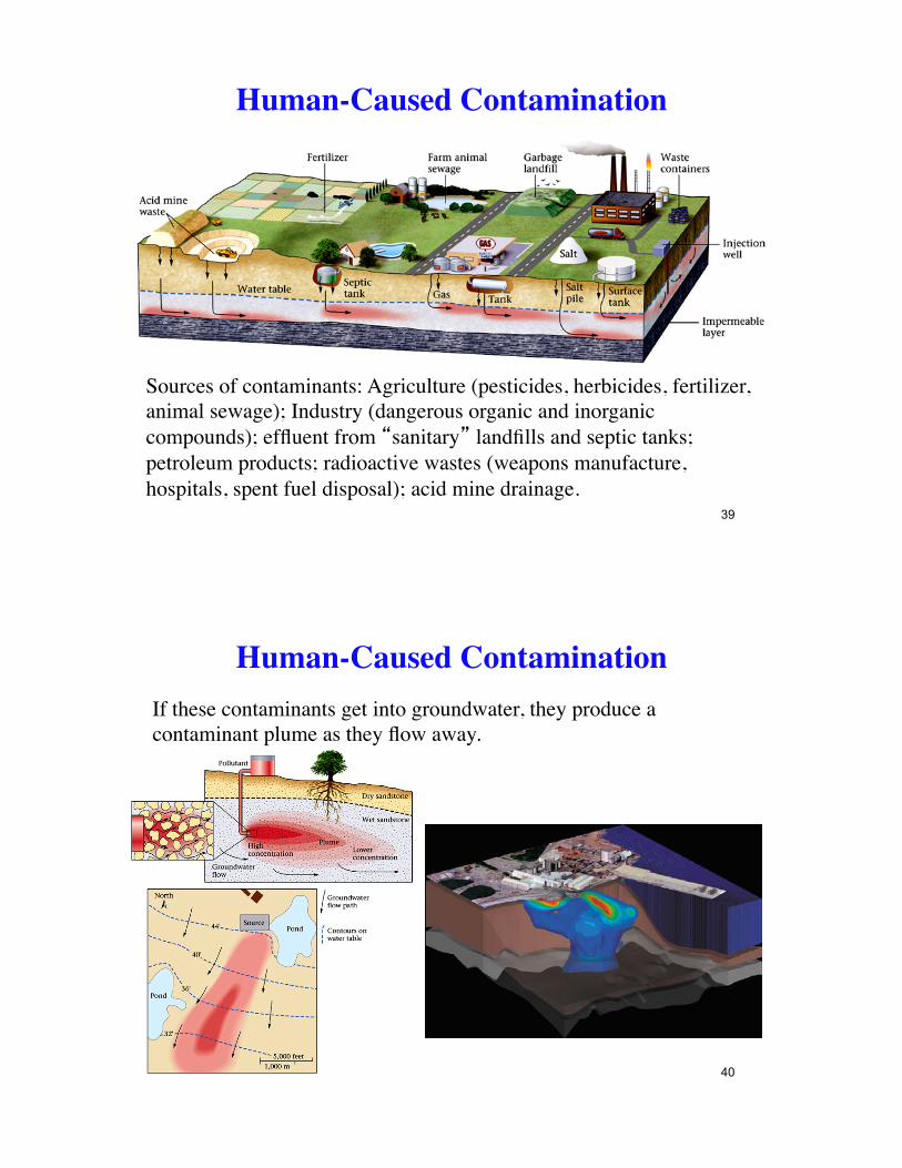
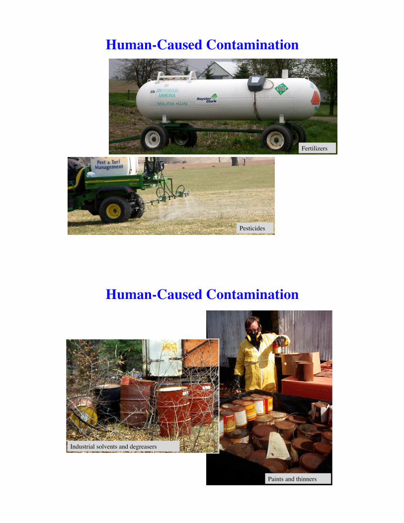
Sources of contaminants: Agriculture (pesticides, herbicides, fertilizer, animal sewage); Industry (dangerous organic and inorganic compounds); effluent from �sanitary� landfills and septic tanks; petroleum products; radioactive wastes (weapons manufacture, hospitals, spent fuel disposal); acid mine drainage.
39
Human-Caused Contamination
If these contaminants get into groundwater, they produce a contaminant plume as they flow away.
40
Human-Caused Contamination
Pesticides
Fertilizers
Human-Caused Contamination
Paints and thinners
Industrial solvents and degreasers
Human-Caused Contamination
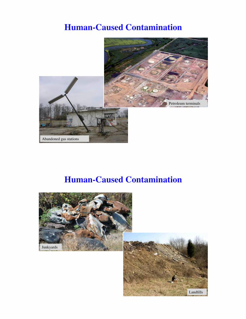
Petroleum terminals
Abandoned gas stations
Human-Caused Contamination
Landfills
Junkyards
Human-Caused Contamination
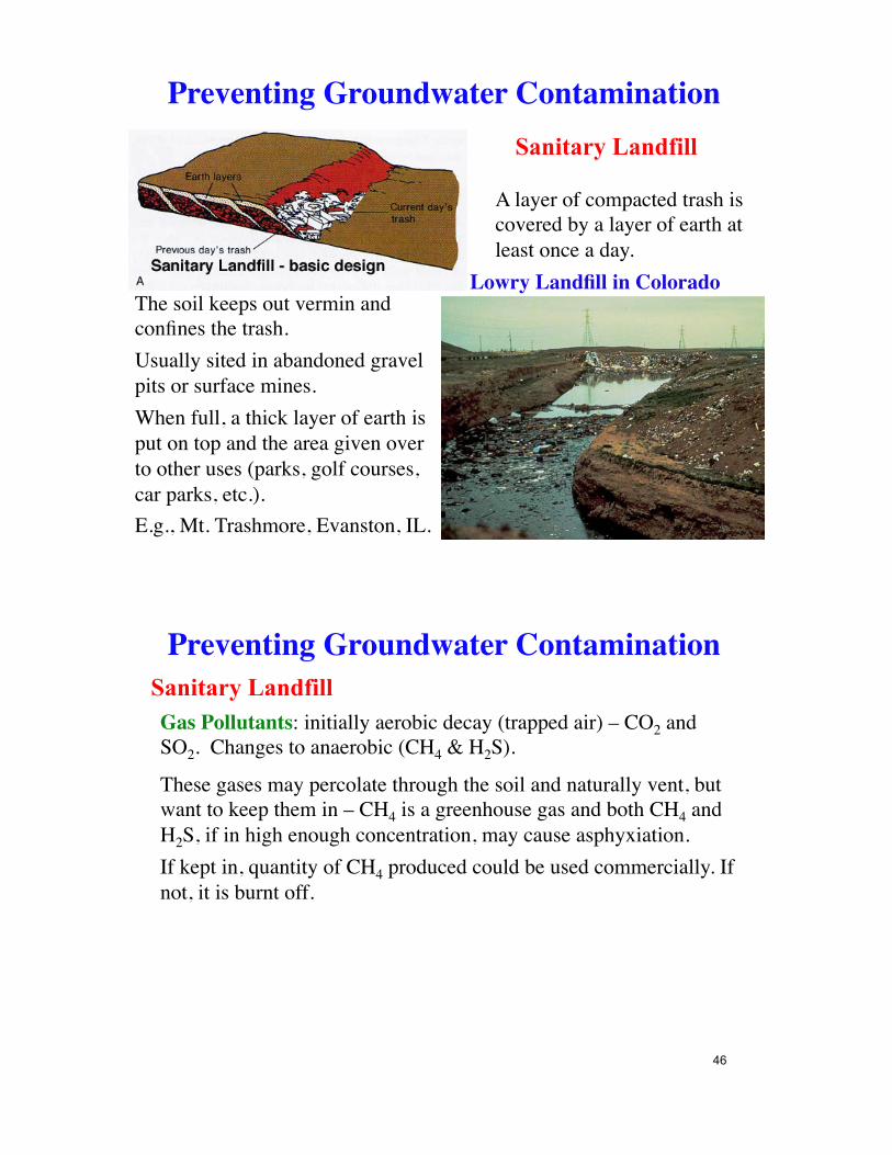
Lowry Landfill in Colorado
Sanitary Landfill
The soil keeps out vermin and confines the trash.Usually sited in abandoned gravel pits or surface mines.When full, a thick layer of earth is put on top and the area given over to other uses (parks, golf courses, car parks, etc.).E.g., Mt. Trashmore, Evanston, IL.
A layer of compacted trash is covered by a layer of earth at least once a day.
Preventing Groundwater Contamination
Gas Pollutants: initially aerobic decay (trapped air) – CO2 and SO2. Changes to anaerobic (CH4 & H2S).
Sanitary Landfill
These gases may percolate through the soil and naturally vent, but want to keep them in – CH4 is a greenhouse gas and both CH4 and H2S, if in high enough concentration, may cause asphyxiation. If kept in, quantity of CH4 produced could be used commercially. If not, it is burnt off.
Preventing Groundwater Contamination
46
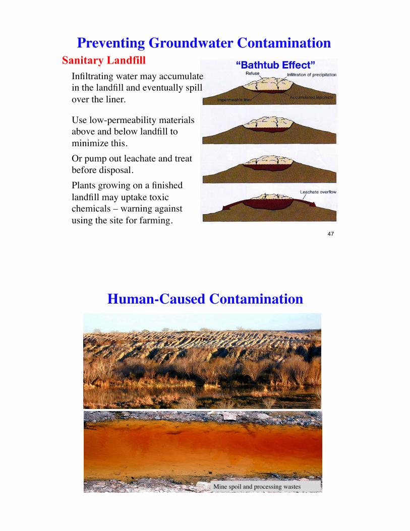
Use low-permeability materials above and below landfill to minimize this.Or pump out leachate and treat before disposal.Plants growing on a finished landfill may uptake toxic chemicals – warning against using the site for farming.
Infiltrating water may accumulate in the landfill and eventually spill over the liner.
Sanitary Landfill Preventing Groundwater Contamination
47
Mine spoil and processing wastes
Human-Caused Contamination
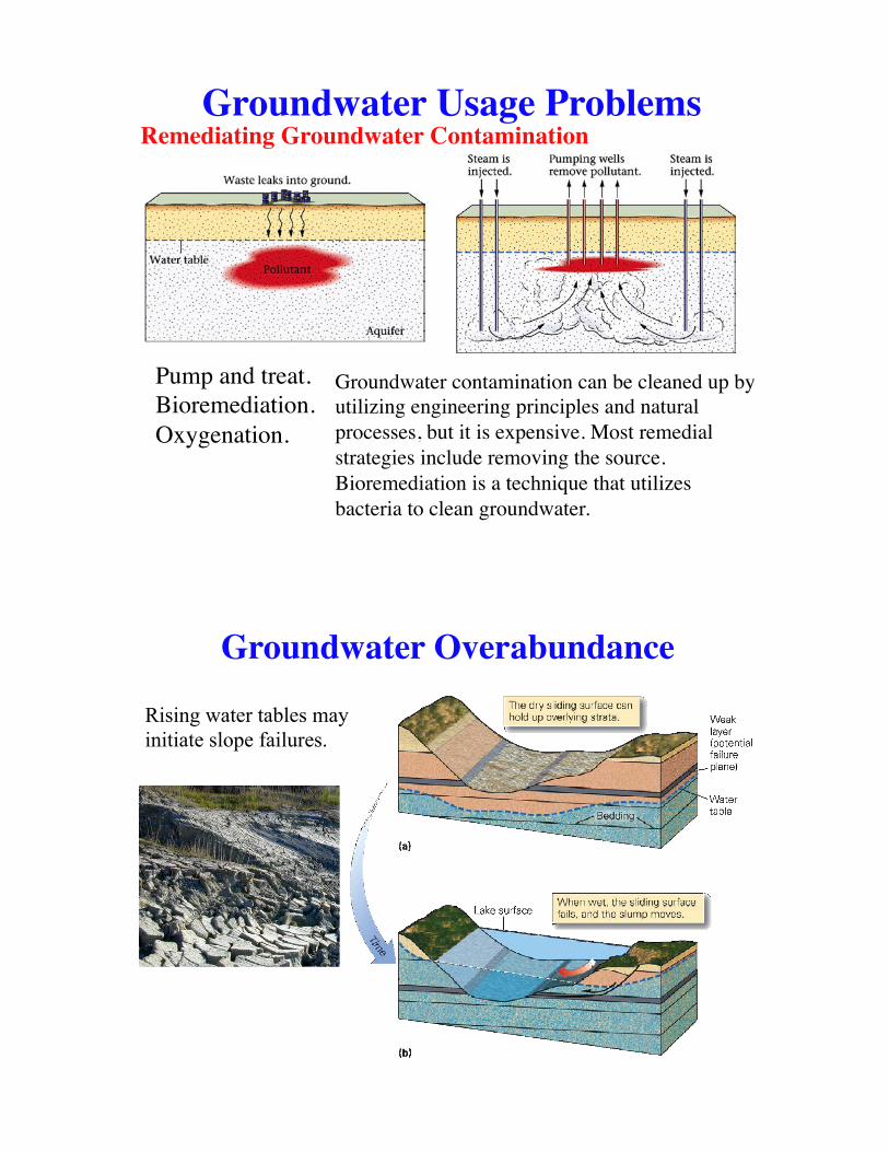
Groundwater Usage ProblemsRemediating Groundwater Contamination
Pump and treat.Bioremediation.Oxygenation.
Groundwater contamination can be cleaned up by utilizing engineering principles and natural processes, but it is expensive. Most remedial strategies include removing the source. Bioremediation is a technique that utilizes bacteria to clean groundwater.
Groundwater Overabundance
Rising water tables may initiate slope failures.

Sinkholes in limestone, New Zealand
A collapse sinkhole that formed suddenly in Florida
Karst Topography Karst: area of limestone underlaying the soil – lots of sinkholes defined by circular lakes. Sinkholes occur in limestone areas that have a lot of water, which can dissolve the rock.Surface streams uncommon and may disappear. Surface expression may not reflect the magnitude of cavern development beneath.
Karst Topography
Groundwater important influence on landscape development in areas with limestone bedrock.
€
CO2 +H 2O → H 2CO3
€
H 2CO3 +CaCO3 →Ca2+ + 2HCO3−
52
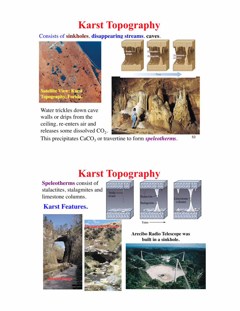
Karst Topography
Satellite View: Karst Topography, Forida.
Consists of sinkholes, disappearing streams, caves.
Water trickles down cave walls or drips from the ceiling, re-enters air and releases some dissolved CO2. This precipitates CaCO3 or travertine to form speleotherms. 53
Karst Topography Speleotherms consist of stalactites, stalagmites and limestone columns.
Karst Features.
Natural Bridge
Disappearing Stream
Arecibo Radio Telescope was built in a sinkhole.
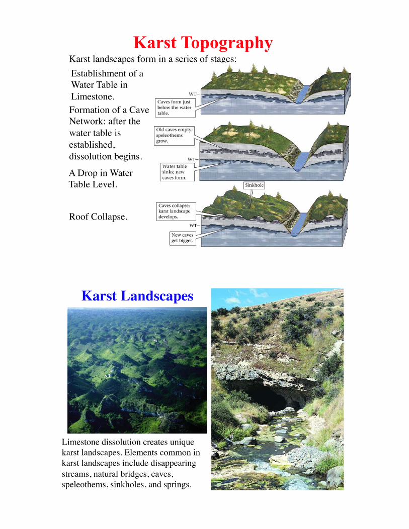
Karst landscapes form in a series of stages:Karst Topography
Formation of a Cave Network: after the !water table is established, !dissolution begins.
A Drop in Water Table Level.
Roof Collapse.
Establishment of a Water Table in Limestone.
Karst Landscapes
Limestone dissolution creates unique karst landscapes. Elements common in karst landscapes include disappearing streams, natural bridges, caves, speleothems, sinkholes, and springs.
SummaryGroundwater: Water Table; Unsaturated/Vadose Zone, Saturated/Phreatic
Zone; Capillary Fringe.Porosity & Permeability: Primary and Secondary Porosity; Interconnectivity.Aquifers & Aquitards: Aquitards also known as Aquicludes; Confined and
Unconfined Aquifers; Gaining and Losing Streams.Water Table: Recharge; Perched Water Tables; Oases.Groundwater Flow: Hydraulic Head; Recharge and Discharge; Flow paths;
Groundwater Age; Hydraulic Gradient; Darcy�s Law.Wells & Springs: Ordinary Well; Cone of Depression; Artesian Well;
Potentiometric Surface; Different Spring formation scenarios.Hot Springs & Geysers: Thermal Springs; Geothermal Energy; Travertine;
Silica, Cyano-bacteria; Geyser Formation.Groundwater Usage Problems: Lowering the Water Table; Reversing Flow;
Saline Intrusion; Pore Collapse; Water Quality; Contamination; Sanitary Landfill; Remediation Techniques.
Karst Topography: Development; Sinkholes; Disappearing Streams; Caves; Speleotherms; Natural Bridges.
57