EARS Workshop White Papers...
29
EARS Workshop White Papers 1. Landscape and lakescape evolution: sourcetosink study of geomorphic, tectonic, climatic, and vegetation interactions in a tropical rift basin (Lake Malawi) Ramon Arrowsmith 1 , Andrew S. Cohen 2 , Scott Robinson 1 , Marina B. Foster 1 , Sarah J. Ivory 2 , Arjun Heimsath 1 , and Kelin Whipple 1 1 Arizona State University 2 The University of Arizona 2. The Lake Tanganyika Drilling Project: A potential ~10Ma continuous record of integrated tectonic and climatic history for the western African rift. Andrew Cohen 1 Cynthia, Ebinger 2 , Thomas, R. Johnson 3 , James, Russell 4 , Christopher A., Scholz 5 , 1 University of Arizona, [email protected], 2 University of Rochester, [email protected], 3 Large Lakes Observatory, University of MinnesotaDuluth, [email protected], 4 Brown University, [email protected] 5 Syracuse University, [email protected] 3. Studying early stage of rifting in Northern Tanzania Cecile Doubre 1 , Christel Tiberi 2 , Cindy Ebinger 3 , Stephanie Gautier 4 , Julie Albaric 5 , Nathalie Rasendra 6 , Cedric Champollion 7 , Fleurice Parat 8 , Sophie Peyrat 9 , Delphine Bosch 10 , Diane Arcay 11 , Andrea Tommasi 12 , Alain Vauchez 13 , Julie Perrot 14 , Jacques Deverchere 15 , Pascal Tarits 16 , Sophie Hautot 17 , Nicolas Lemoigne 18 , Erik Doerflinger 19 , Anne Deschamps 20 , JeanFrancois D'Eu 21 , Clement Bonnet 22 , Simon Kattenhorn 23 , Tobias Fisher 24 , Steven Roecker 25 , Richard FerdinandWambura 26 , Majura Songo 27 , Burton Mwamila 28 1 EOST Strasbourg, [email protected] 2 University of Montpellier, [email protected] 3 University of Rochester, [email protected] 4 University of Montpellier 2, [email protected] 5 University of Brest, [email protected] 6 University of Montpellier 2, [email protected] 7 University of Montpellier 2, [email protected] 8 University of Montpellier 2, [email protected] 9 University of Montpellier 2, [email protected] 10 University of Montpellier 2, [email protected] 11 University of Montpellier 2, [email protected] 12 University of Montpellier 2, [email protected] 13 University of Montpellier 2, [email protected] 14 University of Brest, [email protected] 15 Jacques Deverchere, University of Brest, [email protected] 16 University of Brest, [email protected] 17 University of Brest, [email protected]
Transcript of EARS Workshop White Papers...

EARS Workshop White Papers
1. Landscape and lakescape evolution: source-‐to-‐sink study of geomorphic, tectonic, climatic, and vegetation interactions in a tropical rift basin (Lake Malawi) Ramon Arrowsmith1, Andrew S. Cohen2, Scott Robinson1, Marina B. Foster1, Sarah J. Ivory2, Arjun Heimsath1, and Kelin Whipple1
1 Arizona State University 2 The University of Arizona
2. The Lake Tanganyika Drilling Project: A potential ~10Ma continuous record of integrated tectonic and climatic history for the western African rift. Andrew Cohen1 Cynthia, Ebinger2, Thomas, R. Johnson 3, James, Russell 4, Christopher A., Scholz 5, 1 University of Arizona, [email protected], 2 University of Rochester, [email protected], 3 Large Lakes Observatory, University of Minnesota-‐Duluth, [email protected], 4 Brown University, [email protected] 5 Syracuse University, [email protected]
3. Studying early stage of rifting in Northern Tanzania Cecile Doubre1, Christel Tiberi2, Cindy Ebinger3, Stephanie Gautier4, Julie Albaric5, Nathalie Rasendra6, Cedric Champollion 7, Fleurice Parat 8, Sophie Peyrat 9, Delphine Bosch10, Diane Arcay 11, Andrea Tommasi 12, Alain Vauchez13, Julie Perrot14, Jacques Deverchere15, Pascal Tarits16, Sophie Hautot17, Nicolas Lemoigne18, Erik Doerflinger19, Anne Deschamps20, Jean-‐Francois D'Eu21, Clement Bonnet22, Simon Kattenhorn23, Tobias Fisher24, Steven Roecker25, Richard Ferdinand-‐Wambura26, Majura Songo27, Burton Mwamila28 1 EOST Strasbourg, [email protected] 2 University of Montpellier, [email protected]‐montp2.fr 3 University of Rochester, [email protected] 4 University of Montpellier 2, [email protected]‐montp2.fr 5 University of Brest, [email protected] 6 University of Montpellier 2, [email protected] 7 University of Montpellier 2, [email protected]‐montp2.fr 8 University of Montpellier 2, [email protected]‐montp2.fr 9 University of Montpellier 2, [email protected]‐montp2.fr 10 University of Montpellier 2, [email protected]‐montp2.fr 11 University of Montpellier 2, [email protected]‐montp2.fr 12 University of Montpellier 2, [email protected]‐montp2.fr 13 University of Montpellier 2, [email protected]‐montp2.fr 14 University of Brest, jperrot@univ-‐brest.fr 15 Jacques Deverchere, University of Brest, jacdev@univ-‐brest.fr 16 University of Brest, tarits@univ-‐brest.fr 17 University of Brest, [email protected]
18 University of Montpellier 2, [email protected]‐montp2.fr 19 University of Montpellier 2, [email protected]‐montp2.fr 20 University of Nice, [email protected] 21 University of Brest, deu@univ-‐brest.fr 22 University of Brest, clement.bonnet@univ-‐brest.fr 23 University of Idaho, [email protected] 24 University of New Mexico, [email protected] 25 Rensselaer Polytechnic Institute, [email protected] 26 University of Dar-‐es-‐Salaam, [email protected] 27 University of Dar-‐es-‐Salaam, [email protected] 28 Nelson Mandela Institute, burton.mwamila@nm-‐aist.ac.tz
4. The GeoPRISMS Dataportal Andrew Goodwillie1. 1Lamont-‐Doherty Earth Observatory, [email protected]
5. Active Kinematics of Lithospheric Extension Along the East African Rift
Robert Reilinger1, Robert W. King, Michael Floyd, Eric Calais2 and D. Sarah Stamps, Rebecca Bendick3, Francisco Gomez4, Elias Lewi and Shimelles Fisseha5, Ghebrebrhan Ogubazghi and Berhe Goitom6, Elifuraha Saria7, Hussein Farah8, 1 MIT, Cambridge, MA, [email protected] 2 Purdue University, [email protected] 3 University of Montana, Missoula, [email protected] 4 University of Missouri, Columbia, [email protected] 5 Institutes of Geophysics, Space Science and Astronomy, Addis Ababa, Ethiopia
[email protected], [email protected] 6 Eritrea Institute of Technology, Mai Nefhi, Eritrea, [email protected],
[email protected] 7 Ardhi University, Dar es Salaam, Tanzania, [email protected] 8 Research Center for Remote Sensing, Nairobi, Kenya, [email protected]
6. Geochemical and petrographic approaches for the study of rifting in the EAR
Tyrone Rooney1, Wendy Nelson2, Tobias Fischer3, David Ferguson4, Maryjo Brounce5, Sara Mana6, David Hilton7, Paterno Castillo7, Elisabet Head8, Loyc Vanderkluysen9, Brandon Chiasera10. 1 Michigan State University, [email protected] 2 University of Houston, [email protected] 3 University of New Mexico, [email protected] 4 Lamont-‐Doherty Earth Observatory, [email protected] 5 University of Rhode Island, [email protected] 6 Rutgers University, [email protected] 7 SCRIPPS-‐University of California at San Diego, [email protected], [email protected]

8 Michigan Tech. University, [email protected] 9 Arizona State University, [email protected]
10 Michigan State University, [email protected]
7. SEGMeNT: An NSF-‐Continental Dynamics project to study the weakly extended Malawi (Nyasa) Rift Donna Shillington1, James B. Gaherty1, Cornelia Class1, Scott L. Nooner1, Cynthia J. Ebinger2, Andrew A. Nyblade3, Christopher A. Scholz4, Matthew E. Pritchard5, Paul Bedrosian6, Leonard Kalindekafe7, Winstone Kapanje7, Patrick R.N. Chindandali7, Hassan Mdala7, Richard Wambura Ferdinand8, Shukrani Manya8, Nelson Boniface8, Abdul Mruma9, Saria Elifuraha10 1Lamont-‐Doherty Earth Observatory 2University of Rochester 3Pennsylvania State University 4Syracuse University 5Cornell University 6Geological Survey of Malawi 7 US Geological Survey 8 University of Dar es Salaam, Tanzania 9 Geological Survey of Tanzania 10 Ardhi University
8. Geodetic Constraints of Rift Initiation across the Somalia-‐Lwandle Plate Boundary in Madagascar D. Sarah Stamps1, Gerard Rambolamanana2, Eric Calais3, Tahiry Rajaonarison4
1 Purdue University, [email protected] 2 University of Antananarivo, [email protected] 3 Purdue University, [email protected]
4 University of Antananarivo, [email protected] 9. An Investigation of Continental Rift-‐Parallel Deformation
D. Sarah Stamps1, Eric Calais2, Elifuraha, Saria3, Chris Andronicus4, Rob Reilinger5, Daniel Koehn6, Fred Tugume 7, Arthur Batte 8,
1 Purdue University, [email protected] 2 Purdue University, [email protected]
3 Purdue University, [email protected] 4 Purdue University, [email protected] 5 Massachusetts Institute of Technology, [email protected] 6 Glasgow University, [email protected] 7 Department of Mining and Technology, Uganda, [email protected], 8 Makerere University, Uganda, [email protected]‐frankfurt.de

1
Landscape and lakescape evolution: source-to-sink study of geomorphic, tectonic, climatic, and vegetation interactions in a tropical rift basin (Lake Malawi)
Ramon Arrowsmith1, Andrew S. Cohen2, Scott Robinson1, Marina B. Foster1, Sarah J. Ivory2, Arjun Heimsath1, and Kelin Whipple1
1. Arizona State University, 2. The University of Arizona
Landscape changes within a watershed involve interacting processes that operate on disparate time-scales. Although the relief produced by tectonism establishes the template for the conveyance of eroded materials to sedimentary basins, the relative rates and transitions among surface processes are modulated in time and space by climate with its associated influences on vegetation and soil production. A source-to-sink examination of how geomorphology, tectonism, climate, and vegetation interact would be invaluable to further our understanding of climate/tectonic interactions. Unfortunately, appropriate field laboratories, where watershed/tectonic evolution can be directly coupled to a receiving basin that captures and faithfully records the history of landscape evolution are rarely available (e.g., GeoPrisms, 2010; NRC, 2010).
The Lake Malawi basin, in the western branch of the East African Rift System (EARS) provides an excellent opportunity for an integrated study of landscape (geomorphology and vegetation communities) and lakescape (bathymetry, tectonics, sediment delivery and provenance) evolution in a rift basin (Fig. 1). The lake and its watershed comprise half graben segments of alternating polarity bounding a closed sedimentary basin (Ebinger et al., 1987) containing a deep lake with a paleoenvironmental history that is accessible through cores from deep drilling (Scholz et al., 2006; Fig. 2). The interaction between the footwall escarpments along the ~N-S rift axis and the regional climate system, largely driven by seasonal migration of the Intertropical Convergence Zone (ITCZ), results in a complex but interpretable variation of microclimates, which in turn affect vegetation and, presumably, erosion patterns (Figs 1-3). Through time, this interaction occurs against a dynamic backdrop of extraordinary regional climate variability, with orbitally forced precipitation changes driving that have resulted in dramatic lake level decreases ofas much as 600m (Scholz et al., 2007; Cohen et al., 2007).
Large lakes create their own weather through moisture recycling, and modeling results suggest these “lake effects” in Africa (e.g., Yin and Nicholson, 1998) are accentuated during the dry season. At Malawi, this occurs in the austral winter when strong southeasterly winds prevail along the ~N-S oriented lakes.
We have developed a conceptual model for an elongate rift lake with multiple half-graben segments which predicts: First, in any lake basin with a strong asymmetry in prevailing wind run (mean velocity x duration along the lake fetch), we expect strong precipitation, vegetation, and erosion anomalies at both the leeward lake end and associated with topographic barriers to low elevation airflow. Second, precipitation, vegetation, and erosion should vary (high to low) from the leeward to windward sides of barriers, even over very short distances (tens of km). Third, axial margins of the lake will be wet at the windward end and dry at the leeward end. Finally, for the tropics, this asymmetry is strongest near the N and S ends of the ITCZ belt where the seasonal contrast of wind speed and orientation are strongest (e.g., Lake Malawi; Fig. 1).
During drier climates (which follow eccentricity-modulated precession cycles, Scholz et al., 2011b), when lakes are shallower and smaller, these precipitation, vegetation, and erosion asymmetries disappear (Fig. 3). The much reduced fetch and water sources for evaporation produces little or no “lake effect” on the surrounding watersheds. Consequently, we expect more homogeneous vegetation, erosion or sediment input patterns to the basin between the windward and leeward sides of footwall escarpment topographic barriers.
This general model of climatology and tectonic interactions conforms to observations of within-basin microclimatologic variability associated with the underlying tectonics and geomorphology of the Malawi rift basin, and with other basins within the EARS. Footwall escarpments of the half-graben segments create small mountain ranges that intersect the regional (and periodically moisture laden) winds. These ranges rise to as much as 1500m above the lake surface, generating considerable precipitation along the mountain fronts facing the lake. Striking differences in precipitation occur over very short distances between lakeshore areas adjacent

2
to or farther from these precipitation traps (Cohen et al., 2012; Figs. 2-3). Furthermore, these areas of higher precipitation are asymmetrically organized around the Lake Malawi basin, such that the southern promontories or south-facing coastlines of half-graben footwall uplifts as well as the volcanic Rungwe Mountains that lie at the north axis of the basin, windward relative to the strong southeasterly winds, display the highest precipitation anomalies. The major difference in the precipitation pattern for these regions is that they receive rainfall in the form of recycled moisture through most of the dry season. Conversely, the promontories and escarpment coastlines facing the weaker northeasterly winds (and the south end of the lake) receive only regional precipitation during the rainy season, resulting in less mean annual precipitation and longer dry seasons.
The half graben asymmetry of the basins provides a first order template for the drainage network. This includes steep and short drainages developed on the footwall rift flanks, long lower gradient hanging wall rivers, and large drainage basins wrapping around the ends of the rift segments and entering the basin in the accommodation zones or adjacent hanging wall platform margins(Figs 2-3). The lake level controlled orographic precipitation operates on this template, promoting variable vegetative vigor and soil development in the spatial gradients of our conceptual model. We predict that the orographic precipitation will drive increased erosion rates during high lake stands along the windward promontories.
Figure 1. Annual cross equatorial migration of the ITCZ (A: austral summer, December-January-February (DJF) and B: austral wint June-July-August (JJA)) drives variation in precipitation and airflow, which when combined with temperature and orograph produces a seasonal vegetation response (NDVI from Tucker, et al., 2005). Small blac lines indicate active faults of the East Afric Rift. White polygon outlines Lake Malawi watershed (see Figs. 2 & 3).
Figure 2. Maps of the Lake Malawi watershed (Fig. 1 white polygon). Left topography and bathymetry with maj half graben faults. Hachures indicate t lake extent at >500 m lowstand. Red dots are scientific drill sites (Scholz, et al., 2011a). Fig. 3A,B locations are red squares. Middle: TRMM rainfall (Bookhagen, in review) shows increas moisture along western central basin and north side of northern basin (compare with Fig. 3). Right: DJF-JJA difference in 1980-2000 8km NDVI (Tucker et al., 2005; Ivory, in press) shows enhanced greenness in austral winter (JJA) in areas corresponding to high TRMM values.

3
Figure 3. Prevailing southerly winds gather moisture as they move over a high stand lake (A). Orographic precipitation is enhanced on the windward sides of the protruding footwalls of the alternating half graben segments. When the lake is low (B), available moisture and the orographic effect is limited. In addition, the drainage network must extend over the dry lake floor to the restricted lowstand basins. Red lines are the principal half graben faults and are connected by accommodation zones (AZ).
References Cohen, A.S., Stone, J.R., Beuning, K.R.M., Park, L.E., Reinthal, P.N., Dettmar, D., Scholz, C.A., Johnsor, T.C., King, J.W., Talbot, M.R.,
Brown, E.T., and Ivory, S.J., 2007, Ecological consequences of early Late Pleistocene megadroughts in tropical Africa: Proceedings of the National Academy of Sciences of the United States of America, v. 104, p. 16422-16427.
Cohen, A.S., Arrowsmith, R., Ivory, S.J., Robinson, S., Foster, M., Whipple, K., and Heimsath, A., 2012, Climatic and tectonic interactions in the East African rift system: The view from the Lake Malawi basin: Magmatic Rifting and Active Volcanism Conference, Addis Ababa, Ethiopia, Abstracts with Programs, p. 20.
Ebinger, C.J., Rosendahl, B.R., Reynolds, D.J., 1987, Tectonic model of the Malawi rift, Africa: Tectonophysics, v.141, p.215-235. GeoPrisms, 2010, GeoPrisms Science Plan,
http://www.geoprisms.org/images/stories/documents/DSP/GeoPRISMS_DSP_ALL_hires.pdf. Ivory, S.J., Cohen, A.S., and Lezine, A.-M., (in press), Effect of aridity and rainfall seasonality on vegetation in East Africa during the
Late Pleistocene: Quaternary Research. National Research Council (NRC), 2010, Landscapes on the edge: New horizons for research on the Earth's surface,
http://www.nap.edu/catalog.php?record_id=12700. Scholz, C.A., Cohen, A.S., Johnson, T.C., King, J.W., Moran, K., 2006, The 2005 Lake Malawi scientific drilling project: Scientific Drilling,
v.2, p.17-19. Scholz, C.A., Johnson, T.C., Cohen, A.S., King, J.W., Peck, J.A., Overpeck, J.T., Talbot, M.R., Brown, E.T., Kalindekafe, L., Amoako,
P.Y.O., Lyons, R.P., Shanahan, T.M., Castaneda, I.S., Heil, C.W., Forman, S.L., McHargue, L.R., Beuning, K.R., Gomez, J., and Pierson, J., 2007, East African megadroughts between 135 and 75 thousand years ago and bearing on early-modern human origins: Proceedings of the National Academy of Sciences of the United States of America, v. 104, p. 16416-16421.
Scholz, C.A., Cohen, A.S., and Johnson, T.C., 2011a, Southern hemisphere tropical climate over the past 145ka: Results of the Lake Malawi. Scientific Drilling Project, East Africa: Palaeogeography Palaeoclimatology Palaeoecology, v. 303, p. 1-2.
Scholz, C.A., Cohen, A.S., Johnson, T.C., King, J., Talbot, M.R., and Brown, E.T., 2011b, Scientific drilling in the Great Rift Valley: The 2005 Lake Malawi scientific drilling project - An overview of the past 145,000 years of climate variability in southern hemisphere East Africa: Palaeogeography Palaeoclimatology Palaeoecology, v. 303, p. 3-19.
Tucker, C.J., Pinzon, J.E., Brown, M.E., Slayback, D.A., Pak, E.W., Mahoney, R., Vermote, E.F., and El Saleous, N., 2005, An extended AVHRR 8-km NDVI dataset compatible with MODIS and SPOT vegetation NDVI data: International Journal of Remote Sensing, v. 26, p. 4485-4498.
Yin, X.G., and Nicholson, S.E., 1998, The water balance of Lake Victoria: Hydrological Sciences Journal-Journal Des Sciences Hydrologiques, v. 43, p. 789-811.

The Lake Tanganyika Drilling Project: A potential ~10Ma continuous record of integrated tectonic and climatic history for the western African rift. Andrew S. Cohen1, Cynthia Ebinger2, Thomas R. Johnson3, James Russell4, Christopher A. Scholz5
1 Department of Geosciences, University of Arizona 2 Department of Earth and Environmental Sciences, University of Rochester 3 Large Lakes Observatory, University of Minnesota-Duluth 4 Department of Geological Sciences, Brown University 5 Department of Earth Sciences, Syracuse University Email addresses: [email protected], [email protected], [email protected], [email protected], [email protected] Proposed Site: Lake Tanganyika, East Africa Themes addressed: GeoPrisms Draft Science Plan Overarching Themes: 3.3 Climate-Surface-Tectonic Feedbacks and 3.5 Plate Boundary Deformation and Geodynamics; Rift Initiation and Evolution Initiative Themes: 5.2. How do fundamental rifting processes (such as tectonics, magmatism, and erosion, transport, and sedimentation), and the feedbacks between them, evolve in time and space?; 5.3. What controls the structural and stratigraphic architecture of rifted continental margins during and after breakup? and 5.4 What are the mechanisms and consequences of fluid and volatile exchange between the Earth, oceans, and atmosphere at rifts and rifted margins? Key existing and forthcoming data/infrastructure
NSF-supported East African Lakes Drilling Workshop (Providence Nov 2011) has already chosen Lake Tanganyika (Fig. 1) as its highest priority drilling target for the East African Rift (Russell et al., 2012).Three prior seismic stratigraphic and four coring campaigns since the 1980s have demonstrated very thick sediment accumulation and areas of slow (~0.1mm/yr) accumulation in this lake, suggesting that 10 My of lake history could be recovered in some areas (e.g. Rosendahl, 1988; Scholz et al., 2007; McGlue et al, 2008; Tierney et al., 2008; Burnett et al., 2010) (Fig. 2) .
We will have access to new industry seismic reflection data currently under collection by several hydrocarbon exploration companies and may be able to piggyback on their exploration efforts for locally focused studies (collaborations established at the Providence meeting).
There is a strong likelihood of cofunding through the International Continental Scientific Drilling Program because of multiple, compelling science questions to be addressed (tectonics, paleoclimate, lacustrine faunal evolution in isolation, implications for human origins).
Lake Tanganyika (LT) is the largest (~34000km2) deepest (~1500m), and oldest (estimated 9-12Ma, Cohen et al., 1993) of the African rift lakes. It provides a compelling target for scientific drilling for many reasons, and in particular, should be an attractive target for consideration within the context of the GEOPRISMS-East African Rift initiative. A variety of targets within the lake would provide opportunities to examine different types of questions. The longest and most continuous records would be collected from intrabasin highs in deep water (atop horst blocks on accommodation zones) where extremely slow sedimentation rates, coupled with water depths great enough to avoid episodic desiccation during lake level low stands could yield records covering much of LT’s history and would lack turbidite or mass flow complications Cores from similar settings in anoxic lake basins reveal annual varves lacking bioturbation that provide an exquisite record of changing climate and tectonics (e.g., Tiercelin et al., 1994; Cohen et al., 2006). Alternatively, records from basin flanks would be shorter in duration but could sensitively record local watershed events, thermochronologic histories of rift margin uplift, and climatic/tectonic interactions affecting sedimentation rates and vegetation records. With existing and targeted new seismic lines it will be possible to stratigraphically link the horst and deep basin sites.
LT is a dynamic rift in cratonic lithosphere far from subducting slabs, providing an ideal setting for rift
initiation studies. Stratigraphic records in the Tanganyika area suggest that rift-related volcanism may have occurred at 25 Ma (Roberts et al., 2012), but has far less resurfacing from volcanism than lakes to the north (e.g. Turkana). The long, large-offset border faults define a profound along-axis segmentation that persists throughout repeated cycles, and most strain in the LT basin is localized along a few fault

systems, which allows for relatively “easy” reconstructions of rift architecture through time.. LT has the greatest seismic energy release in the EAR, and entire 100 km-long border faults may rupture during discrete earthquakes (e.g., Jackson and Blenkinsop, 1996), providing insights into the initiation and maintenance of rift segmentation.. With the detailed time-history record afforded by cores, these characteristics could facilitate fault slip rate/paleoseismicity studies discussed below. The high-resolution, long time span of LT core records would provide an unprecedented laboratory for examining the initiation and linkage of faults across and along the length of the rift, the rates of vertical crustal movements, and earthquake cycles, all of which produce the pronounced along-axis basin asymmetry. These results, in turn, could be compared with historic records to improve our understanding of time-averaged vs instantaneous deformation rates, and lithospheric rheology. Data from well sited drill cores at Lake Tanganyika could address the overarching question of “How do rifts initiate and evolve?” by providing specific data on rates of border fault slip and basin subsidence, and repeat time of major earthquakes using seismite records (e.g. Boës and Fagel, 2008), which would have both theoretical and applied implications. A long core from LT could record how basin systems evolve as border fault segments are linked (e.g., Scholz et al., 1998; Densmore et al., 2004; 2006), and to test models of strain localization during progressive rifting episodes (e.g., Ebinger, 2005). Down hole experiments could be conducted in the borehole to determine stress states and to measure heat flow. A long borehole record from LT has the potential to be used to understand a wide array of source to sink processes in an active rift. The LT rift has uplifted flanks rising more than 2 km above the 1000 km-wide EAR plateau that have fundamentally changed drainage and vegetation patterns. A combination of provenance studies (using detrital zircon chronology and petrography), paleoerosion studies (through cosmogenic radionuclides and detrital low temperature thermochronology methods (e.g. Balco and Shuster, 2009; Stock et al, 2006; Rahl et al., 2007), and landscape vegetation history (through pollen and charcoal analysis) would provide an unparalleled opportunity to integrate our understanding of how rift flank exhumation couples with climate (locally affected by orographic uplift) to impact erosion rates and patterns. We could then ask questions about how orographic relief is created and maintained in continental rifts over geologically long intervals, given the high preservation potential of an LT record. Through careful integration of the drill cores with the seismic stratigraphic record available for LT we could extend our conclusions about rates of exhumation and rift basin infill far from the individual drill sites. By extending this approach along the rift axis (LT covers ~600km) and through multiple lake level phases we could eventually develop a full 4-D understanding of rift lake basin evolution as it interacts with changing climate regimes. Basin analysis studies of the modern rift at LT could have applied implications of great interest to potential industry partners, which could in turn reduce the cost of the project to NSF considerably. Exploration wells in nearby Lake Albert demonstrate that sediments <10 My in age can host a robust hydrocarbon system. An LT borehole could allow us to ask whether fault planes are open or whether aqueous, hydrocarbon, and or magmatic fluids are flowing along stratigraphic horizons. How are high wax oils trapped at shallow levels? How does fault architecture control permeability and fluid pathways? And is there a potential to date oils in a high heat flow but relatively young basin? A drill coring campaign at LT will engage a wide range of scientists outside of the GEOPRISMS community, making the funding base for this project much broader. The potential of a continuous environmental record spanning the last 10Ma from tropical Africa would excite paleoclimatologists and climate modelers interested in long term interactions of E. African uplift, and oceanic gateway impacts on the Indian Ocean’s thermal history, the evolution of the monsoon, and even N Atlantic hurricanes (e.g., Cane and Molnar, 2001; Feakins et al., 2007). Lake Tanganyika is one of the global hotspots of lacustrine endemic biodiversity (especially among its cichlid fish, molluscs and crustaceans). A lake core record there holds the promise of documenting and understanding the dynamics of speciation in the context of both an evolving rift basin system and changing climate regimes (Cohen, 2011). And finally, there is potential synergy with the paleoanthropology community’s interest in obtaining a continuous record of environmental history from a single area covering the entire span of human evolution (e.g. deMenocal, 2004; Feakins et al., 2005).

Figure 1 (left). Lake Tanganyika, showing major faults and accommodation zone highs (horsts-purple). Figure 2 (above). Seismic section from the northern end of the Kalya horst; location of the seismic section within lake Tanganyika illustrated by the red line within the seismic grid at right. Note the presence of a continuous and condensed sedimentary sequence above pre-rift basement on the Kalya horst, indicated by the bracket. Data are from Project PROBE (Rosendahl, 1988). Figure from Russell et al. (2012).
References
Balco, G., and Shuster, D.L., 2009, EPSL, 286, p. 570-575. Boës X., and Fagel N., 2008. J. Paleolimnology. 39, 237-252. Burnett, A. P., et al. 2010. Palaeogeog., Palaeoclim. Palaeoecol., doi: 10.1016/j.palaeo.2010.02.011 Cane, M.A. and Molnar, P., 2001. Nature 411:157-162. Cohen, A. S., Soreghan, M., and Scholz, C., 1993. Geology, 21:511–514. Cohen, A.S., et al. 2006 J. Palaeolim. DOI 10.1007/s10933-006-9004-y Cohen, A.S., 2011, Hydrobiologia DOI 10.1007/s10750-010-0546-7. deMenocal, P., 2004. Earth and Planet Sci Let. 220:3-24. Densmore, A. L., et al. 2004, J. Geophys. Res., 109, F03001, doi:10.1029/2003JF000115. Densmore, A., S. Gupta, P. Allen, N. Dawyers 2007. J. Geophys. Res., 112, doi: 10.1029/2006JF000560. Ebinger, C., Astronomy & Geophysics, 46: 2.16-2.21, 2005. Feakins, S.,J., deMenocal, P.B., and Eglinton, T.I., 2005. Geology 33:977-980. Feakins, S.J., Eglinton, T.I. and deMenocal, P.B., 2007 Organic Geochemistry, 38:1607-1624, 10.1016/j.orggeochem.2007.06.008. Jackson, J., and Blenkinsop, T. 1997. Tectonics, 16:137–150. McGlue, M.M et al, 2007 J Paleolimnol DOI 10.1007/s10933-007-9187-x. Rahl, J., Ehlers, T., van der Pluijm, B., 2007. EPSL, 256, p. 147-161. Roberts, E.M., et al.., 2012 Nature Geoscience 5:289-294. Rosendahl, B.R., 1988. Seismic Atlas of Lake Tanganyika, East Africa: Project Probe Atlas Series. Duke University, Durham, NC, USA. Russell, J., et al. C.A., 2012. Scientific Drilling: doi:10.2204/iodp.sd.14.08.2012. Scholz, C.A., et al., 1998, Palaeogeo., Palaeoclim. Palaeoecol. 140:401-420. Scholz, C., et al., 2007. Proc. Natl. Acad. Sci. U.S.A., 42:16416–16421. doi:10.1073/pnas.0703874104. Stock, G.M, Ehlers, T.A., Farley, K.A., 2006, Geology, 34, p. 725-728. Tiercelin, J.J., et al, 1994, Bull. Centres Rech. Explor.-Prod. Elf Aquitaine 16: 83-111. Tierney, J. E., et al.., 2008. Science, 322(5899): 252–255. doi:10.1126/science.1160485

Studying early stage of rifting in Northern Tanzania
Doubre, C., Tiberi, C., Ebinger, C., Gautier, S., Albaric, J., Rasendra, N., Champollion, C., Parat, F., Peyrat, S., Bosch, D., Arcay, D., Tommasi, A., Vauchez, A., Perrot, J., Déverchère, J., Tarits, P., Hautot, S., Lemoigne, N., Doerflinger, E., Deschamps, A., D’Eu, J.-‐F., Bonnet, C., Kattenhorn, S., Fisher, T., Roecker, S., Ferdinand-‐Wambura, R., Songo, M., Mwamila, B. The breakup of continents and creation of new oceans is a fundamental yet poorly understood plate tectonic process. The identification of the processes linked to continental break-up is however not only essential in terms of fundamental Earth Sciences because they result in the formation of new plate boundaries, but their clear identification is also a major economic challenge, as they control the formation, location and storage of energy resources (hydrocarbons, geothermal). As human settlement expands to more and more remote regions, and as we obtain longer historical records, we find that earthquake, volcanic and landslide hazards in continental rift zones have major societal impacts on the rapidly growing human populations living within or near rift zones worldwide.
In classical rifting models, lithospheric stretching leads to upwelling and adiabatic decompression melting of asthenosphere, resulting in magmatism after significant lithospheric thinning (e.g. Sengör & Burke 1978; White & McKenzie 1989). Yet, many continental rift sectors experience magmatism coincident with rift initiation (e.g. Ebinger et al. 2008), implying that magmatism may be a key driving force, as opposed to a consequence, of lithospheric thinning (e.g. Buck 2006). Recent models of rifting also insist on complex interaction between asthenospheric dynamism and far field stresses, between deep processes and local inherited fabrics (Huismans et al. 2001; Petit et al. 2008).
Largely 2D geophysical, structural and geochemical studies of evolved continental rifts and successfully rifted margins document the modification of the crust due to plate stretching and magmatic processes (e.g. Keir et al. 2009; Leroy et al. 2008). Yet in those cases, the time sequence of magma production, storage, eruption and interaction with tectonic processes are impossible to deconvolve. Moreover, rifts develop in heterogeneous continental lithosphere and are thus inherently three-dimensional. Their interaction with pre-existing lithospheric structures (composition, rheology, thickness) may contribute to their localisation. Although the contribution of inherited lithospheric thickness, composition, and structural variations and rheology may seem obvious (Vauchez et al. 1997; Tommasi & Vauchez 2001; Ebinger 2005), its influence on the localisation of the deformation, its temporal relationship with magmatism and rupture during rift inception have yet to be examined. Many fundamental questions regarding inception and development of a continental rift in thick lithosphere still remain unanswered:
• What are the spatial and temporal relationships between magmatism and faulting? • How do these interactions affect the strain localisation? • What are the effects of magmatism in terms of rheological weakening of the
lithosphere? • How do the inherited structures at the lithosphere-asthenosphere boundary (LAB)
through to the crust control the localisation of the deformation and magmatism? The large number of ongoing projects demonstrates the growing interest of the international Earth Sciences community to identify the processes responsible of the lithospheric weakening that leads to strain localisation and the continental break-up (e.g. Buck 2006; Bialas et al. 2010, AfricaArray 2005-2010). The recent EAGLE and DoRA projects (NERC, NSF and ANR, respectively) greatly helped to characterize the late stage of magmatic rifting processes (e.g. Ebinger and Casey 2001; Keir et al. 2006; Rowland et al. 2007). However, they focus on systems already extremely influenced by significant lithospheric thinning and resultant magmatism. Our understanding of continental rifting processes also comes from 2D studies of inactive rift basins (e.g. YOCMAL ANR project) buried beneath ca 10 km of post-rift sedimentary strata where the thermal-mechanical response of the lithosphere to

stretching and heating has long since decayed. Moreover, along magmatic margins where large volumes of magma are intruded into the plate, the timing of magma emplacement is very poorly constrained in these deep water settings (Leroy et al. 2008). Part of us participated to those projects and we are thus fully aware of these obstacles to apprehend the onset of continental rifting, particularly how thick (>100 km) lithosphere dissects while it should be too strong to rift by plate motion stresses alone (e.g., Bott 1991; Bialas et al. 2010). For these reasons, we target the first 5 My of a magmatic rift initiating in thick (>150 km) continental lithosphere, where we can directly image and detect fault and magma interactions, as well as the role of inherited and rheological heterogeneities of the lithosphere on rift localisation. In this context, the North Tanzania system provides an exceptional laboratory, as it is the location of the least evolved stage of magma-assisted continental rift in the East African rift system (Dawson, 1992; Le Gall et al. 2008). We intent to fully characterize the early stages of magma-assisted continental rifting with a multidisciplinary study with coupled data acquisition and modelling tasks. A 3D seismic, structural, and volatile geochemistry part of this project is already funded through NSF program for years 2012-2015 (Lead PI Simon Kattenhorn), and includes the Magadi basin in southern Kenya. We propose here to advantageously complement this with additional geophysical and geochemical studies in two target areas (Natron, Manyara) that span the transition from incipient rifting with deep seismicity and sparse magmatism to shallow seismicity and widespread magmatism.
We propose here to acquire new field, geophysical (gravity, MT, seismic), geochemical and petrophysical data in a rifting inception place, the Tanzania rift, to constrain and test 2D and 3D models of continental lithospheric extension associated with repeated episodes of magma intrusion. This combination of data acquisition, novel inversions and models will allow us to: (1) map the spatial distribution of strain in space and time using geophysical and geodetic methods; (2) constrain crust and upper mantle structure; (3) characterize the chemistry and spatial distribution of crustal fluids
and magma; (4) quantify the volume of magma intruded into the crust through seismic data interpretation combined with InSAR, and (5) distinguish the role of the different processes involved in continental rifting through numerical modelling. The active collaborations between American, French, Tanzanian, and Kenyan institutions will ensure the success of this multidisciplinary project both scientifically and in terms of formation. Project partners: University of Dar-es-Salaam Nelson Mandela Institute, Tanzania University of Nairobi Geothermal Development Corporation, Kenya University of Idaho University of New Mexico University of Rochester Rensselaer Polytechnic Institute
Page 1 of 3
GeoPRISMS Data Portal Authors: Andrew Goodwillie (GeoPRISMS Data Manager) and the GeoPRISMS Portal team. Affiliation: Lamont-Doherty Earth Observatory, Palisades, NY, 10960. Contact: andrewg -at- LDEO.columbia.edu 1) Introduction
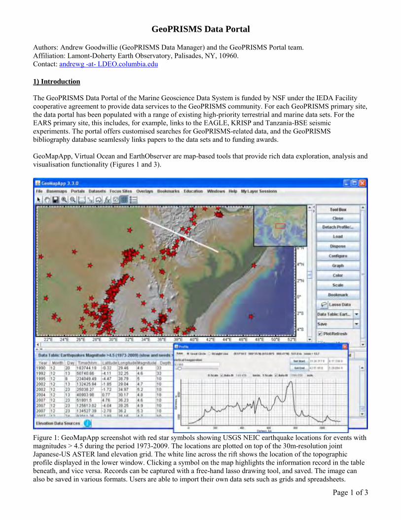
The GeoPRISMS Data Portal of the Marine Geoscience Data System is funded by NSF under the IEDA Facility cooperative agreement to provide data services to the GeoPRISMS community. For each GeoPRISMS primary site, the data portal has been populated with a range of existing high-priority terrestrial and marine data sets. For the EARS primary site, this includes, for example, links to the EAGLE, KRISP and Tanzania-BSE seismic experiments. The portal offers customised searches for GeoPRISMS-related data, and the GeoPRISMS bibliography database seamlessly links papers to the data sets and to funding awards. GeoMapApp, Virtual Ocean and EarthObserver are map-based tools that provide rich data exploration, analysis and visualisation functionality (Figures 1 and 3).
Figure 1: GeoMapApp screenshot with red star symbols showing USGS NEIC earthquake locations for events with magnitudes > 4.5 during the period 1973-2009. The locations are plotted on top of the 30m-resolution joint Japanese-US ASTER land elevation grid. The white line across the rift shows the location of the topographic profile displayed in the lower window. Clicking a symbol on the map highlights the information record in the table beneath, and vice versa. Records can be captured with a free-hand lasso drawing tool, and saved. The image can also be saved in various formats. Users are able to import their own data sets such as grids and spreadsheets.

Page 2 of 3
2) Services
Data Portal
The GeoPRISMS data portal, like the predecessor MARGINS portal, is fully integrated with the wider Lamont database system and offers a compilation of pre-existing data sets of interest to the community. Links are provided to EARS-related projects such as the Ethiopia-Kenya Broadband Seismic Experiment, and a simple search function, described below, provides user access to the data. As funding for GeoPRISMS research projects gets underway, the portal team will work with PIs, members of the community and the GeoPRISMS Office to ensure appropriate capture of marine and terrestrial field program information and derived data products. http://www.marine-geo.org/portals/geoprisms/
Search for Data
Data can be found (Figure 2) by searching on key words such as data or device type, name of field program or investigator, by geographic location, and even by award numbers. Filtered searches and auto-complete technology help speed users towards data. http://www.marine-geo.org/tools/new_search/index.php?initiative=GeoPRISMS
Figure 2: Example of data portal search results listing. Links at left take users to IRIS for information and seismic data files. Links at right open pages giving field program information and with just a couple of clicks allow users to view publications tied with the data sets.
Data Visualisation and Exploration
The GeoMapApp and Virtual Ocean tools offer a rich variety of options for users to plot, analyse and visualise their data in a geographical setting (Figures 1 and 3). EarthObserver, a recently-released app for the iPad™, iPod Touch™ and iPhone™ offers instant mobile access to a large range of built-in data sets. http://www.geomapapp.org/ , http://www.virtualocean.org/ , http://www.earth-observer.org/
Bibliography
The GeoPRISMS references database provides an integrated, searchable resource that links publications to data sets and funding awards. Currently comprising almost 400 papers of direct relevance for GeoPRISMS science, the database can be searched on author, title, journal, year, and primary site. All displayed results can also be exported in EndNote™ format. The bibliography page provides a simple tool to allow anyone to submit references for inclusion in the database. http://www.marine-geo.org/portals/geoprisms/references.php

Page 3 of 3
Data Management Plan Tool
All proposals submitted to NSF must be accompanied by a Data Management Plan. With NSF input we created a simple web page that allows PIs to fill in information boxes and generate a data management plan in PDF format to be attached to the proposal. http://www.iedadata.org/compliance/plan
Data Compliance Reporting Tool
This tool helps PIs demonstrate compliance with funding agency data policies by allowing PIs to inventory their data contributions, with links to award numbers.
3) Data Policy
Led by Susan Schwartz, the GeoPRISMS data policy was compiled by a sub-committee of the GeoPRISMS Steering and Oversight Committee, with input from NSF and the database group. http://www.geoprisms.org/data-policy.html 4) Community Outreach and Accountability
A representative from the database group plans to attend GeoPRISMS meetings to act as a community liaison, to increase awareness about the data portal services, and to solicit feedback and advice on products and resources. A report on database activities will appear in the GeoPRISMS twice-yearly newsletter, and, at each GeoPRISMS Steering and Oversight Committee meeting, a report will be given and data-related discussions held. The GeoPRISMS data manager, Andrew Goodwillie, and the database team are keen to help the community with questions related to data, analysis tools or the GeoPRISMS bibliography. 5) References
GeoPRISMS Data Portal Status Report, GeoPRISMS Newsletter, Spring 2012, vol 28, page 22. http://geoprisms.org/images/stories/documents/newsletters/issue28_opt.pdf
Figure 3: Geochemical analytical data of EARS volcanic rock samples from the EarthChem database. Symbols are coloured on MgO content, scaled on K2O, and the inset graph shows Al2O3 plotted against SiO2. A lasso tool allows records to be captured and saved.

Active Kinematics of Lithospheric Extension Along the East African Rift Robert Reilinger, Robert W. King, Michael Floyd, Dept. Earth, Atmos., Planet. Sci., MIT, Cambridge, MA ([email protected]) Eric Calais and D. Sarah Stamps, Dept. Earth, Atmos., Planet. Sci., Purdue Univ., West Lafayette, IN ([email protected]) Rebecca Bendick, Dept. of Geosciences, Univ. of Montana, Missoula, MT ([email protected]) Francisco Gomez, Dept. of Geological Sci., Univ. of Missouri, Columbia, MO ([email protected]) Elias Lewi and Shimelles Fisseha, Institute of Geophysics, Space Science and Astronomy, Addis Ababa, Ethiopia ([email protected], [email protected]) Ghebrebrhan Ogubazghi and Berhe Goitom, Eritrea Institute of Technology, Mai Nefhi, Eritrea ([email protected], [email protected]) Elifuraha Saria, Ardhi University, Dar es Salaam, Tanzania ([email protected]) Hussein Farah, Research Center for Remote Sensing, Nairobi, Kenya ([email protected]) Fred Tugume, Department of Mining and Energy, Uganda ([email protected]) Theme: Infrastructure to support GPS EAR Transects The East African Rift (EAR) has been identified as a “focus site” for the GeoPRISMS RIE Initiative. In addition, the GeoPRISMS Community has recognized that geodetic observations, particularly GPS and InSAR are already providing important constraints on the distribution of strain across the EAR and that such observations are an essential component for future research on the kinematics and dynamics of rift initiation and evolution. Because of the great length of the EAR system (~3000 km), the GeoPRISMS Program will select specific “discovery corridors” traversing the rift for focused geophysical and geological studies. Since distance along strike is a reasonable proxy for the extent of rift development, selecting “corridors” for focused geodetic observations along the full strike of the EAR (Afar to the southernmost rift in Malawi) will allow comparison of the spatial distribution of strain across the rift at different stages of evolution, addressing fundamental questions about how continental rifting evolves to full ocean spreading. In addition, selecting rift segments at similar stages of development, but different tectonic settings (e.g., magmatic vs. amagmatic environments) will provide opportunities to investigate the role of magmatic and other geologic processes (e.g., pre-existing structures) in rift initiation and evolution. In contrast to other geophysical observations, geodetic monitoring of secular deformation requires sufficient time to allow motions to “grow” beyond the accuracy of the observational technique. Deformation rates along the EAR reach ~20 mm/yr across the Afar in the north (related directly to S Red Sea extension and Danakil block rotation) and vary from ~ 7 mm/yr across the northernmost rift in central Ethiopia (10°N), to ~5 mm/yr in southern Ethiopia/Kenya (distributed between the E and W rift branches in Kenya and Tanzania), to <3 mm/yr across the amagmatic Malawi Rift (-10 to -20°S) and the highly magmatic Massawa Rift in Eritrea (Kogan et al., 2012; McClusky et al., 2010; Stamps et al., 2008) (Figure 1). Sub-mm/yr, 95% confidence levels for current GPS observations require a minimum of 3-5 years of continuous, or 4-6 years of annual, multi-day survey observations. Since we are interested in constraining the spatial distribution of strain, we will need to determine site velocities to roughly an order of magnitude better than the total extension rate across the rift. Accordingly, under the best circumstances (stable monuments stable atmospheric conditions), it will require 5-10 years to determine the distribution of strain across the EAR at a range of evolutionary stages.

The most cost- and time-effective approach to constraining the kinematics of rifting along the EAR, and hence the evolution of rifting, is to build on earlier GPS observations to allow useful results to be obtained quickly, and a full set of geodetic constraints to be developed during the proposed life of the GeoPRISMS Program. Figure 1 shows the locations of survey sites (minimum of 2 occupations) and continuous GPS stations for which data are available along the EAR. These include data collected by the authors of this White Paper in collaboration with host-country partners, and others available through a range of data sharing agreements. Evaluating, integrating, and uniformly processing and analyzing these data to determine their utility for geodynamic studies will provide the basis for developing dense geodetic transects along strike of the EAR. Based on our earlier studies and most recent analyses, for the purpose of contributing to the discussion, we suggest a series of 7 transects as follows (see Figure 1):
1- Massawa Rift in Eritrea (incipient rift [~ 5 Ma], slow [~2-3 mm/yr], highly magmatic); 2- Afar Rift (ocean-like rift, fast [~20 mm/yr], highly magmatic); 3- Northern Ethiopia Rift (well developed continental rift, intermediate rate [~7 mm/yr]); 4- Southern Ethiopia and Kenya (E and W branches) rifts (early continental rift,
intermediate rates [5-7 mm/yr; in Kenya distributed between E and W]); 5- Kenya/Uganda Rift (early continental rift, intermediate rates [5-7 mm/yr], distributed
between E and W branches); 6- Tanzania Rift (early continental rift, intermediate rates [4-6 mm/yr], distributed between
E and W branches); 7- Malawi Rift (incipient rift, slow [~2-3 mm/yr], amagmatic).
Comparisons of the slow spreading Malawi and Massawa rifts (transects 1, 7) will allow investigation of the role of magmatic intrusions in rift initiation. The rapid extension across the Afar (in relation to other rift segments) (transect 2) offers opportunities to evaluate the influence of magmatic processes for the latest stage of crustal extension prior to full-ocean spreading. The kinematics for the relatively simple continental rift in northern and southern Ethiopia (3, 4) will provide constraints on the distribution of extension across well developed (north) and earlier stages of rifting. In Kenya and Tanzania, the distribution of extension between the W and E branches (5, 6) will provide opportunities for evaluating the importance of pre-existing crustal structures in focusing crustal extension and for comparison with faster continental extension in Ethiopia. The overall character of rift development along the full strike of the EAR will undoubtedly provide further, unanticipated insights into the dynamics of rift initiation and evolution. Broader Impacts of geodetic studies of the EAR over the long term include enhancing geodetic and geophysical expertise in Africa through direct collaborations, developing geodetic constraints for basin models for resource exploration, geothermal development, and hazard mitigation (earthquakes, volcanic events) through cooperation with government geological surveys and nonprofit emergency response organizations, such as the Aga Khan Development Network, with whom we have partnered elsewhere in the world, and the GEM Foundation (www.globalquakemodel.org), a public-private partnership to improve global geologic risk assessment. In addition, position data developed during the course of the GeoPRISMS initiative will be provided to government mapping and cadastral agencies for infrastructural development and will contribute to establishing a modern reference frame for the African continent (AFREF). The GeoPRISMS geodetic initiative will provide opportunities for student and postdoctoral involvement in international research.

References Kogan, L., S. Fisseha, R. Bendick, R. Reilinger, S. McClusky, R. King, and T. Solomon (2012), Lithospheric strength and strain localization in continental extension from observations of the East African Rift, J. Geophys. Res., 117, B03402, doi:10.1029/2011JB008516. McClusky, S., R. Reilinger, G. Ogubazghi, A. Amleson, B. Healeb, P. Vernant, J. Sholan, S. Fisseha, L. Asfaw, R. Bendick and L. Kogan (2010), Kinematics of the southern Red Sea-Afar Triple Junction and implications for plate dynamics, Geophys. Res. Lett., 37, doi:10.1029/2009GL041127. Stamps, D., E. Calais, E. Saria, C. Hartnady, J. Nocquet, C. Ebinger and R. Fernandes (2008), A kinematic model for the East African Rift, Geophys. Res. Lett., 35, L05304.
Figure 1. Main features of the East African Rift. Black lines show major faults, yellow circles are M>5 earthquake epicenters (NEIC catalog), red squares are GPS stations where at least two occupations have been performed, arrows show estimated velocities across plate or micro-plate boundaries (Nubia, Victoria (VICT), Rovuma (ROVU), and Somalia) according to Stamps et al. (2008).

Geochemical and petrographic approaches for the study of rifting in the EAR
Tyrone Rooney, Wendy Nelson, Tobias Fischer, David Ferguson, Maryjo Brounce, Sara Mana, David Hilton, Paterno Castillo, Elisabet Head, Loyc Vanderkluysen, Brandon Chiasera.
The growing recognition that magma can play a critical role in the initiation and evolution of continental rifting, even in seemingly magma-poor environments, has highlighted the fundamental need to focus on magmatic processes in studies of rifting. Magmas and volatiles found in rift environments are the result of many overlapping processes, and they may therefore be used to examine the thermo-chemical state of the mantle, dispersion of materials beneath the rift, lithospheric heterogeneity, magmatic differentiation, and many other critical processes that depend on magmas. Perhaps one of the most utilitarian aspects of the geochemical and petrologic study of magmas is the opportunity to develop a temporal understanding of the evolution of these rifting processes by leveraging currently active regions with the wide array of products preserved in the East African Rift (EAR) over the past 45 Ma. In the context of GeoPrisms RIE science plan as it relates to the EAR, the application of geochemical, geochronological and petrographic techniques are central to establishing a new model of rift development.
How does the presence or absence of an upper-mantle plume influence extension?
Decompression melting has been typically linked with magma production in rift environments. However, the temperature and composition of the mantle exert a fundamental control on melt production. The presence of a mantle plume can have a profound impact on the thermo-chemical conditions of the mantle beneath a rift and therefore represent a significant perturbation of melting conditions in the ambient upper mantle. Plumes may contain lithologies characterized by a solidus that exists at lower temperatures and pressures than “background” mantle. Furthermore plumes are perhaps more volatile-rich than the surrounding mantle material, and such volatiles lower the melting point of mantle rocks. Similarly, elevated mantle potential temperatures associated with plumes result in enhanced melt production. Enhanced melting associated with plumes can in turn affect extension.
Plumes can be identified geochemically using several approaches; one of the most unambiguous being helium isotopes. To date, there are 2 main manifestations of high (plume-like) 3He/4He ratios along the EAR: Afar/MER/Red Sea and Rungwe Volcanic Province. Studies volatiles in both along and across rift axis investigations of erupted rocks, volcanic gas discharges and fault related conduits would provide valuable insights into the lithospheric and sub-lithospheric nature of volatile distribution below the rift. Radiogenic isotope systems (e.g., Pb-Sr-Nd-Hf-Os) further constrain contributions from a potential mantle plume but also reveal the role of the ambient upper mantle and continental lithosphere in magma production and modification. Constraining the thermobaric conditions of melt generation beneath the rift and discerning the contributions from a plume are best approached by geochemical modeling techniques. Current models have shown elevated mantle potential temperatures centered beneath Afar and the Tanzania craton, though further sampling throughout the EAR is necessary to refine these observations. The degree of contamination of the EAR upper mantle by plume materials remains uncertain. Such contamination may introduce pyroxenites that can be probed by high precision olivine studies. In addition the impact of a plume on the oxygen fugacity of the mantle (a principle thermodynamic property), has the potential to shift the position of the mantle solidus, promoting or prohibiting the formation of melts rich in carbon, hydrogen and sulfur.
How does the mechanical heterogeneity of continental lithosphere influence rift initiation, morphology, and evolution?
The EAR system has developed across a continent that is characterized by widely heterogeneous lithosphere. From the Tanzania craton to the Pan-African mobile belt, lithospheric heterogeneity can impact the nucleation and evolution of the rift. Isotopic geochemical techniques are vital in deducing the

antiquity of the lithosphere through which the rift passes and how this lithosphere has been modified by rifting processes. The direct geochemical analysis of basement rocks, and investigating lithospheric contamination of rift magmas provides an important record of the rift lithosphere and possible discontinuities not evident at the surface.
The long history of magmatism in the EAR has led to widespread modification of the lithosphere through intrusion, underplating, and metasomatism. Lithospheric modification can promote melt generation from within the lithosphere, and magmatic intrusion can lead to the focusing of extensional strain. Geochemical analysis of mantle xenoliths provides constraints on the characteristics of the pre-rift lithosphere and the impact of subsequent modification. Repeated magma injection into the continental lithosphere facilitates strain migration. Geochemical investigation of the magmatic plumbing system in zones of focused magma intrusion is therefore important in assessing the evolution whereby extension migrates from lithospheric thinning processes towards magmatic intrusion.
How is strain accommodated and partitioned throughout the lithosphere, and what are the controls on strain localization and migration? What factors control the distribution and ponding of magmas and volatiles, and how are they related to extensional fault systems bounding the rift? How is strain accommodated and partitioned throughout the lithosphere, and what are the controls on strain localization and migration? What factors control the distribution and ponding of magmas and volatiles, and how are they related to extensional fault systems bounding the rift?
We believe these two questions to be closely related. Volatile release and magmatic activity are spatially and temporally influenced by the presence of faults, which may act as channels or barriers to flow. The location of magma bodies in the crust is strongly dependent on buoyancy forces and the crustal stress regime. Direct geochemical approaches can evaluate where magmas pond in the crust, how long they reside in the crust before eruption, and at what rates they move through the crust. Geochemical modeling can further inform us regarding the volumes, configurations, and geometries of magma storage reservoirs, and plumbing, all of which are dependent on the crustal stress regime and the availability of pathways for migration of melt and other deep fluids. New and precise geochronology combined with sophisticated P and T constraints based on isotopes, mineral assemblages and volatile contents provides these insights.
How does rift topography, on either the continental- or basin-scale, influence regional climate, and what are the associated feedback processes?
Eastern Africa has long been recognized for its significant deviation from the geoid as well as for some of the most dynamic topography on the African continent. The high Ethiopian plateau, which exerts a fundamental control over the monsoonal rains, is constructed of flood basalts and associated shield volcanoes. However, the origin of this first-order control on EAR topography is controversial, when did this plateau become elevated? Geochemical tools such as (U-Th)/He thermochronometry are indispensible for such studies. Magmatism also has direct and indirect effects on the global carbon budget. Injection of magmas into rift sedimentary basins can release greenhouse gases (CO2 and CH4) due to breakdown of organic C rich sediments. Weathering of crustal and mantle rocks exposed at the surface in some extensional environments consumes CO2 and modulates the greenhouse effect. Understanding the spatial and temporal distribution of these processes in the rift environment is critical to understanding the overall effect of continental rifts on climate though earth’s history.


SEGMeNT: An NSF-Continental Dynamics project to study the weakly extended Malawi (Nyasa) Rift
U.S. Scientists Donna J. Shillington1, James B. Gaherty1, Cornelia Class1, Scott L. Nooner1, Cynthia J. Ebinger2, Andrew A. Nyblade3, Christopher A. Scholz4, Matthew E. Pritchard5, Paul Bedrosian6
Malawi Scientists Leonard Kalindekafe7, Winstone Kapanje7, Patrick R.N. Chindandali7, Hassan Mdala7 Tanzania Scientists Richard Wambura Ferdinand8, Shukrani Manya8, Nelson Boniface8, Abdul Mruma9, Saria Elifuraha10
1Lamont-Doherty Earth Observatory, 2University of Rochester, 3Pennsylvania State University, 4Syracuse University, 5Cornell University, 6US Geological Survey, 7Geological Survey of Malawi, 8University of Dar Es Salaam, Tanzania, 9Geological Survey of Tanzania, 10Ardhi University We are beginning a multidisciplinary, multinational study focused on the northern Malawi (Nyasa) rift that includes characterizing deformation and magmatism in the crust and mantle lithosphere along 2-3 rift segments, quantifying temporal patterns in deformation, and evaluation of the source of magmas. The northern Lake Malawi (Nyasa) region in the East African Rift System is an excellent locality to examine early-stage rifting at slow rates in strong, cold lithosphere. Only a small amount of stretching has occurred (<15%)[Ebinger, 1989], and extension is estimated to be proceeding relatively slowly at ~3.5 mm/yr [Stamps et al., 2008], but model constraints are very sparse. It exhibits pronounced tectonic segmentation, which is defined in the upper crust by ~100-km-long border faults [Ebinger et al., 1987]. The length scales of segments together with flexure associated with faulting [Ebinger et al., 1991], occurrence of deep seismicity [Jackson and Blenkinsop, 1993; Foster and Jackson, 1998] and inferred mafic lower crust [Nyblade and Langston, 1995] suggest that rifting is occurring in relatively strong, cold lithosphere. Very little volcanism is associated with rifting, providing a serious test for recent models that require intrusive magmatism to initiate rifting in cold, strong continental lithosphere [Buck, 2004]. Strikingly, the only surface expression of magmatism in this system occurs in an accommodation zone between segments rather than in a segment center [Furman, 2007], in clear contrast to MORs and mature rifts. This relationship is also observed elsewhere in the Western Rift of the East Africa Rift system and in other early-stage rifts, but the 3D distribution of magma at depth and its role in extension are unknown in all cases. In the SEGMeNT (Study of Extension and maGmatism in Malawi aNd Tanzania) program, we will acquire a suite of geophysical, geological and geochemical data to better understand this rift system. Active and passive seismic data and magnetotelluric (MT) data will reveal the 3D structure of the crust and lithosphere at a variety of length scales, from the architecture of border faults and accommodation zones to the distribution of deformation and magma (if present) in the mantle lithosphere. Geochronology, thermobarometry and geochemistry of volcanic rocks will yield constraints on the origin of magmatism, including variable contributions from sub-lithospheric plume and asthenospheric versus lithospheric sources. Integrated with surface deformation, seismicity, and rift stratigraphy, this will yield constraints on the evolution of

deformation and magmatism at a range of time scales. New details of syn-rift stratigraphy will be correlated to a high-resolution chronologic framework developed from scientific drilling in Lake Malawi, and will provide constraints on the relationships between rift topography and regional climate. Comparisons of active and cumulative deformation patterns may enable us to evaluate the importance of episodic, seismic and/or magmatic events in accommodating extension and how they relate to segmentation. We hope that this powerful combination of temporal and spatial constraints will produce unique insights into the initiation of segmentation and magmatism during continental rifting. In July 2012, a network of continuous GPS stations was deployed across the rift (see abstract of Elliott et al and map below), and will remain deployed for the next five years. Fieldwork in the Rungwe volcanic province was carried out in August 2012 to collect samples for geochemical analysis. We plan to deploy the passive seismic network and acquire MT data in the summer of 2013, and acquire active-source seismic data in Lake Malawi (Nyasa) in early 2014.
A core part of the GeoPRISMS RIE science plan concerns the initiation of rifting and the evolution of early-stage rifts. Key questions concern the origin and role of magma during earliest rifting, the formation and evolution of rift segmentation and its manifestation at depth in the crust and lithosphere, and the temporal style of deformation (episodic versus steady-state). The SEGMeNT program is strongly aligned with GeoPRISMS RIE objectives, and there are several ways in which our program and other studies in the Malawi (Nyasa) rift can contribute to GeoPRISMS science in the EAR. First, we would be excited to initiate new collaborations that build on or are complementary to our funded CD program. Additionally, by comparing regions within the EAR that have undergone different amounts of extension, our community can illuminate the evolution of extensional provinces from inception to breakup. For example, a

funded CD program by Estella Atekwana and colleagues targets the extensional province beneath the Okavango delta, where rifting is just commencing (see Atekwana white paper). Comparing patterns of deformation and magmatism beneath the poorly known, weakly extended rifts of the Okavango Delta and Lake Malawi (Nyasa) with the well-studied, mature rifts in Ethiopia and Afar would reveal the progression of magmatism and deformation with increasing amounts of cumulative stretching, and provide vital constraints on the structure and rheology of extending continental lithosphere. Biggs, J., E. Y. Anthony, and C. J. Ebinger (2009), Multiple inflation and deflation events at
Kenya volcanoes, East African Rift, Geology, 37, 979-982. Buck, W. R. (2004), Consequences of Asthenospheric Variability on Continental Rifting, in
Rheology and deformation of the lithosphere at continental margins, edited by G. D. Karner, et al., pp. 1-30, Columbia University Press, New York, NY, USA.
Ebinger, C. J., B. R. Rosendahl, and D. J. Reynolds (1987), Tectonic model of the Malaŵi Rift, Africa, Tectonophysics, 141, 215-235.
Ebinger, C. J. (1989), Tectonic development of the western branch of the East African rift system, GSA Bulletin, 101, 885-903.
Ebinger, C. J., G. D. Karner, and J. K. Weissel (1991), Mechanical strength of extended continental lithosphere: Constraints from the Western Rift System, East Africa, Tectonics, 10(6), 1239-1256.
Foster, A. N., and J. A. Jackson (1998), Source parameters of large African earthquakes: implications for crustal rheology and regional kinematics, Geophys. J. Int., 134, 422-448.
Furman, T. (2007), Geochemistry of East African Rift basalts: An overview, J. African Earth Sci., 48, 147-160.
Jackson, J., and T. Blenkinsop (1993), The Malawi Earthquake of March 10, 1989: Deep Faulting within the east African rift system, Tectonics, 12(5), 1131-1139.
Nyblade, A. A., and C. A. Langston (1995), East African earthquakes below 20 km and their implications for crustal structure, Geophys. J. Int., 121, 49-62.
Stamps, D. S., E. Calais, E. Saria, C. Hartnady, J.-M. Nocquet, C. J. Ebinger, and R. M. Fernandes (2008), A kinematic model for the East African Rift, Geophys. Res. Lett., 35, L05304, doi:05310.01029/02007GL032781.

Geodetic Constraints of Rift Initiation Across the Somalia-LwandlePlate Boundary in Madagascar
D. Sarah Stamps1, Gerard Rambolamanana2, Eric Calais1, Tahiry Rajaonarison2
1Purdue University, [email protected] of Antananarivo, Madagascar, g [email protected]
GeoPRISMS Theme: Plate Boundary Deformation and Geodynamics (RIE EARS: 1-3,5)Key Data Types/Infrastructure: GPS observations across an initiating rift in the EARS,GPS geodesy capacity building
Madagascar may be an ideal setting to study the onset of continental rift formation, howeverGPS observations are required to confirm extension across the hypothesized Lwandle-Somaliaplate boundary. Evidence for deformation across the continental island includes active seismicity(i.e. Rambolamanama et al., 1995; Rakotondraompiana et al. 1999), geologically recent volcanism(Bertil and Regnoult, 1998; DeWit, 2003), hot springs (Bertil and Regnoult, 1998), and regionaluplift (i.e. Kusky et al., 2010; Roberts et al., 2012). Most earthquakes are low magnitude (<M5),
�
44˚ 48˚ 52˚
−24˚
−20˚
−16˚
−12˚
�
2 mm/yr
Lwandle Somalia
95% confidence
ANTS
ANOM
AMBI
MAMP
BRCK
SAKA
ANTA
AMBO
MIR1
ABPO
CHR1
�
?Lwandle
Plate
Somalian Plate
?
?
?
?
44˚ 48˚ 52˚−7000 −6000 −5000 −4000 −3000 −2000 −500 0 400 1000 7000
Topography (m)
EarthquakesMajor Faults
Quaternary Volcanism
Figure 1: A. Present-day tectonic setting of Madagascar. Seismicity <Mo6 is shown as black circles (per.comm. G. Rambolamanana). Focal mechanisms depict earthquakes >Mo5. Blue dashed lines representmajor faults and red indicates Quaternary volcanism (Bertil and Regnault, 1998). Topography is fromETOPO2.B. Existing geodetic markers in Madagascar. ABPO is a continuous site installed in 2008. MIR1and CHR1 are campaign sites. SAKA, AMBI, ANTA, AMBO, BRCK, MAMP, ANOM, and ANTS were installed by Stamps et al. in 2010 and remeasured in 2012. Predicted velocities for Somalia are blue vectorsand Lwandle plate motions are red vectors. All velocities are with respect to Nubia and shown with 95%confidence ellipses. A hypothesized plate boundary for Lwandle-Somalia is shown as a gray dashed line(Horner-Johnson et al., 2007; Stamps et al., 2008).
1

shallow (15-28 km; Rambolamanama, 1995) and tend to localize on multiple fault segments (i.e.Bertil and Regnoult, 1998). ∼E-W extension associated with active seismicity may be related tothe broader, present-day ∼E-W extension of the East African Rift (Pique et al., 1999; Kusky etal., 2010).
As the easternmost boundary of the East African Rift, Madagascar hosts the only continentalsegment of the Lwandle-Somalia plate boundary (Horner-Johnson et al., 2007; Stamps et al.,2008; DeMets et al., 2010). The exact location and extensional nature of the Somalia-Lwandleplate boundary is still controversial. For example, Kusky et al. (2010) suggest that extensionacross Madagascar is diffuse, but no geodetic evidence currently supports this conclusion. Akinematic study of the East African Rift that incorporates seismic data, transform azimuths,spreading rates, and sparse geodetic velocities predicts 1) extensional rates of ∼1-4 mm/yr inMadagascar from S to N with respect to the Nubian plate and 2) part of the Lwandle-Somaliaplate boundary crosses central Madagascar (Stamps et al., 2008; Figure 1). The Stamps et al.model incorporates only 1 GPS velocity at site MIR1 in Antananarivo, Madagascar, thereforeadditional geodetic observations are needed to quantify the present-day kinematics in this region.
We propose developing a velocity field for Madagascar with the long-term goals of:
1. Quantifying strain distribution across the continental island
2. Elucidating the location of the Lwandle-Somalia plate boundary
3. Describing the kinematics of potential continental rift initiation across Madagascar
This work will build upon a new network of geodetic markers established in 2010 and remeasuredin July of 2012 (Figure 1, Right). Additional measurements with high-precision Global PositioningSystem (GPS) instruments will result in the first Malagasy velocity field.
Broader Impacts
This work will support constructing, testing, and implementing instructional materials (tradi-tional and multi-media) aimed at the undergraduate and graduate level students for (1) occupyingGPS benchmarks in the field and (2) processing GPS data to obtain precise positions and velocitiesusing GAMIT-GLOBK processing software. The content will be developed with the support of acoauthor of the software and the Education and Outreach staff at UNAVCO (www.unavco.org),an NSF-funded consortium devoted to advancing and supporting geodesy research. All instruc-tional materials will be made available for public download through the UNAVCO website as aneducational resource.
Initially, these educational activities will build upon an existing GPS geodesy training programinitiated in 2012 at the University of Antananarivo in Madagascar. This team will serve asa mentor and coach to students as they use the new instructional materials to collect theirown data and process it for precise positions and velocities using GAMIT-GLOBK. The skillsgained by Malagasy students will be new to the country, hence opening up opportunities forboth independent and collaborative science related to GPS geodesy. The pilot program at theUniversity of Antananarivo will be documented such that it can serve as a model for future GPSgeodesy capacity building efforts in developing countries and within the US.
2

Bibliography
Bertil D. and J. M. Regnoult (1998), Seismotectonics of Madagascar, Tectono., 294, 57-74.
DeMets C., R. G. Gordon, and D. F. Argus (2010), Geologically current plate motions, Geophys.J. Int., 181, 1-80, doi: 10.1111/j.1365-246X.2009.04491.x.
de Wit, M. J. (2003), Madagascar: Heads it’s a continent, tails it’s an island, Annu. Rev. EarthPlanet. Sci., 31, 213-248, doi:10.1146/annurev.earth.31.100901.141337.
Herring, T.A., R.W. King, S. McClusky (2009), Documentation for the GAMIT GPS softwareanalysis, release 10.35, unpublished.
Horner-Johnson B. C., R. G. Gordon, and D. F. Argus (2007), Plate kinematic evidence for theexistence of a distinct plate between the Nubian and Somalian plates along the Southwest IndianRidge, J. of Geophys. Res., 112(B05418), doi:10.1029/2006JB004519.
Kusky T. M., E. Toraman, T. Raharimahefa, C. Rasoazanamparany (2010), Active tectonics ofthe Alaotra-Ankay Graben System, Madagascar: possible extension of Somalian-African diffusiveplate boundary?, Gondwana Res., 18(1-2), 274-294, doi:10.1016/j.gr.2010.02.003.
National Geophysical Data Center (2006), 5-minute Gridded Global Relief Data (ETOPO2),http://www.ng dc.noaa.gov/mgg/fliers/06mgg01.html.
Pique A., E. Laville, P. Chotin, J. Chorowicz, S. Rakotondraompiana, and C. Thouin (1999),Neogene and present extension in Madagascar: structural and geophysical data, J. of AfricanEarth Sci., 28(4), 975-983.
Rakotondraompiana, S. A., Y. Albouy, and A. Pique (1999), Lithospheric model of the Mada-gascar island [western Indian ocean]: new interpretation of gravity data, J. of African Earth Sci.,28(4), 961-973.
Rambolamanama, G., P. Suhadolc, and G. F. Panza (1995), Simultaneous inversion of hypocen-tral parameters and structure velocity of the central region of Madagascar as a premise for themitigation of seismic hazard in Antananarivo, Pure Appl. Geophys., 149, 707-730.
Roberts, G. G. and Paul, J. D. and White, N. J. and Winterbourne, J. (2012) Temporal andSpatial Evolution of Dynamic Support From River Profiles: A Framework for Madagascar. G3Geochemistry Geophysics Geosystems, 13 (4).
Stamps D. S., E. Calais, E. Saria, C. Hartnady, J.-M. Nocquet, C. J. Ebinger, and R. M. Fer-nandes (2008), A kinematic model for the East African Rift, Geophys. Res. Lett., 35, L05304,doi:10.1029/2007GL03278.
3

An Investigation of Continental Rift-Parallel DeformationD. Sarah Stamps, Eric Calais, Elifuraha Saria, Chris Andronicus, Purdue University ([email protected])Rob Reilinger, Massachusetts Institute of Technology ([email protected])Daniel Koehn, Glasgow University, Scotland ([email protected])Fred Tugume, Department of Mining and Energy, Uganda (tugume [email protected])Arthur Batte, Makerere University, Uganda, ([email protected])
GeoPRISMS Theme: Plate Boundary Deformation and Geodynamics (RIE EARS: 1-3,5)Key Data Types/Infrastructure: GPS observations along rift-parallel transects, geodynamic mod-eling
In the East African Rift (EAR), an archetype continental rift system and “focus-site” for GeoPRISMS,large-scale plate motions can be described by traditional rifting models (e.g. McKenzie, 1978; Wernicke1981; Buck, 1991; Calais et al., 2006; Stamps et al., 2008) that predict rift-perpendicular extension(Figure 1A). Interestingly, 9 new GPS-derived velocities show a pattern of rift-parallel deformationalong the Rukwa Rift, Western Branch, and Main Ethiopian Rift (Figure 1B). Rift-parallel GPS ve-locities presented here are poorly constrained due to short observation periods, as shown by the largeconfidence ellipses. Verifying the existence of rift-parallel deformation within the EAR and determin-ing the responsible mechanism would provide a more complete understanding of continental riftingprocesses.
Rift-parallel deformation may be ubiquitous across all rifts in the EAR, which would challenge ourcurrent understanding of continental rifting mechanisms. Although the number and quality of GPSobservations along the East African Rift has increased significantly over the past decade (e.g. Sella2002; Fernandes et al., 2004; Bendick et al., 2006; Stamps et al., 2008; Kogan et al., 2012) many ofthe EGPS observations are unreliable due to short observation periods. The timespan of all CGPSvelocities shown in Figure 1B (yellow vectors) is greater than 2.5 years and considered reliable within 3sigma as shown by Blewitt and Lavallee (2002). The EGPS sites shown in Figure 1B were installed in2006 and 2007 with the most recent occupations made in 2010, hence the time-span of EGPS velocitiesshown in Figure 1B (red vectors) is 3-4 years. Currently, 3-sigma uncertainties are larger than thevelocity magnitudes on EGPS data that indicate rift-parallel plate motions (Figure 1B.). We proposemaking additional observations at these sites to decrease the level of uncertainty on EGPS velocitiessuch that we can determine the extent of rift-parallel deformation along the Western Branch and RukwaRift of the EAR.
The pattern of rift-parallel motions observed in East Africa conflict with traditional continental riftingmodels and may indicate additional processes influence rift initiation and evolution. The current end-member models of rifting that have replaced “passive” and “active” rifting models are classified as(1) tectonic stretching, far-field tectonic forces break strong continental lithosphere, and (2) magma-assisted rifting, magmatic intrusions weaken the lithosphere and reduce the amount of force requiredfor continental rupture (Buck, 2004). In each end-member case, predicted surface motions that resultfrom rift initiation are perpendicular to the rift axis. If GPS observations confirm rift-parallel motionsacross multiple rift segments, a new model of continental rifting is needed.
Plate motions driven by upper mantle flow through mechanical coupling has long been a proposedmechanism for surface deformation (e.g. Morgan, 1972; Forsyth and Uyeda,1975; Richardson et al.,1979; Kusznir and Park, 1984; Lithgow-Bertelloni and Guynn, 2004; Bird et al., 2008; Forte et al.,2010, Ghosh and Holt, 2012). In Africa, a recent study by Stamps et al. (submitted) using a “top-down” approach (forces are derived from lithospheric observations) suggests tractions from mantle flowcontribute up to 30% of the total force budget sustaining present-day rifting across the East AfricanRift. Using a “bottom-up” approach (forces are derived from mantle constraints), Forte et al. (2010)suggest asthenospheric flow contributes to the force balance driving rifting in East Africa, however thedegree of coupling at the scale of rift segments (∼800×200 km) is undetermined because the numberof surface deformation observations and the resolution of seismic tomography were limited.
1

In the East African Rift, geophysical observations of crust/mantle composition and the timing of vol-canism from petrology studies can be explained by along-axis, channelled asthenospheric flow (e.g.Ebinger and Sleep, 1998; Walker et al., 2004; Chang and Van der Lee, 2011). If coupling is high,hypothesized rift-parallel asthenospheric flow may drive rift-parallel surface deformation within andaround rift-segments, a hypothesis that can be tested with new GPS observations, detailed fault-derivedstrain rate maps, and geodynamic modeling. Alternative hypotheses for rift-parallel deformation in-clude shearing along existing transform faults due to rift-propagation (e.g. Hey et al., 1980), strainaccumulation within the elastic crust over multiple rifting episodes (Hetland and Hager, 2004), androtation of blocks within rifts at overstepping rift segments.
Imperative for testing hypotheses about localized rift-parallel deformation within the East AfricanRift are (1) new GPS observations along rift-parallel transects that are currently not addressed withGeoPRISMS’s aim to density rift-perpendicular GPS observations (cf. Reilinger et al. White Paper),(2) a detailed understanding of the role of vertical and lateral variations in viscosity within the litho-sphere and upper mantle at the scale of individual rift segments (∼800×200 km), and (3) integratedgeodynamic models that explain geophysical observations. Therefore, we plan to:
• remeasure key geodetic markers along rift-parallel transects (Rukwa Rift, Western Branch)
• construct viscosity models that satisfy the latest geophysical constraints (Main Ethiopian Rift,Western Branch, and Rukwa Rift)
• developed geodynamic models to test the influence of hypothesized asthenospheric flow on rift-parallel surface deformation (Main Ethiopian Rift, Western Branch, and Rukwa Rift)
−20˚
−10˚
0˚
10˚
20˚20˚ 30˚ 40˚ 50˚
−20˚
−10˚
0˚
10˚
20˚
MODELDATA
3 mm/yr
Western Branch
Eastern Branch
Rukwa Rift
Main Ethiopian Rift
24˚ 28˚ 32˚ 36˚ 40˚ 44˚
−16˚
−12˚
−8˚
−4˚
0˚
4˚
8˚
12˚
16˚1 mm/yr
CGPS
EGPS
0 1000 2000 3000 4000 5500(m)
Rovu
ma
NubianPlate
Lwan
dle
SomalianPlate
A B
Victoria
Figure 1: A. A kinematic model of the East African Rift (Stamps et al., submitted). B. New GPS dataalong the Rukwa Rift, Western Branch, and Main Ethiopian Rift that does not conform to predictedplate motions. Red vectors are episodic GPS (EGPS) velocities from sites installed in 2006 and 2007.Yellow vectors are continuous GPS (CGPS) velocities from sites installed in 2007 or later. All data andpredicted velocities are in a Nubia-fixed reference frame. Confidence ellipses are 3-sigma, 95%. Bluedashed lines represent approximate plate boundaries based on seismicity distribution (Stamps et al.,2008).
2

Bendick, R., S. McClusky, R. Bilham, L. Asfaw, and S. Klemperer, Distributed Nubia-Somalia relative motion and dikeintrusion in the Main Ethiopian Rift. Geophys. J. Int. doi:10.1111/j.1365-246X.2006.02904.x, 2006
Bird P., Z. Liu , W.K. Rucker, Stresses that drive the plates from below: Definitions, computational path, modeloptimization, and error analysis, J. Geophys. Res., 113, B11406, .doi:10.1029/2007JB005460, 2008.
Blewitt, G. and D. Lavallee, Effect of annual signals on geodetic velocity, J. Geophys. Res., 107(B7), 10.1029/2001JB000570, 2002.
Buck, W.R., Modes of continental lithospheric extension, J. Geophys. Res., 96, 20,161-20,178, 1991.
Buck, W.R., Consequences of athenospheric variability on continental rifting, in Rheology and Deformation of the Litho-sphere at Continental Margins, G. D. Karner, B. Taylor, N. Driscoll, and D. Kohlstedt, Columbia University Press, NewYork, 1-30, 2004.
Calais E., C. J. Ebinger, C. Hartnady, and J.-M. Nocquet, Kinematics of the East African Rift from GPS and earthquakeslip vector data, in The Afar Volcanic Province Within the East African Rift System, vol. 259, edited by G. Yirgu et al,pp. 9-22, Gel. Soc. of Lond. Spec. Pub.
Ebinger, C.J., and N.H. Sleep, Cenozoic magmatism in central and east Africa resulting from impact of one large plume,Nature, 395, 788-791, 1998.
Fernandes R.M.S, B.A.C. Ambrosius, R. Noomen, L. Bastos, L. Combrinck, J.M. Miranda, W. Spakman, Angularvelocities of Nubia and Somalia from continuous GPS data: implications on present-day relative kinematics, Earth andPlanetary Science Letters, 222, 197-208, 2004.
Forsyth D. and S. Uyeda, On the relative importance of the driving forces of plate motion, Geophys. J. R. Astr. Soc.,43, 163-200, 1975.
Forte A.M., S. Quere, R. Moucha, N.A. Simmons, S.P. Grand, J.X. Mitrovica, and D.B. Rowley, Joint seismic geodynamic-mineral physical modeling of African geodynamics: A reconciliation of deep-mantle convection with surface geophysicalconstraints, Earth Planet. Sci. Lett., 295, 329-341, doi:10.1016/j.epsl.2010.03.017, 2010.
Ghosh A. and W. Holt, Plate motions and stresses from global dynamic models, Science, 335(838), dot: 10.1126/sci-ence.1214209, 2012.
Hetland E. A. and B. H. Hager, Relationship of geodetic velocities to velocities in the mantle, Geophys. Res. Ltts., 31,10.1029/2004GL020691, 2004.
Hey R., F. Duennebier, and W. J. Morgan, Propagating rifts on midocean ridges, J. Geophys. Res., 85 (B7), 3647-3658,1980.
Kogan, L., S. Fisseha, R. Bendick, R. E. Reilinger, S. McClusky, B. King, and T. Soloman, Lithospheric strength and strainlocalization in continental extension from observations of the East African Rift, J. Geophys. Res., doi:10.1029/2011JB008516,2012.
Kusznir, N.J., and Park, R.G., The extensional strength of the continental lithosphere: its dependence on geothermalgradient, and crustal composition and thickness. In Continental Extensional Tectonics (ed. M. P. Coward, J. F. Dewey,and P. L. Hancock), Geol. Soc. Lond. (Spec. Publ.) 28, 35-52, 1987.
Lithgow-Bertelloni, C., and J.H. Guynn, Origin of the lithospheric stress field, J. Geophys. Res., 109, B01408, doi:10.1029/2003JB002467, 2004.
McKenzie, D.P., Some remarks on the development of sedimentary basins, Earth Planet. Sci. Lett. 40, 25-32, 1978.
Morgan, W.J., Deep mantle convection plumes and plate motions, The Amer. Assoc. Petro. Geol. Bull., 56(2), p.203-213, 1972.
Richardson, R. M., S. C. Soloman, and N.H. Sleep, Tectonic stress in the plates, Rev. Geophys. Space. Phys., 17(5),981-1019, 1979.
Sella, G. F., T.H. Dixon and A. Mao, REVEL : A model for recent plate velocities from Space Geodesy, J. Geophys.Res., 107, 10.1029/2000JB00033, 2002.
Stamps D.S., E. Calais, E. Saria, C. Hartnady, J.-M. Nocquet, C.J. Ebinger, and R.M. Fernandes, A kinematic modelfor the East African Rift, Geophys. Res. Lett., 35, L05304, doi:10.1029/2007GL03278, 2008.
Stamps D.S., L. M. Flesch, E. Calais, Current kinematics and dynamics of Africa and the East African Rift J. Geophys.Res., submitted.
Walker, K., Nyblade, A.A., Klemperer, S.L., Bokelmann, G.H.R., and Owens, T.J., On the relationship between ex-tension and anisotropy: Constraints from shear wave splitting across the East Africa Plateau, J. Geophys. Res., 109,doi:10,1029/2003JB002866, 2004.
Wernicke, B., Low-angle normal faults in the basin and range province: nappe tectonics in an extending orogen, Nature,
291, 645-647, 1981.
3