Early City Cult Dig2 - Australian National...
57
The University of Melbourne FACULTY OF ARCHITECTURE, BUILDING AND PLANNING 705-117 CULTURE & HISTORY of URBAN PLANNING Lecture Notes ©1999 C.M.Gutjahr PART 2 - EARLY CITY CULTURES Phase 3 - Bronze Age 3500 - 3300 B.C. onward in which mankind attained the level of development called CIVILIZATION; cities and urban life emerge; people are 'civilized', literate. MESOPOTAMIA Earliest cities developed in Sumer, then in Akkad. 1. CITIES OF SUMER 3500-1950 B.C. 5000 B.C. Proto-Sumerians develop earliest forms of agriculture and first villages in mountainous regions of northern Mesopotamia (Irak). 4000- Sumerians settle in lower Mesopotamia which offers richer micro-3500 B.C. environment; extensive irrigation and co- operative enterprises lead to a process of synoecism 1 and forms the basis of the first urban civilization 3500-. From this date, local village cultures are completely pushed into 3000 B.C background by accelerated urban development (accompanied by writing, higher mathematics, astronomy, astrology, commerce, which spread in all directions) and the emergence of an urban, literate society. Valleys of the Tigris and Euphrates becomes a densely populated cultural landscape of cities, fields, pastures, gardens and palm tree forests, with an urban economy based on flourishing agriculture. The Sumerian City-States Sumer was organized on the basis of 15 - 20 small city-states, each centred on a (capital/temple) city ruled by priest-kings. These cities 1 Synoecism : (Greek word) used by Thucydides meaning union of several towns and villages into one political unit (under a capital city ?)
Transcript of Early City Cult Dig2 - Australian National...

The University of MelbourneFACULTY OF ARCHITECTURE, BUILDING AND PLANNING
705-117 CULTURE & HISTORY of URBAN PLANNING Lecture Notes ©1999 C.M.Gutjahr
PART 2 - EARLY CITY CULTURES
Phase 3 - Bronze Age 3500 - 3300 B.C. onward in which mankind attained the level of development called CIVILIZATION; cities and urban life emerge; people are 'civilized', literate.
MESOPOTAMIAEarliest cities developed in Sumer, then in Akkad.
1. CITIES OF SUMER 3500-1950 B.C.5000 B.C. Proto-Sumerians develop earliest forms of agriculture and first
villages in mountainous regions of northern Mesopotamia (Irak).
4000- Sumerians settle in lower Mesopotamia which offers richer micro-3500 B.C. environment; extensive irrigation and co-operative enterprises lead to a process of synoecism 1 and forms the basis of the first urban civilization
3500-. From this date, local village cultures are completely pushed into3000 B.C background by accelerated urban development (accompanied by
writing, higher mathematics, astronomy, astrology, commerce, which spread in all directions) and the emergence of an urban, literate society.
Valleys of the Tigris and Euphrates becomes a densely populated cultural landscape of cities, fields, pastures, gardens and palm tree forests, with an urban economy based on flourishing agriculture.
The Sumerian City-StatesSumer was organized on the basis of 15 - 20 small city-states, each centred on a (capital/temple) city ruled by priest-kings. These cities were fortified and surrounded by agricultural land which supported (a section of) the urban population. The city-states, while politically independent, were economically interdependent.
Sumerian CivilizationComparatively advanced and experimental e.g. in metallurgy. Invented (?) the wheel in or before the fourth millenium, imported metals from Asia Minor, India, and Egypt. Developed a system of calendars, positional numeration, and made many accurate astronomical observation (we owe Sumerians sexagesimal system by which we divide clocks, circle)
1 Synoecism : (Greek word) used by Thucydides meaning union of several towns and villages into one political unit (under a capital city ?)

2
Profusion of Sumerian Cities
Hundreds of towns/cities were established along the Tigris and Euphrates rivers, dozens of them being of large size.
Between Nippur and Baghdad , a distance of over half the length of Mesopotamia, archaeologists have counted 1800 Tells, every 10th one belonging to a larger town; yet in 100 years of excavation only 70 - 80 have been properly investigated.
Characteristics of Sumerian Cities
1. Predominance of the 'courtyard' building type in houses, temple and palace construction.
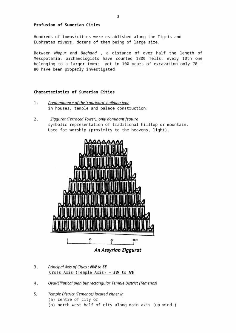
2. Ziggurat (Terraced Tower). only dominant feature symbolic representation of traditional hilltop or mountain. Used for worship (proximity to the heavens, light).
An Assyrian Ziggurat
3. Principal Axis of Cities : NW to SE Cross Axis (Temple Axis) = SW to NE
4. Oval/Elliptical plan but rectangular Temple District (Temenos)
5. Temple District (Temenos) located either in (a) centre of city or (b) north-west half of city along main axis (up wind!)
6. Irregular residential streets
7. Irregular layout and appearance of dwelling lots and building blocks
Examples of Sumerian Cities
3
Probably none were as old as Jericho (?) but they were larger, more urban, and more populous.
URUK (WARKA today; ERECH in the Bible)
4000 B.C. settlement of pre-Sumerian origin;the site contains 18 levels of excavations
3200 level IV provides evidence of civilization.by 2700 most powerful city state in Sumer and during this millenium
largest city on earth, with elaborate double line of fortification, 9 km long and enclosing area of 500 ha (1235 acres)
contained two large temene, palm gardens, and dense residential areas;inhabitants estimated between 50,000 and 150,000
UR (referred to in Bible as Abraham's home town)Rediscovered early 20th century by Sir Leonard Wooley.
6th Millenium - a prehistoric settlement5th Millenium - a proto-urban settlement 4000 B.C. destroyed by great flood (excavations uncovered 8' deep silt
deposit) dating to this time
2500 B.C. third dynasty, period of city's greatest importance
House at Ur

4
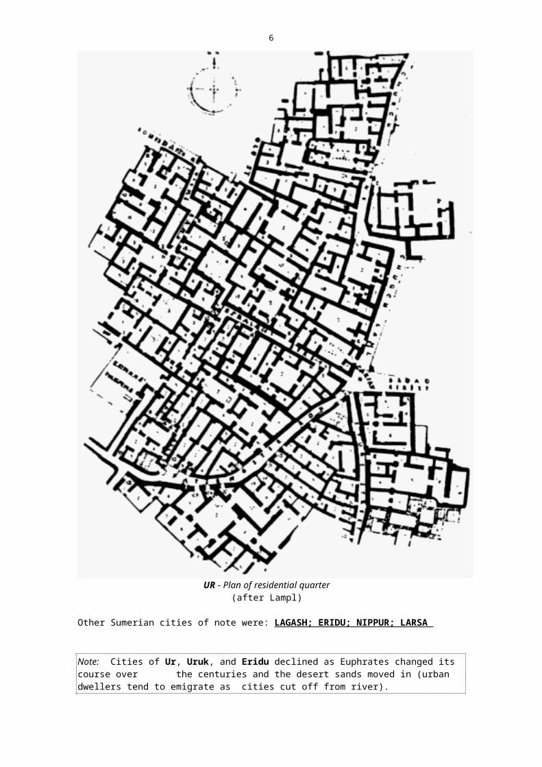
UR - Plan of residential quarter (after Lampl)
Other Sumerian cities of note were: LAGASH; ERIDU; NIPPUR; LARSA
Note: Cities of Ur, Uruk, and Eridu declined as Euphrates changed its course over the centuries and the desert sands moved in (urban dwellers tend to emigrate as cities cut off from river).

5
Courtyard House, LAGASH
2. CITIES OF AKKAD 2350-2100 B.C.
Sumerian and Akkadian City states engaged in continued struggle for dominance in the area; 2350 B.C. King Sargon establishes Akkadian empire, named after his new capital AKKAD, ruled Sumer and Akkad.
2050 Third Dynasty of Ur. Sumer and Akkad brought under one rule of Ur.
Characteristics of Akkadian Cities:
- follow Sumerian features closely; in addition, exhibit a more developed palace layout and construction.
- there is also tendency toward regular city plans (although not planned as such, Akkadian cities achieve a degree of regularity).
Examples: KISH; SHURAPPAK; KISSURA; SIPPAR; AKKAD
3. CITIES OF ASSYRIA 2350 - 600 B.C.
- continue Sumerian temple tradition but develop in new direction:
(a) Plans either conform to mountainous terrain or any other topographical limitations e.g. ASSUR, NINEVEH
or (b) Plans are rectangular or square: DUR-SHARRUKIN (Khorsabad).
Later Assyrian towns become proper citadels or strongholds of Kings while the population lived in the surrounding open countryside.
Examples of Assyrian Cities:
6
NINEVEH7th millen. site occupied since Hassuna period2nd millen. important city with prestigious temples (not yet capital)704 B.C. King Sanherib made Nineveh his capital and makes it a
metropolis to match its power and influence area increased to: 1,700 acres (6.7 km2).120,000 inhabitants (during 7th century B.C.)
612 city destroyed by Babylon but survived for another 1000 years
DUR-SHARRUKIN (KHORSABAD )717 B.C. new city founded by Sargon, self-proclaimed King of
Assyria713-707 B.C. city area 730 acres (300 ha)
plan: approx. rectangular/square, with standard orientation, measuring 1750 x 1600 mcity has 7 gates; palace straddled the north-west wallplan appears to be based on a module of 61m. (Egli)
705 Sargon killed, court moves back to Nineveh
Plan of Dur-Sharrukinnote: location of temenos and Royal Palace

7
Palace of Sargon II at Dur-Sharrukinnote: city residential blocks in lower part of picture,
agricultural fields at top
ASSUR (ASHUR) - the capital of Assyria for 1200 years and its religious centre.
from 2400 B.C. - on a rocky site overlooking the Tigris river- excavated prior to World War I
ASSUR northern section of cityfields and Tigris river below temenos and palaces,
at top of illustration

8
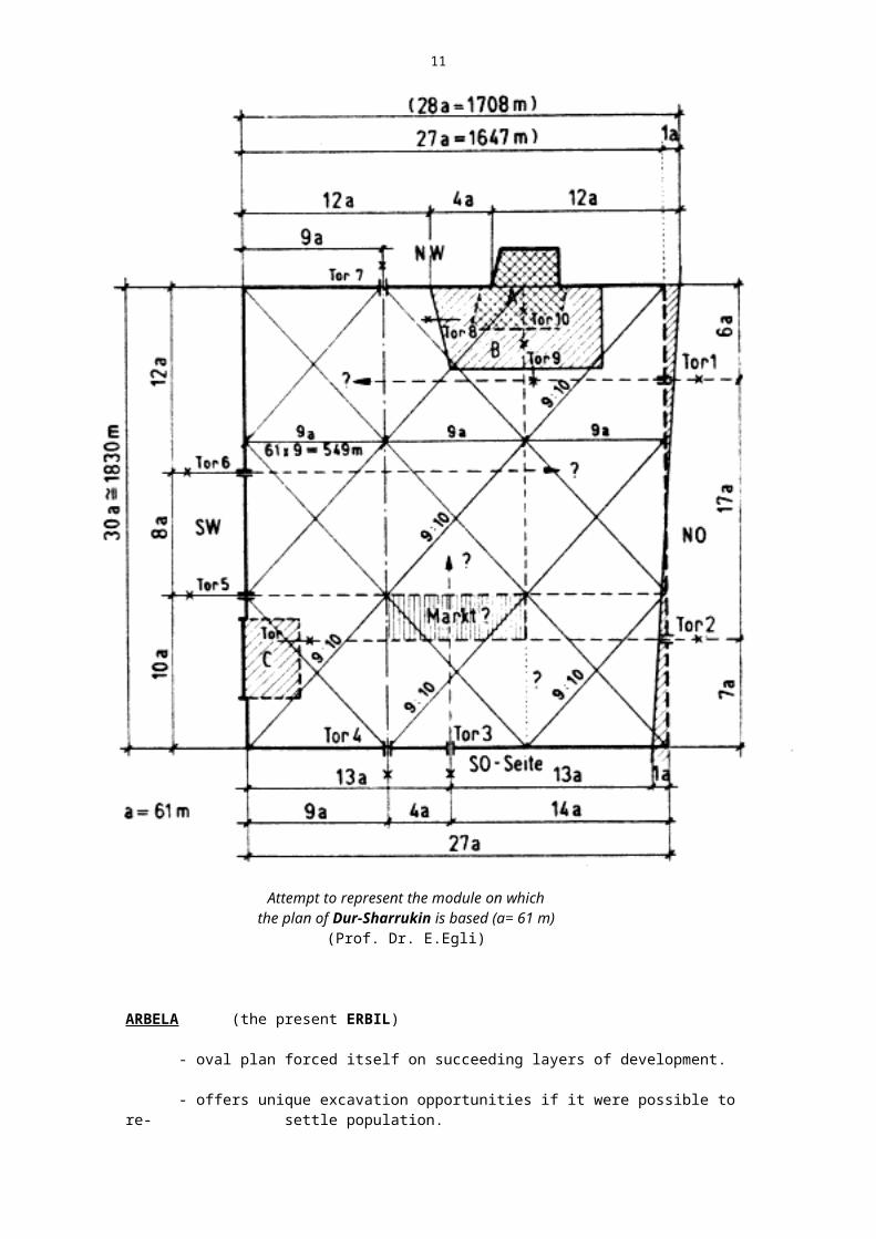
Attempt to represent the module on which the plan of Dur-Sharrukin is based (a= 61 m)
(Prof. Dr. E.Egli)
ARBELA (the present ERBIL)
- oval plan forced itself on succeeding layers of development.
- offers unique excavation opportunities if it were possible to re-settle population.
4. CITIES OF BABYLONIA 2000-539 B.C.

9
- traced back to Sumerian/Akkadian tradition, influenced by Assyria and later Egypt.
- plans have rational and generous layouts (not symmetrical but on modular grid and with geometric regularity).
Examples:
BORSIPPA- plan almost square, its corners orientated (as was usual) to
the four cardinal points.
BABYLON (Gate to God)
Brief History
3000 B.C. emerges later than other towns in the area, remaining small for a period. City remained cultural centre of Middle East for 1400 years, through changing rule and occasional destructions until it lost in importance upon Alexander's death, in 323 B.C.
1728 -1686 reign of HAMMURABI, under his strong rule Babylon becomes capital of Mesopotamia uniting 3 million people.Hammurabi built temples and palaces.Period of cultural and commercial advance.
Plan unknown as city destroyed.1531 B.C. Hittite tribes burn city 1250 Rest of Empire falls to Assyrians1239 Babylon destroyed 2nd time during revolt against Assyrians
yet city City rose again; remained cultural centre under Assyrian rule.
689 3rd devastation by Assyrian King SANHERIB. City belonged to Elamites of SUSA at the time.Nineveh, its traditional rival, became capital.
681 ASARHADDON, successor to Sanherib and plunderer of Memphis, rebuilt Babylon.
648 City destroyed a 4th time by ASSURBANIPAL, destroyer of Thebes, after 2 year siege.
626-605 NABOPOLASSAR rebuilt it again, turned on Assyrians an destroyed their Nineveh.
605-562 NEBUKADNEZAR'S reign: Babylon becomes world city once again Unequalled building frenzy ; a beautiful, ostentatious city (Tower of Babel)Babylonian Empire expands (Jerusalem destroyed)
539 CYRUS of Persia defeats Babylonia336-330 DARIUS II destroys temples and tower of Babel 336-323 ALEXANDER the Great, dies in Babylon before being able to
make it his great metropolis.305-281 SELEUCUS 1 forces inhabitants of Babylon to move to nearby
SELEUCIA, capital of the new Hellenistic rulers of Mesopotamia.
Babylon's rise to fame caused by

10
1. Change in course of Euphrates river (beginning of 2nd millenium), leftKISH, the old capital of northern Mesopotamia stranded. Babylon, 13 km
west, benefitted from access to river.
2. City was home to God MARDUK - an intensive public relations campaign made this the national God of all Mesopotamia. NIPPUR's God out of fashion - hence that city's decline.
Plan of 'New' Babylon [inner city area]6th century version
Plan• an uneven rectangle based on the proportion 3:5
• area contained within is 410 ha (1012 acres), enclosed by double wall of 27m total thickness
• population estimate for above area: 70,000 - 80,000 inhabitants
• a third city wall, 18 km long , enclosed an outer area of approximately (?)• 2000 ha (4940 acres) with a population of 360,000 inhabitants.
• the Euphrates divided city into 2 unequal halves, of which the western one is smaller and less impressive. A bridge joined the two halves.
• tower of babel (in Temenos) : 67m high (220'), with a base of 90x90 m.
Streets
• the main arteries, including the Processional Avenues, were 23 m wide (75') but not perfectly straight and lacking a continuous building line.
• main arteries laid out parallel and at right angles to river
• minor roads were narrow and winding, within the more orderly roadgrid
11
Plan of Babylon with outer city and Nebukadnezar's wall
Houses
- street blocks (insulae) irregular; many-sided building blocks
- houses 3 to 4 storeys high, of varying size, arranged in traditional agglomeration pattern.
EGYPT

12
'Egypt is a gift of the Nile' - Herodotus
Physical Environment
- geographic situation of the Nile valley facilitated Egypt's 'splendid isolation'; Egypt was not situated at cross-roads of trade and transport as Mesopotamia, although both areas had similar environmental conditions.
- a corrosion valley in a desert plateau; the cultivated area was smaller than present-day Belgium - a strip of 800 km long by up to 15 km [av.] wide, stretching from the Delta to Assuan.
- rural life was strongly dependent on the providential Nile, which at fixed date each year inundated low-lying lands (July-September) leaving a deposit of rich black silt and which provided cheap building materials.
- absence of rain and springs meant that settlements generally formed along the river and its canals. Villages, towns grew in oblong settlements near and parallel to the river, specifically along boundary between infertile desert and the agriculture strip; structures were often raised on artificial mounds out of reach of highest flood-waters as periodical inundations rose to 25'.
- intricate system of dikes and canals devised in early dynastic days to control floods and bring water to urban settlements inland from river.
Brief History
6000 - 5000 B.C. Temporary settlements of Nomads: Upper Nile Valley (Hammites)
5000 - 4000 B.C. Pre-historic cultures, (mainly in Nile Delta), Pre-village settlement forms e.g.
MERIMDE
- earliest settlement in Delta area, lasted several centuries
- 16,000 inhabitants- irregular layout (oval) enclosing area of about 45 acres
4400 - 3950 Developed village culture and proto-urban forms emerge around 4000 BC in Nile delta.
3950 - 3500 Growth of small towns based on earlier villages, e.g.
from 3700 HIERAKONPOLIS- late neolithic settlement in upper Egypt- 5,000 - 10,000 inhabitants- irregular, oval layout
NAQADA
These two settlements and many others located at strategic points on Nile formed embryos of later urban settlements.
3500 - 3000 Pre-dynastic Era.

13
Small towns struggle for autonomy against kings and feudal lords.
Regulation of annual flooding of fertile area leads to central political organisation of the original,
autonomous 42 Egyptian provinces (nomes) into upper and lower kingdoms.
3200-2280 Old Kingdom - Dynasties 1 - 6 Consolidation of 2 kingdoms into one Empire under Narmer and Aha. Most creative period of Ancient
Egypt.
Period of Darkness (Dynasties 7-10 ), social crisis
2000-1788 Middle Kingdom - Dynasties 11 - 12Hykos invasion and second period of darkness (Dynasties13 - 14)
1580-1080 New Empire - Dynasties 18-20 Development of imperial power abroad; imposing
representative architectural style.
1080-332 Late Empire - Dynasties 21 - 31 Conservative, senile period; from 332 Egypt forms
part of Hellenistic system of Nations (after 30B.C. a Roman province).
Absence of identifiable early urban remains
There are few urban archaeological remains dating to the period before 2000 B.C. while after that the remains of cities are more extensive; yet we do not possess any fully reconstructed plans of Egyptian cities.
Reasons:
1. Relative internal peace at the timeobviated need to build strong walls for defence as in Mesopotamia. This, in turn, allowed more 'urban mobility'.
2. Few large cities developed because of the practice of changing the site of each capital with the ascendancy of a new pharaoh;
3. Egypt was essentially an agricultural society based on numerous, small communities of peasants.
4. All resources of building industry i.e. all durable materials, were devoted to temple and tomb construction while dwellings and palaces, the urban form, were built of mud-bricks (houses transient and impermanent).
"Generally, speaking the emergence of civilization in Egypt was not accompanied by an significant concentration of activity in urban centres, with the exception of the capital". -H. Frankfurt
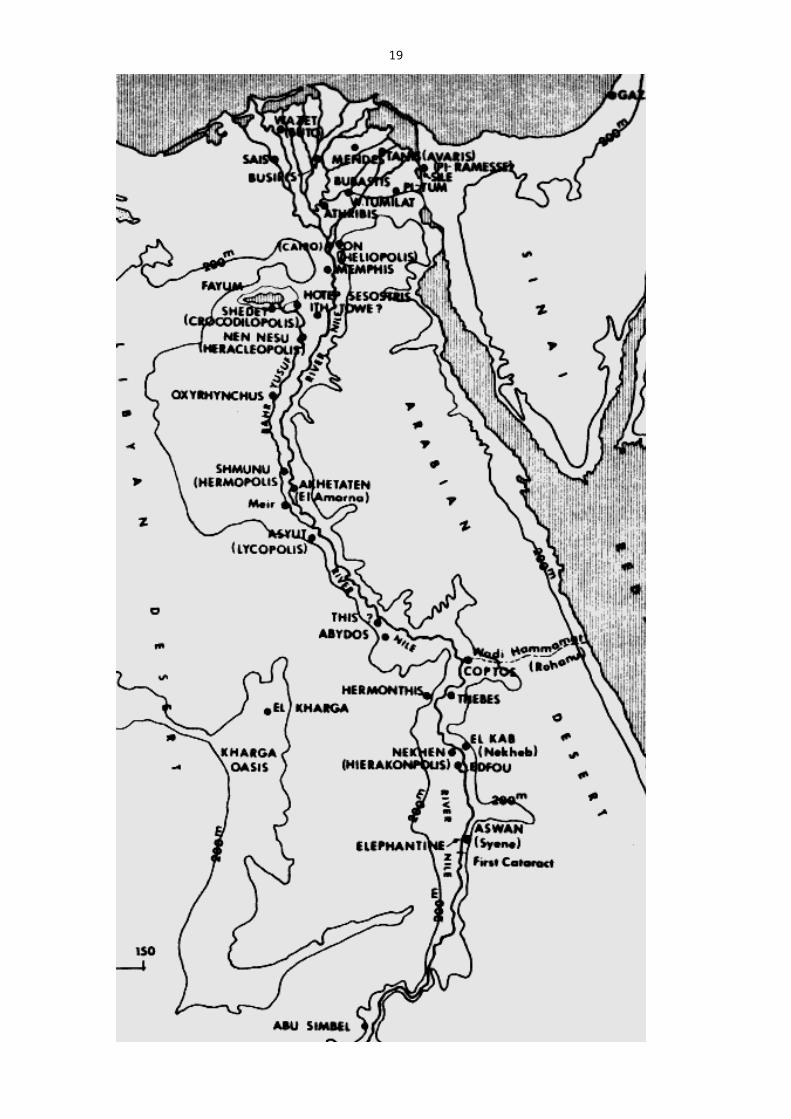
Map of Ancient Egyptnext page
14

15
Social and Religious Background
The emergence of urban culture in Egypt was characterized by:
• wheat and barley cultivation• domesticated oxen and asses used for agriculture and transport• copper working and potter's wheel• increasing differentiation of social classes and occupational groups
The communities along the Nile valley were
(a) politically independent units, each containing large co-operative irrigation projects to harness annual floods and divert water to agricultural and other uses.
(b) open and small in size (as Egyptian economy based on agriculture) bulk of population lived on land, no big industries, and no large-scale commerce to swell urban population or to give rise to a responsible middle class.
(c) fewer in numbers than Mesopotamian settlements of the period.
(d) smaller in terms of inhabitants than Mesopotamian examples but surface area much greater as dimensions of Temples, Palaces, Shrines were gigantic.
(e) Temples and Palaces were the most important elements, but isolated and without relationship to any overall plan, concept.
Religion
Religion was the most important determinant of urban life in Ancient Egypt; most remaining architectural monuments are religious or funerary and characterised by:
• the best locations• the largest scale• most durable materials
'Eternal afterlife' and underground tomb construction were major preoccupations.
The City of the Dead (Necropolis) is the most remarkable adjunct of the capital cities of Ancient Egypt. They were usually built in arid desert location west of Nile in the form of orthogonal layouts centered on tombs (royal pyramids or mastabas) and represent a curious deviation of our traditional urban concepts.
The entire burial complexes of dead kings of Egypt (Royal tombs, funerary chapels, etc.) play a major role in the religion of the land and its urban activity. These burial places were of tremendous dimensions, more like small towns in area than like cemeteries. To the individual as well as the Pharaoh the most important achievement during a lifetime was to build a tomb for the eternal afterlife.
"Each Pharaoh took up residence near the site chosen for his tomb, where during the best part of his lifetime, the work on the pyramid and the temple was carried out whilst government was based in the nearest town. After the death of the Pharaoh, the place was abandoned to the priests who maintained his cult and managed his mortuary estate unless the successor also decided to build his tomb in the area."
- Henri Frankfort, The Birth of Civilization in the Near East (1951).

16
Examples:
MEMPHIS (Men-ofr) 2920 existed since very beginning of Egyptian history: founded
in 1st Dynasty by legendary King Menes (Na'rmer?)2600-1700 capital of all Egypt; for long time practically the only real
capital opf the country City reached its largest urban expansion during 4th Dynasty.
671 conquered by Assyrians, all moveable objects taken to Nineveh
3rd C. B.C. overshadowed by rival metropolis of Alexandria; sinks into twilight of history
1200 A.D. era of the Mameluks of Egypt; Memphis buried under silt of Nile floods.
Memphis was administrative and religious centre of the 1st Lower Egyptian nome; acosmopolitan city in character with several races living side by side in their respective quarters.
LayoutCity Area measured approx. 8 x 4 miles i.e. a rectangle of proportion 1 : 2 and comprised two sections:a) north-eastern part if not entire north of city formed the Egyptian section of city -
this was most pleasant part of city reserved for the upper classes and the king's highly centralized bureaucracy (up wind?)
b) south and east - section for foreign inhabitants.
The Temenos
The Temenos was most likely located in centre of the Egyptian part of city; which, in turn, was separated by a wall from the districts occupied by foreigners. These were situated along the Nile - the natural location of those occupied in trade and commerce.
SAQQARA
Probably the most impressive and best known cemetery in the Memphis necropolis.It was begun during the 1st and 2nd Dynasties, before the period of pyramid building.
2630 B.C. on foundation of famous step pyramid laid by King Djoser (3rd Dynasty) Architect: Imhotep
In building his tomb at Saqqara King Djoser probably followed the Palace and Temple layouts in Memphis as both were concepts of his architect Imhotep.
The walled enclosure of the inner temple and palace district of Memphis (the Temenos) measures 3900 yards x 1740 yards - the walled enclosure of the necropolis at Saqqara measures about the same.The explanation probably lies in the King's desire to find his environment during his eternal afterlife as familiar as possible.

17
A comparison between the layout of the City of the Dead at Saqqara (above) and the layout of the temenos at Memphis (below)
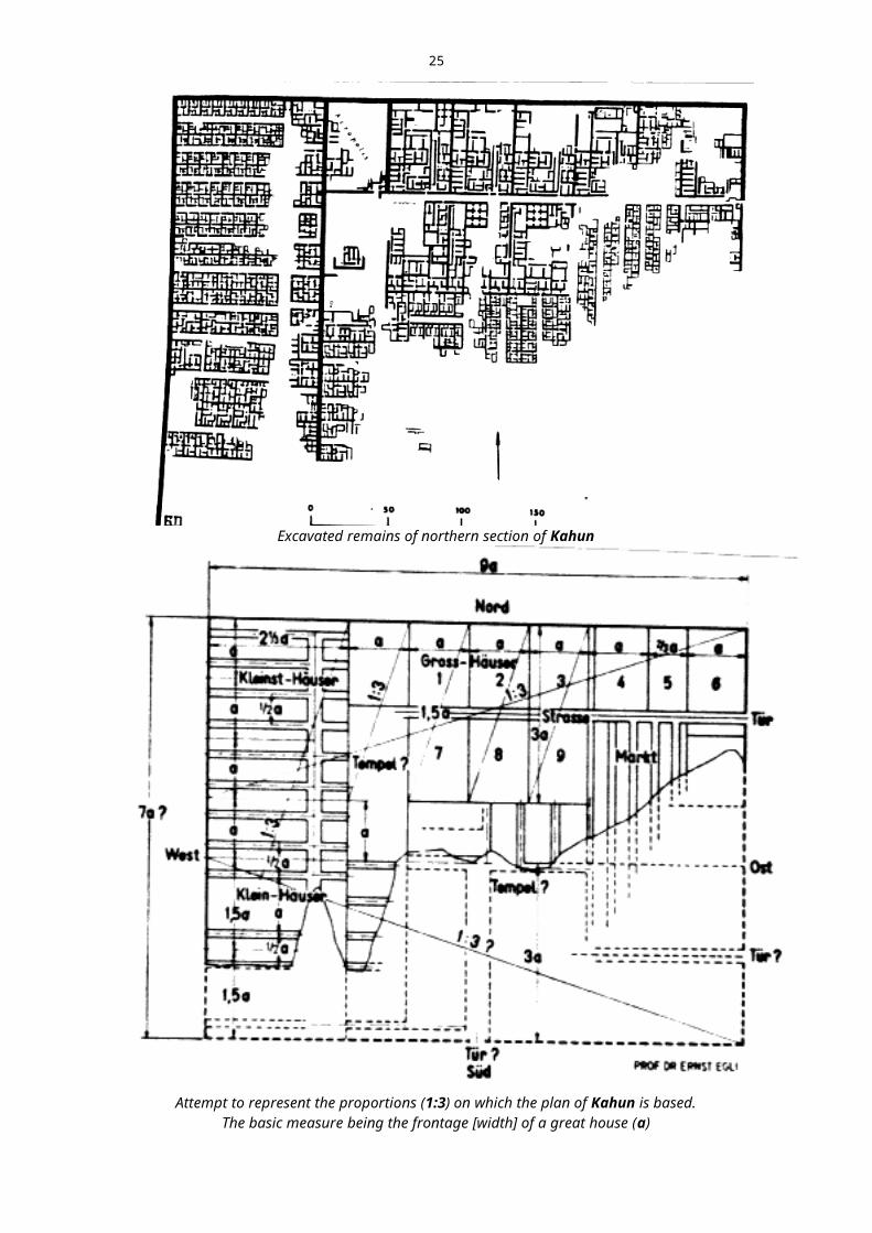
KAHUN (Hetep-Senusret)
The planned pyramid town of Kahun was discovered by Professor Flinders Petrie in the 1890's. The plan of Kahun is one of the most remarkable of antiquity. It contains an order, a regimentation and formalism which applies equally to the largest mansion, the smallest dwelling, to the Temple (?) and the Palace (?) as well.
1900 B.C. built by Pharaoh Senwosret II (12th Dynasty) to house

18
workers engaged in construction of his tomb: the pyramid of el-Lahun
Plan
- a rectangle based on a harmonic proportion, a deliberate, planned design- small walled settlement of less than 14 ha, occupied for 21 years only- 10,000 inhabitants, at density of about 714 persons/ha(?)- clearly divided into eastern and western sections- houses of varying size for different social classes (no gardens)- was a small town + market + workers quarters but also served the king and his followers when on visit.
Orientation
All houses faced exactly north-south; accordingly streets ran east-west.
A wall running north-south divided the city into a small western strip and a larger eastern strip with houses for important people, on large 40 m x 60 m plots with up to 80 principal rooms opening onto seven or eight courtyards. The medium sized houses for 'foremen' numbered 5,6 or more rooms. The smaller uniform dwellings measured 10 m x 10 m with 4 to 6 rooms, on average.
There were no gardens ; the larger houses had 2 storeys and staircase.
The harmony in the relationship of its various parts is based on a rectangle with the proportions of 9 to 7; the basic measure being the width of the large houses (40 m).
Kahun's plan is dictated by the climate and its effect on living habits, the social order of the time and religious beliefs.
Excavated remains of northern section of Kahun
19
Attempt to represent the proportions (1:3) on which the plan of Kahun is based.The basic measure being the frontage [width] of a great house (a)
(after Prof. Dr. Ernst Egli)
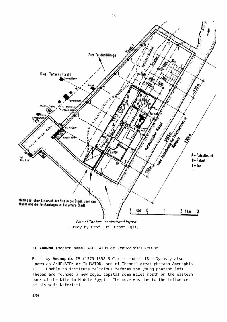
THEBES (U-ast; Us; Nu-a; Nu-amon)
The largest and most monumental city in antiquity (Homer referred to it as 'the city of 100 Gates').
Thebes was situated on the upper Nile, at a point where the river flows north-eastward and the mountain ranges recede to make room for a large valley. Today, the original site is covered by a number of villages (e.g. Luxor, Karnak).
History
2134 B.C- rose to prominence under the rulers of 11th dynasty (Middle Kingdom) who made Thebes their capital
1580 - 1350 Kings of18th dynasty especially were responsible for its development into the largest and most monumental city in antiquity, the capital of all Egypt
1200 remained capital city to the 20th dynasty (1200 B.C.) except for the short interlude at El-Amarna
661 B.C. destroyed by Assyrians 525 destroyed again by Cambyses, during Persian Conquests30 B.C. on Egypt becomes a Roman province
Thebes destroyed a third time by Roman Cornelius Gallus

20
during an uprising.
In spite of dectructions, some remarkable monuments have remained into our time (e.g. Ruins of Karnak and Luxor); however, no traces of the city's layout remain. We must assume the Nile river flowed further east from today's course, probably as in the plan shown below: i.e. parallel to eastern city wall (note: canals to the north and south are for protection).
Area and Dimensions of PlanThe Roman author Strabo visited the city at the time of its destruction under Gallus and reported that it was almost 9 miles long and contained a number of temples.
Today, the site measures about 6.8 miles and is almost 4 miles wide incl. the area of Birket Habu.The area of the city has been estimated at 740 ha (1828 acres).
Temenos 2 If one assumes that both Luxor and Karnak formed part of the same temenos, one gets a holy precinct measuring 3.3 x 1.2 km (similar to that of Memphis). The temenos may have measured about half the city's length and been situated near the south-eastern side of the plan.A waterway had been diverted from the Nile into interior of city for ornamental and holy pools and lakes or canals even. This canal, running through city, may have been cause of later change in the course of the Nile.
Orientation
Longer axis: South West to North EastShorter axis : North West to South East
The principal streets and monumental buildings presumably followed the city's orientation (SW to NE).
Scholars believe present village of EL - NAGA - EL - TAHTANI is spot of ancient palace.Exact plan will not be known until further excavations.
2 Temenos = sacred precinct in which stood temple or sanctuary

21
Plan of Thebes - conjectured layout(Study by Prof. Dr. Ernst Egli)
EL AMARNA (modern name) AKHETATON or 'Horizon of the Sun Disc'
Built by Amenophis IV (1375-1358 B.C.) at end of 18th Dynasty also known as AKHENATEN or IKHNATON, son of Thebes' great pharaoh Amenophis III. Unable to institute religious reforms the young pharaoh left Thebes and founded a new royal capital some miles north on the eastern bank of the Nile in Middle Egypt. The move was due to the influence of his wife Nefertiti.
Site
- situated half way between Cairo and Luxor and has been partially excavated; this heretical city presents quintessence of Theban civilization.History

22
- Amenophis IV was a reformer who tried to loosen Egypt's ties with tradition and superstition; advocated monotheism and equal rights for women.
- time of peace, prosperity and unprecedented flowering of the arts.- city was occupied for 15 years only (1369 to 1354) i.e. Amarna then
abandoned and never occupied again. Tutankhamun, the succeeding pharaoh, returned to Thebes.
Plan- in the form of a narrow strip running along-side the river, 4 km long and 1.4
km wide. Its city of the dead was located to the east, in the mountains.(440 -1200 ha)
- quite different to any previous Egyptian plan:• no regularity or pattern of any kind• no deliberate, controlled planning• no zoning
- characterised by naturalness. Layout is flowing, organic; it may have been a protest against the geometric, orderly and firmly delineated plans of the times.
- street system followed topography i.e. nature closely - indicative of the naturalism of the period.
- critics regard plan as slightly decadent, lacking cohesion, and ill-considered
- city is formed of several independent parts:
• South City- contained homes of leading officials and courtiers, a few humbler homes and an industrial centre.
• North Suburb- few good houses- middle class business area incl. 2 slum areas (hovels)- location of merchants, traders; may have included port.• North City- the smallest sector; incomplete excavations- official quarters (rather than homes)• Central section- carefully and deliberately planned as a unit- contained principal palaces, ministries, and temples- immense buildings with courtyards adorned with statues and colonnaded porticos constitute the official palace precincts
- temenos: although not as distinct from rest of city as in Memphis plan formed part of central town section; as customary, temples faced east while palaces were
orientated north to south.

23
•
Central Section or Quarter with Royal Road, Temple andPalace precinct, Amarna

24
Plan of Amarna
Streets- main road (Royal Road) runs between Palace and Temple precinct- parallel and east of main road are two other main axis of varying widths- the cross-roads are narrower- no defined blocks or insulae/no standardized plot sizes- streets are unmade; there is no drainage; sanitation is poor- rubbish dumped in pits and heaps beyond limits of built-up area; later, pits
were filled and disinfected and new houses built on top.
HousesNobility and middle classes lived in greater luxury than ever before and even humble folk enjoyed comparative ease.
The wealthiest citizens probably selected their own house sites and built along the main streets while the poorer people built in vacant spaces behind and the very poorest squeezed in between without order.
Luxurious comfort was the keynote of the dwellings of the rich:• set in large gardens on outskirts of town• in limited space of central built-up area (usually several storeys
high, max. 3)
Small houses (for slaves or craftsmen/merchants?)• usually 3 to 4 rooms grouped around courtyard
Houses at El Amarna are, generally speaking, different to those at Kahun; probably as there was room to expand horizontally (unlike Memphis or Thebes). Impossible
25
to say if they are typical of the epoch; they are like city-versions of the contemporary Egyptian farmhouse.
El Amarna remains an anachronism in Old Egypt, an untypical example.
Two years after the death of Ikhnathon, Amarna was abandoned; it had only lasted for half a generation.
Workmen's settlement at EL AMARNA (AMARNA EAST)
Situated to the east of El Amarna, the workmen's settlement of the City of the Dead with its rigid layout presents a strange contrast.
Plan- this so called 'model village' was square in plan 70 m x 70 m and, as at
Kahun, an internal north-south wall divided the plan into a small western strip and larger eastern part.- in south, just inside city gates, there was an elongated square into which ran four straight streets, each orientated north to south.- no public or religious land uses, residentialuses onlyHouses- there was only one type of dwelling house (excepting Foreman's quarters
situated near Gate)- each had east-west orientation; built in four single rows along north-south
streets, each with an upper storey.- all similar and of uniform attached type (5m x 10m) throughout plan; regular layout suggests one class of people (i.e. workers)- all entered from west except those along west wall (entrance from east)- each house had 1 or 2 rooms (kitchen, parlour) along western wall, then a
yard while, along the eastern wall, were the bedrooms and cupboards.
The following questions remain unanswered :
1. Why such a contrast to Amarna
2. Why the general relationship to Kahun (in spite of differences)?
3. Why are houses orientated east-west instead of north-south, as elsewhere?
4. Why the internal separation into two by a north-south wall?
5. Are foreign planning influences responsible for the Amarna period?

26
Workmen's settlement at El Amarna(after Badawy)
CONCLUSION
Urban development was caught in a power-struggle between lower and upper Egypt, between centralization and particularism, between the anti-urban feudalism and the popular forces of merchants, artisans and labourers.
Planning of cities was almost totally dependent on the rulers' initiatives and their dynasties, their religions and their economic and military ambitions.
We do not possess any fully reconstructed plans of Egyptian cities but it is thought that their idea of planning was as grand as their architecture generally.Diaries of travellers of antiquity and middle ages confirm this!
Some Egyptologists believe that civilisation advanced for almost 2,000 years under the Pharaohs before true cities appeared in Egypt.
At the same time, it appears that expanding cities such as Memphis and Thebes, which held a unique position in several dynasties, outgrew the social and physical framework their planners and administrators had provided and became

27
dysfunctional - an interesting parallel to the rapid development of 19th century cities during industrialization. Both cities decayed and disintegrated much like a modern metropolis.
Summary of Main Characteristics of Egyptian Cities
1. Houses and Palaces almost exclusively orientated toward the North (some deviation occurs owing to changes in direction of Nile).
2. Most Temples faced East.
3. Outline plans of Egyptian cities varied from rectangle to square (except El Amarna). Oldest settlements were oval or round:
4. Dimensions of city plans were always related to intentional proportion 1:1 1:2 1:2.5 1:3 2:3 3:5
5. Water played an important role in the city image. The importance of water and the Nile were represented formally and spatially in Egyptian cities e.g. in holy lakes, canals, the banks of the Nile.
28
THE LEVANT
Palestine, Phoenicia, Syria
2000 B.C. region flourishing with urban activity, when a number of 'Canaanite' city-states were constituted.
1900 B.C. these came under Egyptian and Hittite domination soon after this date.
Important cities of the 2nd millenium were:
JERICHOOriginally excavated by German Orient Gesellschaft (1907/09); much of the excavation since was carried out by Dr. Kathleen Kenyon.
7000 B.C. probably oldest known settlement; oldest layers excavated date to 8th millenium (at least!)
3500 B.C. existed as small, walled town 2,000 B.C.? heavy dual fortifications built small in size: about 2.3 ha ( population
of 500 inhabitants)1200 B.C. Israelites conquer city.
The famouswalls of Jericho now are interpreted as having been a part of the city's irrigation/canalisation scheme. This 10,000 year old scheme was only recently discovered by staff of the hebraic University of Jerusalem.
JERUSALEM
3000 B.C. - origins unknown but existed as city in 4th millenium (which is now southern part of town).
- this oldest city was situated on hill south of temple terrace.- natural plan devoid of design concept.
1200 B.C. - started on its path to fame under Israelites.
MEGIDDO (now known as Tell-el-Mutesselim)
- situated on edge of Jisrad Valley.- 20 levels excavated, starting before 3300 B.C. and ending
around 350 B.C.- irregular street pattern with courtyard houses of varying
size. - destroyed five times between 1800 - 1500 B.C.
Plan - oval of 300 x 240 m (shorter axis NW-SE orientation)- 5 ha area- strong fortification- irregular street pattern- courtyard houses of mixed sizes.
DAMASCUS- one of the oldest continuously inhabited cities in the world
today- little is known of early city

29
By 1200, Hittite and Egyptian rule over region is at an end.
Phoenician Examples:
1200 B.C. - With collapse of Egyptian and Hittite rule in the region Phoenician sea-farers begin to carry urban life westward
along shores of Mediterranean. They founded many colonial towns:
CARTHAGE (826), TANGIERS, RHODES. Their urban bases were the ports of:
BYBLOS - already city with port in 3200 B.C.; dominant during early Phoenician history.
TYRE - founded 2750 B.C.; rebuilt 1209 B.C. by Sidon.
SIDON - founded 1500 B.C.
Phoenician cities are the immediate predecessors to classic Greek planning (establishment of many colonial towns provided examples to the Greeks).
They are usually ports with two harbours (commercial and naval) while their layouts conform to topography and tend to be systematic.

30
PERSIA
• Remained outside the mainstream of urban experimentation.• Simple village cultures and nomadic settlements. • A few market places - generally cities did not evolve around such nuclei. • Ruling classes lived on fortified hilltops; all building activity devoted to Royal
Palaces which offered little opportunity for urban development. • Persia cannot boast any early cities with the exception of SUSA in Elam, to the
east of Sumer.
SUSA - old settlement located in fertile plain on southern edge of Persian highlands.4000 B.C. - already capital of Elam region
- for 2000 years involved in warfare against Sumerians, then against Babylonians
522-486 - blossomed around middle of 1st mill. during Persian Empire when Darius I made SUSA capital of Persia and its only metropolis
(uncomfortably hot).
Other Examples: Mountain resorts built by Persian Kings:
EKTABANA
PARARGADAE - 700 B.C. residence city of Cyrus II
PERSEPOLIS - 520 B.C. residence city of Darius I
Persian Empire governed Irak, Iran, Syria, Turkey, and Egypt and in the period 500-400 B.C. Persians carried city life into regions now known as Afghanistan and Western Turkestan.
Indigeneous settlements in these regions e.g. KABUL, MARAKANDA, developed into true cities under this influence.
TASHKENT, BOKHARA, KANDAHAR emerged just prior to the Christian era.
Note: Most central Asian cities, though subject to decline and/or destruction and subsequent resurgence, have had
an almost continuous existence down to the present day.

31
INDIA This era is known as the INDUS or HARAPPAN culture (name of site where its remains first discovered) and lasted about 1000 years.
The original inhabitants of the Indian sub-continent were traditionally described as godless, lawless, and noseless barbarians of hostile speech who lived in fortified cities and owned herds of cattle. This urban culture flourished around 2250 B.C.. It may have begun between 2600 and 2500 when invaders from the north conquered the local inhabitants of Indus Valley and built a number of highly organized cities and fortified citadels.
In 1920 and subsequent years, excavations conducted by Sir John Marshal, Earnest Mackay, and Sir Mortimer Wheeler at the sites of Harappa and Mohenjo-Daro, uncovered a civilisation of high standard of art and crafts, possessing a well-developed system of pictographic writing, religion and administrative ability.
The Harappan Civilization, which lasted circa 1000 years, belongs to the Bronze Age - its principal sites yielded bronze and copper objects (as well as stone implements) but no iron-made ones.
GeographyThe Indus Valley resembled Mesopotamia, Egypt, Elam (Susiana):
• alluvial plain watered by Indus River + 5 tributaries in the Punjab• region enjoyed heavier rainfall than at present; vegetation was plentiful• total area of civilization more extensive than those of Egypt and Mesopotamia (and Karun Valley in SW of Iran) extending for 1000 miles north to south and 300 miles east to west.
Economy• based on fertile valleys of major rivers : easy means of transportation and
communication.• agriculture was central to culture : farmers depended on annual rain and
floods for irrigation• cities did brisk trade locally as well as with foreign lands (precious stones
and non- indigenous metals found)
People• of non-Aryan racial stock : medium height, olive brown complexion, long head and face, narrow prominent nose, black hair (men had trimmed beards - used razors).
MOHENJO-DARO (Mound of the Dead)- 140 miles north-east of Karachi, in Pakistan.- discovered 1922 during excavation of the Buddhist stupa; much of the
important exploratory work was done by Sir John Marshal, Ernest Mackay and Sir Mortimer Wheeler.

32
Map of the Indus Valley
Reconstructed plan of Mohenjo-Daro

33
Plan- rectangular shape 4100' x 3600' (600 acres) facing cardinal points.- city well-planned with 30' wide main streets :
• 2 running East - West• 3 running North - South• divided into 12 major districts; these in turn were served by a more
irregular network of smaller access streets 6 - 10' wide.
- excavated city lies in an irregular series of mounds and comprises 2 parts :• Upper part in the WEST, including the Citadel3, probably fortified, Great
Bath, Pillared Hall and the College of priests.• Lower part in the EAST
Houses
- architecture of period is plain and utilitarian (no imposing temples as in Mesopotamia or royal tombs of Egypt)
- aim was comfort rather than luxury- dwelling houses of well-to-do people consisted of:
• courtyard with access through a side alley instead of main street• a watchman's room• living room of different sizes including kitchen• a well• paved bathroom
- most average courtyard houses excavated contain 9 - 18 rooms- typical site areas vary between 70 - 150 m2.
DrainsThe city's drainage constitutes certainly the most elaborate ancient system known or as yet discovered.Houses had bricklined drains which opened into the streets as well (it appears) as chutes for the disposal of rubbish which had also been provided through the walls and which opened into rectangular bins outside (regularly cleared).
Street drains were covered with burnt bricks or stone slabs (for inspection and reducing smell) smaller street drains would join main drains in larger streets forming a city-wide network connected to the Indus river by gravity.
Soakspits for the disposal of sewage have also been found.
Sir Mortimer Wheeler (on seeing elaborate sanitary provisions):"It is clear that the city is no chance growth. It is drilled and regimented by a civic authority whose will is law".
3 Citadel = fortress commanding a city which serves to protect and dominate it at the same time.

34
Principal excavation areas
1. S.D. AREA by explorer Siddiqui (1922-1928)- upper city with Buddhist stupa, college of Priests, Bath4, watch
towers- main street (north) of S.D. hill ('Divinity' street) dates back to 2500 B.C.
2. D.K. AREA by Englishman Dikshit (1923-31)- level dates back to 2000 B.C.- purely residential area of the well-to-do,- possessed flush system for toilets : everything drained into street
system.- width of residential lanes 1.5 arm space
3. V.S. Area - Vatts- industrial sector : equipment for manufacture of dyes and fabrics;
smaller houses with dying pots.
4. H.R. Hargreaves- mixed use area of well-to-do houses, smaller quarters for
workers and industry concerned with melting copper & bronze.
Mohenjo-Daro Residential Quarter (Hargreaves excavation)
B = Great Bath
4 note: floor of Great Bath had bitumen underlayer. Its walls contained gypsum mortar instead usual mud. Precautions taken to prevent seepage into pool from other drain
water (north of bath : first known corbelled arch. in world ?).

35
Levels of Excavation
There are, for example, still 62' below the D.K. area of settlement layers awaiting excavation.The ground water level has risen since 1922 from 35' to 13', to 7' even in some sections. Draining and desalination is necessary before starting on vertical excavation.Pakistan's Department of Archaeology and Museums aims to begin vertical excavation (now that horizontal excavation is almost complete) by lowering water level by 80'.
Other cities in the Indus Culture:
HARAPPA (400 miles north-east of Karachi)
- similar in all respects to Mohenjo-Daro but less residential in character and more military in function.
KOT DIJI, AMRI, CHANHU-DARO
The Indus Valley culture came to a sudden end around 1800/1500 B.C. (as yet unexplained). It was replaced by a predominantly agricultural and non-urban culture (introduction of cow to India).
Unresolved Mysteries of Indus Culture
1. Picture symbols were not de-coded until very recently(still incomplete).
2. No legend or literature exists to give us more of a glimpse of the city life and times or to tell us about its fate.
3. There are no definite clues on the identity of its inhabitants; they appear to have been of non-Aryan stock; remains suggest mixed racial types-4 types excavated at Harappa :• Proto-Australoid• Mediterranean (most common)• Alpine• Mongoloid
4. It seems that when Aryans invaded region, Indus culture had almost completely vanished. Suggested possible causes for this decay/desertion :
• progressive dessication of the river valley• growing danger of floods (evacuation of cities)• climatic changes• gradual decline in material prosperity• peaceful mercantile people probably ransacked and expelled by
neighbouring hill tribes (few weapons of defence and war found).
5. Oldest layers of settlement cannot be reached today as ground water level and mud from Indus are major obstacle.

36

37
CHINA
The further east , the later the evolution of cities, according to one view on the process of urbanization.
China was inhabited since early times by different races and tribes. Agriculture, introduced by immigrants, took root on upper and middle course of the Yellow River (Huang Ho) in north-west China, and along the Yangtze-Kiang River.
Agricultural settlements spread across China. Hamlets were fortified early in history as protection against nomadic invaders. A network of places of refuge was soon set up; out of these emerged cities, possibly during the Shang Dynasty (1766-1123 B.C.) around the 14th century or earlier e.g. ANYANG
The first cities in eastern Asia emerge in the region of the Hwang-Ho (Yellow River). Dating is difficult as new data is being unearthed continuously.
Some excavations show affinity with the Middle East, especially with SUSA and the Mesopotamian civilizations. There is little doubt that some influences have occurred; also north and central China during Neolithic period possessed a cultural coherence like that of the river valley civilizations of the Middle East.
ASIA MINOR
Prior to 2000 B.C.
Political centres of gravity form around fortresses, (city states + kings). Early settlements based on a feudal society; one cannot speak of truly urban development.
2000 to 1200 B.C. Larger kingdoms emerge as new people move in; trade and crafts develop; a number of larger cities are able to evolve:
TROY V AND VI
ALADJA II, ALISHAR, KüLTEPE, BOGASKOY (HATUSHA) most cities fall around 1200 B.C. when Greek tribes overrun the
country from the west.
Artist's impression of Alishar (Badawy)
1200 to 600 B.C.

38
Period dominated by: fortresses, country seats, villages, and feudal estates (as in Europe, India, Persia).
Urban activity resumes gradually, especially along the Agean coastline e.g. in Lydia and along main trade routes of the interior; in addition, there is the colonial activity of both Phoenicians and Achaeans.
600 to 333 B.C. Development of Greek Cities in western regions of Asia Minor.
The urban settlements of Asia Minor, after feudal beginnings, grow in a variety of forms under Phoenician, Mesopotamian, Persian, Phrygian
and Greek influences.
Result: Early urban civilizations of Asia Minor present a colourful variety of town plans and characteristics yet
it is impossible to speak of a national character as in Egypt or Babylonia.
Citadel of Troy(Level VI = 19th - 14th century B.C.)
Examples:
(a) in Eastern Antolia
HADATUSAM'AL (modern ZlNÇIRLI) 900 B.C. - town with geometric circular outline of 720m diameter,
with three gateways and 100 towers.- citadel containing two palaces and barracks was
located on a central hill.

39
TROY
Date Level Description of level
350 BC IX HELLENISTIC - ROMAN City
550 VIII B GREEK City
900 VIII A City called 'ILION' and rebuilt by Greek colonists
1200 VII B new settlers rebuild city, area increased
City destroyed once more
1300 VII A City of Achaeans (Mycenean in character)
note: this is the city referred to in HOMER'S ILIAD (Trojan horse stunt)
1900 VI City of the Achaeans destroyed by earthquake
2050 V City rebuilt on top of previous ruins but it too ended in fire and looting
IV
2300 III City of Level II destroyed
2600 II City covers larger area: strong fortificationno streets
3500 BC I predominantly a fortresscircular plan 90 m. diameternon-urban character
Table showing principal levels of excavation at Troy

40
Plan of Sam'al (Zinçirli)9th-8th century B.C.
(b) in central Asia Minor
Generally, oval in shape - nucleus being formed by a citadel perched on hill; groups of Megaron type houses.
Entire urban complex contained within strong fortifications built along contour lines of hill. e.g.
BEYDJESULTAN, ALADJA-HUJUK, KüLTEPE, KARUN, BOGASKOY PAZARLY, GORDION (the city of MIDAS)
(c) in western Asia Minor
PERGAMON CHALCEDON, TROY (ILIOS or ILION or ILIUM)

41
AEGEAN SEA and its HINTERLAND (all dates are B.C.)
1. CRETE
Urban civilization - an oriental invention - reached Europe by way of its southernmost extremity, the island of Crete.
to 2200 Early Minoan : village culture1900 Urban beginnings
to 1500 Middle Minoan : Cities form around palacesto 1200 Late Minoan
Examples:
KNOSSOSGOURNIA
KNOSSOS: Plan of late-neolithic houses (Muller/Vogel)
2. GREEK ISLANDS
to 2100 Early Cycladic Culture 1700 Urban beginnings (during copper and bronze age)
to 1500 Middle Cycladicto 1200 Late Cycladic
NAXOS (?) THERA (ATLANTIS?)
3. GREEK MAINLAND
2800-1900 Early Helladic Culture
1700 Urban Beginningsto 1500 Middle Helladic (or Middle Macedonian) to 1200 Late Helladic (or Mycenean Culture)
During the 2nd millenium we have only two very fragmentary examples of early Greek Mainland towns:
MYCENAE

42
TIRYNS
Plan of Mycenean fortress town of Tyrins(Müller & Vogel)
A - Citadel with Royal Palace (Fortress)B - CourtyardC - Lower enclosure (refuge)
Reconstruction of the Palace Precinct of the Mycenean fortress town of Tyrins
(Müller & Vogel)
4. MACEDONIA
to 2300 Fortified Settlements of the Dimini-Vardar-Morava Culture1700 Urban development emerges
to 1400 Village cultures (Macedonian cultures) from 1400/1300 Cities blossom during Mycenean Age
WESTERN MEDITERRANEAN and its HINTERLAND

43
As we move westward and northward, the later (according to the theory of diffusion) the appearance of cities.
SICILY AND SOUTHERN ITALYto 2500 B.C. villages, often walled1200-700 Greek Colonization; small urban settlements.
NORTHERN ITALY1600-1150 Influence from Danube cultures to north
Terramare Culture
after 1400 Large settlements 4 to 18 acres5
SPAINafter 2500 Citanias, fortified hilltop settlements
2200-1400 ALMERIALOS MILLERES (5 ha)- proto-urban; early urbanization through trade with east.
1400-1000 EL ARGAR- proto-urban, fortified hilltop settlement.
SOUTHERN FRANCE2200-1000 Copper Age village cultures, which continue into Celtic era.
CENTRAL EUROPE No urban cultures
PART 2 - CONCLUSIONS
Among early city cultures we can distinguish 4 basic types of cities:
1. the fortress-towns with elaborate, strong fortifications + a citadel (usually) JERICHO, TROY, TIRYNS, EKBATANA.
2. the temple-city - centre of a religious cult; a holy place NIPPUR, THEBES.
3. the centre of power - the capital city + king + ruling classes SUSA, MEMPHIS, ANYANG, BABYLON.
4. the Commercial city - along river or coast, cross-roads, market places UR, ERIDU, MOHENJO-DARO.
3. and 4. were often combined in the larger cities of Mesopotamia, also in Thebes and Tell-el-Amarna.All basic or combined types of cities shared the characteristics of type 1- fortress towns i.e. almost always do we find that the earliest cities were fortified.
URUK, was probably the first metropolis on earth, while BABYLON combined all four types in one.
CHARACTERISTICS COMMON TO EARLY CITIES
5 1 Acre = 4671m2

44
Location
Early cities emerged along the 30th parallel of latitude (e.g. Cairo). Gradually urbanization diffused to east and west and centre of gravity of urban development moved up to the 40th parallel (latitude runs north of Athens/south of Rome).
The first cities :• were surrounded by agricultural land fertile enough to support a new social
group - the specialists i.e. the urban dweller.
• emerged in river valleys in which annual floods guaranteed certain level of soil fertility (others emerged in river deltas e.g. ERIDU or at an oasis)
• were located for reasons of protection and subjection of enemies i.e. they depended on being in strategic vantage points e.g. TROY JERICHO.
Climate
• without exception all early cities were situated further south and in warmer latitudes than contemporary centres of urban culture.
• most of them had poor rainfall but sufficient water, being situated in inundation areas.
Housing Standards
• generally speaking, housing was well above the present-day standards in those regions - the overcrowding and unsanitary conditions of Calcutta today were unknown.
• it is quite likely that millions of present-day flat dwellers have to live within smaller floor areas than inhabitants of 4000 years ago.
Character
• nearly all early cities contained a nucleus of temples + palaces and an outer fortifications on the periphery. Their strong 'defensive' character led Max Weber to refer to them as "most perfect military organizations" .
• with the exception of Mohenjo-Daro and Harappa, all early cities devoted a great deal of space to monumental buildings (secular as well as religious). Egypt, in fact, devoted the major share of its urban land use to temples and palaces.
The cities were invariably divided into two types of environment - the larger profane section of the agriculturalists and trades people and the smaller holy section of the elite.

45
Map of the Ancient Near East: Mesopotamia, Iran
(Lampl)

46
Map of the Ancient Near East: Asia Minor, Egypt and Levant
(Lampl)

47
Bibliography Part 2: Early City Cultures
Principal references are shown in bold.
Badawy, A. (1966) Architecture in Ancient Egypt and the Near East, Cambridge, M.I.T. Press.
Baines, J. and Malek, J. (1980) Atlas of Ancient Egypt, Phaidon, Oxford.
Benevolo, L. (1980) The History of the City, Scolar Press, London.
Burke, G. (1971) Towns in the Making, London, Edward Arnold, pp. 5-13.
Childe, V.G. (1954) What Happened in History, Harmondsworth, Penguin Books.
Curl, J.S. (1970) European Cities and Society, London, Leonard Hill, pp. 12-22.
Daniel, G. (1971) The First Civilisations, Harmondsworth, Penguin Books, pp. 44-105.
Fairman, H. W. (1949) 'Town Planning in Pharaonic Egypt', Town Planning Review, April, pp. 33-51.
Frankfort, H. (1950) 'Town Planning in Ancient Mesopotamia', Town Planning Review, July, pp. 99-115.
Frankfort, H. (1954) The Art and Architecture of the Ancient Orient, The Pelican History of Art, Harmondsworth, Penguin Books.
Frankfort, H. (1951) The Birth of Civilisation in the Near East, London, Williams & Norgate.
Grollenberg, L.H. (1959) Shorter Atlas of the Bible, London, Thomas Nelson.
Hawkes, J. (1975) Atlas of Ancient Archaelogy, London, Heinemann.
Johnston, N.J. (1983) Cities in the Round, Univ. of Washington Press, Seattle, Chap II.
Korn, A. (1953) History Builds the Town, London, Lund Humphries, pp. 11-22.
Kostof, S. (1985) A History of Architecture: Settings and Rituals, Oxford University Press, Chap. 3 and 4.
Lampl, P. (1968) Cities and Planning in the Ancient Near East, London, Studio Vista. pp. 13-32.
Morris, A.E.J. (1972) History of Urban Form, London, George Godwin, pp. 7-18.
Mumford, L. (1966) The City in History Harmondsworth, Penguin Books, Chapters 2-4.
Oates, D. & J. (1976) The Rise of Civilisation, Elsevier Phaidon, Oxford.
Roaf, M. (1991) Cultural Atlas of Mesopotamia and the Ancient Near East, Time-Life Books, Amsterdam.
Rowland, B. (1967) The Art and Architecture of India, The Pelican History of Art, Baltimore, Penguin Books, pp. 11-19.
Uphill E. P. (1988) Egyptian Towns and Cities, Shire Publications, Aylesbury, U.K.