Dustbowl Legacies - University of Michigan
30
122 4 Dustbowl Legacies Long-Term Change and Resilience in the Shortgrass Steppe Kenneth M. Sylvester Myron P. Gutmann F or centuries, European observers perceived the western High Plains as a desert. Few signs remained, on the surface, of the Pawnee vil- lages that once grew maize and bean crops and built earthen homes in the bot- tomlands of the South Platte and Republican River basins. Decades-long drought during the 13th century had forced an eastward retreat of the rst agricultural peoples on the High Plains. In the centuries that followed, humans were mainly visitors to a shortgrass steppe dominated by bison, drought, and re. The land- scape that emerged favored resilient shortgrass species, like buffalograss and blue grama, which thrived on natural disturbance. The longevity of these forces only began to unravel when Europeans introduced horses and rearms into plains ecology. The near demise of the bison in the 19th century, and the expansion of agriculture that followed, had dramatic consequences for the shortgrass, reducing its biomass and diversity. But unlike the tallgrass prairie, human intervention was limited by the interaction between the environment and the very institutions that promoted wholesale change farther east, thereby preserving sizeable grassland corridors in the process. The shortgrass thus represents an important counterpoint to the larger narra- tive of the grasslands’ declension into the Dust Bowl. During and since the 1930s, many questioned the wisdom of allowing agricultural land use to continue in the High Plains. Several ofcials instrumental in creating the Soil Conservation Service in Washington believed that careless farming methods were to blame (Bennett, 1947). Generally, historians have shared this negative assessment, see- ing poor land-use practice as a major cause of the soil erosion and subsequent dust storms that blanketed the plains (Opie, 1987, 2000; Worster 1979, 1992). 05-Redman-Ch04.indd 122 05-Redman-Ch04.indd 122 3/26/2008 9:51:58 PM 3/26/2008 9:51:58 PM
Transcript of Dustbowl Legacies - University of Michigan

122
4
Dustbowl Legacies
Long-Term Change and Resiliencein the Shortgrass Steppe
Kenneth M. SylvesterMyron P. Gutmann
For centuries, European observers perceived the western High Plains as a desert. Few signs remained, on the surface, of the Pawnee vil-
lages that once grew maize and bean crops and built earthen homes in the bot-tomlands of the South Platte and Republican River basins. Decades-long drought during the 13th century had forced an eastward retreat of the $ rst agricultural peoples on the High Plains. In the centuries that followed, humans were mainly visitors to a shortgrass steppe dominated by bison, drought, and $ re. The land-scape that emerged favored resilient shortgrass species, like buffalograss and blue grama, which thrived on natural disturbance. The longevity of these forces only began to unravel when Europeans introduced horses and $ rearms into plains ecology. The near demise of the bison in the 19th century, and the expansion of agriculture that followed, had dramatic consequences for the shortgrass, reducing its biomass and diversity. But unlike the tallgrass prairie, human intervention was limited by the interaction between the environment and the very institutions that promoted wholesale change farther east, thereby preserving sizeable grassland corridors in the process.
The shortgrass thus represents an important counterpoint to the larger narra-tive of the grasslands’ declension into the Dust Bowl. During and since the 1930s, many questioned the wisdom of allowing agricultural land use to continue in the High Plains. Several of$ cials instrumental in creating the Soil Conservation Service in Washington believed that careless farming methods were to blame (Bennett, 1947). Generally, historians have shared this negative assessment, see-ing poor land-use practice as a major cause of the soil erosion and subsequent dust storms that blanketed the plains (Opie, 1987, 2000; Worster 1979, 1992).
05-Redman-Ch04.indd 12205-Redman-Ch04.indd 122 3/26/2008 9:51:58 PM3/26/2008 9:51:58 PM

Dustbowl Legacies 123
However, drought has likely become too large a part of our mental model of human impacts in the region. Climate variation was characteristic of the region long before agriculture was a signi$ cant factor in its ecology. Many studies indi-cate that drought was far more severe in plains prehistory, with sand dunes reach-ing their maximum height or range 5,000 to 6,000 years ago (Forman et al., 1995, 2001). Human impacts have certainly added stress in modern times; but, over time, signs of resilience have also become clearer. Overstocked ranges in the 1880s recovered, and homesteaders from the 1890s to the 1910s moved cautiously into the region, seeking out landscapes with rich soils and water access, but not pushing beyond them. These local patterns of persistence and adaptation continue to frame the ecology of the High Plains.
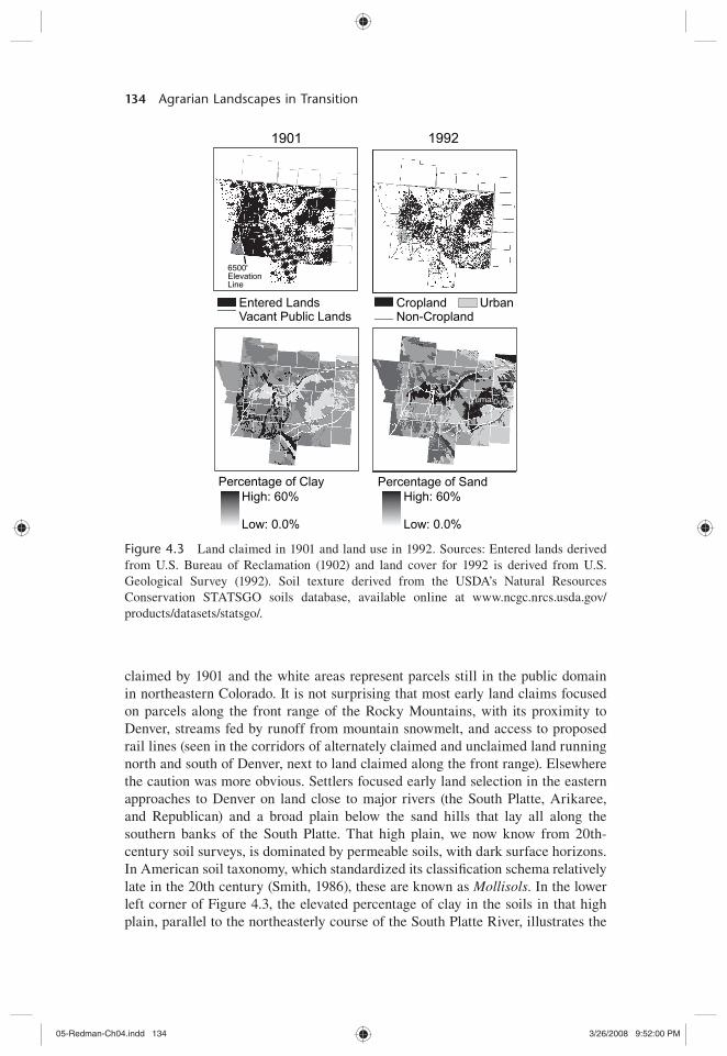
To some extent, early ecosystem science has stayed within the dust bowl para-digm, while working toward a better understanding of the presettlement function-ing of the shortgrass. Early research in the shortgrass began with a grassland recovery effort initiated by the U.S. Forest Service in the 1930s. Charged with the care of the Pawnee National Grasslands (PNG) in Weld County, Colorado, the Forest Service began to study grassland management practices in 1939. At a 15,500-acre site in the northwest corner of the PNG, 13 km northeast of Nunn, Colorado, the Forest Service focused its scienti$ c effort on understanding the diversity and functioning of native plants in the shortgrass, the pace of recovery on abandoned cropland, and techniques for measuring plant responses to grazing by cattle. Known as the Central Plains Experimental Range (CPER), the Forest Service site eventually shifted in 1968 and the service began working jointly with Colorado State University’s Natural Resources Ecology Lab on studies funded under the initiatives of the NSF, which included the International Biological Program (IBP) and the LTER. During IBP, research examined ecosystem inter-actions and grassland productivity, and pioneered approaches for modeling the complexity of ecosystem processes. Since 1982, research projects have focused on monitoring primary production, organic matter accumulation, inorganic inputs and transport, disturbances, and populations (Stafford et al., 2002). The area chosen for this chapter embraces the northernmost extent of the shortgrass, $ rst delimited in a rigorous way by vegetation scientist A. W. Küchler (1964), in his map of potential natural vegetation zones in the conterminous United States(Fig. 4.1). Twenty-six counties surrounding the PNG, which is located in Weld County, Colorado, embrace two major river basins in the region, the South Platte and Republican, and experienced very different settlement patterns in historic times. The South Platte basin was favored early during American territorial expan-sion. It quickly became the scene of agricultural settlement schemes designed to capture mountain runoff in stream C ow irrigation systems and reservoirs. But in the Republican River basin, the high rolling tablelands of northeastern Colorado remained little more than “coal lands” in the minds of early scienti$ c observers like Ferdinand Hayden (Hayden and United States, Geological and Geographical Survey of the Territories, 1877). Without water from the Rocky Mountains, it was dif$ cult for contemporaries to imagine how farms might rely on rainfall less than 450 mm (18 in.) a season (Fig. 4.2) or the intermittent C ows that gathered in the tablelands and occasional springs to form the many lesser creeks that became the
05-Redman-Ch04.indd 12305-Redman-Ch04.indd 123 3/26/2008 9:51:58 PM3/26/2008 9:51:58 PM

Ele
vatio
n (m
eter
s)86
4.9
- 1,2
181,
219
- 1,4
771,
478
- 1,7
761,
777
- 2,2
112,
212
- 2,8
092,
810
- 4,3
45
Kuc
hler
's G
ram
a/B
uffa
lo S
hortg
rass
Pra
irie
(inse
t map
onl
y)
SG
S re
gion
al s
tudy
are
aC
ount
y bo
unda
ries
Paw
nee
Nat
'l G
rass
land
s
Fig
ure
4.1
Shor
tgra
ss S
tepp
e (S
GS)
stu
dy a
rea:
ele
vati
on,
maj
or r
iver
s, a
nd p
olit
ical
bou
ndar
ies.
Ins
et m
ap s
how
s po
tent
ial
natu
ral
vege
tati
on o
f th
e co
nter
min
ous
Uni
ted
Stat
es.
Dig
ital
vec
tor
data
(di
giti
zed
from
1:3
,186
,000
sca
le
map
) on
an
Alb
ers
Equ
al A
rea
Con
ic p
olyg
on n
etw
ork
in A
RC
/IN
FO
for
mat
. Cor
vall
is, O
R:
US
-EPA
Env
iron
men
tal
Res
earc
h L
abor
ator
y. B
ased
on
data
fro
m K
üchl
er (
1993
).
05-Redman-Ch04.indd 12405-Redman-Ch04.indd 124 3/26/2008 9:51:59 PM3/26/2008 9:51:59 PM

Dustbowl Legacies 125
Republican and Arikaree rivers. Although the shallow valleys created by these streams afforded relief from broad, fertile plains, the tablelands were occasionally punctuated with narrow, steep-walled canyons and dune-covered sand hills with poor drainage and no C owing streams (Wedel, 1986). Environmentally cautious patterns of land use by European American settlers continue to de$ ne the extent to which human management has changed the ecosystem of the Republican River basin.
Geophysical, Environmental, and Biological Setting
Grasses have dominated the Shortgrass Steppe region of North America for mil-lennia. Twelve thousand years ago, in what are now the High Plains of Texas, New Mexico, Oklahoma, Kansas, Nebraska, and eastern Colorado, a diverse land-scape of unbroken grasslands was punctuated by small forests, typically in river valleys and canyons. Woodland almost certainly began a steady decline with the arrival of a more arid climate beginning around 11,000 bp, but recent work has questioned the presence of extensive forest cover in the plains during the late Pleistocene era. Investigations in Texas and Kansas have concluded that spruce and $ r pollen were only a small part of otherwise high percentages of grass and composites sampled from glacial lake clays (Fredlund, 1995; Hall and Valastro, 1995). Studies of Holocene dune activity in eastern Colorado indicate repeated activation of eolian dunes during the past 20,000 years. Radiocarbon ages on organic matter from buried soils suggest periods of aridity, visible in parabolic
Keith
Perkins
Chase
Deuel
Sedgwick
DundyYuma
Washington
Cheyenne
PhillipsLogan
Morgan
Sherman
Kit Carson
Cheyenne
Laramie
Kimball
Larimer
WeldBoulder
AdamsArapahoe
Elbert
Lincoln
Douglas
Jeffe
rson
Republican Rv.
Arikaree Rv.
S. Platte
Rv.Nat'lGrassland
Denver
Pawnee
WYOMING NEBRASKA
COLORADOKANSAS
N
100 km
Precipitationin Inches
46-5539-4534-3829-3324-2819-2316-1814-1513
Figure 4.2 Climate normal precipitation (1961–1990) in Shortgrass Steppe counties. Based on PRISM (2008).
05-Redman-Ch04.indd 12505-Redman-Ch04.indd 125 3/26/2008 9:51:59 PM3/26/2008 9:51:59 PM

126 Agrarian Landscapes in Transition
dunes straddling the South Platte (Forman et al., 1995; Madole, 1995; Muhs et al., 1999). The botanical and climate signatures point to a grassland vegetation regime extending over a wide geography for much of the past 20,000 years.
The Shortgrass Steppe region is part of the larger Great Plains physiographic province in North America, extending roughly 1.16 million km2 from south-ern Canada to the Gulf of Mexico (Bailey and Ropes, 1998; Commission for Environmental Cooperation, 1997; Hunt, 1967). Although never under ice, the Shortgrass Steppe’s topography and geology were a by-product of continental gla-ciation. Outwash from the melting of mountain glaciers is evident in alluvium deposited in landscapes across the region. Soils are largely Mollisols, character-ized by a thick, dark surface horizon, resulting from the long-term addition of organic materials from plant roots; and Aridisols, derived from volcanic activ-ity and characterized by their dryness, with subsurface horizons in which clays, calcium carbonate, silica, salts, and gypsum have accumulated. Mollisols typi-cally occupy middle latitudes and are extensive in grassland regions like the Great Plains. In the United States, they are the most extensive soil order, accounting for roughly 21.5% of the nation’s land area, and are among the most important and productive agricultural soils in the world (Quandt et al., 1998). Soils that are coarse in texture (sandy) generally have high in$ ltration rates and store most of their water beyond the inC uence of evaporation, and they increase soil fertility (Lauenroth and Milchunas, 1992).
The major environmental gradient in the Shortgrass Steppe is an increase in annual precipitation from west to east. From the front range of the Rockies to the eastern margin of the shortgrass region, annual precipitation ranges from less than 300 mm to more than 550 mm, with a discernible rain shadow effect from the mountains that carries east of Denver. Most precipitation occurs between May and September, with a dry period from December through February. Much of the rainfall occurs as torrents or light, ineffective showers. Often hot weather and high winds further reduce this effectiveness, especially during drought periods. Variations in precipitation, however, drive most processes in the region, includ-ing the abundance of small mammals, vegetation structure, and the availability of mineral nutrients in the soil. Distribution of plant populations is very closely related to available water, with very little evidence to suggest that differences in the supply of mineral nutrients greatly alter local composition (Lauenroth and Milchunas, 1992). Indeed the plains ecosystem as a whole is unlike most similar grasslands in the world in the relative smoothness of its environmental gradients.
Grasses, shrubs, forbs, and succulents are the major components of the veg-etation structure of the Shortgrass Steppe. Vegetation scientist Küchler (1964) identi$ ed the chief native plant populations as the blue grama (Bouteloua gra-cilis) and buffalograss (Buchloe dactyloides) species, both of which are toler-ant to grazing and are well suited to the semiarid climate. In upland sites like the CPER, plant communities tend to be dominated by blue grama, mixed with plains prickly pear (Opuntia polyacantha) in half-shrub communities. Lowlands are dominated by either blue grama or buffalograss, and plains prickly pear is less common. In saline–alkali soils, western wheatgrass (Agropyron smithii) and inland saltgrass (Distichlis stricta) predominate. Blue grama was particularly well
05-Redman-Ch04.indd 12605-Redman-Ch04.indd 126 3/26/2008 9:51:59 PM3/26/2008 9:51:59 PM

Dustbowl Legacies 127
adapted to the pre-European ecology of the region, because it responded so well to grazing activity from large bison herds and could withstand variations in tem-perature that are known to range from 48 ºC to –34ºC (Savage and Costello, 1948, p. 504). Blue grama is extremely resilient and can recover from almost total destruction resulting from drought, plowing, or overgrazing. Most studies of grassland succession have found that blue grama requires a period of at least 40 years to regenerate after use for cropland agriculture. Costello (1944) described a successional sequence for abandoned farmland in north-central Colorado where the initial stage is dominated by annual plants, like Russian thistle (Salsola kali); and perennial forbs that appeared 3 to 5 years after abandonment, like foxtail barley (Hordeum jubatum), tumble grass (Schedonnardus paniculatus), squirrel tail (Sitanion hystrix), and spike dropseed (Sporobolus cryptandrus). After 20 years, wiregrass or red threeawn (Aristida longiseta) came to dominate. During this interim stage of succession, wiregrass could account for as much as 50% of grass density in $ elds where as much as 80% of the vegetation had recovered. Wheatgrass and blue grama usually returned to dominance after 40 to 50 years.
Pre-European Context and Dynamics
It is believed that the Central Plains was the $ rst region in North America to be inhabited by humans at the end of the last ice age. Descendants of the Clovis, the $ rst peoples in North America, made a home in what was a much wetter plains ecosystem—one punctuated by lakes, rain-fed ponds, and hardwood groves (Dixon, 1999; Smith, 2003; West, 1998; Wyckoff, 1999). These hunters preyed on the extraordinary abundance of game during the Pleistocene era: wild horses, camels, pronghorns, deer, peccaries, Bison antiquus (a much larger predecessor of the plains bison), and Columbian mammoths. When climate change and human predation led to the disappearance of many of these species around 11,000 bp, the Clovis focused on the one mammal that was able to survive and proliferate in the central grasslands: B. antiquus. In turn, even this plains ecology broke down during the middle prehistoric period, around 7000 bp, with a sustained drought. During a dry epoch lasting for centuries, humans retreated from the plains, andB. antiquus disappeared and was replaced by a smaller modern cousin: B. bison.
Very little evidence can be found of human presence in the plains again until around 3000 bp, when the woodland peoples of the Mississippi River basin began to expand westward. Agriculture came to the Central Plains along the lower Republican, when former Mississippi peoples brought traditions of mound build-ing and maize production to the tallgrass and mixed-grass plains. Expansion far-ther west was assisted by still more climate change, as the grasslands entered into one of the wettest periods of its prehistory. Moist tropical air circulated much farther north beginning in about 1200 bp, and the tallgrass and mixed-grass C ora moved westward with increased rainfall, pushing the shortgrass perhaps 200 mi. closer to the Rocky Mountains (West, 1998). By 1000 bp, small communitiesof hunters and horticulturalists had spread out along the tributaries of the upper Republican, and in the valleys of the Loup and Platte Rivers (Calloway, 2003;
05-Redman-Ch04.indd 12705-Redman-Ch04.indd 127 3/26/2008 9:51:59 PM3/26/2008 9:51:59 PM
128 Agrarian Landscapes in Transition
White, 1983). Most of these peoples made their $ elds beside streams, planting in the spring, harvesting in the fall, and moving west during the winter and summer to hunt buffalo.
The Pawnee were among the $ rst High Plains peoples to leave a substantial archaeological record west of the 100th meridian (Parks, 1989; Parks and Wedel, 1985; Wedel, 1986). Pawnee men would clear the $ elds prior to planting, and the women would plant the seeds in clusters of six or seven kernels after digging small holes with sticks. Like elsewhere in the Americas, corn, squash, and beans were grown in the same $ elds. Unfortunately, the Pawnee proved unequal to the return of extended drought in the High Plains. Tree-ring analysis from western Nebraska shows that in the 97 years after 1220, all but 34 were years of drought. Just as the wet period had drawn hunter-farmers westward, the return of drought pushed them eastward in the centuries that followed.
When Francisco Vasquez de Coronado headed north into Kansas in 1541, the only substantial settlements he encountered were at a place known to his guide as Quivira, where several villages of conical grass huts sheltered a few hundred inhabitants (West, 1998). Coronado’s chronicler recorded in his diary that “in some villages there are as many as two hundred houses; they have corn and beans and melons; they do not have cotton or fowls, nor make bread which is cooked, except under the ashes. Francisco Vazquez went twenty-$ ve leagues [105 km or 65 mi.] through these settlements, to where he obtained an account of what was beyond, and they said that the plains came to an end, and that down the river there are people who do not plant, but live wholly by hunting” (Thomas, 1935, pp. 5–6).
Later, Spanish explorers came across horticultural societies in southern Colorado, along the Purgatoire River, and as far north as Sand Creek, where Juan de Ulibarri reported that he found a village composed of several rancheria in 1706. Everywhere Ulibarri journeyed into southeastern Colorado that year he remarked on the horticultural activities of the Apache, who then dominated the shortgrass plains. On the Purgatoire, the Penxayes Apache planted “much land to corn, frijoles, and pumpkins,” he wrote in his diary on Sunday, July 25, 1706, and when Ulibarri reached his destination, El Cuartelejo, up Sand Creek from the Arkansas River, the Apache chiefs “brought us buffalo meat, roasting ears of corn, tamales, plums, and other things to eat” (Thomas, 1935, pp. 64, 68).
When explorer Etienne Véniard de Bourgmont made the $ rst of$ cial expe-dition of the French crown west of the Missouri in 1724, he arrived at very extensive village settlements of Apache in central Kansas, probably very near the settlements Coronado had seen 183 years earlier in present-day Macpherson County, along the Arkansas River. Unlike the Apache in Cuartelejo, the Apache in central Kansas, whom the French referred to as the Padoucas, were further along the transition to nomadism. In his journal of the expedition, deposited in the Archives de la Marine in Paris, he described the manner of living in the chief Padouca settlement:
In the villages of this tribe that are far way from the Spaniards, all subsist solely on the hunt, in winter as in summer. However, they are not entirely nomadic, for they
05-Redman-Ch04.indd 12805-Redman-Ch04.indd 128 3/26/2008 9:51:59 PM3/26/2008 9:51:59 PM
Dustbowl Legacies 129
have large villages with sizable dwellings. They go on the hunt in bands of 50 to 80, sometimes even 100 households together; when they return to their permanent villages, those who had stayed at home leave at once, while those returning bring with them provisions of dried meat, either bison meat or venison, killed not far from their villages. When they travel from their villages as far as $ ve or six days’ journey, they $ nd herds of bison in great numbers, and they kill as many as they want. . . .
This tribe sows hardly any maize; however, it does sow a little and a few pump-kins. They grow no tobacco; nevertheless, they all smoke when they have it. The Spaniards bring them some when they come to trade, and they also bring them horses. The Padoucas trade to them dressed bison skins, as well as bison skins dressed in the hair, which are used as blankets. [Bourgmont (1724), as cited in Norall, 1988]
Bourgmont estimated the territory of the Apache at more than 200 leagues(837 km or 520 mi.) in breadth, extending all the way to the Spanish settlements in New Mexico. In the village where he made a peace pact with the Apache, he estimated that there were 140 dwellings, 800 warriors, 1,500 women, and about 2,000 children.
It was in many ways the sheer physical extent of the bison ecology developed by various plains peoples that made the deepest impression on European chroni-clers. The Apache transition to the bison hunt was one of many that caught their attention and reinforced an image of the west as a wilderness inhabited only by nomadic peoples (Norall, 1988; Thomas, 1935; West, 1998). However, the weight of accumulated archeological and ethnographic evidence indicates that nomad-ism was experimental for the plains peoples. It was experimental both because it was really only possible on the scale seen during the 18th century because of the horse and gun revolution, and because of the migration of displaced Native Americans into the region. Although it is dif$ cult to sequence the transition for speci$ c peoples, during the pedestrian era plains people remained closer to their riverside homes, used $ re to regenerate the soil and reshape the landscape, and were increasingly drawn out onto the plains in response to the spread of horses, guns, and disease. Some peoples never left the bottomlands and canyons in search of the highlands and streams where bison gathered during rutting season. But like the Pawnee along the Platte River basin in Nebraska, those who never abandoned their permanent villages were also the ones that suffered the most severe popula-tion losses in the face of smallpox (Binnema, 2001; Isenberg, 2000).
Most accounts of precontact bison ecology have scaled back the estimates of early 20th century naturalists. Zoologist Tom McHugh (McHugh and Hobson, 1972) estimated the number of bison using a metric based on the direct observation of bison in Yellowstone Park. He found that, with adequate rainfall, one bison needed 25 acres of grassland to be adequately fed each year. McHugh therefore concluded that the carrying capacity of the plains lay close to 32 million bison. Other natural-ists have estimated that this number may still be a few million too high.
These populations were known to C uctuate even further than these maxima, given the considerable climactic and predatory variation in the region. Bison as a species were particularly susceptible to ecological disturbance, as reduced forage
05-Redman-Ch04.indd 12905-Redman-Ch04.indd 129 3/26/2008 9:52:00 PM3/26/2008 9:52:00 PM

130 Agrarian Landscapes in Transition
from grass $ res, drought, or severe cold in winter could delay puberty in females. Wolf predation likely reduced the number of calves who survived by an additional one third (Meagher, 1973). Human turmoil in the region added a dramatic new dimension to the ecological pressures that regulated the size of the bison herd and its range across the plains.
North America was very much a managed and evolving landscape at the time of European contact, the product of as many as 350 generations of human pres-ence. Wildlife biologists have increasingly acknowledged the precontact dimen-sions of this management, noting that wildlife was more abundant in buffer zones between hostile neighbors (Flores, 2001; Martin and Szuter, 1999; White, 1983). Paul Martin and Cristine Szuter conclude that part of the reason why Lewis and Clark reported such differences in wildlife east and west of the Continental Divide was that the Blackfeet had imposed a “war zone” on the upper Missouri, whereas the relative peace among peoples of the Columbia basin was responsible for the game sink the famed explorers experienced there (Martin and Szuter, 1999). Over time, these game sinks became more common as displaced peoples from the east and north made their way to the bison range in the Shortgrass Steppe. From as far away as eastern Minnesota, the Cheyenne slowly made their way to the Black Hills in South Dakota and then southward, reaching Bent’s Fort on the Arkansas River. The Comanche also migrated southward into the shortgrass in search of diminishing bison herds. None of these peoples had built the same mental maps as the Apache of where water was available, and of the many tributaries of major rivers and buffalo wallows where the High Plains aquifer spilled out onto the surface. However, peoples who shifted more fully to a nomadic existence escaped the full onslaught of European disease.
Drivers of Agriculture and Land-Use Change
The $ nal eclipse of bison ecology came in the 1860s and 1870s with the expan-sion of American settlement and the sanctioning of a commercial hunt that nearly exterminated the bison. Signs of decline were visible earlier in the century, par-ticularly during a sustained drought between 1845 and 1856 (Isenberg, 2000).
The effects of the drought on bison populations were well-known by contempo-raries. Native American tribes often harvested 100 bison in a single hunt, accord-ing to Jacob Fowler, who traveled amongst the Kiowa, Comanche, Cheyenne, and Arapahos in the 1820s. This suggests by various calculations an annual kill of between 360,000 and 450,000 bison—a harvest that could quickly exceed the natural increase in times of ecological distress (Isenberg, 2000, p. 83). The migra-tion of California-bound gold-seekers, bringing half a million cattle and sheep through the Platte River basin after 1849, only added to the ecological pressure. Like the Arkansas River valley to the south, the Platte provided critical winter refuge for bison. But during the early 1850s, the bison herds were greeted by overgrazed bottomlands (West, 1998).
Typically, the grasslands were resilient enough to recover from these kinds of stresses, and the bison themselves often adjusted by migrating farther in all
05-Redman-Ch04.indd 13005-Redman-Ch04.indd 130 3/26/2008 9:52:00 PM3/26/2008 9:52:00 PM

Dustbowl Legacies 131
directions in search of forage. However, as the 19th century progressed, the vice was closing. The political bottleneck that had slowed American expansion was removed at the conclusion of the Civil War, and the full weight of European American expansion was brought to bear. For its part, the U.S. government did not impede the acceleration of a commercial hunt of the bison, begun before the Civil War to exploit a growing trade in buffalo hides, but deferred instead to inter-ests in Congress, which favored the use of western plains as open rangeland and homestead land grants, and those that simply wanted to secure routes for proposed transcontinental rail lines. The scorched-earth effects of federal inaction were well understood, particularly by military of$ cers who welcomed the hunt’s poten-tial to ease their task in subjugating the western tribes. In 1867, the Treaties of Medicine Lodge ended 3 years of hostilities with the Comanche, Kiowa, Southern Cheyenne, and Southern Arapaho by promising to forbid agricultural settlement south of the Arkansas River. A year later, the Treaty of Fort Laramie secured peace with the Sioux, Northern Cheyenne, and Northern Arapaho by guarantee-ing Native American hunting rights north of the North Platte and west of the Missouri. However, with little or no attention given to the bisons’ survival, the terms of the treaties were Pyrrhic at best (Isenberg, 2000).
In the near term, the disruption of bison herbivory in the shortgrass was alle-viated to some extent by the introduction of open-range cattle. Ranchers in south-ern Texas had bred an animal, the Texas longhorn, that was able to thrive on grass. During the Civil War, with their southern markets cut off, the ranchers began to range northward, driving cattle toward markets centered in St. Louis. After the war, the trend continued and the Texas ranchers, urged by overseas investors from Great Britain and encouraged by a period of wet weather in the High Plains, drove cattle north in increasing numbers. Between 1866 and 1884, it is estimated that $ ve million head of cattle were driven north and west onto the plains (Jordan, 1993).
As it turned out, the longhorn was not well adapted to the colder climate in the High Plains. The number of calves surviving into adulthood decreased 20% from what ranchers could expect in Texas, because the cattle did not know how to react to snow, standing and starving rather than clearing a hole in the snow with their heads to permit them to eat the dry grass that lay underneath. In some areas in the winter of 1871 to 1872, ranchers lost up to half their herds on the open range because of the severe conditions in Kansas and Nebraska. Without an infrastruc-ture of local feed supplies, huge numbers of cattle died in the severe winters of 1879–1880, 1884–1885, and 1886–1887. There was clear evidence that ranch-ers had stocked the key areas in the western plains with too many cattle by the mid 1880s, as annual grasses started to replace perennials in some overstocked ranges, and undernourished animals faced gale force winds and unusually high snow cover.
Drought returned to the plains with a vengeance in 1887, putting the govern-ment’s land policies in some doubt. Despite warnings from the scienti$ c surveyors of the west like John Wesley Powell and Ferdinand Hayden, the federal govern-ment decided that the shortgrass plains between the Arkansas and the North Platte would be developed in the same way as farmland east of the 99th meridian.
05-Redman-Ch04.indd 13105-Redman-Ch04.indd 131 3/26/2008 9:52:00 PM3/26/2008 9:52:00 PM

132 Agrarian Landscapes in Transition
In his Report on the Arid Lands of the United States, Powell, soon to be installed as director of the U.S. Geological Survey (USGS), urged Congress to adopt a different land-granting framework for western land alienation than the one used for the American interior west of the Ohio River (Powell and Geographical and Geological Survey of the Rocky Mountain Region, 1879). Powell predicted that less than 3% of the western two $ fths of the United States could be farmed in an ordinary way (Opie, 1998; Worster, 2001). He recommended a system of water-shed commonwealths, with small public land parcels close to rivers to provide wider access to water, and larger ones out on the plains to allow for better rotation of crop and grazing land. However, these intended resource regimes remained more of an inspiration for future land-use planners than the basis of western land law. The federal government duly noted his recommendations to sell land in 2- to 4-sq. mi. sections, totaling 1,280 to 2,560 acres, but did not allow his advice to slow the work of the General Land Of$ ce (Pisani, 2002; Worster, 2001). In the post–Civil War climate, too many interests were arrayed on the left and right in favor of continuing the distribution of public lands in the form and at the pace they were proceeding, even if scienti$ c knowledge of the potential uses of the semiarid region was distinctly lacking. Moving west of the Kansas and Nebraska borders in the mid 1880s, the timing of the land surveys proved unfortunate for many. The 5 years of residence required for a successful homestead claim fell in the middle of a severe drought. Some, but not all, of the abandonment foreshad-owed by Powell was realized. Local populations swelled to take advantage of the initial grants of free land, and generally found the semiarid climate unforgiving of inexperience and single-mindedness.
In eastern Colorado, the effects of expansion were dramatic. More than a half dozen new counties were created between 1885 and 1890 that focused on dry-land farming in response to the campaigns of the Kansas Paci$ c and Burlington Railroads (Wyckoff, 1999). Towns sprung up along the tracks with names like Yuma, Akron, Burlington, and Cheyenne Wells, serving as key market towns. Phillips, Yuma, Washington, and Kit Carson counties experienced the largest growth, reaching populations of around 2,500 residents by 1890. Although the railways cynically promoted these counties as the “Rain Belt” of eastern Colorado, farmers soon discovered how tenuous grain farming was in the region. Corn was quickly abandoned in dryland settings in favor of wheat, rye, oat, and sorghum, and feed crops like millet and hay became commercial crops. The reality of rais-ing crops in semiarid conditions, without the bene$ t of irrigation, quickly became known as dryland farming—a vernacular that farm families understood to mean the blend of cropping and ranching that even the smallest of farms was required to pursue to make the best of changing conditions. Families also cultivated small, hand-irrigated gardens of potatoes, lettuce, peas, beans, and melons. In the east-ernmost counties of the state, the census reported more than 10,000 cattle in 1890. With the return of drought in 1893 through 1897, many settlers $ nally packed up and left. By 1900, some counties had lost 30% of the settlers who had arrived in the 1880s.
By 1906, the conditions were set for further expansion of dryland farming. Most cattle in the High Plains were raised on individual farms, and their feed
05-Redman-Ch04.indd 13205-Redman-Ch04.indd 132 3/26/2008 9:52:00 PM3/26/2008 9:52:00 PM
Dustbowl Legacies 133
increasingly came from farm production. State extension agencies were also con-vinced that a more scienti$ c approach to agriculture would mitigate the seasonal hazards of farming on the High Plains. To control surface evaporation, agrono-mists recommended deep plowing after harvests, frequent disking after rains to work moisture into the ground, packing the subsoil and covering it with mulch, and alternating crops with summer fallows to preserve moisture. A state-funded dryland experiment station at Cheyenne Wells led the call for more contour plow-ing and diversi$ ed farming in the region. A federally sponsored station opened at Akron in 1907 to promote further dryland farming research. Then, $ nally, in a symbolic acknowledgment of Powell’s argument, the federal government passed the Enlarged Homestead Act in 1909 to allow a claim of 320 acres of dryland in areas removed from known sources of irrigation (Wyckoff, 1999). As further inducement, in 1912 the federal government shortened the proving-up period (dur-ing which land claimants promised to ful$ ll duties that included plowing a mini-mum number of acres) from 5 years to 3 years. As a result, many of the counties that had lost population during the 1890s began to grow again.
The incentives proved necessary because sizeable portions of the High Plains had still not been claimed at the beginning of the 20th century. Ironically, the fed-eral government’s determination to pursue homestead grants in the High Plains ultimately slowed the transfer of land to private hands. In the High Plains, home-stead-size grants situated in a township grid designed to promote dense settlement forced entrants to be more, not less, selective. The size of the grants excluded ranchers, who needed much larger tracts of land with access to pasture and water organized by watershed, and it obliged small farmers to locate parcels with fertile soils close to groundwater or rivers and streams. Because these resources were not integrated evenly across the region, as Powell suggested, early land selec-tion slowed noticeably after the best locations and endowments were spoken for. Eventually, nearly all public land in eastern Colorado would pass into private hands. However, the tentative nature of early settlement suggests that settlers pro-ceeded with a keen awareness of the limitations that faced them in the High Plains. Irrespective of the temptations to convert grassland to cropland at various points during the 20th century, particularly with the development of groundwater irrigation technology in the 1950s, cropland has remained largely within limits established early during the settlement process.
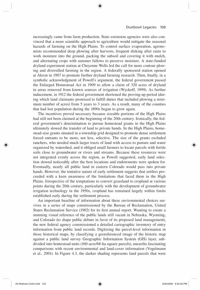
An important baseline of information about these environmental choices sur-vives in a series of maps commissioned by the Bureau of Reclamation, United States Reclamation Service (1902) for its $ rst annual report. Wanting to create a stunning visual reference of the public lands still vacant in Nebraska, Wyoming, and Colorado (to shape public debate in favor of its proposed land management), the new federal agency commissioned a detailed cartographic inventory of entry information from public land records. Digitizing the parcel-level information in those historical maps, by classifying a georeferenced image of the historic map against a public land survey Geographic Information System (GIS) layer, sub-divided into homestead units (160-acre/68-ha square parcels), unearths fascinating comparisons with recent environmental and land-cover information (Vogelmann et al., 2001). In Figure 4.3, the darker shading represents land parcels that were
05-Redman-Ch04.indd 13305-Redman-Ch04.indd 133 3/26/2008 9:52:00 PM3/26/2008 9:52:00 PM
134 Agrarian Landscapes in Transition
claimed by 1901 and the white areas represent parcels still in the public domain in northeastern Colorado. It is not surprising that most early land claims focused on parcels along the front range of the Rocky Mountains, with its proximity to Denver, streams fed by runoff from mountain snowmelt, and access to proposed rail lines (seen in the corridors of alternately claimed and unclaimed land running north and south of Denver, next to land claimed along the front range). Elsewhere the caution was more obvious. Settlers focused early land selection in the eastern approaches to Denver on land close to major rivers (the South Platte, Arikaree, and Republican) and a broad plain below the sand hills that lay all along the southern banks of the South Platte. That high plain, we now know from 20th-century soil surveys, is dominated by permeable soils, with dark surface horizons. In American soil taxonomy, which standardized its classi$ cation schema relatively late in the 20th century (Smith, 1986), these are known as Mollisols. In the lower left corner of Figure 4.3, the elevated percentage of clay in the soils in that high plain, parallel to the northeasterly course of the South Platte River, illustrates the
Entered LandsVacant Public Lands
CroplandNon-Cropland
Urban
Percentage of Clay Percentage of SandHigh: 60%
Low: 0.0%
High: 60%
Low: 0.0%
1901 1992
6500'ElevationLine
Yuma Dundy
Figure 4.3 Land claimed in 1901 and land use in 1992. Sources: Entered lands derived from U.S. Bureau of Reclamation (1902) and land cover for 1992 is derived from U.S. Geological Survey (1992). Soil texture derived from the USDA’s Natural Resources Conservation STATSGO soils database, available online at www.ncgc.nrcs.usda.gov/products/datasets/statsgo/.
05-Redman-Ch04.indd 13405-Redman-Ch04.indd 134 3/26/2008 9:52:00 PM3/26/2008 9:52:00 PM
Dustbowl Legacies 135
location of these rich grassland soils. The opposite effect is illustrated in the map of sand content in the region’s soils in the lower right corner of Figure 4.3. Settlers largely avoided claims where sand content was high. Few early claims were made to the sand hills below the South Platte River prior to 1901, nor to the sandy plain that cuts across Yuma County, Colorado, into Dundy County, Nebraska.
Whatever advantages they may have had as grazing land, the restrictions placed on the size of land grants effectively excluded their integration into early land claims. Therefore there is a remarkable continuity in the magnitude and spatial dimensions of early land claims and cropland agriculture today. This is illustrated in the upper right corner of the panel in Figure 4.3 in a very simpli$ ed representation of the National Land Cover Data (NLCD), a national land-cover data set developed using Landsat Thematic Mapper satellite imagery from 1992. Reducing the 21 Anderson Level II land-cover classi$ cations in the NLCD to just three categories (cropland, noncropland, and urban), we see a striking similarity between the land in crops in 1992 and land that was selected from the public domain by 1901. This is the case despite the much higher spatial resolution of theNLCD, derived from satellite imagery at a 30-m scale, and the inclusion of small grains, row crops, pasture, hay, and fallow in a combined representation of crop-land in 1992.
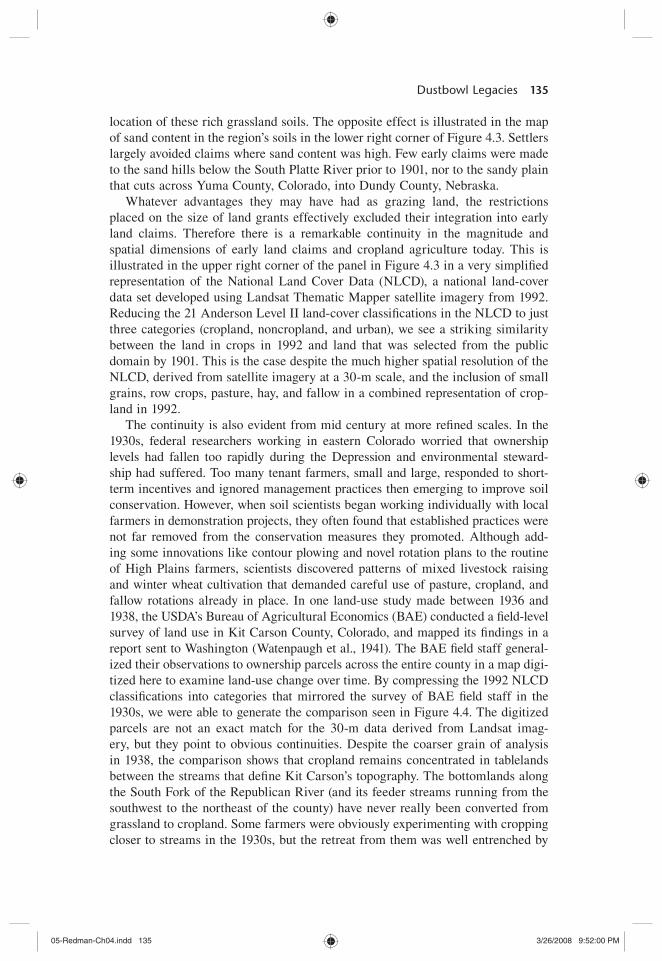
The continuity is also evident from mid century at more re$ ned scales. In the 1930s, federal researchers working in eastern Colorado worried that ownership levels had fallen too rapidly during the Depression and environmental steward-ship had suffered. Too many tenant farmers, small and large, responded to short-term incentives and ignored management practices then emerging to improve soil conservation. However, when soil scientists began working individually with local farmers in demonstration projects, they often found that established practices were not far removed from the conservation measures they promoted. Although add-ing some innovations like contour plowing and novel rotation plans to the routine of High Plains farmers, scientists discovered patterns of mixed livestock raising and winter wheat cultivation that demanded careful use of pasture, cropland, and fallow rotations already in place. In one land-use study made between 1936 and 1938, the USDA’s Bureau of Agricultural Economics (BAE) conducted a $ eld-level survey of land use in Kit Carson County, Colorado, and mapped its $ ndings in a report sent to Washington (Watenpaugh et al., 1941). The BAE $ eld staff general-ized their observations to ownership parcels across the entire county in a map digi-tized here to examine land-use change over time. By compressing the 1992 NLCD classi$ cations into categories that mirrored the survey of BAE $ eld staff in the 1930s, we were able to generate the comparison seen in Figure 4.4. The digitized parcels are not an exact match for the 30-m data derived from Landsat imag-ery, but they point to obvious continuities. Despite the coarser grain of analysis in 1938, the comparison shows that cropland remains concentrated in tablelands between the streams that de$ ne Kit Carson’s topography. The bottomlands along the South Fork of the Republican River (and its feeder streams running from the southwest to the northeast of the county) have never really been converted from grassland to cropland. Some farmers were obviously experimenting with cropping closer to streams in the 1930s, but the retreat from them was well entrenched by
05-Redman-Ch04.indd 13505-Redman-Ch04.indd 135 3/26/2008 9:52:00 PM3/26/2008 9:52:00 PM

136 Agrarian Landscapes in Transition
the 1990s. The biggest difference in land-use practice may be a visible increase in pasture and reduction in fallow cropland by the early 1990s. This suggests a more continuous and spatially concentrated pattern of cropping, with larger $ eld sizes associated with the more challenging landscapes in the western half of the county, and smaller $ elds planted to make more intensive use of the better cropland in the eastern half of the county.
This kind of historical mapping indicates that land use in northeast Colorado has respected biophysical limits to a far greater degree than generally acknowl-edged in the wider historical literature (Opie, 1998; Steinberg, 2002; Worster, 1979). Ecologists have been aware of the differences in conservation outlook for some time. The issues facing the tallgrass prairie, which is estimated to have shrunk to less than 5% of its presettlement range (Knapp et al., 1999; Samson and Knopf, 1994), are very different from ones in the shortgrass, which has shrunk to only 45% of its presettlement extent (Lauenroth et al., 1999). The legacies of prior land use are simply not the same in the western High Plains as they are elsewhere.
Although cropland has not expanded beyond broad maxima since the Depression (Cunfer, 2005), in the Shortgrass Steppe study area, county-level returns from the U.S. agricultural census indicate that cropland did not peak until the 1950s—just
WY NE
KS
COKit
CarsonCo.
NLand Use in 1938
Land Cover in 1992 South Fork of the Republican River
North Fork of theSmoky Hill River
Crosswalk Between1938 and 1992
CultivatedFallowGrasslandsRivers andStreams
Albers Equal Area Conic Projection40 km
Figure 4.4 Land use in 1938 and land cover in 1992, Kit Carson County, Colorado. Based on data from 1938 land use derived from a parcel-level map contained in Watenpaugh et al.(1941). Land cover for 1992 is derived from U.S. Geological Survey (1992).
05-Redman-Ch04.indd 13605-Redman-Ch04.indd 136 3/26/2008 9:52:00 PM3/26/2008 9:52:00 PM

Dustbowl Legacies 137
as the population census shows that urbanization in the metropolitan Denver area began to sever the tight relationship between population and the extent of crop-land that had existed in the region since the 1880s. In Figure 4.5A we see this illustrated by the similar trends in cropland plotted on the left axis, which reached a stable maximum in the 1959 agricultural census at 8,374,566 acres across the region, just as urbanization allowed population growth to accelerate in the 26 counties (plotted on the right axis). The advent of groundwater irrigation technol-ogy in the 1950s helps to explain the modest expansion of cropland in the High Plains during that decade, but as we will see, this did not dramatically reshape the spatial distribution of cropland in the Shortgrass Steppe region. Cropland also spiked higher in the 1970s and 1980s as wheat growers responded to the lifting of trade embargoes against China and Russia, settling back to historic maxima as those export markets declined in the 1990s. Cropland has remained stable throughout eastern Colorado since 1945 (Parton et al., 2003).
Figure 4.5B shows that wheat has dominated the crop regime in the short-grass since the boom in wheat prices that preceded World War I. Early settlers stubbornly planted corn west of what the instrumental record showed to be a 500 mm (20 in.) rainfall line near the 101st meridian (Wedel, 1986). Wheat did brieC y overtake corn by the 1900 census, because poor-yielding midwestern corn varieties were no match for conditions west of the 30-in. rainfall line near the 98th meridian, nor for farming outside the alluvial bottomlands where Native Americans had grown drought-resistant varieties of corn in centuries past (Wedel, 1986). Nevertheless, the acreage devoted to corn grew steadily from the 1900s to the 1930s, mainly because of the development of stream C ow irrigation networks in the South Platte River basin. According to the 1920 U.S. Census, across the study area irrigated farmland rose during the period from a total of 174,205 acres in 1880 to 735,191 acres (U.S. Department of Commerce, Census of agriculture, 1880, 1920). In dryland areas, the adoption of winter wheat, planted in the fall and harvested in May and June, allowed High Plains farmers to better capture winter snowmelt and spring rains, and to expand wheat acreage. New hard win-ter wheat varieties, bred in semiarid conditions in southern Russia, arrived with immigrant Mennonite farmers in the 1870s. By 1919, the famed Turkey wheat variety accounted for 98% of wheat grown in Kansas (Kimbrell, 2002), helping to explain why the acres sown to wheat grew to capture 33% of cropland in the shortgrass in 1930, but corn never exceeded a maximum, reached in the same census, of 23% of total crop acreage. The growth of wheat production also helps explain the farm size adjustment that has occurred in the Shortgrass Steppe study area since the 1940s. Although the number of farms peaked in the region in 1935, and has declined in absolute terms to numbers that prevailed at the beginning of the century, farm size has more than doubled between 1930 and 1997, increas-ing from 605 to 1,290 acres on average (Fig. 4.5C). The ecological implications of the adjustment are not well studied. Farm size might result in a variety of cultivation differences that might affect the environment. Because they are cash constrained, small farmers generally cultivate more of their land than do larger farmers (Hansen and Libecap, 2004a, b; Libecap and Hansen, 2002). On the other hand, larger farmers may use more pesticides and fertilizers, which might have
05-Redman-Ch04.indd 13705-Redman-Ch04.indd 137 3/26/2008 9:52:01 PM3/26/2008 9:52:01 PM

A) Land Use and Population in SGS Counties, 1870 to 1997
05,000
10,00015,00020,00025,00030,000
1870
1880
1890
1900
1910
1920
1930
1940
1950
1960
1970
1980
1990
2000
Acr
es 1
03
0
500
1,000
1,500
2,000
2,500 Population 10
3
Area Land in Farms Cropland
Pasture Population (right axis)
B) Principal Crops in SGS Counties, 1870 to 1997
0500
1,0001,5002,0002,5003,0003,500
1870
1880
1890
1900
1910
1920
1930
1940
1950
1960
1970
1980
1990
2000
Acr
es H
arve
sted
, 103
Wheat Corn Small GrainsHay Sorghum
C) Numbers of Farms and Average Farm Size, SGS Counties, 1870 to 1997
05,000
10,00015,00020,00025,00030,00035,00040,000
1870
1880
1890
1900
1910
1920
1930
1940
1950
1960
1970
1980
1990
2000
Far
ms
02004006008001,0001,2001,400
Average S
ize
Number of Farms (left axis) Average Farm Size (right axis)
Figure 4.5 Land use, population, principal crops, number of farms, and average farm size in the Shortgrass Steppe (SGS) region. (A) Land use and population in SGS counties, 1870–1997. (B) Principal crops in SGS counties, 1870–1997. (C) Number of farms and average farm size in SGS counties, 1870–1997. Based on data from U.S. Department of Commerce, Census of agriculture (1870, 1880, 1890, 1900, 1910, 1920, 1930, 1940, 1950, 1954, 1959, 1964, 1969, 1974, 1978, 1982, 1987, 1992, 1997) and Census of population (1870, 1880, 1890, 1900, 1910, 1920, 1930, 1940, 1950, 1960, 1970, 1980, 1990, 2000).
05-Redman-Ch04.indd 13805-Redman-Ch04.indd 138 3/26/2008 9:52:01 PM3/26/2008 9:52:01 PM
Dustbowl Legacies 139
more negative effects. These questions deserve greater attention in conservation planning in the future.
Conservation Context
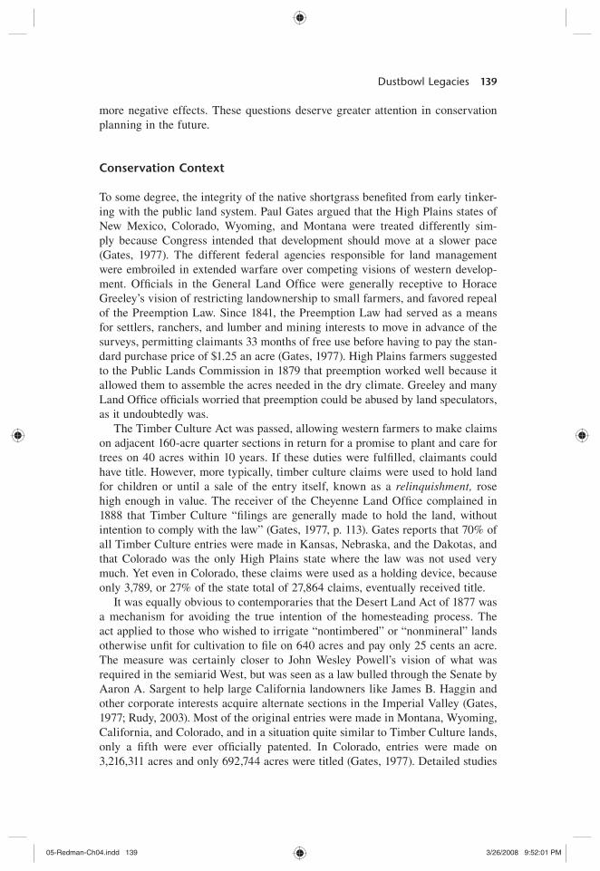
To some degree, the integrity of the native shortgrass bene$ ted from early tinker-ing with the public land system. Paul Gates argued that the High Plains states of New Mexico, Colorado, Wyoming, and Montana were treated differently sim-ply because Congress intended that development should move at a slower pace (Gates, 1977). The different federal agencies responsible for land management were embroiled in extended warfare over competing visions of western develop-ment. Of$ cials in the General Land Of$ ce were generally receptive to Horace Greeley’s vision of restricting landownership to small farmers, and favored repeal of the Preemption Law. Since 1841, the Preemption Law had served as a means for settlers, ranchers, and lumber and mining interests to move in advance of the surveys, permitting claimants 33 months of free use before having to pay the stan-dard purchase price of $1.25 an acre (Gates, 1977). High Plains farmers suggested to the Public Lands Commission in 1879 that preemption worked well because it allowed them to assemble the acres needed in the dry climate. Greeley and many Land Of$ ce of$ cials worried that preemption could be abused by land speculators, as it undoubtedly was.
The Timber Culture Act was passed, allowing western farmers to make claims on adjacent 160-acre quarter sections in return for a promise to plant and care for trees on 40 acres within 10 years. If these duties were ful$ lled, claimants could have title. However, more typically, timber culture claims were used to hold land for children or until a sale of the entry itself, known as a relinquishment, rose high enough in value. The receiver of the Cheyenne Land Of$ ce complained in 1888 that Timber Culture “$ lings are generally made to hold the land, without intention to comply with the law” (Gates, 1977, p. 113). Gates reports that 70% of all Timber Culture entries were made in Kansas, Nebraska, and the Dakotas, and that Colorado was the only High Plains state where the law was not used very much. Yet even in Colorado, these claims were used as a holding device, because only 3,789, or 27% of the state total of 27,864 claims, eventually received title.
It was equally obvious to contemporaries that the Desert Land Act of 1877 was a mechanism for avoiding the true intention of the homesteading process. The act applied to those who wished to irrigate “nontimbered” or “nonmineral” lands otherwise un$ t for cultivation to $ le on 640 acres and pay only 25 cents an acre. The measure was certainly closer to John Wesley Powell’s vision of what was required in the semiarid West, but was seen as a law bulled through the Senate by Aaron A. Sargent to help large California landowners like James B. Haggin and other corporate interests acquire alternate sections in the Imperial Valley (Gates, 1977; Rudy, 2003). Most of the original entries were made in Montana, Wyoming, California, and Colorado, and in a situation quite similar to Timber Culture lands, only a $ fth were ever of$ cially patented. In Colorado, entries were made on 3,216,311 acres and only 692,744 acres were titled (Gates, 1977). Detailed studies
05-Redman-Ch04.indd 13905-Redman-Ch04.indd 139 3/26/2008 9:52:01 PM3/26/2008 9:52:01 PM
140 Agrarian Landscapes in Transition
of whether the lands were used primarily by ranchers without much effort to irri-gate the land have not been made. Interest in the institutional imprint of the public land laws on subsequent land use has waned since the 1970s.
The effect of the public land laws on subsequent land use is worth our attention in this context because the signature of the public lands is still so prominent in landscape-scale processes in northeastern Colorado. Despite numerous changes in land policy during the early settlement of eastern Colorado, each designed to induce more extensive growth, development did not proceed quickly. Why, in the absence of any real planning restrictions, did settlers resist wholesale entry on the remaining public domain? First of all, as Paul Gates reminds us, none of the west-ern states ever made free grants of land from the portion of the public domain transferred to their control upon achieving statehood. Typically the states leased their educational lands for grazing and grain raising, and other federal grants to the states were selected by agents of state governments from what appeared to be the most promising parts of the public lands still unclaimed. In the end, roughly 18% of the public lands in Montana, Wyoming, Colorado, and New Mexico were transferred to the states or to the railroads. Congress locked the High Plains states into a pattern of slower development by insisting that if they were to sell the lands transferred to their control, higher prices for the public lands under state administration had to be charged. When Colorado was admitted to the nation in 1876, Congress required it to sell its lands at not less than $2.50 an acre. Montana and Wyoming met the test of statehood much later (in 1889 and 1890), and were required to sell at not less than $10 per acre; New Mexico gained admission in 1912, and was required to sell its eastern lands at $5 an acre and its mountain lands at $3 an acre (Gates, 1977). The states were not in a position to forgo the potential revenue, and the Congress was eager to ensure that the sale of federal public lands came $ rst.
After 1901, several other institutional factors contributed to the persistence of this landscape-scale pattern. Historians, geoscientists, and other students of western water law and water use suggest that, increasingly, the expansion of crop-land agriculture was only possible with extensive irrigation projects (Pisani, 1992, 2002; Tyler, 1992; Wohl, 2001; Worster, 1985). In the Shortgrass Steppe region, this happened much earlier in the South Platte than the Republican River basin. Several gravity C ow systems were built along the South Platte River in the late 19th and early 20th centuries to expand the area of cropland with access to irriga-tion water. Reservoirs were dug and irrigation canals constructed, especially in the vicinity of Greeley, in southern Weld County, in a community begun as an agricultural cooperative to promote small-scale irrigation.
The success of the gravity C ow systems generally resulted in more secure returns. But irrigated agriculture was ultimately constrained by the C ow of water from the many headwaters of the South Platte River along the eastern slope of the Rocky Mountains. During the Depression, water commissioners began to worry about the low ebb in the water cycle. In 1931, the North and South Platte rivers measured only 55% of the mean C ow measured by instrumental records between 1904 and 1940. The Colorado State Engineer’s Of$ ce released $ gures showing that in the region between Boulder and Fort Collins, and running east to Nebraska
05-Redman-Ch04.indd 14005-Redman-Ch04.indd 140 3/26/2008 9:52:01 PM3/26/2008 9:52:01 PM

Dustbowl Legacies 141
(comprising water districts 1–6 and 64), water C ow had declined 7.6% in 1930, 25% in 1931, and 5.3% in 1932. These volumes fell below estimated minimum needs of 1.25 acre-ft. of water/acre irrigated cropland, representing a steadily declining average of 1.20 acre-ft. in 1929, 1.11 acre-ft. in 1930, 0.83 acre-ft. in 1931, and 0.79 acre-ft. in 1932 (Tyler, 1992).
In the 1930s, in response to local boosters and corporate interests like Great Western Sugar (which operated 17 beet-processing plants in northern Colorado by 1933), an effort was made to divert water eastward over the mountains from the Colorado River basin. In what became an extended campaign, some 37 trans-mountain projects were eventually constructed by 1992, shifting an estimated 650,000 acre-ft. of water out of the Gunnison, San Juan, and Colorado rivers. The Colorado–Big Thompson Project was the largest diversion scheme, pull-ing (by various estimates) between 310,000 and 370,000 acre-ft. of water to the South Platte basin by its year of completion in 1956 (Tyler, 1992; Wohl, 2001). The diversion schemes have generally been lauded in the agricultural community, which in 1987 used 85% of Colorado’s out-of-stream water for irrigation, but have drawn increasing criticism from ecologists for the alteration of stream hydrology and soil erosion caused by diversion canals and large reservoirs (Wohl, 2001). During the dry years between 1958 and 1990, an average of 34% of water used in Larimer, Weld, and Boulder counties originated in western-slope rivers. The problem remains one of maintaining an adequate volume of water C ow rather than increasing C ow. Water diversion, despite the scale of successive engineering proj-ects, has only allowed farmers to keep up with water needs, not to expand irrigated cropland in the South Platte River basin. The map reproduced in Figure 4.6, for instance, reveals that the spatial imprint of irrigated cropping has changed very little during the past half century.
On the other hand, irrigated agriculture was almost unknown in the Republican River basin until the 1950s, when the invention of horizontal centrifugal pumps
1940 Land Use
Grassland, Shrub, or Forest
Sandhill Sage
Irrigated crops
Urban
1992 Land Use
Grassland, Shrub, or Forest
Sandy areas
Irrigated crops
Urban
Colorado
Wyoming Nebraska
Kansas
Figure 4.6 Land use in the South Platte River Basin, 1940 and 1992. Based on 1940 land-use data reported in Field Coordinating Committee 15B; land-use data derived from U.S. Geological Survey (1992).
05-Redman-Ch04.indd 14105-Redman-Ch04.indd 141 3/26/2008 9:52:01 PM3/26/2008 9:52:01 PM

142 Agrarian Landscapes in Transition
allowed wells to be dug deeper than 50 ft. The introduction of the new technology allowed cropland to expand. Remarkably, this expansion in the tablelands over the Ogallala Aquifer in eastern Colorado appears to have focused on land with higher soil quality, near the land parcels selected early during the settlement period. The location of wells dug before 1950 and the pace of wells drilled between 1950 and 1980 was documented in the early 1990s by the USGS (Borman and Reed, 1984). The study shows (Fig. 4.7) that at each time interval during the period examined by the USGS, an ever-expanding number of wells was generally situated on par-cels with the best soils. Overlain on the historic public lands map shown in Figure 4.3, the well locations indicate that farmers were unwilling to risk the use of the new technology outside the proved cropping areas. The sandy plain running through the middle of Yuma County was largely avoided, because it had been before the emergence of groundwater technology.
Arguably, much of the conservation inertia can be traced to the federal govern-ment’s efforts to identify land unsuitable for cropland in the 1930s through key programs, including the Soil Conservation Service (SCS) and the Resettlement Administration (Cannon, 1996; Helms, 1990, 1996). Although the land converted to grassland at the time remained relatively small, and efforts at resettlement were generally deemed modest, conservation and soil science bene$ ted enormously from the investment in scienti$ c enterprise.
As early as the 1920s, the undercapitalized sodbuster was increasingly a rare $ gure, much to the dismay of policymakers like Elwood Mead. As director of the
Groundwater Irrigation Well Locations Overlayed on Public Lands Claimed, 1901
Irrigation Wells
Entered Lands
Vacant Public Land
Ogallala Aquifer
100km
Albers Equal Area Projection
Ogallala Aquifer
Drilled Before 1950 Drilled Before 1960 Drilled Before 1980Drilled Before 1970
Figure 4.7 Irrigation wells in the Republican River Basin, 1950–1980. Location of irrigation wells and application rates for irrigated cropland during 1980 in the northern High Plains of Colorado. Based on map [at 1:500,000 scale] by Borman and Read (1984).
05-Redman-Ch04.indd 14205-Redman-Ch04.indd 142 3/26/2008 9:52:02 PM3/26/2008 9:52:02 PM

Dustbowl Legacies 143
Bureau of Reclamation, Mead wanted to offer a new start to ordinary Americans, but eventually acknowledged that staying on the land required more local knowl-edge and personal wealth than most would-be irrigator–farmers possessed (Pisani, 2002). As the century proceeded, only operators inheriting substantial portions of family estates could afford to carry on in agriculture, and increasingly young farmers and ranchers were exclusively from agricultural families (Gardner, 2002; Gutmann et al., 2002). Institutionally, a steady shift away from “reclama-tion” of desert lands and toward conserving existing water and land resources; restoring vegetative cover; planting borders of grass, shrubs, and trees as wind-breaks; adapting local practices to $ t variations in topography, soil, and climate; and encouraging contour cultivation, strip cropping, and the rotation of grazing became the norm (Helms, 1990). Indeed, the last half of the 20th century wit-nessed a steady growth of income supports to agricultural producers, tied increas-ingly to participation in better management of land already in private ownership (Gardner, 2002).
Most of the work of improving conservation practice was interagency in nature, but the SCS, later renamed the Natural Resources Conservation Service, helped to negotiate the shift in attitude with farmers and ranchers. Unlike the Forest Service and Department of the Interior, the SCS was charged with working with produc-ers and introducing ecological ideas. Arthur W. Sampson’s 13 years of expertise as a range manager in National Forest lands were applied more directly to prairie ecology in privately owned range lands when the SCS began to apply his ideas of how to nurse grasslands back to their “climax” state by studying patterns of succession (Helms, 1990). The SCS used Sampson’s interpretation of Frederic Clement’s work to develop a classi$ cation system, and to set up C oristic guides to plant populations under various range conditions. Soil Conservation Service $ eld staff learned to inventory “decreasers, increasers, and invaders” in their effort to delineate range sites.
When drought struck again in the 1950s, the USDA’s drought committee met to formulate emergency measures, and eventually recommended that any assis-tance be used to help farmers convert cropland back to grassland, offering farm-ers 50% of the cost if they agreed to keep the land in grass for at least 5 years. To discourage a return to cropland, the committee hit on the idea of long-term contracts. This was the key measure of the Great Plains Conservation Program signed into law by President Eisenhower on June 19, 1956. Under the bill, con-tracts of no longer than 10 years were to be entered into between the Secretary of Agriculture and producers before the end of 1971, in counties designated by the secretary as having the most serious wind erosion problems. Practices in the Great Plains, particularly the model of shared-cost contracts of 3 to 10 years’ duration, inC uenced national conservation policies, eventually becoming the stan-dard for other conservation programs (Helms, 1990).
President Nixon’s large grain deals with the Soviet Union in the 1970s threat-ened to derail many of the achievements in conservation practice made since the 1930s. As the price of grain quadrupled between 1970 and 1974, Secretary of Agriculture Earl L. Butz released production controls, including annual set-asides used to lower production levels in key commodities at the outset of the Nixon
05-Redman-Ch04.indd 14305-Redman-Ch04.indd 143 3/26/2008 9:52:03 PM3/26/2008 9:52:03 PM

144 Agrarian Landscapes in Transition
administration. With the new awareness of soil conservation issues in the farm and ranch communities, many did not welcome the plow-up of grassland that fol-lowed or the dust clouds that spilled over into neighboring farms. In Colorado, 572,000 acres of grassland were planted to wheat between 1977 and 1982, prompt-ing many grassroots campaigns against the plowing of fragile grasslands. The solution, dubbed the sodbuster bill, as introduced by Colorado senator William Armstrong, was to link eligibility for USDA support programs to soil conserva-tion. Any $ eld classi$ ed as fragile land by the SCS, and not planted to an annual crop or used as a set-aside in a USDA commodity program between December 31, 1980, and December 23, 1985, would lose its eligibility for USDA programs unless it $ rst submitted a conservation plan. Wetlands were similarly protected from drainage under the terms of the legislation. All were rolled into the omnibus Food Security Act of 1985 (U.S. Congress, House Committee on Agriculture, 1992). Under the law, farmers had until 1990 to begin applying a conservation plan on highly erodible soils, and until 1995 to implement it fully to stay eligible for USDA programs.
None of the provisions have introduced radically different conservation mea-sures. As this look at the structure of the landscape in the Shortgrass Steppe region throughout the course of the 20th century illustrates, choices about land use have been more incremental and local than patterns of policy formation. The biggest surprise may be that often those choices that were made earliest were the ones that have been the most sustainable. The mental model inherited from the Dust Bowl needs to make room for how bottom-up decision making shapes conservation practice. Even in the context of the 1970s export boom, local under-standing of the long-term uses of the land became the basis for grassroots opposi-tion to renewed agricultural expansion.
Nevertheless, local decisions still must interact with the policy frameworks like the public land system. Although virtually all land with any potential for agriculture has passed into private hands since the early 20th century, the archi-tecture of the public lands system is still visible. School lands, for instance, largely remain under the control of the state land boards. These are the 1-sq. mi. parcels of state-owned land that dot the landscape in a chessboard pattern in eastern Colorado and Wyoming, as seen in Figure 4.8. Under the terms of the Land Ordinance Act, which established the township survey system in 1785, section 16 of each township was set aside for school purposes. In recent years, state authorities and nongovernmental organizations have worked together to cre-ate grassland preserves, purchasing private land adjoining the remaining school lands. The Tamarack Ranch Natural Area along the southern bank of the South Platte River is one example.
The most important opportunities for conservation exist in the persistence of privately owned grassland corridors within the Shortgrass Steppe region. With the announcement from the Secretary of Agriculture in 2003 of another round of easements, known as the Grassland Reserve Program, the emphasis on restora-tion and preservation continues to grow. Much of southeastern Colorado remains in grassland cover (except for land along the Arkansas River), and recent analysis of wildlife habitat in northeastern Colorado shows that historic corridors continue
05-Redman-Ch04.indd 14405-Redman-Ch04.indd 144 3/26/2008 9:52:03 PM3/26/2008 9:52:03 PM

Dustbowl Legacies 145
to exist, providing crucial routes for herbivores and bird populations (Theobald et al., 2004). The preservation of these corridors is crucial because, as ecosystem science continues to demonstrate, the mortality of the dominant C4 perennials is driven by patch disturbances, and bunchgrass species like Bouteloua gracilis (blue grama) rely on the increased availability of belowground resources stimu-lated by gap dynamics (Cof$ n and Lauenroth, 1988, 1990, 1991, 1992). Plot-level experiments at CPER, in locations with sand loam soil (with 81% sand content and 1.8% organic matter), have shown bare soil microsites dug to a depth of 10 cm had more seedlings than sites where adult plants were left undisturbed (Aguilera and Lauenroth, 1995).
Similarly, the long-term survivorship of blue grama indicates that plant commu-nities tend to be stable, to recruit seedlings, and to colonize better during drought periods than during wet years (Fair et al., 1999). Patterns of succession over sev-eral decades indicate that blue grama will eventually outcompete other species, regardless of whether they are invasive, because it is so well adapted to low pre-cipitation and grazing (Costello, 1944; Klipple and Costello, 1960; McGinnies et al., 1991; Milchunas et al., 1998). Although $ re and bison cannot function in the same way as they did in the past, studies of livestock grazing and prescribed burning have shown that they can recreate some of the patch dynamics lost his-torically by the bison’s near demise and $ re suppression (Brockway et al., 2002; Knapp et al., 1999). Free-roaming ungulates and $ re tend to create a mosaic of intensely grazed land and carbon-enriched soil. That fragmentation helps to drive
WYOMINGNEBRASKA
KANSASCOLORADO
N
Land Ownership
100 km
FederalStatePrivateNo Data
Figure 4.8 Land ownership in Shortgrass Steppe counties, 1998. Land ownership data are available in statewide land stewardship ArcInfo coverages (in compressed interchange format) from the USGS GAP analysis program, available online at http://gapanalysis.nbii.gov/portal/server.pt. Land ownership information for Colorado is from National Ecology Research Center (1993); Wyoming data are from Wyoming Gap Analysis (1996); Kansas land ownership information is from Data Access and Support Center (1994); Nebraska land ownership information is from University of Nebraska-Lincoln, School of Natural Resources, Center for Advanced Land Management Information Technologies (2005).
05-Redman-Ch04.indd 14505-Redman-Ch04.indd 145 3/26/2008 9:52:03 PM3/26/2008 9:52:03 PM

146 Agrarian Landscapes in Transition
healthy succession dynamics of the shortgrass. An ungrazed landscape leaves the shortgrass more susceptible to plant–exotics and declining bird populations than does low to moderate grazing from domestic cattle (Milchunas et al., 1998). The main alternative use of private land, which is typically dryland wheat production, has been shown to adversely affect soil fertility (Burke et al., 1989; Ihori et al., 1995) and biodiversity (Moore 1994). However, intensi$ ed continuous cropping of winter wheat, where it has traditionally existed, has also been shown to enhance the ef$ ciency of precipitation use and plant productivity, and hence nitrogen and carbon storage in the soil (Lauenroth et al., 2000).
Conclusion
In retrospect, the integrity of remaining corridors in the northern shortgrass are the product of a unique convergence of farm-level behavior and biophysical varia-tion. Since the 1860s, the transformation of the Shortgrass Steppe has reduced native grassland to a fraction of its former size. It has led to the near extinction of a keystone species—the bison—and the challenges remain great. Pollution from intensi$ ed agriculture, the burdens of watershed management, and the threat of urban sprawl, all press on planning agendas. However, ecological disaster is a misnomer. The patterns of agricultural land use in the Shortgrass Steppe region have met the test of time and form the basis for a sustainable future. Institutional imprinting has largely reinforced a human signature on the landscape shaped early and often by biophysical limits. The grassland corridors that remain in the Shortgrass Steppe landscape are a unique resource for preserving biodiversity, increasing wildlife habitat, and ensuring that depleting water resources are used more wisely. Throughout many millennia, the physical extent of the shortgrass has retreated and expanded with the evolution of climate conditions. The 20th century and the Dust Bowl have taught us to respect the resilience of the short-grass and to seek out its many dimensions.
References
Aguilera, M. O., and W. K. Lauenroth. 1995. “InC uence of gap distances and type of microsites on seedling establishment in Bouteloua gracilis.” Journal of Ecology 8(1): 87–97.
Bailey, R. G., and L. Ropes. 1998. Ecoregions: The ecosystem geography of the oceans and continents. New York: Springer.
Bennett, H. H. 1947. Elements of soil conservation. New York: McGraw-Hill.Binnema, T. 2001. Common and contested ground: A human and environmental history
of the northwestern plains. Norman, Okla.: University of Oklahoma Press.Borman, R. G., and R. L. Reed. 1984. Location of irrigation wells and application rates
for irrigated cropland during 1980 in the northern High Plains of Colorado. Reston, Va.: U.S. Geological Survey.
Brockway, D. G., R. G. Gatewood, and R. B. Paris. 2002. “Restoring $ re as an ecologi-cal process in shortgrass prairie ecosystems: Initial effects of prescribed burning
05-Redman-Ch04.indd 14605-Redman-Ch04.indd 146 3/26/2008 9:52:04 PM3/26/2008 9:52:04 PM

Dustbowl Legacies 147
during the dormant and growing seasons.” Journal of Environmental Management 65: 135–152.
Bureau of Reclamation, United States Reclamation Service. 1902. Annual report: Bureau of Reclamation. Washington, D.C.: U.S. Government Printing Of$ ce.
Burke, I. C., C. M. Yonker, W. J. Parton, C. V. Cole, K. Flach, and D. S. Schimel. 1989. “Texture, climate and cultivation effects on soil organic matter content in U.S. grass-land soils.” Soil Science Society of America Journal 53: 800–805.
Calloway, C. G. 2003. One vast winter count: The Native American West before Lewis and Clark. Lincoln, Neb.: University of Nebraska Press.
Cannon, B. Q. 1996. “Keeping their instructions straight: Implementing the rural resettle-ment program in the West.” Agricultural History 70(2): 251–267.
Cof$ n, D. P., and W. K. Lauenroth. 1988. “The effects of disturbance size and frequency on a shortgrass plant community.” Ecology 69: 1609–1617.
Cof$ n, D. P., and W. K. Lauenroth. 1990. “A gap dynamics simulation model of succes-sion in a semiarid grassland.” Ecological Modeling 49: 229–266.
Cof$ n, D. P., and W. K. Lauenroth. 1991. “Effects of competition on spatial distribution of roots of blue grama.” Journal of Range Management 44: 67–70.
Cof$ n, D. P., and W. K. Lauenroth. 1992. “Spatial variability in seed production of the perennial bunchgrass B. gracilis (H.B.K.) Lag. Ex Gif5 ths.” American Journal of Botany 79: 347–353.
Commission for Environmental Cooperation. 1997. Ecological regions of North America: Toward a common perspective. Montreal: CEC Secretariat.
Costello, D. F. 1944. “Natural revegetation of abandoned plowed land in mixed prairie association of northeastern Colorado.” Ecology 25: 312–326.
Cunfer, G. 2005. On the Great Plains: Agriculture and environment. College Station, Tex.: Texas A & M University Press.
Data Access and Support Center. 1994. Kansas-GAP coverage. Lawrence, Kans.: Data Access and Support Center, Kansas Geological Survey.
Dixon, J. 1999. Bones, boats and bison: Archeology and the 5 rst colonization of western North America. Albuquerque, N.M.: University of New Mexico Press.
Fair, J., W. K. Lauenroth, and D. P. Cof$ n. 1999. “Demography of Bouteloua gracilis in a mixed prairie: Analysis of genets and individuals.” Journal of Ecology 87: 233–243.
Field Coordinating Committee 15B. Preliminary Examination Report, Runoff and water-8 ow retardation and soil erosion prevention: South Platte River and its tributar-ies, Colorado, Wyoming, and Nebraska. Denver, Colo.: National Archives and Records Administration, Denver Of$ ce, RG 114, Records of the Natural Resources Conservation Service, Box No. 173, River Basin Reports, Platte River.
Flores, D. 2001. The natural west environmental history in the Great Plains and Rocky Mountains. Norman, Okla.: University of Oklahoma Press.
Forman, S. L., R. Oglesby, V. Markgraf, and T. Stafford. 1995. “Paleoclimatic signi$ -cance of Late Quaternary eolian deposition on the Piedmont and High Plains, central United States.” Global and Planetary Change 11: 35–55.
Forman, S. L., R. Oglesby, and R. S. Webb. 2001. “Temporal and spatial patterns of Holocene dune activity on the Great Plains of North America: Megadroughts and climate links.” Global and Planetary Change 29: 1–29.
Fredlund, G. G. 1995. “Late Quaternary pollen record from Cheyenne Bottoms, Kansas.” Quaternary Research 43: 67–79.
Gardner, B. L. 2002. American agriculture in the twentieth century: How it 8 ourished and what it cost. Cambridge, Mass.: Harvard University Press.
05-Redman-Ch04.indd 14705-Redman-Ch04.indd 147 3/26/2008 9:52:04 PM3/26/2008 9:52:04 PM

148 Agrarian Landscapes in Transition
Gates, P. W. 1977. “Homesteading in the High Plains.” Agricultural History 51(1): 109–133.
Gutmann, M. P., S. Pullum-Pinon, and T. W. Pullum. 2002. Three eras of young adult home leaving in twentieth-century America. Journal of Social History 35(3): 533–576.
Hall, S., and S. Valastro Jr. 1995. “Grassland vegetation in the southern Great Plainsduring the last glacial maximum.” Quaternary Research 44: 237–245.
Hansen, Z. K., and G. D. Libecap. 2004a. “Small farms, externalities, and the Dust Bowl of the 1930s.” Journal of Political Economy 112: 665–693.
Hansen, Z. K., and G. D. Libecap. 2004b. “The allocation of property rights to land: U.S. land policy and farm failure in the Great Plains.” Explorations in Economic History 41: 103–129.
Hayden, F. V., and United States, Geological and Geographical Survey of the Territories. 1877. Geological and geographical atlas of Colorado and portions of adjacentterritory. Washington, D.C.: Julius Bien.
Helms, J. D. 1990. “Conserving the Plains: The Soil Conservation Service in the Great Plains.” Agricultural History 64(2): 58–73.
Helms, J. D. 1996. “National soil conservation policies: A historical case study of the driftless area.” Agricultural History 70(2): 377–394.
Hunt, C. B. 1967. Physiography of the United States. A series of books in geology. San Francisco, Calif.: W. H. Freeman.
Ihori, T., I. C. Burke, W. K. Lauenroth, and D. P. Cof$ n. 1995. “Effects of cultivation and abandonment on soil organic matter in northeastern Colorado.” Soil Science Society of America Journal 59: 1112–1119.
Isenberg, A. C. 2000. The destruction of the bison: An environmental history, 1750–1920. New York: Cambridge University Press.
Jordan, T. G. 1993. North American cattle-ranching frontiers: Origins, diffusion, and differentiation. 1st ed. Histories of the American frontier. Albuquerque, N.M.: University of New Mexico Press.
Kimbrell, A. 2002. “A blow to the breadbasket: Industrial grain production,” pp. 99–110. In: Andrew Kimbrell (ed.), Fatal harvest: The tragedy of industrial agriculture. Washington, D.C.: Island Press.
Klipple, G. E., and D. F. Costello. 1960. Vegetation and cattle responses to different intensi-ties of grazing on short-grass ranges on the central Great Plains. USDA Forest Service technical bulletin no. 1216. Washington, D.C.: U.S. Government Printing Of$ ce.
Knapp, A. K., J. M. Blair, J. M. Briggs, S. L. Collins, D. C. Hartnett, L. C. Johnson, and E. G. Towne. 1999. “The keystone role of bison in North American tallgrass prairie: Bison increase habitat heterogeneity and alter a broad array of plant, community, and ecosystem processes.” Bioscience 49: 39–50.
Küchler, A. W. 1964. Potential natural vegetation of the conterminous United States. New York: American Geographical Society.
Küchler, A. W. 1993. “Potential natural vegetation of the conterminous United States. Digital vector data in an Albers Equal Area Conic polygon network and derived ras-ter data on a 5 km by 5 km Albers Equal Area 590 × 940 grid.” Global Ecosystems Database Version 2.0. Boulder, Colo.: NOAA National Geophysical Data Center.
Lauenroth, W. K., I. C. Burke, and M. P. Gutmann. 1999. “The structure and functions of ecosystems in the central North American grassland region.” Great Plains Research 9: 223–259.
Lauenroth, W. K., I. C. Burke, and J. M. Paruelo. 2000. “Patterns of production andprecipitation-use ef$ ciency of winter wheat and native grasslands in the central Great Plains of the United States.” Ecosystems 3: 344–351.
05-Redman-Ch04.indd 14805-Redman-Ch04.indd 148 3/26/2008 9:52:04 PM3/26/2008 9:52:04 PM

Dustbowl Legacies 149
Lauenroth, W. K., and D. G. Milchunas. 1992. “Shortgrass steppe,” pp. 183–226. In: Robert T. Coupland (ed.), Natural grasslands: Introduction and western hemisphere. Vol. 8A. Amsterdam: Elsevier.
Libecap, G., and Z. Hansen. 2002. “Rain follows the plow and dryfarming doctrine:The climate information problem and homestead failure in the Upper Great Plains, 1890–1925.” Journal of Economic History 62(1): 86–120.
Madole, R. F. 1995. “Spatial and temporal patterns of Late Quaternary eolian deposition, eastern Colorado, USA.” Quaternary Science Reviews 14(2): 155–178.
Martin, P., and C. Szuter. 1999. “War zones and game sinks in Lewis and Clark’s West.” Conservation Biology 13(winter): 36–45.
McGinnies, W. J., H. L. Shantz, and W. G. McGinnies. 1991. Changes in vegetation and land use in eastern Colorado: A photographic study, 1904 to 1986. Spring$ eld, Va.: U.S. Department of Agriculture, Agricultural Research Service, ARS-85.
McHugh, T., and V. Hobson. 1972. The time of the buffalo. Lincoln, Nebr. University of Nebraska Press.
Meagher, M. M. 1973. The bison of Yellowstone National Park. National Park Service. Scienti$ c monograph series, no. 1. Washington, D.C.: U.S. National Park Service the Supt. of Documents, U.S. Government Printing Of$ ce.
Milchunas, D. G., W. K. Lauenroth, and I. C. Burke. 1998. “Livestock grazing: Animal and plant biodiversity of Shortgrass Steppe and the relationship to ecosystem func-tion.” OIKOS 83: 65–74.
Moore, J. C. 1994. “Impact of agricultural practices on soil food web structure: Theory and application.” Agriculture, Ecosystems and Environment 51: 239–247.
Muhs, D. R., J. N. Aleinikoff, T. W. Stafford Jr., R. Kihl, J. Been, S. A. Mahan, and S. Cowherd. 1999. “Late Quaternary loess in northeastern Colorado: Part 1. Age and paleoclimatic signi$ cance.” Geological Society of America Bulletin 111(12): 1861–1975.
National Ecology Research Center. 1993. Colorado Land Ownership, Colorado Gap Project, 500K. Fort Collins, Colo.: Fish and Wildlife Service, National Ecology Research Center.
Norall, F. 1988. Bourgmont, explorer of the Missouri, 1698–1725. Lincoln, Nebr.: University of Nebraska Press.
Opie, J. 1987. The law of the land: Two hundred years of American farmland policy. Lincoln, Nebr.: University of Nebraska Press.
Opie, J. 1998. Nature’s nation: An environmental history of the United States. New York: Harcourt Brace College Publishers.
Opie, J. 2000. Ogallala water for a dry land. 2nd ed. Our sustainable future, vol. 13. Lincoln, Nebr.: University of Nebraska Press.
Parks, D. R. (ed.). 1989. Ceremonies of the Pawnee by James R. Murie. Lincoln, Nebr.: University of Nebraska Press.
Parks, D. R., and W. R. Wedel. 1985. “Pawnee geography: Historical and sacred.” Great Plains Quarterly 5: 143–176.
Parton, W. J., M. P. Gutmann, and W. R. Travis. 2003. “Sustainability and historical land-use change in the Great Plains: The case of eastern Colorado.” Great Plains Research 13(spring): 97–125.
Pisani, D. 1992. To reclaim a divided West: Water, law, and public policy, 1848–1902. Albuquerque, N.M.: University of New Mexico Press.
Pisani, D. 2002. Water and American government: The Reclamation Bureau, national water policy, and the West, 1902–1935. Berkeley, Calif.: University of California Press.
05-Redman-Ch04.indd 14905-Redman-Ch04.indd 149 3/26/2008 9:52:04 PM3/26/2008 9:52:04 PM

150 Agrarian Landscapes in Transition
Powell, J. W., and Geographical and Geological Survey of the Rocky Mountain Region (U.S.). 1879. Report on the lands of the arid region of the United States with a more detailed account of the lands of Utah. Washington D.C.: General Printing Of$ ce.
PRISM. 2008. PRISM (Parameter-elevation Regressions on Independent Slopes Model) Climate Data for the United States. Oregon State University. Online. Available at http://www.prism.oregonstate.edu.
Quandt, L. A., S. W. Waltman, and C. L. Roll. 1998. Dominant soil orders and subor-ders: Soil taxonomy, United States. Maps and photographs, NSSC—5502-0398-30 ed. Lincoln, Nebr.: USDA Natural Resources Conservation Service.
Rudy, A. 2003. “The social economy of development: The state of and the Imperial Valley,” pp. 25–46. In: Jane Adams (ed.), Fighting for the farm: Rural America transformed. Philadelphia, Pa.: University of Pennsylvania Press.
Samson, F., and F. Knopf. 1994. “Prairie conservation in North America.” Bioscience 44: 418–421.
Savage, D. A., and D. F. Costello. 1948. “The Southern Great Plains,” pp. 503–506. In: U.S. Department of Agriculture. Yearbook of Agriculture. Washington, D.C.: U.S. Department of Agriculture.
Smith, G. D. 1986. The Guy Smith interviews: Rationale for concepts in soil taxonomy. U.S. Department of Agriculture, Soil Conservation Service, Soil Management Support Services technical monograph no. 11. Ithaca, N.Y.: Cornell University Department of Agronomy.
Smith, L. M. 2003. Playas of the Great Plains. Austin, Tex.: University of Texas Press.Stafford, S. G., N. E. Kaplan, and C. Bennett. 2002. Looking through the looking glass:
What do we see, what have we learned, what can we share? Information man-agement at the Shortgrass Steppe Long Term Ecological Research Site. Presented at the 6th World Multiconference on Systemics, Cybernetics and Informatics, Orlando, Fla.
Steinberg, T. 2002. Down to earth: Nature’s role in American history. New York: Oxford University Press.
Theobald, D. M., N. Peterson, J. Terlaak, and G. Wilcox. 2004. Mapping and assessment of protected areas and broad-scale threats in the shortgrass prairie of Colorado. Unpublished Report for the Colorado Division of Wildlife. Fort Collins, Colo.: Natural Resources Ecology Lab, Colorado State University.
Thomas, A. B. 1935. After Coronado: Spanish exploration northeast of New Mexico, 1696–1727. Documents from the archives of Spain, Mexico, and New Mexico. Civilization of the American Indian series. Norman, Okla.: University of Oklahoma Press.
Tyler, D. 1992. The last water hole in the West: The Colorado–Big Thompson Project and the Northern Colorado Water Conservancy District. Niwot, Colo.: University Press of Colorado.
University of Nebraska-Lincoln, School of Natural Resources, Center for Advanced Land Management Information Technologies. 2005. Nebraska Land Cover Classi5 cation. Lincoln, Nebr.: University of Nebraska-Lincoln, School of Natural Resources, Center for Advanced Land Management Information Technologies.
U.S. Congress, House Committee on Agriculture, and Subcommittee on Conservation, Credit, and Rural Development. 1992. Implementation of the conservation compli-ance provisions of the Food Security Act of 1985: Hearing before the Subcommittee on Conservation, Credit, and Rural Development of the Committee on Agriculture, House of Representatives. 102nd Cong., 2nd session. May 7, 1992. Washington, D.C.: U.S. Government Printing Of$ ce.
05-Redman-Ch04.indd 15005-Redman-Ch04.indd 150 3/26/2008 9:52:04 PM3/26/2008 9:52:04 PM

Dustbowl Legacies 151
U.S. Department of Commerce. 1870, 1880, 1890, 1900, 1910, 1920, 1930, 1940, 1950, 1954, 1959, 1964, 1969, 1974, 1978, 1982, 1987, 1992, 1997. Census of agriculture. Washington, D.C., Bureau of the Census.
U.S. Department of Commerce. 1870, 1880, 1890, 1900, 1910, 1920, 1930, 1940. Census of manufactures. Washington, D.C.: Bureau of the Census.
U.S. Department of Commerce. 1870, 1880, 1890, 1900, 1910, 1920, 1930, 1940, 1950, 1960, 1970, 1980, 1990, 2000. Census of population. Washington, D.C., Bureau of the Census.
U.S. Department of Commerce. 1947, 1949, 1950, 1952, 1956, 1962, 1967, 1970, 1972, 1977, 1983, 1988, 1994, 2000. County and city data book. Washington, D.C.: Bureau of the Census.
U.S. Department of Interior, Fish and Wildlife Service, National Ecology Research Center. 1993. Colorado Land Ownership, Colorado Gap Project, 500K. Fort Collins, Colo.: Fish and Wildlife Service (FWS), National Ecology Research Center (NERC).
U.S. Geological Survey. 1992. National land cover data. Online. Available at http://landcover.usgs.gov/natllandcover.php.
Vogelmann, J. E., S. M. Howard, L. Yang, C. R. Larson, B. K. Wylie, and N. Van Driel. 2001. “Completion of the 1990s National Land Cover data set for the conterminous United States from Landsat Thematic Mapper data and ancillary data sources.” Photogrammetric Engineering and Remote Sensing 67: 650–652.
Watenpaugh, H. N., L. A. Brown, L. A. Moorhouse, and R. T. Burdick. 1941. Kit Carson County: A procedure for land-use classi5 cation in the central High Plains based on studies in Kit Carson County, Colo. 29 August. Denver, Colo.: National Archives and Records Administration Archives, Denver Of$ ce, RG 83, Records of the Bureau of Agricultural economics, Colorado State Of$ ce, Box No. 2, Entry 261, 8NN-083–92.
Wedel, W. R. 1986. Central Plains prehistory: Holocene environments and culture change in the Republican River basin. Lincoln, Nebr.: University of Nebraska Press.
West, E. 1998. The contested plains Indians, goldseekers, & the rush to Colorado. Lawrence, Kans.: University Press of Kansas.
White, R. 1983. The roots of dependency subsistence, environment, and social change among the Choctaws, Pawnees, and Navajos. Lincoln, Nebr.: University of Nebraska Press.
Wohl, E. 2001. Virtual rivers: Lessons from the mountain rivers of the Colorado front range. New Haven, Conn.: Yale University Press.
Worster, D. 1979. Dust Bowl: The southern plains in the 1930s. New York: Oxford University Press.
Worster, D. 1985. Rivers of empire: Water, aridity, and the growth of the American West. New York: Pantheon Books.
Worster, D. 1992. Under western skies: Nature and history in the American West. New York: Oxford University Press.
Worster, D. 2001. A river running west: The life of John Wesley Powell. New York: Oxford University Press.
Wyckoff, W. 1999. Creating Colorado: The making of a western American landscape, 1860–1940. New Haven, Conn.: Yale University Press.
Wyoming Gap Analysis. 1996. Land Cover for Wyoming. Laramie, Wy.: Spatial Data and Visualization Center, University of Wyoming.
05-Redman-Ch04.indd 15105-Redman-Ch04.indd 151 3/26/2008 9:52:05 PM3/26/2008 9:52:05 PM