DUNSFOLD PARK – ENVIRONMENTAL STATEMENT: NON-TECHNICAL SUMMARY 0-b... · DUNSFOLD PARK –...
39
Dunsfold Park Non-Technical Summary Environmental Statement i DUNSFOLD PARK – ENVIRONMENTAL STATEMENT: NON-TECHNICAL SUMMARY INTRODUCTION What is Environmental Impact Assessment? 1. This document provides a summary of the Environmental Statement that accompanies the planning application by Dunsfold Park Ltd for the development of a 2,601 dwelling new settlement at Dunsfold Park, Surrey, submitted to Waverley Borough Council. 2. The Environmental Statement sets out the findings and conclusions of the Environmental Impact Assessment (EIA). Government guidance 1 states that: “The term ‘Environmental Impact Assessment’ describes a procedure that must be followed for certain types of project before they can be given ‘development consent’. The procedure is a means of drawing together, in a systematic way, an assessment of a project’s likely significant effects. This helps to ensure that the importance of the predicted effects, and the scope for reducing them, are properly understood by the public and the relevant competent authority before it makes its decision. “Environmental Impact Assessment enables environmental factors to be given due weight, along with economic or social factors, when planning applications are being considered. It helps to promote a sustainable pattern of physical development and land and property use in cities, towns and the countryside. If properly carried out, it benefits all those involved in the planning process.” 3. The EIA of the new settlement proposals for Dunsfold Park has been conducted in accordance with Government EIA Regulations and Good Practice Guidance, and has sought to: • Examine the environmental character of the area likely to be affected by the development through baseline studies. • Identify relevant natural and manmade processes that may already be changing the character of the site. • Consider the possible interactions between the proposed development and both existing and future site conditions. • Predict the possible impacts, both beneficial and adverse, of the development on the environment. • Introduce design and operational modifications or other measures to avoid, minimise or mitigate adverse impacts and enhance positive impacts. 1 Office of the Deputy Prime Minister and Welsh Assembly Government (November 2000) Environmental Impact Assessment. A Guide to Procedures.
-
Upload
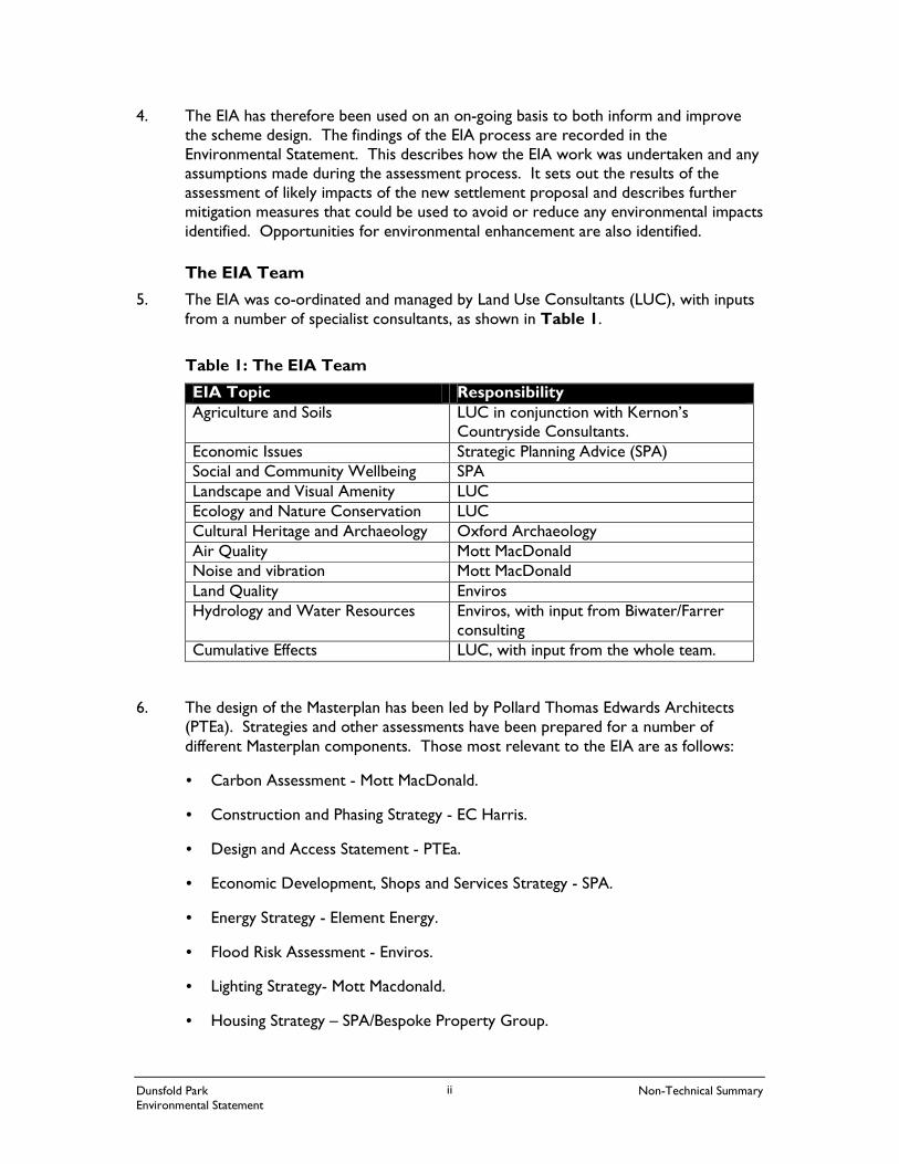
nguyendieu -
Category
Documents
-
view
220 -
download
0
Transcript of DUNSFOLD PARK – ENVIRONMENTAL STATEMENT: NON-TECHNICAL SUMMARY 0-b... · DUNSFOLD PARK –...
Dunsfold Park Non-Technical Summary Environmental Statement
i
DUNSFOLD PARK – ENVIRONMENTAL STATEMENT: NON-TECHNICAL SUMMARY
INTRODUCTION
What is Environmental Impact Assessment? 1. This document provides a summary of the Environmental Statement that
accompanies the planning application by Dunsfold Park Ltd for the development of a 2,601 dwelling new settlement at Dunsfold Park, Surrey, submitted to Waverley Borough Council.
2. The Environmental Statement sets out the findings and conclusions of the Environmental Impact Assessment (EIA). Government guidance1 states that:
“The term ‘Environmental Impact Assessment’ describes a procedure that must be followed for certain types of project before they can be given ‘development consent’. The procedure is a means of drawing together, in a systematic way, an assessment of a project’s likely significant effects. This helps to ensure that the importance of the predicted effects, and the scope for reducing them, are properly understood by the public and the relevant competent authority before it makes its decision. “Environmental Impact Assessment enables environmental factors to be given due weight, along with economic or social factors, when planning applications are being considered. It helps to promote a sustainable pattern of physical development and land and property use in cities, towns and the countryside. If properly carried out, it benefits all those involved in the planning process.”
3. The EIA of the new settlement proposals for Dunsfold Park has been conducted in accordance with Government EIA Regulations and Good Practice Guidance, and has sought to:
• Examine the environmental character of the area likely to be affected by the development through baseline studies.
• Identify relevant natural and manmade processes that may already be changing the character of the site.
• Consider the possible interactions between the proposed development and both existing and future site conditions.
• Predict the possible impacts, both beneficial and adverse, of the development on the environment.
• Introduce design and operational modifications or other measures to avoid, minimise or mitigate adverse impacts and enhance positive impacts.
1 Office of the Deputy Prime Minister and Welsh Assembly Government (November 2000) Environmental Impact Assessment. A Guide to Procedures.
Dunsfold Park Non-Technical Summary Environmental Statement
ii
4. The EIA has therefore been used on an on-going basis to both inform and improve the scheme design. The findings of the EIA process are recorded in the Environmental Statement. This describes how the EIA work was undertaken and any assumptions made during the assessment process. It sets out the results of the assessment of likely impacts of the new settlement proposal and describes further mitigation measures that could be used to avoid or reduce any environmental impacts identified. Opportunities for environmental enhancement are also identified.
The EIA Team 5. The EIA was co-ordinated and managed by Land Use Consultants (LUC), with inputs
from a number of specialist consultants, as shown in Table 1.
Table 1: The EIA Team
EIA Topic Responsibility Agriculture and Soils LUC in conjunction with Kernon’s
Countryside Consultants. Economic Issues Strategic Planning Advice (SPA) Social and Community Wellbeing SPA Landscape and Visual Amenity LUC Ecology and Nature Conservation LUC Cultural Heritage and Archaeology Oxford Archaeology Air Quality Mott MacDonald Noise and vibration Mott MacDonald Land Quality Enviros Hydrology and Water Resources Enviros, with input from Biwater/Farrer
consulting Cumulative Effects LUC, with input from the whole team.
6. The design of the Masterplan has been led by Pollard Thomas Edwards Architects (PTEa). Strategies and other assessments have been prepared for a number of different Masterplan components. Those most relevant to the EIA are as follows:
• Carbon Assessment - Mott MacDonald.
• Construction and Phasing Strategy - EC Harris.
• Design and Access Statement - PTEa.
• Economic Development, Shops and Services Strategy - SPA.
• Energy Strategy - Element Energy.
• Flood Risk Assessment - Enviros.
• Lighting Strategy- Mott Macdonald.
• Housing Strategy – SPA/Bespoke Property Group.
Dunsfold Park Non-Technical Summary Environmental Statement
iii
• Housing Land Supply Assessment - Roger Tym & Partners.
• Open Space, Recreation and Access to Nature Strategy - LUC.
• Sustainability Appraisal of Alternative Locations - LUC.
• Sustainability Appraisal of Masterplan Options - LUC.
• Transport Assessment - Mott MacDonald.
• Transport Plan - Mott MacDonald.
• Transport Strategy - Steer Davies Gleave.
• Waste Management Strategy - Estech.
• Water and Wastewater Strategy - Biwater/Farrer Consulting.
Consultation
The Scope of the EIA
7. To decide which aspects of the scheme are likely to give rise to significant environmental impacts, and to determine the focus and emphasis of the EIA, a Scoping Report prepared by Land Use Consultants (LUC) was submitted to Waverley Borough Council and key statutory and non-statutory consultees in June 2006. The Scoping Report set out the potential environmental impacts that could occur as a result of a new settlement at Dunsfold Park and the assessment process by which these issues would be evaluated. Consultations on the Scoping Report were based on the initial scheme design. Comments received during the scoping exercise were taken on board during the EIA and scheme design process.
Public Consultation
8. Dunsfold Park Ltd has engaged with stakeholders and the local community regarding the future of Dunsfold Park since the acquisition of the site in 2002. From early discussions on the alternative futures for the site, to the presentation of three initial outline masterplans, through to the final Masterplan and supporting strategies now being submitted with the planning application, consultation has been ongoing. Following extensive, interactive and co-ordinated consultation, local residents and stakeholders have made a significant contribution to the evolution of the proposals.
SITE CONTEXT
Location 9. The site is located in a predominately rural setting within the Borough of Waverley in
Surrey, east of the village of Dunsfold on an existing aerodrome (see Figure NTS 1: Location Plan). The site covers some 248 hectares (613 acres). The nearest large settlements are Guildford 17.7km (11miles) and Godalming 15.1km (9.4miles) to the north, Cranleigh 6.9km (4.3miles) to the north-east, and Horsham 18.2km (11.3miles)
Dunsfold Park Non-Technical Summary Environmental Statement
iv
to the south. Gatwick airport lies to the west of the site, approximately 28km (18miles) away.
10. The site is situated close to the A281 which runs to the east approximately 1.25km from the proposed centre of the development. The London to Portsmouth railway runs to the west of the site, served by the nearest station by road to Dunsfold Park (Godalming). The main entrance to the site is via the B2130 Stovolds Hill Road. The Wey & Arun Canal runs north-east to south-west on the eastern boundary of the site.
11. The surrounding land is largely arable with extensive pockets of woodland and field boundaries. Land to the immediate west of the site boundary (Dunsfold Common) is designated as Registered Common Land. There are other types of land use e.g. designated sites (such as those for nature conservation) and community facilities.
12. Cranleigh is the nearest local centre to Dunsfold Park, known as the ‘largest village in England’, with a population of around 10,000 people. Cranleigh offers a wide range of shops and a weekly market on Thursdays, plus clubs and organisations offering a wide range of activities. It acts as a local centre for the villages surrounding it.
Cranfold
One of the aims of the Dunsfold Park proposals is to address the sustainability of the existing communities in the area surrounding the site. For this it was necessary to define an area, known as ‘Cranfold’ within which the existing characteristics (e.g. the make up of the population, social and economic features, types of housing , the distribution of services, travel to work patterns) of those communities could be assessed. The villages comprising ‘Cranfold’ include Alfold, Alfold Crossways, Blackheath, Bramley, Cranleigh, Dunsfold, Hascombe, Ifold, Loxwood, Plaistow, Rowly, Shamley Green and Wonersh. The population is roughly 23,000, and includes some settlements smaller than villages.
Current Site Use 13. The site was developed as a wartime aerodrome in 1942, when the A281 (Alfold by-
pass) was re-aligned to enable the airfield to be built. Dunsfold Aerodrome has been in active use as an airfield throughout its history and remains active today. Whilst under the ownership of the Hawker Aircraft Co and then BAe Systems several famous aircraft – the Hunter, Hawk and the Harrier – were developed and assembled at Dunsfold.
14. The site was acquired by Dunsfold Park Ltd in 2002. Dunsfold Park Ltd is a joint venture between the Rutland Group and the Royal Bank of Scotland. Dunsfold Park Ltd owns a further 404 hectares (1,000 acres) of land including Holdhurst Farm to the north-east of the site boundary.
15. The site has permanent planning permission for the “the production, repair and upgrading of aircraft”, subject to limits on the number of aircraft movements and the numbers employed. In addition to aviation use, the site is home to a wide range of industrial, commercial, distribution and storage activities, providing employment for
Dunsfold Park Non-Technical Summary Environmental Statement
v
over 600 people. Most of the buildings are currently used in accordance with temporary consents that expire in 2010 (a separate application to extend the temporary consents to 2018 has been lodged by Dunsfold Park Ltd with Waverley Borough Council).
RATIONALE FOR THE SCHEME 16. The rationale for the scheme is to deliver a commercially viable and sustainable
development that:
• Meets housing need and demand, particularly in the local housing market area.
• Provides employment opportunities (both short term and long term).
• Promotes the health of a market town and rural area.
• Reduces demand for travel at the outset and promotes alternatives to the car.
• Promotes biodiversity and the conservation of natural resources.
• Is innovative and effective in the delivery of proposals.
17. In particular, the scheme aims to respond to the shortage in, and high price of, housing in the local housing market, and in particular the lack of social affordable housing. This is in line with the Government’s commitment to improving the affordability and supply of housing in all communities, including rural areas2. It aims to do so in a way that is compatible with its rural location, strengthening the links between where people live and work (especially those who work on site) and also by increasing employment opportunities.
18. The scheme aims to provide local access to everyday needs, such as shops, schools, sports and leisure facilities, as well as plenty of open space including a large Country Park, which will also be managed for wildlife. The scheme aims to reduce the need to travel by car with priority given to walking and cycling, and public transport links to neighbouring settlements. The design of the scheme aims to be highly environmentally friendly, with particular emphasis placed on minimising greenhouse gas emissions, water use, and the generation of waste.
What Alternatives have been Considered? 19. In order to inform the EIA of the new settlement scheme for Dunsfold Park, two
Sustainability Appraisals (SAs) were undertaken:
• SA of Alternative Locations.
• SA of Alternative Masterplans.
20. In addition, a ‘fallback’ position (i.e. the ‘business as usual’ alternative) was considered, which represents what would happen to Dunsfold Aerodrome if the development of a new settlement were not to go ahead.
2 ODPM (2006): Planning Policy Statement 3 (PPS): Housing
Dunsfold Park Non-Technical Summary Environmental Statement
vi
Sustainability Appraisal of Alternative Locations
21. The SA of Alternative Locations used a series of SA objectives (covering economic, environmental and social issues) developed by Waverley Borough Council for appraising the development of its Core Strategy Development Plan Document. It considered the merits or otherwise of developing 2,601 dwellings at Dunsfold Park, compared to developing the same amount of housing (i) divided amongst the four main towns in Waverley – Cranleigh, Farnham, Godalming and Haslemere (ii) at a single urban extension to the north east of Guildford (iii) at a single urban extension at Cranleigh.
22. The SA of Alternatives found that developing a new settlement at Dunsfold Park would perform considerably better in sustainability terms than the other three options considered. An urban extension at Guildford would be the next most sustainable option, followed by an urban extension at Cranleigh. Development spread amongst the four Waverley towns would be the least sustainable of the options considered.
23. The four Waverley towns option performed relatively poorly primarily because lots of small scale development would not be able to bring the infrastructure, affordable housing, employment opportunities and community facilities and services that a single larger scale development could bring, and could place further pressure on existing services and facilities in the four towns, and on their special character. An extension at Guildford would be well placed for residents to access the jobs, shops, services and facilities available from being close to a large settlement, but the Dunsfold Park option also performed well due to the existing (and proposed expansion of) employment on site, and the support for existing (and introduction of new) shops, services and facilities in a rural location. It was calculated that the Dunsfold Park and the Guildford urban extension options would generate the smallest increase in traffic, with the four Waverley towns the greatest increase in traffic.
24. Only one of the four options is a firm development proposal – a new a new settlement at Dunsfold Park. The other options either are not worked up in detail, or do not exist as development proposals at all. There are a number of aspects of the Dunsfold Park option that conceivably could be delivered under any of the options, especially the urban extensions at Guildford and Cranleigh where development would (at least in theory) be contained on one site. However, the new settlement at Dunsfold Park includes firm commitments to their achievement. Whilst some could be delivered elsewhere, there is a very real risk that lower sustainability standards could be sought. Development at Dunsfold Park therefore offers a certainty that counts in its favour, and this was reflected in the overall assessment of sustainability.
Sustainability Appraisal of Alternative Masterplans
25. The SA of Alternative Masterplans used a sustainability checklist developed by the South East England Development Agency (SEEDA) to compare the sustainability performance of the three alternative masterplans – the high street, island, and parkland masterplans – that were subject to public consultation in February 2006, a hybrid masterplan that was subject to public consultation in June 2006, and the final
Dunsfold Park Non-Technical Summary Environmental Statement
vii
Masterplan which is subject to the current planning application. This found that the final Masterplan attained a very good sustainability performance, achieving ‘best’ or ‘good’ practice scores against 49 of the 53 SEEDA objectives, although not quite as good as the high street and hybrid masterplans. The slightly reduced sustainability performance of the final Masterplan was due to the outcome of technical studies (e.g. with respect to water supply and management), which found that some of the more radical and challenging proposals in the earlier versions of the masterplan could not be delivered in technical terms.
The Fallback Position
26. The ‘Fallback Position’ comprises a continuation of the existing activities on the site, but with temporary permissions eventually expiring. The permitted uses on the site comprise the production, repair and upgrading of aircraft on a permanent basis. A maximum of 5,000 aircraft movements is permitted per annum. Other restrictions include set flying times, a maximum aircraft weight limit of 70 metric tonnes, use of mufflers or silencers to reduce noise when aircraft are being tested and a maximum of 1,350 employees permitted on site at any one time. There is no restriction on vehicle movements or the type of vehicle on site.
27. The Fallback Position assumes a floorspace of approximately 45,000 sq m, which includes permanent permission for an estate management building of some 558 sq m and permanent permission for 3,263 sq m of B1 (business) and/or B2 (general industrial) and/or B8 (storage and distribution) uses. There is also a series of temporary permissions which form part of the Fallback Position.
28. The continuation of flights under the Fallback Position will continue to contribute to greenhouse gas emissions, although pollution impacts arising from the Fallback Position should lessen over time as the temporary permissions expire (for example noise pollution associated with car testing) unless these permissions are renewed. The new settlement proposal aims to prevent and control pollution (through commitments to carbon neutrality to offset greenhouse gas emissions arising from new housing and employment) and through high rates of water and waste reuse and recycling.
29. None of the following benefits of the new settlement proposal would occur under the Fallback Position: the provision of a large number of new (and affordable) homes in an area of high house prices; additional employment on site (up to 2,000 jobs provided, including existing employment), and employment diversification, by providing a range of new business and industry types; improved bus links from Dunsfold Park to Cranleigh and beyond; new health ,education and other community facilities, including primary healthcare facilities, sport and leisure facilities, a Country Park and a primary school.
30. The new settlement will result in a loss of habitats important to biodiversity and species disturbance. However, over half of the site would be used as a Country Park, with a mosaic of habitats and uses, much of which would be managed for wildlife. This is predicted to result in an overall improvement in the biodiversity of the site once the development is complete. Biodiversity gains are less likely under the

Dunsfold Park Non-Technical Summary Environmental Statement
viii
Fallback Position, although existing habitats of benefit to wildlife (although not specifically managed as such) would be maintained.
31. The airfield would be lost if a new settlement were constructed, resulting in loss of this link to the site’s history. Under the Fallback position the site would continue to function as an airfield. However, the aim of the new settlement is to celebrate the airfield’s history through inclusion of a heritage museum within the current Masterplan and preservation of many of the airfield features. Furthermore, the chosen design aims to represent the linear form of the runway through the creation of ‘Runway Park’.
32. The new settlement will be a significant change in landscape character and although well screened at ground level, the site is visible from surrounding high vantage points such as Hascombe Hill. However, good design (including strategic planting and careful choice of roof colours) will address impacts in the long term. Under the Fallback Position, on site activities, such as the take-off and landing of aircraft, would continue to be visible from key vantage points (and generate noise).
SCHEME DESCRIPTION
Vision and Objectives of the Development
The aim of the proposed scheme is to create a new, self-sustaining settlement, a model for sustainable development and an inspiring place to live and work. In pursuit of this goal the proposals have been designed to:
• Create a balanced community that builds on the employment potential offered by the site.
• Promote the sustainable development, in social, economic and environmental terms, of the wider Cranfold area.
• Support the economic development of the wider region which is the engine of the UK economy.
• Manage the demand for resources.
• Deliver innovative technologies for energy, transport and waste to reduce the environmental footprint of the development.
• Create a diverse housing stock that offers choice for new residents, a broad social mix and opportunities for mobility between tenures.
• Develop housing that performs to the highest feasible environmental standards.
• Make no call on public funds for the delivery of the development.
• Enhance the natural qualities of the site which sits adjacent to very important landscape features.
• Minimise negative impacts on the surrounding areas and communities.
Dunsfold Park Non-Technical Summary Environmental Statement
ix
The Scheme 33. The Masterplan of the scheme is shown in Figure NTS 2: The Proposed
Scheme. The main elements of the proposals which are designed to achieve the vision and objectives are:
• Residential development (2,601 dwellings, including 1,495 dwellings for sale or rent on the open market, 351 intermediate dwellings for shared ownership or discounted rent, 559 social affordable dwellings, 150 dwellings for the elderly being either extra care or warden assisted, and 46 dwellings for students) comprising a mix of mainly two to five bed houses and one and two bed flats, plus a small number of studios.
• A market square at the centre of the village with retail units including a 300 sq m convenience store and six shop units of 100 sq m each, provision for financial and professional services, a restaurant, cafe and public house.
• Business uses including offices, research and development and light industry, general industry, and storage and distribution, with a total net increase in the floorspace from 44,721 sq m to 59,854 sq m.
• A 100 bed hotel.
• A primary school.
• Non-residential institutions including a health centre, a place of worship and museum to celebrate the aerodrome heritage of the site.
• Assembly and leisure uses including a community centre and sports centre.
• 146 hectares of landscaping and open space, outside of the main built up area, including water bodies and sustainable drainage systems, outdoor sports and recreational facilities, allotments, orchard and nature conservation areas (many of which will be incorporated into a new 72 hectare Country Park that will also be the site of a landmark 19 metre tall aviation monument).
• A seven hectare linear Runway Park occupying the line of the existing main runway.
• An internal network of footpaths and cycleways extending outside of the site (e.g. to Cranleigh), and provision of bicycles for all households plus a cycle hire service for visitors and people working on the site.
• Improvements to the local bus network, including services to Cranleigh, Guildford and Horsham, plus demand responsive bus services and a yellow bus for school trips.
• A ‘car restraint area’ in the central part of the development, together with parking barns and the promotion of neighbourhood electric vehicles, a car user charge to exit the new settlement, workplace travel plans and a workplace charging levy.
Dunsfold Park Non-Technical Summary Environmental Statement
x
• A new link road to the A281, with a new roundabout junction where the link road joins the A281.
• Highly energy efficient built development, with energy provision for the entire scheme provided by a Combined Heat Power plant fuelled by biomass primarily from local woodland (the aim is for the built development in the new settlement to be ‘carbon neutral’).
• Water efficiency measures, such as universal metering of all homes, water efficient appliances, and collection of rainwater for recycling, supplemented by drinking water from the mains supply system.
• Telecommunications.
• Waste treatment facilities, with the aim of achieving 80% recovery of all waste generated on site once waste recycled through the normal collection procedures of the waste collection authority is also taken into account.
• A helicopter landing pad and hangar for the Surrey Air Ambulance.
34. To achieve the above, some existing buildings will need to be demolished, the three runways and some other hardstanding will need to be removed, and aviation use will need to cease (with the exception of Surrey Air Ambulance).
35. It is anticipated that the development will become home to approximately 6,000 people. The numbers employed on the site will increase from a current number of approximately 638 people to around 2,000 when the scheme is completed. It is anticipated that the land use and transport measures for the development will result in around 14,300 external vehicle trips per day, which is around 20% less than a typical development of this size.
36. The affordable housing and designated market rent housing will be owned by a Trust set up specifically for the provision of affordable housing at Dunsfold Park. The Trust will sub-contract the management of the affordable housing to a Registered Social Landlord. The Trust and the Registered Social Landlord will enter into a nominations agreement for the affordable housing with Waverley Borough Council in the standard form the Council uses, but with priority order given to:
1. Persons in employment on Dunsfold Park.
2. Persons in employment in Cranfold.
3. Persons on the housing register of Waverley Borough.
4. Persons living in the Cranfold area in a concealed household.
5. Persons living in Waverley Borough in a concealed household.
6. Persons from outside the Borough on the Choice Board lettings scheme.
37. A Community Land Trust will be set up to ensure the future maintenance of the infrastructure and community facilities at Dunsfold Park.
Dunsfold Park Non-Technical Summary Environmental Statement
xi
Phasing and Construction 38. The development is proposed to be constructed over approximately a 10 year period
commencing in 2010 and finishing in 2020. Given the length of the construction period, it will be subdivided into twelve phases with residential dwellings constructed in each phase. The first year will be used to make initial preparations for the site, with the first dwellings constructed in 2010. Community buildings will be constructed in 2010 so that they are available for the first residents of the site. The main open space to the east of the development and the main Country Park to the west will be available for use in the early stages of the development.
39. The new A281 link road will be constructed in the first phase of the programme, and will provide the main site access. It is anticipated that construction related traffic will result in heavy goods vehicle deliveries peaking at 50 per day, with an average of 28 deliveries per day, and light goods vehicle deliveries peaking at 30 per day, and an average of 20 deliveries per day. The construction workforce will include a minimum of 60 employees, with the highest number at any one time being in the order of 222 employees.
40. Throughout development of the site, works will take place according to a Construction and Environmental Management Plan, which will be designed to reduce the risk of impacts upon the environment, existing surrounding communities, development workers and future site residents and users.
IDENTIFYING THE ENVIRONMENTAL ISSUES 41. Following consultation on the scope of the EIA, and the public consultation exercises,
it was decided that the EIA should examine the impacts of the development proposals on the following issues:
• Agriculture and soils.
• Economic issues.
• Social and community well-being.
• Landscape and visual amenity.
• Ecology and nature conservation.
• Cultural heritage and archaeology.
• Air quality.
• Noise and vibration.
• Land quality.
• Hydrology and water resources.
• Cumulative impacts.
Dunsfold Park Non-Technical Summary Environmental Statement
xii
42. It should be noted that a separate Transport Assessment has been undertaken that describes the changes in traffic volumes that are predicted to happen on the road network as a result of the proposed scheme. The EIA addresses the environmental impacts of the changes in traffic within a number of the topics listed, for example air quality, noise, economic issues, and social and community well-being.
43. The key findings of the EIA with respect to each of the above issues are set out below. For each issue a description of the ‘existing conditions’ is provided followed by the predicted impacts of the development taking into account proposed mitigation. Certain terms are used that are commonly found in EIAs, but require further explanation:
Explanation of Terms used in the Assessment of Impacts
• Impact – this refers to the change in the existing conditions that will result from the development during both construction and operation. Impacts can be negative (adverse) or positive (beneficial). Negative impacts mean that conditions will get worse, whereas positive impacts mean they will get better.
• Mitigation – this refers to measures that will be taken to avoid or reduce any negative impacts identified. In addition, some mitigation measures will lead to positive impacts.
• Receptor – this refers to those elements of the natural and built environment and also people and communities that may experience impacts – negative or positive – as a result of the development. Examples of receptors include houses, villages, businesses, historic buildings, animal and plant species, watercourses, etc.
ASSESSMENT OF IMPACTS
Agriculture and Soils 44. The assessment of the impacts on agriculture, soils and agricultural businesses of the
development was carried using a combination of desk studies, field surveys including soil analysis, and consultations with relevant bodies (e.g. the Rural Development Service).
Existing Conditions
45. A large part of the site has been previously developed and therefore is classified as non-agricultural land under the Agricultural Land Classification System. However, some land (approximately 25 hectares / 10% of the site) surrounding the airfield has not been disturbed by construction and has remained in grassland use since the airfield was constructed. The application site comprises approximately 33 hectares of ‘best and most versatile’ quality land with potential for agricultural use. Other areas of undisturbed land are classified as non-agricultural land as they are either woodland, in a non-agricultural use, or are too small to realistically return to an agricultural use.
46. Very little land within the airfield is used for agricultural purposes. A field to the north of the employment land is in agricultural use. In addition, a single field which is
Dunsfold Park Non-Technical Summary Environmental Statement
xiii
required for the development of the A281 link road has been recently acquired by Dunsfold Park Ltd and is being rented by a local farmer.
Impacts and Mitigation
47. Two key areas of impact were identified: the impacts on agricultural land quality (i.e. the impacts of the loss of agricultural land as a national resource); and impacts on farm businesses (i.e. the impacts of non-agricultural development on the viability of farm businesses operating within the study area).
48. The loss of agricultural land cannot be mitigated against and was classified as a moderate negative impact. Taking into account mitigation measures (e.g. with respect to access during the construction period, necessary closure of field accesses during periods when agricultural activity is quiet, and ensuring drainage is not disrupted) it was concluded that the negative impact on farm businesses would be minor.
Economic Issues 49. The impacts of the proposed scheme on the local economy and on the economic life
of both future residents, and people already living and working in the neighbouring settlements and the wider region were evaluated as part of the EIA. The main focus of the study was the impacts on the ‘Cranfold’ cluster of settlements. A wide range of national, regional and local data sources were used. These were complemented by three field surveys: a study and consultation survey of the tenants at Dunsfold Park; an analysis of Cranfold’s shops, businesses and community services and visits to all the villages within Cranfold as well as business parks and industrial parks within the Cranfold boundary to identify the types of business present; a questionnaire survey of major employers in Cranfold to provide information on the nature of their business, their customers and existing employee travel-to-work patterns.
Existing Conditions
50. As in other parts of the South East, Cranfold’s labour market is not self-contained. Cranfold is a desirable residential location for commuters, many of whom hold high-paying jobs in international business sectors such as finance and banking. Cranfold, like other parts of Waverley, provides a number of large homes in an attractive setting, close to London and other regional employment centres. Two-thirds of Cranfold’s residents who travel to work commute to destinations beyond Cranfold. The 3,400 individuals who live and work in Cranfold (excluding those who work from home) are slightly outnumbered by the 3,500 who commute daily from outside Cranfold to work in Cranfold.
51. The local labour market in Cranfold is exceptionally tight. A lack of local affordable
housing means that employers find recruitment of staff problematic. In turn, this leads to long daily commutes for half of Cranfold’s workforce (excluding those who work from home), who travel in from outside the area. Trends for the South East region, and Surrey in particular, show that these wider areas have continued to see a strong economy evidenced by low unemployment.
Dunsfold Park Non-Technical Summary Environmental Statement
xiv
52. Cranfold’s mix of industries is broadly similar to that of Waverley as a whole. Its substantial facilities for schooling are evidenced by the large numbers working in education. Financial and business services are a large part of the South East economy, and businesses in this industry employ over a quarter of Cranfold’s workforce. The construction industry is an important sector. Construction firms located in Cranfold employ approximately 545 workers, just over 6% of the total number employed in Cranfold.
53. Cranfold’s jobs cover a similar distribution of occupations to Waverley. The main difference is in the proportion of people who work for small employers and are self-employed (18.2%). This is reflected in the high proportion of individuals who work from home in the area. Another notable category is those working in higher managerial and professional occupations. Although Cranfold is part of an area frequently labelled the ‘stockbroker belt’ due to its affluent residents, such jobs are not located in the local area. Hence although 13.4% of Cranfold residents work in these occupations, only 9.6% of Cranfold jobs are in such well paid fields.
54. Dunsfold Park, along with Smithbrook Kilns and the villages of Cranleigh and Bramley, represents a major cluster of employment and business activity within Cranfold. The A281 is the primary means of connecting these destinations to each other and to the national primary route network of roads at Guildford and Horsham. A number of Cranfold businesses are located on the A281 itself, and the road itself is likely to provide a significant source of passing trade for many businesses.
55. Dunsfold Park features a greater proportion of jobs in manufacturing and warehousing and fewer jobs in distribution, wholesale or retail. Although 41% of workers at Dunsfold Park are employed in services, their employers are typically providers of business services, rather than services to the public, as may be found more commonly in Cranleigh and in ‘High Street’ locations. There are currently 80 firms operating at Dunsfold Park. Niche industries have emerged at Dunsfold Park since British Aerospace vacated the site in 2000. Especially important are automotive engineering, environmental technologies, and research and development facilities – reflective of growing sectors in the 21st century in the South East.
56. According to local public opinion surveys, congestion is a key issue. 50% of Surrey residents questioned in a recent MORI survey and 70% of local businesses cited the need to tackle congestion to limit delays as a priority, although the costs of congestion in Waverley per km driven on Waverley roads is the second lowest of Surrey’s 11 local authorities. Surrey has the highest traffic flows of any county in the South East and traffic volume growth was 24% between 1993 and 2002.
Impacts and Mitigation
57. During construction it is predicted that there will be a minor negative impact on Cranfold businesses as staff recruitment and retention becomes more challenging, due to the demand for labour. A minor positive impact is likely for Cranfold businesses (and their employees) resulting from the expenditure of the construction workforce. This will be especially important for local businesses subject to weak performance due to a lack of local customers. After the first phase of construction, it is anticipated workers will use the village centre for much of their shopping and this will provide an opportunity for the establishment of new businesses, shops, or
Dunsfold Park Non-Technical Summary Environmental Statement
xv
branches of existing firms. A moderate positive impact is likely for construction-related businesses in the Cranfold economy resulting from the expenditure by the applicant during construction.
58. A minor negative impact is likely for road users after mitigation measures (e.g. travel plans), especially businesses and members of the public vulnerable to the impacts of increased traffic volume upon local roads. This is a result of construction workforce travel to work trips, and the delivery of materials. This is also likely to impact negatively upon the efficient operation of some public transport services.
59. The impacts during operation will be felt progressively as subsequent phases are completed. A major positive impact is predicted for Cranfold due to the addition of 3,200 workers to the labour supply. This will increase the range of labour available in terms of skills, qualifications and experience and will be particularly relevant for businesses subject to staff recruitment and retention challenges. A minor negative impact is likely in terms of staff recruitment and retention for existing Cranfold businesses due to the additional jobs at Dunsfold Park. These positions will need to be filled and therefore will compete with existing businesses for labour. This impact will be particularly relevant for businesses experiencing staff recruitment and retention challenges. A moderate positive impact is likely for Cranfold businesses (and their employees) resulting from the expenditure of 6,000 new residents and the expanded workforce. This will be especially important for local businesses currently suffering weak performance due to a lack of local customers.
60. A moderate positive impact is likely for businesses in the Cranfold economy resulting from business-to-business expenditure from an expanded number of firms located at Dunsfold Park, and the development of local supply chains and inter-trading among these firms and clusters. Additionally, the expansion of the industrial and commercial premises will offer businesses an enhanced range of available spaces which are more modern and efficient than those currently available at Dunsfold Park or elsewhere in the local area. Businesses (and their employees) in the forestry sector currently experiencing weak performance due to a lack of demand for forest products will particularly benefit from this impact due to the specific demand for bio-mass associated with the operation of the Combined Heat and Power plant within the proposed scheme.
61. Vehicles trips on local roads made by local residents, workers at Dunsfold Park, and commercial vehicles serving the village will add to congestion on the roads at certain places at specific times, but this will be off-set by new public transport provision that will benefit those without access to a car.
Social and Community Well-being 62. The impacts of the Dunsfold Park proposals on the quality of life of people already
living and working in the neighbouring settlements and the wider region were evaluated. The impacts on future residents of Dunsfold Park were also assessed. Reference was made to a range of national, regional and local policy documents and data, including the ‘Waverley Community Strategy’ and the ‘Cranleigh Health Check’. Discussions with local authority officers and the various consultation events on the
Dunsfold Park Non-Technical Summary Environmental Statement
xvi
future of Dunsfold Park also provided valuable information. Specific research was undertaken on rights of way.
Existing Conditions
63. At present, Cranfold is characterised by high house prices and a severe shortage of affordable housing options. As in other parts of the South East, new households increasingly cannot afford to rent or buy housing in their local area, or near to their workplace. This is thought to be having significant impacts on the social structure of the area. Average house prices in Waverley have risen 63.7% since 2001, and stand at over £400,000, almost double the national average. A lack of affordable housing means that in Cranfold, like other rural areas facing similar challenges, most housing is only accessible to those with ample economic means. The Affordable Rural Housing Commission found that as a result many are excluded, and that affected rural areas will lack the social mix to function as communities (e.g. where people of different backgrounds share a common identity and support each other across occupations and between generations).
64. Cranfold’s shops and services include 132 shops and services in Cranleigh, 39 in Bramley, and a further 62 scattered across the remaining 11 villages which make up Cranfold. Larger retail and service centres exist close to Cranfold – principally Guildford, Horsham and Godalming. Access to post offices and supermarkets is much more difficult in rural parts of Cranfold than in the rest of Waverley due to distances from homes. Post offices currently operate in six of Cranfold’s villages. Residents in rural Cranfold are 1.9km from a post office, on average, compared to 1.2km for other parts of Waverley. The Government target is that 90% of the UK population live within 1 mile (1.6km) of a post office.
65. Three of the ten villages in Cranfold have doctor’s practices or health centres: Cranleigh, Dunsfold and Loxwood. Three dental practices are located in Cranleigh, and one dentist at Bramley. Cranleigh is also home to three registered opticians and a village hospital.
66. Education in Cranfold is provided by Surrey County Council and West Sussex County Council, as well as a number of independent schools. Four of Cranfold’s 10 villages have schools. Children in some Cranfold families may attend their closest primary or secondary school which may be beyond the boundaries of Cranfold (e.g. primary schools in Busbridge or Ewhurst or secondary schools in Godalming or Guildford). Residents of rural Cranfold live twice as far from a primary school, on average, as residents elsewhere in Waverley.
67. There are currently no public transport links to Dunsfold Park. Access to the site is controlled, and restricted to business tenants and their visitors. There are two forms of public transport available within Cranfold. Fixed-route bus services are operated in partnership with Surrey County Council, while Hoppa operates door-to-door services within Waverley for registered users who book in advance, and offering wheelchair-accessible vehicles. Cranfold has no rail stations, but is close to both the London to Portsmouth line and the Guildford to Redhill lines. There are seven stations in Waverley served by the national rail network, with fast direct connections
Dunsfold Park Non-Technical Summary Environmental Statement
xvii
to London. However, peak hour trains suffer from overcrowding, causing inconvenience to passengers.
68. Many of Cranfold’s villages are well endowed with village halls, community halls or church halls, which act as the centre of community life, providing free or low-cost meeting space for the parish council as well as various clubs and societies. Bramley and Cranleigh both have libraries maintained by Surrey County Council. The council also operates a mobile library which stops in Alfold (five times per month), Cranleigh (three times per month) and Shamley Green (every four weeks). Religion is important in Cranfold as an element of community life.
69. Cranfold enjoys a wide array of opportunities for leisure and recreation, and residents can take advantage of both the natural environment of the countryside, and active social life within the villages. The natural environment assets in Waverley (such as the Area of Outstanding Natural Beauty) are a key feature of its recreational provision.
70. Close to Dunsfold Park, designated routes exist for walking, including long distance paths such as the Greensand Way, running roughly east-west from Hascombe to Shamley Green, and the Downs Link, running roughly north-south from Guildford to Horsham, via Bramley and Cranleigh, along a disused railway line. Cranfold is also linked via the Surrey Cycleway to the rest of the County.
Impacts and Mitigation
71. The assessment found that the construction workforce could bid up house prices against a limited supply of dwellings in the area. This will be mitigated through the prioritisation of firms and labour who already operate locally, and hence have established residency, and through the employment of workers who live elsewhere and commute to work in the local area. Minor positive impacts for local people in terms of access to shops and services are likely as Cranfold businesses (and their employees) will benefit indirectly from the expenditure of the construction workforce.
72. The traffic generated by construction will be mitigated through specified haul routes and hauling schedule which avoids congested roads at congested times, channelling traffic to the south east of the site, and a travel plan for the construction workforce to minimise the generation of vehicle trips.
73. There may be some disturbance to rights of way near the site during construction, but simple mitigation measures, such as diversions and the implementation of environmental management plans for construction work, should ensure any potential negative impacts are minimised.
74. All operation impacts are considered long-term and permanent, apart from congestion which is subject to a number of unpredictable influences. The operation of Dunsfold Park is predicted to result in a major positive impact upon individuals who are excluded from the housing market, due to the provision of 2,601 dwellings. The 910 affordable units will be financially accessible to a larger proportion of the population, and therefore these units will have a major positive impact on those
Dunsfold Park Non-Technical Summary Environmental Statement
xviii
currently excluded from the housing market due to a lack of units within their range of affordability. Within this provision, the 559 socially rented units will be of particular importance to individuals on the Waverley Housing Register.
75. A moderate positive impact is likely, overall, in terms of access to shops and services for residents of Cranfold. The shops and services at Dunsfold Park will be highly accessible to new residents and employees, while the scale of retail provision will likely support, indirectly, Cranleigh’s role as a town centre, meeting the local shopping needs of Dunsfold Park residents and many others in Cranfold and beyond.
76. A moderate positive impact is likely, overall, in terms of access to health, education and other community facilities for residents in Cranfold. The scale of community facilities are likely to support, indirectly, Cranleigh’s role as a local centre for secondary education and medical care for Dunsfold Park residents and many others in Cranfold and beyond.
77. A moderate positive impact is likely upon social inclusion in the local area resulting from the addition of 500-600 jobs to the local economy. This offers the prospect of further reducing unemployment beyond its current level, albeit very low. An additional positive impact will come from the larger range of jobs in the local economy, which will also allow more local residents to find a suitable job locally.
78. A minor negative impact on the mobility of car-reliant Cranfold residents is predicted. For road users, vehicle trips on local roads made by local residents, workers at Dunsfold Park, and commercial vehicles serving the village will add to congestion on the roads at certain places at specific times. The Transport Strategy proposes a number of innovative measures that aim to reduce the need to use cars from the outset. As a result, public transport users both in Dunsfold Park and Cranfold are likely to see a net positive impact on their mobility due to the addition of new bus services, and support for existing services from residents at Dunsfold Park. Although some public transport services will suffer negative impacts as a result of additional road congestion, new residents at Dunsfold Park will have their mobility enhanced further by a range of measures including demand-responsive transport services and extensive provision for walking and cycling within the village. New public rights of way are expected to have a moderate positive impact for recreational and non-recreational walkers locally.
79. A moderate positive impact on Dunsfold Park residents and Cranfold residents is likely due to the provision of a community centre, leisure centre, church, museum, and extensive open space and landscape, with new public rights of way, for leisure and recreation. These will be highly accessible to those at Dunsfold Park – within 650m of each dwelling – and will be an asset for residents who live in close proximity. Indirectly, Dunsfold Park is likely to improve the viability of other community facilities in Cranleigh through use by new residents.
Landscape and Visual Amenity 80. Potential impacts of the scheme on the landscape include physical changes to the
fabric of the landscape, as well as perceptual changes in the character of the landscape. They also include impacts on areas designated for their scenic or
Dunsfold Park Non-Technical Summary Environmental Statement
xix
landscape qualities, at a national, regional or local level. Visual impacts relate to changes in views and the appearance and prominence of Dunsfold Park in those views.
81. The assessment was carried out using a combination of a review of relevant policies and documentation (e.g. ‘The Future of Surrey’s Landscape and Woodland’ produced by the County Council), consultations with statutory agencies and local authority officers, tree and field surveys, the identification of key viewpoints of Dunsfold Park, and the use of computer generated visual impressions – to understand how the proposed development would look in the landscape compared to the existing aerodrome.
Existing Conditions
82. The site is predominantly flat (hence its selection as an airfield during World War II), although the land rises, in gently undulating form, to the north beyond the site boundary. The site is largely contained by established vegetation of tree belts and woods around much of its perimeter. However, the scale of the site and the extent of openness afford longer views outwards towards more elevated land, particularly to the wooded skylines which include Hascombe Hill (to the north-west) and to the sweep of scarp slopes to the north-east including Pitch Hill, Holmbury Hill and, more distantly, Leith Hill.
83. Historically, as shown in earlier editions of Ordnance Survey, the site had a pattern of fields with hedgerows, and several woods. Some of these remain around the peripheries, although much was cleared to make way for the airfield in 1942. Some of the free-standing trees around these peripheral areas are also remnants of the former hedgerow pattern.
84. The runways and open expanses of maintained grassland are significant elements of the present landscape although other airfield elements – the perimeter road, other areas of hardstanding, locally embanked enclosures and former airfield outbuildings and structures – are distributed mainly around the perimeter.
85. The central core of the site, comprising the open airfield and the business park, does not contribute to wider landscape character and is comprised of easily replaceable components (hardstanding, large scale modern buildings, short cut grassland). It is significant because of its links with aviation history and World War II. In terms of landscape character, the sensitivity to change of this central section is low.
86. The marginal areas of the site outside this central core retain elements that are part of the historic pattern of the wider landscape – the woodland (including fragments of ancient woodland), field boundaries and mature trees, plus the canal. Although these elements are in declining or poor condition they are not easily replaceable. Taking into account all of these factors, for the purposes of this assessment, the landscape sensitivity of the perimeter areas of the site to change was judged as moderate.
87. Although Dunsfold Park does not fall within the boundary of the nationally designated Surrey Hills Area of Outstanding Natural Beauty (AONB), views over the area affect the scenic quality of the AONB, and it therefore forms part of the setting of the designated landscape. A small area of the site itself lies within the locally designated Area of Great Landscape Value, indicating its local landscape value.
Dunsfold Park Non-Technical Summary Environmental Statement
xx
88. The landscape character areas relevant to Dunsfold Park primarily have a moderate sensitivity to new residential or mixed development.
Impacts and Mitigation
89. The proposed scheme has been designed to minimise potential landscape and visual impacts by using new tree and woodland planting to screen built development. The disposition of the buildings and the street tree planting and provision of open spaces are also intended to integrate the proposed scheme with its landscape context in the Weald.
90. Principal negative landscape and visual impacts will occur at the construction stage. There will be moderate negative impacts on the local landscape of the site and the perceptual character of the local landscape (e.g. to the Alfold Crossways and Wey and Arun Clay Vale landscape character area), due to the site access and road link to the A281. In addition there will be major negative impact during the construction phase on some local viewpoints due to the new site access.
91. Moderate negative impacts at the operational stage will occur as a result of the new site access and lighting of the development and upgrades to the local road network, although these will diminish as the new landscape planting matures. Visual impacts of the proposed scheme will be reduced by the landscape screening to the northern site boundary, notably in views to the site from the north such as from Hall Place. Moderate negative impacts will result on views from within the AONB, notably from Hascombe Hill, although the proposed scheme has been designed to minimise these as far as possible, with a dappled roofscape broken by green roofs and street tree planting. There will be mixed impacts on the landscape character of the central area of the site once development is complete and on the view of the new development from Primemeads to the west of Compasses Bridge.
92. However, the new and enhanced landscape of the proposed scheme, including substantial tree planting and woodland planting and the Country Park in the western part of the site will give rise to a major positive impact.
Ecology and Nature Conservation 93. The ecological assessment of the proposed scheme considered the potential impacts
of the development on both floral (plant) and faunal (animal) communities. In particular it considered direct impacts (e.g. loss) and indirect impacts (e.g. disturbance) of the development on habitats and species during both construction and operation. It also considered opportunities for habitat management and enhancement to mitigate for any impacts and improve ecology overall.
94. The ecological interest of the site and surrounding areas was established by examining local records, consultations with relevant conservation bodies, and a series of site surveys. These included an extended Phase 1 habitat survey, and surveys of dormouse, bats, badgers, birds, great crested newts, reptiles and invertebrates. Reference was made to legislation that protects certain habitats and species, national, regional and local policies, and the Biodiversity Action Plans that aim to improve the ecology of an area, specifically in relation to target habitats and species.
Dunsfold Park Non-Technical Summary Environmental Statement
xxi
Existing Conditions
95. Dunsfold Park falls within the Low Weald and Pevensey Natural Area and is one of the most densely wooded areas in England. There are no nature conservation sites designated under law within the site boundary. The closest designated site is the Chiddingfold Forest Site of Special Scientific Interest (SSSI), which is located some 150 m to the south west of Dunsfold Park. There are a number of internationally designated sites within 20km of Dunsfold Park (many of which also have national designations). These comprise Thursley, Ash, Pirbright and Chobham Special Area of Conservation (SAC), Thursley, Hankley & Frensham Commons Special Protection Area (SPA) and Wealden Heaths SPA. These are located over 8 km to the west and north-west of Dunsfold Park. The Ebernoe Common SAC is located some 9 km to the south west of Dunsfold Park, with The Mens SAC over 10 km to the south. The Thames Basin Heaths SPA is located some 18 km to the north of Dunsfold Park.
96. Eleven non-statutory Sites of Nature Conservation Importance (SNCIs) are found within 1 km of the Dunsfold Park boundary. These include Furtherfits, Benbow Rew, Honeymead Copse (within Dunsfold Park), Mill Copse (immediately to the north east), Sayers Land, Jewings Hurst and Benbow Rew (West) (partially within Dunsfold Park), and Sidney Wood (to the south).
97. There is considerable overlap between SNCIs and areas identified as ancient woodland (defined as woodlands which have been in existence since 1600AD), with a number of areas of Ancient Semi-Natural and Ancient Replanted Woodland on-site and in the vicinity. Five areas in Dunsfold Park have been identified including parts of Furtherfits Woodland, Sayer’s Land, Chalcrofts Rough and Roundles Copse.
98. Surveys indicated that a number of habitat types can be found within the site, in particular grasslands (amenity, improved, semi-improved and unimproved neutral grasslands), a network of semi-natural broad-leaved woodland (including those classified as ancient), scrub, hedgerows, tree lines and scattered trees. Other habitats include small areas of ruderal and ephemeral communities, and wetlands comprising ponds, ditches and the Wey & Arun Canal.
99. Dormouse was not recorded on the site despite a high level of survey effort. This would suggest that if they have been present on the site in the past they may have become locally extinct (possibly as a result of past management practices). Relatively few signs of badger were recorded on the site, with scattered evidence around the periphery indicating use of the site for foraging by low numbers of badgers with setts near the site boundary (either on or off-site). In total nine setts were recorded in 2006 and 2008, with two of those recorded as active in 2006 having become disused in 2008. These were mainly outlier setts (i.e. a sett used intermittently by badgers, and not used for breeding), with no main setts (i.e. a principal breeding sett) were located on the site and two probable main setts recorded off-site.
100. Long-eared bat roosts were identified at Primemeads Cottage and Honeymead Cottage, and Broadmeads Cottage was considered to have potential to support bats. Surveys confirmed eight bat species as present on the site, namely common and soprano pipistrelles, brown long-eared bat, noctule bat, Leisler’s bat, Natterer’s bat, serotine and barbastelle. Daubenton’s, whiskered and Brandt’s could also be present
Dunsfold Park Non-Technical Summary Environmental Statement
xxii
given their distribution across the UK and the suitability of habitat at Dunsfold. In addition to the roost sites confirmed or suspected in buildings, the following locations were considered to be key areas for bat activity: the west and south of the site where woodland and hedgerow habitats supported at least seven species of bat; the canal and associated woodland and hedgerows in the south that also supported at least seven species; and the areas to the north immediately around the industrial areas in which five to seven species were recorded. The central area of the site is comprised of short sward grassland with limited value to bat foraging. Negligible activity was recorded over this central area and the lack of commuting bat activity across this area is likely a reflection of the high quality perimeter habitats.
101. The Common Bird Census recorded a total of 66 bird species of which at least 54 species were considered to be breeding within the survey area. A further 12 species were recorded which, while not nesting within the survey area, were noted feeding or hunting within it, or which range widely and were passing over. The site supports a diverse bird species assemblage, with the number of breeding species within the threshold of those defined as of County Importance (50 – 69 species). However, 16 of the species considered to be associated with the site are classed as of National Importance due to their scarcity or declining trends in population size. The peripheral habitats supported the greatest diversity of territories, with particularly diverse habitats provided in the eastern, western and southern parts of the site. These included mature hedgerows and tree lines, blocks of woodland and scrub, and rough grassland habitats including networks of small fields. Grassland areas provide important foraging areas for birds of prey species as rough grassland habitats are likely to support small mammal species. Breeding opportunities within grassland habitats are largely restricted to skylark and meadow pipit. Skylark was present in high densities following a relaxation of mowing regimes in 2005. Site buildings also provide nesting opportunities for some species, including swallow, house martin, pied wagtail, house sparrow and starling.
102. In Surrey, great crested newt have a wide but scattered distribution and are considered rare. Great crested newt were recorded in three of the ten waterbodies, with an assumed breeding population recorded in a waterbody at Tickners Heath Farm towards the southern perimeter of the site. Single sub-adults were recorded in the other two waterbodies. No eggs were recorded in any of the waterbodies. Other amphibians recorded during the surveys included smooth newt and common toad.
103. Surveys indicated that adult reptile population sizes on site are low for each reptile species. Much of the site’s peripheral habitats were suitable for reptiles and provide opportunities for connectivity between the areas of optimum habitat. There is therefore likely to be movement of reptiles around the periphery of the site between optimum areas, particularly with the more mobile reptiles such as grass snake and adder. Given the presence of all four common and widespread reptile species, the site qualifies for inclusion on the key reptile site register. Whilst the grassland areas of the site are likely to provide foraging opportunities for reptiles for parts of the year, prior to mowing, the peritrack would be very likely to prevent access to the centre of the site and therefore foraging habitat would be limited to the site
Dunsfold Park Non-Technical Summary Environmental Statement
xxiii
periphery. Abundant overwintering opportunities are also present around the site boundary, including within woodlands, animal burrows and rubble/dead wood piles.
104. The majority of the invertebrate interest at Dunsfold Park is associated with woodland and woodland edge habitats, rather than the grasslands. 331 invertebrate species were recorded on the site, the majority of which were found in woodland habitats. No species that are afforded protection under any UK or European legislation were recorded during the survey, nor were any species listed in the British Red Data Books or those which have been elevated to the status of Nationally Endangered, Nationally Vulnerable or Nationally Rare by subsequent formal reviews. Four species were recorded which have recently been added to the list of UK Biodiversity Action Plan species list although these are not strictly endangered. Two species – the picture-winged fly and the weevil – may genuinely be scarce.
Impacts and Mitigation
105. There will be no direct impacts on internationally and nationally designated sites, although Chiddingfold Forest SSSI could be affected by increased disturbance from recreational use. This will be mitigated by the provision of the Country Park on site as an alternative recreational space.
106. There will be no direct impacts on the SNCIs and ancient woodland located within the site boundaries as there will be no habitat loss. However, there is the potential for moderate negative indirect impacts (e.g. from alterations to hydrology and disturbance), but mitigation (e.g. best construction practice, protective fencing and retention of water flows) should ensure that the impacts are reduced to a negligible level. Potential increased disturbance from recreation will be mitigated by restricted public access (on site) and enhanced long-term management.
107. The vast majority of the mature trees, hedgerows and woodlands within the site will be retained. Approximately 0.2 hectares of woodland will be removed in the eastern part of the site for the construction of the A281 link road. The road has been located to minimise woodland removal, as informed by ecological surveys, the chosen section comprising a narrow part of the wood/outgrown hedgerow. In addition, a length of approximately 70 m of species-poor hedgerow will be lost along the A281 for the creation of a new junction and associated sightlines. Two small waterbodies (settling tanks) will also be directly impacted. Additional habitat loss will result from landscaping works, although this will result in the creation of new habitats which will mature in time. Before mitigation, impacts are predicted for poor semi-improved neutral grassland and semi-improved neutral grassland associated with permanent and short-term habitat loss within the built footprint and for landscaping works. Impacts before mitigation are associated with the loss of the majority of a species-poor hedgerow. Impacts before mitigation are also predicted for standing and running water habitats associated with alterations to hydrological conditions and potential contamination.
108. Once mitigation measures are taken into account, such as employing best construction practice, habitat protective fencing, large scale habitat creation and enhanced habitat management, it is considered that minor positive impacts will result from construction. Potential moderate negative impacts on habitats from
Dunsfold Park Non-Technical Summary Environmental Statement
xxiv
recreational disturbance during operation of the scheme will be mitigated by restricted access to the most sensitive locations, enhanced habitat management, and a comprehensive strategy of planting and habitat creation. Given the scale and nature of these improvements, it is predicted that a major positive impact on habitats overall will result once established.
109. The likely renovation of Primemeads Cottage and Honeymead Cottage would result in the loss of two long-eared bat roosts. Restoration of Broadmeads Cottage may result in the loss of a roost site if such a feature was present in this building. The majority of valuable bat foraging habitat and flight corridors will be retained within the scheme. However, the A281 link road will sever the woodland corridor along the canal (a known bat flight corridor) and a hedgerow at the junction with the A281 (a possible bat flight line although is a well-managed hedgerow). Disturbance to bats from noise and lighting arising from construction machinery is of primary concern along the southeast boundary of the site parallel to the canal. Construction phase impacts on bats would be of major negative significance without mitigation. A series of mitigation measures will therefore be employed including works timed to minimise impacts, retention of roosting opportunities within existing buildings, enhancement of foraging habitat, and incorporation of new roosting opportunities within structures and trees. These are anticipated to result in a minor positive impact overall from construction. Disturbance from lighting and collision risks with vehicles could result in a major negative impact during operation. However, a moderate positive impact is anticipated once enhancement of existing and creation of new foraging habitats is established, and lighting designed to avoid sensitive locations and reduce glare is in place.
110. Badgers are at increased risk of mortality through vehicular collisions, although there is existing vehicle use of the site and evening construction vehicle movements will be restricted. Hazards to badger may be posed by construction methods, such as creation of holes/trenches and presence of hazardous materials. Given the low level of badger activity recorded, the abundance of available habitat and the limited loss of woodland / scrub habitat it is considered that there will be negligible impact on badger foraging habitat. There is the risk of fragmentation to badger foraging habitat by the A281 link road, although this will affect a relatively small proportion of potential badger foraging habitat in the locality. Lighting during construction may also affect badger foraging. Off-site transport enhancement works may potentially disturb badgers. Given the low level of use of the site by badgers, the status of the setts as outliers (including that to be closed) and the extent of suitable foraging habitat available for badger these impacts are unlikely to affect their conservation status in the locality. Potential impacts from construction are therefore considered of moderate negative significance prior to mitigation. Licensing through Natural England for sett closure, enhancement and creation of foraging habitat and road measures designed to reduce mortality should result in a minor positive impact overall. During operation, moderate negative impacts to badger could occur from increased disturbance from people and pets, disturbance from lighting and the risk of collision from vehicles. Mitigation measures, such as restricted public access in sensitive locations, the lighting strategy, traffic calming, and habitat management are anticipated to result in a minor positive impact overall.
Dunsfold Park Non-Technical Summary Environmental Statement
xxv
111. Direct impacts on birds potentially include the risk of killing or injuring breeding birds during the removal of habitat for development, including grassland habitats for ground nesting birds, such as skylark and meadow pipit, localised loss of woodland, scrub and ornamental shrub habitats, and the demolition, renovation and restoration of buildings. This would also result in temporary and permanent loss of breeding habitat, and foraging habitat with reductions in invertebrate abundance, and also small mammals for raptors. However, much of the peripheral habitats, particularly in the west of the site, will be retained as rough grassland. Construction works could also result in increased disturbance, particularly as a result of works within the north east of the site which is currently relatively undisturbed. Overall, it is considered construction impacts on birds would be of major negative significance without mitigation. Mitigation measures will include timing of works to avoid the breeding season, advanced landscape works and sensitive management, erection of a variety of bird boxes. Following mitigation it is anticipated that a minor negative impact will remain, primarily due to impacts on skylark and meadow pipit. During operation the main potential impacts are likely to be from disturbance from people and pets, and from lighting. Habitat enhancement, especially in the Country Park, additional nesting opportunities, and the lighting strategy are anticipated to result in a minor positive impact on birds overall.
112. No direct impacts are predicted on any great crested newt breeding sites, or other waterbodies where roaming great crested newts have been recorded. The possibility or indirect impacts, such as the contamination of breeding ponds through accidental spillage or runoff, are considered to be of major negative significance prior to mitigation. Translocation of newt populations, pond management, and adherence to best practice construction techniques are predicted to result in minor positive impacts overall. During operation there is the risk of a major negative impact on great crested newt from disturbance from people and pets, traffic, the introduction of fish to waterbodies and disturbance from lighting. The creation and sympathetic management of waterbodies, enhancement of other habitats, sympathetic road design and the lighting strategy are anticipated to result in a major positive impact overall.
113. Direct impacts on reptiles during construction could occur outside the peritrack and also through localised demolition, removal of debris and construction works. Works will also result in the temporary loss and fragmentation of reptile foraging habitat around the site periphery. However the majority of the peripheral habitats providing these habitat types will be retained. Due to the likely widespread nature of the populations around the periphery, and relatively localised areas of works, the potential impact significance is considered to be moderate negative prior to mitigation. Translocation of reptiles and enhancement of reptile habitats should mitigate for these impacts, and result in a minor positive impact overall. During operation, increased disturbance and traffic could result in a moderate negative impact, but the mitigation measures described above should result in a moderate positive impact overall.
114. Construction is likely to result in negative impacts on the sites’ invertebrate assemblage through the clearance of extensive areas of grassland habitat and construction of hard surfaces over previously semi-natural habitat. However, the
Dunsfold Park Non-Technical Summary Environmental Statement
xxvi
grassland habitats to be lost are considered to be of minimal value in contributing to local invertebrate ecology. The woodland edge and peripheral grassland habitats provide the highest quality invertebrate habitat on the site and are mostly to be retained. The impact on invertebrates is considered to be of minor negative significance, which should become minor positive once sympathetic habitat management is taken into account. During operation, habitat creation and management is anticipated to result in a major positive impact overall.
Cultural Heritage and Archaeology 115. Cultural heritage encompasses the varied elements of archaeology, history,
architecture and landscape that individually or collectively reflect the presence and development associated with human activity over time. The assessment was carried out using documentary, cartographic and archaeological sources, including results from any archaeological and geo-technical investigations within or in close proximity to Dunsfold Park. A field survey and aerial photographic survey were also undertaken.
Existing Conditions
116. The archaeological potential of the site appears low for most of the prehistoric period, given the limited number of archaeological finds recorded from that period. There is significant potential for evidence of Roman occupation to be found on the north side of Dunsfold Park, where pits from that period have already been excavated. The areas of highest archaeological potential are in parts of Dunsfold Park where little building has taken place.
117. There are no Scheduled Monuments within Dunsfold Park, with the closest Scheduled Monuments both lying approximately 2 km from the site boundary. These are the Iron Age Hascombe Camp and a Medieval Moated Site and Associated Pillow Mound at Wildwood Copse.
118. A Site or Area of High Archaeological Potential lies partially within the site boundary and is known as ‘Furtherfits’, with another site slightly further to the north-west at High Billinghurst Farm. Other such sites are located at Springbok Farm to the south of the site boundary, Stoney Copse on the eastern edge of the site and in the south-west corner near Hurlands.
119. There are no Listed Buildings within the site boundary. The closest Listed Buildings are Tickners Heath Farm Cottage lying 0.05 km to the south of the site boundary, and to the north High Billinghurst Farm and Stovolds Hill Farm and its adjoining barn (0.15 km and 0.25 km respectively from the boundary). Fastbridge Farmhouse, Fastbridge Cottage and Fast Bridge lie 0.25 km and Old Farnhurst Farm lies 0.15 km to the east.
120. A Conservation Area (i.e. an area of special architectural or historic interest the character or appearance of which it is desirable to preserve or enhance) exists at Dunsfold village 0.6 km to the west of the site boundary.
121. A number of other significant historic features survive within Dunsfold Park, including Primemeads Farmhouse, Broadmeads Cottage, Honey Mead and a 19th century
Dunsfold Park Non-Technical Summary Environmental Statement
xxvii
pumping station. The Wey & Arun Canal was allowed to fall into disrepair after it closed for commercial use in 1871, but is currently under restoration by the Wey & Arun Canal Trust.
122. The remains of the World War II airfield and from the later use of Dunsfold Park by Hawker Aircraft Ltd and BAe are of importance in the history of aviation. The Cold War monitoring post run by the Royal Observer Corps (ROC) is also of historic interest.
Impacts and Mitigation
123. The only impacts identified on Scheduled Monuments, Listed Buildings or Conservation Areas are related to their setting. A number of Listed Buildings lying close to the access routes to Dunsfold Park could potentially be affected by pollution, noise and vibration during the construction phase. These minor negative impacts can be mitigated to some extent by careful routing of traffic.
124. The proposed development of Dunsfold Park will have an uncertain impact on below-ground archaeology. There is known potential for prehistoric and Roman remains, but overall the significance and extent of the archaeological resource is unknown. Where construction of buildings, roads and water features takes place any surviving below-ground features will be damaged or destroyed. In order to provide a more reliable assessment of the archaeological potential, evaluation will be carried out before development to inform a further detailed programme of mitigation, in consultation with the Local Authority and/or English Heritage. This archaeological mitigation programme should eliminate any residual impact on below-ground archaeology.
125. The proposed development includes land reserved for a Canal Basin within the built-up area, with the intention of linking this to the Wey & Arun Canal once this is restored by the Wey & Arun Canal Trust. The proposed Canal Basin would give rise to a moderate positive impact.
126. When Dunsfold airfield was constructed in 1942 a landscape of fields, woods and winding lanes was destroyed. The proposed development of Dunsfold Park would not restore this landscape, but the design of tree and hedgerow planting and pedestrian routes will have a moderate positive impact in re-establishing some of its elements. Wartime construction led to the demolition of almost all the existing buildings and the proposed development could potentially result in the loss of two of the remaining three. One of these, Primemead Farm, has 17th century origins and may be worthy of listing. Preservation of this and Broadmeads Cottage would mitigate for potential major negative impacts.
127. The proposed development would have a major negative impact on the integrity and character of Dunsfold Park as an airfield. These impacts will be mitigated through design, with the line of the main runway respected in the proposed Runway Park, preservation of some features and through establishment of an Aviation Museum. At present the site is not well understood and there is no interpretative material available. A minor negative residual impact will remain.
Dunsfold Park Non-Technical Summary Environmental Statement
xxviii
128. The number of surviving structures associated with World War II and Hawkers activities is limited. A specialist survey has assisted with assessing their significance and identifying features for which preservation would be appropriate. It is possible that loss of features could be mitigated by recording and incorporation of data into the work of the museum. Other buildings form part of the existing Business Park and would be unaffected by development. Preservation and restoration of these features would produce a minor positive residual impact.
Air Quality 129. The assessment of air quality considered issues such as dust, and exhaust emissions
associated with activities carried out during the construction phase of the development, emissions associated with changes in traffic flows on the local road network during the operation phase of the proposed development, and the suitability of air quality at the proposed development site for new uses. The assessment considered current uses on site that could affect air quality and how air quality might change as a result of the development. The assessment was undertaken as a desk study using modelling techniques. It was agreed with Waverley Borough Council that a field survey of air quality was unnecessary given available information.
Existing Conditions
130. Under the Government’s Air Quality Strategy, local authorities have a duty to review and assess local air quality to determine whether national objectives will be met. Any location likely to exceed the objectives must be declared an Air Quality Management Area (AQMA) and an action plan must be prepared and implemented, with the aim of achieving the objectives in the designated area. Currently, Waverley Borough Council has declared three AQMAs at Farnham, Godalming and Hindhead.
131. Available data suggests that current air quality at, and in the vicinity of the site is generally good. Emissions from the site associated with its current uses (including aeroplane emissions, vehicle emissions, and emissions from commercial uses in the existing buildings) do not appear to be significantly affecting existing off site receptors. The absence of current sensitive receptors on site also means that on site effects are not significant. Background concentrations of air pollutants in the UK are generally expected to decrease in the future, primarily as a result of improvements in vehicle emissions technology and more stringent legislation.
132. Activities currently existing on site that could give rise to emissions are a vehicle re-spraying facility and a bioethanol plant.
Impacts and Mitigation
133. As the construction site is over 15,000 square metres and for development of significantly more that 150 properties, the site is concluded to be at ‘high risk’ of causing significant dust impacts, and therefore will need to include mitigation measures. There remains, however, a medium to low risk of nuisance and/or the loss of amenity caused by dust during construction risks, particularly from demolition of buildings and break-up of the runway.
Dunsfold Park Non-Technical Summary Environmental Statement
xxix
134. The Proposed Scheme includes the construction of a Combined Heat and Power that will provide the entire energy demand for the proposed scheme. This will include a chimney stack nineteen metres high to ensure appropriate dispersion of pollutants, which will ensure that any effects on air quality are insignificant. It is likely that the proposed waste treatment centre will require a Waste Management Licence or Pollution Prevention and Control Permit, which will ensure that any effects on air quality are insignificant.
135. The only locations where it is predicted that there will be significant changes in air quality associated with construction and operational traffic once the development is completed, are at Bookers Lea, Loxwood Road, and Horsham Road, but all in cases the significance was calculated was being no more than minor. The air quality impacts from construction traffic travelling through Horsham are also likely to be no worse than minor adverse significance. Impacts on air quality generally from traffic are therefore considered to be no worse than minor.
136. A series of mitigation measures will be included in the Construction and Environmental Management Plan to ensure that the risk of any significant impacts is avoided or reduced to an acceptable level. However, for the purposes of the EIA, the medium to low risk of nuisance or impacts on amenity from dust from construction and demolition works has been determined to be potentially a moderate negative impact.
Noise and Vibration 137. The construction and operation of the proposed scheme has the potential to
generate noise and vibration impacts. The assessment quantified these impacts and, where necessary, considered what mitigation measures may be applied. The assessment process comprised the identification of potential sources of noise and vibration, measurement of existing noise and vibration conditions, and estimation of likely change against the existing conditions.
Existing Conditions
138. Dunsfold Park is currently used as a private aerodrome, along with associated activities such as testing and maintenance. These activities are subject to a restriction of 5,000 aircraft movements within any one calendar year of which 2,500 are to be associated with aircraft repair, upgrading and flight testing, with the remainder associated with staff movements. The permitted flying hours are also limited. During the months of October to March, flying times are limited to the hours of 07:30-19:30 and between the months of April to September 07:30-20:30, Monday to Friday. Weekend flights are not permitted between 15:00 on Saturdays and 07:30 Monday.
139. Surrey Air Ambulance is also subject to these flying restrictions, and this will continue to be the case when the development commences in 2012. There are currently a number of other businesses operating from the site, this includes the use of buildings, and the runway and perimeter track for the filming of the Top Gear television programme.
Dunsfold Park Non-Technical Summary Environmental Statement
xxx
140. The study area has been defined according to the location of sensitive receptors such as dwellings, recreational facilities, schools and places of worship. Sensitive receptors within 150m of the site were identified as being likely to be adversely impacted by the development. However, sensitive receptors up to 300m from a road significantly impacted by traffic generated by the development could also be affected.
141. The monitoring site located adjacent to the Compasses Bridge site entrance was found to have the highest noise levels of all six monitoring sites. Noise levels were fairly consistent on a day to day basis, and fall within an official category where noise would not be a determining factor when considering planning permission, despite the activities on the site.
142. The field survey was carried out to provide additional background noise data close to sensitive receptors. Locations were chosen which were considered most likely to experience an increase in noise due to increased traffic flows. Some activities on the site were audible during the noise survey, for example tyre screeching from vehicles using the track and runway. At these times this noise deleted from the survey to give a more realistic baseline.
Impacts and Mitigation
143. The calculations for the predicted noise levels from construction activities are presented as the very worst-case. Due to variations in time of activity and location from receptors, the actual effect is likely to be less for the majority of the construction period. Furthermore, the predicted measurements assume no screening and these values will be reduced if appropriate acoustic screening is in place when working close to the site boundary. The dominant source of noise from construction activities is likely to be a pneumatic breaker which will be used during the early stages of construction to break up the concrete runway. The results indicate that there will be a potential for a major negative impact to occur from noise from construction activities if appropriate mitigation is not implemented. The Construction and Environmental Management Plan should reduce this to a minor negative impact.
144. Traffic within the site boundary may impact upon the residents of the mobile home park currently situated next to the southern access at Compass Bridge. Construction traffic flow information highlights that, on average, there will be an additional 28 vehicle deliveries per day throughout the scheme, with a maximum of 50 vehicles per day during the first phase of the scheme. This equates to a 1.8% increase in vehicles on the quietest link. The impact due to construction traffic flows will therefore result in an overall minor negative impact to the nearby receptors.
145. Vibration from construction activities is difficult to predict due to the wide variation in ground conditions and uncertainties in the amount of energy and force used in an activity, although there is potential for adverse impacts for short periods of the construction phase. It is recommended that the level of vibration from piling and other construction activities at the nearest sensitive receptors is monitored during demolition and construction, and controlled to within acceptable limits agreed with the contractor.
Dunsfold Park Non-Technical Summary Environmental Statement
xxxi
146. Traffic-induced vibration can be either ground-borne or air-borne. Ground-borne vibration is generated as vehicles pass over irregular road surfaces. It is assumed that the surface of the access route used by construction traffic would not be as even as a well-maintained main road and that there would be some irregularities. Due to the short duration of such vibration episodes it is expected that the impacts will be negligible. Air-borne vibration is associated with the low frequency sound generated by vehicle engine and exhaust sources. These can arise in light, flexible building elements, typically windows. It is not possible to quantify the effect of air-borne vibration and the effects are often localised.
147. During operation, on-site noise impacts are expected to arise primarily from the existing and proposed industrial activities (including the energy and waste centre), shops, school, the hotel, fixed plant and heating, traffic within the development (including parking barns) and Surrey Air Ambulance. The noise impacts of the industrial activities are difficult to quantify at this stage due to a limited amount of information being available. Given the nature of this type of facility it is likely that some noisy activities will be carried out.
148. Careful consideration of the noise impacts of the energy and waste facility will be required at the detailed design stage, given the close proximity of proposed residential dwellings. Noise from fixed plant should be limited to an acceptable level by an appropriate performance specification. The effect of noise from the energy and waste facilities on nearby residential receptors is likely to be a minor negative impact.
149. It is proposed that the Surrey Air Ambulance continues to operate between current operating times following completion of the development. Noise levels from the take-off and landing of the helicopter have not been surveyed. However noise from low flying helicopters will be clearly audible above the background noise, but will be of short duration due to the fast nature of the service. The flying time controls placed on the Surrey Air Ambulance will mean that helicopter noise will be limited to daytime only and should not interfere with sleep. The flying times will also provide a break from helicopter noise on Saturday afternoons and all day Sunday. Taking the flying times, short duration of take off and landing noise, and the nature of the air ambulance, residents are likely to be fairly tolerant of the noise. The operation of the Surrey Air Ambulance is considered likely to give rise to a moderate negative impact on nearby residential receptors.
150. The main impacts off site are likely to arise from increases in traffic associated with the development. The largest increase in noise would be at Dunsfold Road, adjacent to the Compasses Bridge mobile home park. At the present time, traffic flows at this location are very low, but there is currently a high percentage of heavy goods vehicles. This noise source would be removed with the development in place as the heavy goods vehicles would be routed via the new link road. The removal of heavy goods vehicles from using the entrances to the site at Compasses Bridge and also Stovolds Hill (although buses will use this route) has been assessed as a major positive impact.
151. The impacts of increased traffic associated with the development are likely to be the main source of noise. Given the long development period, traffic will build up gradually over 10 to 15 years. The impacts will therefore be less noticeable as noise
Dunsfold Park Non-Technical Summary Environmental Statement
xxxii
levels will increase gradually over time and are not likely to be perceptible to most people. The increase in noise in general from traffic is therefore considered to be a minor negative impact. Properties on Dunsfold Road, Wildwood Lane and the A281, particularly where close to the proposed scheme, would be subject to the most impacts. The increase in noise could give rise to a moderate negative impact in these locations.
Land Quality 152. Land quality relates to the potential impacts associated with land contamination
during both the construction phase and lifetime of the proposed scheme, and in particular on identified receptors including future site residents.
153. Contamination has been identified through a combination of desk based study and site investigation studies. These studies are limited as they do not cover the complete site, but focus in on particular parts of the site where it is considered contamination is most likely to occur.
Existing Conditions
154. The site is currently occupied by an active airfield, car testing track and industrial units. The current use of the site includes the storage of bulk aviation fuel and practising of fire fighting techniques, both of which have been identified as having the potential to cause harm to identified sensitive receptors.
155. The historical use of the site includes a former history as a military airfield and home to fighter bombers, development centre for harrier aeroplanes and significant fuel storage facilities. All activities have the potential to have resulted in contamination being present on site, with a low likelihood of unexploded ordnance.
Impacts and Mitigation
156. The most likely receptors that could be affected by contamination are the Wey & Arun Canal, Springfield Rew (a watercourse on the site) and future users of the site including residents. The main risks with respect to contaminants are from leakage and spills, direct physical contact, ingestion, and inhalation, with the risk classified as moderate/low. There is also the risk of disturbing unexploded ordnance. None is considered a major risk.
157. Through appropriate investigation and remediation all identified risks can be mitigated to acceptable levels. During demolition and construction, a Quality Risk Assessment will be undertaken to ensure that appropriate standards are used for identifying, assessing, managing and cleaning up contamination. There are a number of strategies that can be used to deal with any contamination identified, and these will be agreed with the relevant regulatory authorities prior to commencement of works. The detailed Construction and Environmental Management Plan will contain detailed instruction regarding the techniques and methods that will be used to limit the environmental impact of the construction phase of the project.
Dunsfold Park Non-Technical Summary Environmental Statement
xxxiii
158. During operation, control and management techniques will be used (including natural processes such as reed beds) to ensure that the risk of contamination to water bodies is reduced to an acceptable level.
159. Overall it is considered that investigation and cleaning up of the site will lead to a beneficial impact as it will result in an improvement in ground conditions and will reduce the risk of the sensitive receptors identified being affected.
Hydrology and Water Resources 160. The assessment of the potential impact posed to the hydrological (i.e. water)
environment was carried out using established modelling techniques. A full desk study was undertaken for the site including a review of data from a wide range of sources. In addition, a walkover survey was carried out supplemented by an intrusive investigation of the site for the purposes of defining the shallow geology and hydrogeology at the site.
Existing Conditions
161. The Wey & Arun Canal runs along the southern and eastern boundary of the site. Along this reach the canal is disused although some stretches do still hold some water. Generally, flow within the canal is minimal.
162. A watercourse called Springfield Rew flows in a southerly direction to the west of the site boundary. It is estimated that this watercourse has a catchment area of approximately 2km2, comprised predominantly of the fields and woodland to the west and north of the Dunsfold Park site. The catchment of this watercourse also includes most of the village of Dunsfold. This watercourse eventually flows into Loxwood Stream and on to the River Arun, which is used as a resource for the canal at locations to the south of the site.
163. A field drain system exists on site to prevent water logging across the central grassed areas. No plans of this field drainage system have been identified, but it is known from intrusive investigation that it is both dense and extensive.
164. Flows from the site currently discharge to either the Wey & Arun Canal or Springfield Rew. Other significant surface water receptors on site are limited to drains discharging to these features and a pond in the southern corner of the site.
165. The majority of the site is located on a non aquifer of negligible permeability, the exception being for the north-western and eastern boundaries where deposits are classified as minor aquifers. The site is located entirely in flood zone 1 (defined as land with a low probability of flooding).
166. Mains drinking water supplies within Dunsfold Park are provided by Thames Water. The existing foul water from the site is pumped to Cranleigh Waste Water Treatment Works also operated by Thames Water.
Dunsfold Park Non-Technical Summary Environmental Statement
xxxiv
Impacts and Mitigation
167. None of the immediate receptors of site runoff are considered particularly important or sensitive to environmental impact. Construction processes can result in adverse impacts on the water environment through runoff of soil and mud, and the potential for pollution from oils and other chemicals associated with use of construction plant or materials. These potential impacts will be mitigated through the implementation of good construction methodology and the phased implementation of the sustainable drainage strategy within the construction programme.
168. There is no significant potential for flooding other than the site drainage network, which could be affected during the construction phase. This will be mitigated through the phased implementation of the sustainable drainage strategy with detailed drainage assessments to be undertaken in advance of each development phase.
169. Following construction the potential for pollution from the site is reduced, and any remaining impacts will be largely managed through the sustainable drainage strategy. This will also regulate flows from the site ensuring that infiltration is encouraged and peak flows are reduced to a level expected from an equivalent greenfield site. This will help reduce flood risk downstream of the site, improve the flow of water entering local water features, and address any potential environmental problems.
170. The sustainable drainage strategy will result in the creation of quite significant hydrological features within the site including ponds and wetlands. These will provide significant new habitat areas within the site and consequently result in aesthetic and ecological improvements over the current situation. Overall, the sustainable drainage strategy is anticipated to provide a moderate positive impact.
171. The current mains water and foul sewer infrastructure is not sufficient for the proposed scheme. As a result a detailed water strategy report has been undertaken to consider options for the use and disposal of water at the site.
172. The proposed water supply strategy intends to reduce the demand for mains drinking water within the proposed scheme from the UK average of 150 litres / person / day down to 80 litres / person / day. This will be achieved primarily through the installation of water efficient devices. In addition 30% of water demand will be sourced by capturing and using rainfall on the site, reducing average mains water supply usage down to 56 litres / person / day. These measures will ensure compliance with Grade 6 under the Code for Sustainable Homes.
173. Even with such stringent measures additional mains water supply to the site will be required. Negotiations with Thames Water are currently in progress. The application is submitted on the assumption that the local supply capacity will be upgraded by Thames Water subject to an appropriate developer contribution.
174. As with the local mains water network, the existing foul sewerage network does not have sufficient capacity for the proposed scheme, and is therefore also subject to negotiations with Thames Water. The application is submitted on the assumption that the local foul drainage capacity will be upgraded by Thames Water subject to an appropriate developer contribution.
Dunsfold Park Non-Technical Summary Environmental Statement
xxxv
175. If agreement is reached with Thames Water on these issues then the major renewal works required are likely to result in a net improvement in the local system with increased capacity, reduced leakage and improved reliability.
176. The local Cranleigh Sewage Treatment Works does not currently have sufficient capacity to receive the additional foul water that would be created within the whole developed site. However, future expansion of the works will rectify this problem. Thames Water are already planning to upgrade the works to provide capacity for new proposed schemes. Ongoing discussions with Thames Water will be necessary, particularly concerning beyond the first phase of the proposed scheme.
Cumulative Impacts 177. The term ‘cumulative impacts’ refers to the impacts on a particular sensitive feature
of the environment (including people or communities) that can result from the combined effects of a number of different actions arising from a development. For example, the combined impact of noise, pollution, and disturbance from people on a bird species may be greater than individual impact. The term also refers to the impact of the proposed scheme in combination with any other proposed developments in the local area. Cumulative impacts can be positive or negative.
178. To carry out the assessment of cumulative effects two initial tasks were undertaken. Firstly, all receptors that potentially could be sensitive to cumulative effects were identified. Secondly, all other development proposals within 10km of the boundary of Dunsfold Park were identified.
179. Potential significant cumulative negative impacts of the proposed scheme itself were identified for some local residents as a result of the combination of noise, visual amenity, air quality and social (traffic and transport) impacts, and on residents of Listed Buildings along Dunsfold Road as increased traffic is likely to affect both the amenity of the residents and the fabric of their dwellings. Significant cumulative positive impacts were identified for local businesses and their employees from safeguarding the future of local retailers and service providers and through provision of housing, services, public transport and retail opportunities, which aid employee retention and safeguard the future of local retailers and service providers.
180. Potential significant cumulative negative impacts of the proposed scheme in combination with other development proposals were identified as being the impact on some residents and businesses in Cranleigh and on receptors along A281 from noise, light, vibration and air quality impacts, the pressure that could be placed on the water supply and foul sewage network. Significant cumulative positive impacts were identified on the local economy from the labour force required for construction of the combined developments, and from the cumulative increase in dwellings which would help to address housing needs in the area thereby aiding employee retention and safeguarding existing services in the area.
Dunsfold Park Non-Technical Summary Environmental Statement
xxxvi
CONCLUSIONS 181. The EIA of the proposed new settlement at Dunsfold Park was carried out in
accordance with regulatory requirements and guidance on good practice. The EIA has shown that, with the proposed mitigation measures in place, many potential negative impacts associated with the construction and operation of the new settlement can be avoided or minimised. A number of positive impacts will occur.
182. A summary of all the likely major/moderate positive and negative impacts arising from the proposed scheme (after mitigation is taken into account) is provided below. These are considered to be the ‘significant effects’ as defined in the EIA Regulations.
Positive Impacts 183. The potential major positive impacts of the proposed new settlement, following
proposed mitigation, are:
• The addition of 3,200 workers to the local labour supply from expansion of employment uses on site.
• The provision of 2,601 dwellings, with 910 affordable units financially accessible to a larger proportion of the population, which will have a particular impact on those currently excluded from the housing market.
• The new and enhanced landscape provided by the substantial new tree and woodland planting and Country Park.
• The enhancement and management of existing habitats, and the creation and management of new habitats, particularly those associated with the Country Park, but also some of the other peripheral parts of the site.
• Habitat enhancement, creation and management measures of benefit to great crested newt populations.
• Habitat enhancement, creation and management measures of benefit to invertebrate populations.
• The reduction in noise from heavy goods vehicles which will no longer use the entrances to the site at Compasses Bridge and at Stovolds Hill (although buses will use this route).
184. The potential moderate positive impacts of the proposed new settlement, following proposed mitigation, are:
• Increased trade for construction-related businesses in the Cranfold economy resulting from the expenditure by the applicant during construction.
• Increased investment in the Cranfold economy resulting from business-to-business expenditure from an expanded number of firms located at Dunsfold Park, and the development of local supply chains and inter-trading among these firms and clusters.
Dunsfold Park Non-Technical Summary Environmental Statement
xxxvii
• Increased trade for Cranfold businesses (and their employees) resulting from the expenditure of approximately 6,000 new residents and the expanded workforce, which will be especially important for local businesses currently experiencing weak performance due to a lack of local customers.
• Improved access to shops and services for residents of Cranfold, with the shops and services at Dunsfold Park being highly accessible to new residents and employees, while the scale of retail provision will be likely to support, indirectly, Cranleigh’s role as a town centre.
• Improved access to health and education facilities for residents in Cranfold with the scale of facilities likely to support, indirectly, Cranleigh’s role as a local centre for secondary education and medical care.
• Access to new community facilities for the Dunsfold Park residents and Cranfold residents due to the provision of a community centre, leisure centre, church, museum, and extensive open space and landscape, with new public rights of way, for leisure and recreation.
• Improved social inclusion in the local area resulting from the addition of 500-600 jobs to the local economy.
• The effects on the character of the peripheral area of the site once the development has been completed.
• The effects on the Dunsfold Undulating Clay Weald and the Loxhill Clay Slopes landscape character areas once the development has been completed.
• Once the development is completed the effects on views of the site:
- Towards the new parkland from Old Benbow Lane South.
- Of new tree planting from the public footpath north of Honey Mead.
- Of the completed development through new screen planting from Stovolds Hill next to Stovolds Hill Farm.
• Habitat enhancement, creation and management measures of benefit to bat populations.
• Habitat enhancement, creation and management measures of benefit to reptile populations.
• The provision of a Canal Basin within the built-up area.
• The introduction of a sustainable drainage strategy, based on a more natural approach to managing the water environment, benefiting the landscape and wildlife of the new settlement, reducing flood risk and the risk of pollution (e.g. from accidental leakages on site), and potentially contributing water to the Wey & Arun Canal.

Dunsfold Park Non-Technical Summary Environmental Statement
xxxviii
Negative Impacts 185. The potential major negative impacts of the proposed new settlement, following
proposed mitigation, are:
• During construction, the effects on viewpoints from the Wey South Path, the A281 north of Bookers Lea and the South End of High Loxley Road.
186. The potential moderate negative impacts of the proposed new settlement, following proposed mitigation, are:
• The loss of 33 hectares of best and most versatile agricultural land to development.
• The effects of construction activities on the local landscape of the site.
• During construction, the effects on:
- The Alfold Crossways, Wey & Arun Canal and Arun Clay Vale landscape character.
- The Dunsfold Undulating Clay Weald landscape character area.
- The Loxhill Clay Slopes landscape character area.
- Local viewpoints from the A281 north of Fastbridge Farm, Compasses Bridge, Primemeads to the west of Compasses Bridge, Old Benbow Lane South, the public footpaths from Alfold Road east of Garden Cottage, north of Honey Mead, and adjacent to Hall Place, the view from the open space to the north of the Estate Office, Stovolds Hill next to Stovolds Hill Farm.
- Mid-range viewpoints from the public footpath on the upper slope of Hascombe Hill near Coney Boroughs and from the public footpath to the east side of the fort earthwork on Hascombe Hill.
• Once the development is completed, the effects on views to the site:
- Through new screen planting from the public footpath adjacent to Hall Place.
- From the Wey South Path once the development has been completed.
- From the public footpaths on the upper slope of Hascombe Hill near Coney Burroughs and from the east side of the fort earthwork on Hascombe Hill.
• The medium to low risk of nuisance and/or the loss of amenity caused by dust during construction, particularly from demolition of buildings and break-up of the runway.
• Noise increases for people and properties on or near to Dunsfold Road, Wildwood Lane and the A281 due to traffic associated with the development.
• The effects of noise from the operation of the Surrey Air Ambulance on nearby residential receptors.
Dunsfold Park Non-Technical Summary Environmental Statement
xxxix
Mixed Impacts 187. The potential mixed (i.e. a combination of positive and negative) impacts of
the proposed new settlement, following proposed mitigation, are:
• The effects on the character of the central area of the site once the development has been completed.
• The view of new development from Primemeads to the west of Compasses Bridge.
Cumulative Impacts 188. The potential significant positive cumulative impacts are:
• The effects on local businesses and their employees from safeguarding the future of local retailers and service providers.
• The effects on local businesses and their employees through provision of housing, services, public transport and retail opportunities, which aid employee retention and safeguard the future of local retailers and service providers.
• The effects on the local economy from the labour force required for construction of the combined developments.
• The effects on the economy, resulting from a cumulative increase in dwellings helping to address housing needs in the area and thereby aiding employee retention.
• The effects of a cumulative increase in dwellings tackling housing need and safeguarding existing services in the area.
189. The potential significant negative cumulative impacts are:
• The effects on some local residents as a result of the combination of noise, visual amenity, air quality and social (traffic and transport) impacts.
• The effects of increased traffic affecting the amenity of the residents living in the Listed Buildings along Dunsfold Road and the fabric of their dwellings.
• The effects on some residents and businesses in Cranleigh and on receptors along A281 from noise, light, vibration and air quality impacts during both construction and once the scheme is fully developed.
• The pressure on the water supply and foul sewage network in combination with other proposed development in the area.
Land Use Consultants April 2008