Drilling and Construction Data for the Waiohuli ... · Management using the State well-numbering...
13
Drilling and Construction Data for the Waiohuli Exploratory Well (State Well 6-4421-01), Island of Maui, Hawaii By Stephen B. Gingerich and David R. Sherrod U.S. GEOLOGICAL SURVEY Open-File Report 02-477 Prepared in cooperation with the DEPARTMENT OF HAWAIIAN HOME LANDS STATE OF HAWAII Honolulu, Hawaii 2002
Transcript of Drilling and Construction Data for the Waiohuli ... · Management using the State well-numbering...

Drilling and Construction Data for the Waiohuli Exploratory Well (State Well 6-4421-01), Island of Maui, Hawaii
By Stephen B. Gingerich and David R. Sherrod
U.S. GEOLOGICAL SURVEY
Open-File Report 02-477
Prepared in cooperation with the
DEPARTMENT OF HAWAIIAN HOME LANDS
STATE OF HAWAII
Honolulu, Hawaii 2002
U.S. DEPARTMENT OF THE INTERIOR
GALE A. NORTON, Secretary
U.S. GEOLOGICAL SURVEY
Charles G. Groat, Director
The use of firm, trade, and brand names in this report is for identification purposes only and does not constitute endorsement by the U.S. Geological Survey.
For additional information write to:
District ChiefU.S. Geological Survey677 Ala Moana Blvd., Suite 415Honolulu, HI 96813
Copies of this report can be purchased from:
U.S. Geological Survey Branch of Information Services Box 25286 Denver, CO 80225^0286

CONTENTS
Abstract ........................................ 1Introduction.................................................... .. 1
Site Selection ................................................................................. 1
Location ..................................................................................... 1Geologic Setting............................................................................... 3Acknowledgments ............................................................................. 3
Drilling Methods and Construction. ..................................................................... 3Geologic Log....................................................................................... 3Water-Level and Water-Quality Measurements ............................................................ 8Summary.......................................................................................... 8References Cited .................................................................................... 10
FIGURES
1-2. Maps showing:
1. Location of the Waiohuli exploratory well (State well 6-4421-01), Maui, Hawaii....................... 2
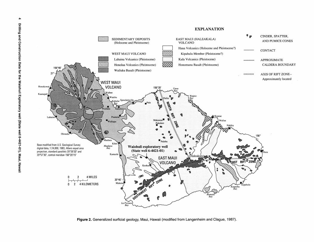
2. Generalized surficial geology, Maui, Hawaii.................................................... 4
3. Diagram showing construction details of the Waiohuli exploratory well (State well 6-4421-01),Maui, Hawaii ............................................................................ 5
4. Geologic log for the Waiohuli exploratory well (State well 6-4421-01), Maui, Hawaii...................... 6
TABLES
1. Location, altitude, and State number of the Waiohuli exploratory well, Maui, Hawaii.......................... 3
2. Lithologic descriptions of drill cuttings collected from Waiohuli exploratory well (State well 6-4421-01),Maui, Hawaii................................................................................ 7
3. Chemical analysis of selected rock cuttings collected during drilling of the Waiohuli exploratory well(State well 6-4421-01), Maui, Hawaii............................................................. 9
4. Water-level measurements from the Waiohuli exploratory well, Maui, Hawaii between September2001 and August 2002......................................................................... 10
CONVERSION FACTORS, ABBREVIATIONS, AND VERTICAL DATUM
Multiply By To obtain
inch (in.) 2.54 centimeterfoot (ft) 0.3048 meter
cubic foot per minute (ft3/min) 0.02832 cubic meter per minutegallon per minute (gal/min) 3.785 liter per minute
_____________mile, statute (mi)_________1.609_________kilometer_________________
AbbreviationsjuS/cm, microsiemens per centimeter at 25 degrees Celsius mg/L, milligrams per liter
DatumsVertical coordinate information is referenced relative to mean sea level.Horizontal coordinate information is referenced to the North American Datum of 1983 (NAD 83).
Contents iii

Drilling and Construction Data for the Waiohuli Exploratory Well (State Well 6-4421-01), Island of Maui, Hawaii
By Stephen B. Gingerich and David R. Sherrod
Abstract
The Waiohuli exploratory well, located on the western slope of Haleakala, Maui, Hawaii, was drilled in 2001 to investigate the hydrology and geology in an area where other well information was not available. The well was drilled from a ground altitude of about 1,864 feet and penetrated a 1,940-foot section of subaerial lava flows (con sisting of basanite, hawaiite, and alkalic basalt) with interbedded tephra. Water levels measured in the well ranged from about 5 to 6 feet above sea level.
INTRODUCTION
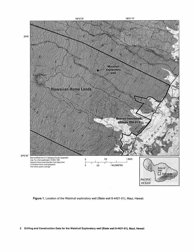
The Waiohuli exploratory well was drilled during April to August 2001 by the U.S. Geological Survey (USGS) in cooperation with the State of Hawaii Depart ment of Hawaiian Home Lands to explore the availabil ity of ground water and the geology on the western slope of Haleakala (also known as East Maui Volcano) (fig. 1). The objectives for drilling the well include determining (1) the water-table altitude in the area, (2) the salinity of water in the aquifer at the well, and (3) the subsurface geology of the area. The Department of Hawaiian Home Lands considers the Waiohuli area a potential site for future ground-water development.
This report documents (1) the well location, (2) drilling and well-construction information from the drillers, (3) geologic descriptions of the rock cuttings brought to the surface during drilling, (4) available water-level information, and (5) chloride concentration, specific conductance, and temperature of water in the well.
Site Selection
The exploratory well was sited in an area where no wells had been drilled and no subsurface information was available and is at least 5 mi from the nearest pumped wells. Site selection was also guided by (1) the need to have the well on public land for future access, (2) the need to have the well near a road for drilling equipment access, and (3) the need to avoid drilling near Puu O Kali because of the potential effects of drilling activity on threatened or endangered species and the possible geologic complications associated with the volcanic feature.
Location
The Waiohuli exploratory well is on ranchland leased from the State of Hawaii Department of Hawai ian Home Lands, about 1.7 mi west and downhill from the Kula Highway (State Road 37) on the western flank of Haleakala (fig. 2). The well is about 2,000 ft down- slope from the downhill end of Laueie Road, a new sub division road not yet shown on the topographic map. The well was assigned the well number 6-4421-01 by the State of Hawaii Commission on Water Resource Management using the State well-numbering system (table 1).
No perennial surface-water bodies lie within at least 4 mi of the well. The nearest intermittent stream valley is Waiohuli Gulch, about 0.1 mi south of the well. The well is about 5.4 mi inland from the western coast of east Maui.
Introduction 1
156°22'30" 156°21'15"
20°45'
20°42'30"
^Hawaiian Home Landsi I,-' f, I h. .1 / ,-' _J / , ; ,' »--'=;- ' j i ; \' ' \ I
Base modified from U.S. Geological Survey topographic map, Puu o Kali quadrangle,1:24,000,1992. Hawaiian Home Lands boundary from Department of Hawaiian Home Lands geographic information system coverage.
Figure 1. Location of the Waiohuli exploratory well (State well 6-4421-01), Maui, Hawaii.
2 Drilling and Construction Data for the Waiohuli Exploratory well (State well 6-4421-01), Maui, Hawaii

Table 1. Location, altitude, and State number of the Waiohuli exploratory well, Maui, Hawaii[Vertical datum is mean sea level; latitude and longitude measured using GPS (global positioning system) and referenced to NAD83 datum]
Latitude 20°44'07"N Longitude 156°21'55"WGround altitude at brass plate in 1,864.33 feet
concrete padMeasuring-point altitude at top of 1,867.56 feet
4-inch well casingDistance and direction from Keokea 2.2 miles north-
northwestDistance and direction from nearest 5.4 miles east
shorelineState well number 6-4421 -01
Geologic Setting
The Waiohuli exploratory well is located on the western flank of Haleakala, a broad shield volcano that forms the eastern part of the island of Maui. Haleakala was built chiefly by thousands of pahoehoe and aa lava flows erupted during the past 2 million years, the last 1 million years of which the flows erupted above sea level (Stearns and Macdonald, 1942). Consequently the drill hole penetrates almost entirely through lava flows. Additionally, tephra deposits are interbedded among the lava flows. Though generally thin, these deposits are as thick as 6 to 9 ft.
Two major stratigraphic units, the Kula Volcanics and the Hana Volcanics, are mapped at the surface on Haleakala's west flank (Stearns and Macdonald, 1942) (fig. 2). The Kula Volcanics comprises chiefly basanite and hawaiite lava in flows that were emplaced as aa. Pahoehoe is sparse. The Kula Volcanics unit represents the alkalic-cap stage of Hawaiian volcano evolution (Langenheim and Clague, 1987). Hana Volcanics is not found at the drill site.
A third stratigraphic unit, the Honomanu Basalt, is inferred to underlie the Kula Volcanics. Though not exposed on the volcano's west flank, the Honomanu Basalt is found in deep canyons on the north and possi bly the southeast side (Stearns and Macdonald, 1942). The Honomanu Basalt, containing both pahoehoe and aa lava flows, was emplaced as Haleakala progressed from its shield-building to alkalic-cap stage (Langen heim and Clague, 1987).
Acknowledgments
The drilling and construction of the Waiohuli exploratory well was made possible with the coopera tion and assistance of Darrell Yagodich, Carolyn Darr, and Daniel Ornellas of the Department of Hawaiian Home Lands and David Craddick of the Maui Depart ment of Water Supply.
DRILLING METHODS AND CONSTRUCTION
The well was bored by rotary drilling with an 7- 7/8-in.-diameter tungsten-carbide bit. Air and foam were injected down through the hollow drill stem and circulated back up the space between the stem and the well bore to remove water and cuttings from the hole. The Waiohuli exploratory well was drilled to a depth of 1,940 ft from an altitude of about 1,864 ft.
A 1,924-ft solid steel casing with a 4-in. inner diameter was installed and the bottom 90 ft was hand perforated to create a well screen. The altitude of a brass plate in a concrete pad surrounding the well is 1,864.33 ft and the altitude of the measuring point notched in the top of the steel well casing is 1,867.56 ft. The well alti tude was determined by leveling survey from a bench mark (National Geodetic Survey No. P23; alt. 2,954.61 ft) on the east side of a bridge along State Road 37 (fig. 1). Construction details of the finished well are shown in figure 3. Kimo Akina was the head of the USGS drill crew for well construction.
GEOLOGIC LOG
The geologic log (fig. 4) of the Waiohuli explor atory well was compiled from cuttings brought to the surface by the air and foam circulated through the well bore. Samples were collected at 5-ft depth intervals, then rinsed and dried before being examined at low- power magnification with a binocular microscope. Lithologic descriptions appear in table 2. The following terms refer to the percentage of phenocrysts found in the samples: slightly porphyritic, 1 to 3 percent; moderately porphyritic; 3 to 10 percent; highly porphyritic, 10 to 25 percent.
Drilling Methods and Construction 3
EXPLANATION
a oO
Ii
5<D
II
156°40'
Kaanapa!
SEDIMENTARY DEPOSITS (Holocene and Pleistocene)
EAST MAUI (HALEAKALA) VOLCANO
Hana Volcanics (Holocene and Pleistocene?)
Kipahulu Member (Pleistocene?)
Kula Volcanics (Pleistocene)
Honomanu Basalt (Pleistocene)
CINDER, SPATTER,
AND PUMICE CONES
WEST MAUI VOLCANO
Lahaina Volcanics (Pleistocene)
Honolua Volcanics (Pleistocene)
Wailuku Basalt (Pleistocene)
WEST MAUI VOLCANOWaihee
Waiehuahului Sprcckelsville Bov
Waiohuh exploratory well (State well 6-4421-01)
EAST MAUI VOLCANO.-
024 KILOMETERS
CONTACT
........... APPROXIMATE
CALDERA BOUNDARY
"nun AXIS OF RIFT ZONE-
Approximately located
156°
Base modified from U.S. Geological Survey digital data, 1:24,000,1983, Albers equal area projection, standard parallels 20°39'30" and 20°57'30", central meridian 156°20'15"
Kaapahu Bay
Kipahulu
Figure 2. Generalized surficial geology, Maui, Hawaii (modified from Langenheim and Clague, 1987).

4-inch concrete pad (4 feet by 4 feet)
1,867.56 feet altitude:r casing ^"""^
tonite seal ^^ outer casing ^^
et altitude: ^^ameter steel ^"~s lid wall
talttude: -^^ iameter ^""^ casing
it altitude: -^^ )etween e casing
<
£
**'
t altitude: \^ diameter ^""\ eel casing
« *_
v:
Wr Wr
1 1 1 1 1 1
1 1 1 1 1 1
Jn 1 1 1 I
1 1 1 1 1 1
I 1 1 I 1 1
I 1 1JJ L
/ ^^- Brass plate ^<C laltitnrip 1 RfidlWfp
-
Vi^tiWI^v^vj/ib])^ Ground surface
^ 17-inch hole
1,649 feet
^ 8-inch hole
5.58 feet - water level (September 27, 2001)
Mean sea level (datum)
^ about 20 feet of caved materia
Not to scale -76feet- bottom of hole
Figure 3. Diagram showing construction details of the Waiohuli exploratory well (State well 6-4421-01), Maui, Hawaii.
Geologic Log 5

INTERVAL SAMPLED FOR CHEMICAL ANALYSIS
ALTITUDE, INFEET ABOVE
MEAN SEA LEVEL
1,759-1,774
669-684
514-524
-1,864-1,854
1,444
1,379
1,324
Tephra, soil (silt too fine to wash)
Fine-grained aphyric or slightly porphyritic basanite
'I'll VoidNo recovery
Tephra (silt too fine to wash)
Fine- to medium-grained aphyric or slightly porphyritic basalt or basanite
/704 Tephra (silt too fine to wash)-684x_5g Coarse chips
Fine-to medium-grained aphyric or slightly porphyritic basalt or basanite
124
sea level
-76
COo
o
939 ? - -
oz o
Figure 4. Geologic log for the Waiohuli exploratory well (State well 6-4421-01), Maui, Hawaii.
6 Drilling and Construction Data for the Waiohuli Exploratory well (State well 6-4421-01), Maui, Hawaii

Table 2. Lithologic descriptions of drill cuttings from Waiohuli exploratory well (State well 6-4421 -01), Maui, Hawaii[Datum is mean sea level; depth measured from 1,864 feet above sea level; slightly porphyritic, 1 to 3 percent phenocrysts; moderately porphyritic, 3 to 10 percent phenocrysts; highly porphyritic, 10 to 25 percent phenocrysts]
Altitude (feet)
1,864
1,854
1,554
1,444
1,384
1,379
1,324
1,124
1,119
1,114
1,109
1,104
964
954
944
914
884
704
684
584
524
504
124
to
to
to
to
to
to
to
to
to
to
to
to
to
to
to
to
to
to
to
to
to
to
to
1,859
1,554
1,444
1,384
1,379
1,324
1,124
1,119
1,114
1,109
1,104
964
954
944
914
884
704
684
584
524
504
124
-76
Depth (feet)
0
10
310
420
480
485
540
740
745
750
755
760
900
910
920
950
980
1,160
1,180
1,280
1,340
1,360
1,740
to
to
to
to
to
to
to
to
to
to
to
to
to
to
to
to
to
to
to
to
to
to
to
5
310
420
480
485
540
740
745
750
755
760
900
910
920
950
980
1,160
1,180
1,280
1,340
1,360
1,740
1,940
Sample description1
dark-brown soil
dark-gray fresh aphyric to slightly porphyritic lava
No recovery due to void between 1,551-ft and 1,544-ft altitude
Medium-gray aphyric lava
Light-brownish gray grit-size lava chips
Light-brownish gray silt- to sand-size chips, probably weathered tephra
Medium-gray aphyric lava; some chips with sparse small olivine
Medium-gray lava; slightly olivine-bearing chips more abundant
Medium-gray lava; slightly olivine-bearing chips more abundant
Medium-gray lava, several chips moderately to highly porphyritic with olivine andclinopyroxene
Medium gray lava, 70 percent of chips aphyric, 30 percent moderately to highly porphyritic
Chiefly medium-gray aphyric lava, 20 percent with olivine phenocrysts 1 to 2 mm; rarelyplagioclase- or clinopyroxene-bearing
Medium-gray lava; 50 percent aphyric and 50 percent moderately plagioclase-phyric
Chiefly medium-gray aphyric lava, 20 percent porphyritic lava
Medium-gray lava, many chips moderately plagioclase-phyric, phenocrysts 1 to 2 mm
Medium-gray lava; abundance of plagioclase-bearing chips diminishes
Chiefly medium-gray aphyric lava; 10-20 percent moderately olivine-phyric lava and onlyscant plagioclase-phyric chips
Medium-gray silt- and sand-size matter
Chiefly medium-gray aphyric lava; 20 to 30 percent moderately olivine-phyric lava withscattered clinopyroxene phenocrysts
Chiefly medium-gray aphyric lava; 10 to 20 percent moderately olivine-phyric lava withscattered clinopyroxene phenocrysts
Medium-gray aphyric lava; 20 to 30 percent chips with small plagioclase phenocrysts
Medium-gray aphyric lava; 5 percent chips with plagioclase phenocrysts, 10 percent chipswith olivine and clinopyroxene phenocrysts
gray silt-size matter
Rotary-drilling cuttings lifted with air, foam, and polymer. Sample repository: U.S. Geological Survey, Hawaii District office.
Geologic Log 7

The Waiohuli well penetrates a 1,940-ft section of subaerial lava flows with interbedded tephra. The cut tings, generally fresh, range from massive to slightly vesicular basanite, hawaiite, and alkalic basalt. Specific compositions are not discernible in hand specimen but are based on chemical analyses from selected cuttings (table 3). Cuttings typically are medium gray in color, indicating that groundmass glass has not degraded extensively to clay minerals. Olivine phenocrysts range from oxidized to fresh, plagioclase is generally unal tered. Secondary mineralization is sparse to absent; opa line silica lightly coats some vesicle and fracture surfaces below 1,444-ft altitude. Tests using hydrochlo ric acid indicate almost no calcium carbonate as a sec ondary mineral.
Aphyric and slightly porphyritic lava predominate among the lava flows. Olivine-bearing lava, some mod erately to highly porphyritic, forms less than 20 percent of the sequence. Clinopyroxene accompanies olivine as a phenocryst phase in some flows. Moderately plagio- clase-bearing flows form less than 5 percent of the stratigraphic section penetrated by the drill stem. The porphyritic flows occur sporadically, never forming thick, homogeneous sequences as judged by their scant representation among cuttings from all depths.
Two discrete tephra sequences are presumed from cuttings collected at altitude intervals 1,379 to 1,324 ft and 704 to 684 ft. Material from these intervals is entirely silt to sand in size. In contrast, chips are com monly as large as 1 in. from other depth intervals where lava flows presumably dominate the sequence. Thin individual tephra beds between lava flows would be impossible to recognize in the drill cuttings. One void is mentioned in the driller's notes between altitudes of 1,551 to 1,544ft.
Medium-gray silt-sized cuttings were the only material returned from the 124- to -76-ft altitude inter val, the bottom 200 ft in the drill hole. It is unlikely that this extensive return of fine material represents 200 ft of tephra accumulation. The material is not beach sand or other fluvial or marine sediment. The driller's log shows no change in drilling procedures. Conceivably, the sequence below the 124-ft altitude comprises thin vesic ular pahoehoe lava flows pulverized by drilling. This extensive return of fine material is otherwise unex plained.
Eight chemical analyses were obtained from cut tings at selected intervals (table 3). Rock chips were
hand picked to obtain a petrographically uniform sam ple. However, the samples were composites and can not be shown to correspond to any single lava flow from the stratigraphic section. The sample collected from 524- to 514-ft altitude is slightly porphyritic with small pheno crysts of plagioclase and olivine. Similar chips are sparse to lacking from cuttings immediately above and below those depths, so this sample may come closest to representing a single lava flow. The sample collected from 1,324- to 1,314-ft altitude is from coarse chips collected beneath a zone of silt-size cuttings (tephra?). These aphyric chips are larger than those from shal lower parts of the hole and may therefore be from one or two flows at that depth. The boundary between the Kula Volcanics and the Honomanu Basalt is probably about 925 ft deep in the Waiohuli drill hole, or about the 939-ft altitude, on the basis of the chemical analyses (David R. Sherrod, U.S. Geological Survey, Hawaiian Volcanoes Observatory, written commun., 2002).
WATER-LEVEL AND WATER-QUALITY MEASUREMENTS
Water-level measurements made in the Waiohuli exploratory well between September 2001 and April 2002 ranged from 5.58 ft to 6.11 ft above sea level (table 4). A water sample, collected from the well on April 3, 2002, had a chloride concentration of 65.9 mg/L. The specific conductance of the water sample was 442 |0,S/cm and the temperature was 19.3°C. The sample was collected from several feet below the water surface using a bailer attached to a steel cable on an electric reel. The water-level altitude, measured with a 2,000-ft grad uated electric tape just prior to sampling, was 5.91 ft.
SUMMARY
The Waiohuli exploratory well (State well number 6-4421-01) is located on ranchland owned by the Department of Hawaiian Home Lands on the western slope of Haleakala. The well was constructed during April to August 2001 to study the hydrology and geol ogy in an area where no other well information was available. The altitude of a brass plate embedded in the concrete pad at the well is 1,864.33 feet above mean sea level and the well is 1,940 feet deep (bottom is at -76 feet altitude) and has a bore diameter of 7-7/8 in. A 1,924-ft solid steel casing with a 4-in. inner diameter
8 Drilling and Construction Data for the Waiohuli Exploratory well (State well 6-4421-01), Maui, Hawaii
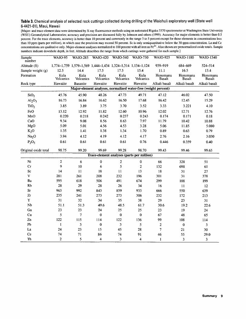
Table 3. Chemical analysis of selected rock cuttings collected during drilling of the Waiohuli exploratory well (State well 6-4421-01), Maui, Hawaii[Major- and trace-element data were determined by X-ray fluorescence methods using an automated Rigaku 3370 spectrometer at Washington State University (WSU) Geoanalytical Laboratories; accuracy and precision are discussed fully by Johnson and others (1999). Accuracy for major elements is better than 0.5 percent. For the trace elements, accuracy is better than 10 percent and commonly in the range 3 to 5 percent except for those elements in concentrations less than 10 ppm (parts per million), in which case the precision may exceed 50 percent. Sc is only semiquantitative below the 30-ppm concentration. La and Ce concentrations are qualitative only. Major-element analyses normalized to 100 percent with all iron as Fe2+ . Also shown are prenormalized oxide totals. Sample numbers indicate downhole depth, in feet. Altitude describes the range from which cuttings were gathered for each sample.]
Sample number
Altitude (ft)Sample weight (g)Formation
Rock type
WAIO-95
1,774-1,75912.5Kula
VolcanicsHawaiite
WAIO-285
1,579-1,56914.4Kula
VolcanicsBasanite
WAIO-420 WAIO-540
1,444-1,434 1,324-1,31417.5Kula
VolcanicsHawaiite
Major-element analyses,
SiO2
A1203
TiO2
FeOMnOCaOMgOK2O
Na2O
P205
Original oxide total
45.76
16.73
3.85
13.120.2209.345.091.35
3.94
0.61
98.75
45.90
16.84
3.89
12.920.2189.085.011.41
4.12
0.61
99.20
48.26
16.62
3.75
11.820.2428.564.561.38
4.19
0.61
99.69
17.5Kula
VolcanicsHawaiite
WAIO-730
1,134-1,12415.4Kula
VolcanicsHawaiite
WAIO-925
939-91911.1
Honomanu Basalt
Alkali basalt
WAIO-1180
684-66916.5
Honomanu Basalt
Alkali basalt
WAIO-1340
524-51413.4
Honomanu Basalt
Alkali basaltnormalized water-free (weight percent)
47.73
16.50
3.70
12.600.2378.634.531.34
4.12
0.61
99.28
49.71
17.68
3.52
10.960.2437.973.281.70
4.17
0.76
98.70
47.12
16.42
3.33
12.020.174
11.795.060.89
2.76
0.446
99.43
46.02
12.45
3.221
12.710.171
10.4211.850.63
2.16
0.359
99.46
47.50
15.29
4.10
12.760.18
10.885.0800.79
3.030
0.40
99.63Trace-element analyses (parts per million)
NiCrScVBaRbSrZrYNbGaCuZnPbLaCeTh
29
14281
595
28963235
3151.123
5122
12474
2
61011
261618
29992241
3251.323
7115
32371
5
06
18208506
28843273
3449.624
0114
01586
4
25
11232
491
26859273
3548.525
0122
34574
3
02
13196674
34933306
3861.725
0136
528914
66132
18301299
16666232
2930.6236799
27
461
328698
3131
18811
5501722319.21948
1080
2155
3
516127
378199
12639213
3122.62465
1143
3029.0
3
Summary 9

was installed and the bottom 90 ft was hand perforated to create a well screen. The Waiohuli exploratory well penetrated a 1,940-ft section of subaerial lava flows with interbedded tephra. On the basis of chemical ana lyses of eight samples of drill cuttings, the Honomanu Basalt/Kula Volcanics contact is placed at 939-ft alti tude.
Water-level measurements between September 2001 and April 2002 ranged from 5.58 ft to 6.11 ft above sea level. Water sampled from the well on April 3,2002 had a specific conductance of 442 |0,S/cm, a tem perature of 19.3°C, and a chloride concentration of 65.9 mg/L.
Table 4. Water-level measurements from the Waiohuli exploratory well (State well 6-4421 -01) Maui, Hawaii between September 2001 and August 2002[Datum is mean sea level]
Date and time Water level (feet)
September 27, 2001; 14:09 December 18, 2001; 11:10 February 14, 2002; 13:20 April3, 2002; 11:25 June 18, 2002; 11:20 August 22, 2002; 11:30
5.586.116.055.915.715.73
REFERENCES CITED
Johnson, D.M., Hooper, P.R., and Conrey, R.M., 1999, XRF analysis of rocks and minerals for major and trace ele ments on a single low dilution Li-tetraborate fused bead: Advances in X-ray Analysis, v. 41, p. 843-867.
Langenheim, V.A.M., and Clague, D.A., 1987, The Hawai ian-Emperor volcanic chain: stratigraphic framework of volcanic rocks of the Hawaiian islands, chap. 1 of Decker, R.W., Wright, T.L., and Stauffer, P.H., eds., Volcanism in Hawaii: U.S. Geological Survey Profes sional Paper 1350, v. 1, p. 55-84.
Stearns, H.T., and Macdonald, G.A., 1942, Geology and ground-water resources of the island of Maui, Hawaii: Territory of Hawaii, Division of Hydrography Bulletin 7, 344 p.
10 Drilling and Construction Data for the Waiohuli Exploratory well (State well 6-4421-01), Maui, Hawaii