Dredged Material Management Long Term Strategic Plan
92
Great Lakes and Ohio River Division U.S. Army Corps of Engineers Great Lakes System Dredged Material Management Long Term Strategic Plan April 2012
Transcript of Dredged Material Management Long Term Strategic Plan
Great Lakes and Ohio River Division U.S. Army Corps of Engineers
Great Lakes System
Dredged Material Management Long Term Strategic Plan
April 2012
i
Executive Summary The U.S. Army Corps of Engineers (Corps) recognizes that a Long Term Dredged Material Management Strategic Plan is necessary to anticipate and meet the challenges of maintaining a viable and sustainable Great Lakes Navigation System. Long term solutions, must address causal factors rather than only the ultimate accumulation of sediment in navigation channels. We need to look at ways to partner with agencies and stakeholders to reduce the amount of material entering the waterways through land-based conservation practices as well as new technology and beneficial use of sediment to expand the useful life of existing Dredged Material Disposal Facilities (DMDF) or Confined Disposal Facilities (CDFs). A new paradigm is needed as state and local governments recognize that they must participate in actively finding solutions to dredged material disposal and placement needs. Realizing that the continued economic viability of their harbors and ports depends in part on their ability and willingness to share the responsibility making suitable placement or disposal sites available, they must reconsider traditional but perhaps outmoded assumptions. An example of such initiative from a non federal sponsor is the Cleveland Harbor Dredging Task Force who is now starting to identify newly conceived options for interim dredged material placement. Secondly, the Long-Term Dredged Material Management Strategic Plan recognizes that CDFs are a necessary part of the solution, but additional approaches are needed. The U.S. Army Engineer Division Great Lakes and Ohio River (LRD) is seeking to extend the life of existing CDFs and defer the need to construct new facilities by:
- Prioritizing funding for fill management, such as routine raising of perimeter dikes to accommodate 1-2 dredging cycles and re-working the material in the CDFs to create additional capacity
- Emphasizing beneficial uses of dredged material (including reclaiming material
already deposited in CDFs for beneficial reuse) - Collaborating with partner agencies to leverage the Corps’ current programs
such as Great Lakes Tributary Modeling to ultimately reduce the amount of material entering watersheds that contribute to sedimentation in federally maintained navigation channels
- Engaging state agencies, U.S. Environmental Protection Agency (USEPA), and
U.S. Fish and Wildlife Service (USFWS) to participate in studies or expert elicitation to improve the scientific basis for establishing dredging environmental windows.
- Reinforcing the need for open-lake placement decisions that recognize the
Federal Standard to maintain efficiency of the Corps’ dredging program while protecting the environment.
ii
- Developing strategic alliances with the USEPA on Great Lakes Legacy Act and
Great Lakes Restoration Initiative to leverage the beneficial use of federal funding and authorities for both dredging and beneficial reuse of material.
- Joining forces with regional navigation and environmental stakeholders to gain
their ideas and support. This report, authored by the Great Lakes Navigation Team, was created to offer recommendations on the long term management of Great Lakes dredged material to the Great Lakes and Ohio River Division Commander.
iii
Table of Contents
Introduction: Great Lakes Navigation System 1
Historical Perspective of Great Lakes Dredged Material Management 1
The ‘Federal Standard’ for Dredged Material Disposal 2
Dredged Material Management Studies 4
Funding Process for Dredged Material Management Activities 5
Evaluation of Harbor Conditions 8
Current Dredged Material Placement Methods 12
1. Open Lake Placement 12
2. Beach Nourishment/Near Shore Placement 13
3. Upland Placement 13
4. Confined Disposal Facilities Placement 14
Dredged Material Placement on the Great Lakes 15
Dredged Material Management 21
Current Conditions 21
Dredged Material Management Strategies 24
1. Extend CDF Life through Fill Management 24
2. Create CDF Capacity through Beneficial Reuse and Use 25
3. Reduce Amount of Material Entering Federal Navigation Channels 25
4. Engage State Agencies in Solutions 26
5. Foster Partnership with USEPA to Leverage Funding for Projects Supporting Environmental Goals and Navigation Benefits. 27
Harbor Specific Dredged Material Management Strategies 29
Recommendations 30
APPENDIX A: Process for Identifying Impact Levels & Maintenance Priority
APPENDIX B: Dredged Material Management Plans: ER 1105‐2‐100
APPENDIX C: Great Lakes State Clean Water Act – Related Policies
APPENDIX D: Fact Sheets for Harbors w/ Critical Dredged Material Management Status
APPENDIX E: Regional Sediment Management Strategies
1
Introduction: Great Lakes Navigation System The U.S. Army Corps of Engineer Division of the Great Lakes and Ohio River (LRD) operates and maintains the U.S. portion of the Great Lakes Navigation System (GLNS) consisting of 140 projects (60 commercial and 80 shallow-draft), including three lock complexes, 104 miles of navigation structures, and over 600 miles of maintained navigation channels. The GLNS is a complex deepwater navigation system stretching 1,600 miles through all five Great Lakes and connecting channels from Duluth, Minnesota to Ogdensburg, New York. It is a non-linear system of interdependent locks, ports, harbors, navigational channels, dredged material disposal facilities, and navigation structures. The GLNS provides an estimated transportation rate savings benefit of $3.6 billion per year. Waterborne commerce is the most environmentally friendly and safest form of transportation of bulk commodities, producing lower emissions as well as lower damages to property and a reduction in fatal and non-fatal injuries when compared to transportation by truck or rail. A recent study concluded that pollution abatement savings resulting from the continued usage of the GLNS exceed $350 million annually. Property and bodily harm damages avoided from rail and truck accidents and congestion around the Great Lakes total $280 million annually. Each year the U.S. Army Corps of Engineers (Corps) dredges 2 to 5 million cubic yards of sediment from 25-50 federal harbors and projects in the Great Lakes. A little over half of the volume of material dredged on an annual basis is considered contaminated to the extent that it is unsuitable for open lake placement and must be placed in confined disposal facilities (CDFs). Although the proportion of clean sediment across the Great Lakes is increasing due to the success of decades of environmental efforts, state agencies involved in issuing water quality certifications have become less accepting of open-lake placement; therefore the Corps faces new challenges to corroborate open-lake placement or find alternate placement methods for dredged material. At the same time, many Corps CDFs are at or near capacity. The objective of this Dredged Material Management Long Term Strategic Plan is to address the challenges of maintaining a viable and sustainable Great Lakes Navigation System. The Challenges and active solutions are analyzed from an ecological, financial, and regional perspective. This document lays out a strategic direction that the Corps will pursue to solve the dredged material management challenge from a programmatic view as well as on a harbor-specific basis.
Historical Perspective of Great Lakes Dredged Material Management The U.S. portion of the GLNS includes 140 projects (60 commercial and 80 shallow-draft) and over 600 miles of maintained navigation channels. Prior to the 1970s, virtually all dredged material from the Great Lakes was discharged at established open water placement areas. With the advent of the environmental movement of the late 1960s, it became apparent that significant changes in pollution management practices had to be made to restore the nation’s waters. One of those practices was the largely unregulated placement of contaminated dredged materials in the open-waters of the Great Lakes.
2
In December of 1970, Congress passed the River and Harbor and Flood Control Act of 1970 (P.L. 91-611). Section 123 of that Act specifically authorized the USACE to construct, operate and maintain “spoil disposal” facilities on the Great Lakes for the confinement of dredged materials. Costs of facilities were to be borne by the federal government and a non-federal sponsor. The need for a particular CDF was to be established in conjunction with the USEPA and the affected states and local entities. Further, Section 123 stated that spoil facilities were to be established for a period not to exceed 10 years. The assumption at the time was that after 10 years, the nation’s waters would be sufficiently restored such that dredged material would no longer require confined disposal. Amendments to that authority extended the timeframe in which CDFs could continue to be operated by the Corps. Since the mid-1970s, the Corps has constructed and/or operated 45 CDFs for Great Lakes harbors and channels at a cost of nearly $900 million (in 2009 dollars). Most of this construction occurred between 1974 and 1980. There are currently 20 actively used CDFs which are, on a cumulative basis, 80 percent full. Section 201 of the Water Resource Development Act (WRDA) created a national program for the construction of CDFs. This authority specified uniform cost-sharing requirements for all future CDFs. The non-federal cost share is based on the depth of the navigation channel. For deep draft channels on the Great Lakes (greater than 18 feet and less than 45 feet), the non-federal sponsor must provide 25 percent of CDF construction costs, plus an additional 10 percent (paid over as long as 30 years) against which all lands, easements, rights-of-way and relocations may be credited.
The ‘Federal Standard’ for Dredged Material Disposal In 1988, the Corps promulgated a regulation (33 CFR Part 335.7) which provides:
the ‘Federal Standard’ means the dredged material disposal alternative or alternatives identified by the Corps which represent the least costly alternatives consistent with sound engineering practices and meeting the environmental standards established by the 404(b)(1) evaluation process…
Dredged material testing and evaluation manuals to support Section 404(b)(1) evaluations have been developed by USEPA and the Corps at national and regional (Great Lakes) levels. The guidance prescribed in these manuals uses a chemical and biological effects-based sediment testing approach, as an integral part of the greater Section 404(b)(1) Evaluation, to determine which general method of placement or dredged material disposal is environmentally acceptable relative to waters of the U.S. (including the Great Lakes). There are four basic options for placement of dredged material depending on impacts from Contaminants of Concern:
(1) Open-Water (2) Soil Grade: upland placement, as unrestricted soil (3) Fill Grade: upland placement, as regulated fill
3
(4) Impaired: placed in a CDF, and managed under CWA authority if located in the near-shore zone.
This document, however, may combine Categories 2 and 3 into “soil or fill grade material” to portray three options to simplify further discussion and displays, especially from a regional viewpoint. Whatever method of disposal is determined to be environmentally acceptable by this process goes toward the formulation of the Federal Standard. As applied by LRD the Federal Standard refers to the dredged material disposal alternative identified by the Corps that represents the least cost consistent with sound engineering practices and selected through the Section 404(b)(1) Guidelines. While often used interchangeably with the Federal Standard, the ‘Base Plan’ includes additional consideration of site-specific impacts. In practice, the Federal Standard determines which of the three general approaches for dredged material management can be used for dredging at a given site (open-water, confined, or upland confined); the least cost, environmentally acceptable alternative that satisfies the Federal Standard is the Base Plan. Determination of the Federal Standard and corresponding ‘Base Plan’ is a critical step in the project decision-making process. The Base Plan defines the benchmark for discussions with the states on the financial limits of Federal participation in dredged material placement. While often synonymous with the Federal Standard, the Base Plan may include consideration of other site-specific impacts. There may be several alternatives that are consistent with the Federal Standard for how to manage the dredged material, but only one can constitute the Base Plan. If a state or local government imposes restrictions that are more costly than the Base Plan, generally, the additional costs may be the responsibility of non-federal interests; 33 CFR 337.2 provides the following guidance:
(a) District engineers should cooperate to the maximum extent practicable with state agencies to prevent violation of Federally approved state water quality standards and to achieve consistency to the maximum degree practicable with an approved coastal zone management program.
(b) If the state agency imposes conditions or requirements which exceed those needed to meet the Federal standard, the district engineer should determine and consider the state's rationale and provide to the state information addressing why the alternative which represents the Federal standard is environmentally acceptable. The district engineer will accommodate the state's concerns to the extent practicable. However, if a state agency attempts to impose conditions or controls which, in the district engineer’s opinion, cannot reasonably be accommodated, the following procedures will be followed:
(1) In situations where an agency requires monitoring or testing, the district engineer will strive to reach an agreement with the agency on a data acquisition program. The district engineer will use the technical
4
manual “Management Strategy for Disposal of Dredged Material: Contaminant Testing and Controls” or its appropriate updated version as a guide for developing the appropriate tests to be conducted. If the agency insists on requirements which, in the opinion of the district engineer, exceed those required in establishment of the Federal standard, the agency will be asked to fund the difference in cost. If the agency agrees to fund the difference in cost, the district engineer will comply with the request. If the agency does not fund the additional cost, the district engineer will follow the guidance in paragraph (b) (3) of this section.
(2) When an agency requires special conditions or implementation of an alternative which the Federal standard does not, district engineers will proceed as follows: In those cases where the project authorization requires a local sponsor to provide suitable disposal areas, disposal areas must be made available by a sponsor before dredging proceeds. In other cases where there are no local sponsor requirements to provide disposal areas, the state or the prospective local sponsor will be advised that, unless the state or the sponsor provides suitable disposal areas, the added Federal cost of providing these disposal areas will affect the priority of performing dredging on that project. In either case, states will be made aware that additional costs to meet state standards or the requirements of the coastal zone management program which exceed those necessary in establishment of the Federal standard may cause the project to become economically unjustified.
(3) If the state denies or notifies the district engineer of its intent to deny water quality certification or does not concur regarding coastal zone consistency, the project dredging may be deferred.
Application of the Federal Standard levels the playing field for Corps dredging project costs among states having disparate policies and requirements on dredged material management. A state that by law or policy prohibits open-water placement regardless of testing and evaluation of its suitability may have to pay all costs above those associated with the Base Plan (which was derived from the available alternatives consistent with the Federal Standard determination). The current USEPA/Corps testing and evaluation protocol for dredged material that are used to support the development of the Federal Standard are currently under revision. Revised guidance at the regional level (i.e., Great Lakes) for open water placement may take effect as early as 2013. The guidelines may be more restrictive than those that currently apply, further limiting placement options.
Dredged Material Management Studies Requirements for Dredged Material Management Plans are described in Corps regulation ER 1105-2-100, Appendix B.
5
All Federally maintained navigation projects must demonstrate that there is sufficient dredged material disposal capacity for a minimum of 20 years. A preliminary assessment is required for all Federal navigation projects to document the continued viability of the project and the availability of dredged material disposal capacity sufficient to accommodate 20 years of maintenance dredging. If the preliminary assessment determines that there is not sufficient capacity to accommodate maintenance dredging for the next 20 years, then a dredged material management study must be performed (p. E-68). More detailed guidance is provided on page E-71: Management Plan development shall proceed in the following phases: (1) Preliminary Assessment. Preliminary assessments establish whether more detailed study is required to establish a management plan, and, if so, provides information to justify the study and permit its prioritization in the budgetary process. For many projects with readily available maintenance and usage information, a preliminary assessment, based on indicators such as annual Operation and Maintenance (O&M) costs per ton of cargo, volume and frequency of traffic, and vessel dimensions, may establish the Base Plan and confirm that continued maintenance appears to be warranted. Where these conditions are met, the findings of the Preliminary Assessment would complete the requirement for a Management Plan. Where these conditions are not met, the Preliminary Assessment will recommend a Management Plan Study. (2) Management Plan Studies. A Management Plan Study shall be required to establish the Base Plan and the recommended Plan if basic indicators are inconclusive, or if attempts to define the Base Plan disclose significant problems, a major new investment, or other significant increase in maintenance costs. For example, the provision of a new confined disposal facility or use of more distant ocean disposal site would trigger this requirement. Management Plan studies shall be conducted in two phases: initial and final. The initial phase concentrates on developing a detailed scope of work, and the final phase executes that scope of work.”
Funding Process for Dredged Material Management Activities Budgets established by the Corps for O&M of dredged material management facilities and activities are set annually during the budgeting process. In general, Districts recommend budget amounts to the Great Lakes Navigation Team, who rolls up the recommendation to LRD, who then rolls it up to Corps Headquarters. Office of Management and Budget makes a determination on funding levels and the budget is ultimately released by the President in February of the year preceding the fiscal year in question. The individual line items ultimately funded in the President’s Budget are determined by many factors, which include risk and return on investment. For the purpose of budget development, different performance metrics are used to prioritize work packages. In addition to, and consistent with, the performance measures provided in the Corps budget guidance, the Great Lakes system program uses the current shoaling depth in harbors and channels, transportation rate savings (the savings
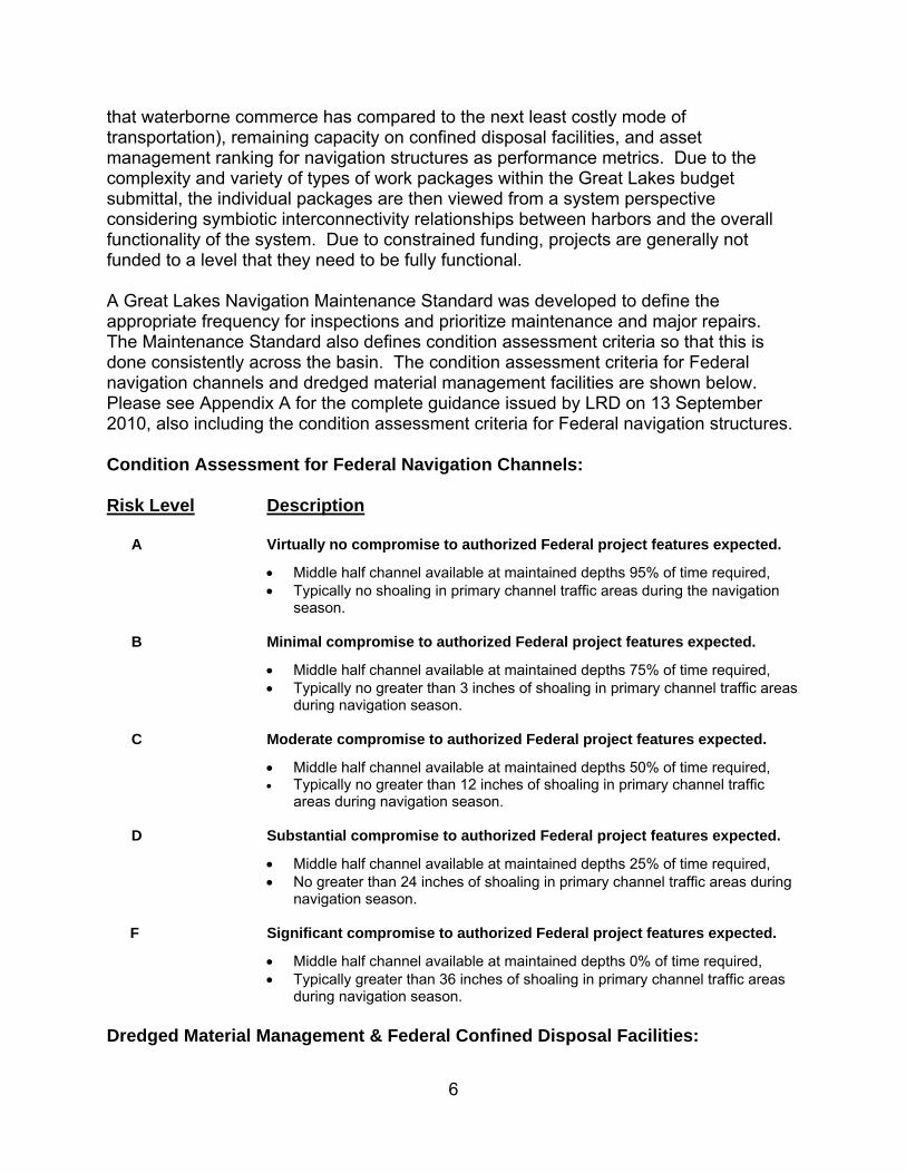
6
that waterborne commerce has compared to the next least costly mode of transportation), remaining capacity on confined disposal facilities, and asset management ranking for navigation structures as performance metrics. Due to the complexity and variety of types of work packages within the Great Lakes budget submittal, the individual packages are then viewed from a system perspective considering symbiotic interconnectivity relationships between harbors and the overall functionality of the system. Due to constrained funding, projects are generally not funded to a level that they need to be fully functional. A Great Lakes Navigation Maintenance Standard was developed to define the appropriate frequency for inspections and prioritize maintenance and major repairs. The Maintenance Standard also defines condition assessment criteria so that this is done consistently across the basin. The condition assessment criteria for Federal navigation channels and dredged material management facilities are shown below. Please see Appendix A for the complete guidance issued by LRD on 13 September 2010, also including the condition assessment criteria for Federal navigation structures. Condition Assessment for Federal Navigation Channels: Risk Level Description A Virtually no compromise to authorized Federal project features expected.
Middle half channel available at maintained depths 95% of time required, Typically no shoaling in primary channel traffic areas during the navigation
season. B Minimal compromise to authorized Federal project features expected.
Middle half channel available at maintained depths 75% of time required, Typically no greater than 3 inches of shoaling in primary channel traffic areas
during navigation season. C Moderate compromise to authorized Federal project features expected.
Middle half channel available at maintained depths 50% of time required, Typically no greater than 12 inches of shoaling in primary channel traffic
areas during navigation season. D Substantial compromise to authorized Federal project features expected.
Middle half channel available at maintained depths 25% of time required, No greater than 24 inches of shoaling in primary channel traffic areas during
navigation season.
F Significant compromise to authorized Federal project features expected.
Middle half channel available at maintained depths 0% of time required, Typically greater than 36 inches of shoaling in primary channel traffic areas
during navigation season.
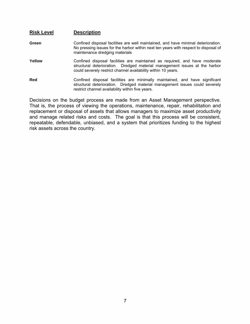
Dredged Material Management & Federal Confined Disposal Facilities:
7
Risk Level Description Green Confined disposal facilities are well maintained, and have minimal deterioration.
No pressing issues for the harbor within next ten years with respect to disposal of maintenance dredging materials
Yellow Confined disposal facilities are maintained as required, and have moderate
structural deterioration. Dredged material management issues at the harbor could severely restrict channel availability within 10 years.
Red Confined disposal facilities are minimally maintained, and have significant
structural deterioration. Dredged material management issues could severely restrict channel availability within five years.
Decisions on the budget process are made from an Asset Management perspective. That is, the process of viewing the operations, maintenance, repair, rehabilitation and replacement or disposal of assets that allows managers to maximize asset productivity and manage related risks and costs. The goal is that this process will be consistent, repeatable, defendable, unbiased, and a system that prioritizes funding to the highest risk assets across the country.
8
Evaluation of Harbor Conditions Although the proportion of sediments that meets Federal guidelines for open-lake placement across the Great Lakes is increasing due to the success of decades of environmental abatement efforts, States have generally become less accepting of open-lake placement as a dredged material management practice. Depending on the State, this position may be the result of policy, executive directive or law. The practice in general is also not well perceived by the public despite scientific evidence showing that it is environmentally acceptable. At the same time, bulk concentration criteria (as a general measure of sediment contamination) for many contaminants in Great Lakes dredged material have become lower and increasingly more restrictive over time. Bulk sediment concentrations for polychlorinated biphenyls (PCBs) were selected as an example to demonstrate this for several reasons:
(1) PCBs are a typical contaminant analyzed in most USACE Great Lakes harbor sediments
(2) PCBs are often suspected as a contaminant of concern (3) PCBs are relatively persistent in the environment (4) bulk sediment criteria for PCBs can be shown to have changed over
time (5) current PCB criteria depend heavily on site-specific measured
‘bioaccumulation’ in bottom-dwelling organisms Bioaccumulation can be related to a bulk sediment concentration. The toxicity of other contaminants [e.g., metals, polycyclic aromatic hydrocarbons [PAHs], pesticides] is often evaluated using solid phase toxicity tests (nor bioaccumulation tests) that assess all contaminants in sediment as a whole, and thus do not determine a specific cause or concentration of toxicity. Trends in bulk sediment criteria for other contaminants over time differ, and may or may not be similar to those deciphered for PCBs. At this time, the initial criterion for any contaminant in Great Lakes dredged material is a bulk concentration at the dispersive open-lake placement area, which can vary widely depending on the harbor and lake. Since the initial passage of the Clean Water Act in 1972, Federal criteria for total PCBs concentrations in dredged material, in terms of suitability for open-water placement, have changed several times. These criteria have been in the form of U.S. Environmental Protection Agency (USEPA)-led guidelines and policy, all of which were phased in and out over a number of years. None were promulgated. The following is a description of these criteria starting in 1977:
a. “Jensen Criteria” (1977- ~1989): This criterion of 10 mg/kg was a USEPA-Region 5 guideline. It was intended to be interim in nature and could include (but did not necessarily require) confined aquatic disposal of dredged material containing total PCBs concentrations of 10 mg/kg (or less).
9
b. USEPA, Region 5 letters (mainly 1989) to USACE-Buffalo District with respect to Ashtabula Harbor dredged material (~1989- ~1993): A criterion of 1 mg/kg was a USEPA policy relative to material dredged from Ashtabula Harbor, Ohio. Since PCBs have not been a contaminant of concern at many Great Lakes harbors (in terms of proposed open-lake placement) and Ashtabula Harbor has served in essence as a test case for the management of PCBs in Great Lakes dredged material, it was selected to represent a general criterion for Great Lakes harbor dredged material. This criterion was phased in while the former “Jensen Criteria” containing the 10 mg/kg guideline was phased out.
c. Great Lakes Dredged Material Testing and Evaluation Manual (~1993-present): USEPA/Corps guidelines under Section 404 of the Clean Water Act require the Corps to make open-water dredged material management decisions using a tiered, biological effects-based testing approach. This approach includes initial bulk sediment screening relative to placement area sediments and toxicity (bioassay) and bioaccumulation testing (potential precursors to biological testing are toxicity modeling) (USEPA/U.S. Army Corps of Engineers [USACE] 1998). The reasons for this approach are founded in sound science. For example, bioassay tests reflect the combined effects of all sediment-associated contaminants (e.g. concentrations, bioavailability, interactions), including for those not tested for, and bioaccumulation test can be used to determine the true bioavailability of a contaminant.
A criterion of approximately 0.1 mg/kg is indirectly based on USEPA/Corps guidelines. The 0.1 mg/kg criteria is based on the reasonable technical assumption that bioaccumulation is the most appropriate biological measurement endpoint to evaluate PCBs toxicity in the aquatic environs. Using predictive modeling and general toxicological risk assessment, these criteria across the Great Lakes would not be expected to fall much outside the range of 0.1 to 0.3 mg/kg. This approximated value of 0.1 mg/kg represents the low end of the range and is based on the use of a bioaccumulation multiplier for Ashtabula Harbor sediments linked to Lake Erie sediment PCBs tissue residues at the benthic level. Harbor and lake sediments used in the projection were gauged to be generally representative of other Great Lakes sediments and harbor dredged material (e.g., lake sediment bioaccumulation of total PCBs, harbor total organic carbon [TOC] content, harbor PCBs bioavailability). These three criteria are presented over time in Table 1.
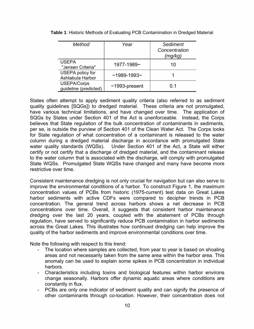
10
Table 1: Historic Methods of Evaluating PCB Contamination in Dredged Material
Method Year Sediment Concentration
(mg/kg) USEPA "Jensen Criteria" 1977-1989~ 10
USEPA policy for Ashtabula Harbor ~1989-1993~ 1
USEPA/Corps guideline (predicted) ~1993-present 0.1
States often attempt to apply sediment quality criteria (also referred to as sediment quality guidelines [SQGs]) to dredged material. These criteria are not promulgated, have various technical limitations, and have changed over time. The application of SQGs by States under Section 401 of the Act is unenforceable. Instead, the Corps believes that State regulation of the bulk concentration of contaminants in sediments, per se, is outside the purview of Section 401 of the Clean Water Act. The Corps looks for State regulation of what concentration of a contaminant is released to the water column during a dredged material discharge in accordance with promulgated State water quality standards (WQSs). Under Section 401 of the Act, a State will either certify or not certify that a discharge of dredged material, and the contaminant release to the water column that is associated with the discharge, will comply with promulgated State WQSs. Promulgated State WQSs have changed and many have become more restrictive over time. Consistent maintenance dredging is not only crucial for navigation but can also serve to improve the environmental conditions of a harbor. To construct Figure 1, the maximum concentration values of PCBs from historic (1975-current) test data on Great Lakes harbor sediments with active CDFs were compared to decipher trends in PCB concentration. The general trend across harbors shows a net decrease in PCB concentrations over time. Overall, it suggests that consistent harbor maintenance dredging over the last 20 years, coupled with the abatement of PCBs through regulation, have served to significantly reduce PCB contamination in harbor sediments across the Great Lakes. This illustrates how continued dredging can help improve the quality of the harbor sediments and improve environmental conditions over time. Note the following with respect to this trend:
- The location where samples are collected, from year to year is based on shoaling areas and not necessarily taken from the same area within the harbor area. This anomaly can be used to explain some spikes in PCB concentration in individual harbors.
- Characteristics including toxins and biological features within harbor environs change seasonally. Harbors offer dynamic aquatic areas where conditions are constantly in flux.
- PCBs are only one indicator of sediment quality and can signify the presence of other contaminants through co-location. However, their concentration does not
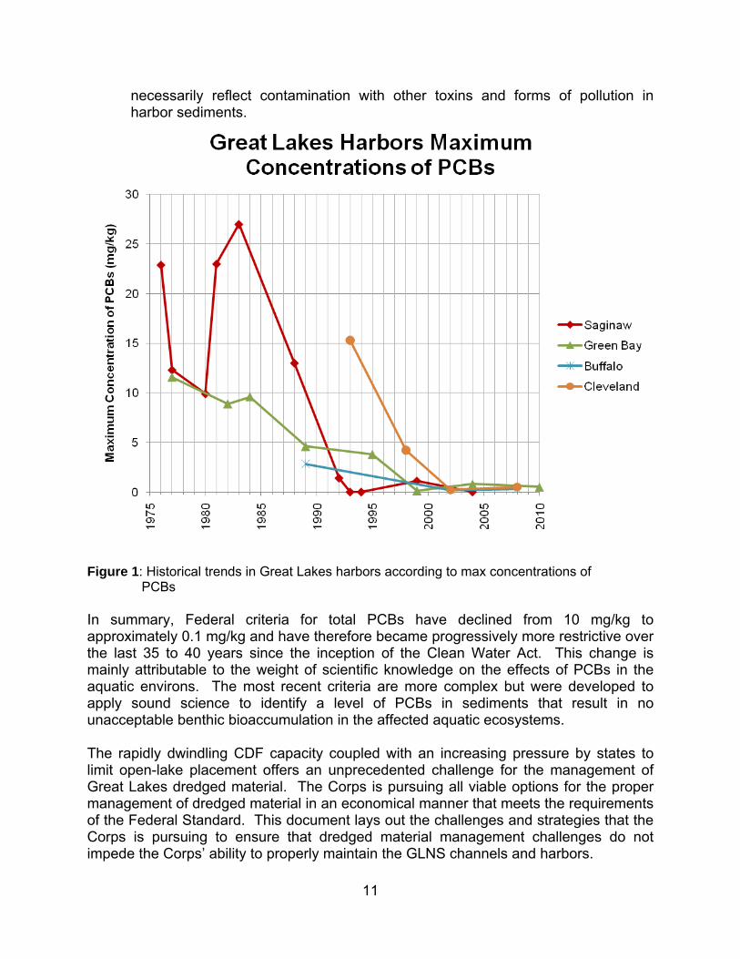
11
necessarily reflect contamination with other toxins and forms of pollution in harbor sediments.
Figure 1: Historical trends in Great Lakes harbors according to max concentrations of
PCBs In summary, Federal criteria for total PCBs have declined from 10 mg/kg to approximately 0.1 mg/kg and have therefore became progressively more restrictive over the last 35 to 40 years since the inception of the Clean Water Act. This change is mainly attributable to the weight of scientific knowledge on the effects of PCBs in the aquatic environs. The most recent criteria are more complex but were developed to apply sound science to identify a level of PCBs in sediments that result in no unacceptable benthic bioaccumulation in the affected aquatic ecosystems. The rapidly dwindling CDF capacity coupled with an increasing pressure by states to limit open-lake placement offers an unprecedented challenge for the management of Great Lakes dredged material. The Corps is pursuing all viable options for the proper management of dredged material in an economical manner that meets the requirements of the Federal Standard. This document lays out the challenges and strategies that the Corps is pursuing to ensure that dredged material management challenges do not impede the Corps’ ability to properly maintain the GLNS channels and harbors.
12
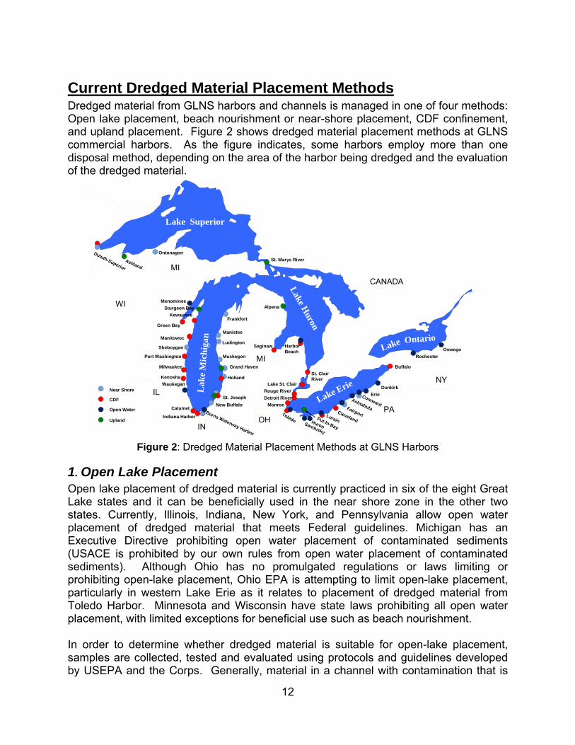
Current Dredged Material Placement Methods Dredged material from GLNS harbors and channels is managed in one of four methods: Open lake placement, beach nourishment or near-shore placement, CDF confinement, and upland placement. Figure 2 shows dredged material placement methods at GLNS commercial harbors. As the figure indicates, some harbors employ more than one disposal method, depending on the area of the harbor being dredged and the evaluation of the dredged material.
Lake Superior
Lak
e M
ichi
gan
Lake H
uron
Lake Erie
Lake Ontario
MI
MI
NY
PA
IL
WI
IN
CANADA
OH
Rochester
Oswego
Buffalo
Dunkirk
ErieAshtabula
ConneautFairport
ClevelandLorainHuron
Sandusky
Toledo
Monroe
Rouge River
Detroit River
Lake St. Clair
St. Clair River
Harbor Beach
Saginaw
Alpena
Frankfort
Manistee
Ludington
Muskegon
Holland
Grand Haven
St. Joseph
Burns Waterway Harbor
Indiana Harbor
Calumet
Waukegan
Milwaukee
Port Washington
Sheboygan
Manitowoc
Green Bay
Kewaunee
Sturgeon Bay
Menominee
St. Marys River
Ontonagon
Ashland
Duluth-Superior
Near Shore
CDF
Open Water
Upland
Kenosha
New Buffalo
Put-In-Bay
Figure 2: Dredged Material Placement Methods at GLNS Harbors
1. Open Lake Placement Open lake placement of dredged material is currently practiced in six of the eight Great Lake states and it can be beneficially used in the near shore zone in the other two states. Currently, Illinois, Indiana, New York, and Pennsylvania allow open water placement of dredged material that meets Federal guidelines. Michigan has an Executive Directive prohibiting open water placement of contaminated sediments (USACE is prohibited by our own rules from open water placement of contaminated sediments). Although Ohio has no promulgated regulations or laws limiting or prohibiting open-lake placement, Ohio EPA is attempting to limit open-lake placement, particularly in western Lake Erie as it relates to placement of dredged material from Toledo Harbor. Minnesota and Wisconsin have state laws prohibiting all open water placement, with limited exceptions for beneficial use such as beach nourishment. In order to determine whether dredged material is suitable for open-lake placement, samples are collected, tested and evaluated using protocols and guidelines developed by USEPA and the Corps. Generally, material in a channel with contamination that is
13
toxicologically comparable to existing lake bottom sediments/substrate at a specified disposal site is determined to be suitable for open-lake placement or for a variety of beneficial uses that are addressed in the subsequent “Near Shore/Beach Nourishments” section. Despite the fact that information and testing may demonstrate a given dredged material to be suitable for open-lake placement, some states object to it as a placement option based on rationale such as the potential impact on lake bottom habitat. Additional information regarding individual Great Lakes State’s Clean Water Act related policies concerning open-water placement of dredged material is included in Appendix C.
2. Beach Nourishment/Near Shore Placement Dredged material that is determined to be suitable for open lake placement can be disposed of using one of several beneficial uses. If the material is predominantly coarse-grain (e.g., sandy), it can be placed in the near-shore or directly on the beach as a form of beach nourishment. The composition of sediments in some areas of the upper Great Lakes is generally sandier and therefore can be highly desired for beach fill and other beneficial uses; the composition of sediments in Lake Erie has higher silt content and is therefore less desirable for beneficial use. Numerous shallow draft, primarily recreational harbors are dredged on an intermittent basis when Congress has appropriated funds. Dredged material in these harbors is frequently coarse-grain and is placed nearby in the littoral zone as beach nourishment at a Federal cost that does not exceed placement in a suitable open-lake site.
3. Upland Placement Provided the dredged material is not contaminated, material can also be placed upland, such as in a farm field, construction site, or mine reclamation area. At a number of harbors in Michigan and Wisconsin, upland placement is often cost comparable to open-lake placement and are the preferred methods of placement of dredged material. Generally, the dredging areas at these projects are relatively close to an upland placement site as opposed to being many miles from an open-water site. Variations in dredged material quality between dredging cycles must also be taken into consideration; on several occasions sediment that had been deemed suitable for upland placement during one dredging cycle was deemed unsuitable during the next dredge cycle and vice versa.
14
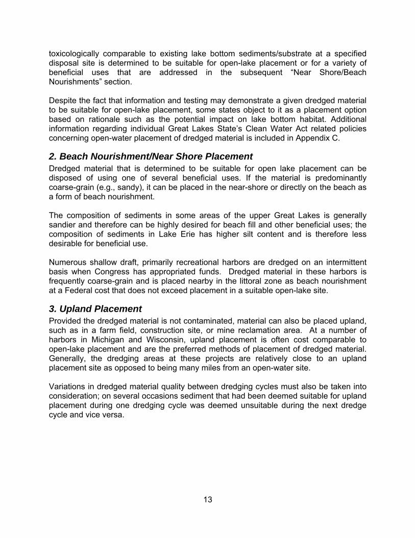
4. Confined Disposal Facilities Placement A CDF is a structure designed and constructed to contain contaminated dredged material in a manner that complies with applicable environmental laws and regulations. The first CDF on the Great Lakes was constructed in 1960 prior to the Clean Water Act. Since then, the Corps has constructed and/or operated 45 CDFs for Great Lakes harbors and channels at a cost of more than $300 million (not adjusted for inflation). The Great Lakes currently has 20 active CDFs. CDFs are built with dikes to contain the dredged material. Some facilities are built in water with stone dikes (as seen in Figure 5) and some are upland with earthen dikes. Almost all of the aforementioned CDFs have been planned, sited, and designed in partnership with a non-federal sponsor such as states, local governments, and or port authorities. The size, shape, and design of individual CDFs have been selected to fit dredging needs of harbor(s) and channel(s) served physical and chemical characteristics of dredged material, local conditions and resources, and interests of non-federal sponsors. CDFs have been planned and sited with full opportunity for public and agency review and input. The impacts of CDFs on the physical, chemical, biological, and socio-economic resources of the Great Lakes have been both positive and negative. Negative impacts include the loss of aquatic habitat from CDF construction, increased water turbidity during construction, and some increased exposure to contaminants for fish and wildlife that use the CDF for habitat. CDFs being filled with dredged material often support dense vegetation due to the nutrient rich sediments. The positive impacts of CDFs include the continued safe transport of people, goods and materials at Great Lakes harbors and channels. Commercial and recreational use of these waterways is a major contributor to the national and regional economies as well as the history and social identity of many communities along the Great Lakes shoreline. Some CDFs have also created new lands along the
Figure 3: Huron Harbor CDF, constructed in 1975, is a good example of “in-water” CDF
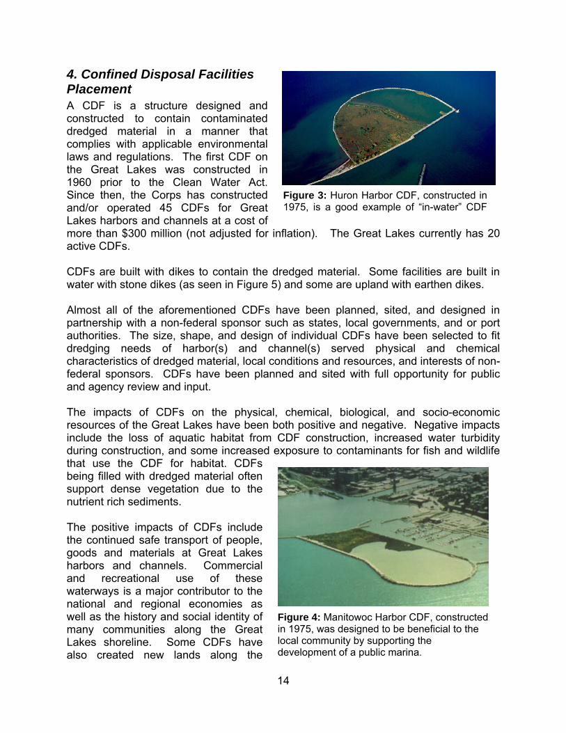
Figure 4: Manitowoc Harbor CDF, constructed in 1975, was designed to be beneficial to the local community by supporting the development of a public marina.

15
shoreline that have been used to support waterfront and recreational development plans. For example, as seen in Figure 6, the CDF in Manitowoc, WI, was designed to provide protection for and support the development of a public marina. In Milwaukee, a high-speed lake ferry service was built on a portion of a closed CDF. Confined Disposal Facilities like the Detroit River Pointe Mouille, Cleveland Harbor Dike 14 and Buffalo Harbor Times Beach serve as wildlife habitats. A Report to Congress prepared by the Corps and USEPA in 2005 concluded that overall impacts of CDFs on the Great Lakes were significantly positive. It was cited that CDFs enabled the removal and containment of over 90 million cubic yards of contaminated sediments from rivers and harbors. As a result, exposure of fish and wildlife to contaminants has been decreased and the likelihood of contaminants being washed into the lake and spread over an even greater area has been eliminated. The federal government made a very large investment of almost $1 billion (2009 dollars) to create CDFs to dispose of dredged material that is not suitable for open-lake placement. However, most of that investment was made over 30 years ago. With the existing active CDFs being cumulatively 80 percent full, the Corps is striving to prolong CDF service life by emphasizing dredged material recycling (removing material from the CDF for a beneficial use) and fill management activities (dike raising and material management within the CDF). Section 148 of Public Law 94-587 requires the Corps to use and encourage the use of management practices to extend the useful life of CDFs such that the need for new facilities is kept to a minimum. Further, understanding the reality of the high construction costs for new CDFs, the Corps is focusing on maximizing other methods of dredged material management with new CDFs being planned on a more limited basis.
Dredged Material Placement on the Great Lakes It is important to understand how, where, and why dredged material is placed around the Great Lakes. Figure 5 shows the dredged material placement methods used at harbors on the GLNS: 45% of harbors utilize near shore placement, 28% of harbors utilize CDFs, 25% of harbors use open lake placement, and 16% of harbors employ upland placement.
Figure 5: Dredged Material Placement Method Usage at GLNS Harbors (Percentage)
16
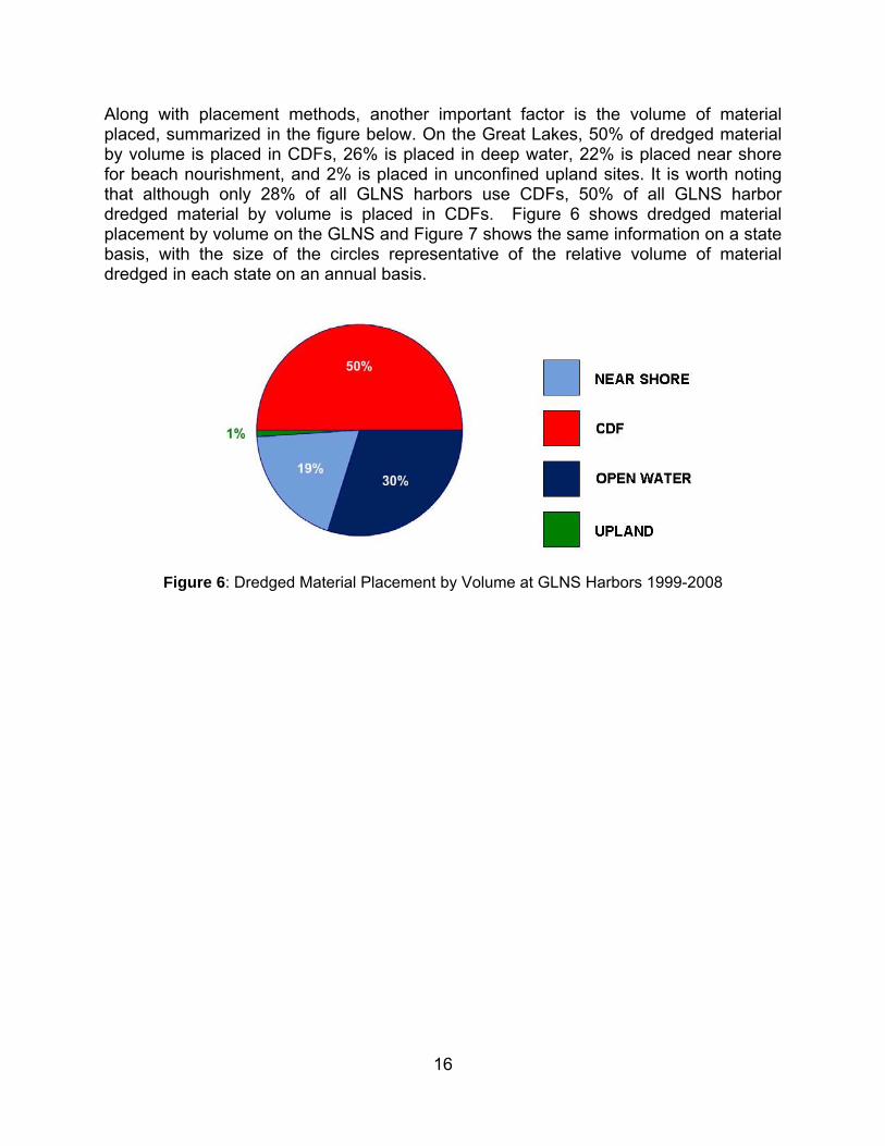
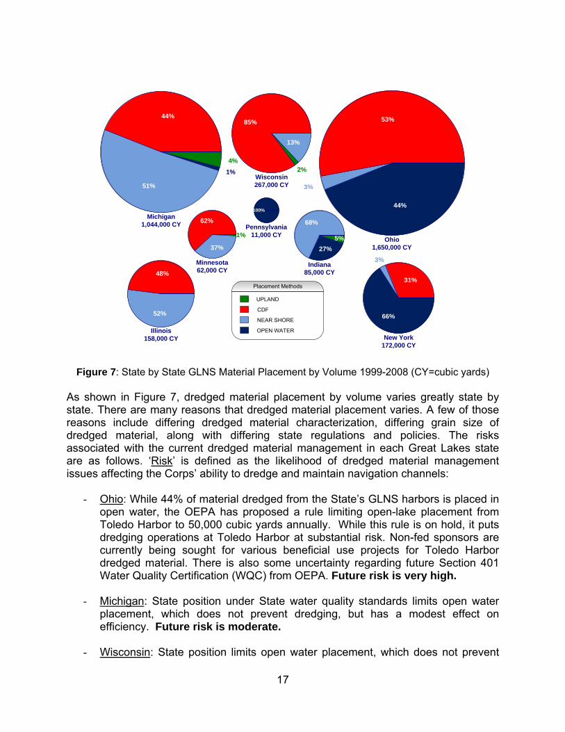
Along with placement methods, another important factor is the volume of material placed, summarized in the figure below. On the Great Lakes, 50% of dredged material by volume is placed in CDFs, 26% is placed in deep water, 22% is placed near shore for beach nourishment, and 2% is placed in unconfined upland sites. It is worth noting that although only 28% of all GLNS harbors use CDFs, 50% of all GLNS harbor dredged material by volume is placed in CDFs. Figure 6 shows dredged material placement by volume on the GLNS and Figure 7 shows the same information on a state basis, with the size of the circles representative of the relative volume of material dredged in each state on an annual basis.
Figure 6: Dredged Material Placement by Volume at GLNS Harbors 1999-2008
17
44%
3%
53%
Ohio1,650,000 CY
13%
2%
85%
Wisconsin267,000 CY
27%
5%
68%
Indiana85,000 CY
1%
37%
62%
Minnesota62,000 CY
66%
3%
31%
New York172,000 CY
52%
48%
Illinois158,000 CY
1%
4%
51%
44%
Michigan1,044,000 CY
100%
Pennsylvania11,000 CY
Placement Methods
CDF
UPLAND
NEAR SHORE
OPEN WATER
Figure 7: State by State GLNS Material Placement by Volume 1999-2008 (CY=cubic yards)
As shown in Figure 7, dredged material placement by volume varies greatly state by state. There are many reasons that dredged material placement varies. A few of those reasons include differing dredged material characterization, differing grain size of dredged material, along with differing state regulations and policies. The risks associated with the current dredged material management in each Great Lakes state are as follows. ‘Risk’ is defined as the likelihood of dredged material management issues affecting the Corps’ ability to dredge and maintain navigation channels:
- Ohio: While 44% of material dredged from the State’s GLNS harbors is placed in open water, the OEPA has proposed a rule limiting open-lake placement from Toledo Harbor to 50,000 cubic yards annually. While this rule is on hold, it puts dredging operations at Toledo Harbor at substantial risk. Non-fed sponsors are currently being sought for various beneficial use projects for Toledo Harbor dredged material. There is also some uncertainty regarding future Section 401 Water Quality Certification (WQC) from OEPA. Future risk is very high.
- Michigan: State position under State water quality standards limits open water placement, which does not prevent dredging, but has a modest effect on efficiency. Future risk is moderate.
- Wisconsin: State position limits open water placement, which does not prevent
18
dredging, but has a modest effect on efficiency. Future risk is moderate.
- New York: Open water placement is employed for 66% of dredged material; there are no foreseeable changes in the future. Future risk is low.
- Illinois: Placement of dredged material is split fairly evenly between near shore and CDF placement. Future risk is low due to the State of Illinois’ favorable position regarding near shore and open lake placement.
- Indiana: The majority (68%) of dredged material is placed near shore; 27% is
placed in open water. The placement statistics for the State of Indiana are expected to change significantly when the Indiana CDF comes online in 2011 and dredging at Indiana Harbor resumes. Future risk is low.
- Minnesota: State water quality standards limits open-water placement of dredged
material in Lake Superior to those projects that result in an improvement of natural conditions which has exacerbated situation at the Duluth Erie Pier CDF. While the current division of material placement is 62% CDF, 37% near shore, and 1% upland, in the future these percentages will be closer to 80% CDF, 19% near shore, and 1% open water. Future risk is high.
- Pennsylvania: The majority of dredged material is placed in the open lake because it meets Federal guidelines. The State of Pennsylvania has a solid waste law that regulates dredged material and prohibits the sitting of solid waste disposal facilities in Waters of the Commonwealth. The state has granted WQC for open lake placement by the Corps. Future risk is low.
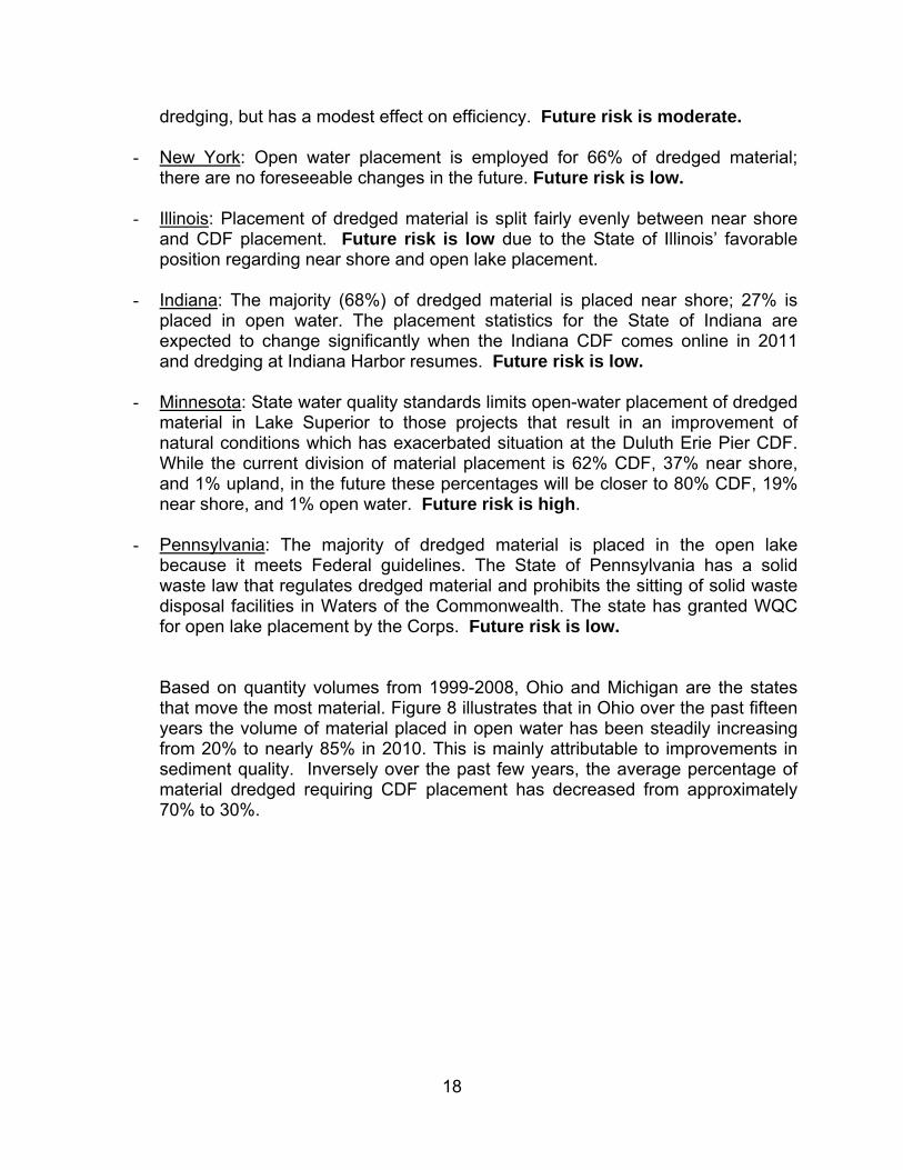
Based on quantity volumes from 1999-2008, Ohio and Michigan are the states that move the most material. Figure 8 illustrates that in Ohio over the past fifteen years the volume of material placed in open water has been steadily increasing from 20% to nearly 85% in 2010. This is mainly attributable to improvements in sediment quality. Inversely over the past few years, the average percentage of material dredged requiring CDF placement has decreased from approximately 70% to 30%.
19
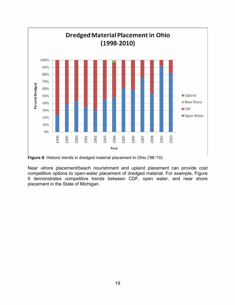
Figure 8: Historic trends in dredged material placement in Ohio ('98-'10) Near -shore placement/beach nourishment and upland placement can provide cost competitive options to open-water placement of dredged material. For example, Figure 9 demonstrates competitive trends between CDF, open water, and near shore placement in the State of Michigan.
20
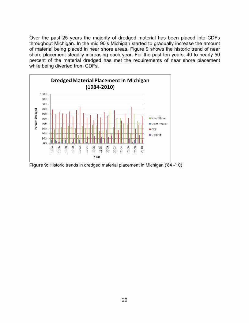
Over the past 25 years the majority of dredged material has been placed into CDFs throughout Michigan. In the mid 90’s Michigan started to gradually increase the amount of material being placed in near shore areas. Figure 9 shows the historic trend of near shore placement steadily increasing each year. For the past ten years, 40 to nearly 50 percent of the material dredged has met the requirements of near shore placement while being diverted from CDFs.
Figure 9: Historic trends in dredged material placement in Michigan ('84 -'10)
21
Dredged Material Management
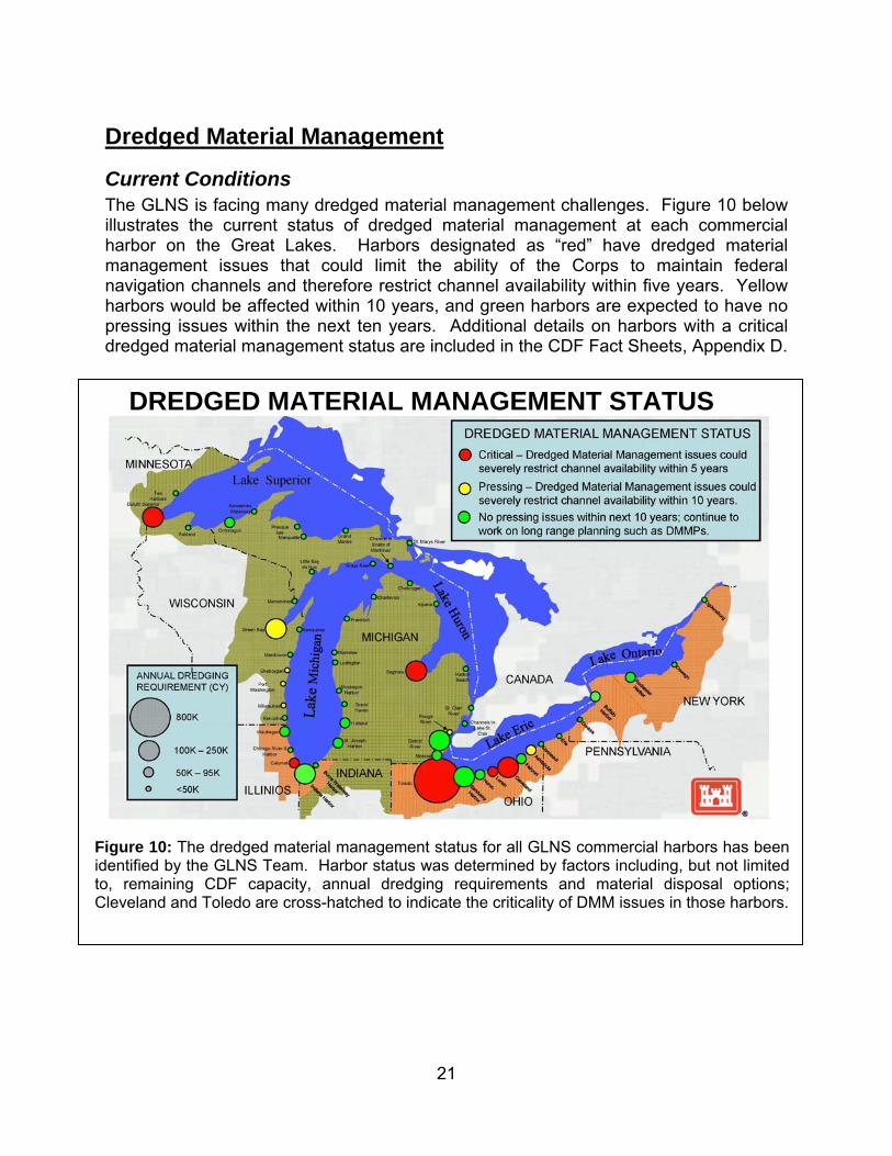
Current Conditions
The GLNS is facing many dredged material management challenges. Figure 10 below illustrates the current status of dredged material management at each commercial harbor on the Great Lakes. Harbors designated as “red” have dredged material management issues that could limit the ability of the Corps to maintain federal navigation channels and therefore restrict channel availability within five years. Yellow harbors would be affected within 10 years, and green harbors are expected to have no pressing issues within the next ten years. Additional details on harbors with a critical dredged material management status are included in the CDF Fact Sheets, Appendix D.
DREDGED MATERIAL MANAGEMENT STATUS
Figure 10: The dredged material management status for all GLNS commercial harbors has been identified by the GLNS Team. Harbor status was determined by factors including, but not limited to, remaining CDF capacity, annual dredging requirements and material disposal options; Cleveland and Toledo are cross-hatched to indicate the criticality of DMM issues in those harbors.
22
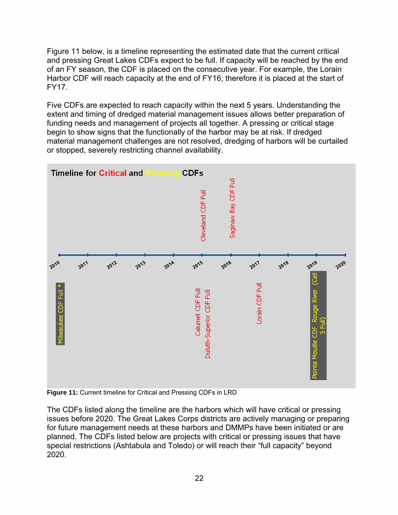
Figure 11 below, is a timeline representing the estimated date that the current critical and pressing Great Lakes CDFs expect to be full. If capacity will be reached by the end of an FY season, the CDF is placed on the consecutive year. For example, the Lorain Harbor CDF will reach capacity at the end of FY16; therefore it is placed at the start of FY17. Five CDFs are expected to reach capacity within the next 5 years. Understanding the extent and timing of dredged material management issues allows better preparation of funding needs and management of projects all together. A pressing or critical stage begin to show signs that the functionally of the harbor may be at risk. If dredged material management challenges are not resolved, dredging of harbors will be curtailed or stopped, severely restricting channel availability.
Figure 11: Current timeline for Critical and Pressing CDFs in LRD The CDFs listed along the timeline are the harbors which will have critical or pressing issues before 2020. The Great Lakes Corps districts are actively managing or preparing for future management needs at these harbors and DMMPs have been initiated or are planned. The CDFs listed below are projects with critical or pressing issues that have special restrictions (Ashtabula and Toledo) or will reach their “full capacity” beyond 2020.
23
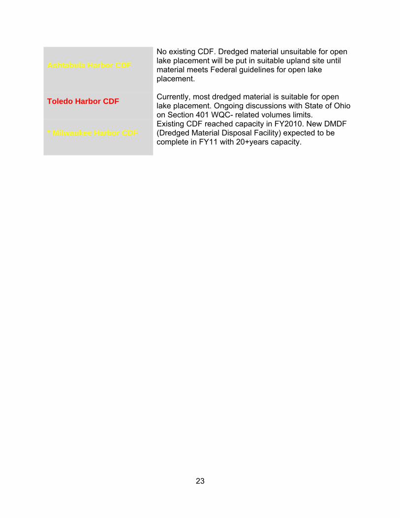
Ashtabula Harbor CDF
No existing CDF. Dredged material unsuitable for open lake placement will be put in suitable upland site until material meets Federal guidelines for open lake placement.
Toledo Harbor CDF
Currently, most dredged material is suitable for open lake placement. Ongoing discussions with State of Ohio on Section 401 WQC- related volumes limits.
* Milwaukee Harbor CDF
Existing CDF reached capacity in FY2010. New DMDF (Dredged Material Disposal Facility) expected to be complete in FY11 with 20+years capacity.
24
Dredged Material Management Strategies The situation with decreased CDF capacity, a large dredging backlog, and limited funds for construction of new CDFs has prompted the Corps to investigate a variety of other strategies that can be used to ease the dredged material management challenges in lieu of building new CDFs. These strategies must be economically and technically feasible, environmentally acceptable, and fiscally attainable if we are to achieve the goal of not impeding navigation on the Great Lakes. Some of these approaches are short-term, such as extending CDF life through fill management. Others are long-term and very ambitious, such as reducing sediment transport throughout watersheds, thus reducing material deposited in the system’s rivers and harbors. Another example is state and local governments to recognize that they must participate in actively finding solutions to dredged material disposal and placement needs. Realizing that the continued economic viability of their harbors and ports depends on their ability and willingness to share the responsibility making suitable placement or disposal sites available, they must reconsider traditional but perhaps outmoded assumptions. These approaches include the following:
1. Extend CDF life through fill management 2. Preserve existing CDF capacity through beneficial use and reuse 3. Decrease amount of material entering rivers and harbors 4. Engage local and state agencies in solutions 5. Foster partnership with USEPA to leverage funding for projects supporting both environmental goals and navigation benefits
Constructing a new CDF is the very last option; costs can range from $30-$60/CY compared to fill management ($7.5 - $20/CY) or beneficial reuse ($2.50 - $20/CY). Based on the high cost of construction, acquiring funding of this high level is very difficult. This strategy document focuses on the five strategies listed above to maximize available capacity for dredged material management.
1. Extend CDF Life through Fill Management The Corps has been and will continue to employ the short-term strategic plan of fill management to extend the life of existing CDFs. Fill management techniques include the practice of repositioning material, thus making room for the placement of additional dredged material in the CDF. Fill management also includes raising the CDF dikes to create additional storage capacity. According to Corps Policy Guidance Letter No. 47, these activities can be considered O&M activities and thus shall be undertaken as routine activities. Fill management is employed at many Corps operated CDFs, and is often used in conjunction with beneficial use and beneficial re-use. Each fill management cycle can add 1-2 dredging cycles of capacity to the CDF. The cost of fill management ranges from $7.50 to $20 per cubic yard of capacity created.
25
2. Create CDF Capacity through Beneficial Reuse and Use Although material deposited in CDFs is unsuitable for open-lake placement, it is often of sufficient quality for many other beneficial uses such as road construction, brownfield restoration, or mine reclamation. Beneficial reuse of existing CDF material is a technique being used at several Great Lakes CDFs. Material was removed from a Cleveland CDF for use in brownfield restoration, for example. This creates additional capacity in the CDF and can extend the life of a CDF by several years. Material in the Duluth-Superior Harbor Erie Pier CDF is also removed for use on construction sites. CDF life could be lengthened indefinitely, assuming enough beneficial reuse projects of sufficient size were found to accommodate the sediment recycling concept. Beneficial use of dredged material is also being employed in the Great Lakes. Beneficial use is when dredged material is applied directly to one of these uses rather than first being placed in a CDF. Costs for beneficial reuse ranges from $2.50 to $20 per cubic yard of material or capacity created.
3. Reduce Amount of Material Entering Federal Navigation Channels The Corps must dredge approximately 3.3 million cubic yards per year from the commercial harbors and projects on the Great Lakes just to keep up with the rate of annual sedimentation. The most efficient and effective solution to this challenge is to reduce the amount of material that must be dredged every year. Sediments in Great Lakes federal navigation channels originate from two distinct sources: (1) fluvial sediments that have eroded from lands in the watershed that drain into the channel and (2) littoral sediments transported along the lakeshore. The rate of sediment accumulation caused by fluvial sediments is highly dependent on the geology and hydrology of the watershed and the land use practices currently employed by landowners. LRD is embracing a regional sediment management approach, including looking at upland measures to reduce sedimentation in federally maintained navigation channels. The Corps is currently working with the U.S. Department of Agriculture - Natural Resource Conservation Service (USDA-NRCS) and many other partners on the Great Lakes Tributary Modeling Program. Through this program the Corps works with partner agencies to develop models for predicting sediment transport and evaluating various best management practices (BMPs) that could be employed in the watershed to reduce sediment runoff. To understand in better detail how regional sediment management strategies can be implemented throughout the Great Lakes region refer to Appendix E. Sediment transport models have already been developed in 20 watersheds throughout the Great Lakes that discharge to a federal navigation channel under the Great Lakes Tributary Model program (Sec 516e, WRDA 1996, as amended). Tributaries to be modeled are prioritized with consideration given to the dredging issues with the downstream harbor and the ability to “make a difference” in the watershed. The models
26
are being used by state and local partner agencies that can influence land management practices, including farming, forestry, and urban development. These partner agencies and organizations use the models to help promote, plan, and design measures for soil conservation and nonpoint pollution prevention. The goal is to reduce soil erosion and nonpoint pollution, which contribute to sedimentation in navigation channels and/or pollution levels in sediments in navigation channels and Great Lakes Areas of Concern (AOCs). While USDA-NRCS staff have indicated that it is difficult to justify and implement sediment load reduction programs (such as conservation tillage or buffer and filter strips) based on benefits to navigation projects, the water quality, ecosystem, and economic benefits to farmers do justify these relatively expensive programs. A large part of the expense of these programs is payment of the annual easements to private landowners. A lower cost alternative to paying annual easements to private land owners is the conversion of grasslands to forested riparian corridors on public lands. This alternative involves much lower costs, as the cost of plantings is relatively inexpensive, but USDA-NRCS programs do not provide assistance for publicly owned land. A promising study involving the conversion of land management was done in conjunction with the Cleveland Metroparks, who alone have more than 20,000 acres of land, much of it located along the Cuyahoga River or its tributaries. Studies completed by the Corps from the 1970s and 1980s identified management programs to implement BMPs to address Cuyahoga River erosion problems.
4. Engage State Agencies in Solutions State agencies are a key partner in dredged material management. CDFs that have effluent and overflow weir discharges require a Section 401 WQC from the State because they are Clean Water Act Section 404 discharges. Similarly, the open lake placement of dredged material requires a Section 401 WQC from the State. Some Great Lakes states either discourage or prohibit open lake placement. In many cases, the distance that must be travelled to suitable open lake placement areas is so great that upland placement is more economical. However, 33 CFR 209, 335-338 defines a “Federal Standard” as the basis for determining the upper limit of federal funding for management of dredged material. The Federal Standard is the least costly management alternative that is technically sound and complies with federal environmental laws and regulations. If a state or local government imposes restrictions that are more costly than the Federal Standard, the additional costs must be borne by non-federal interests. Thus, where open lake placement is the least costly method of placement, the Corps must engage the states on the cost differential. Any additional costs that would be incurred due to state policy or law that exceed the Federal Standard must be borne by the state or local community. Most states place restrictions on when dredging can occur, referred to as environmental windows, because of a variety of environmental concerns including spawning activities for particular fish and breeding times for birds. The Corps understands the importance
27
of these environmental concerns; however, these restrictions are often risk-averse and place a burden on the dredging program. The Corps is committed to working with the states and USEPA to investigate the science behind these restrictions to balance the needs of the Corps’ dredging program while being environmentally protective.
5. Foster Partnership with USEPA to Leverage Funding for Projects Supporting Environmental Goals and Navigation Benefits. The USEPA has several ongoing programs that offer opportunities for partnerships with the Corps on dredged material management solutions. The Great Lakes Legacy Act is one such program. USEPA’s Legacy Act was signed into law in 2002 to provide funding to clean up contaminated sediment in Great Lakes AOCs. The Legacy Act was reauthorized in October 2008, providing authority for two more years. One such Area of Concern is the Kinnickinnic River in Wisconsin. The Legacy Act dredging of the Kinnickinnic River offered an opportunity for cooperation between the Corps, USEPA, the State of Wisconsin and the Milwaukee Port Authority. Upon the request of the Wisconsin DNR, a local sponsor of the Legacy Act project to dredge the Kinnickinnic River, the Corps allowed USEPA and WDNR to use the existing Milwaukee CDF for placement of contaminated dredged material from the Kinnickinnic River in a specially designed cell within the CDF. While this portion of the river is not part of the federally maintained navigation channel, its contribution to future sedimentation of the navigation channel establishes a nexus with the navigation project. USEPA and WDNR agreed that providing disposal space in the CDF would be considered an in-kind contribution by the WDNR to the Legacy Act project. This freed up Wisconsin State funds to be provided as a grant to the Milwaukee Port Authority. The Legacy Act dredged material (approximately 176,000 cubic yards) effectively filled the CDF to 100% capacity, necessitating the construction of new DMDF with 20 years of dredged material capacity at Milwaukee Harbor. The Corps and the local sponsor (Milwaukee Port Authority) are required to fund 65% and 35%, respectively, of the construction of the new DMDF. Although the Port had sufficient funding for their share of the DMDF, federal funding was unavailable within the timeframe needed to construct the DMDF. The Port, having received a grant from the State of Wisconsin sufficient to cover the Corps’ share of the DMDF, offered to contribute those funds to the Corps. In addition, the Port will be responsible for its 35% share of the cost of the DMDF. The offer of contributed funds was reviewed and authority to negotiate an agreement was provided. The acceptance of contributed funds was included in the Project Partnership Agreement for the construction of a new DMDF at Milwaukee. Construction began in late 2011 and will be completed in 2012. Another USEPA initiative offers an important partnership opportunity with the Corps on dredged material management. The Great Lakes Restoration Initiative is a USEPA-led program that targets the most significant environmental issues in the Great Lakes region. The current list of potential projects includes construction of the initial phase of Cat Islands, which restores a historic barrier island chain in Green Bay that was lost to erosion. Creation of Cat Islands will also provide a placement site for material that is
28
dredged from Green Bay, with significant federal savings over transporting and disposing material in Brown County’s Bayport CDF. The Cat Islands will provide shelter for the restoration of 1,400 acres of coastal habitat while also helping to provide 20 years capacity for material dredged from Green Bay. The Corps will continue to seek partnership opportunities with the USEPA to leverage federal dollars where projects both support environmental goals and provide navigation benefits.

29
Harbor Specific Dredged Material Management Strategies The Corps has laid out a multi-faceted approach to address the dredged material management crisis at each individual harbor where dredged material management was identified as “critical” (red) or “pressing” (yellow). No single approach will be sufficient on its own; the long term solution will require a combination of all of approaches and will require cooperation and partnership with local, state, and federal agencies. Table 2: Harbor Specific Strategies
CDF
Dredged Material Mgmt Status
Annual Dredging
Requirement (1000 CY)
Remaining Capacity
Mgmt Options Status Year by which
Construction is Required
Calumet Harbor and
River Critical 50 4 years Upland, CDF
Fill Management to extend CDF life to 2014. District working on Preliminary Assessment FY 15
Cleveland Critical 330 4 years Fill Mgmt, Ben
Reuse, New CDF
Combination of fill mgmt. and open lake placement will be used to maximize the remaining CDF capacity until a long term upland placement site is available. DMMP approved by LRD Commander on 31 Aug 2009.
FY 15
Duluth Critical 110 4-7 years Upland, CDF Fill mgt thru at least 2012. No non-fed sponsor. Working on DMMP including possible mine reclamation with dredged material.
FY 13
Lorain Critical 75 4-5 years Upland, DMDF Combination of fill mgmt & beneficial use of newly dredged material at pending upland site. DMMP approved by LRD Commander on 31 Aug 2009.
N/A
Toledo Harbor
Critical 100
20 years for small portion of periodic dredged material
that must be placed in CDF
CDF, Ben Reuse
Ohio EPA proposed rule limiting open-lake placement to 50,000 CY annually is on hold. Seeking non-federal sponsor(s) for beneficial use of dredged material. Red because of open lake placement issue.
FY 11 and 12 Sec. 204
Saginaw Critical 210 5-7 years CDF Saginaw River DMDF is newly constructed; continuing fill mgmt activities for Saginaw Bay CDF
FY 11 Fill Mgmt
30
Recommendations As outlined in the previous sections of this document, there is no single approach that the Corps can employ to solve the long-term dredged material management issue on the Great Lakes. The following system-wide strategies are all being employed to meet the challenges of maintaining a viable and sustainable GLNS:
1. Continue to prioritize funding for fill management at many CDFs to lengthen the serviceable life of the CDFs. 2. Aggressively pursue opportunities for beneficial use and beneficial reuse of dredged material.
3. Collaborate with USDA-NRCS, state and local agencies to leverage the Corps’ current programs.
4. Engage state agencies, USEPA, and USFWS to participate in studies or expert elicitation to improve the scientific basis for establishing environmental dredging windows; that would be environmentally protective while improving the efficiency of the Corps’ dredging program.
5. Reinforce the need for open-lake placement decisions that recognize the Federal Standard to maintain efficiency of the Corps’ dredging program while protecting the environment.
6. Partner with USEPA to aggressively leverage authorities and funding for projects that benefit navigation and the environment, specifically through the Great Lakes Legacy Act and the Great Lakes Restoration Initiative.
In addition to these system-wide recommendations, there are numerous harbor-specific initiatives that must be pursued to ensure the long-term viability of the GLNS. These harbor-specific initiatives are outlined in the CDF harbor fact sheets included in Appendix D. We also must recognize that state and local governments must be active participants in the search for solutions to dredged material disposal and placement needs. Realizing that the continued economic viability of their harbors and ports depends on their ability and willingness to share the responsibility making suitable placement or disposal sites available, all parties must reconsider traditional but perhaps outmoded assumptions. The Corps is facing a critical situation with the challenge of disposal of dredged material. Unless solutions are found soon, the Corps’ ability to dredge at several key ports on the Great Lakes will be restricted. There are six major harbors on the Great Lakes that are currently labeled “Critical - Red”; that is, without dredged material management solutions channel availability will be restricted within 5 years. These are

31
the projects that have the highest priority but there are also a number of harbors that are labeled “Pressing – Yellow” meaning that channel availability will be restricted within 10 years without dredged material management solutions. This document lays out a strategic direction that the Corps will pursue to solve the dredged material management challenge from a programmatic view as well as on a harbor-specific basis. This strategy document recognizes that CDFs are a necessary part of the solution, but additional approaches are needed. These approaches can include a combination of: prioritizing funding for fill management, emphasizing beneficial uses of dredged material, collaborating with partner agencies to leverage the Corps’s current programs, and engaging state agencies to participate in studies or expert elicitation to improve the scientific basis for establishing environmental constraints. The key factor to solving the challenge of material management will be a solution that involves collaboration between local, state and federal organizations. A combination of several strategies will be used in most cases to meet the challenges of maintaining a viable and sustainable navigation system on the Great Lakes.
APPENDIX A
Process for Identifying Impact Levels and Maintenance Priority on Great Lakes Navigation Features
A-1
Process for Identifying Impact Levels and Maintenance Priority Great Lakes Navigation Features
(Channels, Harbors, CDFs and Structures)
1. Purpose. The purpose of this Appendix is to describe simplified processes to be used to develop factors that reflect the loss of functionality (and associated impacts) at Great Lakes navigation projects (Federal harbors and channels). This loss of functionality could take the form of reduced channel dimensions due to lack of maintenance dredging, severe shoaling events, breakwater failure, deteriorated wave climate and/or channel blockage within the harbor due to navigation structure failure, non-availability of confined disposal capacity for critical maintenance dredging, or other impacts. This information can then be used by the District Navigation Maintenance Program Managers to assist in annually prioritizing the use of fleet and contracted maintenance packages to minimize the potential for negative economic impacts in the region. Reduced channel dimensions or blockages impact commercial navigation by either halting all traffic, in the case of a channel blockage or unsafe wave conditions in a harbor, or reducing carrying capacity of vessels resulting in the need for additional transits. Aging infrastructure and limited resources requires maintenance be focused first at those projects that exhibit the highest potential economic risk The Division strives to provide for fully-functional conditions (maximizing reliability) at all of its navigation projects, but is most focused on minimizing the economic consequences of a loss of functionality. This challenge is further complicated by the need to maintain harbor connectivity to ensure overall system reliability on the Great Lakes. A harbor handling tens of millions of tons annually ships to numerous other smaller, low tonnage harbors within the system. However, tonnage alone cannot be used to establish maintenance priorities. Additionally, besides economic considerations, factors such as public health and safety, national security, and environmental/regulatory considerations will be considered in budgetary decision making. 2. Methodology Overview. It is recognized that determining the economic impacts of loss of functionality (channel dimensions, wave climate, etc.) can be quite complex. Economic impacts are unique for each shipment and are sensitive not only to harbor/channel conditions, but also to lake levels, weather conditions, non-Federal berth/dock conditions, etc. While the science has been advanced to estimate additional transportation costs associated with light loading of vessels and/or vessel delays, the costs from the ripple effect of overland diversion costs, overland diversion impacts (delays, pollution, etc.) and regional impacts of missed or delayed shipments (layoffs, plant closures, etc.), are beyond the scope of this regulation. The method described in this Appendix combines several factors related to Great Lakes navigation features to help the District Navigation Maintenance Program Managers, Great Lakes Navigation PDT and the LRD Chief of Operations, prioritize fleet and contracted maintenance packages throughout the region. This process was developed using readily available information and an easy to use and understandable methodology. It does not claim to be an exhaustive engineering risk
A-2
assessment or NED economic analysis. This method seeks to add a measure of objectivity to what was once a purely subjective process. These procedures will likely evolve over time as they are used and improved. This methodology does not result in any cumulative ranking of harbors or harbor features (i.e. – one overall condition rating for a given harbor that reflects condition of all of the harbor features); however, it does generate several indicators that can be used for determining the frequency and level of detail of condition inspections, as well as an elementary prioritization tool for making resource decisions. Each year, several tasks will be performed in order to apply this methodology to assist with scheduling inspections and out-year budget development efforts. For every Great Lakes commercial harbor, the risk of less than fully functional conditions will be reviewed and updated in accordance with the procedures described in the following paragraphs;
a. The Great Lakes Breakwater Assessment Team will ensure that the most recent list of ranked coastal navigation structures (based on OCAs) is updated by the end December and sent to the GL NAV PDT and Division Operations Chief. District Operations Chiefs will review and ensure any proposed updates as a result of annual field inspection activities are raised to the BAT for consideration and incorporation by the end of January; b. District Operations Chiefs will ensure the list of existing confined disposal facilities is updated by the end of January to reflect any new survey data, changes in facility conditions, remaining capacity and the criticality rankings updated where warranted; c. District Operations Chiefs will ensure the historical and annual dredging requirements for each Great Lakes harbor are reviewed and updated by the end of January based on the past season’s dredging activities, and future dredging needs be revisited based on any changes to functional harbor needs, changed harbor usage, or additional channel shoaling studies and data; d. For Great Lakes commercial harbors, the table of transportation cost savings by depth of shoaling will be updated by the end of February by the USACE Center of Expertise for Inland Navigation based on latest year of available traffic data; e. Appropriate risk and economic performance measures will be selected by the Great Lakes Navigation PDT and the LRD Chief of Operations and will be considered when determining priority funding items.
3. Risk Level Indicators. There are several risk factors that influence the reliability of the GLNS. The most obvious is the continuously changing depths of federal channels and turning basins. The majority of federal commercial deep draft harbors on the Great

A-3
Lakes require periodic maintenance dredging. Changes in available depth are the result of three primary elements:
a. The most far-reaching element is continuous seasonal and annual fluctuation of lake water levels within the system, which impacts large numbers of harbors simultaneously.
b. The second common element is the shoaling that results from sediment transport from sources upstream of Federal harbors. Another source of shoal material is the littoral transport of sand and gravel along the lake coasts into federal channels. Lake storms often contribute to this latter process. Shoaling in Federal channels reduces the available depth for commercial vessels, thereby restricting the maximum tonnage on a transit. The result of vessel light loading is substantial increases in the transportation cost of a transit.
c. The third factor affecting navigation on the GLNS is the age and condition of
coastal structures, i.e. breakwaters, jetties, etc. at federal projects. The advanced age of most of these features, combined with their continued exposure to the adverse conditions associated with the harsh Great Lakes’ climate including frequent damaging storm conditions, inevitably results in high risks of structure failure. Navigation structures at Federal projects require routine inspection and periodic repair and maintenance.
The following risk level definitions, consistent with the latest Corps budget development guidance, have been established for the various navigation features that are integral to maintaining a reliable Great Lakes navigation system. Determination of these risk level indicators for specific features is based on all sources of readily available data (operational condition assessments, channel condition surveys, CDF capacity surveys, periodic inspections, etc.). Caveat: Time and funding limitations limit the extent to which more detailed analytical procedures can be applied to all navigation assets that comprise the overall Great Lakes navigation system. Such analyses would be undertaken as part of any formal rehabilitation study. Efforts are underway at the national level to establish risk-reliability tools which will provide a simplified methodology. Risk determinations will be expert elicitation based until such a time as these methodologies and tools are formalized Corps-wide. Federal Navigation Channels: Risk Level Description A Virtually no compromise to authorized Federal project features
expected.
Middle half channel available at maintained depths 95% of time required,
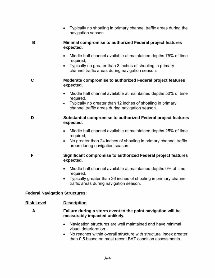
A-4
Typically no shoaling in primary channel traffic areas during the navigation season.
B Minimal compromise to authorized Federal project features
expected.
Middle half channel available at maintained depths 75% of time required,
Typically no greater than 3 inches of shoaling in primary channel traffic areas during navigation season.
C Moderate compromise to authorized Federal project features
expected.
Middle half channel available at maintained depths 50% of time required,
Typically no greater than 12 inches of shoaling in primary channel traffic areas during navigation season.
D Substantial compromise to authorized Federal project features
expected.
Middle half channel available at maintained depths 25% of time required,
No greater than 24 inches of shoaling in primary channel traffic areas during navigation season.
F Significant compromise to authorized Federal project features
expected.
Middle half channel available at maintained depths 0% of time required,
Typically greater than 36 inches of shoaling in primary channel traffic areas during navigation season.
Federal Navigation Structures: Risk Level Description
A Failure during a storm event to the point navigation will be measurably impacted unlikely.
Navigation structures are well maintained and have minimal visual deterioration.
No reaches within overall structure with structural index greater than 0.5 based on most recent BAT condition assessments.
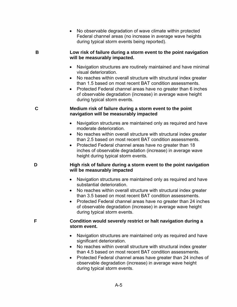
A-5
No observable degradation of wave climate within protected Federal channel areas (no increase in average wave heights during typical storm events being reported).
B Low risk of failure during a storm event to the point navigation
will be measurably impacted.
Navigation structures are routinely maintained and have minimal visual deterioration.
No reaches within overall structure with structural index greater than 1.5 based on most recent BAT condition assessments.
Protected Federal channel areas have no greater than 6 inches of observable degradation (increase) in average wave height during typical storm events.
C Medium risk of failure during a storm event to the point navigation will be measurably impacted
Navigation structures are maintained only as required and have moderate deterioration.
No reaches within overall structure with structural index greater than 2.5 based on most recent BAT condition assessments.
Protected Federal channel areas have no greater than 18 inches of observable degradation (increase) in average wave height during typical storm events.
D High risk of failure during a storm event to the point navigation will be measurably impacted
Navigation structures are maintained only as required and have substantial deterioration.
No reaches within overall structure with structural index greater than 3.5 based on most recent BAT condition assessments.
Protected Federal channel areas have no greater than 24 inches of observable degradation (increase) in average wave height during typical storm events.
F Condition would severely restrict or halt navigation during a storm event.
Navigation structures are maintained only as required and have significant deterioration.
No reaches within overall structure with structural index greater than 4.5 based on most recent BAT condition assessments.
Protected Federal channel areas have greater than 24 inches of observable degradation (increase) in average wave height during typical storm events.
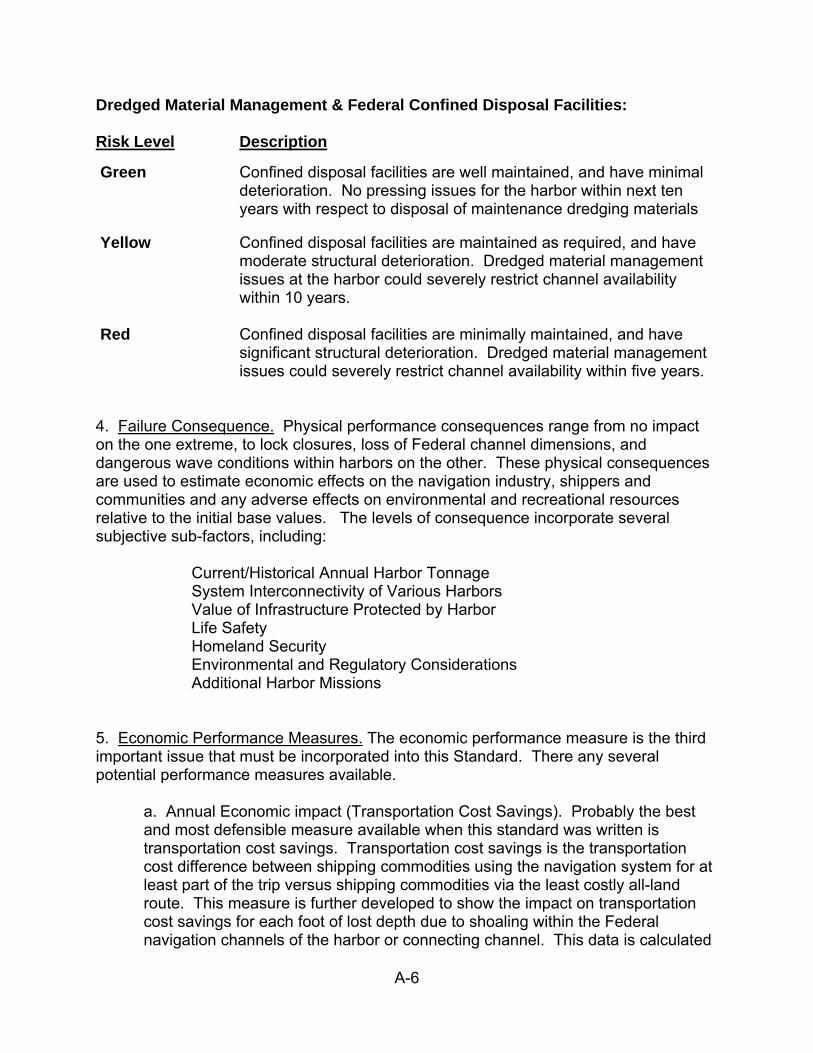
A-6
Dredged Material Management & Federal Confined Disposal Facilities: Risk Level Description
Green Confined disposal facilities are well maintained, and have minimal deterioration. No pressing issues for the harbor within next ten years with respect to disposal of maintenance dredging materials
Yellow Confined disposal facilities are maintained as required, and have
moderate structural deterioration. Dredged material management issues at the harbor could severely restrict channel availability within 10 years.
Red Confined disposal facilities are minimally maintained, and have
significant structural deterioration. Dredged material management issues could severely restrict channel availability within five years.
4. Failure Consequence. Physical performance consequences range from no impact on the one extreme, to lock closures, loss of Federal channel dimensions, and dangerous wave conditions within harbors on the other. These physical consequences are used to estimate economic effects on the navigation industry, shippers and communities and any adverse effects on environmental and recreational resources relative to the initial base values. The levels of consequence incorporate several subjective sub-factors, including:
Current/Historical Annual Harbor Tonnage System Interconnectivity of Various Harbors Value of Infrastructure Protected by Harbor Life Safety Homeland Security Environmental and Regulatory Considerations Additional Harbor Missions
5. Economic Performance Measures. The economic performance measure is the third important issue that must be incorporated into this Standard. There any several potential performance measures available.
a. Annual Economic impact (Transportation Cost Savings). Probably the best and most defensible measure available when this standard was written is transportation cost savings. Transportation cost savings is the transportation cost difference between shipping commodities using the navigation system for at least part of the trip versus shipping commodities via the least costly all-land route. This measure is further developed to show the impact on transportation cost savings for each foot of lost depth due to shoaling within the Federal navigation channels of the harbor or connecting channel. This data is calculated
A-7
for every Great Lake commercial harbor in LRD. Caveat: It is recognized that transportation cost savings is determined by analysis of long term transportation rates that shippers are able to secure through negotiation. Unexpected channel impacts/closures will potentially cause shippers to seek transportation services at “spot market” prices which may be significantly different than long term prices. For the purpose of annual budget development and prioritization, the following guidelines have been developed in coordination with the USACE Center of Expertise for Inland Navigation to provide an estimate of potential depth lost to shoaling associated with various maintenance activities. Several of these guidelines will be further refined as more definitive relationships are developed as part ongoing activities to further implement asset management practices.
Primary Dredging/PCS – The projected critical shoal depth within the harbor functional channel(s) based on historical/annual shoaling records. Unfunded State PCS - The projected critical shoal depth within the functional channel(s) based on historical/annual shoaling records for the various harbors to be surveyed CDF Fill Management/Beneficial Reuse - The projected critical shoal depth within the harbor functional channel(s) based on historical/annual shoaling records. DMMPs/New CDF Construction and E&D – Assume a 10 foot critical shoal depth in order to capture the maximum transportation cost savings for the harbor. A lesser shoal depth may be warranted for harbors where remaining CDF capacity is less critical. Coastal Structure Repairs – Assume a 5 foot critical shoal depth for both plant and contract repair activities in order to estimate the potential deterioration of harbor wave climate and/or potential for increased shoaling of functional harbor channels adjacent to deteriorated structures. Backlog Dredging and Section 111 Studies – Assume a two foot critical shoal depth as an estimate of potential additional channel capacity that might be regained. Connecting Channel Strike Removal/PCS – Use overall transportation savings for these channels (versus transportation cost savings associated with loss of channel depth). Obstruction Removal/Snagging & Clearing – Critical shoal depth estimated based on typical size of obstructions removed from the functional channel within the harbor.
A-8
b. Commodity Tonnage. This measure is readily available from both OMNI data and Waterborne Commerce Statistics data, which is the performance measure used by HQ. Caveat: The use of this measure alone produces a side effect where better maintained harbors continue to attract traffic and therefore more maintenance focus, while the decline of less maintained harbors accelerates. Ultimately this “rich get richer while the poor get poorer” condition results is serious impacts to the overall system interconnectivity – i.e., there will no longer be lower tonnage harbors to which the larger harbors need to connect. c. Total Economic Impact. This indicator incorporates both the estimated transportation cost savings described above, as well as the anticipated duration of the economic benefits to be realized as the result of the maintenance activities. For the purpose of annual operation and maintenance budget development and analysis, the following are used as an estimate of the number of years of economic impacts avoided for any proposed budget activities. Budget Category # Years Economic Impact Avoided Annual Routine Lock O&M 1 years Contract Lock Maintenance 50 years (could be less) Primary Maintenance Dredging/PCS dredging cycle for that harbor/channel Connecting Chan. Strike Removal/PCS 1 year (annual requirement) Obstruction Removal/Snag & Clear 1 year (annual requirement) Coastal Structure Repair (Gov’t Plant) 25 years Coastal Structure Repair (Contract) 50 years (more permanent repair) CDF (DMMP/E&D/Construction) 20 years (typical req’d capacity) CDF Fill Management/Beneficial Reuse 5 years (or years of capacity regained) Unfunded State PCS 1 year (annual requirement) Section 111 Studies 20 years Backlog Maintenance Dredging 7 years d. Net Economic Impacts. This is a measure of the net economic impacts of any given operation or maintenance activity. Annual budgets are developed by identifying specific proposed budget packages to address system needs (channel dredging, breakwater repairs, lock operations, project condition surveys, etc.) at each authorized project throughout the navigation system. The net economic benefit is the difference between the anticipated total economic impact avoided to be derived and the individual cost of the package. e. Other impacts. This category of impacts may include things such as the value added to the economy by the commodities shipped through a harbor, i.e. coal used to create electricity which is used for other purposes. It may also include other economic impacts not listed here. These impacts are not generally available, but they are included here because it is recognized that there may be other legitimate measures available in the future.
APPENDIX B
“Dredged Material Management Plans” from ER 1105-2-100

B-1
FROM: Planning Guidance Notebook, Engineering Regulation 1105-2-100, 22 April 2000 E-15. Dredged Material Management Plans. All Federally maintained navigation projects must demonstrate that there is sufficient dredged material disposal capacity for a minimum of 20 years. A preliminary assessment is required for all Federal navigation projects to document the continued viability of the project and the availability of dredged material disposal capacity sufficient to accommodate 20 years of maintenance dredging. If the preliminary assessment determines that there is not sufficient capacity to accommodate maintenance dredging for the next 20 years, then a dredged material management study must be performed.
a. Policy. (1) General. (a) Sound management of dredged material is a priority mission of the Corps. (b) The Corps is committed to conducting dredging and managing dredged material in an environmentally sound manner. (c) The interests of economic development and environmental sustainability will best be served when dredged material placement proceeds according to a management plan. Therefore each existing and proposed navigation project will have a dredged material management plan that ensures warranted and environmentally acceptable maintenance of the project. (d) Beneficial uses of dredged material are powerful tools for harmonizing environmental values and navigation purposes. It is the policy of the Corps that all dredged material management studies include an assessment of potential beneficial uses for environmental purposes including fish and wildlife habitat creation, ecosystem restoration and enhancement and/or hurricane and storm damage reduction. Districts and MSCs will make every effort to ensure that sponsors and other interests understand the valuable contributions that beneficial uses can make to management plans and will maximize use of regional forums to share experiences of opportunities for beneficial uses. (e) Dredged material management goals are to be achieved by District and Division Commanders within existing delegations of authority. Exceptions to this principal are when problems arise that are of such significance that HQUSACE or Administration commitment is required such as changes in dredged material management practices that require substantial capital investment.
(2) Requirements: Dredged Material Management Plans (Management Plans) shall be prepared, on a priority basis, for all Federal navigation projects, or groups of inter-related harbor projects, or systems of inland waterway projects (or segments).
(a) Priority will be given to projects for which existing dredged material disposal sites,
B-2
including existing confined disposal facilities, are expected to reach capacity or to no longer be available sometime in the next 10 years, or (b) Existing and projected navigation usage of the project indicates that continued maintenance of the project, or of any substantial increment thereof, may not be warranted.
(c) Management Plans shall identify specific measures necessary to manage the volume of material likely to be dredged over a twenty year period, from both construction and maintenance dredging of Federal channel and harbor projects. Non-Federal, permitted dredging within the related geographic area shall be considered in formulating Management Plans to the extent that disposal of material from these sources affects the size and capacity of disposal areas required for the Federal project(s). In those cases where two or more Federal projects are physically inter-related (e.g., harbors which share a common disposal area or a common channel) or are economically complementary, one Management Plan may encompass that group of projects.
(3) Base Plan. It is the Corps of Engineers policy to accomplish the disposal of dredged material associated with the construction or maintenance dredging of navigation projects in the least costly manner. Disposal is to be consistent with sound engineering practice and meet all Federal environmental standards including the environmental standards established by Section 404 of the Clean Water Act of 1972 or Section 103 of the Marine Protection, Research and Sanctuaries Act of 1972, as amended. This constitutes the base disposal plan for the navigation purpose. Each management plan study must establish this “Base Plan”, applying the principles set forth below. b. Management Plan Development Principles.
(1) Existing Projects. (a) Process. Management Plans are intended to cost effectively and expeditiously support environmentally acceptable channel and harbor maintenance. Plan development shall employ a phased process determining the appropriate scope and detail of required assessment. This process will:
(1) Establish the Base Plan for the project; (2) Include an assessment of the potential for beneficial uses of dredged material which is proposed to be undertaken as separate plan elements pursuant to separate authority; and, (3) Establish the Management Plan for the project, or if approval by higher authority is required elsewhere in this guidance, the District Commander’s recommended (4) Demonstrate continued maintenance is economically warranted based on high priority
B-3
(non-recreation) benefits. If it cannot be demonstrated based on high priority benefits but would otherwise be warranted considering recreation benefits, recommendations will state that project is economically warranted using recreation benefits.
(b) Phases. Management Plan development shall proceed in the following phases: (1) Preliminary Assessment. Preliminary assessments establish whether more detailed study is required to establish a management plan, and, if so, provides information to justify the study and permit its prioritization in the budgetary process. For many projects with readily available maintenance and usage information, a preliminary assessment, based on indicators such as annual O&M costs per ton of cargo, volume and frequency of traffic, and vessel dimensions, may establish the Base Plan and confirm that continued maintenance appears to be warranted. Where these conditions are met, the findings of the Preliminary Assessment would complete the requirement for a Management Plan. Where these conditions are not met, the Preliminary Assessment will recommend a Management Plan Study. (2) Management Plan Studies. A Management Plan Study shall be required to establish the Base Plan and the recommended Plan if basic indicators are inconclusive, or if attempts to define the Base Plan disclose significant problems, a major new investment, or other significant increase in maintenance costs. For example, the provision of a new confined disposal facility or use of more distant ocean disposal site would trigger this requirement. Management Plan studies shall be conducted in two phases: initial and final. The initial phase concentrates on developing a detailed scope of work, and the final phase executes that scope of work. (2) Proposed Projects. Feasibility and Pre-construction Engineering and Design (PED) studies for proposed projects shall include a Management Plan in accordance with the criteria and procedures herein, as applicable.
c . Study Authority. Preliminary Assessment and Management Plan studies shall be conducted pursuant to existing authorities for individual navigation project feasibility studies, PED, construction, or O&M, as provided in Congressional Committee study resolutions and public laws authorizing specific projects. These specific study and/or project authorities are supplemented by general authorities relating primarily to beneficial uses of dredged material, as set forth in paragraph E-15f. Where Management Plan studies disclose the need to consider expanding or enlarging existing projects, such studies may only be pursued under specific study authority or under authority of Section 216 of the Flood Control Act of 1970. d. Responsibilities.
(1) Existing Projects. Operations functional elements have program management responsibility for administering Dredged Material Management Plan preparation efforts for existing Federal projects. Those responsibilities include prioritizing and budgeting
B-4
studies and providing subject matter expertise and guidance as members of the interdisciplinary study team. Planning functional elements have study management responsibility for conducting the studies required to implement effective dredged material management. Both elements have joint functional responsibility to ensure efficient use of shared resources. (2) Proposed Projects. Planning functional elements are responsible for administering and conducting Management Plan studies for proposed projects. The Operations functional elements are essential participants and assume on-going responsibility for dredged material management following project completion.
e. Study Components.
(1) Alternatives. Management plan studies shall consider the full range of measures for dredged material management including: management of existing disposal sites to extend their life; various combinations of new disposal sites involving different disposal methods, disposal area locations, and periods of use; and, measures to reduce dredging requirements, including reduced dimensions. The Federal interest in continued O&M of an existing project for its navigation purpose is defined by that project of maximum scale and extent, within project authorization, for which continued maintenance is warranted in terms of vessel traffic and related factors.
(2) Beneficial Uses. Each Management Plan study shall include an assessment of potential beneficial uses of dredged material, for meeting both navigation and non-navigation objectives, including fish and wildlife habitat creation and restoration, hurricane and storm damage reduction, and recreation. Where a beneficial use is part of the Base Plan, it shall be treated as a general navigation O&M component. Beneficial uses which are not part of the Base Plan shall be considered separable elements of the management plan, and will be pursued in accordance with guidance implementing other available authorities. However, even though funded from different sources, the beneficial use planning effort must be pursued in conjunction with the overall management plan effort to assure the timely availability of dredged material for the beneficial use project. The beneficial use project site must be available to meet maintenance dredging disposal needs. (3) Study Involvement and Coordination. District Operations and Planning functions must jointly ensure appropriate involvement of all resources and affected non-Federal interests in Management Plan studies, as follows:
(a) Interdisciplinary Analysis. The relevant professional disciplines needed to ensure sound professional decisions are to be involved.
(b) Partnership. Project sponsors, local governments, port authorities, and other project users and beneficiaries are partners in dredged material management, and have a key role as the project proponents in building local consensus for the Management Plan. A potential key role is played by the state governor to mediate sometimes competing state
B-5
environmental, regulatory and economic objectives. All those having a partnership interest must be informed and involved throughout the course of all management plan studies. (c) Review and Consultation. Federal, State and other public agencies with legal review, consultation, or other regulatory responsibilities are to be involved. Dredged material disposal is a multi-faceted issue, which involves both the water resources development, and regulatory responsibilities of the Corps. It involves the regulatory, water quality, hazardous, toxic, and radiological waste responsibilities of the U.S. Environmental Protection Agency (EPA) and state agencies. It also involves the environmental resources protection and management responsibilities of the National Marine Fisheries Service, the U.S. Fish and Wildlife Service and various state agencies as well as the economic and regional economic development interests of states, local governments, port authorities, maritime users and shippers. (d) Public Involvement. Members of the public who are interested, likely to be affected, or otherwise have a stake in outcomes are to be kept informed and appropriately involved.
(4) Environmental Consistency. Management Plans shall be consistent with protecting the Nation’s environment, pursuant to national environmental statues, applicable executive orders, and other Federal requirements. Management Plan studies shall address the requirements of all applicable environmental statues for all disposal options considered, including the requirements of the National Environmental Policy Act, Section 404 of the Clean Water Act, Section 103 of the Marine Protection, Research and Sanctuaries Act, and the Coastal Zone Management Act. Any dredged material assessment to determine compliance with the Clean Water Act, Section 404(b)(1) guidelines, will be performed in accordance with the manual “Evaluation of Dredged Material Proposed for Discharge in Inland and Near Coastal Waters: Testing Manual”. The manual “Evaluation of Dredged Material Proposed for Ocean Disposal: Testing Manual, commonly referred to as the “Green Book”, will be used for assessing material proposed for ocean disposal under Section 102 of the Marine Protection, Research and Sanctuaries Act. Regional variations of these two manuals, where approved by both the Corps and EPA, may also be used.
f. Cost Sharing and Financing. (1) Management Plan Studies. (a) Existing Projects. (1) General. The cost of Management Plan studies for continued maintenance of existing Federal navigation projects are O&M costs and shall be Federally funded. For harbor projects, including inland harbors, such costs shall be reimbursable from the Harbor Maintenance Trust Fund, subject to the following:
B-6
(a)Project sponsors, port authorities and other project users, are partners in dredged material management and must pay the costs of their participation in the dredged material management studies including participation in meetings, providing information and other coordination activities.
(b) Budgeting priority for the navigation purpose is limited to the Base Plan. Therefore, the cost for any component of a management plan study attributable to meeting local or state environmental standards that are not provided for by the requirements of Federal laws and regulations, shall be a non-Federal cost.
(c) Study activities related to dredged material management for the Federal project, but not required for continued maintenance dredging and dredged material disposal, will not be included in dredged material management studies unless funded by others.
(d) Studies of project modifications needing congressional authorization, including dredged material management requirements related to the modification, will be pursued as feasibility studies under the authority of Section 216 of the Flood Control Act of 1970.
(2) Beneficial Uses. The cost of studies for beneficial uses that are consistent with, and part of, the Base Plan are Federal O&M costs. However, study costs for beneficial uses, which are not part of the Base Plan, are either a non-Federal responsibility, or are a shared Federal and Non-Federal responsibility. These include reconnaissance level studies needed to identify these potential uses as part of management plan studies. Depending on the type of beneficial use, itmight also include:
(a) Ecosystem Restoration. The incremental costs of studies beyond those required for the Base Plan for the use of dredged material to improve, restore and protect environmental resources, pursuant to Section 204 of the WRDA of 1992 or Section 207 of the WRDA of 1996 are not navigation O&M costs. If a potential environmental improvement or ecosystem restoration beneficial use project exceeds the cost limitations of Section 204, it may be pursued as a cost shared feasibility study leading to specific authorization, in accordance with existing procedures. (b) Placement of Materials on Beaches. The Corps of Engineers, under Section 933 of the Water Resources Development Act of 1986, may participate in the additional costs of placing clean sand or other suitable material on beaches. This may include material dredged by the Corps during construction or maintenance of Federal navigation projects, and the placement onto adjacent beaches or near-shore waters. This is only permitted if the added cost of placement is justified primarily by the benefits associated with the hurricane and storm damage protection provided by such beach or beaches, and the beach involved is open to the public with public access. The non-Federal sponsor must provide 50 percent of the incremental study costs. (c) Other Beneficial Uses. Other potential beneficial uses include placement of dredged material for land creation or land enhancement for development purposes, disposal of material on beaches not meeting the criteria for Corps participation, and environmental
B-7
enhancement projects not meeting the criteria for Corps participation. In these cases, all incremental study costs and implementation costs above those costs required for the Base Plan, must be paid by non-Federal interests. (b) Proposed Projects. (1) General. Management Plan studies to be included with feasibility studies shall be subject to the cost sharing provisions set forth in the Project Study Plan. Study cost sharing for projects in PED shall be in accordance with the specific PED cost sharing requirements for that project as authorized. (2) Allocation of Study Costs. The costs of Management Plan studies will be allocated between the existing project and the feasibility study for the project modification. Costs will be allocated by first identifying all costs that would be associated with planning for dredged material management for the existing authorized Federal project at existing depths and widths. These costs will be allocated to maintenance of the existing project and be funded from the Operation and Maintenance (O&M), General, appropriation at 100% Federal cost. Increments of dredged material management study costs above those required for planning for continued maintenance of the existing project, shall be allocated as feasibility study costs. Those costs which are associated with disposal of dredged material from construction of the project modification or increments of new maintenance cost attributable to the project modification, shall also be allocated as feasibility study costs. The definition of the required dredged material management studies and the allocation of the costs of these studies between the existing project and the feasibility study must be a carefully coordinated effort involving Planning and Operations elements and the non Federal sponsor. While the costs for dredged material management are allocated between O&M and the feasibility study, the dredged material management studies will be conducted as a unified study within the context of the feasibility study.
g. Implementation. (1) Operation and Maintenance. (a) Existing Projects. Costs for implementing Management Plans for existing projects are O&M costs and shall be shared in accordance with navigation O&M cost sharing provisions applicable to the project as authorized. Dredged material disposal facility costs shall be shared in accordance with Section 201 of the Water Resources Development Act of 1996 (P.L. 104-303). The cost for any component of a Management Plan attributable solely to meeting state water quality standards which are more restrictive than those upon which the Base Plan is based, shall be non-Federal cost.
(b) Proposed Projects. Costs for implementing management plans for proposed projects are O&M costs and shall be shared in accordance with navigation O&M cost sharing provisions of the Water Resources Development Act of 1986. The cost for any component of a Management Plan attributable solely to meeting state water quality
B-8
standards which are more restrictive than those upon which the Base Plan is based, shall be non-Federal cost. (2) Beneficial Uses. Costs for beneficial uses consistent with, and part of, the Base Plan are O&M costs and shall be shared in the same manner as other navigation O&M costs. Where beneficial uses involve an incremental cost over the Base Plan, these incremental costs are either a non-Federal responsibility or are a shared Federal and non-Federal responsibility depending on the type of beneficial use, as follows:
(a) Environmental Improvement and Ecosystem Restoration. The incremental costs above the Base Plan for the use of dredged material to improve, restore and protect environmental resources, pursuant to Section 204 of the WRDA of 1992 or Section 207 of the WRDA of 1996 must be shared in accordance with procedures set forth in Section E-14g.(1) of this Appendix.
(b) Placement of Materials on Beaches. Under the authority of Section 145 of the Water Resources Development Act of 1976, as amended by Section 933 of WRDA 86, the additional cost, beyond the cost of the Base Plan, for the placement of materials on beaches must be shared 50 percent Federal and 50 percent non-Federal. The non-Federal sponsor must provide (without cost sharing) any necessary additional lands, easements, rights-of-way, and relocations.
h. Procedures for Existing Projects. (1) Phased Plan Development Process. A phased process will be used to determine the need for, and to develop, Management Plans on a priority basis; to manage existing projects in the interim while Management Plans are being developed; and, to review, approve and implement the Management Plans.
(2) Preliminary Assessment. Preliminary assessments shall be undertaken for all navigation projects. Priority shall be given to projects for which maintenance is expected to be required within the next ten years. Preliminary assessments shall include the following components: (a) An economic assessment to determine whether continuing O&M of the overall project and separable increments appears to be warranted; (b) A preliminary assessment of potential impediments to continuing maintenance; (c) An evaluation of the consistency of existing environmental compliance documents with ongoing O&M activities; and, (d) An assessment of need for Management Plan studies; (e) Summary of Findings and Recommendations. Preliminary assessments will produce a summary of Findings and Recommendations, prepared in accordance with the format and
B-9
guidance presented herein, and signed by the District Commander. If applicable, the District Commander may request for funds to initiate Management Plan studies in accordance with instructions in annual guidance for preparation of the program and budget request.
(3) Management Plan Studies. (a) General Requirements. The purpose of Management Plan studies (studies) is to ensure timely and economical completion of quality reports that recommend implementable solutions to identified management problems, in the form of Management Plans. The Management Plan shall include sufficient detail to ensure unimpeded maintenance, with respect to dredging, for a 20-year time horizon. The study shall be conducted in two phases: initial and final. The initial phase shall be completed within 12 months of receipt of funds by the district, and shall produce a Scope of Work for the final phase of the study. (b) Scoping. Management Plan studies are intended to cost effectively and expeditiously support project maintenance. The scoping of the final phase of the study is the most important activity in the initial phase. The scope of the final phase is dictated by the study objective of formulating a plan for the continued O&M of the Federal project.
(1) The most important scoping factor, and therefore the focus of the initial phase, is the degree of engineering, environmental and economic risk and uncertainty associated with the project.
(2) Related activities, such as surveys of bottom sediments outside the limits of the Federal project, identification and elimination of sources of contamination, and control of nonpoint sources of pollution, shall be included only if these activities are funded by local, state or other Federal agencies. (3) In some cases, the need for a project modification requiring Congressional authorization (for example the need for an enlarged project to meet increased shipping demands) may be identified. Studies to support recommendations for authorization of such modifications are outside the scope of Management Plan studies. In these cases, a new feasibility study (General Investigations funded new start Reconnaissance) under authority of Section 216 of the Water Resources Development Act of 1970 should be sought through the budget process. O&M study funding should be terminated unless there is an immediate need for additional planning for continued maintenance of the existing project pending the project modification. (c) Scope of Work. A Scope of Work (SOW) shall be prepared during the initial phase to ensure that the work required for the final phase has been carefully developed and considered.
(1) The SOW shall be the basis for estimating the total study cost and local share, if any,

B-10
and shall allow not longer than 36 months to complete the final phase. The SOW will guide the allocation of study funds among tasks to assure that all interests are given adequate attention. (2) As a minimum, the SOW should address the work tasks, their milestones, negotiated costs, and responsibility for their accomplishment. The SOW should also address the Corps and other professional criteria to assess the adequacy of the completed work effort; the schedule of performance; the coordination mechanism between the Corps and the non-Federal sponsor; and references to regulations and other guidance that will be followed in conducting the tasks.
(3) The SOW will address the level of technical and scientific detail required for the final phase. Technical studies and analysis should be scoped to the minimum level needed to establish project features and elements that will form an adequate basis for the plan implementation schedules and cost estimate. Risk and uncertainty should be sufficiently identified and addressed to provide the basis for appropriate contingencies.
(4) The SOW should include the work items typically necessary to support the review process from the signing of the report through approval. These items could include answering comments, attending Washington Level meetings (including the non-Federal sponsor), and minor report revisions as a result of review by higher authority. Any significant increase in study scope shall require HQUSACE approval in accordance with guidance provided as conditions of approval of the Scope of Work.
(d) Management Plan Reports. Management Plan Reports (reports) should be complete decision documents that present the results of both study phases. The reports will: (1) Provide a complete presentation of study results and findings, including those developed in the initial phase so that readers can reach independent conclusions regarding the reasonableness of recommendations; (2) Indicate how compliance with applicable statutes, executive orders and policies is achieved; and
(3) Provide a sound and documented basis for decision makers at all levels to judge the recommended Management Plan. The reports shall, at a minimum, address the subject matter outlined in Table E-14, and shall identify all necessary agreements (Federal, sponsor, real estate, etc.) and procedural requirements (appropriate NEPA documentation, long-term permits, certifications, etc.) necessary to cover, at a minimum, the next twenty years of project maintenance. The reports shall include executed copies of all such agreements or schedules for obtaining them. District Commanders shall sign and submit Management Plan Reports to the Division Commander for appropriate action.

B-11
Table E- 14 Management Plan Report Outline Project Description(s) [include project map(s)] Scope of Study [indicate whether single project or group of projects; relationship to permittee dredging, etc.] Authorization and Development History [include all project authorizations, Section 221 agreements, Project Cooperation Agreements (PCAs), other agreements entered into, easements obtained, fee acquisition, construction dates, etc.] Description of existing conditions Projections of future conditions in the absence of a Management Plan Concise statement of specific problems and opportunities Alternative plans: Χ Alternative disposal measures to address identified problems and opportunities Χ Beneficial uses alternatives Χ Reasons for selecting and combining measures to form alternative plans Evaluation of Alternative Plans Trade-off analysis Selection of final plan [discuss rationale for selection, sensitivity analysis, and risks and uncertainties] Description of selected Management Plan Χ Plan components Χ Implementation requirements and schedules Χ Consistency with the Base Plan NEPA documentation, as required Results of coordination with local, state and Federal agencies Recommendations
(e) Issue Resolution Conferences. Issue Resolution Conferences (IRCs) with HQUSACE and laboratory participation shall be held for all Management Plan studies whenever significant problems or issues require higher level guidance or concurrence during the course of the study. Issue Resolution Conferences may be called by Division Commanders at their discretion. Upon review of the SOW, HQUSACE may call for an IRC to resolve pertinent issues. HQUSACE participation shall include at a minimum, senior staff of both CECW-0 and CECW-P. IRCs shall identify required follow-up actions and assign responsibilities for their execution. These actions and assigned responsibilities shall be documented explicitly.
B-12
(f) Review and Approval. Division Commanders shall ensure full technical review of Management Plan reports, and may approve Management Plans except in those cases where one or more of the following conditions apply:
(1) Implementation of the Management Plan will require a non-recurring item of work or aggregate item of related work which qualifies as major maintenance as defined in the annual guidance for preparation of the program and budget request. (2) Implementation of the Management Plan requires an adjustment to the District’s funding targets (a Corps-wide Priority Incremental Request, CPIR) as defined in the annual guidance for preparation of the program and budget request. (3) Implementation requires additional congressional authority. Where one or more of the above conditions apply, the Division commander will transmit the final report and associated NEPA documentation by concurring endorsement to HQUSACE, CECW-0 for review and approval. Upon approval of the report, the Major Subordinate Commander shall prepare the draft Record of Decision following the completion of the final NEPA review, and if required, shall file the final NEPA documentation.
(g) Implementation.
(1) Project Cooperation Agreement and Financing Plan. (a) For Management Plans that involve new capital investments, (such as a new confined disposal facility) relocations, or acquisition of interests in real estate, and require the execution of a Project Cooperation Agreement (PCA), a draft PCA and financing plan shall be developed in connection with preparation of the Management Plan report and submitted therewith in accordance with procedures outlined in ER 1165-2-131.
(b) The full implication of PCA requirements should be discussed with the local sponsor. The first draft PCA is prepared, by the District Commander, in coordination with the local sponsor. However, no commitments relating to a construction schedule or specific provisions of the draft PCA can be made to the local sponsor on any aspect of the project until the Management Plan report and the draft PCA have been approved.
(c) Once the Management Plan has been approved, the District Commander shall begin final negotiations with the local sponsor and submit the PCA package for review by HQUSACE, attention CECW-A, and approval by the ASA(CW).
(2) Monitoring and Periodic Review. Division Commanders shall ensure monitoring and review of approved Management Plan implementation. (3) Curtailment and Disposition. Curtailment refers to the indefinite discontinuance of maintenance of a project or a substantial portion thereof (e.g., segment or length, depth, width increment of channel or turning basin). Curtailment requires the development of a plan for disposition of the project. Disposition requirements and procedures generally are
B-13
project specific; and guidance thereon should be obtained from HQUSACE. Where continued O&M of a project, or substantial portion thereof, is determined by the District Commander to no longer be warranted, the District Commander shall submit, subject to concurring endorsement by the Division Commander, a report recommending disposition of the project, to HQUSACE (attn: CECW-P).
(h) Budgeting and funding. (1) General Requirements. Study activities required to develop Preliminary Assessments for all eligible projects shall be funded from available project O&M funds in accordance with priorities established annually by HQUSACE. Requests for funding to accomplish Management Plan studies to cost no more than $150,000 to complete shall be included in project O&M funding requests, provided that a Summary of Findings and Recommendations has been completed in accordance with the requirements of outlined in this section. Requests for funding to initiate Management Plan studies to cost more than $150,000 will be considered on a national priority basis, commensurate with the urgency and significance of impediments to continued maintenance. These will be considered upon HQUSACE review of submission documents, in accordance with annual budget guidance, as may be supplemented by guidance to be provided periodically by HQUSACE. (2) Limitations. Preliminary Assessments shall be limited to an expenditure of $20,000 per project, or multiples thereof for assessments involving more than one deep draft project. If more than $20,000 (or multiple thereof) is required, written approval must be requested from HQUSACE (attention CECW-O). The request must include sufficient information to justify the additional expenditure. (i) Ongoing Studies. Ongoing O&M studies for planning, managing or regulating dredging and dredged material disposal activities shall be phased into conformity with the procedures and guidance of this ER. This includes any O&M studies of disposal options including studies of alternative open water disposal sites or studies of sites for new confined disposal facilities. The following procedures shall be used to bring the existing studies into conformity with the new procedures. (1) Review of Continuing Economic Justification. Continuation of ongoing dredged material management studies is conditioned on a confirmation that continued maintenance is warranted. Therefore, for each ongoing study, a review of indicators of continued economic justification will be conducted.
(2) Scope of Work. For each ongoing study, the district shall prepare a review of studies accomplished to date, and a SOW for studies yet to be accomplished. This SOW, along with the results of the review of indicators of continued economic justification, will be included in the Preliminary Assessment or the Management Plan Report, as appropriate.
(3) Management Plan Report. The results of ongoing studies, when completed, will be
B-14
presented in a management Plan report conforming with the guidance for preparation, review and approval of such reports as presented in this appendix. i. Procedures for Proposed Projects. Feasibility reports recommending Congressional authorization of new navigation projects or modifications of existing projects shall include a plan for management of dredged material associated with the construction and maintenance of the new project or project modification, consistent with the requirements for Management Plans for existing projects. This plan shall satisfy all identified dredged material management requirements associated with the project, to include construction dredging, projected maintenance dredging for the established project economic life, and other dredged material disposal requirements (for example dredging of berthing areas) needed to realize project benefits.
For Additional Information: Report to Congress on Great Lakes CDFs is available online at www.lrd.usace.army.mil/navigation/

APPENDIX C
GREAT LAKES STATE CLEAN WATER ACT-RELATED POLICIES CONCERNING OPEN-WATER PLACEMENT OF DREDGED MATERIAL
C-1
GREAT LAKES STATE CLEAN WATER ACT-RELATED POLICIES CONCERNING OPEN-WATER PLACEMENT OF DREDGED MATERIAL
Contamination and toxicity is often a driving concern with respect to open-lake placement of dredged material, although other important considerations such as ecosystem and ecological effects (e.g., turbidity, suspended sediments, fish, benthos, etc.) are included in Section 404(b)(1) Evaluations. From a contaminant standpoint, dredged material discharges in Great Lakes Waters of the United States are typically evaluated and “permitted” in two basic steps. First, the dredged material is tested and evaluated according to the protocols and guidelines prescribed in the 1998 Evaluation of Dredged Material Proposed for Discharge in Waters of the U.S.—Testing Manual (ITM) (USEPA/USACE 1998a) and USEPA/USACE Great Lakes Dredged Material and Testing Manual per 40 CFR 230.11(d) (USEPA/USACE 1998b). This involves an evaluation of the potential toxicological effects of the discharge on the aquatic ecosystem (benthic and water column compartments) at a given site based largely on sediment quality. This evaluation is documented or integrated in the Clean Water Act Section 404(b)(1) Evaluation. Second, contaminant releases from the sediments to the water column are evaluated to determine compliance with promulgated and applicable State Water Quality Standards, and these data are used to request Clean Water Act Section 401 Water Quality Certification from the State. While some states use this regulatory mechanism, others use different approaches, or have policies, laws or Executive Directives outside this regulatory mechanism that explicitly prohibit or seek to limit the open-lake placement of dredged material. The following is a summary of the Great Lakes State positions regarding the open-lake placement of dredged material: Illinois: The State permitting agency charged with regulating dredged material discharges under Section 401 of the Clean Water Act is the Illinois Environmental Protection Agency (IEPA). Illinois allows open-water placement of sandy dredged material that does not exceed stringent Lake Michigan Water Quality Standards. The recommended State sediment testing procedures are similar to those prescribed in the ITM (U.S. Environmental Protection Agency [USEPA]/U.S. Army Corps of Engineers [USACE] 1998a) and Great Lakes Dredged Material Testing and Evaluation Manual (GLTM) (USEPA/USACE 1998b) pursuant to Section 404 of the Clean Water Act. However, some details for testing procedures are State-specific, including grain size requirements, supernatant testing (a variation of the elutriate testing procedure) and a recent asbestos testing requirement, as well as additional bulk chemistry requirements. There are no provisions for Mixing Zones in Lake Michigan within Illinois, most notably in nearshore placement areas. Supernatant quality must meet stringent Lake Michigan Water Quality Standards which were set to allow implementation of the National Pollution Discharge Elimination System (NPDES) established by the Clean Water Act (State of Illinois 2009). The State does not have a mechanism to evaluate biological
C-2
effects data, since the suitability of sediment for open-water placement is based primarily on grain size distribution and supernatant quality. Title 35 of the Illinois Administrative Code provides: Section 395.401 Criteria for Certification, Waiver of Certification or Denial of Certification In making its determination, the Agency shall consider all information provided under Sections 395.203, 395.205, 395.301 and 395.303 of these rules. Certification or waiver of certification by the Agency shall be based on its determination that the intended activities of the applicant shall not cause: 1) Violations of the water quality standards of Chapter 3 of the Board's rules; 2) Violation of other applicable regulations of the Board; 3) Noncompliance with Sections 301, 302, 303, 306, and 307 of the Clean Water Act; 4) Interference with existing water uses, particularly public recreation on affected waters and public and food processing water supply sources. 5) The Agency may place conditions on its certification or waiver of certification of activities under these rules. Such conditions shall relate to the characteristics of the specific site and the nature of the intended activities. The federal licensing or permitting authority is required to include such conditions in its license or permit. 6) When the Agency determines that the intended activities cannot be performed without isolation of the criteria in subsection (5) of this section, it shall deny certification. Indiana: The State permitting agency charged with regulating dredged material discharges under Section 401 of the Clean Water Act is the Indiana Department of Environmental Management (IDEM). Indiana allows the open-water placement of dredged material subject to suitable sediment quality. The State generally agrees with the protocols and guidelines prescribed in the ITM/GLTM. The suitability of dredged material for open-water placement is based heavily on elutriate test data and Mixing Zones are determined on a case-by-case basis. Elutriate data are compared to stringent Lake Michigan Water Quality Standards which were set to regulate continuous discharges under Section 402 of the Clean Water Act (State of Indiana 2009). The State allows the use of operational controls to meet the Lake Michigan Water Quality Standards for material that otherwise would not meet those standards. The State does not consider biological effects data and has no basis for doing so under the current regulatory language for water quality. The State has agreed to limit or eliminate sediment sampling/testing requirements for specific dredging areas based on Tier I and Tier II Evaluations and the repeated documentation of high sediment quality. State of Indiana water quality standards provide: 327 IAC 2-1.5-3 Water quality goals Sec. 3. The goal of the state is to restore and maintain the chemical, physical, and biological integrity of the waters of the state within the Great Lakes system. In furtherance of this primary goal, it is the public policy of the state that the discharge of: (1) toxic substances in toxic amounts be prohibited; and
C-3
(2) persistent and bioaccumulating toxic substances be reduced or eliminated. 327 IAC 2-1.5-4 Antidegradation standard Sec. 4. (a) For all surface waters of the state within the Great Lakes system, existing instream water uses and the level of water quality necessary to protect existing uses shall be maintained and protected. Where designated uses of the waterbody are impaired, there shall be no lowering of the water quality with respect to the pollutant or pollutants that are causing the impairment. (b) Any surface water of the state within the Great Lakes system whose existing quality for any parameter exceeds the criteria established within this rule shall be considered high quality for that parameter consistent with the definition of high quality water found in this rule; and that quality shall be maintained and protected unless the commissioner finds, after full satisfaction of intergovernmental coordination and public participation provisions under 327 IAC 5-2-11.3, that allowing lower water quality is necessary and accommodates [sic.] important economic or social development in the area in which the waters are located. In allowing such degradation, the commissioner shall assure water quality adequate to protect existing uses fully. Further, the commissioner shall assure that there shall be achieved the highest statutory and regulatory requirements for all new and existing point sources and all cost-effective and reasonable best management practices for nonpoint source control. The commissioner shall utilize the antidegradation implementation procedures under 327 IAC 5-2-11.3 in determining if a significant lowering of water quality will be allowed. (c) From the effective date of this section… all high quality waters designated under section 19(b) of this rule as an outstanding state resource water shall be maintained in their present high quality without degradation. (d) High quality waters designated as an outstanding national resource water (such as waters of national and state parks and wildlife refuges and waters of exceptional recreational or ecological significance) shall be maintained and protected in their present high quality without degradation… Michigan: The State permitting agency charged with regulating dredged material discharges under Section 401 of the Clean Water Act is Michigan Department of Environmental Quality (MDEQ). Michigan prohibits the placement of contaminated dredged material in open-waters of the State under an Executive Directive (State of Michigan Office of the Governor in 2004). However, for open-water placement determinations, the State now generally agrees with the protocols and guidelines prescribed in the ITM and GLTM. If the dredged material complies with the ITM/GLTM guidelines, it is generally agreed by the State to be acceptable for placement in open-waters, including Lake Michigan, Lake Huron and Lake Superior. However, if the dredged material is determined to be unsuitable for open-water placement, capping of the dredged material in the water is not considered an option and would be prohibited by the State.
C-4
EXECUTIVE DIRECTIVE No. 2004-1 OPEN-WATER DISPOSAL RESTRICTIONS WHEREAS, Section 1 of Article V of the Michigan Constitution of 1963 vests the executive power of the State of Michigan in the Governor; WHEREAS, under Section 8 of Article V of the Michigan Constitution of 1963 each principal department of state government is under the supervision of the Governor unless otherwise provided by the Constitution; WHEREAS, under Section 8 of Article V of the Michigan Constitution of 1963, the Governor is responsible to take care that the laws be faithfully executed; WHEREAS, the open-water disposal of dredge material contaminated with toxic substances such as dioxin or polychlorinated biphenyls (PCBs) in the waters of the Great Lakes has long been of concern to Michigan’s citizens; WHEREAS, allowing the open-water disposal of such material may significantly impair important uses of Michigan surface waters—including uses for public water supply, agriculture, navigation, industrial water supply, fishing, recreation, and the protection of indigenous aquatic life and wildlife; WHEREAS, the open-water disposal of such material within the Great Lakes has the potential to harm fish, other indigenous aquatic life, wildlife, and human health—including toxic effects on fish from direct contact with contaminated sediments, as well as the bioaccumulation of contaminants through the food chain, which threatens not only aquatic life but also wildlife and human health; WHEREAS, Michigan, other Great Lakes states, Great Lakes provinces, and the federal governments of the United States and Canada are devoting substantial resources to remediate areas of toxic contamination within the Great Lakes Basin; WHEREAS, the federal Great Lakes Legacy Act of 2002 authorized up to $50 million per year for the remediation of contaminated sediments within the Great Lakes Basin and allowing open-water disposal of contaminated sediments within the Great Lakes would contradict the purpose of the Great Lakes Legacy Act of 2002 and is inimical to restoration efforts to clean up toxic hot spots in the Great Lakes; WHEREAS, Michigan and other Great Lakes states are continuing to seek congressional assistance in restoring the waters and water-dependant natural resources of the Great Lakes through the proposed Great Lakes Restoration Act now being debated in Congress, which will provide assistance for the restoration of fish and wildlife habitat within the Great Lakes Basin to the Great Lakes Fisheries Commission, Great Lakes states, Native American tribes, and other interested entities; WHEREAS, we must not undermine the importance of this major restorative effort, and Michigan’s corresponding responsibility to ensure that requested funds are used wisely, by simultaneously permitting further impairment of the waters of the Great Lakes through the open-water disposal of contaminated dredge material; WHEREAS, Michigan has numerous laws in place designed to protect the Great Lakes, and Great Lakes bottomlands from pollution, impairment and destruction, including but not limited to prohibitions on the disposal of dredge material without a permit under both Part 31 of the Natural Resources and Environmental Protection Act, 1994 PA 451, MCL 324.3101 to 324.3133 (“Part 31”), and Part 325 of the Natural Resources and Environmental Protection Act, 1994 PA 451, MCL 324.32501 to 324.32516 (“Part 325”); WHEREAS, the Department of Environmental Quality (“DEQ”) proposes strengthening Michigan laws regulating the open-water disposal of dredged material by amending Part 31 to prohibit the open-water disposal of dredged material contaminated with toxic substances on Michigan public trust bottomland within the Great Lakes; NOW, THEREFORE, I, Jennifer M. Granholm, Governor of the State of Michigan, pursuant to the power vested in the Governor by the Michigan Constitution of 1963 and Michigan law direct

C-5
the following: A. The Department of Environmental Quality, consistent with Michigan law, shall do all of the following: 1. Ensure that no permits or approvals are issued for the open-water disposal of contaminated dredge material, unless such permits or approvals are strictly required under Michigan law. 2. Thoroughly evaluate all proposals for the open-water disposal of dredge material to ensure that dredge material proposed for open-water disposal is adequately tested to determine that it is not contaminated and does not pose a threat to indigenous aquatic life, wildlife, and human health. 3. Comprehensively evaluate all proposals seeking to dispose of dredge material within the waters of the Great Lakes that may be contaminated with a toxic substance, to ensure that all feasible and prudent alternative disposal methods are considered in lieu of open-water disposal.4. Take steps to ensure that instances of suspected violation of Part 31, Part 325, and any other law applicable to open-water disposal of dredge material are promptly investigated and referred for enforcement by appropriate departments or agencies when action is warranted. 5. Report to the Governor within 90 days, and as otherwise requested by the Governor, on the measures taken to comply with this directive. B. Other state departments and agencies shall assist the DEQ in complying with this directive. C. As used in this directive: 1. “Department of Environmental Quality” or “DEQ” means the principal department of state government created under Executive Order 1995-18, MCL 324.99903. 2. “Open-water disposal of dredge material” means the placement of dredge material contaminated with one or more toxic substances into the open waters of the Great Lakes excluding the siting or use of a confined disposal facility designated by the United States Army Corps of Engineers or beach nourishment activity utilizing uncontaminated materials. 3. “Toxic substance” means that term as defined in 1997 MR 7, R 323.1205(u). This directive is effective immediately. The assistance of all state departments and agencies in implementing this directive and the continued hard work of state employees is appreciated. Given under my hand this 20th day of January, 2004. _______________________________________ Jennifer M. Granholm GOVERNOR Minnesota: The State permitting agency charged with regulating dredged material discharges under Section 401 of the Clean Water Act is Minnesota Pollution Control Agency (MPCA). By statute Minnesota limits the open-water placement of dredged material in Lake Superior to those projects that result in an improvement of natural conditions such as habitat enhancement and creation, including beach nourishment. Use of dredged material for beach nourishment or island sites is allowed via a bulkhead line and submerged lands lease, which deems the area in the lease as “upland,” thereby removing the activity from "in-water." The controlling statute is the MINNESOTA Water Pollution Control Act 115.01 et seq. as well as 103G (Waters of the State). In-water discharge of dredged material is allowable so long as its being done for a legitimate reuse program, i.e. fill material. Deep water placement is considered a true
C-6
disposal of waste. MN statute 115.01 subd 9 defines dredged spoil as other waste and classified the same as garbage, municipal refuse, decayed wood, sawdust, shavings, bark, lime etc. Section 115.03 authorizes the Minnesota Pollution Control Agency (MPCA) to prevent, control or abate discharge of other waste into the waters of the state. According to Agency guidelines dredged materials are to be disposed of at a permitted solid waste facility or through a re-use program, including fill. Furthermore, the Agency works on the NPDES/SDS permitting scheme through individual or general permits.
Minn. Stat. 115.01(9) Subd. 9.Other wastes. "Other wastes" … dredged spoil… and all other substances not included within the definitions of sewage and industrial waste set forth in this chapter which may pollute or tend to pollute the waters of the state.
Minn. Stat. 115.01(12) Subd. 12.Pollutant. "Pollutant" means any… other wastes, as defined in this chapter, discharged into a disposal system or to waters of the state.
Minn. Stat. 115.01(13) Subd. 13. Pollution of water, water pollution, or pollute the water. "Pollution of water," "water pollution," or "pollute the water" means: (a) the discharge of any pollutant into any waters of the state … or (b) the alteration made or induced by human activity of the chemical, physical, biological, or radiological integrity of waters of the state.
Minn. Stat. 115.01(22) Subd. 22 Waters of the State. "Waters of the state" means all streams, lakes, ponds, marshes, watercourses, waterways…which are contained within, flow through, or border upon the state or any portion thereof.
Minn. Stat. 115.03(1)(a) The agency is hereby given and charged with the following powers and duties:
(a) to administer and enforce all laws relating to the pollution of any of the waters of the state;
Minn. Stat. 115(3)
(e) to adopt, issue, … or enforce reasonable orders, permits, … in order to prevent, control or abate water pollution ….requiring the discontinuance of the discharge of … other wastes into any waters of the state resulting in pollution in excess of the applicable pollution standard established under this chapter;
Prohibiting or directing the abatement of any discharge of…other wastes, into any waters of the state; New York: The State permitting agency charged with regulating dredged material discharges under Section 401 of the Clean Water Act is New York State Department of Environmental Conservation (NYSDEC). At this time, the State appears to have no major concerns with respect to the placement of dredged material in Lake Erie and Lake
C-7
Ontario which meets Federal guidelines contained in the ITM/GLTM. NYSDEC has developed a Technical and Operational Guidance Series (TOGS) that contains sediment quality guidelines designed to evaluate dredged material for open-water placement (NYSDEC 2004). This guidance document is outside the purview of Section 401 of the Clean Water Act and is not promulgated and thus unenforceable. Ohio: The State permitting agency charged with regulating dredged material discharges under Section 401 of the Clean Water Act is Ohio Environmental Protection Agency (OEPA). Ohio has a long-standing policy or position to eliminate the open-water placement of dredged material in the shallow Western Basin of Lake Erie. Recently, OEPA proposed to limit the open-lake placement of dredged material in the Western Basin of Lake Erie to 50,000 cubic yards, via a March 2009 draft revision to Ohio Water Quality Standards (Ohio Administrative Code [OAC] 3745-1) rules. However, OEPA decided to delay proposal of this rule (3745-1-31) to allow additional time for discussion with stakeholders (OEPA 2009). For dredged material open-water placement determinations in Lake Erie, the State generally does not disagree with the protocols and guidelines prescribed in the ITM/GLTM. However, the State opposes the placement of Toledo Harbor dredged material in the lake’s shallow Western Basin. Since the placement of this dredged material in the Western Basin complies with promulgated State Water Quality Standards, it is the opinion of USACE that any regulatory application of this preference would be outside the purview of Section 401 of the Clean Water Act. Note there is potential for future issues due to the potential application of non-promulgated and unenforceable sediment quality guidelines that are outside the purview of Section 401 of the Clean Water Act. Pennsylvania: The State permitting agency charged with regulating dredged material discharges under Section 401 of the Clean Water Act is Pennsylvania Department of Environmental Protection (PADEP). The State appears to have no major concerns with respect to the placement of dredged material in Lake Erie that meets Federal guidelines contained in the ITM/GLTM. Wisconsin: Open-water placement of dredged material in Lake Superior and Lake Michigan is prohibited by law (State of Wisconsin 2009). However, use of dredged material for beach nourishment or island sites is allowed via a bulkhead line and submerged lands lease, which deems the area in the lease as “upland,” thereby removing the activity from in-water." The State permitting agency charged with regulating dredged material discharges under Section 401 of the Clean Water Act is Wisconsin Department of Natural Resources. State of Wisconsin, 2009, Wisconsin Statutes Database, Chapter 30, Navigable Waters, Harbors and Navigation, Wisconsin State Rule Section 30.12(1), provides: 30.12 Structures and deposits in navigable waters.
C-8
(1) PERMITS REQUIRED. Unless an individual or a general permit has been issued under this section or authorization has been granted by the legislature, no person may do any of the following:
(a) Deposit any material or place any structure upon the bed of any navigable water where no bulkhead line has been established. (b) Deposit any material or place any structure upon the bed of any navigable water beyond a lawfully established bulkhead line.
(1g) EXEMPTIONS (k) A biological shore erosion control structure, as defined by rule by the department.
C-9
REFERENCES NYSDEC. 2004. Technical & Operational Guidance Series (TOGS) 5.1.9, In-Water and Riparian Management of Sediment and Dredged Material. http://www.dec.ny.gov/docs/water_pdf/togs519.pdf. OEPA. 2009. Response to Comments, Rules OAC 3745-1-05 (Antidegradation) OAC 3745-1-07 (Water use designations and statewide criteria). http://www.epa.state.oh.us/LinkClick.aspx?fileticket=ggbXVjahTEQ%3d&tabid=4307. State of Illinois. 2009. Title 35 of the Illinois Administrative Code, Subtitle C: Water Pollution. http://www.ipcb.state.il.us/SLR/IPCBandIEPAEnvironmentalRegulations-Title35.asp. State of Indiana. 2009. Indiana Title 327 Water Pollution Control Board. http://www.in.gov/idem/4686.htm#water. State of Michigan, Office of the Governor. 2004. Executive Directive 2004-1. http://www.michigan.gov/gov/0,1607,7-168-36898_36900-84798--,00.html. State of Wisconsin. 2009. Wisconsin Statutes Database, Chapter 30, Navigable Waters, Harbors and Navigation, Wisconsin State Rule Section 30.12(1). http://www.legis.state.wi.us/statutes/Stat0030.pdf. USEPA and USACE. 1998a. Evaluation of Dredged Material Proposed for Discharge in Waters of the U.S.—Testing Manual. http://www.epa.gov/waterscience/itm/ITM/. USEPA and USACE. 1998b. Great Lakes Dredged Material Testing and Evaluation Manual. http://www.epa.gov/glnpo/sediment/gltem/manual.htm
APPENDIX D
Fact Sheets For Harbors with a Critical
Dredged Material Management Status
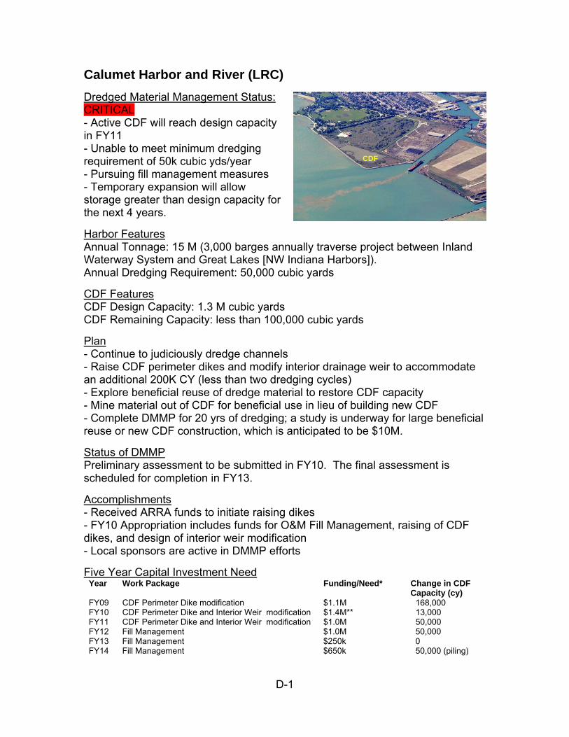
D-1
Calumet Harbor and River (LRC)
Dredged Material Management Status: CRITICAL - Active CDF will reach design capacity in FY11 - Unable to meet minimum dredging requirement of 50k cubic yds/year - Pursuing fill management measures - Temporary expansion will allow storage greater than design capacity for the next 4 years.
Harbor Features Annual Tonnage: 15 M (3,000 barges annually traverse project between Inland Waterway System and Great Lakes [NW Indiana Harbors]). Annual Dredging Requirement: 50,000 cubic yards
CDF Features CDF Design Capacity: 1.3 M cubic yards CDF Remaining Capacity: less than 100,000 cubic yards
Plan - Continue to judiciously dredge channels - Raise CDF perimeter dikes and modify interior drainage weir to accommodate an additional 200K CY (less than two dredging cycles) - Explore beneficial reuse of dredge material to restore CDF capacity - Mine material out of CDF for beneficial use in lieu of building new CDF - Complete DMMP for 20 yrs of dredging; a study is underway for large beneficial reuse or new CDF construction, which is anticipated to be $10M.
Status of DMMP Preliminary assessment to be submitted in FY10. The final assessment is scheduled for completion in FY13.
Accomplishments - Received ARRA funds to initiate raising dikes - FY10 Appropriation includes funds for O&M Fill Management, raising of CDF dikes, and design of interior weir modification - Local sponsors are active in DMMP efforts
Five Year Capital Investment Need Year Work Package Funding/Need* Change in CDF
Capacity (cy) FY09 CDF Perimeter Dike modification $1.1M 168,000 FY10 CDF Perimeter Dike and Interior Weir modification $1.4M** 13,000 FY11 CDF Perimeter Dike and Interior Weir modification $1.0M 50,000 FY12 Fill Management $1.0M 50,000 FY13 Fill Management $250k 0 FY14 Fill Management $650k 50,000 (piling)
CDF
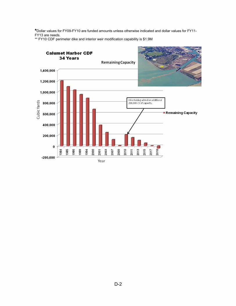
D-2
*Dollar values for FY09-FY10 are funded amounts unless otherwise indicated and dollar values for FY11-FY13 are needs. ** FY10 CDF perimeter dike and interior weir modification capability is $1.9M
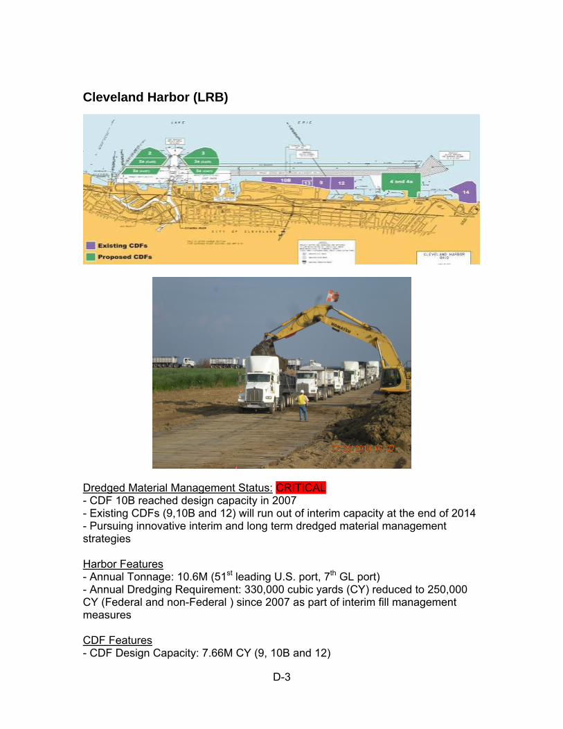
D-3
Cleveland Harbor (LRB)
Dredged Material Management Status: CRITICAL - CDF 10B reached design capacity in 2007 - Existing CDFs (9,10B and 12) will run out of interim capacity at the end of 2014 - Pursuing innovative interim and long term dredged material management strategies Harbor Features - Annual Tonnage: 10.6M (51st leading U.S. port, 7th GL port) - Annual Dredging Requirement: 330,000 cubic yards (CY) reduced to 250,000 CY (Federal and non-Federal ) since 2007 as part of interim fill management measures CDF Features - CDF Design Capacity: 7.66M CY (9, 10B and 12)
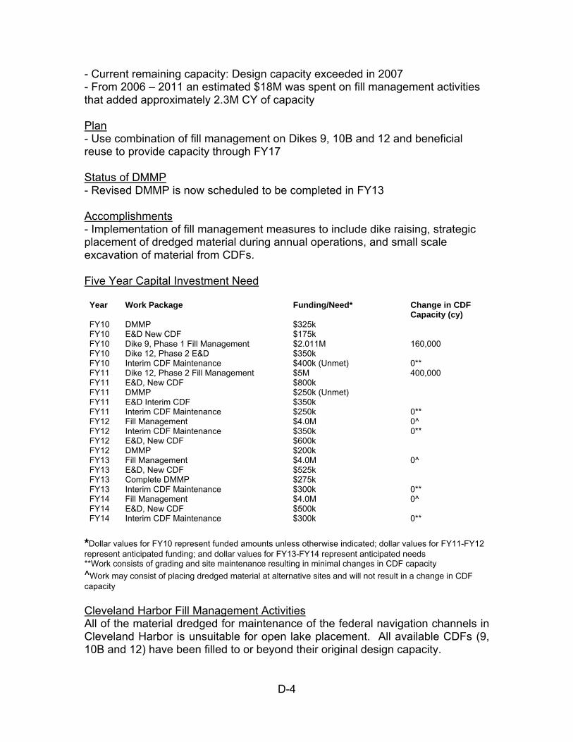
D-4
- Current remaining capacity: Design capacity exceeded in 2007 - From 2006 – 2011 an estimated $18M was spent on fill management activities that added approximately 2.3M CY of capacity Plan - Use combination of fill management on Dikes 9, 10B and 12 and beneficial reuse to provide capacity through FY17 Status of DMMP - Revised DMMP is now scheduled to be completed in FY13 Accomplishments - Implementation of fill management measures to include dike raising, strategic placement of dredged material during annual operations, and small scale excavation of material from CDFs. Five Year Capital Investment Need
Year Work Package Funding/Need* Change in CDF Capacity (cy)
FY10 DMMP $325k FY10 E&D New CDF $175k FY10 Dike 9, Phase 1 Fill Management $2.011M 160,000 FY10 Dike 12, Phase 2 E&D $350k FY10 Interim CDF Maintenance $400k (Unmet) 0** FY11 Dike 12, Phase 2 Fill Management $5M 400,000 FY11 E&D, New CDF $800k FY11 DMMP $250k (Unmet) FY11 E&D Interim CDF $350k FY11 Interim CDF Maintenance $250k 0** FY12 Fill Management $4.0M 0^ FY12 Interim CDF Maintenance $350k 0** FY12 E&D, New CDF $600k FY12 DMMP $200k FY13 Fill Management $4.0M 0^ FY13 E&D, New CDF $525k FY13 Complete DMMP $275k FY13 Interim CDF Maintenance $300k 0** FY14 Fill Management $4.0M 0^ FY14 E&D, New CDF $500k FY14 Interim CDF Maintenance $300k 0**
*Dollar values for FY10 represent funded amounts unless otherwise indicated; dollar values for FY11-FY12 represent anticipated funding; and dollar values for FY13-FY14 represent anticipated needs **Work consists of grading and site maintenance resulting in minimal changes in CDF capacity
^Work may consist of placing dredged material at alternative sites and will not result in a change in CDF capacity
Cleveland Harbor Fill Management Activities All of the material dredged for maintenance of the federal navigation channels in Cleveland Harbor is unsuitable for open lake placement. All available CDFs (9, 10B and 12) have been filled to or beyond their original design capacity.
D-5
While the preliminary assumption is that construction of a new CDF will be necessary for use in FY18, this measure would be dependent upon federal and non-federal funding estimated to be in the range of $250-$300M. Accordingly, it is imperative that interim alternate measures be evaluated and planned These measures will include activities currently being utilized (reduction in annual dredging requirements, strategic placement of annual dredged material as well as berm raising/excavation to gain additional capacity). Additional measures including using the material for Brownfield reclamation as well as new technology, such as equipment that can quickly dewater and separate dredged material for construction soil, etc., and sediment reduction that were eliminated from initial consideration due to time, cost and regulatory constraints must be reevaluated with a sense of urgency. In February 2010 Buffalo District held a summit in Cleveland, Ohio to assemble interested parties and initiate forward progress to develop a plan that could be implemented in the event a new DMDF is not constructed.
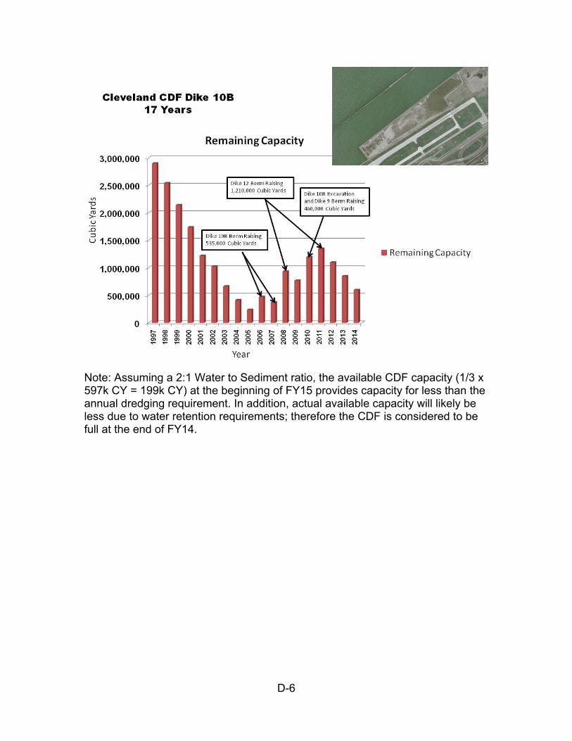
D-6
Note: Assuming a 2:1 Water to Sediment ratio, the available CDF capacity (1/3 x 597k CY = 199k CY) at the beginning of FY15 provides capacity for less than the annual dredging requirement. In addition, actual available capacity will likely be less due to water retention requirements; therefore the CDF is considered to be full at the end of FY14.
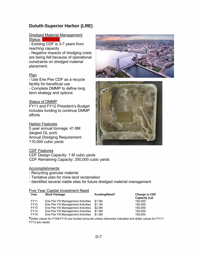
D-7
Duluth-Superior Harbor (LRE) Dredged Material Management Status: CRITICAL - Existing CDF is 3-7 years from reaching capacity - Negative impacts of dredging costs are being felt because of operational constraints on dredged material placement. Plan - Use Erie Pier CDF as a recycle facility for beneficial use - Complete DMMP to define long term strategy and options Status of DMMP FY11 and FY12 President’s Budget includes funding to continue DMMP efforts Harbor Features 5 year annual tonnage: 41.8M (largest GL port) Annual Dredging Requirement: 110,000 cubic yards CDF Features CDF Design Capacity: 1 M cubic yards CDF Remaining Capacity: 350,000 cubic yards Accomplishments - Recycling granular material - Tentative plan for mine land reclamation - Identified several viable sites for future dredged material management Five Year Capital Investment Need
Year Work Package Funding/Need* Change in CDF Capacity (cy)
FY11 Erie Pier Fill Management Activities $1.5M 150,000 FY12 Erie Pier Fill Management Activities $1.1M 150,000 FY13 Erie Pier Fill Management Activities $2.0M 150,000 FY14 Erie Pier Fill Management Activities $1.0M 150,000 FY15 Erie Pier Fill Management Activities $1.2M 150,000
*Dollar values for FY09-FY10 are funded amounts unless otherwise indicated and dollar values for FY11-FY13 are needs.
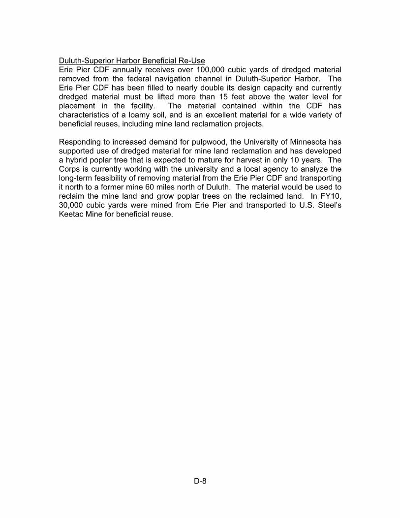
D-8
Duluth-Superior Harbor Beneficial Re-Use Erie Pier CDF annually receives over 100,000 cubic yards of dredged material removed from the federal navigation channel in Duluth-Superior Harbor. The Erie Pier CDF has been filled to nearly double its design capacity and currently dredged material must be lifted more than 15 feet above the water level for placement in the facility. The material contained within the CDF has characteristics of a loamy soil, and is an excellent material for a wide variety of beneficial reuses, including mine land reclamation projects. Responding to increased demand for pulpwood, the University of Minnesota has supported use of dredged material for mine land reclamation and has developed a hybrid poplar tree that is expected to mature for harvest in only 10 years. The Corps is currently working with the university and a local agency to analyze the long-term feasibility of removing material from the Erie Pier CDF and transporting it north to a former mine 60 miles north of Duluth. The material would be used to reclaim the mine land and grow poplar trees on the reclaimed land. In FY10, 30,000 cubic yards were mined from Erie Pier and transported to U.S. Steel’s Keetac Mine for beneficial reuse.
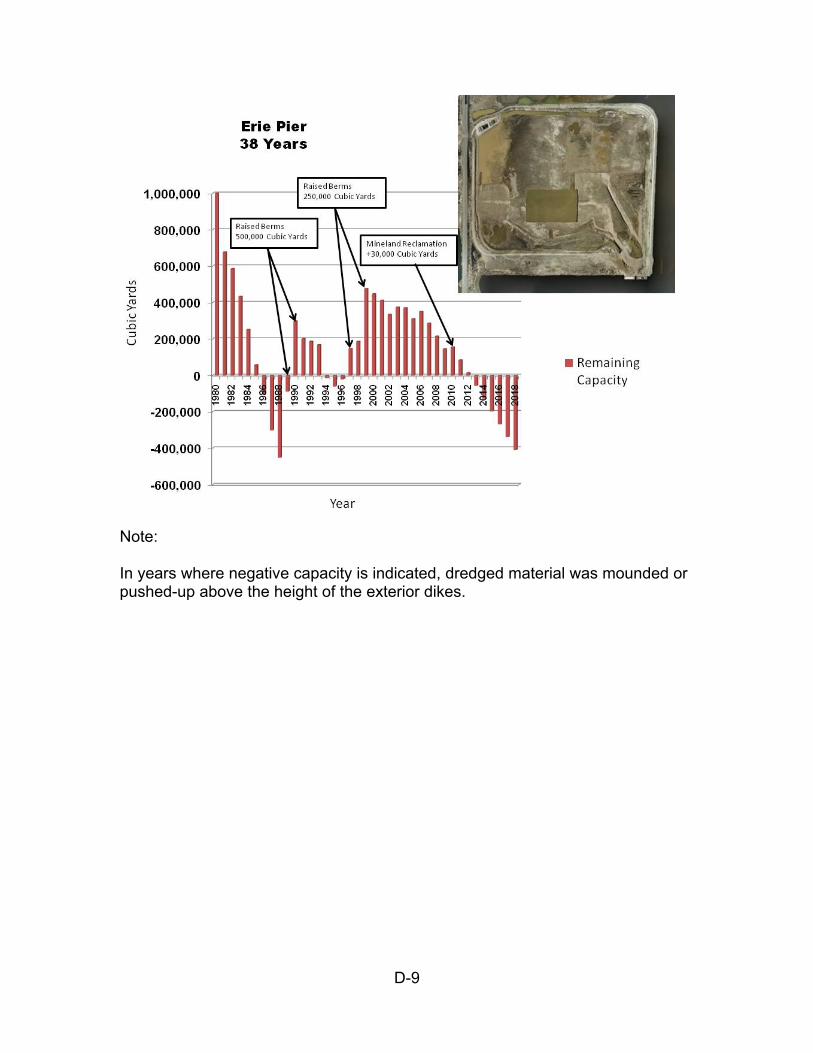
D-9
Note: In years where negative capacity is indicated, dredged material was mounded or pushed-up above the height of the exterior dikes.
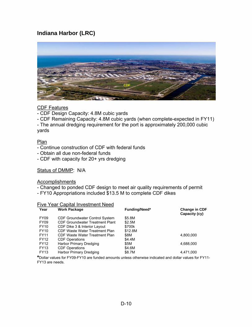
D-10
Indiana Harbor (LRC)
Dredged Material Management Status: CRITICAL CDF under construction into FY11 Unable to meet minimum dredging requirement of 100k cubic yds/year Vessels light loading & offloading inefficiently; Corps has not dredged since 1972 due to lack of disposal facility Harbor Features Annual Tonnage: 15M (42nd leading U.S. port, 3rd GL port) Annual Dredging Requirement: 100,000 cubic yards CDF Features - CDF Design Capacity: 4.8M cubic yards - CDF Remaining Capacity: 4.8M cubic yards (when complete-expected in FY11) - The annual dredging requirement for the port is approximately 200,000 cubic yards Plan - Continue construction of CDF with federal funds - Obtain all due non-federal funds - CDF with capacity for 20+ yrs dredging Status of DMMP: N/A Accomplishments - Changed to ponded CDF design to meet air quality requirements of permit - FY10 Appropriations included $13.5 M to complete CDF dikes Five Year Capital Investment Need
Year Work Package Funding/Need* Change in CDF Capacity (cy)
FY09 CDF Groundwater Control System $5.8M FY09 CDF Groundwater Treatment Plant $2.5M FY10 CDF Dike 3 & Interior Layout $700k FY10 CDF Waste Water Treatment Plan $12.8M FY11 CDF Waste Water Treatment Plan $8M 4,800,000 FY12 CDF Operations $4.4M FY12 Harbor Primary Dredging $5M 4,688,000 FY13 CDF Operations $4.6M FY13 Harbor Primary Dredging $8.7M 4,471,000
*Dollar values for FY09-FY10 are funded amounts unless otherwise indicated and dollar values for FY11-FY13 are needs.
CDF
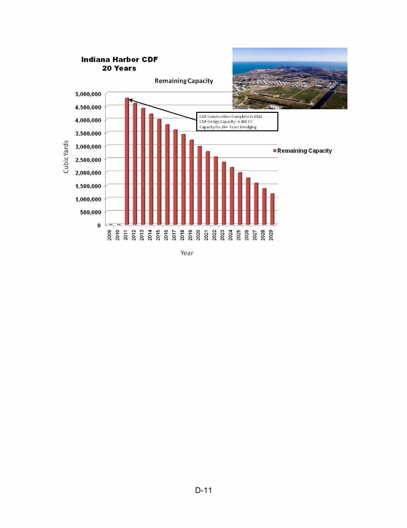
D-11
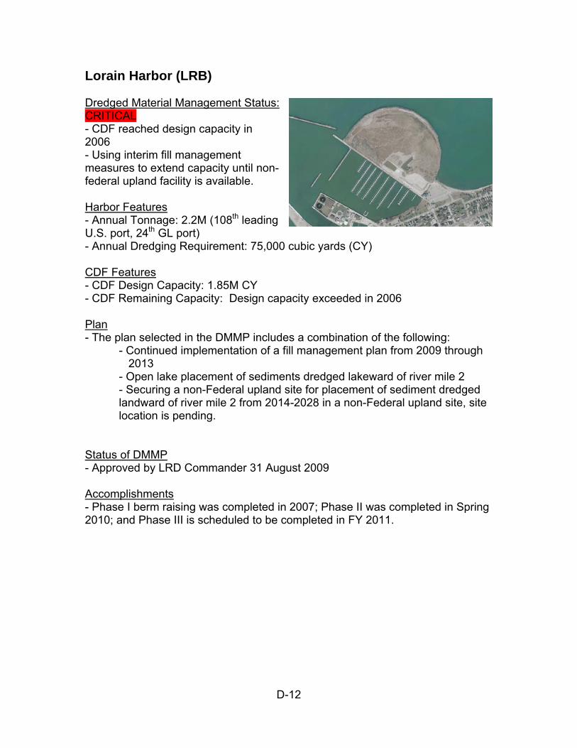
D-12
Lorain Harbor (LRB) Dredged Material Management Status: CRITICAL - CDF reached design capacity in 2006 - Using interim fill management measures to extend capacity until non-federal upland facility is available. Harbor Features - Annual Tonnage: 2.2M (108th leading U.S. port, 24th GL port) - Annual Dredging Requirement: 75,000 cubic yards (CY) CDF Features - CDF Design Capacity: 1.85M CY - CDF Remaining Capacity: Design capacity exceeded in 2006 Plan - The plan selected in the DMMP includes a combination of the following:
- Continued implementation of a fill management plan from 2009 through 2013 - Open lake placement of sediments dredged lakeward of river mile 2 - Securing a non-Federal upland site for placement of sediment dredged landward of river mile 2 from 2014-2028 in a non-Federal upland site, site location is pending.
Status of DMMP - Approved by LRD Commander 31 August 2009 Accomplishments - Phase I berm raising was completed in 2007; Phase II was completed in Spring 2010; and Phase III is scheduled to be completed in FY 2011.
D-13
Five Year Capital Investment Need
Year Work Package Funding/Need* Change in CDF Capacity (cy)
FY09 CDF Maintenance $425k 150,000 FY09 DMMP $170k FY10 E&D CDF Lift 2 $50k FY11 CDF Lift 2 Construction $500k 150,000 FY12 Operations Coordination with Non-Federal operator $25k FY13 Operations Coordination with Non-Federal Operator $25k FY14 Upland Disposal Site In Use $0
*Dollar values for FY09-FY10 represent funded amounts unless otherwise indicated; dollar values for FY11-FY12 represent anticipated funding; and dollar values for FY13-FY14 represent anticipated needs.
Lorain Harbor CDF Beneficial Use and Fill Management The Lorain Harbor CDF has been filled to its original design capacity, yet a portion of the material dredged for maintenance of the federal navigation channel is unsuitable for open lake placement. The dredged material management plan (DMMP) originally envisioned for Lorain Harbor included both expanding capacity at the existing CDF by raising the berms and constructing a new CDF in the outer harbor. The estimated cost of this plan totaled $36.4 million, including a federal share of $27.4 million. In an effort to reduce costs, the Lorain Harbor CDF DMMP was revised in a three part approach to accommodate dredged material placement needs through 2028. First, for sediments dredged lakeward of River Mile 2, open-lake placement of material is proposed. Second, from 2009-2013, material dredged upstream of River Mile 2 will be placed in the CDF through the implementation of best management practices including using material from inside the CDF to raise the CDF’s berms. Third, from 2014-2028, material dredged upstream of River Mile 2 (approximately one million cubic yards), will be placed in an upland site; details to be determined.
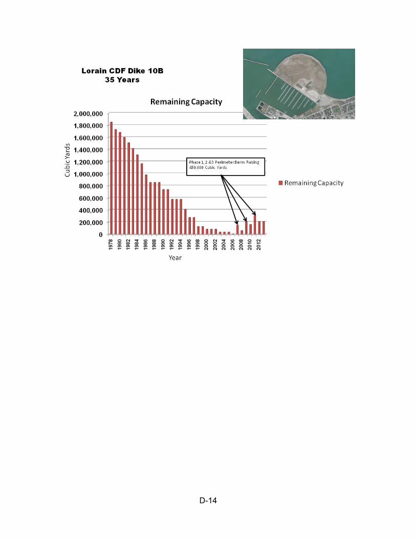
D-14
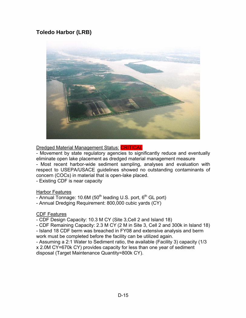
D-15
Toledo Harbor (LRB)
Dredged Material Management Status: CRITICAL - Movement by state regulatory agencies to significantly reduce and eventually eliminate open lake placement as dredged material management measure - Most recent harbor-wide sediment sampling, analyses and evaluation with respect to USEPA/USACE guidelines showed no outstanding contaminants of concern (COCs) in material that is open-lake placed. - Existing CDF is near capacity Harbor Features - Annual Tonnage: 10.6M (50th leading U.S. port, 6th GL port) - Annual Dredging Requirement: 800,000 cubic yards (CY) CDF Features - CDF Design Capacity: 10.3 M CY (Site 3,Cell 2 and Island 18) - CDF Remaining Capacity: 2.3 M CY (2 M in Site 3, Cell 2 and 300k in Island 18) - Island 18 CDF berm was breached in FY08 and extensive analysis and berm work must be completed before the facility can be utilized again. - Assuming a 2:1 Water to Sediment ratio, the available (Facility 3) capacity (1/3 x 2.0M CY=670k CY) provides capacity for less than one year of sediment disposal (Target Maintenance Quantity=800k CY).

D-16
Plan - Together with the Toledo Lucas County Port Authority, work collaboratively with government agencies and special interest groups to increase beneficial use measures and decrease open lake placement (if no incremental federal cost) - Apply science to restrictions on dredging and placement. Status of DMMP - Preliminary Assessment completed in 2006 concluded that no additional CDF capacity is needed because projected dredged material is suitable for open-lake placement. Accomplishments - Using science as basis to retain open lake placement as dredged material management measure while working toward implementation of beneficial use options - Small scale (130k CY/yr) reuse of dredged material from CDF by private interest for commercial use. - Completing tributary studies to model erosion patterns and develop best management practices to reduce sedimentation. - Using various USACE authorities to evaluate and eventually implement use of dredged material for habitat restoration; small scale (50-150CY) beneficial use at Wynn Road for riparian habitat restoration could be constructed in FY12, pending funding. - Continuing efforts to secure non-federal sponsor for Maumee Bay habitat restoration project targeted for future construction. Five Year Capital Investment Need
Year Work Package Funding/Need* Change in CDF Capacity (cy)
FY09 Fill Management Activities $325k 0 FY10 E&D Island 18 Stone Repair $300k (Unmet) 0 FY10 E&D Beneficial Reuse Pilot $300k (Unmet) 0 FY11 RMS Demonstration $325k 0 FY13 E&D, Construction Island 18 Stone
Repair $3.2M 0**
*Dollar values for FY10 represent funded amounts unless otherwise indicated; dollar values for FY11-FY12 represent anticipated funding; and dollar values for FY13-FY14 represent anticipated needs **Work consists of repair of exterior stone dike and will not result in additional capacity
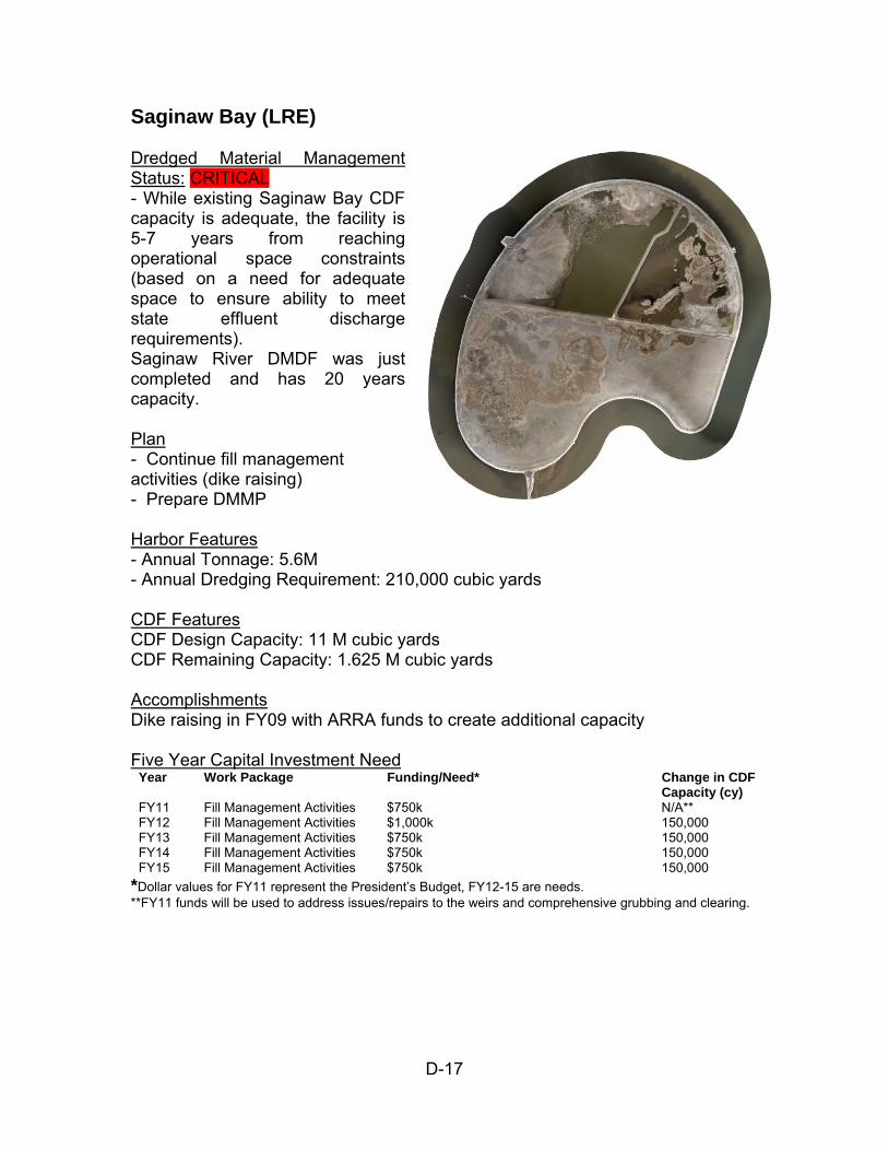
D-17
Saginaw Bay (LRE) Dredged Material Management Status: CRITICAL - While existing Saginaw Bay CDF capacity is adequate, the facility is 5-7 years from reaching operational space constraints (based on a need for adequate space to ensure ability to meet state effluent discharge requirements). Saginaw River DMDF was just completed and has 20 years capacity. Plan - Continue fill management activities (dike raising) - Prepare DMMP Harbor Features - Annual Tonnage: 5.6M - Annual Dredging Requirement: 210,000 cubic yards CDF Features CDF Design Capacity: 11 M cubic yards CDF Remaining Capacity: 1.625 M cubic yards Accomplishments Dike raising in FY09 with ARRA funds to create additional capacity Five Year Capital Investment Need
Year Work Package Funding/Need* Change in CDF Capacity (cy)
FY11 Fill Management Activities $750k N/A** FY12 Fill Management Activities $1,000k 150,000 FY13 Fill Management Activities $750k 150,000 FY14 Fill Management Activities $750k 150,000 FY15 Fill Management Activities $750k 150,000
*Dollar values for FY11 represent the President’s Budget, FY12-15 are needs. **FY11 funds will be used to address issues/repairs to the weirs and comprehensive grubbing and clearing.

D-18
Note: Due to dredged material consolidation and effective fill management practices, it’s estimated that no additional material will be placed into the CDF starting in 2016.
APPENDIX E
REGIONAL SEDIMENT MANAGEMENT STRATEGIES

E-1
Regional Sediment Management Strategies A very important aspect of Regional Sediment Management is keeping soil out of Federal Navigation Channels before it ever becomes sediment in need of dredging. State and local groups play a key role in implementing Federal and State Dollars available for these strategies, including the following:
319 Nonpoint Source Management Program - The 1987 amendments to
the Clean Water Act (CWA) established the Section 319 Nonpoint Source Management Program administered by USEPA. Section 319 addresses the need for greater federal leadership to help focus state and local nonpoint source efforts. Under Section 319, states, territories and tribes receive grant money that supports a wide variety of activities including technical assistance, financial assistance, education, training, technology transfer, demonstration projects and monitoring to assess the success of specific nonpoint source implementation projects.
TMDL - A Total Maximum Daily Load, or TMDL, is a calculation of the
maximum amount of a pollutant that a water body can receive and still safely meet water quality standards. The States and Soil and Water Conservation Districts are working to reduce sediment loads in critical watersheds. For instance, in Ohio the Swan Creek Watershed TMDL Report is a tool that includes ideas to help delist the Maumee AOC. The report includes fixes to improve erosion and sediment control throughout the watershed.
o Practice conservation tillage on row crop farms o Install filter strips along all agricultural tributaries o Implement storm water controls in developing areas and construction sites o Establish and protect riparian buffers on streams o Retrofit storm water detention structures in urban areas to reduce first flush chemicals and high flows
CREP - The Conservation Reserve Enhancement Program (CREP) is a
voluntary land retirement program that helps agricultural producers protect environmentally sensitive land, decrease erosion, restore wildlife habitat, and safeguard ground and surface water. The program is a partnership among producers; tribal, state, and federal governments (USDA – Farm Service Agency (FSA)); and, in some cases, private groups. For example, the Lake Erie Conservation Reserve Enhancement Program (CREP) in Ohio is one of the programs funded largely by USDA that allows landowners to voluntarily enroll environmentally sensitive land in the watershed. The primary emphasis of the Lake Erie CREP has been on the establishment of streamside buffers, field windbreaks, and wetland practices to reduce water and wind erosion. To date over 37,000 acres of
E-2
conservation practices have been installed on land in the Lake Erie Watershed
EQIP - The Environmental Quality Incentives Program (EQIP) is an NRCS voluntary program that provides financial and technical assistance to agricultural producers through contracts up to a maximum term of ten years in length. These contracts provide financial assistance to help plan and implement conservation practices that address natural resource concerns and for opportunities to improve soil, water, plant, animal, air and related resources on agricultural land and non-industrial private forestland. In addition, a purpose of EQIP is to help producers meet Federal, State, Tribal and local environmental regulations. 46 million acres throughout the U.S. are currently managed under the EQIP program. Two of the most common and effective practices used to abate sediment erosion are conservation (reduced) tillage and no-tillage.
Buffer Strips - Conservation buffers are small areas or strips of land in permanent vegetation, designed to intercept pollutants and manage other environmental concerns. Buffers include: riparian buffers, filter strips, grassed waterways, shelterbelts, windbreaks, living snow fences, contour grass strips, cross-wind trap strips, shallow water areas for wildlife, field borders, alley cropping, herbaceous wind barriers, and vegetative barriers. Strategically placed buffer strips in the agricultural landscape can effectively mitigate the movement of sediment, nutrients, and pesticides within farm fields and from farm fields. USDA and many state and local governments--and even some private organizations--offer financial incentives to install conservation buffers.
Two stage ditches – An Ohio State University project funded by the Great Lakes Protection Fund provided information and research findings on channel design and impacts on water quality. They found channel stability in two stage ditches may be improved by a reduction in the erosive potential of larger flows as they are shallower and spread out across the bench. Stability of the ditch bank may also be improved because the toe of the ditch bank meets the bench rather than the ditch bottom. Here the bank height is effectively reduced and the shear stress (erosive force) on the toe of the bank is less. Two stage ditches have been implemented at a number of locations throughout the great lakes, and NRCS has prepared a two-stage ditch design manual for Stream Restoration. Technical assistance is offered through agencies such as the ODNR-Division of Soil and Water Resources to landowners and units of government regarding new channel applications, specifically self-formed streams and multi-staged ditch (e.g. 2 stage ditches), that perform enhanced sediment removal and water quality treatment. Development of specification for these practices is occurring, so that NRCS might include them in their list of practices in the future for EQIP and other programs.
E-3
Erosion and Sediment Control - An Erosion Prevention and Sediment
Control Plan (EPSCP) ensures that sediment transport is addressed in one of the most crucial stages of the project: the planning stage. A good erosion prevention and sediment control plan first minimizes the extent of disturbance by focusing on erosion control (minimizing disturbed areas, seeding, mulching, matting) by controlling the amount of soil that can run off and by stabilizing exposed soil. Sediment control measures (i.e. stabilized construction entrances) then focus on any sediment that has escaped your erosion control measures. Erosion prevention measures are far more effective than sediment. State and county environmental protection agencies require EPSCP throughout Great Lakes watersheds. Many soil and water conservation districts in urbanized areas have staff focused on construction site plan review and site inspection. For example, the ODNR-Division of Soil and Water Resources supports these efforts through on-going development of standards and specifications for new development sites that are contained in the Rainwater and Land Development manual http://www.dnr.state.oh.us/soilandwater/water/rainwater/default/tabid/9186/Default.aspx) as well as training of staff, consulting personnel and other local government officials. These standards help construction sites comply with local EPA stormwater permit requirements (e.g. NPDES permits).
Beneficial Use Requirement Standards - Richard A. Price of ERDC and
Dave Knight of the Great Lakes Commission are working with Great Lake States to develop awareness with state resource agencies of beneficial use opportunities and help them understand the critical need to pursue Beneficial Uses where they are suitable. They are sharing Corps testing standards for environmental suitability involving impacts and risks on a site specific basis, and working with Great Lakes states to consider these analyses in performing beneficial use determinations versus relying solely on statewide numerical standards.
Appropriate upland treatments, including crop residue management, nutrient management, integrated pest management, winter cover crops, buffer strips , and similar management practices and technologies can allow farmers to achieve a measure of economic and environmental sustainability in their operations. In urban settings, retrofitting storm water detention structures in urban areas will reduce first flush chemicals and high flows. Contaminants may enter sewer systems throughout the watershed and allow areas that would not otherwise be considered sources to potentially contribute contaminated sediment to the Federal Channels.