DRAFT TRARALGON - latrobe.vic.gov.au · up to 2 storeys up to 3 storeys up to 4 storeys up to 5...
44
TRARALGON DRAFT ACTIVITY CENTRE PLAN
Transcript of DRAFT TRARALGON - latrobe.vic.gov.au · up to 2 storeys up to 3 storeys up to 4 storeys up to 5...
TRARALGON DRAFT
ACTIVITY CENTRE PLAN

TRARALGON ACTIVITY CENTRE PLAN2 12.10.2017
ACKNOWLEDGEMENTS
The Traralgon Activity Centre Plan has been developed on behalf of Latrobe City Council by the Victorian Planning Authority (VPA) and Hansen Partnership Pty Ltd. Background work and an initial draft of the Traralgon Activity Centre Plan was completed by Hansen Partnership Pty Ltd.
Following this work, Council applied to have the project completed as part of the Victorian State Government's Streamlining for Growth Program. Work undertaken by the VPA as part of this program generated additional inputs which have formed significant parts of this final draft report.
The Traralgon Activity Centre Plan is a Latrobe City document, and is a shared initiative of Latrobe City Council and Victorian State Government.
TRARALGON ACTIVITY CENTRE PLAN 312.10.2017
CONTENTS
ACKNOWLEDGEMENTS 2
1 EXECUTIVE SUMMARY 5Introduction 6Consultation 6
2 KEY DIRECTIONS 7
3 ACTIVITY CENTRE PLAN 11The public realm 13Land use & activity 15Built form 17Access & movement 19
4 DESIGN GUIDELINES 21General guidelines for all precincts 22Precinct 1: Town centre core 23Precinct 2: Princes Highway & station corridor 24Precinct 3: Kay Street & civic corridor 25Precinct 4: Creekside office 26Precinct 5: Breed Street 27
5 KEY INITIATIVES 28Key public realm areas 28Key development sites 29Post Office Place concept 30
6 IMPLEMENTATION 35Planning policy 35Zoning and overlay controls 35Actions 36
FIGURESFigure 1: Context 4Figure 2: Activity Centre 10Figure 3: Public Realm 12Figure 4: Land Use & Activity 14Figure 5: Built Form & Height 16Figure 6: Franklin Street Cross Section 17Figure 7: Access & Movement 18Figure 8: The Precincts 20Figure 9: Post Office Place: Public Realm Improvements 30Figure 10a: Post Office Place Cross Section: Option 1 33Figure 10b: Post Office Place Cross Section: Option 2 34
P R I N C E S H I G H W AY
TRA
RA
LGO
N C
RE
EK
Traralgon Activity Centre Plan 0.20 0.4 0.80.6 1km
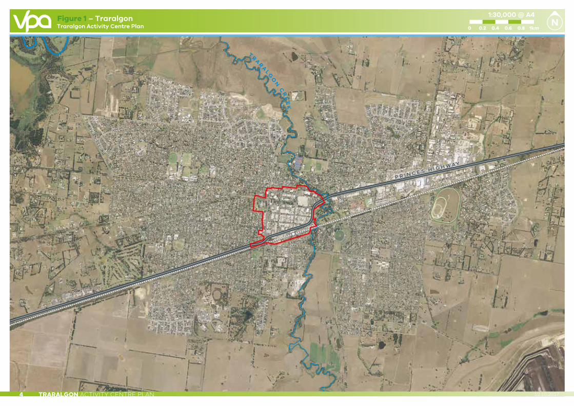
1:30,000 @ A4Figure 1 – Traralgon
TRARALGON ACTIVITY CENTRE PLAN4 12.10.2017

MELBOURNE
WARRAGUL
DROUIN
INVERLOCHWONTHAGGI
CHURCHILL
G R E A T D I V I D I N GR A N G E
S T R Z E L E C K IR A N G E S
LATROBE
W I L S O N SP R O M O N T O R Y
MOE
MORWELL
TRARALGON
ROSEDALE
SALE
100 20 4030 50km
1:1,700,000
TRARALGON ACTIVITY CENTRE PLAN 512.10.2017
1 EXECUTIVE SUMMARY
EXECUTIVE SUMMARYTraralgon is the largest town in Latrobe City, Gippsland’s regional city. Latrobe City is identified as a Regional City in the State Planning Policy Framework, alongside Geelong, Ballarat and Bendigo. This designation has major implications for the type of development that can, and should, be expected within this Activity Centre. Traralgon is also a key public transport interchange, due to the direct rail link to Melbourne (see Figure 1 – Context).
The Traralgon Activity Centre Plan (‘the Plan’) is a key guiding document designed to assist the management and monitoring of future growth and development in the central business district (CBD) of Traralgon. The plan will positively guide future land use and development in a coordinated manner, and provide greater certainty for all stakeholders in the delivery of a preferred outcome.
The study area for the Plan focuses on the existing business hub in central Traralgon. The precinct is generally bounded by Grey Street to the north, Traralgon Creek and Princes Highway to the east, the railway precinct to the south, and the rear property boundary of Breed Street commercial properties (including Hubert Osborne Park) to the west.
The Plan was prepared through a collaborative process involving stakeholders, landowners and agencies. The Plan builds on previous work undertaken within the broad Traralgon area and in the activity centre itself. Chief among these are the Latrobe Transit Centre Precincts: Traralgon (2008) and the Traralgon Structure Plan (2017). These important documents were reviewed, and the principles and strategies contained within were considered in the preparation of this Plan.
The Plan was undertaken in phases, with background information on existing conditions and plans sourced and analysed before technical assessments were prepared. This information, along with feedback from the community formed the basis of the ‘vision’ outlined in the Traralgon Activity Centre Plan: Key Directions Report (2011).
The public exhibition of the Key Directions Report identified a number of key issues and concerns which were then addressed through the development of a car parking strategy and the finalisation of other key strategic policy documents.
The Plan has now been revised and updated to reflect the progress of Traralgon over the past five years, including the findings of the Car Parking Framework Review (2014) and the adopted Traralgon Station Precinct Master Plan (2011) given the key role the station area plays in linking the commercial centre to the residential land south of the precinct.

TRARALGON ACTIVITY CENTRE PLAN6 12.10.2017
INTRODUCTIONTraralgon is the largest town in Latrobe City, Gippsland’s regional city. It is located 164 kilometres east of Melbourne and serves as the primary commercial centre for the wider Gippsland area. Traralgon’s CBD needs to ensure it reflects this important role.
In establishing an agreed vision for the Centre for a period of 15 to 20 years, the Plan seeks to outline key policy directions, and important physical outcomes as they relate to the Traralgon Activity Centre’s public realm, land use and activity, built form and access and movement.
The Plan must be regularly reviewed to ensure its directions and ambitions continue to be relevant to the activity centre as it changes over time.
CONSULTATIONA draft Traralgon Activity Centre Plan was developed through a two-stage consultation process in 2010 and 2011.
Stage 1 involved a series of consultation sessions held with a range of stakeholders, including, but not limited to:
• Internal Council staff and Councillors;
• Government agencies including Local Government, the Department of Environment, Land, Water and Planning, VicRoads, and the West Gippsland Catchment Management Authority;
• Key interest groups including the Traralgon Chamber of Commerce; and
• The wider Traralgon community.
These sessions identified the key issues for the centre which informed the development of eight background reports. These reports included an executive summary, consultation summary, planning context, economics, community infrastructure, car parking, traffic and public transport, and urban design. The background reports were exhibited to the public for review and comment.
A series of stakeholder workshops formed Stage 2 of the consultation process, involving stakeholders from Stage 1 and the wider community. These workshops discussed the key issues identified in Stage 1, and developed responses to be reflected in the future Activity Centre Plan.
From this process, the Traralgon Activity Centre Plan: Key Directions Report (2011) was developed, and publicly exhibited for review and comment for 15 weeks between December 2010 and March 2011. Additional information sessions on the Key Directions Report were also held during this time.
The report exhibition process identified car parking availability within the Activity Centre as a key issue. In response, Council resolved that this and a number of other matters required further investigation before the Traralgon Activity Centre Plan could be finalised.
This work has now been undertaken, and the appropriate strategic documents have been developed and endorsed by Council.
TRARALGON ACTIVITY CENTRE PLAN 712.10.2017
2 KEY DIRECTIONS
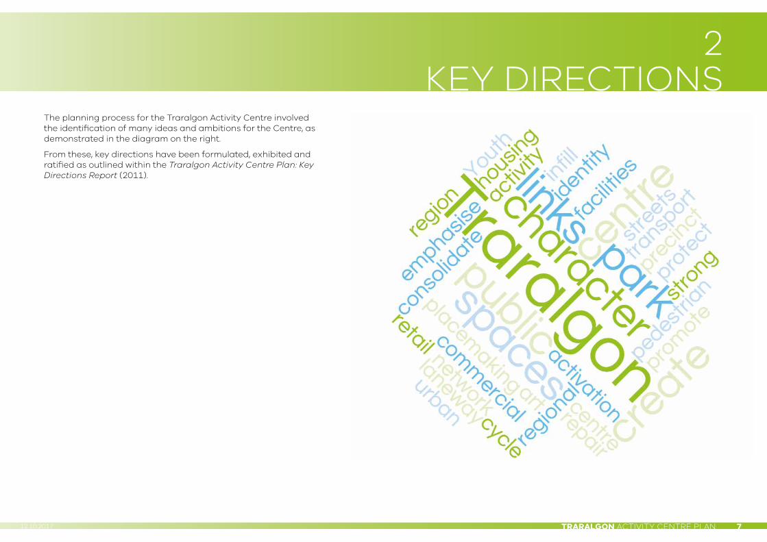
The planning process for the Traralgon Activity Centre involved the identification of many ideas and ambitions for the Centre, as demonstrated in the diagram on the right.
From these, key directions have been formulated, exhibited and ratified as outlined within the Traralgon Activity Centre Plan: Key Directions Report (2011).

TRARALGON ACTIVITY CENTRE PLAN8 12.10.2017
PUBLIC REALM• To create a Princes Highway Boulevard;
• To create a network of public spaces incorporating the Traralgon Courthouse and Post Office Project, the Traralgon Station Precinct Master Plan, The Gippsland Regional Aquatic Centre and the Latrobe Creative Precinct Project;
• To create a 'shared space' in the form of a town square at the intersection of Post Office Place, Kay Street and Franklin Street;
• To incorporate art and place making to enhance identity and character;
• To support the integration and activation of the Traralgon Creek corridor; and
• To resolve laneway ownership and encourage activation.
LAND USE• To emphasise the key retail axes of Franklin Street and Seymour Streets;
• To promote the role of Traralgon Activity Centre as the premier shopping and business destination for Gippsland;
• To support shop-top housing and mixed uses within the activity centre;
• To support the provision of appropriate youth spaces within the town centre;
• To encourage consolidation of land to facilitate the creation of viable development sites; and
• To support civic and community uses within the Traralgon Activity Centre including the Latrobe Creative Precinct, the Gippsland Regional Aquatic Centre, and the Traralgon Court House and Post Office
The key directions have been arranged into four main themes, which form the basis of the planning and design principles of the Traralgon Activity Centre Plan. These themes are represented in the following diagrams.

TRARALGON ACTIVITY CENTRE PLAN 912.10.2017
BUILT FORM• To consolidate the town centre by infilling blocks and creating a
consistent street wall;
• To create strong urban form that responds to the public realm and regional character;
• To encourage the development of taller built form throughout the centre (up to 6 storeys) in recognition of the important CBD function that the Traralgon Activity Centre plays; and
• To provide continuous weather protection such as an awning treatment along active frontages.
ACCESS & MOVEMENT• To identify and define the role of streets within the town centre;
• To encourage multi-storey and integrated parking solutions in appropriate locations;
• To improve the provision of facilities associated with public transport and identify bus interchange at Traralgon Station;
• To provide safe cycle links through the town centre and ensure that connections can be made with other cycle path projects such as the Traralgon–Morwell Shared Pathway; and
• To allow for pedestrian and visual links from Kay Street to Victory Park.

G R E Y S T R E E T
BR
EE
D S
TR
EE
T
MA
BE
L S
TR
EE
T
AL
BE
RT
ST
RE
ET
DE
AK
I N S
TR
EE
T
CH
UR
CH
ST
RE
ET
FR
AN
KL
I N S
TR
EE
T
CO
LL
INS
ST
RE
ET
M O O R E S T R E E T
G O R D O N S T R E E T
K AY S T R E E T
P O S T O F F I C E P L A C E
G W A L I A S T R E E T
CA
MP
BE
LL
ST
RE
ET
PE
TE
RK
I N S
TR
EE
T
HI G
H S
T RE E T
WH
I TT
AK
ER
S R
OA
D
PO
ST
OF
FI C
E L
AN
E
M E T H O D I S T L A N E
L I V I N G S T O N E L N
LIV
ING
ST
ON
E S
TR
EE
T
S E Y M O U R S T R E E T
H O T H A M S T R E E T
FE
EL
EY
LA
NE
S E R V I C E S T R E E T
H E N R Y S T R E E T
B R I D G E S A V E N U E
S H A K E S P E A R E S T R E E T
P R I N C E S H I G H W AY
P R I N C E S H I G H W AY
Q U E E N S PA R A D E
M E R E D I T H S T R E E T
B A N K S T R E E T
TR
A R A L G O N C R E E K
TE
NN
YS
ON
ST
RE
ET
StocklandTraralgon
PostOffice
PoliceStation
PostOffice
Woolworths
VictoryPark
TraralgonRecreation
Reserve
TraralgonStation
TAFE
retirementvillage
NeighbourhoodLearning Centre
Gippsland RegionalAquatics Centre Project
Hubert OsbornePark
St Michael’sPrimary School
Grey StreetPrimary School
Bert ThompsonReserve
DoortyPark
Latrobe CreativePrecinct
VRI Hall
Duncan CameronMemorial Park
study area boundary
station masterplan precinct
town centre hub
town centre identity art
civic use
pocket park / plaza
open space
creek interface
key residential opportunities at upper levels
up to 2 storeys
up to 3 storeys
up to 4 storeys
up to 5 storeys
up to 6 storeys
activated laneway
shared service lane
shared pathway
key development sites
boulevard treatment
public art
cycle route
bus route
intermodal transport interchange
at-grade car park
integrated car park
multi-level integrated car park
key view corridor
key retail axes
visual connection to parkland
access way
Heritage Overlay
significant forms
exisiting landmarks
key pedestrian connections
Traralgon Activity Centre Plan
© Victorian Planning Authority, 2017. The State of Victoria does not warrant the accuracy or completeness of information in this publication and any person using or relying upon such information does so on the basis that the State of Victoria shall bear no responsibility or liability whatsoever for any errors, faults, defects or omission in the information.
1:6,000 @ A4
0 10050 200150 250
Figure 2 – Key Planning & Design Principles
TRARALGON ACTIVITY CENTRE PLAN10 12.10.2017
TRARALGON ACTIVITY CENTRE PLAN 1112.10.2017
3 ACTIVITY CENTRE PLAN
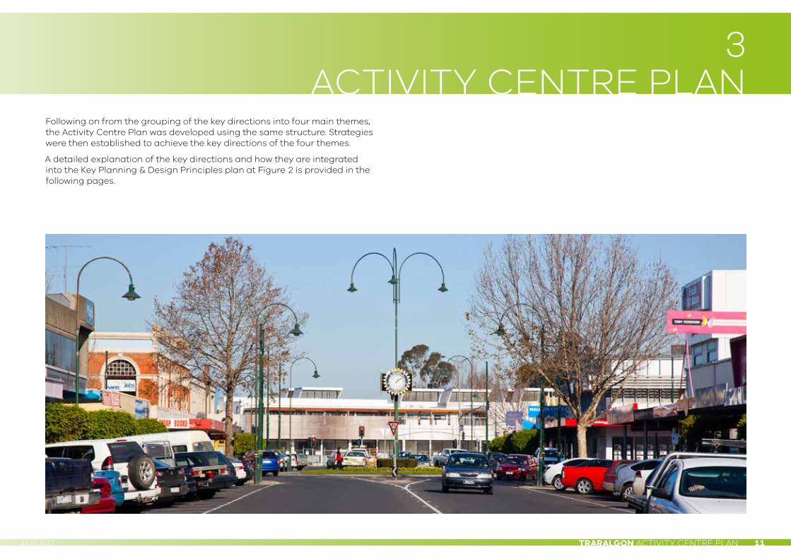
Following on from the grouping of the key directions into four main themes, the Activity Centre Plan was developed using the same structure. Strategies were then established to achieve the key directions of the four themes.
A detailed explanation of the key directions and how they are integrated into the Key Planning & Design Principles plan at Figure 2 is provided in the following pages.
StocklandTraralgon
PoliceStation
PostOffice
Woolworths
VictoryPark
DoortyPark
TraralgonRecreation
Reserve
TraralgonStation
TAFE
RetirementVillage
Duncan CameronMemorial Park
NeighbourhoodLearning Centre
St Michael’sPrimary School
Latrobe CreativePrecinct
Grey StreetPrimary School
Bert ThompsonReserve
PostOffice
Gippsland RegionalAquatics Centre Project
Hubert OsbornePark
G R E Y S T R E E T
BR
EE
D S
TR
EE
T
MA
BE
L S
TR
EE
T
AL
BE
RT
ST
RE
ET
DE
AK
I N S
TR
EE
T
CH
UR
CH
ST
RE
ET
FR
AN
KL
I N S
TR
EE
T
CO
LL
INS
ST
RE
ET
M O O R E S T R E E T
G O R D O N S T R E E T
K AY S T R E E T
P O S T O F F I C E P L A C E
G W A L I A S T R E E T
CA
MP
BE
LL
ST
RE
ET
HI G
H S
T RE E T
WH
I TT
AK
ER
S R
OA
D
PO
ST
OF
FI C
E L
AN
E
M E T H O D I S T L A N E
L I V I N G S T O N E L A N E
LIV
ING
ST
ON
E S
TR
EE
T
S E Y M O U R S T R E E T
H O T H A M S T R E E T
FE
EL
EY
LA
NE
S E R V I C E S T R E E TH E N R Y S T R E E T
B R I D G E S A V E N U E
S H A K E S P E A R E S T R E E T
P R I N C E S H I G H W AY
Q U E E N S PA R A D E
M E R E D I T H S T R E E T
B A N K S T R E E T
T
RA R A L G O N C R E E K
TE
NN
YS
ON
ST
RE
ET
study area boundary
station masterplan precinct
town centre identity art
open space & parklands
pocket park / plaza
town centre hub
public art
activated pedestrian laneway
boulevard treatment
streetscape treatment
existing vegetation
roundabout treatment
shared path
shared service lane
key view corridor
visual connection to parkland
key pedestrian connections
Traralgon Activity Centre Plan
© Victorian Planning Authority, 2017. The State of Victoria does not warrant the accuracy or completeness of information in this publication and any person using or relying upon such information does so on the basis that the State of Victoria shall bear no responsibility or liability whatsoever for any errors, faults, defects or omission in the information.
1:6,000 @ A4
0 10050 200150 250
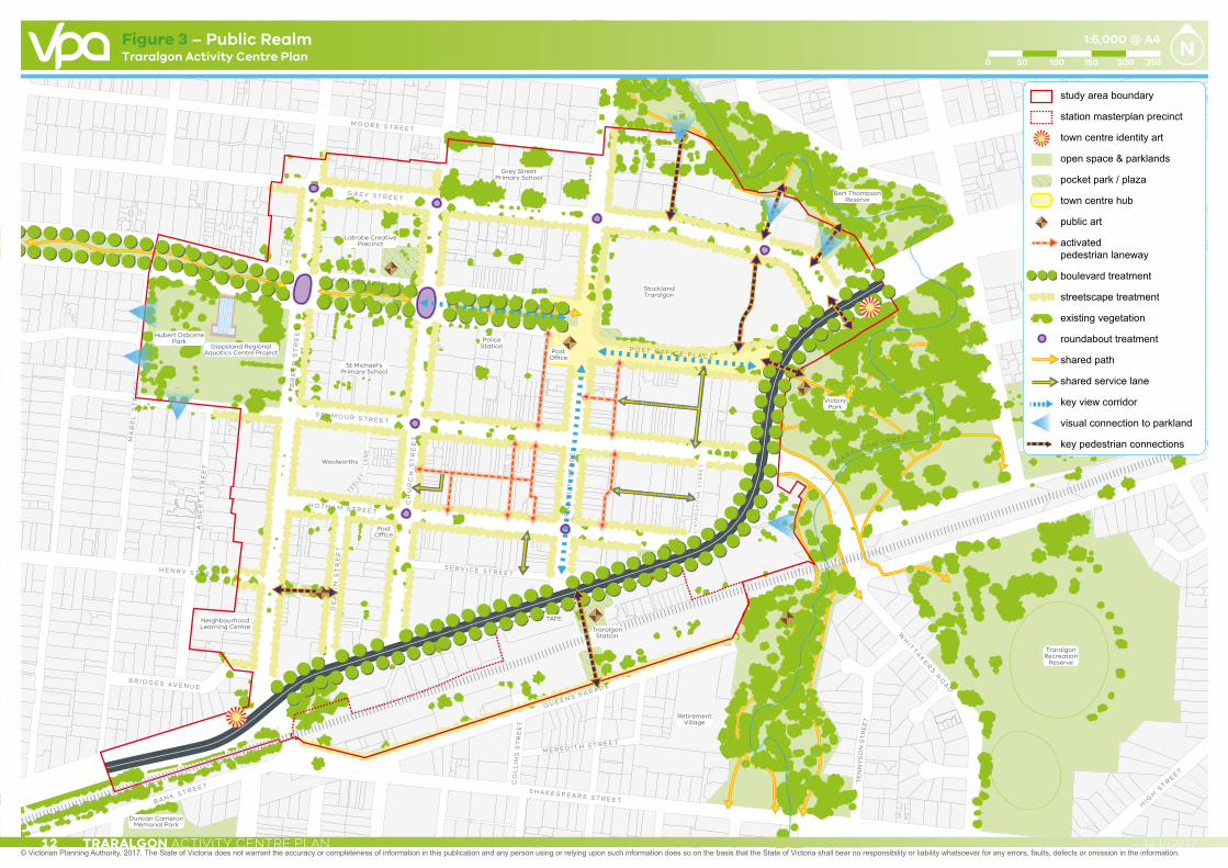
Figure 3 – Public Realm
TRARALGON ACTIVITY CENTRE PLAN12 12.10.2017

StocklandTraralgon
PoliceStation
PostOffice
Woolworths
VictoryPark
DoortyPark
TraralgonRecreation
Reserve
TraralgonStation
TAFE
RetirementVillage
Duncan CameronMemorial Park
NeighbourhoodLearning Centre
St Michael’sPrimary School
Latrobe CreativePrecinct
Grey StreetPrimary School
Bert ThompsonReserve
PostOffice
Gippsland RegionalAquatics Centre Project
Hubert OsbornePark
G R E Y S T R E E T
BR
EE
D S
TR
EE
T
MA
BE
L S
TR
EE
T
AL
BE
RT
ST
RE
ET
DE
AK
I N S
TR
EE
T
CH
UR
CH
ST
RE
ET
FR
AN
KL
I N S
TR
EE
T
CO
LL
INS
ST
RE
ET
M O O R E S T R E E T
G O R D O N S T R E E T
K AY S T R E E T
P O S T O F F I C E P L A C E
G W A L I A S T R E E T
CA
MP
BE
LL
ST
RE
ET
HI G
H S
T RE E T
WH
I TT
AK
ER
S R
OA
D
PO
ST
OF
FI C
E L
AN
E
M E T H O D I S T L A N E
L I V I N G S T O N E L A N E
LIV
ING
ST
ON
E S
TR
EE
T
S E Y M O U R S T R E E T
H O T H A M S T R E E T
FE
EL
EY
LA
NE
S E R V I C E S T R E E TH E N R Y S T R E E T
B R I D G E S A V E N U E
S H A K E S P E A R E S T R E E T
P R I N C E S H I G H W AY
Q U E E N S PA R A D E
M E R E D I T H S T R E E T
B A N K S T R E E T
T
RA R A L G O N C R E E K
TE
NN
YS
ON
ST
RE
ET
study area boundary
station masterplan precinct
town centre identity art
open space & parklands
pocket park / plaza
town centre hub
public art
activated pedestrian laneway
boulevard treatment
streetscape treatment
existing vegetation
roundabout treatment
shared path
shared service lane
key view corridor
visual connection to parkland
key pedestrian connections
Traralgon Activity Centre Plan
© Victorian Planning Authority, 2017. The State of Victoria does not warrant the accuracy or completeness of information in this publication and any person using or relying upon such information does so on the basis that the State of Victoria shall bear no responsibility or liability whatsoever for any errors, faults, defects or omission in the information.
1:6,000 @ A4
0 10050 200150 250
Figure 3 – Public Realm
TRARALGON ACTIVITY CENTRE PLAN 1312.10.2017
S1 Improve the Princes Highway between Breed Street and Traralgon Creek.
S2 Support the inclusion of a public plaza fronting the Princes Highway, creating linkages to Franklin Street as outlined in the Traralgon Station Precinct Master Plan 2011.
S3 Create a town square-style community space for civic events, linking Post Office Place and the old Courthouse with Kay Street.
S4 Support the implementation of the Latrobe Creative Precinct Project.
S5 Support the development of a range of unique smaller public plazas.
S6 Support the activation of smaller streets and laneways to provide additional connections between streets in the town centre.
S7 Support public art at key sites within the town centre, ensuring the art reflects the character and values of the community and is of an appropriate scale for its location.
S8 Prepare a streetscape master plan to determine how the streets within the centre should be upgraded, noting the area around Franklin and Seymour Streets as a priority.
S9 Improve public realm infrastructure.
S10 Promote the history of the town centre.
S11 Protect significant corridor views throughout the town centre including:
• Franklin Street towards the post office;• West along Post Office Place to the post
office and east towards Victory Park; and• In the direction of the church at the
intersection of Church and Kay Streets.
THE PUBLIC REALMThe following strategies relating to the public realm are identified to achieve the key directions for the Traralgon Activity Centre:
S12 Protect and enhance Kay Street as a northern ‘boulevard’ with a strong landscape character leading into the centre.
S13 Improve connections between the town centre and Traralgon Creek.
S14 Encourage activation of the creek corridor by upgrading facilities along the creek.

Lorem ipsum
StocklandTraralgon
PostOffice
PoliceStation
PostOffice
Woolworths
VictoryPark
TraralgonRecreation
Reserve
TraralgonStation
VRI Hall
TAFE
RetirementVillage
Duncan CameronMemorial Park
NeighbourhoodLearning Centre
St Michael’sPrimary School
Grey StreetPrimary School
Bert ThompsonReserve
DoortyPark
Latrobe CreativePrecinct
Gippsland RegionalAquatics Centre Project
Hubert OsbornePark
G R E Y S T R E E T
BR
EE
D S
TR
EE
T
MA
BE
L S
TR
EE
T
AL
BE
RT
ST
RE
ET
DE
AK
I N S
TR
EE
T
CH
UR
CH
ST
RE
ET
FR
AN
KL
I N S
TR
EE
T
CO
LL
INS
ST
RE
ET
M O O R E S T R E E T
G O R D O N S T R E E T
K AY S T R E E T
P O S T O F F I C E P L A C E
G W A L I A S T R E E T
CA
MP
BE
LL
ST
RE
ET
PE
TE
RK
I N S
TR
EE
T
HI G
H S
T RE E T
WH
I TT
AK
ER
S R
OA
D
PO
ST
OF
FI C
E L
AN
E
M E T H O D I S T L A N E
L I V I N G S T O N E L N
LIV
ING
ST
ON
E S
TR
EE
T
S E Y M O U R S T R E E T
H O T H A M S T R E E T
FE
EL
EY
LA
NE
S E R V I C E S T R E E T
H E N R Y S T R E E T
B R I D G E S A V E N U E
S H A K E S P E A R E S T R E E T
P R I N C E S H I G H W AY
P R I N C E S H I G H W AY
Q U E E N S PA R A D E
M E R E D I T H S T R E E T
B A N K S T R E E T
TR
A R A L G O N C R E E K
TE
NN
YS
ON
ST
RE
ET
study area boundary
station masterplan precinct
town centre hub
station precinct
office / commercial focus
retail focus
mixed use
civic uses
education
proposed pocket park / plaza
open space
key residential opportunities at upper levels
active frontage
activated laneway
shared service lane
key development sites
at-grade car park
integrated car park
multi-level integrated car park
key retail axes
Access way
key pedestrian connections
Traralgon Activity Centre Plan
© Victorian Planning Authority, 2017. The State of Victoria does not warrant the accuracy or completeness of information in this publication and any person using or relying upon such information does so on the basis that the State of Victoria shall bear no responsibility or liability whatsoever for any errors, faults, defects or omission in the information.
1:6,000 @ A4
0 10050 200150 250
Figure 4 – Land Use & Activity
TRARALGON ACTIVITY CENTRE PLAN14 12.10.2017

Lorem ipsum
StocklandTraralgon
PostOffice
PoliceStation
PostOffice
Woolworths
VictoryPark
TraralgonRecreation
Reserve
TraralgonStation
VRI Hall
TAFE
RetirementVillage
Duncan CameronMemorial Park
NeighbourhoodLearning Centre
St Michael’sPrimary School
Grey StreetPrimary School
Bert ThompsonReserve
DoortyPark
Latrobe CreativePrecinct
Gippsland RegionalAquatics Centre Project
Hubert OsbornePark
G R E Y S T R E E T
BR
EE
D S
TR
EE
T
MA
BE
L S
TR
EE
T
AL
BE
RT
ST
RE
ET
DE
AK
I N S
TR
EE
T
CH
UR
CH
ST
RE
ET
FR
AN
KL
I N S
TR
EE
T
CO
LL
INS
ST
RE
ET
M O O R E S T R E E T
G O R D O N S T R E E T
K AY S T R E E T
P O S T O F F I C E P L A C E
G W A L I A S T R E E T
CA
MP
BE
LL
ST
RE
ET
PE
TE
RK
I N S
TR
EE
T
HI G
H S
T RE E T
WH
I TT
AK
ER
S R
OA
D
PO
ST
OF
FI C
E L
AN
E
M E T H O D I S T L A N E
L I V I N G S T O N E L N
LIV
ING
ST
ON
E S
TR
EE
T
S E Y M O U R S T R E E T
H O T H A M S T R E E T
FE
EL
EY
LA
NE
S E R V I C E S T R E E T
H E N R Y S T R E E T
B R I D G E S A V E N U E
S H A K E S P E A R E S T R E E T
P R I N C E S H I G H W AY
P R I N C E S H I G H W AY
Q U E E N S PA R A D E
M E R E D I T H S T R E E T
B A N K S T R E E T
TR
A R A L G O N C R E E K
TE
NN
YS
ON
ST
RE
ET
study area boundary
station masterplan precinct
town centre hub
station precinct
office / commercial focus
retail focus
mixed use
civic uses
education
proposed pocket park / plaza
open space
key residential opportunities at upper levels
active frontage
activated laneway
shared service lane
key development sites
at-grade car park
integrated car park
multi-level integrated car park
key retail axes
Access way
key pedestrian connections
Traralgon Activity Centre Plan
© Victorian Planning Authority, 2017. The State of Victoria does not warrant the accuracy or completeness of information in this publication and any person using or relying upon such information does so on the basis that the State of Victoria shall bear no responsibility or liability whatsoever for any errors, faults, defects or omission in the information.
1:6,000 @ A4
0 10050 200150 250
Figure 4 – Land Use & Activity
TRARALGON ACTIVITY CENTRE PLAN 1512.10.2017
LAND USEThe following strategies relating to land use and activity are identified to achieve the key directions for the Traralgon Activity Centre:
S15 Support the development of a major retail development at the western end of Seymour Street (between Seymour and Hotham Streets) to provide a central anchor.
S16 Recognise Franklin Street as the main retail spine.
S17 Support the further expansion of retail uses by extending commercial activity west along Seymour Street.
S18 Support the Traralgon Activity Centre as the commercial hub for both Latrobe City and the wider Gippsland region.
S19 Encourage consolidation of lots to allow for centre-block and mid-block developments.
S20 Support the development of major office uses along the Princes Highway frontage and the eastern side of Breed Street.
S21 Support the development of service and office-based uses along the western side of Breed Street.
S22 Support new office/commercial development around Deakin Street.
S23 Support additional street facing development to the western and southern edges of Stockland Plaza including outdoor dining areas along Post Office Place.
S24 Support a range of community, health, and service-based uses on land north of Kay Street, recognising the proximity to the civic precinct and primary schools.
S25 Support the development of the Creekside precinct with a mixed use development that responds to the flood constraints and the interface with public open space and integrates residential development with existing office uses.
S26 Support the longer term transition of the St. Michael’s Primary School site to commercial and higher density residential uses.
S27 Promote upper level residential development in areas of high amenity within the town centre including locations close to public transport, adjoining the creek, overlooking green spaces, along the Princes Highway Boulevard and in the interiors of existing urban blocks.
S28 Promote youth spaces within the town centre.
S29 Support the redevelopment of the Civic Precinct as per the Latrobe Creative Precinct Project.
S30 Support the redevelopment of the Traralgon Outdoor Pool as per the Gippsland Regional Aquatics Centre Project.

StocklandTraralgon
PostOffice
PoliceStation
PostOffice
Woolworths
VictoryPark
TraralgonRecreation
Reserve
TraralgonStation
TAFE
RetirementVillage
Duncan CameronMemorial Park
NeighbourhoodLearning Centre
St Michael’sPrimary School
Grey StreetPrimary School
Bert ThompsonReserve
Latrobe CreativePrecinct
DoortyPark
VRI Hall
Gippsland RegionalAquatics Centre Project
Hubert OsbornePark
G R E Y S T R E E T
BR
EE
D S
TR
EE
T
MA
BE
L S
TR
EE
T
AL
BE
RT
ST
RE
ET
DE
AK
I N S
TR
EE
T
CH
UR
CH
ST
RE
ET
FR
AN
KL
I N S
TR
EE
T
CO
LL
INS
ST
RE
ET
M O O R E S T R E E T
G O R D O N S T R E E T
K AY S T R E E T
P O S T O F F I C E P L A C E
G W A L I A S T R E E T
CA
MP
BE
LL
ST
RE
ET
HI G
H S
T RE E T
WH
I TT
AK
ER
S R
OA
D
PO
ST
OF
FI C
E L
AN
E
M E T H O D I S T L A N E
L I V I N G S T O N E L A N E
LIV
ING
ST
ON
E S
TR
EE
T
S E Y M O U R S T R E E T
H O T H A M S T R E E T
S E R V I C E S T R E E TH E N R Y S T R E E T
B R I D G E S A V E N U E
S H A K E S P E A R E S T R E E T
P R I N C E S H I G H W AY
Q U E E N S PA R A D E
M E R E D I T H S T R E E T
B A N K S T R E E T
T R A R A L G O N C R E E K
TE
NN
YS
ON
ST
RE
ET
study area boundary
station masterplan precinct
town centre hub
up to 2 storeys
up to 3 storeys
up to 4 storeys
up to 5 storeys
up to 6 storeys
2 storey street wall with front setback to upper levels
3 storey street wall with front setback to upper levels
transitional setback
active frontage
activated laneway
at-grade car park
integrated car park
multi-level integrated car park
creek interface
significant forms
existing landmarks
Heritage Overlay
pocket park / plaza
access way
Traralgon Activity Centre Plan
© Victorian Planning Authority, 2017. The State of Victoria does not warrant the accuracy or completeness of information in this publication and any person using or relying upon such information does so on the basis that the State of Victoria shall bear no responsibility or liability whatsoever for any errors, faults, defects or omission in the information.
1:6,000 @ A4
0 10050 200150 250
Figure 5 – Built Form & Height
TRARALGON ACTIVITY CENTRE PLAN16 12.10.2017
StocklandTraralgon
PostOffice
PoliceStation
PostOffice
Woolworths
VictoryPark
TraralgonRecreation
Reserve
TraralgonStation
TAFE
RetirementVillage
Duncan CameronMemorial Park
NeighbourhoodLearning Centre
St Michael’sPrimary School
Grey StreetPrimary School
Bert ThompsonReserve
Latrobe CreativePrecinct
DoortyPark
VRI Hall
Gippsland RegionalAquatics Centre Project
Hubert OsbornePark
G R E Y S T R E E T
BR
EE
D S
TR
EE
T
MA
BE
L S
TR
EE
T
AL
BE
RT
ST
RE
ET
DE
AK
I N S
TR
EE
T
CH
UR
CH
ST
RE
ET
FR
AN
KL
I N S
TR
EE
T
CO
LL
INS
ST
RE
ET
M O O R E S T R E E T
G O R D O N S T R E E T
K AY S T R E E T
P O S T O F F I C E P L A C E
G W A L I A S T R E E T
CA
MP
BE
LL
ST
RE
ET
HI G
H S
T RE E T
WH
I TT
AK
ER
S R
OA
D
PO
ST
OF
FI C
E L
AN
E
M E T H O D I S T L A N E
L I V I N G S T O N E L A N E
LIV
ING
ST
ON
E S
TR
EE
T
S E Y M O U R S T R E E T
H O T H A M S T R E E T
S E R V I C E S T R E E TH E N R Y S T R E E T
B R I D G E S A V E N U E
S H A K E S P E A R E S T R E E T
P R I N C E S H I G H W AY
Q U E E N S PA R A D E
M E R E D I T H S T R E E T
B A N K S T R E E T
T R A R A L G O N C R E E K
TE
NN
YS
ON
ST
RE
ET
study area boundary
station masterplan precinct
town centre hub
up to 2 storeys
up to 3 storeys
up to 4 storeys
up to 5 storeys
up to 6 storeys
2 storey street wall with front setback to upper levels
3 storey street wall with front setback to upper levels
transitional setback
active frontage
activated laneway
at-grade car park
integrated car park
multi-level integrated car park
creek interface
significant forms
existing landmarks
Heritage Overlay
pocket park / plaza
access way
Traralgon Activity Centre Plan
© Victorian Planning Authority, 2017. The State of Victoria does not warrant the accuracy or completeness of information in this publication and any person using or relying upon such information does so on the basis that the State of Victoria shall bear no responsibility or liability whatsoever for any errors, faults, defects or omission in the information.
1:6,000 @ A4
0 10050 200150 250
Figure 5 – Built Form & Height
EASTWEST
POTENTIAL USES
residential
commercial / office
retail / café / services
Figure 6 – Franklin Street Cross SectionTraralgon Activity Centre Plan
TRARALGON ACTIVITY CENTRE PLAN 1712.10.2017
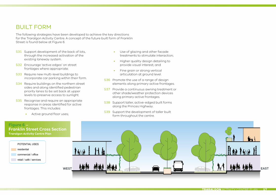
BUILT FORMThe following strategies have been developed to achieve the key directions for the Traralgon Activity Centre. A concept of the future built form of Franklin Street is found below at Figure 6.
S31 Support development of the back of lots, through the increased activation of the existing laneway system.
S32 Encourage ‘active edges’ on street frontages where appropriate.
S33 Require new multi-level buildings to incorporate car parking within their form.
S34 Require buildings on the northern street sides and along identified pedestrian priority lanes to be set back at upper levels to preserve access to sunlight.
S35 Recognise and require an appropriate response in areas identified for active frontages. This includes:
• Active ground floor uses;
• Use of glazing and other facade treatments to stimulate interaction;
• Higher quality design detailing to provide visual interest; and
• Fine grain or strong vertical articulation at ground level.
S36 Promote the use of a range of design elements along primary active frontages.
S37 Provide a continuous awning treatment or other shade/weather protection devices along primary active frontages.
S38 Support taller, active-edged built forms along the Princes Highway.
S39 Support the development of taller built form throughout the centre.

Lorem ipsumG R E Y S T R E E T
BR
EE
D S
TR
EE
T
MA
BE
L S
TR
EE
T
ET
HE
L S
TR
EE
T
AL
BE
RT
ST
RE
ET
DE
AK
I N S
TR
EE
T
CH
UR
CH
ST
RE
ET
FR
AN
KL
I N S
TR
EE
T
CO
LL
INS
ST
RE
ET
M O O R E S T R E E T
G E O R G E S T R E E T
G O R D O N S T R E E T
K AY S T R E E T
WR
IGH
TS
TR
EE
T
P O S T O F F I C E P L A C E
G W A L I A S T R E E T
CA
MP
BE
LL
ST
RE
ET
PE
TE
RK
I N S
TR
EE
T
HI G
H S
T RE E T
WH
I TT
AK
ER
S R
OA
D
PO
ST
OF
FI C
E L
AN
E
METHODIST LANE
LIVINGSTONE LANE
LIV
ING
ST
ON
E S
TR
EE
T
S E Y M O U R S T R E E T
H O T H A M S T R E E T
FE
EL
EY
LA
NE
S E R V I C E S T R E E T
H E N R Y S T R E E T
B R I D G E S A V E N U E
S H A K E S P E A R E S T R E E T
P R I N C E S H I G H W AY
Q U E E N S PA R A D E
M E R E D I T H S T R E E T
B A N K S T R E E T
T R A R A L G O N C R E E K
TE
NN
YS
ON
ST
RE
ET
GREENWOOD GROVE
StocklandTraralgon
PostOffice
PoliceStation
PostOffice
Woolworths
VictoryPark
TraralgonRecreation
Reserve
TraralgonStation
TAFE
RetirementVillage
Duncan CameronMemorial Park
NeighbourhoodLearning Centre
St Michael’sPrimary School
Grey StreetPrimary School
Bert ThompsonReserve
DoortyPark
Latrobe CreativePrecinct
VRI Hall
Gippsland RegionalAquatics Centre Project
Hubert OsbornePark
study area boundary
station masterplan precinct
Princes Highway
primary access road
local street
proposed 40km/h zone
key development sites
shared pedestrian laneway
shared service lane
existing signalised intersection
proposed signalised pedestrian crossing
connection to creek
roundabout
shared path
cycle route
bus route
intermodal transport interchange
at-grade car park
integrated car park
multi-level integrated car park
long bay parking
key pedestrian connections
Traralgon Activity Centre Plan
© Victorian Planning Authority, 2017. The State of Victoria does not warrant the accuracy or completeness of information in this publication and any person using or relying upon such information does so on the basis that the State of Victoria shall bear no responsibility or liability whatsoever for any errors, faults, defects or omission in the information.
1:6,000 @ A4
0 10050 200150 250
Figure 7 – Access & Movement
TRARALGON ACTIVITY CENTRE PLAN18 12.10.2017
Lorem ipsumG R E Y S T R E E T
BR
EE
D S
TR
EE
T
MA
BE
L S
TR
EE
T
ET
HE
L S
TR
EE
T
AL
BE
RT
ST
RE
ET
DE
AK
I N S
TR
EE
T
CH
UR
CH
ST
RE
ET
FR
AN
KL
I N S
TR
EE
T
CO
LL
INS
ST
RE
ET
M O O R E S T R E E T
G E O R G E S T R E E T
G O R D O N S T R E E T
K AY S T R E E T
WR
IGH
TS
TR
EE
T
P O S T O F F I C E P L A C E
G W A L I A S T R E E T
CA
MP
BE
LL
ST
RE
ET
PE
TE
RK
I N S
TR
EE
T
HI G
H S
T RE E T
WH
I TT
AK
ER
S R
OA
D
PO
ST
OF
FI C
E L
AN
E
METHODIST LANE
LIVINGSTONE LANE
LIV
ING
ST
ON
E S
TR
EE
T
S E Y M O U R S T R E E T
H O T H A M S T R E E T
FE
EL
EY
LA
NE
S E R V I C E S T R E E T
H E N R Y S T R E E T
B R I D G E S A V E N U E
S H A K E S P E A R E S T R E E T
P R I N C E S H I G H W AY
Q U E E N S PA R A D E
M E R E D I T H S T R E E T
B A N K S T R E E T
T R A R A L G O N C R E E K
TE
NN
YS
ON
ST
RE
ET
GREENWOOD GROVE
StocklandTraralgon
PostOffice
PoliceStation
PostOffice
Woolworths
VictoryPark
TraralgonRecreation
Reserve
TraralgonStation
TAFE
RetirementVillage
Duncan CameronMemorial Park
NeighbourhoodLearning Centre
St Michael’sPrimary School
Grey StreetPrimary School
Bert ThompsonReserve
DoortyPark
Latrobe CreativePrecinct
VRI Hall
Gippsland RegionalAquatics Centre Project
Hubert OsbornePark
study area boundary
station masterplan precinct
Princes Highway
primary access road
local street
proposed 40km/h zone
key development sites
shared pedestrian laneway
shared service lane
existing signalised intersection
proposed signalised pedestrian crossing
connection to creek
roundabout
shared path
cycle route
bus route
intermodal transport interchange
at-grade car park
integrated car park
multi-level integrated car park
long bay parking
key pedestrian connections
Traralgon Activity Centre Plan
© Victorian Planning Authority, 2017. The State of Victoria does not warrant the accuracy or completeness of information in this publication and any person using or relying upon such information does so on the basis that the State of Victoria shall bear no responsibility or liability whatsoever for any errors, faults, defects or omission in the information.
1:6,000 @ A4
0 10050 200150 250
Figure 7 – Access & Movement
TRARALGON ACTIVITY CENTRE PLAN 1912.10.2017
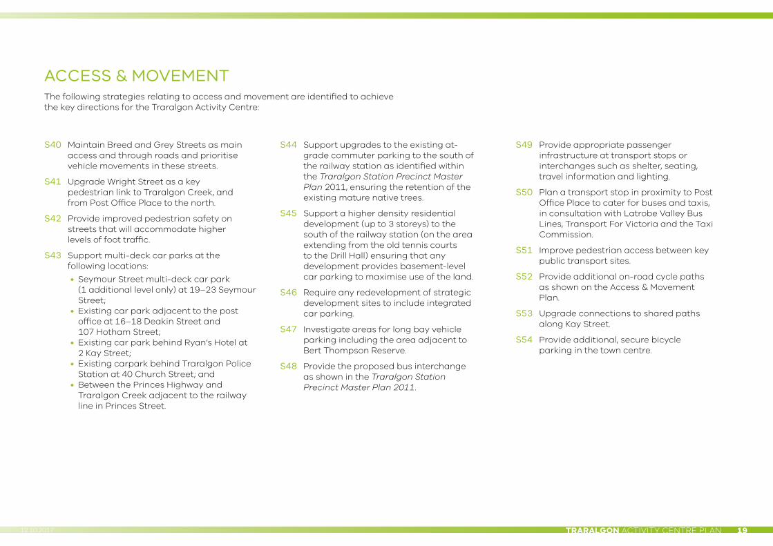
ACCESS & MOVEMENTThe following strategies relating to access and movement are identified to achieve the key directions for the Traralgon Activity Centre:
S40 Maintain Breed and Grey Streets as main access and through roads and prioritise vehicle movements in these streets.
S41 Upgrade Wright Street as a key pedestrian link to Traralgon Creek, and from Post Office Place to the north.
S42 Provide improved pedestrian safety on streets that will accommodate higher levels of foot traffic.
S43 Support multi-deck car parks at the following locations:
• Seymour Street multi-deck car park (1 additional level only) at 19–23 Seymour Street;
• Existing car park adjacent to the post office at 16–18 Deakin Street and 107 Hotham Street;
• Existing car park behind Ryan’s Hotel at 2 Kay Street;
• Existing carpark behind Traralgon Police Station at 40 Church Street; and
• Between the Princes Highway and Traralgon Creek adjacent to the railway line in Princes Street.
S44 Support upgrades to the existing at-grade commuter parking to the south of the railway station as identified within the Traralgon Station Precinct Master Plan 2011, ensuring the retention of the existing mature native trees.
S45 Support a higher density residential development (up to 3 storeys) to the south of the railway station (on the area extending from the old tennis courts to the Drill Hall) ensuring that any development provides basement-level car parking to maximise use of the land.
S46 Require any redevelopment of strategic development sites to include integrated car parking.
S47 Investigate areas for long bay vehicle parking including the area adjacent to Bert Thompson Reserve.
S48 Provide the proposed bus interchange as shown in the Traralgon Station Precinct Master Plan 2011.
S49 Provide appropriate passenger infrastructure at transport stops or interchanges such as shelter, seating, travel information and lighting.
S50 Plan a transport stop in proximity to Post Office Place to cater for buses and taxis, in consultation with Latrobe Valley Bus Lines, Transport For Victoria and the Taxi Commission.
S51 Improve pedestrian access between key public transport sites.
S52 Provide additional on-road cycle paths as shown on the Access & Movement Plan.
S53 Upgrade connections to shared paths along Kay Street.
S54 Provide additional, secure bicycle parking in the town centre.
G R E Y S T R E E TG R E Y S T R E E T
BR
EE
D S
TR
EE
TB
RE
ED
ST
RE
ET
AL
BE
RT
ST
RE
ET
AL
BE
RT
ST
RE
ET
DE
AK
I N S
TR
EE
TD
EA
KI N
ST
RE
ET
CH
UR
CH
ST
RE
ET
CH
UR
CH
ST
RE
ET
FR
AN
KL
I N S
TR
EE
TF
RA
NK
LI N
ST
RE
ET
CO
LLIN
S S
TC
OLL
INS
ST
M O O R E S T R E E TM O O R E S T R E E T
K A Y S T R E E TK A Y S T R E E T
P O S T O F F I C E P L A C EP O S T O F F I C E P L A C E
PO
ST
OF
FI C
E L
AN
EP
OS
T O
FF
I CE
LA
NE
M E T H O D I S T L A N EM E T H O D I S T L A N E
L I V I N G S T O N E L A N EL I V I N G S T O N E L A N E
LIV
I NG
ST
ON
E S
TR
EE
TL
I VI N
GS
TO
NE
ST
RE
ET
S E Y M O U R S T R E E TS E Y M O U R S T R E E T
H O T H A M S T R E E TH O T H A M S T R E E T
F E E L E Y
F E E L E YL
AN
EL
AN
E
S E R V I C E S T R E E TS E R V I C E S T R E E TH E N R Y S T R E E T
H E N R Y S T R E E T
B R I D G E S A V E N U EB R I D G E S A V E N U E
S H A K E S P E A R E S T R E E TS H A K E S P E A R E S T R E E T
P R I N C E S H I G H W A Y
P R I N C E S H I G H W A Y
Q U E E N S P A R A D E
Q U E E N S P A R A D E
M E R E D I T H S T R E E TM E R E D I T H S T R E E T
B A N K S T R E E T
B A N K S T R E E T
MA
BE
L S
TR
EE
TM
AB
EL
ST
RE
ET
LO
CH
PA
RK
RO
AD
LO
CH
PA
RK
RO
AD
G O R D O N S T R E E TG O R D O N S T R E E T
PE
TE
RK
I N S
TR
EE
T
PE
TE
RK
I N S
TR
EE
T
H I G H ST R E E T
H I G H ST R E E T
WH
I T TAK E R S R O
AD
WH
I T TAK E R S R O
AD
TEN
NYS
ON
STR
EET
TEN
NYS
ON
STR
EET
3
4
1
2
5
StocklandPlaza
PostO�ce
PoliceStation
PostO�ce
Woolworths
VictoryPark
TraralgonRecreation
Reserve
DoortyPark
TraralgonStation
TAFE
RetirementVillage
Duncan CameronMemorial Park
NeighbourhoodLearning Centre
St Michael’sPrimary School
Grey StreetPrimary School
Bert ThompsonReserve
Latrobe CreativePrecinct
Gippsland RegionalAquatics Centre Project
Hubert OsbornePark
study area boundary
precinct boundary
activity centre core
Princes Highway corridor & station precinct
Kay Street & civic corridor
creekside office
Breed Street
12
3
45
Traralgon Activity Centre Plan
© Victorian Planning Authority, 2017. The State of Victoria does not warrant the accuracy or completeness of information in this publication and any person using or relying upon such information does so on the basis that the State of Victoria shall bear no responsibility or liability whatsoever for any errors, faults, defects or omission in the information.
0 100 200 300
1:6,500 @ A4Figure 8 – The Precincts
TRARALGON ACTIVITY CENTRE PLAN20 12.10.2017
TRARALGON ACTIVITY CENTRE PLAN 2112.10.2017
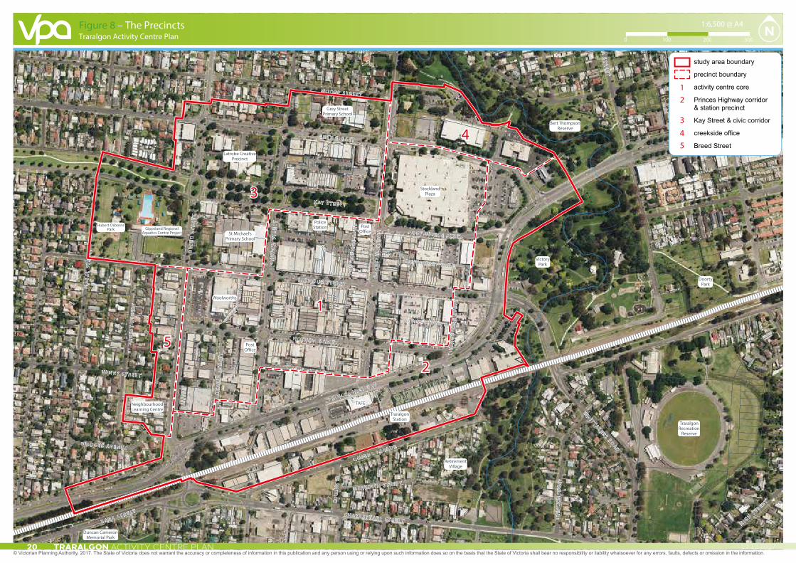
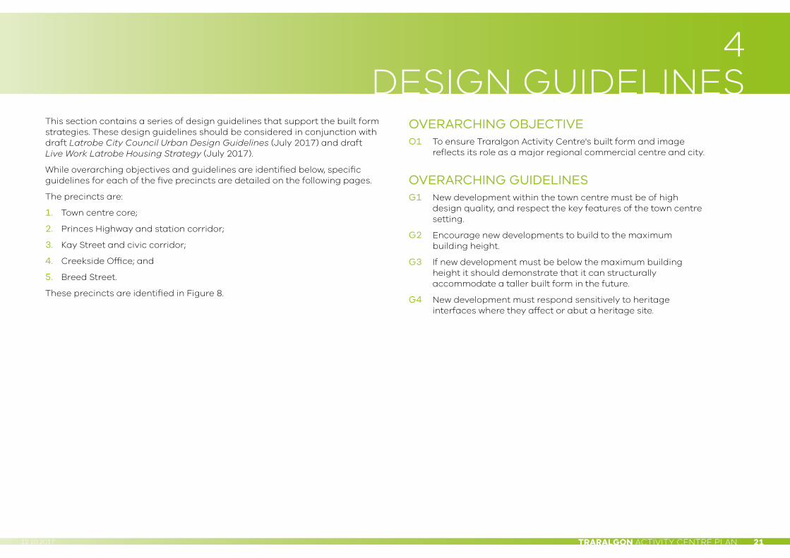
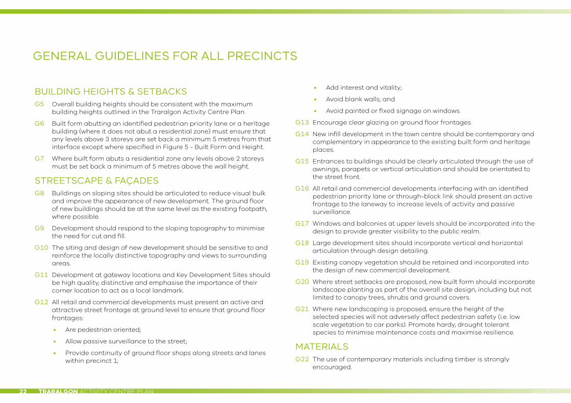
4 DESIGN GUIDELINES
This section contains a series of design guidelines that support the built form strategies. These design guidelines should be considered in conjunction with draft Latrobe City Council Urban Design Guidelines (July 2017) and draft Live Work Latrobe Housing Strategy (July 2017).
While overarching objectives and guidelines are identified below, specific guidelines for each of the five precincts are detailed on the following pages.
The precincts are:
1. Town centre core;
2. Princes Highway and station corridor;
3. Kay Street and civic corridor;
4. Creekside Office; and
5. Breed Street.
These precincts are identified in Figure 8.
OVERARCHING OBJECTIVEO1 To ensure Traralgon Activity Centre's built form and image
reflects its role as a major regional commercial centre and city.
OVERARCHING GUIDELINESG1 New development within the town centre must be of high
design quality, and respect the key features of the town centre setting.
G2 Encourage new developments to build to the maximum building height.
G3 If new development must be below the maximum building height it should demonstrate that it can structurally accommodate a taller built form in the future.
G4 New development must respond sensitively to heritage interfaces where they affect or abut a heritage site.
TRARALGON ACTIVITY CENTRE PLAN22 12.10.2017
BUILDING HEIGHTS & SETBACKSG5 Overall building heights should be consistent with the maximum
building heights outlined in the Traralgon Activity Centre Plan.
G6 Built form abutting an identified pedestrian priority lane or a heritage building (where it does not abut a residential zone) must ensure that any levels above 3 storeys are set back a minimum 5 metres from that interface except where specified in Figure 5 - Built Form and Height.
G7 Where built form abuts a residential zone any levels above 2 storeys must be set back a minimum of 5 metres above the wall height.
STREETSCAPE & FAÇADESG8 Buildings on sloping sites should be articulated to reduce visual bulk
and improve the appearance of new development. The ground floor of new buildings should be at the same level as the existing footpath, where possible.
G9 Development should respond to the sloping topography to minimise the need for cut and fill.
G10 The siting and design of new development should be sensitive to and reinforce the locally distinctive topography and views to surrounding areas.
G11 Development at gateway locations and Key Development Sites should be high quality, distinctive and emphasise the importance of their corner location to act as a local landmark.
G12 All retail and commercial developments must present an active and attractive street frontage at ground level to ensure that ground floor frontages:
• Are pedestrian oriented;
• Allow passive surveillance to the street;
• Provide continuity of ground floor shops along streets and lanes within precinct 1;
• Add interest and vitality;
• Avoid blank walls; and
• Avoid painted or fixed signage on windows.
G13 Encourage clear glazing on ground floor frontages.
G14 New infill development in the town centre should be contemporary and complementary in appearance to the existing built form and heritage places.
G15 Entrances to buildings should be clearly articulated through the use of awnings, parapets or vertical articulation and should be orientated to the street front.
G16 All retail and commercial developments interfacing with an identified pedestrian priority lane or through-block link should present an active frontage to the laneway to increase levels of activity and passive surveillance.
G17 Windows and balconies at upper levels should be incorporated into the design to provide greater visibility to the public realm.
G18 Large development sites should incorporate vertical and horizontal articulation through design detailing.
G19 Existing canopy vegetation should be retained and incorporated into the design of new commercial development.
G20 Where street setbacks are proposed, new built form should incorporate landscape planting as part of the overall site design, including but not limited to canopy trees, shrubs and ground covers.
G21 Where new landscaping is proposed, ensure the height of the selected species will not adversely affect pedestrian safety (i.e. low scale vegetation to car parks). Promote hardy, drought tolerant species to minimise maintenance costs and maximise resilience.
MATERIALSG22 The use of contemporary materials including timber is strongly
encouraged.
GENERAL GUIDELINES FOR ALL PRECINCTS

TRARALGON ACTIVITY CENTRE PLAN 2312.10.2017
ACCESSG23 Large developments should incorporate through-block links (north to
south and east to west) to encourage pedestrian permeability.
G24 Secondary pedestrian access to buildings should be incorporated into buildings that abut an identified pedestrian priority lane.
G25 Vehicle access and loading areas should be separated from pedestrian access, preferably located at the side and rear of development (loading bays should be within service lanes), and screened from view.
G26 If vehicle access must be located to the front of the development, priority must be given to pedestrian movement.
G27 Ensure on-site car parking has a minimal visual impact on the streetscape. Avoid parking between building frontages and the street.
SUSTAINABILITYG28 Encourage passive and active sustainability principles in the design
and operation of new development.
G29 Encourage the incorporation of water sensitive urban design (WSUD) principles and ecologically sustainable design (ESD) measures in both the public and private realms.
G30 Encourage the design of new development to include windows positioned that allow for natural cross ventilation.
G31 Continuous weather protection measures (awnings, verandahs, shade cloths or canopies) should be provided along key pedestrian areas to allow winter sun and restrict summer sun.
PUBLIC REALMG32 Protect and enhance street trees and key landscape features including
the Kay Street corridor, the Traralgon Court House and Post Office and Traralgon Creek.
G33 All infrastructure and services should be contained underground within service trenches and pits, and not be discernible within the public realm.
G34 Ensure bin storage areas are located to the side or rear of commercial buildings and are screened from view within the public realm.
G35 Site air conditioning units (or other such plant facilities) behind the roofline so they are not visible from the street.
SIGNAGE & LIGHTINGG36 Signage on the building facade should be limited, particularly across
windows and doors, to ensure passive surveillance and a positive interface with the streetscape.
G37 Signage should not protrude above the parapet.
G38 The proportion and scale of signage should not detract from public view lines and views of the surrounding landscape.
G39 Encourage lighting that promotes a safe and secure environment for pedestrians.
G40 Tall pole lighting is discouraged.
G41 Encourage illumination of building façades where lighting is well-integrated into the façade design, subject to no light spilling into adjoining residential and shop-top housing areas.

TRARALGON ACTIVITY CENTRE PLAN24 12.10.2017
PRECINCT 1
TOWN CENTRE CORE
OVERARCHING OBJECTIVESO2 To achieve sensitive consolidation of the town centre core, and provide the
opportunity to develop underutilised sites.
O3 To establish a consistent street wall arrangement that reiterates the grid street network of the town centre.
O4 To encourage residential development within the town centre.
O5 To strengthen the role of the key retail axes of Franklin and Seymour Streets as a vibrant dining, retail and commercial hub.
O6 To ensure a distinction between the historic Franklin Street corridor and the contemporary streetscapes of Seymour and Hotham Streets.
O7 To create a shared community space around Post Office Place, Kay Street and Franklin Street that can be utilised for civic occasions.
BUILDING HEIGHTS & SETBACKSG42 Properties fronting Franklin Street should not exceed 3 storeys and should have
a 2 storey street wall to maintain view lines to the historic Traralgon Court House and Post Office except for the building directly abutting the Traralgon Court House and Post Office to the south which should not exceed 2 storeys.
G43 Any sites identified with a maximum building height of 5 storeys must ensure that any levels above 3 storeys are set back a minimum 5 metres from the street frontage to be recessive in appearance.
G44 Redevelopment of any heritage buildings should be sympathetic to the traditional fabric of the building, including its principal street wall or façade.
STREETSCAPE & FAÇADESG45 New development should maintain and contribute to the fine grain character
along the main commercial streets.
PUBLIC REALMG46 Treat Post Office Place as a public plaza, incorporating paving treatments, public
art and street furniture.
ACCESSG47 Improve pedestrian connections between Wright Street and the
east end of Post Office Place.
SIGNAGE & LIGHTINGG48 Illuminated or electronic signage should be limited.
TRARALGON ACTIVITY CENTRE PLAN 2512.10.2017
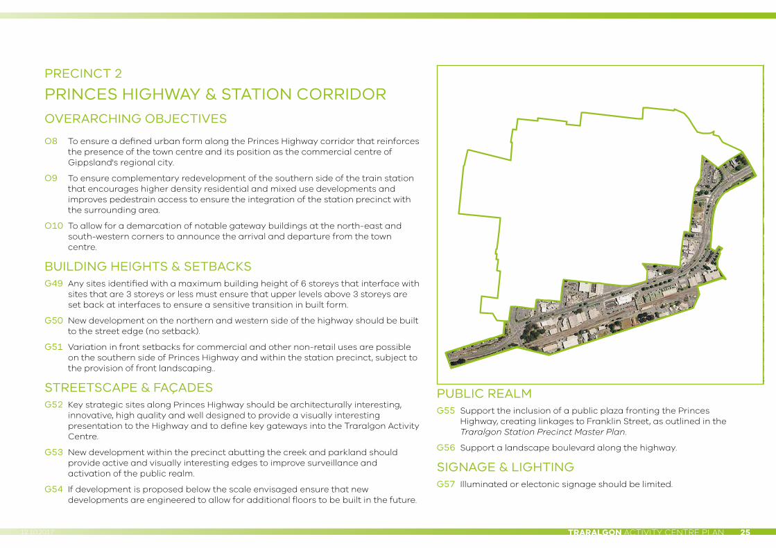
PRECINCT 2
PRINCES HIGHWAY & STATION CORRIDOROVERARCHING OBJECTIVES
O8 To ensure a defined urban form along the Princes Highway corridor that reinforces the presence of the town centre and its position as the commercial centre of Gippsland's regional city.
O9 To ensure complementary redevelopment of the southern side of the train station that encourages higher density residential and mixed use developments and improves pedestrain access to ensure the integration of the station precinct with the surrounding area.
O10 To allow for a demarcation of notable gateway buildings at the north-east and south-western corners to announce the arrival and departure from the town centre.
BUILDING HEIGHTS & SETBACKSG49 Any sites identified with a maximum building height of 6 storeys that interface with
sites that are 3 storeys or less must ensure that upper levels above 3 storeys are set back at interfaces to ensure a sensitive transition in built form.
G50 New development on the northern and western side of the highway should be built to the street edge (no setback).
G51 Variation in front setbacks for commercial and other non-retail uses are possible on the southern side of Princes Highway and within the station precinct, subject to the provision of front landscaping..
STREETSCAPE & FAÇADESG52 Key strategic sites along Princes Highway should be architecturally interesting,
innovative, high quality and well designed to provide a visually interesting presentation to the Highway and to define key gateways into the Traralgon Activity Centre.
G53 New development within the precinct abutting the creek and parkland should provide active and visually interesting edges to improve surveillance and activation of the public realm.
G54 If development is proposed below the scale envisaged ensure that new developments are engineered to allow for additional floors to be built in the future.
PUBLIC REALMG55 Support the inclusion of a public plaza fronting the Princes
Highway, creating linkages to Franklin Street, as outlined in the Traralgon Station Precinct Master Plan.
G56 Support a landscape boulevard along the highway.
SIGNAGE & LIGHTINGG57 Illuminated or electonic signage should be limited.
TRARALGON ACTIVITY CENTRE PLAN26 12.10.2017
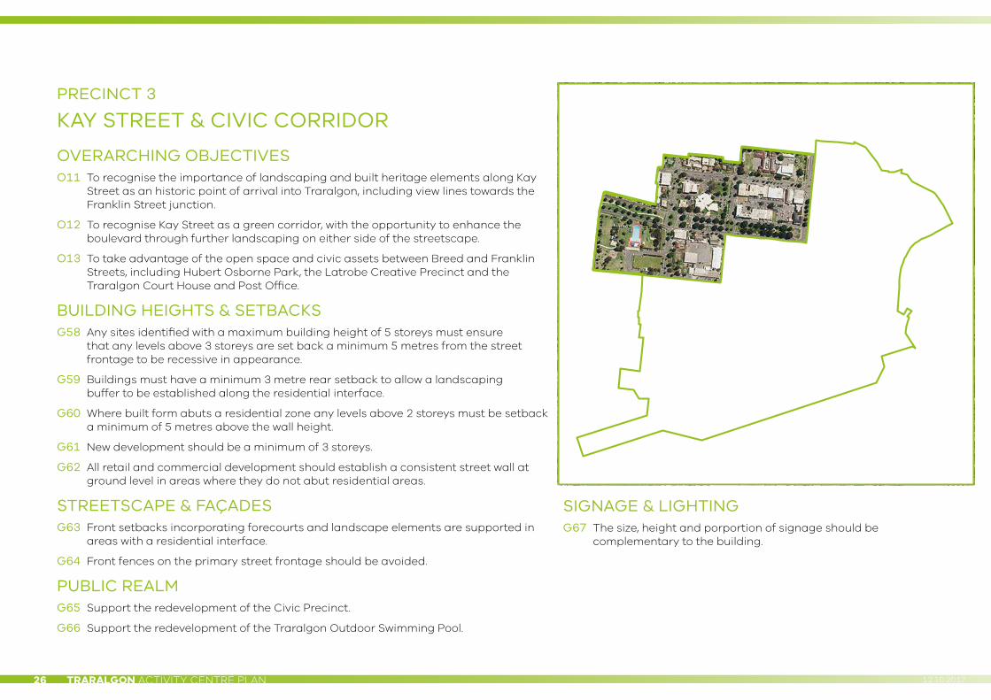
PRECINCT 3
KAY STREET & CIVIC CORRIDOR
OVERARCHING OBJECTIVESO11 To recognise the importance of landscaping and built heritage elements along Kay
Street as an historic point of arrival into Traralgon, including view lines towards the Franklin Street junction.
O12 To recognise Kay Street as a green corridor, with the opportunity to enhance the boulevard through further landscaping on either side of the streetscape.
O13 To take advantage of the open space and civic assets between Breed and Franklin Streets, including Hubert Osborne Park, the Latrobe Creative Precinct and the Traralgon Court House and Post Office.
BUILDING HEIGHTS & SETBACKSG58 Any sites identified with a maximum building height of 5 storeys must ensure
that any levels above 3 storeys are set back a minimum 5 metres from the street frontage to be recessive in appearance.
G59 Buildings must have a minimum 3 metre rear setback to allow a landscaping buffer to be established along the residential interface.
G60 Where built form abuts a residential zone any levels above 2 storeys must be setback a minimum of 5 metres above the wall height.
G61 New development should be a minimum of 3 storeys.
G62 All retail and commercial development should establish a consistent street wall at ground level in areas where they do not abut residential areas.
STREETSCAPE & FAÇADESG63 Front setbacks incorporating forecourts and landscape elements are supported in
areas with a residential interface.
G64 Front fences on the primary street frontage should be avoided.
PUBLIC REALMG65 Support the redevelopment of the Civic Precinct.
G66 Support the redevelopment of the Traralgon Outdoor Swimming Pool.
SIGNAGE & LIGHTINGG67 The size, height and porportion of signage should be
complementary to the building.
TRARALGON ACTIVITY CENTRE PLAN 2712.10.2017
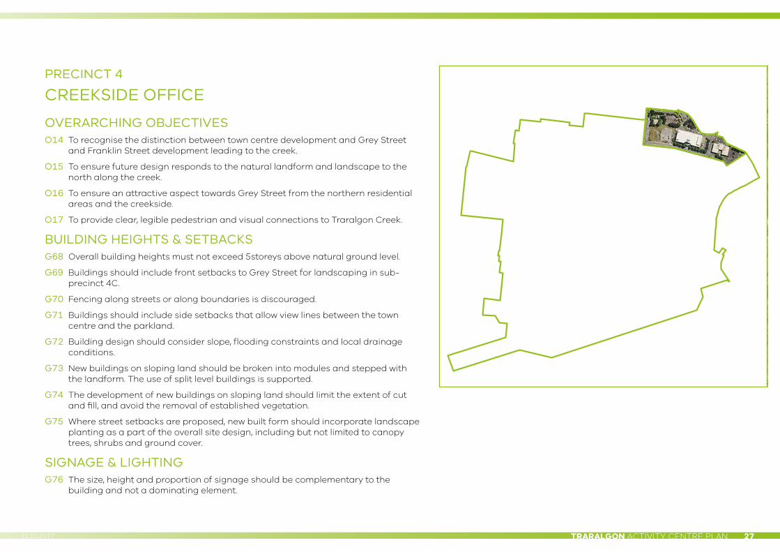
PRECINCT 4
CREEKSIDE OFFICE
OVERARCHING OBJECTIVESO14 To recognise the distinction between town centre development and Grey Street
and Franklin Street development leading to the creek.
O15 To ensure future design responds to the natural landform and landscape to the north along the creek.
O16 To ensure an attractive aspect towards Grey Street from the northern residential areas and the creekside.
O17 To provide clear, legible pedestrian and visual connections to Traralgon Creek.
BUILDING HEIGHTS & SETBACKSG68 Overall building heights must not exceed 5storeys above natural ground level.
G69 Buildings should include front setbacks to Grey Street for landscaping in sub-precinct 4C.
G70 Fencing along streets or along boundaries is discouraged.
G71 Buildings should include side setbacks that allow view lines between the town centre and the parkland.
G72 Building design should consider slope, flooding constraints and local drainage conditions.
G73 New buildings on sloping land should be broken into modules and stepped with the landform. The use of split level buildings is supported.
G74 The development of new buildings on sloping land should limit the extent of cut and fill, and avoid the removal of established vegetation.
G75 Where street setbacks are proposed, new built form should incorporate landscape planting as a part of the overall site design, including but not limited to canopy trees, shrubs and ground cover.
SIGNAGE & LIGHTINGG76 The size, height and proportion of signage should be complementary to the
building and not a dominating element.

TRARALGON ACTIVITY CENTRE PLAN28 12.10.2017
PRECINCT 5
BREED STREET
OVERARCHING OBJECTIVESO18 To recognise the Breed Street corridor as an area of transition between the city
and surrounding residential areas.
O19 To encourage a transformation of the western side of Breed Street so that it is consistent with the town centre form.
O20 To support the development of service based uses and residential opportunities.
O21 To discourage retail uses.
BUILDING HEIGHTS & SETBACKSG77 Overall building heights must not exceed 4 storeys .
G78 Buildings must have a minimum 3 metre setback from the western boundary, to allow a landscaping buffer to be established along the residential interface.
G79 Where built form abuts a residential zone any levels above 2 storeys must be setback a minimum of 5 metres above the wall height.
G80 Support variation in front and side setbacks for commercial and other non-retail uses, subject to the provision of landscape treatments.
STREETSCAPE & FAÇADESG81 Where street setbacks are proposed, new built form should incorporate
landscaping as part of the overall site design, including but not limited to canopy trees, shrubs and ground covers.
G82 New development should present an active and attractive street frontage with a high level of interaction between the property and the street front.
G83 Buildings should incorporate vertical and horizontal articulation of a human scale through design detailing.
G84 Fencing along the primary street frontage should be avoided.
SIGNAGE & LIGHTINGG85 The size, height and proportion of signage should be complementary to the
building and not a dominating element.
TRARALGON ACTIVITY CENTRE PLAN 2912.10.2017
5 KEY INITIATIVES
KEY PUBLIC REALM AREASA series of key initiatives have been identified for key areas of the Activity Centre public realm. These are areas where the plan recommends that funding is sought to implement upgrades and improvements to the public realm.
These areas have been identified as having a strong influence on the public perception of the town centre, or because they have been identified as key amenity areas of the town centre.
Princes Highway (Breed Street to Victory Park)The existing approach to Traralgon from the west presents relatively poorly, with the built environment dominated by a number of at-grade car parks and large format stores. While tree planting has been established along the central median, it is considered that additional canopy tree planting on verges, the undergrounding of powerlines, and other landscaping plantings would significantly improve this important gateway to the town centre.
Franklin Street spineFranklin Street forms the key pedestrian spine, and has therefore been identified as the priority street for streetscape improvements, including matters outlined in Section 3 of this report.
Station precinct plazaThe establishment of the plaza is a crucially important element of the future Traralgon Activity Centre from an access and movement perspective, as is the implementation of a new transport interchange at this location, which will form a vital component of this precinct for the Activity Centre. As such, the approved Master Plan should be implemented in the short term.
Post Office PlaceAs outlined in this section of the plan, the reconfiguration of Post Office Place as the public ‘heart’ of the town centre, and the key gathering place for the Traralgon community, is a central part of this Plan.
Civic precinctThe Latrobe Creative Precinct will be a significant central element of the Activity Centre. It will promote and encourage regular civic, cultural and social activity, thus being vital to the public realm.
TRARALGON ACTIVITY CENTRE PLAN30 12.10.2017
KEY DEVELOPMENT SITESIn addition to the key public realm areas, there are a number of key sites in both public and private ownership which have been identified as exerting a key influence on the Activity Centre.
Five at-grade car parks or underutilised sites have been identified as key sites for redevelopment. Their ability to accommodate higher forms will contribute significantly more floorspace within the centre. These sites are:
1. The south-east corner of Breed Street;
2. Adjoining and around the Royal Exchange Hotel;
3. The existing Woolworths site and surrounds, bounded by Seymour, Church, Hotham and Breed Streets;
4. The old church site south of Post Office Place; and
5. Stockland Traralgon.
Other key sites which have been identified include:
• The areas immediately to the south of the rail line, as they could accommodate a mix of car parking and medium density residential development (subject to further consultation with VicTrack).
• Two existing at-grade Council car parks located centrally within the Traralgon Activity Centre, as they have the potential to be developed with 4 to 5 storey forms accommodating the provision of car parking.
• The two at-grade car parks on Deakin Street and in the south-east corner of the Study Area which could potentially accommodate integrated multi-deck car parking, which would allow for the redevelopment of other sites.
• The existing Manny's Market car park on Post Office Place and Stockland Traralgon, in relation to the redevelopment of Post Office Place.
• The site near the intersection of Traralgon Creek and Princes Highway, which should be redeveloped to provide a landmark for the centre’s eastern entrance, and an improved design response to its creekside location;
• Federation Training site, Princes Highway due to its location at the Franklin Street interface and its prominence along the viewing corridor.
• The former Manny's Market site at the intersection of Grey and Franklin Streets. The current permit for the site which includes food and drink premises, cinema, motel and bowling alley is supported however the development is yet to commence construction. Any future approvals for the site should consider an appropriate interface with the creek.

Commission public art for key locations
Retain and enhance connections to the existing ANZAC memorial
Introduce changed roadway paving to delineate town centre area and connect key heritage
forms and Kay Street to Post Office Place
Allow the street to be closed off for special events
Strongly promote the installation of a ‘skin’ of active retail uses, architectural activation and/or public art installations along the south side of Stockland Traralgon
Support the redesign of the Stockland Traralgon entry to provide a higher quality more contemporary entrance that reflects the prominence of this entrance within the town centre
Remove existing pedestrian crossings and signalise intersection of Post Office Place and Franklin Street
Retain access to Stockland car parking area
Promote the development of outdoor dining within this precinct
Support the redevelopment of buildings along the southern edge
of Post Office Place with active ground floor uses and upper level
residential development to increase activity and levels of
passive surveillance within the precinct
Reconfigure service access for businesses to utilise Methodist
Lane for deliveries
Provide clusters of seating, bins, and other street furniture in
outstand areas
Provide on road bicycle lanes
Artist’s conceptual impression of potential upgrades to Post O�ce Place looking west
NOTE: Street reconfiguration including any car parking removal will only occur once subsequentcar parking has been provided elsewhere in close proximity to ensure no net loss.
Existing Post O�ce Place looking west
Traralgon Activity Centre Plan
© Victorian Planning Authority, 2017. The State of Victoria does not warrant the accuracy or completeness of information in this publication and any person using or relying upon such information does so on the basis that the State of Victoria shall bear no responsibility or liability whatsoever for any errors, faults, defects or omission in the information.
0 100 200 300
1:6,500 @ A4Figure 9 – Post Office Place: Public Realm Improvements
TRARALGON ACTIVITY CENTRE PLAN31 12.10.2017

TRARALGON ACTIVITY CENTRE PLAN32 12.10.2017
POST OFFICE PLACE CONCEPTThe Post Office Place precinct is a key linking street within the Traralgon Activity Centre, providing a connection between the important parkland spaces of Kay Street, Victory Park, and Traralgon Creek. The street itself is bookended by the historically and architecturally significant Traralgon Post Office at the western end, and Princes Highway at the eastern end. The southern side of the street features a diverse mix of built forms and businesses, with the inactive façade of Stockland Traralgon to the north.
The Key Directions Report, prepared as a precursor to the Traralgon Activity Centre Plan, identified the following key directions with specific relevance to the future planning for Post Office Place:
Create a network of public spaces through the establishment of a town square-style shared space at the intersection of Post Office Place, Kay Street, and Franklin Street.
Provide safe cycle links through the town centre, including the provision of a designated connection to Stockland Traralgon as a key destination.
Allow for pedestrian and visual links from Kay Street to Victory Park, through the establishment of pedestrian priority routes, a new retail frontage to the north side of Post Office Place, substantial new street tree planting, and the redefinition of Post Office Place as the ‘tourism gateway’ of the Traralgon Activity Centre.
TRARALGON ACTIVITY CENTRE PLAN 3312.10.2017
The manner in which these key directions might be realised is illustrated in the concept (Figure 9). Key design attributes of the concept plan area are as follows:
Introduction of new street planting, in association with the reconfiguration of Stockland Traralgon, to provide an active address to the north of Post Office Place. The combination of a consistent canopy of street tree vegetation, as well as active retail and other commercial frontages, will contribute strongly to increased street activation.
Linear arrangement of street trees and careful selection of species to ensure that canopy spread does not encroach significantly upon the important vista from Victory Park and Princes Highway towards the Post Office tower.
Establishment of a town square character to the key intersection of Post Office Place, Franklin Street and Kay Street, through pavement treatments and associated street furniture, providing traffic calming and provision of pedestrian priority.
Delineation of outdoor dining precincts within the extended footpath width, predominantly along the south side of Post Office Place to take advantage of good solar access.
Reconfiguration of vehicular entry into Post Office Place from Princes Highway, and the subsequent creation of a new green entry into the Activity Centre, with opportunities for the establishment of hard and soft landscape elements, and canopy trees. This treatment is intended to respond to the notion of designating this location as the tourism entry to the Activity Centre, as well as emphasising the transition in public domain character from an urban context to a parkland context.
Provision of bike paths providing an important east-west connection across the Activity Centre and linking it to its surrounds.
Provision of a suite of coordinated street furniture elements – including seating, lighting, shelter, bins, bollards, and signage – to provide a high level of amenity and encourage use and activation of the public domain, which will in turn boost activation of the commercial frontages.
Encourage the incorporation of public art, both in key locations such as both ends of Post Office Place, and also in an integrated manner as part of improvements to the public domain.
Refer also to cross sections at Figures 10a and 10b.

StocklandTraralgon
Strongly promote the installation of a ‘skin’ of architectural activation, green wall/landscape and/or public art installations along the south side of Stockland Traralgon.
NORTHSOUTH
POTENTIAL USES
residential
commercial / office
retail / café / services
Traralgon Activity Centre Plan
© Victorian Planning Authority, 2017. The State of Victoria does not warrant the accuracy or completeness of information in this publication and any person using or relying upon such information does so on the basis that the State of Victoria shall bear no responsibility or liability whatsoever for any errors, faults, defects or omission in the information.
0 100 200 300
1:6,500 @ A4Figure 10a – Post Office Place Cross Section: Concept 120 4 86 10m
1:200 @ A4
TRARALGON ACTIVITY CENTRE PLAN34 12.10.2017

StocklandTraralgon
Strongly promote the installation of a ‘skin’ of architectural activation, green wall/landscape and/or public art installations along the south side of Stockland Traralgon.
NORTHSOUTH
POTENTIAL USES
residential
commercial / office
retail / café / services
Traralgon Activity Centre Plan
© Victorian Planning Authority, 2017. The State of Victoria does not warrant the accuracy or completeness of information in this publication and any person using or relying upon such information does so on the basis that the State of Victoria shall bear no responsibility or liability whatsoever for any errors, faults, defects or omission in the information.
0 100 200 300
1:6,500 @ A4Figure 10a – Post Office Place Cross Section: Concept 120 4 86 10m
1:200 @ A4
Strongly promote the installation of a ‘skin’ of active retail uses, architectural activation and/or public art installations along the south side of Stockland Traralgon.
StocklandTraralgon
NORTHSOUTH
POTENTIAL USES
residential
commercial / office
retail / café / services
Traralgon Activity Centre Plan
© Victorian Planning Authority, 2017. The State of Victoria does not warrant the accuracy or completeness of information in this publication and any person using or relying upon such information does so on the basis that the State of Victoria shall bear no responsibility or liability whatsoever for any errors, faults, defects or omission in the information.
0 100 200 300
1:6,500 @ A4Figure 10b – Post Office Place Cross Section: Concept 220 4 86 10m
1:200 @ A4
TRARALGON ACTIVITY CENTRE PLAN35 12.10.2017

TRARALGON ACTIVITY CENTRE PLAN36 12.10.2017
6 IMPLEMENTATIONThe Traralgon Activity Centre Plan will guide the development of the Traralgon Activity Centre over a period of 20 years. This section of the document identifies a number of actions required to implement the strategies and directions of this plan.
To achieve these aims, zoning and policy changes are identified as a first priority, with other actions to support this then identified.
PLANNING POLICYThe current Latrobe Planning Scheme already identifies many of the broader strategic aims sought by the Traralgon Activity Centre Plan. As such, there are not likely to be significant changes to the Local Planning Policy Framework required to implement the Traralgon Activity Centre Plan, with the zoning and overlay tools likely to be the primary tools for implementation. However, the following changes are recommended to existing Planning Policy within the Latrobe Planning Scheme:
• Clause 21.02 map will need to be updated to indicate the need to implement the Traralgon Activity Centre Plan;
• Clause 21.05–6 Specific Main Town Strategies – Traralgon will need to be adjusted to ensure that the outcomes of the Traralgon Activity Centre Plan are incorporated;
• The Traralgon Structure Plan at Clause 21.05–6 will require updating to reflect some of the aspects of this plan.
ZONING AND OVERLAY CONTROLSUnder the Victorian Planning framework, land use and built form are controlled through the application of a standard suite of zoning and overlay controls, as defined in the Latrobe Planning Scheme. Land uses within the Traralgon Activity Centre are affected by a range of different zoning controls, including the Commercial 1, Commercial 2, and Mixed Use zones. There are, however, few controls that provide guidance and direction on the appropriate built form outcomes within the centre, apart from some discrete properties or precincts that are affected by heritage controls.
Proposed zoningIt is proposed to apply the Activity Centre Zone (ACZ) over the Study Area. This zone seeks to simplify the zoning and overlay controls within activity centres. The ACZ removes the need to apply multiple zones and overlays to a precinct to control the built form. Previously, controlling built form within Activity Centres often resulted in a number of separate Design and Development Overlays applying to different areas within the centres. The ACZ combines both zoning and built form controls, and allows for these to be targeted to the requirements of different precincts within the Activity Centre.
TRARALGON ACTIVITY CENTRE PLAN 3712.10.2017
While the ACZ was developed primarily for application within major activity centres in metropolitan Melbourne, it is also suitable for application in larger regional centres:
It has also been developed for application at larger regional cities which demonstrate distinct ‘CBD’ type functions and have undertaken a structure planning process.1
Given the ‘networked city’ of Latrobe is identified as one of the major regional cities in Victoria under Clause 11 of the State Planning Policy Framework, the application of this zone in this centre is recommended.
OverlaysThe current Overlay controls which affect the study area are as follows:
• Floodway Overlay;
• Land subject to inundation Overlay;
• Heritage Overlay; and
• Parking Overlay.
It is considered necessary to retain these overlays to support the implementation of the Traralgon Activity Centre Plan.
1 ‘Activity Centre Zone’, Planning Practice Note 56, DELWP, June 2015.
OTHER ACTIONSThe following table outlines a series of actions required to implement the Traralgon Activity Centre Plan, the parties that will be primarily responsible for delivery, and the recommended timeframe for the actions.
In the context of this document, the following timeframes should be considered:
Short: 1–5 years
Medium: 5–10 years
Long: 10+ years

TRARALGON ACTIVITY CENTRE PLAN38 12.10.2017
ACTION TIMING RESPONSIBLE PARTY COST
PUBLIC REALM
A1 Support additional public events in the heart of the city. S Council Advocacy
A2
Undertake a public realm master plan for the detailed design of the Traralgon Activity Centre, with a focus on the key public realm areas as identified in the plan including a concept plan for Post Office Place and the Princess Highway Boulevard. The master plan should consider:
• The undertaking of pedestrian counts to confirm pedestrian priority areas prior to undertaking the public realm projects.
• Identification of priority public realm improvements and funding mechanisms that could be used to ensure contributions from developers are maximised and coordinated;
• Planning and creation of a series of informal plazas and places for socialising;
• Changes to road treatments and removal of infrastructure such as overhead powerlines along the Princes Highway Boulevard. As a part of this process, work with VicRoads to implement priority avenue tree planting to allow for canopy growth prior to the introduction of the Traralgon Bypass.
• The establishment of high quality and integrated public art throughout the centre, using local and youth artists where possible;
• Incorporation of water sensitive urban design in streetscape improvements;
• Development of feature lighting;
• Coordination of outdoor dining and associated development guidelines;
• Integrated revegetation and public art projects along the creek in proximity to the town centre;
• Improvements to the amenity of the shared pathway connections under the highway and railway overpasses;
• Identify priority laneways for potential public realm improvements; and
• Create signed historical walking trails through and around the town centre linking significant landmarks and icons.
• Providing median refuges throughout the town centre to encourage walkability.
S Council $300,000
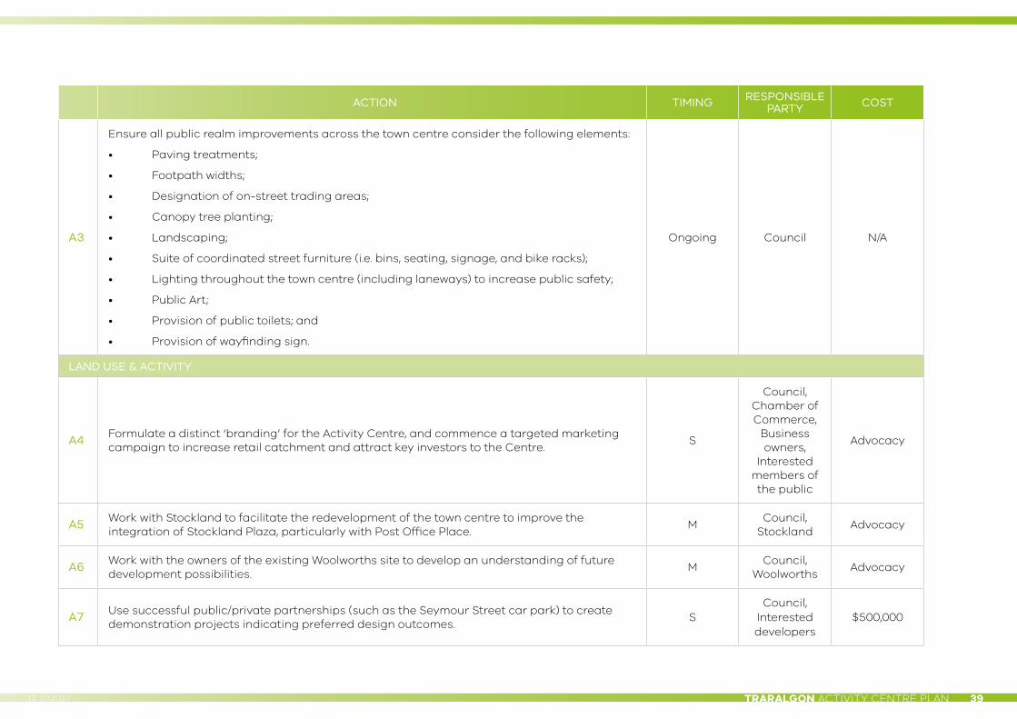
TRARALGON ACTIVITY CENTRE PLAN 3912.10.2017
ACTION TIMING RESPONSIBLE PARTY COST
A3
Ensure all public realm improvements across the town centre consider the following elements:
• Paving treatments;
• Footpath widths;
• Designation of on-street trading areas;
• Canopy tree planting;
• Landscaping;
• Suite of coordinated street furniture (i.e. bins, seating, signage, and bike racks);
• Lighting throughout the town centre (including laneways) to increase public safety;
• Public Art;
• Provision of public toilets; and
• Provision of wayfinding sign.
Ongoing Council N/A
LAND USE & ACTIVITY
A4 Formulate a distinct ‘branding’ for the Activity Centre, and commence a targeted marketing campaign to increase retail catchment and attract key investors to the Centre.
S
Council, Chamber of Commerce,
Business owners,
Interested members of the public
Advocacy
A5 Work with Stockland to facilitate the redevelopment of the town centre to improve the integration of Stockland Plaza, particularly with Post Office Place.
MCouncil,
StocklandAdvocacy
A6 Work with the owners of the existing Woolworths site to develop an understanding of future development possibilities.
MCouncil,
WoolworthsAdvocacy
A7 Use successful public/private partnerships (such as the Seymour Street car park) to create demonstration projects indicating preferred design outcomes.
SCouncil,
Interested developers
$500,000

TRARALGON ACTIVITY CENTRE PLAN40 12.10.2017
ACTION TIMING RESPONSIBLE PARTY COST
A8 Undertake a project to determine the requirements for a ‘youth space’ within the Centre, including an in-depth analysis of what facilities and activities should be provided.
S Council $15,000
A9 Work with relevant agencies to review, update and implement the recommendations of the Traralgon Station Precinct Master Plan 2011.
S–L
Council, Transport For Victoria, Vline,
VicTrack
$15,000
A10 Implement the Gippsland Regional Aquatics Centre Project. SCouncil, State Government
$46 million
A13 Implement the Latrobe Creative Precinct Project S
Council, State Government,
Federal Government
$30 million
BUILT FORM
A14 Facilitate the redevelopment of the former Manny's Market site (corner Franklin and Grey Streets), either in line with the existing approved permit (2015/192A), or negotiate an alternative development outcome for the site.
SCouncil,
LandownersAdvocacy
A15
Develop and implement a laneway activation strategy which includes a set of design guidelines for pedestrian priority laneways. These guidelines should address:
• The development of an ‘active edge’,
• Pedestrian-friendly interfaces; and
• Design detailing.
M Council $100,000
ACCESS & MOVEMENT
A16 Implement the recommendations of the Car Parking Framework Review 2014. S–L Council TBC

TRARALGON ACTIVITY CENTRE PLAN 4112.10.2017
ACTION TIMING RESPONSIBLE PARTY COST
A18 Work with the owners of Stockland Plaza to improve pedestrian connections through the plaza at ground carpark to connect Post Office Place with Wright Street and Traralgon Creek.
M–LCouncil,
StocklandAdvocacy
A19Seek to introduce a 40km/hr speed limit in the core pedestrian areas (bounded by Grey and Breed Streets and the Princes Highway).
S–MCouncil,
VicRoads$4,000
A20 Install a signalised pedestrian crossing at the intersection of Hotham and Breed Streets to improve safety and access at this location.
MCouncil,
VicRoadsTBC
A21Investigate locations for tourist facilities, e.g., long bay vehicle parking and associated tourism signage.
SCouncil,
VicRoadsN/A
A22 Improve pedestrian connectivity between the Activity Centre and the residential areas south of the Princes Highway through changes to the existing signalised pedestrian crossing of Breed Street and Princes Highway.
MCouncil,
VicRoadsTBC
A23
Undertake a muncipal-wide bicycle strategy to ensure locations for safe cycle links through the town centre are established and maintained.
M Council $120,000

TRARALGON ACTIVITY CENTRE PLAN42 12.10.2017
GLOSSARY
TERM DEFINITION
Activation Activation is achieved through a combination of built form, design features and the program of uses either in a street or precinct. Not all edges can be activated to the same degree – context is key.
Active address The primary entry point to a building or site.
Active edges The built form or other edge to the public realm which helps to animate the space. This includes windows, openings as well as the activities which occur at ground level internally and externally.
Active-edged built form
Building features which promote activity and interaction with the street including features such as windows, doors, highlight lighting and display areas.
At-grade parking
Parking areas which are located on the surface of a block or lot.
Built form The height, volume and overall shape of a building as well as its surface appearance.
Consolidation of lots
The process of combining two or more lots to create larger development opportunity through economies of scale.
Delineation of outdoor dining precincts
This is typically achieved by the location of outdoor dining street furniture within designated sections of the footpath to ensure clear passage of pedestrians. It can be through placement of dining furniture, screens, garden beds and potentially through markers cast into the paving.
Demarcation of gateways
The location of built form, wayfinding, signage, landscape treatments and others to signify a threshold or entry into a precinct.
Green wall A green wall is a wall partially or completely covered with greenery that includes a growing medium, such as soil or a substrate. Most green walls also feature an integrated water delivery system. A green wall is also known as a living wall or vertical garden. Cables to support vines are also considered green walls.
TERM DEFINITION
Hard and soft landscape elements
Hard landscape elements include paving, furniture such as seats, bins and lights. Soft landscape elements include lawn, garden beds, groundcover, larger plants, trees and shrubs.
Infilling blocks The process of utilising unused or underutilised land within city blocks for new development.
Integrated car parking
Parking areas which are located within the built form, this may include basement or roof top car parking.
Outstand areas These are extensions to footpaths typically bat corners which provide additional space for gathering points, street furniture and tree and other plantings.
Passive surveillance
A combination of:
• the design of the public realm itself, whether neighbourhood, street, plaza or park;
• the legitimate activities in that public realm;
• the design of the buildings that define or adjoin that public realm and hence the physical possibility of overlooking it; and
• the land uses and activities in those buildings and hence the potential they create to have lots of people “available” to see into the public realm.
Passive sustainability principles
The incorporation of natural ventilation, rainwater capture and use of ambient energy sources instead of purchased energy like electricity or natural gas. These strategies include daylighting, natural ventilation, and solar energy.
Pedestrian permeability
The ability for pedestrians to pass unimpeded through a building or block. This may be achieved with through block links or other techniques.
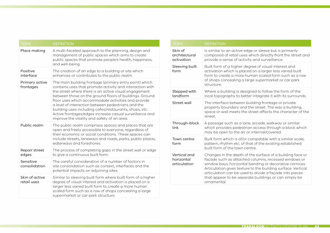
TRARALGON ACTIVITY CENTRE PLAN 4312.10.2017
TERM DEFINITION
Place making A multi-faceted approach to the planning, design and management of public spaces which aims to create public spaces that promote people’s health, happiness, and well-being.
Positive interface
The creation of an edge to a building or site which enhances or contributes to the public realm.
Primary active frontages
The main building frontage (primary entry point) which contains uses that promote activity and interaction with the street where there is an active visual engagement between those on the ground floors of buildings. Ground floor uses which accommodate activities and provide a level of interaction between pedestrians and the building uses including cafes/restaurants, shops, etc. Active frontages/edges increase casual surveillance and improve the vitality and safety of an area.
Public realm The public realm comprises spaces and places that are open and freely accessible to everyone, regardless of their economic or social conditions. These spaces can include streets, laneways and roads, parks, public plazas, waterways and foreshores.
Repair street edges
The process of completing gaps in the street wall or edge to give a continuous built form.
Sensitive consolidation
The careful consideration of a number of factors in site consolidation such as context, interfaces and the potential impacts on adjoining sites.
Skin of active retail uses
Similar to sleeving built form where built form of a higher degree of visual interest and activation is placed on a larger less varied built form to create a more human scaled form such as a row of shops concealing a large supermarket or car park structure.
TERM DEFINITION
Skin of architectural activation
Is similar to an active edge or sleeve but is primarily composed of retail uses which directly front the street and provide a sense of activity and surveillance.
Sleeving built form
Built form of a higher degree of visual interest and activation which is placed on a larger less varied built form to create a more human scaled form such as a row of shops concealing a large supermarket or car park structure.
Stepped with landform
Where a building is designed to follow the form of the local topography to better integrate it with its surrounds.
Street wall The interface between building frontage or private property boundary and the street. The way a building, space or wall meets the street affects the character of the street.
Through-block link
A passage such as a lane, arcade, walkway or similar which provides pedestrian access through a block which may be open to the air or internal/covered.
Town centre form
Built form which is of/or compatible with a similar scale, pattern, rhythm etc. of that of the existing established built form of the town centre.
Vertical and horizontal articulation
Changes in the depth of the surface of a building face or façade such as attached columns, recessed windows or window bays, horizontal banding or decorative cornices. Articulation gives texture to the building surface. Vertical articulation can be used to divide a façade into pieces that appear to be separate buildings or can simply be ornamental.
PRODUCED BY THE VPA
OCTOBER 2017