Draft Synthesis Report - Ground Water Governance · Groundwater Management in Libya Draft Synthesis...
14
Groundwater Management in Libya Draft Synthesis Report Food and Agriculture Organization of the United Nations Rome, 2009 el. +39 06 93938367 - Fax +39 1786034698 - email: [email protected] © ICU 2011
Transcript of Draft Synthesis Report - Ground Water Governance · Groundwater Management in Libya Draft Synthesis...

Groundwater Management in Libya
Draft Synthesis Report
Food and Agriculture Organization of the United Nations
Rome, 2009
el. +39 06 93938367 - Fax +39 1786034698 - email: [email protected] © ICU 2011

The designations employed and the presentation of material in this information product do not imply the expression of any opinion whatsoever on the part of the Food and Agriculture Organization of the United Nations concerning the legal or development status of any country, territory, city or area or of its authorities, or concerning the delimitation of its frontiers or boundaries.
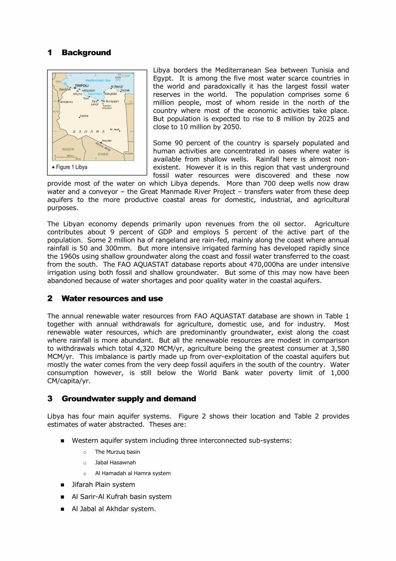
1 Background
Libya borders the Mediterranean Sea between Tunisia and
Egypt. It is among the five most water scarce countries in
the world and paradoxically it has the largest fossil water
reserves in the world. The population comprises some 6
million people, most of whom reside in the north of the
country where most of the economic activities take place.
But population is expected to rise to 8 million by 2025 and
close to 10 million by 2050.
Some 90 percent of the country is sparsely populated and
human activities are concentrated in oases where water is
available from shallow wells. Rainfall here is almost non-
existent. However it is in this region that vast underground
fossil water resources were discovered and these now
provide most of the water on which Libya depends. More than 700 deep wells now draw
water and a conveyor – the Great Manmade River Project – transfers water from these deep
aquifers to the more productive coastal areas for domestic, industrial, and agricultural
purposes.
The Libyan economy depends primarily upon revenues from the oil sector. Agriculture
contributes about 9 percent of GDP and employs 5 percent of the active part of the
population. Some 2 million ha of rangeland are rain-fed, mainly along the coast where annual
rainfall is 50 and 300mm. But more intensive irrigated farming has developed rapidly since
the 1960s using shallow groundwater along the coast and fossil water transferred to the coast
from the south. The FAO AQUASTAT database reports about 470,000ha are under intensive
irrigation using both fossil and shallow groundwater. But some of this may now have been
abandoned because of water shortages and poor quality water in the coastal aquifers.
2 Water resources and use
The annual renewable water resources from FAO AQUASTAT database are shown in Table 1
together with annual withdrawals for agriculture, domestic use, and for industry. Most
renewable water resources, which are predominantly groundwater, exist along the coast
where rainfall is more abundant. But all the renewable resources are modest in comparison
to withdrawals which total 4,320 MCM/yr, agriculture being the greatest consumer at 3,580
MCM/yr. This imbalance is partly made up from over-exploitation of the coastal aquifers but
mostly the water comes from the very deep fossil aquifers in the south of the country. Water
consumption however, is still below the World Bank water poverty limit of 1,000
CM/capita/yr.
3 Groundwater supply and demand
Libya has four main aquifer systems. Figure 2 shows their location and Table 2 provides
estimates of water abstracted. Theses are:
Western aquifer system including three interconnected sub-systems:
o The Murzuq basin
o Jabal Hasawnah
o Al Hamadah al Hamra system
Jifarah Plain system
Al Sarir-Al Kufrah basin system
Al Jabal al Akhdar system.
Figure 1 Libya
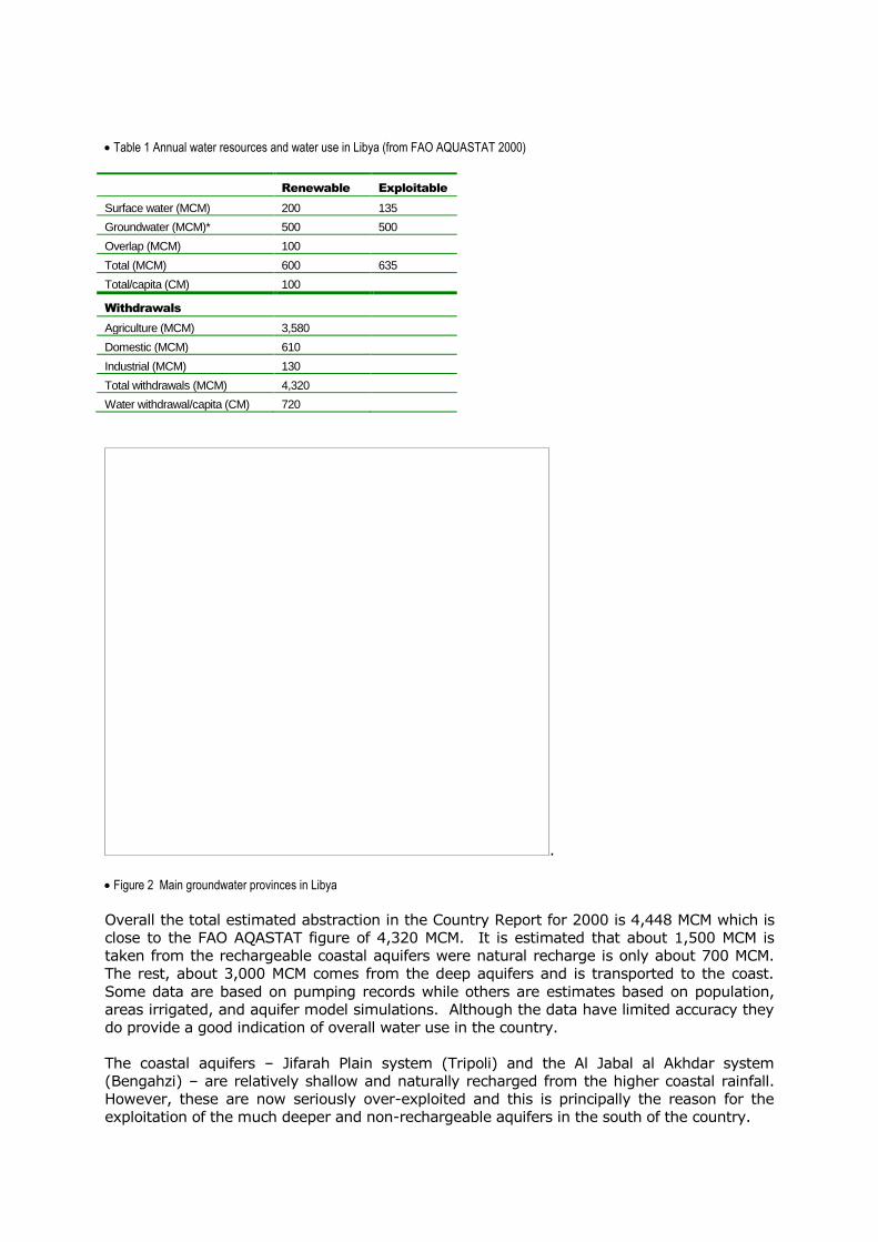
Table 1 Annual water resources and water use in Libya (from FAO AQUASTAT 2000)
Renewable Exploitable
Surface water (MCM) 200 135
Groundwater (MCM)* 500 500
Overlap (MCM) 100
Total (MCM) 600 635
Total/capita (CM) 100
Withdrawals
Agriculture (MCM) 3,580
Domestic (MCM) 610
Industrial (MCM) 130
Total withdrawals (MCM) 4,320
Water withdrawal/capita (CM) 720
.
Figure 2 Main groundwater provinces in Libya
Overall the total estimated abstraction in the Country Report for 2000 is 4,448 MCM which is
close to the FAO AQASTAT figure of 4,320 MCM. It is estimated that about 1,500 MCM is
taken from the rechargeable coastal aquifers were natural recharge is only about 700 MCM.
The rest, about 3,000 MCM comes from the deep aquifers and is transported to the coast.
Some data are based on pumping records while others are estimates based on population,
areas irrigated, and aquifer model simulations. Although the data have limited accuracy they
do provide a good indication of overall water use in the country.
The coastal aquifers – Jifarah Plain system (Tripoli) and the Al Jabal al Akhdar system
(Bengahzi) – are relatively shallow and naturally recharged from the higher coastal rainfall.
However, these are now seriously over-exploited and this is principally the reason for the
exploitation of the much deeper and non-rechargeable aquifers in the south of the country.
Al Sarir-Al Kufrah basin system, for example, is known as the Nubian Sandstone Aquifer
System and is the largest aquifer in the world covering approximately 2 million km2 of north-
east Africa. It extends across eastern and south-eastern Libya, north-eastern Chad, northern
Sudan, and Egypt. It is of immense importance to the countries that share this resource. A
mathematical model of this aquifer was used to demonstrate that in 2050 (abstracting 1,090
MCM/yr) the aquifer would be able to cope with the expected development in the Kufra area,
which includes phase III of the Great Man-Made River (GMR), with no significant impact
beyond the political boundary with Egypt. The simulation of the proposed rates of
groundwater abstraction in East Awaynat in Egypt in turn indicated there would be no
interference beyond the political border with Libya.
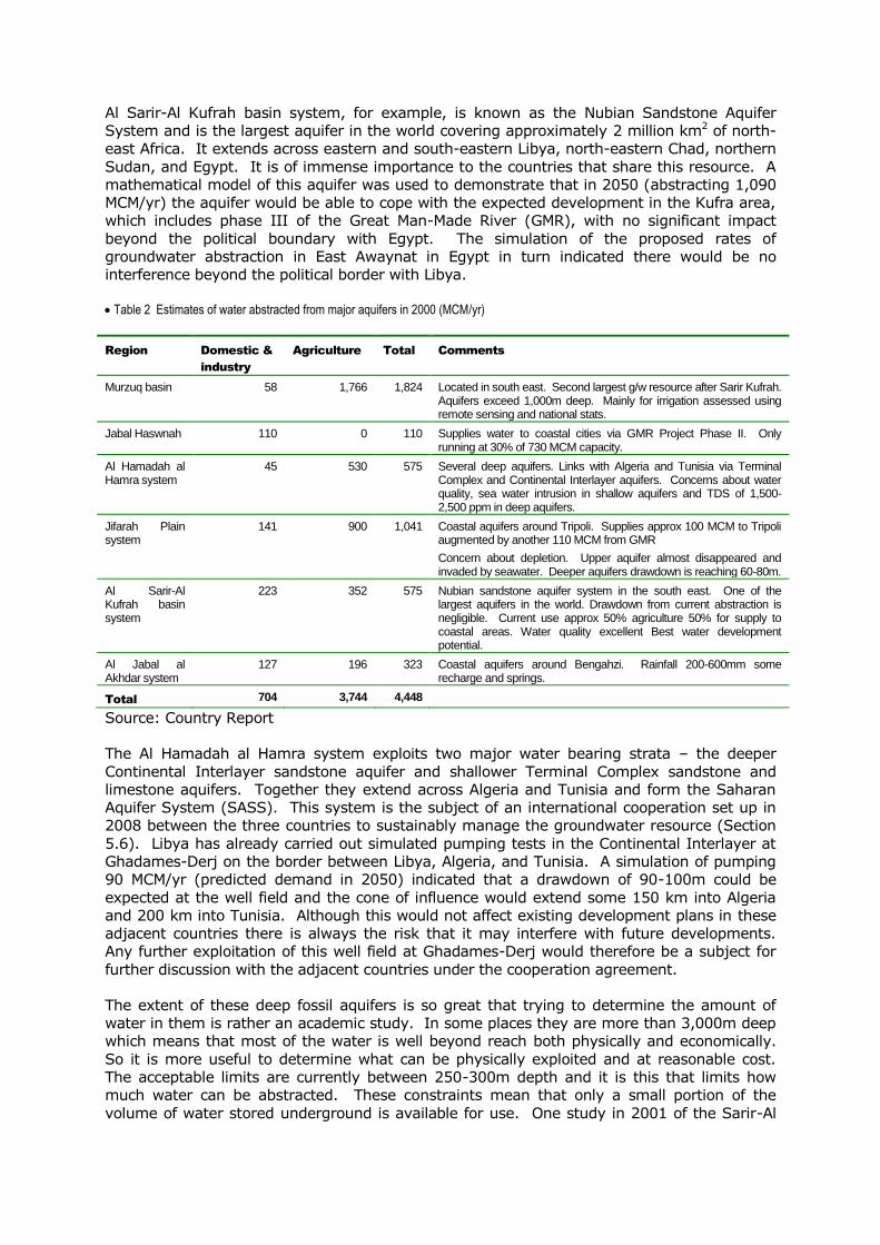
Table 2 Estimates of water abstracted from major aquifers in 2000 (MCM/yr)
Region Domestic &
industry
Agriculture Total Comments
Murzuq basin 58 1,766 1,824 Located in south east. Second largest g/w resource after Sarir Kufrah. Aquifers exceed 1,000m deep. Mainly for irrigation assessed using remote sensing and national stats.
Jabal Haswnah 110 0 110 Supplies water to coastal cities via GMR Project Phase II. Only running at 30% of 730 MCM capacity.
Al Hamadah al Hamra system
45 530 575 Several deep aquifers. Links with Algeria and Tunisia via Terminal Complex and Continental Interlayer aquifers. Concerns about water quality, sea water intrusion in shallow aquifers and TDS of 1,500-2,500 ppm in deep aquifers.
Jifarah Plain system
141 900 1,041 Coastal aquifers around Tripoli. Supplies approx 100 MCM to Tripoli augmented by another 110 MCM from GMR
Concern about depletion. Upper aquifer almost disappeared and invaded by seawater. Deeper aquifers drawdown is reaching 60-80m.
Al Sarir-Al Kufrah basin system
223 352 575 Nubian sandstone aquifer system in the south east. One of the largest aquifers in the world. Drawdown from current abstraction is negligible. Current use approx 50% agriculture 50% for supply to coastal areas. Water quality excellent Best water development potential.
Al Jabal al Akhdar system
127 196 323 Coastal aquifers around Bengahzi. Rainfall 200-600mm some recharge and springs.
Total 704 3,744 4,448
Source: Country Report
The Al Hamadah al Hamra system exploits two major water bearing strata – the deeper
Continental Interlayer sandstone aquifer and shallower Terminal Complex sandstone and
limestone aquifers. Together they extend across Algeria and Tunisia and form the Saharan
Aquifer System (SASS). This system is the subject of an international cooperation set up in
2008 between the three countries to sustainably manage the groundwater resource (Section
5.6). Libya has already carried out simulated pumping tests in the Continental Interlayer at
Ghadames-Derj on the border between Libya, Algeria, and Tunisia. A simulation of pumping
90 MCM/yr (predicted demand in 2050) indicated that a drawdown of 90-100m could be
expected at the well field and the cone of influence would extend some 150 km into Algeria
and 200 km into Tunisia. Although this would not affect existing development plans in these
adjacent countries there is always the risk that it may interfere with future developments.
Any further exploitation of this well field at Ghadames-Derj would therefore be a subject for
further discussion with the adjacent countries under the cooperation agreement.
The extent of these deep fossil aquifers is so great that trying to determine the amount of
water in them is rather an academic study. In some places they are more than 3,000m deep
which means that most of the water is well beyond reach both physically and economically.
So it is more useful to determine what can be physically exploited and at reasonable cost.
The acceptable limits are currently between 250-300m depth and it is this that limits how
much water can be abstracted. These constraints mean that only a small portion of the
volume of water stored underground is available for use. One study in 2001 of the Sarir-Al
Kufrah basin in south-east Libya estimated that lowering the water level by an average of
50m would yield 2,400 BCM. At a withdrawal rate of 4.4 BCM/yr – the current annual
withdrawal rate for the entire country (Table 1) – this aquifer alone could meet the country’s
entire water needs for more than 500 years.
Groundwater abstraction planning for the fossil water aquifers is based on how much water
can be taken within a planned range of aquifer drawdown. The Water Transport well field of
Jabal Hasawnah that supplies Tripoli for example, is designed to deliver water for a period of
50 years after which the depth to the water table will exceed 200-250m. With this drawdown
saline intrusion is likely in the north western part of the aquifer. So an alternative water
supply for Tripoli will need to be planned, designed, and implemented in the next 25-30
years.
4 Drivers for change
4.1 Agriculture
At present about 50 percent of cereals and 90 percent of fruit and vegetable needs are met
from local agricultural production. So Libya is still reliant on imports to satisfy basic staple
food requirements – in 2000 the import of cereals, sugar and oil, represented 68 percent of
the national calorie budget.
Agriculture consumes about 96 percent of all the abstracted groundwater. Water resources
policy, although not clearly stated, is driven by agricultural needs and is focused on food self-
sufficiency. In the early 1970s families were allotted enough land to satisfy their food needs
and to discourage large-scale private enterprise farming. These relatively small areas of land,
together with a proliferation of illegal well drilling by private farmers led to over-exploitation of
the aquifers close to Tripoli. Poor and inefficient irrigation management made this situation
worse. Although attempts were made to reduce the area under water intensive crops, little
has happened and water tables have continued to fall and this in turn has resulted in sea
water intrusion in coastal aquifers.
Agricultural water demand is somewhat distorted by low irrigation efficiency – water use for
wheat and barley grown in the Libyan Jamahiriya is reported to be much more than that used
in other countries with a similar climate – 7,617 CM/ha (water use in agriculture – 3,580 MCM
– divided by the irrigated area – 470,000 ha). However, this does not appear to be an
excessive amount of water for arid conditions. The discrepancy may be that the area under
irrigation is considerably less than that quoted because of the over-exploitation of the coastal
aquifers. Most of the wastage is blamed on poor management. Little is being done at
present to deal with these problems.
Groundwater use for irrigation is not effectively managed and the expansion of irrigation
continues without control. Recent investigations based on satellite imagery have revealed
that even in the vulnerable coastal regions the area under irrigation has continued to grow
even after warnings in 2000 from the General Water Authority. Demand management does
not yet form part of national water policy and highly subsidized energy for private farmers
does nothing to encourage efficiency and increase productivity of water. Rather the focus is
on supplying more water and since 1983 the government has pumped large quantities of
water from the fossil water reserves using the GMR to meet the growing, but inefficient,
demand for more water.
4.2 Water supply and sanitation
Generally water supply in the cities is not well recorded and managed. Tripoli is reported to
be using 650 l/capita/day, most of which is lost to the system as leakage from the distribution
network and overuse by households. This is in spite of the fact that Libya’s groundwater is

non-renewable, households are not metered and no fees are charged which could encourage
water saving. Wastage in urban systems is reported to exceed 50% of the amount supplied
and there is there is no real attention to recovering wastage or to recycling sewage effluent
for other purposes such as agriculture.
However, new systems are being installed in Tripoli, Benghazi, Misrata, and Sirte which offers
much better control and this should make it easier to monitor domestic and industrial water
use in the main cities.
Urban waste water is the main source of groundwater pollution mainly from inadequate
sewage systems. A Company for Water and Waste Water has recently been created with
responsibilities for both urban water supply and sanitation. It is also responsible for
monitoring water distribution and efficiency of the sewerage system. However, monitoring is
not yet a regular activity. A programme to monitoring groundwater pollution is also not yet
operational.
4.3 Environment
In addition to the environmental, social and health concerns raised about pollution from
untreated sewage effluent domestic water, the main environmental concern is about saline
intrusion in the coastal aquifers where both population and agricultural activities are
concentrated.
Water quality in the main well fields is regularly monitored by the GMRA. There are concerns
about water quality in the shallow aquifers where saline intrusion is affecting water supplies to
Tripoli and Benghazi. In the Jifarah Plain for example, the groundwater salinity contour line
corresponding to 3g/l has moved southward by more than 20 km from 1960 to 2000. Water
quality in the deep aquifers of the Terminal Complex and Continental Interlayer is monitored.
TDS in places can be up to 1,500-2,500 ppm.
Monitoring groundwater pollution from urban waste water is clearly important but it is not
done on a regular basis. It is done from time to time by individual researchers as part of their
investigations. The main source of pollution is inadequate sewerage systems. In small
towns, sewerage systems are practically non-existent. Data on industrial pollution, mainly
from the oil industry, are not available and there is no information on the monitoring systems,
although since 2006 the industry has been expected to undertake Environmental Impact
Assessments.
No data are available on agricultural pollution. Water logging and soil salinization is a
constant threat in irrigated areas under arid climatic conditions and there are several
examples of this. In the Al Jufrah area, for example, two irrigation schemes set up in the
1970s and based on shallow groundwater now show signs of water logging and salinity.
Initially these were artesian wells but they are now mostly pumped because of over-
exploitation. Large area are flooded as a consequence of poor irrigation management and
some farms have been abandoned. There is the risk that this kind of mismanagement will
pollute the shallow groundwater but this has not yet been monitored. There are other
examples of this in the Murzuq Basin resulting from inadequate drainage facilities.
5 Groundwater management
The Government as yet has no definitive policy on national food production aimed either at
maximizing internal production or optimizing the mix between internal production and food
import. Such a policy would have a significant influence on groundwater management.
At present most of the cities along the coast are or will soon be supplied by the water from
the fossil aquifers. But recent programmes of construction of seawater desalination plants

may suggest that in the future domestic water may tend to rely also on seawater desalinated,
leaving more transported water to agriculture.
5.1 Groundwater monitoring
Ideally groundwater resources should be monitored
for water level and drawdown, water quality,
abstraction, and pollution.
All the major well fields have piezometers to
monitor water levels and drawdown. The Murzuq
basin is typical with 53 piezometers tapping into the
shallow and deep aquifers in each of the five zones
of the basin. They are monitored by the General
Water Authority (GWA). A typical record is shown in
Figure3. The well fields that form part of the GMR
water transport project are monitored by the GMRA
while the GWA monitor those piezometers located in the agricultural projects fed by the well
fields.
Monitoring the amount of water abstracted from groundwater is well recognized as an
essential part of groundwater management, yet there is no systematic monitoring beyond
those well fields operated for water transport by the GMRA. Abstraction for agriculture, both
government and private farming, and for urban water supply not dependent on GMRA water,
is estimated on the basis of data available from the People’s Committee for Agriculture,
satellite imagery, and comments from pump operators.
5.2 Institutions governing groundwater
The main institutions that influence the governance of groundwater include:
GENERAL WATER AUTHORITY (GWA)
This organization works under the Secretariat of Agriculture, Livestock, and Fisheries and is
the national body responsible for assessment, planning, and management of water resources.
It provides advice to water users, formulates water legislation, designs water structures and
supervises their construction and O&M, and monitors and implement water legislation.
NATIONAL COMPANY FOR WATER AND WASTE WATER
This was set up in 2008 with headquarters in Tripoli and eight branches across the country. It
is within the General Corporation for Housing and Utilities and deals with water supply from
any source (groundwater, surface water, desalination plants, treated waste-water) and with
waste water treatment and the sanitation. Although a strategy is in place for the domestic
user to pay for water used this is not widely implemented. Municipalities pay for water
supplied from the GMRA but at a heavily subsidized price.
GREAT MANMADE RIVER AUTHORITY (GMRA)
Responsible for groundwater exploitation and its transport from the southern well fields to the
coastal area.
NATIONAL COMPANY FOR DESALINATION UNDER THE SECRETARIAT OF ELECTRICITY, WATER AND GAS
Responsible for planning, designing, implementing and operating the seawater desalination
plants.
Wadi Shati - Jabal Fazzan - Pz 4097
-80
-78
-76
-74
-72
-70
-68
-66
01/70 01/74 01/78 01/82 01/86 01/90 01/94 01/98 01/02
Dep
th t
o w
ate
r le
vel in
m
Figure 3 Piezometer record for Murzuq basin

LOCAL COMPANIES FOR WATER AND WASTE WATER
These operate at Shaabiat level and they are responsible for operating and maintaining water
structures developed by the National Company for Water and Waste Water.
GREAT MANMADE RIVER WATER UTILIZATION FOR AGRICULTURE
This organization operates under the Secretariat of Agriculture, Livestock, and Fisheries and is
responsible for designing and constructing water structures (distribution and drainage
networks, reservoirs, irrigation systems) necessary to make use of the water transported
from the south for agricultural purposes. It has responsibilities for the management of
transported water supplied by the GMRA to irrigation projects set up by government. Some
private farms also now receive transported water.
The institutions involved in the operation and management of the water sector are numerous
and their tasks are often overlapping. Moreover the status and the functions of the various
institutions keep changing and this affects their internal planning and the way they operate.
One of the major issues in the water sector is the lack of planning at top level and the lack of
coordination between the institutions. This multiplicity of management systems does not
favour rational and standard water management practices. This makes it difficult to attain
sound development and utilization of water resources. Some examples of the confusion
between institutions include:
Two important institutions dealing with substantial water resources are the Great
Manmade River Authority and the Electricity, Gas, and Water Secretariat through its
subordinated Company for Desalination. However, they work independently and
there is little coordination between them.
The Electricity Corporation was recently raised to the level of Secretariat. It
incorporated the water sector to become the Secretariat for Electricity, Gas and
Water. It was understood that it would be responsible for the domestic water supply
and urban sanitation but these activities were transferred to the Housing and Utilities
Corporation.
GMRA is initiating its Phase III programme to bring a new well field (300 wells) on-
stream in the Kufra area. This will be added to Sarir and Tazerbo in the eastern water
transport system. However, the Secretariat for Agriculture and Animal and Marine
Wealth intends to develop a 100,000 ha irrigation scheme to produce wheat on the
same site.
Private irrigated agriculture is developing everywhere in Libya. This can be beneficial
for food production and livelihoods but in some areas there are negative
environmental impacts. Limiting abstractions by licence was established in some
areas by the GWA. But this has now changed so that it is controlled at the Shabiat
level where there are few skills and little experience of doing this.
The water law indicates that the General Water Authority is the institution which
should act to protect aquifers against over-exploitation and pollution. But it is not
clear that the GWA has power to enforce the water policies and regulations because
this task was recently assigned to the Secretariat of Electricity, Gas and Water.
All the water related institutions have been active in preparing and implementing their
sectoral strategies and action plans. But the limitations on doing this are the lack of a clear
national water policy/strategy that defines the overall long-term priorities and objectives, a
lack of a high level body with full authority and means to guide and coordinate the planning
process, and the overlap and grey areas between the mandates of the different institutions
and their lack of coordination.

The highly centralized nature of the water institutions do not as yet provide a favourable
environment for decentralizing responsibility for groundwater management to abstractor
groups, although there is some scope for this among
private farmers.
5.3 The regulatory framework
An old water law exists (see box) but this was
amended in 1982 to set out the boundaries of water
utilization. After promulgating the law, the General
People’s Congress issued the decree N° 790 of 1982
defining the regulations for the protection of the
aquifers against overexploitation and pollution,
which is the responsibility of the General Water
Authority However, there is little evidence in the Country Report of how well this law is being
implemented.
5.4 Economic instruments
Managing demand is usually achieved through the use of tariffs both for domestic use and for
agriculture. Although this is not normally the practice in Libya, there are signs that
government intend to ask all users to pay for water. This is being introduced at present, but
only the charges levied are for electricity and water from the GMRA when it is sold to the
GMRWUA or to Municipalities. The GMRWUA is charged for water supplied by the GMRA at
UD$0.03/CM. This is much lower than the cost of transporting the water which is estimated
to be US$0.76/CM – this includes investment and operating costs.
So at present there is no opportunity to use water tariffs to encourage more efficient use of
water.
5.5 Private sector
The private farming sector is growing rapidly, even in the south in Kufrah and the Murzuq
basin and is now responsible for more than 80 percent of irrigated agriculture. Typical farms
of 50 ha and more are to be found, well equipped with modern irrigation technologies, and
well adapted to the local market. They drill their own wells and use electric submersible
pumps. This is all subject to approval by the GWA but this is not always enforced and wells
are drilled without a licence. It is estimated that farmers pay US$180-220/ha to the GMRUA
for water. This is a land tax rather than a tax on water
use.
5.6 Trans-boundary aquifer management
Libya shares the Nubian Aquifer with Egypt, Sudan and
Chad. A Joint Commision for Studies and Development
of this aquifer was set up by Libya and Egypt then
between Libya, Egypt and Sudan. Finally Chad was
invited to participate in the Commission in 2000. Two
agreements were signed by the four countries
concerning the exchange of updated information. But
the main concern is the issues surrounding the southern
border of Egypt and the possible interference in Sudan
from the Egyptian development in Awaynat. There is as
yet no urgent issues along the Libyan-Egyptian border.
Another important shared resource is the deep fossil
aquifers known as the Septentrional Saharan Aquifer
An old water law exists whose main principles say that water is a commodity shared by all people. Everybody shall protect water and needs to be moderate in its use. Water resources in Libya are in public ownership. Lakes, wadis and springs are publicly owned. Any person can drink and water his animals from lakes, wadis and springs, provided that it shall not cause damage to water or its source or to the land and installations constructed thereon or adjacent thereto. Shallow and deep wells are considered to be privately owned by the owner of the land and need to be drilled under license issued by the General Water Authority.
Figure 4 Extent of the Nubian sandstone aquifer

System (SSAS). It comprises the Continental Interlayer sandstone aquifer and shallower
Terminal Complex sandstone and limestone aquifers. These underlie Libya, Algeria, and
Tunisia. A consultation mechanism was established to manage and share the water
resources. A light management structure is hosted in the Sahara and Sahel Observatory
(OSS) based in Tunis. Following a final agreement and the adoption of the text defining the
Consultation Mechanism by the three countries and the contribution of Euro 30,000 each, the
first year of operation began in 2008.
The consultation mechanism includes:
A Council of Ministers in charge of water in the three countries
A permanent Technical Committee composed of the national water authorities (ANRH,
GWA and DGRE), alternatively presided over for one year by the three countries
National Committees possibly enlarged to include other national institutions beyond
the immediate water sector
National and regional working groups
A Coordination Unit run by Coordinators from each country to promote the
implementation of technical activities and meetings and to secure the exchange and
dissemination of information.
6 Future perspective
Groundwater resource development and allocation in Libya is now at a cross-roads. As
population increases, the demand for water will also increase and by 2025 some 10,000-
16,000 MCM/yr will be needed should Libya wish to pursue self-sufficiency in basic foods and
meet all its urban water needs. At present water use is 4,400 MCM/yr and this produces only
50 percent of basic food needs. Most of the coastal aquifers are over-exploited and may not
continue to produce water at the same rate as they do now. So future food production will
rely much more on transported water from the desert to the coast.
Although the transportation of groundwater is planned to increase in the coming years, by
2025 it is only expected to reach 6,400 MCM/yr. So clearly there will be a significant shortfall
between supply and anticipated demand. This is not so much a shortage of groundwater per
se, the resources are immense. Rather it is limited by the GMRA’s plans and investment in
infrastructure for water transport. Some of the shortfall could be made up from
Figure 5 Extent of deep aquifers in Libya, Tunisia and Algeria
Continental interlayer
Terminal complex

improvements in water use efficiency both in agriculture and in domestic use. There is also
the possibility of installing desalination plants to provide water for the urban areas along the
coast thus releasing transported water for agriculture. Improvements in water availability will
also require significant improvements in the way in which the organizations that manage
water work together to achieve the desired levels of efficiency.
So these are issues for Libya’s future groundwater and food policies which have yet to be
clearly defined. One positive note is that neither fossil water nor sea water availability will be
affected by climate change. But the demand for water could increase if crop water demand
rose as a result of temperature increase.
References
Abd el Gelil Abd Allah K (1996) Hydrogeological studies of El Kufra area – Thesis – Cairo
University Institute of African Researches & Studies. Cairo.
BRL ingénierie (1997) Ghadames Project – Water resources, Final report – Nimes (France)
June. (revised January 1998)
Baruni SS, RH Futaisi, MA El Gadi, MA El Mejebri (2004) Hydrology of the Libyan Jeffara plain,
GWA, Tripoli.
Baruni SS, RH Futaisi, MA El Gadi, HM Taloua (2004) Hydrogeology of the Libyan Jeffara
plain. GWA, Tripoli.
BRL ingénierie (1997) Ghadames Project – Water resources, Final report – Nimes, France.
(revised January 1998)
Brown & Root (Overseas) Ltd (1992) Tazirbu Groundwater Modeling Study - report on First
Stage - Report submitted to the Management and Implementation Authority of the Great
Man-made River Project.
CEDARE (2001) Regional Strategy for the Nubian Sandstone Aquifer System – Final report 4
volumes. Cairo
El Sunni AT, SS Baruni, RH Futaisi, AB Doma, MT Gharyane (2004) Geology of the libyan
Jeffara plain (February, 2004), GWA, Tripoli.
FAO (2000) Water Resources and Irrigation in Africa. Rome.
FAO-UNDP-Biruni Centre for Remote Sensing-Libyan Centre for Remote Sensing and Space
Science (2004) Mapping of Natural Resources for Agriculture Use and Planning in Libya –
Tripoli.
FAO (2004) Comparing water requirements for agricultural production in the Libyan
Jamahiriya and twenty other countries. Rome.
Fisk EP, Duffy CJ, Clyde CG, Jeppson RW, DeGroot PH, Bhaster Rao K, and Win-kai Liu (1983)
Hydrologic Evaluation of Coastal Belt Water Project Sarir and Tazirbu Well Fields, Libya.
Brown and Root Ltd Subcontract - Report submitted to the Management and Implementation
Authority of the great Man-made River Project - Utah water Research Laboratory, Utah State
University, Logan Utah.
Franlab (1974) Water Resources Study of the Southern Flank of Jabal Akhdar; Phase 1, Final
Report. Unpublished Rep. Agricultural Development Council, Tripoli, 105 p.
Franlab (1976) Water Resources Study of the Southern Flank of Jabal Akhdar; Phase 2, Final
Report. Unpublished Rep. Agricultural Development Council, Tripoli.
Geomath Srl (1994) Phase II - Western Jamahiriya System - Hydrogeological modeling of
aquifers and well fields - Brown and Root Ltd Subcontract N° 918 - Report submitted to the
Management and Implementation Authority of the Great Man-made River Project – Pisa.
Geomath Srl (1994) Phase II - Western Jamahiriya System - Wellfield modelling - Brown and
Root Ltd Subcontract N° 918 Change Order N°1 - Report submitted to the Management and
Implementation Authority of the Great Man-made River Project – Pisa.
Guerre A (1976) Al Marj-Al Abyar Phase I Study. Technical report 1: Inventory of water
points. Unpublished Rep., Secretariat of Dams and Water Resources, Tripoli, 19p.
Guerre A (1976b) Al Marj-Al Abyar Phase I Study. Technical report 2: Pie+ometry.
Unpublished Rep., Secretariat of Dams and Water Resources, Tripoli, 21p.
Guerre A (1976) Al Marj-Al Abyar Phase I Study. Technical report 3: Water Quality.
Unpublished Rep., Secretariat of Dams and Water Resources, Tripoli, 16p.
Guerre A (1977) Al Marj-Al Abyar Phase I Study. Technical report 4: Hydraulic characteristics.
Unpublished Rep., Secretariat of Dams and Water Resources, Tripoli, 25p.
General Water Authority (2006) Water situation in 2006 – in Arabic.
Hydrogeo (1992) Baydah-Bayyadah Area – Water resources study – Phase I – based on data
collected in 1981-1984. Pisa.
Idrotecneco (1982) Hydrogeological study of Wadi ash Shati, Al Jufrah and Jabal Fazzan –
Report prepared for the Secretariat of Dams and Water Ressources (now General Water
Authority) – San Lorenzo in Campo (Italy).
Pallas P (1980) Water Resources of the Socialist People’s Libyan Arab Jamahiriya – The
geology of Libya - Second Symposium on the Geology of Libya, held at Tripoli, September
16-21 1978 - pp 539-593 – Academic Press.
Pallas P and Salem O (1999) Water Resources Utilisation and Management of the Socialist
People Arab Jamahiriya - International Conference “Regional Aquifer Systems in Arid Zone –
Managing Non-renewable Resources”. Tripoli.
Pallas P (2005) Scénarios d’exploitation future des eaux souterraines dans la Djeffara tuniso-
libyenne. OSS.
Renault D (2002) Value of Virtual Water in Food: Principles and Virtues. Paper presented at
the UNESCO-IHE Workshop on Virtual Water Trade, 12-13 December, Delft, The Netherlands.
Sahara and Sahel Observatory (OSS) (2004) The North-Western Sahara Aquifer System – 4
volumes. Tunis.
Sahara and Sahel Observatory (OSS) (2006) Mathematical modeling of the Tunisian-Libyan
Jifarah Aquifers. Tunis.
Salem O (2001) Present water exploitation and future demand in Hamada al Hamra Sub-
Basin – Tripoli.
Taloua H (2004) Monitoring activities of sampling water to elaborate the salinity map of the
Jeffara plain. GWA.